survey of highway construction...
TRANSCRIPT
A SURVEY OF HIGHWAY CONSTRUCTION MATERIALS
IN THE TOWN OF PROCTOR, RUTLAND COUNTY, VERJ[ONT
prepared by
Engineering Geology Section, Materials Division
Vermont Department of Highways
4
in cooperation with
United States Department of Commerce
Bureau of Public Roads
Montpelier, Vermont
December 1967
4
'1

I
TABLE OF CONTENTS
Introduction
Acknowledgements . . . • . . . . . . . . . . . 1
History • . . . . . . . . 0 • 0 0 0 0 • • 0
Inclosures • 0 I I • I S • 0 0 0 • • 0 0 • 2
Location . • ,, • • 0 • • • • • • • • • • 4
County and Town Outline Map of Vermont
Survey of Rock Sources
Procedure of Rock Survey • . , . . . • • . • , 5
Discussion of Rock and Rock Sources • • • • • , • • • 6
Survey of Sand and Gravel Deposits
Procedure for Sand and Gravel Survey • • . . . . . . 8
Discussion of Sand and Gravel Deposits . . . . . . • • 9
Summary of Rock Formations in the Town of Proctor . . • . . . 10
Glossary of Selected Geologic Terms • . • . . • • • . 12
Bibliography • • • • • • . . . . • • . • . • .. • 14
Partial Specifications for Highway Construction Materials . Appendix I
Proctor Granular Data Sheets • • • • • • • • • • Thble I
Proctor Property Owners - Granular . . . . , • . • • Supplement
Proctor Rock Data Sheets • • • • • • • • • • • • Table II
Proctor Property Owners - Rock • • • . • • . . • . Supplement
Granular Materials Map . . . . . . . . • . . . . Plate I
Rock Materials Map . • • • • • • • • • 0 0 • • Plate 11

page 1
Acknowledgments
I The work of this Project was greatly implemented by the cooperation
and assistance of many groups and individuals. The following were partic-
ularly helpful in carrying out the Project's objectives:
1. Various departments and individuals of the Vermont State Department of Highways, notably the Planning and Mapping Division and the Highway Testing Labo-ratory,
2. Professor D.P. Stewart of Miami University, Oxford, Ohio,
3. Professor C.G. Doll, Vermont State Geologist, Uni-versity of Vermont, Burlington, Vermont,
4. United States Department of Commerce, Bureau of Public Roads.
- History
The Materials Survey Project was formed in 1957 by the Vermont State
Department of Highways with the assistance of the United States Bureau of
Public Roads. Its prime objective was to compile an inventory of highway
construetion materials in the State of Vermont. Prior to the efforts of
the personnel of the Survey as described in this and other reports, searches
for highway construction materials were conducted only as the ininediate
situation required. Thus only limited areas were surveyed, and no over-
all picture of material resources was available. Highway contractors or
resident engineers are usually required to locate the materials for their
respective projects and have samples tested by the Highway Testing Labo-
ratory. The additional cost of exploration for construction materials is
passed onto the State in the form of higher construction costs. The Ma
teriale Survey Project was established to minimize or eliminate this fac-
tor by enabling the State and its contractors to proceed with information
page 2
on material sources available beforehand. Prior knowledge of locations of
1
suitable material is an important factor in planning future highways.
The sources of construction materials are located by this Project
through ground reconnaissance, study of maps and aerial photographs, and
geological and physiographic interpretation. Maps, data sheets, and work
sheets for reporting the findings of the Project were designed with their
intended use in mind. These maps and data sheets were devised to furnish
information of particular use to the contractor or construction man. For
maximum benefit, the maps, data sheets, and this report should be studied
simultaneously.
Enclosures
Included in this folder are two surface-geology maps, one defining the
location of tests conducted on bedrock sources, the other defining the loca-
tion of tests conducted on granular materials. These maps are derived from
15-minute or 7k-minute quadrangles of the United States Geological Survey
enlarged or reduced to 1:31250 or 1" = 2604 1 . Delineated on the Bedrock
Map are the various rock types of the area. This information was obtained
from numerous sources: Vermont Geological Survey Bulletins, Vermont State
Geologist Reports, United States Geological Survey Bedrock Maps, and the
Centennial Geological Map of Vermont, as well as other references.
The granular materials map depicts areas covered by various types of
glacial deposits (outwash, moraines, kames, kame terraces, eskers, etc.) by
which potential sources of gravel and sand may be recognized. This infor-
mation was obtained primarily from a survey being conducted by Professor
D.P. Stewart of Miami University, Oxford, Ohio, who has been mapping the
glacial features of the State of Vermont during the summer months since

page 3
1956. Further information was obtained from the Soil Survey (Reconnaissance)
of Vermont conducted by the Bureau of Chemistry and Soils of the United
States Department of Agriculture, and from Vermont Geological Survey Bul-
letins, United States Geological Survey Quadrangles, aerial photographs,
and other sources. On both maps the areas tested are represented by Iden-
tification Numbers. Several tests are usually conducted in each area repre-
sented by an Identification Number, the number of such tests being more or
less arbitrarily determined either by the character of the material or by
the topography.
Also included in this folder are data sheets for both the Bedrock and
Granular Materials Survey, which contain detailed information for each test
conducted by the Project as well as information obtained from other sources,
and including an active card file compiled by the Highway Testing Laboratory.
The latter information was gathered over a period of years by many persons
and consequently lacks the organized approach and detail required for effec-
tive use. The information on the cards varied widely in completeness. Trans-
fer - infcrmaUon from the cards to the data sheets was made without elabø
oratLi or verification. When possible, the locations of the deposits listed
in ths ca:d files have also been plotted on the maps; however, some cards in
the file were not used because the information on the location of the deposit
was incomplete or unidentifiable. Caution should be exercised wherever this
information appears incomplete. This Project does not assume responsibility
fcr the information taken from the card files.
Work sheets contain more detailed information on each test and a de. -
-
tailed sketch of each Identification Number Area. The work shsets and
laboratory reports are on file in the office headquarters of this Project.

Page 4
* lv LOCATION
The town of Proctor is located in north-central Rutland County in
the southwest part of the state. Its northern one-third is surrounded by
Pittsford. It is bounded on the west and southwest by West Rutland, and
the town of Rutland lies to the southeast and east.
It is located in the Limestone Valley Physiographic Region of Ver-
mont and is characterized by rolling to abrupt hills and a broad north-
south trending floodplain through which Otter Creek flows north toward
Lake Champlain.
ElevatIons range from a high of 1,445 feet on Pine Hill on the east
side of town to a low of about 400 feet on the Otter Creek floodplain on
the Proctor-Pittsford Town Line.
-è ..'.

EN
0
NJ
z
C A N A D A
7r
r 'S FRANKLIN
NEROSSIRE RICHEOND JAY 4 I I DENNY 1 MOLLANO /
NORTON 'N CANNON
\ NIOSGOTE . I ,. I TROT I NEWrONT 1.- j / N
ERILL
--—----- •. L__ AS
WARNERS GRANT tAVERNS, ' S
TON N OMELETS / '. ,,N N I/CORE/
SWAN / ENSSAORS
WESTFIELD
/ COVENTRY
NNONOAN / N
/LEMINGTON N / N / LEWIS / MONTGOMERY
ST SLOANE N N N / NCNNRLESTONNN/
N / 'S
/ N,
' N / RLOONFIELD .-'TV '_( TAIREIEL
/ / ORIOlES /
/ \N
5_
S
/ RANERSFIELDJ
LOWELL
BARTON / WEETHORE
GEORGIA4RELAISERE
/ ' EENDI \ EONS
SEN TI C. /
"S I ALBENY I'
lee
EWARK 7N I N FAINFOS \ FLETC
WOTER-N / EDEN N
N
VILLE / E N N / SLAVER N N
• \/ NJ
/NN /OROF EATTON 'N
/c / NILTON
T000RY / N
.JONEYEIELD \
... • 0 EA5T MAVEN / N
OEMNEIDGE JOHNSON / . / N / Nk ao
/ IEEE POOR H AFOOt1
/ /\
/
/ CRSEN4NERT/ '
S N A / NERVE GRANNY /
WEETF000
ONP'S / NJ b 'S
NIL
7 WOLCOTT
* COLONEETER / KoUHDER
• /
'NOR
/
N /
I LYNDON I N./GUIL0NALL
000ROIOTOWN / \ VICTORY OWICK / NApN I o / N 05000 I I / N
N
) \ •'i_S_ / N / 'S .4
N / ELNORE / WALDEN //
\ NINNY \ LUNENBLRE
>-< N
\C.
DAJA - U T, JERICHO ).____(•_•,•TTONOE
/•' OONVILLE NORI IVO- 0000000
\ CONCERT \ A
) WILLIOTON / ,<,
• /WOOCESTEE / / - 5.
/ CANOE
V*j SNELNORNO /
/&RICHNNENO I BOLTON ? WATERBURY 'SN
,/ 5TN N •
/ S-. T. OEOREE /
N / Nç OOLOIE
/ N ... \ WVTERE000
( / \ • C /
PEAGNAN /
/ TV 4 MEASURE / ,Y EAST 'S / MARONFIELO(/ / RVRNET
)
1 HIVESRANG 1 HUNTINGTON1
'Sr' NIOOLEEEO / N /
CHARLOTTE •, ••_•••__ / 'S
,NONTPELIER / C
1.•••I I MN0IA / /
.4-_ 4, - / 010RETTWN /
C VETO N M500TTN OTONR505RO /\ PLOINEIELO
( A A
NUELO C/BE /FAYOTOH N /
REOLIN RE050TE
I
- 1_•5-_U I E NONTNEIELO
7-L ABOVE U NONCE I I .5. PANTON (WSLTNAN
"S /WILLI
/ TOPSHAN I
r_J BRISTOL
NEW HAVEN LINCOLN WORSEN / .._ ANETOWN/ 'SN / NOWHERE
-- N /
00010DB CS' r • / ROSBURT
/ T'SN N / WASNINCTOV
E.. 0... '5.
Ej
_( AR000TIELD N CORINTH /
PORT
RIPTON /
'SE'-. NIODLEBURT GROVAILLE E •
IDRA000RO
/ N., CHELSEA /
N ICORNNNLL_- ' N
OROINTREE / N / VERSHIRE /
'S/ 1 SVLIOBLRY NANCTO
RANDOLPH
SETREHAN C _-
// I
ERWELL \ \ BRANEON
/ TANNRI000
I COENE4>N A L1 LEICESTER I NE C ES T E R/
/ OTRAFEONO
1
_•-..--•------i / RETNEL / "DL. / THEIFORD
1JOLOREEY1 I
KT1 / ROTVLIOH /
/M ,/ SHARON ,/
•••••-.
/ I - ---N. CNITTENSEN \ ' OTOCENRIDCE/ 'S Os. / NORWI OH
RESETS I NUNNNROTONI PITTOFEOS • /
E / .N /
DNONARO /
POVFRET 1 ,--- / f --r
WEST HAVEN tPROJTLON0I / SHERNARHE / NNRTEORO
CO 01 L U TO N lu
f-
r\ IWEET
'S-. /NE000WOTER /
O \VTLONDL': 'S 7&..
/ W0000TOCK,' c0 N
INVRTLNNO
INN T
I E COUNTY AND TOWN PEULTNEY
/CLARONOON I ENREWSAURT PLEMOATH
/MlOOUUTOW --r!i NEADINC OUTLINE MAP
• ,.I I \
--&. SYRINGE OF BELLS
N 'TINNOSTH1 MALLINGEORD I
I I NT. HOLLY I I I
/ CAVONDION \,l E R lvi 0 l.J 1 -•-----
U0L0W .1
r I I
WEATHERSEIELD
PVWLET J__/'RALTINONE DANNY I MT. TANOR
rWEETSN I
I 'S
I INNOONERI CHESTER SPRINGFIELD
I I REPENT ) DORSET
(PERU 0 I I I ------- _L___U
LONOONOERR4J I
SAN0GATI MANCHESTER WINHNLL IWIVDHNMI
ONAETON IROCRINGHNN
/ I _4 4 THENS N
I JAMAICA / ARLINGTON UJNDERIVND
STRATTON I / TOWNSNE ND NESTMINSTOR N
J
• -- -----I-----
---i
I WOVOSNORO
SHAETSRANE IGLTENOURY • ' r --- i '\ FOTNEE
I I DOVER 5. YVEWFANE 0_L___
OUMNERSTON
I RENNINCTON I W000FOR0 I.
I .
._____
I WILMINGTON MARLBORO
f
r-- • I iKR0TTLEB0RD
F I VERMONT DEPARTMENT OF HIGHWAYS
I I I C HIGHWAY PLANNING DIVNSION POWNAL STAMFORD
WHITINOHAN I N0LIFAS CAILFORD
I I I
SCALE I VERNON 0RE2 WELES
M A S S A C H U S E T T S AUGUST,I967
A

I
SURVEY OF ROCK SOURCES
Procedure for Rock Survey
The routine employed by the project in the survey of possible sources of
rock for highway construction is divided into two main stages: office inves-
tigation and field investigation. The first is conducted primarily during
the winter months and comprises the mapping of rock types as indicated in vari-
ous reference sources. Many different sources of information were utilized,
as indicated in the bibliography. These references differ considerably in de-
pendability due to new developments and studies contributing to the obsoles-
cense of a number of reports. In addition, the results of samples taken by
other individuals are analyzed, and the location in which these samples were
taken is mapped when possible. In other words, as complete a correlation as
possible is made of all the information available concerning the geology of
the area under consideration.
The second stage of the investigation is begun in the field by making a
cursory preliminary survey over the entire area. The information obtained in
this survey, together with the information assimilated in the first stage of
the investigation, is employed to determine the areas in which the testing and
sampling will be concentrated. When a promising source is encountered as de-
termined not only by rock type but also by volume, accessibility, and the ex-
istence of a good working face, chip samples are taken with a hammer and sub-
mitted to the Highway Testing Laboratory for testing by the Deval Method (AASHO
T-3). It is kept in mind that the samples taken by the chip method are often
in the weathered zone of the outcrop and consequently may show a less satis-
factory test result than the fresh material deeper in the body of the rock
structure. When deemed necessary, further samples are taken by drilling to a
depth of approximately 3 feet and blasting across the strike or trend of the
outcrop. When the material is uniform and satisfactory tests result from the
chip samples, no further drilling, blasting, or sampling is done, and the ma-
terial source is included as being satisfactory.

Page 6
Discussion of Rock and Rock Sources
Rocks in the town of Proctor consist almost entirely of the Valley
sequence of quartzites, dolomites, limestones, marbles, slates, and phyl-
lites. The oldest formation of the sequence; the Dalton quartzite and
dolomite, overlies the Mount Holly gneiss on the eastern edge of town, and
both formations have been thrust over younger formations lying to the west
by the Pine Hill thrust fault. This part of town is forested and accessible
only by woods roads or field roads leading west from State Aid Highway No.
4 In Rutland.
Carbonate rocks comprising the Shelburne Formation have been exten-
sively quarried in Proctor. Interestingly, the Sutherland Falls Marble
Member is named from its supposed type exposure in the falls by that name
- in Otter Creek at Proctor Village. However, that rock has more recently
been correctly i-napped as the Winooski Formation. The Sutherland Falls
Marble is exposed in a large operating quarry about 2,000 west of the
river in Proctor Village.
The Vermont Marble Company owns inactive quarries in the town of Proc-
tor that were investigated as possible sources of Item 204, Sub-base of
Crushed Rock. A small quarry with a large waste pile is located on the
northwest side of State Aid Highway No. 2 north of Proctor Village on pro
perty owned by Mrs. Emil Hancsarik. A small face and opening (now water-
filled) was worked and a large waste pile accumulated. Small scattered ex-
posures occur in the pasture west of the quarry. The materials survey par-
ty deemed this location too small and too distant from proposed construc-
tion projects to warrant consideration as a source of Item 204.
Page 7
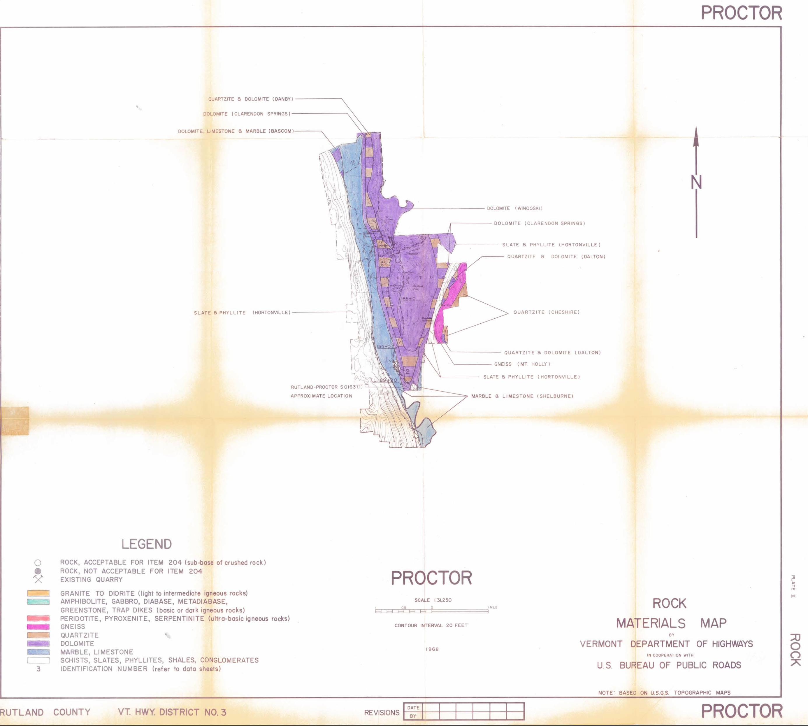
The Flint and Johnson Quarry, located on the east side of Vermont
- Route 3, 0.60 mile north of the Rutland Town Line, was investigated and
sampled as Map Identification No. 1 (See Table II and Plate II). Rock in
this locality has been mapped as the Columbian Marble Member and Interme-
diate Dolomite Member of the Shelburne Formation. It is apparently the
Columbian marble which has been quarried, and the west edge of the quarry
openings appears to follow a contact between a dolomite to the west and the
Columbian Marble to the east. This dolomite may be only a thin bed with-
in the Columbian Marble or may be the result of tight folds in the Colum-
bian Marble and Intermediate Dolomite.
Two tests taken from dolomite beds and one from marble exposures met
abrasion requirements for Item 204. Construction of the project on Ver-
mont Route 3 will involve rock cutting and removal of waste piles between
the highway and the quarry openings, and will necessitate moving a crusher
and quarry operation eastward into the wooded hill where the Intermediate
Dolomite may be uncovered.
The wooded area south of the quarries was sampled as Map Identifica-
tion No. 2 (See Plate II and Table II). Beds of the Intermediate Dolomite
were well exposed. However, no room is available beside the highway to
set up a crusher. In order to locate an operation here it would be neces-
sary to construct an access up to the more or less flat wooded area east
of the highway and to clear a site for quarry and crusher.
SURVEY OF SPND AND GRAVEL SOURCES
Procedure for Sand and Gravel Survey
The method employed by the project in the survey of possible sources of
sand and gravel for highway construction is divided into two main stages:
office investigation and field investigation. The office investigation is
conducted primarily during the winter months and comprises the mapping of
possible potentially productive areas as indicated from various references.
Of these references, the survey of glacial deposits mapped by Professor Stew-
art proves to be valuable, particularly when used in conjunction with other
references such as soil-type maps, aerial photographs, and United States Geo-
logical Survey quadrangles. The last two are used in recognizing and locating
physiographic features indicating glacial deposits and in studying drainage
patterns. In addition, the location of existing pits are mapped when known.
The locations in which samples were taken by other individuals are noted and
I mapped when possible.
The second stage of the investigation is begun in the field by making a
cursory preliminary survey over the entire area noting area which show physio-
graphic features giving evidence of glacial or fluvial deposits. These loca-
tions are later examined by digging test pits with a backhoe to a depth of
approximately 11 feet and then sampling the material. The samples are sub-
mitted to the Highway Testing Laboratory where they are tested for gradation
and stone wear, the latter by the Deval Method (AASHO T-4-35).
Page 9
Discussion of Sand and Gravel Sources
The granular materials in the town of Proctor consist almost entirely
of ice-contact sands and gravels exposed in Vermont Marble Company's large
gravel pit at the east edge of Proctor Village. These gravels probably ex-
tend northeast along the wooded hillside east of and above Vermont Route
3, and south and southwest in a residential area.
Small patches of glaciolacustrine sands have been mapped by Dr. D. P.
Stewart along the east side of Otter Creek and along State Aid Highway No.
2 on the west side of the flood plain, both in residential areas % and in a
number of scattered small areas north of Proctor Village west of and
above Otter Creek. Map Identification No. 1 is a small pit showing sitly
sands unacceptable for Item 105, and there is little extension possible.
- Four other sand areas either could not be located in the field by the ma-
terials survey party or could not be tested because of cultural features.
Numerous tests of sand and gravel acceptable for Item 201 Sub-base of Gra-
vel have been taken in Map Identification No, 2, Vermont Marble Company's
pit. However, a spokesman expressed the unwilligness of the company to
sell any large quantity of material. The pit is in a feature mapped as a
kanie terrace and the material ranges from fine sands, exposed in a lower
level on the northwest side of the property, to bouldery gravels and hard-
pan exposed on the east face.
Two features designated by Dr., D. P. Stewart as beach gravel depo-
sits are located on the west side of State Aid Highway No. 2 and material
representative of the deposits was sampled in Map Identification No. 3.
In this location poorly-sorted, bouldery, and somewhat silty gravels are
exposed in a small pit with limited extension.

Page 10
SUMMARY OF ROCK F0R1iATIONS IN THE TOWN OF PROCTOR
Vermont Valley Sequence
Ilortonville Formation - Black, carbonaceous, and pyritic slate and phyllite, locally sandy; brown-weathered limy beds are com-mon near base.
Bascom Formation - Interbedded dolomite limestone or marble, cal-careous sandstone, quartzite, and limestone breccia; irregular dolomitic layers, thin sandy laminae, and slaty or phyl]itic par-tings characterize limestone and marble of lower, middle, and up-per parts of the Bascoin, respectively; south of West Rutland it includes some of Chipman formation.
Shelburne Formation - Chiefly a white marble characterized by raised lines of gray dolomite on the weathered surface. Includes Sutherland Falls Marble, Intermediate Dolomite (a massive gray-weathering rock) and the massive, white Columbian Marble.
Clarendon Springs Formation - Fairly uniform, massive, smooth-weathered gray dolomite characterized by numerous geodes and knots of white quartz; quartz sandstone and irregular masses of chert are near the top.
Danby Formation - Comprised of white vitreous or glassy quartzite beds, often cross-lam!nated, interbedded with gray dolomite. White quartzite beds, more than a foot thick, separated by 10 to 12 feet of dolomite in eastern areas, increase westward to continuous sec-tions of white to pink weathered, massively bedded Potsdam quartz-ite, west of Orwell thrust.
Winooski Formation - Buff-weathered, pink, buff, and gray dolomite; beds 4 inches to 1 foot thick separated by thin, protruding, red, pink, green, and black siliceous partings.
Cheshire Formation - Very massive, white to faintly pink or buff vitreous quartzlte near the top in west-central and southwestern Vermont; predominantly a less massive-appearing mottled gray, somewhat phyllitic quartzite, dolomitic sandstone and conglomerate near the base of the formation in west-central Vermont apparently grades southward into the Dalton Formation.
Dalton Formation - Schistose quartzite containing pebbles of feld-spar and blue quartz; impure dolomite containing pebbles of quartz and feldspar occurs locally; conglomerate common near base.

Page 11
Creen Mountains
Mount Holly Complex - Mainly fine- to medium-grained biotitic gneiss, locally muscovitic, and in western areas chloritic; mas-sive and granitoid in some localities, fine-grained or schistose and compositionally layered in others; also abundant aniphibolite and hornblende gneiss, and minor beds of mica schists, quartzite, quartzite, and calc-silicate granulite; includes numerous small bodies of pegniatite and gneissoid granitic rock.

I
Page 12
GLOSSARY OF SELECTED GEOLOGIC TERMS
Alluvial - Pertaining to material carried or deposited by running water.
Breccia - A rock consisting of consolidated angular rock fragments larger than sand grains. There may be fault, talus, and volcanic breccia.
Calcareous - Pertaining to or containing calcium carbonate,
Carbonate Rocks - Rocks composed of the molecule CO 3 combined with cal-cium, magnesium, etc. Includes limestones and dolomites.
Delta - A predominantly alluvial deposit built by a stren entering the sea or other body of water. Usually it has the form of the Greek letter delta.
Dolomite - A rock consisting predominantly of the mineral calcium mag-nesium carbonate (dolomite), containing carbon dioxide 47.7%, lime 30.4%, magnesia 21.9%.
Esker - A long, narrow winding ridge of mixed sand and gravel deposited by a stream of meltwater flowing in a tunnel or crevasse in stagnant gla-cial ice.
Claciolacustrine - A teri used to denote formation by, or deposition in, quiescent waters of glacial lakes.
Cneiss - Originally meaning a more or less banded metamorphic rock with the mineral composition of granite. The term now designates a foliated metamorphic rock with no specific composition implied, but having layers that are niineralogically unlike and consisting of particles visible to the eye. Usually gneiss displays an alternation of granular mineral and schistose minerals with the rock tending to split along the schistose bands.
Hardpan A term loosely applied to any subsurface soil layer that offers great resistance to digging and drilling. Correctly, and as used in this report, it is gravel cemented by carbonates so as to form an impene-trable layer. It is commonly found in gravels having a preponderance of particles derived from carbonate rocks.
Ice Contact - Refers to sediments which have accumulated in contact with stagnant or wasting glacial ice. They assume the varied topographic forms expressed by eskers, karnes, and kanie terraces.
Kame - A conical hill of generally poorly stratified drift deposited in contact with glacial ice by streams flowing in or on the ice.
Kane Terrace - Stratified sands and gravels deposited by streams between a glacier and an adjacent valley wall.
Page 13
Limestone - A bedded sedimentary rock consisting chiefly of calcium car-bnnate. The most important and widely distributed of the carbonate rocks.
Marble - A soft, white rock being the metamorphic form of limestone in which the calcium carbonate (calcite) is recrystallized and the calcite crystals are overgrown and interlocked with additional calcite. Commer-cially it is a trade name applied to any carbonate rock of good color and texture and hard enough to take a polish.
Metamorphic Rocks - Rocks that owe their distinctive characteristics to the transformation of preexisting rocks through intense heat or pressure or both.
Phyllite - A fine-grained, foliated metamorphic rock intermediate between the mica schists and slates into which it may grade. The foliation is made possible by the development of a large amount of potash mica, sen- cite, which also gives the rock a distinctive silvery appearance.
Physiograpic - Pertaining to the physical divisions of the earth.
Quartzite - A compact metamorphic rock composed of quartz grains so firm-ly cemented that fracture takes place across the grains and the cementing
- material with equal ease.
Slate - A very fine-grained homogeneous metamorphic rock which splits smoothly along parallel cleavage planes and yields roughly similar slabs.
Thrust Fault - A low-angle or horizontal plane of displacement along which one block of rocks has been pushed or thrust upon and over another block. A lateral displacement of tens of miles along a fault plane of scores of miles is not uncommon.

Page 14
I BIBLIOGRAPHY
A survey of the glacial geology of Vermont being conducted by D. P. Stew-art, the partial results of which are published in Vermont Geologi-cal Survey Bulletin No. 19; 1961.
Soil Survey (Reconnaissance) of Vermont, W. J. Latimer; 1930; Bureau of Chemistry and Soils, United States Department of Agriculture.
Soil Exploration and Happing; 1950; Highway Research Board, Bulletin 2.
Survey of Highway Aggregate Materials in West Virginia; December, 1959; Engineering Station, West Virginia University, iorgantown, West Virginia.
Materials Inventory, Bangor Quadrangle, South Half; September, 1959; University of Lathe.
Glacial Geology and the Pleistocene Epoch, R. F. Flint; 1947; John Wiley and Sons, Inc.
A Handbook of Rocks, J. F. Kemp; June 1946; D. Van Nostrand Company, Inc.
Reports of the Vermont State Geologist, G. H. Perkins; 1931-1932.
Rock and Rock Minerals, L. V. Pirsson; June, 1949; John Wiley and Sons, Inc.
Glossary of Selected Geologic Terms, W. L. Stokes and D. J. Varnes; 1955; Colorado Scientific Proceedings, Vol. 16.
Licroscopic Petrography, E. W. Heinrich; 1956; McGraw-Hill Book Company, Inc.
Centennial Geologic Map of Vermont, C. G. Doll; 1961.
Stratigraphy and Structure of the Castleton Area, Phillip Fowler; 1950; Vermont Geological Survey Bulletin No. 2.
Stratigraphy and Structure of a Portion of the Castleton Quadrangle, E-An-Zen; 1964; Vermont Geological Survey Bulletin No. 25.
Castleton Quadrangle, Vermont; Geological Survey, United States Depart-ment of the Interior.

Appendix I
PARTIAL SPECIFICATIONS FOR HIGHWAY CONSTRtTCTION MATERIALS
Listed below are partial specifications for Highway Construction Mate-
rials as they apply to this report. at date of publication. For a complete
list of specifications see Standard Specifications for Highway and Bridge
Construction, approved and adopted by the Vermont Depar±ment of Highways
in April, 196.
Item lOs, Granular Borrow
"Irticle 10.02 - Materials. The granular borrow shall be obtained from
approved sources and shall consist of satisfactorily graded, free-draining,
hard durable stone and coarse sand practically free from loam, silt, clay,
and organic matter.
"The sand portion (material passing the No b screen) shall have not
more than ten percent (io) passing the No 270 mesh sieve and shall show
a color of not more than three and one-half (3) as determined by the colon-
metric test described in AASHO Method of Test, Designation T-21.
"When used in connection with fine grading or in fills where piling is
to be driven, the granular material shall all pass the nine-inch (9 11 ) square-
opening screen."
Item 201, Sub-base of Gravel
"Article 201.02 - Materials. The gravel shall consist of material
reasonably free from silt, loam, clay, or organic matter. It shall be ob-
tamed from approved sources and meet, the following requirements: -
"Not less than forty percent (40%) stone shall be retained on No, 14 Sieve.
- "The percent of wear shall be not more than twenty-five (2) when tested by laboratory methods using Method T-li or more than for+y (140) when tested by .A.ASHO Method T-96.
Appendix I page B
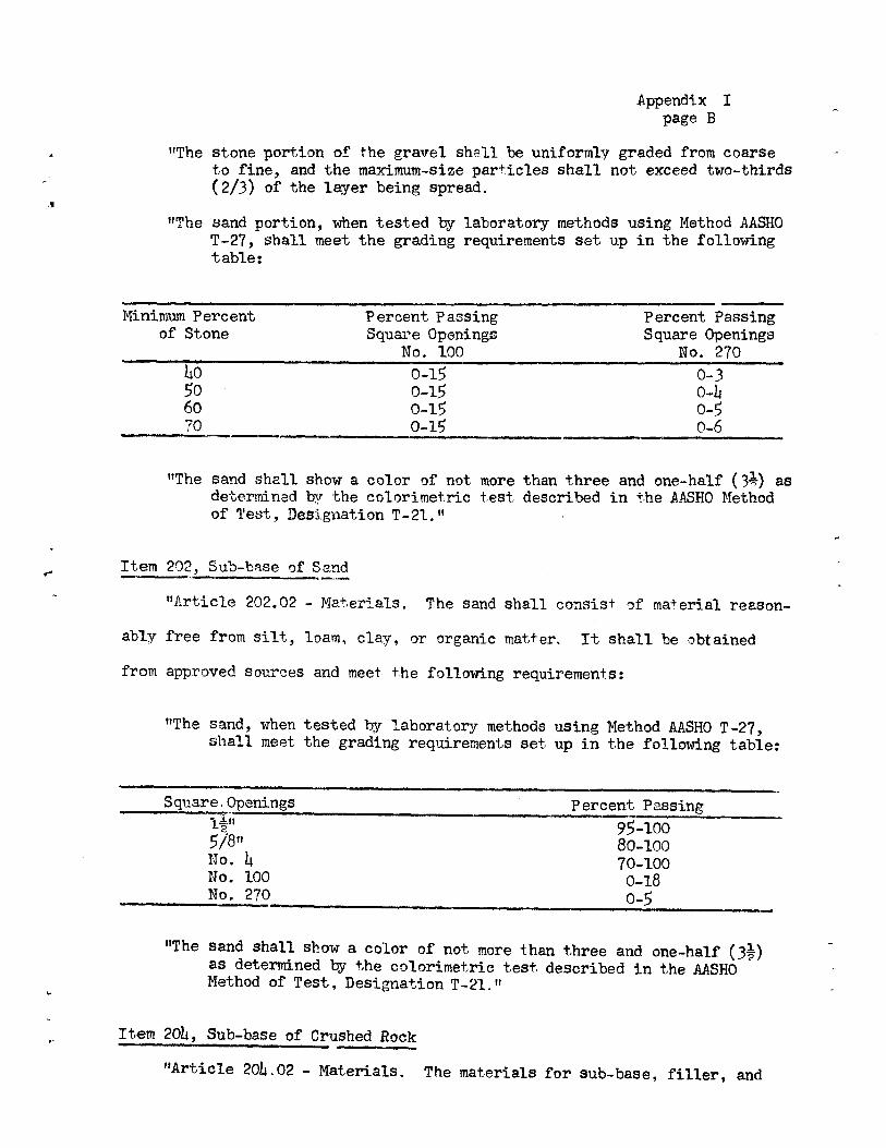
"The stone portion of the gravel shall be uniformly graded from coarse to fine, and the maximum-size particles shall not exceed two-thirds (2/3) of the layer being spread.
"The sand portion, when tested by laboratory methods using Method AASHO T-27, shall meet the grading requirements set up in the following table:
Minimum Percent Percent Pa$sing Percent Passing of Stone Square Openings Square Openings
No. 100 No. 270
0-15 0-3 So 0-15 0-14 60 0-15 0-5 70 _____ 0-15 0-6
"The sand shall, show a color of not determined by the colorimetric of Test, 1ssignation T-21."
more than three and one-half (3k) as test described in the AASRO Method
Item202, Sub-base of Sand
"Article 202.02 - Materials. The sand shall consist of material reason-
ably free from silt, loam, clay, or organic matter. It shall be obtained
from approved sources and meet the following requirements:
"The sand, when tested by laboratory methods using Method AASHO T-27, shall meet the grading requirements set up in the following table:
Square Openings Percent Passing l.0
518" 95-100 80-100
No. L 70-100 No. 100 0-18 No. 270 0_S
"The sand shall show a color of not more than three and one-half (3 1?) as determined by the colorimetric test described in the AASHO Method of Test, Designation T-21."
Item 2014, Sub-base of Crushed Rock
"Article 201402 - Materials. The materials for sub-base, filler, and

Appendix I page C
- sand cushion shall be obtained from approved sources and meet the following
requirements: 4
- Crushed Rock. "The crushed rock shall be unifrmly graded, crusher-run material and shall be free from dirt. The ledge from which this mat erial. is obained shall be sripped and cleaned before blasting. Conical stockpiling, or any other method of stockpiling which causes segregation of aggregaes, will not be permitted.
"The crushed rock, when tested by laboratory methods using Method AASHO T-27, shall meet the grading requirements set up in the following table:
Square Openings Percent PasLeing 411 9-.lOO
2-O No, 14 0-15
"The percent of wear shall not be more than eight (8) when tested by laboratory methods using Method AISHO T-3 or more than forty (140) when tested by AASHO Method T-96."
Item 20, Sub-base of Crushed Gravel
"Article 20.02 - Materials.
A - Crushed Gravel. "The crushed gravel shall consist of material rea-sonably free from silt, loam, clay, or organic matter. It shall be obtained from approved sources and produced by a crusher adjusted to deliver a product uniformly graded from coarse to fine.
"when tested by laboratory methods using Method AASHO T-27, it shall meet the grading requirements as set forth below:
Square Percent Openings Passing
Coarse-Graded 14" 100 Sub-base of It5tn2OA No. 14 2.-0
Crushed Gravel Fine-Graded l" 9--lOO
Item 20.-B No. 14 30-60
"At least thirty percent (30%) by weight of the stone content of the crushed gravel, that is, the material retained on the No. 14 screen, shall have a minimum of one (1) fractured face as determined by

Appendix I page D
actual count from the sample submitted to the laboratory.
"The percent of wear shall, not be more than twenty (20) when tested by laboratory methods using Method AASHO T-14 or more than thirty-five when tested by AASHO Method T-96.
B - Sand. "The sand content of the crushed gravel, that is, the mate-. rial passing the No. L screen, when tested by laboratory methods using Method AASHO T-27, shall meet the grading requirements set up in the fol1odng table:
Square Opemings Percent Passing______ No, 0-18 No. 270 0-8 -
"The cnd shall show a color of not more than three and one-half (3) as determined by the colorimetric test described in the AASHO Method of Test, Designation T-21."
t

TABLE I
Map Fieldl Year Ident. Test Field No. No. Tested
IDepth of Sample (Pt)
I Over- burden (Ft)
I Exist-ing
jPit 1 T 1 1106-7 1-15 0-1 Yes
PROCTOR GRANULAR DATA SHEET NO. 1
Sieve Analysis 1 ColorlAbrasi AASHO AASHO
1%"T5/8" #4 #1001#270 IT-21 T-4-35 100 1100 100 42.0113.0* 1
.1 t 4 4 A .
Passes VUD Spec. - Remarks
Owner: Emil Hancsarik. This is a 150-foot long pit in side of a low mound. It is lo- cated 0.2 mile east of State Aid Highway No. 2 on Town High- way No. 5. Area was mapped as site of lake sand deposition by D. P. Stewart. Could not dig in rolling field to north- west, but it looks like thin fine material covering bedrock. Extension to northeast limited by bedrock. Pit face has much sloughing. Naterial is a fine sand with a 2-foot thick silt layer at 6 1 ...81. Very few peb-
______ bles noted. Cran. Owner: Angelo Margo. Borrow A small pit on the west side of (Grav.)f State Aid Highway No. 2 1.65
miles north of U. S. Route 4. Property owned by Angelo Mar- go has about 225' frontage and is about 200' deep. The pit shows much sloughing and has many large boulders on faces and scattered around the floor. Test taken on north face. Main- ly a "dirty", coarse, poorly sorted gravel with many +6" stones which were not included in the sample. A 6-foot thick boulder bed occurs from 0_11• Bottom 7' of 26-foot face was not sampled due to heavy
13.
*Percentage of Total Sample
S
r
TABLE I PROCTOR GRANULAR DATA SHEET NO. 2
Rapp FieldYear Ident. Test Field No. No. Tested
Depth of! Sample (Ft)
Over- burden (FL!it
Ecist- ing
Sieve Analysis Pas sing - Color AASHO
T-21
Abrasion AASHO T-4-35
Passes
Spec. - Remarks _
J J JOii27O sloughing. This pit is loca- ted in feature mapped as a beach by D. P. Stewart.
1967 0-28 tripped Yes 61.1T43.3t26.l 18 4.5 1 7.07. fcran. Owner: Vermont Marble Company Borrow Area is large pit located east (Gray.) of and above Williams Street
in Proctor Village. There is also an access from the south from Warners Avenue, but haul road down south end of pit is too steep. The Vermont Marble Company is not interested in selling large quantities of gravel. Pit is in three level The northwest (lowest) level would extend eastward below floor of second level. This area was not sampled. A high face shows some gravel beds over fine sands with a few gravel lenses. Test #1 was a hand sample from south face of second level. Inclined beds of sand, gravel, and cobbles sampled; representing perhaps 10,000 to 12,000 cu. yds. of gravel. Sample had excess pas sing the #100 mesh sieve for item 201.
2 1967 0-4 ;tripped N 0 T S A 14 P L E D Test #2 dug on east face in northeast lobe of pit. Some fine gravel, but clay and boul ders hit at 4 1 . Pit seems to have reached its limit here. Much gullying and many bouldet
*Percentage of Total Sample
Be
TABLE I
PROCTOR GRANULAR DATA SHEET NO. 3
Map - Ident. No,
Field Test No.
Year Field Tested
Depth of Sample (Ft)
Over- burden (Ft)
Exist- ing Pit
Sieve Analysis Pn__
Colorf AASHO
Abrasion AASHO T-4-35
Passes V}ID Spec. Remarks 14 ," 5/8" #4 #100 #27OlT2l
and hardpan seen on east face
1.8 1 8.2% in this part of pit.
3 1967 13.5-29 0-1 Yes 94.0 76.1 49.01 5 Cravel Test #3 sampled on south face of upper level. Top of face had too much sloughing to get a hand sample representative of the material. Beds of gra- vel and gravelly sand were sampled from the lower face.
4A 1967 1-6.5 0-1 Yes 37.2 33.0 30.5 5 1 1.0 1 --- Gran. Test #4 dug in floor of second I Borrow level near south end. From
(Cray.) 1 1 -6.5' was sampled as Test #4A. The material was a coars cobbly gravel with many +6" co bles. Too few proper-size stones were included for the wear test.
48 6.5-12.5 0-1 Yes 96.5 96.5 95.2 4.8 1.0 1 --- Sand Beds of coarse sand with a few 1 1967 0.6* stones were sampled as Test
#4B. Hole bottomed in sand. 5 20-100 Yes 82.5 63.9 49.6 5 2.25 1 7.4% Gravel This pit was also sampled in 1 1963
1963 by Callahan. Three gra-- vel samples met requirements for Item 20 11.
6 1963 1 2-60 0-2 Yes 68.2 1 49.4 40.0 15 6.5 1 12.0% Cran. Test #6 taken on center of the Borrow east face, had excess silt for (Gray.) Item 201e
7 1963 2-20 0-2 Yes 83.8 75.7 44.5 2 0.75 1 --- Gran. Test #7 also taken on east Borrow face met grading requirements (Cray.) for Item 201, but too few '
proper-size stones were taken for the wear test.
8 1963 Yes 27.0 2 1.0 1. 9.4% Gravel Pit probably has extension to 1 72.2 1 41.5 1 south, southeast, and east.
9 1963 2-30 0-2 Yes 74.1 51.445.2 6 1 3.0 i 1~ 9.0% Gravel I *Percentage of Total Sample
)-
1
TABLE I Supplement
PROCTOR PROPERTY OWNERS — GRANULAR Map Ident. No.
Hancsarik, Emil 1
Margo, Angelo 2
Vermont Marble Company 3
lb.

r
TABLE ]:1 PROCTOR ROCK DATA SHEET NO. 1
Map - Field Year - Rock Exist- Method Abrasioni
Ident)Test IField Type ing of AASHO
No. No. TestedL Quarry - Sampling - T-3 Remarks -
1967 J Dolomite Yes Chip 3.27. Vermont Marble Company, Flint and Johnson Quarry. Located 0.60 mile north of Rutland-Proctor Town Line. Three deep, water-filled openings and an open cut working, as well as numerous waste piles are located above the le- vel of Vermont Route 3. Marble outcrops are visible be- tween the openings and east of them. Dolomite beds occur west of a line joining the west faces of the openings. The rock is mapped as the Shelburne formation. E-An-Zen, in Vermont Geological Survey Bulletin No. 25, maps the rock as the Columbian Marble Member and the Intermediate Dolostone from west to east. Tests #1 and #2 were a con-
2 1967 Dolomite Yes Chip 4.0% tinuous sample across the strike between the east side of Vermont Route 3 and the west edge of the north opening. A distance of 160' were covered having a relief of 35 1 -40' The rock is a gray.weathering white to light gray dolomite with quartz stringers, clusters, and grains shown on sur- face. It is finely to coarsely crystalline, sugary and quite soft in places, but is generally quite hard. Pos- sibly dolomite is the Bascom, not mapped in this area, with the Columbian lying to the east.
3 1967 Marble Yes Chip 6.6% Test #3 begun 130' north-norLheast of east end of Test #1 and continued for 172' to the east. Rock is a white to dark gray-weathered marble. Fresh color is white with flesh-colored dolomite mottling. The texture was sugary coarse-grained to fine-grained. The rock broke fairly blocky to angular, and crumbled rather than broke in some places. Marble shows lacy streaks. The open cut working showed highly broken marble. The dolomite appeared better as Item 204 rock than did the marble. The south end of the quarry area has a deep water-filled opening backed by a high east face. The Rutland-Proctor S0163(l) project will be built in the vicinity of the existing highway, but the grade will be lowered in the quarry vicinity and much of the waste pile and the exposed rock west of the openings will be removed and a rock slope constructed. The proposed center line
p )

4 4' , r
TABLE II
PROCTOR ROCK DATA SHEET NO. 2
Map - Ident. No.
Field Test No.
Year Field Tested
- Rock Type
Exist- ing
Quarry
Ivlethod of
Sanplig
Abrasioni AASHO T-3 Remarks
will pass close to the east edge of the existing highway south of the Test #1 - Test_#2 traverse.
2 1 11967 Dolomite No Chip 4.0% Owner: Vermont Marble Company. & This area is steep, wooded hillside and wooded flat area
Marble south of the Flint and Johnson Quarry on the east side of
I Vermont Route 3. The test traverse was begun at a point 425' north of the rest area and continued for 277' north
1 65° east across the strike. Test #1 was sampled from ran- dom outcrops on the steep, wooded slope above the highway. A horizontal distance of 127' was covered with relief of about 55 1 . The rock type from the highway to about half- way up the slope is a gray-weathering, somewhat soft mar- ble and it is gradational and interbedded with doloniltes higher up the slope.
2 1967 Dolomite No Chip 4.2% Test #2 was sampled from the top of slope eastward to a low vertical scarp, a distance of 150 1 . Traverse is fair- ly level and wooded. The rock is a nearly vitreous to finely crystalline dolomite weathering gray. It is hard, and breaks angular to fairly blocky with the tendency toward a conchoidal fracture. Exposures are plentiful in tbis wooded area between the quarry and the Rutland Town Line. However, there is little room to set up a crusher beside the highway. Also there is currently reconstructiot and relocation of Vermont Route 3 in this vicinity. A possible access would be through the Flint and Johnson Quarry property and into the wooded area behind the quar- ries.

Table II s Supplement
PROCTOR PROPERTY OWNERS - ROCK Map Ident. No. OF
Vermont Marble Comapny 1, 2
'4