survey of palestinian neighborhoods in east jerusalem: planning
TRANSCRIPT

Survey of Palestinian Neighborhoods in East Jerusalem
planning problems
and opportunities


planning problems and opportunities
Survey of
Palestinian Neighborhoods
in East Jerusalem
JERUSALEM 2013
1.1 Beit Hanina 15
1.2 Shuafat 19
2.1 Al-Isawiyyah 25
2.2 At-Tur 29
2.3 Ash-Shayyah 33
2.4 As-Suwwanah 37
2.5 Wadi aj-Joz 41
2.6 Ash-Sheik Jarrah 45
2.7 Wadi Qaddum 49
2.8 Ras al-Aamud 53
2.9 Silwan Center 57
2.10 Abu Thor 61
3.1 Jabal al-Mokabber 67
3.2 As-Sawahrah 71
3.3 Umm Laysoon 75
3.4 Sur Baher 79
3.5 Beit Safafa 83
3.6 Sharafat 87
north
center
south
Bimkom – Planners for Planning Rights is an Israeli NGO that was established in 1999 by planners and architects sharing a vision of strengthening the connection between planning and human rights. Drawing on values of equality, good governance, and community participation, Bimkom assists communities that are disadvantaged by economic, social, or civil circumstances, in exercising their planning rights, and strives to advance planning policies and practices that are more just and responsive to the needs of local communities.
This survey was funded by the Government of Denmark and the European Union. All content is the sole responsibility of Bimkom and does not reflect the views of
the Danish Government, the European Union, or UN-Habitat.
This survey was produced by Bimkom, in the framework of the Urban Planning Support Programme for Palestinian Communities in East Jerusalem, led by UN-Habitat in partnership with the International Peace and Cooperation Cenre (IPPC),
Bimkom - Planners for Planning Rights, and the Centre for the Advancement of Peace Initiatives (CAPI).
Editors of the Survey Efrat Cohen-Bar, Sari Kronish
Texts Efrat Cohen-Bar, Sari Kronish, Noa Alfiya, Michal Breyer, Dafna Klimes-Saporta
Research Efrat Cohen-Bar, Sari Kronish, Noa Alfiya, Michal Breyer, Dafna Klimes-Saporta,
Diana Mardi, Dror Beumel, Maya Oren, Einat Datner, Yaron Hirsch
Mapping Nava Sheer, Dafna Shemer
Photographs (unless otherwise indicated) Sari Kronish, Efrat Cohen-Bar, Noa Alfiya, Orit Rozovski
Graphic Design Liora Darom
Translation and Editing Tamar Cohen


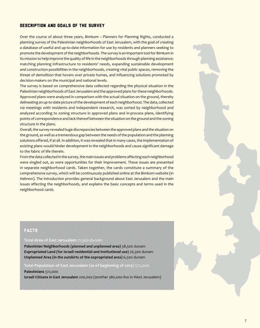
Description and Goals of the Survey
Over the course of about three years, Bimkom – Planners for Planning Rights, conducted a planning survey of the Palestinian neighborhoods of East Jerusalem, with the goal of creating a database of useful and up-to-date information for use by residents and planners seeking to promote the development of the neighborhoods. The survey is an important tool for Bimkom in its mission to help improve the quality of life in the neighborhoods through planning assistance: matching planning infrastructure to residents’ needs, expanding sustainable development and construction possibilities in the neighborhoods, creating vital public spaces, removing the threat of demolition that hovers over private homes, and influencing solutions promoted by decision-makers on the municipal and national levels. The survey is based on comprehensive data collected regarding the physical situation in the Palestinian neighborhoods of East Jerusalem and the approved plans for these neighborhoods. Approved plans were analyzed in comparison with the actual situation on the ground, thereby delineating an up-to-date picture of the development of each neighborhood. The data, collected via meetings with residents and independent research, was sorted by neighborhood and analyzed according to zoning structure in approved plans and in-process plans, identifying points of correspondence and lack thereof between the situation on the ground and the zoning structure in the plans. Overall, the survey revealed huge discrepancies between the approved plans and the situation on the ground, as well as a tremendous gap between the needs of the population and the planning solutions offered, if at all. In addition, it was revealed that in many cases, the implementation of existing plans would hinder development in the neighborhoods and cause significant damage to the fabric of life therein.From the data collected in the survey, the main issues and problems affecting each neighborhood were singled out, as were opportunities for their improvement. These issues are presented in separate neighborhood cards. Taken together, the cards constitute a summary of the comprehensive survey, which will be continuously published online at the Bimkom website (in Hebrew). The introduction provides general background about East Jerusalem and the main issues affecting the neighborhoods, and explains the basic concepts and terms used in the neighborhood cards.
Facts
Total Area of East Jerusalem 71,300 dunamPalestinian Neighborhoods (planned and unplanned area) 38,500 dunamExpropriated Land (for Israeli residential and institutional use) 26,300 dunamUnplanned Area (in the outskirts of the expropriated area) 6,500 dunam
Total Population of East Jerusalem (as of beginning of 2013) 572,000Palestinians 372,000 Israeli Citizens in East Jerusalem 200,000 (another 380,000 live in West Jerusalem)
7

The Jerusalem 2000 Outline Plan
The Jerusalem 2000 Outline Plan is the first outline plan for Jerusalem to include the entire municipal area of the city, both West and East Jerusalem. The plan broaches many urban issues: housing, transportation, open spaces, preservation, etc., and suggests new directions for development in the city. The plan was approved by the planning committees in 2009, at which time it was intended to have been deposited for public review. It was never deposited, however, and therefore never reached the validation stage. Although the frozen plan is considered no more than a “policy document,” for all intents and purposes, the planning authorities relate to it as if it were a valid plan.
As far as residential construction is concerned, the plan proposes an addition of housing units for the Palestinian neighborhoods in two ways: the first is the densification of the built-up fabric within the existing borders of the neighborhoods, by increasing building rights (building ratio and number of storeys); the second is the expansion of the neighborhoods by adding new areas. Showing a clear preference for densification over expansion, the plan proposes excessive densification for the neighborhoods, thus accelerating their transition from rural-style neighborhoods to dense urban neighborhoods, though without conditioning such growth on improvement of infrastructure. In both cases, as will be described below, the addition of housing units is for the most part on paper alone.
Densification of existing neighborhoods – In places where a transition from two storeys to four storeys is proposed, the plan contains the stipulation that only two storeys may be added on an existing structure. So, for example, this limitation does not allow the exploitation of all four storeys in places where there are one-storey buildings, unless the building is demolished and a new one built in its place. In places where six storeys are proposed, there are other limitations as well: a demand that projects be located adjacent to a road of at least 12-meters width (in the Palestinian neighborhoods there are almost no roads that wide), and a stipulation that projects be planned on plots of more than 10 dunam (there are few such large vacant plots within the Palestinian neighborhoods). As we have said, these limitations render the proposed additions purely theoretical.
Expansion of neighborhoods – Most of the proposed expansion areas in the outline plan are for areas that have already been built up through spontaneous construction. Thus, the significance of these expansions is that they provide a planning framework within which it would be possible to retroactively approve homes that were built without permits. Proposed expansion areas on already built-up areas do not therefore constitute meaningful land reserves for future construction. In addition, there is a severe limitation on development in the new expansion areas, namely, that any detail planning by private owners must be preceded by the general planning of each and every expansion in its entirety. Due to the fact that most of the land in East Jerusalem is privately owned, private landowners often independently advanced detail planning in the Palestinian neighborhoods of East Jerusalem (ever since this was made legal in 1995). The new limitations have halted this process, while the municipality advances general planning for the expansion areas at a very slow pace.
Population and StatisticsAt the head of each card appear statistics about the size of the population living in each neighborhood. It is important to emphasize that these statistics are not always precise. The numbers represent an adaptation of the statistics published in the 2012 Annual Statistical Report of the Jerusalem Institute for Israel Studies. The authors of the statistical report attribute the imprecision of their data to the existence of sectors that do not report about inward and outward migration to and from Jerusalem, and to the rush back into the municipal boundaries by Palestinians in the
wake of the construction of the Separation Barrier. Another challenge in determining the size of the population in every neighborhood is the lack of correspondence between the spatial break-down done in our survey and that of the Central Bureau of Statistics (CBS), not to mention the fact that in recent years the CBS has grouped together the statistics for a number of statistical areas. Nonetheless, we view it as essential to provide these statistics, alongside the area of the neighborhood (in dunam), in order to provide a general picture of the population density of each neighborhood.
Main Issues
East JerusalemEast Jerusalem is part of the territory occupied by the state of Israel in the 1967 war. Following the war, Israel included the area of East Jerusalem – whose area included the Jordanian city of Jerusalem as well as more than twenty surrounding villages – within the municipal boundaries of Jerusalem. As opposed to the residents of the rest of the Occupied Territories, who were left without any civic status, the approximately 69,000 Palestinians in East Jerusalem, who were present for the Israeli census taken immediately following the war, were granted permanent residency status in Israel, though without full citizenship. The state of Israel views East Jerusalem as an integral part of Jerusalem, and has applied Israeli law there. Immediately upon the de facto annexation of East Jerusalem, Israel began to strengthen its hold over East Jerusalem through the establishment of new neighborhoods, intended for Israelis only and generally built on lands that were expropriated from their Palestinian owners. Although located beyond the Green Line, these neighborhoods are perceived by the Israeli public as an inseparable part of Israel. The international community, however, does not recognize the annexation, and considers East Jerusalem to be occupied territory and the Israeli neighborhoods built there to be settlements. Even though the State of Israel presents Jerusalem as a united city, in reality, the different groups that make up the city’s social fabric live mostly in separate neighborhoods.
The Demographic BalanceIsrael’s planning policy in Jerusalem is subordinate to the principle of maintaining the demographic balance in the city, by increasing and strengthening the Jewish majority in the city while encouraging the continual reduction of the Palestinian population. The goal is to ensure that the Palestinians remain a minority in the city, despite actual trends in population growth and immigration to and from the city. The Israeli planning apparatus serves as a tool in the hands of the state for achieving this goal.
Planning Policy in East JerusalemGuided by the above-described demographic principle, the planning policy for the Palestinian neighborhoods in East Jerusalem since 1967 has been to enable very little additional construction in the neighborhoods, beyond the already existing fabric. As a result, the outline plans drawn up for the neighborhoods have several endemic problems: insufficient area designated for residential development, coupled by inadequate building rights in those areas; a surplus of areas designated as open spaces; a sparse road network that limits provision of infrastructures and development of inaccessible areas; a general paucity of public structures and their placement in unsuitable locations; a virtual lack of business and commercial zones; etc. Moreover, since large parts of these outline plans are not detailed, and therefore do not suffice for requesting building permits, detail plans must be drawn up before building permits can be requested and actual development can take place.
Development in East JerusalemThe Jerusalem Municipality has done little to develop the Palestinian neighborhoods. It has built few public structures, developed hardly any public parks, and paved virtually none of the roads that appear on the plans it itself drew up. This vacuum has been filled by the residents themselves, who either draw up their own detail plans on their land or build in a more spontaneous fashion, while not heeding the zoning designations that appear in the plans. As a result, the Palestinian population in East Jerusalem, which has grown five-fold since 1967, lives in crowded conditions, in neighborhoods that have undergone a rapid process of urbanization, with no sufficient planning infrastructure to accompany this growth.
The Separation BarrierIn the early 2000s, following a wave of terror attacks inside of Israel, the state of Israel began to build the Separation Barrier, in an irregular and accelerated planning process and in contravention of existing plans. The barrier, whose stated purpose was to separate between the Palestinian population, which was perceived as a security threat, and the Israeli
population, in effect slices through Palestinian communities, creating enclaves and tearing apart social structures. Most of the Palestinian neighborhoods of East Jerusalem remained on the Israeli side of the barrier but, along with many West-Bank villages and towns around Jerusalem, several neighborhoods that belong to the Jerusalem Municipality, partially or entirely, were left on the Palestinian side of the barrier: Kafr Aqab, the Shuafat refugee camp, Ras Khamis, Ras Shihadi, New Anata, and al-Walaje (a total of about 4,200 dunam). Planning and development in these neighborhoods is extremely poor, and of late they do not even receive basic municipal services. Requiring additional research, these neighborhoods are not included in the present survey. The route of the Separation Barrier also cuts off parts of the West Bank around Jerusalem from the rest of the West Bank. These enclaves, located on the Israeli side of the barrier but not included in the municipal boundary of Jerusalem, are included in the survey.
Open SpacesIn approved plans for the Palestinian neighborhoods of East Jerusalem, open spaces are designated using various categories: open public area, open scenic area, national park, nature reserve, and a few others. Only the first of these categories allows for the land to be expropriated for public use by the local authorities (while compensating the landowner). Meanwhile, the zoning category “open scenic area,” which dictates a complete prohibition on construction, with no compensation for landowners and no municipal obligation to develop, is the one that appears most commonly in the plans. The zoning category “nature reserve” was used, inexplicably, in a number of places despite their lack of any particular scenic value. In recent years, there has been a trend to zone vacant areas as national parks, even if they have no particular scenic or cultural value. National parks are a powerful tool used by the authorities to expel and exclude Palestinians from their land and limit the development of their neighborhoods. Either way, in the Palestinian neighborhoods of East Jerusalem, the municipality has built very few parks and playgrounds for the residents’ welfare.
8 9
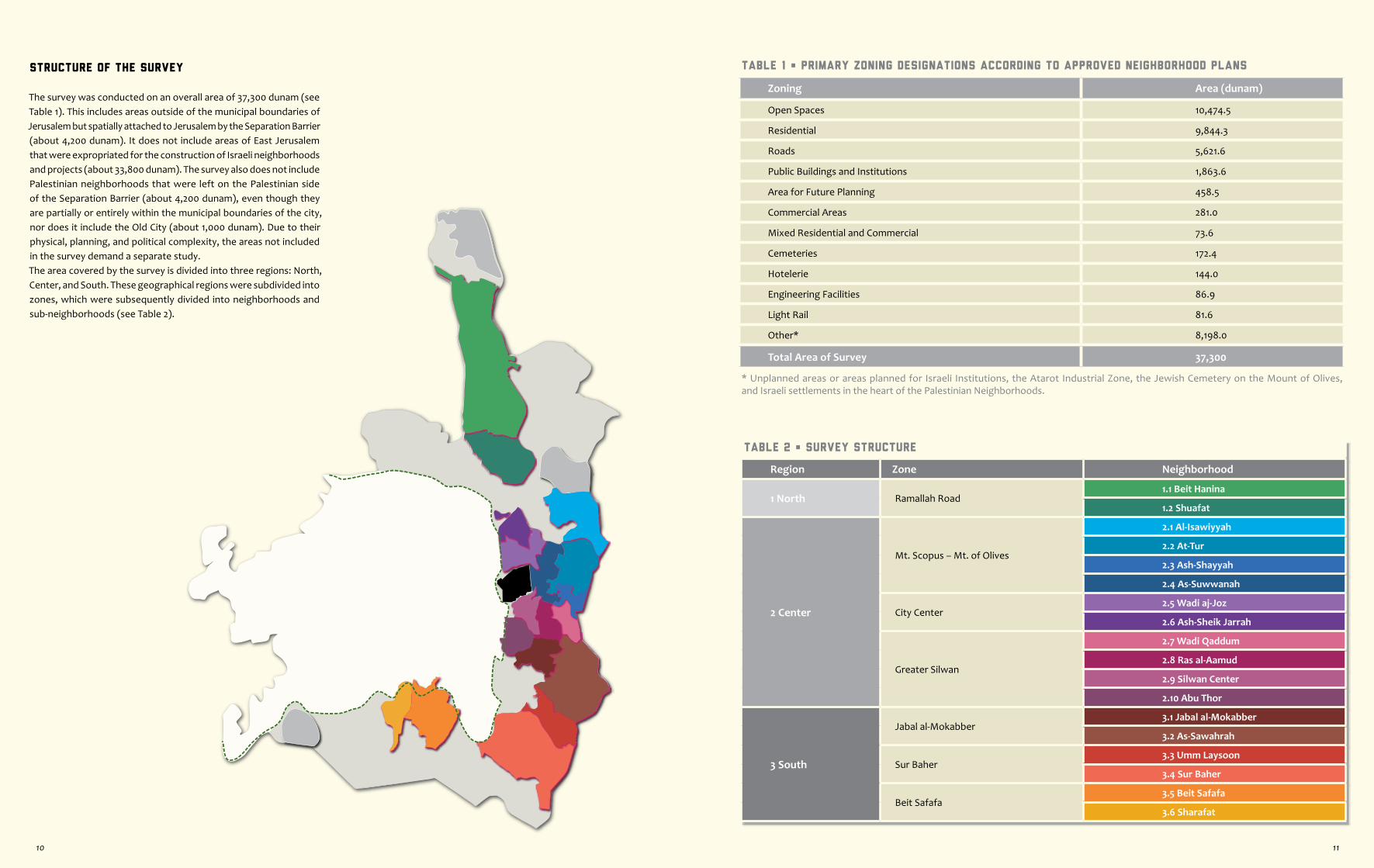
Table 1 • Primary Zoning Designations According to Approved Neighborhood Plans
Zoning Area (dunam)
Open Spaces 10,474.5
Residential 9,844.3
Roads 5,621.6
Public Buildings and Institutions 1,863.6
Area for Future Planning 458.5
Commercial Areas 281.0
Mixed Residential and Commercial 73.6
Cemeteries 172.4
Hotelerie 144.0
Engineering Facilities 86.9
Light Rail 81.6
Other* 8,198.0
Total Area of Survey 37,300
* Unplanned areas or areas planned for Israeli Institutions, the Atarot Industrial Zone, the Jewish Cemetery on the Mount of Olives, and Israeli settlements in the heart of the Palestinian Neighborhoods.
Table 2 • Survey Structure
Region Zone Neighborhood
1 North Ramallah Road1.1 Beit Hanina
1.2 Shuafat
2 Center
Mt. Scopus – Mt. of Olives
2.1 Al-Isawiyyah
2.2 At-Tur
2.3 Ash-Shayyah
2.4 As-Suwwanah
City Center2.5 Wadi aj-Joz
2.6 Ash-Sheik Jarrah
Greater Silwan
2.7 Wadi Qaddum
2.8 Ras al-Aamud
2.9 Silwan Center
2.10 Abu Thor
3 South
Jabal al-Mokabber3.1 Jabal al-Mokabber
3.2 As-Sawahrah
Sur Baher3.3 Umm Laysoon
3.4 Sur Baher
Beit Safafa 3.5 Beit Safafa
3.6 Sharafat
Structure of the Survey
The survey was conducted on an overall area of 37,300 dunam (see Table 1). This includes areas outside of the municipal boundaries of Jerusalem but spatially attached to Jerusalem by the Separation Barrier (about 4,200 dunam). It does not include areas of East Jerusalem that were expropriated for the construction of Israeli neighborhoods and projects (about 33,800 dunam). The survey also does not include Palestinian neighborhoods that were left on the Palestinian side of the Separation Barrier (about 4,200 dunam), even though they are partially or entirely within the municipal boundaries of the city, nor does it include the Old City (about 1,000 dunam). Due to their physical, planning, and political complexity, the areas not included in the survey demand a separate study.The area covered by the survey is divided into three regions: North, Center, and South. These geographical regions were subdivided into zones, which were subsequently divided into neighborhoods and sub-neighborhoods (see Table 2).
10 11


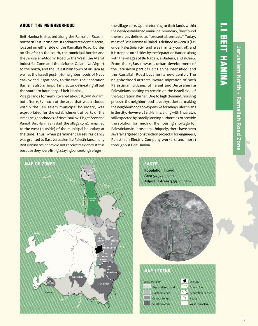
About the Neighborhood
Beit Hanina is situated along the Ramallah Road in northern East Jerusalem. Its primary residential areas, located on either side of the Ramallah Road, border on Shuafat to the south, the municipal border and the Jerusalem-Modi’in Road to the West, the Atarot Industrial Zone and the defunct Qalandiya Airport to the north, and the Palestinian town of ar-Ram as well as the Israeli post-1967 neighborhoods of Neve Yaakov and Pisgat Zeev, to the east. The Separation Barrier is also an important factor delineating all but the southern boundary of Beit Hanina.Village lands formerly covered about 15,000 dunam, but after 1967 much of the area that was included within the Jerusalem municipal boundary, was expropriated for the establishment of parts of the Israeli neighborhoods of Neve Yaakov, Pisgat Zeev and Ramot. Beit Hanina al-Balad (the village core), remained to the west (outside) of the municipal boundary at the time. Thus, when permanent Israeli residency was granted to East Jerusalemite Palestinians, many Beit Hanina residents did not receive residency status because they were living, staying, or seeking refuge in
the village core. Upon returning to their lands within the newly established municipal boundary, they found themselves defined as “present-absentees.” Today, most of Beit Hanina al-Balad is defined as Area B (i.e. under Palestinian civil and Israeli military control), and it is trapped on all sides by the Separation Barrier, along with the villages of Bir Nabala, al-Jadeira, and al-Jeeb. From the 1980s onward, urban development of the Jerusalem part of Beit Hanina intensified, and the Ramallah Road became its new center. The neighborhood attracts inward migration of both Palestinian citizens of Israel and Jerusalemite Palestinians seeking to remain on the Israeli side of the Separation Barrier. Due to high demand, housing prices in the neighborhood have skyrocketed, making the neighborhood too expensive for many Palestinians in the city. However, Beit Hanina, along with Shuafat, is still expected by Israeli planning authorities to provide the solution for much of the housing shortage for Palestinians in Jerusalem. Uniquely, there have been several targeted construction projects (for engineers, Palestinian Electric Company workers, and more) throughout Beit Hanina.
Jaffa Rd.
Rd. 4
Heb
ron
Rd.
Ramallah Rd.
Hwy 1
Hwy 443Hwy 45
Rd. 20
Hw
y 40
4
Hw y 1
Hwy 60
Hw
y 60
(o
ld)
Hw
y 60 (old)
Hwy 60
RamallahRoad
Anata
Kafr Aqab
Mt. of Olives
Mt.Scopus&
City Center
GreaterSilwan
al-Mokabber
Jabal
Sur Baher
Beit Safafa
Al-Walaje
MAP OF ZONES
Map Legend
Population 41,000Area 5,237 dunamAdjacent Areas 3,391 dunam
Facts
Separation Barrier
West Jerusalem
East Jerusalem
Expropriated Land
Northern Zones
Central Zones
Southern Zones
Old City
Roads
Green Line
1.1 Beit
Hanin
a
Jerusalem N
orth • Ramallah Road Zone
15
Al-Aqabeh (photo Bimkom)
Bottom-Up Planning
Beit Hanina is an excellent example of a place in which alternative grassroots plans have emerged based on local initiatives, cooperation between residents, and organizational support from the community center. The plans aimed to enable construction and to legalize existing houses in areas that were previously zoned as open scenic areas.Plan # 6671 for the Hod at-Tabel sub-neighborhood (Wadi ad-Dam and al-Aqabeh), on 628 dunam in the northwest part of Beit Hanina, was authorized in January 2002. The plan proposes a unique mechanism allowing the landowners whose land remains zoned as open scenic area, to build one residential building on each plot, up to a certain volume. The exact placement of the house is not stipulated precisely in the plan, and is left to the discretion of the landowner, under certain restrictions. This mechanism enables all landowners to realize their right to live on their land and provides flexibility concerning the precise development of the area.Plan # 9713 for the al-Ashqariyah area in the southwest part of the neighborhood, covering about 83 dunam, was authorized only recently (2012). The plan formalizes the status of this residential neighborhood, built spontaneously over the years on land designated as open scenic area. Only part of this area was included in the expansion area proposed in the Jerusalem 2000 Outline Plan, even though planning had begun prior to the approval of the outline plan for deposition. Through collaboration between the residents, a unique mechanism was created for allotting areas for public use. Accordingly, landowners who owned vacant land allocated larger areas than their neighbors and in exchange received higher building rights. Likewise, the residents collectively purchased land to serve as open public area. These two plans testify to the fact that sensitive planning, with full cooperation between residents and based on creative planning ideas, can yield positive results both in order to legalize existing construction and to create a framework for new construction, while strengthening the public and community infrastructure.
slated for cancellation, thus preserving the historical route of the road.
The Unrecognized NeighborhoodPart of the West-Bank village of Qalandiya was included within the municipal boundary of Jerusalem after 1967. This small neighborhood is not contiguous with the residential areas of Beit Hanina and it is trapped between the Atarot Industrial Zone and the defunct Qalandiya Airport, which was built by the British. Approximately one quarter of the area is zoned as industrial, and most of it is un-planned. Several small-scale detail plans were approved, allowing residential construction and hotels. De facto, the land serves for housing and agriculture. The Separation Barrier eats into the western part of the neighborhood, leaving a number of houses on the Palestinian side. One cluster of houses, in the eastern part of the neighborhood, was designated in the Jerusalem 2000 Outline Plan as an existing urban residential area, though the area is not zoned as residential in approved plans.
Dakhyat al-BareedThe neighborhood of Dakhyat al-Bareed (literally “the postal suburb”) is located in the northeastern part of Beit Hanina, east of Highway 60 and outside of the Jerusalem municipal boundary. Until the erection of the Separation Barrier, this neighborhood was an integral part of the urban fabric of ar-Ram, though it is also contiguous with a small part of Beit Hanina that is east of Highway 60. About a quarter of Dakhyat al-Bareed is classified as Area B, i.e., under Palestinian civil control, and the rest as Area C, under complete Israeli military and civil control. De facto, the neighborhood is cut off physically from ar-Ram and the Palestinian Authority (which provided it with services until the building of the barrier), and administratively from Jerusalem, to which it is now spatially bound. As a result, it receives municipal services from no one, and its residents remain trapped between checkpoints and walls.
Approved Plans for Beit HaninaPart of Local Outline Plan # 3000b for Beit Hanina and Shuafat 5,195.0 dunamTotal planned area 5,195.0 dunamUnplanned area 42.0 dunamTotal area of neighborhood 5,237.0 dunamTwo detailed outline plans (3457a, 3458a) rezoned about 3,022 dunam of the area of the local outline plan (3000b), including 29 re-parcelization plans on a total area of about 1,237 dunam. Additional detailed outline plans (6671, 9713, 11448), for Hod at-Tabel and al-Ashqariyah, rezoned another roughly 733 dunam of the area of the original plan.In addition, about 115 dunam were rezoned as part of detailed infrastructure plans (9081a for Road 20, and 8000 for the Light Rail). Likewise, dozens of small-scale detail plans were approved in the neighborhood, increasing building rights in limited areas.
Approved Plans for Adjacent AreasDetailed outline plans (1689a + b, 3012, 4572) for the Atarot Industrial Zone 1,563.0 dunam
Small-scale detail plans (5357a, 6330, 3891) in the unrecognized neighborhood 7.0 dunamTotal planned area 1,570.0 dunamUnplanned area 1,821.0 dunamTotal area of adjacent areas 3,391.0 dunamThe detailed outline plans for the industrial zone also include part of the unrecognized neighborhood. Seven small-scale detail plans were approved in the industrial zone, adding building rights to limited areas. The unplanned area includes areas within the municipal boundary beyond the Separation Barrier, as well as areas on the Israeli side of the Separation Barrier but not included within the municipal boundary.
Main Problems in and around
Beit Hanina
The Jerusalem 2000 Outline PlanThe Jerusalem 2000 Outline Plan (pending deposition) proposes a seemingly significant densification of Beit Hanina. However, only a small part of the potential can be realized, as in neighboring Shuafat. In addition, the outline plan allocates two expansion areas for Beit Hanina. The first is an already built-up area of about 160 dunam (of which 40 are de facto part of Shuafat) in the southwestern al-Ashqariyah quarter. During the last decade, two resident-initiated plans have been approved for part of this expansion area, and even a little beyond it, on a total area of nearly 100 dunam. In other words, a large part of the expansion area was already in planning stages even before the outline plan was approved for deposition. The Beit Hanina-Shuafat Community Center seeks to promote planning for the rest of the expansion area, including the establishment of a new cemetery (see: Road 20). The second expansion area, of about 600 dunam, is located in the mostly vacant area known as Tal al-Adasah, north of the al-Aqabeh sub-neighborhood. In recent years, a general plan for the area has been promoted by local landowners, supported by non-governmental organizations, and in coordination with the Jerusalem Municipality. Proposing some 2,500 housing units, as well as a district park, the plan is in initial stages and has not yet been submitted to the planning authorities.
Land RegistrationRegistration of most of the land in Beit Hanina is considered “in progress.” This status hinders the approval of detail plans and the granting of building permits, which are conditioned upon proof of land ownership. In the common case of multiple heirs, agreements must be reached among themselves, or verification of ownership by neighbors and mukhtars must be obtained. Furthermore, attempts by landowners who live in Beit Hanina al-Balad to register their land can result in the declaration of the land as absentee property, which in turn leads to its registration as Israeli state land. The issue is further complicated by the many re-parcelization plans that have been approved (or are in progress) in the neighborhood over the past 15 years. The uncertainty has led to many incidents of land theft using forged documents. Simultaneously, the municipality placed stricter requirements on proof of ownership, making it even harder for residents to get building permits. Recently, the municipality began to operate an experimental permits committee out of the Beit-Hanina-Shuafat Community Center. In an effort to shorten the building application process, the committee verifies ownership for residents interested in legalizing existing construction and/or building new buildings according to an approved plan.
Road 20The route of Road 20 is mostly based on the historical road that ran east-west from Beit Hanina al-Balad to the Ramallah Road. After 1967, the old road continued to serve the residents of Beit Hanina, among other things to reach the cemetery in the village core. Over the years, the original road was expanded and extended eastward to provide the residents of Pisgat Zeev quicker access to the Jerusalem-Modi’in Road. This new segment severed Beit Hanina in two, leaving pedestrian-only passages via two bridges. The western segment, diverging from the original route in order to bypass the Separation Barrier enclave, was constructed as a massive bridge, to the detriment of the landscape. The blocking of the original road by the Separation Barrier has turned the short drive to the village core into an hour-and-a-half ordeal that involves passing through the Qalandiya checkpoint. Following a petition to the HCJ by a village resident who
lives adjacent to the barrier, on the Israeli side, a gate is opened upon coordination, in order to allow him to farm his land beyond the barrier.
Settler ActivityIn 2012, the phenomenon of Israeli settlement in the heart of Palestinian neighborhoods in East Jerusalem spread beyond the neighborhoods around the Old City, when a family of 13 was forcefully evicted from its home in Beit Hanina. In the same compound, after ongoing harassment from settlers, two more Palestinian families were evicted. According to newspaper reports, the settlers are planning to submit a plan for dozens of housing units on site. The eviction of the Palestinian families was made possible after the court accepted proof of Jewish land ownership prior to 1948 (a legal option not available to Palestinians regarding their pre-1948 lost property). In addition, of late, settler organizations have tried to cancel a legitimate transaction in which the Hebrew University sold some of its lands in Beit Hanina to the Palestinian organization Majlis al-Iskan, which operates as a de facto Housing Ministry for Palestinians in East Jerusalem.
The Disputed TerritoryNear the intersection of the Ramallah Road and Highway 60 (at the entrance to Neve Yaakov), is an area that was originally zoned for public kindergartens. Its proximity to a gas station made it impossible to implement it as such. The community center worked towards developing the area as a public park, while searching for an alternative site for essential public services. They filed a request to rezone the vacant plot across the street, formerly the site of a military base and currently zoned for future planning, as a public high school. The residents of Neve Yaakov adamantly opposed the idea, claiming that it posed a security threat. The opposition was steadfast also when it was proposed to designate the site for a girls’ school, kindergartens, or even an institution for the handicapped. Recently a compromise was reached in which the site will be re-planned for Beit Hanina’s public services, while an educational facility (apparently a Yeshiva) will be developed for the residents of Neve Yaakov, east of Highway 60. The plan will also entail the regularization of an existing segment of the Ramallah Road, which was previously
16 17
Adjacent Areas
NamePlans
Land Usedunam %
Atarot Industrial Zone
1,462 43
Most of the area is zoned for industry and roads, as well as for private and open public areas. To establish the industrial zone, the land was expropriated mostly from residents of Beit Hanina. In the northeastern part there is a vacant area of about 25 dunam that is designated for future planning and on which the residents seek to promote a development plan. On the western edge, about 17 unplanned dunam are today caught within the al-Mawahel section of the Bir Nabala enclave.
Unrecognized Neighborhood (Qalandiya)
526 16Aside from the existing residential buildings, the area contains farmed land as well as un-built land. Most of the planned area is designated for industrial use and for the expansion of the east-west artery connecting Road 45 to Highway 60. About half of the area remains unplanned (see: The Unrecognized Neighborhood).
Dakhyat al-Bareed Enclave
183 5A sub-neighborhood of ar-Ram, most of which is located outside the Jerusalem municipal boundary but on the Israeli side of the Separation Barrier. The area is entirely built-up (see: Dakhyat al-Bareed).
Seam-zone Enclave
1,220 36This area is trapped between the municipal boundary and the Separation Barrier and contains a small part of the Hod at-Tabel sub-neighborhood and an isolated house adjacent to the barrier (see: Road 20). The land is owned by Beit Hanina residents, living both inside and out of the municipal boundary, and is mostly used for agriculture.
Total 3,391 100
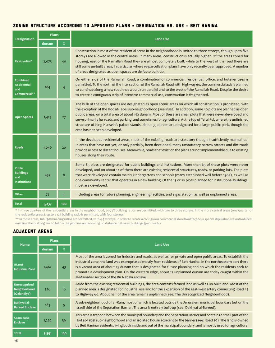
Zoning Structure According to Approved Plans • Designation vs. Use - Beit Hanina
DesignationPlans
Land Usedunam %
Residential* 2,075 40
Construction in most of the residential areas in the neighborhood is limited to three storeys, though up to five storeys are allowed in the central areas. In many areas, construction is actually higher. Of the areas zoned for housing, east of the Ramallah Road they are almost completely built, while to the west of the road there are still some un-built areas, in particular where re-parcelization plans have only recently been approved. A number of areas designated as open spaces are de facto built-up.
Combined Residential and Commercial**
184 4
On either side of the Ramallah Road, a combination of commercial, residential, office, and hotelier uses is permitted. To the north of the intersection of the Ramallah Road with Highway 60, the commercial axis is planned to continue along a new road that would run parallel and to the west of the Ramallah Road. Despite the desire to create a contiguous strip of intensive commercial use, construction is fragmented.
Open Spaces 1,423 27
The bulk of the open spaces are designated as open scenic areas on which all construction is prohibited, with the exception of the Hod at-Tabel sub-neighborhood (see inset). In addition, some 40 plots are planned as open public areas, on a total area of about 152 dunam. Most of these are small plots that were never developed and serve primarily for roads and parking, and sometimes for agriculture. At the top of Tel al-Ful, where the unfinished structure of King Hussein’s palace stands, about 35 dunam are designated for a large public park, though the area has not been developed.
Roads 1,046 20
In the developed residential areas, most of the existing roads are statutory though insufficiently maintained. In areas that have not yet, or only partially, been developed, many unstatutory narrow streets and dirt roads provide access to distant houses. Meanwhile, roads that exist on the plans are not implementable due to existing houses along their route.
Public Buildings and Institutions
437 8
Some 85 plots are designated for public buildings and institutions. More than 65 of these plots were never developed, and on about 12 of them there are existing residential structures, roads, or parking lots. The plots that were developed contain mainly kindergartens and schools (many established well before 1967), as well as one community center that operates in a new building. Of the 15 or so plots planned for institutional buildings, most are developed.
Other 72 1 Including areas for future planning, engineering facilities, and a gas station, as well as unplanned areas.
Total 5,237 100
* In three quarters of the residential areas in the neighborhood, 50-75% building ratios are permitted, with two to three storeys. In the more central areas (one quarter of the residential areas), up to a 12% building ratio is permitted, with four storeys.** In these areas, 100-150% building ratios are permitted, with 4-5 storeys. In order to create a contiguous commercial storefront façade, a special stipulation was introduced, enabling the building line to follow the plot line and allowing no distance between buildings (joint walls).
18
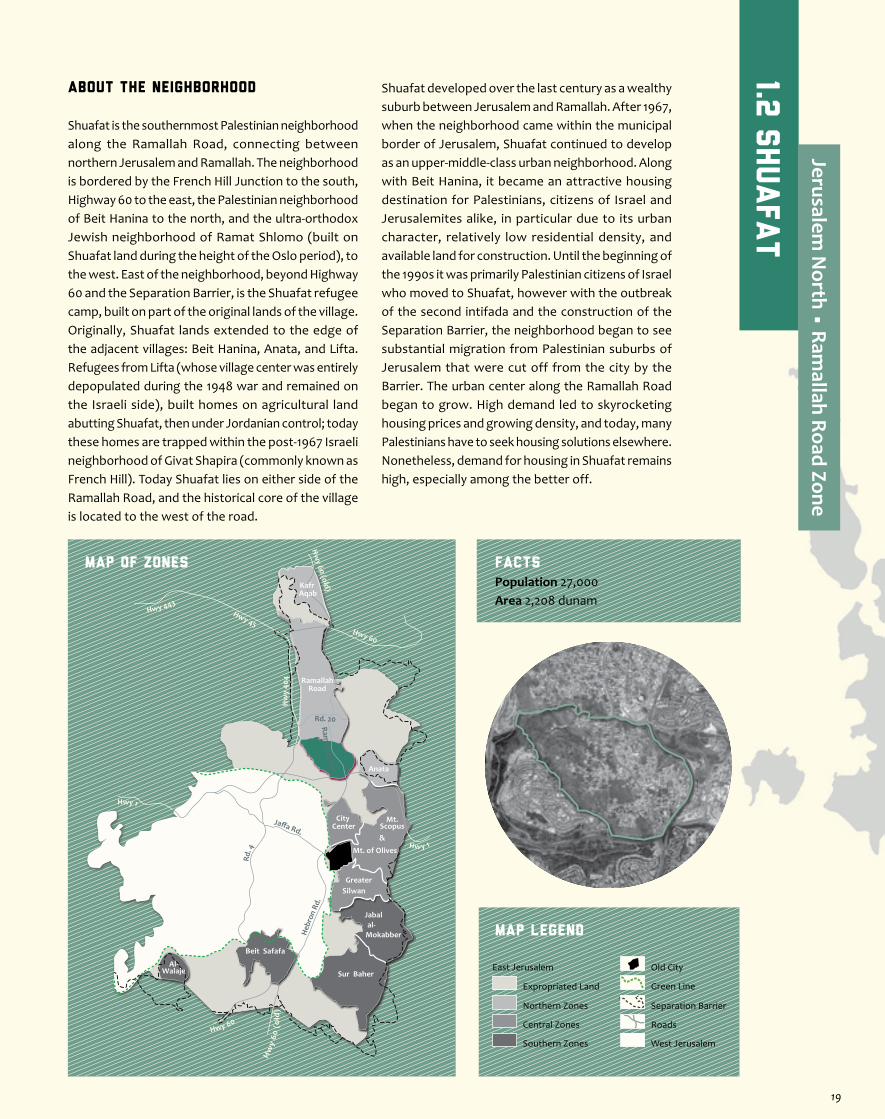
About the Neighborhood
Shuafat is the southernmost Palestinian neighborhood along the Ramallah Road, connecting between northern Jerusalem and Ramallah. The neighborhood is bordered by the French Hill Junction to the south, Highway 60 to the east, the Palestinian neighborhood of Beit Hanina to the north, and the ultra-orthodox Jewish neighborhood of Ramat Shlomo (built on Shuafat land during the height of the Oslo period), to the west. East of the neighborhood, beyond Highway 60 and the Separation Barrier, is the Shuafat refugee camp, built on part of the original lands of the village. Originally, Shuafat lands extended to the edge of the adjacent villages: Beit Hanina, Anata, and Lifta. Refugees from Lifta (whose village center was entirely depopulated during the 1948 war and remained on the Israeli side), built homes on agricultural land abutting Shuafat, then under Jordanian control; today these homes are trapped within the post-1967 Israeli neighborhood of Givat Shapira (commonly known as French Hill). Today Shuafat lies on either side of the Ramallah Road, and the historical core of the village is located to the west of the road.
Shuafat developed over the last century as a wealthy suburb between Jerusalem and Ramallah. After 1967, when the neighborhood came within the municipal border of Jerusalem, Shuafat continued to develop as an upper-middle-class urban neighborhood. Along with Beit Hanina, it became an attractive housing destination for Palestinians, citizens of Israel and Jerusalemites alike, in particular due to its urban character, relatively low residential density, and available land for construction. Until the beginning of the 1990s it was primarily Palestinian citizens of Israel who moved to Shuafat, however with the outbreak of the second intifada and the construction of the Separation Barrier, the neighborhood began to see substantial migration from Palestinian suburbs of Jerusalem that were cut off from the city by the Barrier. The urban center along the Ramallah Road began to grow. High demand led to skyrocketing housing prices and growing density, and today, many Palestinians have to seek housing solutions elsewhere. Nonetheless, demand for housing in Shuafat remains high, especially among the better off.
Jaffa Rd.
Rd. 4
Heb
ron
Rd.
Ramallah Rd.
Hwy 1
Hwy 443Hwy 45
Rd. 20
Hw
y 40
4
Hw y 1
Hwy 60
Hw
y 60
(o
ld)
Hw
y 60 (old)
Hwy 60
RamallahRoad
Anata
Kafr Aqab
Mt. of Olives
Mt.Scopus&
City Center
GreaterSilwan
al-Mokabber
Jabal
Sur Baher
Beit Safafa
Al-Walaje
MAP OF ZONES
Map Legend
Population 27,000Area 2,208 dunam
Facts
Separation Barrier
West Jerusalem
East Jerusalem
Expropriated Land
Northern Zones
Central Zones
Southern Zones
Old City
Roads
Green Line
1.2 s
huafat
Jerusalem N
orth • Ramallah Road Zone
19
Construction of Road 21 (photo Bimkom)
East of Ramallah Road (photo Bimkom) As-Sahel Plain (photo Bimkom)Village Center (photo Bimkom)
As-Sahel, the Undeveloped Plain
South of the village core, west of the Ramallah Road, and east of the open scenic areas that are designated for the expansion of the neighborhood, is a large, mostly vacant, plain of about 90 dunam. The area, known as as-Sahel (“the plain,” in Arabic), is a valuable and desirable land reserve, especially considering that flat, vacant, land is a rarity in Jerusalem in general and East Jerusalem in particular. Today, only a number of dirt roads and about six houses exist here. According to the neighborhood plan, the area is zoned mostly as residential, with sections designated for open areas or public buildings. Development of the area is pending the approval of its re-parcelization plan, which is being advanced by the Jerusalem Municipality. The objection of one of the landowners in the area, to the land-swap arrangements proposed in the plan, has frozen the planning process and led to the declaration of the rest of the re-parcelization plans as “parcelization for planning purposes only.” In areas adjacent to as-Sahel, additional re-parcelization plans have not yet been approved, also in the wake of objections by residents. As a result, the parcelization plans for as-Sahel and its immediate vicinity have been sent back to the drawing board. Until these are approved, the process of obtaining building permits and effectively developing these areas remains frozen, as it has been since the approval of the neighborhood plan a decade and a half ago. In summation, at the time of writing (2013), development of as-Sahel continues to be delayed.
Shuafat, in part because more intensive construction would be enabled along it.
Difficulties Obtaining Building PermitsLand-ownership registration in Shuafat is considered “in progress.” This fact encumbers the process of submission of detail plans and building-permit requests, which are contingent on proof of land-ownership. Furthermore, the neighborhood plan for Shuafat has designated various areas in which re-parcelization plans must be approved before any building permits can be issued. This process is extremely lengthy, and not always done in consultation with the landowners. As a result, the situation on the ground is not always reflected in the plans, once approved, and further adjustments are required. Likewise, in recently approved plans, the re-parcelization has no proprietary implications, because the Jerusalem Municipality legal advisor has deemed it impossible to implement proprietary re-parcelization on land for which registration is “in progress.” These bureaucratic obstacles hinder the implementation of approved plans, including the attainment of building permits and the regularization of existing construction. In order to remove some of the difficulties, a provisional permits committee was established in the Beit Hanina-Shuafat Community Center as a pilot program of the Jerusalem Municipality. The committee examines the initial feasibility of the requests, focusing on verification of the land ownership of residents who are interested in submitting requests for formalization of existing construction and/or new construction.
Main Problems in Shuafat
The Jerusalem 2000 Outline PlanThe new outline plan for Jerusalem, which awaits deposition, allocates an area of 130 dunam, west of the village core, for the expansion of Shuafat, on lands currently zoned as open scenic areas. The area is mostly vacant, and partly cultivated. One resident, who owns about a third of the area, has independently initiated a plan on his part of the land. However, since the Jerusalem 2000 Outline Plan stipulates that detailed planning is contingent on comprehensive planning for the entire expansion area, this plan is unlikely to be approved. The case demonstrates the difficulties residents encounter when trying to advance overall planning, even for substantive parcels of land. Meanwhile the Jerusalem Municipality has taken no steps to publicly initiate a comprehensive plan for this area. Thus, although the expansion is essential for the neighborhood’s development, it is not likely to be realized in the near future.In addition, some 440 dunam have been allotted for the expansion of Ramat Shlomo. The bulk of this expansion is a 330 dunam strip abutting the existing Ultra-Orthodox neighborhood from the southwest. This area is included in a publicly funded detail plan initiated by the housing ministry, which was fast-tracked towards final approval and implementation, as part of the Israeli government’s decision to
penalize the Palestinian Authority for seeking recognition at the UN by expanding Israeli construction in East Jerusalem.Most of the remainder of the expansion for Ramat Shlomo is located to the north, on land that is not contiguous with the built-up area of Ramat Shlomo. Rather, it protrudes deep into Shuafat’s land reserves, essentially laying the groundwork for a new Israeli settlement on Shuafat land. As evidence of these intentions, Shuafat’s expansion area was reduced to the current 130 dunam and the new settlement was drawn to connect with the entire Ramat Shlomo expansion.
Unrealistic Densification PolicyAt the time of the validation of the neighborhood plan for Shuafat, in 1998, the Local Planning and Building Committee already recognized that the building densities it provided would need to be enlarged, in order to meet the distinctively urban character of the neighborhood. As a result, some densification was implemented through re-parcelization plans and sporadic detail plans, though without an overarching policy. Such a policy was finally formulated in the Jerusalem 2000 Outline Plan (see elaboration), which stipulated that densification would occur via the construction of six to eight storeys with building ratios of 200% to 320%. And yet, the Jerusalem Municipality recanted, claiming that such an intense densification would result in a severe lack of public facilities
and open spaces. This estimate is based on unrealistic implementation predictions and does not account for the many available open public areas in Shuafat that are still awaiting development.In line with the municipality’s revised policy, since 2009 existing buildings are usually permitted small additions of up to two storeys, allowing a maximum of six storeys with 160-180% building ratios. Some further enlargement is possible on large plots and along the Ramallah Road. Since most of the residential areas are zoned for 2-3 storeys, this policy makes it virtually impossible to legalize an existing building of more than 5 storeys, and even that requires the submission of a detail plan – a long, expensive, and uncertain process. Moreover, the municipality’s policy uses increased building ratios (250%-320%) to encourage replacing existing buildings with new construction, particularly on large plots. This increase is conditioned, however, on the allocation of areas – whether vacant or built-up – for public use. In many cases the landowners are also required to develop the public area at their own expense. Most residents prefer expanding existing buildings, even if this means receiving fewer building rights, rather than partaking in such “allocation deals.” Thus, in effect only a small amount of the building potential proposed in the current policy is realized.
Road 21The neighborhood plan includes an additional main traffic artery known as Road 21, for which Shuafat land was expropriated. This route is planned to run through Shuafat and Beit Hanina, parallel and to the west of Ramallah Road, connecting the neighborhoods to the Atarot Industrial Zone. In Shuafat, the road is planned to connect to a new access road for Ramat Shlomo (and its completion is prerequisite for that neighborhood’s expansion; see: The Jerusalem 2000 Outline Plan). The road is currently being implemented, and the residents fear that construction will only go as far as the junction with Road 20, recently completed in Beit Hanina (for the purpose of connecting the Israeli neighborhood of Pisgat Zeev with the Jerusalem-Modi’in Road, leading to the coastal plain). Whether built partially or entirely, the road could bring benefits for the residents of
20 21
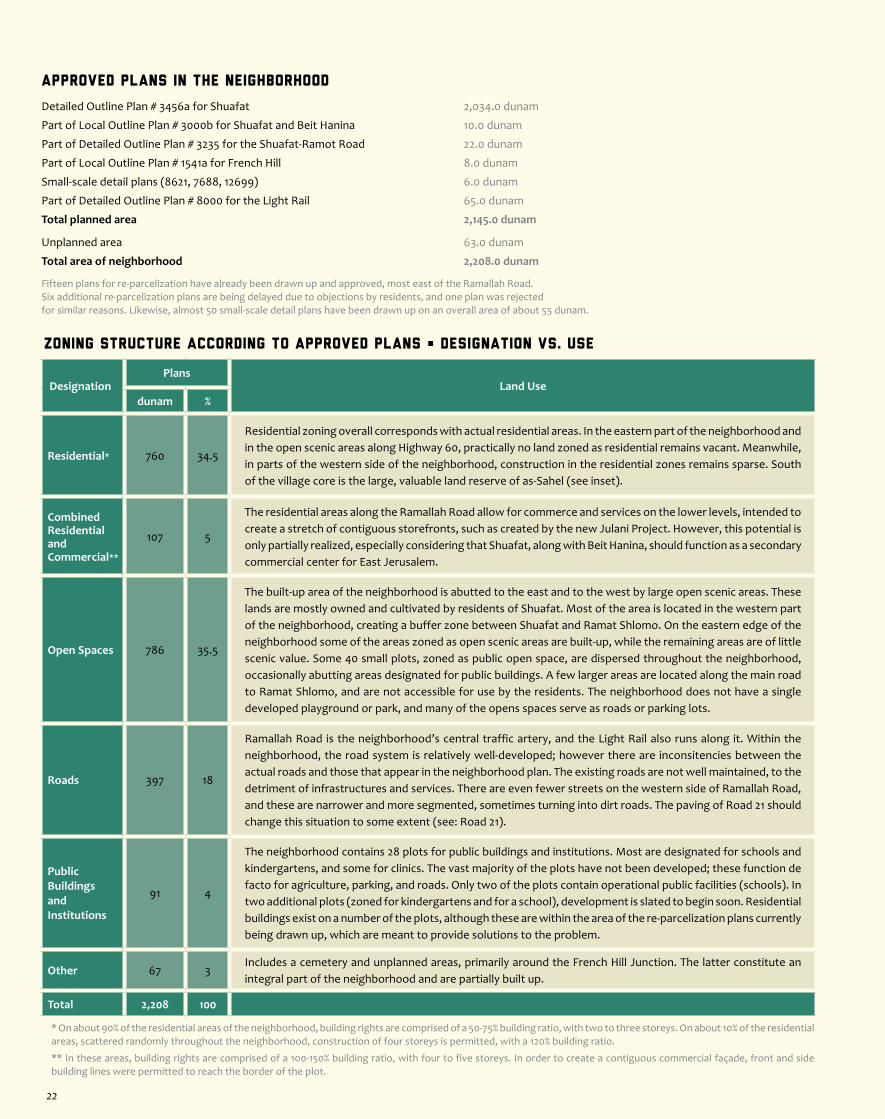
Zoning Structure According to Approved Plans • Designation vs. Use
DesignationPlans
Land Usedunam %
Residential* 760 34.5
Residential zoning overall corresponds with actual residential areas. In the eastern part of the neighborhood and in the open scenic areas along Highway 60, practically no land zoned as residential remains vacant. Meanwhile, in parts of the western side of the neighborhood, construction in the residential zones remains sparse. South of the village core is the large, valuable land reserve of as-Sahel (see inset).
CombinedResidential and Commercial**
107 5
The residential areas along the Ramallah Road allow for commerce and services on the lower levels, intended to create a stretch of contiguous storefronts, such as created by the new Julani Project. However, this potential is only partially realized, especially considering that Shuafat, along with Beit Hanina, should function as a secondary commercial center for East Jerusalem.
Open Spaces 786 35.5
The built-up area of the neighborhood is abutted to the east and to the west by large open scenic areas. These lands are mostly owned and cultivated by residents of Shuafat. Most of the area is located in the western part of the neighborhood, creating a buffer zone between Shuafat and Ramat Shlomo. On the eastern edge of the neighborhood some of the areas zoned as open scenic areas are built-up, while the remaining areas are of little scenic value. Some 40 small plots, zoned as public open space, are dispersed throughout the neighborhood, occasionally abutting areas designated for public buildings. A few larger areas are located along the main road to Ramat Shlomo, and are not accessible for use by the residents. The neighborhood does not have a single developed playground or park, and many of the opens spaces serve as roads or parking lots.
Roads 397 18
Ramallah Road is the neighborhood’s central traffic artery, and the Light Rail also runs along it. Within the neighborhood, the road system is relatively well-developed; however there are inconsitencies between the actual roads and those that appear in the neighborhood plan. The existing roads are not well maintained, to the detriment of infrastructures and services. There are even fewer streets on the western side of Ramallah Road, and these are narrower and more segmented, sometimes turning into dirt roads. The paving of Road 21 should change this situation to some extent (see: Road 21).
Public BuildingsandInstitutions
91 4
The neighborhood contains 28 plots for public buildings and institutions. Most are designated for schools and kindergartens, and some for clinics. The vast majority of the plots have not been developed; these function de facto for agriculture, parking, and roads. Only two of the plots contain operational public facilities (schools). In two additional plots (zoned for kindergartens and for a school), development is slated to begin soon. Residential buildings exist on a number of the plots, although these are within the area of the re-parcelization plans currently being drawn up, which are meant to provide solutions to the problem.
Other 67 3Includes a cemetery and unplanned areas, primarily around the French Hill Junction. The latter constitute an integral part of the neighborhood and are partially built up.
Total 2,208 100
* On about 90% of the residential areas of the neighborhood, building rights are comprised of a 50-75% building ratio, with two to three storeys. On about 10% of the residential areas, scattered randomly throughout the neighborhood, construction of four storeys is permitted, with a 120% building ratio.
** In these areas, building rights are comprised of a 100-150% building ratio, with four to five storeys. In order to create a contiguous commercial façade, front and side building lines were permitted to reach the border of the plot.
Approved Plans in the Neighborhood
Detailed Outline Plan # 3456a for Shuafat 2,034.0 dunam
Part of Local Outline Plan # 3000b for Shuafat and Beit Hanina 10.0 dunam
Part of Detailed Outline Plan # 3235 for the Shuafat-Ramot Road 22.0 dunam
Part of Local Outline Plan # 1541a for French Hill 8.0 dunam
Small-scale detail plans (8621, 7688, 12699) 6.0 dunam
Part of Detailed Outline Plan # 8000 for the Light Rail 65.0 dunam
Total planned area 2,145.0 dunam
Unplanned area 63.0 dunam
Total area of neighborhood 2,208.0 dunam
Fifteen plans for re-parcelization have already been drawn up and approved, most east of the Ramallah Road. Six additional re-parcelization plans are being delayed due to objections by residents, and one plan was rejected for similar reasons. Likewise, almost 50 small-scale detail plans have been drawn up on an overall area of about 55 dunam.
22


About the Neighborhood
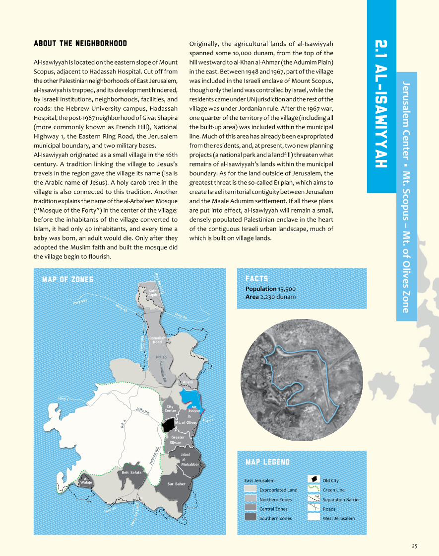
Al-Isawiyyah is located on the eastern slope of Mount Scopus, adjacent to Hadassah Hospital. Cut off from the other Palestinian neighborhoods of East Jerusalem, al-Issawiyah is trapped, and its development hindered, by Israeli institutions, neighborhoods, facilities, and roads: the Hebrew University campus, Hadassah Hospital, the post-1967 neighborhood of Givat Shapira (more commonly known as French Hill), National Highway 1, the Eastern Ring Road, the Jerusalem municipal boundary, and two military bases.Al-Isawiyyah originated as a small village in the 16th century. A tradition linking the village to Jesus’s travels in the region gave the village its name (Isa is the Arabic name of Jesus). A holy carob tree in the village is also connected to this tradition. Another tradition explains the name of the al-Arba’een Mosque (“Mosque of the Forty”) in the center of the village: before the inhabitants of the village converted to Islam, it had only 40 inhabitants, and every time a baby was born, an adult would die. Only after they adopted the Muslim faith and built the mosque did the village begin to flourish.
Originally, the agricultural lands of al-Isawiyyah spanned some 10,000 dunam, from the top of the hill westward to al-Khan al-Ahmar (the Adumim Plain) in the east. Between 1948 and 1967, part of the village was included in the Israeli enclave of Mount Scopus, though only the land was controlled by Israel, while the residents came under UN jurisdiction and the rest of the village was under Jordanian rule. After the 1967 war, one quarter of the territory of the village (including all the built-up area) was included within the municipal line. Much of this area has already been expropriated from the residents, and, at present, two new planning projects (a national park and a landfill) threaten what remains of al-Isawiyyah’s lands within the municipal boundary. As for the land outside of Jerusalem, the greatest threat is the so-called E1 plan, which aims to create Israeli territorial contiguity between Jerusalem and the Maale Adumim settlement. If all these plans are put into effect, al-Isawiyyah will remain a small, densely populated Palestinian enclave in the heart of the contiguous Israeli urban landscape, much of which is built on village lands.
Jaffa Rd.
Rd. 4
Heb
ron
Rd.
Ramallah Rd.
Hwy 1
Hwy 443Hwy 45
Rd. 20
Hw
y 40
4
Hw y 1
Hwy 60
Hw
y 60
(o
ld)
Hw
y 60 (old)
Hwy 60
RamallahRoad
Anata
Kafr Aqab
Mt. of Olives
Mt.Scopus&
City Center
GreaterSilwan
al-Mokabber
Jabal
Sur Baher
Beit Safafa
Al-Walaje
MAP OF ZONES
Map Legend
Population 15,500 Area 2,230 dunam
Facts
Separation Barrier
West Jerusalem
East Jerusalem
Expropriated Land
Northern Zones
Central Zones
Southern Zones
Old City
Roads
Green Line
2.1 A
l-Is
awiy
yah
Jerusalem Center • M
t. Scopus – Mt. of O
lives Zone
25

Residents Struggle for a Suitable Plan
After the neighborhood plan (# 2316) exhausted its building potential, residents of al-Isawiyyah had little choice but to begin building residential structures without permits, in areas that are not zoned as residential and even in areas that have no planning whatsoever. In the wake of this spontaneous construction, many demolition orders were served, some of which have been carried out. In response, the residents, in cooperation with Bimkom – Planners for Planning Rights, decided to take their future into their hands and began, in early 2004, to advance a new detailed outline plan for the neighborhood (#11500). The plan was made in a cooperative endeavor by representatives of the residents, along with a professional planning staff. Likewise, the plan was coordinated with engineers of the Jerusalem Municipality and district planners in the Ministry of Interior, who welcomed the initiative and promised to help make it happen.The residents’ plan got underway with high hopes. It proposed to double the area of the neighborhood, in order to legalize the spontaneous construction and provide land reserves for additional construction in the future. Likewise, the plan proposed to change the existing zoning in Plan # 2316, in order to reconcile the zoning with the actual construction in the area: built-up areas were zoned as residential; un-implementable roads were cancelled and alternative roads were proposed, usually based on existing roads. The new plan included an addition of large areas for public and educational structures. In addition, a new system of roads was proposed that included the regulation of the four entrances to the neighborhood and their connection to a ring road that would provide access to areas on the edges of the neighborhood and alleviate the traffic congestion on the internal roads. The plan attempted to resolve all of the planning problems in the neighborhood.But the obstacles were quick in coming. A year after the first draft of the plan was coordinated with the planning authorities, those same authorities began to promote the plan for the national park. The Jerusalem 2000 Outline Plan was approved for deposition without being updated in accordance with the areas for expansion agreed upon in the plan. And then came the plan for the landfill, which, if approved, will block the neighborhood off from the north as well. Given these circumstances, the residents decided to stop planning their neighborhood and handed the responsibility back to the municipality. At the end of 2010, the City Engineer committed to advance the plan for the neighborhood within smaller borders, but since then, nothing has been done. Almost a decade after beginning to promote the new plan, al-Isawiyyah has no updated outline plan and no planning horizon; spontaneous construction continues, new demolition orders are served, the physical infrastructure is becoming more and more run-down, and the residents feel suffocated.
to the court demanding that the plan be translated into Arabic delayed the process. After nearly a year of court proceedings, the appeal has been denied. Residents of both neighborhoods submitted objections to the plan and have also appealed to the Supreme Court. Decisions are pending (2013).
Solid Waste LandfillTo the north of al-Isawiyyah runs Wadi Muqleq (the Og Valley), which includes lands owned by residents of al-Isawiyyah, Anata, and Shuafat. When drawing up their plan (see inset), the residents of al-Isawiyyah requested to build a small industrial zone on their lands in the valley and also considered building a high school there. Their request was not accepted. In 2008, the Jerusalem Municipality began to advance plans to place a solid waste landfill in the valley, as well as a plant for the treatment of dry waste and construction material. In November 2012 the plan for the landfill was deposited for public review. The plans indicate that the valley will be blocked by an artificial hill that may in the distant future be developed into a public park. The rain waters will be drained off the hill in two channels, one on the north side and the other on the south side of the hill. At the time of writing (2013), the owners of the land, as well as the people living in the wadi and adjacent to it, have submitted their objections to the plan, which has significant environmental and proprietary repercussions. Decisions are pending.
Makeshift Infrastructure (photo Bimkom)
Main Problems in al-Isawiyyah
Shortage of Land for ConstructionA very densely populated neighborhood, al-Isawiyyah is blocked from development on all sides. An inadequate amount of land zoned for construction, coupled by a high population-growth rate, has led to a severe housing shortage, giving residents no choice but to build without building permits. Today the built-up area of the neighborhood covers about 800 dunam. Despite the deviation from the development areas allotted in the neighborhood plan, population density in the neighborhood is high, reaching 20 people per gross dunam. For the sake of comparison, at the end of 2008 in the adjacent Israeli neighborhoods of French Hill and Tzameret HaBira, the population was 7,678 residents on an area of 982 dunam, with a density of about 8 people per dunam. At the end of 2011, average population density for all of Jerusalem was about 6.5 people per dunam.
Building-Height RestrictionsOn a hill overshadowing al-Isawiyyah is an Israeli military base. When the neighborhood plan was being prepared, the IDF stipulated height limitations on construction over a large radius around the base’s antennae. This area includes about a third of the planned area of the village as well as most of the valley and part of the hill. Following changes in use of the military facility, and as part of preparations of a residents’ plan (see inset), there was an attempt to mitigate or cancel these restrictions, but without success. Operatively, so long as building rights in the neighborhood allowed only up to two storeys, this restriction had no particular significance. However, now that the planning authorities have allowed construction
of four and even six storeys (through detailed plans that comply with the Jerusalem 2000 Outline Plan, awaiting deposition), the meaning of this restriction is that in most of the area of the neighborhood it will not be possible to take advantage of the potential addition of floors, in order to ease the housing shortage.
Traffic CongestionAl-Isawiyyah has four entrances, only two of which connect the neighborhood to the municipal road system. The other two entrances connect it directly to National Highway 1. Operatively, most of the traffic runs through the western entrance from the direction of French HIll. As a result, vehicular traffic funnels mostly into the neighborhood’s neglected main street. A small loop road at the top of the hill is in relatively good physical condition, even having sidewalks on part of it. However, a special-education school on this street, serving students from all over East Jerusalem, creates congestion well beyond the street’s capacity. Recently the municipality renovated another road (most of which is narrow and not statutory), thereby opening up the entrance adjacent to the Hebrew University campus, which had been blocked during the al-Aqsa Intifada. This is a narrow entrance that connects to narrow streets, and it only slightly relieves the congestion of the main road.
The Jerusalem 2000 Outline PlanThe new outline plan for Jerusalem, which awaits deposition for public review, proposes to expand the planned area of al-Isawiyyah only slightly beyond its built-up areas. The plan provides the residents of al-Isawiyyah a framework for the legalization of existing homes and for the densification of the neighborhood’s fabric, through the addition
of floors and housing units. However, only very little vacant area for new construction was proposed, at the edge of the allotted expansion area. After residents and planners drew up Plan # 11500 (see inset), the planning authorities asked them to reduce the area of their plan and to adapt it to the polygon designated for the expansion of al-Isawiyyah in the Jerusalem 2000 Outline Plan, claiming that it was not possible to deviate from the plan. Meanwhile, the same planning committees deposited for public review a deviation from the outline plan on the same strip of land, for the establishment of a national park (see following).
The National ParkAl-Isawiyyah’s natural land reserves are located to the south of the neighborhood’s built-up area, at the base of the slope below the military base. This area is easily accessible from the village, constituting a potentially direct continuation of its built-up areas. Moreover, this is the only area not blocked to date by other Israeli development projects. Although this land has no special environmental value, the Jerusalem Municipality, in cooperation with the Israel National Parks Authority, has decided to develop it into a national park. The plan for the national park (known as the Mount Scopus Slopes National Park) covers about 750 dunam, stretching from the southern houses of al-Isawiyyah up to the northern houses of its neighbor, at-Tur, thus annulling the areas allotted in the Jerusalem 2000 Outline Plan for the expansion of these neighborhoods. The residents believe that the goal of the park is to limit the development of the two densely populated Palestinian neighborhoods. The plan for the national park was deposited for public review at the end of 2011, but an appeal
Views of the Village (photos Bimkom)
26 27

Zoning Structure According to Approved Plans • Designation vs. Use
DesignationPlans
Land Usedunam %
Residential* 366 16
In about 90% of residentially zoned areas of the neighborhood, building rights are insufficient and do not correspond with existing construction. The neighborhood has dozens of 4-6-storey apartment houses, built without permits. Furthermore, the built-up areas cover about 800 dunam (more than double the residentially zoned areas) with more than 200 houses built on unplanned areas and on land zoned as open.
Open Spaces 313 14
More than half of the neighborhood’s open areas are not designated for use by its residents; most of them are intended to become a national park (see elaboration). Some 150 dunam are included in the plans for the Mount Scopus Tunnel Road and some 60 dunam are zoned as a nature reserve under an old plan. In the neighborhood plan, the areas defined as open are located on the slope of the valley, in the center of the village, and on the edges of the hill. There are also three plots that are apparently designated to be small playgrounds. Effectively, the areas in the valley are built up intensively, the areas on the edge of the hill are partially built up, and the neighborhood does not have a single playground.
Public BuildingsandInstitutions
111 5
About half of the areas for public buildings and institutions in al-Isawiyyah are not zoned for use by its residents. About 42 dunam are included in the plan for the Hebrew University campus and about eight dunam are included in the plan for French Hill – both of which are vacant areas. The remaining areas (only about 50 dunam) are designated for the building of five schools (which were built without exhausting the land and building rights) and seven kindergarten compounds, only one of which was actually built. The elementary schools are operating beyond their capacity and the neighborhood has no high school. Many students attend private schools and high-school-aged girls sometimes forgo their studies because there is no high school for them in the neighborhood.
Local Roads 125 6
The roads that appear in the neighborhood plan, with the exception of the main road and two local ones, have not been developed. Some streets have been only partially developed and are in bad condition. The rest of the planned roads cannot be implemented because of the dense construction, while existing roads that are not included in the neighborhood plan (and therefore are not statutory) serve the residents on a daily basis and are in very bad shape, with no expectation for their future development.
Main Arteries and Highways
315 14
Al-Isawiyyah is surrounded by main traffic arteries. National Highway 1, connecting Jerusalem to both east and west, abuts the neighborhood to the north and east, effectively drawing its boundary. The highway merges with the future route of the Eastern Ring Road, which is being planned as another highway. An overlapping segment of the two roads, running adjacent to the eastern edge of al-Isawiyyah, has a 3-meter wall running down the middle of it, separating between Israelis and Palestinians.
Other 15 1 A cemetery, two gas stations, and an engineering facility.
Unplanned Areas 985 44
The neighborhood plan covers a very small area and leaves crucial areas unplanned. There are also two pockets in the heart of al-Isawiyyah to which the neighborhood plan does not apply, both of which are built up.
Total 2,230 100
* The most common residential zoning type in al-Isawiyyah allows for a 50% building ratio, with up to two storeys. Exceptions to this are two compounds in the center of the village, where building rights consist of a 70% ratio, with 3 storeys.
Approved Plans in the Neighborhood
Outline Plan # 2316 for al-Isawiyyah 663.0 dunam
Outline Plans # 4902 and 5036 for gas stations 9.0 dunam
Part of Local Outline Plan # 62 for Jerusalem 59.5 dunam
Parts of Plans (4752, 14049) for the Mount Scopus Tunnel Road 154.0 dunam
Part of Outline Plan # 4585a for the Eastern Ring Road 154.0 dunam
Part of Outline Plan # 3116 for the National Highway No.1 104.2 dunam
Part of Outline Plan # 3203 for the Hebrew University 74.3 dunam
Parts of Outline Plans (3361, 1541a) for Givat Shapira (French Hill) 27.0 dunam
Total planned area 1,245.0 dunam
Unplanned area 985.0 dunam
Total area of neighborhood 2,230.0 dunam
In addition, six detail plans were approved, with no added area for the neighborhood.
About the Neighborhood
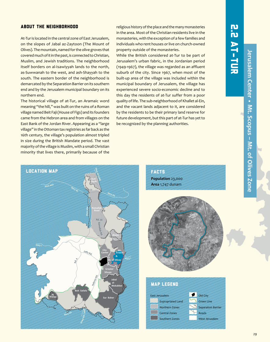
At-Tur is located in the central zone of East Jerusalem, on the slopes of Jabal az-Zaytoon (The Mount of Olives). The mountain, named for the olive groves that covered much of it in the past, is connected to Christian, Muslim, and Jewish traditions. The neighborhood itself borders on al-Isawiyyah lands to the north, as-Suwwanah to the west, and ash-Shayyah to the south. The eastern border of the neighborhood is demarcated by the Separation Barrier on its southern end and by the Jerusalem municipal boundary on its northern end.The historical village of at-Tur, an Aramaic word meaning “the hill,” was built on the ruins of a Roman village named Beit Faji (House of Figs) and its founders came from the Hebron area and from villages on the East Bank of the Jordan River. Appearing as a “large village” in the Ottoman tax registries as far back as the 16th century, the village’s population almost tripled in size during the British Mandate period. The vast majority of the village is Muslim, with a small Christian minority that lives there, primarily because of the
religious history of the place and the many monasteries in the area. Most of the Christian residents live in the monasteries, with the exception of a few families and individuals who rent houses or live on church-owned property outside of the monasteries.While the British considered at-Tur to be part of Jerusalem’s urban fabric, in the Jordanian period (1949-1967), the village was regarded as an affluent suburb of the city. Since 1967, when most of the built-up area of the village was included within the municipal boundary of Jerusalem, the village has experienced severe socio-economic decline and to this day the residents of at-Tur suffer from a poor quality of life. The sub-neighborhood of Khallet al-Ein, and the vacant lands adjacent to it, are considered by the residents to be their primary land reserve for future development, but this part of at-Tur has yet to be recognized by the planning authorities.
Jaffa Rd.
Rd. 4
Heb
ron
Rd.
Ramallah Rd.
Hwy 1
Hwy 443Hwy 45
Rd. 20
Hw
y 40
4
Hw y 1
Hwy 60
Hw
y 60
(o
ld)
Hw
y 60 (old)
Hwy 60
RamallahRoad
Anata
Kafr Aqab
Mt. of Olives
Mt.Scopus&
City Center
GreaterSilwan
al-Mokabber
Jabal
Sur Baher
Beit Safafa
Al-Walaje
Location Map
Map Legend
Population 23,000Area 1,747 dunam
Facts
Separation Barrier
West Jerusalem
East Jerusalem
Expropriated Land
Northern Zones
Central Zones
Southern Zones
Old City
Roads
Green Line
2.2
At-Tur
Jerusalem Center • M
t. Scopus – Mt. of O
lives Zone
29

The Residents’ Plan for Khallet al-Ein
Since 2006, the residents of at-Tur, and in particular owners of land in the sub-neighborhood of Khallet al-Ein, have been working, with the assistance of the community center, to advance a new plan for part of their neighborhood (about 800 dunam in the northeastern part of at-Tur, located within the Jerusalem municipal boundary). The residents hired the services of an architect and began the arduous journey to achieve the recognition of the Israeli authorities and to change the zoning. Part of the area is unplanned, part is designated as public open space, and a small part is designated as scenic area.The residents’ plan proposes to expand the areas allowed for development in at-Tur towards the northeast, and to designate the vacant areas owned by residents of the neighborhood for the creation of additional residential areas, neighborhood parks, access roads, and, above all, areas for public structures. Another goal of the plan is the retroactive legalization of houses built without permits, which are under threat of demolition orders. The plan was made with the encouragement of and in coordination with the Jerusalem Municipality, but now it is being threatened by the plan for a national park on the eastern slopes of Mount Scopus, which eats away at the available areas and leaves no land reserves beyond the already built-up areas. The residents decided to take matters into their own hands and to bypass the Jerusalem Municipality – as permitted by law – by presenting their plan directly to the District Planning Committee. The committee, in turn, will have to decide between two plans being advanced on the same area – the one by the National Parks Authority and the other by the residents.
transportation in most parts of the neighborhood, there are hardly any sidewalks, and parking is also very problematic.
The Jerusalem 2000 Outline PlanIn the Jerusalem 2000 Outline Plan, which awaits deposition for public review, an addition of housing units is proposed for at-Tur through the densification of the built-up fabric as well as the inclusion of an area for future expansion. This area, which is already partially built up, is smaller than the area designated in the residents’ plan (see inset). Meanwhile, plans for a national park are eating away at the expansion area (see: The National Park). In the areas designated for densification, construction of up to four storeys is allowed in the west and south of the neighborhood (in the Visual Basin of the Old City) and of up to six storeys in the east of the neighborhood. However, this construction is subject to a limit of no more than two additional storeys on existing structures. Moreover, since large parts of the neighborhoods are already built to four storeys, the proposed densification in fact provides only a negligible number of new housing units.
Vacant Plots (photos Bimkom)
Main Problems in at-Tur
The Threat of Home DemolitionsThe historical core of the neighborhood is very densely built and has almost no land reserves for residential construction. Moreover, the neighborhood is blocked from expansion on all sides – by neighboring Palestinian villages, main roads, the Separation Barrier, and the municipal boundary. Its only hope for expansion is to the northeast, where the unrecognized sub-neighborhood of Khallet al-Ein (see inset) is located, but a plan for a national park is currently being advanced there (see: The National Park). Additional housing clusters are considered illegal because they were built on areas not zoned for housing. The residents of at-Tur, primarily those in the unrecognized and unplanned areas, live under the constant threat of home demolitions and evacuation orders. A recent demolition, on a cold and rainy morning in December 2012, displaced 11 people, including 7 children, who were given less than an hour to pack their belongings.
SettlementsBeit Orot, the first Israeli settlement ever built in the heart of a Palestinian neighborhood in East Jerusalem, is located on the western edge of at-Tur, on the border with as-Suwwanah. The land, most of which had been zoned for a Palestinian
girls’ school, was purchased in the early 90s by the American-Jewish multimillionaire Irwin Moskowitz. Two residential buildings on the site were converted for the settlement’s use, and a yeshiva was opened. In addition, a number of caravans for yeshiva students and their families were put up on a vacant area zoned as public open space, in close proximity to the neighborhood soccer field. Beit Orot and the Elad settler organization are currently building four new residential structures (totaling 24 housing units) on part of the site designated for housing in the outline plan for as-Suwwanah. Meanwhile, an alternative site was found for the school on land zoned as a nature reserve, in central at-Tur (see expansion), and a stipulation was added to the plan for the yeshiva that if a building permit is granted for building a new yeshiva compound, the municipality must also grant one for the school. In June 2012, the Beit Orot organization submitted a building-permit request for the construction of a new institutional building on the site, and it remains to be seen whether a permit for the school will be granted along with it. The smaller settlement of Beit Ha-Hoshen was established in 2006, in the southwestern part of the neighborhood, next to the Seven Arches Hotel and the lookout over the Old City. Its approximately 30 settlers live in two adjacent structures that boast a giant
Israeli flag. A Palestinian family continued to live on the ground floor of one of the buildings until November 2012, when they were forcefully evacuated.
The National ParkSince 2005, the Israel National Parks Authority, the Jerusalem Development Authority, and the Jerusalem Municipality, have been advancing a plan for a national park on the eastern slopes of Mount Scopus, on 750 dunam stretching from at-Tur in the south to al-Isawiyyah in the north, blocking the expansion of both neighborhoods. The plan for the so-called Mount Scopus Slopes National Park was approved in both the local and district planning committees and was deposited for public review in November 2011. However, following a petition by the residents about the fact that the plan was not translated into Arabic, proceedings were frozen until the court’s decision to reject the petition was received in December 2012. Residents from both neighborhoods have submitted objections to the plan and have also appealed to the Supreme Court. Decisions are pending (2013).
The Nature ReserveIn Outline Plan # 2733 for central at-Tur (approved in the late 1980s), a large part of the vacant area in the center of the neighborhood was zoned as a nature reserve. Over the years, houses were built on this area and two detail plans were approved, reducing its size. One of these plans designated a plot for the building of a school, as part of the land swap with the Beit Orot Yeshiva (see: Settlements). Today, the area of the nature reserve is almost entirely built up.
Infrastructure and ServicesAs a direct result of the terrible situation of the roads in the neighborhood, infrastructure and public services are also severely lacking. Drainage and sewerage are particularly inadequate; entire areas of at-Tur are not connected to the municipal sewer system and the residents have to dig and maintain private cesspits. The steep topography causes seasonal flooding, forcing some of the residents to leave their houses for short periods during the winter. In addition, the street lighting is not properly maintained, and on some of the streets it is nonexistent. There is no public
Village Center (photo Bimkom)
30 31

Zoning Structure According to Approved Plans • Designation vs. Use
DesignationPlans
Land Usedunam %
Residential* 446 25
The residential zoning only partially corresponds with the existing residential areas. Entire residential areas in the neighborhood are located on differently zoned land (open scenic area, open public area, nature reserve, public buildings). Even in the built-up areas that are zoned as residential, building rights, which were defined as rural-type, are not sufficient. A large housing project in the south of the neighborhood was established on church-owned land, adjacent to the border with ash-Shayyah. This construction was enabled by changing the zoning from “institutional” to “religious structures and public institutions.”
Open Spaces 508 29
The approved plans in the neighborhood designate open spaces on all sides of the neighborhood except to the west. To the northeast, on the areas of the unrecognized sub-neighborhood of Khallet al-Ein, part of the land is zoned as public open space. The residents have been working on a plan to change this zoning to residential (see inset), but in the meantime, plans for a national park in the vicinity may thwart these intentions (see: The National Park). To the east, there is a strip of land zoned as open scenic area, which also contains many houses. The open areas to the south are zoned as institutional open space; these areas are church owned and are not accessible to the residents of the neighborhood. Within the neighborhood, there is a soccer field on land zoned for that purpose, and there is not a single plot designated for a neighborhood playground.
Roads 208 12
The roads appearing on the plans only very partially correspond with the existing roads. As a result of this disparity, most of the planned roads have not been developed and are not expected to be developed in the future. Meanwhile, the state of the roads that are in daily use by the residents is very bad: practically no sidewalks, inadequate maintenance, and insufficient deployment – with some residential areas, such as Khallet al-Ein, having no access road whatsoever (see inset).
Public Buildings and Institutions
205 12
The neighborhood has about 20 plots designated for public structures and institutions. Half of them were never developed. Out of these, two are zoned for municipal schools. The rest of the available plots are small and more suitable for kindergartens. At least one kindergarten and one elementary school operate out of rented houses in the neighborhood. Out of the plots that are developed, three contain municipal schools (including one high school) that serve the neighborhood, and one houses the neighborhood mosque. Another plot is located in the area of the Beit Orot settlement (see: Settlements). The rest of the plots serve city-wide institutions, including two Palestinian hospitals, churches, a special-education school, and a nursing school. The second-largest plot contains a cluster of residential structures.
Other 380 22Includes area for hotelerie, an area for a cemetery, unplanned area within the Jerusalem municipal border (39 dunam) and area outside of the municipal border (64 dunam).
Total 1,747 100
* The most common residential zoning type in at-Tur allows for a 50% building ratio, with sparse construction of up to two storeys. In the village core, higher building rights are allowed (between 80% and 90%, with up to four storeys). Some areas have an additional stipulation of a minimal plot-size of 500 m2, and the submission of a detail plan for every plot of more than three dunam.
Approved Plans in the Neighborhood
Part of Outline Plan # 3085 for at-Tur and ash-Shayyah 619.0 dunam
Outline Plan #2733 for central at-Tur 309.2 dunam
Part of Outline Plan # 3092 for at-Tur and as-Suwwanah 69.0 dunam
Part of Local Outline Plan # 9 for the Visual Basin of the Old City 292.6 dunam
Parts of Outline Plans (4752, 14049) for the Mount Scopus Tunnel Road 110.2 dunam
Total planned area 1,400.0 dunam
Unplanned area, including area outside of Jerusalem 347.0 dunam
Total area of neighborhood 1,747.0 dunam
In addition, some 10 detail plans were also approved, with no added area for the neighborhood.
32
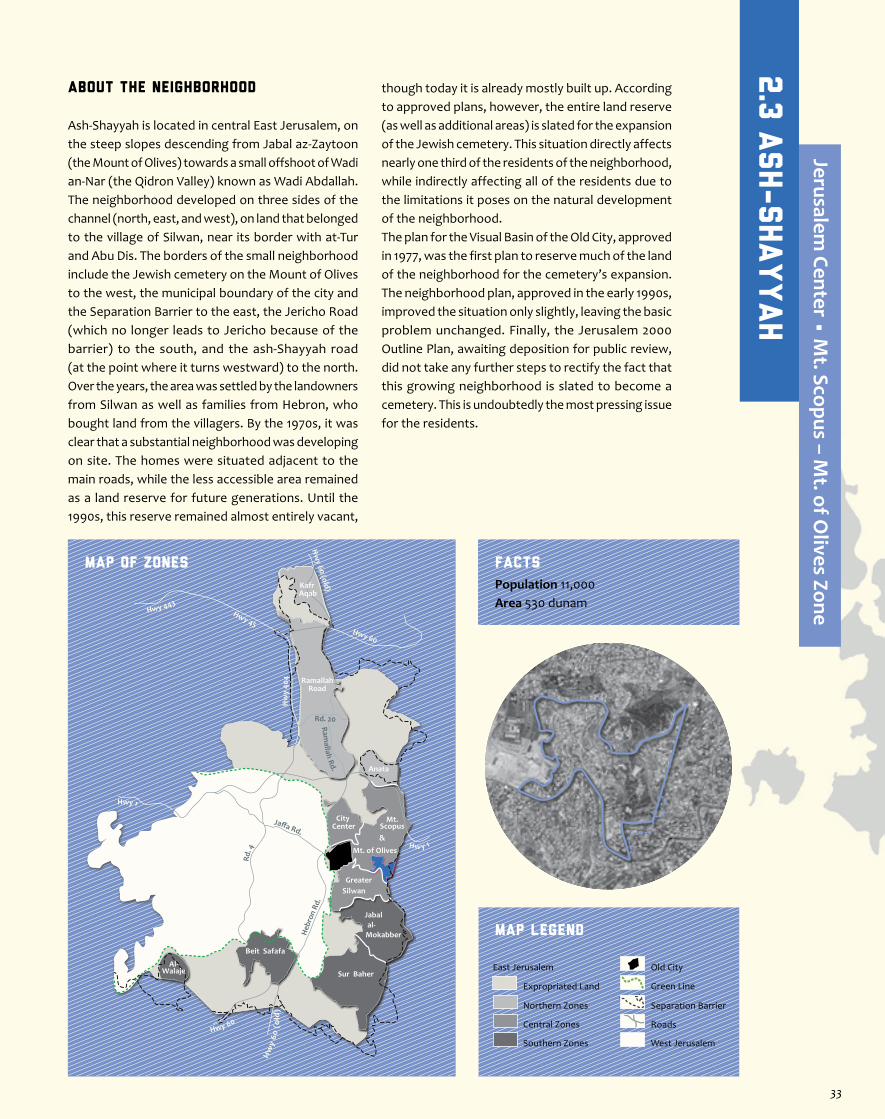
About the Neighborhood
Ash-Shayyah is located in central East Jerusalem, on the steep slopes descending from Jabal az-Zaytoon (the Mount of Olives) towards a small offshoot of Wadi an-Nar (the Qidron Valley) known as Wadi Abdallah. The neighborhood developed on three sides of the channel (north, east, and west), on land that belonged to the village of Silwan, near its border with at-Tur and Abu Dis. The borders of the small neighborhood include the Jewish cemetery on the Mount of Olives to the west, the municipal boundary of the city and the Separation Barrier to the east, the Jericho Road (which no longer leads to Jericho because of the barrier) to the south, and the ash-Shayyah road (at the point where it turns westward) to the north. Over the years, the area was settled by the landowners from Silwan as well as families from Hebron, who bought land from the villagers. By the 1970s, it was clear that a substantial neighborhood was developing on site. The homes were situated adjacent to the main roads, while the less accessible area remained as a land reserve for future generations. Until the 1990s, this reserve remained almost entirely vacant,
though today it is already mostly built up. According to approved plans, however, the entire land reserve (as well as additional areas) is slated for the expansion of the Jewish cemetery. This situation directly affects nearly one third of the residents of the neighborhood, while indirectly affecting all of the residents due to the limitations it poses on the natural development of the neighborhood.The plan for the Visual Basin of the Old City, approved in 1977, was the first plan to reserve much of the land of the neighborhood for the cemetery’s expansion. The neighborhood plan, approved in the early 1990s, improved the situation only slightly, leaving the basic problem unchanged. Finally, the Jerusalem 2000 Outline Plan, awaiting deposition for public review, did not take any further steps to rectify the fact that this growing neighborhood is slated to become a cemetery. This is undoubtedly the most pressing issue for the residents.
Jaffa Rd.
Rd. 4
Heb
ron
Rd.
Ramallah Rd.
Hwy 1
Hwy 443Hwy 45
Rd. 20
Hw
y 40
4
Hw y 1
Hwy 60
Hw
y 60
(o
ld)
Hw
y 60 (old)
Hwy 60
RamallahRoad
Anata
Kafr Aqab
Mt. of Olives
Mt.Scopus&
City Center
GreaterSilwan
al-Mokabber
Jabal
Sur Baher
Beit Safafa
Al-Walaje
MAP OF ZONES
Map Legend
Population 11,000Area 530 dunam
Facts
Separation Barrier
West Jerusalem
East Jerusalem
Expropriated Land
Northern Zones
Central Zones
Southern Zones
Old City
Roads
Green Line
2.3
Ash-Shayyah
Jerusalem Center • M
t. Scopus – Mt. of O
lives Zone
33
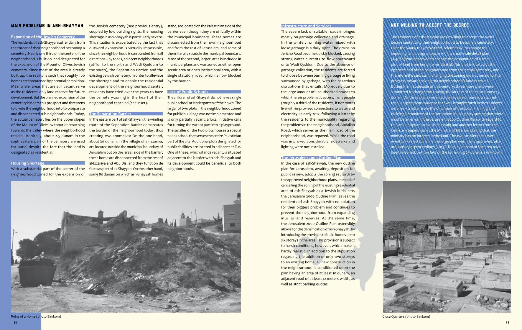
Close Quarters (photo Bimkom)
Not Willing to Accept the Decree
The residents of ash-Shayyah are unwilling to accept the awful decree sentencing their neighborhood to become a cemetery. Over the years, they have tried, relentlessly, to change the impeding land designation. In 1995, a small-scale detail plan (# 4684) was approved to change the designation of a small plot of land from burial to residential. This plot is located at the opposite end of the neighborhood from the actual cemetery, and therefore the success in changing the zoning did not herald further progress towards saving the neighborhood’s land reserves. During the first decade of this century, three more plans were submitted to change the zoning, the largest of them on almost 15 dunam. All three plans were tied up in years of bureaucratic red tape, despite clear evidence that was brought forth in the residents’ defense – a letter from the Chairman of the Local Planning and Building Committee of the Jerusalem Municipality stating that there must be an error in the Jerusalem 2000 Outline Plan with regard to the land designation in ash-Shayyah; and another letter from the Cemetery Supervisor at the Ministry of Interior, stating that the ministry has no interest in the land. The two smaller plans were eventually rejected, while the large plan was finally approved, after arduous legal proceedings (2013). Thus, 15 dunam of the area have been re-zoned, but the fate of the remaining 75 dunam is unknown.
Infrastructure and Services The severe lack of suitable roads impinges mostly on garbage collection and drainage. In the winter, running water mixed with loose garbage is a daily sight. The drains on Jericho Road become quickly blocked, causing strong water currents to flow southward onto Wadi Qaddum. Due to the absence of garbage collection, the residents are forced to choose between burning garbage or living surrounded by garbage, with the hazardous disruptions that entails. Moreover, due to the large amount of unauthorized houses to which there is problematic access, many people (roughly a third of the residents, if not more) live with improvised connections to water and electricity. In early 2012, following a letter by the residents to the municipality regarding the problems in their neighborhood, Abdallah Road, which serves as the main road of the neighborhood, was repaved. While the road was improved considerably, sidewalks and lighting were not installed.
The Jerusalem 2000 Outline PlanIn the case of ash-Shayyah, the new outline plan for Jerusalem, awaiting deposition for public review, adopts the zoning set forth by the approved neighborhood plans. Instead of cancelling the zoning of the existing residential area of ash-Shayyah as a Jewish burial site, the Jerusalem 2000 Outline Plan leaves the residents of ash-Shayyah with no solution for their biggest problem and continues to prevent the neighborhood from expanding into its land reserves. At the same time, the Jerusalem 2000 Outline Plan ostensibly allows for the densification of ash-Shayyah, by introducing the provision to build homes up to six storeys in the area. This provision is subject to harsh conditions, however, which make it hardly realistic. In addition to the stipulation regarding the addition of only two storeys to an existing home, all new construction in the neighborhood is conditioned upon the plan having an area of at least 10 dunam, an adjacent road of at least 12 meters width, as well as strict parking quotas.
Main Problems in ash-Shayyah
Expansion of the Jewish CemeteryThe residents of ash-Shayyah suffer daily from the threat of their neighborhood becoming a cemetery. Nearly one third of the center of the neighborhood is built on land designated for the expansion of the Mount of Olives Jewish cemetery. Since most of the area is already built up, the reality is such that roughly 100 homes are threatened by potential demolition. Meanwhile, areas that are still vacant serve as the residents’ only land reserve for future development. But the planned expansion of the cemetery hinders this prospect and threatens to divide the neighborhood into two separate and disconnected sub-neighborhoods. Today, the actual cemetery lies on the upper slopes of the Mount of Olives, without encroaching towards the valley where the neighborhood resides. Ironically, about 2.5 dunam in the southeastern part of the cemetery are used for burial despite the fact that the land is designated as residential.
Housing ShortageWith a substantial part of the center of the neighborhood zoned for the expansion of
the Jewish cemetery (see previous entry), coupled by low building rights, the housing shortage in ash-Shayyah is particularly severe. This situation is exacerbated by the fact that outward expansion is virtually impossible, since the neighborhood is surrounded from all directions – by roads, adjacent neighborhoods (at-Tur to the north and Wadi Qaddum to the south), the Separation Barrier, and the existing Jewish cemetery. In order to alleviate the shortage and to enable the residential development of the neighborhood center, residents have tried over the years to have the cemetery-zoning in the heart of their neighborhood canceled (see inset).
The Separation BarrierIn the eastern part of ash-Shayyah, the winding route of the Separation Barrier demarcates the border of the neighborhood today, thus creating two anomalies: On the one hand, about 20 dunam, in the village of al-Izzariya, are located outside the municipal boundary of Jerusalem but on the Israeli side of the barrier; these home are disconnected from the rest of al-Izzariya and Abu Dis, and they function de facto as part of as-Shayyah. On the other hand, some 80 dunam on which ash-Shayyah homes
stand, are located on the Palestinian side of the barrier even though they are officially within the municipal boundary. These homes are disconnected from their own neighborhood and from the rest of Jerusalem, and some of them literally straddle the municipal boundary. Most of the second, larger, area is included in municipal plans and was zoned as either open scenic area or open institutional area, with a single statutory road, which is now blocked by the barrier.
Lack of Public SchoolsThe children of ash-Shayyah do not have a single public school or kindergarten of their own. The larger of two plots in the neighborhood zoned for public buildings was not implemented and is only partially vacant; a local initiative calls for turning the vacant part into a playground. The smaller of the two plots houses a special needs school that serves the entire Palestinian part of the city. Additional plots designated for public facilities are located in adjacent at-Tur. One of these, which stands vacant, is situated adjacent to the border with ash-Shayyah and its development could be beneficial to both neighborhoods.
Ruins of a Home (photo Bimkom)
34 35
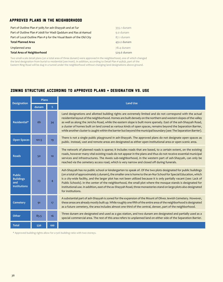
Zoning Structure According to Approved Plans • Designation vs. Use
DesignationPlans
Land Usedunam %
Residential* 181 34
Land designations and allotted building rights are extremely limited and do not correspond with the actual residential layout of the neighborhood. Homes are built densely on the northern and western slopes of the valley as well as along the Jericho Road, while the eastern slope is built more sparsely. East of the ash-Shayyah Road, a cluster of homes built on land zoned as various kinds of open spaces, remains beyond the Separation Barrier, while another cluster is caught within the barrier but beyond the municipal boundary (see: The Separation Barrier).
Open Spaces 101.5 19There is not a single public playground in ash-Shayyah. The approved plans do not designate open spaces as public. Instead, vast and remote areas are designated as either open institutional area or open scenic area.
Roads 50 10
The network of planned roads is sparse; it includes roads that are based, to a certain extent, on the existing roads, however many vital existing roads do not appear in the plans and thus do not receive essential municipal services and infrastructures. The Aweis sub-neighborhood, in the western part of ash-Shayyah, can only be reached via the cemetery access road, which is very narrow and closed off during funerals.
Public Buildingsand Institutions
23 4
Ash-Shayyah has no public school or kindergarten to speak of. Of the two plots designated for public buildings (on a total of approximately 5 dunam), the smaller one is home to the an-Nur School for Special Education, which is a city-wide facility, and the larger plot has not been utilized because it is only partially vacant (see: Lack of Public Schools). In the center of the neighborhood, the small plot where the mosque stands is designated for institutional use. In addition, east of the as-Shayyah Road, three monasteries stand on large plots also designated for institutions.
Cemetery 91 17A substantial part of ash-Shayyah is zoned for the expansion of the Mount of Olives Jewish Cemetery. However, these areas are already mostly built up. While roughly one fifth of the entire area of the neighborhood is designated as a future cemetery, the area includes almost one third of the central, denser, part of the neighborhood.
Other 83.5 16Three dunam are designated and used as a gas station, and two dunam are designated and partially used as a special commercial area. The rest of this area refers to unplanned land on either side of the Separation Barrier.
Total 530 100
* Approved building rights allow for a 50% building ratio with two storeys.
Approved Plans in the Neighborhood
Part of Outline Plan # 3085 for ash-Shayyah and at-Tur 355.1 dunam
Part of Outline Plan # 2668 for Wadi Qaddum and Ras al-Aamud 9.0 dunam
Part of Local Outline Plan # 9 for the Visual Basin of the Old City 87.1 dunam
Total Planned Area 451.2 dunam
Unplanned area 78.4 dunam
Total Area of Neighborhood 529.6 dunam
Two small-scale detail plans (on a total area of three dunam) were approved in the neighborhood, one of which changed the land designation from burial to residential (see inset). In addition, according to Detail Plan # 4585b, part of the Eastern Ring Road will be dug in a tunnel under the neighborhood without changing land designations above ground.
36

About the Neighborhood
As-Suwwanah is the only residential neighborhood on the westward-facing slopes of Jabal az-Zaytoon (The Mount of Olives). Descending into Wadi an-Nar (the Qidron Valley), it borders to the west on Wadi aj-Joz, to the north on the Hebrew University Mount Scopus campus, and to the east on at-Tur and Brigham Young University (commonly known as the Mormon University). To the south, the neighborhood borders on an extensive strip of land that includes the Jewish cemetery on the Mount of Olives, a major Muslim cemetery, and several church compounds. As-Suwwanah developed on agricultural lands belonging to the village of at-Tur, which, under Ottoman rule in the Holy Land, was considered part of Jerusalem’s rural periphery. The British included both at-Tur and as-Suwwanah within the city’s boundaries, however, unlike at-Tur, which appears on the Mandatory plans as a residential area, as-Suwwanah is designated on those plans as various types of open spaces. With no historical village center, the neighborhood developed from the late 19th century onwards in the midst of the olive groves
to the south of At-Tur Road, which ascends steeply toward the Mount of Olives.At the beginning of the 1940s, the neighborhood was comprised of a cluster of about 25 houses. By the early 1970s, this had grown into a neighborhood of about 75 residential buildings. However, since the beginning of Israeli rule after 1967, this growth has been limited. In Plan no. 9 for the Visual Basin of the Old City (1976), residential land-use was restricted to the area south of At-Tur Road, and low construction density was stipulated. The land to the north of the road, on which 20 houses already existed, was zoned for hotels, recreation, and institutions. In the years since, only a few new residential structures have been built, all to the south of the road, and a number of city-wide institutions have been built, mostly to the north of the road. In comparison with other neighborhoods in East Jerusalem, as-Suwwanah’s residents are well-off. Its proximity to the commercial areas of East Jerusalem’s City Center and the tourist and medical facilities on the Mount of Olives, give it many advantages. However, the establishment of national parks around it poses a severe threat to its future development.
Jaffa Rd.
Rd. 4
Heb
ron
Rd.
Ramallah Rd.
Hwy 1
Hwy 443Hwy 45
Rd. 20
Hw
y 40
4
Hw y 1
Hwy 60
Hw
y 60
(o
ld)
Hw
y 60 (old)
Hwy 60
RamallahRoad
Anata
Kafr Aqab
Mt. of Olives
Mt.Scopus&
City Center
GreaterSilwan
al-Mokabber
Jabal
Sur Baher
Beit Safafa
Al-Walaje
Location Map
Map Legend
Population 3,000Area 448 dunamAdjacent Area 780 dunam
Facts
Separation Barrier
West Jerusalem
East Jerusalem
Expropriated Land
Northern Zones
Central Zones
Southern Zones
Old City
Roads
Green Line
2.4
As-Suwwanah
Jerusalem Center • M
t. Scopus – Mt. of O
lives Zone
37

The Soccer Field, with Wadi aj-Joz in the background (photo Bimkom)A Typical Street (photo Bimkom) At-Tur Road (photo Bimkom)
The al-Ibrahimeyyah School
The establishment of the Tzurim Valley National Park by the Israel National Parks Authority (INPA) was met by resistance from the local landowners and the management of the al-Ibrahimeyyah School, a private K-thru-12 school and college. The longstanding and respected East Jerusalem educational institution has operated in as-Suwwanah, to the north of At-Tur Road, since before 1967. In the 1970s, a detailed plan (# 2177) was approved, formalizing the zoning of the land for a public building, while zoning the adjacent plot to the north of the school as open public area. The latter plot, which was developed only on the most basic level, is used by the school as well as the children of as-Suwwanah and the adjacent neighborhoods as a football field. In the neighborhood outline plan, which was prepared in the 1980s and approved in 1990, a large swath of land in the north of the neighborhood was zoned for a national park, and the football field remained zoned as open public area, without any change. However, in the plan that was prepared in anticipation of the declaration of the Tzurim Valley National Park in 2000, the area of the football field was included in the national park, as was another open public area adjacent to Wadi aj-Joz, despite the fact that, by law, the plans for the declared park should have been on an area already zoned as a national park.In the years following the declaration, the INPA dismantled the fence surrounding the football field and the school subsequently put it back up; this repeated itself over and over again. There was also an attempt by the INPA to prevent the parents of students from parking in the parking lot next to the school, claiming that it was designated for
Israeli Military AcademiesIn blatant contrast to the severe construction limitations imposed on as-Suwwanah and the adjacent Palestinian neighborhoods, Plan # 51870 was drawn up, for the establishment of an Israeli military academy on the Mount of Olives, adjacent to the Mount Scopus Hebrew University Campus. This plan, which was deposited for public review in November 2012, proposes the establishment of a densely built compound (eight-storey buildings, most of which are to be dug into the ground) that will house several IDF officer-training schools. This compound is located in the northern part of as-Suwwanah, between the Mormon University and the Augusta Victoria German-Lutheran Church compound, on a site that was originally designated for building Israel’s Supreme Court. The Israel Defense Ministry and the Jerusalem Municipality, who initiated the plan, claim that it sits on Israeli state land within the Mount Scopus enclave. This claim is imprecise, since the vast majority of the area of the new campus will actually be outside of the enclave. Local
landowners, as well as the Mormon University, have submitted objections to the plan. The District Committee hearing on the issue has been delayed several times and has yet to take place.
The Jerusalem 2000 Outline PlanThe new outline plan for Jerusalem, which awaits deposition for public review, heralds no planning relief for as-Suwwanah. The plan perpetuates the reduced borders of the neighborhood, proposing no expansion. As-Suwwanah is included both within the boundaries of the Visual Basin of the Old City as well as the area set aside for preservation, for which special stipulations apply, primarily the limitation of construction to four storeys. This means the addition of two storeys on top of the two storeys stipulated in the approved plans. None of the national parks encircling as-Suwwanah (except for the National Park Surrounding the Old City Walls) appear on the plan.
visitors of the national park. The INPA’s actions have been carried out in a threatening manner, sometimes by night, and have led to physical confrontations. Eventually, the landowners and directorship of the school appealed to the HCJ and, following the proceedings, an agreement was reached between the sides according to which the borders of the park would be corrected and the football field would not be included in the national park. Thus the status quo was maintained. The children continue to play football, the parents continue to use the parking lot, and tourists continue to pass by the school fence, on their way to the park. But the conflict still casts a shadow, as students, parents, and residents of as-Suwwanah are not made to feel welcome in the national park, which was not intended to serve them.
Main Problems in as-Suwwanah
Housing ShortageThe main residential area in the neighborhood is located to the south of At-Tur Road. Even in this area, however, approved plans provide limited construction possibilities, and almost all of the areas zoned as residential are already built up. The only way to increase residential construction is to build upwards to four storeys (see: The Jerusalem 2000 Outline Plan) on buildings where this has not yet been done. To the north of At-Tur Road, the existing homes and some vacant land adjacent to them were originally granted a mixed zoning for residential use and tourism. Newer plans have rezoned the vacant land exclusively for hotels. The almost complete lack of construction opportunities in as-Suwwanah is a phenomenon that afflicts the adjacent Palestinian neighborhoods as well, creating a continuum of Palestinian neighborhoods with no potential for development.
Declared National ParksThe development of the neighborhood is also limited by two declared national parks. Declaration is a powerful tool; it follows planning and is nearly impossible to cancel or change. The earliest of the declared national parks is the National Park Surrounding the Old
City Walls, which was declared in 1974. This park is not adjacent to as-Suwwanah, but it is a hub for the subsequent national parks. In 2000, the Tzurim Valley National Park was declared, its land stretching over the entire open area to the north of as-Suwwanah. The park is named after the type of stone that is found in the area (the Arabic name as-Suwwanah is also connected to these rocks). Whereas the National Park Surrounding the Old City Walls has recognized archeological and historical value (though not necessarily necessitating its width), the Tzurim Valley is of questionable historic significance. Located in the heart of the urban fabric of East Jerusalem, the Tzurim Valley National Park limits the development of as-Suwwanah and Wadi aj-Joz and forms a wedge in the urban continuity between the neighborhoods of East Jerusalem ’ s City Center and those on the Mount of Olives. The park targets tourists and visitors from outside of the city, while disregarding the needs of the Palestinian neighborhoods on whose lands it sits. Moreover, a massive stone fence separates it from the adjacent residential areas.
Planned National ParksThree additional national parks around as-Suwwanah are in various planning stages, not yet approved or declared. If approved, they will significantly expand the area
of the national parks in the heart of the Palestinian neighborhoods of East Jerusalem while tightening the choke-hold around as-Suwwanah. Two of these parks will strengthen the weak link between the two declared parks (see above): the first is an area of about 40 dunam of Wadi aj-Joz land that includes the Rockefeller Archeological Museum and the adjacent public garden; the second and larger area (of about 470 dunam) confines as-Suwannah to the south and includes the large swaths of church land, mostly open areas, on the slope descending westward from the Mount of Olives. On the latter site, construction and development activities are already being carried out by the Israel National Parks Authority, despite the fact that its formal planning has not begun. Plans for these two parks were first revealed in an early version of the Jerusalem 2000 Outline Plan. However, they do not appear on the official version of the outline plan which awaits deposition for public review. Another park, the Mount Scopus Slopes National Park, is planned to the east of as-Suwwanah, between at-Tur and al-Isawiyyah, on the eastward-facing slopes of Mount Scopus. The plan for this park is in advanced stages, and, although the residents’ objections have yet to be heard, construction activity is already taking place on site.
38 39
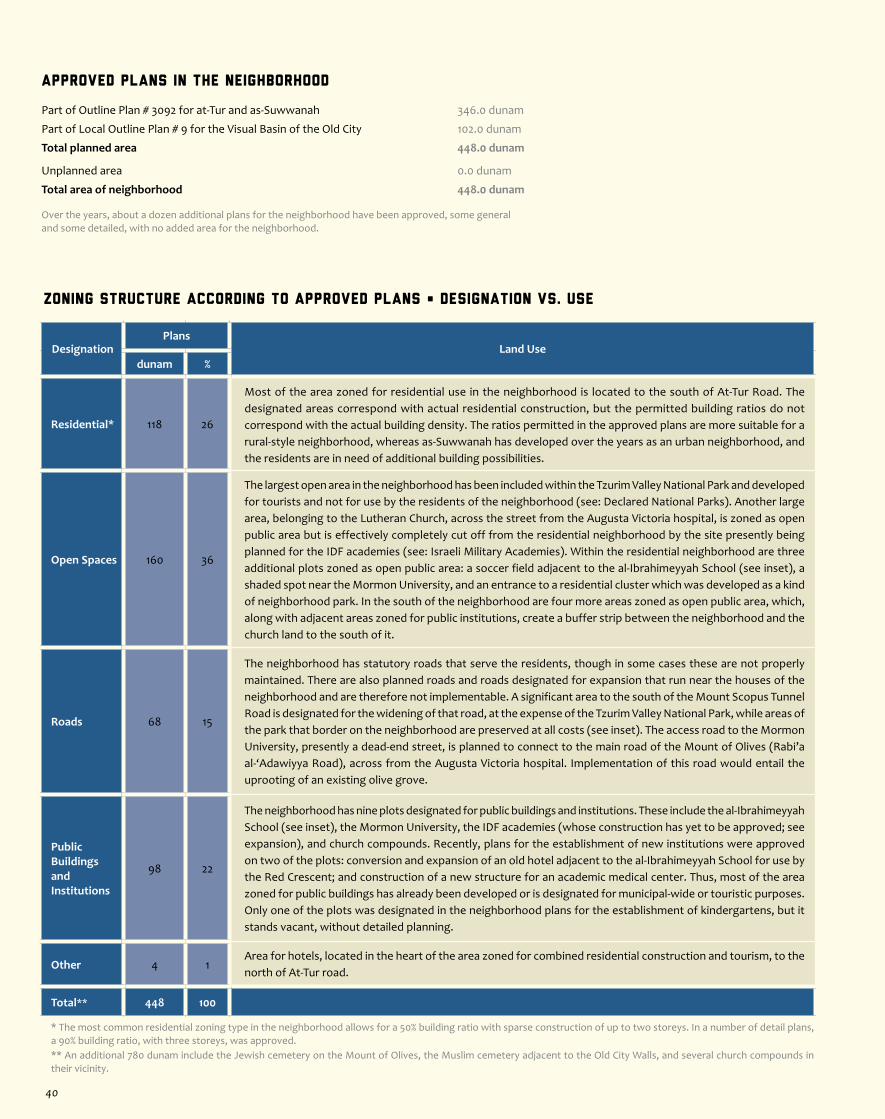
Zoning Structure According to Approved Plans • Designation vs. Use
DesignationPlans
Land Usedunam %
Residential* 118 26
Most of the area zoned for residential use in the neighborhood is located to the south of At-Tur Road. The designated areas correspond with actual residential construction, but the permitted building ratios do not correspond with the actual building density. The ratios permitted in the approved plans are more suitable for a rural-style neighborhood, whereas as-Suwwanah has developed over the years as an urban neighborhood, and the residents are in need of additional building possibilities.
Open Spaces 160 36
The largest open area in the neighborhood has been included within the Tzurim Valley National Park and developed for tourists and not for use by the residents of the neighborhood (see: Declared National Parks). Another large area, belonging to the Lutheran Church, across the street from the Augusta Victoria hospital, is zoned as open public area but is effectively completely cut off from the residential neighborhood by the site presently being planned for the IDF academies (see: Israeli Military Academies). Within the residential neighborhood are three additional plots zoned as open public area: a soccer field adjacent to the al-Ibrahimeyyah School (see inset), a shaded spot near the Mormon University, and an entrance to a residential cluster which was developed as a kind of neighborhood park. In the south of the neighborhood are four more areas zoned as open public area, which, along with adjacent areas zoned for public institutions, create a buffer strip between the neighborhood and the church land to the south of it.
Roads 68 15
The neighborhood has statutory roads that serve the residents, though in some cases these are not properly maintained. There are also planned roads and roads designated for expansion that run near the houses of the neighborhood and are therefore not implementable. A significant area to the south of the Mount Scopus Tunnel Road is designated for the widening of that road, at the expense of the Tzurim Valley National Park, while areas of the park that border on the neighborhood are preserved at all costs (see inset). The access road to the Mormon University, presently a dead-end street, is planned to connect to the main road of the Mount of Olives (Rabi’a al-‘Adawiyya Road), across from the Augusta Victoria hospital. Implementation of this road would entail the uprooting of an existing olive grove.
Public Buildings and Institutions
98 22
The neighborhood has nine plots designated for public buildings and institutions. These include the al-Ibrahimeyyah School (see inset), the Mormon University, the IDF academies (whose construction has yet to be approved; see expansion), and church compounds. Recently, plans for the establishment of new institutions were approved on two of the plots: conversion and expansion of an old hotel adjacent to the al-Ibrahimeyyah School for use by the Red Crescent; and construction of a new structure for an academic medical center. Thus, most of the area zoned for public buildings has already been developed or is designated for municipal-wide or touristic purposes. Only one of the plots was designated in the neighborhood plans for the establishment of kindergartens, but it stands vacant, without detailed planning.
Other 4 1Area for hotels, located in the heart of the area zoned for combined residential construction and tourism, to the north of At-Tur road.
Total** 448 100
* The most common residential zoning type in the neighborhood allows for a 50% building ratio with sparse construction of up to two storeys. In a number of detail plans, a 90% building ratio, with three storeys, was approved. ** An additional 780 dunam include the Jewish cemetery on the Mount of Olives, the Muslim cemetery adjacent to the Old City Walls, and several church compounds in their vicinity.
Approved Plans in the Neighborhood
Part of Outline Plan # 3092 for at-Tur and as-Suwwanah 346.0 dunam
Part of Local Outline Plan # 9 for the Visual Basin of the Old City 102.0 dunam
Total planned area 448.0 dunam
Unplanned area 0.0 dunam
Total area of neighborhood 448.0 dunam
Over the years, about a dozen additional plans for the neighborhood have been approved, some general and some detailed, with no added area for the neighborhood.
40

About the Neighborhood
Located north of the Old City, Wadi aj-Joz and its subsidiaries border on as-Suwwanah and the Mount of Olives to the east, ash-Sheikh Jarrah to the north and northwest, and the armistice line that divided Jerusalem between Israel and Jordan from 1949 to 1967 (the Green Line), to the west. The area is comprised of a number of sub-neighborhoods: in the east, Wadi aj-Joz, sitting on the northern channel of Wadi an-Nar (the Qidron Valley); in the northwest, the al-Husseini Quarter (also known as the American Colony); in the southwest the al-Mas’udiyya neighborhood (eastern Musrara), and in the center Bab as-Sahrah (outside of Herod’s Gate, known in Arabic as Bab as-Sahrah and in Hebrew as the Flowers Gate). The commercial, business, and industrial life of East Jerusalem is centered in Wadi aj-Joz and its vicinity, which is also known as the East Jerusalem Central Business District. Before the construction boom in the second half of the 19th century, there were only a few summer homes in the area, belonging to wealthy Palestinian families (one of these houses is integrated in what is today the Rockefeller Archeological Museum compound).
When people began to move outside of the Old City walls, Bab as-Sahrah, Musrara, and Wadi aj-Joz became desirable locations for middle-class Palestinians, while the wealthy families (al-Husseini, Nusseibeh) settled in the American Colony. As residential construction grew, commercial workshops were also built outside of the Old City, mainly in the open area of Wadi aj-Joz. In 1949, the Green Line divided Musrara in two, with no man’s land cutting through the middle of it. The commercial, business, and residential mix is the main characteristic of the area. Because of its central location, the area is also a social and cultural hub for East Jerusalem, though it has not been formally developed as such. Among the cultural landmarks in the area are the al-Hakawati Palestinian National Theater, the American Colony Hotel, the Orient House, the Hind al-Husseini College for Women, the Rockefeller Museum, the Garden Tomb, the Muslim cemetery across from Herod’s Gate, the Sa’ad Sa’id Mosque, and more. Despite its general state of neglect, the area receives a considerable amount of tourism.
Jaffa Rd.
Rd. 4
Heb
ron
Rd.
Ramallah Rd.
Hwy 1
Hwy 443Hwy 45
Rd. 20
Hw
y 40
4
Hw y 1
Hwy 60
Hw
y 60
(o
ld)
Hw
y 60 (old)
Hwy 60
RamallahRoad
Anata
Kafr Aqab
Mt. of Olives
Mt.Scopus&
City Center
GreaterSilwan
al-Mokabber
Jabal
Sur Baher
Beit Safafa
Al-Walaje
MAP OF ZONES
Map Legend
Facts
Separation Barrier
West Jerusalem
East Jerusalem
Expropriated Land
Northern Zones
Central Zones
Southern Zones
Old City
Roads
Green Line
Population 17,000Area 1,149 dunam
2.5
Wadi a
j-Joz
Jerusalem Center • City Center Zone
41
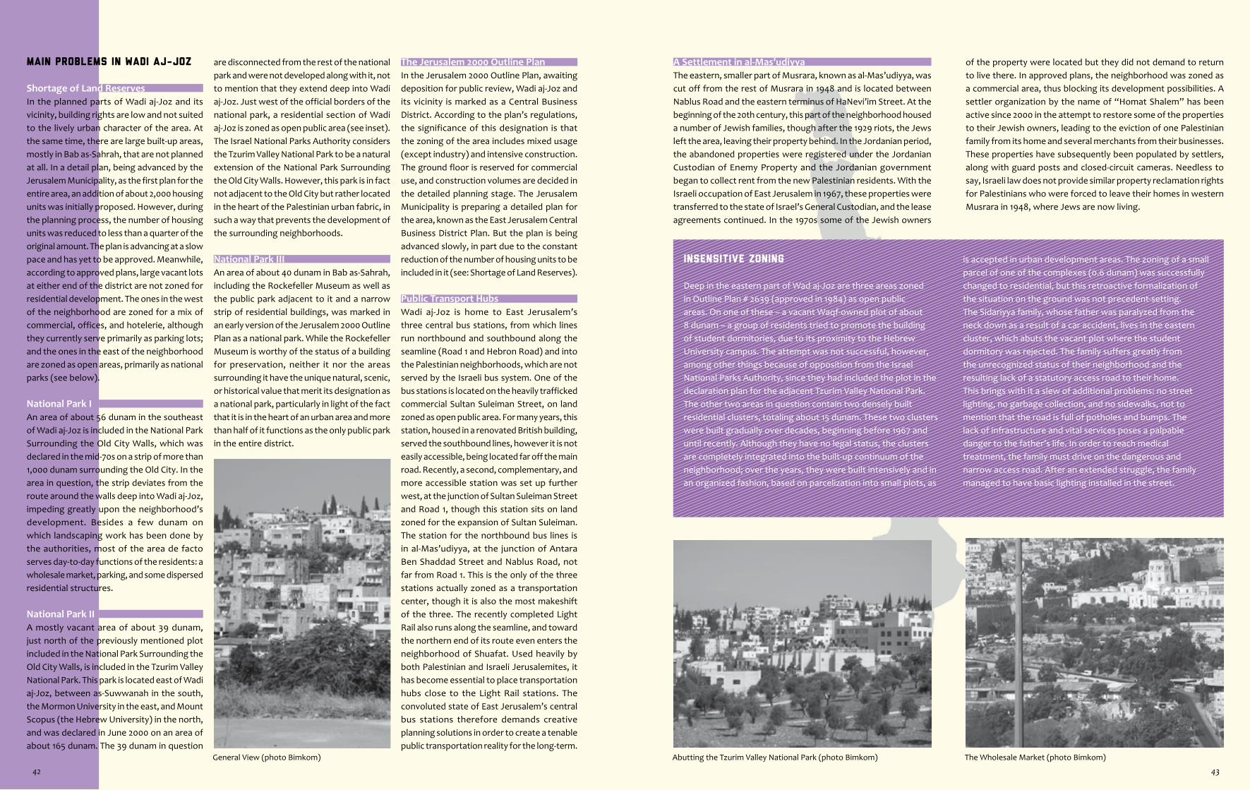
Abutting the Tzurim Valley National Park (photo Bimkom) The Wholesale Market (photo Bimkom)General View (photo Bimkom)
Insensitive Zoning
Deep in the eastern part of Wad aj-Joz are three areas zoned in Outline Plan # 2639 (approved in 1984) as open public areas. On one of these – a vacant Waqf-owned plot of about 8 dunam – a group of residents tried to promote the building of student dormitories, due to its proximity to the Hebrew University campus. The attempt was not successful, however, among other things because of opposition from the Israel National Parks Authority, since they had included the plot in the declaration plan for the adjacent Tzurim Valley National Park. The other two areas in question contain two densely built residential clusters, totaling about 15 dunam. These two clusters were built gradually over decades, beginning before 1967 and until recently. Although they have no legal status, the clusters are completely integrated into the built-up continuum of the neighborhood; over the years, they were built intensively and in an organized fashion, based on parcelization into small plots, as
A Settlement in al-Mas’udiyyaThe eastern, smaller part of Musrara, known as al-Mas’udiyya, was cut off from the rest of Musrara in 1948 and is located between Nablus Road and the eastern terminus of HaNevi’im Street. At the beginning of the 20th century, this part of the neighborhood housed a number of Jewish families, though after the 1929 riots, the Jews left the area, leaving their property behind. In the Jordanian period, the abandoned properties were registered under the Jordanian Custodian of Enemy Property and the Jordanian government began to collect rent from the new Palestinian residents. With the Israeli occupation of East Jerusalem in 1967, these properties were transferred to the state of Israel’s General Custodian, and the lease agreements continued. In the 1970s some of the Jewish owners
of the property were located but they did not demand to return to live there. In approved plans, the neighborhood was zoned as a commercial area, thus blocking its development possibilities. A settler organization by the name of “Homat Shalem” has been active since 2000 in the attempt to restore some of the properties to their Jewish owners, leading to the eviction of one Palestinian family from its home and several merchants from their businesses. These properties have subsequently been populated by settlers, along with guard posts and closed-circuit cameras. Needless to say, Israeli law does not provide similar property reclamation rights for Palestinians who were forced to leave their homes in western Musrara in 1948, where Jews are now living.
is accepted in urban development areas. The zoning of a small parcel of one of the complexes (0.6 dunam) was successfully changed to residential, but this retroactive formalization of the situation on the ground was not precedent-setting.The Sidariyya family, whose father was paralyzed from the neck down as a result of a car accident, lives in the eastern cluster, which abuts the vacant plot where the student dormitory was rejected. The family suffers greatly from the unrecognized status of their neighborhood and the resulting lack of a statutory access road to their home. This brings with it a slew of additional problems: no street lighting, no garbage collection, and no sidewalks, not to mention that the road is full of potholes and bumps. The lack of infrastructure and vital services poses a palpable danger to the father’s life. In order to reach medical treatment, the family must drive on the dangerous and narrow access road. After an extended struggle, the family managed to have basic lighting installed in the street.
Main Problems in Wadi aj-Joz
Shortage of Land ReservesIn the planned parts of Wadi aj-Joz and its vicinity, building rights are low and not suited to the lively urban character of the area. At the same time, there are large built-up areas, mostly in Bab as-Sahrah, that are not planned at all. In a detail plan, being advanced by the Jerusalem Municipality, as the first plan for the entire area, an addition of about 2,000 housing units was initially proposed. However, during the planning process, the number of housing units was reduced to less than a quarter of the original amount. The plan is advancing at a slow pace and has yet to be approved. Meanwhile, according to approved plans, large vacant lots at either end of the district are not zoned for residential development. The ones in the west of the neighborhood are zoned for a mix of commercial, offices, and hotelerie, although they currently serve primarily as parking lots; and the ones in the east of the neighborhood are zoned as open areas, primarily as national parks (see below).
National Park IAn area of about 56 dunam in the southeast of Wadi aj-Joz is included in the National Park Surrounding the Old City Walls, which was declared in the mid-70s on a strip of more than 1,000 dunam surrounding the Old City. In the area in question, the strip deviates from the route around the walls deep into Wadi aj-Joz, impeding greatly upon the neighborhood’s development. Besides a few dunam on which landscaping work has been done by the authorities, most of the area de facto serves day-to-day functions of the residents: a wholesale market, parking, and some dispersed residential structures.
National Park IIA mostly vacant area of about 39 dunam, just north of the previously mentioned plot included in the National Park Surrounding the Old City Walls, is included in the Tzurim Valley National Park. This park is located east of Wadi aj-Joz, between as-Suwwanah in the south, the Mormon University in the east, and Mount Scopus (the Hebrew University) in the north, and was declared in June 2000 on an area of about 165 dunam. The 39 dunam in question
are disconnected from the rest of the national park and were not developed along with it, not to mention that they extend deep into Wadi aj-Joz. Just west of the official borders of the national park, a residential section of Wadi aj-Joz is zoned as open public area (see inset). The Israel National Parks Authority considers the Tzurim Valley National Park to be a natural extension of the National Park Surrounding the Old City Walls. However, this park is in fact not adjacent to the Old City but rather located in the heart of the Palestinian urban fabric, in such a way that prevents the development of the surrounding neighborhoods.
National Park IIIAn area of about 40 dunam in Bab as-Sahrah, including the Rockefeller Museum as well as the public park adjacent to it and a narrow strip of residential buildings, was marked in an early version of the Jerusalem 2000 Outline Plan as a national park. While the Rockefeller Museum is worthy of the status of a building for preservation, neither it nor the areas surrounding it have the unique natural, scenic, or historical value that merit its designation as a national park, particularly in light of the fact that it is in the heart of an urban area and more than half of it functions as the only public park in the entire district.
The Jerusalem 2000 Outline PlanIn the Jerusalem 2000 Outline Plan, awaiting deposition for public review, Wadi aj-Joz and its vicinity is marked as a Central Business District. According to the plan’s regulations, the significance of this designation is that the zoning of the area includes mixed usage (except industry) and intensive construction. The ground floor is reserved for commercial use, and construction volumes are decided in the detailed planning stage. The Jerusalem Municipality is preparing a detailed plan for the area, known as the East Jerusalem Central Business District Plan. But the plan is being advanced slowly, in part due to the constant reduction of the number of housing units to be included in it (see: Shortage of Land Reserves).
Public Transport HubsWadi aj-Joz is home to East Jerusalem’s three central bus stations, from which lines run northbound and southbound along the seamline (Road 1 and Hebron Road) and into the Palestinian neighborhoods, which are not served by the Israeli bus system. One of the bus stations is located on the heavily trafficked commercial Sultan Suleiman Street, on land zoned as open public area. For many years, this station, housed in a renovated British building, served the southbound lines, however it is not easily accessible, being located far off the main road. Recently, a second, complementary, and more accessible station was set up further west, at the junction of Sultan Suleiman Street and Road 1, though this station sits on land zoned for the expansion of Sultan Suleiman. The station for the northbound bus lines is in al-Mas’udiyya, at the junction of Antara Ben Shaddad Street and Nablus Road, not far from Road 1. This is the only of the three stations actually zoned as a transportation center, though it is also the most makeshift of the three. The recently completed Light Rail also runs along the seamline, and toward the northern end of its route even enters the neighborhood of Shuafat. Used heavily by both Palestinian and Israeli Jerusalemites, it has become essential to place transportation hubs close to the Light Rail stations. The convoluted state of East Jerusalem’s central bus stations therefore demands creative planning solutions in order to create a tenable public transportation reality for the long-term.
42 43

Zoning Structure According to Approved Plans • Designation vs. Use
DesignationPlans
Land Usedunam %
Residential* 301 26Residential zoning and building rights do not match the neighborhood’s urban character. Most of Bab as-Sahrah has no approved plan, though it functions de facto as a lively mix of residential and commercial uses. Two residential clusters, on either side of al-Maqdasi Street, are zoned as open public area (see inset).
Commercial 80 7
Large, mostly vacant, areas, mostly in the western part of the neighborhood, were zoned for commercial use, sometimes combined with offices and hotelerie. However, they are used for parking, as well as a sports field and the Israeli Ministry of Justice building. The al-Mas’udiyya sub-neighborhood is also zoned exclusively as commercial although de facto there is a mix of commercial and residential uses there. A commercial storefront façade was approved along the main street of the residential cluster across from the northern transportation center (see: Public Transport Hubs). Much commercial activity is located in the unplanned area of Bab as-Sahrah.
Open Spaces 172 15
Eight plots are designated as open. Two of these plots are included within declared national parks (see: National Parks I & II). The rest of the plots are designated as open public areas, with the exception of one small lot, which is zoned as open private area. Among the open public areas, only the smallest of them, in the American Colony (adjacent to the Jarrah Mosque) is vacant. Two additional plots are entirely built-up (see inset) and one is partially built-up and abuts the highway leading to the Mount Scopus Tunnel. In the western part of the neighborhood, one plot serves as a parking lot and in the central part of the neighborhood, another plot contains the old East Jerusalem Central Bus Station (see: Public Transport Hubs). The only public park in the neighborhood (and in East Jerusalem), is located adjacent to the Rockefeller Museum (see: National Park III), on an area zoned for public institutions; it is run-down and its existence is threatened by new plans, but it preserves memories of better days.
Roads 215 19
Most of the statutory roads actually serve the residents but they are not properly maintained. Some of them are designated for expansion, despite proximity to existing houses. In addition, there are vital, useful roads that serve as access roads to the houses, but which are not statutory (see inset). In the al-Mas’udiyya sub-neighborhood, an area of about 10 dunam is zoned as a transportation center (see: Public Transport Hubs).
Public Buildings and Institutions
185 16
Out of approximately 20 plots, only two are vacant (in the northeast); on one of them there are plans to build a new elementary school. Among the public institutions located on land designated as such are: two municipal high schools (al-Ma’amuniyya and ar-Rashidiyya), the al-Barqiyya Special Education School, the Saint George School, the Schmidt Girls’ College, the French École Biblique, the East Jerusalem YMCA, the Jerusalem District Court, the Rockefeller Museum, the Paley Center, a fire department, and the UN Headquarters. Among the public institutions located on differently zoned areas are: a municipal library (the only one in all of East Jerusalem), the YWCA, the East Jerusalem Shari’a court, and the Israeli Ministry of Justice.
Hotelerie 55 5Throughout Bab as-Sahrah and the American Colony, there are about 11 plots zoned for hoteleire. Most of these have hotels on them, including the well-known American Colony; there are also hotels on differently zoned plots.
Other 141 12Includes an archeological site, the Light Rail, and a cemetery. De facto, the as-Sahrah Cemetery is much larger than the area allotted to it. Also includes unplanned areas.
Total 1,149 100
* In most of Wadi aj-Joz and its vicinity, a 50% building ratio with sparse construction of up to two storeys is permitted. Another significant zoning type is 75% building ratio, also with sparse construction. Many small-scale detail plans have been approved, enabling denser construction and, at times, also changing land designations.
Approved Plans in the Neighborhood
Outline Plan # 2639 for Wadi aj-Joz 475.0 dunam
Part of Outline Plan # 2969 for the eastern bank of Road 1 113.0 dunam
Part of Outline Plan # 3092 for at-Tur and as-Suwwanah 42.0 dunam
Part of Outline Plan # 2591 for ash-Sheikh Jarrah 1.0 dunam
4 detail plans in northeastern Wadi aj-Joz 68.0 dunam
14 detail plans in Bab as-Sahrah 110.0 dunam
Part of Local Outline Plan # 9 for the Visual Basin of the Old City 118.0 dunam
Part of Declaration Plan 11/19/c, National Park Surrounding the Old City Walls 56.0 dunam
Local Plan # 8088 for the eastern section of Ha-Nevi’im Street 17.0 dunam
Part of Detail Plan # 8000 for the Light Rail 19.0 dunam
Total planned area 1,019.0 dunam
Unplanned area 130.0 dunam
Total area of neighborhood 1,149.0 dunamOver the years, about 25 detail plans have been approved, with no added area for the neighborhood.
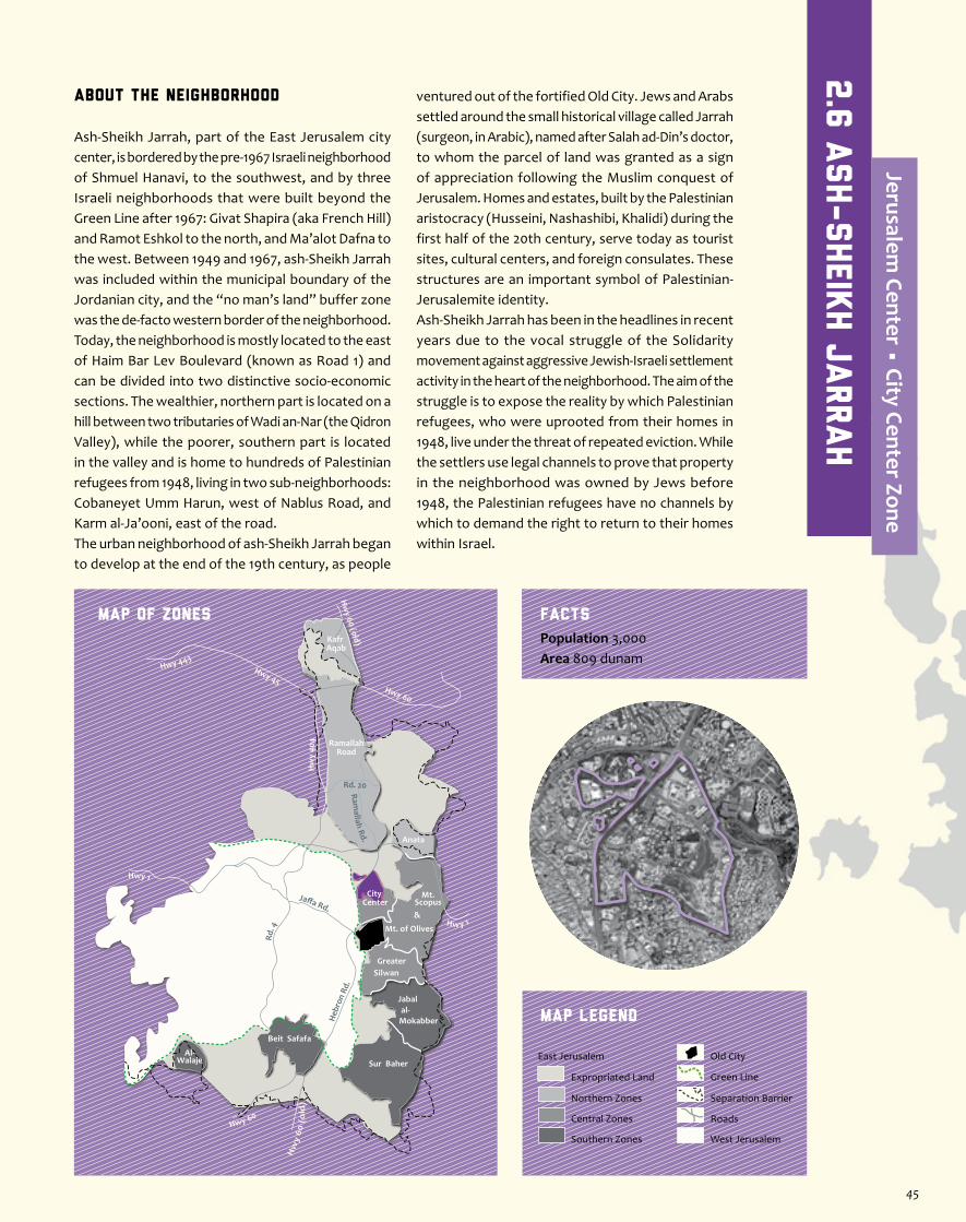
About the Neighborhood
Ash-Sheikh Jarrah, part of the East Jerusalem city center, is bordered by the pre-1967 Israeli neighborhood of Shmuel Hanavi, to the southwest, and by three Israeli neighborhoods that were built beyond the Green Line after 1967: Givat Shapira (aka French Hill) and Ramot Eshkol to the north, and Ma’alot Dafna to the west. Between 1949 and 1967, ash-Sheikh Jarrah was included within the municipal boundary of the Jordanian city, and the “no man’s land” buffer zone was the de-facto western border of the neighborhood. Today, the neighborhood is mostly located to the east of Haim Bar Lev Boulevard (known as Road 1) and can be divided into two distinctive socio-economic sections. The wealthier, northern part is located on a hill between two tributaries of Wadi an-Nar (the Qidron Valley), while the poorer, southern part is located in the valley and is home to hundreds of Palestinian refugees from 1948, living in two sub-neighborhoods: Cobaneyet Umm Harun, west of Nablus Road, and Karm al-Ja’ooni, east of the road.The urban neighborhood of ash-Sheikh Jarrah began to develop at the end of the 19th century, as people
ventured out of the fortified Old City. Jews and Arabs settled around the small historical village called Jarrah (surgeon, in Arabic), named after Salah ad-Din’s doctor, to whom the parcel of land was granted as a sign of appreciation following the Muslim conquest of Jerusalem. Homes and estates, built by the Palestinian aristocracy (Husseini, Nashashibi, Khalidi) during the first half of the 20th century, serve today as tourist sites, cultural centers, and foreign consulates. These structures are an important symbol of Palestinian-Jerusalemite identity. Ash-Sheikh Jarrah has been in the headlines in recent years due to the vocal struggle of the Solidarity movement against aggressive Jewish-Israeli settlement activity in the heart of the neighborhood. The aim of the struggle is to expose the reality by which Palestinian refugees, who were uprooted from their homes in 1948, live under the threat of repeated eviction. While the settlers use legal channels to prove that property in the neighborhood was owned by Jews before 1948, the Palestinian refugees have no channels by which to demand the right to return to their homes within Israel.
Jaffa Rd.
Rd. 4
Heb
ron
Rd.
Ramallah Rd.
Hwy 1
Hwy 443Hwy 45
Rd. 20
Hw
y 40
4
Hw y 1
Hwy 60
Hw
y 60
(o
ld)
Hw
y 60 (old)
Hwy 60
RamallahRoad
Anata
Kafr Aqab
Mt. of Olives
Mt.Scopus&
City Center
GreaterSilwan
al-Mokabber
Jabal
Sur Baher
Beit Safafa
Al-Walaje
MAP OF ZONES
Map Legend
Population 3,000Area 809 dunam
Facts
Separation Barrier
West Jerusalem
East Jerusalem
Expropriated Land
Northern Zones
Central Zones
Southern Zones
Old City
Roads
Green Line
2.6
Ash-Sheik
h J
arrah
Jerusalem Center • City Center Zone
45
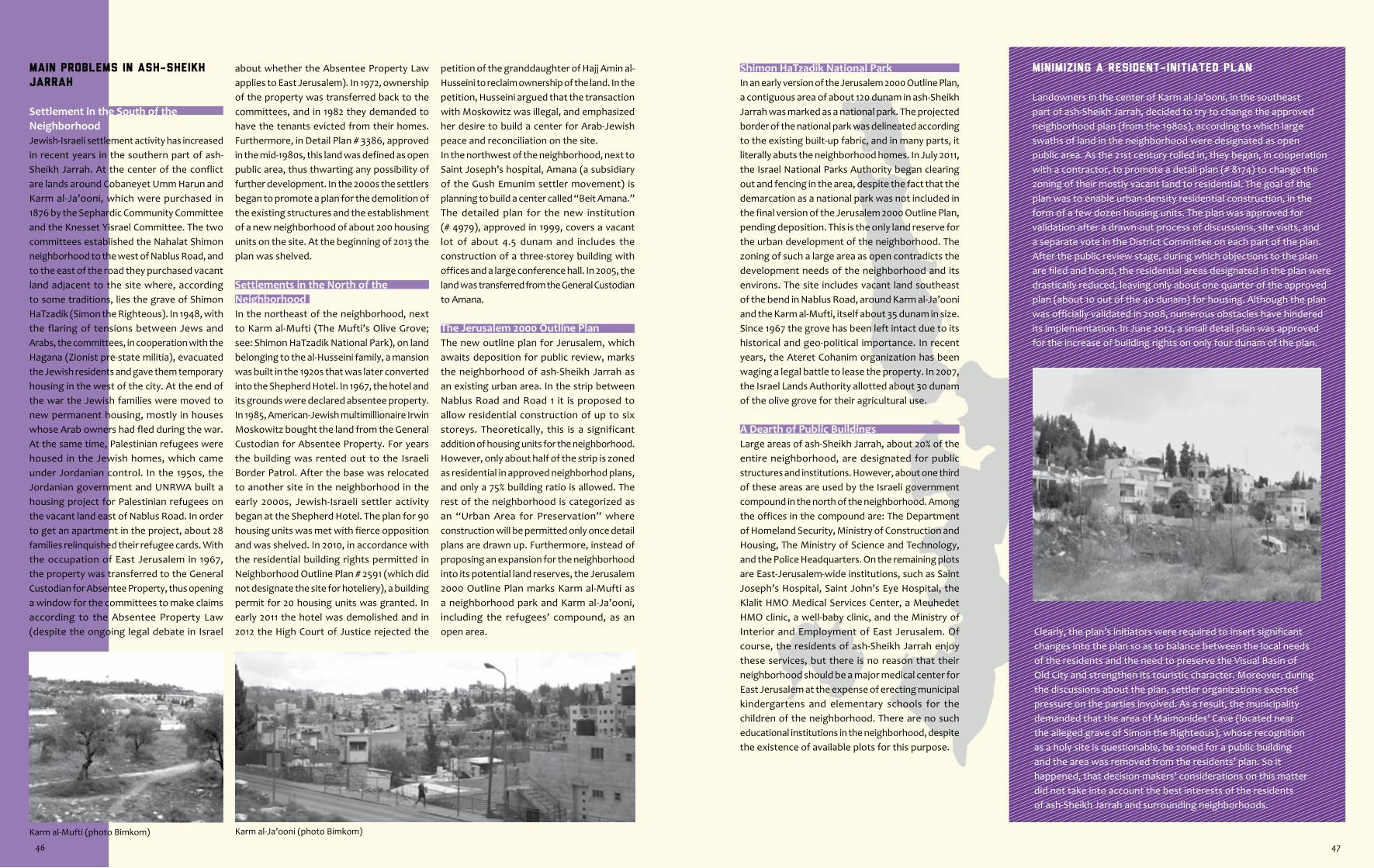
Karm al-Mufti (photo Bimkom) Karm al-Ja’ooni (photo Bimkom)
Minimizing a Resident-Initiated Plan
Landowners in the center of Karm al-Ja’ooni, in the southeast part of ash-Sheikh Jarrah, decided to try to change the approved neighborhood plan (from the 1980s), according to which large swaths of land in the neighborhood were designated as open public area. As the 21st century rolled in, they began, in cooperation with a contractor, to promote a detail plan (# 8174) to change the zoning of their mostly vacant land to residential. The goal of the plan was to enable urban-density residential construction, in the form of a few dozen housing units. The plan was approved for validation after a drawn-out process of discussions, site visits, and a separate vote in the District Committee on each part of the plan.After the public review stage, during which objections to the plan are filed and heard, the residential areas designated in the plan were drastically reduced, leaving only about one quarter of the approved plan (about 10 out of the 40 dunam) for housing. Although the plan was officially validated in 2008, numerous obstacles have hindered its implementation. In June 2012, a small detail plan was approved for the increase of building rights on only four dunam of the plan.
Shimon HaTzadik National ParkIn an early version of the Jerusalem 2000 Outline Plan, a contiguous area of about 120 dunam in ash-Sheikh Jarrah was marked as a national park. The projected border of the national park was delineated according to the existing built-up fabric, and in many parts, it literally abuts the neighborhood homes. In July 2011, the Israel National Parks Authority began clearing out and fencing in the area, despite the fact that the demarcation as a national park was not included in the final version of the Jerusalem 2000 Outline Plan, pending deposition. This is the only land reserve for the urban development of the neighborhood. The zoning of such a large area as open contradicts the development needs of the neighborhood and its environs. The site includes vacant land southeast of the bend in Nablus Road, around Karm al-Ja’ooni and the Karm al-Mufti, itself about 35 dunam in size. Since 1967 the grove has been left intact due to its historical and geo-political importance. In recent years, the Ateret Cohanim organization has been waging a legal battle to lease the property. In 2007, the Israel Lands Authority allotted about 30 dunam of the olive grove for their agricultural use.
A Dearth of Public BuildingsLarge areas of ash-Sheikh Jarrah, about 20% of the entire neighborhood, are designated for public structures and institutions. However, about one third of these areas are used by the Israeli government compound in the north of the neighborhood. Among the offices in the compound are: The Department of Homeland Security, Ministry of Construction and Housing, The Ministry of Science and Technology, and the Police Headquarters. On the remaining plots are East-Jerusalem-wide institutions, such as Saint Joseph’s Hospital, Saint John’s Eye Hospital, the Klalit HMO Medical Services Center, a Meuhedet HMO clinic, a well-baby clinic, and the Ministry of Interior and Employment of East Jerusalem. Of course, the residents of ash-Sheikh Jarrah enjoy these services, but there is no reason that their neighborhood should be a major medical center for East Jerusalem at the expense of erecting municipal kindergartens and elementary schools for the children of the neighborhood. There are no such educational institutions in the neighborhood, despite the existence of available plots for this purpose.
Clearly, the plan’s initiators were required to insert significant changes into the plan so as to balance between the local needs of the residents and the need to preserve the Visual Basin of Old City and strengthen its touristic character. Moreover, during the discussions about the plan, settler organizations exerted pressure on the parties involved. As a result, the municipality demanded that the area of Maimonides’ Cave (located near the alleged grave of Simon the Righteous), whose recognition as a holy site is questionable, be zoned for a public building and the area was removed from the residents’ plan. So it happened, that decision-makers’ considerations on this matter did not take into account the best interests of the residents of ash-Sheikh Jarrah and surrounding neighborhoods.
Main Problems in ash-Sheikh
Jarrah
Settlement in the South of the NeighborhoodJewish-Israeli settlement activity has increased in recent years in the southern part of ash-Sheikh Jarrah. At the center of the conflict are lands around Cobaneyet Umm Harun and Karm al-Ja’ooni, which were purchased in 1876 by the Sephardic Community Committee and the Knesset Yisrael Committee. The two committees established the Nahalat Shimon neighborhood to the west of Nablus Road, and to the east of the road they purchased vacant land adjacent to the site where, according to some traditions, lies the grave of Shimon HaTzadik (Simon the Righteous). In 1948, with the flaring of tensions between Jews and Arabs, the committees, in cooperation with the Hagana (Zionist pre-state militia), evacuated the Jewish residents and gave them temporary housing in the west of the city. At the end of the war the Jewish families were moved to new permanent housing, mostly in houses whose Arab owners had fled during the war. At the same time, Palestinian refugees were housed in the Jewish homes, which came under Jordanian control. In the 1950s, the Jordanian government and UNRWA built a housing project for Palestinian refugees on the vacant land east of Nablus Road. In order to get an apartment in the project, about 28 families relinquished their refugee cards. With the occupation of East Jerusalem in 1967, the property was transferred to the General Custodian for Absentee Property, thus opening a window for the committees to make claims according to the Absentee Property Law (despite the ongoing legal debate in Israel
about whether the Absentee Property Law applies to East Jerusalem). In 1972, ownership of the property was transferred back to the committees, and in 1982 they demanded to have the tenants evicted from their homes. Furthermore, in Detail Plan # 3386, approved in the mid-1980s, this land was defined as open public area, thus thwarting any possibility of further development. In the 2000s the settlers began to promote a plan for the demolition of the existing structures and the establishment of a new neighborhood of about 200 housing units on the site. At the beginning of 2013 the plan was shelved.
Settlements in the North of the Neighborhood In the northeast of the neighborhood, next to Karm al-Mufti (The Mufti’s Olive Grove; see: Shimon HaTzadik National Park), on land belonging to the al-Husseini family, a mansion was built in the 1920s that was later converted into the Shepherd Hotel. In 1967, the hotel and its grounds were declared absentee property. In 1985, American-Jewish multimillionaire Irwin Moskowitz bought the land from the General Custodian for Absentee Property. For years the building was rented out to the Israeli Border Patrol. After the base was relocated to another site in the neighborhood in the early 2000s, Jewish-Israeli settler activity began at the Shepherd Hotel. The plan for 90 housing units was met with fierce opposition and was shelved. In 2010, in accordance with the residential building rights permitted in Neighborhood Outline Plan # 2591 (which did not designate the site for hoteliery), a building permit for 20 housing units was granted. In early 2011 the hotel was demolished and in 2012 the High Court of Justice rejected the
petition of the granddaughter of Hajj Amin al-Husseini to reclaim ownership of the land. In the petition, Husseini argued that the transaction with Moskowitz was illegal, and emphasized her desire to build a center for Arab-Jewish peace and reconciliation on the site.In the northwest of the neighborhood, next to Saint Joseph’s hospital, Amana (a subsidiary of the Gush Emunim settler movement) is planning to build a center called “Beit Amana.” The detailed plan for the new institution (# 4979), approved in 1999, covers a vacant lot of about 4.5 dunam and includes the construction of a three-storey building with offices and a large conference hall. In 2005, the land was transferred from the General Custodian to Amana.
The Jerusalem 2000 Outline PlanThe new outline plan for Jerusalem, which awaits deposition for public review, marks the neighborhood of ash-Sheikh Jarrah as an existing urban area. In the strip between Nablus Road and Road 1 it is proposed to allow residential construction of up to six storeys. Theoretically, this is a significant addition of housing units for the neighborhood. However, only about half of the strip is zoned as residential in approved neighborhod plans, and only a 75% building ratio is allowed. The rest of the neighborhood is categorized as an “Urban Area for Preservation” where construction will be permitted only once detail plans are drawn up. Furthermore, instead of proposing an expansion for the neighborhood into its potential land reserves, the Jerusalem 2000 Outline Plan marks Karm al-Mufti as a neighborhood park and Karm al-Ja’ooni, including the refugees’ compound, as an open area.
46 47

Zoning Structure According to Approved Plans • Designation vs. Use
DesignationPlans
Land Usedunam %
Residential* 177.5 22
The few allotted residential areas do not correspond with actual ones, often existing on land zoned for other uses: open areas, hotelerie, and roads. In addition, permitted building rights are low and do not meet the needs of an urban center. A number of Palestinian homes are located to the west of Road 1, only some of which are on land designated for residential use.
Open Spaces 158.5 20
A large, mostly vacant, contiguous area in the center of the neighborhood is currently zoned mostly as an open public area (and partly as an open scenic area) and is intended to become a national park (see: Shimon HaTzadik National Park). At the edges of the area, approximately 30 vacant dunam (about half zoned for housing and half for public structures) are also proposed to be part of the national park. Another 15 or so plots are designated as open public areas, only two of which were developed: in the southwest as a public park, and in the northwest as a sports field. Of the undeveloped plots, those in the southeast serve as residential plots and those in the south-west are either vacant or serve as parking lots.
Roads 141 17.5
Most of the statutory roads are in the south of the neighborhood and are not properly maintained. Many of them are designated for expansion, which will be difficult to implement due to the proximity of existing houses. Part of the area of Karm al-Mufti is zoned for the expansion of Nablus Road. Access roads to the housing cluster designated as open public area, are not formalized; lack of status results in a lack of basic infrastructure such as lighting and garbage collection.
Public Buildings and Institutions
168 21
The two largest plots (of an allotted 20), on a total of about 56 dunam, serve the Israeli Govrenment Compound; the rest of the compound (another 50 or so dunam) does not even have an approved plan. Another plot is designated for the construction of “Beit Amana” and about half of the remaining plots are used by public structures or institutions serving citywide functions. A new building for the East Jerusalem Social Security offices is currently being erected on a vacant plot in the southwestern part of the neighborhood, along Road 1. Further north, on the other side of the road, is the Abdallah Abu Hussein Municipal Girls’ High School, on a plot designated for public buildings. The rest of the plots are mostly vacant. The only elementary school in the neighborhood is run by the Waqf and it operates out of a residential building. The municipal boys’ high school operates on a site intended for a hotel (see below). At the northwestern edge of Karm al-Mufti, part of one of the plots used to house a kindergarten cluster; today the building serves a local NGO.
Hotelerie 60 7.5
Of 8 plots zoned for hotelerie, five are in the northern part of the neighborhood, only one of which actually houses a hotel: the Ambassador Hotel. Meanwhile, the land on which the nearby Mt. Scopus Hotel stands was designated for housing, and the adjacent Abdallah Abu Hussein Municipal Boys’ High School (formerly the Sakakini School) sits on a plot designated for a hotel, as do the relocated Border Patrol base and another two residential structures. Adjacent to the Shepherd Hotel site, which itself is zoned for housing, there is a vacant lot zoned for a hotel. Among the plots in the south of the neighborhood, two are vacant and the third and largest of them, along the strip of car repair shops, has industrial structures on it.
Other 104 12Including the Light Rail tracks, an area for special commercial use, a plot for a gas station, minimal areas for future planning (including the UNRWA compound, west of Road 1), and unplanned areas.
Total 809 100
* In most of the residentially zoned areas in the neighborhood, to the east and north of Nablus Road, the permitted building ratio is 50%, with sparse construction of up to two storeys. In the narrow strip between Road 1 and Nablus Road, a building ratio of 75% is permitted, also with sparse construction. Building rights, allowing up to 6 storeys, have been allocated via the approval of small-scale detail plans.
Approved Plans in the Neighborhood
Outline plans (2591, 3386) for ash-Sheikh Jarrah 373.5 dunam
Part of Outline Plan #2969 for the eastern bank of Road 1 168.0 dunam
Detail plans (2875, 6313) for the Government Compound 62.0 dunam
Part of Outline Plan # 2639 for Wadi aj-Joz 12.0 dunam
Part of Outline Plan # 9 for the Visual Basin of the Old City 54.5 dunam
Part of Detail Plan # 8000 for the Light Rail 23.0 dunam
Plans to the West of Road 1 79.4 dunam
Total Planned Area 772.4 dunam
Unplanned Area 36.2 dunam
Total Area of the Neighborhood 808.6 dunam
Some 20 small-scale detail plans have been approved in the neighborhood over the years, with no added area for the neighborhood.
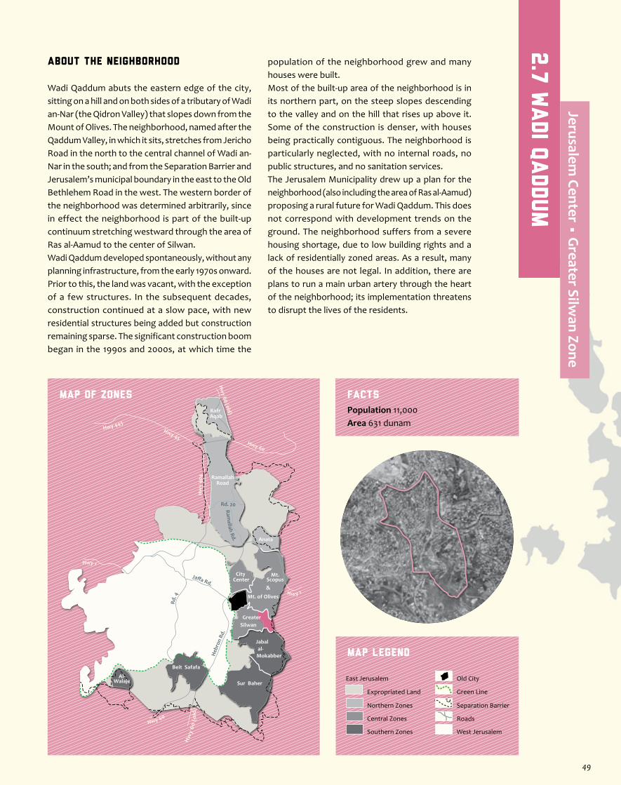
About the Neighborhood
Wadi Qaddum abuts the eastern edge of the city, sitting on a hill and on both sides of a tributary of Wadi an-Nar (the Qidron Valley) that slopes down from the Mount of Olives. The neighborhood, named after the Qaddum Valley, in which it sits, stretches from Jericho Road in the north to the central channel of Wadi an-Nar in the south; and from the Separation Barrier and Jerusalem’s municipal boundary in the east to the Old Bethlehem Road in the west. The western border of the neighborhood was determined arbitrarily, since in effect the neighborhood is part of the built-up continuum stretching westward through the area of Ras al-Aamud to the center of Silwan.Wadi Qaddum developed spontaneously, without any planning infrastructure, from the early 1970s onward. Prior to this, the land was vacant, with the exception of a few structures. In the subsequent decades, construction continued at a slow pace, with new residential structures being added but construction remaining sparse. The significant construction boom began in the 1990s and 2000s, at which time the
population of the neighborhood grew and many houses were built.Most of the built-up area of the neighborhood is in its northern part, on the steep slopes descending to the valley and on the hill that rises up above it. Some of the construction is denser, with houses being practically contiguous. The neighborhood is particularly neglected, with no internal roads, no public structures, and no sanitation services.The Jerusalem Municipality drew up a plan for the neighborhood (also including the area of Ras al-Aamud) proposing a rural future for Wadi Qaddum. This does not correspond with development trends on the ground. The neighborhood suffers from a severe housing shortage, due to low building rights and a lack of residentially zoned areas. As a result, many of the houses are not legal. In addition, there are plans to run a main urban artery through the heart of the neighborhood; its implementation threatens to disrupt the lives of the residents.
Jaffa Rd.
Rd. 4
Heb
ron
Rd.
Ramallah Rd.
Hwy 1
Hwy 443Hwy 45
Rd. 20
Hw
y 40
4
Hw y 1
Hwy 60
Hw
y 60
(o
ld)
Hw
y 60 (old)
Hwy 60
RamallahRoad
Anata
Kafr Aqab
Mt. of Olives
Mt.Scopus&
City Center
GreaterSilwan
al-Mokabber
Jabal
Sur Baher
Beit Safafa
Al-Walaje
MAP OF ZONES
Map Legend
Population 11,000Area 631 dunam
Facts
Separation Barrier
West Jerusalem
East Jerusalem
Expropriated Land
Northern Zones
Central Zones
Southern Zones
Old City
Roads
Green Line
2.7
Wadi Q
addum
Jerusalem Center • G
reater Silwan Zone
49
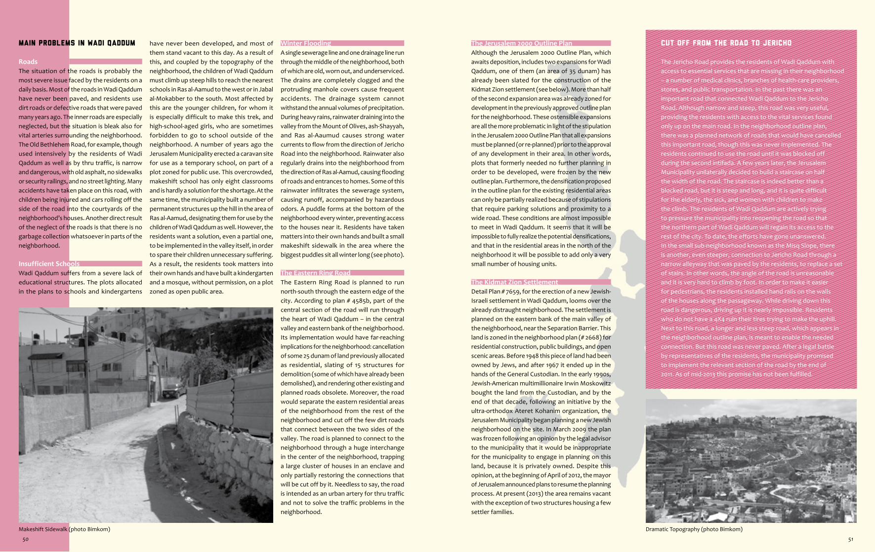
Cut Off from the Road to Jericho
The Jericho Road provides the residents of Wadi Qaddum with access to essential services that are missing in their neighborhood – a number of medical clinics, branches of health-care providers, stores, and public transportation. In the past there was an important road that connected Wadi Qaddum to the Jericho Road. Although narrow and steep, this road was very useful, providing the residents with access to the vital services found only up on the main road. In the neighborhood outline plan, there was a planned network of roads that would have cancelled this important road, though this was never implemented. The residents continued to use the road until it was blocked off during the second intifada. A few years later, the Jerusalem Municipality unilaterally decided to build a staircase on half the width of the road. The staircase is indeed better than a blocked road, but it is steep and long, and it is quite difficult for the elderly, the sick, and women with children to make the climb. The residents of Wadi Qaddum are actively trying to pressure the municipality into reopening the road so that the northern part of Wadi Qaddum will regain its access to the rest of the city. To date, the efforts have gone unanswered. In the small sub-neighborhood known as the Misq Slope, there is another, even steeper, connection to Jericho Road through a narrow alleyway that was paved by the residents, to replace a set of stairs. In other words, the angle of the road is unreasonable and it is very hard to climb by foot. In order to make it easier for pedestrians, the residents installed hand rails on the walls of the houses along the passageway. While driving down this road is dangerous, driving up it is nearly impossible. Residents who do not have a 4X4 ruin their tires trying to make the uphill. Next to this road, a longer and less steep road, which appears in the neighborhood outline plan, is meant to enable the needed connection. But this road was never paved. After a legal battle by representatives of the residents, the municipality promised to implement the relevant section of the road by the end of 2011. As of mid-2013 this promise has not been fulfilled.
The Jerusalem 2000 Outline PlanAlthough the Jerusalem 2000 Outline Plan, which awaits deposition, includes two expansions for Wadi Qaddum, one of them (an area of 35 dunam) has already been slated for the construction of the Kidmat Zion settlement (see below). More than half of the second expansion area was already zoned for development in the previously approved outline plan for the neighborhood. These ostensible expansions are all the more problematic in light of the stipulation in the Jerusalem 2000 Outline Plan that all expansions must be planned (or re-planned) prior to the approval of any development in their area. In other words, plots that formerly needed no further planning in order to be developed, were frozen by the new outline plan. Furthermore, the densification proposed in the outline plan for the existing residential areas can only be partially realized because of stipulations that require parking solutions and proximity to a wide road. These conditions are almost impossible to meet in Wadi Qaddum. It seems that it will be impossible to fully realize the potential densifications, and that in the residential areas in the north of the neighborhood it will be possible to add only a very small number of housing units.
The Kidmat Zion SettlementDetail Plan # 7659, for the erection of a new Jewish-Israeli settlement in Wadi Qaddum, looms over the already distraught neighborhood. The settlement is planned on the eastern bank of the main valley of the neighborhood, near the Separation Barrier. This land is zoned in the neighborhood plan (# 2668) for residential construction, public buildings, and open scenic areas. Before 1948 this piece of land had been owned by Jews, and after 1967 it ended up in the hands of the General Custodian. In the early 1990s, Jewish-American multimillionaire Irwin Moskowitz bought the land from the Custodian, and by the end of that decade, following an initiative by the ultra-orthodox Ateret Kohanim organization, the Jerusalem Municipality began planning a new Jewish neighborhood on the site. In March 2009 the plan was frozen following an opinion by the legal advisor to the municipality that it would be inappropriate for the municipality to engage in planning on this land, because it is privately owned. Despite this opinion, at the beginning of April of 2012, the mayor of Jerusalem announced plans to resume the planning process. At present (2013) the area remains vacant with the exception of two structures housing a few settler families.
Dramatic Topography (photo Bimkom)
Main Problems in Wadi Qaddum
RoadsThe situation of the roads is probably the most severe issue faced by the residents on a daily basis. Most of the roads in Wadi Qaddum have never been paved, and residents use dirt roads or defective roads that were paved many years ago. The inner roads are especially neglected, but the situation is bleak also for vital arteries surrounding the neighborhood. The Old Bethlehem Road, for example, though used intensively by the residents of Wadi Qaddum as well as by thru traffic, is narrow and dangerous, with old asphalt, no sidewalks or security railings, and no street lighting. Many accidents have taken place on this road, with children being injured and cars rolling off the side of the road into the courtyards of the neighborhood’s houses. Another direct result of the neglect of the roads is that there is no garbage collection whatsoever in parts of the neighborhood.
Insufficient SchoolsWadi Qaddum suffers from a severe lack of educational structures. The plots allocated in the plans to schools and kindergartens
have never been developed, and most of them stand vacant to this day. As a result of this, and coupled by the topography of the neighborhood, the children of Wadi Qaddum must climb up steep hills to reach the nearest schools in Ras al-Aamud to the west or in Jabal al-Mokabber to the south. Most affected by this are the younger children, for whom it is especially difficult to make this trek, and high-school-aged girls, who are sometimes forbidden to go to school outside of the neighborhood. A number of years ago the Jerusalem Municipality erected a caravan site for use as a temporary school, on part of a plot zoned for public use. This overcrowded, makeshift school has only eight classrooms and is hardly a solution for the shortage. At the same time, the municipality built a number of permanent structures up the hill in the area of Ras al-Aamud, designating them for use by the children of Wadi Qaddum as well. However, the residents want a solution, even a partial one, to be implemented in the valley itself, in order to spare their children unnecessary suffering. As a result, the residents took matters into their own hands and have built a kindergarten and a mosque, without permission, on a plot zoned as open public area.
Winter FloodingA single sewerage line and one drainage line run through the middle of the neighborhood, both of which are old, worn out, and underserviced. The drains are completely clogged and the protruding manhole covers cause frequent accidents. The drainage system cannot withstand the annual volumes of precipitation. During heavy rains, rainwater draining into the valley from the Mount of Olives, ash-Shayyah, and Ras al-Aaumud causes strong water currents to flow from the direction of Jericho Road into the neighborhood. Rainwater also regularly drains into the neighborhood from the direction of Ras al-Aamud, causing flooding of roads and entrances to homes. Some of this rainwater infiltrates the sewerage system, causing runoff, accompanied by hazardous odors. A puddle forms at the bottom of the neighborhood every winter, preventing access to the houses near it. Residents have taken matters into their own hands and built a small makeshift sidewalk in the area where the biggest puddles sit all winter long (see photo).
The Eastern Ring RoadThe Eastern Ring Road is planned to run north-south through the eastern edge of the city. According to plan # 4585b, part of the central section of the road will run through the heart of Wadi Qaddum – in the central valley and eastern bank of the neighborhood. Its implementation would have far-reaching implications for the neighborhood: cancellation of some 25 dunam of land previously allocated as residential, slating of 15 structures for demolition (some of which have already been demolished), and rendering other existing and planned roads obsolete. Moreover, the road would separate the eastern residential areas of the neighborhood from the rest of the neighborhood and cut off the few dirt roads that connect between the two sides of the valley. The road is planned to connect to the neighborhood through a huge interchange in the center of the neighborhood, trapping a large cluster of houses in an enclave and only partially restoring the connections that will be cut off by it. Needless to say, the road is intended as an urban artery for thru traffic and not to solve the traffic problems in the neighborhood.
Makeshift Sidewalk (photo Bimkom)
50 51
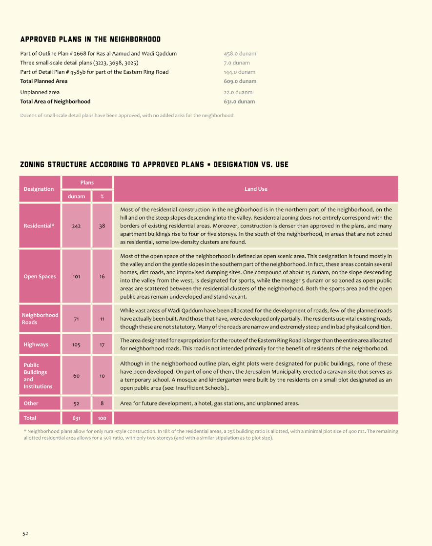
Zoning Structure According to Approved Plans • Designation vs. Use
DesignationPlans
Land Usedunam %
Residential* 242 38
Most of the residential construction in the neighborhood is in the northern part of the neighborhood, on the hill and on the steep slopes descending into the valley. Residential zoning does not entirely correspond with the borders of existing residential areas. Moreover, construction is denser than approved in the plans, and many apartment buildings rise to four or five storeys. In the south of the neighborhood, in areas that are not zoned as residential, some low-density clusters are found.
Open Spaces 101 16
Most of the open space of the neighborhood is defined as open scenic area. This designation is found mostly in the valley and on the gentle slopes in the southern part of the neighborhood. In fact, these areas contain several homes, dirt roads, and improvised dumping sites. One compound of about 15 dunam, on the slope descending into the valley from the west, is designated for sports, while the meager 5 dunam or so zoned as open public areas are scattered between the residential clusters of the neighborhood. Both the sports area and the open public areas remain undeveloped and stand vacant.
Neighborhood Roads 71 11
While vast areas of Wadi Qaddum have been allocated for the development of roads, few of the planned roads have actually been built. And those that have, were developed only partially. The residents use vital existing roads, though these are not statutory. Many of the roads are narrow and extremely steep and in bad physical condition.
Highways 105 17The area designated for expropriation for the route of the Eastern Ring Road is larger than the entire area allocated for neighborhood roads. This road is not intended primarily for the benefit of residents of the neighborhood.
Public BuildingsandInstitutions
60 10
Although in the neighborhood outline plan, eight plots were designated for public buildings, none of these have been developed. On part of one of them, the Jerusalem Municipality erected a caravan site that serves as a temporary school. A mosque and kindergarten were built by the residents on a small plot designated as an open public area (see: Insufficient Schools)..
Other 52 8 Area for future development, a hotel, gas stations, and unplanned areas.
Total 631 100
* Neighborhood plans allow for only rural-style construction. In 18% of the residential areas, a 25% building ratio is allotted, with a minimal plot size of 400 m2. The remaining allotted residential area allows for a 50% ratio, with only two storeys (and with a similar stipulation as to plot size).
Approved Plans in the Neighborhood
Part of Outline Plan # 2668 for Ras al-Aamud and Wadi Qaddum 458.0 dunam
Three small-scale detail plans (3223, 3698, 3025) 7.0 dunam
Part of Detail Plan # 4585b for part of the Eastern Ring Road 144.0 dunam
Total Planned Area 609.0 dunam
Unplanned area 22.0 duanm
Total Area of Neighborhood 631.0 dunam
Dozens of small-scale detail plans have been approved, with no added area for the neighborhood.
52

About the Neighborhood
The area of Ras al-Aamud is not generally defined as a separate neighborhood of East Jerusalem, but rather as part of the contiguous built-up area of Silwan. Ras al-Aamud borders on Silwan al-Wusta to the west, on the Mount of Olives to the north, on the Old Bethlehem Road and Wadi Qaddum to the east, and on Wadi an-Nar (the Qidron Valley) to the south. The area’s steep topography descends from its highest part in the northwest down to the lower part in the southeast. The upper/western section is the highest point; halfway down the slope is as-Sweih; and in the valley is Ein al-Lawza. The strict development restrictions of Plan # 9 for the Visual Basin of the Old City apply to the vast majority of the area, despite the fact that much of it is not visible from the Old City. Ras al-Aamud began to develop in the first half of the 20th century, as a subsidiary of the village of Silwan. In the 1920s it had only about twenty houses, and by the beginning of the 1950s a few dozen more were added. Although the area was sparsely built up, the Jordanian government acceded to the request of the residents to include Ras al-Aamud within the municipal boundaries
of the city. The “new” suburb developed slowly as more families from Silwan moved in and families from Hebron purchased plots from Silwan residents. However, the significant construction boom, which transformed Ras al-Aamud from a peripheral rural area of the city to an intensely built-up neighborhood, occurred in the last quarter of the 20th century, when the area was already under Israeli control.In 1998 the Jerusalem Municipality drew up a new plan (also including Wadi Qaddum), which dictated a rural future for the neighborhood, in contradiction with development trends on the ground. The neighborhood suffers from a severe housing shortage, and as a result many homes have been built in deviation from the plan. In recent years, in glaring mockery of the housing shortage of the Palestinian residents, two of the largest and most upscale Israeli settlements in the heart of Palestinian East Jerusalem have been built in the northern part of the neighborhood.
Jaffa Rd.
Rd. 4
Heb
ron
Rd.
Ramallah Rd.
Hwy 1
Hwy 443Hwy 45
Rd. 20
Hw
y 40
4
Hw y 1
Hwy 60
Hw
y 60
(o
ld)
Hw
y 60 (old)
Hwy 60
RamallahRoad
Anata
Kafr Aqab
Mt. of Olives
Mt.Scopus&
City Center
GreaterSilwan
al-Mokabber
Jabal
Sur Baher
Beit Safafa
Al-Walaje
MAP OF ZONES
Map Legend
Population 14,500Area 722 dunam
Facts
Separation Barrier
West Jerusalem
East Jerusalem
Expropriated Land
Northern Zones
Central Zones
Southern Zones
Old City
Roads
Green Line
2.8
Ras a
l-Aamud
Jerusalem Center • G
reater Silwan Zone
53
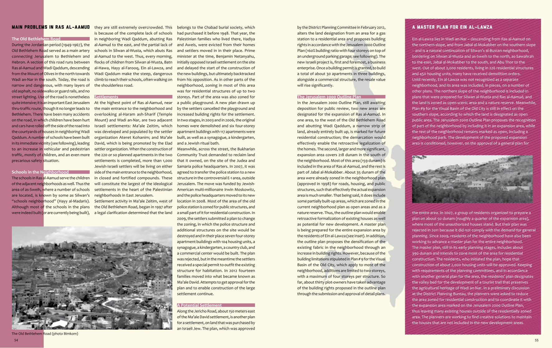
The Old Bethlehem Road (photo Bimkom)
A Master Plan for Ein al-Lawza
Ein al-Lawza lies in Wadi an-Nar – descending from Ras al-Aamud on the northern slope, and from Jabal al-Mokabber on the southern slope – and is a natural continuation of Silwan’s al-Bustan neighborhood, bordering on Silwan al-Wusta and as-Sweih to the north, as-Sawahrah to the east, Jabal al-Mokabber to the south, and Abu Thor to the west. Out of about 2,000 residents, living in 226 residential structures and 450 housing units, many have received demolition orders.Until recently, Ein al-Lawza was not recognized as a separate neighborhood, and its area was included, in pieces, on a number of other plans. The northern slope of the neighborhood is included in plans that were prepared for Silwan al-Wusta and Ras al-Aamud, and the land is zoned as open scenic area and a nature reserve. Meanwhile, Plan #9 for the Visual Basin of the Old City is still in effect on the southern slope, according to which the land is designated as open public area. The Jerusalem 2000 Outline Plan proposes the recognition of part of the neighborhood by including it in an expansion area, while the rest of the neighborhood remains marked as open, including a neighborhood park. The development of the proposed expansion area is conditioned, however, on the approval of a general plan for
by the District Planning Committee in February 2012, alters the land designation from an area for a gas station to a residential area and proposes building rights in accordance with the Jerusalem 2000 Outline Plan (160% building ratio with four storeys on top of an underground parking garage; see following). The new Israeli project is, first and foremost, a business enterprise. Once a building permit is granted, to build a total of about 30 apartments in three buildings, alongside a commercial structure, the resale value will rise significantly.
The Jerusalem 2000 Outline PlanIn the Jerusalem 2000 Outline Plan, still awaiting deposition for public review, two new areas are designated for the expansion of Ras al-Aamud. In one area, to the west of the Old Bethlehem Road and abutting Wadi Qaddum, a narrow strip of land, already entirely built up, is marked for future residential construction; the demarcation would effectively enable the retroactive legalization of the homes. The second, larger and more significant, expansion area covers 218 dunam in the south of the neighborhood. Most of this area (159 dunam) is included in the area of Ras al-Aamud, and the rest is part of Jabal al-Mokabber. About 35 dunam of the area were already zoned in the neighborhood plan (approved in 1998) for roads, housing, and public structures, such that effectively the actual expansion area is much smaller. That being said, it does include some partially built-up areas, which are zoned in the current neighborhood plan as open areas and as a nature reserve. Thus, the outline plan would enable retroactive formalization of existing houses as well as potential for new development. A master plan is being prepared for the entire expansion area by the residents of Ein al-Lawza (see inset). In addition, the outline plan proposes the densification of the existing fabric in the neighborhood through an increase in building rights. However, because of the building limitations stipulated in Plan # 9 for the Visual Basin of the Old City, which apply to most of the neighborhood, additions are limited to two storeys, with a maximum of four storeys per structure. So far, about thirty plot-owners have taken advantage of the building rights proposed in the outline plan through the submission and approval of detail plans.
the entire area. In 2007, a group of residents organized to prepare a plan on about 50 dunam (roughly a quarter of the expansion area), where most of the unauthorized houses stand. But their plan was rejected in 2011 because it did not comply with the demand for general planning. Since 2009, residents of the neighborhood have also been working to advance a master plan for the entire neighborhood. The master plan, still in its early planning stages, includes about 390 dunam and intends to zone most of the area for residential construction. The residents, who initiated the plan, hope that construction of about 2,000 housing units will be approved. Keeping with requirements of the planning committees, and in accordance with another general plan for the area, the residents’ plan designates the valley bed for the development of a tourist trail that preserves the agricultural heritage of Wadi an-Nar. In a preliminary discussion at the District Planning Bureau, the planners were asked to reduce the area zoned for residential construction and to coordinate it with the expansion area marked on the Jerusalem 2000 Outline Plan, thus leaving many existing houses outside of the residentially zoned area. The planners are working to find creative solutions to maintain the houses that are not included in the new development areas.
Main Problems in Ras al-Aamud
The Old Bethlehem RoadDuring the Jordanian period (1949-1967), the Old Bethlehem Road served as a main artery connecting Jerusalem to Bethlehem and Hebron. A section of this road runs between Ras al-Aamud and Wadi Qaddum, descending from the Mount of Olives in the north towards Wadi an-Nar in the south. Today, the road is narrow and dangerous, with many layers of old asphalt, no sidewalks or guard rails, and no street lighting. Use of the road is nonetheless quite intensive; it is an important East Jerusalem thru-traffic route, though it no longer leads to Bethlehem. There have been many accidents on the road, in which children have been hurt and cars have rolled off the side of the road into the courtyards of houses in neighboring Wadi Qaddum. A number of schools have been built in its immediate vicinity (see following), leading to an increase in vehicular and pedestrian traffic, mostly of children, and an even more precarious safety situation.
Schools in the NeighborhoodThe schools in Ras al-Aamud serve the children of the adjacent neighborhoods as well. Thus the area of as-Sweih, where a number of schools are located, is known by some as Silwan’s “schools neighborhood” (Hayy al-Madaris). Although most of the schools in the plans were indeed built (or are currently being built),
they are still extremely overcrowded. This is because of the complete lack of schools in neighboring Wadi Qaddum, abutting Ras al-Aamud to the east, and the partial lack of schools in Silwan al-Wusta, which abuts Ras al-Aamud to the west. Thus, every morning, flocks of children from Silwan al-Wusta, Batn al-Hawa, Hayy al-Farooq, Ein al-Lawza, and Wadi Qaddum make the steep, dangerous climb to reach their schools, often walking on the shoulderless road.
SettlementsAt the highest point of Ras al-Aamud, near the main entrance to the neighborhood and overlooking al-Haram ash-Sharif (Temple Mount) and Wadi an-Nar, are two adjacent Israeli settlements: Ma’ale Zeitim, which was developed and populated by the settler organization Ateret Kohanim; and Ma’ale David, which is being promoted by the Elad settler organization. When the construction of the 220 or so planned apartments in the two settlements is completed, more than 1,000 Jewish-Israeli settlers will be living on either side of the main entrance to the neighborhood, in closed and fortified compounds. These will constitute the largest of the ideological settlements in the heart of the Palestinian neighborhoods in East Jerusalem.Settlement activity in Ma’ale Zeitim, west of the Old Bethlehem Road, began in 1997 after a legal clarification determined that the land
belongs to the Chabad burial society, which had purchased it before 1948. That year, the Palestinian families who lived there, Hadiya and Aweis, were evicted from their homes and settlers moved in in their place. Prime minister at the time, Benjamin Netanyahu, initially opposed Israeli settlement on the site and delayed the start of the construction of the new buildings, but ultimately backtracked from his opposition. As in other parts of the neighborhood, zoning in most of this area was for residential structures of up to two storeys. Part of the area was also zoned for a public playground. A new plan drawn up by the settlers cancelled the playground and increased building rights for the settlement. In two stages, in 2003 and in 2006, the original homes were demolished and six four-storey apartment buildings with 117 apartments were built, as well as a synagogue, a kindergarten, and a Jewish ritual bath.Meanwhile, across the street, the Bukharian Community Trust demanded to reclaim land that it owned, on the site of the Judea and Samaria police headquarters. In 2007, it was agreed to transfer the police station to a new structure in the controversial E-1 area, outside Jerusalem. The move was funded by Jewish-American multi-millionaire Irwin Moskowitz, and the police headquarters moved to its new location in 2008. Most of the area of the old police station is zoned for public structures, and a small part of it for residential construction. In 2009, the settlers submitted a plan to change the zoning, in which the police structure and additional structures on the site would be destroyed and in their place seven four-storey apartment buildings with 104 housing units, a synagogue, a kindergarten, a country club, and a commercial center would be built. The plan was rejected, but in the meantime the settlers received a special permit to outfit the existing structure for habitation. In 2012 fourteen families moved into what became known as Ma’ale David. Attempts to get approval for the plan and to enable construction of the large settlement continue.
A Potential SettlementAlong the Jericho Road, about 150 meters east of the Ma’ale David settlement, is another plan for a settlement, on land that was purchased by an Israeli Jew. The plan, which was approved
54 55
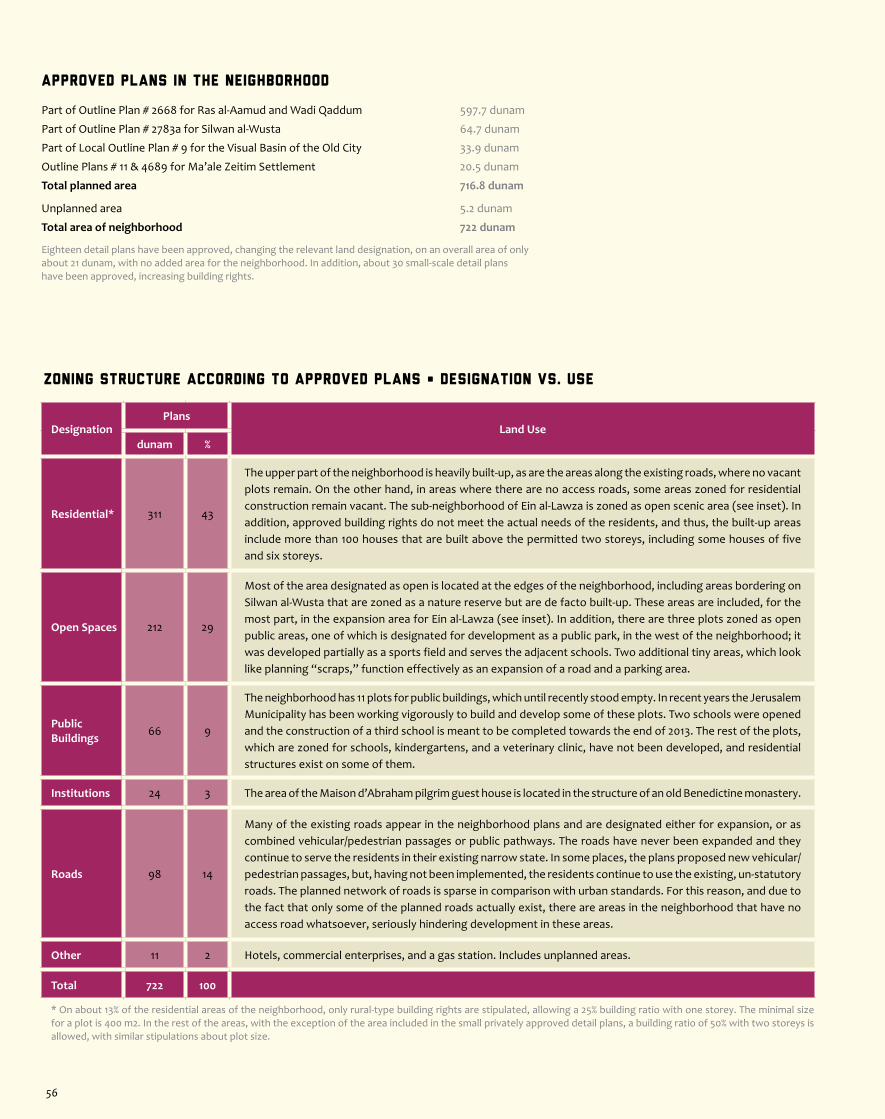
Zoning Structure According to Approved Plans • Designation vs. Use
DesignationPlans
Land Usedunam %
Residential* 311 43
The upper part of the neighborhood is heavily built-up, as are the areas along the existing roads, where no vacant plots remain. On the other hand, in areas where there are no access roads, some areas zoned for residential construction remain vacant. The sub-neighborhood of Ein al-Lawza is zoned as open scenic area (see inset). In addition, approved building rights do not meet the actual needs of the residents, and thus, the built-up areas include more than 100 houses that are built above the permitted two storeys, including some houses of five and six storeys.
Open Spaces 212 29
Most of the area designated as open is located at the edges of the neighborhood, including areas bordering on Silwan al-Wusta that are zoned as a nature reserve but are de facto built-up. These areas are included, for the most part, in the expansion area for Ein al-Lawza (see inset). In addition, there are three plots zoned as open public areas, one of which is designated for development as a public park, in the west of the neighborhood; it was developed partially as a sports field and serves the adjacent schools. Two additional tiny areas, which look like planning “scraps,” function effectively as an expansion of a road and a parking area.
Public Buildings 66 9
The neighborhood has 11 plots for public buildings, which until recently stood empty. In recent years the Jerusalem Municipality has been working vigorously to build and develop some of these plots. Two schools were opened and the construction of a third school is meant to be completed towards the end of 2013. The rest of the plots, which are zoned for schools, kindergartens, and a veterinary clinic, have not been developed, and residential structures exist on some of them.
Institutions 24 3 The area of the Maison d’Abraham pilgrim guest house is located in the structure of an old Benedictine monastery.
Roads 98 14
Many of the existing roads appear in the neighborhood plans and are designated either for expansion, or as combined vehicular/pedestrian passages or public pathways. The roads have never been expanded and they continue to serve the residents in their existing narrow state. In some places, the plans proposed new vehicular/pedestrian passages, but, having not been implemented, the residents continue to use the existing, un-statutory roads. The planned network of roads is sparse in comparison with urban standards. For this reason, and due to the fact that only some of the planned roads actually exist, there are areas in the neighborhood that have no access road whatsoever, seriously hindering development in these areas.
Other 11 2 Hotels, commercial enterprises, and a gas station. Includes unplanned areas.
Total 722 100
* On about 13% of the residential areas of the neighborhood, only rural-type building rights are stipulated, allowing a 25% building ratio with one storey. The minimal size for a plot is 400 m2. In the rest of the areas, with the exception of the area included in the small privately approved detail plans, a building ratio of 50% with two storeys is allowed, with similar stipulations about plot size.
Approved Plans in the Neighborhood
Part of Outline Plan # 2668 for Ras al-Aamud and Wadi Qaddum 597.7 dunam
Part of Outline Plan # 2783a for Silwan al-Wusta 64.7 dunam
Part of Local Outline Plan # 9 for the Visual Basin of the Old City 33.9 dunam
Outline Plans # 11 & 4689 for Ma’ale Zeitim Settlement 20.5 dunam
Total planned area 716.8 dunam
Unplanned area 5.2 dunam
Total area of neighborhood 722 dunam
Eighteen detail plans have been approved, changing the relevant land designation, on an overall area of only about 21 dunam, with no added area for the neighborhood. In addition, about 30 small-scale detail plans have been approved, increasing building rights.
56

About the Neighborhood
Silwan Center is located to the south of the Old City, on lands bearing significant historical, cultural and scenic value. This is the heart of the Visual Basin of the Old City, a fact that carries with it severe building restrictions. The neighborhood sits in Wadi an-Nar (the Qidron Valley) and on the slopes that descend into it from the west and the east. Bordering on the walls of the Old City and the outskirts of the Mount of Olives to the north, on Mount Zion and Abu Thor (ath-Thori) to the southwest, on Jabal al-Mokabber to the south, and on Ras al-Aamud to the east (where the border is least defined), Silwan Center is comprised of a number of sub-neighborhoods – Silwan al-Wusta, Wadi Hilwe, al-Bustan, and Batn al-Hawa.In the 16th century, Silwan was a small agricultural village on the outskirts of the Old City. At first, people settled in Silwan al-Wusta, in natural caves and in ancient burial caves carved into the slope. Later on, small houses were built on the facades of the caves, forming the protective front line of the settled area. The village was rich in natural springs, and the village’s livelihood was based on irrigation agriculture. From
the beginning of the 20th century, the population of the village grew, density increased significantly, and many inhabitants moved out to more distant village lands (today the abovementioned sub-neighborhoods, as well as the adjacent neighborhoods – Ras al-Aamud, Ein al-Lawza, Wadi Qaddum, ash-Shayah, Abu Thor, and Hayy al-Faruq). In the last two decades Silwan has become a target for Jewish-Israeli settlers, who have settled in the area of the archeological site in Wadi Hilwe, and in the area of the Yemenite Neighborhood in al-Wusta, where Yemenite Jews had settled at the end of the 19th century and left at the beginning of the 20th century following violent clashes between Jews and Arabs. The residents of Silwan Center are caught between a rock and a hard place, because all new plans for the neighborhood link the legalization of Palestinian homes to the formalization and expansion of Israeli settlement in the area.
Jaffa Rd.
Rd. 4
Heb
ron
Rd.
Ramallah Rd.
Hwy 1
Hwy 443Hwy 45
Rd. 20
Hw
y 40
4
Hw y 1
Hwy 60
Hw
y 60
(o
ld)
Hw
y 60 (old)
Hwy 60
RamallahRoad
Anata
Kafr Aqab
Mt. of Olives
Mt.Scopus&
City Center
GreaterSilwan
al-Mokabber
Jabal
Sur Baher
Beit Safafa
Al-Walaje
MAP OF ZONES
Map Legend
Population 23,500Area 678 dunam
Facts
Separation Barrier
West Jerusalem
East Jerusalem
Expropriated Land
Northern Zones
Central Zones
Southern Zones
Old City
Roads
Green Line
2.9
Sil
wan C
enter
Jerusalem Center • G
reater Silwan Zone
57
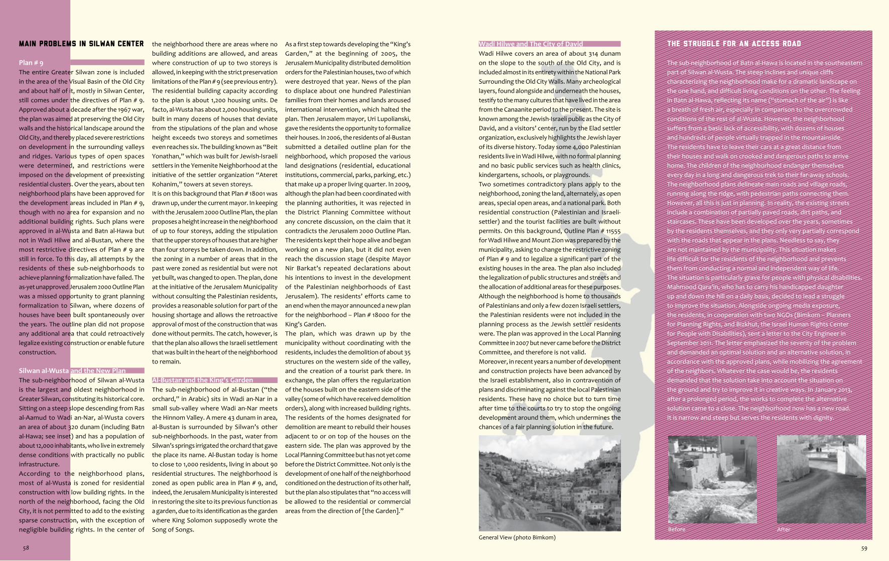
Before After
The Struggle for an Access Road
The sub-neighborhood of Batn al-Hawa is located in the southeastern part of Silwan al-Wusta. The steep inclines and unique cliffs characterizing the neighborhood make for a dramatic landscape on the one hand, and difficult living conditions on the other. The feeling in Batn al-Hawa, reflecting its name (“stomach of the air”) is like a breath of fresh air, especially in comparison to the overcrowded conditions of the rest of al-Wusta. However, the neighborhood suffers from a basic lack of accessibility, with dozens of houses and hundreds of people virtually trapped in the mountainside. The residents have to leave their cars at a great distance from their houses and walk on crooked and dangerous paths to arrive home. The children of the neighborhood endanger themselves every day in a long and dangerous trek to their far-away schools.The neighborhood plans delineate main roads and village roads, running along the ridge, with pedestrian paths connecting them. However, all this is just in planning. In reality, the existing streets include a combination of partially paved roads, dirt paths, and staircases. These have been developed over the years, sometimes by the residents themselves, and they only very partially correspond with the roads that appear in the plans. Needless to say, they are not maintained by the municipality. This situation makes life difficult for the residents of the neighborhood and prevents them from conducting a normal and independent way of life.The situation is particularly grave for people with physical disabilities. Mahmood Qara’in, who has to carry his handicapped daughter up and down the hill on a daily basis, decided to lead a struggle to improve the situation. Alongside ongoing media exposure, the residents, in cooperation with two NGOs (Bimkom – Planners for Planning Rights, and Bizkhut, the Israel Human Rights Center for People with Disabilities), sent a letter to the City Engineer in September 2011. The letter emphasized the severity of the problem and demanded an optimal solution and an alternative solution, in accordance with the approved plans, while mobilizing the agreement of the neighbors. Whatever the case would be, the residents demanded that the solution take into account the situation on the ground and try to improve it in creative ways. In January 2013, after a prolonged period, the works to complete the alternative solution came to a close. The neighborhood now has a new road. It is narrow and steep but serves the residents with dignity.
Wadi Hilwe and The City of DavidWadi Hilwe covers an area of about 314 dunam on the slope to the south of the Old City, and is included almost in its entirety within the National Park Surrounding the Old City Walls. Many archeological layers, found alongside and underneath the houses, testify to the many cultures that have lived in the area from the Canaanite period to the present. The site is known among the Jewish-Israeli public as the City of David, and a visitors’ center, run by the Elad settler organization, exclusively highlights the Jewish layer of its diverse history. Today some 4,000 Palestinian residents live in Wadi Hilwe, with no formal planning and no basic public services such as health clinics, kindergartens, schools, or playgrounds.Two sometimes contradictory plans apply to the neighborhood, zoning the land, alternately, as open areas, special open areas, and a national park. Both residential construction (Palestinian and Israeli-settler) and the tourist facilities are built without permits. On this background, Outline Plan # 11555 for Wadi Hilwe and Mount Zion was prepared by the municipality, asking to change the restrictive zoning of Plan # 9 and to legalize a significant part of the existing houses in the area. The plan also included the legalization of public structures and streets and the allocation of additional areas for these purposes. Although the neighborhood is home to thousands of Palestinians and only a few dozen Israeli settlers, the Palestinian residents were not included in the planning process as the Jewish settler residents were. The plan was approved in the Local Planning Committee in 2007 but never came before the District Committee, and therefore is not valid.Moreover, in recent years a number of development and construction projects have been advanced by the Israeli establishment, also in contravention of plans and discriminating against the local Palestinian residents. These have no choice but to turn time after time to the courts to try to stop the ongoing development around them, which undermines the chances of a fair planning solution in the future.
General View (photo Bimkom)
Main Problems in Silwan Center
Plan # 9The entire Greater Silwan zone is included in the area of the Visual Basin of the Old City and about half of it, mostly in Silwan Center, still comes under the directives of Plan # 9. Approved about a decade after the 1967 war, the plan was aimed at preserving the Old City walls and the historical landscape around the Old City, and thereby placed severe restrictions on development in the surrounding valleys and ridges. Various types of open spaces were determined, and restrictions were imposed on the development of preexisting residential clusters. Over the years, about ten neighborhood plans have been approved for the development areas included in Plan # 9, though with no area for expansion and no additional building rights. Such plans were approved in al-Wusta and Batn al-Hawa but not in Wadi Hilwe and al-Bustan, where the most restrictive directives of Plan # 9 are still in force. To this day, all attempts by the residents of these sub-neighborhoods to achieve planning formalization have failed. The as-yet unapproved Jerusalem 2000 Outline Plan was a missed opportunity to grant planning formalization to Silwan, where dozens of houses have been built spontaneously over the years. The outline plan did not propose any additional area that could retroactively legalize existing construction or enable future construction.
Silwan al-Wusta and the New PlanThe sub-neighborhood of Silwan al-Wusta is the largest and oldest neighborhood in Greater Silwan, constituting its historical core. Sitting on a steep slope descending from Ras al-Aamud to Wadi an-Nar, al-Wusta covers an area of about 320 dunam (including Batn al-Hawa; see inset) and has a population of about 12,000 inhabitants, who live in extremely dense conditions with practically no public infrastructure.According to the neighborhood plans, most of al-Wusta is zoned for residential construction with low building rights. In the north of the neighborhood, facing the Old City, it is not permitted to add to the existing sparse construction, with the exception of negligible building rights. In the center of
the neighborhood there are areas where no building additions are allowed, and areas where construction of up to two storeys is allowed, in keeping with the strict preservation limitations of the Plan # 9 (see previous entry). The residential building capacity according to the plan is about 1,200 housing units. De facto, al-Wusta has about 2,000 housing units, built in many dozens of houses that deviate from the stipulations of the plan and whose height exceeds two storeys and sometimes even reaches six. The building known as “Beit Yonathan,” which was built for Jewish-Israeli settlers in the Yemenite Neighborhood at the initiative of the settler organization “Ateret Kohanim,” towers at seven storeys.It is on this background that Plan # 18001 was drawn up, under the current mayor. In keeping with the Jerusalem 2000 Outline Plan, the plan proposes a height increase in the neighborhood of up to four storeys, adding the stipulation that the upper storeys of houses that are higher than four storeys be taken down. In addition, the zoning in a number of areas that in the past were zoned as residential but were not yet built, was changed to open. The plan, done at the initiative of the Jerusalem Municipality without consulting the Palestinian residents, provides a reasonable solution for part of the housing shortage and allows the retroactive approval of most of the construction that was done without permits. The catch, however, is that the plan also allows the Israeli settlement that was built in the heart of the neighborhood to remain.
Al-Bustan and the King’s GardenThe sub-neighborhood of al-Bustan (“the orchard,” in Arabic) sits in Wadi an-Nar in a small sub-valley where Wadi an-Nar meets the Hinnom Valley. A mere 43 dunam in area, al-Bustan is surrounded by Silwan’s other sub-neighborhoods. In the past, water from Silwan’s springs irrigated the orchard that gave the place its name. Al-Bustan today is home to close to 1,000 residents, living in about 90 residential structures. The neighborhood is zoned as open public area in Plan # 9, and, indeed, the Jerusalem Municipality is interested in restoring the site to its previous function as a garden, due to its identification as the garden where King Solomon supposedly wrote the Song of Songs.
As a first step towards developing the “King’s Garden,” at the beginning of 2005, the Jerusalem Municipality distributed demolition orders for the Palestinian houses, two of which were destroyed that year. News of the plan to displace about one hundred Palestinian families from their homes and lands aroused international intervention, which halted the plan. Then Jerusalem mayor, Uri Lupolianski, gave the residents the opportunity to formalize their houses. In 2006, the residents of al-Bustan submitted a detailed outline plan for the neighborhood, which proposed the various land designations (residential, educational institutions, commercial, parks, parking, etc.) that make up a proper living quarter. In 2009, although the plan had been coordinated with the planning authorities, it was rejected in the District Planning Committee without any concrete discussion, on the claim that it contradicts the Jerusalem 2000 Outline Plan. The residents kept their hope alive and began working on a new plan, but it did not even reach the discussion stage (despite Mayor Nir Barkat’s repeated declarations about his intentions to invest in the development of the Palestinian neighborhoods of East Jerusalem). The residents’ efforts came to an end when the mayor announced a new plan for the neighborhood – Plan # 18000 for the King’s Garden.The plan, which was drawn up by the municipality without coordinating with the residents, includes the demolition of about 35 structures on the western side of the valley, and the creation of a tourist park there. In exchange, the plan offers the regularization of the houses built on the eastern side of the valley (some of which have received demolition orders), along with increased building rights. The residents of the homes designated for demolition are meant to rebuild their houses adjacent to or on top of the houses on the eastern side. The plan was approved by the Local Planning Committee but has not yet come before the District Committee. Not only is the development of one half of the neighborhood conditioned on the destruction of its other half, but the plan also stipulates that “no access will be allowed to the residential or commercial areas from the direction of [the Garden].”
58 59
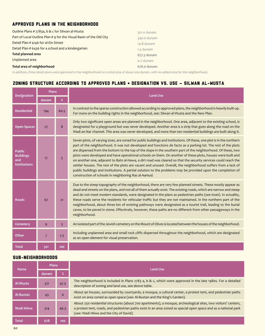
Zoning Structure According to Approved Plans • Designation vs. Use – silwan al-wusta
DesignationPlans
Land Usedunam %
Residential 194 60.5In contrast to the sparse construction allowed according to approved plans, the neighborhood is heavily built-up. For more on the building rights in the neighborhood, see: Silwan al-Wusta and the New Plan.
Open Spaces 27 8Only two significant open areas are planned in the neighborhood. One area, adjacent to the existing school, is designated for a playground but was never developed. Another area is a strip that goes along the road on the Wadi an-Nar channel. This area was never developed, and more than ten residential buildings are built along it.
Public BuildingsandInstitutions
17 5
Seven plots, of varying sizes, are zoned for public buildings and institutions. Of these, one plot is in the northern part of the neighborhood. It was not developed and functions de facto as a parking lot. The rest of the plots are dispersed from the bottom to the top of the slope in the southern part of the neighborhood. Of these, two plots were developed and have operational schools on them. On another of these plots, houses were built and on another one, adjacent to Batn al-Hawa, a dirt road was cleared so that the security services could reach the settler houses. The rest of the plots are vacant and unused. Overall, the neighborhood suffers from a lack of public buildings and institutions. A partial solution to the problems may be provided upon the completion of construction of schools in neighboring Ras al-Aamud.
Roads 67 21
Due to the steep topography of the neighborhood, there are very few planned streets. These mostly appear as dead-end streets on the plans, and not all of them actually exist. The existing roads, which are narrow and steep and do not meet modern standards, were designated in the plans as pedestrian paths (see inset). In actuality, these roads serve the residents for vehicular traffic but they are not maintained. In the northern part of the neighborhood, about three km of existing pathways were designated as a tourist trail, leading to the burial caves, to be paved in stone. Effectively, however, these paths are no different from other passageways in the neighborhood.
Cemetery 9 3 An isolated part of the Jewish cemetery on the Mount of Olives is located between the houses of the neighborhood.
Other 7 2.5Including unplanned area and small rock cliffs dispersed throughout the neighborhood, which are designated as an open element for visual preservation.
Total 321 100
Approved Plans in the Neighborhood
Outline Plans # 2783a, b & c for Silwan al-Wusta 321.0 dunam Part of Local Outline Plan # 9 for the Visual Basin of the Old City 340.0 dunamDetail Plan # 4146 for al-Ein Street 14.8 dunamDetail Plan # 6436 for a school and a kindergarten 1.5 dunamTotal planned area 677.3 dunamUnplanned area 0.7 dunam
Total area of neighborhood 678.0 dunam
In addition, three detail plans were approved in the neighborhood on a total area of about one dunam, with no added area for the neighborhood.
Sub-Neighborhoods
NamePlans
Land Usedunam %
Al-Wusta 321 47.5The neighborhood is included in Plans 2783 a, b & c, which were approved in the late 1980s. For a detailed description of zoning and land use, see above table.
Al-Bustan 43 6About 90 houses, surrounded by courtyards, a mosque, a cultural center, a protest tent, and pedestrian paths exist on area zoned as open space (see: Al-Bustan and the King’s Garden).
Wadi Hilwe 314 46.5About 250 residential structures (about 700 apartments), a mosque, archeological sites, two visitors’ centers, a protest tent, roads, and pedestrian paths exist in an area zoned as special open space and as a national park (see: Wadi Hilwe and the City of David).
Total 678 100
60
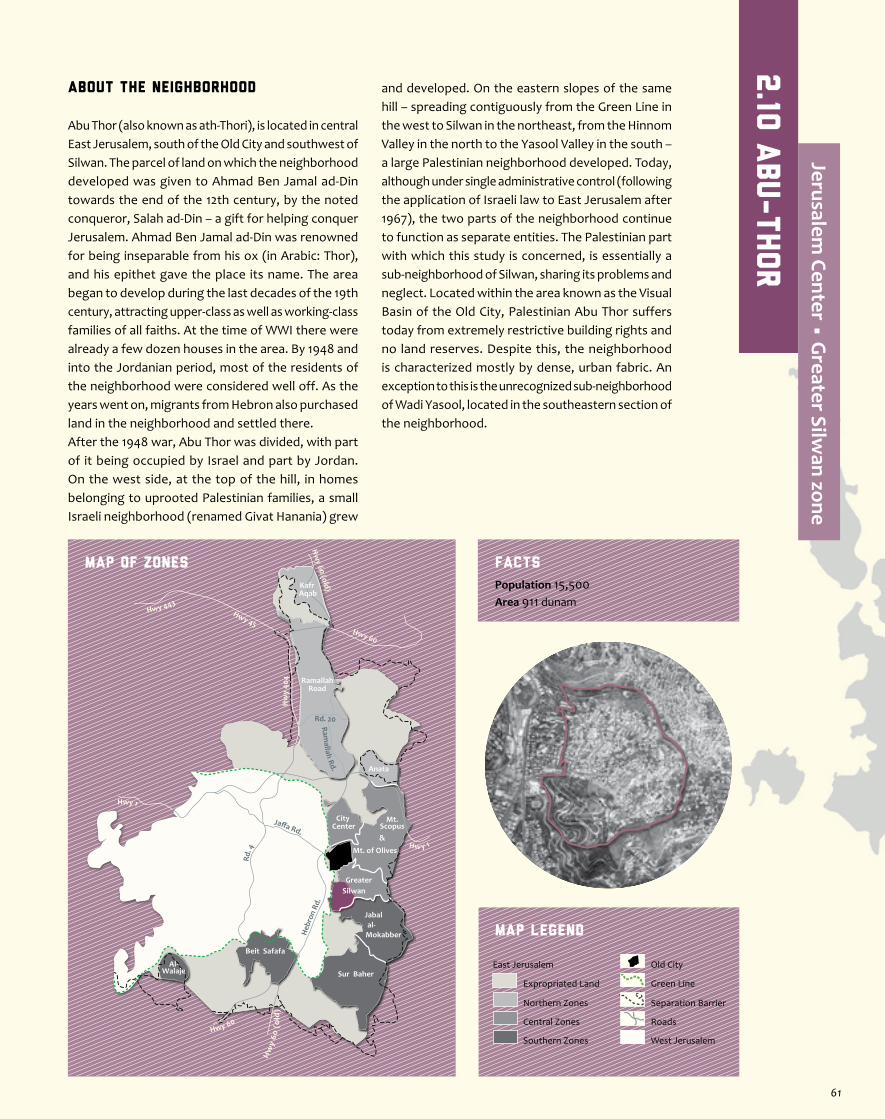
About the neighborhood
Abu Thor (also known as ath-Thori), is located in central East Jerusalem, south of the Old City and southwest of Silwan. The parcel of land on which the neighborhood developed was given to Ahmad Ben Jamal ad-Din towards the end of the 12th century, by the noted conqueror, Salah ad-Din – a gift for helping conquer Jerusalem. Ahmad Ben Jamal ad-Din was renowned for being inseparable from his ox (in Arabic: Thor), and his epithet gave the place its name. The area began to develop during the last decades of the 19th century, attracting upper-class as well as working-class families of all faiths. At the time of WWI there were already a few dozen houses in the area. By 1948 and into the Jordanian period, most of the residents of the neighborhood were considered well off. As the years went on, migrants from Hebron also purchased land in the neighborhood and settled there.After the 1948 war, Abu Thor was divided, with part of it being occupied by Israel and part by Jordan. On the west side, at the top of the hill, in homes belonging to uprooted Palestinian families, a small Israeli neighborhood (renamed Givat Hanania) grew
and developed. On the eastern slopes of the same hill – spreading contiguously from the Green Line in the west to Silwan in the northeast, from the Hinnom Valley in the north to the Yasool Valley in the south – a large Palestinian neighborhood developed. Today, although under single administrative control (following the application of Israeli law to East Jerusalem after 1967), the two parts of the neighborhood continue to function as separate entities. The Palestinian part with which this study is concerned, is essentially a sub-neighborhood of Silwan, sharing its problems and neglect. Located within the area known as the Visual Basin of the Old City, Palestinian Abu Thor suffers today from extremely restrictive building rights and no land reserves. Despite this, the neighborhood is characterized mostly by dense, urban fabric. An exception to this is the unrecognized sub-neighborhood of Wadi Yasool, located in the southeastern section of the neighborhood.
Jaffa Rd.
Rd. 4
Heb
ron
Rd.
Ramallah Rd.
Hwy 1
Hwy 443Hwy 45
Rd. 20
Hw
y 40
4
Hw y 1
Hwy 60
Hw
y 60
(o
ld)
Hw
y 60 (old)
Hwy 60
RamallahRoad
Anata
Kafr Aqab
Mt. of Olives
Mt.Scopus&
City Center
GreaterSilwan
al-Mokabber
Jabal
Sur Baher
Beit Safafa
Al-Walaje
MAP OF ZONES
Map Legend
Population 15,500Area 911 dunam
Facts
Separation Barrier
West Jerusalem
East Jerusalem
Expropriated Land
Northern Zones
Central Zones
Southern Zones
Old City
Roads
Green Line
2.10
abu-thor
Jerusalem Center • G
reater Silwan zone
61

A School in Search of a Home
The Ahmed Sameh Elementary School for Boys operates out of a residential building in the center of Abu Thor. The Jerusalem Municipality, while renting the building from its owner for use as a school, has never outfitted it accordingly. Density is unbearable, hygiene is disgraceful, and safety conditions are alarming: improvised classrooms on balconies, boys having to climb over desks to enter and exit classrooms, few toilets for hundreds of students, young pupils having to walk on the road to reach the schoolyard, and insufficient heating in the winter. The parents’ committee has been putting pressure on the municipality to improve the conditions of the school and to find it a new home. The municipality has responded with incremental improvements that do not solve the root of the problem. Recently, out of despair, one of the leaders of the committee decided to transfer his children to a private religious school, where the conditions are only slightly better. The appropriate solution depends on a thorough renovation of the building and/or mobilization of all the relevant bureaucratic bodies to the cause of building a new elementary school in the neighborhood, and the sooner the better.
The Walk to School (photo Mohamed Siaj, resident)
separates the valley from the homes, rendering the added part completely disconnected from the rest of the national park. Part of this area is owned by the Haqel Dama Church, built into the cliff overlooking the valley. A few years ago, as proof of the seriousness of their intentions, the INPA erected an observation post on the site, which stands neglected today. In December 2011, an agricultural structure of roughly 300 square meters that had been there for years was destroyed, and some ten olive trees were uprooted. Though it is designated as open public area, the plot in question, at the edge of the cliff, has not been developed for the use of the residents. It is clearly valuable land for Abu Thor, being flat, accessible , and adjacent to the main road.
The Jerusalem 2000 Outline PlanA close study of the expansion area allotted for Abu Thor in the Jerusalem 2000 Outline Plan (awaiting deposition for public review) reveals that most of this area was already designated for development in previously approved plans. Only a small part of the expansion was not previously designated for development and it is already entirely built-up. Meanwhile, the low-density sub-neighborhood of Wadi Yasool remains outside the marked expansion area (see: The Unrecognized Neighborhood). A group of landowners submitted a plan for some six dunam of their land, included in the expansion area. Their plan was rejected by the District Planning Committee, on the claim that a general plan for the entire expansion area must precede the approval of any detail plans. The residents continued their struggle with a court petition. The judge, unsatisfied by the unreasonable timeframe (14 years) given by the state for its completion of the general plan, ordered in January 2013 that the detail plan be re-examined by the District Committee.The Jerusalem 2000 Outline Plan also stipulates densification of the urban fabric of the neighborhood by allowing construction of up to four storeys. However, since only two floors may be added to existing structures, single-storey homes could only become three-floor structures. Moreover, since many of the buildings already have four floors or more, the suggested mechanism for increasing density is all the more irrelevant.
Main Problems in Abu Thor
Insufficient SchoolsThere is an acute shortage of structures for public schools in the neighborhood, and private educational institutions, operating out of rented residential buildings, provide only partial relief. The elementary schools, in particular, are extremely overcrowded; the girls’ elementary school literally overflows into an adjacent structure that is not adequately outfitted. New classrooms being planned for the girls’ school, when eventually built, will provide some relief to this problem. (For information about the boys’ school, see inset.) There is no high school in the neighborhood. This is particularly problematic for the girls, who are often not permitted to leave the neighborhood for high-school education.
Housing ShortageThe low building rights allotted in the approved neighborhood plans have been virtually exhausted and exceeded. In addition, apartments have been built in areas not zoned as residential. As a result, many homes face the threat of demolition. For lack of better options, homes are often built very close to, even attached to, their neighbors’, resulting in a sort of modern-day Casbah (old town), not unlike Silwan. Blocked by Israeli Abu Thor to the west, Silwan to the east, the national park to the north (see expansion), and the Peace Forest in the Yasool Valley to the south (see: The Unrecognized Neighborhood), the neighborhood is left with no land reserves for expansion (see: The Jerusalem 2000 Outline Plan).
The Unrecognized NeighborhoodTo the south of the main neighborhood, in the Yasool Valley, on some 45 dunam designated mostly as open public area (in Plan # 9), lies the unrecognized sub-neighborhood of Wadi Yasool. Since 1967, a few dozen homes have been built in the valley, on private land owned by residents of the neighborhood, to alleviate overcrowding in the rest of the neighborhood. Because the land is not included in the neighborhood plans and therefore is not designated for development, the residents suffer from a severe lack of access roads, services, and infrastructure, and the threat of demolition constantly lurks. In addition,
the Jewish National Fund is promoting a plan to incorporate the un-built part of the valley into the adjacent so-called Peace Forest. The residents are in the midst of the process of seeking recognition by the planning authorities. However, their attempts at promoting a statutory plan have so far been unsuccessful.
RoadsThe main road in Abu Thor, connecting to the Hebron Road on one end and Silwan on the other, is an important route for East Jerusalem thru-traffic. But it is narrow, steep, and in poor condition. The situation of the inner neighborhood roads is even worse. Most of them are not statutory and are therefore not serviced by the municipality, even though they are used by the residents regularly. As a result of the high density in the neighborhood, the existing road network is basically in a state of collapse. Two loop roads at the western edge of the neighborhood, connected to the Hebron Road at either end, are shared by Givat Hanania. Their condition shifts starkly each time the virtual Green Line is crossed.
Infrastructure and ServicesDue to the state of the roads, many homes in the neighborhood are not connected to the municipal water system, and the sewerage network is meager. Also, drains for rain water appear only along the main road, and in most places there are no street lights. In addition, the volume, scope, and distribution of garbage
collection bins is scant, with large walking distances to overflowing collection points. As a result, residents resort to burning garbage at certain focal points, and the streets are quite filthy. One of these points is adjacent to the boys’ elementary school (see photo).
The National ParkThe Jerusalem Municipality and the Israel National Parks Authority (INPA) intend to expand the National Park Surrounding the Old City Walls, declared as such in the mid-1970s, at Abu Thor’s expense. At the moment, the edge of the declared national park is in the Hinnom Valley, just north of Abu Thor, however, the intention is to extend its border so that it reaches the edge of the northernmost homes. This is despite the fact that a steep cliff
Unpaved and Neglected (photo Mohamed Siaj, resident)
Wadi Yasool (photo Bimkom)
62 63

Approved Plans in the Neighborhood
Outline Plans # 1864a & 1864b 634.0 dunamPart of Outline Plan # 2783a for Silwan al-Wusta 1.0 dunamPart of Local Outline Plan #9 for the Visual Basin of the Old City 276.0 dunamTotal Planned Area 911.0 dunam
Unplanned Area 0.0 dunamTotal area of neighborhood 911.0 dunam
In addition, Outline Plans # 5222a & 5222b have been approved, changing the zoning of about 100 dunam of Plan # 1864. Some 15 small-scale detail plans were also approved, with no added area to the neighborhood.
Zoning Structure According to Approved Plans • Designation vs. Use
DesignationPlans
Land Usedunam %
Residential* 363 40
Allotted building rights do not correspond with the actual urban density of the neighborhood. Most of the neighborhood is built up far beyond its planned capacity, and remaining implementable building rights are few and far between. The area defined as the village core was allotted higher but still insufficient building rights. In addition, there are no land reserves. The entire sub-neighborhood of Wadi Yasool remains unrecognized, and residential construction there is not permitted (see: The Unrecognized Neighborhood).
Open Spaces 438 48
Forming a buffer zone to the north, east, and south of the neighborhood, the planned open spaces do not serve as effective public spaces. The southern and eastern portions are designated for open public area, but they are already built-up (see: The Unrecognized Neighborhood). In the north, part of the land is included in the National Park Surrounding the Old City Walls, and another part of it is included in the proposed expansion of the national park (see expansion). In addition, there are six small plots designated as open public area inside the fabric of the neighborhood. Only one has been developed as a playground, but it was regularly vandalized and stood neglected for many years, until being renovated in September 2012. The rest of the plots are either geographically inaccessible due to topography, or negligible in size.
Roads 90 10
The approved roads that appear in the neighborhood plans, do not correspond with the existing roads. Some of the existing roads are designated as public pathways, even though they serve vehicular traffic on a daily basis. At the same time, many of the planned roads have never been implemented, and, for the most part, their implementation is not possible or necessary; improvement and recognition of the existing roads is much more crucial. Unpaved and having no sidewalks, the existing roads, statutory and non-statutory alike, are in generally poor condition and do not reach all places. The situation is by far the most acute for the sub-neighborhood of Wadi Yasool (see: The Unrecognized Neighborhood).
Public Buildings and Institutions
20 2
Out of the seven plots designated for public buildings, only three were developed: the girls’ elementary school, the
boys’ junior high school, and a kindergarten. All facilities are over-crowded (see: Insufficient Schools). The boys’ elementary school functions out of a rental building that is extremely run-down (see inset). There is no apparent reason why two of the four remaining plots cannot be implemented; the other two are small and inappropriately located. The plot where the neighborhood mosque stands is indeed designated for institutional use. There are no additional institutional plots in the neighborhood.
Total 911 100
* In 60% of the area allotted for housing, the building rights (12%-50%, with two floors) meet only rural standards. The rights allotted to the rest of the area (70%-90%, with three floors), meet a semi-urban standard. In the detail plans, allotted building rights reach 4 floors at an average building ratio of 100%.
64


About the Neighborhood
Jabal al-Mokabber sits on the northern slope of the hill marking the southern edge of the Visual Basin of the Old City. The neighborhood is comprised of three sub-neighborhoods (Hayy Abidat, Kherbet Ahmad as-Sahoori, and Hayy al-Farooq), which sit on ridges overlooking the Old City. To the north of the neighborhood runs Wadi an-Nar (the Qidron Valley), and on the other side of the wadi is the neighborhood of Silwan. Jabal al-Mokabber borders on the neighborhood of Abu Thor and the Sherover Promenade to the northwest, on the Goldman Promenade, near the UN Headquarters (located in what was the palace of the British High Commissioner), to the south, and on the neighborhood of as-Sawahrah to the east and southeast.The site and name of the neighborhood are connected to traditions in the three monotheistic religions. In Jewish tradition, this is the mountain where Abraham bid farewell to his two companions before setting off for the binding of Isaac on Mount Moriah. For Christians, this is where the house of the High Priest Kaifa stood, and where the Jewish Council of Elders
(Sanhedrin) ruled to denounce Jesus to the Romans. In Muslim tradition, this is the place where the Muslim conqueror Umar Ibn al-Khattab arrived in 640 and from where he saw Jerusalem for the first time in all its glory and called “Allahu Akbar!” (God is great!). The name of the mountain preserves this call. The name of Hayy al-Farooq is also related to this event; al-Farooq (The Chosen One) refers to Ibn al-Khattab. Kherbet Ahmad as-Sahoori is named after the founder of the as-Sawahrah Bedouin tribe, and the old cemetery of Western as-Sawahrah is located on its outskirts. Hayy Abidat is named after the extended family from the tribe that settled there and lives there to this day.The neighborhood of Jabal al-Mokabber suffers from the restrictions on building which were stipulated in Plan # 9 for the Visual Basin of the Old City, the goal of which was to preserve the historic landscape around the city walls. As a result, most of the area of the neighborhood was designated as open scenic area, where construction is strictly forbidden, and very low building rights were allotted to the existing residential clusters.
Jaffa Rd.
Rd. 4
Heb
ron
Rd.
Ramallah Rd.
Hwy 1
Hwy 443Hwy 45
Rd. 20
Hw
y 40
4
Hw y 1
Hwy 60
Hw
y 60
(o
ld)
Hw
y 60 (old)
Hwy 60
RamallahRoad
Anata
Kafr Aqab
Mt. of Olives
Mt.Scopus&
City Center
GreaterSilwan
al-Mokabber
Jabal
Sur Baher
Beit Safafa
Al-Walaje
MAP OF ZONES
Map Legend
Population 3,500 Area 1,011 dunam
Facts
Separation Barrier
West Jerusalem
East Jerusalem
Expropriated Land
Northern Zones
Central Zones
Southern Zones
Old City
Roads
Green Line
3.1 J
abal a
l-Mokabber
Jerusalem South • Jabal al-M
okabber Zone
67
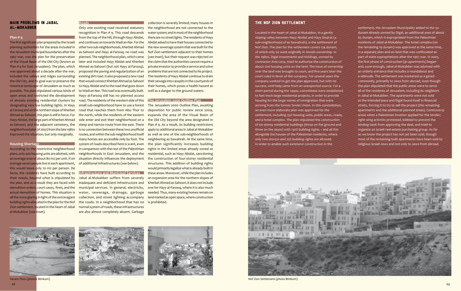
Nof Zion Settlement (photo Bimkom)Vacant Plots (photos Bimkom)
The Nof Zion Settlement
Located in the heart of Jabal al-Mokabber, in a gently sloping valley between Hayy Abidat and Hayy Shqirat (a sub-neighborhood of as-Sawahrah), is the settlement of Nof Zion. The plan for the settlement covers 134 dunam, of which only 50 were originally in Jewish ownership. In the 1980s, Digal Investments and Holdings, owned by contractor Avie Levy, tried to authorize the construction of about 200 housing units on the land. The issue of ownership over the land was brought to court, and five years later the court ruled in favor of the company. For several years the company worked to get the plan approved, but with no success, until help came from an unexpected source. For a short period during the 1990s, committees were established to fast-track large residential projects, in order to provide housing for the large waves of immigration that were arriving from the former Soviet Union. In this constellation, an even more elaborate plan was approved for the settlement, including 350 housing units, public areas, roads, and a hotel complex. The plan stipulated the construction of six-storey residential buildings (three on flat ground and three on the slope) with 130% building rights – and all this alongside the houses of the Palestinian residents, where only two storeys and 25% building rights are allowed.In order to enable such extensive construction in the
settlement, the Jerusalem Municipality added to the 50 dunam already owned by Digal, an additional area of about 65 dunam, which it expropriated from the Palestinian residents of Jabal al-Mokabber. The hotel complex (on the remaining 19 dunam) was approved at the same time, in a separate plan and on land that was confiscated as part of state expropriations after the 1967 war. In 2005, the first phase of construction (91 apartments) began and, soon enough, Jabal al-Mokabber was adorned with an orderly entrance that includes a roundabout and a sidewalk. The settlement was marketed as a gated community, primarily to Jews from abroad, even though the plan stipulated that the public areas were to serve all of the residents of Jerusalem, including its neighbors in Jabal al-Mokabber. The apartments were not sold at the intended pace and Digal found itself in financial straits, forcing it to try to sell the project (the remaining apartments and the additional planned areas). Controversy arose when a Palestinian investor applied for the tender; right-wing activists protested, lobbied to prevent the lending bank from approving the deal, and tried to organize an Israeli real-estate purchasing group. As far as we know the project has not yet been sold, though most of the remaining built apartments have been sold to religious Israeli Jews and not only to Jews from abroad.
Main Problems in Jabal
al-Mokabber
Plan # 9The first significant plan prepared by the Israeli planning authorities for the areas included in the Jerusalem municipal boundaries after the 1967 war, was the plan for the preservation of the Visual Basin of the Old City (known as Plan # 9 for East Jerusalem). The plan, which was approved about a decade after the war, included the valleys and ridges surrounding the Old City, and its goal was to preserve the historical landscape of Jerusalem as much as possible. The plan stipulated various kinds of open areas and restricted the development of already existing residential clusters by designating very low building rights. In Hayy al-Farooq and on the northern slope of Kherbet Ahmad as-Sahoori, this plan is still in force. For Hayy Abidat, the large part of Kherbet Ahmad as-Sahoori, and the adjacent cemetery, the neighborhood plan (# 2691) from the late 1980s improved the situation, but only marginally.
Housing ShortageAccording to the restrictive neighborhood plans, only 400 housing units are allotted, with an average area of about 80 m2 per unit. If on average seven people live in each apartment, this would leave only 10 m2 per person. De facto, the residents have built according to their needs, beyond what is stipulated by the plan, and as a result they are faced with demolition orders, court cases, fines, and the actual demolition of homes. This situation is all the more glaring in light of the extravagant building rights allocated in the plan for the Nof Zion settlement, located in the heart of Jabal al-Mokabber (see inset).
RoadsOnly one existing road received statutory recognition in Plan # 9. This road descends from the top of the hill, through Hayy Abidat, and continues on towards Wadi an-Nar. For the other two sub-neighborhoods, Kherbet Ahmad as-Sahoori and Hayy al-Farooq, no road was planned. The neighborhood plan, which came later and included Hayy Abidat and Kherbet Ahmad as-Sahoori (but not Hayy al-Farooq), proposed the paving and regularization of an existing dirt road. It also proposed a new road that would connect Kherbet Ahmad as-Sahoori to Hayy Abidat and to the road that goes down to Wadi an-Nar. This road was eventually built. Hayy al-Farooq still has no planned access road. The residents of the western side of this small sub-neighborhood have to use a forest road that reaches them from Abu Thor to the north, while the residents of the eastern side enter and exit their neighborhood on a steep and narrow route from the east. There is no connection between these two unofficial routes, and within the sub-neighborhood itself many homes are accessible only by foot. The system of roads described here is scant, even in comparison with the rest of the Palestinian neighborhoods in East Jerusalem, and the situation directly influences the deployment of additional infrastructures (see below).
Infrastructure and Municipal ServicesJabal al-Mokabber suffers from severely inadequate and deficient infrastructure and municipal services. In general, electricity, water, sewerage, drainage, garbage collection, and street lighting accompany the roads. In a neighborhood that has no normal system of roads, these infrastructures are also almost completely absent. Garbage
collection is severely limited; many houses in the neighborhood are not connected to the water system; and in most of the neighborhood there are no street lights. The residents of Hayy Abidat asked to have their houses connected to the new sewerage system that was built for the Nof Zion settlement adjacent to their homes (see inset), but their request was rejected on the claim that the authorities cannot require a private investor to provide a service and solve problems that are not connected to his project. The residents of Hayy Abidat continue to drain their sewage into cesspits in the courtyards of their homes, which poses a health hazard as well as a danger to the ground waters.
The Jerusalem 2000 Outline PlanThe Jerusalem 2000 Outline Plan, awaiting deposition for public review since 2009, expands the area of the Visual Basin of the Old City beyond the area designated in Plan # 9. As a result, its building restrictions apply to additional areas in Jabal al-Mokabber as well as one of the sub-neighborhoods of neighboring as-Sawahrah. At the same time, the plan significantly increases building rights in the limited areas already zoned as residential, such as Hayy Abidat, sanctioning the construction of four-storey residential structures. This addition of building rights would primarily legalize what is already built in these areas. Moreover, while the plan includes an expansion area for the northern slopes of Kherbet Ahmed as-Sahoori, it does not include one for Hayy al-Farooq, where it is also much needed. Thus, many existing homes remain on land marked as open space, where construction is prohibited.
68 69

Approved Plans in the Neighborhood
Outline plans # 2691 & 2691a for Jabal al-Mokabber 486.0 dunam
Part of Local Outline Plan # 9 for the Visual Basin of the Old City 386.5 dunam
Outline plans # 4558 & 4559 for the Nof Zion Settlement 134.5 dunam
Part of Outline Plan # 2598 for East Talpiyot 3.0 dunam
Total planned area 1,010.0 dunam
Unplanned area 1.0 dunam
Total area of neighborhood 1,011.0 dunam
In addition, some 19 detail plans were approved in the neighborhood, on a total area of 24 dunam (1.33 dunam on average per plan), none of which add any area to the neighborhood.
Zoning Structure According to Approved Plans • Designation vs. Use
DesignationPlans
Land Usedunam %
Residential* 161 16
The neighborhood suffers from the most extreme building restrictions of all the Palestinian neighborhoods in East Jerusalem. Construction is prohibited on most of the area, and in the few places where construction is allowed, building rights are negligible. De facto, residential construction exceeds the rights allotted in the plans. The residents of Hayy Abidat and Kherbet Ahmad as-Sahoori recently managed to attain additional building rights in the framework of detail plans, but the rest of the neighborhood has seen no increase in building rights.
Open Spaces 667 66
The amount of open spaces stipulated in the approved plans for the neighborhood is unusually large, even in comparison with the other Palestinian neighborhoods in East Jerusalem. These were designated exclusively as open scenic areas, while not a single plot in the neighborhood was zoned as open public area, which can be expropriated and developed as a public neighborhood park. In the areas designated as open spaces there is de facto relatively sparse residential construction.
Public Buildings 1 0
The approved plans for the neighborhood include only one plot for public buildings. The plot was designated for a kindergarten. Although this plot abuts an existing road and has good access, it remains vacant and has never been developed.
Roads 29 3
The planned system of roads in the neighborhood is so sparse that it leaves most of the area of the neighborhood completely inaccessible. In areas where the directives of Plan # 9 still apply, there is not a single statutory road. De facto, there are additional streets in the neighborhood that serve the residents, but these are not statutory, are not maintained, and receive no municipal services. In the area of the plan for the Nof Zion settlement (see inset), and in its immediate vicinity, a complete system of roads was planned, and the part that has already been implemented is conspicuous in its high quality, stone walls, comfortable sidewalks, and street lighting.
Cemetery 11 1The area zoned for the cemetery includes most but not all of the existing burial grounds as well as a number of residential structures. In the Jerusalem 2000 Outline Plan, a larger area is marked for the cemetery, but this is also on an area that includes residential structures.
Other 8 1 Including sections of the promenades and unplanned areas resulting, in part, from imprecisions in old plans.
Settlement 134 13 The settlement of Nof Zion and the adjacent hotel compound (see inset).
Total 1,011 100
* In a little more than half of the residential area of Jabal al-Mokabber, building rights are comprised of a 25% building ratio, with construction of up to two storeys. In the rest of the area, a 10% building ratio is permitted, with only one storey. Exceptions to this are the areas of the detail plans, in which building rights increase to 50% and 70% ratios, with up to three storeys.
70
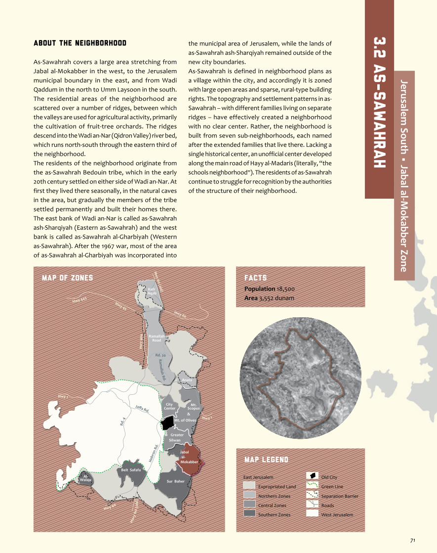
About the Neighborhood
As-Sawahrah covers a large area stretching from Jabal al-Mokabber in the west, to the Jerusalem municipal boundary in the east, and from Wadi Qaddum in the north to Umm Laysoon in the south. The residential areas of the neighborhood are scattered over a number of ridges, between which the valleys are used for agricultural activity, primarily the cultivation of fruit-tree orchards. The ridges descend into the Wadi an-Nar (Qidron Valley) river bed, which runs north-south through the eastern third of the neighborhood.The residents of the neighborhood originate from the as-Sawahrah Bedouin tribe, which in the early 20th century settled on either side of Wadi an-Nar. At first they lived there seasonally, in the natural caves in the area, but gradually the members of the tribe settled permanently and built their homes there. The east bank of Wadi an-Nar is called as-Sawahrah ash-Sharqiyah (Eastern as-Sawahrah) and the west bank is called as-Sawahrah al-Gharbiyah (Western as-Sawahrah). After the 1967 war, most of the area of as-Sawahrah al-Gharbiyah was incorporated into
the municipal area of Jerusalem, while the lands of as-Sawahrah ash-Sharqiyah remained outside of the new city boundaries.As-Sawahrah is defined in neighborhood plans as a village within the city, and accordingly it is zoned with large open areas and sparse, rural-type building rights. The topography and settlement patterns in as-Sawahrah – with different families living on separate ridges – have effectively created a neighborhood with no clear center. Rather, the neighborhood is built from seven sub-neighborhoods, each named after the extended families that live there. Lacking a single historical center, an unofficial center developed along the main road of Hayy al-Madaris (literally, “the schools neighborhood”). The residents of as-Sawahrah continue to struggle for recognition by the authorities of the structure of their neighborhood.
Jaffa Rd.
Rd. 4
Heb
ron
Rd.
Ramallah Rd.
Hwy 1
Hwy 443Hwy 45
Rd. 20
Hw
y 40
4
Hw y 1
Hwy 60
Hw
y 60
(o
ld)
Hw
y 60 (old)
Hwy 60
RamallahRoad
Anata
Kafr Aqab
Mt. of Olives
Mt.Scopus&
City Center
GreaterSilwan
al-Mokabber
Jabal
Sur Baher
Beit Safafa
Al-Walaje
MAP OF ZONES
Map Legend
Population 18,500Area 3,552 dunam
Facts
Separation Barrier
West Jerusalem
East Jerusalem
Expropriated Land
Northern Zones
Central Zones
Southern Zones
Old City
Roads
Green Line
3.2
As-Sawahrah
Jerusalem South • Jabal al-M
okabber Zone
71
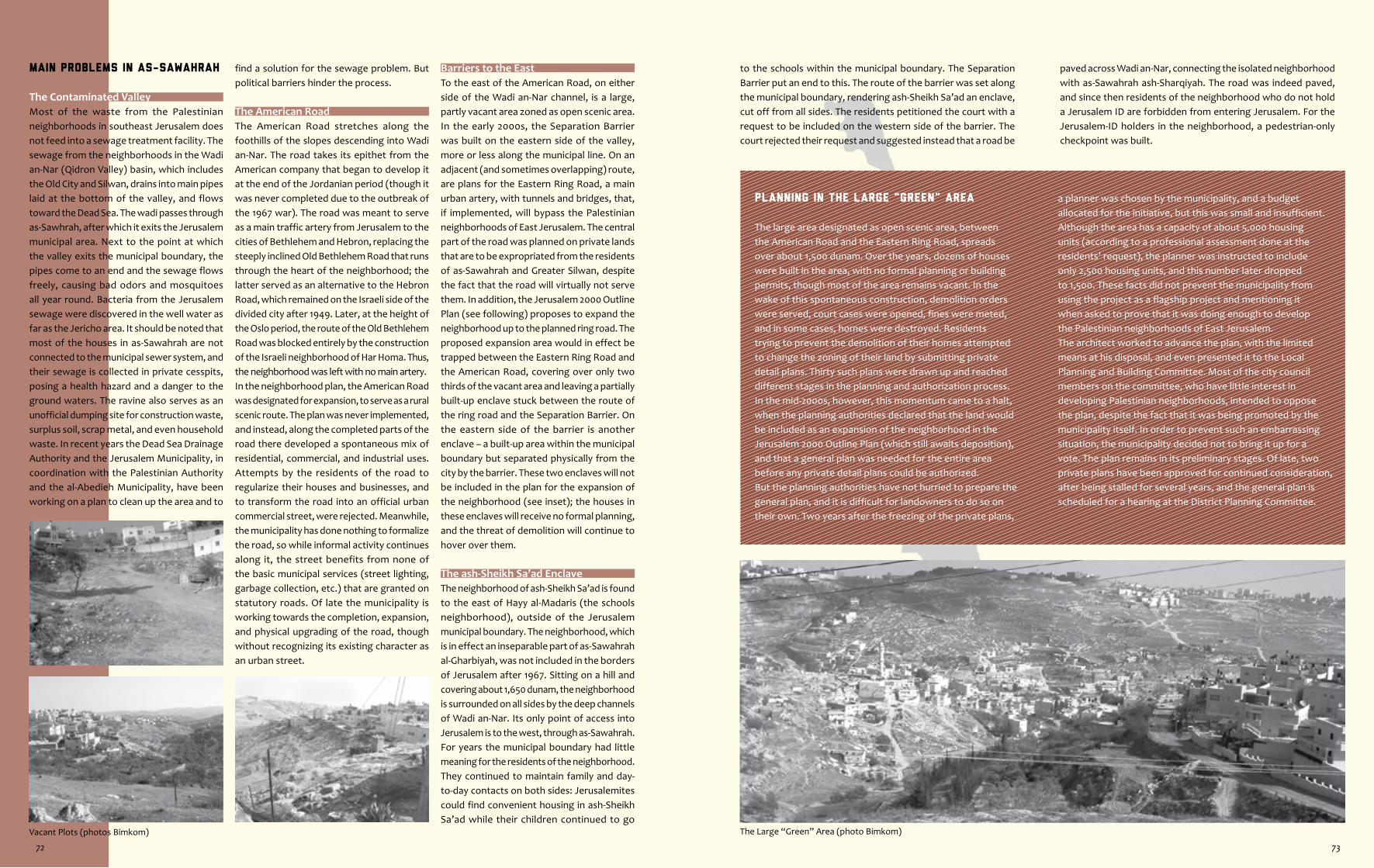
The Large “Green” Area (photo Bimkom)Vacant Plots (photos Bimkom)
to the schools within the municipal boundary. The Separation Barrier put an end to this. The route of the barrier was set along the municipal boundary, rendering ash-Sheikh Sa’ad an enclave, cut off from all sides. The residents petitioned the court with a request to be included on the western side of the barrier. The court rejected their request and suggested instead that a road be
Planning in the Large “Green” Area
The large area designated as open scenic area, between the American Road and the Eastern Ring Road, spreads over about 1,500 dunam. Over the years, dozens of houses were built in the area, with no formal planning or building permits, though most of the area remains vacant. In the wake of this spontaneous construction, demolition orders were served, court cases were opened, fines were meted, and in some cases, homes were destroyed. Residents trying to prevent the demolition of their homes attempted to change the zoning of their land by submitting private detail plans. Thirty such plans were drawn up and reached different stages in the planning and authorization process. In the mid-2000s, however, this momentum came to a halt, when the planning authorities declared that the land would be included as an expansion of the neighborhood in the Jerusalem 2000 Outline Plan (which still awaits deposition), and that a general plan was needed for the entire area before any private detail plans could be authorized.But the planning authorities have not hurried to prepare the general plan, and it is difficult for landowners to do so on their own. Two years after the freezing of the private plans,
a planner was chosen by the municipality, and a budget allocated for the initiative, but this was small and insufficient. Although the area has a capacity of about 5,000 housing units (according to a professional assessment done at the residents’ request), the planner was instructed to include only 2,500 housing units, and this number later dropped to 1,500. These facts did not prevent the municipality from using the project as a flagship project and mentioning it when asked to prove that it was doing enough to develop the Palestinian neighborhoods of East Jerusalem.The architect worked to advance the plan, with the limited means at his disposal, and even presented it to the Local Planning and Building Committee. Most of the city council members on the committee, who have little interest in developing Palestinian neighborhoods, intended to oppose the plan, despite the fact that it was being promoted by the municipality itself. In order to prevent such an embarrassing situation, the municipality decided not to bring it up for a vote. The plan remains in its preliminary stages. Of late, two private plans have been approved for continued consideration, after being stalled for several years, and the general plan is scheduled for a hearing at the District Planning Committee.
paved across Wadi an-Nar, connecting the isolated neighborhood with as-Sawahrah ash-Sharqiyah. The road was indeed paved, and since then residents of the neighborhood who do not hold a Jerusalem ID are forbidden from entering Jerusalem. For the Jerusalem-ID holders in the neighborhood, a pedestrian-only checkpoint was built.
Main Problems in as-Sawahrah
The Contaminated ValleyMost of the waste from the Palestinian neighborhoods in southeast Jerusalem does not feed into a sewage treatment facility. The sewage from the neighborhoods in the Wadi an-Nar (Qidron Valley) basin, which includes the Old City and Silwan, drains into main pipes laid at the bottom of the valley, and flows toward the Dead Sea. The wadi passes through as-Sawhrah, after which it exits the Jerusalem municipal area. Next to the point at which the valley exits the municipal boundary, the pipes come to an end and the sewage flows freely, causing bad odors and mosquitoes all year round. Bacteria from the Jerusalem sewage were discovered in the well water as far as the Jericho area. It should be noted that most of the houses in as-Sawahrah are not connected to the municipal sewer system, and their sewage is collected in private cesspits, posing a health hazard and a danger to the ground waters. The ravine also serves as an unofficial dumping site for construction waste, surplus soil, scrap metal, and even household waste. In recent years the Dead Sea Drainage Authority and the Jerusalem Municipality, in coordination with the Palestinian Authority and the al-Abedieh Municipality, have been working on a plan to clean up the area and to
find a solution for the sewage problem. But political barriers hinder the process.
The American RoadThe American Road stretches along the foothills of the slopes descending into Wadi an-Nar. The road takes its epithet from the American company that began to develop it at the end of the Jordanian period (though it was never completed due to the outbreak of the 1967 war). The road was meant to serve as a main traffic artery from Jerusalem to the cities of Bethlehem and Hebron, replacing the steeply inclined Old Bethlehem Road that runs through the heart of the neighborhood; the latter served as an alternative to the Hebron Road, which remained on the Israeli side of the divided city after 1949. Later, at the height of the Oslo period, the route of the Old Bethlehem Road was blocked entirely by the construction of the Israeli neighborhood of Har Homa. Thus, the neighborhood was left with no main artery. In the neighborhood plan, the American Road was designated for expansion, to serve as a rural scenic route. The plan was never implemented, and instead, along the completed parts of the road there developed a spontaneous mix of residential, commercial, and industrial uses. Attempts by the residents of the road to regularize their houses and businesses, and to transform the road into an official urban commercial street, were rejected. Meanwhile, the municipality has done nothing to formalize the road, so while informal activity continues along it, the street benefits from none of the basic municipal services (street lighting, garbage collection, etc.) that are granted on statutory roads. Of late the municipality is working towards the completion, expansion, and physical upgrading of the road, though without recognizing its existing character as an urban street.
Barriers to the EastTo the east of the American Road, on either side of the Wadi an-Nar channel, is a large, partly vacant area zoned as open scenic area. In the early 2000s, the Separation Barrier was built on the eastern side of the valley, more or less along the municipal line. On an adjacent (and sometimes overlapping) route, are plans for the Eastern Ring Road, a main urban artery, with tunnels and bridges, that, if implemented, will bypass the Palestinian neighborhoods of East Jerusalem. The central part of the road was planned on private lands that are to be expropriated from the residents of as-Sawahrah and Greater Silwan, despite the fact that the road will virtually not serve them. In addition, the Jerusalem 2000 Outline Plan (see following) proposes to expand the neighborhood up to the planned ring road. The proposed expansion area would in effect be trapped between the Eastern Ring Road and the American Road, covering over only two thirds of the vacant area and leaving a partially built-up enclave stuck between the route of the ring road and the Separation Barrier. On the eastern side of the barrier is another enclave – a built-up area within the municipal boundary but separated physically from the city by the barrier. These two enclaves will not be included in the plan for the expansion of the neighborhood (see inset); the houses in these enclaves will receive no formal planning, and the threat of demolition will continue to hover over them.
The ash-Sheikh Sa’ad EnclaveThe neighborhood of ash-Sheikh Sa’ad is found to the east of Hayy al-Madaris (the schools neighborhood), outside of the Jerusalem municipal boundary. The neighborhood, which is in effect an inseparable part of as-Sawahrah al-Gharbiyah, was not included in the borders of Jerusalem after 1967. Sitting on a hill and covering about 1,650 dunam, the neighborhood is surrounded on all sides by the deep channels of Wadi an-Nar. Its only point of access into Jerusalem is to the west, through as-Sawahrah. For years the municipal boundary had little meaning for the residents of the neighborhood. They continued to maintain family and day-to-day contacts on both sides: Jerusalemites could find convenient housing in ash-Sheikh Sa’ad while their children continued to go
72 73
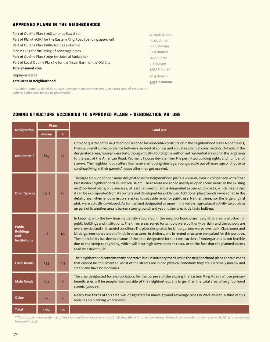
Zoning Structure According to Approved Plans • Designation vs. Use
DesignationPlans
Land Usedunam %
Residential* 883 25
Only one quarter of the neighborhood is zoned for residential construction in the neighborhood plans. Nonetheless, there is overall correspondence between residential zoning and actual residential construction. Outside of the designated areas, houses were built, though mostly abutting the authorized residential areas or in the large area to the east of the American Road. Yet many houses deviate from the permitted building rights and number of storeys. The neighborhood suffers from a severe housing shortage; young people put off marriage or choose to continue living in their parents’ house after they get married.
Open Spaces 1,913 54
The large amount of open areas designated in the neighborhood plans is unusual, even in comparison with other Palestinian neighborhoods in East Jerusalem. These areas are zoned mostly as open scenic areas. In the existing neighborhood plans, only one area, of less than one dunam, is designated as open public area, which means that it can be expropriated from its owners and developed for public use. Additional playgrounds were zoned in the detail plans, when landowners were asked to set aside lands for public use. Neither these, nor the large original plot, were actually developed. As for the land designated as open in the valleys: agricultural activity takes place on part of it; another area is barren stony ground; and yet another area is de facto built-up.
Public BuildingsandInstitutions
56 1.5
In keeping with the low housing density stipulated in the neighborhood plans, very little area is allotted for public buildings and institutions. The three areas zoned for schools were built only partially and the schools are overcrowded and in shameful condition. The plots designated for kindergartens were never built. Classrooms and kindergartens operate out of mobile structures, in shelters, and in rented structures not suited for this purpose. The municipality has deemed some of the plots designated for the construction of kindergartens as not feasible due to the steep topography, which will incur high development costs, or to the fact that the planned access road was never built.
Local Roads 299 8.5The neighborhood contains many operative but unstatutory roads while the neighborhood plans contain roads that cannot be implemented. Most of the streets are in bad physical condition: they are extremely narrow and steep, and have no sidewalks.
Main Roads 324 9The area designated for expropriation, for the purpose of developing the Eastern Ring Road (whose primary beneficiaries will be people from outside of the neighborhood), is larger than the total area of neighborhood streets (above).
Other 77 2Nearly two thirds of this area was designated for above-ground sewerage pipes in Wadi an-Nar. A third of this area has no planning whatsoever.
Total 3,552 100
* The most common residential zoning type n as-Sawahrah allows a 37.5% building ratio, with up to two storeys. In detail plans, residents have received building ratios ranging from 50% to 125%.
Approved Plans in the Neighborhood
Part of Outline Plan # 2683a for as-Sawahrah 2,709.8 dunamPart of Plan # 4585f for the Eastern Ring Road (pending approval) 592.5 dunamPart of Outline Plan #2886 for Ras al-Aamud 142.6 dunamPlan # 2064 for the laying of sewerage pipes 67.9 dunamPart of Outline Plan # 2691 for Jabal al-Mokabber 14.0 dunamPart of Local Outline Plan # 9 for the Visual Basin of the Old City 4.8 dunam Total planned area 3,531.6 dunam
Unplanned area 20.4 dunamTotal area of neighborhood 3,552.0 dunam
In addition, some 37 detail plans have been approved over the years, on a total area of 210 dunam, with no added area for the neighborhood.
74
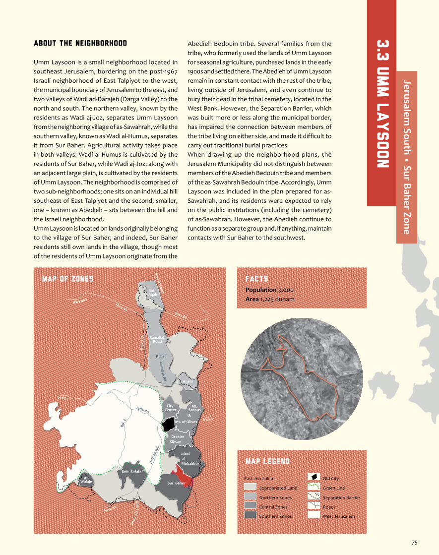
About the Neighborhood
Umm Laysoon is a small neighborhood located in southeast Jerusalem, bordering on the post-1967 Israeli neighborhood of East Talpiyot to the west, the municipal boundary of Jerusalem to the east, and two valleys of Wadi ad-Darajeh (Darga Valley) to the north and south. The northern valley, known by the residents as Wadi aj-Joz, separates Umm Laysoon from the neighboring village of as-Sawahrah, while the southern valley, known as Wadi al-Humus, separates it from Sur Baher. Agricultural activity takes place in both valleys: Wadi al-Humus is cultivated by the residents of Sur Baher, while Wadi aj-Joz, along with an adjacent large plain, is cultivated by the residents of Umm Laysoon. The neighborhood is comprised of two sub-neighborhoods; one sits on an individual hill southeast of East Talpiyot and the second, smaller, one – known as Abedieh – sits between the hill and the Israeli neighborhood.Umm Laysoon is located on lands originally belonging to the village of Sur Baher, and indeed, Sur Baher residents still own lands in the village, though most of the residents of Umm Laysoon originate from the
Abedieh Bedouin tribe. Several families from the tribe, who formerly used the lands of Umm Laysoon for seasonal agriculture, purchased lands in the early 1900s and settled there. The Abedieh of Umm Laysoon remain in constant contact with the rest of the tribe, living outside of Jerusalem, and even continue to bury their dead in the tribal cemetery, located in the West Bank. However, the Separation Barrier, which was built more or less along the municipal border, has impaired the connection between members of the tribe living on either side, and made it difficult to carry out traditional burial practices.When drawing up the neighborhood plans, the Jerusalem Municipality did not distinguish between members of the Abedieh Bedouin tribe and members of the as-Sawahrah Bedouin tribe. Accordingly, Umm Laysoon was included in the plan prepared for as-Sawahrah, and its residents were expected to rely on the public institutions (including the cemetery) of as-Sawahrah. However, the Abedieh continue to function as a separate group and, if anything, maintain contacts with Sur Baher to the southwest.
Jaffa Rd.
Rd. 4
Heb
ron
Rd.
Ramallah Rd.
Hwy 1
Hwy 443Hwy 45
Rd. 20
Hw
y 40
4
Hw y 1
Hwy 60
Hw
y 60
(o
ld)
Hw
y 60 (old)
Hwy 60
RamallahRoad
Anata
Kafr Aqab
Mt. of Olives
Mt.Scopus&
City Center
GreaterSilwan
al-Mokabber
Jabal
Sur Baher
Beit Safafa
Al-Walaje
MAP OF ZONES
Map Legend
Population 3,000Area 1,225 dunam
Facts
Separation Barrier
West Jerusalem
East Jerusalem
Expropriated Land
Northern Zones
Central Zones
Southern Zones
Old City
Roads
Green Line
3.3
Umm L
aysoon
Jerusalem South • Sur Baher Zone
75
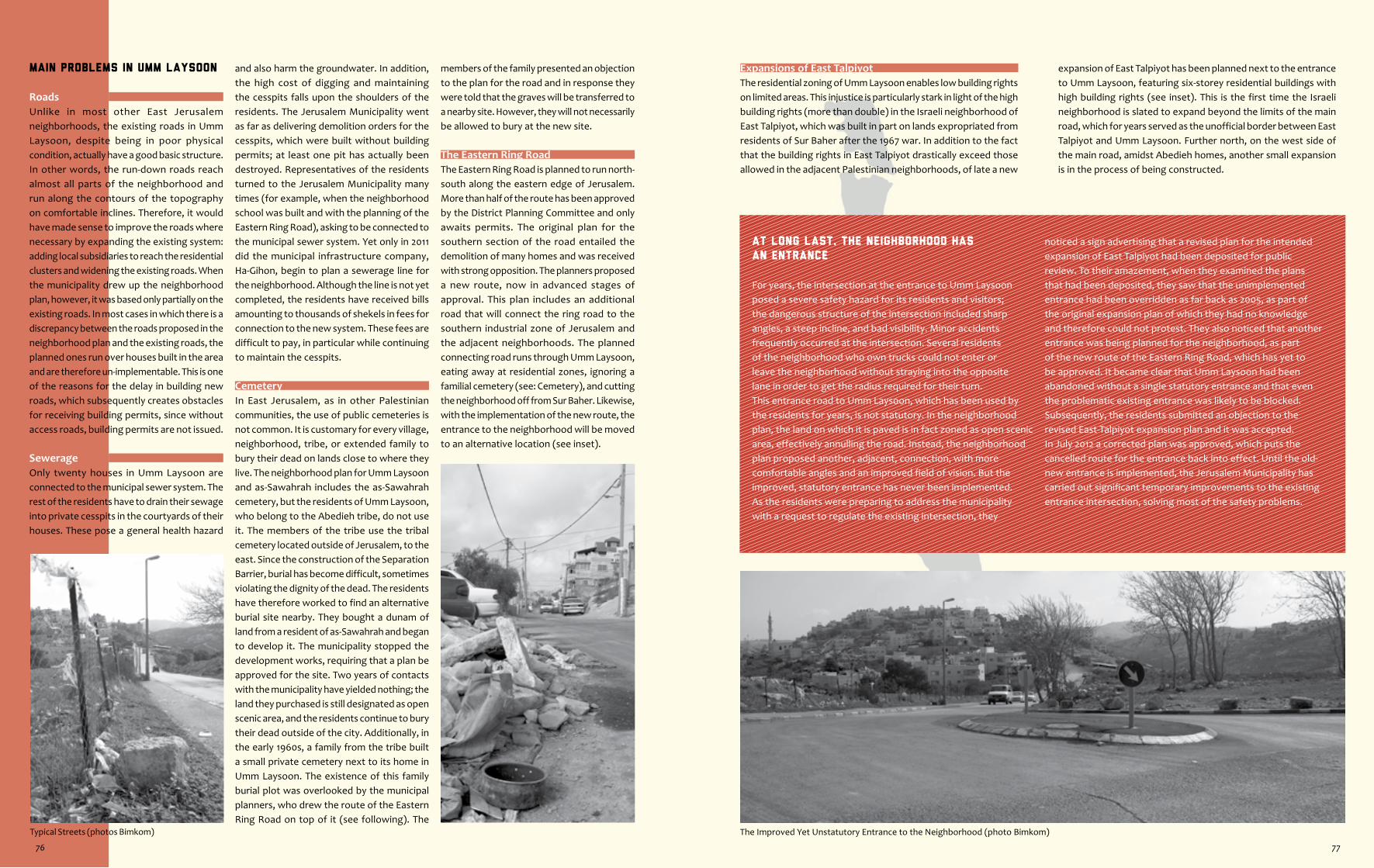
The Improved Yet Unstatutory Entrance to the Neighborhood (photo Bimkom)Typical Streets (photos Bimkom)
At long last, the Neighborhood has
an Entrance
For years, the intersection at the entrance to Umm Laysoon posed a severe safety hazard for its residents and visitors; the dangerous structure of the intersection included sharp angles, a steep incline, and bad visibility. Minor accidents frequently occurred at the intersection. Several residents of the neighborhood who own trucks could not enter or leave the neighborhood without straying into the opposite lane in order to get the radius required for their turn.This entrance road to Umm Laysoon, which has been used by the residents for years, is not statutory. In the neighborhood plan, the land on which it is paved is in fact zoned as open scenic area, effectively annulling the road. Instead, the neighborhood plan proposed another, adjacent, connection, with more comfortable angles and an improved field of vision. But the improved, statutory entrance has never been implemented.As the residents were preparing to address the municipality with a request to regulate the existing intersection, they
noticed a sign advertising that a revised plan for the intended expansion of East Talpiyot had been deposited for public review. To their amazement, when they examined the plans that had been deposited, they saw that the unimplemented entrance had been overridden as far back as 2005, as part of the original expansion plan of which they had no knowledge and therefore could not protest. They also noticed that another entrance was being planned for the neighborhood, as part of the new route of the Eastern Ring Road, which has yet to be approved. It became clear that Umm Laysoon had been abandoned without a single statutory entrance and that even the problematic existing entrance was likely to be blocked.Subsequently, the residents submitted an objection to the revised East-Talpiyot expansion plan and it was accepted. In July 2012 a corrected plan was approved, which puts the cancelled route for the entrance back into effect. Until the old-new entrance is implemented, the Jerusalem Municipality has carried out significant temporary improvements to the existing entrance intersection, solving most of the safety problems.
Expansions of East TalpiyotThe residential zoning of Umm Laysoon enables low building rights on limited areas. This injustice is particularly stark in light of the high building rights (more than double) in the Israeli neighborhood of East Talpiyot, which was built in part on lands expropriated from residents of Sur Baher after the 1967 war. In addition to the fact that the building rights in East Talpiyot drastically exceed those allowed in the adjacent Palestinian neighborhoods, of late a new
expansion of East Talpiyot has been planned next to the entrance to Umm Laysoon, featuring six-storey residential buildings with high building rights (see inset). This is the first time the Israeli neighborhood is slated to expand beyond the limits of the main road, which for years served as the unofficial border between East Talpiyot and Umm Laysoon. Further north, on the west side of the main road, amidst Abedieh homes, another small expansion is in the process of being constructed.
Main Problems in Umm Laysoon
RoadsUnlike in most other East Jerusalem neighborhoods, the existing roads in Umm Laysoon, despite being in poor physical condition, actually have a good basic structure. In other words, the run-down roads reach almost all parts of the neighborhood and run along the contours of the topography on comfortable inclines. Therefore, it would have made sense to improve the roads where necessary by expanding the existing system: adding local subsidiaries to reach the residential clusters and widening the existing roads. When the municipality drew up the neighborhood plan, however, it was based only partially on the existing roads. In most cases in which there is a discrepancy between the roads proposed in the neighborhood plan and the existing roads, the planned ones run over houses built in the area and are therefore un-implementable. This is one of the reasons for the delay in building new roads, which subsequently creates obstacles for receiving building permits, since without access roads, building permits are not issued.
SewerageOnly twenty houses in Umm Laysoon are connected to the municipal sewer system. The rest of the residents have to drain their sewage into private cesspits in the courtyards of their houses. These pose a general health hazard
and also harm the groundwater. In addition, the high cost of digging and maintaining the cesspits falls upon the shoulders of the residents. The Jerusalem Municipality went as far as delivering demolition orders for the cesspits, which were built without building permits; at least one pit has actually been destroyed. Representatives of the residents turned to the Jerusalem Municipality many times (for example, when the neighborhood school was built and with the planning of the Eastern Ring Road), asking to be connected to the municipal sewer system. Yet only in 2011 did the municipal infrastructure company, Ha-Gihon, begin to plan a sewerage line for the neighborhood. Although the line is not yet completed, the residents have received bills amounting to thousands of shekels in fees for connection to the new system. These fees are difficult to pay, in particular while continuing to maintain the cesspits.
CemeteryIn East Jerusalem, as in other Palestinian communities, the use of public cemeteries is not common. It is customary for every village, neighborhood, tribe, or extended family to bury their dead on lands close to where they live. The neighborhood plan for Umm Laysoon and as-Sawahrah includes the as-Sawahrah cemetery, but the residents of Umm Laysoon, who belong to the Abedieh tribe, do not use it. The members of the tribe use the tribal cemetery located outside of Jerusalem, to the east. Since the construction of the Separation Barrier, burial has become difficult, sometimes violating the dignity of the dead. The residents have therefore worked to find an alternative burial site nearby. They bought a dunam of land from a resident of as-Sawahrah and began to develop it. The municipality stopped the development works, requiring that a plan be approved for the site. Two years of contacts with the municipality have yielded nothing; the land they purchased is still designated as open scenic area, and the residents continue to bury their dead outside of the city. Additionally, in the early 1960s, a family from the tribe built a small private cemetery next to its home in Umm Laysoon. The existence of this family burial plot was overlooked by the municipal planners, who drew the route of the Eastern Ring Road on top of it (see following). The
members of the family presented an objection to the plan for the road and in response they were told that the graves will be transferred to a nearby site. However, they will not necessarily be allowed to bury at the new site.
The Eastern Ring RoadThe Eastern Ring Road is planned to run north-south along the eastern edge of Jerusalem. More than half of the route has been approved by the District Planning Committee and only awaits permits. The original plan for the southern section of the road entailed the demolition of many homes and was received with strong opposition. The planners proposed a new route, now in advanced stages of approval. This plan includes an additional road that will connect the ring road to the southern industrial zone of Jerusalem and the adjacent neighborhoods. The planned connecting road runs through Umm Laysoon, eating away at residential zones, ignoring a familial cemetery (see: Cemetery), and cutting the neighborhood off from Sur Baher. Likewise, with the implementation of the new route, the entrance to the neighborhood will be moved to an alternative location (see inset).
76 77
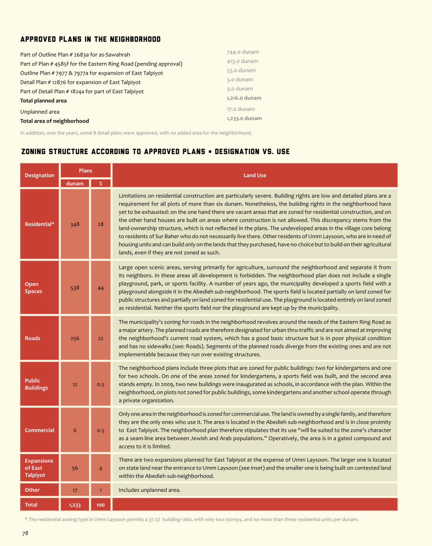
Zoning Structure According to Approved Plans • Designation vs. Use
DesignationPlans
Land Usedunam %
Residential* 348 28
Limitations on residential construction are particularly severe. Building rights are low and detailed plans are a requirement for all plots of more than six dunam. Nonetheless, the building rights in the neighborhood have yet to be exhausted: on the one hand there are vacant areas that are zoned for residential construction, and on the other hand houses are built on areas where construction is not allowed. This discrepancy stems from the land-ownership structure, which is not reflected in the plans. The undeveloped areas in the village core belong to residents of Sur Baher who do not necessarily live there. Other residents of Umm Laysoon, who are in need of housing units and can build only on the lands that they purchased, have no choice but to build on their agricultural lands, even if they are not zoned as such.
Open Spaces 538 44
Large open scenic areas, serving primarily for agriculture, surround the neighborhood and separate it from its neighbors. In these areas all development is forbidden. The neighborhood plan does not include a single playground, park, or sports facility. A number of years ago, the municipality developed a sports field with a playground alongside it in the Abedieh sub-neighborhood. The sports field is located partially on land zoned for public structures and partially on land zoned for residential use. The playground is located entirely on land zoned as residential. Neither the sports field nor the playground are kept up by the municipality.
Roads 256 22
The municipality’s zoning for roads in the neighborhood revolves around the needs of the Eastern Ring Road as a major artery. The planned roads are therefore designated for urban thru-traffic and are not aimed at improving the neighborhood’s current road system, which has a good basic structure but is in poor physical condition and has no sidewalks (see: Roads). Segments of the planned roads diverge from the existing ones and are not implementable because they run over existing structures.
Public Buildings 12 0.5
The neighborhood plans include three plots that are zoned for public buildings: two for kindergartens and one for two schools. On one of the areas zoned for kindergartens, a sports field was built, and the second area stands empty. In 2009, two new buildings were inaugurated as schools, in accordance with the plan. Within the neighborhood, on plots not zoned for public buildings, some kindergartens and another school operate through a private organization.
Commercial 6 0.5
Only one area in the neighborhood is zoned for commercial use. The land is owned by a single family, and therefore they are the only ones who use it. The area is located in the Abedieh sub-neighborhood and is in close proimity to East Talpiyot. The neighborhood plan therefore stipulates that its use “will be suited to the zone’s character as a seam-line area between Jewish and Arab populations.” Operatively, the area is in a gated compound and access to it is limited.
Expansions of East Talpiyot
56 4There are two expansions planned for East Talpiyot at the expense of Umm Laysoon. The larger one is located on state land near the entrance to Umm Laysoon (see inset) and the smaller one is being built on contested land within the Abedieh sub-neighborhood.
Other 17 1 Includes unplanned area.
Total 1,233 100
* The residential zoning type in Umm Laysoon permits a 37.5% building ratio, with only two storeys, and no more than three residential units per dunam.
Approved Plans in the Neighborhood
Part of Outline Plan # 2683a for as-Sawahrah 744.0 dunam
Part of Plan # 4585f for the Eastern Ring Road (pending approval) 413.0 dunam
Outline Plan # 7977 & 7977a for expansion of East Talpiyot 53.0 dunam
Detail Plan # 12876 for expansion of East Talpiyot 3.0 dunam
Part of Detail Plan # 1824a for part of East Talpiyot 3.0 dunam
Total planned area 1,216.0 dunam
Unplanned area 17.0 dunam
Total area of neighborhood 1,233.0 dunam
In addition, over the years, some 8 detail plans were approved, with no added area for the neighborhood.
78
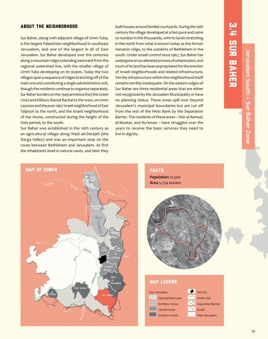
About the neighborhood
Sur Baher, along with adjacent village of Umm Tuba, is the largest Palestinian neighborhood in southeast Jerusalem, and one of the largest in all of East Jerusalem. Sur Baher developed over the centuries along a mountain ridge extending eastward from the regional watershed line, with the smaller village of Umm Tuba developing on its slopes. Today the two villages span a sequence of ridges branching off of the main one and constituting a single administrative unit, though the residents continue to organize separately. Sur Baher borders on the 1949 armistice line (the Green Line) and Kibbutz Ramat Rachel to the west, on Umm Laysoon and the post-1967 Israeli neighborhood of East Talpiyot to the north, and the Israeli neighborhood of Har Homa, constructed during the height of the Oslo period, to the south. Sur Baher was established in the 16th century as an agricultural village along Wadi ad-Darajeh (the Darga Valley) and was an important stop on the route between Bethlehem and Jerusalem. At first the inhabitants lived in natural caves, and later they
built houses around familial courtyards. During the 19th century the village developed at a fast pace and came to number in the thousands, with its lands stretching in the north from what is known today as the Armon Hanatziv ridge, to the outskirts of Bethlehem in the south. Under Israeli control since 1967, Sur Baher has undergone an accelerated process of urbanization, and much of its land has been expropriated for the erection of Israeli neighborhoods and related infrastructure. Yet the infrastructure within the neighborhood itself remains terribly inadequate. On the eastern edges of Sur Baher are three residential areas that are either not recognized by the Jerusalem Municipality or have no planning status. These areas spill over beyond Jerusalem’s municipal boundaries but are cut off from the rest of the West Bank by the Separation Barrier. The residents of these areas – Deir al-Aamud, al-Muntar, and Nu’eman – have struggled over the years to receive the basic services they need to live in dignity.
Jaffa Rd.
Rd. 4
Heb
ron
Rd.
Ramallah Rd.
Hwy 1
Hwy 443Hwy 45
Rd. 20
Hw
y 40
4
Hw y 1
Hwy 60
Hw
y 60
(o
ld)
Hw
y 60 (old)
Hwy 60
RamallahRoad
Anata
Kafr Aqab
Mt. of Olives
Mt.Scopus&
City Center
GreaterSilwan
al-Mokabber
Jabal
Sur Baher
Beit Safafa
Al-Walaje
MAP OF ZONES
Map Legend
Population 21,500Area 5,754 dunam
Facts
Separation Barrier
West Jerusalem
East Jerusalem
Expropriated Land
Northern Zones
Central Zones
Southern Zones
Old City
Roads
Green Line
3.4
sur b
aher
Jerusalem South • Sur Baher Zone
79
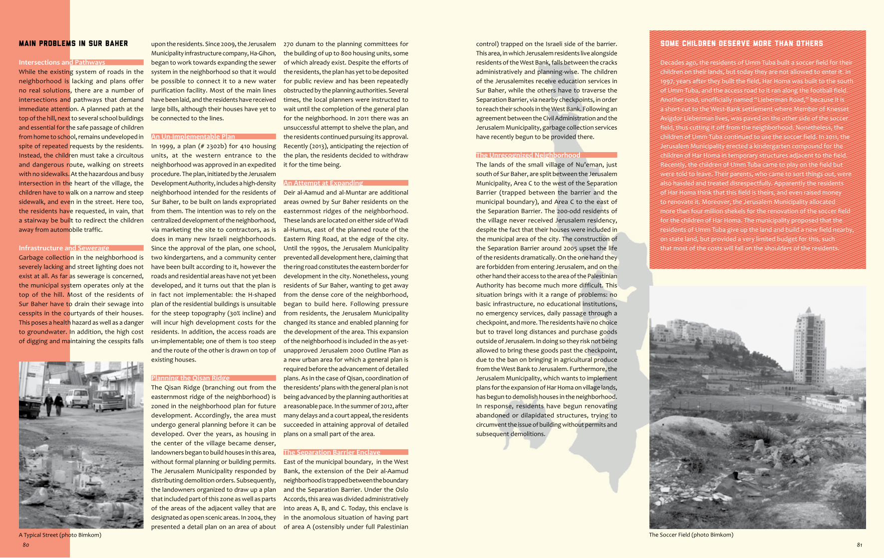
The Soccer Field (photo Bimkom)A Typical Street (photo Bimkom)
Some children deserve more than others
Decades ago, the residents of Umm Tuba built a soccer field for their children on their lands, but today they are not allowed to enter it. In 1997, years after they built the field, Har Homa was built to the south of Umm Tuba, and the access road to it ran along the football field. Another road, unofficially named “Lieberman Road,” because it is a short-cut to the West-Bank settlement where Member of Knesset Avigdor Lieberman lives, was paved on the other side of the soccer field, thus cutting it off from the neighborhood. Nonetheless, the children of Umm Tuba continued to use the soccer field. In 2011, the Jerusalem Municipality erected a kindergarten compound for the children of Har Homa in temporary structures adjacent to the field. Recently, the children of Umm Tuba came to play on the field but were told to leave. Their parents, who came to sort things out, were also hassled and treated disrespectfully. Apparently the residents of Har Homa think that this field is theirs, and even raised money to renovate it. Moreover, the Jerusalem Municipality allocated more than four million shekels for the renovation of the soccer field for the children of Har Homa. The municipality proposed that the residents of Umm Tuba give up the land and build a new field nearby, on state land, but provided a very limited budget for this, such that most of the costs will fall on the shoulders of the residents.
control) trapped on the Israeli side of the barrier. This area, in which Jerusalem residents live alongside residents of the West Bank, falls between the cracks administratively and planning-wise. The children of the Jerusalemites receive education services in Sur Baher, while the others have to traverse the Separation Barrier, via nearby checkpoints, in order to reach their schools in the West Bank. Following an agreement between the Civil Administration and the Jerusalem Municipality, garbage collection services have recently begun to be provided there.
The Unrecognized NeighborhoodThe lands of the small village of Nu’eman, just south of Sur Baher, are split between the Jerusalem Municipality, Area C to the west of the Separation Barrier (trapped between the barrier and the municipal boundary), and Area C to the east of the Separation Barrier. The 200-odd residents of the village never received Jerusalem residency, despite the fact that their houses were included in the municipal area of the city. The construction of the Separation Barrier around 2005 upset the life of the residents dramatically. On the one hand they are forbidden from entering Jerusalem, and on the other hand their access to the area of the Palestinian Authority has become much more difficult. This situation brings with it a range of problems: no basic infrastructure, no educational institutions, no emergency services, daily passage through a checkpoint, and more. The residents have no choice but to travel long distances and purchase goods outside of Jerusalem. In doing so they risk not being allowed to bring these goods past the checkpoint, due to the ban on bringing in agricultural produce from the West Bank to Jerusalem. Furthermore, the Jerusalem Municipality, which wants to implement plans for the expansion of Har Homa on village lands, has begun to demolish houses in the neighborhood. In response, residents have begun renovating abandoned or dilapidated structures, trying to circumvent the issue of building without permits and subsequent demolitions.
Main Problems in Sur Baher
Intersections and PathwaysWhile the existing system of roads in the neighborhood is lacking and plans offer no real solutions, there are a number of intersections and pathways that demand immediate attention. A planned path at the top of the hill, next to several school buildings and essential for the safe passage of children from home to school, remains undeveloped in spite of repeated requests by the residents. Instead, the children must take a circuitous and dangerous route, walking on streets with no sidewalks. At the hazardous and busy intersection in the heart of the village, the children have to walk on a narrow and steep sidewalk, and even in the street. Here too, the residents have requested, in vain, that a stairway be built to redirect the children away from automobile traffic.
Infrastructure and SewerageGarbage collection in the neighborhood is severely lacking and street lighting does not exist at all. As far as sewerage is concerned, the municipal system operates only at the top of the hill. Most of the residents of Sur Baher have to drain their sewage into cesspits in the courtyards of their houses. This poses a health hazard as well as a danger to groundwater. In addition, the high cost of digging and maintaining the cesspits falls
upon the residents. Since 2009, the Jerusalem Municipality infrastructure company, Ha-Gihon, began to work towards expanding the sewer system in the neighborhood so that it would be possible to connect it to a new water purification facility. Most of the main lines have been laid, and the residents have received large bills, although their houses have yet to be connected to the lines.
An Un-Implementable PlanIn 1999, a plan (# 2302b) for 410 housing units, at the western entrance to the neighborhood was approved in an expedited procedure. The plan, initiated by the Jerusalem Development Authority, includes a high-density neighborhood intended for the residents of Sur Baher, to be built on lands expropriated from them. The intention was to rely on the centralized development of the neighborhood, via marketing the site to contractors, as is does in many new Israeli neighborhoods. Since the approval of the plan, one school, two kindergartens, and a community center have been built according to it, however the roads and residential areas have not yet been developed, and it turns out that the plan is in fact not implementable: the H-shaped plan of the residential buildings is unsuitable for the steep topography (30% incline) and will incur high development costs for the residents. In addition, the access roads are un-implementable; one of them is too steep and the route of the other is drawn on top of existing houses.
Planning the Qisan RidgeThe Qisan Ridge (branching out from the easternmost ridge of the neighborhood) is zoned in the neighborhood plan for future development. Accordingly, the area must undergo general planning before it can be developed. Over the years, as housing in the center of the village became denser, landowners began to build houses in this area, without formal planning or building permits. The Jerusalem Municipality responded by distributing demolition orders. Subsequently, the landowners organized to draw up a plan that included part of this zone as well as parts of the areas of the adjacent valley that are designated as open scenic areas. In 2004, they presented a detail plan on an area of about
270 dunam to the planning committees for the building of up to 800 housing units, some of which already exist. Despite the efforts of the residents, the plan has yet to be deposited for public review and has been repeatedly obstructed by the planning authorities. Several times, the local planners were instructed to wait until the completion of the general plan for the neighborhood. In 2011 there was an unsuccessful attempt to shelve the plan, and the residents continued pursuing its approval. Recently (2013), anticipating the rejection of the plan, the residents decided to withdraw it for the time being.
An Attempt at ExpandingDeir al-Aamud and al-Muntar are additional areas owned by Sur Baher residents on the easternmost ridges of the neighborhood. These lands are located on either side of Wadi al-Humus, east of the planned route of the Eastern Ring Road, at the edge of the city. Until the 1990s, the Jerusalem Municipality prevented all development here, claiming that the ring road constitutes the eastern border for development in the city. Nonetheless, young residents of Sur Baher, wanting to get away from the dense core of the neighborhood, began to build here. Following pressure from residents, the Jerusalem Municipality changed its stance and enabled planning for the development of the area. This expansion of the neighborhood is included in the as-yet- unapproved Jerusalem 2000 Outline Plan as a new urban area for which a general plan is required before the advancement of detailed plans. As in the case of Qisan, coordination of the residents’ plans with the general plan is not being advanced by the planning authorities at a reasonable pace. In the summer of 2012, after many delays and a court appeal, the residents succeeded in attaining approval of detailed plans on a small part of the area.
The Separation Barrier EnclaveEast of the municipal boundary, in the West Bank, the extension of the Deir al-Aamud neighborhood is trapped between the boundary and the Separation Barrier. Under the Oslo Accords, this area was divided administratively into areas A, B, and C. Today, this enclave is in the anomolous situation of having part of area A (ostensibly under full Palestinian
80 81
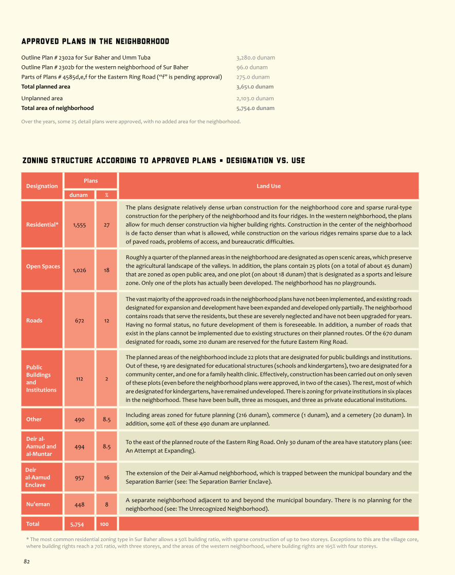
Zoning Structure According to Approved Plans • Designation vs. Use
DesignationPlans
Land Usedunam %
Residential* 1,555 27
The plans designate relatively dense urban construction for the neighborhood core and sparse rural-type construction for the periphery of the neighborhood and its four ridges. In the western neighborhood, the plans allow for much denser construction via higher building rights. Construction in the center of the neighborhood is de facto denser than what is allowed, while construction on the various ridges remains sparse due to a lack of paved roads, problems of access, and bureaucratic difficulties.
Open Spaces 1,026 18
Roughly a quarter of the planned areas in the neighborhood are designated as open scenic areas, which preserve the agricultural landscape of the valleys. In addition, the plans contain 25 plots (on a total of about 45 dunam) that are zoned as open public area, and one plot (on about 18 dunam) that is designated as a sports and leisure zone. Only one of the plots has actually been developed. The neighborhood has no playgrounds.
Roads 672 12
The vast majority of the approved roads in the neighborhood plans have not been implemented, and existing roads designated for expansion and development have been expanded and developed only partially. The neighborhood contains roads that serve the residents, but these are severely neglected and have not been upgraded for years. Having no formal status, no future development of them is foreseeable. In addition, a number of roads that exist in the plans cannot be implemented due to existing structures on their planned routes. Of the 670 dunam designated for roads, some 210 dunam are reserved for the future Eastern Ring Road.
Public Buildings and Institutions
112 2
The planned areas of the neighborhood include 22 plots that are designated for public buildings and institutions. Out of these, 19 are designated for educational structures (schools and kindergartens), two are designated for a community center, and one for a family health clinic. Effectively, construction has been carried out on only seven of these plots (even before the neighborhood plans were approved, in two of the cases). The rest, most of which are designated for kindergartens, have remained undeveloped. There is zoning for private institutions in six places in the neighborhood. These have been built, three as mosques, and three as private educational institutions.
Other 490 8.5Including areas zoned for future planning (216 dunam), commerce (1 dunam), and a cemetery (20 dunam). In addition, some 40% of these 490 dunam are unplanned.
Deir al-Aamud and al-Muntar
494 8.5To the east of the planned route of the Eastern Ring Road. Only 30 dunam of the area have statutory plans (see: An Attempt at Expanding).
Deir al-Aamud Enclave
957 16The extension of the Deir al-Aamud neighborhood, which is trapped between the municipal boundary and the Separation Barrier (see: The Separation Barrier Enclave).
Nu’eman 448 8A separate neighborhood adjacent to and beyond the municipal boundary. There is no planning for the neighborhood (see: The Unrecognized Neighborhood).
Total 5,754 100
* The most common residential zoning type in Sur Baher allows a 50% building ratio, with sparse construction of up to two storeys. Exceptions to this are the village core, where building rights reach a 70% ratio, with three storeys, and the areas of the western neighborhood, where building rights are 165% with four storeys.
Approved Plans in the Neighborhood
Outline Plan # 2302a for Sur Baher and Umm Tuba 3,280.0 dunam
Outline Plan # 2302b for the western neighborhood of Sur Baher 96.0 dunam
Parts of Plans # 4585d,e,f for the Eastern Ring Road (“f” is pending approval) 275.0 dunam
Total planned area 3,651.0 dunam
Unplanned area 2,103.0 dunam
Total area of neighborhood 5,754.0 dunam
Over the years, some 25 detail plans were approved, with no added area for the neighborhood.
82

About the neighborhood
Located in southern Jerusalem, Beit Safafa, along with the adjacent Sharafat neighborhood, is not contiguous with the other Palestinian neighborhoods of East Jerusalem. Beit Safafa borders on the Israeli neighborhoods of Pat and Gonenim (in West Jerusalem) to the north, Hebron Road to the east, Dov Yosef Road (“the road up to Gilo”) to the west, and the post-1967 Israeli neighborhood of Gilo to the southwest. Before being included within Jerusalem’s current municipal borders, Beit Safafa was an independent agricultural village located to the southwest of Jerusalem, along the Refaim Valley. At the end of the 1948 war, the Green Line was drawn through the northern part of Beit Safafa, splitting the village into two. The northern (smaller) section became part of the State of Israel and its residents were granted Israeli citizenship, while the southern section of the village came under Jordanian rule. After the 1967 war, the village was reunited, this time under Israeli control, and the residents of the southern part of the village received permanent residency status. Today, along the route of the fence
that once divided the village, is the street known as Ihud Ha-Kfar (Hebrew for “Unification of the Village”). While the neighborhood’s population is comprised of both citizens and non-citizens of Israel, people do not necessarily choose to live along 48/67 lines. Beit Safafa retains its rural character to this day, with relatively low buildings and agricultural plots between the houses. However, the neighborhood has seen population growth since the 1980s due to inward migration. Much like the north-Jerusalem neighborhoods of Beit Hanina and Shuafat, Beit Safafa is a neighborhood of choice for Palestinian-Israelis settling in Jerusalem, with more than half of them living in Beit Safafa. With Israel’s ongoing construction of the Separation Barrier, many Jerusalemite Palestinians have moved to neighborhoods on the Israeli side of the barrier, Beit Safafa among them. Beit Safafa’s proximity to the more adequate infrastructures and services of the neighboring Jewish-Israeli neighborhoods and to the industrial and commercial zone of Talpiyot, increases its desirability in comparison to other Palestinian neighborhoods.
Jaffa Rd.
Rd. 4
Heb
ron
Rd.
Ramallah Rd.
Hwy 1
Hwy 443Hwy 45
Rd. 20
Hw
y 40
4
Hw y 1
Hwy 60
Hw
y 60
(o
ld)
Hw
y 60 (old)
Hwy 60
RamallahRoad
Anata
Kafr Aqab
Mt. of Olives
Mt.Scopus&
City Center
GreaterSilwan
al-Mokabber
Jabal
Sur Baher
Beit Safafa
Al-Walaje
MAP OF ZONES
Map Legend
Population 10,500Area 2,091 dunam
Facts
Separation Barrier
West Jerusalem
East Jerusalem
Expropriated Land
Northern Zones
Central Zones
Southern Zones
Old City
Roads
Green Line
3.5
Beit
Safafa
Jerusalem South • Beit Safafa Zone
83
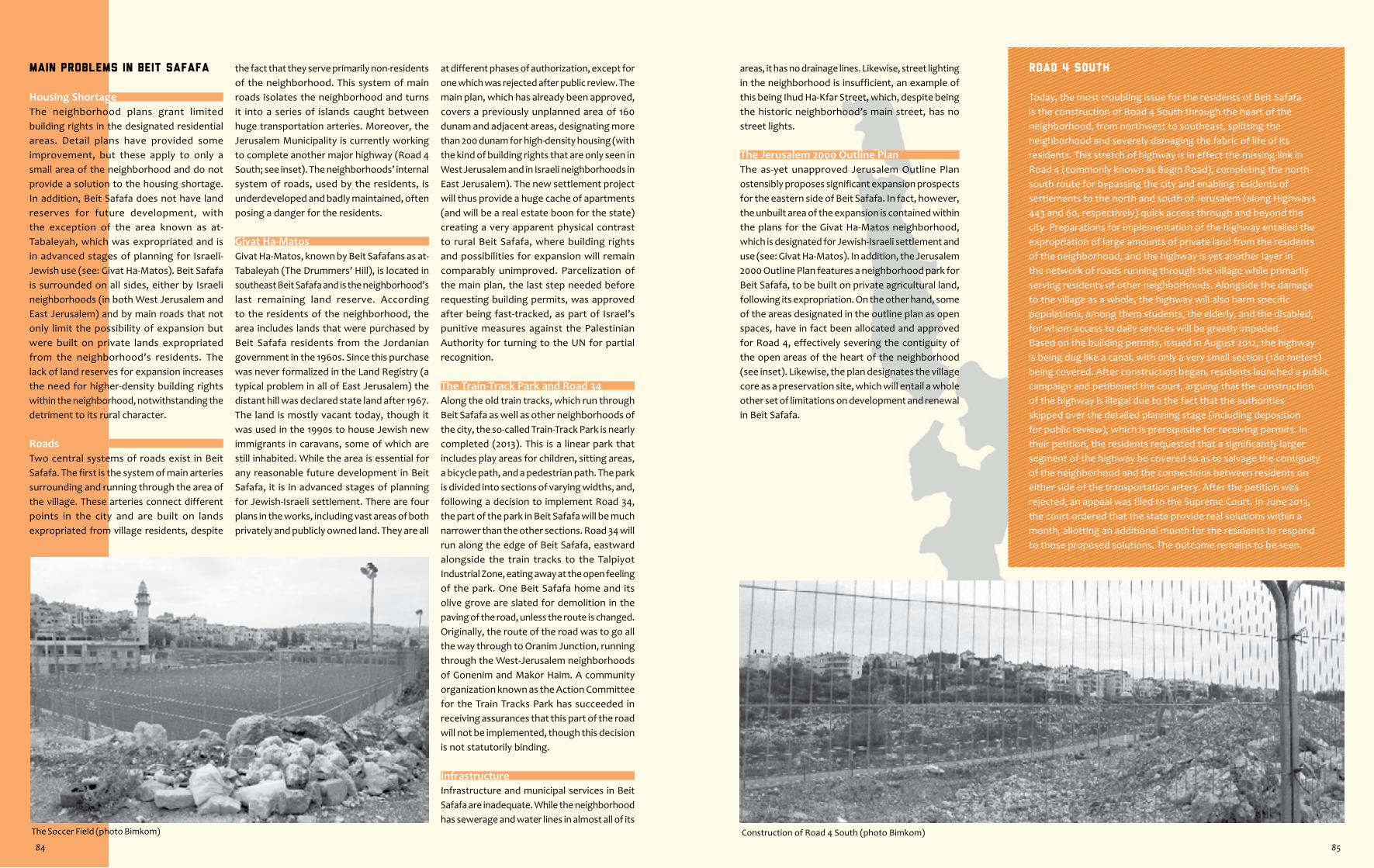
Construction of Road 4 South (photo Bimkom)The Soccer Field (photo Bimkom)
ROAD 4 SOUTH
Today, the most troubling issue for the residents of Beit Safafa is the construction of Road 4 South through the heart of the neighborhood, from northwest to southeast, splitting the neighborhood and severely damaging the fabric of life of its residents. This stretch of highway is in effect the missing link in Road 4 (commonly known as Begin Road), completing the north-south route for bypassing the city and enabling residents of settlements to the north and south of Jerusalem (along Highways 443 and 60, respectively) quick access through and beyond the city. Preparations for implementation of the highway entailed the expropriation of large amounts of private land from the residents of the neighborhood, and the highway is yet another layer in the network of roads running through the village while primarily serving residents of other neighborhoods. Alongside the damage to the village as a whole, the highway will also harm specific populations, among them students, the elderly, and the disabled, for whom access to daily services will be greatly impeded. Based on the building permits, issued in August 2012, the highway is being dug like a canal, with only a very small section (180 meters) being covered. After construction began, residents launched a public campaign and petitioned the court, arguing that the construction of the highway is illegal due to the fact that the authorities skipped over the detailed planning stage (including deposition for public review), which is prerequisite for receiving permits. In their petition, the residents requested that a significantly larger segment of the highway be covered so as to salvage the contiguity of the neighborhood and the connections between residents on either side of the transportation artery. After the petition was rejected, an appeal was filed to the Supreme Court. In June 2013, the court ordered that the state provide real solutions within a month, allotting an additional month for the residents to respond to those proposed solutions. The outcome remains to be seen.
areas, it has no drainage lines. Likewise, street lighting in the neighborhood is insufficient, an example of this being Ihud Ha-Kfar Street, which, despite being the historic neighborhood’s main street, has no street lights.
The Jerusalem 2000 Outline PlanThe as-yet unapproved Jerusalem Outline Plan ostensibly proposes significant expansion prospects for the eastern side of Beit Safafa. In fact, however, the unbuilt area of the expansion is contained within the plans for the Givat Ha-Matos neighborhood, which is designated for Jewish-Israeli settlement and use (see: Givat Ha-Matos). In addition, the Jerusalem 2000 Outline Plan features a neighborhood park for Beit Safafa, to be built on private agricultural land, following its expropriation. On the other hand, some of the areas designated in the outline plan as open spaces, have in fact been allocated and approved for Road 4, effectively severing the contiguity of the open areas of the heart of the neighborhood (see inset). Likewise, the plan designates the village core as a preservation site, which will entail a whole other set of limitations on development and renewal in Beit Safafa.
Main Problems in Beit Safafa
Housing ShortageThe neighborhood plans grant limited building rights in the designated residential areas. Detail plans have provided some improvement, but these apply to only a small area of the neighborhood and do not provide a solution to the housing shortage. In addition, Beit Safafa does not have land reserves for future development, with the exception of the area known as at-Tabaleyah, which was expropriated and is in advanced stages of planning for Israeli-Jewish use (see: Givat Ha-Matos). Beit Safafa is surrounded on all sides, either by Israeli neighborhoods (in both West Jerusalem and East Jerusalem) and by main roads that not only limit the possibility of expansion but were built on private lands expropriated from the neighborhood’s residents. The lack of land reserves for expansion increases the need for higher-density building rights within the neighborhood, notwithstanding the detriment to its rural character.
RoadsTwo central systems of roads exist in Beit Safafa. The first is the system of main arteries surrounding and running through the area of the village. These arteries connect different points in the city and are built on lands expropriated from village residents, despite
the fact that they serve primarily non-residents of the neighborhood. This system of main roads isolates the neighborhood and turns it into a series of islands caught between huge transportation arteries. Moreover, the Jerusalem Municipality is currently working to complete another major highway (Road 4 South; see inset). The neighborhoods’ internal system of roads, used by the residents, is underdeveloped and badly maintained, often posing a danger for the residents.
Givat Ha-MatosGivat Ha-Matos, known by Beit Safafans as at-Tabaleyah (The Drummers’ Hill), is located in southeast Beit Safafa and is the neighborhood’s last remaining land reserve. According to the residents of the neighborhood, the area includes lands that were purchased by Beit Safafa residents from the Jordanian government in the 1960s. Since this purchase was never formalized in the Land Registry (a typical problem in all of East Jerusalem) the distant hill was declared state land after 1967. The land is mostly vacant today, though it was used in the 1990s to house Jewish new immigrants in caravans, some of which are still inhabited. While the area is essential for any reasonable future development in Beit Safafa, it is in advanced stages of planning for Jewish-Israeli settlement. There are four plans in the works, including vast areas of both privately and publicly owned land. They are all
at different phases of authorization, except for one which was rejected after public review. The main plan, which has already been approved, covers a previously unplanned area of 160 dunam and adjacent areas, designating more than 200 dunam for high-density housing (with the kind of building rights that are only seen in West Jerusalem and in Israeli neighborhoods in East Jerusalem). The new settlement project will thus provide a huge cache of apartments (and will be a real estate boon for the state) creating a very apparent physical contrast to rural Beit Safafa, where building rights and possibilities for expansion will remain comparably unimproved. Parcelization of the main plan, the last step needed before requesting building permits, was approved after being fast-tracked, as part of Israel’s punitive measures against the Palestinian Authority for turning to the UN for partial recognition.
The Train-Track Park and Road 34Along the old train tracks, which run through Beit Safafa as well as other neighborhoods of the city, the so-called Train-Track Park is nearly completed (2013). This is a linear park that includes play areas for children, sitting areas, a bicycle path, and a pedestrian path. The park is divided into sections of varying widths, and, following a decision to implement Road 34, the part of the park in Beit Safafa will be much narrower than the other sections. Road 34 will run along the edge of Beit Safafa, eastward alongside the train tracks to the Talpiyot Industrial Zone, eating away at the open feeling of the park. One Beit Safafa home and its olive grove are slated for demolition in the paving of the road, unless the route is changed. Originally, the route of the road was to go all the way through to Oranim Junction, running through the West-Jerusalem neighborhoods of Gonenim and Makor Haim. A community organization known as the Action Committee for the Train Tracks Park has succeeded in receiving assurances that this part of the road will not be implemented, though this decision is not statutorily binding.
InfrastructureInfrastructure and municipal services in Beit Safafa are inadequate. While the neighborhood has sewerage and water lines in almost all of its
84 85

Zoning Structure According to Approved Plans • Designation vs. Use
DesignationPlans
Land Usedunam %
Residential* 968 46
There is a discrepancy between the low-density, rural-type building rights and the needs and aspirations of the residents, some of whom prefer to retain the rural character of Beit Safafa and others who want to see it developed as an urban neighborhood. Demographic patterns have dramatically increased the demand for apartments, resulting in many detail plans that have de facto created a densifying residential fabric.
Open Spaces 347 17
The agricultural valley in the center of the neighborhood is designated as open scenic area. Road 4 South is planned to run through the neighborhood (see inset), leaving the southern part of the strip as a buffer zone between the neighborhood and the adjacent Israeli neighborhood of Gilo, to the south. Another large open area, designated as open public area, is located along Hebron Road, in the eastern part of Givat Ha-Matos. The neighborhood plans also allocate some 17 small plots as open public areas, only three of which have been developed - two as a playground, and one as a soccer field. The largest plot is used for agriculture. The development of the rest of the areas is unlikely, as the narrow plots look more like leftover spaces and serve functionally as passageways and the like.
Roads 496 24
Large areas of the neighborhood have been allocated for the development of roads. However, instead of improving and upgrading the system of neighborhood roads, which in its current condition poses a danger to the residents on a daily basis, the Jerusalem Municipality has begun working on the implementation of another major urban transportation artery which is not aimed at improving the quality of life of the residents (see inset).
Public Buildings
85 4
The neighborhood plans contain 15 plots designated for public buildings (10 dunam of which are allocated on Givat Ha-Matos). Only six of these plots have actually been developed. Unlike most Palestinian neighborhoods in East Jerusalem, Beit Safafa actually has a municipal high school. Within the area of the neighborhood is also a Jewish Yeshiva, which is housed in a structure that served as a hospital before 1948.
Givat Ha-Matos
160 7The central area of Givat Ha-Matos was not included in the outline plan of the neighborhood and is not designated for use by the neighborhood’s residents. An Israeli settlement project is planned on the site.
Other 35 2 Includes unplanned areas.
Total 2,091 100
* The most common residential zoning type in Beit Safafa allows a 50% building ratio, with sparse construction of up to two storeys. Exceptions to this are the village core, where building ratios reach 80%, and Plan # 3855 in which a 90% building ratio is permitted, with four storeys.
Approved Plans in the Neighborhood
Part of Outline Plan # 2317 for Beit Safa and Sharafat 1,643.0 dunam
Outline Plan # 3488 for the al-Jam’iyyah sub-neighborhood 234.0 dunam
Part of Local Outline Plan # 62 for West Jerusalem 23.0 dunam
Plan # 1760 for the high school 15.0 dunam
Part of Plan # 5834a for the main section of Givat Ha-Matos 160.0 dunam
Total planned area 2,075.0 dunam
Unplanned area 16.0 dunam
Total area of neighborhood 2,091.0 dunam
In addition, three more outline plans (3801, 3802, 3855), were approved as changes to the neighborhood outline plan (# 2317), and some 28 detail plans were also approved, with no added area for the neighborhood.
86
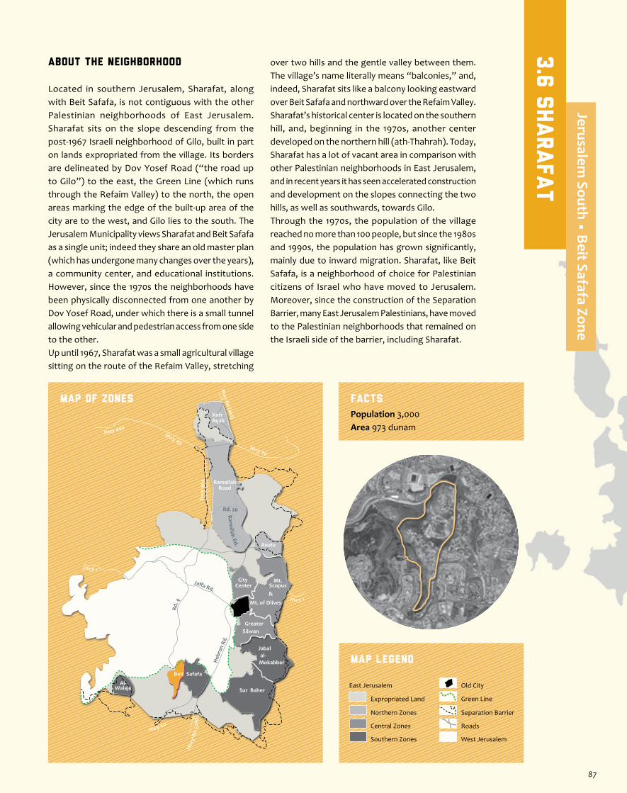
About the neighborhood
Located in southern Jerusalem, Sharafat, along with Beit Safafa, is not contiguous with the other Palestinian neighborhoods of East Jerusalem. Sharafat sits on the slope descending from the post-1967 Israeli neighborhood of Gilo, built in part on lands expropriated from the village. Its borders are delineated by Dov Yosef Road (“the road up to Gilo”) to the east, the Green Line (which runs through the Refaim Valley) to the north, the open areas marking the edge of the built-up area of the city are to the west, and Gilo lies to the south. The Jerusalem Municipality views Sharafat and Beit Safafa as a single unit; indeed they share an old master plan (which has undergone many changes over the years), a community center, and educational institutions. However, since the 1970s the neighborhoods have been physically disconnected from one another by Dov Yosef Road, under which there is a small tunnel allowing vehicular and pedestrian access from one side to the other.Up until 1967, Sharafat was a small agricultural village sitting on the route of the Refaim Valley, stretching
over two hills and the gentle valley between them. The village’s name literally means “balconies,” and, indeed, Sharafat sits like a balcony looking eastward over Beit Safafa and northward over the Refaim Valley. Sharafat’s historical center is located on the southern hill, and, beginning in the 1970s, another center developed on the northern hill (ath-Thahrah). Today, Sharafat has a lot of vacant area in comparison with other Palestinian neighborhoods in East Jerusalem, and in recent years it has seen accelerated construction and development on the slopes connecting the two hills, as well as southwards, towards Gilo. Through the 1970s, the population of the village reached no more than 100 people, but since the 1980s and 1990s, the population has grown significantly, mainly due to inward migration. Sharafat, like Beit Safafa, is a neighborhood of choice for Palestinian citizens of Israel who have moved to Jerusalem. Moreover, since the construction of the Separation Barrier, many East Jerusalem Palestinians, have moved to the Palestinian neighborhoods that remained on the Israeli side of the barrier, including Sharafat.
Jaffa Rd.
Rd. 4
Heb
ron
Rd.
Ramallah Rd.
Hwy 1
Hwy 443Hwy 45
Rd. 20
Hw
y 40
4
Hw y 1
Hwy 60
Hw
y 60
(o
ld)
Hw
y 60 (old)
Hwy 60
RamallahRoad
Anata
Kafr Aqab
Mt. of Olives
Mt.Scopus&
City Center
GreaterSilwan
al-Mokabber
Jabal
Sur Baher
Beit Safafa
Al-Walaje
MAP OF ZONES
Map Legend
Population 3,000Area 973 dunam
Facts
Separation Barrier
West Jerusalem
East Jerusalem
Expropriated Land
Northern Zones
Central Zones
Southern Zones
Old City
Roads
Green Line
3.6
sharafat
Jerusalem South • Beit Safafa Zone
87
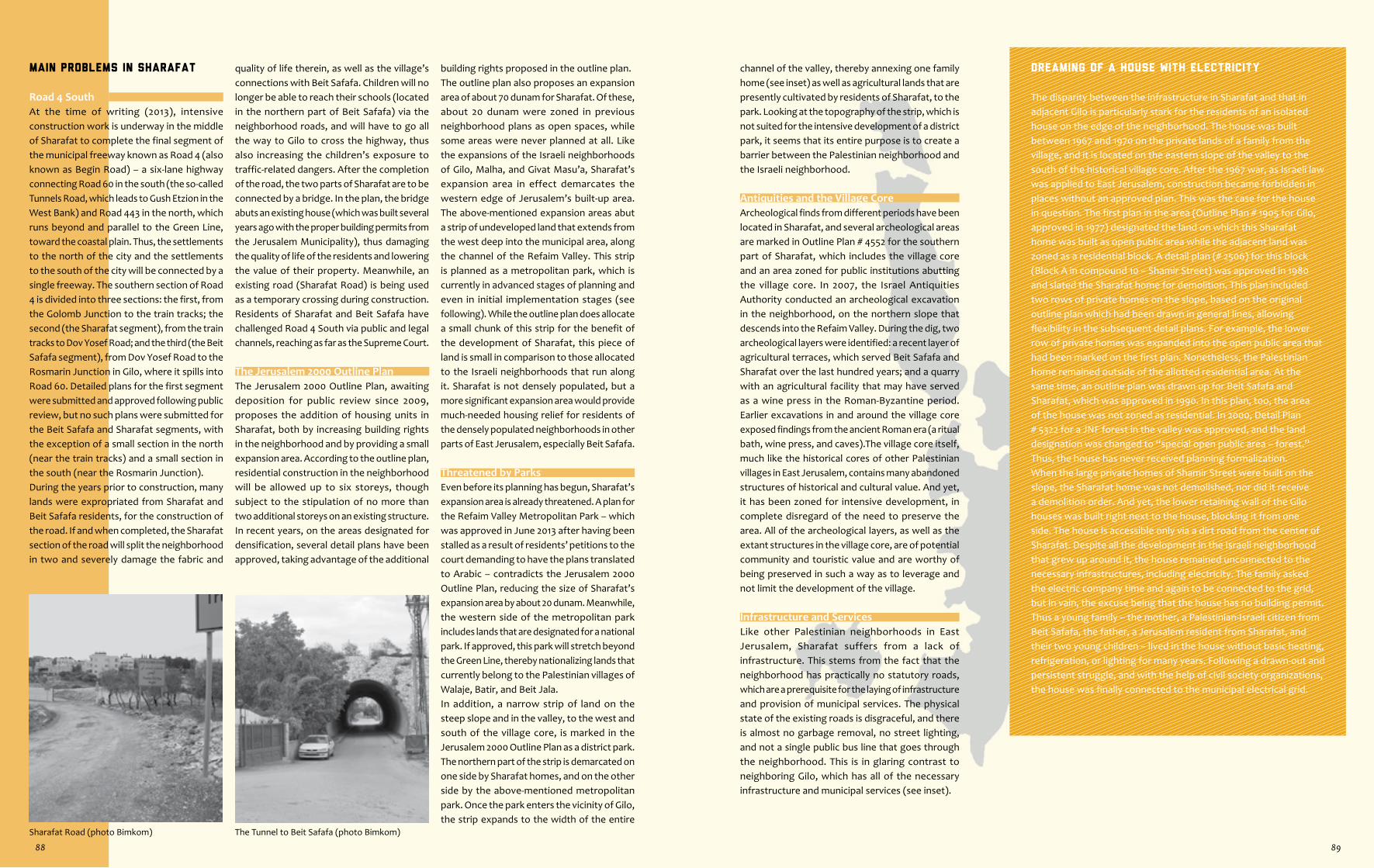
Sharafat Road (photo Bimkom) The Tunnel to Beit Safafa (photo Bimkom)
Dreaming of a House with Electricity
The disparity between the infrastructure in Sharafat and that in adjacent Gilo is particularly stark for the residents of an isolated house on the edge of the neighborhood. The house was built between 1967 and 1970 on the private lands of a family from the village, and it is located on the eastern slope of the valley to the south of the historical village core. After the 1967 war, as Israeli law was applied to East Jerusalem, construction became forbidden in places without an approved plan. This was the case for the house in question. The first plan in the area (Outline Plan # 1905 for Gilo, approved in 1977) designated the land on which this Sharafat home was built as open public area while the adjacent land was zoned as a residential block. A detail plan (# 2506) for this block (Block A in compound 10 – Shamir Street) was approved in 1980 and slated the Sharafat home for demolition. This plan included two rows of private homes on the slope, based on the original outline plan which had been drawn in general lines, allowing flexibility in the subsequent detail plans. For example, the lower row of private homes was expanded into the open public area that had been marked on the first plan. Nonetheless, the Palestinian home remained outside of the allotted residential area. At the same time, an outline plan was drawn up for Beit Safafa and Sharafat, which was approved in 1990. In this plan, too, the area of the house was not zoned as residential. In 2000, Detail Plan # 5322 for a JNF forest in the valley was approved, and the land designation was changed to “special open public area – forest.” Thus, the house has never received planning formalization.When the large private homes of Shamir Street were built on the slope, the Sharafat home was not demolished, nor did it receive a demolition order. And yet, the lower retaining wall of the Gilo houses was built right next to the house, blocking it from one side. The house is accessible only via a dirt road from the center of Sharafat. Despite all the development in the Israeli neighborhood that grew up around it, the house remained unconnected to the necessary infrastructures, including electricity. The family asked the electric company time and again to be connected to the grid, but in vain, the excuse being that the house has no building permit. Thus a young family – the mother, a Palestinian-Israeli citizen from Beit Safafa, the father, a Jerusalem resident from Sharafat, and their two young children – lived in the house without basic heating, refrigeration, or lighting for many years. Following a drawn-out and persistent struggle, and with the help of civil society organizations, the house was finally connected to the municipal electrical grid.
channel of the valley, thereby annexing one family home (see inset) as well as agricultural lands that are presently cultivated by residents of Sharafat, to the park. Looking at the topography of the strip, which is not suited for the intensive development of a district park, it seems that its entire purpose is to create a barrier between the Palestinian neighborhood and the Israeli neighborhood.
Antiquities and the Village CoreArcheological finds from different periods have been located in Sharafat, and several archeological areas are marked in Outline Plan # 4552 for the southern part of Sharafat, which includes the village core and an area zoned for public institutions abutting the village core. In 2007, the Israel Antiquities Authority conducted an archeological excavation in the neighborhood, on the northern slope that descends into the Refaim Valley. During the dig, two archeological layers were identified: a recent layer of agricultural terraces, which served Beit Safafa and Sharafat over the last hundred years; and a quarry with an agricultural facility that may have served as a wine press in the Roman-Byzantine period. Earlier excavations in and around the village core exposed findings from the ancient Roman era (a ritual bath, wine press, and caves).The village core itself, much like the historical cores of other Palestinian villages in East Jerusalem, contains many abandoned structures of historical and cultural value. And yet, it has been zoned for intensive development, in complete disregard of the need to preserve the area. All of the archeological layers, as well as the extant structures in the village core, are of potential community and touristic value and are worthy of being preserved in such a way as to leverage and not limit the development of the village.
Infrastructure and ServicesLike other Palestinian neighborhoods in East Jerusalem, Sharafat suffers from a lack of infrastructure. This stems from the fact that the neighborhood has practically no statutory roads, which are a prerequisite for the laying of infrastructure and provision of municipal services. The physical state of the existing roads is disgraceful, and there is almost no garbage removal, no street lighting, and not a single public bus line that goes through the neighborhood. This is in glaring contrast to neighboring Gilo, which has all of the necessary infrastructure and municipal services (see inset).
Main Problems in Sharafat
Road 4 SouthAt the time of writing (2013), intensive construction work is underway in the middle of Sharafat to complete the final segment of the municipal freeway known as Road 4 (also known as Begin Road) – a six-lane highway connecting Road 60 in the south (the so-called Tunnels Road, which leads to Gush Etzion in the West Bank) and Road 443 in the north, which runs beyond and parallel to the Green Line, toward the coastal plain. Thus, the settlements to the north of the city and the settlements to the south of the city will be connected by a single freeway. The southern section of Road 4 is divided into three sections: the first, from the Golomb Junction to the train tracks; the second (the Sharafat segment), from the train tracks to Dov Yosef Road; and the third (the Beit Safafa segment), from Dov Yosef Road to the Rosmarin Junction in Gilo, where it spills into Road 60. Detailed plans for the first segment were submitted and approved following public review, but no such plans were submitted for the Beit Safafa and Sharafat segments, with the exception of a small section in the north (near the train tracks) and a small section in the south (near the Rosmarin Junction). During the years prior to construction, many lands were expropriated from Sharafat and Beit Safafa residents, for the construction of the road. If and when completed, the Sharafat section of the road will split the neighborhood in two and severely damage the fabric and
quality of life therein, as well as the village’s connections with Beit Safafa. Children will no longer be able to reach their schools (located in the northern part of Beit Safafa) via the neighborhood roads, and will have to go all the way to Gilo to cross the highway, thus also increasing the children’s exposure to traffic-related dangers. After the completion of the road, the two parts of Sharafat are to be connected by a bridge. In the plan, the bridge abuts an existing house (which was built several years ago with the proper building permits from the Jerusalem Municipality), thus damaging the quality of life of the residents and lowering the value of their property. Meanwhile, an existing road (Sharafat Road) is being used as a temporary crossing during construction. Residents of Sharafat and Beit Safafa have challenged Road 4 South via public and legal channels, reaching as far as the Supreme Court.
The Jerusalem 2000 Outline PlanThe Jerusalem 2000 Outline Plan, awaiting deposition for public review since 2009, proposes the addition of housing units in Sharafat, both by increasing building rights in the neighborhood and by providing a small expansion area. According to the outline plan, residential construction in the neighborhood will be allowed up to six storeys, though subject to the stipulation of no more than two additional storeys on an existing structure. In recent years, on the areas designated for densification, several detail plans have been approved, taking advantage of the additional
building rights proposed in the outline plan.The outline plan also proposes an expansion area of about 70 dunam for Sharafat. Of these, about 20 dunam were zoned in previous neighborhood plans as open spaces, while some areas were never planned at all. Like the expansions of the Israeli neighborhoods of Gilo, Malha, and Givat Masu’a, Sharafat’s expansion area in effect demarcates the western edge of Jerusalem’s built-up area. The above-mentioned expansion areas abut a strip of undeveloped land that extends from the west deep into the municipal area, along the channel of the Refaim Valley. This strip is planned as a metropolitan park, which is currently in advanced stages of planning and even in initial implementation stages (see following). While the outline plan does allocate a small chunk of this strip for the benefit of the development of Sharafat, this piece of land is small in comparison to those allocated to the Israeli neighborhoods that run along it. Sharafat is not densely populated, but a more significant expansion area would provide much-needed housing relief for residents of the densely populated neighborhoods in other parts of East Jerusalem, especially Beit Safafa.
Threatened by ParksEven before its planning has begun, Sharafat’s expansion area is already threatened. A plan for the Refaim Valley Metropolitan Park – which was approved in June 2013 after having been stalled as a result of residents’ petitions to the court demanding to have the plans translated to Arabic – contradicts the Jerusalem 2000 Outline Plan, reducing the size of Sharafat’s expansion area by about 20 dunam. Meanwhile, the western side of the metropolitan park includes lands that are designated for a national park. If approved, this park will stretch beyond the Green Line, thereby nationalizing lands that currently belong to the Palestinian villages of Walaje, Batir, and Beit Jala. In addition, a narrow strip of land on the steep slope and in the valley, to the west and south of the village core, is marked in the Jerusalem 2000 Outline Plan as a district park. The northern part of the strip is demarcated on one side by Sharafat homes, and on the other side by the above-mentioned metropolitan park. Once the park enters the vicinity of Gilo, the strip expands to the width of the entire
88 89
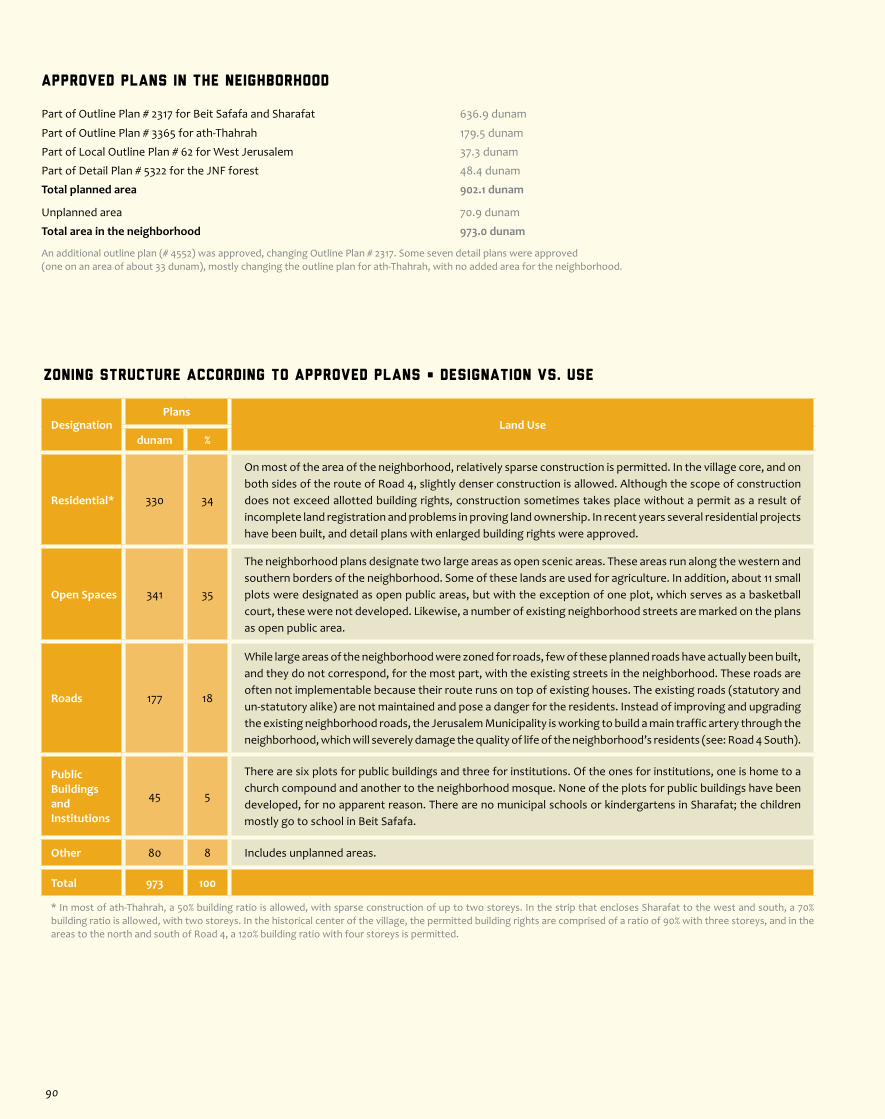
Zoning Structure According to Approved Plans • Designation vs. Use
DesignationPlans
Land Usedunam %
Residential* 330 34
On most of the area of the neighborhood, relatively sparse construction is permitted. In the village core, and on both sides of the route of Road 4, slightly denser construction is allowed. Although the scope of construction does not exceed allotted building rights, construction sometimes takes place without a permit as a result of incomplete land registration and problems in proving land ownership. In recent years several residential projects have been built, and detail plans with enlarged building rights were approved.
Open Spaces 341 35
The neighborhood plans designate two large areas as open scenic areas. These areas run along the western and southern borders of the neighborhood. Some of these lands are used for agriculture. In addition, about 11 small plots were designated as open public areas, but with the exception of one plot, which serves as a basketball court, these were not developed. Likewise, a number of existing neighborhood streets are marked on the plans as open public area.
Roads 177 18
While large areas of the neighborhood were zoned for roads, few of these planned roads have actually been built, and they do not correspond, for the most part, with the existing streets in the neighborhood. These roads are often not implementable because their route runs on top of existing houses. The existing roads (statutory and un-statutory alike) are not maintained and pose a danger for the residents. Instead of improving and upgrading the existing neighborhood roads, the Jerusalem Municipality is working to build a main traffic artery through the neighborhood, which will severely damage the quality of life of the neighborhood’s residents (see: Road 4 South).
Public BuildingsandInstitutions
45 5
There are six plots for public buildings and three for institutions. Of the ones for institutions, one is home to a church compound and another to the neighborhood mosque. None of the plots for public buildings have been developed, for no apparent reason. There are no municipal schools or kindergartens in Sharafat; the children mostly go to school in Beit Safafa.
Other 80 8 Includes unplanned areas.
Total 973 100
* In most of ath-Thahrah, a 50% building ratio is allowed, with sparse construction of up to two storeys. In the strip that encloses Sharafat to the west and south, a 70% building ratio is allowed, with two storeys. In the historical center of the village, the permitted building rights are comprised of a ratio of 90% with three storeys, and in the areas to the north and south of Road 4, a 120% building ratio with four storeys is permitted.
Approved Plans in the Neighborhood
Part of Outline Plan # 2317 for Beit Safafa and Sharafat 636.9 dunam
Part of Outline Plan # 3365 for ath-Thahrah 179.5 dunam
Part of Local Outline Plan # 62 for West Jerusalem 37.3 dunam
Part of Detail Plan # 5322 for the JNF forest 48.4 dunam
Total planned area 902.1 dunam
Unplanned area 70.9 dunam
Total area in the neighborhood 973.0 dunam
An additional outline plan (# 4552) was approved, changing Outline Plan # 2317. Some seven detail plans were approved (one on an area of about 33 dunam), mostly changing the outline plan for ath-Thahrah, with no added area for the neighborhood.
90

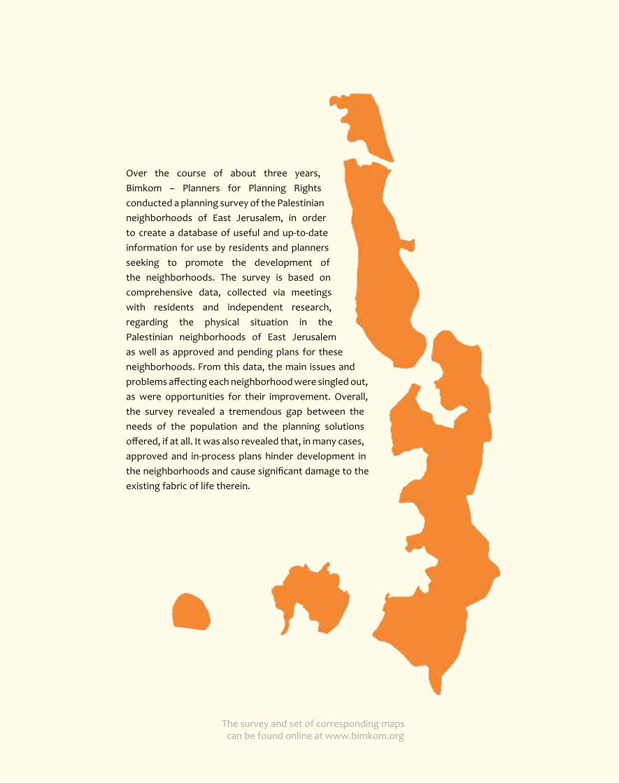
Over the course of about three years, Bimkom – Planners for Planning Rights conducted a planning survey of the Palestinian neighborhoods of East Jerusalem, in order to create a database of useful and up-to-date information for use by residents and planners seeking to promote the development of the neighborhoods. The survey is based on comprehensive data, collected via meetings with residents and independent research, regarding the physical situation in the Palestinian neighborhoods of East Jerusalem as well as approved and pending plans for these neighborhoods. From this data, the main issues and problems affecting each neighborhood were singled out, as were opportunities for their improvement. Overall, the survey revealed a tremendous gap between the needs of the population and the planning solutions offered, if at all. It was also revealed that, in many cases, approved and in-process plans hinder development in the neighborhoods and cause significant damage to the existing fabric of life therein.
The survey and set of corresponding maps can be found online at www.bimkom.org