survey of the shoreline · saint paul district-(contract no. dacw37-81-m-2669) ~~.' by guy...
TRANSCRIPT

e, CULTURAL RESOURCES RECONNAISSANCE SURVEY OF THE SHORELINE
.. ""OF BIG SANDY RESERVOIR, AITKIN COUNTY, MINNESOTA: 1982 2*B
Submitted to: -
The U.S. Army Corps of Engineers
Saint Paul District
-(Contract No. DACW37-81-M-2669)
~~.'
by
Guy Gibbon _"
Principal Investigator
and
, Terri Leistman
Field Director WI r. ..-
4-. \:APR 2 2~84
The University of Minnesota
" Minneapolis, Minnesota
00. * (F 'S¢ ' February 15, 1984 This documnent has been ,e'." f public zelease and sale; its
,., t~ibution is unlimited.'--- "----"-
S EC FILE COPY 84 03 28 085'6;. _.. .

CULTURAL RESOURCES RECONNAISSANCE SURVEY OF THE SHORELINE
OF BIG SANDY RESERVOIR, AITKIN COUNTY, MINNESOTA: 1982
Submitted to:
The U.S. Army Corps of Engineers
Saint Paul District
(Contract No. DACW37-81-M-2669)
by
Guy Gibbon
Principal Investigator
and
Terri Leistman
Field Director
The University of Minnesota
Minneapolis, Minnesota
February 15, 1984
This docuIIm as anb9,e;U '
distfibutiOn 's

J., .7, . .7 .7. : - .,,, , , . 7 - "-. .V 7... . 777. 7.%7 - . . . .-,7,77-..7
UNCLASSIFIEDSECURITY CLASSIFICATION OF THIS PAGE (hen Data Entered)
REPORT DOCUMENTATION PAGE BEFORE COMPLETNG FORM
1. REPORT NUMBER 2. GOVT ACCESSION NO. 3. RECIPIENT'S CATALOG NUMBER
4. TITLE (dSubtitle) 5. TYPE OF REPORT & PERIOD COVERED
CULTURAL RESOURCES RECONNAISSANCE SURVEY OF THE...- SHORELINE OF BIG SANDY RESERVOIR, AITKIN
COUNTY, MINNESOTA: 1982. S. PERFORMING ORG. REPORT NUMBER
7. AUTHOR(&) S. CONTRACT OR GRANT NUMBER(a)
Guy Gibbon, Principal InvestigatorTerri Leistman, Field Director DACW37-81-M-2669
9. PERFORMING ORGANIZATION NAME AND ADDRESS 10. PROGRAM ELEMENT. PROJECT, TASKThe University of Minnesota AREA & WORK UNIT NUMBERS
Minneapolis, Minnesota 55455
11. CONTROLLING OFFICE NAME AND ADDRESS 12. REPORT DATE
U.S. Army Engineer District, St. Paul February, 19841135 USPO & Custom House 13. NUMBER OF PAGESSt. Paul, Minnesota 108 p.
14. MONITORING AGENCY NAME & ADDRESS(If different frorm Con:rolling Office) IS. SECURITY CLASS. (of thie report)
1Sa. DECL ASSI FICATION/DOWNGRADINGSCHEDULE
1. DISTRIBUTION STATEMENT (of tle Report)
Approved for public release; distribution unlimited.
i 17. DISTRIBUTION STATEMENT (of the abetract entered In Block 20, If different from Report)
IIII. SUPPLWMENTARY NOTES
Lake map folded inside back cover.
I. KEY WORDS (Continue on reveree eide if neceeary end Identify by block number)
ARCHAEOLOGYRESERVOIRSMINNESOTAPRESERVATION
21L AUrlRACr m(iAe - r,,eree N nmemy and Identify by block number)
--Arhe 1982 archaeological reconnaissance survey of the shoreline of the BigSandy Lake Reservoir is in many ways a companion to an extensive survey
% completed in 1977-78 by G. Joseph Hudak and Timothy L. Ready. The 1982 surveywas able to examine previously unsurveyed areas of Big Sandy Lake, as well asshorelines of Aitkin and Flowage lakes, a d part of the shoreline of BigSandy River Lake. Fifteen sites or "flnd sports were located. Only one isthreatened by extensive erosion. An additional 22 sites previously reportedwere also examined . One of these sites is subjected to heavy- erosion and
t JA, uJ EDfTIO* OF I NOV 65 IS OBSOLETE
- -. 8 4 ~ 28 TY CLASSIFICATION OF THIS PAI;E (Whten Date Entered)-84 03 28 WIN"

UNCLASSIFIED
SECURITY CLASSIFICATION OF THIS PAGE(When Data Entered)
-should be conserved.
Recommendations are made concerning potential public-use development of the
sites and find spots. The conclusions of this survey support and add to the
conclusions drawn in the Hudak-Ready survey. The most important of these
are: l.A large number of archaeological sites representing a long time span
occur or at least once occurred within the reservoir area; 2. The
construction of the Big Sandy Lake Reservoir dam has significantly damaged the
archaeological resources within the reservoir area; 3. Every effort should be
made to protect or investigate the few remaining sites along the shorelineand preserve their primary context.
(\
UNCLASSIFIEDSErCUITY CLASSIFICATION OF THIS PAGE("Wen Dae E.ntered)
-S.
.S..SI. , ,". .'r" ,, ... .,:.. ... '.". . . . ...... • . .- . . . .... . . . . . . •.. .. . . . . . . . . . . _

1. ABSTRACT
The 1982 archaeological reconnaissance survey of the".
shoreline of the Big Sandy Lake Reservoir is in manyways a companion to an equally extensive survey com-pleted in 1977-78 by G. Joseph Hudak and Timothy L.Ready (1978). Because of unusually wet weather, someareas of the reservoir were not examined during thisearlier survey. It is many of these unexamined areasthat were surveyed in 1982. The 1982 survey was ableto examine all remaining unsurveyed areas of BigSandy Lake, as well as the shorelines of Aitkin andFlowage lakes, and part of the shoreline of BigSandy River Lake. Fifteen new sites or "find" spotswere located during the survey. Only one (21 AK 50)of these sites or find spots is threatened by ex-tensive erosion; it is recommended that this site beevaluated as soon as possible. An additional twenty-two sites or find spots either previously reportedby archaeologists or reported by local landownersand other interested individuals were also examined.One of these sites (21 AK 29), reported by Hudak andReady, is being subjected to heavy erosion andshould be conserved. Recommendations are made con-cerning the potential public-use development of thesites and find spots examined during the 1982 sur-vey, and their potential eligibility for nominationto the National Register of Historic Places. None of .W1these sites or find spots are recommended for nomina-tion to the National Register of Historic Places.The conclusions of this reconnaissance survey supportand add to the conclusions drawn in the Hudak-Readysurvey. The most important of these conclusions are:1) A very large number of archaeological sites repre-senting a long time span occur or at least once oc-curred within the reservoir area; 2) The constructionof the Big Sandy Lake Reservoir dam has significantlydamaged the archaeological resources within the re-servoir area; 3) Every effort should be made to pro-tect or investigate the few remaining sites along theshoreline that retain their primary context. Thosesites or find spots whose significance could not bedetermined during the 1982 survey should be evaluatedas soon as possible.._.___
.7-.z
. . . . . ... .II a'

Id
.0
2. MANAGEMENT SUMMARY
2.1 The cultural resources reconnaissance survey of the shoreline ofBig Sandy Reservoir in Aitkin County, Minnesota, reported in this studywas done in partial fulfillment of the obligations of the St. Paul Dis-trict regarding cultural resources, their location, and preservation.The pertinent Federal laws are listed in Chapter 5 (Theoretical andMethodological Overview) and in section 1.02 of Appendix A. The Con-tractor was Dr. Guy E. Gibbon, Associate Professor of Anthropology atthe University of Minnesota, Minneapolis.
2.2 This cultural resources investigation involved a Phase one culturalresources survey of-those lands along-the shoreline of Big Sandy, in-cluding all islands, not previously surveyed (as shown on Map 2 attachedto the backcover of this report). If time and funds allowed, a Phase onecultural resources survey was also to be conducted along the shorelineof Aitkln Lake (approximately 13 miles). The area to be surveyed was toinclude all lands within 50 meters of the water's edge and all islandsin their entirety. Nineteen additional sites or unverified find spotswere to be field checked and evaluated. The precise survey specifica-tions, and the location of specific sites and unverified find spots thatwere to be checked, are contained in section 4 of Appendix A. A Phaseone cultural resources survey is defined as an intensive, on-the-groundsurvey and testing of an area in order to determine the number and ex-tent of the archaeological, historic, and architectural resources pre-sent and their relationship to all the project alternatives and fea- 4;tures. A more extensive definition of a Phase one survey is containedin section 3.05 of Appendix A. A literature and records search and re-view, and Phase two testing, were not required in this study. The entirebudget for this study was $5000; funding for the study was managed bythe University of Minnesota. The conplete Scope of Work for this study qis reproduced in Appendix A.
2.3 The 1982 cultural resources reconnaissance survey of the shorelineof Big Sandy Reservoir was conducted by Terri Liestman (field director),Susan McCanna, Gary Staupe, and Eugene Willms between June 12 and July4, 1982. The crew, which traveled as a team in a boat, began the surveyby examining those areas of Big Sandy Lake not examined in previous sur-veys; they then examined as much shoreline along other lakes in the re-servoir system as time and finances permitted. The laboratory analysisof recovered materials was conducted by Terri Liestman in the WilfordLaboratory of Archaeology at the University of Minnesota in Septemberand October of 1982. Since a literature and records search and reviewwas not required, none was conducted. The results of the survey and therecommendations that resulted from it are reviewed in section 2.5 and2.7 below. Chapters 5 (Theoretical and Methodological Overview) and 6(Field Methods) contain a more extensive discussion of the theoreticaland methodological framework of the study, and of the field methods em-ployed.
iil-
...................................................... a .-

2.4 The 1982 cultural resources reconnaissance survey of the shorelineof Big Sandy Reservoir experienced two limitations. The first was therelatively high waterlevel of the reservoir during the months of Juneand July in 1982. Many potential site areas around the shoreline hadbeen inundated following the construction of the Big Sandy Reservoirdam. In some instances the extent of inundation was startlingly large.For example, only one-quarter of Battle Island is now above water.Many potential site areas were not, then, accessible to the surveycrew. The second limitation was the absence of landowners - which iscommon in summer resort areas. Since we could not obtain permission toshovel-test in these areas, a visual inspection of exposed land sur-faces had to suffice. These areas are mentioned in Chapter 7 (SiteDescriptions, Evaluations, and Recommendations). Over 97% of the areasurveyed was, however, shovel-tested.In general, the weather duringthe survey was very good. As a result, a much more extensive area wassurveyed than anticipated. The extent of this area is mentioned in sec-tion 2.5 below and is indicated on Map 2 on the backcover of this re-port.,
2.5 The 1982 cultural resources reconnaissance survey of the shorelineof Big Sandy Reservoir completed the investigation of all requiredareas in Big Sandy Lake, and surveyed substantial areas of Aitkin,Sandy River, and Flowage lakes; these areas are indicated on Map 2 at-tached to the backcover of this report. In nearly all cases, those areasnot surveyed around these latter lakes were very marshy and difficultto approach by boat. A total of 15 new sites or find-spots were locatedduring the 1982 reconnaissance of the Big Sandy Reservoir shoreline.These sites or find-spots are extensively described and evaluated inChapter 7 (Site Descriptions, Evaluations, and Recommendations).
2.6 Of the many conclusions drawn in this study, four have particularsignificance. First, the most dense concentration of archaeologicalsites seems to occur around the shoreline of Big Sandy Lake. This state-ment is qualified, because many potential site areas have been inundatedby reservoir waters. Second, archaeological sites within the reservoirsystem seem small in size and in general lack extensive faunal andfloral remains as well as cultural features and obvious stratigraphicseparation between components. In general, a Phase one survey is notsufficient to identify the function of a site, except where culturalfeatures such as ricing-jigs are present. Third, many archaeologicaland some historic sites have been inundated by the raised water-levelof the reservoir system. This event has apparently destroyed many ofthese sites and resulted in the creation of "secondary" deposits ofcultural material on the present shoreline through wave action. Bytheir very nature, these secondary sites lack primary context andsignificant stratigraphic information. Fourth, the general conclusions ,.'.of this study support those conclusions reached by Hudak and Ready intheir 1978 reconnaissance survey of a portion of the shoreline of Big -a.Sandy Lake (Hudak and Ready 1978)..'
iv
" ' , ' % -; ; -'- - ; % % , , .' -, ,'. ,' ',. -. , .- - '-' ',
2.7 A number of recommendations are made in this study. First, although-most cultural resources surveys are conducted during the summer monthswhen trained personnel are most readily available, the most efficienttime to conduct a reconnaissance survey of reservoir areas where thewater-level has been significantly raised (such as the Big Sandy Re-servoir system) is during spring and fall months when the water-levelis at its lowest and survey remains possible (e.g., ice does not coverthe shoreline). While these are the months of maximal site exposure,on the negative side these are also periods when land-owners are dif-ficult to locate in summer resort areas. Second, of the 15 new sites orfind-spots located during the survey, no immediate action is recommend-ed for 14 of them (field numbers 41 - 50 and 52-55); one of these sites(field number 51) is threatened with destruction and shovel-testingshould be performed when possible to determine whether a Phase two sur-vey is necessary. Although no immediate action is recommended for 14 ofthe 15 sites located, a number of them should be shovel-tested or check-ed again for newly redeposited materials when possible (these includefield numbers 41 - 43 and 43 - 49). Third, an effort should be made todetermine whether 21 AK 28 does consist of burial mounds that shouldbe protected from further erosion. Of a reported 32 mounds, only 4 werelocated by the survey crew; either the remaining mounds have eroded offthe present shore or are now so worndown that they are no longer visi- z '.ble from the surface. It is impossible to determine whether these moundsare cultural features without excavation or the use of subsurface detec-tion devices such as ground penetrating radar. We should assume theyare burial mounds and protect them from further erosion until a moreprecise determination can be made. Fourth, two historic sites (fieldnumbers 4 and 29) reported by the Hudak-Ready survey should be consid-ered for potential nomination to the National Register of HistoricPlaces. The first is a Northwest Company fur post that is threatenedby erosion along its eastern edge (other structures associated withthis site have already been inundated by reservoir waters). The secondis 21 AK 29, an historic, protohistoric, and possibly prehistoricburial ground on BIA land. Sufficient information now exists on thesetwo sites, that Phase two surveys are probably not necessary to makea determination regarding their candidacy for nomination to theNational Register. Fifth, although specific details are not given here,it is recommended that a number of the "unverified find spots" be re-investigated when possible (unverified find spot numbers 4, 13, 15, and18 as listed in Chapter 7). More detailed evaluations and recommenda-tions for each site, find-spot, or unverified find-spot are containedin Chapter 7 (Site Descriptions, Evaluations, and Recommendations).
2.8 All collected cultural materials recovered during the survey arenow housed in the Wilford Laboratory of Archaeology at the Universityof Minnesota; notes, photographs, and field maps are housed in the of-fices of the St. Paul District of the U.S. Corps of Engineers.
,-.
v
'C"-"-

-,,-.o.--
TABLE OF CONTENTS
1. ABSTRACT ...................... ...................... :2. MANAGEMENT SUMMIlARY ................................ iii
3. ITRODUCTION ......................................... 1
4. BACKGROUND. ......................................... 4A. ENVIRONMENTAL SETTING ........................... 4
B. CULTURE HISTORY .................................. 7
C. PREVIOUS INVESTIGATIONS .......................... 12
5. THEORETICAL AND METHODOLOGICAL OVERVIEW ................ 16
6. FIELD METHODS ........................................ 18
7. SITE DESCRIPTIONS, EVALUATIONS AND RECOMMENDATIONS 20
1. Field Number 41 21 AK FS3 21
2. Field Number 42 21 AK FS4 24
3. Field Number 43 21 AK FS5 284. Field Number 44 21 AK 43 32-
5. Field Number 45 21 AK 44 36
6. Field Number 46 21 AK 45 40
7. Field Number 47 21 AK 46 44
8. Field Number 48 21 AK 47 48
9. Field Number 49 21 AK 48 52
10. Field Number 50 21 AK 49 56
vi

11. Field Number 51 .21 AK 50 60 "
12. Field Number 52 .21 AK 51 64
13. Field Number 53 .21 AK FS6 68
14. Field Number 54 21 AK FS7 72 Z.
15. Field Number 55 21 AK FS8 76
16. Evaluation of 21 AK 25, 28, and 29 80
17. Evaluation of Unverified Find-Spots 80
8. CONCLUSIONS ........................................ 84
REFERENCES CITED ................................... 88
APPENDIX A : SCOPE OF WORK ........................ 92
APPENDIX B : VITA OF PRINCIPAL INVESTIGATOR ...... 106
ILLUSTRATIONS:
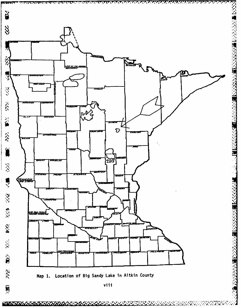
Map I : Location of Big Sandy Lake in Aitkin County viii
Map 2 : Location of Surveyed Sites and Survey Area
(inside backcover)
Sv i
* -S
S
17 - t. - -Ztt 4
%I4
6''
jrjMa .LoainofBgSnd ae nAtinCut
Svii

3. INTRODUCTION
The cultural resources reconnaissance survey of the shoreline ofBig Sandy Reservoir reported here is in many ways a companion to anequally extensive survey conducted by G. Joseph Hudak and Timothy L.Ready in 1977-78 (Hudak and Ready 1978). Because of unusually wetweather, the Hudak-Ready survey was unable to examine all of the shore-line of the reservoir. It is most of this unexamined area that wassurveyed by a four-person University of Minnesota crew between June 12and July 4, 1982. Terri Liestman, a graduate student at the Universityof Minnesota, served as field director; the senior author of this re-port served as Principal Investigator. Terri Liestman also curated andanalyzed all recovered cultural materials in late October and in Sep-tember of 1982 in the Wilford Laboratory of Archaeology at the Univer-sity of Minnesota. Both the Hudak-Ready survey and this study weresponsored by the St. Paul District of the U.S. Army Corps of Engineersin partial fulfillment of the obligations of the St. Paul District re-garding cultural resources as detailed in a number of Federal docu-ments (see section 1.02 of Appendix A).
Big Sandy Reservoir is located about 120 miles north of the TwinCities in Aitkin County, Minnesota (Map 1). The eight natural lakesencompassed in this drainage area include Sandy, Aitkin, Sandy River, ..- ,Rat, Flowage, Round, Davis, and Tiesen lakes. Construction of theSandy Lake Dam, located on the Sandy River 1-1/4 miles above the junc-tion of the Sandy and Mississippi rivers, has raised the water-levelof the lake system approximately 9 feet. This event has increased thesize of the lake area from only 8 square miles to 16.6 square miles.The forest vegetation surrounding Big Sandy Lake is principally de-ciduous. Elm-ash with some aspen and oak is found at lower elevationsassociated with marsh habitats. Maple-basswood intermixed with aspenand oak is predominant. There are almost no pure pine stands, althoughthere are some pine-mixed hardwood communities on the east and south-east shore of Big Sandy. Aitkin County, in which Sandy Lake is located,is predominantly till plain with a large outwash area immed.iately tothe northeast characterized by surface deposits of sand and gravel. Thesoil of the till plain area is brownish and slightly acidic, with peb-bles and boulders of granite and gneiss. The shoreline is highly ir-regular with moderate on and off-grades such that a 1-foot verticalchange in the water level can alter the shoreline 5 to 20 feet hori-zontally. There are some exceptionally flat areas, but the lake edgeis almost totally uniform in the 5 to 19 percent slope range. Cultu-rally, the Big Sandy Reservoir is within an extensive "North Woods"habitat that has partially constrained and channeled the adaptationsof both its prehistoric and historic occupants. Chapter 4 (Background)reviews the environmental setting and culture history of the surveyarea. ...
Since the Hudak-Ready survey was the first large scale surveyin the reservoir area, most of the locally known sites and much of the
.pr.
..',

more accessible shoreline were visited. This pattern of investigationdetermined to a large extent the nature of the 1982 survey. The shore-line investigated by the 1982 survey crew was largely marshland thatwas difficult to penetrate and low in expected site potential. Thisdifference in the nature of the areas surveyed in 1977-78 and 1982largely explains the differences in numbers of sites located in thetwo surveys. Map 2 attached to the inside of the backcover indicatesthe extent of the Hudak-Ready survey and the shoreline areas investi-gated in 1982. Sections 4.01 - 4.07 in Appendix A detail the surveyspecifications; Appendix A itself is a copy of the Scope of Work for
*i this study. In brief the 1982 survey examined all lands within 50 metersof the water's edge and all islands in their entirety not previouslyinvestigated in Big Sandy Lake, and substantial shoreline areas ofAitkin, Sandy River, and Flowage lakes. Standard shovel-testing andvisual search procedures w-re used in the ground investigation. In orderto insure comparability of results, the survey procedures adopted by
-the Hudak-Ready survey were followed as closely as possible (see Hudakand Ready 1978:26-30). A discussion of the theoretical and methodologi-cal overview, and the field methods, employed during this study are con-tained in chapters 5 and 6.
The cultural resources reconnaissance survey of the shoreline ofBig Sandy Reservoir reported here is a "Phase one cultural resourcessurvey." A "Phase one cultural resources survey" is defined as an inten-sive, on-the-ground survey and testing of an area in order to determinethe number and extent of the archaeological, historic, and architec-tural resources present and their relationship to all the project al-ternatives and features. The purpose of a Phase one survey is to obtaindata adequate to assess the general nature of all sites present; to re-commend additional testing of those resources which, in the professionalopinion of the Contractor, may provide important cultural and scienti-fic information; and to provide detailed time and cost estimates forPhase two testing. A literature and records search and review, and Phasetwo testing, were not required in this study. Detailed definitions ofthese terms can be found in section 3 of Appendix A. All culturalmaterials recovered during this survey are presently stored in the Wil-ford Laboratory of Archaeology at the University of Minnesota; fieldnotes, maps, and photographs are presently stored in offices of the St.Paul District of the U.S. Anny Corps of Engineers.
Z.1 This study report proceeds in the following manner. Chapter 4 (Back-ground) reviews the environmental setting and culture history of the sur-vey area, and previous investigations. Although tentative in its nature,the reconstructed culture history of the region within which the studyarea is situated is meant to be suggestive in deciphering site function.Chapter 5 contains an overview of the theoretical and methodologicalframeworks that guided the study. Chapter 6 is a discussion of fieldmethods. Site descriptions, evaluations, and recommendations are con-tained in Chapter 7. This chapter contains those sections of a reportgenerally labeled ?Analysis," "Investigation Results," "Evaluation and
2

Conclusions," and "Recommendations." Chapter 8 reviews the major con-clusions and recommendations of the study. Cited references followChapter 8, and the Scope of Work and the vita of the Principal Inves-tigator are included in appendices A and B.
The major goals of this study are (1) to recover data adequateto assess the nature of all sites present in surveyed areas, (2) torecommend additional testing of those resources which, in the profes-sional opinion of the Contractor, may provide important cultural andscientific information, and (3) to detail time and cost estimates forPhase two testing. In addition this study attempts to assess thesignificance of the information recovered to the reconstruction ofthe culture history of the region and to the successful management ofthe cultural resources of the reservoir area by the U.S. Army Corpsof Engineers.
i %
. 5
I.
7
IP w
3 .'%

(. 4. BACKGROUND
Archaeological surveys are conducted within a framework ofexpectations. These expectations are based upon the environmentalsetting of the survey area, the culture history of the region
.. within which it is situated, and the knowledge gained from pre-vious archaeological investigations. These three sources of infor-mation are reviewed below.
9A. Environmental Setting
'Big Sandy Lake is what geologists call an ice-block lake.Lakes of this type are formed when one or more extremely largeblocks of ice which are trapped within a moraine complex meltand form a lake basin. Big Sandy Lake and its surrounding tillplains, terminal moraines, proglacial lakes, outwash deposits,and other glacial features are products of the multiple glacia-tions of the Superior lobe ice mass, especially the ice massof the last or Wisconsin glacial period. Successive glacialsurges approached the area of the present lake from the eastand northeast, which accounts for the orientation of most butnot all of the existing glacial remnants and for the presenceof red Superior lobe till in the sub-soil. The eastern terminusof the St. Louis sublobe of the Des Moines lobe also reachedthe Big Sandy Lake area and deposited a thin layer of calca-reous western yellow till over the Superior red till. The bed-a rock beneath these glacial remnants is a formation of patchycretaceous sandstone and clay which extends from the Big SandyLake area across the north-central section of the state of
' Minnesota to the North Dakota border. An argillite bedrock for-mation lies immediately to the south and east of the Big SandyLake area (Wright 1972). Big Sandy Lake itself probably formedabout 12,000 B.P. with the retreat of the final Wisconsin icemass and the melting of the remaining ice blocks. A succinctand informative review of the glacial history of Minnesota canbe found in Ojakangas and Matsch (1982).
Today, the Big Sandy Lake Reservoir is situated in a"* modern Mixed Coniferous-Hardwood vegetation zone. This zone is
composed of Boreal forest vegetation penetrating southward anddeciduous forest vegetation gradually fading in numerical im-portance to the north. The transitional nature of this zone isreflected in the composition of its dominant tree species: oak,maple, basswood, elm, and ash from the Deciduous forest, andwhite pine, red pine, jack pine, fir, and spruce from theBoreal forest.
The vegetative cover of the land surrounding the Big -"
Sandy Lake Reservoir area has changed dramatically in both theprehistoric and historic periods. Pollen profiles from the Ross-burg Bog, Kotiranta Lake, and Jacobson Lake document these drama-tic changes (see Wright and Watts 1969, and Birks 1976 and 1981,
)44
;'a.'4

IJFV P- - .-0 .I.
for summary). The paleo-environmental vegetative sequence that has beenreconstructed from these profiles is outlined below. These changingpaleo-environmental periods provided different habitats to which theprehistoric inhabitants of the reservoir area adapted. Spruce parkland,Jack Pine forests, oak savannas, and pine forests are habitats thatpresent different subsistence-settlement opportunities for the state'searly inhabitants. Understanding these changes is a necessary task inunraveling the processes that promoted sociocultural change and stabil-ity during this period.
Years Ago (B.P.) Dominant Vegetation Climate
1. c.1000-3000 Pine forest: white pine with cooler anda red and jack pine, birch, moisterand alder mixture (resembles the
presentclimate)
2. c.3500-7700 Oak savanna: oak with grasses warmer andan.d sage in forest openings. -drier; theSome patches of xeric decid- Thermal Maxi-uous forest with birch, alder, mum occurselm, and ironwood in small c.7000 B.P.numbers.
3. c.7700-10,000 Jack Pine forest: jack pine warming climatewith birch, alder, elm, and and extinctionoak. of Pleistocene
megafauna
4. c.10,000-12,000 Spruce parkland: spruce with cool-moist;birch, oak, elm, aspen, and Pleistocenesagebrush in park-like megafauna areopenings. present.
(The gradual retreat of the ice mass begins c.13,000 B.P.,
and Big Sandy Lake forms as remnant ice blocks melt c.12,000B.P.)
The present vegetation of the Big Sandy Lake Reservoir area was
5
'U.s "A#... . . .. . . . . . ..- . , , , ., . . . . : . =
- a%, %7, L.5
extensively documented during an environmental review of the sixheadwaters reservoirs in the state a decade ago (Center for Environ-mental Studies 1973). A number of factors have changed the compositionof the natural pine forest climax vegetation that was present in the - -
Big Sandy Lake Reservoir area in the early historic period. These in-.6 clude the supression of fires, logging, the construction of the reser-
voir, and lakeshore development. The supression of forest fires thatfollowed white settlement in the area eventually produced a climaxvegetation called a maple-basswood association; under normal condi-tions a natural pine-forest climax would develop following an exten-sive fire, since pine is better adapted to ground fires than shadetolerant trees such as basswood, fir, or maple. Logging had its mostdramatic impact in the reservoir area along the eastern and south-eastern sections of the shoreline; a secondary forest dominated bybirch and aspen gradually developed in these areas as a natural suc-cession leading to the maple-basswood climax.
The rise in the level of the water table of the Big Sandy Lakesystem that followed the construction of the dam that formed the re-servoir inundated extensive areas of low lying land (see Map 2 attachedto the backcover); although this event drastically disrupted archaeo-logical sites, its effect on plant communities was less drastic, re-sulting mainly in the shift in location of some plant communities.Lakeshore development in recent years is increasingly altering the vege-
(V tation that borders the lake system; wooded areas are being cleared, %new tree species are being introduced, and grassy lawns are beingplanted. An extensive review of the modern vegetation around the shoresof the lake system is contained in the 1973 report by the Center forEnvironmental Studries. The reader should also be aware that the actualcomposition of the vegetation in any one area of the lake system isclosely tied to local topographical conditions and the distance of itssurface vegetation from the water table.
No background discussion of the environmental setting of presentday archaeological sites within the Big Sandy Lake Reservoir would becomplete without a description of the effects on these sites of the con- -.'struction of the reservoir itself. Nearly all archaeological sites inthe "North Woods" of Minnesota are situated adjacent to large bodiesof water. The construction of the Big Sandy Lake Reservoir dam nearthe turn of the century raised the water of the reservoir lakes some7 - 13 feet. The map attached to the backcover shows both the presentand the past shoreline of the lake system before the construction ofthe dam. As this report will argue in the concluding chapter, the greatmajority of archaeological sites once situated around the edges of thelake system before the construction of the dam have been destroyed orextensively eroded. Wave action and the current of the Sandy andPrairie rivers continue to severely erode many of the remaining sitestoday. These destructive events must be taken into consideration inreconstructing the changing settlement patterns in the area.
A concise and informative introduction to the plant communitiesand wildlife of the "North Woods" of Minnesota can be found inDaniel and Sullivan (1981).
'S
6
.I

._ -- -. t t, : .. r w. . i, a-- r.. . .. .,.
J...
B. THE CULTURE HISTORY OF THE BIG SANDY LAKE AREA
Today, archaeologists have a sufficient understanding of the cul-ture history of the Headwaters region in Minnesota and the broaderWestern Great Lakes area to construct a sequence of expected culturalperiods for the Big Sandy Lake area (e.g., Hudak and Ready 1978;Johnson 1976). These periods provide a network of expectations againstwhich the materials and sites discovered during a survey can be corn- _
pared. A brief description of the seven major periods that have been de-fined for this region from earliest to most recent is given below. Theemphasis in these descriptions Is upon diagnostic features or artifactssuch as ceramics or projectile points that aid the survey archaeologistin assigning sites to periods and/or archaeological complexes. Broadertrends throughout the prehistoric period are also discussed, althoughsurvey data are generally inadequate to verify all of the details ofthese trends.
1. Terminal Glacial - Early Prehistoric Period (11,000-200 B.C.)
The earliest period of human occupation in the Headwaters regionis the longest but also the poorest known of the seven periods in theregion. Remains of "Big Game" hunters that roamed areas to the west andsouth of the Headwaters region seem absent in the region or at leastvery elusive during this cool-moist period when spruce parkland coveredmuch of the region. A few prismatic blades found along the Rainy Riverin the far north of the state do suggest, however, that small numbers "-of early hunters may have lived in this terminal glacial environment, V_too (Stoltman 1871).
The succeeding "Early Archaic" phase coincided with the appear-ance of increasingly warmer and drier climatic conditions. This phaseis still poorly known, too, although it is archaeologically more visi-ble in the form of scattered projectile points than the preceding "BigGame" hunting phase. Possible "Early Archaic" settlement-subsistencepatterns have been constructed for the Lake Itasca area by Shay (1971),and a distinctive Llano complex has been described for the Duluth.Reservoir system and other areas to the north by Steinbring and Whelan(1971). The "Early Archaic" phase probably dates to 9,000 - 7,000 B.P.in the Headwaters region.
"Late Archaic" archaeological remains began to be deposited afterthe Thermal Maximum of c.7,O00 B.P. Remains of this phase are moreabundant in the Headwaters region than artifacts or sites from earlierphases. Complexes of this phase in the Headwaters region include theFish Lake Dam Archaic and the White Oak Point complexes. Perhaps themost recognizable artifacts of these "Late Archaic" occupations aremade of copper. Distinctive copper tools associated with this phase havebeen found at the White Oak Point site (Wilford 1955; Lugenbeal 1977),the Petaga Point site (Bleed 1969), along the Rainy Lake shoreline(Steinbring 1975), and within the basin of glacial Lake Agassiz (John-son 1964). A few scattered copper tools have also been reported fromthe Big Sandy Lake area. Other diagnostic artifacts associated with
7
7
o. . *.. .

"Late Archaic" complexes include large stemmed and notched projectilepoints.
2. Middle Prehistoric Period (200 B.C. - A.D. 800)
:Z, Ceramics and earthern burial mounds first appear in the Headwaters
region during the Middle Prehistoric period. The Big Sandy Lake area issituated between the homeland of the Laurel Tradition to the north(Stoltman 1973; Lugenbeal 1976) and the Malmo/Kern complex to the south(Wilford 1953). A small amount of Laurel pottery has been found aroundlakes Winnibigoshish and Leech in the Headwaters region. Laurel cera-mics probably occur in equally small amounts in other areas of theregion, for small amounts of this ware have been found as far south asthe Anderson site (AN8) in Anoka County and the Calhoun Lake site (KH1)in Kandiyohi County (Anfinson 1979a:126). A small amount of Malmo/Kernpottery should also be expected in this region. Both Laurel and Malmo/Kern are associated with circular earthern mounds with secondaryburials in shallow pits, charred log layers or cribs, and straight-stemmed, side-notched, and corner-notched projectile points. A briefdescription of Laurel ceramics can be found in Anderson (1979) and ofMalmo/Kern ceramics in Caine (1979).
The most abundant Middle Prehistoric period ceramics in the BigSandy Lake area should be Brainerd Ware and the St. Croix Stampedceramic series. These ceramic complexes should be especially commonduring the c.A.D. 500 - 800 period. Brainerd Ware is divided into twodistinctive types, Brainerd Net Impressed and Brainerd HorizontallyCorded (Birk 1979a). The ware is commonly associated with earthernburial mounds and possibly with side-notched projectile points. The St.Croix Stamped series contains distinctive dentate stamped and combstamped varieties (George 1979). St. Croix Stamped ceramics have also .5
been found associated with earthern burial mounds, and with smallside-notched and finely made isosceles triangular projectile points.
3. Late Prehistoric Period (A.D. 800 - 1640)The Late Prehistoric period in the Headwaters region is asso-
--.: ciated with at least Onamia, Kathio, Blackduck, Sandy Lake, and somelate simple and check stamped ceramics. Onamia ceramics occur duringthe transitional Middle-Late Prehistoric period of c.A.D. 800 - 1000in central Minnesota (Ready 1979a). These ceramics are probably tran-sitional too between earlier St. Croix Stamped and more recent Kathioceramics in this region. Onamia ceramics are characterized by dentateand cordwrapped-stick-impressed decoration. Projectile points asso-cated with these and the other ceramics of the Late Prehistoricperiod are primarily small side-notched forms and small triangularpoints. Kathio series ceramics (A.D. 800 - 1200) have short rims andfine cordwrapped-stick decoration (Ready 1979b).
The Late Prehistoric period in the Headwaters region is charac-terized by the intensified utilization of wild rice as a food staple.
"8,
8%°%.

The two major cultural complexes generally associated with intensifiedwild rice gathering in the region are Blackduck and Sandy Lake. Black-
*duck, the earliest of the complexes (c.A.D. 700 - 1200), is character-ized by a distinctive ceramic style, triangular projectile points,small end scrapers, tubular stone pipes, and unilaterally-barbed boneand antler projectile points (Wilford 1941). Blackduck burials areusually primary pit-burials in circular earthenmounds. Ricing jigs oc-cur at specialized ricing-activity sites. Compared with earlier region-al archaeological complexes for which we have artifactual documentation,Blackduck is very extensive, having been found in the prairies of west-ern Manitoba and eastward into Ontario and Wisconsin. Only early phaseBlackduck ceramics (c.A.D. 700 - 1200) apparently occur in the Head-waters region in any abundance. A succinct description of Blackduckceramics can be found in Lugenbeal (1979).
Blackduck complexes are succeeded by Sandy Lake complexes through-out most of the Headwaters region. Sandy Lake ceramics are easily dis-tinguished from Blackduck; besides a difference in decorative style,many Sandy Lake vessels are tempered with shell. Sandy Lake ware is as-sociated with what Douglas Birk (1977:31, 1979b) has called the WanikanCulture. Characteristics of the Wanikan Culture also include conicalburial mounds, small triangular projectile points, and ricing jigs orthreshing pits. Besides cordmarked and plain varieties, there appear tobe simple and check stamped varieties of Sandy Lake ware that may dateto the late Late Prehistoric period. Many of the artifact types commonon Blackduck sites also occur in Sandy Lake occupations. In fact,Sandy Lake components often occur at the same locations as Blackduckcomponents. It is generally thought that the Sandy Lake complex is aprehistoric manifestation of a number of branches of the Dakota In-dians, especially the Yanktonai Dakota and the Assiniboin (e.g.,Lothson 1971). Sandy Lake complexes probably span the A.D. 1000 - 1750time period.
r
A number of sociocultural and demographic trends seem to have oc-curred in the Headwaters region during the prehistoric time period.Since these trends have had an effect on what the survey archaeologistcan expect to find in the Big Sandy Lake area, they are briefly dis-cussed here. One trend has been a dramatic increase in the numbers ofpeople who have lived in the region through time. Since more peoplelived in the area during the Late Prehistoric period, we can anticipatefinding more Blackduck and Sandy Lake sites, for example, than MiddlePrehistoric period sites.
There may also have been trends in the subsistence-settlement basefrom a concentration on a few food resources (especially megafauna) atan early period, to a concentration on a diversity of food resources,and a return again to a concentration on a few food resources (especial-ly wild rice, fish, and deer) in the Late Prehistoric period. Sincethese were markedly different settlement-subsistence strategies, theyshould be reflected in the archaeological record in the distributionand content of archaeological sites. A useful but still tentative
Zoe. 7

°4..
framework for understanding these changes in the Headwaters region isto think in terms of a general shift from focal to diffuse to focaladaptations (Cleland 1977). Focal adaptations are highly specializedadaptive systems that are centered on one or a few similar reliableresources, while diffuse adaptations are based on the scheduled utili-zation of a great variety of resources. Although these are ideal types,actual adaptations can be easily classified into one or the other ofthese types. Each type, however, produces predictable patterns of re-source exploitation that are expressed in characteristic settlement-subsistence systems and tool inventories. In focal adaptations sitesize, permanence, and function tend to be consistent; site utilizationtends to be brief and intensive; the range of tasks at any one site islimited; and only a small number of tool kits is employed, althoughtool production may be prodigious. In diffuse adaptations there areusually a greater variety of tool kits, technological variability be-tween sites is greater, there is a greater variability in the size ofsites and in the intensity with which they were occupied, base campsor villages tend to be more common, and territorialism is promoted.Since territorialism increases intergroup variability within "terri-tories," exchange systems tend to appear across boundaries; these sys-tems lead to the rapid diffusion of materials and ideas.
The focal-diffuse distinction in adaptive pattern provides auseful classificatory system for ordering the prehistoric cultures ,that we anticipate finding in the Big Sandy Lake Reservoir area.Following Cleland (1977), four major patterns are proposed here. Thefirst is an Early Focal pattern. This pattern includes those Paleo-Indian, Early Archaic, and Plano cultures that were adapted to thehunting of big game. In searching for sites belonging to this pattern,we should anticipate finding small sites containing an occupationaldebris which indicates an intensive preoccupation with capturing game •and processing meat, hides, and bone; there should be a low degree ofvariability in site size and permanence, with sites providing evi-dence of an intensive occupation of a very limited duration. Toolkits should be limited in variety. This stable and successful focaladaptation was severely disrupted at the close of the Pleistocene bythe substantial ecological changes that occurred following the with-drawal of the ice masses from the area and the replacement of thespruce parkland by the ecologically expansive Jack Pine forest.
A new Early Diffuse pattern gradually replaced the Early Focalpattern as the first readaptive response to post-Pleistocene condi-tions. This pattern equates with the Middle Archaic phase in manyareas, and the expansion of Jack Pine forests into our study area. Asduring the earlier pattern, population density was still very low.However, we should anticipate finding an increased variability intool form and function, new materials being used to manufacture tools,a proliferation of new styles, and increased variability among sitesas multiple resources began to be exploited. A greater variabilityin site size, permanence, and function should reflect the complexi-ties of resource scheduling in time and space in this pattern. Weshould also anticipate the initial establishment of territories. Al-
10

-.
7,
though this is a diffuse adaptive pattern, fewer resources were probo-bly being exploited compared with the following pattern.
The succeeding Late Diffuse pattern witnessed the firm establish-ment of multiple resource scheduling and the continued specialization
I, of these diffuse adaptations. In the Big Sandy Lake area archaeologi-cal complexes belonging to the Late Archaic (e.g., Old Copper) and theMiddle Prehistoric period belong within this adaptive pattern. Thisnew phase of adaptation contains the first appearance of pottery andburial mounds, and an increased territorialism which promoted differ-ential production and exchange systems which moved resources acrossboundaries. The heightened demand for exchanged items and the regulari-zation of the exchange systems may have promoted systems of statuswhich are reflected archaeologically in the greater richness and diver-sity of burial ceremonialism which characterizes at least the latterphase of this time period. A greater variability in site function,site size, and differentiated artifact distributions at this time istypical of the complex multiple-resource base of these nonspecializeddiffuse economies. Wild rice probably became an increasingly importantfood throughout the Late Diffuse pattern.
Finally, the Late Focal pattern in our area evolved around thedevelopment of an intensive wild rice harvesting subsistence base. Wild
4. rice is a highly productive and storable grain capable of supporting-. a new focal adaptation. As mentioned above, people with Late Diffuse
adaptations were probably preadapted for this development, since therequisite technology and social patterns necessary for gathering, pro-cessing, and storing wild rice grains were most likely an importantelement of their adaptations. It is not clear at the present time whenthis subtle reorientation to a focal economy occurred in the Head-waters region. This transition has generally been set at c.A.D. 800,although intensive wild rice harvesting seems to be best documented in -\
"* our region for the Wanikan Culture. Until additional information be-comes available, we will equate a Late Focal pattern with Late Pre-historic archaeological complexes as briefly described earlier.
A significant increase in population was either a result or acause of these changes in adaptive equilibrium. Among the probablechanges that characterize the Late Focal pattern in the Headwatersregion are a decrease in technological and social variability, moreregular and even conventionalized patterns of settlement, a greaterproliferation of ceramic styles, a reduction in the size of territoriesand intergroup contacts and exchange, and an increased productivity ofthe new focal adaptation. Undoubtedly, specialized secondary resourcessuch as fish and deer were being expl-ced and were an important partof the subsistence round. However, available information is still notsufficient to identify these resources and to assess their importancewithin the seasonal round.
It should be stressed in concluding this section that the focal-diffuse model is a heuristic that we have found useful in interpretingthe prehistoric archaeological remains in the Big Sandy Lake Reservoirarea. The merits of the model remain to be tested by continued sitesurvey, as in this report, and by excavation.
! "'.11

a.. . . . . . .
V °J. %
4. Initial Historic Period (A.D. 1640 - 1750)
The Initial Historic period in the Headwaters region witnessedthe first incursions of the French fur-traders and Algonkin-speakingOjibwa Indians into the area. Although the evidence for this period isvery skimpy throughout the region, a new economic system revolvingaround the fur-trade was initiated; an eventual result of this processwas the replacement of many element of the native life-way by newsocial systems and by goods manufactured by the French.
5. Fur Trade Period (A.D. 1750 - 1800)
The florescence of the fur trade occurred during this period, andthe final displacement of the Dakota by the Ojibwa. The fur-trade wasdominated by the British throughout most of the period, and posts ofthe Hudson Bay, Northwest Company, and other firms were established.
6. Intensive Resource Use Period (A.D. 1800 - 1920)
This period saw major changes throughout the Headwaters region.Anglo-Americans entered the region to log-off the conifers. Dams wereconstructed and lake levels raised. Small farming homesteads were es-
.. tablished, and the native populations were gradually moved to reserva-tions. Villages, towns, and railways were also constructed.
7. Recent Period (A.D. 1920 to the present)
The occupation of the Big Sandy Lake area changed in characterafter 1920. Many homesteads were gradually abandoned due to the poorsoils and short growing season of the area, and logging ceased as amajor activity. The resulting economic void was rapidly filled by therecreation industry which focused upon summer fishing. Resorts andsummer residences remain the major economic force in the area today.
C. Previous Investigations
Investigations of the Big Sandy Lake Reservoir area by profes-sional archaeologists have been very limited. Until 1977, most of theavailable information for the area had resulted from occasional brief ._
surveys by Lloyd Wilford and Leland Cooper. However, extensive col-lections of artifactual material were made between c.1920 and 1960 bylocal residents and summer visitors. Among these collections are thoseof Mr. and Mrs. Eugene Grolla, Mr. and Mrs. William Russ, and Mr.Frank Zinc. Mr. Zinc also excavated a portion of a fur post (21 AK 4)on Brown's Point under the aegis of the Minnesota Historical Society.Most of the material recovered during this excavation is now on dis-play in the Big Sandy Lake dam facility museum or in storage at FortSnelling in the Archaeology Department. By 1977, six sites (21 AK 4,AK 6- 9, and AK 11) were listed in files of the State Archaeologist.
12

This list was composed of the fur-trading post, an historic Ojibwavillage site with an associated cemetery, and prehistoric earthenburial mounds. One of the major Late Prehistoric period ceramic typesin the Headwaters region, Sandy Lake ware, was defined in part on thebasis of a study by Elden Johnson and Leland Cooper (1964) of collec-
-A tions from the Miner's Point site (21 AK 18) near Big Sandy Lake.Professional archaeological activity in the Big Sandy Lake Reser-
voir area has increased in the 1970s and 1980s. An interdisciplinarystudy of the Headwaters region was conducted in 1973 by the Center forEnvironmental Studies at Bemidji State University. Archaeologists visit-ed Big Sandy Lake during this study, examining recorded sites and pri-vate collections. The results of this study are summarized in Environ-mental Review of the Headwaters of the Mississippi Reservoir Projects,a report submitted to the St. Paul District of the U.S. Army Corps ofEngineers in 1973. The first professional excavations in the reservoirarea were conducted by Charles Watrall for the Minnesota HistoricalSociety on Battle Island (21 AK 9) in 1969 (Watrall 1969). Watrallfound Sandy Lake sites and early historic Dakota sites on Battle Is-land and Brown's Point; the affinities of the latter sites seem to bewith the Dakota who lived at Kathio before 1730 (Woolworth 1969).Watrall also investigated the historic Ojibwa cemetery at the north endof Big Sandy Lake, and found evidence of historic Ojibwa camps onBrown's Point, on the north side of Sandy Lake, on the park road toShumway Lake, on the south-east corner of the junction of the SandyLake River and the Mississippi River, and one-half mile from the westend of the Savanna Portage. Several reports of the accidental discoveryof "Old Copper" projectile points around Big Sandy Lake were also re-corded by Watrall.
More extensive excavations were conducted in the summer of 1975by a University of Minnesota archaeological field school under thedirection of Professor Elden Johnson; five test units were excavated at21 AK 11, the Big Sandy Lake dam site.
The first modern large scale archaeological survey of the BigSandy Lake shoreline was conducted in 1977 by G. Joseph Hudak and TimReady of the Science Museum of Minnesota for the U.S. Army Corps ofEngineers (Hudak and Ready 1978). This was not the first reported sur-vey, however, for Jacob V. Brower had found mounds around Big SandyLake and along the Sandy River in 1894 (Brower 1898), and six prehis-toric habitation sites around 1900 (Brower 1901). These latter siteswere at the outlet and inlet of Big Sandy Lake; near the mouth of theWest Savanna River; at Section 16, Township 49, Range 23; at the westside of Davis Lake; and at the head of the Sandy River, south of Tama-rac. Some of the mound groups discovered by Brower were recorded on amap made by Evan Hart in 1964 (Hart 1964). Nonetheless, the Hudak andReady survey was the first to examine large sections of the shorelineusing modern survey techniques. Thirty-five archaeological sites weredocumented and evaluated during this survey which examined approxi-mately one-half of the modern shoreline of Big Sandy Lake (see Map 2attached to the backcover). Hudak and Ready developed a cultural his-torical framework for the area,assessed the potential of site des-
13
IVV

S.
777.1771"
d°..
truction, and recommended intensive testing and/or mitigation for threat-ened sites. The survey reported here, as mentioned earlier, should beviewed as a continuation and companion of the Hudak and Ready survey.U The map attached to the backcover of this report is based on a map inthe Hudak and Ready report; this map shows the extent of both the Hudak .and Ready survey, and the 1982 survey reported here.
A five-week University of Minnesota summer field school under thedirection of the senior author of this report excavated portions of theIndian Mound Point site (21 AK 7) and the Battle Island site (21 AK 9)in 1981, as well as-a portion of the western-most "pause" along the Savan-na Portage in nearby Savanna Portage State Park. This material is nowbeing prepared for publication. An archaeological survey of the portagewas begun in the summer of 1982 and continued throughout the summer of1983. An extensive review of the historic documentation of the use ofthe portage can be found in Woolworth (1969). Several small-scale in-vestigations of potential site areas were also conducted in the summerof 1982. A field crew from St. Cloud State University tested the "TwinIslands" site, and the author surveyed Blarney Island. Both of thesereports are on file with the State Archaeologist of Minnesota.
V14
I. .. ,,
?-.-
14 "
! . *.*: .* * . .
A J *.4.t *4*,* r * -- .. .77 4
5. THEORETICAL AND METHODOLOGICAL OVERVIEW
q A statement of the goals and rationale of the Corps of Engineersin supporting this cultural resources investigation of the Big SandyReservoir is contained in the introduction to the scope of work append-ed to this report. Relevant sections are reprinted below:
"This cultural resources inventory is being done in partial fulfill-l ment of the obligations of the St. Paul District regarding cultural re-
sources, as set forth in the Historic Preservation Act of 1966 (Public .'Law (P.L.) 89-665), the National Environmental Policy Act of 1969 (P.L.91-190)•.Executive Order (E.O.) -1593 for the Protection and Enhance-ment of the Cultural Environment (Federal Register, 13 May 1971), andthe Archaeological Conservation Act of 1974 (P.L. 93-291), the AdvisoryCouncil on Historic Preservation "Regulations for the Protection ofHistoric and Cultural Properties" (36 CFR Part 800), the Department ofthe Interior guidelines concerning cultural resources (36 CFR Part 60),and Corps of Engineers regulations (ER 1105-2-460) "Identification andAdministration of Cultural Resources" (Federal Register, 3 April 1978).
"The above laws establish the importance of Federal leadership, throughthe various responsible agencies, in locating and preserving culturalresources within project areas. Specific steps to comply with theselaws, particularly as directed in P.L. 93-291 and E.O. 11593, are being .-taken by the Corps "... to assure that Federal plans and programs con-tribute to the preservation and enhancement of non-federally ownedsites, structures, and objects of historical, architectural, or archaeo-logical significance." A part of that responsibility is to locate, in-ventory, and nominate to the Secretary of the Interior all such sitesin the project area that appear to qualify for listing on the NationalRegister of Historic Places.
"The Executive Order further directs Federal agencies "...to assurethat any federally owned property that might qualify for nomination isnot inadvertently transferred, sold, demolished or substantially alter-ed." In addition, the Corps is directed to administer its policies,plans and programs in such a way that federally and non-federally own-ed sites, structures, and objects of historical, architectural, orarchaeological significance are preserved and maintained for the in-spiration and benefit of the people.
"This cultural resources investigation will serve several purposes.The report will be a planning tool to aid the Corps in meeting its ob-ligations to preserve and protect our cultural heritage. It will be acomprehensive, scholarly document that not only partially fulfillsfederally mandated legal requirements but also serves as a scientificreference for future professional studies. It will identify sites whichmay require additional investigations and which may have potential for
2. public-use development. Therefore, the report must be analytical, not
16
IS SLAN
*.. ~ .***.**~.* * :.~.~ .. ' vV ~ %V*.' .*~N

just descriptive."
The ultimate goal of the study researcher is the description andexplanation of the similarities and differences of the cultural re-sources in the Big Sandy Reservoir system. Within the framework of thisbroader objective, this survey complements that of Hudak and Ready bymaking us aware of the present distribution and nature of cultural re-sources in the area. Since this is a phase one survey, the kinds of cul-tural resource information gathered are limited to statements about thepresence of sites and their general characteristics (e.g., depth, size, "
range of materials present). Information regarding the spatial associa-tion of artifacts or the "structure" of a site that is the result ofmore extensive excavation is necessarily excluded from this project.However, a Phase one cultural resources survey generally results indata adequate to assess the general nature of all sites present; a re-commendation for additional testing of those resources which, in theprofessional opinion of the Contractor, may provide important culturaland scientific information; and detailed time and cost estimates forPhase two testing.
The theoretical orientation of this study was described in thepreceding chapter. A major goal of this orientation was the eventualidentification of the functions of; components of sites within complexadaptive focal or diffuse settlement-subsistence systems. Although itis still too premature to reconstruct these systems in detail, the
search strategies adopted were developed to contribute to this objec-tive. These strategies were carried out within a geographic area man-dated by the Scope of Work of this project. That is, the Phase onecultural resource survey was mandated to include those lands along theshoreline of Big Sandy, including all islands, not previously survey-ed; the shoreline of Aitkin Lake (approximately 13 miles - if time andfunds allowed); all lands within 50 meters of the water's edge in .these areas or, in those areas of shoreline with evidence of erosion,all lands from the water's edge to 50 meters inland from the edge ofthe eroded bank; all islands not previously investigated in their en-tirety. In addition two known sites (21 AK 28 and 21 AK 29) and 19 un-verified find spots were to be field checked to determine their sitetype and condition - or at least the reality of their existence. How-ever, within these constraints, the project attempted to adopt proce-dures that would locate all habitation sites, determine their size ifpossible, recover as complete a range of artifacts from each site aspossible, and establish the presence or absence of subsistence refusesuch as bones and carbonized seeds.
The following chapter describes the field procedures adopted tofulfill these goals, including shovel-testing, the collection of allvisible portable cultural materials, and the recording of site locationand size.
17
; ,; ' ,';''...,.,,, "'' ... .-. , , . ..,.- . ...., - -. .. .- . . .-.- . •. "-,. . .n"/ -

6. FIELD METHODS
The 1982 cultural resources reconnaissance of the shoreline ofBig Sandy Reservoir was conducted by Terri Liestman (field director),Susan McCanna, Gary Staupe, and Eugene Willms between June 12 and July4, 1982. McCanna, Staupe, and Willms were members of the 1981 Univer-sity of Minnesota field school held at Big Sandy Lake and were, there-fore, quite familiar with the area. Liestman has had extensive ex-perience as an archaeologist and is now employed as an archaeologist bythe national parks system. The crew, which traveled as a team in a boat,began the survey by examining those areas of Big Sandy not examined byHudak and Ready; they then examined as much shoreline along other lakesin the reservoir system as time and finances permitted. The areas a-round Big Sandy Lake surveyed by Hudak and Ready, and all shorelineareas examined by the 1982 crew, are indicated on Map 2 attached tothe inside of the backcover of this report.
The weather during the survey was very good; that is, there wasextensive rain only during part of one week. Unlike the Hudak-Readysurvey, then, survey conditions were not hindered by excessive rain orother natural conditions. However, the waterline was fairly high duringthe survey, which made access to marshy areas very difficult. Theseareas, we must remember, would have been part of the low-lying beachsystem that bordered the lake system before construction of the dam.The extent of the inundation of this beach system fs indicated in Map2. In some instances the extent of inundation is startling large. Forexample, only one-quarter of Battle Island is now above water. As willbe mentioned in the conclusions to this report, surveys during theearly spring and late fall when the water level is often at its lowestmight lead to the discovery of additional sites or site areas thathave been inundated by the raise in water level following the construc-tion of the dam.
Permission to survey was asked of all landowners whenever possi-ble. An article was also placed in a local newspaper that informed theresidents of the region of the purpose of the survey. Since three ofthe crew members had worked within the reservoir system the previoussummer, they were a familiar sight on the water and along the shore-line. The survey crew examined an area within 50 meters of the presentshoreline (as defined by the water level during the survey period in1982) or to the 1225 foot contour. All of the exposed surfaces of thesurvey areas visited were visually examined for artifacts or cultural " "features, such as mounds, ricing jigs,house basins, and standing housesthat might pre-date 1900 or have other cultural significance. Systema-tic shovel-testing was used in all areas back from the immediate shore-line; as a standard procedure 15 meter intervals were maintained andtests were made every 8 to 10 meters. However, shovel-tests were madein addition in any area that appeated potentially iinteresting to thefield archaeologist. This might be, for example, an unusual depressionor rise, or ai:flat elevated area that might have been a good campingground. All artifacts found on the exposed surface of the survey area
18
".. . 40

-~K~ V k. b. ~. -~~. I ~I e '. b . -. *-.
.1.
were collected. When artifacts were found in shovel-test pits, addition-al closely spaced pits were dug to determine the extent of distribu-tion of the site. All cultural material found in shovel-test pits wasalso collected. All of the artifacts collected during the survey weresubsequently washed and accessioned in the Wilford Laboratory of Arch-aeology of the Department of Anthropology at the University of Minneso-ta, Minneapolis, where they are now stored.
Since the 1982 survey was a cultural resources reconnaissance orPhase 1 survey designed to cover a very large extent of shoreline, thestandard shovel-test pit was one-by-one foot rather than some largerunit. All shovel-tests were taken down to a depth of at least 1.5 feetand their contents screened through I inch mesh. Because of the lightcolor of the sand in this area, artifacts were very visible in the soil.Although shovel-testing is a standard technique in modern-day archaeo-logical surveys, it is not a sufficient procedure for locating deeplyburied materials .of great age. Archaic artifacts, for example, have beenfound at a depth of 10 feet or more during the construction of housecellars in the Big Sandy Lake area. Shifting and blowing sand has, there-fore, probably buried quite deeply many of the earliest archaeologicalsites in the area. Archaeologists attempt to locate such deeply buriedsites routinely by cut bank profiling, but no inexpensive procedure hasbeen devised yet for the detection of such sites. The inexpensive de-tection of deeply buried sites remains a major problem in archaeologytoday, a problem that might be solved in the near future by the develop-ment of modestly-priced ground-penetrating radar equipment or similardevices.
Following the completion of the Big Sandy Lake survey, additionalareas in Aitkin, Sandy River, and Flowage lakes were examined using thesame procedures. As Map 2 indicates, some areas in these lakes couldnot be surveyed b ecause of extensive marsh bordering the presentshoreline. In most cases this marshy growth extended at least 200 feetfrom the shore. Since the water-level of the reservoir has beenraised considerably by the construction of the dam at the lake systemoutlet, sites within a strip at least 60 meters wide from the naturalshoreline would now be underwater in these marshy areas. The areas sur-veyed in these smaller lakes are also marked on Map 2 on the inside ofthe backcover. Since the entire shoreline of these smaller lakes couldnot be surveyed (because of financial restrictions), those areas werechosen that would have been closest to the natural shoreline and/or ap-peared to be from past experience good habitation locations (e.g., aflat elevated area).
Local collectors and residents were interviewed throughout thesurvey. In fact a hazard of archaeological survey in densely populatedareas like the shoreline of Big Sandy Lake is the loss of survey timethat can result through conversations with local residents. The prac-tice of assigning one crew member as "talker" and note-taker was adoptedduring the 1982 survey; this permitted other crew members to proceedwith the ground search. The names of local informants and their address(when it was possible to obtain it) are included in the site forms inthe following chapter. The existence of local collections is noted too.
19

7. SITE DESCRIPTIONS, EVALUATIONS, AND RECOMMENDATIONS
A total of 15 new sites or find-spots were found during the 1982reconnaissance of the Big Sandy Lake Reservoir shoreline. Since therehas been extensive site destruction in the reservoir following the con-struction of the dam, a large amount of material has been redeposited 2through wave action on the present shoreline. This material was parti-cularly abundant during the 1920s and 1930s. It has decreased in abun-dance since that time as collectors have combed the shoreline. A siteby definition is a geographical locus of artifacts and features such asricing-jigs. Many of these collecting spots are sites in this sense, for
they are at least a geographical locus of artifacts even though they arecomposed of secondary, redeposited material. In addition, the labeling Iof geographical loci where archaeological material has been found as asite warrenting an official state site number or as a "find-spot" is aconvention of the Office of the State Archaeologist of Minnesota. Thisoffice makes the final determination as to whether one of these official- l-:ly reported geographical loci should be labeled a site or a find-spot.
C For these reasons, the "sites" found during the 1982 survey are intro-duced in this section by field number. A determination is then madewhether they are a primary or secondary "site,"or an official site ora find-spot. Since the term "site" is generally used (and is so usedhere in many sections) to refer to any geographical locus where arti-factual materials and/or features have been found, the restricted sensein which the term is used by the State Archaeologist's Office may causesome confusion. However, if one can remember that the term "site" isgenerally used to refer to the abstract idea of any geographical locuswhere artifactual material and/or features have been found, and that inMinnesota officially reported "sites" are categorized as either a siteor a find-spot, confusion can be kept to a minimum. Although the criter-ia which are used to differentiate between sites and find-spots are notentirely clear, it seems that find-spots refer to geographical loci withonly a few artifacts and no signs of actual habitation such as an ashlense or, perhaps, of significant stratigraphic separation.,
The field numbers used in this report are continuations of thesequence initiated by the Hudak and Ready survey. These numbers areprinted in Map 2 within squares. Several additional site areas orpotential site areas were also examined during the survey. These areasare also discussed in this section.
Besides the field number, the state number, site name, owner,location, site type, probably cultural components, site description,site condition, current land use, size of site area, nature of nearestwater, distance to water, direction of site from water, site elevation,elevation of nearest water, nature of investigation, artifacts observed,
.* local informants or collectors, written references, repository, andother information are recorded on official Minnesota archaeologicalsite forms. Recommendations are also made in the discussion of eachsite concerning the manner in which the site should be treated in thenear future.
20
d
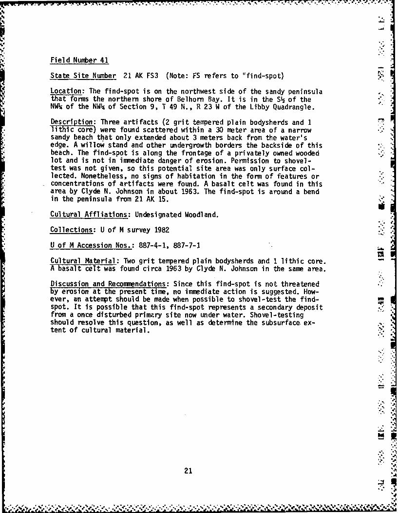
Field Number 41
State Site Number 21 AK FS3 (Note: FS refers to "find-spot)
Location: The find-spot is on the northwest side of the sandy peninsulathat forms the northern shore of Belhorn Bay. It is in the S of theNW. of the NW4 of Section 9, T 49 N., R 23 W of the Libby Quadrangle.
Description: Three artifacts (2 grit tempered plain bodysherds and 1lithic core) were found scattered within a 30 meter area of a narrowsandy beach that only extended about 3 meters back from the water'sedge. A willow stand and other undergrowth borders the backside of thisbeach. The find-spot is along the frontage of a privately owned woodedlot and is not in immediate danger of erosion. Permission to shovel-test was not given, so this potential site area was only surface col-lected. Nonetheless, no signs of habitation in the form of features orconcentrations of artifacts were found. A basalt celt was found in thisarea by Clyde N. Johnson in about 1963. The find-spot is around a bendin the peninsula from 21 AK 15.
Cultural Affliations: Undesignated Woodland.
Collections: U of M survey 1982
U of M Accession Nos.: 887-4-1, 887-7-1
Cultural Material: Two grit tempered plain bodysherds and 1 lithic core. -
A basalt celt was found circa 1963 by Clyde N. Johnson in the same area.
Discussion and Recommendations: Since this find-spot is not threatenedby erosion at the present time, no immediate action is suggested. How-ever, an attempt should be made when possible to shovel-test the find-spot. It is possible that this find-spot represents a secondary depositfrom a once disturbed primary site now under water. Shovel-testingshould resolve this question, as well as determine the subsurface ex-tent of cultural material. ."
-%.
21!',
F -%

4 _., - , , = , . , 1 _ , . , . . ,.-.-.. -. .
MINNESOTA ARCHAEOLOGICAL SITE FORMCOUNTY SITE NAME FIELD NUMBER STATE NUMBER
Aitken None 41 21-AK-FS3
OWNER U.S.G.S. OUAD
Libby 7.5' - 1970Unknown LEGAL DESCRIPTION
SITE LOCATION
Northwest side of sandy peninsula extending S , NWk, NWk Sec. 9into Big Sandy Lake and forming northern T49, R23, Libbyshore of Belhorn Bay.T
SITE TYPE PROBABLE CULTURAL COMPONENTS:Indeterminate Middle or Late Woodland
SITE DESCRIPTION
Narrow sandy beach about 3 meters from water, succeeded by small
willow stand and undergrowth, currently undeveloped.
SITE CONDITION CURRENT LAND USE SITE AREA
No immediate danger Frontage of wooded lot, private 30 m. along
of erosion. property, shoreline.
'NATURE OF NEAREST WATER DISTANCE TO WATER DIRECTION .M WATER
Big Sandy Lake Shoreline South
ELEVATION OF SITE: 1220 ELEVATION OF NEAREST WATER: 1216
NATURE, EXTENT OFINVESTIGATION:Surface survey. permission to subsurface test not obtainable.
ARTIFACTS OBSERVED, RECOVERED:
2 grit tempered plain body sherds
1 lithic core MAP SCALE:.LOCAL COLLECTIONS, INFORMANTS: M,A."E K.::
Clyde N. Johnson (found basalt celt in .Rte 4 - Box 53 this area circa 1963) .
McGregor, MN 55460 IL. IWRITTEN REFERENCES
None 4
COMMENTS:Scattered artifacts very near to shore, noconclusive signs of habitation. Near to C K
known site 21-AK-15.
ACCESSION NOS. PHOTO NOS. REPOSITORY: INVESTIGATORS:887-4-1 None Univ. of Minn. Liestman/crew887-7 -1 PROJECT: 1982 Survey DATE: 6/14/82
22

Field Number 42
State Site Number 21 AK FS4
Location: The find-spot is in Davis Bay about 400 meters due east ofKare Phree Pines Resort. The legal description is the NWP4 of the NW 4.of the NE of Section 20, T 49 N., R 23 W of the Minnewawa 7.5' Quad-rangle.
Description: Although no artifacts were found by the survey crew atthis find-spot, 15 - BO stones measuring approximately 10-20 cm. in dia-meter are arranged in a rectangular shape 3.3 meters long and 90 cm.wide. This potential post-contact burial is situated on a ridge coveredby trees and dense underbrush. Permission was not granted for shovel-testing in the area. Several projectile points and a possible groundstone implement were found near the resort and are now in the possessionof the resort owner, Marian Stringham.
Cultural Affliation: If the pile of stones does represent a burial,this find-spot most probably represents a post-contact burial site.
Collections: Two projectile points and a ground stone implement in thepossession of Marian Stringham, owner of Kare Phree Pines Resort.
Discussion and Recommendations: This find-spot is not threatened byerosion or other disturbance at the present time. However, it is notcertain that this covering of stones does represent a site by any name.This can only be determined by testing in the future. This potentialsite should be protected until this determination is made.
.
24 3 'jj".......
I°.S,

."1
MINNESOTA ARCHAEOLOGICAL SITE FORM "COUNTY SITE NAME FIELD NUMBER STATE NUMBER
Aitken None 42 21-AK- FS4
OWNERMarian StringhaU.S.G.S. QUADKare Phree Pines Resort Minnewawa 7.51 1970 ..?, .
McGregor, MN 55460
SITE LOCATION LEGAL D.
On Davis Bay about 400 m due east of NWk, NWk, NEk Sec 20 .
Kare Phree Pines Resort. T49, R23 (Minnewawa)
SITE TYPE PROBABLE CULTURAL COMPONENTS:Unidentified Feature Historic ?
SITE DESCRIPTION
15-20 stones measuring approx. 10-20 cm. in diameter, in a rectangular
shape, 3.32 m long by 90 cm wide. On a ridge, elm/ash/oak forest and
dense underbrush.SITE CONDITION CURRENT LAND USE SITE AREA
No immediate danger of Private commercial property Less thanerosion. (resort grounds). 10 sq. m.
NATURE OF NEAREST WATER DISTANCE TO WATER DIRECTION OF SITE FROM WATER
Big Sandy Lake 30 meters South
ELEVATION OF SITE: ELEVATION OF NEAREST WATER:
NATURE, EXTENT OFINVESTIGATION: Surface, owner withheld permission to shovel test.
ARTIFACTS OBSERVED, RECOVERED:
None recovered, see description above.
MAP SCALE:LOCAL COLLECTIONS, INFORMANTS: MAP
Marian Stringham (collection of two points, . ./ *one ground stone implement
found npa'r rPnrt)WRITTEN REFERENCES ..... ___ -
None- : 0
COMMENTS:FA NA ATI
This pile of stones could represent a post- Icontact burial. This potential site should beprotected until this determination can be made. .
ACCESSION NOS. PHOTO NOS. REPOSITORY: INVESTIGATORS:None None Univ. of Minn. Liestman/Crew _
PROJECT: 1982 Survey DATE: 6/15/82
26

d
Field Number 43
State Site Number 21 AK FS5
Location: This find-spot is on the southeast tip of Long Island in theNW of the SW4 of the SE4 of Section 5, T 49 N., R 23 W. of the Libby7.5' Quadrangle.
Description: A small number of artifacts were found along the shoreof a wooded lot that is under development. The clay and sandy soil isheavily disturbed by excavations for a sewer line, although the find-spot itself is not presently subject to erosion. The artifacts werefound about 25 meters back from the water's edge in shovel-test pits.No collections are known from the find-spot. It is possible that thisfind-spot is a continuation of a long-term habitation area that sur-rounded much of the peninsula, for 21 AK 22, 21 AK 23, and 21 AK 24 areall nearby.
m Cultural Affliation: Middle Woodland
Collections: U of M survey 1982
U of M Accession Nos.: 888-3-2, 888-4-2, 888-5-2
Cultural Material: Three grit tempered bodysherds (one comb impressedand two net-impressed) and 1 chert flake.
Discussion and Recommendations: This find-spot may represent a heavilydisturbed campsite. Since the density of artifacts is low, we do notregard it as a major occupation center. However, it is a concentrationof Middle Woodland material and it should be closely examined for addi-tional materials whenever possible. It is not subject to erosion and -if it escapes destruction during the development of the lot -it could ,"add to our knowledge of Middle Woodland occupations in the Big Sandyarea. Since it is located some distance back from the edge of theshoreline, it could represent one of the few undisturbed (at least inpart) Middle Woodland sites in the area. This find-spot probably de-
-serves a phase two survey that involves limited excavation; a phase twosurvey would also alert the present landowners to areas of their lotthat should not be disturbed.
.4
PREVIOUS PAGE
28 IS BLANK
, Z g.:,2 ,2 ,'" " ; g0,°',,°2o "'2'2 .. "" -"." "- - - ". . -.- € " " '- ""i . ." -°',-" "2"'" -'°-.''J'.-',""- "" -""-, .: -' A

MINNESOTA ARCHAEOLOGICAL S1TE FORMCOUNTY SITE NAME FIELD NUMBER STATE NUMBER
Aitken None 43 2 1-AK- FS 5
OWNER U.S.G.S. QUAD
Jongvard Libby 7.5' 1970
SITE LCATIONLEGAL DESCRIPTION
*Point of land of the Southeast tU'p of NWk, SWk, SEk Sec 5
Long Islane. T49, R23 (Libby)
> SITE TYPE PROBABLE CULTURAL COMPONENTS:Indeterminate Middle Woodland
4' SITE DESCRIPTION
Wooded lots under development, heavily disturbed clay and sandy soil.
SITE CONDITION CURRENT LAND USE SITE AREAHeavily developed,
much sewer-excavation, Residential Undesignated.."-
SNATURE OF NEAREST WATER DISTANCE TO WATER DIRECTION OF SITE FROM WA-TEr-*
Big Sandy Lake 25 meters Northeast
SELEVATION OF SITE: 1225 ELEVATION OF NEAREST WATER: 1216
NATURE, EXTENT OF ---INVESTIGATION: Surface survey and subsurface shovel testing.
ARTIFACTS OBSERVED$ RECOVERED:
3 grit tempered body sherds (One comb impressed, two net impressed)1 lithic flake (chert) MAP SCA'LE:
LOCAL COLLECTIONS, INFORMANTS: MAP
NoneA DYLS WRITTEN REFERENCES NRA (EORPO L~TO 2GF
None%
%~ COMMENTS:
Found in shovel tests,*near to sites / 21
21-AK-22, 21-AK-23, and 21-AK-24.
.6ACCESSION NOS. PHOTO NOS. RPSTY:Univ of Min NVESIAOS888--2 Nne ILiestman/Crew
888-5-2 IROJECT: 18SuvyDATE: 6/17/82
30 PREVIOUS PAGEIS BLN
~. ~ p - .~ .~. -.

. . . . • * . •. r* ' w; .. - -- - -
• ... .* *.-*...
~-A
Field Number 44
State Site Number 21 AK 43
Location: This historic ricing site is on a small island directlysouth of the Aitken Lake Resort in the southwestern section of AitkenLake. It is in the NW of the SW of the SE of Section 19, T 50 N.,R 23 W. of the Libby 7.5' Quadrangle.
Description: This is a small island covered with a dense layer ofbrush and trees. At least 13 depressions measuring 95 cm. to 1.5 metersin diameter were concentrated along 80 meters of shoreline on the southend of the island. The depressions are located in a band stretching fromthe shoreline back some 50 meters. The island is privately owned and hasno development potential at the moment. There is no immediate dangerof erosion. The entire island was shovel-tested. An informant statedthat Ojibwa have riced and camped here as recently as 30 years ago. How-ever, no artifacts were found by the survey crew.
Cultural Affliation: Historic Ojibwa (this determination is based onthe size and location of the pits, and on an informant's information.Although a systematic survey of the cultural affliations of ricingjigs in Minnesota has never-been made-to my knowledge, jigs associatedwith historic Dakota sites near Mille Lacs Lake are much smaller andlined with clay. The cultural affliation of this site must remain,therefore, tentative.)
Collections: None
Cultural Materials: No artifacts were found during the survey. Theonly indication of a cultural presence is the ricing jigs.
Discussion and Recommendations: Ricing jigs are a common occurrenceon the shorelines of many lakes in this area of Minnesota. We havenever found artifacts in direct association with jigs unless the jigsare within a habitation site. Since this site is not threatened byimmediate destruction, no immediate action is suggested.
.Z
32 -1.'-
- ...... j *qX*% ~' ~~ -.. ',1 rvV- -%

MINNESOTA ARCHAEOLOGICAL SITE FORMCOUNTY SITE NAME FIELD NUMBER STATE NUMBER
Aitken None 44 2 I-AK- 43
OWNER U.S.G.S. QUAD
Jim Aldrich Libby 7.5' - 1970Aitken Lk. Resort, McGregor MN 55460
SITELOCAIONLEGAL DESCRIPTION- SITE LOCATION
Island directly south of resort in southwest NW-, SW, SEk Sec 19
part of Aitken Lake. T50, R23 (Libby)
SITE TYPE PROBABLE CULTURAL COMPONENTS:
Ricing site/Camping place Historic
SITE DESCRIPTIONSmall densely covered island with at least 13 depressions measuring
from 95 cm. to 1.5 meters in diameter, concentrated primarily on southeast
end.
SITE CONDITION CURRENT LAND USE SITE AREA
No immediate danger of Privately owned, no development 80 meters oferosion. potential. shoreline on
South end.NATURE OF NEAREST WATER DISTANCE TO WATER DIRECTION OF SITE FROM WATER 4'
Aitken Lake Shore to 50 meters Northwest
ELEVATION OF SITE: 1225 ELEVATION OF NEAREST WATER:
NATURE, EXTENT OFINVESTIGATION: Surface and subsurface shovel testing.
ARTIFACTS OBSERVED, RECOVERED:
None recovered
MAP SCALE:.LOCAL COLLECTIONS, INFORMANTS: MAP
Jim Aldrich '
B , . . L- . - , .-- ._ .
WRITTEN REFERENCES -, " . 2- -
None -(3
COMMENTS: i .//,
Informant says Ojibwa's have riced and camped
here as recently as 30 years ago. -
ACCESSION NOS. PHOTO NOS. EPOSITORY: INVESTIGATORS:Univ. of Minn. Liestman/Crew
None None PROJECT: 1982 Survey DATE: 6/18/82
34' i. *,"**'*,'_' *,. .,.-. . . ...'- . .-",..-'-" ,.." " ..-' .,-...-'. ,." -.-' .' -.-.- ' ."-" - ', '

Field Number 45
State Site Number 21 AK 44
Location: This site is located on a point of land that extends east-ward from the northwest shore of Aitken Lake. It is in the SW of the
4: SW of the NW of Section 20, T 50 N., R 23 W. of the Libby 7.5' Quad-rangle. The site is between the shoreline and a line about 10 meters
m parallel to the shore. t
Description: This site stretches along the shoreline of an undevelopedpoint of land for less than 200 meters. The point is presently sur-rounded by marsh and wild rice stands. Although shovel-testing was em-ployed, artifacts were only found within a distance of no more than 10meters from the shoreline. The site appears to have been a small LateWoodland campsite. No features were discovered in shovel-tests. At thepresent time, the site is not in danger of erosion.
Cultural Affliations: Late Woodland (Blackduck)
Collections: U of M survey 1982
U of M Accession Nos.: 889-4-2, 889-5-2, 889-8-2, 889-6-2, 889-4-1'C
Cultural Material: Thirteen cord-marked bodysherds, 2 lithic wasteflakes, 1 fish scale, 2 burnt bone fragments (one of which may be aburnt human medial phalange).
Discussion and Recommendations: Since this site is not threatened byerosion at the present time, no immediate action is suggested. It ispossible that this site represents a secondary deposit of culturalmaterial, having been redeposited by wave action following the con-struction of the Sandy Lake Reservoir dam. This possibility could beevaluated by a phase two survey when the opportunity arises in thefuture.
36 .:
-- d
"--'-

MINNESOTA ARCHAEOLOGICAL SITE FORM
COUNTY SITE NAME FIELD NUMBER STATE NUMBER
Ai tken None 45 2 1-AK- 4 4
OWNER Jim Aldrich U.S.G.S. QUAD
Aitken .Lk Resort Libby 7.5' - 1970McGregor, MN 55460
SiTE__LOCATION LEGAL DESCRIPTION
Point of land extending eastward from the SWA, SW, NW Sec 20Northwest shore of Aitken Lake. T50, R23 (Libby)
SITE TYPE I PROBABLE CULTURAL COMPONENTS:Indeterminant Late Woodland (Blackduck)
SITE DESCRIPTION
Mixed deciduous shoreline, undeveloped point of land surrounded on sides
by marsh and wild rice stands. Brown loamy and mixed sandy loam soil.
SITE CONDITION CURRENT LAND USE SITE AREALess than 200 m
In no immediate danger Undeveloped along shore inof erosion. Iortheasterly| irection.
NATURE OF NEAREST WATER DISTANCE TO WATER DIRECTION OF SITE FROM WATER
Aitken Lake Shoreline to 10 meters, West
ELEVATION OF SITE: ELEVATION OF NEAREST WATER:120 1,216
NATURE, EXTENT OFINVESTIGATION: Surface survey and sub-surface shovel testing.
ARTIFACTS OBSERVED, RECOVERED:13 cord marked body sherds 2 burnt bone fragments (one possibly2 lithic waste flakes human - medial phalange)1 fish scale MAP SCALE:
LOCAL COLLECTIONS, INFORMANTS: MAPJim Aldrich -
WRITTEN REFERENCESI
COMMENTS: o \o
20-
E NOS. PHOTO NOS. IREPOSITORY: INVESTIGATORS:889-5-2889-8- None .Univ. of Minn. Liestman/Crew
889-6-2 8 8 9 - 4 - i 1PROJECT: 1982 Survey IDATE, 6/18/82 Lp
*,=
38

Field Number 46
State Site Number 21 AK 45
Location: This site is on a point of land that extends eastward fromthe northwest shore of Aitken Lake. It is in the SE1 of the NW of theNW, of Section 20, T 50 N., R 23 W. of the Libby 7.5' Quadrangle.
Description: The site stretches 200 meters on either side of a partlycleared, narrow point of land in Aitkin Lake. The area, although unde-veloped, is cleared and used by a local snowmobile club. The banksalong the edge of the site are undergoing moderate erosion. At presentthe area is owned by Jim Aldrich, the owner of Aitken Lake Resort.
Cultural Affliations: Late Woodland (Sandy Lake)
Collections: U of M survey 1982
U of M Accession Nos.: 890-3-1, 890-5-1, 890-6-2, 890-3-2,890-4-2, 890-5-2
Cultural Material: Seven plain bodysherds, 7 cord-marked bodysherds,6 smoothed-over cord-marked bodysherds, 1 fabric impressed bodysherd,
• 9 exfoliated sherds, 3 chert flakes, 1 bone fragment.
Discussion and Recommendations: This was the most promising site foundduring the 1982 survey in terms of density of artifacts in an undis-turbed context. Since the shoreline edge of the site is experiencingmoderate erosion, it should be checked occasionally to prevent anyextensive damage.
,,,1'
.5V.
40
' p * .'

MINNESOTA ARCHAEOLOGICAL SITE FORM
COUNTY SITE NAME FIELD NUMBER STATE NUMBER
Aitken None 46 21-AK-45
OWNER U.S.G.S. QUADJim AldrichAitken Lake Resort Libby 7.5' - 1970
M n-r MN S%460 LEGAL DESCRIPTION-SITE LOCATION"
Point of land extending eastward from the SEk, NW , NWk Sec 20
Northwest shore of Aitken Lake. R23, T50 (Libby)
SITE TYPE PROBABLE CULTURAL COMPONENTS:
Indeterminate Late Woodland (Sandy Lake Ware)SITE DESCRIPTION
Partly cleared, narrow point of land, mostly pine forest on small ridge
of land, between lake shore and meandering creek 50 meters inland.
SITE CONDITION CURRENT LAND USE SITE AREA
Banks undergoing moderate Undeveloped, used and cleared 200 meterson either side
erosion. by local snowmobile club. of it.7 of point.
NATURE OF NEAREST WATER DISTANCE TO WATER DIRECTION OF SITE FROM WATER
Aitken Lake Shoreline West
ELEVATION OF SITE: 1225 ELEVATION OF NEAREST WATER: 1216
NATURE, EXTENT OFINVESTIGATION: Surface and subsurface shovel testing.
ARTIFACTS OBSERVED, RECOVERED:7 plain body sherds 1 fabric impressed body sherd 3 waste flakes7 cordmarked body sherds 9 exfoliated sherds 1 bone fragment6 smoothed-over cord marked body sherds
MAP SCALE:
LOCAL COLLECTIONS, INFORMANTS: MAP
Jim Aldrich
WRITTEN REFERENCES
None v . -.
SCOMMENTS:
Most promising in terms of artifacts located 20
in a relatively small area.
!A
U 9O6-2 PHOTO NOS. REPOSITORY: INVESTIGATORS:6 Univ. of Minn. Liestman/Crew
890-4 1 890-3-? None 6890-5-1 890-4- Z PROJECT: 1982 Survey DATE: 6/18/82
42-....*. ~.. • "'

Field Number 47 ...__2
State Site Number 21 AK 46
Location: The site is situated on a point of land that extends south-east into Muck's Bay in the northernmost section of Aitken Lake. It isin the NE of the SW-% of the SE of Section 17, T 50 N., R 23 W. of theLibby 7.5' Quadrangle.
Description: The site is on a high ridge that extends out into AitkinLake. Pine and mixed hardwoods now cover the ridge; a wild rice standoccurs immediately to the west. The site itself is surrounded by wateron all sides except the northwest. At the present time the peninsulaon which the site is located is undeveloped and in no immediate dangerof erosion. Sherds were found scattered along the shoreline about 100meters on either side of the point. No artifacts were found in shovel-
14 tests, which may indicate that the sherds found could have been re-deposited along the shore by wave action.
Cultural Affliations: Late Woodland
Collections: U of M survey 1982
U of M Accession Nos.: 891-4-2
Cultural Material: Nineteen plain grit-tempered bodysherds
Discussion and Recommendations: Since this site is not threatened byerosion at the present time, no immediate action is suggested. As men- .-tioned above, this site could represent a secondary deposit eroded froma primary site now submerged under Aitken Lake. Even though no artifactswere found by shovel-testing, the site should be checked again in thefuture for artifacts that may be occasionally deposited along the shore-line.
0]ION
44
44 '
-- 1
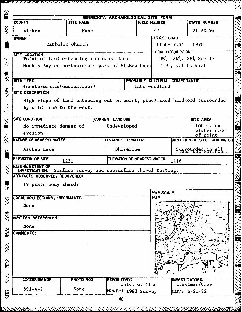
S.. - - - '..,
MINNESOTA ARCHAEOLOGICAL SITE FORM
COUNTY SITE NAME FIELD NUMBER STATE NUMBER
Aitken None 47 21-AK-46
OWNER U.S.G.S. QUAD
Catholic Church Libby 7.5' - 1970
LEGAL DESCRIPTIONSITE LOCATION
Point of land extending southeast into NE, SWt, SE Sec 17
Muck's Bay on northernmost part of Aitken Lake T50, R23 (Libby)
SITE TYPE I PROBABLE CULTURAL COMPONENTS:
Indeterminate (occupation?) Late woodlandSITE DESCRIPTION
High ridge of land extending out on point, pine/mixed hardwood surrounded
.-by wild rice to the west.
.SITE CONDITION CURRENT LAND USE SITE AREA
No immediate danger of Undeveloped 100 m. oneither sideof point.
N ATURE OF NEAREST WATER DISTANCE TO WATER DIRECTION OF SITE FROM WATER
Aitken Lake Shoreline Sugrounded ontall" " , , I s l o e NU r w e s t .
ELEVATION OF SITE: 1251 ELEVATION OF NEAREST WATER: 1216
.. NATURE, EXTENT OFINVESTIGATION: Surface survey and subsurface shovel testing.
ARTIFACTS OBSERVED, RECOVERED:
19 plain body sherds
AP MAP SCALE:.
' LOCAL COLLECTIONS, INFORMANTS: MAP
None r-'--
WRITTEN REFERENCES " "--'."
None " - I , - " ?
COMMENTS: "
ACCESSION NOS. PHOTO NOS. IREPOSITORY: INVESTIGATORS: 5
Univ. of Minn. Liestman/Crew891-4-2 None [PROJECT: 1982 Survey DATE: 6-21-82
46
.*"* *, v%'.E .. . * **?.>?, . * .'.-. '.*-...... ..

MCT a 7. 1 T. a 7- .'7777..
Field Number 48
State Site Number 21AK 47
Location: This site is located 30 meters west of an inlet on thenorth end of Aitken Lake in Muck's Bay. It is in the SE of the NW-of the SE, of Section 17, T 50 N., R 23 W. of the Libby 7.5' Quadrangle.
Description: This is an historic (c. 1920) house foundation on a riseapproximately 50 meters from the shoreline. The area around the c.30square meter dwelling is still partially open. Surrounding vegetationis a mixed hardwood forest. Local informants say that this is theformer homestead of an Indian named "Muck," for whom the bay wasnamed. The stone foundation is well-preserved and in no immediate dan-ger of erosion. Since the survey crew was unable to locate the currentowner, only surface survey was possible.
Cultural Affliations: Historic (c.1920s)
Collections: U of M survey 1982
U of M Accession Nos.: 892-9-1, 892-8-1
Cultural Material: Two broken pieces of historic ceramic and a frag-ment of the lower part of a rectangular glass bottle.
Discussion and Recommendations: Since this site is not threatened byerosion at the present time, no immediate action is suggested. An at-tempt to preserve this site should be made, for the archaeologicalstudy of even relatively late acculturation situations is becomingincreasingly important.
.,
48

MINNESOTA ARCHAEOLOGICAL SITE FORMCOUNTY SITE NAME FIELD NUMBER STATE NUMBER
Aitken None 48 21-AK- 4 7
OWNER U.S.G.S. QUAD
Catholic Church Libby 7.5' - 1970
LEGAL DESCRIPTIONSITE LOCATION
30 meters west of inlet on northernmost end SE4, NW4, SE Sec 17
of Aitken Lake (Muck's Bay). T50, R23 (Libby)
SITE TYPE PROBABLE CULTURAL COMPONENTS:Foundation, Iistoric occupation j Historic - 1920's
SITE DESCRIPTIONW,
Foundation is in partially cleared mixed hardwood forest, top of rise,
approximately 50 meters in from shore.
SITE CONDITION CURRENT LAND USE SITE AREA'"-I
No immediate danger of Private property, abandoned 30 sq. meters
erosion. dwelling.NATURE OF NEAREST WATER DISTANCE TO WATER DIRECTION OF SITE FROM WATER
Aitken Lake 50 meters West
ELEVATION OF SITE: 1241 ELEVATION OF NEAREST WATER:1241 1216
NATURE, EXTENT OFINVESTIGATION: Surface survey (Unable to contact current owner for permission)
ARTIFACTS OBSERVED, RECOVERED:
2 broken pieces historic ceramics
1 lower part of rectangular glass bottle MAP SCALE:
LOCAL COLLECTIONS, INFORMANTS: MAP
Jim AldrichAitken Lake ResortMr.r~gn- MV '*LLA )A
WRITTEN RE'FERENCES -7 .7
None T
SCOMMENTS:
Well preserved historic stone foundation
and related artifacts. Informed that this is i -former homestead of an, Indian named "Muck"" ... ! ..
for whom the bay is named. "
ACCESSION NOS. PHOTO NOS. REPOSITORY: INVESTIGATORS:892-9-1 Univ. of Minn. Liestman/Crew -
None892- 8 -1 NPROJECT: 1982 Survey DATE: 6/22/82
50
, ,% * , ' . , '. ', .' '.'. .. ". " - . , ,'. ., .,

Field Number 49
State Site Number 21 AK 48
Location: This site is in an island near the middle of Aitken Lake.It is in the SE of the SE of the NWP4 of Section 20, T 50 N., R 23 W,of the Libby 7.5' Quadrangle.
Description: This lowlying island is frequently flooded. For thisreason,. it has been shunned as a potential housing development loca-tion by its owner. The site area is about 20 square meters along theshoreline of the northeast end of this island. Young ash and basswoodform a heavy ground cover at the present time. No features were dis-covered in subsurface shovel-testing.Cultural Affliation: Late Woodland (Sandy Lake)
Collections: U of M survey 1982
U of M Accession Nos.: 893-1-2, 893-3-1, 893-4-2, 893-5-1
Cultural Material: Three cord-marked, grit-tempered bodysherds, 2smoothed-over cord-marked, grit-tempered bodysherds, 2 plain body-
sherds, 1 unifacial quartzite scraper, 1 quartzite flake.
Discussion and Recommendations: This site is threatened by the risingwater level of the lake. However, since all artifactual materialswere found along the shoreline, the site could represent a secondarydeposit of material eroded from a now submerged site. This site shouldbe checked whenever possible for additional material that may bewashed ashore. Additional shovel-tests should also be made when pos-sible to confirm the shoreline limitation of this site.
52
... ,,. '.
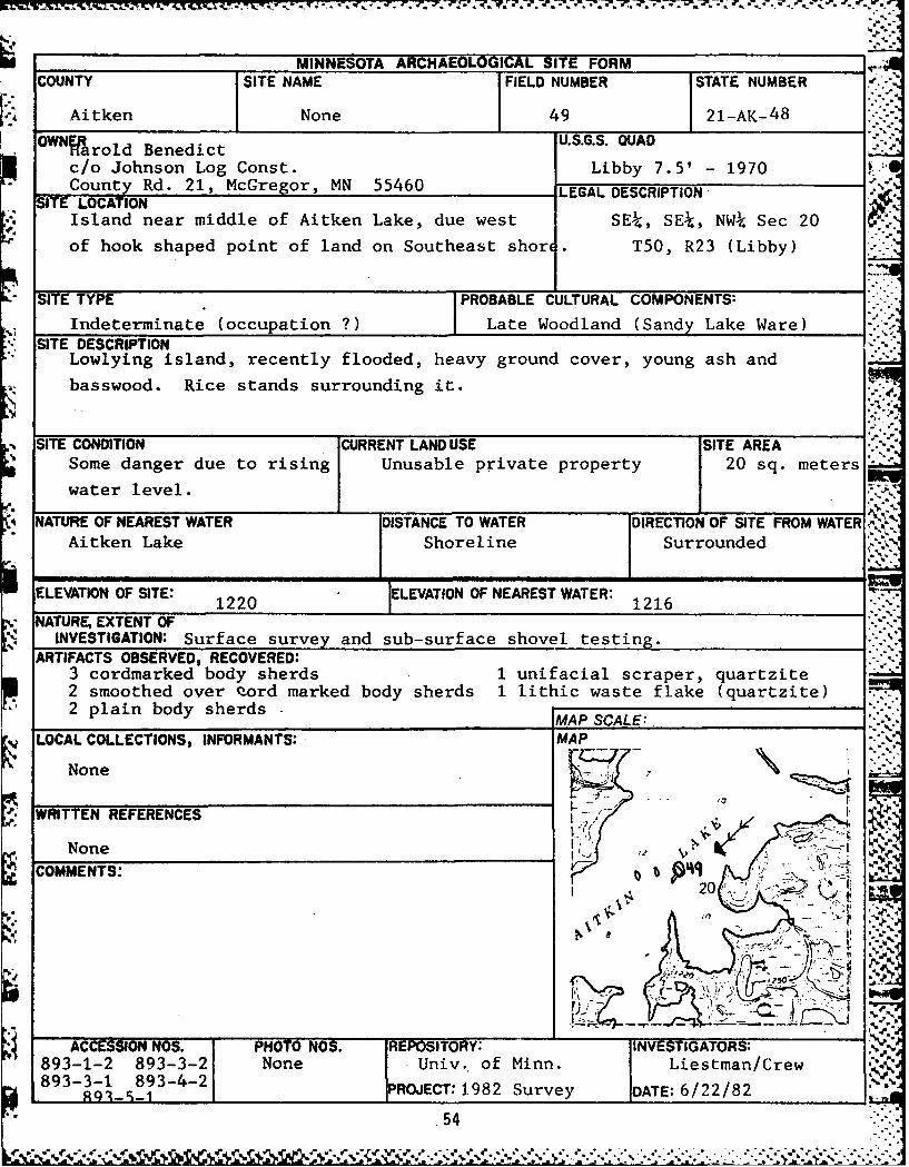
MINNESOTA ARCHAEOLOGICAL SITE FORMCOUNTY SITE NAME FIELD NUMBER STATE NUMBER
Aitken None 49 21-AK- 4 8
OWNa U.S.G.S. QUAD
c/o Johnson Log Const. Libby 7.5' - 1970County Rd. 21, McGregor, MN 55460 LEGAL DESCRIPTION
SITE LOCATIONIsland near middle of Aitken Lake, due west SEk, SEk, NWk Sec 20
of hook shaped point of land on Southeast shor . T50, R23 (Libby)
SITE TYPE PROBABLE CULTURAL COMPONENTS:
Indeterminate (occupation ?) Late Woodland (Sandy Lake Ware)SITE DESCRIPTION
Lowlying island, recently flooded, heavy ground cover, young ash and
basswood. Rice stands surrounding it.
SITE CONDITION CURRENT LAND USE SITE AREA
Some danger due to rising Unusable private property 20 sq. meters
water level.
NATURE OF NEAREST WATER DISTANCE TO WATER DIRECTION OF SITE FROM WATER ,-Aitken Lake Shoreline Surrounded
ELEVATION OF SITE: 1220 ELEVATION OF NEAREST WATER: 1216
NATURE, EXTENT OFINVESTIGATION: Surface survey and sub-surface shovel testing.
ARTIFACTS OBSERVED, RECOVERED:3 cordmarked body sherds 1 unifacial scraper, quartzite2 smoothed over eord marked body sherds 1 lithic waste flake (quartzite)2 plain body sherds MAP SCALE:.
!LOCAL COLLECTIONS, INFORMANTS: MAP
None
WRITTEN REFERENCES ." . ,-
None K UM L a - .
COMMENTS: R 2022/2 C4
I t
54
N.-ACCESIONNOS.PHOO NO. REOSITRY:INV-TIGAOR"
893-1-2* 893-3-2 None _ Univ".'"""'"* of Minn"._' Liest"-man'/G ."" " "r"ew ' :• :,,_, - ,.. ., ,, , , ' ,,, ,,,, , % V X,,,,,.-, , , , ,-, .. .. ,. ... ,, ,, -. - ... .. ... ,.. ... . .. ,,, .. , ..-. .

Field Number 50
State Site Number 21 AK 49
Location: This site is on the south shore of Aitken Lake about 500meters east of the channel which connects it with Big Sandy Lake. Itis in the NW of the SE of the SW4 of Section 20, T 50 N., R 23 W.of the Libby 7.5' Quadrangle.
Description: Although no artifacts were found in this area, approx-imately 12 round depressions measuring from 1 to 1.2 meters in dia-meter were found within a 30 square meter area. All of these depres-sions are within 50 meters of the shoreline. The depressions are ina partially cleared mixed deciduous forest that remains undevelopedand is in no immediate danger of erosion. These cultural featuresare probably historic ricing-jigs.
Cultural Affliation: Probably historic
Collections: None
Cultural Material:
Discussion and Recommendations: Since this site is not threatened byerosion at the present time, no immediate action is recommended. De-pressions of this size and form seem to be associated with the historicOjibwa occupation of northern Minnesota and are common around many ofthe lakes in the area.
56
• " -" '." " . , ", " " ."-"*' " . . ' . . ' " - ; ...''o..""-*'' -*'""-. "". """.."" ".'.;"V.. . .. ,-- .

MINNESOTA ARCHAEOLOGICAL SITE FORMCOUNTY SITE NAME FIELD NUMBER STATE NUMBER
Aitken None 50 21-AK- 49
OWNER U.S.G.S. QUADHarold Benedictc/o Johnson Log Const. Libby 7.5' - 1970Coiunfy Rd. 21 MnCregor. MN 55460 LEGAL DESCRIPTION
SITE LOCATION
South shore of Aitken Lake, 500 meters east of NWk, SE4, SWk Sec 20
channel connecting it to Big Sandy Lake. T50, R23 (Libby)
SITE TYPE I PROBABLE CULTURAL COMPONENTS:Ricing (?)I Historic (?)
SITE DESCRIPTION
Approximately 12 depressions, roundish, measuring from 1 meter to 1.2 meters
in diameterset in partially cleared mixed deciduous forest. Appear to be
cultural.SITE CONDITION CURRENT LAND USE SITE AREA
No immediate danger of Undeveloped 30 sq. meters
erosion.
NATURE OF NEAREST WATER ISTANCE TO WATER DIRECTION OF SITE FROM WATER
Aitken Lake Within 50 m. from shor East
ELEVATION OF SITE: 1220 LEVATION OF NEAREST WATER: 1216
NATURE, EXTENT OFINVESTIGATION: Surface survey and sub-surface shovel testing.
ARTIFACTS OBSERVED, RECOVERED:
None recovered
MAP SCALE:LOCAL COLLECTIONS, INFORMANTS: MAP
None
WRITTEN REFERENCES .
None -
COMMENTS: - . V20No cultural material associated with these
pits. We are assuming they are somehow re- ,-
lated to ricing in the near past. " -
4._5. ...
ACCESSION NOS. PHOTO NOS. REPOSITORY: INVESTIGATORS:Univ. of Minn. Liestman/Crew
None None NPROJECT: 1982 Survey DATE: 6/22/82
58
,' ;,::,2 ;,;, :' .,,.v' :.: .' .;', .";;.",;'->-i;-: ,' .'',,.....-......-..-.....-..............'.........-.-......-....-..........".......-....".-...
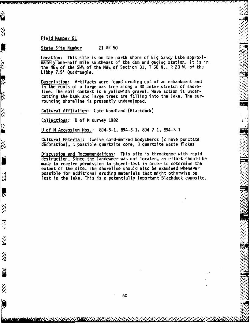
7. 7.7 7 W .. '_
Field Number 51
3 State Site Number 21 AK 50
Location: This site is on the north shore of Big Sandy Lake approxi-mately one-half mile southeast of the dam and gaging station. It is inthe NEk of the SW4 of the NW of Section 31, T 50 N., R 23 W. of theLibby 7.5' Quadrangle.
Description: Artifacts were found eroding out of an embankment andin the -roots of a large oak tree along a 30 meter stretch of shore-line. The soil context is a yellowish gravel. Wave action is under-cutting the bank and large trees are falling into the lake. The sur-rounding shoreline is presently undeveloped.
Cultural Affliation: Late Woodland (Blackduck)
Collections: U of M survey 1982
U of M Accession Nos.: 894-5-1, 894-3-1, 894-7-1, 894-3-1
Cultural Material: Twelve cord-marked bodysherds (2 have punctatedecoration), 1 possible quartzite core, 8 quartzite waste flakes
Discussion and Recommendations: This site is threatened with rapiddestruction. Since the landowner was not located, an effort should bemade to receive permission to shovel-test in order to determine theextent of the site. The shoreline should also be examined whenever rpossible for additional eroding materials that might otherwise belost in the lake. This is a potentially important Blackduck campsite.
;.
60

, _:. :,*. . . ,.,g m:.,-. i .. ,..' . _ * ,% - ,,, .'. ... . . p . . *.. . . . *..,. • .. *. . . .
MINNESOTA ARCHAEOLOGICAL SITE FORMCOUNTY SITE NAME FIELD NUMBER STATE NUMBER
Aitken None 51 21-AK- 50
OWNER U.S.G.S. QUADUnknown Libby 7.5' - 1970
SITE LOCATION LEGAL DESCRIPTIONNorth shore of Big Sandy, approximately 1/2 NEk, SWk, NW4 Sec 31
mile Southeast of dam and gaging station. 1 50, R23 (Libby)
(Near known site 21AK28.)
SITE TYPE j PROBABLE CULTURAL COMPONENTS:
TndeterminateI Ln-Pt Woodland (Rlankdurk)SITE DESCRIPTION
Severely eroded bank of yellowish, gravel like till. Wave action is
causing bank to be undercut, large tree (oak, elm, maple) are falling
into the lake.SITE CONDITION CURRENT LAND USE SITE AREA
30 m. alongIn serious danger of Undeveloped shore in east/
erosion, currently erodin w directionNATURE OF NEAREST WATER DISTANCE TO WATER DIRECTION OF SITE FROM WATER
Big Sandy Lake Shoreline North
ELEVATION OF SITE: 1ELEVATION OF NEAREST WATER:
NATURE, EXTENT OFINVESTIGATION: Surface survey, unable to locate owner
ARTIFACTS OBSERVED, RECOVERED:
12 cordmarked body sherds (2 with punctates)1 possible core (quartzite)8 waste flakes (puartzite) MAP SCALE:
LOCAL COLLECTIONS, INFORMANTS: MAP
None _
WRITTEN REFERENCES
None
SCOMMENTS: I
These artifacts were found eroding out of an
embankment and in the roots of a large oak I j4)0 "%
tree.
ACCRIN . PHOO NO. I NVTIGATORS:
Cnqiv. of Minn. Liestman/Crew894-5-1 894-3- sP
894-7-1 ROJECT: 1982 Survey DATE: 6/23/82
62 .:::

.. . .. . . .... *.
Field Number 52
State Site Number 21 AK 51
Location: This site is on the east shore of Sandy River Lake, justsouth of a marshy point which extends into the lake. It is in the N "of the SE of the NW 4 of Section 19, T 49 N., R 23 W. of the Minnewawa7.5' Quadrangle.
Description: Artifacts were found in a possible hearth situated about50 meters back from the shoreline on a steep bank. Mixed deciduous(maple-basswood) forest covers the upper part of the bank, and tallgrass and marsh cover the bank near the waterline. No other artifactswere found in the area outside of the possible hearth. The area iscurrently undeveloped private property and is in no immediate danger "of erosion.
Cultural Affliation: Late Woodland
Collections: U of M survey 1982
U of M Accession Nos.: 895-3-2, 895-4-2, 895-10-2, 895-5-2
Cultural Material: One plain bodysherd, 1 cord-mariked bodysherd, 1quartzite waste flake, 2 pieces of burnt sandstone
Discussion and Recommendations: Since this site is not threatened byerosion at the present time, no immediate action is suggested. Whenpossible, the hearth should be excavated, for this area will undoubted-ly be developed in the near future.
4.
r,%
64
1A,2,
16 . . ... -,
MINNESOTA ARCHAEOLOGICAL SITE FORMCOUNTY SITE NAME FIELD NUMBER STATE NUMBER
Aitken None 52 21-AK- 51
OWNER U.S.G.S. QUAD
Paul Sather - Rte 4 Minnewawa 7.5' - 1970
Sather's Store, McGregor, MN 55460 LEGAL DESCRIPTION"-SITE LOCATION
East shore of Sandy River Lake, just south of N , SE , NWk Sec 19
.-marshy point which extends into lake. T49, R23 (Minnewawa)
SITE TYPE PROBABLE CULTURAL COMPONENTS:
Hearth (?) Late Woodland
SITE DESCRIPTION
Steep bank, mixed deciduous (maple/basswood) on upper part, descending
into tall grass and marsh near the waterline.
SITE CONDITION CURRENT LAND USE SITE AREANo immediate danger from Undeveloped private property. Undetermined
erosion.
NATURE OF NEAREST WATER DISTANCE TO WATER DIRECTION OF SITE FROM WATER=
Sandy River Lake 50 meters East
ELEVATION OF SITE: 1230 ELEVATION OF NEAREST WATER: 1216
NATURE, EXTENT OFINVESTIGATION: Surface survey and subsurface shovel testing.
ARTIFACTS OBSERVED, RECOVERED:
1 plain body sherd 2 pieces burnt sandstoneI cordmarked body sherd1 waste flake (quartzite) MAP SCALE:
LOCAL COLLECTIONS, INFORMANTS: MAP
None
ZWYRITTEN REFERENCES
None 9-
: COMMENTS: I10 . . .1. .1 .9
ACCESSION NOS. PHOTO NOS. REPOSITORY: INVESTIGATORS:
895-3-2 895-50-2 University of Minn. Liestnan/Crew895-4-2 895-5- None PROJECT: 1982 Survey DATE: 6/24/82
66

P..
Field Number 53
State Site Number 21 AK FS6
Location: This site is situated on an island in Flowage Lake near theeastern shoreline. It is in the SE- of the SW4 of the NW4 of Section30, T 49 N., R 23 W. of the Minnewawa 7.5' Quadrangle.
Description: A small number of artifacts were found along the shore- .-line of a low-lying island now covered with shrubs and marsh grass. Theisland is actually connected to the shore by a marshy peninsula. Beforethe rise in waterlevel, this island must have been, therefore, apeninsula point or even near the edge of the river that has been ex-panded by the dam into a lake. The site is in no immediate danger oferosion.
Cultural Affliation: Late Woodland (Sandy Lake)
Collections: U of M survey 1982
U of M Accession Nos.: 896-3-1, 896-3-2
Cultural Material: Eight smoothed-over, cord-marked, shell-temperedbodysherds
Discussion and Recommendations: Since this site is not threatenedby erosion at the present time, no immediate action is suggested. Itis possible that this is a secondary site, having been redepositedby wave action following the construction of the reservoir dam, sinceno artifacts were found in primary context back from the shoreline.
I.o
68-
.5-
68 ''
,%,
r 70
MINNESOTA ARCHAEOLOGICAL SITE FORMCOUNTY SITE NAME FIELD NUMBER sTATE NUMBER
Ai tken None 53 21-AK- FS6
OWNER U.S.G.S. QUADUnknown Minnewawa 7.5' - 1970
LEGAL DESCRIPTION •SITE LOCATION .
Island in Flowage Lake near the eastern shore SEk, SW, NWA Sec 30
directly across from large point of land ex-' . T 49 R23 (Minnewawa)
tending in a southwesterly direction
SITE TYPE PROBABLE CULTU.AL COMPONENTSIndeterminate (occupation) Late Woodland (Sandy Lake Ware)
SITE DESCRIPTIONLow-lying island covered with shrubs and marsh grass. It is actually x
connected to the shore now by a marshlike peninsula.
SITE CONDITION CURRENT.LAND USE SITE AREA
No immediate danger of Unusable. Less than 30 -erosion. meters
NATURE OF NEAREST WATER DISTANCE TO WA TER DIRECTION OF SITE FROM WATEFlowage Lake Shoreline Surrounded
ELEVATION OF SITE: 1220 LEVATION OF NEAREST WATER: 1216
NATURE, EXTENT OFINVESTIGATION: Surface survey and sub-surface shovel testing.
ARTIFACTS OBSERVED, RECOVERED:
8 smoothed over, cordmarked body sherds
MAP SCALE:LOCAL COLLECTIONS, INFORMANTS: MAP ...
None .
%e WRITTEN REFERENCES
None
ICOMMENTS: 13-S. , - .I- .'.L :
ii - ** - .::-:.," I--' - - : "
. .I. ,:. - :
ACCESSION NOS. PHOTO NOS. IREPOSITORY: IINVESTIGATORS. "896-3-1 Univ. of Minn. Liesr./Crew896-3-2 ":"'3":., r-,,,,,-,.L ,, .,- ,. ,.., .. ,,-- -,.,-: 2.g . .:. , .. l.p_€ .- , ,,A., . -.
.. ~ .'. . ~ S - - ~ . ~ .*. . ** S.
Field Number 54 •
State Site Number 21 AK FS7
Location: This site is situated on a large, roughly rectangular is- -.
land in Aitken Lake, directly north of the channel connecting Aitkenamd Big Sandy lakes. It is in the SW of the SW of the SW of Section20, T 50 N., R 23 W. of the Libby 7.5' Quadrangle.
Description: A small number of artifacts were found on the surface ofthe highest point of a willow and shrub covered island. Rice standsborder the site on the south and west sides. All of these artifactswere found within a 10 square meter area about 20 meters from thewater's edge. The site area is undeveloped and in no immediate dangerof erosion.
Cultural Affliations: Woodland and Historic
Collections: U of M survey 1982
U of M Accession Nos.: 897-8-1, 897-4-1, 897-5-1
Cultural Material: One historic piece of ceramic, 1 plain bodysherdtempered with coarse grit, 2 quartzite waste flakes
Discussion and Recommendations: Since this site is not threatened byerosion at the present time, no immediate action is suggested. Thisappears to be a small campsite in primary context. It should be in-vestigated whenever possible. ..-. "
'.N.
4*5*
b6%
72 "
-. •
;-.

.- .. q
74
,.. MINNESOTA ARCHAEOLOGICAL SITE FORMCOUNTY SITE NAME FIELD NUMBER STATE NUMBER
Aitken None 54 21-AK-FS7
OWNER U.S.G.S. OUADUnknown Libby 7.5' - 1970
LEGAL DESCRIPTIONSITE LOCATION
Large, roughly rectangular shaped island in SWk, SWk, SW Sec 20
Aitken*Lake, directly north of channel con- T50, R23 (Libby)
necting to Big Sandy Lake.
ITE TYPE PROBABLE CULTURAL COMPONENTS:Indeterminate Prehistoric/Historic
SITE DESCRIPTIONWillow and shrub covered island, rising to pointed ridge on north andeast sides, gradually turning to rice on south and west. Artifacts on
highest point.
SITE CONDITION CURRENT.LAND USE SITE AREANo immediate danger of Unusable 10 sq. meters
erosion.
NATURE OF NEAREST WATER DISTANCE TO WATER DIRECTION OF SITE FROM WATER.
Aitken Lake 20 meters Surrounded
ELEVATION OF SITE: 1230 ELEVATION OF NEAREST WATER: 1216
NATURE, EXTENT OFINVESTIGATION: Surface survey and subsurface shovel testing.
ARTIFACTS OBSERVED, RECOVERED:
1 historic ceramic sherd1 plain body sherd (thick with coarse grit temo')2 lithic waste flakes (quartzite) MAP SCALE:
LOCAL COLLECTIONS, INFORMANTS: MAP
None
WRITTEN REFERENCES .-
NoneCOMMENTS: .'-
These were all on the surface. V -
' " s.- -,e- '
CCESSION NOS. PHOTO NOS. REPOSITORY: . IVESTIGATO8978-1 897-5-1 None Univ. of *,in - _ ,.eismanlCrw897-4-1 Project: 1982 Survey Date: 6/24/82
S - . " - -" " " "- . " S '. ' .y .. ... "
Field Number 55
State Site Number 21 AK FS8
Location: This site is on a horseshoe-shaped point of land on theeastern shore of Aitken Lake, near the entrance of the channel con-necting Aitken and Big Sandy lakes. It is in the N of the NW of theSE of Section 20, T 50 N., R 23 W. of the Libby 7.5' Quadrangle.
Description: A small number of artifacts were found along a 10 meterstretch of shoreline in low-lying wet land. The shore is covered withwillow shrubs and swamp grasses. The site is in no immediate dangerof erosion and is at present undeveloped.
Cultural Affliation: Late Woodland
Collections: U of M survey 1982
U of M Accession Nos.: 898-3-1, 898-5-2, 898-4-2
Cultural Material: One cord-marked bodysherd, 2 plain bodysherds,
2 waste flakes (1 quartzite, 1 grey chert)
Discussion and Recommendations: Since this site is not threatenedby erosion at the present time, no immediate action is recommended.It is possible that this is a secondary site, having been redepositedby wave action following the construction of the reservoir dam, sinceno artifacts were found in primary context back from the shoreline.
.. ' .
0
le
•A , o
0'e
I'
76-:-
.5.
.5.'
.5
°° ,°
'5 5.5
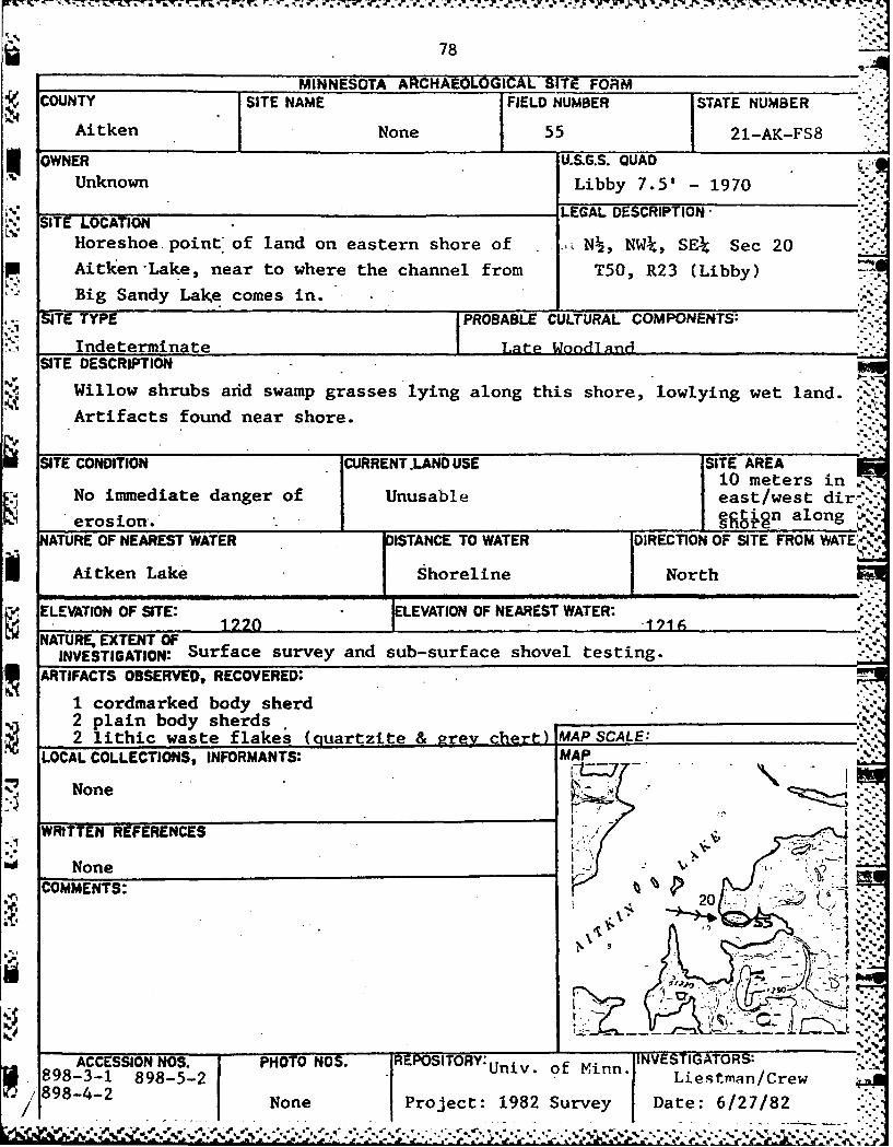
78
MINNESOTA ARCHAEOLOGICAL SITZ FORMCOUNTY SITE NAME FIELD NUMBER STATE NUMBER
Aitken None 55 21-AK-FS8
OWNER U.S.G.S. QUADUnknown Libby 7.5' - 1970
TLEGAL DESCRIPTIONSSITE LOCATION -:Horeshoe point of land on eastern shore of ., N , NWk, SEk Sec 20
Aitken Lake, near to where the channel from T50, R23 (Libby)
Big Sandy Lake comes in.
SITE TYPE PROBABLE CULTURAL COMPONENTS:
Indeterminate Late Woo and1SITE DESCRIPTION
Willow shrubs arid swamp grasses lying along this shore, lowlying wet land.
Artifacts found near shore.
SITE CONDITION CURRENT .LAND USE SITE AREA1 10 meters inNo immediate danger of Unusable east/west dir.-'
erosion. g n along . .
NATURE OF NEAREST WATER DISTANCE TO WATER DIRECTION OF SITE FROM WATE'-i
Aitken Lake Shoreline North
ELEVATION OF SITE: ELEVATION OF NEAREST WATER:
NATURE, EXTENT OFINVESTIGATION: Surface survey and sub-surface shovel testing.
ARTIFACTS OBSERVED, RECOVERED:
1 cordmarked body sherd2 plain body sherds ____
2 lithic waste flakes (quartzite & grey chart MAP SCALE:.__"___LOCAL COLLECTIONS, INFORMANTS: MAP
None
WRITTEN REFERENCES -
None , -""COMMENTS: 2
-" '-" "-- :' , . ,, -..
20
T; z)-)oi
ACCESSION NOS. PHOTO NOS. REPOSITORY:Univ. of Minn. INVESTIGATORS:898-3-1 898-5-2 Lies tman/Crew898-4-2 None Project: 1982 Survey Date: 6./27/82
/ I m .,.o. , ' . .'. -'= .'..-.' ' . '..-t .. .- ., .• . . . - . . .. .._ . ., . . -.: *.e . S. * l , 1 . .- **.
5*d. ***i - l il ~ . i' *****-"*** *******l il-I il I~ll i~ l

Twenty-two additional sites or "potential" site areas were ex-amined and evaluated. The areas examined and our conclusions are listedbelow.
During the survey, the crew inevitably stopped and examined someof the many previously recorded sites. Special mention is made here tothree of these sites.
1. 21 AK 28 - located in the SE of the NE of the NW of Section31, T 50 N., R 23 W. The site consists of 32 mounds- supposedly. The survey crew found only 4 mounds.Either the remaining mounds have eroded off theshore or are now so worndown that they are no longervisible on the surface. Erosion in the area is quiteheavy. No cultural material was found in the shovel-tests made in the area. If these are eroding mounds,an effort should be made to protect the remainingmounds.
2. 21 AK 29 - located in the NE of the NW of the NW- of Section- 32, T 50 N., R 23 W. The site is composed of pre-
historic, protohistoric, and historic burials. It ison BIA land and is eroding quite heavily at the pre-sent time. Plans have apparently been made to rip-rap the shoreline. This remains an important siteon Big Sandy Lake; every effort should be made toprotect it from destruction.
3. 21 AK 25 - This site was examined because it was reported to beone of the few remaining extensive sites in the area.However, the survey crew was unable to locate thesite in the area indicated by Hudak and Ready's re-port. Shovel-testing was begun adjacent to the high-way and continued with tests every 50' until theshoreline was reached. No cultural material was found.
The remaining areas investigated were unverified "find spots"whose location was included in our scope of work statement.
4. Island in NEI, SE , S1i, Sec. 25, T 50 N., R 23 W. One sherd wasonce recovered here. This area is now a bog and inaccessible forsurvey except during low water-levels. Since many sites were pro-bably inundated following the construction of the dam, it is pos-urinsible that a site could occur in this area. It should be checked
during low water-levels.
5. Island in Sl, SW, SW34, Sec. 30, T 50 N., R 23 W. A local collectorhas located material here. The entire island was surveyed, but nocultural material was found. A deserted cabin was the only sign ofhabitation.
80.
' .. . . ..- ''.

.7-20 N7 I W. W -- 74 -5-777. 7.7 77 7 -
6. Knoll in S , SW , NW , NW and Sl, SEP., NW , Sec. 31, T 50 N.,R 23 W. This knoll is located within the confines of Hudak'sfield site number 36. It is of glacial origin and not a culturalfeature.
7. Possible burial mound in NW4, SW34, NWP4, Sec. 34, T 50 N., R 23 W.Two artifacts were also found at this spot. This area has beenheavily disturbed by the widening of County Highway 14. An infor-mant who has lived in the area for 40 years knew of no such mound.
8. Possible small burial mounds at "Frosty" Moore property in Sec. 36,:. T 50 N., R 23 W. These apparent mounds were leveled last year , when
the new owner installed a concrete pad for a mobile home. The sur-vey crew was unable to locate the new owner.
9. Projectile point located on point in N , SEP, NEP4, Sec. 1, T 49 N.,R 24 W. Approximately 600' of shoreline was surveyed on this point.No cultural material was found. According to local residents, thepoint floods annually because of its low elevation. The projectilepoint may have been washed ashore.
10. Island in center of the Nk, NEP4, Sec. 6, T 49 N., R 23 W. Flakescatter has been reported for the island. This is an island thatwas surveyed by Hudak and Ready, and by the 1981 University ofMinnesota fieldschool. No artifacts were found in either survey.A glance at the map at the end of this report will indicate thatthis island was once a raised interior section of a much largerisland before the construction of the dam. It is possible thatartifactual material from now inundated sites occasionally washonto the present shore.
11. Projectile point and skeleton reported in SE , Sec. 7, T 49 N.,R 23 W., at Johnson cabin on point. This area was extensivelysurveyed by the 1981 University of Minnesota fieldschool. This areawas undoubtedly a site at one time, for local collectors reportfinding large amounts of pottery along the shoreline; in fact, itis known as one of the best artifact collecting beaches in the area.However, the ground has been heavily disturbed by the construc- n
tion of a house and the earthen platform on which it was built.Earth was apparently taken from around the house to build the plat-form. Although no artifacts were found during our shovel-testingsurvey, part of the site may still exist under the platform (wherethe skeleton apparently came from); other parts of the site wereprobably destroyed by the rise in lake-level following the construc-tion of the dam. This latter event would explain the large numbersof artifacts found along the present shoreline in the past. L
12. Biface fragment near center of the E , Sec. 9, T 49 N., R 23 W.,approximately 100 meters south of the Schmitt cabin. The shoreline
81"

was walked and shovel-testing performed around the cabin, but noadditional cultural material was found.
13. Possible mound at last cabin on bluff top at the south side of thePrairie River outlet. This possible mound does exist. It is south-east of the cabin and about 9' in diameter. Without partial excava-tion, it is impossible to determine whether this is a cultural fea-ture. No artifacts were found in the area.
14. Possible mounds at Miner's Point in SW4, SW, Sec. 9, T 49 N.,R 23 W. These directions proved confusing. Miner's Point is southof Davis Bay, while the SW of Sec. 9 is at is known as Tower PinesPoint. This latter area is now very heavily developed and no moundsremain - if they did exist here at one time. The present owner,Jerry Sheehan, was not available during the survey.
15. Possible mounds on the Lake Minnewawa Road past the Shamrock Ball-
room, south of Davis Bay. Possible Chippewa cemetery in this area . ;also. These directions are also confusing. The Lake Minnewawa Roaddoes not go near the Shamrock Ballroom - which is not south of DavisBay. More precise directions are needed if possible.
16. Possible site on former gravel road, now a garbage dump across fromthe fire tower on Highway 14. This possible site area was bladed-over about 5 years ago after the dump was closed. No artifacts werefound during a shovel-test survey. The area is highly disturbed.
17. Grooved maul was reportedly found at Perry property on long,narrow, westward projecting peninsula in SW4, NW , NEU, Sec. 18,T 49 N., R 23 W. Shovel-testing did not result in any additionalartifacts being found. The maul seems to have been an isolatedfind. The Perry's no longer own the property.
18. Possible mound in NE . NE , Sec. 19, Y 49 N., R 23 W., on west-ward projecting point. A roughly circular large mound Is presentin this area approximately 75 yards from shore. It is immpossible todetermine whether the mound is cultural without testing. Thispossible mound should be protected until its origin can be deter-mined..>>
19. Numerous artifacts have been found on the shore of the cove alongthe north section line of Sec. 20, T 49 N., R 23 W., particularlyat Kare Phree Pines Resort, and around the Stringham and Hal versoncabins. This area was checked throughly and no cultural materialwas found. Mrs. Stringham gave permission for shovel-testing on herproperty, but again these tests proved sterile. According to locallore, this area is one end of a portage to the lake to the south.
Vaal
5.. 82
p. *. V. . %
8. CONCLUSIONS
The 1982 cultural resources reconnaissance survey of the BigSandy Reservoir not investigated by the Hudak-Ready survey supportsand adds to the conclusions drawn in that earlier survey (Hudak andReady 1978). The most important of these conclusions are listed below:
1. A very large number of sites representing a long time spanoccur or at least once occurred within the reservoir area. As our M
' brief discussion of trends in the culture history of the Headwatersregion' indicated (section B in CHapter 4), the largest numbers ofprehistoric sites date to the Late Prehistoric period. The numbers ofcomponents for the prehistoric period are: Terminal Glacial - EarlyPrehistoric = 6 (all found during the Hudak-Ready survey); MiddlePrehistoric = 5 (4 from the Hudak-Ready survey and 1 from the 1982survey); Late Prehistoric = 27 (19 from the Hudak-Ready survey and 8from the 1982 survey). The numbers of sites associated with historicperiods are: Initial Historic = 1 (from the Hudak-Ready survey); FurTrade = 3 (from the Hudak-Ready survey); Intensive Resource Use period3 (2 from the Hudak-Ready survey and 1 from the 1982 survey);
Recent period = 1 (from the 1982 survey). Sixteen additional siteswere assigned to the Middle-Late Prehistoric period on the basis ofthe presence of ceramics and/or earthen burial mounds (14 from theHudak-Ready survey and 2 from the 1982 survey), and an additional 3sites are associated with one of the historic periods but a more pre-cise assignment could not be made (all from the 1982 survey).
Although no Terminal Glacial - Early Prehistoric period siteswere found during the 1982 survey, the area was occupied during thisperiod. For example, Hudak and Ready (1978) report six xomponentsfrom this period and Old Copper artifacts have been reported by a num-ber of property owners. These latter artifacts have almost alwaysbeen foutd in deeply buried deposits, which suggests that early sitesin the reservoir area may be deeply buried and, therefore, lesslikely to be found through surface survey and shovel-testing. Archaicprojectile points occur in a number of local collections, and parallel-flaked Paleo-Indian projectile points have been reported from near theeastern end of the Savanna Portage (Woolworth 1969:2). As far as wecould determine, all of these points were found along the shorelineor on the surface near other bodies of water than those surveyed.
Although it is difficult to estimate the numbers of earlyperiod sites, a significant rise in numbers of sites almost certainlyoccurred during the Middle Prehistoric and, especiall-, during theLate Prehistoric period.Analysis of the Indian Mound Point site (21AK 7) by the Principal Investigator shows a largely Middle Prehistoricperiod occupation dominated by Brainerd Ware and St. Croix Stampedpottery. In cintrast, the Battle Island site (21 AK 9) has a LatePrehistoric period occupation dominated by Sandy Lake Ware; a small
84R. ]'
* ~ *. -:a *~ * ~ -.~ *~*- ~N .~ %~ -a-.- .%t f~.~.% Ii~ L~4~* . v.-!

U """
amount of Blackduck pottery was also found at this site as well as Idecorated Oneota bodysherd. Ifthese two sites are typical of theirtime periods, then features such asrefuse pits are rare in the area;bone preservation is either very poor or faunal remains occur in verysmall numbers.
It is difficult to evaluate the merits of the focal-diffuse -.model on the basis of the small numbers of artifacts collected duringthe Hudak-Ready and the 1982 surveys. However, a future study of thestone debitage recovered from the sites discovered in the reservoirarea might provide some clues to changing degrees of tool-kit varia-bility over tine. All of the ricing-jigs discovered in the area seemassociated with Sandy Lake Ware or historic Ojibwa occupations. It isprobably fair to conclude that the interpretation of the archaeologicalremains in the area is in an initial phase of development.
2. The construction of the Big Sandy Reservoir dam has significantlydamaged the archaeological resources of the reservoir system. Manysites found during both the Hudak-Ready survey and the 1982 survey pro-bably represent redeposited materials washed ashore from now submergedsites. Map 2 attached to the inside backcover shows the outline of thepre-dam shoreline. This flooding and erosional event would explain thelarge numbers of artifacts once discovered by local collectors alongthe shoreline. A significant number of sites in the reservoir area are,therefore, secondary deposits without significant context. These sitesshould be visited periodically and freshly deposited artifacts collect-ed. The 1982 survey was able to examine all remaining unsurveyed areasof Big Sandy Lake as well as the shorelines of Aitkin and Flowage lakes,and part of the shoreline of Big Sandy River Lake. The shorelines ofthese latter lakes are now covered with extensive beds of marsh. Infact, the southern lakes in the reservoir were largely created by thewidening of the river that flowed through the area following the con-struction of the reservoir dam. Many archaeological sites were pro-bably destroyed in these areas, too.
3. Every effort should be made to protect or investigate the fewremaining sites along the shoreline of the reservoir system that re-tain their primary context. Those sites whose significance could not bedetermined during the 1982 survey should be evaluated as soon as possi-ble.
A number of the major recommendations made in this report thatoncern site preservation are reviewed below:
a. Although most cultural resources surveys are conducted during thesummer months when trained personnel are most readily available, themost efficient time to conduct a reconnaissance survey of reservoir areaswhere the water-level has been significantly raised (such as the BigSandy Reservoir system) is during spring and fall months when the water-level is at its lowest and survey remains possible (e.g., ice does not
85
. .* t.. . - .- ." .4"

* -.' cover the shoreline). While these are the months of maximal site ex-posure, on the negative side these are also periods when land-ownersare difficult to locate in summer resort areas.
b. Of the 15 new sites or find-spots located during the 1982 cul-tural resources reconnaissance survey, no immediate is recommended for14 of them (field numbers 41 - 50 and 52 - 55); one of these sites orfind-spots (field number 51) is threatened with destruction and shovel-testing should be performed when possible to determine whether a Phasetwo survey is necessary. Although no immediate action is recommendedfor 14 of the 15 sites located, a number of them should be shovel-tested-or checked again for newly redeposited materials when possible(these are field numbers 41 - 43 and 45 - 49).
c. An effort should be made to determine whether 21 AK 28 doesconsist of burial mounds that should be protected from further ero-sion. Of a reported 32 mounds, only 4 were located by the survey crew;either the remaining mounds have eroded off the present shore or arenow so worndown that they are no longer visible from the surface. Itis impossible to determine whether these mounds are cultural features -. ,
without excavation or other means of subsurface probing. We should as-sume that they are cultural features until a more precise determinationc an be made.
d. Two historic sites (field numbers 4 and 29) reported by theHudak-Ready survey should be considered for potential nomination tothe National Register of Historic Places. The first is a NorthwestCompany fur post that is threatened by erosion along its eastern edge(other structures associated with this site have already been inun-dated by reservoir waters). The second is 21 AK 29, an historic, proto-historic, and possibly prehistoric burial ground on BIA land. Suffi-cient information now exists on these two sites, that Phase two sur-veys are probably not necessary to make a determination regardingtheir candidacy for nomination to the National Register.
e. Although specific details are not given here, it is recommendedthat a number of the "unverified find spots" be reinvestigated whenpossible (unverified find spot numbers 4, 13, 15, and 18 as listed inChapter 7). More detailed evaluations and recommendations for eachsite, find-spot, or unverified find-spot are contained in Chapter 7.
No specific cost and time estimates are given here to carry outthe recommendations made above. Since immediate reinvestigation is sug-gested for only 2 sites (21 AK 28 and field number 51), this work couldbe incorporated within other projects within the reservoir system; thecultural resources staff at the Corps of Engineers could evaluate thepotential for nomination to the National Register of Historic Places ofthe fur post and 21 Ak 29.
Little attention has been given in this report to historic and
86
,-..-.
architectural cultural resources, for few were encountered. However, asthe Woolworth.(1969) reportindicates, the historic period in the BigSandy Reservoir area was dynamic and in many ways pivotal in the devel- 12opment of post-contact Minnesota as we now know it. The Savannah Portagejust to the east of the reservoir area was for many years a major arteryof traffic into central Minnesota. Legacies of this Fur Trade periodactivity are the Northwest post on Brown's Point (field number 4), thehistoric and protohistoric cemetery on the north edge of Big Sandy Lake(field number 29), and the American Fur Company post (called the AitkinPost) at the confluence of the Mississippi and Sandy rivers. It has beenrecommended that the first two of these sites be considered for potentialnomination to the National Register of Historic Places; although outsideof our survey area, the American Fur Company post also deserves similarconsideration. Investigations by the senior author over the past threeyears of the Savanna Portage, the Northwest post, and the American FurCompany post should bring the importance of these Fur Trade period sites-into greater. prominence.
is to Finally, the St. Paul District of the U.S. Army Corps of Engineersis to be commended for their efforts in the preservation of the prehis-toric and early historic cultural resources of the Big Sandy Reservoirsystem.
%':
-%
'
.87 :
. , _,,_ , . , ..:, .- , ,: :.'..--,: .-- c--..-.--, .,- .--. - ....-.- , .... . .. .* .- . . -.. . -. . . .. -, - .. . . - .-

REFERENCES CITED
Anderson, D. 1979. Laurel Ware. In A Handbook of Minnesota Ceramics.Occasional Publications in Minnesota Anthropology, No. 5, pp. 121-135. Minnesota Archaeological Society, Fort Snelling.
Anfinson, Scott, ed. 1979. A Handbook of Minnesota Prehistoric Ceramics.Occasional Publications in Minnesota Anthropology, No. 5. Minne-sota Archaeological Society, Fort Snelling.
Birk, D. 1977. Two Sandy Lake Ware Vessels from Onigum Point, CassCounty, Minnesota. Minnesota Archaeologist 36(1):9-15.
____. 1979a. Brainerd Ware. In A Handbook of Minnesota PrehistoricCeramics. Occasional Publications in Minnesota Anthropology, No.5, pp. 45-50. Minnesota Archaeological Society, Fort Snelling.
_ 1979b. Sandy Lake Ware. In A Handbook of Minnesota PrehistoricCeramics. Occasional Publications in Minnesota Anthropology, No.5, pp. 175-182. Minnesota Archaeolgical Society, Fort Snelling.
Birks, H.J.B. 1976. Late-Wisconsinian Vegetational History at WolfCreek, Central Minnesota. Ecological Monographs 46:395-429.
1981. Late Wisconsin Vegetational and Climatic History9 at Kylen Lake, Northeastern Minnesota. Quaternary Research 16:322-355.
Bleed, P. 1969. The Archaeology of Petaga Point: The Preceramic Compo-nent. Minnesota Prehistoric Archaeology Series, No. 2.Minnesota Historical Society, St. Paul.
Brower, J.V. 1898. Prehistoric Man at the Head of the Mississippi, inCollections of the Minnesota Historical Society 8:238-239. Min-nesota Historical Society, St. Paul.
____ __ 1901. Kathio, in Memoirs of Explorations in the Basin ofthe Mississippi 4:57-58. St. Paul.
Caine, C. 1979. Malmo/Kern Series. In A Handbook of Minnesota Prehis-toric Ceramics. Occasional Publications in Minnesota AnthropologyNo. 5, pp. 137-141. Minnesota Archaeological Society, FortSnelling.
Center for Environmental Studies. 1973. Environmental Review of theHeadwaters of the Mississippi Reservoir Projects. Bemidji StateCollege (Univ.T.
88

S ~ ~ ~ 7 7 S ..77.tS
Cleland, C. 1977. The Focal-Diffuse Model: An Evolutionary Perspectiveon the Prehistoric Cultural Adaptations of the Eastern UnitedStates. Mid-Continental Journal of Archaeology 1(1):59-76.
Cooper, L., and E. Johnson. 1964. Sandy Lake Ware and Its Distribution.American Antiquity 29:474-479. Salt Lake City. 5
Daniel, G.,.and J. Sullivan. 1981. The North Woods of Michigan, Wiscon-sin, and Minnesota. Sierra Club Books, Sand Francisco.
George, D. 1979. St. Croix Stamped Series. In A Handbook of MinnesotaPrehistoric Ceramics. Occasional Publications in Minnesota Anthro-pology, No. 5, pp. 169-174. Minnesota Archaeological Society,Fort Snelling.
Hart, E. 1964. Map of Big Sandy Lake. Pamphlet Collection, ReferenceLibrary, Minnesota Historical Society, St. Paul.
Hudak, G.J, and T. Ready. 1978. Cultural Resources Inventory of LandsAdjacent to Bia Sandy Lake. Science Museum of Minnesota, St. Paul.
Johnson, E. 1964. Twenty New Radiocarbon Dates from Minnesota Archaeo-logical Sites. Minnesota Archaeologist 26:34-49. Minneapolis.
_ (and others) 1977. Cultural Resources Inventory of LandsAdjacent to Lake Winnibigoshish. U.S. Army Corps of Engineers,St. Paul District.
Lothson, G. 1972. Burial Mounds of the Mille Lacs Lake Area. M.A.thesis, University of Minnesota, Archaeology Laboratory, Minnea-polis.
Lugenbeal, E. 1976. The Archaeology of the Smith Site: A Study of the .4
Ceramics and Culture History of Minnesota Laurel and Blackduck.Ph.D. Dissertation, University of Wisconsin-Madison.
. 1979. Blackduck Ware. In A Handbook of Minnesota Prehis-toric Ceramics. Occasional Publications in Minnesota Anthropology,No. 5, pp. 23-37. Minnesota Archaeological Society, Fort Snelling.
Ojakangas, R., and C. Matsch. 1982. Minnesota's Geology. University ofMinnesota Press, Minneapolis.
Ready, T. 1979a. Onamia Series. In A Handbook of Minnesota PrehistoricCeramics. Occasional Publications in Minnesota Anthropology, No.5, pp. 149-155. Minnesota Archaeological Society, Fort Snelling.
• 1979b. Kathio Series. In A Handbook of Minnesota PrehistoricCeramics. Occasional Publications in Minnesota Anthropology, No.5, pp. 103-107. Minnesota Archaeological Society, Fort Snelling.
89
5,..

Shay, C.T. 1971. The Itasca Bison Kill Site: An Ecological Analysis.Minnesota Prehistoric Archaeology Series, No. 6. MinnesotaHistorical Society, St. Paul.
Steinbring, J. 1974. The Preceramic Archeology of Northern Minnesota.In Aspects of Upper Great Lakes Anthropology, ed. E. Johnson,Minnesota Prehistoric Archaeology Series, No. 11.
and J. Whelan. 1971. Test Excavations at the Fish LakeDam Site. Minnesota Archaeologist 31:3-40.
Stoltman, J. 1971. Prismatic Blades from Northern Minnesota. PlainsAnthropologist 16(52):105-110. Lincoln.
1973. The Laurel Culture in Minnesota. Minnesota Prehis-toric Archaeology Series, No. 8. Minnesota Historical Society,St. Paul.
Watrall, C. 1969. Unpublished report, Minnesota Historical Society,St. Paul.
Wilford, L. 1941. A Tentative Classification of the Prehistoric Cul-tures of Minnesota. American Antiquity*6:231-249.
1953. Unpublished manuscript on Kern site excavations.Wilford Laboratory of Archaeology, University of Minnesota,Minneapolis.
.1955. A Revised Classification of the Prehistoric Culturesof Minnesota. American Antiquity 21:130-142.
Woolworth, N. 1969. Savanna Portage Southwest. Unpublished manuscript,m Wilford Laboratory of Archaeology, University of Minnesota,
, Minneapolis.
Wright, H.E. Jr. 1972. Physiography of Minnesota, pp. 561-578. Quater-"2.'.nary History of Minnesota. In P.K. Sims and G.B. Morey, eds.
Geology of Minnesota, a Centennial Volume. Minnesota GeologicalSurvey, St. Paul.
____ , and W.A. Watts. 1969. Glacial and Vegetational Historyof Northeastern Minnesota. Minnesota Geological Survey, SpecialPublication 11.
9I'
90 .
I:'.
- - -.-- . A- * - - *** - * *f
APPENDIX A
SCOPE OF WORK
CULTURAL RESOURCES INVESTIGATION
OF BIG SANDY RESERVOIRAITKIN COUNTY, MINNESOTA
1.00 INTRODUCTION
1.01 The Contractor will undertake a cultural resources reconnaissancesurvey of the shoreline of Big Sandy Reservoir, Aitkin County, Minnesota.
1.02 This cultural resources inventory is being done in partial fulfill-ment of the obligations of the St. Paul District -agarding cultural re-sources, as set forth in the Historic Preservat4 ,n Act of 1966 (PublicLaw (P.L.) 89-665), the National Environmental Policy Act of 1969 (P.L.91-190), Executive Order (E.O.) 11593 for the Protection and Enhance-ment of the Cultural Environment (Federal Register, 13 May 1971), theArchaeological Conservation Act of 1974 (P.L. 93-291), the AdvisoryCouncil on Historic Preservation "Regulations for the Protection ofHistoric and Cultural Properties" (36 CFR Part 800), the Department ofthe Interior guidelines concerning cultural resources (36 CFR Part 60),and Corps of Engineers regulations. (ER 1105-2-460) "Identification andAdministration of Cultural Resources" (Federal Register, 3 April 1978).
1.03 The above laws establish the importance of Federal leadership,S.. through the various responsible agencies, in locating and preserving
cultural resources within project areas. Specific steps to comply withthese laws, particularly as directed in P.L. 93-291 and E.O. 11593, arebeing taken by the Corps "...to assure that Federal plans and programscontribute to the preservation and enhancement of non-federally ownedlogical significance." A part of that responsibility is to locate, in-
ventory, and nominate to the Secretary of the Interior all such sitesin the project area that appear to qualify for listing on the National
., .. Register of Historic Places.
1.04 The Executive Order further directs Federal agencies "...to as-sure that any federally owned property that might qualify for nomina-
• .tion is not inadvertently transferred, sold, demolished or substantial-ly altered." In addition, the Corps is directed to administer its poli-cies, plans- and programs in such a way that federally and non-federally owned sites, structures, and objects of historical, architec-tural, or archaeological significance are preserved and maintained forthe inspiration and benefit of the people.
1.05 This cultural resources investigation will serve several purposes.
64 92
The report will be a planning tool to aid the Corps in meeting its ob-ligations to preserve and protect our cultural heritage. It will be aI. comprehensive, scholarly document that not only partially fulfillsfederally mandated legal requirements but also serves as a scitnificreference for future professional studies. It will identify siteswhich may require additional investigations and which may have poten-tial for public-use development. Therefore, the report must be analy-tical, not Just descriptive.
* 2.00 PROJECT DESCRIPTION
2.01 Big San'dy Reservoir is located about 120 miles north of the Twin jCities in Aitkin County. Sandy Lake Dam is on the Sandy River 1-1/4miles above the junction of the Sandy and Mississippi Rivers and 264river miles above St. Paul. The dam controls runoff from a 421-squaremile drainage area. The eight natural lakes encompassed in this drain-age area include Sandy, Aitkin, Sandy River, Rat, Flowage, Round,Davis, and Tiesen Lakes.
2.02 With a total storage capacity of 72,500 acre-feet, the lake coversan area of 16.6 square miles at maximum elevation of 1218.31 feet abovemean. sea level. Although the normal operating elevation of the lake is1216.31, during periods of abnormally high inflow storage is utilizedup to the 1218.31-foot elevation. Stored floodwater is released duringthe summer to augment flows in the Mississippi River for water supply,hydroelectric power, and other beneficial uses. Low-flow releases arerestricted to inflow or to State of Minnesota recommended minimums.The dam is controlled by a log sluice, five gated sluices, and onestop-log sluice. A lock, no longer ised for navigation, now serves asan additional outlet controlled by stop logs. :
2.03 Dam construction and subsequent rise of the water level (andassociated water tables) by approximately 9 feet has resulted in a re-servoir area of 16.6 square miles, as compared to the original lakearea of only 8 square miles. This increase is a product of the consid-erable enlargement of Aitkin Lake, Prairie and Sandy River flowages,and also inundation of upland beyond the original Big Sandy shoreline.
2.04 The Federal Government holds fee title to over 1,116 acres of landand flowage easements on another 9,785 acres at Big Sandy Lake. Thoselands presently administered by the Corps of Engineers are located ona narrow strip around the northern perimeter of Big Sandy Lake and onone large tract at the dam structure. In addition, the Bureau of Indian '"Affairs administers two parcels of land.
2.05 The forest vegetation surrounding Big Sandy Lake is principallydeciduous. Elm-ash with some aspen and oak is found at lower eleva-tions associated with marsh habitats. Maple-basswood intermixed withaspen and oak is predomiant. There are almosr no pure pine stands, al-though there are some pine-mixed hardwood communities on the east and so
93
",."..''.' . ,.. ' .,,'.,,.'V ..."." ".. ' ,. °- *' % Y 4I ."

I . -
southeast shore of Big Sandy.
2.06 Aitkin County, in which Sandy Lake is located, is predominantlytill plain with a large outwash area immediately to the northeastcharacterized by surface deposits of sand and gravel. The soil of thetill plain area is brownish and slightly acidic, with pebbles andboulders of granite and gneiss. The shoreline is highly irregular withmoderate on and off-shore grades such that a 1-foot vertical change inthe water level can alter the shoreline 5 to 20 feet horizontally.There are some exceptionally flat areas, but the lake edge is almosttotally uniform in the 5 to 19 percent slope range.
2.07 A cultural resource survey of the shoreline of Big Sandy Reser-voir, including all Corps-owned land, was conducted in 1978. This sur-vey located 35 archaeological sites, the majority of these on Sandy _L_
Lake itself. The results of this survey are detailed in the report en-titled Cultural Resources Inventory of Lands Adjacent to Big Sandy Lakeby G. Joseph Hudak and Timothy L. Ready of the Science Museum of Minne- .sota under contract with the St. Paul District.
3.00 DEFINITIONS
3.01 For the purposes of this study, the cultural resources investi-gation will include a Phase I cultural resources survey. A literatureand records search and review, and Phase II testing will not be con-ducted at this time.
3.02 "Cultural resources" are defined to include any building, site,district, structure, object, data, or other material relating to thehistory, architecture, archaeology, or culture of an area.
3.03 "Literature and records search" is defined as a search for andexamination of written reports, books, articles, files, records, etc.,published and unpublished (found in private, local, State, and Federaldepositories), which are pertinent to the cultural resources investi-gation to be carried out for a particular project. The purposes of theliterature and records search are: to familiarize the Contractor withthe culture history of the study area and past investigations which *.-I
have been carried out in the area; to document the location and condi-tion of known sites which may exist within the project area, the ex-
tent of past work undertaken at the site, and any other informationwhich may be relevant in assessing the significance of the site; andto provide this information in a summarized form to the agency request-ing the search. Although existing data may be extensive, the litera-ture and records search should be as comprehensive as possible in pro-viding a usable body of data for the purposes outlined above.
3.04 "Literature and records review" is defined as the review andevaluation of the pertinent literature and records examined under sec-tion 3.03. The purpose of the literature and records review is to pro-
94
' '' "' '7" . 's *.CI :¢;J ~ :S:.:A,; ;; .P*> *2;4. ° :. . .;.-..--, -.-- , ,.

. . . . . . .... . . . . . . . . . . . -. ,
vide the sponsoring agency with the Contractor's professional opinion asto the qua ity, nature, and extent of the sources identified in the lit-erature and records search (see section 5.11). ; I
3.05 "Phase I cultural resources survey" is defined as an intensive, on-the-ground survey and testing of an area in order to determine the num-ber and extent of the archaeological, historic, and architectural re-sources present and their relationship to all the project alternativesand features. A Phase I cultural resources survey will result in dataadequate to assess the general nature of all sites present; a recommen-dation for additional testing of those resources which, in the profes-sional opinion of the Contractor, may provide important cultural andscientific information; and detailed time and cost estimates for PhaseII testing. -3.06 "Phase II testing" is defined as the intensive testing of thosesites which may provide important cultural and scientific information. .Phase II testing will result in data adequate to determine the eligi-bility of the resources for inclusion on the National Register of His-toric Places, a plan for the satisfactory mitigation of eligible siteswhich will be directly or indirectly impacted, and detailed time andcost estimates for mitigation. Phase II testing will not be conductedunder this contract.
4.00 SURVEY SPECIFICATIONS
4.01 The Phase I cultural resource survey will include those landsalong the shoreline of Big Sandy, including all islands, not previouslysurveyed as shown on the inclosed map. (See Map 2 attached to the back-cover)
4.02 If time and funds allow, a Phase I cultural resource survey willinclude the shoreline of Aitkin Lake, approximately 13 miles.
4.03 The area to be surveyed will include all lands within 50 metersof the water's edge.
4.04 In those areas of shoreline with evidence of erosion, the surveywill include all lands from the water's edge to 50 meters inland fromthe edge of the eroded bank. .
4.05 All islands not previously investigated will be surveyed in theirentirety.
4.06 The following two known sites will be field checked to determinesite type and condition:
a. 21 AK 28 - located in the SE4, NEP , NW4, Sec. 31, T. 50 N.,R. 23 W. Site consists of 32 low mounds.
95
S.* ' - .- -. ~~S . - . * . . , * ]

b. 21 AK 29 - located in the NEP, NW4, NW-•, Sec. 32, T. 50 N.,R. 23 W. Site consists of prehistoric, protohistoric and historicgburials.4.07 An attempt will be made to locate in the field the following un-verified find spots:
a. Island in NE , SE , SE , Sec. 25, T. 50 N., R. 24 W. Onesherd recovered.
b. Island in S , SWP, SWP, Sec. 30, T. 50 N., R. 23 W. A localcollector has located material here.
c. Knoll in S11, SW , NW4, NW4m and S-, SE , NW., NW , Sec. 31,T. 50 N., R. 23W.
d. Possible burial mound in NW4, SW), NWP, Sec. 34, T. 50 N.,R. 23 W. Two artifacts recovered here also.
e. Possible small burial mounds at "Frosty" Moore property inSec. 36, T. 50 N., R. 23 W.
f. Projectile point located on point in N , SE , NE , Sec. 1,- T. 49 N., R. 24 W.
g. Island in center of the N3, NE , Sec. 6, T. 49 N., R. 23 W.* Flake scatter.
h. Projectile point and skeleton reported in SE , Sec. 7,T. 49 N., R. 23 W., at Johnson cabin on point.
i. Biface fragment near center of the E , Sec. 9, T. 49 N.,R. 23 W., approximately 100 meters south of Schmitt cabin.
J. Possible mound at last cabin on bluff top at the south sideof Prairie River outlet.
k. Possible mounds on Miner;s Point in SE4, SWk, Sec. 9,T. 49 N., R. 23W.
1. Possible mounds on the Lake Minnewawa Road past the ShamrockBallroom, south of Davis Bay. Possible historic Chippewa cemetery inthis area also.
m. Possible site on former gravel road, now garbage dump acrossfrom the fire tower on Highway 14.
n. Grooved maul was reportedly found at Perry property on long,narrow westward projecting peninsula in SW4, NWk, NE , Sec. 18,
96 6
,* .-

T. 49 N., R. 23 W.
o. Possible mound in NE4, NE , Sec. 19, T. 49 N., R. 23 W., onwestward projecting point.
p. Numerous artifacts have been found on the shore of the covealong north section line of Sec. 20, T. 49 N., R. 23 W., particularly atKare Phree Pines Resort, Stringham and Halverson cabins.
q. The following known site, 21 AK 25, will be field checked todetermine site type and condition.
5.00 PERFORMANCE SPECIFICATIONS
5.01 The Contractor will utilize a systematic, interdisciplinary ap-proach in conducting the study. The Contractor will provide specializedknowledge and skills during the course of the study to include expertisein archeology, history, architectural history and other social andnatural sciences as required.
5.02 The extent and character of the work to be accomplished by the Con-tractor will be subject to the general supervision, direction, control,review and approval of the Contracting Officer.
5.03 Techniques and methodologies that the Contractor uses during theinvestigation shall be representative of the current state of knowledgefor their respective disciplines.
5.04 The Contractor shall keep standard records which shall include,but not be limited to, field notebooks, site survey forms, field maps,and photographs.
5.05 The recommended professional treatment of recovered materials iscuration and storage of the artifacts at an institution that can pro-perly insure their preservation and that will make them available forresearch and public view. If such materials are not in Federal owner-ship, the consent of the owner must be obtained, in accordance with ap-plicable law, concerning the disposition of the materials after comple-tion of the report. The Contractor will be responsible for making cura-torial arrangements for any collections which are obtained. Such ar-rangements must be coordinated with the appropriate officials of Minne-sota and approved by the Contracting Officer.
5.06 When sites are not wholly contained within the study area, theContractor shall survey an area outside the study area limits large
"* enough to include the entire site boundaries and to determine the de-gree to which the site will be impacted.
5.07 The Contractor shall provide all materials and equipment as may benecessary to expeditiously perform those services required of the study.
.5,"
.5 .. .- .. . . . ...... %

J W . W., w-; P-U R VjL 7j~. - * -
5.08 Should it become necessary in the performance of the work and.;-services, the Contractor shall, at no cost to the Government, secure therights of ingress and egress on properties not owned or controlled by theGovernment. The Contractor shall secure the consent of the owner, hisrepresentative, or agent, in writing prior to effecting entry on suchproperty. If requested, a letter of introduction, signed by the DistrictEngineer, can be provided to explain the project purposes and requestthe cooperation of landowners. Where a landowner denies permission forsurvey, the Contractor shall immediately notify the Contracting Officer -and shall describe the extent of the property to be excluded from the nosurvey.
Phase I Survey
5.09 The on-the-ground examination will involve an intensive survey andsubsurface informal testing of the area in order to determine the totalnumber and extent of cultural resources present. This includes standingarchitectural structures as well as historic and prehistoric archeologi-cal sites.
5.10 The survey shall include surface inspection in areas where surfacevisibility permits adequate recovery of cultural materials and subsur-face testing where surface visibility is limited. Subsurface investigationwill include shovel testing, coring, soil borings, or cut bank profiling,where necessary and appropriate.
'"I 5.11 The recommended grid or transect interval is 15 meters (50 feet).However, this interval may vary depending upon field conditions. If therecommended interval is not used, justification should be presented forselection of an alternate interval. All subsurface tests will be screen-ed through 1/4-inch mesh.
95.12 The tested areas will be returned as closely as practical to pre-survey conditions by the Contractor.
6.00 GENERAL REPORT REQUIREMENTS 1"
6.01 The Contractor will submit the following types of reports, whichare described in this section and in section 9.00: field report, fieldnotes, draft contract report, and a final contract report.
6.02 The Contractor's technical report shall include, but shall not belimited to, the following sections as appropriate to the study.
a. Title Page: The title page shall provide the following infor-mation: the type of investigation undertaken; the cultural resourceswhich were assessed (archeological, historical, and architectural); theproject name and location (county and State); the name of the author(s)..,"and/or Principal Investigator; the signature of the Principal Investiga-
p-,
~* 98 .:
* .. '"-" .. '" ... *5,%. . ... ,:.S. .. . . . b ** Ih ~ 1- . ,.,ftq' -- xru : wm. ,., -'v q Lq.m k .. r

tor; and the agency for which the report is being prepared.
b. Abstract: An abstract of findings, conclusions, and recom-mendations. This should not be an annotation.
c. Management Summary: This section will include a concise sum-mary of the study, which will contain all essential data for using thedocument in the Corps of Engineers management of the project. This in-formation will minimally include: why the work was undertaken and who thesponsor is, a brief summary of the scope of work and budget, summary ofthe study (field work; lab analysis; literature and records search andreview, including the National Register of Historic Places, dates check-ed, and results), study limitations, study results, significance, re-commendations and the repository of all pertinent records and artifacts.
d. Table of Contents
e. List of Figures
f. List of Plates
g. Introduction: This section shall identify the sponsor (Corpsof Engineers) and the sponsor's reason for the study; provide an over-view of the archeological/historical study to be undertaken; define thelocation and boundaries of the study area (with regional and area-specific maps); define the study area within its cultural, regional, and -
environmental context; reference the scope of work; identify the insti-tute that did the work, the number of people involved in the study, thenumber of person-days/hours utilized during the study; identify thedates when the various types of work were completed; identify the repo-sitory of records and artifacts; and provide a brief overview or out-line of how the study report will proceed and an overview of the majorgoals that the study/study report will accomplish.
h. Environmental Background: This section shall include a des-cription of the study area and regional environment, including the fol-lowing categories: geology, vegetation, fauna, climate, topography,physiography, and soils, with reference to prehistoric, historic, ethno-graphic, and contemporary periods. Any information available on the the -relationship of the environmental setting to the area's prehistory andhistory shall be included. This section shall be of a length commen-surate with other report sections.
i. Theoretical and Methodological Overview: This section shallinclude a description or statement of the goals of the Corps of Engi-neers and the study researcher, the theoretical and methodologicalorientation of the study, and the research strategies that were applied -,in achieving the stated goals.
Le
99
6g.1 *~*~** *-.*. . . . . . . . . .
P.=.Co.I *

712
j. Field Methods: This section will describe specific archeo-logical and historical activities that were undertaken to achieve thestated theoretical and methodological goals. The section shall includeall field methods, techniques, strategies, and rationale or justifica-tion for specific methods or decisions. The description of the fieldmethods shall minimally include: a description of the areas surveyed, Isurvey conditions, topographic/physiographic features, vegetation con-ditions, soil types, stratigraphy, survey limitations, survey testingresults with all appropriate testing forms to be included as an ap-pendix (e.g., shovel tests, coring, cut bank profiles, etc.), degreeof surface visibility, whether or not the survey resulted in the loca-tion of any cultural resources, the methods used to survey the area(pedestrian reconnaissance, subsurface test, etc.), the rationale foreliminating uninvestigated areas, the estimated size of the investi-gated sample and its relationship to the sample universe (e.g., 100acres were surveyed, representing 15 percent of the project impactarea), and the grid or transect interval used. Testing methods shallinclude descriptions of text units (size, intervals, stratigraphy,depth) and the rationale behind their placement.
k. Analysis: This section will describe and provide the ra-tionale for the specific analytic methods and techniques used, anddescribe and discuss the qualitative and quantitative manipulation of -.the data. Limitations or problems with the analysis based on the datacollection results will also be discussed. This section shall alsocontain references to accession numbers used for all collections,photographs, and field notes obtained during the study, and the loca-tion where they are permanently housed.
1. Investigation Results: This section will describe all thearcheological and historic resources encountered during the study,and any other data pertinent to a complete understanding of the re-sources within the study area. This section shall include enough em-pirical data that the study results can be independently assessed. Thedescription of the data shall minimally include: a description of thesite; amounts and type of material remains recovered; relation of thesite or sites to physiographic features, vegetation and soil types,project alternatives, and direct and indirect impact areas; analysisof the site and data (e.g., site type, cultural historical componentsand information, cultural/behavioral inferences or patterns); sitecondition; and location and size information (elevation, completequad map source, legal description, address if appropriate, and site .
size, density, depth, and extent). The information shall be presentedin a manner that can be used easily and efficiently by the Corps ofEngineers. This site information shall be presented with each sitediscussed on a separate page/pages and the site location indicated ona USGS map. If a site location has not been field-verified, the Con-tractor must indicate the approximate area on the map and indicate thatit has not been verified, or give an explanation why the site cannot be
1%

located on a map. An example of this site description format follows:
Site Number and Name
Complete Legal Description: Township, Range, Section,County or Address, if appropriate. Indicate if the site hasbeen field-verified or not, when and by whom.
Complete USGS Quadrangle Reference: Quad name, Quad size,all Quad dates.
Report Figure/Map/Plate Reference
.Accession Nunbers
Site Type, Site Reports, Investigations of Dates
Cultural Affliation (with dates or date estimates)
Environmental Descriptions: Briefly, to include topogra-phy, physiography, soils, and vegetation.
Site Description
Present Site Condition: Disturbed, undisturbed, vegeta-tion, soils, and surface material.
Site Significance: As reported by others and the Con-tractor's evaluation, including an evaluation of previousconclusions.
Impacts: Evaluate the direct and indirect impacts affect-ing the site.
Recommendations: Management recommendations, future
archeological/his toric work recommendations.
Remarks: For comments with no other category.
Pertinent Bibliographic References
The location of all sites and other features discussed in the text willbe shown on a legibly photocopied USGS map and will be bound into thereport. Maps shall also be included showing the relationship of sites to -the project areas which were surveyed. In addition, the project map willshow those areas that have been eliminated from the survey due to un-acceptable survey conditions. Maps should also show the type of surveymethod employed for each area surveyed (for example, pedestrian walk-over, shovel tests). All maps will be labeled with a caption/description,a north arrow, a scale bar, township, range, map size, and dates, and
.101
.. . ¢e ' :'.*... . . . ;.; .. ,-..., -,.- .-.-.... ... ,_,. ,," : . F ,,

the map source (e.g., the USGS quad name or published source) and willhave proper margins. All sites will be recorded on the appropriateState site forms. Inventoried sites shall include a site number. Of-ficial site designations assigned by an appropriate State agency arepreferred. However, if temporary site numbers will be used in either .. ,the draft or final reports, they shall be substantially different fromthe official site designations to avoid confusion or duplication ofsite numbers. Known sites shall have their State site forms updated asnecessary.
m., Evaluation and Conclusions: This section shall evaluate andformulate conclusions concerning site/sites location, density, size,condition, distribution, and significance in relation to the localand regional archeology and history. This section shall also discussthe potential and goals for future research. The section shall alsodiscuss the reliability of the analysis or other pertinent data re-covered (e.g., site locations, types, distribution, etc.); relate re-sults of the study and analysis to the stated study goals; identifychanges, if any in the research goals; synthesize and compare the re-sults of the analysis and study; integrate ancillary data; and identifyand discuss cultural/behavioral patterns and processes that are in-ferred from the study and analysis results.
n. Recommendations: This section shall discuss the direct andindirect impacts affecting the area's cultural resources with specificmanagement recommendations on all previously recorded and newly dis-covered sites; discuss the significance of sites to the extent per-mitted by the study level in relation to the research goals establishedin the study; make recommendations on the potential eligibility of thesites to the National Register of Historic Places' recommend futureintensive level research priorities and needs; and make suggestionswith regard to the Corps of Engineers planning goals. These recommen-dations shall include a time and cost estimate. If it is the Contrac-tor's assessment that no significant resources exist in the study area,the methods of investigation and reasoning which support that conclu- -
sion will be presented. If certain areas are not accessible, recommen-dations will be made for future consideration. Any evidence of culturalresources or materials which have been previously disturbed or des-troyed will be presented and explained.
o. References: This section shall provide standard bibliogra-phic references (American Antiquity format) for every publicationcited in the report. References not cited in the report will be listed ...in a separate "Additional References" section.
p. Appendix: This section shall include the Scope of Work; re-sumes of all personnel involved; all correspondence derived from thestudy; all State site forms; all testing and any other pertinent re-port information referenced in the text as being included in the ap-pendix.
102
6.03 Failure to fulfill these report requirements will result in therejection of the report by the Contracting Officer.
7.00 FORMAT SPECIFICATIONS
7.01 The Contractor shall submit to the Contracting Officer the photo-graphic negatives for all black and white photographs which appear inthe final report.
7.02 All text materials will be typed, single-spaced (the draft reportsshould be space-and-one-half or double-spaced), on good quality bondpaper, 8.5 inches by 11.0 inches, with a 1.5-inch binding margin on theleft, 1-inch margins on the top and right, and a 1.5-inch margin at thebottom, and will be printed on both sides of the paper.
7.03 Information will be presented in textual, tabular, and graphicforms, whichever are most appropriate, effective, or advantageous tocommunicate the necessary information.
7.04 All figures and maps must be clear, legible, self-explanatory, andof sufficiently high quality to be readily reproducible by standard xero-graphic equipment, and will have margins as defined above.
7.05 The final report cover letter shall include a budget of the pro-ject.
7.06 The draft and final reports will be divided into easily discerni-ble chapters, with appropriate page separation and heading.
8.00 MATERIALS PROVIDED
8.01 The Contracting Officer will furnish the Contractor with the fol-lowing materials:
a. Access to any publications, records, maps, or photographsthat are on file at the district headquarters.
b. Two sets of USGS Quadrangle maps of the project area. One setwill be used as field maps, and one set will be returned to the Corpsof Engineers designating site numbers and locations, and areas surveyedand tested.
c. A letter of introduction signed by the St. Paul District En-gineer explaining the objectives of the work and requesting cooperationfrom private landowners, if requested.
9.00 SUBMITTALS
9.01 The Contractor will submit reports according to the followingschedules:
1 103
KV-117°" Jh ]
a. Field Report: The original and one copy of a field report willbe submitted after completion of the field work. The field report willsummarize the work, project/field limitations, methodology used, timeutilized, and survey results.
! b. Project Field Notes: One legible copy of all the project field
notes will be submitted with the draft contract report.
c. Draft Contract Report: The original and 10 copies of the draft --
contract report will be submitted on or before days after contract
award. The draft contract report will be reviewed by the Corps of En-gineers, the State Historic Preservation Officer, the State Archeologist,and the National Park Service. The draft contract report will be sub-mitted according to the report and contract specifications outlined inthis Scope of Work.
d. Final Contract Report: The original and 15 copies of the finalc/ntract report will be submitted 60 days after the Corps of Engineerscomments on trie draft contract report are received by the Contractor.The final contract report will incorporate all the comments made on thedraft contract report.
e. Site Forms: All completed State site forms will be submittedto the appropriate State agency.
9.02 Neither the Contractor nor his representative shall release anysketch, photograph, report, or other material of any nature obtained orprepared under the contract within specific written approval of theContracting Officer prior to the acceptance of the final report by theGovernment. After the Contracting Officer has accepted the final report,distribution will not be restricted by either party except that datarelating to the specific location of extant sites will be deleted indistributions to the public.
10.00 METHOD OF PAYMENT
10.01 Requests for partial payment under this fixed price contractshall be made monthly on ENG Form 93. A 10 percent retained percentagewill be withheld from each partial payment. Upon approval of the finalreports by the Contracting Officer, final payment, including previouslyretained percentage, shall be made.
104,Ib'

NANE:
PHONE:
EDUCATION:
APPENDIX B Curriculum Vitae of Contractor
Autumn 1983
Gibbon, Guy Edward
612-926-3305 (home) 612-376-3256 (office)
Kenyon College, Gambier, Ohio 1957-1959 University of Wisconsin-Madison 1959-1960,
B.S. degree in Anthropology, June 1964 University of Wisconsin-Madison 1964-1969
M.S. degree in Anthropology, June 1966 Ph.D. de·gree in Anthropology, August 16,
1963-1964
1969
AREAS OF INTEREST:
POSITIONS HELD:
Cultur~ Change. History and Philosophy of Archaeology. Archaeological theory with an emphasis on for~al theory construction, explanation, and the relationships between mathematical modelling and theory construction. PostPleistocene North America. Post-Pleistocene western and central Europe.
Visiting Assistant Professor of Anthropology, University of Illinois, Urbana-Champaign, 1969-1970, summer 1970.
Assistant Professor of Anthropology, University of Illinois, Urbana-Champaign, fall 1970 through summer 1972.
Visiting Assistant Professor of Anthropology, University of Wisconsin-Milwaukee, fall 1972 through summer 1973.
Visiting Assistant Professor of Anthropology, University of Minnesota, summer 1972.
Assistant Professor of Anthropology, University of Minnesota, fall 1973 through June 1976.
Associate Professor of Anthropology, University of Minnesota, June 1976 through the present date.
Acting Director, Center for Ancient Studies, University of Hinnesota, summer 1981 through th~ present date.
105
.... .. ....
. •. •.. ·-,._
._.
"J' • J'.
il
:·~ .. . _.
-~ .. -· .... "'· . . . . .. .
--. . . . ..
. . . . . . . . . ·.
!,j .. ··.

Bibliography-
1970 "A Brief History of Oneota Research in Wisconsin." In Wisconsin
Magazine of History 53(4): 278-293. Madison.1970 "The Midway Village Site." In The Wisconsin Archaeologist 51(3):-' ' 79-162. Milwaukee. . ...-..
1971 "The Bornick Site: A Grand River Phase Oneota Site in MarquetteCounty." In The Wisconsin Archaeologist 52(3): 85-137. Milwaukee.
1971 Review of:. Johnson, The Prehistoric Peoples of Minnesota; Wilford,Johnson, and Vicinus, Burial Mounds of Central Minnesota; Wilford,Burial Mounds of the Red River Headwaters; Bleed, The Archaeologyof Petaga Point. In American Antiquity 36(1): 123-124. Salt LakeCity.
LA 1972 "Cultural Dynamics and the Development of the Oneota Life-Way inWisconsin." American Antiquity 37(2): 166-185. Salt Lake City.
1972 "The Walker-Hooper Site: A Grand River Phase Oneota Site in GreenLake County." In The Wisconsin Archaeologist 53(4): 149-290.Milwaukee.
1972 Review of: Dale R. Henning, "Development and Interrelationships ofOneota Culture in the Lower Missouri River Valley." The MissouriArchaeologist 32 (1970). In Plains Anthropologist 17(56): 161-162.
1973 The Sheffield Site: an Oneota Site on the St. Croix River. MinnesotaPrehistoric Archaeology Series No. 10. 62 pages. Minnesota HistoricalSociety. St. Paul.
1974 "A Model of Mississippian Development and Its Implications for theRed Wing Area." In Aspects of Upper Great Lakes Anthropology, EldenJohnson (ed.), pp. 129-137. Minnesota Prehistoric Archaeology Series
No. 11. Minnesota Historical Society. St. Paul.
1974 Review of: Raymond B. Chaplin, The Study of Animal Bones fromArchaeological Sites. 1971. Seminar Press. In American Journalof Physical Anthropology 40(1): 107-108.
1974 "Archaeological Survey of the Sibley County Generating Plant Site."Ms. Northern States Power. 6 pages.
1975 "The Brower Site: A Middle Woodland Mound and Camp Site on LakeOnamia." In The Minnesota Archaeologist 34(1 and 2): 1-43. St. Paul.S..
1975 "The Crace Site: A Late Woodland Special Activity Site on Lake Onamia."In The Minnesota Archaeologist 34(3 and 4): 49-70. St. Paul.
106 .,
p'... ~p . . .~ *~* .~ ~ , ,q,2

Bibliography -.
1976 "Archaeology and Prehistory, North America." In Dictionary of AmericanHistory, pp. 154-158; also short topic articles on pp. 11, 83-84, 117,289, 300, 319-320, 334, 352-353, 370, 382-383, 385-386, 402-403, and 484.Scribner's Sons, New York.
1976 "The Use of Taxonomic Aids in the Hierarchic Grouping of Ceramics."Canadian Archaeology Abroad, P.L. Shinnie et al. (eds.), pp. 251-260.Calgary.
1976 "The Old Shakopee Bridge Site: A Late Woodland Ricing Site on ShakopeeLake." In The Minnesota Archaeologist 35(2): 1-56. St. Paul.
1976 Review of: Marshall McKusick, The Grant Oneota Village. Report No. 4,Office of the State Archaeologist, University of Iowa. 1973. In PlainsAnthropologist 21(71): 78-80.
1977 Prehistoric and Historic Archaeological Sites Survey of Voyageurs NationalPark. Ms. National Park Service. 353 pages.
1978 Spring Shoreline Survey of Voyageurs National Park. Ms. National ParkService. 53 pages.
1978 "A Simplified Algorithm Model for the Classification of Silvernale and
Blue Earth Phase Ceramic Vessels." In Some Studies of.-Minnesota Pre-historic Ceramics: Papers Presented at the First Council for MinnesotaArchaeology Symposium, 1976. Occasional Publications in Minnesota An-thropology No. 2. Minnesota Archaeological Society. St. Paul, pp. 3-11.
1979 The Mississippian Occupation of the Red Wing Area. Minnesota PrehistoricArchaeology Series No. 13. Minnesota State Historical Society, St. Paul.Microfiche.
1980 "The Middle to Late Woodland Transition in Eastern Minnesota," with ChristyA.H. Caine. Midcontinental Journal of Archaeology Yol. 5(1).: 16 pp.
1980 An Archaeological Survey of Nobles, Pipestone, and Rock Counties, Minnesota.Unpubl. Ms. Minnesota State Historical Society. 85 pp.
1981 Review of: Archeology and a Science of Man by Wilfred T. Neill. Columbia 4
University Press (1978). British Journal for the Philosophy of Science 32:106-109.
1981 Test Excavations at the Gideon Pond Historic House Site. 29 pp. Unpubl.Ms. The City of Bloomington, Minnesota.
1981 Phase I Cultural Resources Survey, Battle Creek Project I. 45 pp.Unpubl. Ms. Ramsey-Washington Metro Watershed District. Minnesota.
107
40 ,r -y

1981 One Hundred Years of Upper Midwest Archaeology. Upper Midwest History 7Vol. 1, pp. 41-53.
the Eastern United States. T. Emerson, editor. In press. .*.*
I %
.4.
1982 The Blue Earth Phase in Southern Minnesota. Journal of Iowa Archaeology.
Monograph. In press.
, 1983 Archaeological Reconnaissance of Big Sandy Lake, Minnesota. With TerriLeistmann. U.S. Army Corps of Engineers, St. Paul. Unpublished manu-script.
1983 Prairie Archaeology. Editor. University of Minnesota Publications inAnthropology No. 3. 170 pages.
1983 "First-Step" Settlement Subsistence Models for the Rock River Drainagein Southwestern Minnesota. In Prairie Archaeology, G. Gibbon editor,pp. 131-149. With Homer Hruby.
1983 Oneota Studies. Editor. University of Minnesota Publications in Anthro-pology No. 1. 122 pages.
1983 Oneota Origins Revisited. In Oneota Studies, G. Gibbon, editor, pp.85-89.
°.5* .
1983 Positivism and the New Archaeology. Paper submitted to American An-tiquity.
1983 Classical and Anthropological Archaeology: A Coming Rapproachement?In Studies in Aegean Archaeology, edited by William Coulson and NancyWilkie. University of Minnesota Publications in Ancient Studies, Vol. 1.
193In press.
1983 The Mississippian Presence in Minnesota. With Clark Dobbs. In Mississi-ppian Complexes in the Eastern United States. T. Emerson, editor. Inpress. - .
.-5
1983 Anthropological Archaeology. Columbia University Press. Scheduled forpublication early fall 1984.
108

17 1
4 24
30 2421
33 34 .35~
t"
4"4
-' - . ,-/-*' 1NUEA,'
2Amt AMCNP~GE.4 . I
el- dIle AO K
'F~~~1 1 'CLUULASUC ICMASA-1--4 -1SITELOCAIOH
tv Ap Z, . .ggCTO
-. ~ 4~.u,: > ~ I - -- jF~y-:~ I - MI ARM CO RPS geor lu 1*tIU19 106l
l'~~** F Ess:"V aYft - ' @, SAVOYI~ geII I '
SCNNISA0,
. . . . . . . . . . . . . . . . . . . . . . .. . . .
SIT LOAIN