survey of the united states mexico boundary- 1849 …
TRANSCRIPT
v r; J 0; 3 o ; L> -17
SURVEY OF THE UNITED STATES
MEXICO BOUNDARY-1849-1855
Background Study By
LENARD· E. BROWN
DIVISION OF HISTORY
Office of Archeology and Historic Preservation
May 1, 1969
U.S. DEPARTMENT OF THE INTERIOR National Park Service


PREFACE
This study of the survey of the boundary line between Mexico
and the United States from 1849 to 1855 was prepared in accordance
with the Historical Resource Study Proposal CHAM-H-la. This called
for a gathering of documentary and graphic evidence of the boundary
survey to aid in the preparation of an interpretive film to be used
at Chamizal National Memorial.
Chapter 5 of this report was prepared to fulfill the requirements
of His.torical RSP CHAM-H-1 •. Originally it was· intended to clarify
the details of the meeting between Capt. E. L. F. Hardcastle and
Seller Francisco. Jiml!nez that marked the completion of the California
boundary survey.· This information was to be the basis of a dioram.a
and possibly form a part of a motion picture script. Historical research
revealed that the story as originally conceived had to be modified
almost completely. The new vers~on contained in the fifth chapter of
this report ought to be of paramount concern in the development of certain
interpretive features at Chamizal National Memorial.
i

TABLE OF CONTENTS
Preface
Table of Contents
Acknowledgments
List of Illustrations
To Designate the Boundary Line with Due Precision
A Most Singular Country
Discontent and Disorder
The Unfortunate, The Miserable; and The Treacherous
The Prolongation of the Line
Sources for Illustrations
Appendix I
Bibliography
Illustrations following page
ii
PAGE
i
ii
iii
v
1
38
68
107
148
172
176
198
202

ACKNOWLEDGMENTS
In the beginning the story of the original survey of the Mexican
American boundary appeared to be the most challenging report that I
had undertaken in my brief time with the Division of History. It
proved to be one of the most rewarding also. More importantly it
provided me with the chance to work in the excellent Western Americana
Collection of Yale University, the John Russell Bartlett Collection
at Brown University, and of course the extensive resources of the
National Archives. The research represented also a return to the
history of the Southwest, after an absence of several years.
Many people contributed to preparation of this report. Mr.
Archibald Hanna of the Western Americana Collection at the Beinecke
Library, Yale University, provided most considerate help both during
my stay and after my return to Washington. Miss Joan Hofmann fulfilled
the highest standards in assisting me during my work at Yale and in
processing the order for xeroxing of certain materials from the W. H.
Emory Papers. Mr. Thomas Adams and Mrs. Hardy of the John Carter
Brown Library at Brown University provided both aid and hospitality
during the ten days that I worked in the Bartlett Papers. Finally
the staff of the National Archives, and especially Miss Mary Johnson,
provided so much help during my work there.
iii

To several members of the Division of History I owe a special
thank you. They suffered nearly as many hardships during the writing
of this report as the original surveyors did in marking the boundary.
To Ed Bearss, John Bond, Erwin Thompson, Ben Levy, and Anna Toogood,
a sincere thank you for your patience and understanding. Chief
Historian Robert M. Utley gave extensively of his knowledge and time
to aid in solving one particularly thorny problem. Frank B. Sarles
read the manuscript and discovered the many sins of style and grammar.
Last, but certainly not least, a bow to Dorothy Junkin, who patiently
transformed the rough draft into the final product you hold in your
hands.
It could be.assumed that with such a large number of able
assistants the report would be without error. Such is not true; and
I alone am responsible for the errors it contains.
iv

Plate No:
LIST OF ILLUSTRATIONS
1. Outline Map of the Borderlands
2. Monument at Initial Point on the West bank of the Rio Grande
3. View from Monument number 3 in 1855
4. Photograph of same general area in the 1890s
5. Monument number 11 southwest of Potrillo Mountains
6. Looking west along the boundary from the Rio San Pedro, 1855
7. Photograph looking west from the Rio San Pedro, 1895 ca.
8. Looking east from the Sierra del Pajaritos toward Nogales, 1855.
9. Same view forty years later.
10. Looking east from the east ridge of the Sierra de la Nariz
11. Photograph to the northwest on the spur of the Nariz Mountains
12. Lesna Moun_tain located north of the border a.nd west of Tecolate Valley .
. 13. Sketch of monument near Quitobacquita Springs showing four tYPes of cacti.
14. Looking west from Monument near Quitobaquita Springs in 1890s..
15. Sketch showing the rugged terrain of the Sierra del Tule east of the Colorado River.
v

16. Monument on the crest of the Tule Mountains, 1890s.
17. Sketch showing view to the west from the Sierra Tinajas ALTAS in 1855.
18. Photograph looking west from the same area as in plate 17.
19. The Yuma Desert in 1890s
20. On the Colorado Desert, 1895 ca.
21. Monument east of New River, 1895 ca.
22. Monument to the west of New River
23. Rugged terrain of the mountains west of the Colorado Desert
24. The steadfast mule
25. Initial monument on the Pacific.
26. The Church and Plaza of El Paso del Norte in 1852.
27. Rio Salado of Mexico before it joins the Rio Grande.
28. Junction of the Rio Grande and Pecos Rivers.
29. Northernmost canyon in the big bend of the Rio Grande.
30. Lipan Apache Warrior.
31. Three Yuma Indians on the Colorado River.
32. Papago women harvesting Saguaro fruit.
33. Sketch and description of Pima House from Bartlett's "Personal Journal."
34. Drawing of the Guadalupe Mountains from Bartlett Collection.
35. Duape, Sonora. Drawing in Bartlett Collection.
36. Water color of Santa Rita del Cobre.
vi

37. Camp on the Gila above Fort Yuma. Sketch.from the Bartlett Collection.
38. Water color of the Case Grande ruins in Arizona.
39. The Santa Cruz valley
40. Tucson Arizona in 1852. Drawing in the Bartlett Collection.
41. Mission San Xavier del Bac south of Tucson.
vii

CHAPTER 1
To Designate the Boundary Line with Due Precision.
In order to designate the boundary line with due precision • • • the two governments shall each appoint a commissioner and surveyor, who ••. shall meet at the port of San Diego, and proceed to run and mark the said boundary in its whole course to the mouth of the Rio Bravo del Norte.
Extract from Article V Treaty of Guadalupe Hidalgo February 2, 1848
On September 14, 1847, Mexico City fell to the invading forces
led by General Winfield Scott and the Mexican nation lay at the mercy
of the United States. 'Along with the army came Nicholas Trist, Presi-
dent James K. P'olk's peace commissioner, charged with the duty of
drafting a treaty to end the war and define the new boundary between
the two nations. It was two months before Trist could find a Mexican
government willing to negotiate, and by that time he had been recalled
because of an earlier failure in peace negotiations. The peace commis-
sioner remained in Mexico City, however, and .between November 1847 and
February 2, 1848, negotiated the Treaty of Guadalupe-Hidalgo, The fifth
article of this treaty described the boundary between the two nations
as beginning three leagues out in the Gulf of Mexico and running up the
deepest channel of the Rio Grande to a point where the river struck the
southern boundary of New Mexico. The boundary line then was to go due·

west along the whole southern boundary of New Mexico, "which
runs north of the town called Paso," to its western terminus, then
north to the first branch of the Gila River, down that branch to
the Gila and down the Gila to its junction with Colorado River.
From the junction of the Gila and Colorado the line was to go west
to a point one marine league south of the southernmost point of
the Port of San Diego.
Included as part of the treaty was a map by J. Disturnell,
Map of the United Mexiaan States, as Organized and Defined by Various
Aats of the Congress of Said RepubZia and Constructed Aoaording to
the Best Authorities. Although known to be inaccurate the map was
used to define the limits of New Mexico. 1 The boundary as delineated
in the treaty was based on the following: (1) an exact initial point
on the Pacific coast, (2) an arbitrary line between upper and lower
California, (3) the beds of two rivers, the Gila and Rio Grande, (4)
an erroneous map, and (5) a specific reference to the geographical
point of El Paso del Norte, present day .Juarez. To the ·officials
designated by both nations to survey the boundary would fall the task
of determining just where the actual line was to be. 2
1. This disregard for exactness was to .create major problems three years later when the boundary between Mexico and New Mexico was to be determined on the ground.
2 •. William H. Goetzmann, A1'171y Exploration in the American West, (New Haven, 1959)~ pp. 156-57. This introductory chapter will be
2
The treaty stipulated that a commissioner and a surveyor repre-
senting each nation meet in San Diego within a year after the exchange
of ratifications and proceed to run the boundary from the Pacific to
the Gulf of Mexico. The maps and journals of the Mexican and American
Commissions were to be regarded as part of the treaty and binding on
both countries. On January 16, 1849, President Polk appointed John B.
Weller of Ohio as Boundary Commissioner. Weller, a loyal Democrat,
had just been defeated for Governor of Ohio and the position was a
reward for faithful service to the party. In a letter on February 13,
1849, Secretary of State James Buchanan wrote regarding the importance
of the position of Boundary-Commissioner:
This article places you·in a highly responsible position; because it declares that the boundary line between the two republics which shall be run and marked by the joint commission shall be deemed part of the treaty, and shall have the same force as if it were inserted therein. The action of the commission, therefore, will be final and conclusive; and the President has full confidence that, in the discharge of your important duties, your conduct will be characterized by prudence, firmness and a conciliatory spirit. While he desires no advantage over the Mexican government, you will take care in running the boundary, that all our just rights under the treaty shall be maintained.3
based not only on Goetz mann's excellent work, but also on Edward s. Wallace,.~e Great Reaonnaissance (Boston, 1955}, Robert M. Utley, "The International Boundary, United States and Mexico" (Santa Fe, Southwest Regional Office, National Park Servl.ce,-USDI, 1964} and other works as cited.
3. Report of the Searetary of the Interior in Answer to a Resolution of the S~nate aalling for Information in Relation to the Operation
3

Despite Buchanan's high flown rhetoric, Weller was viewed by the
incoming Whigs as a midnight appointee. The post of surveyor was
given to Andrew B. Gray, who had served on the Texas commission
during the United States-Texas Boundary survey in 1840. Brevet
Major William H. Emory, whose Notes of a MilitaPy Reconnaissance
from Fort Leavenworth . to San Diego • ••• 4 marked him as one
of the best informed on the area, was designated Chief Astronomer
and Commander of the Escort.
Lt. Arnie! Weeks Whipple and Lt. Edmund L. F. Hardcastle, of
the Topographical Engineers, were designated to assist Emory in his
work. A company of infantry and one of cavalry, approximately 105
soldiers, were provided to protect the surveyors during their labors.
Because the treaty required that he meet his Mexican counterpart
by May 30, 1849, Weller lost no time in embarking for San Diego.
Leaving on February 28, he arrived in Panama on March 12 but because
of the rush of gold seekers to California found himself stranded
there until May 13. During this time Major Emory made extensive
of the Commission Appointed to run and mark the Boundary Between the United States and Mexico., 31st Cong. 1st Session, Senate Executive Document 34, Parts I and II (1850), I, ·4.
4. w. H. Emory, Notes of a Military. Reconnaissance from Fort Leavenworth, in Missouri to San Diego in California, Including Parts of the Arkansas, Del Norte, and Gila Rivers, 30t.h Cong., 1st Sess, Sen. Exec. Doc. 7, 1848.
4

scientific observations which might be used in a map of that area.
Emory also expressed his disdain for the usual methods of avoiding
fevers and cholera:
When we arrived in March, the summer or dry season was not ended, and the country was very healthy; but towards the latter end of April the rainy season set in, and with it came fever and cholera. Rejecting the sanitary precautions of abstemiousness usually resorted to in such cases I employed a good cook and purchased light wines, and, by a generous diet, myself and companions escaped all dise·ase, although we were out every clear night observing •.•• 5
The United States Commission reached San Diego in June, but the
Mexican Commission, which had also suffered from the transportation
crisis brought on by the gold rush, did not appear until July 3.
The Mexican Commissioner, General Pedro Garcia Cond~, had drawn
the first geographical map of Chihuahua and in the early 1840s directed
the reconstruction of the National .Palace in Mexico City. Jos~ Salazar
Ylarrequi6had worked as an engineer prior to his appointment as Surveyor
of the Mexican Boundary Commission. In addition there were two first-·
class engineers--Francisco Jim~nez and Martfnez de Chav~ro. .August!n
Garcia Cond~ and Ricardo Ramirez were engineers of the second class
and Felipe de Iturbide, son of the former Emperor of Mexico, was
5. William H. Emory, Report on the United States and Mexiaan Boundary Survey, 34th Cong. 1st Sess., House Executive Document 135 (2 vols., 1857), !• 2-3. Hereinafter cite4 as Emory, Report,£.
6. There are several variants of Salazar's name: Illarequi, Larrequi and Y Larrequi used in contemporary documents. In this report he· will be called either Salazar or Salazar Ylarrequi.
5

interpreter and translator. 7 JUl escort of 150 soldiers under General
Carrasco was to come from Sonora.
After a joint celebration of Independence Day, the Commissioners
and Surveyors met two days later in an office secured by Weller and
exchanged credentials. On J.uly 7, survey operations began. Because
the instruments of the Mexican party were not as accurate as those
used by the Americans, 8 they depended on the services of the American
Surveyors and limited themselves to checking the observations and cal-
culations of the U.S. Topographical Engineers and certifying that the
·results were correct and acceptable to Mexico.
Emory placed three parties in the field. He headed the detachment
that began making observations from which the initial point on the
Pacific could be defined. A •. B. Gray surveyed thePort of San Diego.
Lieutenant Whipple, after several delays because of supply difficulties,
left in September for the junction of the Gila and Colorado to determine
the exact point where the two rivers met. This was to be the initial
point at the western end of the line between the two Californias. The
third party, under,Bvt. Capt. Edmund L. F. Hardcastle, with help at
times from A. B. Gray, explored the barren country between the two
7. Jose sal~zar Ylarrequ~, Dqto_s de Jos_ i'ra.bajo_s Aatronomioos y Topog_rafiooa Di~puestos en forma de Diario Praotioadoa Durante EZ Ano ae 1849 y Prinoipos de Z850 Por la Comision de Limites Mexicana en la en Za Lina que Divide Esta Republica de los Estados Unidos, (Mexico, 1850), p. 8. Hereinafter cited as Salazar Ylarrequi, Datos de Zos Traba;jos.
8. Ibid., p. 13. see also Emory, Report, ~ 4.
6

points in the hope that the boundary line could be run through the
use. of flashes--gunpowder explosions at night--observed through
surveying instruments. 9
By early October Emory and Salazar had agreed upon the location
of the initial point on the Pacific, using the observation of moon
and stars to reach an accurate determination of longitude and latitude.
On October 10, 1849, the commissioners of both countries met and
approved the location of the initial point on the ground and on the
map. Whipple meanwhile completed his .observations early in November,
despite the hordes of destitute gold seekers that demanded his aid.·
Salazar and General Cond6 came over from San Diego to verify the astro
nomical readings made by Whipple on "Capitol Hill" near the junction of
the two rivers. The two engineers computed the latitude and longitude
of the junction of the Gila .and· Colorado Rivers by direct measurement
from the determined position of the observatory on the hill. With the
two initial points established, all that remained was to connect them
with a straight line on the earth's surface. The topography of the
country did not lend itself to a rapid survey and the terrain presented
a hostile environment which Major Emory described as follows:
The whole distance, about 148 miles, may be divided·into two nearly equal parts, differing in character, but both
9. Despite the assurances of Indian guides, Hardcastle was not able to find a location where both the junction of the Gila and Colorado and the initial point on the Pacific coast were both visible. Thus it was not possible to hasten the running of the line as Major Emory had hoped.
7

unfavorable to geodetic operations. The first, rising in steppes from the sea; devoid of water, and covered with spinous vegetation, attains in abrupt ascents the height of five or six thousand feet above the sea in the short distance of thirty miles. From this point for about thirty miles more, the country is occupied by a succession of parallel ridges, striking the boundary nearly at right angles, and separated by deep and sometimes impassable chasms. It then falls abruptly to near the level of the sea. The remainder of the line stretches across the desert of shifting sand at the head of the Gulf of California, destitute for the most part of both water and vegetation, rendering it impossible to mark the boundary in the usual manner on the ground.lO
In addition to the hostile environment of desert and mountains
delaying the final survey of the boundary, the American Commission
was plagued by political ~achinations in Washington--a continent away.
The Whig administration of President Zachary Taylor was actively
involved in replacing Weller, a Democrat, with a deserving Whig. On
June 20, 1849, Weller was officially succeeded by John C. Fr~mont,
the renowned "Pathfinder." Fr~mont, however, was instructed not to
deliver Weller's letter of recall until he was ready to enter upon the
duties of the office. On arrival in California he delayed further while
deliberating whether to take the job as commissioner or become Senator
from California. Weller, meanwhile, was having trouble cashing drafts
on the Government as rumors of his impending removal reached the
merchants of California. In order to keep the American Commission
going, Major Emory borrowed from local army posts to maintain his
10. Emo:i:y, Report, b 4.
8

troops. Fremont finally decided to take the senatorial seat and
neglected to give Weller his letter of recall. The jurisdiction
over the boundary commission was transferred from the State Depart-
ment to Interior Department in the fall. On December 18, 1849,
Weller was dismissed by Secretary of Interior Thomas Ewing, and
ordered to turn over all books and property to Emory, who was to
serve as acting commissioner.
In January of 1850 Weller and General Conde agreed that "the
present condition of California" precluded continuing the survey
east from the Colorado and further agreed to adjourn to meet again
in November at El Paso. 11 In late February Weller received the notice
of recall. Emory, as Acting Commissioner, remained in California
several more months and then returned to the East to demand funds to
finish the work. Upon arrival in Washington he found funds were avail-
able, but the Corps of Topographical Engineers terminated his detail
to the boundary survey. Before leaving the west coast, Emory had sent
part of the survey instruments with Lieutenant Whipple via Panama and
New York to El Paso where Whipple was to meet the new American
commissioner and the Mexican contingent in November. A small group
was left in California under the command of Captain Hardcastle, who,
11. The gold rush to California had driven prices up to unbelievable heights at a time when the American Commission had no available funds. In addition the survey up the Gila would have subjected the Conunission to the same constant demands of the overland gold seekers.that had
9

with Francisco Jim~nez and a Mexican group, was charged by the
commissioners with the duty of completing the boundary determination
and placing the monuments to mark it. 12
The new Boundary Commissioner, John Russell Bartlett, was
appointed on May 4, 1850, by President Taylor. Bartlett, from
Providence, Rhode Island, was a prominent bibliophile and amateur
ethnologist. 13 He had come to Washington in hope of receiving the
post of ambassador to Denmark. When this was not available he was
offered the boundary commi"sion post and accepted it. With his
appointment as Commissioner, a complete reorganization took place.
The Whigs took full advantage of the situation to deluge Bartlett
with applications and recommendations for positions on the' survey.
Often the talents cited as qualifying an individual for the commission
were far removed from the needs of an organization charged with running
a boundary through unknown territory. 14 Bartlett formed a large party
bedeviled Whipple and his escort of dragoons during their stay on the Colorado.
12. A detailed discussion of this final phase of the boundary survey in California will be presented in a separate chapter of this· report.
13. In 1842 Bartlett and Albe~t Gallatin, Secretary of the Treasury under ·Thomas Jefferson, were among the founders of the American Ethnological Society. since 1836 Bartlett, in partnership with Charles Welford, had run a bookstore in New York specializing in foreign books and travel accounts. Goetzmann, Army Exploration in the American West, p. 168.
14. Some of the talents listed on the letters of recommendation inCluded: "a.true gentlemann 11 Skilled in French," "Having a talent for
10

from these many applications.l5 On August 3, 1850, the main party
left New York for Indianola, Texas. Bartlett artd a smaller party
left ten days later for the same port on the Gulf Coast.
The trip from Indianola to El Paso via San Antonio was a long
and hard one. The young gentlemen of the commission found the daily
camp life far less romantic then they had envisioned. Because of
the slow pace of the march, Bartlett decided to push ahead to El Paso
with a small advance party so that he could meet the Mexican Commissioner
on November 1 as agreed. The new commissioner traveled in a closed
coach "drawn by four fleet and powerful mules" and equipped with an·
arsenal of one double-barreled shot gun, one Sharps repeating rifle,
two Colt's sixcshooters strapped on the door and two pairs of Colt's
five-shooters strapped to the. two passengers~ A pair of Derringers
was issued to the driver. Barlett's companion during most of the
trip was Dr. Thomas A. Webb, who was not fond of riding a horse.l6
words," 11 a citizen of Providence, 11 and so forth. John Russell Bartlett Correspondence, Volume 1 (May 1850-July.l850), BartlettCollection, John Carter Brown Library, Brown University, Providen~e, Rhode Island.
15. Ibid., Bartlett has been criticism by both his contemporaries and by historians for the number of employees on the commission. Yet he did not succumb to every request.for·a position. On June 19, 1850, ten United States Senators including A. P. Butler, .w. s. Foote, G. E. Badger, R. M. Hunter and Henry Clay recommended _a Thomas w. Jones for a subordinate position. Bartlett rejected the suggestion, noting that Jones was "a hanger-on in Washington and all wanted him out of the way." A man that can say 11 No" to ten members of the United States Senate was not totally lacking in discrimination in hiring.
16. John Russell Bartlett, PersonaZ Narrative of the E:r:pZorations and Inaidents in Texas, New Mexiao, CaZifornia, Sonora and Chihuahua,
11

On November 13 the advance party arrived at Franklin across from
El Paso del Norte. Though he was nearly two weeks late for the
appointed meeting, Bartlett learned that General Pedro Garcia Cond6
was still in Chihuahua City, a considerable distance to the south.
Bartlett sent word of his arrival to Conde. In the interim he
explored the country, made social calls on the. leading citizens
of El Paso, including General Conde's brother, and attended a ·round
of banquets and collations. 17
General Conde arrived on.December 1 and the next day the American
Commissioner called on him at his quarters. Bartlett indicated his
desire to proceed to business immediately as the many engineers and
scientific men in his party were eager to begin. Conde agreed and
Connected with the United.States and Mexican Boundary Commission dUring the Years, U50, 15l, '52, and '53 (2 Vols., New York, 1854), 1, 48. See also John c. Cremony, Life Among the Apaches (San Francisco, 1868), pp. 18-19. Bartlett's work cited hereafter as Bartlett, Personal Narrative.
17. Bartlett celebrated Thanksgiving on the 28th with the officers of the military post at Franklin and members of the Commission. During the evening dispatches arrived from the East which included news of his daughter Leila's death. Leila had contracted dysentery in late summer, had not responded to treatment, and died on October 5. Bartlett did not receive the details of his daughter'sillness until mid-1851. "Personal Journal," Bartlett Collection. The. 11 Personal Journal" is not to be confused with the published Personal Narrative; it is basically the same but contains considerable extra detail. See also Correspondence, Vol. 4 (March to July 1851) for letters from Henry B. Anthony dated September 21 and October 3, 1850. Bartlett Collection •.
12

indicated that he had only ten engineers and surveyors with him. 18
The following day Condl! returned Bartlett's call and a 2 1/2 hour
discussion of the business of the commission followed. It was also
agreed that the meetings would alternate between the quarters of
the two commissioners.
As the work began of placing on the ground the boundary described
in the treaty it was discovered through astronomical observations
that there were two major errors in Disturnel's map. The Rio Grande
River was two degrees, about 115 miles, too far west and El Paso was
shown nearly 40 minutes of latitude, approximately 30 miles, too· far
north. To John Russell, Bartlett and Pedro Garcia Cond6 fell the task
of negotiating an equitable solution of the problem, In General Cond6's
mind the boundary should be laid down according to the lines of latitude
and longitude shown on the Disturnel Map. The boundary line would begin
on the Rio Grande thirty miles north of El Paso, continue west for one
degree of longitude and then go north to the first tributary of the
Gila. Bartlett, remembering his instructions, tried to maintain a
conciliatory attitude toward Mexico, but also.to protect his nation's
interest. He pointed out that the southern boun~ary of New Mexico was
shown on the map to run due wesf for· three degrees from the Rio Grande
18. Unlike the Americans, the Mexican personnel were much the same as they had been on the California side: Conde, his son, Iturbide, Jimenez, and Salazar.
13

and that the town of El Paso was placed only 8 miles south of the
line on the map. He felt the boundary should be drawn as shown on
the Disturnel map.
After much discussion the two commissioners compromised and
in effect swapped latitude and longitude. Cond~ agreed that the
boundary should run three degrees west of the Rio Grande before
turning north to its junction with the Gila River.or its tributary.
Bartlett in return agreed that the southern boundary of New Mexico
should be at 31° 22' North Latitude, 30 miles north of El Paso, rather
than 8 miles north of El Paso at 31° 45'. The formal agreement was
signed by both commissioners, the Mexican surveyor Salazar Ylarrequi
and, under protest, by Lt. A. W. Whipple.l9
Whipple had protested against any compromise that would deny the
United Stat~s the Mesilla Valiey to the north of El Paso Del Norte.
Bartlett, however, felt the loss of the town and valley of Mesilla was
not as important as retaining the. mineral area of the Santa Rita Copper
Mines, east of present day Silver City. Despite his objections, Whipple,
under orders from the Commissioner, began astronomical observations to
determine the point where 32° 22 • North Latitude s'truck the Rio· Grande
River. .At the same time Sei'lor Salaz!J.r began his own series of observa-
tions to determine the same thing. After both had completed their work
19. Whipple had been designated Acting Surveyor by Bartlett to replace A. B. Gray, who had not yet arrived at El Paso because of sickness. A's Acting Surveyor, Whipple signed the agreement.
14

it was found that a difference of 3l.SS meters existed between
the two initial points. Salazar and Whipple agreed to split this
difference of 103.5 feet. The intial point was established 52
feet south of Whipple's location and the same distance north of
the point located by Salazar. 20 In a brief ceremony on April 24,
1851, a marker was placed at this point to locate where the southern
boundary of New Mexico would strike the Rio Grande.
In May the Boundary Commissions of both countries moved to the
Santa Rita Copper Mines where the climate was cooler. Work was started
on the line west from the Rio Grande, but progress was slow as Whipple,
serving as both astronomer and surveyor of the commission, discovered
he Jacked certain necessary instruments. Bartlett meanwhile was
traveling over the country, exploring Indian ruins, and examining
geological formations. On the way to the Copper Mines on May 2 he
fell or was dragged off his mule and then kicked by the "malacious [sic]
beast." Though his arm was injured .llartlett walked the two miles to
where he had left his carriage and then traveled eighteen miles to the
Copper Mines. The jolting of the carriage pained him exceedingly, but
the nearest doctors were at the camp. An examination by Doctors Webb
and Bigelow disclosed a fracture near·the shoulder· and for two weeks
20. Official Journal of the United States-Mexican Boundary Commission, July 6, 1849, to October 8, 1852. Bartlett Collection. This is also available at the National Archives Record Group 76, Records relating ·to International Boundaries Southern Boundary (Mexico) 1849-60.
15

Bartlett was confined to his chair or cot. 21 This injury did not
stop his traveling for long. On May 16 he left the Copper Mines
on a trip to. Mexico.
To the commissioner this was not a pleasure jaunt, but rather
had four goals. First, to evaluate the condition of Cooke's Wagon
Road toward the Gila River in connection with transporting supplies
to the surveying parties as they moved down the river. Second, to
determine what supplies of corn, flour, meat and vegetables were
available in Sonora and if the Mexicans would supply parties on the
Gila or at the Copper Mines. Third, to induce the Mexican people
to renew their trade with the Copper Mines. Fourth, some members
of the Commission and the military escort were suffering from scurvy
and Bartlett hoped to obtain a supply of anti-scorbutics to counter
this threat. The trip took a month and Bartlett went as far as
Arispe, Sonora, before returning. He discovered the road established
by Col. Philip St. George Cooke in 1846 was still in good condition,
that there was no abundance of supplies in Sonora, and ·that the Mexican
fear of the Apaches made resumption of trade with the copper mines
unlikely. He was not able to find vegetables or fruits in large amounts.
Ten·days after his return the commissioner acted to free a young
female Mexican captive from three New Mexican traders who had purchased
21.. Bartlett, Personal Narrative, b 226.
16

her from the Pinal Apaches. He based this action on enforcement
of the 11th article of the Treaty of Guadalupe-Hidalgo, which
obligated the United States to free any Mexican citizens captured
or sold by the Indians. Bartlett determined that he would return
the captive, Inez Gonzales, to her family in Santa Cruz, Sonora,
and informed General Cond~ of this. Cond~ agreed to this plan. The
traders were sent on their way poorer by one captive and the herd
of horses and mules that they had purchased from the same Indians. 22
Bartlett noted the presence of Mexican brands on many of the animals
and confiscated them until the owners could come and claim their
livestock. The day after liberating Inez, the Commissioner freed
two young Mexican boys from the captivity of Apaches living near the
Copper Mines. On June 28 these boys had fled to the tent of John C.
Cremony, interpreter for the American Commission. He took them to
Bartlett. Bartlett sent the two boys to Cond~. who returned them to
their parents. This seizure of their slaves did not please the Apaches
led by Magnus Colorado. In a confe~~nce that followed, Bartlett made
provision to buy the two boys from the Apache who owned them, thus
maintaining the peace with the Indians who visited the camp almost
daily.
Relations with the Apaches at the Copper Mines during the summer
of 1851 degenerated rapidly. On June 17 Magnus 'colorado visited
22. An extended discussion of Inez Gonzales, her rescue and subsequent life, will be presented elsewhere in this report.
17

Bartlett for the first time. For a period of about six weeks the
Indians remained in and about the area, showing all indications of
friendly intentions. Several incidents, however, including the
shooting of an Apache by a Mexican teamster and the rescue of the
two boys, caused relations to become worse. In mid-August the Indians
began a series of raids against the Commission and attempted to run
off most of their horses and mules.
In addition to the increasing hostility of the Indians, Bartlett
was faced with problems and dissension within the Commission. This
was not a new development, but had plagued the Boundary Commission
ever since its arrival in Texas in September 1850. Shortly after
arriving in El Paso Lt. Col. John McClellan of the Topographical
Engineers was relieved from duty and ordered to return to Washington
to face charges brought by another member of the party. McClellan's
replacement, Lt. Col. James D. Graham, was one of the senior officers
of the Corps of Topographical. Engineers and had graduated from West
Point in 1817. Graham was appointed in October, but did not arrive
at El Paso until mid-July of 1851. The reason· for his delay was that
he was assembling the necessary instruments to survey the boundary.
Arriving with Graham was A. B. Gray, the official American Surveyor.
Upon arrival at the Copper Mines, Gray examined the proceedings
of the Commission and was horrified at the Bartlett-Cond6 agreement
on the southern boundary of New Mexico. Believing that Cond6 had
18

duped Bartlett, Gray ordered all surveying work to cease until
a new conference with the Mexican Commissioner could be held. At
about the same time Colonel Graham, "chief astronomer and head
of the scientific corps," ordered Whipple to report to him at
El Paso, which also halted the boundary survey.
Bartlett soon found himself opposed by the three scientific
men of the commission in respect to the southern boundary of
New Mexico. All three felt that the boundary should run eight miles
north of El Paso as shown on the Disturnel map. The requirements
for a southern railway route also figured in their objections. Gray,
as_surveyor, refused to sign the agreement of April between the two
commissioners. Letters flew back and forth between Washington and
the Copper Mines as both sides tried to prove their point with the
Whig Administration in Washington. Secretary of the Interior
Alexander H. H. Stuart sided with Bartlett and ordered Gray on
October 3, 1851, to sign the agreement and authenticate the maps.
Before he was able to refuse he was removed and replaced by Major
William H. Emory. Besides the acrimonious debate over the treaty
line there was the argument over the extent of their respective
authority between Colonel Graham and.the civilians, Gray and Bartlett.
As head of the scientific corps Graham believed-that he was answerable
only to the commissioner and was unquestionably the superior of the
surveyor. Gray objected to this usurpation of his authority and
19
Bartlett supported him, refusing to allow Colonel Graham to attend
conferences with the Mexican Commission. Colonel Graham retaliated
by ordering Lt. Ambrose E. Burnside, the commissary officer, not
to honor any requests for supplies from Bartlett. Once again
Commissioner Bartlett wrote to the Secretary of the Interior. Stuart
acted to remove Graham and replaced him with Emory, who was designated
surveyor and chief astronomer.
On August 27, 1851, Bartlett, Gray, Whipple and approximately
50 men left the Copper Mines and set out to meet General Cond~ south
of the Gila River to discuss initial point difficulties. On September 7
a meeting was held. Conde refused t.~ concede that the init;ialpoint was
in question. It was agreed that Lieutenant Whipple and Senor Jimenez
would survey the Gila and. Senor Saiazar arid Colonel Graham would survey
the Rio Grande. General Cond~ "suggested that Col. Graham should be
authorized by Mr. Gray to act for him on the Rio Grande1123--a.suggestion
that Gray, smarting under Graham's attacks on his authority, no doubt
accepted with pleasure.
General Cond~ intended to accompany Whipple and Jimenez down the
Gila, but first was going to Santa Cruz, Sonora, for supplies. Bartlett
decided that he too could use some provisions, and would also be able
to return Inez Gonzales to her family. Cond~ left for Santa Cruz and
23. Official Journal u.s. Mexican Boundary Commission, Bartlett Collection.
20

Bartlett followed. Both parties got lost, but after some wandering
found each other and together managed to find Santa Cruz. 24 Their
arrival was an emotional one as Inez was reunited with her family.
The American party remained there several days and on September 29
continued south when they found the needed supplies were not available
at Santa Cruz.
This search for supplies took Bartlett and his small party south
as far as Ures, Sonora, where the commissioner.was struck down with
typhoid fever. While Bartlett recuperated there, Dr. Webb, John C.
Cremony, the Pratts--father and son both serving as artists to the
expedition--and Mr. Thurber returned north via Santa Cruz and Tucson
to the Pima Villages on the Gila River in hopes of joining Lieutenant
Whipple. Whipple and his party had gone north from Santa Cruz in late
September. They began a survey of the Gila River boundary to its
junction with the Colorado. Learning that Whipple had passed through
the Pima villages several weeks earlier, Webb and his party continued
down the river and crossed the Colorado Desert to San Diego. Here they
were reunited with Whipple, who had.arrived a month earlier, on January
10, 1852. By December Bartlett had recovered his health and started
towards San Diego via Guaymas, Mazatlan and Acapulco. He reached there
on February 8, three days ahead of Br. Webb, Cremony, and party.
About the same time that Commissioner Bartlett was arriving in
Ures suffering from typhoid fever, Major Emory was in San Antonio
24. While lost in a dead-end valley Bartlett was joined by Colonel Graham, who had left the Copper Mines several days after the main party and had been following them.
21

making some rather pointed comments about the organization he
was joining:
I have yet to see how I am to accomplish ·the just and necessary objects of the expedition: for as I approach the scene of action they look gloomy. I hear nothing but dissentions, of debts without number and finally of the loss of most of the means of transportation growing out of the depredations of the Indians.25
The disaster which Major Emory anticipated in San Antonio was realized
when he reached El Paso in late November. Commissioner Bartlett was
not there and the last news of his whereabouts, now two months old,
placed him at Santa Cruz, Sonora. It was assumed that the commissioner
had later joined the surveying party on the Gila River. The conditions
at El Paso were described very tersely by the Major in January·l852:
On my arrival here I found things more complicated than I had expected, a large party, half with Colonel Graham at this place, and the other half with Mr. Bartlett Godknows-where, the whole numbering one hundred and upwards, no money, no credit, subdivided amongst themselves and the bitterest feeling between the different parties. Little or nor work has been done, and yet the appropriation is all gone and that of new year anticipated. 26
The Major felt it necessary to confer with Bartlett and considered
trying to find him, but abandoned the idea when he realized that he
25 •. Letter to Professor Louis A~assiz through Prof. Joseph Henry dated October 13 1 1851. William H. Emory Papers, western Americana Collection, ~ale University. Cited hereafter as Emory Papers.
26. Draft of letter from Emory to James A. Pearce, El Paso, January 15, 1852, Emory Papers.
22

could be any place from San Diego to Washington, D. c. 27 Despite
these problems, Emory began to survey the Rio Grande. He discharged
many of the incompetent employees, organized. the remainder into three
parties so they could work on different sections of the boundary
simultaneously, and assigned his assistants to head the sections.
On the surface, the problem of placing the river boundary seemed
simple. The border was to run up the deepest channel of the Rio
Grande from a point three leagues from its mouth to the southern
boundary of New Mexico. Below Laredo this was a simple matter, but
between El Paso and.Larado the river passed through a series of
canyons as the Rio Grande cut through the eastern portion of the
Sierra Madres. The survey crews assigned to this portion of the
line were in virtually uneicplored country. The survey of "this
desolate river" brought extreme hardship to the crews under Marine
T. W. Chandler and Nathaniel Michler:
The sharp rocks of the mountains had cut the shoes from their feet, and blood, in many instances, marked their progress through the day's work. Beyond the Sierra Carmel the river seemed to pass through an almost interminable succession of mountains; canon succeeded canon; the
27. Emory was also interested in "recovering" Lieutenant Whipple before he too. went to Washinton: To this end he sent Mr. Edward ...
~·. ' .-Ingraham, one of his assistants, as far as the· Pima Vi;Ll_~ges_ on the Gila in hopes of catching the-Lieutenant. Ingraham failed to find Whipple and returned to El Paso and reported that Whipple's party and that of Webb had passed through ·the villages se_veral weeks earlier. See letters to and from Emory and Ingraham in January and February 1852, Emory Papers.
23

valleys which alone had afforded some slight chances for rest and refreshment, had become so· ·narrow and devoid of vegetation that it was quite a task to find grass sufficient for the mules.28
The conditions on this part of the river made it impossible.
to take the necessary astronomical observations. Emory therefore
selected several points that could be reached by wagon to serve
as astronomical observatories and supply depots. He then made the
astronomical readings and computed the latitude and longitude. These
points were then connected through lineal survey by the field parties.
From December until the following November, Emory and his men
surveyed and marked on maps the boundary along the river. During
most of this time the Mexican party was able to offer little help.
They were even more poorly financed and equipped than the Americans
and unprepared to maintain .the pace set by Emory and his subordinates.
On August 1 Salazar, who had become the Mexican Commissioner upon the
death of General Cond~ the previous December, arrived at Presidio del
Norte, one of the points selected as an astronomical observatory.
Salazar requested that Emory join ln signing .all the maps of the river
boundary that had been drawn. This would include the map depicting
the initial point of the B.artlett-Cond!! agreement of the previous year.
Emory's signature would bind the United States to the compromise.
28. Emory, Repc;rt, b 84-85. and Michler for the narrative of Chandler's account of the survey Big Bend National Park.
24
Emory used the reports of Chandler his report. This quote is from of the river through present day

Before reaChing El Paso, Emory had received specific orders to
authenticate the agreement on the southern boundary of New Mexico.
But the Major did not wish to do so, and it was August 28.when he
finally signed the maps. but only as a "witness" to the agreement
already reached. At the end of August Emory moved his instruments
to Fort Duncan at Eagle Pass and began his observations to·determine
latitude and longitude of that location.
During the first eight months of 1852, Emory was constantly
hoping th~t he would hear from the Commissioner, or, even better,
that Bartlett would rejoin the main portion of the commission. Emory's
concern was less for Mr. Bartlett than for the need to have his authori-
zation to spend funds available to the Boundary Commission.
Bartlett, unaware of Major Emory's problems on the Rio Grande,
spent the three months from February to May outfitting his small party
for a return to El Paso. After a trip to San Francisco for supplies
and excursions to the Napa Valley, San Jose, and the New Almaden quick
silver mines, he returned to San Diego in early May. 29 On May 28
Bartlett's party left San Diego for Fort Yuma and ultimately.El Paso.
To many men in the group the difficulties of travel on the desert
29. Dispatches awaiting Bartlett on his return informed him of the removal of A. B. Gray and his replacement by Emory as well as the recall of Colonel Graham. Because of Gray's removal, Bartlett was compelled to pay off and discharge all of Gray's men reducing the strength of his party about 40 percent. Wallace, The Great Reconnaissance, p .. 64.
25
between Yuma and the mountains east of San Diego were well known,
but Bartlett, crossing the Colorado Desert for the first time,
found the country "a dreadful one to cross--unquestionably the
worst between the Atlantic and Pacific oceans. 1130 Traveling at
night to avoid the burning heat of the sun, the party reached Fort
Yuma on the California side on June 9, but only after burying Lt.
Co 1. Lewis S. Craig, who was killed by deserters on the 6th. 31
Bartlett found the officers and men of Fort Yuma friendly. He
also discovered the Yuma Indians, who were native to the area, were
considerably less congenial. They stole an expensive horse and four-
teen mules from the camp of the commission. After crossing the
Colorado, then in flood, Lt. Amiel W. Whipple began to survey final
eighty miles of the Gila River which ·he ha.d 'been unable to complete
the previous December.
The commissioner and a small group pushed ahead and spent several
days at the Maricopa and Pima villages visiting with the Indians
and investigating the local sights. The Casa Grande Ruins were viewed
and_ sketched on a July day when the thermometer reached 119° in the
30. Odie B. Faulk, "A Letter from John R. Bartlett at Camp Yuma, 1852," Journa~ of Arizona Hiet'ocy, _§. (1965), 207.
31. Craig had commanded the escort of the Boundary Commission from November 1850 until his death and had traveled from El Paso to San Diego with Lieutenant Whipple's survey crew.
26

shade. Whipple joined Bartlett at the Pima Villages and together
they continued toward Tucson, Tubac, and Santa Cruz. At Tubac,
Bartlett was shocked to find that Inez Gonzales, the young lady
rescued from the Apaches a year before, was living with Captain
Gomez, Commandante of the Presidio. At Santa Cruz he found out
that this liaison had come about without the consent of the parents.
Despite several· outraged conferences and letters, Bartlett was unable
to dissolve the union. From Santa Cruz the commissioner and his
party continued on toward El Paso, arriving there·on August 17. The
next day John R. Bartlett wrote to Major Emory expressing his pleasure
at the progress made in t,he survey of the Rio Grande, his approval
of any changes the Major made in heads of surveying parties, and
promising to "proceed with all haste to join [Emory] at Presidio del
Norte, or such other place as [he] may occupy as [his] quarters."
Bartlett estimated that within a month he could complete the necessary
work at El Paso and then would leave to join Emory. 32
Like so many other schedules of Bartlett, this one went astray
and he did not leave El Paso until October 8. Mu~h to the disgust of
Emory, he then took a circuitous route through Chihuahua, Mexico, to
avoid hostile Indians. 33 Ironically Bartlett finally reached Ringgold
32. Bartlett to Emory, August 18, 1852. Emory Papers.
33. Emory expressed his disgust to Lieutenant Michler in a letter dated Camp near Fort Duncan, October 26, 1852, in which he pointed
27

Barracks (Rio Grande City) just before Christmas. On December 22,
it was decided to disband the commission.34 The force behind this
decision was the action of Congress in denying further appropria-
tions for the Boundary Commission until the question of the southern
boundary of New Mexico was solved to the satisfaction of the
advocates of a southern railway route. The compromise with General
Cond~ 18 months before continued to haunt the little commissioner
from Rhode Island.
Both Bartlett and Emory returned to Washington, arriving there
about February 1, 1853. By this time Congress had relented and
authorized the completion of the survey of the Rio Grande below the
disputed initial point. Work resumed in the spring, but under a
new commissioner, Robert B. Campbell. With the change of administra
tions Bartlett was out of a job·. 35 Again it was Emory who directed
out that two wagon trains had come from El Paso by the direct route since Bartlett's arrival in El Paso and commented that the Indians in Mexico were worse than any the commissioner would encounter "on the road in question." Emory Papers. ·
34. 1852.
Bartlett to Emory, Ringgold Barracks, December 21 and 23, Emory Papers.
35. Bartlett returned to Providenc~, Rhode Island, where he defended his administration of the Boundary Commission. He edited his extensive and detailed Personal Journal to be published as the two volume PersonaZ Narrative, one.of the best western travel accounts ever published. He served as Secretary of State of Rhode Island for 15 years, wrote several more books, aided John Carter Brown in organizing his collection of books on early Americana, and compiled the landmark catalogue of this collection. John Russell Bartlett died in
28

the work, aided by Lt. Nathaniel Michler, and surveyors Arthur Schott,
Charles Radziminski, and G. Clinton Gardner. By September all but
the placing of the boundary markers had been completed and. Emory
returned to Washington, leaving a skeleton crew behind.
In July of 1853 President Franklin Pierce moved to solve the
.smoldering dispute over the boundary with Mexico between the Rio
Grande and Colorado River by purchase of the needed land. He dis-
patched James Gadsden of South Carolina to Mexico with instructions
to secure the land needed for a southern railway route and to resolve
several other problems. After several months of negotiation, the
treaty was completed and signed on December 30, 1853. Gadsden returned
to the United States in early January, proclaiming to the New Orleans
custom officer: "Sir, I am General Gadsden.--There is. nothing in my
trunk but my treaty." After an extremely rough treatment in the
Senate the treaty was approved by a narrow margin in April 1854 and
in June it was formally ratified. For fifteen million dollars the
United States acquired a southern railroad route and other concessions
from Mexico. The. boundary was pre·cisely defined and nothing was left
to later interpretation. 36 Full power· was invested in the two boundary
1886, a respected citizen of Providence, Rhode Island. Wallace, The Great Reaonnaissanae, p. 91.
36. Beginning on the Rio Grande at parallel 31°47', the line was to run due west for 100 miles, then south to parallel 31°20', and west again to the intersection of this parallel with the lllth meridian.
29

commissioners, and their work was to be considered an integral
part of the treaty.
Major William H. Emory accepted the post of Commissioner and
Chief Astronomer in August of 1854 and quickly began assembling a
party to accomplish the job. In contrast to John R. Bartlett,
Emory's organization was spartan. He planned to survey the line
from either end toward the middle. Major Emory selected eleven
skilled men of officer status for his party and three such men
plus Lieutenant Michler for the western crew. 37 By the end of
November, Emory was at El Paso ready to begin. Much to his plea-
sure he discovered that his Mexican opposite was Jose Salazar
Ylarrequi who had served with him in California and on the Rio.
Grande survey in 1852. There was a high degree of cooperation and
trust between the representatives of the two nations, with Salazar
agreeing that Emory do the survey of the line by himself and he,
Salazar, would verify the boundary points later.
From that point i·t was to run in a straight line to a point on· the Colorado River 20 miles south of its confluence with the Gila and up the middle of the Colorado to the already established southern boundary of California. William.M. Mallery (comp.) Treaties, Conventions, International Aots, Protoools and Agreements Between the· United States and other Powers, l776-l909 (2 vols., Washington, 1910), 1, 1121-25, as cited in Utley, The International Boundary United States and Mexioo, p. 41.
37. Goetzmann,. Army Exploration in the Amerioan West, p. 195. Each of the parties also had a military escort and a contingent of laborers.
30

By late March 1855 the boundary had been marked westward for
100 miles and south to parallel 31°20', by the Amer~can party with
out any aid from the Mexican Commission. 38 The survey under Emory's
direction was, for the most part, very routine. The Americans
experienced no difficulty running the line west to its junction
with the lllth meridian and placing pyramids of stone to mark the
boundary wherever the availability of water and stone permitted.
Only a few events occurred to mar the normality of the operations
and Emory's composure. One was the non-appearance of the Mexican
Commis.sion. Another, related to the first, was the arrest of Salazar
on suspicion of his relations with the disposed General Santa Ana in
early summer. A third was the lack of communication with Lt •. Nathaniel
Michler, charged with surveying the line east from the Colorado to
Dos Nogales, the point where the lllth meridian crossed the boundary
line.
Lieutenant Michler, who suffered Emory's wrath for neither
writing of his progress nor arriving at Dos Nogales in mid-May 1855,
as Emory expected, was having.his own problems in the survey of the
western half of the Gadsden Treaty line. Michler had traveled to
San Diego via Panama and marched overland to Fort Yuma, arriving
there on December .9, 1854. Here he dis covered that his surveying
38. Emory to Robert McClelland, Secretary of the Interior, Camp at Latitude 3i0 20', March 23, 1855. Emory Papers.
31

instruments had been damaged in transit. After repairing them
he began surveying the Colorado River south of Fort Yuma as well
as making extensive notes on the customs and daily life of-the
Yuma Indians. By March he was beginning to take readings to
determine longitude and latitude of the new initial point, but
weather conditions and the spring flood of the river disrupted
this effort. _On April 1 the observatory was back in operation.
About the same time Capt. Francisco Jim~nez39 and his party appeared
to work with Michler on the western line. The initial point had .
been established by April 10 and the two parties were ready to begin
the projection of the li~e toward the lllth meridian. On A~ril 26
an agreement regarding the method of surveying the line was signed
by both engineers, Fifteen days later, after discovering that there
was virtually no water for the first 125 miles, an eighth article
was added. JimE!nez and Michler agreed to cease operations at the
western end of the line, proceed to the point near Dos Nogales, and
trace the line west from that point-as far as practicable. 40
39. Jimenez had been in San Diego with General Conde in 1849 as well as serving as Secretary to the Mexican Commission when the Joint Boundary Commission reconvened at Ei Paso in December 1850.
40. Proceedings of the United States Mexican Boundary Commission, 1850-57, Item 396, National Archives (NA), RE)cord Group (RG) 76, Southern Boundary (Mexico) 1849-60, A preliminary inventory of Records Relating to International Boundaries (No. 170) has been prepared on this material •. References to item numbers are based on this inventory.
32

The decision by Michler and Jim~nez: not to attempt the
survey of the line from west to east was well founded. The bound-
ary ran through some of the most desolate country in. North America.
There was only one spring that could be depended on--at Quitobaquito--
midway on the 240-mile line. The only other water was that collected
in natural rock tanks ("tinajas") after rainstorms. 41 For the first
25 miles east of the Colorado, the border crossed the Yuma Desert
of shifting sand. Beyond that was a plain studded with jagged moun-
tains and volcanic rock.
When Emory arrived at Dos Nogales in early May, Michler, Jim~nez
and their parties were traveling up the Gila on their way to Tucson
and a meeting with. the Major. .Letters flew back and forth between
Major Emory, Lieutenant Michler, and Lieutenant Patterson, commander
of the escort with Michler.· Emory demanded Michler hasten to his
headquarters at Nogales and explain his delay. Upon his arrival
Michler was able to justify his actions to Emory's satisfaction and
he grudgingly withdrew his order to disband Michler's party. 42
41. · Between the Colorado· and Quitabaquito there were only two such natural tanks and from there to Nogales less than a half dozen springs ar tanks.
42. Papers. May and
Emory to Michler, Des Nogales, June 13, 1855 (Draft). Emory The correspondence between Emory, Michler and Patterson during
June can be found in the Emory Papers at Yale University.
33

On June 26 Michler and JimEnez. beaan running the boundary
westward. Lieutenant Michler and a small group worked the ]ine
while Captain Jim~nez and another party went to Quitobaquito to
set up a astronomical station to compute latitude and longitude.
The advent of the rainy season filled the rock tanks along the
border and made the survey routinely disagreeable, but not dangerous.
Lt. Nathaniel· Michler wrote Emory on October 14 from a camp near
Janos, Chihuahua, that: "The tracing and marking of the Boundary
line between the United States and Mexico, from the river Colorado
to the intersection of the parallel 31°20' North Latitude with the 43
lllth Meridian West from Greenwich have been completed." Two months
later, Emory wa~ about to report the arrival of the last surveying
party in San Antonio and the completion of the work assigned to it.
With considerable pleasure Major Emory concluded: "The field work
of the boundary commission is therefore at an end."44
There remained the business of signing the maps and publishing
a report of the boundary survey. By January 1857 the former had been
accomplished. Emory's Report of the survey was published in two parts
in 1857 and 1859. In addition to the·narrative of the survey the
three-volume report included sections on the geology, botany and
43. Michler to Emory, October 14, 1855. Emory Papers.
44. Letter from Emory to Robert McClelland, Secretary of the Interior, Washington, December lB, 1855. Emory, Report. 1, 35.
34

zoology, of the borderlands, plus excellent illustrations to
accompany the various portions of the report. In the century
since, this work has become increasingly valuable to not only
scientists, but also to historians and anthropologists.
During the first half of 1856 the United States made the
final payment to Mexico for the Gadsden Purchase and the present
territorial limits of the nation were complete. It had taken more
than six years to complete the survey of the boundary and most of
the work had been done in the second half of that period. To one
man, Maj. William H. Emory, must go the credit of completing the
boundary survey. He had been in California in the last half of
1849 and the first half of 1850 while most of the work on the line
between upper and lower California was performed. After an absence
of a year, Emory returned to El Paso as Surveyor and Chief Astronomer
in November 1851. During the year that followed he directed the
survey of.the Rio Grande border. When funds were withheld in the
fall of 1852, all work ceased for six months, but in mid-1853 Emory
returned with a small party and completed the river boundary survey.
In August 1854 he was assigned to locate the Gadsden treaty line.
During the first ten months of 1855 the line from the Rio Grande to
the Colorado was located on the. ground and montiments placed to mark
it.45
·45. Major Emory was involved. with the preparation of his report until 1858. In the summer of that year he was sent as Commanding
35

Emory's work on the international boundary was not performed
in a vacuum. He was aided by other officers in the Topographical
Engineers as well as many skilled civilian scientists and surveyors.
In addition he had the cooperation of the Mexican Boundary Commission,
which shared the job of surveying the line that divided the two
nations. From the first meeting of the Joint Commission on July 6,
1849, until its final session on August 16, 1855, the dominant theme
of the work was one o·f cooperation between the two nations. It is
hard to document the friendly relations for they were built on small
incidents: The loan of four mules to the Mexican Commission on
July 27, 1849, the "cracking of several champagnes" between Lt. Cave
J. Couts and General Corrasco on the banks of the Colorado in September
of that year, dinner par.ties that Commissioner Bartlett and Conde gave
for each other in 1850 and 1851,. and the sincere pleasure that Emory
and Salaz.ar took in learning that the other was Commissioner for the
Officer to Fort Arbuckle in the Indian Nation. By 1861 he was commanding troops at Forts· Cobb, Smith, Washita, and Arbuckle. With the outbreak of. the Civil War EmOry realized that he could not hold the forts against the insurrectionists ·and withdrew to Fort Leavenworth with his entire command, without the'loss of a man. The presence of these troops may have prevented Missouri from joining the rebellion. In 1862 Emory became a Brigadier-(;eneral of Volunteers and took part in several campaigns serving as a brigade, division and corps commander. After the War he commanded the Department of West. Virginia and the Department of Washington from 1865-69. He then commanded the District of the Republican {1869-71) and Department of the Gulf {1871-75) and .on July 1, 1876, retired as a Brigadier-General after forty;.five years· of service. He died in 1887 at the age of 76. Dictionary of American Biography· {22 vols. New York, 1943), §_, 153-54.
36

survey of the boundary set forth in the Gadsden Treaty. In a
. larger sense both sides respected the professional ability of
the other. Though there were periods of friction, the Joint
Boundary Commission generally got along famously as understanding,
teamwork, cooperation, and good humor smoothed over the rough spots.
Lt. Nathaniel Michler could have been speaking .for more than his
party when he wrote Emory in July of 1856: "I take great pleasure
in reporting to the commissioner the very agreeable relations both
official and soCial, which constantly existed during a difficult
work, with those gentlemen of the Mexican commission with whom we
were so long and intimately associated."46
46. From Michler • s report to Emory on the survey of the boundary from the lllth Meridian to the Colorado, dated July 29, 1856, as cited in Emory, Report, b i24. The rough draft of the report may have been written at Indianola, Texas, in December 1855, for Michler's party arrived there on November 30, 1855, and he was in washington by January 10 ,. 1856.
37

CHAPTER 2
A Most Singular Country
"We have had a rather rough time and traversed a most singular country."
Dr. C. C. _Parry To MajoT Emory November 4, 1852
Most Americans knew very little of the vast territory won
from Mexico in 1847 and even less of that gained by the Gadsden
Purchase six years later. What knowledge did exist was from the·
narratives of Santa Fe traders, accounts of fur trappers, informa-
tion gathered by military expeditions, travel accounts by private
individuals, and a few scholarly works on Mexico. Mili taty reconnais-
sance during the war added to the knowledge of the area, but much
of it remained unknown except in ·the most general terms. Between
1849 and 1855 the men of the boundary survey were to move over, live
upon, and become intimately acquainted with the borderlands. Their
counnents--in letters, diaries, communications .to hometown newspapers,
official reports and' published travel narratives~-would provide a
detailed study not only of the region, but also of their reaction as
men from the settled and temperate East encountering the unsettled
and rugged Southwest.
To many the climate was the greatest change andiof all the
climatic elements it was the heat of the desert that was most
38

impressive. Lt. Cave J. Couts was no stranger to travel across
the Colorado Desert. He had come to California via that route in
1847, but in September of 1849 Couts commented several times on
the excessive heat, noting that near Vallecito a reading of 102°
in the shade and 120° in the sun was recorded. Six days later,
on the 27th, he wrote in his diary: "Day exceedingly warm. Thermo-
meter 110°. 111 ' Lieutenant Couts was the first of many _individuals
connected with the boundary survey to comment on conditions in the
Colorado Desert. George Thurber, part of a small party traveling
to San Diego in January 1852 to rejoin Commissioner Bartlett,
included this succinct observation:
Few have eyer crossed this waste without having cause to remember it. By the time we entered upon it, we had lost so many cargo mules that the most of us had given up our riding animals for the purpose of packing and were obliged to cross it on foot. The loose sand rendered walking doubly fatiguing • • • • We lost eight animals in our passage across and those who survived it, were reduced to mere skeletons.2
When deep into the desert the small party was caught in a sand-
storm that left a vivid impression on John C .. Cremony, interpreter
and former Boston newspaperman:
1. From Sa:n Diego to the Colorado in Z849: The Journals and Maps of Cave J. Couts, ed. W. H. McPherson, (Los Angeles, 1932), pp. 13 and 24. Couts was in command of the escort with Lt. A. w. Whipple at the Gila and Colorado Rivers.
·2. Newspaper Releases relating to Volume, p: 49. Bartlett Collection. Releases.
39
the Boundary Commission, 1 Cited hereafter as Newspaper

The day·was intensely hot, and the most 'Oppressive silence .seemed to reign absolute. SuddeQly a dark, dense and singular looking cloud arose. in the west and moved toward us with incredible velocity. Great masses of heavy sand were lifted as if they were so many feathers and carried high into the ·air with extreme violence • • • , Our mules fell flat upon their bellies and thrust their noses close to the ground, our horses followed their example--none of us could stand against the force and might of the storm--and we too laid down flat, hauling a tent over us. In a few moments the tent was so deeply covered with ~and as to retain its position, and every now.and then we were compelled to remove the swiftly growing mass to avoid being absolutely buried alive. 3 ·
In late May, Commissioner Bartlett and a small party started_
back across the same desolate region. Before reaching the sandy
waste, they camped at Santa Isabel in "one of the most lovely
groves of large branching oaks that it had ever been our fortune
to meet with. It is closely hemmed in on three sides by high hills,
all of which are thickly wooded, while a clear mountain stream
passes directly through it. Grass in abundance grew all around us,
on which our mules were luxuriating."4
During the first ten days of June, Bartlett and his party no
doubt ·thought_longingly of this -oasis as the thermometer ranged
between 105° and 114° in the shade. Because of this heat they
3. crernony, Life Among the Apaahes., pp. 125-26.
4. Bartlett, PePaonaZ NaPPative, ~ 118. Santa Isabel is approximately fifty miles from San Diego.
40
traveled at night and "layed by" during the da)'. Even this was
"almost as intolerable as traveling, for with the mercury ranging
from 112-120° in our tents, sleep affords no refreshment, food is
disgusting, and reading a fatigue. Generally there is a strong
breeze, which, coming from off the heated sands, burns and parches
the skin, if it does not bring a cloud of dust to add to the general
discomfort." 5 On June 9 the party reached Fort Yuma on the Colorado.
After a brief stay they continued up the Gila River Valley and here
too they found the thermometer above 1000 for several hours every
day.
Upon leaving Gila Valley at the Pima Villages the weather became
cooler, but it began to rain, and."with but two or three exceptions,
it rained every day subsequently until we struck the valley of the
Rio Grande."6 Near Picacho Peak, a prominent landmark on the road
to Tucson, Bartlett's party was caught during the night in a summer
thunderstorm as:
natures light-house opened its portals, and the vivid lightning flashed around us so that the black mountain
5. From a letter written at Camp .Yuma, June 13, 1852, by G. T, (George ·Thurber) and published in· tne Providence .JournaL. Newspaper Releases, p. 51. Bartlett Collection.
6. Bartlett to Alexander H. H. Stuart, Secretary of the Interior, El Paso, August 1852. Letters Received Third u.s. commissioner, Item 424, NA, RG 76, Southern Boundary (Mexico) 1849-60.
41

[Picacho], our beacon in this desert, seemed constantly before us • • • • Peals of the most terrific thunder burst upon us, leaving scarcely an interval of repose. Next came violent. gusts of wind, accompanied by clouds of sand and dus.t, reminding one of the simoon. The wind was from the south and brought the sand directly in our
·faces. To avoid it was impossible • • • Lastly came torrents of rain, and this terrific storm was at its height.
Slowly we journeyed on, drenched to the skin not withstanding our overcoats and Indian rubber garments; 7
The trip to El Paso from San Diego was not John Russell
Bartlett's first experience with the erratic weather of the
southwest nor drenching summer downpours. In August and September
of the previous year, the American party traveling to meet with
General Cond6 were caught in a sudden heavy shower. Those without.
India rubber coats were drenched to the skin. The rain also made
the ground very soft and the wagon train was forced to halt:
The mules had given out, the wagons were fast in the mud and it was impossible to proceed further •••• It continued to rain very hard and beat through the tent. However a cup of coffee_served as a most welcome stimulant--and we retired in the midst of .rain and wind-and though the wai:er dripped upon me and everything around was wet, I slept as comfortable as I ~ver did
. in camp. 8
7. Bartlett, Personal Narrative, ~ 286-87.
8. "Personal Journal," August 30, 1851. ·Bartlett Collection.
42

The next day, September 1, was spent drying out the bedding and
tents, and giving the mules a chance to recover. On the second
the wagon train passed near a range identified as Sierra Chiricahui
by General Cond~. There were heavy rains during the night of
September 3, bringing more misery and difficulties to the party
under Bartlett:
The tents and everything being very wet we did not leave till nine o'clock. The road and plain were very heavy and it was with the greatest difficulty that the wagons could get along so deep did the wheels sink into the earth--many times they became immovable requiring the help of several men to relieve them. The pack mules also experienced great difficulty in making their way over the soil. 9
Though rain caused ·problems for the Boundary Commission
during August and early September of 1851, the climate of the
border between Mexico and the United States was generally dry
and often very hot. As a result.there was little vegetation and
what did exist was sparse and strange to the men of the United
States Boundary Commission, whose homes were in the well-watered
eastern half of the nation. Not only the veg~tation, but also
the animal life elicited comments from members of the commission.
There were, however, portions o{ the· land that possessed water and
vegetation in abundance •. These small oases often brought forth
9. Ibid., September 3, 1851. This may have been in the San Pedro Valley of Arizona.
43

outbursts of descriptive prose as the homesick men of the
commission described scenes that reminded them of what they had
left behind.
The usual view of the land was presented by Commissioner
Bartlett in a report to Secretary of the Interior Alexander Stuart
on his trip to Mexico during early June:
My journey to Sonora gave me an opportunity to notice the country for a long distance over which the boundary line will pass, west of the Rio Grande. After passing Ojo de Vaaa nothing but a vast plain presents itself, as far as the eye can reach, no mountains being visible westward. It is doubtful, therefore, whether there is water here. The Indians say there is none; but I shall recommend the exploring parties to examine the depressions in the prairies with the view of discovering springs of water. Portions of the valley of the river Mimbres might be cultivated to advantage to the extent of half a mile in breadth; but with this exception there is probably not an acre of land susceptible of cultivation from the Rio Grande to. the San Pedro. The whole region south of the range of mountains which .runs about twelve miles south of the Copper Mines is barren desert waste, without a single tree or bush with but. three or four springs of water and destitute of grass, save the parched and dry musquit [sic], some three or four inches high.10
The third United States Boundary Collllllissioner expanded.his view of
the desolate nature of the country ·a year.later when describing· the
near-completion of the Gila River.boundary survey:
Although the entire boundary arong the River Gila was not completed, it was a source of peculiar. satisfaction
10. Report of the Searetary of the Interior, 32nd Cong, 1st Session, Senate.Exec. Doc. 119 (1852), pp. 413-14. Bartlett's letter was dated July 1.
44

to me that we had accomplished so much • • • • To cross s wilderness, such as it may in truth be called, from the Rio Grande to the Pacific Ocean, a distance of more than eight hundred miles, would at anytime be a labor of difficulty. But when this whole line is through a desolate region, with a scanty supply of grass for the animals; with large tracts destitute of water, and no means of procuring provisions; and furthermore, when nearly the entire distance is invested with hostile Indians, the work is one, for the near coriletion of which, we could not be too thankful.
In this "desolate region" there were a few rivers whose valleys
provided relief from "the barren desert waste" which Mr. Bartlett
deplored. One of these was the Mimbres valley. Bartlett visited
it on April 30 on his way to the new headquarters of the Boundary
Commission at the Santa Rita Copper Mines:
When we r·eached the edge of the hills which bounded the valley of the river, our eyes were greeted with a sight trtily refreshing. The plain or bottom for a mile in width was covered with a rich verdure, such as we had not seen since leaving the rich valleys near San Antonio in Texas •. As we rode rapidly forward we noticed a herd of about 20 black tailed deer quietly grazing on the luxuriant grass of the valley. Disturbed in their solitude by the rattling of the carriage and the rushing of our ·horsemen they dashed away over the plains in single file, led by a large buck with extraordinary speed • • •
Reached the River at 3/4 o'clock, being but four hours from Cooke's Spring 19 miles distant and pitched our tents beneath a grove of Cotton Woods, when all hastened to taste the water of the Mimbres • • • .• It was not
11. Bartlett; PersonaZ Na:tTative, b 5-6.
45

more than 20 feet wide where we encamped, but was very clear and rapid. The water was·soft and delightful to the taste, surpassing any we · had met since we left the pure mountain streams on our journey to El Paso.12
This enthusiasm for rivers in the desert had waned somewhat in
four months, or perhaps the commissioner had seen enough water
during his rain-plagued search for General Cond~. He gave the
San Pedro River considerably shorter shrift;
On getting out of the canon or ravine we entered a plain which extended about two miles, when we suddenly came upon the River San Pedro, so concealed by its steep banks of mud and brush, that we did not discover it until within 20 feet of it. The stream here was about 20 feet across and quite rapid. The water muddy, though soft and pleasant to the taste. The river resembled in appearance the Pecos, though much smaller. We were all exceedingly fatigued with this days march which one estimated at from 27 to 30 miles.
Tuesday, Sept 9. The valley of the San Pedro near our camp is anything but luxuriant; the grass is very scant and poor. A few stunted mosquit trees and bushes are thinly scattered about. The low hills approach within a mile of the river on the east side and on the west within a quarter of that distance. ·sent several men to trace the stream up and down in search of grass, who, after several hours absence reported that they found pretty good grazing abou·t 2 1/2 miles south of our camp, where I directed the whole party to move tomorrow,l3
12. "Personal Journal," April 30, 1851. Bartlett Collection.
13. Ibid., September 8 and 9, 1851. Lieutenant Whipple determined the latitude and longitude· of the camp established on the 8th: Latitude 31054'31" and Longitude 110°11'41" or near present day St. David, Arizona.
46

Traveling over this land presented its own special problems which
took a heavy toll of the mules that served as both mounts and pack
animals. Upon arrival in San Diego in February 1852, George Thurber
wrote to the Providence Journal describing his experiences, during
a journey from the Pima villages on the Gila River to San Diego:
Below the villages of the Pimas and Maricopas the Gila makes a great bend, and the road, instead of following.the course of the stream strikes across this bend, being a jornada of forty-five miles without water. Our first day's march across this, was one of the most difficult I ever experienced. The wind blew a gale, throwing the salt, with which the soil is impregnated, with fury into our faces, and rendering it almost impossible to see, while the icy chillness benumbed our poor beasts so that
.they had hardly strength to face the storm, and in the course of the day we were obliged to leave :three of them victims to its severity.
From the Indian villages to the junction of the Gila with the Colorado, there is scarcely an object of interest to the traveler, save the picturesque forms of the· distant mountain summits, some of which resemble domes and spires so perfectly that but little imagination is required to form a large city in the distance. From the scarcity of grass upon this portion of the route, our animals suffered severely, and scarcely a day passed without one or more giving out. We were obliged t.o cache everything except the· provisions. and few other articles abs.olutely necessary • • • • . Such is the dearth of food·for animals, that we were several times obliged to encamp with out other than than the dead leaves of cotton wood and willow trees, and mezquit [sic] and o·ther shrubs •14
14. Newspaper Releases, p. 48. Bartlett Collection.
47

After crossing the Colorado Desert and reaching Vallecita in
California, Thurber describes how they left the wagon road and
struck across the mountains to San Ysabel. Here they found the
verdant valleys of the Pacific slope. All hardship was forgotten
as the party marveled in "the luxuriance of the valleys and
mountain slopes":
The change from the barrenness of the deaert over which we had passed to the verdure and luxuriance of the valleys and mountain slopes was almost too great to seem real, and every new scene which the continued ascents and declivities brought us to called forth shouts of admiration--now we crossed a valley clothed with the newly sprung grass of all shades of brilliant verdure; now wound through a narrow pass down.which tumbled a clear mountain stream; now clambered up a steep hill covered with wide spreading oaks; now crossing a ridge fringed with graceful pines,.and all the while breathing the exhilarating sea air, it seemed like a new existence. 15
Most of the border country, though arid, did possess sufficient
springs, river valleys, or other sources of water that travel over
them was possible. These places often served not only to refresh
the traveler physically, but also mentally •. However, there was one
section of the border between the Colorado River on the west and
Rancho Sonoyta on the east--that was so totally devoid of any redeeming
virtue that it had been labeled Jornada del.Muerto or Camino del
Diablo by early travelers. And it lived up to both these names. In
15. Ibid •• p. 49.
48

the summer of 1855 Lt. Nathaniel Michler and Seftor Francisco
jim6nez ran and marked the boundary across this forbidding terri-
tory. In his report to Major Emory the following year, Michler
described the terrain in graphic terms:
The road continues along the course of the subterraneous stream until you reach the Ranch de Sonoyta, thirteen miles and a half further on. From the junction to within a short distance of this place· [the Colorado], a heavy road of one hundred and thirty miles, you look on a desert country. Near Sonoyta it is well covered with mezquite timber; in the valley to the east of the town there is some salt grass; but to the west, as far as the Colorado, scarce a blade is to be seen • . • • A dull wide waste lies before you, interspersed low sierras and mounds covered with black igneous rocks. The soil is a mixture of sand and gravel; the reflection from its white surface adds still greater torment to the intense scorching heat of the sun. Well do I recollect the ride from Sonoyta to Fort Yuma and back, in the middle of August, 1855. It was the most dreary and tiresome I have ever experienced. Imagination cannot picture a more dreary sterile country, and we named it the "Mal Pais". The burnt lime-like appearance of the soil is ever before you; the very stones look like the scoriae of a furnace; there is no grass, and but a sickly vegetation, more unpleasant to .sight than the barren earth itself; scarce an animal to be seen~-not even the wolf or the hare to attract the attention, and,
·save the lizard and the horned frog, naught ·to give life and animation to this region; The eye may watch in vain for the flight of .a bird; to add to all is the knowledge that there is not one drop of water to be depended upon from Sonoyta.to the Colorado or Gila. All traces of the road are sometimes erased by the high winds sweeping_the unstable soil before them, but death has strewn a continuous
49

line of bleached bones and withered carcases of horses and cattle, as monuments to mark the way. 16
The only water in 130 miles was at several tinajas or rock
tanks where rain water would collect during the summer and at the
springs near Quitobaquito. It is a comment on .the importance
of water on the desert that Michler devotes part of two pages to
a discussion of these sources of the precious element. The first
water east of·the Colorado was at Tinajas ALTAS; fort~-five miles
from the river:
These are .natural wells formed in the gullies or arroyos on the sides of the mountains, by dams composed of fragments of rocks and sand washed down by heavy rains; they are filled up during the rainy seasons, and frequently furnish travelers with water for many months of the year, being in fact their cinly dependence. There are eight of these' tinajas, one above the other, the highest two extremely difficult.to reach; as the water is used from the lower ones you ascend to the next highest, passing it down by means of buckets. It is dangerous to attempt the highest as it requires a skilful [sic] climber to ascend the mountain, which is granitic origin, the rocks are smooth and slippery. Although no vegetation marks the place, still it is readily found, A variety of birds frequent the spot principally the small delicate humming-bird. The "palo de fierro" [iron tree] and the "palo verde" grow near the base of the mountains,!?··
Sixteen and a half miles farther on are the Tinajas de Tule
situated in ·the mountains of the same name, "called so from the
few scattered blades of coarse grass growing·in their vicinity.
16. EmOry, Report, ~· 115.
17. Ibid., 114. so

The water here is found in an arroyo, walled in by huge high
masses of granitic-rocks, which present a peculiar appearance,
as they.lie in smooth whitish lumps, huddled together in every
possible way."18 The springs at Quitobaquito were fifty-four
miles from Tinajas de Tule. 19 Midway between these two was a
low mesquite flat called Las Playas containing aharaos or holes
where rain would collect.
Lieutenant Michler also commented on the natural history of
the boundary from Nogales to the Colorado River. The animals
included: "what is called by the Mexicans 'El Scorpion', a large
slothful lizard, in shape a miniature alligator, marked with red,
black, and white belts--a hideous looking anima1."20 There was
rattlesnake with a "tiger-colored skin [that was] exceedingly
fierce and vemonus [sic]" and many antelope. The lieutenant also
repeated the legend of the antagonism of the roadrunner and the
rattlesnake:
The paisano, or chapparal [sic) cock, surrounds his· antagonist, while asl&ep, with a chain of cactus thorns; when the preparations are all made the bird flutters
18. Ibid.
19. Michler descri)>ed the springs at Quitobaquito as "fine springs running for the greater part of the year." Ibid., 115.
20. Ibid., 121. His reference is to the Gila Monster.
51

over the head of the snake to arouse it to action; the latter in vain efforts to e·scape is irritated to such a degree, by running against the barrier encompassing it, that it ends its existence by burying its fangs in in its own body.21
Of all the plants and animals of the border the one which
elicited_the most comment was the Saguaro cactus. These tall
desert plants with 'their upraised arms made, and still make, a
deep impression on all who see them for the first time. To
John Russell Bartlett it was "that remarkable cactus. Known as
the Ceraus giganteus springing from the mountainside, and often
from the crevices of rocks over hanging our path. They came on
us quite sudden, hundreds or I may say thousands presenting
themselves in one view."22 Lieutenant Michler in his report to Emory
described the fruit of the "Suwarrow" as delightful--"i t is shaped
like the pomegranate, and when opened, presents the same beautiful
carnation red; the seeds are very small and numerous, and of a
black color; only the pulp and seeds are eaten. The Pimos and
Papagos use ·it as food."23
The climate was dry and it was hot. The weather was erratic--
burning the traveler one day and chilling him the next. Seldom
were the elements in moderation--either there was too much or too
21. Ibid., 122.
22. "Pers·onal Journal," September 30, 1851. Bartlett Collection.
23. Emory, Report, b 121.
52

little heat, wind, or rain. The land was desolate,. bleak, dreary
and sterile. It was damned by most and praised by few, yet there
were verdant river valleys and sweet streams that elicited admira-
tion and hosannas of praise. But above all, the land was angular,
jagged, rugged, rough, hard, stark, stony, and vast. All these
qualities impressed and even overwhelmed the men of the boundary
commission.
To those who came to California in 1849, the mountains and
deserts over which the boundary line was to run seemed "insur-
mountable obstacles" and "vast and almost impassable tracts." Yet
these mountains and the Colorado desert with its lack of water and·
shifting sand could not be called rugged in view of what awaited
the Boundary Commission when it began work on the western end of
the iine a year later.
John Russell Bartlett commented on the ruggedness of the western
mountains as he made his way through Guadalupe in November of 1850;
Our way now continued through the narrow defiles of· elevated hills. At one time in a deep valley, at another wending our way along the brink of a gorge the mountain rising some thousand feet above on one side, with the gorge on the other while at other times we were on the summit of· a hill, overlooking all but the high towering Guadalupe itself • • the majestic bluff of this remarkable mountain was visible standing out in bold relief.24 ·
24. "Personal Journal," November 10, 1850. Bartlett Collection.
53

Ten months later, Dr. Thomas Webb, a member of the Boundary
Commission, wrote describing his experiences clambering over
the mountains of southern Arizona with Jose Salazar of the
Mexican Commission. During the last half of September 1851
the parties of both Bartlett and Cond~ were wandering about
trying to find Santa Cruz, Sonora, with little success:
We had a pretty tedious time of it, ascending and descending Mts. almost perpendicular such as we have never dreamed of attempting to scale and visiting many of the uninhabitable, & not a few of the deserted portions of this.miserable region of Creation. Among other places we went to Tucson San Javier de Alvercur, Tubac, the mission_ of Tomacacori [sic), San Lasara [sic) & Calabasas, & as a matter of course we had an opportunity of seeing ·•some lions', which·I would not willingly have missed. 25
The commissioner, himself, had opportunity to experience the
disadvantages of travel over the poor roads that threaded through
the mountains along the border while traveling between San Diego
and the Colorado River. He described the. land as "the worst between
the Atlantic and Pacific Oceans":
The entire distance of 250 miles consists' of hills, mountains and a desert of 125.miles. ·The hills are long, steep, sideling and rocky. :rwo wagons were upset and one abandoned--my little wagon bought in San Francisco came in with a broken axle tree, and other in1uries and 1 may say that we were pretty well used up. ;lG ·
25. 1851.
26.
Thomas H. Webb to J. R. Bartlett, Santa Cruz, September 22, Correspondence July-Decemher 1851, Bartlett Papers.
Faulk, "Letter from John Russell Bartlett," p. 207.
54

This bleak view of travel through the coastal mountains may have
been prompted in part by Bartlett's experiences in crossing
San Pasqua! .M.Ql.Jiltain on May 29, 1852:
We had heard much of this hill, and were fully prepared to undertake the labor of passing it • • • • we all got out, and literally put our shoulders to the wheels. The driver, while he held the reins, braced up the wagon to prevent its upsetting, .and Dr. Webb and myself alternately pushed behind or chocked the wheels. The mules tugged with all their strength and we moved steadily though slowly on, stopping every forty or fifty feet to let the animals rest. The road pursued a zig-zag course ; • • which somewhat lessened the difficulty of ascent. But the steepness was not the greatest difficulty to encounter. This consisted of the 'sidling' places where the wagon could not stand upright, and required to be held up with ropes while ascending or descending. Then again portions of the road were very rocky, and much gullied by running water • • • • [The descents] were attended with more trouble than the ascents; for the wheels had to be locked and the wagons held up with ropes.
In this way we journeyed the whole variation. ·san Pasqual forms ~art ridge running north and south. 7
day with little of .a mountain
Difficulty.in travel because of the ruggedness of the terrain
did not always mean mountains or deserts. It could also be the
problem of crossing a river in flood, strange as that might sound
in a land that was often described as· ·arid. In June of 1852 the
Colorado River was in flood. Lt. Amiel Whipple was faced with the
27, Bartlett, Personat Narr>ative, !, 116.
55

problem of moving the wagons, mules, and supplies of Bartlett's
.small party to the east side of the river. On June 12, he began
this job:
It had been the practice to swim animals across the river, but the stream was now so much swollen and so rapid that it was impossible to do so now. They had therefor to be ferried over in the scow, a few at a time. The wagons were unloaded and taken over with their contents. But with the aid of all our men the progress in crossing was slow, for on several occasions the scow failed to reach the desired point on the opposite side and was then swept away by the current between two and three miles before a landing could be made. Then it had to be towed upstream with great labor until it reached some nook or low-bank where the animals could be landed. In this way three hours were sometimes taken for a single crossing.28
· Approximately three years later the Colorado again frustrated
the work of the boundary survey. In March 1855 Lt. Nathaniel Michler
was taking readings to determine_the initial point of the Gadsden
Treaty line- twenty miles south of the junction of the Gila and
Colorado. He established an observatory on a low knoll east of
the river and began his work. Heavy rains on the upper Gila caused_
the Colorado to rise very slowly an·d the sloughs between the observa-
tory and the camp began to fill up. Work continued as Michler.hoped
the water would recede. Instead-it advanced. On March 19 the
instruments were moved to _a higher point 500 yards farther from the
28. Bartlett, "Personal Journal," June 12, 1852. Bartlett Collection. During this same period, Bartlett and Maj. Samuel P. Heintzelman,
56
river. Michler's notes for the 20th contain this observation:
Compelled again to move the instruments and carry them up camp; every slough is filled, all rapidly rising, and several swimming deep; rafts built to transport the men over them; all the men in water up to their breasts, and instruments only kept dry by being carried on their heads. About noon all safely in camp; water within fifty feet of it, and everybody getting ready to leave. At sunset river still continues rising, and gradually approaches camp, but so slowly that we are in doubt. At 2 o'clock a.m. decided to take to the sand hills; the long roll was beaten, the camp struck, the train loaded, and all moved on the high plain. Behind us lay a desert of sand forty miles across, and in front was spread a sheet of water several miles in breadth. From fifteen hund~ed feet the Colorado widened to at least five miles.29
The river began to recede, but the bottom land was so boggy that
it was "many days before we were able to reach our observatory."
The result was considerable· delay in. establishing the initial
point on the Colorado and also in beginning the survey of the
boundary east toward Nogales.
By 1849 most portions of the boundary had been seen by many
travelers. Gold seekers. had crossed the Colorado Desert by the
thousands. Cooke's Wagon Road traversed the region between the
Rio Grande and the Pima villages on the Gila River. A few brave
commanding.Fort Yuma, measured the velocity of the river and found it to be 5 l/4 miles an hour as compared to 2 miles per hour when low. On June 13 the river was 13 1/2 feet above its normal level. Bartlett, Personal Narrative, ~ 173-74.
· 29. Emory, Report, b 113.
57

travelers took "The Devil' s Highway" that paralleled the boundary
from Sonoyta to the Colorado. But one portion of the line few men
had seen and even fewer traversed--the canyons of the Rio Grande
above the junction with Pecos River. In 1852 Emory described this
segment of the Rio Grande as "never having been traversed by civilized
man, [because of] the impassable character of the river; walled in
at places by stupendous rocky bariers, and escaping through chasms
blocked up by huge rocks that have fallen from impending heights,
where, if the traveller should chance to be caught in a freshet
inevitable destruction would be the consequence."30
The reason for these chasms and rocky barriers was described
succinctly and simply by Emory in his report:
[A branch of the Rocky Mountains] diverges about the head of the Pecos and running south with unequal elevation crosses the Rio Bravo between the 102nd and 106th meridian of longitude forming the great bend in that river, and producing one of the most remarkable features on the face of the globe--that of a river traversing at an oblique angle a chain of lofty mountains, and making through these on a gigantic scale what is called in Spanish America a canon--that is, a river hemmed in by vertical walls.31
The worst of these cai'lons were between Presidio del Norte and
the Pecos River. Lt. Nathaniel L. Michler described the Rio Grande
above its junction with the Pecos in· his report of March 10, 1856:
The whole adjacent country is traversed by deep arroyos or canons, intended by nature to drain the high plains
30. Ibid.' b 11.
31. Ibid.' b 42
58

bordering on the river; they are in their appearance, but miniature creations of the same power which forced a passage for the Rio Grande. Their junctions with the river form large rapids or falls, caused by the rocks and earthy matter washed down them. These rapids are numerous, many of them dangerous, and will always prove insurmountable obstructions to future navigation. The force of the current is very great and for thirty miles above the mouth of the Pecos is one continual rapid; its average rate is nearly six miles an hour. The width of the river varies from 80 to 300 feet, and at a few points narrows down to 25 and 30, when confined between its rocky walls the channel is very deep.32
The survey of this portion of the river had been done by parties
under the direction of Michler and M. T. W. Chandler, an assistant·
surveyor. The heroic work of mapping these trackless canyons of
the Big Bend was performed by men clad in rags, often lacking· shoes
or sufficient supplies of food, under the constant threat of Indian
attack, and with boats that were both leaky and far too fragile for
the work required. Two letters from Marine T. W. Chandler written
in November 1852 present a graphic picture of the hardships endured:
Major: I have with great difficulty and exertion brought the line t.o the entrance of a canon near this camp and after careful reconnaissance made both by ~yself and Lieut. Green [Lt. Duff Green] I believe that the country in advance is impracticable to be surveyed with the means now at my disposal. My boats are tinfit to transport the provisions necessary for the suryeying party for more than one· day and of course I must depend upon the mule train for supplies every night, you can· judge of. the impossibility of this when I say that during the last week, some of my men were without food for seventy-eight hours. Mr. Phillips
32. Ibid., b 78.
59

and I walked in one day more than forty miles without water except once finding a little in a rock and for more than forty hours were destitute of food.
We are, for the better furtherance of the survey on the Mexican side and it is the opinion of all that we had better take a trail leading by the Interior to Eagle Pass, known to some of the Mexicans, than to endeavor to find a crossing and make a very long march on the Texan side of the river, I send this and a letter of Dr. Parry. by some of the men who prefer risking their lives in the remains of the best boat to walking with the train during the necessary long marches that are before us, suffering as they are from want of shoes and other clothing.
I write in haste but expect (God willing) to report to you in person with my notes in about eighteen days.
I should add that I have made arrangements to connect this point by triangulation with the mouth of the Pecos should the men in the boat discover it within two.days.
I am very respectfully Yr Obt. Servant32
Emory's reply on November 13 told him that he was on his way to
intercept Mr. Bartlett in hopes of obtaining either money or
satisfaction for the officers and·men of the survey. He informed
Chandler he could not refit his party.and ordered him to discharge
·all who desired it and for the remainder to remain at Eagle Pass
32. Chandler to Emory, Camp on the Rio Grande, November 4, 1852. Emory Papers.
60

and hold themselves "in readiness to resume the work if the
Conunissioner should furnish the means of so doing.n34
Dr. C. C. Parry's letter enclosed with Chandler's told the
Major that he had asked one of the boatmen, Abott, to take some
notes on the character of the river to enable Emory to decide
the best plan for fitting out another party to complete the work.
Parry estimated they were less than 100 miles above the mouth of
the Pecos and therefore below the distance ascended in boats by
Lieutenant Michler:
We have had rather a rough time and traversed a most singular country the formation here is the same as that of the Peco~ and Devil's river. I would come down in the boat if,I thought it would offer any new features, but do not like to trust my collection to the risk of.a capsize. It is concluded to leave here to-morrow on route for Eagle Pass by Santa Rosa and we hope to meet you there in at least 2 weeks date. I shall take a sketch of the country for you and will probably see more of interest than in following down this horribly desolate river.
Yours with Much Respect.35
On the 14th Mr. Abott arrived at Eagle Pass after a ten-day trip
down the river in one of the India rubber boats from Chandler's
camp below San Vecinte. 36
34. 1852.
Emory to Chandler, On the road to Loredo [sic], November 13, Emory Papers.
35. Parry to Emory, Camp on the Rio. Grande, November 4, 1852. Emory Papers.
36. Note dated Eagle Pass, November 14, 1852, To Emory,author unknown. Emory Papers.
61

By November 25 Chandler was at Fort Duncan with all his
party:
I hasten to anounce my safe arrival at this place with my party all safe except the effects of want of shoes and other clothing. Most of them lost everything in the boats on the river and have been without blankets or a change of clothes since the 16th of September--their feet covered only with raw cow-skin moccasins or left bare. Rations furnished me by Mr. Green enabled me, with a great curtailment of the usual issue, to bring the party in without much suffering from want of food. The merchants at this place are willing to take the orders of the men on the.ir pay accounts for articles of clothing etc and I have done my best to assist them in covering their nakedness.
Our march after leavina the river was by a trail part of which had·been followed last year by Colonel Lanberg • • • • I consider the road impracticable for wagons and very difficult for loaded mules and should prefer passing by this s'ide of the river in the event of a renewal of the work.
We met a band of Comanches at Vade del los Comanches under Mana, they had just crossed the San Antonio road and had with them gold we supposed to be taken from the bodies of Americans mardered near Comanche Spring. Wildcat is living just above the town of Santa Rosa & did not let us pass without an explanation of our intentions.
Awaiting your orders here, J; am preparing a report of the work done during the time I was employed on the river and shall as far as possible make a map of the line to the point of suspension.
The animals and other property of the commission, not ·lost in the boats, are still under my charge and will be retained until further notice.
I have the honor to be very Respectfully Your Obt. Sevt 37
37. Chandler to Emory, Fort Duncan, November 25, 1852. Emory Papers.
62

A month after Chandler's letter the survey of the boundary
was suspended for lack of funds and all the principals returned
to Washington. In the spring, funds became available and the
Commission returned to complete the survey of the Rio Grande.
Lieutenant Michler was given the task of completing the work left
undone by Mr. Chandler. Beginning about one hundred miles above
the Pecos he encountered not only the same hazardous conditions
that had forced Chandler to withdraw the previous fall but other
complications. The party encamped at Lipan Crossing and prepared
to launch the boats:
Upon trial, we found the boats, which were our only resource, would float--the only thing that: could be said in their favor. The wood of which they were made was only partially seasoned, and the hot sun had so warped them that they presented anything but a shipshape appearance. The two skiffs were frail--a moderate blow would have knocked a hole in them--and the flat boat was unwieldy and unmanageable. The current was so strong that two good oarsmen could not stem it in a light. skiff.3B
Upon leaving Lipan Crossing the men entered the canyons--
"continuous and perfect walls of· natural masonry, varying from 50
to 300 feet in height; the breadth of the riyer being extremely
contracted, these structures seen from our boats, look stupendous
as they rise perpendicularly from the water."39 The river itself
38. EmOry, Repoi't, b 77. The. survey of the river was done during the spring and sunnner of 1853.
39. Ibid.
63

was a series of falls and rapids. The men in the fragile boats
were driven along with little hope of escaping destruction or
drowning should the boats be damaged or capsized:
Nor were these dangers imaginary--a serious accident, and one almost fatal to the success of the expedition and to the lives of most of the party, occurred the very first day after taking to the boats; notwithstanding every precaution had been taken, we were unable to avoid it, and our minds were most forcibly impressed with the truth that real dangers did exist. After having descended the river for a few miles an immense rapid presented itself to our view. The river here narrowed from nearly three hundred feet to the width of twenty-five both shores could be touched with the ends of the oars; an immense boulder divided the main into two smaller channels, leaving but a narrow chute for the boats to descend. The bottom was covered with large rocks, and over these the whole mass of water rushed, foaming and tumbling in a furious manner; a dangerous rapid was thus formed of several hundred feet in: length extending from bank ·to bank, The two skiffs made the descent in safety although the waves rolled so high that each plunge filled them almost to overflowing. The flat-boat was not so fortunate; totally unmanageable; she ran square against the rocky walls, splintering and tearing away her entire front; such was the force of the blow that the crew were knocked .flat on their backs and the boat hooks left firmly imbedded in the crevices of the rocks. Thrown back by the great swell, she commenced floating .stern foremost down the rapid, gradually sinking. The men stuck to her faithfully, and the skiffs were put into immediate requisition; but ·by the expert swimming of two of the men, both Mexicans, who.had dashed into the current ere the sound of the crash had died away, and seized her lines she was landed on the end of a sand bar which most providentially lay at the foot of the rapid; a few feet further, both men and boat would have been destroyed, and
64

our all--provisions and ammunition-ir.recoverably lost, the perpendicular banks offering no foothold where to land.40
The boat was repaired and the survey continued the next day, although
the flat-boat, was "bereft of all her fair proportions."
The survey of the Rio Grande was completed by September 1853.
In June 1854 the Gadsden Treaty was ratified by both nations. By
the end of November, Emory was in El Paso ready to survey the treaty
line. During the next ten months this was completed. Though there
were hardships, only the arid desert east of the Colorado and west
of Sonoyta presented a major problem. Ironically, it was Lt. Nathaniel
Michler--bedeviled by the Rio Grande in 1852 and 1853, and the flooding
Colorado in March 1855--who was. faced with a lack of water. on the
Yuma Desert during the summer of 1855.
In view of. the hardshi.ps endured, the unsettled character of
the country, and the often dangerous activities of the surveying crews,
it is notable that there were very few casualties as a direct result
of the work. 41 Most of the accidents were of a minor sort, such as
the injury to Commissioner Bartlett in May 1851 when he fell or was
dragged off his mule and kicked by the animal. ·The. lack of a
40, Ibid., 79-80.
41. one of the few fatalities suffered .during the boundary survey was on July 23, 1853, when Assistant surveyor Walter Jones drowned twenty miles below Reynosa on the Rio Grande. Emory to Gen. R. B. Campbell,U.S·. Commissioner, Mouth of the Rio Bravo, August 21, 1853 (ca). Emory Papers.
65

balanced diet ·posed perhaps the greatest threat to the health
of the two Commissions. In June of 1851, Bartlett traveled to
Fronteras, Sonora, in search of fresh fruits and vegetables to
combat scurvy among members of the commission and the military
escort. A report by John M. Bigelow, surgeon with the Boundary
Commission, alerted the Commissioner to the threat of "scorbutic
diseases in this climate":
Whether this tendency arises from pecularity of soil or climate, o.r both conjoined is more than I am able to say. But from the knowledge and experience I have had with the members of the commission and of the escort under Colonel Craig accompanying us, I am satisfied that the predisposition to attacks of this disease is much stronger here than it is in the eastern portions of the United States. Although the members of the commission suffered less.than the escort under Colonel Craig, among whom it is very manifest, twelve or fifteen cases have occurred, in the course of nine months, in a command of eighty men; yet in the survey of Mr. Thompson, from about the 15th of February to near .15th of May, two manifest cases occurred in a party of fifteen men. They were a good deal exposed to fatigue and moisture in surveying and traversing the Rio Grande, and their means of obtaining fresh provisions were also limited to a very considerable degree.
Dr. Stone, surgeon of the military post at· Franklin, near El Paso, informed me that citizens of El Paso who belonged to the more elevated rank of society, and consequently had it in their power to supply themselves with such a diet as ~as required by their necessities, were subject to fatal attacks of this disease;42
4T- Senate Executive Document 119, p. 254. Bigelow to Bartlett, Santa Rita copper Mines, June 19, 1851. Report of the Searetary of the Interior, 32nd Cong., 1st Sess.
66

Because of the natl!lre of the work, the Boundary Commission
lived under canvas. On rare occasions such as San Diego in 1849
and Santa Rita de Cobre in 1851, housing was available. In both
cases it was less than the best. General Garcia Cond~, the Mexican
Commissioner, could find only a "miserable house in the Presidio,
all living in a single room in which later was arranged all the
instruments that [they] brought."43 When the Joint Commissioner
moved to the Copper Mines in 1851, some of the housing was described
as "so much dilapidated that it seems to me to be a greater labor
and expense to repair than build houses. 1144
:ouring the six years that it took to complete the international
line, the men of the boundary commission encountered a wide variety
of weather and topography. In a desert land they were drenched by
. thunderstorms. The barren desert waste contained river valleys of
incredible lushness that!brought shouts of admiration. On the
California desert the wind seared the skin, but at El Paso the
Rio Grande froze in the winter. The boundary crossed rolling hills
of sand and went down canyons whose walls rose perpendicularly from the
river. It was all in all, a most singular country.
43. Salazar, Datos de Los Trabajos, p. 12.
44. James Meyers, Quartermaster, to Bartlett, Copper Mines, April 21, 1851. Correspondence, March-July 1851, Bartlett Collection.· Meyers went on to request the presence of carpenters tools, and material to do the· work.
67

CHAPTER 3
Discontent and Disorder
"Discontent and Disorder Would Inevitably Follow"
Maj. W. H. Emory to Lt. N. Michler May 18, 1855
The problems which weather and terrain presented were only
part of the difficulties that the men of the two commissions faced.
Both sides at various times suffered from internal political and
personal conflicts, the American Commission considerably more than
the Mexican. In contrast, relations between the two parties were
extremely cordial and several strong friendships developed·between
members of the two commissions. During Bartlett's tenure as commis-
sioner there was a Pandora's box of problems to plague the work on
the border, including labor troubles and, closely related to it,
financial prob1ems. The former served to complicate the existence
of the commission. The latter severely hamstrung operations and
ultimately forced a halt for six months. Compared to crossing the
Colorado Desert, near-catastrophe in the canyons of the Rio Grande,
drenching downpours in Arizona, 'or absence of water on the Yuma .
Desert, the. political and economic problems of the two commissions
were often, in their complexity, more difficult and troublesome.
From the very beginning the American Boundary Commission was
plagued by· an inordinate number of political problems and personality
68

conflicts. John B. Weller, from the time ·of his arrival in
California until his removal six months later, was subjected to
constant harassment by the administration of the opposition party.
Weller on March 1, 1851, in a bitter letter to Secretary of the
Interior Thomas Ewing, conunented on the "fortunate" and "unfortunate"
aspects of suspension of payment of his vouchers. He caustically
conunented on the Secretary of State's lack of knowledge of geography
in directing a letter of instruction to him:
The letter to which you allude from the Secretary.of State, under date 26th June, has never been received • • • • It may have been directed in the same way that his communication of the 15th March was directed, (San Diego, Mexico:) and if so, its failure to reach me is easily accounted for. A little knowledge of the geography of the country often times facilitates the transmission of letters.
It is unfortunate for me, although fortunate for the government, that letter was·not received--unfortunate because its receipt would have justified me in withdrawing from the commission at. once, and engaging in business more agreeable and much more profitable than the public employ; besides, I would not have made myself liable to suits for damages upon protested drafts.
It is fortunate for the government because its reception would have necessarily.disbanded the commission, and suspended the w.ork for an indefinite period •••• In this event. instead of completing the line from the Pacific Ocean to the mouth of the Gila river, (except for placing the monuments at the points agreed upon,) as is now the case, the commission would have been broken up, and compelled to reorganize and reassemble at San Diego at some future day. This would have subjected the government. to an additional expe~se of at least fifty thousand dollars. So that
69

whilst the failure of that letter to.reach its destination may, as it already has, inflict injury upon me individually, the government has profited very much. 1
Not only because of the nature of the work--laying down a
boundary for newly acquired territory in a time of rising sectional
differences--but also because the job of commissioner was considered
to be a political appointment, the Boundary Commission was entwined
in politics. The location of New Mexico's southern boundary was
considered crucial to southern expansionists who hoped for a southern
transcontinental railroad. The dispute over Mr. Bartlett's agreement
with General Conde in 1B51 halted the survey in December 1852 and
precipitated an international crisis, which was ultimately solved by
the Gadsden Purchase. 2
The effect of domestic .politics on the working of the American
commissions was considerable. It resulted in the removal of Weller
and his replacement by Bartlett. Besieged by jobseekers, Bartlett
selected an excessively large number of employees. He led these
"young gentlemen" across Texas to El Paso during the fall of 1850.
Soon after the arrival of the party the glamour of western adventure
wore off and complaints began.
1. Weller to Ewing, san Francisco, March 1, 1850, Report of the Secretary of the Interior, 32nd Congress, ls·t Session, Senate Executive Document 119, pp. 74-75.
2. Because· of the complexity of this topic and the many facets, this report cannot discuss it at the length it requires. There have
70

Mr. W. Bausman wrote in January 1851 to complain of his appoint
ment as a chain bearer at $1.25 per day while others were receiving
$1.50:
I have rendered the Whig Party some service, a laborer for nine years in its service as the Editor of several public newspapers; in which profession it was finally my misfortune to suffer total, but honorable bankruptcy You are informed • • • that the people among whom I conducted .these several enterprises did not suffer me to depart from them without flattering manifestations of popular approbation.3
The rate of pay also bothered another member of the commission,
who commented that had he known it was to be "so economical an
expedition" he would not have left his horne and friends to live "in
such a country as this." But to this "young gentlemen" it was not
the pay, but hurt feelings that prompted his request to be returned
to the East:
There are a number of young men, in this expedition, who are old acquaintances of mine.; some of them old school mates, and my juniors in class. Now, so far as my merits are concerned I have nothing to say and if I cannot say
been several good treatments of it, including: Odie Faulk, "The Controversial.Boundary Survey and the Gadsden Treaty," Arizona·and the West, 4, (1962), 201-27; Faulk, Too Far North . •• Too Far South, (I<>s Angeles, 1967) 1 w. H. Goetzmann; Army E:r:pZoration in the American West (New Haven, 1959), pp. 173-79 "and 186-195; and Edward Wallace in the first seven chapters of The Great Reconnaissance (Boston, 1955) discusses Bartlett's tenure as commissi.oner.
3. w. Bausman to J. R. Bartlett, Socoro,· Texas, January 17, 1851. Correspondence, January to March 1851, Bartlett Collection.
71

more of theirs, it is not for me to say less. They, on what claims I know not, have preceded me and it is this, that wounds my pride and it is of this that I would like to speak were my tongue as quick to utter, as my heart to fee1.4
In most instances, Bartlett's reaction to these complaints
is not known. ·An exchange of correspondence in January 1851, however,
reveals that he was not the total "humanitarian" some writers have
made him out to be. Again the complaint was about rate of pay,
$720 per year. The writer of this undated letter complained that
he as a topographer was receiving lower wages than mechanics and
laborers, and the same pay as a "large number of young gentlemen
who do·not understand anything about surveying." He demanded $1,200
per year or he would not be able to do the work required. The
Commissioner's reply was detailed, answering his complaints in full,
and closed as follows:
Understanding therefore, that you will not serve for less than $1,200 a year, and are dissatisfied in other respects you are at liberty to leave the commission.
I will at once direct Messrs. Chgbb and Schenck to stop the allotment to your wife.
A week later Mr. Hesse replied to Bartlett 1 s letter and begged to
withdraw his complaint. Bartlett reinstated him, but on February.21,
4, J. Thomas McDuffie to Bartlett, El Paso, Mexico, January 22, 1851, ibid.
5. Bartlett to Eugene Hesse, El Paso, January 18, 1851, Report of the Seare~ of the Interior, 32nd Congress, 1st Session, Senate
72

Messrs. Hesse, Steinwehr, and Hippel tendered their resignations
in consequence of "inadequacy of pay and dissatisfaction as to
position." The resignations were accepted by Mr. Bartlett .. This
self-pruning of the commission went on for another few months, but
still there was an inordinate number of employees burdening the
payrolls.
A sense of the way the winds of politics were blowing caused
the resignation .of one ·of the more valued members of Bartlett's
immediate party, Interpreter John C. Cremony. A week after Cremony
arrived at San Diego in February 1852, he received a letter from
Senator Jere Clemens of Alabama, Cremony's Lieutenant Colonel during
part of the Mexican War, informing him that the appropriation for
the Boundary Commission was in trouble. A proviso introduced by
Senator John B. Weller of California, former boundary commissioner,
might make money unavailable with the result that "we would be
disbanded in the deserts without money or means of return to our
friends and home in the East."6 In view of this Cremony left the
boundary commission in May of 1852.
In addition to political problems,. there were also personality
clashes within the commission, ranging from minor irritation to
Executive Document 119, p. 191. Chubb and Schneck were bankers handling the Commission•s accounts.
6. Cremony,.Life Among the Apaahea, p. 129.
73

proposals to settle disputes on the field of honor. Lt. Cave J.
Couts commanded the escort for Lieutenant Whipple when he traveled
to the junction of the Gila and Colorado in September of 1849.
Couts' opinion of the lieutenant did not improve as time passed.
On September 16 he confided to his diary that Whipple's disapproval
of coarse talk about the campfire marked him as "being modest as
a young maiden." Three days later it was Whipple's desire to receive
all the credit for the observations at the mouth of the Gila. "That
he wanted the Indians and emigrants to know and understand that he
was going to do this and not me, because, what they heard was published
to the world and from the world to the newspapers. 117 On the same day
he also confided to his diary his·disgust at Whipple's protestations
against night marches: "Washington City dandies with white kid gloves,
etc don't like roughing it anymore than having to get up early in the
morning, saying nothing of losing a nights sleep."8 Ten days later
Couts' opinion had not changed. On October 1 he described Whipple's
selection of a camp and added: "Take him away from his books, and
he is not worth a tinker's d---n for anything under God's heaven.
I now doubt his capacity for determining the position of the mouth
of the Gila. With the aid of Dr. Pa.-ry he may succeed. 119
7. Couts, From San Diego to the CoLo~do in L849, p. 11.
a. Ibid., p. 12.
9. Ibid., p. 29.
74

In addition to Couts' lack of admiration 9f Whipple, there
was the less-than-harmonious relations that existed between the
three topographical engineers, Emory, Whipple, and Hardcastle, and
the Chief Surveyor of the Boundary Commission, A. B. Gray. This
antagonism continued for two years. In May 1851 Captain Hardcastle
was writing to his superior, Major Emory, about Mr. Gray's claim
that he had run; marked, and taken the topography along the boundary
from the Pacific to the Gila:
Now I am of the opinion that this work had been done by myself and those immediately under my direction-except the producing and marking of the line by Yourself from the Pacific Coast to ''Mon. No. 5" and none other. I shall claim it as due to myself and to those who have so faithfully aided ine that the truth may be known, and I shall call upon you as my Commanding Officer to state the facts and I shall .request of the Hon. Secy. of the Interior to be informed upon what data ••• he, Mr. A. B. Gray, can lay claim to work done by me. I trust you have . taken steps to. expose the falsehood •10
Emory acted ·to clarify this matter with Secretary of the Interior
Stuart and presumably took great pleasure in doing so, for his
adrnira tion for. Mr. Gray was limited ..
The bitterness that existed in California during 1849 and 1850
was minimal in contrast to relations between the gentlemen of the
survey during Bartlett's tenure. Tl1e problems started before the
party reached the Texas coast. There was a series of disputes
10. Hardcastle to Emory, Camp Stuart on New River, May 2, 1851. Emory Papers.
75

between Lt. Issac Strain11 and Bvt. Lt. Col. John McClellan, Chief
Astronomer. Conditions were not eased during the trip to San
Antonio. Lieutenant Strain left the expedition there to return
to Washington, where he preferred charges against the Colonel before
the Secretary of the Interior. During the march from San Antonio
to El Paso, McClellan and Quartermaster James Meyers became embroiled
in a continuous debate over choice of camp sites, protection of the
livestock, and issuance of supplies. Lieutenant Strain's complaints
received a favorable response and Secretary Stuart wrote to Bartlett
ordering McClellan's recall:
It having been reported to this Department that the habits of Bvt. Lt. Col. J. M. McClellan, U, S. Top. Engineers • • • are so bad as to render his continuance in the expedition a source of discredit to the Government and Country, you are hereby directed to take measures to cause him to return and report himself at this department. 12
Stuart counseled Bartlett to .allow the Colonel to be permitted
to withdraw on basis of illness so as not to wound "the high toned
and gentlemanly corps of which· he i.s a member." Stuart noted that if
McClellan declined he was to be relieved of duties and officially
11. Lieutenant strain (USN) was ·to command the flotilla of four iron boats that Bartlett planned to use on the Rio Grande and Gila Rivers, none of which were ever used. Strain did organize and command the cavalry detac~ent during the march to San Antonio. Wallace, The Great Reconnaissance, pp. 10-11.
12. Stuart to Bartlett, Washington, October --, 1850, Official Dispatches, Bartlett Collection. It is worth noting that references to 11 Major Emory" have been crossed out and the words, "the officer" substituted.
76

infomed that a report has been lodged against him "for habitual
drunkenness and conduct unbecoming an officer and a gentleman and
that these charges will be preferred if he refuses to resign the
position he now holds in the commission."13 In early December a
series of letters passed between Commissioner Bartlett and Colonel
McClellan. Bartlett's attempts to secure his resignation on grounds
of health failed. McClellan demanded to know the charges and by
whom preferred as well as the names of the witnesses. On December 16,
1850, Bartlett notified him that he had been relieved of duty. Three
days later McClellan acknowledged this and commented:
It is the first time an officer of the army has suffered punishment before conviction; and as I do not fear the charges preferred against me, I will have them tried, and give their author an opportunity to substantiate them. I will • • • take the small ambulance at its original cost, the amount of which you can deduct from what will be due me in the settlement of my accounts. 14
Colonel McClellan returned to Washington, was not reprimanded, and
was placed in charge of the Tennessee River Surveys. Lieutenant
Strain was reassigned to other duties.
During the interim, after McClellan's departure, Lieutenant
Whipple was appointed to fill his position.· Early in the next year,
news of the selection of Colonel James D. Graham to replace McClellan
13. Ibid.
14. McClellan to Bartlett, San Elizario, December 19, 1850. Report of the Secretary of the Interior, 32nd Congress, 1st Session, Senate Executive no·cument 119, p. 31.
77

was received. This must have warmed the heart of Lt. Amiel W.
Whipple in view of the letter he wrote to Graham the previous
October. He proclaimed the Colonel "one of my best friends and
in every situation in which fortune has placed me, my second
thoughts have been would Col. Graham in my place have done as I
have done. 1115 Whipple then notes his pride in acquiring some of
Graham's methods and habits of observation and expresses a hope
that he might acquire a "tenth of your professional reputation."
He continues "[I am] exceedingly well pleased with Col. McClellan.
He is a man of science and has an excellent appreciation of character.
Long as he remains my chief I have no fear for the credit of the.
corps. "16 Major Emory. d1d not fare as we 11 under the Lieutenant's
scrutiny. "But I say it fearlessly--restore Maj. Emory tci the
position he has occupied and·jealousy, lest some assistant may share
in the credit due the work, will cramp if not defeat the operations
of the survey."17
The arrival of Colonel Graham at El Paso in mid-July of 1851
was the beginning of another very trying time for John R. Bartlett.
Colonel Grahain came with certain views of his rore in the work cif
. 15. Whipple to Graham, Piedra Pinto--138 miles from San Antonio. Enroute to El Paso, October 29, 1850 •. Correspondence, 1850, James D. Graham Papers, Yale Western Americana Collection, Yale University.
16. Ibid.
17. Ibid.
78

the American commission that conflicted with Bartlett's and made
for bitter relations between the two men during the two ·and a half
months they were together. Graham came to the commission with a
fine reputation based on a long career in the military, dating from
his graduation from West Point in 1817 and including the survey
of the boundary between Maine and Canada in the 1840s. He also had
the support of other officers and professional members of the commission
besides Lt. A. W. Whipple: "If not already acquainted with Colonel
Graham I think you will find him a pleasant gentlemanly companion and
a man of high scientific abilities, affable and kind in his deportment,
but enough of the _____ _ [not legible) to make him
respected."l8
From the beginning, when Graham sent Bartlett notice of his arrival
and the clerk mistakenly enclosed the pencil draft instead of the formal
letter, the men were at odds. Bartlett wrote in his "Personal Journal"
on Tuesday, August 5, that Graham had called on him "by appointment":
About two hours were spent in his abuse of Maj.· Emory, as much more time in praising himself, and the. remainder or the time till 4 o'clock in defending his claim to a higher position with the Commission than that of principal surveyor. I did not recognize his claims. He. was urgent to be introduced to the members of the Commission and his position and rank defined to them. I decline·d doing so until it was better understood between us, but at his request I. consented to present him to the members tomorrow morning at 10 o'clock.
18. 1851.
M. T. W •. Chandler to Bartlett, Fronteras·Observatory, July 24, Correspondence July to December 1851, Bartlett Collection.
79
He said that he heard that many of the assistants were calling on and reporting to Mr. Gray, Whereas they had not noticed him.l9
Graham retaliated for Bartlett's·refusal to consider him subordinate
only to the commissioner by refusing to issue supplies to members
of the commission not included on his roll of members. This exasperated
John C. Cremony, and he wrote Bartlett enquiring "by what right he
dares to refuse the necessary issue of provision to me, especially
when approved by yourself":
For my future guidance in this matter I humbly request to be informed if Colonel J. D. Graham is the Quarter Master and Commissary of this Commission or not? And also whether your orders and desires are to be hereafter complied with by him. I am compelled to make this complaint to you as my head and Chief and the Cornman [sic·) Director of the Whole Commission in consequence of my being without food for some time, and according to · appearances, likely to remain so for an indefinite period. 20
The tension continued to build through the remainder of August
and the first three weeks in September. The final explosion came at
Santa Cruz, Sonora, on September 25. ·Graham and Bartlett were walking
back from the village towards the camp .. The colonel requested a drink
of water and was invited into Bartlett's tent. Dr. Thomas Webb was
present and the conversation·turned toward the shortage of provisions.
Webb blamed Graham for the problem since he had held provisions, intended
19. "Personal Journal," August 5, 1851. Bartlett Collection.
20. Crernony to Bartlett, Santa Rita del Cobre, August 22, 1851. Correspondence July-December 1851, Bartlett Collection.
80

for the Copper Mines, at Fronteras and the large party with Graham
was a serious drain on the scant supplies available. ·Graham stated
he was under orders of the Secretary of the Interior to meet the
Mexican Commissioner and told Webb not to get excited or in a passion.
Webb replied that he was neither excited nor in a passion, but always
talked loudly; inwardly he was not excited but calm as ever •. The
conversation continued with Webb repeating his charges that the
commissary department was poorly run and Graham negligent. The
Colonel continued to refer to Webb's passion:
The Doctor then said, "Colonel, if you say I am in a passion after what I have told you, you say what is false." The Colonel then rose from his seat greatly excited, and shaking ·his finger in Dr. Webb's face said, "Do you charge me with falsehood?"--to which the Doctor replied, "If you say that I was in a passion, after my explanation to you of my usual manner, you do say what is false:"21
Charges of drunkenness, swearing, baby talk and black guardism were
then exchanged-by the two men. The result was a challenge by Colonel
Graham to Doctor Webb to "settle the matter according to the rules of·
honor." Webb replied after a "night ·of calm rep_ose" and declined "to
take the field-and endeavor to blow one another's brains out, or·cripple
one another for life. " 22 Webb's reasons for declining to duel was that
he had entered into obligations to discharge certain duties on the
21. "Personal Journal," September 25, 1851. Bartlett Collection,
22. Webb.to Graham, Santa Cruz, September 26, 1851. Correspondence, July-September 1851. Bartlett Collection.
81

boundary commission and tmtil he had completed this obligation,
"my time is not my own to trifle with, or to use in any manner
which may interfere with these duties." He closed with the offer
to receive "any apology which you may be disposed to make for the
false accusation unexpectedly uttered against me in my tent at the
interview to which you refer, n23
A few days after this encounter, Bartlett, Webb, and a small
party continued south in search of supplies. Graham returned to
El Paso to begin work on the survey of the Rio Grande. In late
November, Major Emory arrived to relieve him as chief astronomer
and also to assume 'Gray's position as Surveyor. Bartlett, absent.
from operations along the Rio Grande boundary for almost eleven
months, never again had contact with those individuals who had caused
him so much provocation during the first year of his tenure as
commissioner. In an undated memorandum among his papers he commented
on several of the officers connected with the survey. For Whipple
and Strain he had praise, and mere.ly recited the cause for McClellan's
removal, but Col. James D. Graham was another matter:
He did not report t:·o me until 10· months after his appointment:. He opposed too much~~claimed precedence over all-retarded my operations and gave much trouble. I endorsed the correspondence between him and myself to the Department:.
23. Ibid.
82

The Cabinet and President sustained me and Graham was recalled.
The advent of Emory as Surveyor and Chief Astronomer did not
mark the end of harsh opinions from members of the commission toward
Bartlett. Emory was quick to take offense at an article in the
New Orleans Picayune during September 1851, which stated he had
been ordered to report to Commissioner Bartlett to assist in the
labor of the survey. To Emory, he was relieving Colonel Graham and
was not an assistant to Mr. Bartlett, but a "co-equal." "I have
seen rather too much service to be an asst. to any man that has
not a pair of Epaulettes on his shoulders and who does not rank me
in the Army."25
During 1852 Emory, involved in the survey of the Rio Grande, had
a considerable amount to say about the absent commissioner in regard
to the dire financial problems of the boundary commission. When
Bartlett took a circuitous route to join him in the fall of 1852,
Emory's wrath found expression in a letter to Lt. Nathaniel Michler:
Now then here I am without money; the checks repudiated at Washington and all authority placed in hands wholly and entirely irresponsible. Irresponsible because absent, and absent for purposes having no connection with the business of the Commission.
24. Memorandum, no date. Letters of J. R. Bartlett, 1850-54 (Gift Lehigh University), Bartlett Collection.
25. Emory to Captain Cleary (?),New Orleans, September 28, 1851. Emory Papers •.
83

For one whole year this has been the caae and I cannot think the Honorable Secretary will expect me to perform any longer impossibilities ••
The pretext for this second trip of pleasure is the danger of passing along the road without an escort. Now the Indians in Mexico are worse than they are on the road in question, and two trains have passed along the road since Mr. Bartlett's arrival with either of which my assistants could have come, and the Commissioner himself if he had chosen.26 .
After a six-month suspension, the work resumed under a new
commissioner, General Robert B. Campbell. Within a few months the
Rio Grande boundary had been completed. In June 1854 the· Gadsden
Treaty was ratified by both nations and in September, Emory, now
the Boundary Commissioner,'prepared to leave for El Paso. He·
arrived there in late November and early the next month met with
Seftor Salazar, the Mexican Commissioner. The survey of the Gadsden
Treaty line was so routine to be dull after the sometimes 1 tumultuous
events of the. first five years. The only problems revolved around
Lieutenant Michler's slowness in arriving to meet·Emory at Dos Nogales
in Arizona, the lack of support in the work by toe Mexican Commission,
and the arrest ·of Salazar by the government of Mexico.
In May of 1855, Emory, irritated by Michler's non-arrival as well
as by his lack of communication, ordered him to do the following:
26. Emory to Michler, Camp near Fort Duncan, October 26, 1852. :Emory Papers.
84

send his three assistant surveyors to Emory along with all notes
taken by the lieutenant; return with the remainder of the party to
Los Angeles and. disband; ship himself and the instruments to Washington;
if there were more rations than necessary for the return to the coast
to send 1,000 rations to Emory at Nogales; and finally, because of
the discrepancy in salaries, to prevent the laborers of the two
parties from visiting, for "discontent and disorder would inevitably
follow. "27 Michler's reply on May 26 defended his actions. Emory
still was not satisfied and ordered him to leave his train in Tucson
and come to his camp with all papers relative to public property in
his possession and a statement showing the wages paid and amount owed
to the hired men of his party. 28 Apparently Michler's explanations
in person were sufficient, far· commissioner Emory agreed to his con-
tinuing his work on the boundary west of Dos Nogales.
The lack of support by the Mexican party was mentioned several
times in Emory's letters to Robert McClelland, Secretary of the Interior:
I regret again to call your attention to the failure of the Mexican Commission to perform its proper share in the expense and labour of surveying and marking this Boundary. So far we have received from them no assistance whatever and at last account, they had not left El Paso and the Indians had run off most of their animals from the Initial point within a few miles of that town.
27. Emory to Michler, Camp at Cos Nogales near the lllth Meridian Longitude, May 18, 1855. Emory Papers.
28. Emory. tc Michler, Santa Cruz, June 1, 1855. Emory Papers.
85

When ·our estimates were made, and parties were organized it was on the assumption the Mexican government would contribute its portion of expenses, and furnish its portion of men. So far we have received no material aid from the Mexican Commission, and it is unjust to the U.S., particularly to the American Commission to be required to do the whole work.29
The failure of the Mexican Commission to aid in the work was
traceable to a lack of fUnds and revolutionary activities in
Mexico leading to the overthrow of Santa Ana. Because of his
suspected identification with the deposed dictator, Salazar was
arrested. Emory learned of this when he reached El Paso in late
July. He wrote to the Secretary of the Interior on August 9
expressing his surprise in learning "that in the month of May last,
the Mexican Commissioner was arrested by order of the Supreme
Government of Mexico and ·carried prisoner to Chihuahua." 3° Five
days later Salazar was back in El Paso. The Journal of the
Commission for August 16 referred discreetly to the fact that he
was "necessarily absent" during the survey· of the line.
Despite Emory's unhappiness with Salazar and the Mexican
Commission during 1855, relations between the two nations were far
29 •. Emory to McClelland, Camp at Lat.· 31°20', March 23, 1855. Emory Papers. This was perhaps the most serious verbal blast Emory took at the other commission. In May he commented that the Mexican Commissioner was still at El Paso.
30. Emory to McClelland, El Paso, August 9, 1855, Letters Received· Fourth u.s. Commissioner, 1849-60, Item 425, NA, RG76, Southern Boundary (Mexico) 1849-60.
86

more cordial· than those within the American Conunission. From the
first contacts in 1849, when the Americans helped unload the
surveying instruments of the Mexican Commission, to the completion
of the survey in October of 1855, there was constant cooperation
and friendship between the two nations.
The Mexican Boundary Commission arrived in San Diego on July 3
1849. The next day they were invited by the Americans to join in
the celebration of Independence Day. Commissioner Weller delivered
an oration in honor of the event, and a dance was held in the evening
"in order to celebrate it more."31 Toward the end of July, Senor
Salazar called upon Major Emory for the use of two or four mules to
bring his wagons into camp and apologized for "the trouble I give
and the faults I have conuni tted." Emory replied that it gave him
great pleasure "to comply with your request and I send at once to
the grazing camp an order for a teamster to go up with four mules to
meet you." 32 Emory's quick response to Salazar's request was
illustrative of the fine relations between the Americans and the
Mexicans less than two years after the war had ended. The companion
ship included not only the officers and men of the commission, but
also the military men commanding the. escorts. On September 30, 1849,
31. Salazar, Datos de Zos Trabajos, p. 12.
32. Emory to Salazar, Camp Riley, ca. July 27, 1849. Emory Papers.
87

Lieutenant Couts, whose jaundiced view of Lieutenant Whipple we
have already read, was visited by.Colonel Carrasco, commander of
the Mexican escort, at his camp near the Colorado River:
Col. Corrasco came into camp today early. I had heard that he had left the upper landing last night and although wishing to see him, was quite delighted that he had left for fear that he would call on me for provisions. Such turned out to be the case. Heating of me below, he broke straight for me, and provisions was (sic] the first thing. It was like drawing teeth, but I was bound to supply him upon the promise that he would return them in less than a month. I cracked a couple champagnes with the Colonel and he came near talking me to death, though touched it lightly. He went over all the battles of Mexico, particularly those wherein he acted so nobly, discussing the qualities of Scott and Taylor extensively. Thinks Taylor the greatest man in the world, and Scott the smallest. Taylor a humane general, and Scott a barbarian; that in a few years St. Louis will be the Capital of the United States, which will include all the northern continent. That in less than one hundred, Panama will be. the capital and include the two continents, the western hemisphere, and about the same time there will be one grand battle fought, and the capital at Panama will be the capital of the world. His imagination is fanciful, if not flighty, he is a man of quick and lively temperament, active physically and always ready, pas'sionate and irritable. 33
One of the warmest relationships was betw~en Major Emory, General
Cond~, and Senor Salazar. It began in California and lasted until
the survey was completed six years later. When Emory took over as
Acting Commissioner in February of 1850, Cond~ sent him a warm letter
expressing his pleasure at his appointment and praising "your previous.
33. Couts, Prom San Diego to the Colorado, pp. 25-26.
88

scientific pursuits and the knowledge you.possess of the subject
·upon which we are engaged."34 Emory's acknowledgment noted "the
just and enlightened course you have pursued as commissioner" and
indicated that he anticipated an agreeable association. Cond~
left soon after and Emory never saw him again as the General died
in December of 1851 at Arispe, Sonora. Upon hearing of his death,
Major Emory, in charge of the portion of the commission at El Paso,
made the following comment in an order to the officers of the commission:
His long association with many in this commission has • impressed them with a high sense of nis justice, his virtues, and his abilities.
From the time of his landing at San Diego in June [sic] 1849 to the day of 'his death, his intercourse official and personal with the officers and men of this commission has been without reproach to him and has increased the respect entertained for his elevated character.
I therefore in the absence of the United States Commissioner as a mark of respect for the illustrious dead invite all Officers under my control, and all others belonging to the Commission to wear crape on the hilt of the sabre and on the left arm for thirty days. 35
Major Emory wrote to Seftor Salazar_enclosing a copy of the order to
his command and noting Cond!!'s eminent service, integrity, and abflity.
The respect that the Mexican Commission had for the Major during
1849-50 was summed up by Salazar in,his. published report:
34. Report of the Seareta:ry of the Interior, 31st Cong., 1st Session, Senate Executive Document 34; ~· 7.
35. order to his Command, E1 Paso, January 20, 1851. Emory Papers.
89

Before concluding it is just that I manifest to Messers [sic] Weller, Emory and Gray and.other individuals of the American commission for me and taking to me the liberty to do it for Mexico and the Commission the most sincere gratitude for the consideration and concern that they gave such repeated samples. To all we give a thousand regards, but to Mr. Emory who made himself indispensable, to give to him in particular the most expressive thanks for the services that so much from the heart he gave us. Never will I forget the smile that animated the grave face of this scientifi~ soldier always when speaking to or seeing some of our Commission. This smile translated itself saying to us, "I am American, but without being a traitor could, like a brother of all men love the Mexicans, love the sister republic of Mexico.36
Senor Salazar took over the job of boundary commissioner on Cond6's
death and during 1852 he' and Emory worked together on the Rio Grande.
Their relationship was very cordial and, except for the problem of
approving the initial point on the Rio Grande, there was little to
mar th!" "happy harmony" of their work. Salazar in a private note
to Emory commented on the cooperation and sacrifice that each side
had made:
The happy harmony which has existed betwe"n the· members of both Commissions since the beginning of our work has obliged them to make sacrifices in regard to the others. So it was in California firstly when Mr. Weller told to ·the General that he was not prepared for running the line as soon as the General wished. Captain Hardcastle was after in wait of Mr. Ramierez in San Diego. The past year we awaited Lieut. Whipple till he had
36. Salazar, Datos de Zos Trabajos, p. 38.
90

fixed the initial point and in the demarcation of the line we waited also,37
In late August the two men agreed to divide the survey of
the Rio Grande into six segments: the first and last parts to
be surveyed by both parties, the second and fourth by the U.S.
Commission, and the third and fifth by the Mexican Commission.
Each nation was to have the right to send an officer as an observer
with the other commission to make a general reconnaissance of
the territory. In September of 1852 this agreement was approved
38 by the two commissioners, Bartlett and Salazar.
In the fall of 1854, each man took great pleasure in learning
that the other had been appointed as commissioner to ·execute the
survey of the Gadsden Treaty line.· A note on November 30 contains·
Emory's "real pleasure" at learning of Salazar's position and his
belief that: "It is an omen of rapid and successful completion of
our labors.... Two days later Salazar presented his respects imd
indicated his eagerness to. "embrace" Emory. "Be·welcome and receive
my sincere regard."39 This sincere regard for each other continued.
during the year that followed.
37. Salazar to Emory, El Paso, April 17, 1852. Emory Papers.
38. Official Journal of the Boundary Commission, September 18 and 30, 1852. Bartlett Collection.
39. Emory to Salazar, San Elizario, November 30, 1854; Salazar to Emory, El Paso, December 2, 1854. Emory Papers.
91

Commissioner John Russell Bartlett, like Emory, developed
extremely friendly relations with his Mexican counterpart, and
this feeling was reflected throughout the two organizations.
Though the commissioners began work immediately after their first
meeting in December 1850, time was also given over to a series
of dinners hosted alternately by General Cond~ and Mr. Bartlett.
On February 21, 1851, Bartlett and the American Commission gave
an extremely lavish affair to celebrate Washington's birthday.
The house of James Magoffin, the largest in the area, was used
and decorations were improvised by the American Commission. The
walls were draped and curtained with alternate strips of blue, white,
and red and green, white, and red to represent the national colors
of both countries. At one end of the room the colors were woven
and interlaced "in amicable· and graceful festoons." Light carne
from candles in sardine cans attached to a hoop of a pork barrel.
Four of these chandeliers illuminated the room and each, with its
dozens of candles, was wrapped in cloth of a scarlet.hue and suspended
by several loops of the same material from a common center. The
food sent a correspondent of the Providence Journal into rhapsodies
of praise as he described the "substantial but epicurean" dishes
set before the guests:
Bear's hams from the Copper Mines and pork hams from Virginia, venison from the Prairie and delectable fish from the Rio Bravo del Norte, mutton from the mountains, and beef from the vallies [sic], birds
92

and poultry from the pond, the lake, the river and the plain, cheese from England, maccaroni [sic) from Italy, potatoes from Chihuahua, and green peas from Dona Ana, Bordeaux from France and water from heaven.40
About eight in the evening the guests began to arrive and after
the lavish meal, toasts were offered and honored by the guests.
Dancing followed and more than sixty "lovely sei\ori tas of Paso
del Norte joined in to provide partners for the men from the
boundary commission, the town, and the surrounding area." The
dancing was characterized by "relish, gusto, esprit, animation,
joy and hilarity." At the end of the evening "the guests dispersed
to their various homes, delighted with their amusement and charmed
by the courtesy and attention with which they had been treated."41
During the spring and summer, relations between the two nations
continued to be cordial. The patience of the Mexican Commissioner
was tried, however, by the delays in surveying the southern boundary
of New' Mexico. General Cond6 sent a strong complaint to Bartlett
over this and particularly Whipple's withdrawal from the work at the
end of June. Bartlett replied that he also was surprised by Whipple's
actions. Had he known of Colonel Graham's order to Whipple to report
to Frontera near El Paso, he would.have instructed the Lieutenant
40. Newspaper Releases, pp. 68-69. Bartlett Collection.
41. Ibid.
93

to make arrangements to assure there would be no interruption
in running the line. After meeting at Santa Cruz in the last
week of September, the members of the two commissions divided
into several smaller parties. Senor Salazar and Colonel Graham
went to survey the Rio Graham. Lieutenant Whipple, Mr. Gray,
Sei'\or Jim~nez, and General Cond~ traveled .to the Gila River.
Mr. Bartlett and a small party continued south in Mexico in
search of supplies for the Gila River survey crews. Dr. Thomas
Webb summarized relations with the Mexican Commission in a letter
to Bartlett: "I have seen much Mr S[alazar], as well as of
Messers Jimenez and Aleman, and the more I see the better I like
them. They are all very friendly disposed."42
The contrast of relations between the two commissions and the
relations within the American party has already been noted. Another
of the factors, besides politics and personalities, that created
problems for the American commission was the dissatisfaction of
the laborers. In California, in both 1849 and 1855, laborers unhappy
with working for the Boundary Commission could desert to the gold
fields, and many of them did. During·the period that the survey
was on the eastern end of the line· near El Paso or working on the
Rio Grande, the men remained and complained, rather than leaving.
42. Webb to Bartlett, Santa Cruz, September 22, 1852, Correspondence, January-December 1852, Bartlett Collection.
94

Most of the reasons for complaint--poor pay, lapse in pay, personal
jealousy, disillusionment with the work, or hardship--have already
been discussed. Two other causes were poor food and what can only
be described as a clash between eastern and western mentalities.
In early January 1851 a note was addressed to Commissioner
Bartlett by 25 members of the Boundary Commission. Their complaint
dealt with the quantity and quality of the supplies issued. They
had no complaints about the sugar, coffee, salt, and soap, but they
considered the rice inferior in quality and believed that it would
be condemned by a board of survey. The pork, they charged, "~
condemned at the military post and which we unhesitatingly say is
unfit for use." The flour they felt was, on comparison, much inferior
to flour that had been condemned as unfit for use at the military post
at San Elizario, Texas, and would be injurious to their health. To
these two-score-plus men, the beef issured them "would not be eaten
by a man regardful of his life and health." Finally they had not
been issued any bacon, saleratus, or.hard bread, and frequent complaints
to the Commissary, George F. Bartlett, had been.ignored. 43
John R. Bartlett responded immediately to the complaints. In a
letter dated January 6, he pointed out that both he and the officers
43. Report of the Searetary of the Interior, 32nd Congress, 1st Session, Senate Executive Document 119, p. 43. George F. Bartlett was the brother of the Commissioner.
95

and men of the military post at El Paso were supplied from the
same source and that the food has been transported a long distance
during the heat of the summer. In the days that followed, military
men attached to the post near El Paso verified that the food served
the men of the commission was the same as that served the soldiers
and that it was a suitable quality. Whether convinced or not, the
complaint by the men was not renewed.
J. H. Prioleau, ·lst Assistant Surveyor of the Boundary Commission,
formulated some rules of the camp for application to the survey
parties working under his direction. He transmitted a copy of them
to Bartlett with the comment that he had confiscated two decks of
cards and burned them, though the owners claimed they were merely
showing some card tricks; If Mr. Prioleau enforced the rules he
read to the men, it is no wonder there was discontent in the ranks
of the labor force:
Gentlemen:
As you are detailed under me for the purpose of which you may not be aware, I. hereby make known to you the rules and regulations of our party and I shall immediately discharge any one from the survey who I am satisfied has broken anyone of them.
1st. There shall be no -card playing or gambling of any description in tents or in quarters.
2nd. No young gentleman of.the party shall associate more intimately than the exigencies of the services requires with any teamster, servant or cook.
96

3rd. Each person (except cooks, teamsters and servants) shall subscribe for $5.00 to the mess acct and deposit the same in the hands of the Caterer.
4th. No teamster, cook or servant shall.presume to sit down to any meal until all the Gentlemen of the party have finished.
I am solely responsible for the above orders, and I promulgate them, Gentlemen, for your own advantage and to preserve discipline on the survey. No party can go (as ours probably will) to the Gila River and the shores of the Pacific without discipline and if you associate and make familiar friends of the servants etc all discipline is destroyed and we will never get through with the survey on which we are ordered. 44
From December of 1851, when Emory took effective if not actua1
control the work, until the completion of the boundary survey in
October 1855, labor problems were minimal. During 1852 Emory
discharged as many of the commission as he could afford to in order
to cut down on operation costs. In the summer of 1853, when work
on the Rio Grande frontier was completed, the crews were small and
efficientlY. organized. The work on the Gadsden line was done with
a very small force under tight financial controls. In each of the
final two cases there were no problems of the type that plagued the
commission during the first two years.
Closely linked with the problems caused by the employees were
financial crises, especially during 1852. The fiscal problems caused
44. Prioleau to Bartlett with enclosure, San Elizario, February 16, 1851. Correspondence, January-March 1851, Bartlett Collection.
97

•
by political intrigue during John B. Weller•s_term as commissioner
have been discussed. Bartlett within a few months after reaching
El Paso was beginning to have some financial difficulties, .but
nothing of an overwhelming nature. Most of his problems were the
result of the large number of men employed on the Commission. Even
with the natural decrease by resignation, the payrolls of the
Commission remained large. With John Russell Bartlett in Mexico
and California during most of 1852, the cumulative effect of his
extravagant expenditures became the problem of Major Emory.
What saved Bartlett from the same embarrassment was the slowness
of communications and the use of the appropriations for fiscal year
1852 as early as April 1851. In the colloquial expression of today,
the commissioner had been ''hanging paper" in New Orleans as well as
in Texas since the end of 1850. Those who accepted his checks found
them to have a distressing rubber quality when they tried to cash
them. The banking firm of Chubb, Schenck, and Company of Washington,
D. C., was acting as Bartlett's agent in handling the commissions
accounts. The firm was also responsible for paying the allotments,
that portion of each man's salary sent· to his wife or other relative.
On January 28, 1851, the firm informed Bartlett that they were dis
appointed in not receiving requisitions to make his accounts good.
At that time his account was overdrawn by $3,500 and would be nearly
$5,000 in the red by the end of the month. Chubb, Schenck and Company
98

closed the letter by threatening to suspend payment on checks
and stop paying the allotments unless they received funds. 45
Two months passed and in early April the banking firm did
stop payment on Bartlett's drafts for a few days, but then the
Secretary of the Interior transferred money from next year's
appropriation to cover his accounts. Chubb, Schenck, and Company
telegraphed their agents to resume payment of Bartlett's checks. 46
Apparently the appropriation for 1852 was sufficient to cover the
drafts written by Bartlett and there was no more correspondence from
the firm.
Within a month after taking over as Chief Astronomer and Head
of the Scientific Corps, Emory had tightened the control of purchasing
and supplies. Among other things, he instructed that no draft or
order would be made by individuals under his command without his
permission; no equipment or property was to be issued without the
approval of the quartermaster and himself; no purchase or contract
except through the quartermaster, and then only upon permission from
Emory; and finally, quarterly returns and estimates of needs were
45. Chubb, Schenck, and Company to Bartlett, Washington, January 28, 1851. Correspondence, January-March 1851, Bartlett Collection.
46. Chubb, Schenck, and Company to Bartlett, Washington, April 7 and 8, 1851. ·Th~re were five letters sent by the firm to Bartlett on these two days. Correspondence, March-July 1851, BartlettCollection.
99

to be submitted beginning January 1, 1852. The reasons for all
these rules was stated briefly by Emory:
The appropriation for the survey of the. Boundary being limited and the operations in the field depending wholly for their character and extent upon the means now on hand and on the appropriation hereafter to be made by Congress, it is necessary to enable persons at the Head of these operations to conduct them properly to know with exactness all the available means of the Commission. 47
The increased ·control over expenditure of funds and issuance of
equipment solved only part of the problem. There were still far
too many employees and Emory could only prune the ranks of those
under his command, leaving a considerable number in excess of his
needs.
In April he submitted a requisition for $35,000 to the Secretary
of the Interior in order to continue the survey. Without it, he
warned, "the parties now making rapid and successful progress in the
business of running and marking the boundary: must fall to pieces, and
the work stopped, only to be resumed again at an immense expense of
time and money. 1148 In Emory's view the parties only remained together
because they believed funds would be sent and that after the new
appropriation passed they would be paid regularly. The problems
4 7. These :instructions da.1;.ed December 24 were sent to Lieutenant Michler on detached service near Fort Duncan. Emory Papers.
48. Emory to Stuart, Frontera near El Paso, April 9, 1852. Emory Papers.
100
caused by lack of funds continued to grow as the leaders of the
surveying parties wrote to the.Major reporting the destitute
conditions of their men and the impossibility of providing .them
with clothes or boots to continue the work:
I am exceedingly disappointed in finding that no money has been sent to this point for my use and I am compelled for the want of a very small sum, to retain in my camp three of the Mexican packers recommended by Mr. Magoffin, who have already·proved themselves thieves and of whom I should rid myself immediately and thus·save·both their pay and rations ••• had I the means of paying them off.49
0
The men had not been paid since the previous July and there was
increasing doubt among the laborers that they would ever be paid.
In a letter to Bartlett, the Major pleaded that if the Commissioner
upon arrival did not have funds available, he $hould at least devise
means of certifying the accounts of the men to quiet the apprehensions
and insure ultimate payment by the government. 50
Conditions among the parties continued to deteriorate. In early
June Mr. Hippe!, in charge of one of the surveying parties, informed
Major Emory that he had used the money sent him to pay off several
less desirable members of his crew. The condition of his crew was
such that most of his men lacked shoes and some had only the minimal
amount of clothing. To dramatize the total lack of supplies, Hippel
49. M. v. Hippel to Emory, Camp near Presidio del Norte, May 15, 1852. Emory Papers.
50. Emory to Bartlett, San Elezario, June 1, 1852. Emory Papers.
101

noted that at present he had only three lead_pencils left and
none could be procured at Presidio dei Norte. 51
The financial condition of the commission worsened during
the sununer and fall. Bartlett sent a draft to Emory in September,
but it was repudiated by Washington and only a portion of the money
52 was sent. In October, Lieutenant Nathaniel Michler went to
Washington to straighten out the problems regarding drafts issued
by Emory or others. The credit of the boundary commission had
fallen so low that Emory, in a fit of despondency, began to talk
of being arrested. In mid-October he wrote the Chief Clerk of the
Department of the Interior: "God knows how the thing has happened,
but unless relief is afforded r·stand a chance of seeing the inside
of a Texas jail and of seeing this work, now progressing so well
with every prospect of being finished by the fourth of March, stopped
and thrown again into ·confusion."53
51. Hippel to Emory, Presidio del Norte, June 4, 1852. Emory Papers. In this letter Hippel repeated that he could not continue the survey unless he received supplies, though he was going to send a small party down the river to determine how difficult the passage would be. But continuation of the work hinged on Emory's arrival at Presidio del Norte with clothing for the men.
52. Emory toR. B. Campbell, Mouth of the Rio Bravo, ca ~ugust_31, 1853. Emory Papers.
53. Emor¥ to George Whiting, Fort Duncan, October 15, 1852. Emory Papers.
102

When Commissioner Bartlett arrived in mid-December, work
had been at a standstill for more than a month. The men of the
commission had labored for a year or more without receiving a dollar
from the government. The party at Presidio del Norte had panicked,
fearing they would never be paid, and that they would be attacked
by Indians. Emory had personally stopped the panic and promised
they would be paid and discharged at Fort Duncan. He requested the
commissioner to make good that pledge if there remained a dollar
of unexpended funds. 54 By the end of December there was a total
debt of $43,439 including only salaries, and repudiated drafts by·
Bartlett and Emory. Knowing that a rider on the appropriation bill
prevented further expenditures of funds on the survey until the
controversy over the boundary line of New Mexico was settled, Emory
and Bartlett agreed to suspend operations. 55
The boundary commissions of both countries were plagued with a
variety of problems ranging from political disagreement and intrigue
through complaints by the labor force and a crippling lack of money.
There was one element of the organization, however, which acquitted
itself honorably through out the entire operation--the mule. From
the Pacific to the Gulf of Mexico and back again these beasts of
54. Emory to Bartlett, Ringgold Barracks, December 20, 1852. Emory Papers.
55. Not only had Congress acted to prevent further expenditure of money but Embry learned, to his total disgust, that a deficiency
103

burden carried on their backs or pulled in waaons most of the
supplies for the Boundary Commissions of both nations--and did
so with only the normal amount of mulishness. Mules labored
through the sands of the Colorado Desert in 1849. Mules pulled
and carried Bartlett and his party across Texas and ultimately
into Sonora and California. Mules supplied the survey parties
under Emory during 1852 and in many cases fell off the steep trails
that they followed. Mules played a role in the work in 1853 and
in 1855 when the boundary line was completed.
Yet the value of the mule was not often the cause of long
descriptive passages in the correspondence of the men; rather, it
was the matter-of-fact way they were mentioned that indicates their
worth. Perhaps the best testimony to their value were two phrases
used to describe especially rugged terrain--"it can only traversed
with mules" and "not even mules can reach this place." On two
occasions the mu1e was the recipient of an extended comment.
On April 18, 1850, Bartlett, anticipatina his appointment as
Commissioner, wrote to H. G. Catlett of Austin, Texas, and made certain
inquiries regarding transportation problems in Texas. Two months
later Catlett replied in a long letter with specific recommendations
appropriation that could have pulled him and the commission out of the fiscal morass was completely used up in paying off Bartlett's drafts strewn ov~r most of Northern Mexico, California, and Texas during the first eight months of 1852.
104

for wagons and stock. He suggested that Bartlett buy his animals
in· Texas, and advanced the Mexican: mule as the perfect animal:
"Our Mexican mule [who) has to browse for a living upon brush, herbs,
and scanty spears of grass is worth two fine large American mules
that have always been accustomed to being fed on grain and are not
acclimated." Horses from the east, in Catlett's view, would be
"worse than useless." "If you could be content to dispense with a
fine horse, you would find yourself much more servicable [sic] mounted
upon a good mule."56
Bartlett did make use of mules both to pull his personal coach
and as a riding animal. Mules also served as dray animals for the
commission. There was considerable concern by the quartermaster and
other members of the party regarding the poor condition of the animals
during the eight months the· commission was in Texas and New Mexico.
A lack of corn in the diet of the mules was of great concern. There
was a constant worry that without sufficient ·corn the animals would
not be able to perform the tasks assigned to them. The mules of the
commission, however, continued to do their work in a satisfactory
manner and Bartlett in May of 1852 was praising the mule for his
stamina on long journeys: "They endure fatigue better than horses,
will thrive where horses will starve, and in case of accident or
56. Catlett to Bartlett, Austin, Texas, June 23, 1850. Correspondence, May-July 1850, Bartlett Collection.
105

emergency, may be used to carry burdens or be harnessed to be a
tearn." 57 His praise for his own team of "excellent animals" was
even more profuse:
They had served me in my rapid journey to El Paso, and three times back and forth from that place to the Copper Mines. They had drawn my carriage in my first journey to Sonora, and subsequently, with four others, brought a loaded wagon from the Copper Mines to San Diego. Notwithstanding these journeys and their constant use since we had been in California, they were in as fine condition as when they left the shores of the Atlantic.58
Bartlett might have added that he wished that he could say the
same for the human members of the United States Boundary Commission.
Major Emory and Mr. Weller would have echoed the wish that the human
members of their parties' could have been as reliable as the trust-
worthy mule. During the six years it took to complete the boundary
survey, the problems of politics and economics made the work more
difficult than it would have been normally.
57. Bartlett, Personal Narrative, J:., 111.
58. Ibid.
106

CHAPTER 4
The Unfortunate, The Miserable, and The Treacherous
"so unfortunate as to be stationed at Fort Yuma" Lt. N. Michler
"this truly miserable town" J, R. Bartlett
"they are said to be a very treacherous race" Lt. N. Michler
The population of the borderlands of Mexico and the United States
during the period of the boundary survey was very small. There
were a few towns along the Rio Grande, but between El Paso and
San Diego the only settlement of any size was Tucson. After the
Mexican War, United States citizens began to enter the area in
greater numbers. This process was accelerated by the gold rush to
California. Some travelers along the southern route decided the
promise of possible riches was less sure than the actual opportunities
offered in villages along the way. A major reason for the small
population of the border area was the activities of the hostile
Indians, chiefly Apache and Comanche, who viewed the Mexican people
with a deep hostility and carried out a constant series of raids
against them. During the survey of the boundary the members of the
American Commission came in close contact with the newly arrived
American citizens, the Mexican population that had lived on the land
107
for generations and the Indians, both hostile and friendly, who
had been there for centuries. Each group would cause the commission
problems, but it was the latter two that would elicit the comments.
Those citizens of the United States who had been residing
along the border prior to the arrival of the boundary commission
and the large numbers who came west with the gold rush provided few
problems to the commission. In most cases they welcomed the trans
fer of the territory to the United States. The "Forty-Niners" who
traveled the southern route to the gold fields did bedevil the
party at the Colorado and Gila for supplies during the fall of
1849 .. The possibility of facing the same problem if the line was
projected up the Gila in 1850 was partly responsible for the decision
in February 1850 to adjourn to El Paso. In one instance, however,
a major problem did result from the sudden influx of Americans into
the villages and towns that prior to the war had belonged to Mexico.
When John R. Bartlett landed on the Texas coast in 1850, he
hired teamsters to drive the wagons containing the food and equipment
of the commission to El Paso. They proved to be an unruly bunch and
during the course of the trip across Texas several men were shot,
including Mr. Wakeman, the wagonmaster. Upon arrival at El Paso,
Bartlett released most of the teamsters to shift for themselves.
This proved to be a less than wise decision as some of them moved
to Socorro, south of El Paso del Norte on the Texas side of the
108

river. 1 Here they began to terrorize the residents. Soon they
·had gained nearly total control of the town. They paraded in the
streets arms in hand, intimidating and often killing anyone who
opposed their plans to rob, murder, and ·loot. 2 On January 28 a
man was knifed. The next day another was shot and the murderer,
Alexander Young, helped to lay out the corpse. On the afternoon
of the 29th, Young went about looking for a shotgun, possibly to
commit further mayhem. 3 There were employees of the Boundary
Commission at Socorro at this time. The activities of the ruffians
menaced not only the men, but also the supplies located there.
Appeals to the commander of the American detachment at San Elizario
had elicited a negative response. He declined to provide troops to
enforce martial law.
On January 29 events reached a climax when Young and several
others attacked Mr. Edward Clarke, a member of the commission and
1. Socorro had been established in 1682 after the Pueblo revolt by Piro, Tano, and Jemez Indians. By 1744 the population included 66 · families, of which six were Spanish. Early in the nineteenth century a flood changed the course of the Rio Grande, placing the village on the Texas side. It was located about fifteen miles south of El Paso del Norte or Franklin. w. P. Webb, H. P. Carroll, etc., The Handbook of Texaa (2 vols., Austin, 1952), ~· 292 and 633.
2. James Meyers to Bartlett, Socorro, January 30, 1851. Correspondence, January to March 1851, Bartlett Collection.
3. Ibid. G. F. Bartlett to·J. R. Bartlett, Socorro, January 30, 1851. Correspondence, January .to March 1851, Bartlett Collection.
109

son of Bartlett's political patron, Senator John Clark of Rhode
Island. During the course of a Mexican dance or fandango they
cornered the young man and stabbed him ten times, then shot and
wounded a Mr. Gates who came to Clark's aid. ·Both Clark and Gates
were believed to be unarmed at the time. 4 Clark died. Gates, with
only a flesh wound in the leg, recovered. The four murderers fled
the town, but three were quickly arrested and returned to Socorro.
Young escaped into Mexico and a reward of $400 alive or $200 dead
was offered for him. Meanwhile his three accomplices were brought
to trial before Judge Bartolo of Socorro and a jury composed of
six members of the commission and six of the prominent citizens
of the town. The evidence against them was overwhelming, and the
casual, almost arrogant, attitude of the three contributed to the
jury's finding them guilty. Sentence was carried out the same after-
noon. The three men were hanged from a tree in the village. Young
was captured a week or so later. On February 12 he was tried, con
victed, and executed for the same crime. 5 Faced with an outbreak
of law and order, the remainder of the ruffians left the town and
events returned to normal.
There was one other incident when a member of the Boundary
Commission met with violent death at the hands of fugitives from
4. Ibid.
5. Bartlett, "Personal Journal," February l and 13, 1851. Bartlett Collection. Bartlett in his PePsona~ NaPrative, ~ 157-58 and 163-64, discusses the events at Socorro.
llO
justice. In June of 1852, a small party under Bartlett's command
was traveling toward Fort Yuma. On the morning of June 5 the
party met Lt. Thomas W. Sweeny at Sacketts Wells. Sweeny, in
pursuit of two deserters from Camp Yuma, was riding toward the
station at Vallecito to alert the commander there. He indicated
that the two deserters were probably to his rear and they might
either come into the camp of the commission or the party would meet
them on the trail. Colonel Craig commanding the escort, replied
that if they should meet the two men, he would try to. apprehend them.
During the march that night the Colonel did encounter the two deserters
and after identifying himself called on them to surrender. They
refused and .indicated that they would resist any attempt to take
them prisoner. Colonel Craig offered to intercede for them and have
the men transferred to his command, but this was declined. He, along
with Sergeants Quinn and Bale began to pursue the deserters and after
five miles once again caught up with the men. Again, in most concil
iatory terms, the colonel tried to induce them to surrender. The
deserters, who were afoot, stopped, and Craig approached them, leaving
his revolver and sword on his mule. The mule wandered off. Craig
ordered Sergeant Quinn to go after it. After catching the animal,
Quinn heard several shots, saw the Colonel fall, and noted that
Sergeant Bale was not to be seen. Quinn tried to return to aid the
Colonel, but the deserters fired at him and one shot struck Craig's
111

mount. Quinn allowed the mule to escape and, eluding his pursuers,
rode to the camp of the commission at Alamo Mucho.
He arrived there after the main party had set up camp. A
rescue party led by Lieutenant Whipple was organized to return to
the point where the attack had taken place, some twenty-five or
thirty miles from Alamo Mucho. Leaving camp at l p.m., they reached
the place at 10 o'clock in the evening of June 6. At this time the
party encountered an express rider from Fort Yuma to San Diego and
apprised him of the probable fate of Colonel Craig and Sergeant
Bale so he could alert the military to the west to be on the alert
for the two deserters. After an hour's rest, a careful search of
the area was made by moonlight. About a mile from the road, the
corpse of the colonel was located:
[It was] extended on .the· ground and carefully covered with a blanket. Upon examination I found that he had been shot in the abdomen; the ball entering upon the left side, about midway between the groin and umbilicus coursing along, among & through the upper and exterior part of the thigh. The musket had been loaded with buck and ball cartridge; & whilst the ball caused the internal mischief, the buckshot and cartridge tore away the upper part of the pantaloons & other clothing and ripped open the abdomen so that a considerable portion of the bowels protruded from the wound. 6
6. Dr. Thomas Webb to Bartlett, In camp at Alamo Mucho, June 7, 1852. Correspondence, January to December 1852, Bartlett Collection. This account is taken from Webb's eight-page letter to Bartlett on the incident. Bartlett discusses the death of Craig in Volume 2 of his Personal Narrative.
112

Near Colonel Craig's body was the dead horse of Sergeant Bale,
but the sergeant was nowhere to be found.
Craig's body was wrapped and placed in the ambulance for the
return trip to the camp. At three in the morning the small party
began the return to Alamo Mucho. After traveling about ten miles
they met the missing Sergeant Bale. He related the details of
Craig's death at the hands of Corporal Hays and Private Cordon.
Sergeant had been shot in the leg, with the ball entering the body
of his horse, which fell on him. The deserters disarmed him, but
did him no further harm on his promise to remain quiet. They then
continued west and Bale, after covering the body of the colonel,
began to retrace his way. He became confused, lost his way, and
wandered in the desert until the party under Webb and Whipple found
him. The small group returned to the commission camp at Alamo Mucha,
where Colonel Craig was buried. The advanced stage of decomposition
made it impossible to take the body to Fort Yuma for a military
burial. 7 After services for Colonel Craig, Bartlett's small party
continued on to Fort Yuma, which had been recently re-established
by Major Samuel P. Heintzelman. 8
7. Ibid. Ultimately the two men were caught by Indians in Southern California. They were turned over to the military, tried, condemned, and hanged for the murder of Colonel Craig.
8. In the fall of 1849, Lt. Cave Couts had labeled his escort camp for the Boundary Commission Fort Calhoun. In November 1850, Major Heintzelman with three companies of the Second Infantry arrived from San Diego and established a post called Camp Independence on the California side of the river. Because of supply difficulties the
113

When Bartlett saw it in June 1852, Fort Yuma was not very
impressive and his comments reflected this. Two and a half years
later, Lt. Nathaniel Michler described Fort Yuma9 with considerable
stress on the miserable housing afforded the officers and men:
Think of those officers and soldiers who are so unfortunate as to be stationed at Fort Yuma. Two companies of artillery now garrison the post; their quarters have heretofore been Mexican jacals--upright rnezquite poles, plastered with mud and covered with a thatching of arrow-wood; like so much powder, a single spark ignites them, and they burn like a flash in the pan. Dust and rain, as well as the eyes of the curious, penetrate through the crevices, the sun only being denied admission. When I left they were engaged in building new quarters of adobes, (sundried brick). As every other confort is denied them, their dwellings at least should be substantial and cool.l0
While Lieutenant Michler could view the situation of the
American soldiers at Fort Yuma as unfortunate, other members of the
commission at other times used more derogatory terms to describe
the citizens of Mexico who resided along the boundary. Their view
of the Mexican people was in marked contrast to the high esteem in
which the American Commission held the professional members of the
Mexican Commission. Most of the comments that have survived were
post was abandoned a year later. In·February 1852, Heintzelman returned to the area and established Fort Yuma.
9. Fort Yuma is described here for it did not exist before the United States acquired the territory from Mexico. Other selected sites, which existed as part of Mexico, will be described in the portion of the chapter dealing with the Mexican people as seen by members of the Boundary Commission.
10. Emory, Report, p. 106.
114

made by members of the commission under Bartlett and reflect the
large amount of time that was spent near the populated areas and
the short span given over to actual work on the boundary.
Upon arriving at El Paso del Norte in November 1850, John Russell
Bartlett began making social calls on the prominent citizens of
the town. Very quickly both he and his immediate party developed
some definite ideas about the mode of life followed in this, the
first Mexican town they had visited. Prior to the arrival of
General Conde, the American Commissioner and his party were treated
to a series of dinners by the citizens of El Paso: "The dinner
was served up in true Mexican style, with a great variety of dishes;
and, with the exception of vegetables, of which there is a great
deficiency in the country, the entertainment would have been creditable
even in our Atlantic cities. nll
The area near El Paso grew a large amount of grapes and other
fruit, some o:f which was made into wines and brandy. John Russell
Bartlett, often described as a non-drinker, pronounced the vino del
pais (wine of the country) "an excellent article, the best I ever
found at El Paso."12 In the eyes of another member of the commissioner's
party the area was "a great grape raising place and the dried grapes
make good raisins. Pears are the best fruit raised here; three fine
11. Bartlett, PersonaZ Narrative, ~ 146.
12. Ibid. Emory in his Report, ~ 91, commented on the excellence of the wine of El Paso.
115

ones can be bought for five cents. Onions are the nicest I ever
saw." He also commented on the Piiion nut, "a very small sweet,
three cornered oblong nut.nl3
The agricultural products of the area were for the most part
familiar to the men of the boundary commission, but the houses and
the people elicited comment. To men from the east, the low adobe
houses with their small windows, single door, and central patio were
strange indeed. The people of El Paso did not impress the visitors
from the east:
On the whole, the people of El Paso are the most primative I ever saw, which is not remarkable when you consider their isolated position.l4
The Mexican men are the homliest [sic] and most cowardly looking men I ever saw; while a great many of the women are very pretty.lS
The prejudice reflected in the above comments unfortunately
colored nearly every observation made by members of the boundary
commission on the residents of Mexico and the border area. There
were few compliments, and many criticisms bestowed by the boundary
commission as they worked along the border during the first half of
the 1850s.
13. Newspaper Releases, p. 19. Bartlett Collection.
14. Ibid., p. 15.
15. Ibid., p. 20.
116

To Bartlett, a native of Rhode Island, the villages of Mexico
were for the most part "miserable." In May 1851 he visited
Bacuachi, Sonora, and his acid connnents on this "truly miserable"
town with its dilapidated houses and roofless church were typical
of his general viewpoint: "I thought I had seen human wretchedness
in its worst state, but here was a lower depth. A more degraded,
filthy, destitute population than this can hardly exist. Their
number is about one thousand."16 Santa Cruz in September 1851 did
not fare much better at the hands of Dr. Webb, Bartlett's close
friend:
I hope you have no extravagantly exalted ideas of this place; but if ,you have, you had better lower your standards very materially without delay as it is a very poor town. You may obtain flour here, and perhaps a cow but little else •• ·• • The chief, I may say staple productions of this place are fleas, flies & mosquitoes, hogs, dogs and children; the first three are now in the height of their glory. I was obliged to abandon my bed & sit up all of last night to ward off the attacks of the fleas, and if you wish to have any comfort here, I advise you to encamp out, by all means, tho' I understand the Gen'l has obtained the refusal for you of a portion of one of the miserable apologies for rooms that are to be met with here.l7
Not only the towns, but also the residents of the towns were
subjected to the scorn of the connnissioner and his .friends. Much of
16. Bartlett, PePsonat Narrative, ~ 277-78.
17. Webb to Bartlett, Santa Cruz, September 22, 1851. Correspondence, July to December 1851, Bartlett Collection.
117

the criticism was directed at the cowardice and fear of the people
in facing the Apache Indians. To John C. Cremony, interpreter for
the American Commission and veteran of the Mexican War, the residents
of Mexico's northern frontier were less than admirable:
The Mexicans on the northern frontier are the very lowest and poorest of their countrymen. Living in hovels and sustaining themselves in some manner never yet determined or ascertained by any other people, almost wholly without arms or ammunition and brought up from the earliest infancy to entertain the most abject dred [sic] and horror of the Apaches ••• against whom it is useless to contend, and who is [sic] only to be avoided bl flight or appeased by unconditional submission. 8
Others echoed Cremony's comments. Bartlett took the time to record
in his personal journal a long story he heard in Ures, Sonora, to
illustrate the great cowardice of the Mexicans. John R. Bartlett
also took exception to the lack of direct answers to direct questions.
His particular complaint was the reply, "Quien Sabe":
In my intercourse and journeyings with the lower class of Mexicans, these same replies have been given to me a hundred times. Had I asked if the place [Chinapi] contained five hundred people, the answer probably would have been, "Quisas", Perhaps. But when they don't know what to answer the universal reply is "Quien Sabe". The proper expression, 11 No se", I don't know, is rarely heard even among intelligent people
19so habituated have they
all become to the other form. ·
18. cremony, Life Among the Apaches, p. 38.
19. Bartlett, Personal Narrative, !• 279-80.
118

One of the few sights that elicited admiration from Bartlett
and others on the commission were the churches which dominated
every town. Of these, San Xavier near Tucson was the best example,
and it received extended comments from nearly everyone. In January
1852, George Thurber, along with Webb and Cremony, passed by the
mission and described it in detail for the readers of the Providence
Journal:
About forty miles from Tubac is the mission of San Xavier del Bac. This is the most highly finished and elaborately ornamented church I have ever visited, the mass of carving, painting and gilding which its interior displays, puts description at fault. It contains a multitude of saints from a foot in height to the size of life, some of them exceedingly well executed and several pictures of decided merit. This magnificent church was built from the produce· of mission lands. A Mexican family occupies a portion of the mission building, and a few Indian families live in huts near·by, whose miserable filthy dwellings stand in strange contrast with the costly, though useless temple.20
That summer Bartlett described San Xavier as "the largest and most
beautiful church in the state of Sonora":
This church has more pretensions to Architectural beauty than any I saw in the country, although its general character is the same. It is elaborately ornamented inside and out, and contains many decorations new in architecture, partaking neither of the Greek, Roman, nor Gothic orders. Along the eaves is a row of queer looking creatures, the like of strange animals. The interior is gaudily painted, and from the profusion of gilding, one might suppose
20. Newspaper Releases, p. 55. Bartlett Collection.
119

the mission to have possessed a gold placer. Around the altar and in the niches, are man~ wooden statues
• about half are statues of old Spanish cavaliers and figures of Chinese mandarins. There are besides angels and archangels, or figures intended to represent celestial beings with wings, five or six feet high springing from the walls. This church was built toward the close of the last centu~ • • • and is throughout in a good state of preservation. 21
It is hard to comprehend why the members of the American Commis-
sion, who were visitors in Mexico and received only the most courteous
treatment from the officials they encountered, would continually make
such caustic comments about the people and the count~. It may have
been in part the result of extreme nationalism and the manifest
destiny that was so prevalant in this era. Another and an uglier
reason was covert racism. Emory in his report on the boundary survey
devotes several paragraphs to discussing the reason for the downfall
of the northern frontier of Spain and lays much of the blame on
intermarriage of the whites and Indians. He views the result of such
unions as "an inferior and syphilitic race" that tends toward infidelity
and adulte~. In Emo~'s view and perhaps less overtly in the view
of others: "The only mode by which a count~ can be benefitted by
the introduction of the white race is by the introduction of both
sexes, which with the proper guards upon morals results in exter-
minating or curshing out the inferior races, or placing them in
slavery." 22
21. Bartlett, Personal Nar'l:'ative, b 298-99.
22. Erne~, RepoX't, p. 70.
120

Given the attitudes expressed by Bartlett, Cremony, Webb and
others toward the Mexican common people, it would be hard to imagine
that they would risk their lives or their security to aid.such people.
However, on two occasions in late June of 1851, they did just that.
The relocation of the main camp of the Boundary Commission at Sarita
Rita del Cobre was done in order to have a cooler climate. It also
placed the commission in the middle of the Mimbres Apache tribe. In
early June these Indians began to visit the camp of the Boundary
Commission on a regular basis. The relationship was friendly, but
cautious, by both sides.
On June 27 some New Mexican traders arrived at the Copper Mines.
Among their goods was a young Mexican girl, 15 years of age, whom
·they had purchased from the Pinal Apaches to the west. Commissioner
Bartlett took her into his custody under the provisions of article 11
of the Treaty of Guadalupe Hidalgo.23 Under the same article Bartlett
confiscated the livestock of the traders, which had Mexican brands
and had also been acquired from the Pinal Apaches; Backed by the
military under Colonel Craig, Bartlett was able to enforce this act.
The traders were·, to put it mildly, upset at the commissioner's exercise
of international law, but could do little about it. General Cond€ was
23. This article prohibited the purchase or acquisition of any Mexican or foreigner captured by the Indians by an inhabitant of the United States as well as forbidding the purchase of livestock or property stolen from within Mexican territory by the Indians. It also
121

informed of the events. After a meeting on the 30th he dispatched
a special messenger to Sonora to inform the citizens of the confisca-
ted stock and allow them to come and claim any which belonged to
them. The young captive was kept as a guest in the American camp
until she could be returned to her parents in Santa Cruz, Sonora.
The girl was named Inez Gonzales. She had been captured on
September 30, 1850, along with two other girls and a young boy. The
other three captives had been purchased the previous winter by a
band of traders. Inez, after her rescue, was dressed in material
available in the commissary stores and spent her time sewing and
reading the few Spanish books in the commission's library. Bartlett
described her as "quite young, artless, and interesting in appearance,
prepossessing in manners, and by her bearing and deportment, gives
evidence that she must have belonged to a family well circumstanced
in life. "24
On the day after the rescue of Inez, a second event occurred
involving Indian captives. During the afternoon of June 28 two young
pledged the U.S. government to rescue and return such captives or property to their country or to an agent of the Mexican government.
24. Report of the Secretary of the Interior, 32nd Congress, lst Session, Senate Executive Document 119, p. 418. The story of Inez Gonzales is covered in considerable detail in Bartlett, PersonaZ Narrative, 1; Cremony, Life Among the Apaches; and in the manuscript material of the Bartlett Collection.
122

Mexican boys darted into the tent of John C. Cremony and hid
themselves beneath his cot. Upon inquiry, 'Cremony found out
that they had been captives among the Copper Mine (Mimbres) Apaches
and were attempting to escape. Cremony determined to take the two
boys to Bartlett and armed himself with two six shooters, placing
another pair in his belt. He ~ave his Mexican servant, Jose, a double
barrelled shotgun and a carbine, which Jose slung over his shoulder.
Thus armed they began to walk toward the tent of the commissioner.
Soon they were surrounded by thirty to forty Apaches who demanded
the return of the boys. Telling Jose to "place his back to mine,
cock his gun and shoot the first Indian he saw bend his bow or give
sign of active hostility," Cremony continued to walk slowly toward
the commissioner's tent. Several members of the Boundary Commission
came to his aid and the boys were turned over to Mr. Bartlett. 25
One of the boys, Saverro Aredia, was from Bacuachi and about
13 years old. He had been a captive for six months. The other,
Jose Trinfan, from Fronteras, was 10 or 12 and had been a captive
of the Apaches for six years. They were sent to General Cond~, who
returned them to their families.
As a result of this rescue the Mimbres Apaches led by their
chief, Mangus Colorado, came to see Bartlett and demanded the return
25. Cremony, Life Among the Apaahes, pp. 59-60.
123

of their property. When Bartlett refused, the Indians suggested
that he buy the boys from their owner. Bartlett explained the
provisions of the Treaty of Guadalupe-Hidalgo to the Apaches, but
they seemed unimpressed. The Apaches then left the camp and for
several days were not seen. In early July a conference between
Bartlett, Mangus Colorado, Ponce, and Delgadito (two sub-chiefs)
was held with Cremony translating. 26 After much debate an agreement
was reached whereby a Mexican employee of the commission would buy
the boys from their Indian owner and return them to their parents. 27
A price of approximately $250 in trade goods was agreed upon and the
incident was closed.
Inez Gonzales remained with the American Commission for three
months. In late August the commissioner and a large party left the
Copper Mines in search of General Cond~, who was somewhere south of
the Gila. Inez went along and after nearly a month of traveling and
misadventures was finally reunited with her family. On September 20
two scouts of the combined party of Bartlett and Colonel Graham
26. A transcript of this meeting can be found in Cremony, Life Among the Apaches, pp. 61-66; Bartlett, Persona~ Narrative, Vol. 1; and Report of the Secretary of the Interior, 32nd Congress, 1st Session, Senate Executive Document 119, pp. 423-25.
27. some doubt has been expressed about the altruism of this employee, and evidence in the records of the Boundary Commission in the National
·Archives bears this out. On March 28, 1853, Bartlett wrote to Robert McClelland, Secretary of the Interior, requesting credit for $288.05
124

discovered thirty or forty Mexicans near the San Pedro River. This
large party was hunting wild cattle and included among its members
the father, 28 two uncles, and several friends of Seftorita Gonzales.
They returned with the scouts to the American camp and here the
reunion occurred:
The joy of all parties on again beholding the face of her whom they had supposed was forever lost to them was unbounded • • • • Tears of joy burst from all and the members of the Commission could not behold the scene without participatina in the feeling manifested at the meeting of Inez and her friends and relatives, 29
Upon arrival at Santa Cruz the commission was witness to a second
joyful outburst as the residents of the village, which had been aban-
doned shortly after the, capture of Inez and reoccupied six months
earlier, greeted the girl they thought was dead. For several minutes
which he spent to clothe the two Mexican boys and buy their release. By buying the boys, peace with the Apaches was maintained. "I therefore, with the advice and consent of General Cond~ directed a Mexican to give the owner of the boys an equivalent in goods which I purchased amounting to two Hundred and fifty dollars, with the understanding that the amount should be embraced in my bill •••• • The total cost of rescuing, feeding and clothing the two boys was $407.50, of which $119.45 came from commission stores and $288.05 from Bartlett's personal funds. Letters Received, Third u.s. Commissioner, 1850-1860, Item 424, NA, RG 76, Southern Boundary Mexico, 1849-60.
28. Whether this was Inez's actual father or not is open to question, or. Webb wrote to Bartle.tt· from Santa Cruz on the 22nd that General Conde commented that Inez has a mother, "but no father." Conde then explained that her real father had died and her mother had since remarried. Correspondence July-December 1851, Bartlett Collection.
29. Bartlett, "Personal Journal," September 20, 1851. Bartlett Collection.
125
there were only tears and embraces. This return and reunion had
a profound effect on the members of the commission and '~ig tears
as they rolled down their weather-beaten and bearded faces, showed
how fully they sympathized with the feelings of our Mexican friends. ,Jo
Several days later Bartlett and a small party departed south into
Mexico. The American Commissioner no doubt felt extremely pleased
that he had so gallantly returned the young lady to the loving arms
of her parents. He may have even seen in Inez some of his children
in far distant Providence, Rhode Island.
Ten months passed and Bartlett arrived in Tubac, south of Tucson,
on his way to El Paso. The commandante there was Captain Gomez, whom
Bartlett had met at Fronteras in·May 1851. But much to his surprise
here also was Senorita Inez Gonzales, living with Captain Gomez.
Bartlett investigated and discovered, to his horror, that the union
was without benefit of clergy. An interview with Inez was arranged
and, with the captain present, the young lady seemed very ill at ease.
The Mexican captain promised the commissioner that Inez would return
to Santa Cruz with her mother, who was visiting in Tubac. When the
commissioner's party arrived in Santa Cruz, there was the mother, but
no daughter. Bartlett discussed the matter with the village priest,
but the priest could do nothing. Bartlett then wrote a letter to the
30. Bartlett, PersonaZ Narrative, ~ p. 410.
126

governor of Sonora requesting his intercession on behalf of Inez.
Bartlett's despair over the fate of Senorita Gonzales is understand-
able, but after .leaving Santa Cruz he dropped the cause. No further
reference to her is made in either his personal journal or the
published narrative.
In 1862, John C. Cremony, who had served as interpreter from
1850 to 1852, passed through Arizona with the California Column.
Cremony filled in more details on Inez and provided the happy ending:
Some months after the Commission left on its way toward California, Inez attracted and secured the admiration of a Captain Gomez in the Mexican Regular Army, and at the time in command of the frontier town of Tubac. The relaxed state of morals among the Mexicans seemed to warrant the poor girl in becoming his mistress for a time, but he subsequently made amends by marrying her and legitimizing the two fine boys she had bore [sic] him.31
Captain Gomez died during the late 1850s and by 1862 Inez was living
in Santa Cruz, had married the Alcalde, and borne him two children:
In 1864, it was again my lot to be within fifty miles of Santa Cruz •••• My trip to.Santa Cruz offered me the opportunity to visit Inez, who I found to be the respected wife of the chief and most influential man in that little community. She has an affectionate husband, who is by no means cramped for this world's goods; is surrounded by a fine and promising family of three boys and a girl, and is universally esteemed for her many excellent qualities,32
31. Cremony, Life Among the Apaahes, pp. 56-57.
32. Ibid., pp. 57-58.
127

Cremony expressed the hope that this subsequent history of Inez
would be received with pleasure by all former members of the
commission, "and by none with more interest thart Mr. Bartlett .and
Dr. Webb." 33 We can assume it was.
After Bartlett had turned the two young Mexican boys over to
General Cond6, he had the problem of maintaining friendly relations
with the Apaches who lived in the area. These Indians viewed the
loss of their property with less than enthusiasm. Bartlett solved
that problem buying the two boys from their owner. He realized that
if the Apaches became·hostile the situation of the Boundary Commission
would be very hazardous. Maintaining ·friendly relations with the
Indians was a problem that existed during the entire six years of
the boundary survey.
Members of the Boundary Commission made constant observations
on the Indian tribes they encountered. Some were superficial, while
others provided excellent ethnological information on the tribes of
the borderlands. 34 Ethnology was not given the same importance in
Emory's report as were the other disciplines, but nevertheless there
is considerable information on the Indians of the borderlands. Emory
33. Ibid., p. 58.
34. This report will not attempt to treat with every Indian tribe contacted during the work of the Boundary Commission, though nearly every one received at least passing comment. Instead it will discuss
128

made several observations on the hostile tribes encountered during
the survey of the Rio Grande in 1852. Lt. N. Michler made comments
on the Indians of Texas, California, and Arizona during the years
from 1852 to 1855. Bartlett, whose interest in ethnology and the
red man was considerable, made constant comments on the Indians he
encountered during his travels through the Southwest and Mexico. He
also collected a basic vocabulary for each tribe he encountered, using
a printed form furnished by the Smithsonian Institution. 35 In the
published and unpublished work of members of the Boundary Commission
there is a wealth of material on the primitive people of the borderlands.
The Yuma Indians resided along the Colorado to the north and
south of where the boundary line strikes the river. The tribe, though
generally friendly to Americans during the 1850s, did on occasion
commit depredations against emigrant trains and were not above stealing
horses from the unwary Americans. Lt. Cave J. Couts noted that the
Indians near the junction of the Gila and Colorado were very numerous,
but entirely harmless. They did use cunning in extracting large sums
from the emigrants crossing the Colorado. "They have a raft for this
only five tribal groups: Yumas, Pimas and Maricopas, Papagos, Apaches, and Comanches ,.-Lipan Apaches.
35. The form consisted of 200-210 commonly used words. The vocabulary sheets prepared by Bartlett are now part of the National Anthropological Archives of the Smithsonian Institution.
129

purpose, and before setting out make all pay .who cross in it--
afterwards, and while passing over, make them pay again frequently
as often as three times--and after landing them on this side, still
call for pay again. n 36 Couts noted that the Yumas were better off
economically and attributed it to the robberies and outrages committed
against travelers.
During six months in 1851-1852, members of the Boundary Commission
had contact with the Yuma Indians on three separate occasions. In
December 1851 the survey crew of Lt. A. W. Whipple and A. B. Gray
reached the Colorado. They found the Yumas and Cocopas "glorying in
the belief that they had driven away the small detachment of U.S.
Troops stationed among them."37 The Indians treated the surveyors
with respect, and the vigilance of Colonel Craig gave them little
chance for hostile action. Another reason for the friendly reception
by the Indians may have stemmed from an action taken by Whipple two
years earlier. The surveying crew needed rafts to cross the Colorado
River and the only ones available were owned by the Yumas. A confer-
ence was called to bargain over use of the rafts. In the midst of the
meeting a young girl approached and whispered to her father, Juan
Antonio, a Yuma chief. She said that Whipple in the fall of 1849 had
36. Couts to Emory, Santa Isabel, September 17, 1849. Emory Papers.
37. Report of Lieutenant Whipple to Colonel Graham on the Survey of the Gila, San Diego, January 10, 1852. Correspondence JanuaryDecember 1852, Bartlett Collection.
130

found her in a state of hunger and had given her a watermelon and
a mirror as a present. Whipple recalled the incident and the next
day the Yumas took the surveying party across the river.38
A month after Whipple and Gray passed through the area, the
party of Webb, Mr. Cremony, Mr. Thurber, and others reached the
Colorado. Mr. Thurber commented on the mode of dress of the Yuma
women:
On our road to the boats we passed near one of their villages and saw a number of their women, who dress in a peculiar and graceful costume. This consists of a sort of skirt composed of strips of willow bark intermixed sometimes with strips of colored cloth. These are fastened to a girdle at the waist, and extend down to the knees, and being made very full behind give their figures that rotundity so very much prized by our city belles a few years ago.39
Thurber commented on the hostile acts of the Yuma Indians ascribing
the reason to the poor treatment by the emigrants. Their mode of
attack was to club their victims to death after first professing
friendship.
In June of 1852, Bartlett and a small party passed through the
territory of the Yumas. During the night of June 11 the Yuma Indians
came into the camp and stole fifteen horses and mules. Among
38. Frank Wheaton, "The Boundary line: Trials and Adventures of the Surveyors as described by General Frank Wheaton," Arizona Daily Citizen (Tucson) July 27, 1895, as cited in Faulk, Too Far North Too Far South, p. 92. Even if less than totally accurate, the story is an interesting one.
39. Newspaper Releases, p. 39. Bartlett Collection
131

these was a $300 horse given Bartlett by A. B. Gray, which had
made the journey from Kentucky to El Paso and then on to San Diego.
The loss of the mules was more crucial as they could not be replaced
and were needed for the trip to El Paso. This event caused Bartlett
to write despairingly to a friend: "so begin the difficulties of
our overland journey. With warlike tribes all the way to the Rio
Grande, it will be running the gauntlet to get across. u 40
In December 1854. Lt. Nathaniel Michler arrived at the Colorado
to begin work on the Gadsden Treaty line. During the first four
months of 1855 he had ample opportunity to observe the habits,
appearance and customs of the Yuma Indians. 41 As a result, his report
to E~ory on the survey of the boundary includes a long description
of the Yuma Indians. According to Michler the Yumas were treacherous,
practicing craft, cunning and midnight attack. Their weapons for
hunting and war were bows, arrows, clubs, and knives. The men's
sole article of clothing was the breechclout, the women dressed much
as described by Thurber. Michler made brief comment on the religion,
government, recreation, music, houses, and agriculture of these
40. Faulk, "Letter from John R. Bartlett," p. 210. Information on this can also be found in Bartlett's "Personal Journal" for June 11 and his Personal Narrative, Vol. 2.
41. Emory included Michler's report within his own on the boundary survey. Michler devoted five pages to a discussion of the Indians. Emory, Report, b 107-12.
132

Indians. He also left a fine description of the physical appearance
of the Yumas:
They are of the medium height, well formed and slender; not muscular • • • active and clean limbed; their features not disagreeable, although they have large noses, thick lips, and high cheek-bones; their chests are well developed and figures manly, indicating activity but not strength. The women are under the medium height: their figures are fine and plump; the bust is well developed, the mamma firm; the arms finely moulded; the hands small and pretty; the legs beautifully formed and well rounded, and nicely turned ankles; the feet are naturally small , , •• altogether they present a very voluptuous appearance. Their deportment is modest and their carriage and bearing erect and graceful. They all travel on foot, and when going long distances at a slow trot. 42
In contrast to the Yuma Indians, the Pimas and Maricopas, who
were related to Yumas, were on constantly friendly terms with the
Americans during the entire decade of the 1850s. During the gold
rush of 1849, the Pimas and Maricopas fed many of the travelers on
the southern overland trail. Located on the Gila River, the Pima
Villages were situated in the same general area as the present day
Gila River Indian Reservation. Other members of the tribe resided
along the Gila and Salt River near present-day Phoenix. The Maricopas
. were located west of the Pimas on the Gila. The first contact the
men of the boundary survey had with these, two tribes was in the fall
of 1851, when Whipple and his party passed down the river on their way
to California. A month later Webb, Thurber, Cremony and company
42. Emory, F!epoPt, z. 109.
133

paused at the villages for four days. Thurber in one of his articles
for the Providence JournaZ described the agricultural activities of
the Pimas and Maricopas in considerable detail. They had immense
fields under cultivation, used irrigation to water them, and each
field was fenced. They raised pumpkins, corn, cotton, and beans.
Because of the many emigrants who had passed through the villages
during the previous two years, the Pimas and Maricopas had become
expert bargainers and set a high price on the goods they offered for
sale to the commission. 43
In July 1852 Bartlett stopped in the Pimas Villages on his way
to El Paso. He also found the Indians friendly and spent his time
exploring the region around the villages, including Casa Grande.
On page 293 of his personal journal, Bartlett sketched the mode of
construction of a Pima house plus a description of how it was built.44 •
During his so!ourn with the Pimas and Maricopas, the commissioner I
met Francisco Oakey. When Whipple and Gray passed through the 'area
the previous December, Gray had written Bartlett of Dakey, describing
him as "a good Indian. You will find him intelligent and communica
tive--and valuable as a judge--should you have occasion for one."45
43. Newspaper Releases, p. 55. Bartlett Collection.
44. See illustrations at end of report.
45. Gray to Bartlett, Camp 33 on the Gila at the Mouth of the Salt River, December 4, 1851. Correspondence July to December 1851, Bartlett Collection.
134

At first Bartlett was quite happy with Francisco. He had breakfast
with the commissioner and impressed him not only with his table
manners, but also with his mode of dress, intelligence, and desire
to serve. 46 Later Bartlett's opinion changed as Oakey made a pest
of himself, demanding shirts, beads, calico, and trinkets from
various members of the party. Worst of all he asked constantly for
h . k 47 w 1s ey.
In 1855 Lieutenant Michler traveled through the land of the
Pimas and Maricopas on·his way to meet Emory. He commented that
the Pimas were further advanced agriculturally and had more comforts
than any "uncivilized Indian tribe I have ever seen." In addition
to the crops mentioned by Thurber, Michler mentioned sugar, peas,
and wheat as products of Piman agriculture. He also noted the fine
horses, mules, oxen, cows, pigs, and poultry that the Pimas possessed.
By 1855 the Indians were worried that the rights and titles to their
lands might not be respected by the United States. 48
Later that sUIDIIler Michler passed through the land of the Papagos.
These Indians lived along the boundary and west of the Snata Cruz river.
He noted the contrast between the poverty-stricken village of Sonoyta
46. Bartlett, "Personal Journal," July 2, 1852. Bartlett Collection.
47. Bartlett, Pe1'sonat Na:t'rutive, ~ 220.
48. Emory, Repo1't, f. 117. Michler apparently conveyed this concern to Emory, for on August 11, 1855, Emory wrote to General Garland at Fort Bliss in regard to the land and water rights of these peaceful tribesmen on the Gila. Emory Papers.
135

and the comparative comfort of the Papaao villages nearby:
This tribe is comparatively well off in worldly goods; they plant and grow corn and wheat and possess cattle ·and many fine horaes. Nature supplies them with numerous useful plants which grow spontaneously; from the suwarrow (Cereus Giganteus) and pitaya they make an excellent preserve by simply boiling the fruit down without sugar and also a candy of the same material. They collect from a 1·ow bush growing wild, seeds called 1 Chie' which are coated with a gummy substance; placed in water these become partly dissolved and make a cool and refreshing drink, a refreshment much needed in that warm country.49
In a land with little water the Papagos lived some distance
from the water sources. The women brought the water to the village
in ollas, or earthen vessels, carried on their heads. It was stored
in large ollas sunk in the ground and capable of holding many gallons.
In sharp contrast to the sometimes hostile Yumas, the friendly
Maricopas and Pimas, and the peaceful Papagos, are the other two
tribal groupings: the Apaches, and the Comanches-Lipan Apaches. ·soth
tribes viewed the Mexicans as their traditional enemies and could not
understand the American concern for raids against the Mexicans. At
first they viewed the Americans as allies, but when this did not work
out, they included them among their enemies.
In the 1850s, to be an enemy of the Apaches was to be an enemy
of the people who controlled the territory between the Rio Grande and
49. Ibid •• b 123.
136

the lllth degree of longitude along the borderlands. The total
domination of this area by the Apaches and its effect of the survey
of the boundary was indicated by Emory in a letter to the Secretary
of the Interior from San Diego:
I think it also proper to inform the Department for the benefit of the operations from the Paso del Norte, That authentic information has reached here that the Mexican frontier towns of Fronteras & Santa Cruz which have always been counted on by the officers of the Commission to furnish supplies have been ravaged by the wild Indians, and deserted by the inhabitants: and the means of subsistence of the Pimos [sic] Indians have been eaten out by the Emigrants. In addition to the American Emigration a dense stream of Sonoranians and other Mexicans is now passing over a portion of the same route into California desolating the herbage and means of subsistence as they pass. Five thousand & upwards have already penetrated the country this season and it is estimated by intelligent men that fifteen thousand more are in movement in the same direction. 50
During the first few months that the commission was at El Paso
del Norte, they were subjected to several raids on their stock and
faced a potential threat to members of the survey crews. This was
accepted as part of the hazards of the work and pursuit of the
raiders was carried out, usually unsuccessfully. In March the
astronomical party at Frontera Observatory requested that guns be
issued to them because observations were frequently made from the
50. Emory to EWing, San Diego, April 2, 1850. Emory Papers.
137

Slllllllli ts of surrounding motmtains and "~ger of life from the
Indians is not at all improbable. u51
In April the headquarters of the commission was moved from
El Paso to the cooler climate of the Copper Mines. Though this
put them in the center of the Mimbres or Copper Mine Apaches, it
didn't seem to bother John R. Bartlett. About June 17, Mangus
Colorado visited the camp for the first time. The Commissioner
presented him with a suit of blue broadcloth with a scarlet stripe
down the legs and brass buttons. A white shirt and red silk sash
completed the outfit. 52 Bartlett also had several of the Apache
leaders as dinner guests. It appeared, at least to the commissioner,
that good relations had been established with the Apaches. His trust
in the excellence of the relations was shown by the fact that the
livestock of the commission was grazing in the valley of the Mimbres
River eight miles from the camp and totally at the mercy of the Apaches.
Bartlett told the Apaches that they must show their friendship by
protecting the herds from ''bad Indians." This the Apaches did faith-
fully. Bartlet felt his concept of Indian control was working:
I am firmly of the opinion, which I have always entertained, that kind trea~t, a rigid adherence
51. George Pierce (writing for Lt. A. w. Whipple) to J. R. Bartlett, Frontera Observatory March 3, 1851. Correspondence January-March 1851, Bartlett Collection.
52. Wallace, ~e Great Reaonnaissanae, p. 35.
138

to what is right, and a prompt and invariable fulfilment of all promises, will secure the friendship of the Apaches, a tribe of Indians which has the reputation of beins the most hostile and treacherous to the whites of any between the Rio Grande and the Pacific. It is the intercourse of unprincipled traders and emigrants who sow the seeds of intemperance and vice among them, which has created most of the difficulty heretofore experienced • • That they feel the· greatest hatred towards the Mexicans is true, and they certainly have reason for enter.taining a strong antipathy to them. Acts of treachery of the grossest and unwarrantable nature have been practiced by the Mexicans toward them; ••• they are not forgotten by the Apaches. Revenge with them, or a desire of retributive justice, as in our own case we should term it, increases as the events recede which gave rise to the feeling or desire.53
The peace with·the Apaches lasted less than a month and a week.
During the last days of June and the first week of July two events
occurred which damaged relations with the Indians, although the break
did not come for another month. The first was the rescue of the two
young Mexican boys. The.second was the death of an Apache at the
54 hands of a Mexican employee of the commission named Jesus Lopez.
In another conference with the Apaches, Bartlett was able to dissuade
53. Bartlett to stuart, Santa Rita Copper Mines, July 5, 1851, Report of the Searetary of the Interior, 32nd Congress, 1st Session, Senate Executive Document 119, p. 421.
54. Senor Lopez proved to be a heavy burden to Bartlett. On July 26, 1852, he got drunk and attacked a respectable woman in Santa cruz, Sonora. He was arrested by the Mexican authorities and Bartlett, joyful to be rid of him, left Jesus to the mercy of the Mexican courts. Bartlett, Personal Narrative, ~ 319.
139

them from demanding Jesus' life as compensation, but did agree
that all wages earned by Lopez should be paid to the family of
the dead Indian.
By the end of July, Bartlett's attitude toward the Apaches
had changed and he was requesting an increase in the military
escort. Failure to do this, in Bartlett's view, could result in
loss of supplies, the capture or death of the parties, and destruc-
tion of the surveying instruments. On the 28th Colonel Craig lost
a few mules. On August 7 ten mules were stolen from the observa-
tory at Frontera, and four days later 25 were "Stampeded from near
Colonel Craig's camp. On August 17 fifty mules disappeared from a
pasture six miles from the Copper Mines. A week later the Apaches,
aided by a group of Navajo Indians, descended on the commission and
tried to strip it of the rest of the mules and all its beef cattle.
They nearly succeeded. The attempt on the riding stock and mules
was thwarted, but 94 head of beef cattle guarded by Mexican herders
were captured as well as 22 head owned by a Mr. Hay, who was working
the gold mines near the camp. 55 'Pursuit was made by a party led
by Lieutenants Whipple and Smith. Most of the cattle were recaptured.
55. This list of losses is from Bartlett, PersonaL Narrative, ~ 343-52, and Report of the Searetar,y of War Communicating, in Compliance with a resolution of the Senate, the report of Lieutenant Colonel Graham on the subject of the b~ line between the United States and Mexico, 32nd Congress, 1st Seasion, Senate Executive Document 121,
140

To add insult to injury, one of the raiders was Delgadito, who
a month previous had been professing his friendship to Bartlett.
Delgadito did not escape unscathed from this encounter with
the Americans. Among the pursuers under command of Whipple were
John C. Cremony and Wells, the Commissioner's carriage driver.
When the force caught up with the Indians, the Apaches divided,
some giving battle while others drove the cattle on. Delgadito
remained behind and poured abuse on the Americans. Turning his bare
backside toward them he slapped it disdainfully. Among the weapons
of the American party were several Wesson rifles which were accurate
at a distance of 400 yards. One of these, belonging to Cremony,
had been fitted with fine sights and "a good marksman could hit the
the size of his hat eight times out of ten at three hundred and
fifty yards." Wells was an excellent shot. Cremony gave him the
rifle, told him to approach as near as possible, and ·~ring the
rascal down." Wells moved to a point within 260 or 270 yards of
Degadito "who at that moment was slapping his buttocks and defying
us with the most opprobrious language. While in the act of exhibiting
his posteriors, ..• he uncovered them to Wells, who took deliberate
aim and fired. This mark of attention was received by Delgadito
with an unearthly yell and a series of dances·and capers that would
pp. 25-26. Cited hereafter as Report of the Secretary of War, 32nd Cong, 1st sess, SED 121.
141

put a maitre de ballet to the blusl\. 1156 John C. Cremony, the
narrator, adds that he later learned "that the ball from Wells's
rifle gouged a neat streak across that portion of Delgadito's
person denominated as the 'seat of honor'. His riding and general
activity were spoiled for several weeks, 1157
Soon after Delgadito got his just reward, the commission left
Santa Rita del Cobre and proceeded west toward a meeting with General
Cond~. During the fall of the year Lieutenant Whipple commanded a
party surveying the Gila River, which in its upper portion passed
through Apache country. "Notwithstanding the recent hosti 1i ty of
the whole tribe of Apaches, Colloteros [sic], Pinal Llenos, and
Tontos through which we passed.without escort nothing but kindness
was received from them."58
.Emory upon arrival at.El Paso became the recipient of Apache
hostility. There were daily depredations against the military and
civilians along the line. He requested two companies of dragoons
be detailed to act as escort for the working parties. As Emory and
his survey crews moved down the Rio Grande, their Indian antagonists
became Comanches rather than Apaches. When Bartlett returned to
56. The source of this story was Cremony, Life Among the Apaches, pp. 82-83.
57. Ibid., p. 84.
58. Report of Whipple to Colonel Graham, San Diego, January 10, 1852. Correspondence January-December 1852, Bartlett Collection.
142

El Paso in August 1852, he found conditions even worse as the
Indians ran off horses, mules, and livestock:
But it is not our animals alone that are in danger; we are so hemmed in by the savage, that it is unsafe to go from place to place except in bodies of from six to ten persona well armed; for the wiley enemy lies concealed by the road side ready to pierce the passing traveler with his deadly arrow when he least anticipates it.SB
The Comanche Indians posed a constant threat to the work of
the commission on the Rio Grande in both 1852 and 1853. On several
occasions, parties abandoned the line for fear of Indians. In
September and October 1852, Emory had to reorganize one surveying
party that panicked because of the presence of Comanches or Lipan
Apaches. Another after being surrounded by the Indians had to
retire to the hills and call for aid. 59 Arthur Schott's party on
September 30 had reached the left shore of the Rio San Pedro after
marking 20 miles of the boundary over rugged country while being
followed by about 25 well-armed and well-mounted Lipan Indians.
The opposite bank of the San Pedro "seems to be entirely occupied
by these wicked hunters," according to Schott. 60 Emory's attitude
58. Bartlett to Stuart, El Paso del Norte, August 1852, Letters Received from the Third u.s. Commissioner, 1850-60, Item 424, NA, RG 76, Southern Boundary (Mexico) 1849-60.
59. Emory to Stuart, Camp near Fort Duncan, October 1, 1852. Emory Papers.
60. Schott to Emory, Camp on Arroyo San Filipe, October l, 1852. Emory Papers.
143

toward Indian attacks is summed up in his reply to Schott: "To
withdraw is to invite attack. In case of future problems place
yourself in a strong position and send for aid." Emory himself
had many contacts with the."rascals" and developed a definite
Indian policy:
We ••• encouatered many adventures ••• , but I shall not trouble the reader with any reference to these rascals; or our adventures with them, except. to say that I never trusted them, and during the last year of my experience with them I gave orders to permit none to come into any camp under my orders, and to kill them at sight. By taking this harsh, but necessary step, I was the only person passing through this country who did not incur difficulty and loss. The Mexican couunission was robbed repeatedly, and on more than one occasion was in cons.equence obliged to suspend its operations. 51
In 1855 Emory followed the same policy with the Apaches, and though
the boundary ran through the center of "Apacheria" and cut across
their raiding trails into Mexico, he was not molested.
In retrospect, the members of the boundary commission suffered
more from the threat of Indian attack than from actual attack. There
were raids on their horse herds by the Apaches and the Yumas and the
constant menace of the Comanches and Lipan Apaches, but during six
years there was only one Indian attack. This occurred while Commis-
sioner Bartlett was on his way to join Emory. Bartlett left El Paso
61. Emory,. Report~ b 88.
144

in October 1852 and, pleading the danaer of travel through Texas,
took a route through Chihuahua.
Bartlett left El Paso on October 8. Ten days later about
halfway between the crossing of the Rio Carmen and Chihuahua City,
the Comanches struck. A mile from the previous night's camp,
Bartlett, Webb, Pratt,· and several others riding ahead of the
wagons passed a small ravine. The mounted party had gone about
100 yards farther and' the lead wagon had passed the ravine when
the Indians attacked. Bartlett and the others turned their mounts
and rode back toward the wagon train 150 to 200 yards away. The
Comanches were trying to break the line of wagons and stampede the
mules. The teamsters, however, ·held their animals under control
while firing at th6 attackers. Failing in this the Comanches dashed
towards the rear of the train and made a furious charge on the
Mexicans who were driving the nine mules and horses not being used.
All three of the herders were unhorsed and one was wounded by an
arrow. The wounded man hung onto his bridle, but an Indian charged
upon him and plunged a lance into his heart. Two members of Bartlett's
party fired at the Comanche, knocking him from his horse. Two other
Indians rushed in, threw his body across a mule ridden by one of them,
and carried the wounded Comanche out of the battle.
The fight was now confined to the rear of the train, where the
Comanches had cut off the last wagon and were attempting to run off
145

the six mules. Separated from the remainder of the train by 300
yards, the wagon was extremely vulnerable. The teamster brought
the lead mules around and tied them to the wagon. This made it
impossible to stampede the team unless the harness could be cut.
Seizing his rifle, the teamster joined in the fight. Firing from
both sides was heavy, 'but there were no more casualties as the
Indians were moving and darting about and the members of the wagon
train were under cover. The five Mexican soldiers furnished by
Colonel Langberg62 provided considerable aid and were instrumental
in preventing the capture of George Thurber by the Comanches.
Mr. Thurber had wandered from the train prior to the attack to
collect some botanical specimens. He was some distance from the
main force when the Comanches attacked. The Indians made a dash at
him with their lances poised, but Thurber held the Indians at bay
with his revolver, and the fire of the soldiers drove them off.
Having been foiled in this, the Comanches withdrew, pursued by six
or eight of the men. They soon gave up the chase, fearing an ambush
by the Indians. The nine mules and horses at the rear of the train
were lost to the attackers, but except for the one herder there were
no casualties and the wagon train continued on. 63
62. Col. Emilio Langberg was a Swedish. soldier of fortune wi1th the Mexican Army.
63. The narrative of the attack on Bartlett's party is from his "Personal·Journal," October 18, 1852, Bartlett Collection, and the Personal Narrative. ~ 412-14.
146

The hostility of the Comanches and Apaches against the commis
sion may have given its members a better understanding of why the
inhabitants of Northern Mexico were so fearful of these savage
tribesmen. The land was hard and often this was reflected in the
actions of the people. The Indians who had come to the land first,
the Mexicans who had maintained a marginal existence there for
generations, and the newly arrived citizens of the United States
all adapted to the land in their own way. Each in different ways
affected the work of completing the survey of the international
boundary.
147
CHAPTER 5
The Prolongation of the Line
"A previous act of the joint commission had devolved the duty of putting up the monuments on two engineers, one to be selected from each side; it was now proposed that the prolongation of the line should be confided to the same hands."
Emory to Stuart September 25, 1851
On Saturday, July 7, 1849, the joint commission to run and
mark the boundary between the United States and Mexico met for the
second time. They ordered the two surveyors to present a plan to
ascertain the southernmost point of the port of San Diego, the
initial point upon the Pacific. coast, the initial point at the
junction of the Gila and Colorado Rivers, and the mode of surveying
and marking the line between these two points. On July 9 the
surveyors suggested the following plan: both parties should make
surveys to define upon the ground the southernmost point of the port
of San Diego and the two initial points and "the latitude and longi
tude of the two extreme points to be determined for the purpose of
obtaining the azimuth and correct course, preparatory to its demarca-
tion upon the ground." Each nation would pursue its own method to
arrive at the required result. When both were satisfied and had
148

agreed, the demarcation of these points (by monuments or other
method) would take place. 1 This plan was accepted by the commis-
sioners.
On October 10 the commissioners met and approved the location
of the initial point on the Pacific based on astronomical determina
tions by Major William H. Emory and Jos~ Salazar Ylarrequi. 2 A
month earlie.r Lt. Amiel W. Whipple had left for the junction of the
Gila and the Colorado to begin observations at that point. By
mid-November he had completed the work of determining the point
where the Gila joined the Colorado River. On November 29 he
contacted Senor Salazar, who had worked with Emory on the Pacific
side and was now encamped at the lower crossing of the Colorado.
The next day Salazar examined the work done by Whipple and approved
. t 3 1 • General Cond~. the Mexican Commissioner, was present at the
Colorado with his party. Commissioner John B. Weller was ill in
San Diego and did not arrive. Condd suggested that since both
nations agreed upon the initial point at the Gila and the Colorado,
an American party should be sent to the eastern end of the line
1. Copy of Proceedings of the Joint Boundary Commission, 1849-50, Item 397, NA, RG 76, Southern Boundary (Mexico) 1849-60.
2. Ibid. Meeting of October 10, 1849.
3. Report of the Searetary of the Interior, 31st Congress, 1st Session, Senate Executive Doc. 34, pp. 33-34.
149

and together the two parties would travel along the boundary to
San Diego. 4 Lieutenant Whipple returned to San Diego with the
agreement signed by Condl! and himself, actina for the Ame.rican
Commissioner, and the proposition by Condl! to complete the work.
On December 16 Emory informed Weller of his approval of Whipple's
work and suggested that as he had already marked the line for
about five miles from the coast, General Condl!'s proposition be
modified so that the Mexican party continue the line from the
mouth of the Gila and the Americans project the azimUth from the
P . f" 5 ac1 1c coast.
Events conspired against this plan advanced by General Condl!
and modified by Emory, for the American Boundary Commission was
plagued by a lack of funds. Weller's appointment was challenged
by the incoming Whig administration of Zachary Taylor, and in
June 1849 it was decided not to honor drafts drawn by him for the
work of the boundary commission. · The Whigs also began searching
for a deserving party member to replace Weller, when they could
find cause to remove him. News of both these actions reached
4. Ibid., p. 34. They would, presumably, place monuments and determine the correctness of the azimuth taken by Whipple.
5. Emory to Weller, Camp Riley, December 16, 1849, ibid., p. 36. Whipple had projected the line east for a mile from the Colorado.
150

California soon after the arrival of Weller, and he was unable
to cash government drafts in order to buy the necessary supplies
or pay the workers. Adding to the problem was the gold rush to
California, which had driven the price of labor and material out
of sight, caused many employees to desert, and subjected the survey
crews on the Colorado to· the con$tant demands for supplies by
destitute gold seekers. On Decel!lber 12 Emory had been forced to
stop his work on the western end of the boundary for lack of funds. 6
Cond~ and Salazar apparently remained encamped on the banks of the
Colorado during the month of Decel!lber, awaiting a reply from Weller.
On January 3, 1850, the American Coamissioner reported that funds
were entirely exhausted. He sent·a mesaage to his Mexican counter•
part requesting an adjournment of the work, but expressing the hope
that the work between the two initial points could be completed
before this occurred. 7
The commissioners met in late January, determined what remained
to be done, and presented detailed instructions for·the completion
6. Emory to T. Ewing, Secretary of the Interior, San Diego, March 1, 1850. Letters Received, Fourth u. s. Commissioner, 1849-60, Item 425, NA, RG 76, Southern Boundary (Mexico), 1849-60.
7. Weller to John Clayton, Secretary of State,. San Diego,_ January 3, 1850, Report of the Seo1'11tazov of the Intel"iol', 31st Congress, 1st Session, Senate Executive DOcument 34, p. 38. At that time more than $11,000 was owed to members of the commission which · Weller could not pay, nor could he provide them with funds to return
151

of the California boundary. Durilll the Meting on January 28
the commissioners approved the findings of Whipple on the western
initial point and the calculation of the azi.uth or inclination
of the line starting from the initial point on the Pacific to tho
initial point on the Colorado. All that remained was to place
suitable monuments at both ends of the line and at specified points
in between. On the 29th it was agreed that seven monuments should
be placed along the boundary: one at each initial point, one on
the left bank of the Colorado, one where the boundary crossed
New River, and at three other points to be determined by the two
surveyors of the co~ission. The surveyors were to proceed at as
early a day as practicable to fix and determine the precise points
where the three monuments should be erected. Two engineers, one
from each nation, were selected to place the monuments at the points
desiiftated and be responsible for the construction of the monuaents
in conformity with the orders of the two commissioners. 8 Both the
engineers and the surveyors were to subait reports that would be
inscribed in the journal of the commission. The cost of construction,
home. All he could do was provide certificates of amount due and an allowance to return to the point where employed.
8. The monuments at the initial points were to be of white .arble and those at the intermediate points of cast iron. The marble a:mument on the Pacific was to be a pyramid or obelisk nine feet high on a block three feet on each side. The cast iron monuments were not to
152

transportation, and placing of the lllOnWIIents on the line would
be shared equally by both nations. Capt. Edmund L. F. Hardcastle
and Capt. Francisco Jim~nez were the engineers in charge of the
placing of the monuments, with the proviso that if either one was
unable to attend to his duties, the nation appointing him should
select another to serve.
Because the American Commissioner was not prepared to send
out the surveyor, Mr. A. B. Gray, to determine the three inter-
mediate points where monuments were to be placed, at the time
desired by the Mexican commissioner, another meeting was held on
February 15. It was then decided to place one of the intermediate
monuments on the main road leading ·'from San Diego to Lower California.
Because Major Emory, the chief astronomer, had marked the azimuth
of the line on the ground at this point, it was agreed that he and
Senor Salazar should proceed at once to designate exactly where the
monument would be placed. The location of the other two monuments
was left to the two engineers charged with placing the monuments. 9
It was also decided that nothing remained to be done on the western
end of the line that had not been provided for and that the present
weigh more than 400 pounds each. Copy of Proceedings, Joint Boundary Commission, 1849-50, Item 397, NA, RG 76, Southern Boundary (Mexico) 1849-60. The monument on the Gila was to be of smaller dimensions.
9. Ibid., Meeting of February 15, 1849.
153

conditions in California made it impossible to continue the work
beyond the. mouth of the Gila. The commissioners agreed to adjourn
and meet again on the first Monday in November at El Paso del Norte
on the Rio Grande.
Emory and Salazar met on February 26 and erected a marker on
the road to Lower California. This marker was described as "suffi-
ciently durable to last until replaced by the Iron monument."
Emory, prior to suspension of operations in December, had located
five stations along the line between the initial point on the Pacific
Ocean and Mount Tecate, one of which was near the road. Salazar
verified this location as correct and acceptable to Mexico. The
two men also agreed that the line should be prolonged east from
station five on the mesa east of the Arroyo Tia Juana since it "most.
correctly marks the direction of the line of boundary."10
During·March Emory and Salazar erected monuments along the
30-mile section of the line between the Pacific and Mount Tecate.
Each monument was composed of stones and earth. The cost of these
was shared equally by the two nations. lJ.
10. The agreement was contained in a letter from Emory to EWing, San Diego, April 2, 1850. Letters Received, Fourth u.s. Commissioner, 1849-60, NA, RG 76, Southern Boundary (Mexico), 1849-60.
11. Through some misunderstanding Senor Salazar paid the entire cost of these monuments and EmOry, without government funds, borrowed the sum from the Army Quartermaster Department in order to pay the
154

Prior to the completion of this work, the two commissioners
had left San Diego. Weller departed on February 19 for San Francisco.
On the first of the next month he wrote to Secretary of the Interior
Ewing acknowledging the letter of December 19 removing him as commis-
sioner. Emory had been appointed acting commissioner and Weller
indicated that he would turn over to the Major all the books and papers
when Emory arrived in San Francisco. 12 On March 4, General Carrasco,
·commander of the military escort, General Cond6, and most of the Mexican
employees left by steamer for Mexico. 13 A month later, Seftor Salazar
and his party also departed for Mexico. Emory was left in San Diego
with a reduced American commission, no money, and poor credit.
By mid-April 1850 the sitUation of the boundary survey was as
follows. The line had been marked on the ground for 30 miles from
the western end and five miles or less from the eastern end. The
entire Mexican contingent had left for Mexico City on their way to
El Paso. The old commissioner, Weller, was in San Francisco and a
Mexican Surveyor before he left with his party for Mexico City on April 4. Ibid.
12. Weller to EWing, San Francisco, March 1, 1850, Report of the Secretary of the Interior, 32nd Cong., lst Session, Senate Executive Doc. 119, p. 74.
13. Emory to EWing, San Diego, April 2, 1850. Letters Received, Fourth u.s. Commissioner, 1849-60, Item 425, NA, RG 76, Southern Boundary (Mexico), 1849-60.
155

new commissioner had not yet been appointed; The American commis-
sion Wider the charge of Emory was ''without one cent of money,
without a hoof or wheel for transporation."14 Acting Wider instruc-
tions of Secretary Ewing dated January 8, Emory had reduced the
number of employees to a minimum, a not-too-difficult task since
many had already deserted and gone north. The small group that
remained included the three topographical engineers--Lieutenant
Whipple, Captain Hardcastle and Major Emory--plus the civilian,
A. B. Gray, and several assistants. Emory intended to dispatch
Whipple with the heavier surveying instruments to El Paso via
New York, and send Gray and two assistants directly to El Paso as
soon as funds arrived. Hardcastle would remain in California to
complete the work on the boundary and place the monuments as ordered
by the joint commission. 15. Whipple left for the East during April
but the rest of the party stayed in California, for without fiDidS
they were Wlable to leave. On April 10 Ewing wrote, promising fWids,
but by JW\e 30 they had not arrived. Emory testilypointed out that
two steamers had come since he received the letter of April 10, but
14. Ibid.
15. Ibid. Hardcastle and Ji!Mnez had agreed on February· 23 to meet at san Diego on January 1, 1851, to place the monuments alo.nv the line.
156

there still were no fwuls: '"'11e ~saion is still here stripped
of everything unable to move, with its debt• acc:uaalating. nl6
Funds apparently did become available soon after this, for
during the late summer Hardcastle operated along the line east of
the point where Emory and Salazar had stopped in late March to
the east base of the mountains bordering the desert. 17 The major
concern during this work was to complete the topographical survey
of the boundary, but no doubt Hardcastle and his small. force also
placed temporary monuments as they prolonged the line. In September
Hardcastle returned to San Diego, presumably to see Major Emory
before he departed for Washington. Emory on September 27 ordered
Hardcastle to go to the Gila and Colorado, note the topography of
the land on either side· of the boundary, and run the line west from
the river junction. Five days. later Hardcastle departed for the
Colorado River with a command of the 2nd Infantry, going to establish
the post of Fort Yuma near the junction of the rivers. The command,
because of lack of forage, halted at Vallecito, sent the wagons back
to San Diego for additional forage, and waited there for their return.
Hardcastle was compelled to wait with them as they could not provide
16. Emory to Ewing, San Diego, June 30, 1850, Letters Received, Fourth u.s. Commissioner, 1849-60, Item 425, NA, RG. 76, southem Boundary (Mexico) 1849-6.0.
17. Hardcastle to Emory, San Diego, January 18, 1851. Emory Papers.
157

him with an escort to continue. Because of this delay he did
not reach the Colorado until November 26. 19
He began at once to carry out the instructions of Emory to
run the line westward. The attempt was unsuccessful because of
the lack of water and forage between the Colorado and New River,
approximately forty miles to the west. The sandy Colorado Des~rt,
the poor condition of his animals;· and the impossibility of using
wagons over the shifting sands compounded his problems. As a result
he was able to extend the line no more than eight miles from the
Colorado. From this point, stake number two, Hardcastle could
distinguish Signal Mountain on the desert west of New River and
decided that the line would pass over it. Because the mountain was
visible for some distance, he was able on his return to San Diego
to locate the approximate point where the line crossed the Emigrant
trail.
The journey to and from the Colorado, plus the work done there,
also provided the young officer with some ideas on how to run the
boundary line when he met with Captain Jim~nez. His plan was not
to run the line continuously across the desert, but rather to
19. Ibid. Though eight weeks, even with a two-week delay mentioned by Hardcastle, seems excessively long for a journey of less than two hundred miles, which others had covered in much briefer periods of time, it apparently was acceptable to both Emory and Hardcastle, as no further mention of the time taken is made.
158

establish the point where the line crossed Signal Mowttain and
then observe fires at night from the east and west and by this
process determine the location of the monuments on the emigrant
trail and at New River. 20
Hardcastle intended to present this plan to Jim~nez when they
met, as agreed, on January 1, but two and a half weeks after this
date neither Jim~nez nor any other representative of the Mexican
government had appeared. Hardcastle wrote to Emory inquiring what
course he should follow regarding the placing of the three monuments
whose location had not been specified. 21 Emory's reaction upon
receiving .the Captain's inquiry was to request permission of Secretary
of the Interior Alexander Stuart to instruct Hardcastle to proceed
·as if Jimenez were present and erect all seven monuments at one time.
He also suggested that he be permitted to instruct him to "fill up a
gap in the topography of the line, caused by the unavoidable failure of
20. Ibid. The description of Hardcastle's work on the Colorado is taken from his letter to Emory on January 18, 1851.
21. Both Hardcastle in his letter of January 18 and Emory in his letter to the Secretary of Interior on March 15, 1851, use the.number three in relation to the monuments still to be located, though Emory and Salazar had placed a marker on the road to lower California and the commission had specified four other locations.
159

his animals in crossing the desert, and by the failure of water
in New River, which forced him to leave the line. n22
The course of action advocated by Emory in regard to the
absence of the Mexican engineer was unnecessary. The Mexican
representative arrived on March 18 and Captain Hardcastle called
on him at once. Instead of Jim~nez, as expected, it proved to be
Dr. Ricardo Ramirez, who had been zoologist and botanist on the
commission the previous year. 23 Four days before the doctor arrived
the cast iron monuments for the intermediate points had arrived in
San Diego. Hardcastle determined to go first to the Gila and Colorado
and place the two monuments there, run the line west to the mountains,
and then return to the initial point on the Pacific and run the line
east to completion. 24
The day after Ramirez' arrival the two men had their first formal
meeting and reached an agreement for completion of the boundary that
approximated Hardcastle's plan, with the one difference that the
engineers would run the line as far as New River and then return to
22. Emory to Stuart, washington, March 15, 1851, Letters received from the Fourth u.s. Commissioner, 1'849-60, Item 425, NA, RG 76, southern Boundary (Mexico), 1849-60.
23. Dr. Ricardo Ramirez also served as an Engineer Second Class on the Mexican Commission in 1849-50 and in the fall of 1849 was working with Whipple in the determination of the junction of the Gila and Colorado. Salazar Ylarrequi, Datos de ~os Tzoabajos, pp. 8 and 38.
24. Hardcastle to Emory, San Diego, March 28, 1851. Emory Papers.
160

San Diego and extend the line east from the_initial point to
New River. Ramtrez and Hardcastle also agreed on the location
of the other monuments: one where the boundary crossed the
emigrant trail east of New River, another on the wagon road leading
into Lower California (already located by Emory and Salazar), and
the third where the boundary crosses the road leading from Rancho
Otay to Rancho Jesus Maria. 25
The two met again on March 20 to inspect the five cast iron
monuments. The monuments conformed to the specifications drawn up
by the Joint Commission on January 30, 1850. Captain Hardcastle
reported that the marble monument for the initial point on the
Pacific had not yet arrived. He also explained that, though the
monument for the point near the junction of the Gila and Colorado
had arrived, it was not of marble but of cast iron, though of larger
dimensions than those intended for the intermediate points. Hardcastle
informed Dr. Ramirez that under the agreement drawn up with Jim~nez
on February 23, 1850, he had been responsible for ordering the monu-
ments after the Joint Boundary Commission had adjourned. Hardcastle
25. Official Journal of the Boundary Commission, September 18, 1852. John Russell Bartlett Collection. Another copy of the Official Journal is in RG 76, Southern Boundary (Mexico) 1849-60, in the National Archives. The minutes of the meetings between the two men were transmitted by Captain Hardcastle to Commissioner Bartlett on November 12, 1851, from Washington, D. c., and read into the record the following September when Bartlett returned to El Paso.
161

soon realized that it would not be practicable to transport a
heavy marble monument across the desert to the junction of the
two rivers. Emory, as acting commissioner, agreed and a monument
made of iron was ordered for the initial point on the Gila and
Colorado. Ramirez accepted this explanation and modification and
the meeting adjourned. 26
When Ramirez arrived in San Diego, Hardcastle had nearly
completed his plans to leave for the Colorado to begin placing the
monuments. He delayed his departure to m~et with his Mexican counter-
part and did not dispatch his wagons with the two monuments to be
placed near the junction of the rivers until March 25. Ramirez had
authority to draw men for his escort from the Commandante at St. Thomas
in Lower California and sent a dispatch on March 19 for that purpose.
Captain Hardcastle remained in San Diego until March 30, hoping to
see the Doctor started and to hear news of the marble monument. On
the 30th he attached a postscript·to his letter to Emory, informing
him that the monument had arrived.in San Francisco but because of
its great weight could not be brought down by the steamer which arrived
that morning. Hardcastle made arrangements for the monument to be
26. Official Journal of the Boundary Commission, September 18, 1852. Minutes of meeting of March 20, 1851. Bartlett Collection. Cited hereafter as Official Journal with date of meeting between Hardcastle and Ramirez.
162

sent south as soon as possible, either by steamer or sailing
vesse1. 27 A few days after attaching the postscript, he left for
the Colorado River to erect the two markers. Ram!rez remained in
San Diego and planned to leave within a week with the two monuments
to be placed on the desert near the Emigrant Trail and New River.
On April 10 Hardcastle arrived with his party at the junction
28 of the Gila ·and Colorado. He began immediately to place the two
monuments: one near the junction and the other on the left bank
of the Colorado. On the 14th he met with Ramrrez. They inspected
the placing of the monuments and agreed that they were correct. The
two men then decided that Captain Hardcastle and his men would run
the boundary and Dr. Ramrrez' party would be responsible for chaining
or measuring the line from the Colorado to New River.29
Hardcastle
had hoped he could run the line by taking sightings at night on
Signal Mountain, as he believed the line would pass over this height;
but he discovered, when he took more detailed readings, that it would
27. The weight and size of this monument was a constant complaint of Hardcastle in his letters to Emory. He closes his postscripts by noting: "What a great mistake it was to have a marble monument of such dimensions--one piece alone weighs 5 tons and is so unwieldy that it will be difficult to get here and more difficult afterwards to put in position." Hardcastle to Emory, San Diego, March 28, 1851. Emory Papers.
28. Hardcastle to Emory, Camp Stuart on New River, May 2, 1851. Emory Papers.
29. Official Journal, April 14, 1851. Bartlett Collection.
163

not. The only other choice was to produce the line continuously,
that is, to move across the desert taking sightings to front and
rear and using triangulation to maintain a straight line. Hardcastle
organized a party of five men, including himself and his assistant,
Edward Ingraham. With two pack mules, they began moving toward
New River. The pace was slow. They covered only 13 miles the first
two days as the intense heat and nearly impassable hills of drifting
sand made the job extremely difficult. When the going· became a bit
easier, Captain Hardcastle left Mr. Ingraham to continue by himself
and returned for a fresh supply of water. The only source of water
along the 40-mile stretch of border was at First Wells. 30 Here on
April 26 he met Ram!rez again and learned that a young Mexican engineer,
Jose I. Tamora, was in charge of the chaining party measuring the
boundary. 31 Captain Hardcastle returned to New River and by the 29th
had determined where the boundary crossed this intermittent stream.
He went into camp near there and waited for Ramfrez to join him.
30. Hardcastle to Emory, Camp Stuart on New River, May 2, 1851. Emory Papers.
31. There is some problem with the chronology of events during April and early May while work on this portion of the boundary was being done. Hardcastle in his letter of May 2 to Emory indicates that "Mr. Ramirez did not reach the Colorado till the 26th of April, the day I had started with my wagons for New River." Yet the minutes of the Commission indicate a meeting near the Colorado between the two men on April 14 and agreement as outlined above. According to the Captain's letter the agreement by the Mexicans to chain the boundary was reached on the 26 and he expected the Mexican party to reach his camp by "tomorrow [May 3) or the next day." This writer can offer no explanation for this inconsistency of two primary sources.
164

On May 7 the representatives of the two nations met at
New River. They placed a monument where the boundary intersects
the emigrant trail, a distance of 61,640.7 meters or 38.5 miles
from the marker on the west bank of the Colorado River. The same
day a fourth marker was placed on "the left bank of New River at
the distance of 2,785.8 metres from the preceeding [sic] or third
monument. 1132 The two engineers met the following day and decided,
as previously agreed, that the most expeditious method of placing
the final three monuments was to return to San Diego, install the
marble monument on the Pacific shore, and then work eastwardly until
the parties reached New River. 33
The return to San Diego was the beginning of a month and a half
of feverish work by Hardcastle and Ramirez to complete the boundary.
On May 26 they met and placed the last two iron monuments on the
wagon road to lower California, and on the road between Rancho Otay
and Rancho Jesus Maria. 34 Six days later the engineers began to prolong
32. Official Journal, May 7, 1851, Bartlett Collection. It is interesting that the Official Journal contains the inexact terms left and right rather than direction. An earlier reference to the "left" bank of the Colorado was to the monument on the west side of the river. However, the marker as the "left bank." of the survey. The about 1.74 miles.
placed to the east of New River was also described This usage is in ·contrast to the usual exact detail
distance between the third and fourth monuments is
33. Ibid., May 8, 1851.
34. Official Journal, May 26, 1851. Bartlett Collection. The wagon road was 7,800.8 meters or 4.875 miles from the Pacific initial
165

the boundary line west from Mount Tecate, where the line marked by
Emory and Salazar the previous year ended. Hardcastle, and possibly
Ramfrez, was also involved in moving the pieces of marble for the
initial monument on the Pacific to the point south of San Diego. By
June 3 this job had been completed with even the largest piece,
weighing five to seven tons, at the site. The erection of the menu-
ment would take two or three days and Hardcastle estimated that by
the end of the first week in June he would be able to join his
assistants, Gardner and Ingraham, on the boundary line,35
G. Clinton Gardner was at the terminus of the line on Mount
Tecate and Edward Ingraham was on the dividing ridge setting up a
signal that would be visible from both New River and Mount Tecate.
In mid-June, Hardcastle and Ramfrez began to complete the line from
Mount Tecate to New River. The work was done at night through the
use of signal fires. The boundary line across the Tecate Valley was
marked with monuments of loose stone. Because of the rough terrain
and, to a lesser extent, bad weather, it took 24 nights before the
exact point where the boundary crossed the dividing ridge was deter-
mined. On June 24 this was accomplished, and two days later every
thing was in readiness to complete the survey to New River. Fog on
the first two nights made it impossible to see the fires. The 28th
point and the second marker on the road connecting the two ranches was 12 miles from the same point.
35. Hardcastle to Emory, C~ at the Initial Point on the Pacific, June 3, 1851.
166

was clear and the surveyors were ahle to mak.e considerable progress
toward completion of the boundary. The next two nights were foggy
again, so nothing was done. With provisions running low, Captain
Hardcastle decided to return to San Diego for more supplies. By
July 3 he was in San Diego, where he wrote Emory regarding the
progress of the survey and expressed the hope that with favorable
weather the survey would be finished before he returned with supplies.36
On July 4 the boundary line was completed, though Hardcastle and
Ramirez did not finish their work at New River until the 8th.
These few extra days were devoted to straightening out the
boundary, as the line projected from the west had struck New River
1,864 feet south of the monument placed there in May to mark ·the
boundary. This discrepancy presented no problem to Hardcastle and
Ramirez. They agreed to move·the monuments at New River and on the
Emigrant Trail to conform to the final determination of the boundary
from the Pacific. 37 In the eyes of Capt. Edmund L. F. Hardcastle
36. Hardcastle to Emory, New San Diego, July 3, 1851. Emory Papers. The description of the survey of the boundary from Mount Tecate to New River is based on the above and on the Official Journal, June 1, 1851, which contains a narrative of events from June 1 to July 4.
37. Hardcastle had been expecting this problem for more than a month as he mentioned the possibility of changing the two markers to prevent any disagreement and to make everything "derecho" in his letter of June 3 to Emory. By July he had accepted this as fact and indicated that he and Ramirez had agreed to place the monuments at New River and the Emigrant Trail at points determined by running the
167

and Dr. Ricardo Ramirez, they had done a good job: '~ith the
final result I am very well satisfied--being a disagreement of a
little more than 1/3 of a mile--when I think of the difficulties
& the means I had to overcome them."38
The two men returned to San Diego and on July 14 met at the
initial point on the Pacific to deposit a bottle containing a piece
of parchment testifying to the erection of the marble monument by
them. It consisted of four separate pieces, together weighing
nearly eight tons. To prevent the entire monument from settling,
a masonry foundation six feet square and three-and-a-half feet deep
was prepared and the monument placed on it. 39 The size and dimensions
of the marble marker made an impressive sight to travelers on both
land and sea. John Russell Bartlett visited the location in May of
1852 and described the monument in detail:
line from the Pacific. The variance was blamed by Hardcastle, in his letter of June 3, on the instrument used for the survey from east to west. This "very btperfect instrument" was the only one light enough for work on the "waste of deep and plodding sands." Hardcastle describes the line fr0111 the east as an "approximation" and intended to verify and check the line by continuing it from the Pacific side eastward. Hardcastle to Emory, Camp at Initial Point of Boundary on Pacific, June 3, 1851. ·Emory Papers. See also letters from Hardcastle to Emory on July 3 and 17, 1851. Ibid.
38. Hardcastle to Emory, San Diego, July 17, 1851. Emory Papers.
39. Official Journal, June 16, 1851. Bartlett Collection.
168

It is. an obelisk of white 11111.rble 0 l'aating on a pedestal, and is about twenty feet· in height. It stands near the margin of the tableland, about two hUndred yards from the seashore, and'bears the name of the Commissioner, Surveyor and Astronomer of the two governments, together with. the latitude and longitude ••••
This monument stands directly opposite the Coronado Islands, and is seen from a great distance on land as well as by vessels at sea. On the tableland around and south of it grow large numbers of the beautiful agave.40
With this final formal action of July 14, the work of the
two men was complete and they soon left San Diego. Captain Hardcastle
departed for Washington with all the instruments that had survived
the two years of use by the Boundary Commission. Ramirez returned
to Mexico and little more is known of him. By mid-September, Hardcastle
was in Washington. He met briefly with Major Emory, before the Major
left for El Paso. Emory wrote to Secretary of the Interior A. H. H.
Stuart from New Orleans· and commented on the "very satisfactory conclu-
sion of the work on the Pacific side": "The work was of a description
involving a combination of astronomical and geodetic operations of the
first class--the determination of a lir.e connecting two points, since
ascertained to be upwards of one hundred and forty-eight miles apart,
and separated by precipitous mountains and a desert of shifting sand,
without vegetation, and without water."41
40. Bartlett, Personal- Narrative, ~ 105.
41. Emory to Stuart, New Orleans, September 25, 1851. EmOry Papers.
169

In the same letter Emory reviewed t~e history of the work on
the California boundary from early 1850 to its· completion in July
1851:
Early in the operations, when my line had been produced to Mount Tecate, about thirty miles, General Conde, the Mexican commissioner, signified his wish to move towards El Paso, to meet the joint commission which was by agreement to meet there on the first Monday in November 1850. A previous act of the joint commission had devolved the duty.of putting up the monuments on two engineers, one to be selected from each side; it was now proposed that the prolongation of the line should be confided to the same hands. Having faith in the correctness of my determination, and entire confidence in the ability and integrity of Captain Hardcastle, •• , he was left in October, 1850, to complete the prolongation of the line, and put up the monuments. He has accomplished all that was left for him to do in the most satisfactory manner; and I now report to you his arrival in Washington, and that he produced the line to the end and found it correct; that he has obtained all the topography not heretofore obtained and that he has placed all the monuments on the line and that the same has been officially accepted by the officer delegated by the Mexican commission to accompany him; so that all appertaining to the boundary line on the Pacific side may now be considered as finally settled. 42
Captain Hardcastle spent the next seven months in Washington
finishing work on the maps of the boundary and survey. On June 10,
1852, he reported to the Secretary of the Interior that he had
completed all duties assigned to him. The maps of the boundary were
complete and awaited only the verification of the two commissioners.
42. Ibid.
170

The survey of the boundary between Alta and ~aja California was
officially elosed.43
43. The details of the completion of the California boundary have only been alluded to by most hi•torians, who terminate their narrative of the survey with Emory's departure from California. Several historians and writers have made a one- or two-line summary of the work completing the boundary line that is in conflict with the account given in this chapter. A careful check of sources.both primary and secondary provided no substantiation for these brief accounts and resulted instead in the above narrative.
171

CHAPTER 6
Sources for Illustrations
A picture shows me at a glance what it takes dozens of pages of a book to expound.
Ivan Turgenev (1818-1883) Fathers and Sons, Chapter 16
In addition to the vast amount of written material resulting
from the survey of the boundary between Mexico and the United States,
there is also a considerable treasure of illustrative work. Both
Emory's Report on the United States and Mexican Boundaxy Survey and
Bartlett's two-volume Personal Narrative contain extensive illustra-
tions. Bartlett's work includes pictorial representations of the
more dramatic events during the two years he roamed the Southwest
as boundary conunissioner. · The first volume of Emory's work is
especially notable for its color plates and black-and-white sketches
of scenes along the border and, most importantly, of individual and
small groups of Indians. The second volume, divided in two parts,
is given over to the scientific work of the commission and is filled
with detailed drawings of the flora and fauna of the borderlands
including cactus, birds, plants, reptiles, and fishes.
Though not connected with the boundary survey, a third book
published in 1856 contains pictures of sites closely related to the
172

boundary survey. In December 1853, A. B. Gray, at one time
Surveyor for the Boundary Commission, arrived in San Antonio to
organize a party for a survey of a railroad route along the 32nd
parallel. In late February Gray's party reached El Paso. During
the next four months the small party of 13 men traveled across
New Mexico and Arizona with several side trips into Mexico. When
they reached the Colorado, they learned of the ratification of the
Gadsden treaty which transferred the area they had surveyed to the
United States. The party continued on to the Pacific coast, where
they disbanded. Gray's comments on the area complement those of
Emory, Bartlett, Michler, and others on the Boundary Commission.
His report also contains illustrations depicting El Paso, the Rio
Grande north or south of the town, Tubac, the mission of Tumacacori
near Tubac, Tinajas Altas, Fort Yuma,. and the junction of the Gila
·and the Color_ado. 1 The art work was done by Charles Schuchard. The
original sketches were destroyed in the fire at the Smithsonian in
1865.
Less than 30 years after Emory concluded his work on the Gadsden
treaty line, it was necessary to resurvey the boundary. The original
1. The original report, a scarce item, was reprinted with notes by L. R. Bailey, Survey of a Route on the $2nd Para~~e~ for the Texas Western Rai~road, ~854. The A. B. Gray Report inc~uding the Reminiscences of Peter R. Brady who accompanied the E:r:pedition. Los Angeles,
173

markers placed by Emory and others had been destroyed or moved,
and with the land filling up, a new determination was needed. In
1882 the two countries concluded a convention which was r.enewed in
1889. Between 1891 and 1896 the boundary was resurveyed and remonu-
mented. In 1898 a report of this was published by the United States
Government. 2 The photos in the report show the type of terrain that
the original boundary commission had to traverse and might prove use-
ful as a supplement to the work of Emory, ·Bartlett, and Grey. Supple-
menting this are several albums of photos in the Audio-Visual Branch
of the National Archives that were taken during the survey.
A final source of material on the,boundary survey is in the John
Russell Bartlett Papers at John Carter Brown Library, Brown University.
Here are 204 water colors and sketches by artists including Henry C.
Pratt, John R. Bartletf, Seth Eastman, and Harrison Eastman. A
considerable number are reproduced in Bartlett's two-volume work, but
only as black and white drawings. In 1968, Robert V. Hine produced
Westernlore Press, 1963. Brady was a member of Gray's party and wrote his reminiscences for a Tucson paper in 1898.
2. Report of the Boundary Commission upon the Survey and Remarking of the Boundary between the United Staus and Merico west of the Rio Grands, Z89Z-L896, Parts I and II. Senate Document 247, 55th Congress, 2nd Session. Part two of this report is an album of one or more photographs taken of and from most of the 258 monuments along the line from the Rio Grande to the Pacific.
174

many of these drawings in color in his work entitled BartZett'e
Weet. 3 During the fall of 1968 and the first months of 1969 a
selection of the paintings was on tour through the United States.
They were returned to the John Carter Brown Library in March of
this year. Appendix I of this report contains a list and brief
description of the paintings at Brown University compiled by the
staff of the· library.
3. R. v. Hine, Ba:l'tZett 'e West: DraliJing the Me:cioan Boundary (New Haven, Yale University Press, 1968).
175

APPENDIX I
A Few Notes on this Compilation
I have added a comments to the information already included
in the inventory by the library staff. These are set off
with brackets []or if.a footnote I have used multiple
asterisks. •
176
Lenard E. Brown April 1969

WATER COLORS AND DRAWINGS .FROM
THE JOHN RUSSELL BARTLETT PAPERS (1850-1852)
IN ll!E JOHN CARTER BROWN LIBRARY, BROWN UNIVERSITY
********
An identification list of works by
Henry Cheeves Pratt, 1803-1880 Nos. 1-31
John Russell Bartlett, 1805-1886 Nos. 32-173
Oscar Bessau, fl. 1852 Nos. 174-181
Seth Eastman, 1808-1875 Nos. 182-194
Harrison Eastman, b.ca. 1823 Nos. 195-200
Unknown Artists Nos. 201-204
PROVIDENCE, RHODE ISLAND 1962
177

NOTE
The drawings and water colors listed here form part of the
John Russell Bartlett Papers in the John Carter Brown Library,
Brown University. In 1850 Bartlett was appointed by President
Taylor as this country's member of the Commission to run the
boundary line between the United States and Mexico. With him on
the expedition, which lasted nearly four years, was Henry Cheeves
Pratt, draughtsman and artist, who painted the water colors and
made the pencil sketches (Nos. 1-31) described in this list. Bartlett
is responsible for most of the sepia and pencil drawings (Nos. 32-173).
During the latter part of his life John Russell Bartlett was closely
associated with John Carter Brown in forming his noted collection
of Americana. Bartlett later compiled, the first printed catalogues
of the Library. After his death in 1886 Bartlett's personal papers
became part of the Library.
Among the Papers were found eight drawings in pencil and Chinese
white (Nos. 174-181) drawn from Bartlett sketches by the French artist,
Oscar Bessau, who was working in Washington, D. C., in 1853.
Seth Eastman, an Army officer, topographical draftsman, and painter,
is described by John Francis McDermott, Seth Eastman (1961), as the
most effective pictorial historian of Indian life in the nineteenth
century. The thirteen Seth Eastman water colors were copied in 1853
178

from sketches by Bartlett while Eastman was stationed at the
Office of Indian Affairs in Washington, D. C. Nos. 182-193 in
the Eastman group were given to the Library in 1947 and are
recorded in McDermott's book. No. 194 was later found in the
Bartlett Papers.
Harrison Eastman, primarily known as an engraver and lithog-
rapher, also painted in water color. He was working in San Francisco.
in 1853 at the time John Russell Bartlett was in that area, which
may be the reason some of his paintings were found among the Bartlett
Papers.
REFERENCES
John Russell Bartlett. PePsonaZ Narpative of ExpZoPations and Inaidents in Texas, New Mexico, California, SonoPa, and Chihuahua, connected with the United States and Mexican Boundary Commission, dUPing the Years Z850, '5Z, '52, and '5J. In ruo VoZwnes, with Map and IZZustpations. New York, 1854.
John Francis MCDermott. Seth Eastman PictoPiaZ HistoPian of the Indian, Norman: University of Oklahoma Press, [1961].
179

HENRY CHEEVES PRATI, 1803-.1880
1. Fort Yuma, Colorado River Water color. 9 3/4" x 9 1/811 (Bartlett, Narrative, V.I., front, lithograph, signed by H. C. Pratt, del.)
2. Castle Mountain Pass, Texas Sepia. 9 1/411 x 11 1/2" (Bartlett, Narrative, V.I., p. 91, woodcut) [National Geographic]*
3. Church at El Paso del Norte, Chihuahua Sepia. 9 x.ll 1/4 (Bartlett, Narrative, V.I., p. 189, woodcut) (NG], (Doubtful if done by Pratt]**
4. Valley leading to Santa Cruz, Sonora Water color. 9 7/8" x 13 7/8" (Bartlett, Narrative, V.I., p. 402, lithograph, signed by H. C. Pratt, del.)
5. Magdalena, Sonora Water color. 9 3/4" x 13 7/8" (Bartlett, Narrative, V.I., p. 431, woodcut)
6. The Mission of San Diego - April 1852 Pencil sketch signed by H. C. Pratt. 4 1/2" x 7". (Cf. Bartlett Narrative, V.II, p. 103, woodcut).
7. Junction of the Colorado & Gila Rivers Water color. 9 3/4" x 14" (Cf. Bartlett, Narrative, V.II, p. 158, woodcut) [NG], (Also sepia by John Russell Bartlett, No. 66)
8. View on the Gila River - Arizona Water color. 14" x 10" (Cf. Bartlett, Narrative, V.II, p. 205, woodcut) (NG]
*In 1965 the NationaZ Geographic took· photographs of some of the John R. Bartlett Collection of paintings. Mr. Andrew Poggenpohl, Art Editor of the Geographic, made.the arrangements. The pictures that were photographed have been marked [NG].
**Comments on the authenticity of artist or further identification of the paintings are by Mr. Thomas Hardy, Librarian, John Carter· Brown Library, in a conversation with the author in November 1968.
180

22. Casas Grandes, Chihuahua Mexico Water color. 9 3/4" x 14" [NG]
23. Duape, Sonora, Mexico Pencil sketch. 4 1/2" x 7"
24. Organ Mountains from the Rio Grande Pencil sketch. 5 1/4" x 8 1/4"
25. View near Chalco Grande, on the Road between El Paso -Chihuahua by H. C. Pratt, Nov 1852. Pen and ink sketch. 4 3/8" X 6 3/4"
26. Valley leading to Santa Cruz from the North Pencil sketch. 4 1/211
X 7 1/8"
27. View near R. Santa Maria Chuhuahua Pencil sketch. 8 1/4" X 11 1/211
28. View near Mule Spring - Picacho de Mimbres Pencil sketch. 4 7/811
X 7 7/8"
29. Maricopa Village Pencil sketch. 4 3/8" x 7 l/811 [NG]
30. [Unidentified mission church.] San Xavier Water color. 10" x 15 11 (NG]
31. [Unidentified view of mountains.] Water color. 10" x 14"
JOHN RUSSELL BARTLETT, 1805-1886 ·
32. Picacho de Mimbres or Mule Mts. Pencil sketch. 7" x 10" (Bartlett, Narrative, V.l, p. 219, woodcut)
33. Mission of San Jos~ Pen and ink sketch.
· p. 42, woodcut)
Texas 7 3/8" x 10 1/4" (Bartlett, Narrative, V.I,
34. Camp in Snow Storm on Delaware Creek, Texas. Pencil and sepia wash. 10 1/8" x 15 1/8" (Bartlett, Narrative, V.l, p. 112, lithograph)
182

35. Guadalupe Mountain, Texas
36.
Pencil and sepia wash. 9 1/2" x 13" (Bartlett, Narrative, V.l, p. 118, woodcut.) [NG)
Giant of the Mimbres Wash in sepia, pencil and color. Narrative, V.I, p. 224, woodcut)
9" x 1211 (Cf. Bartlett, [NG)
37. Giant of the Mimbres near Santa Rita Sepia. 9 1/2" x 13" (Bartlett, Narrative, V.I, p. 235, woodcut)
38. Presidio at the Copper Mines Pencil sketch. 7" x 10" (Bartlett, Narrative, V. I, p. 235, woodcut)
39. Fronteras - Sonora. Sepia. 9 5/8" x 13" (Cf. Bartlett, Narrative, V.I, p. 265, woodcut)
40. Sand Stone column near Arispe Wash and pencil sketch. 7 5/8" x 9 1/211 (Bartlett, Narrative, V.I, p. 280, woodcut)
41. Guadalupe Pass, Co'oke' s Road, Sonora Sepia. 11 1/2" x 15 7/8" (Bartlett, Narrative, V.I, p. 296, where litho graph is signed "J. R. B.Del. ") [NG]
42. Burro Mountains, Chihuahua
43.
Pencil sketch. 6 i/4" x 8 1/2" (Bartlett, Narrative,V.I, p. 364, woodcut)
Sugar Loaf Mt. Pencil sketch. woodcut.)
Sonora 6 1/4" x 9 5/811 (Bartlett, Narrative, V. I, p. 366,
44. Rocky Cavern near Arispe. Pencil sketch. 9 1/2" x 13" (Bartlett, Narrative, V.I, p. 368, woodcut)
45. Rocky Cavern, near Sugar Loaf Mountain Pencil and wash. 9 5/8" x 12 1/4" (Bartlett, Narrative, V.I, p.368, woodcut)
46. Chiricahui Mtns. Pencil sketch. 7" x 10" (Bartlett, Narrative, V.I, p. 369, woodcut)
183

47. La Punta de Sauz
48.
49.
Pencil sketch. 6 3/4" x 9 1/2" (Bartlett Narrative, V.I, p.370, woodcut)
Santa Cruz from Pencil sketch. woodcut)
Entrance to San Pencil sketch. woodcut)
the West, Sept. 25, 1851 9 1/2" x 13 1/8" (Bartlett, Narrative, V. I, p. 408,
Ignacio Church 5 3/8" x 5 7/8" (Bartlett, Narrative, V.I, p. 419,
SO. Magdalena, Sonora. Pencil sketch. 9 5/8" x 13" (Bartlett, Narrative, V.I, p. 431, woodcut)
51. Date tree at Ures Sepia. 4 3/4" x 7 3/4" (Cf. Bartlett, Narrative, V.I, p. 441, woodcut)
52. Manzarillo on the Pacific Coast Pencil and wash. 7 5/8" x 11 1/2" (Bartlett, Narrative, V.I, p. 496, woodcut) (NG)
53. Acapulco Pencil sketch. 9 3/4" x 13" (Bartlett, Narrative, V.I, p. 500, where lithograph is signed "J.R.B.Del.") (NG]
54. Acapulco, Mexico Pencil and wash. 8 1/ 4" x 13 3/ 4" (Bartlett, Narrative, V. I, p. 500, where lithograph is signed "J.R.B.Del.") (NG)
55. Casas Grandes - Ruins, Chihuahua from the East· Pencil and sepia wash. 9" x 14 1/4" (Cf. Bartlett, Narrative, front., where lithograph is signed "J.R.B.del.")
56. Geysers. No. 1. Vulcania March 23, 1852 Pencil sketch. 9" x 11 5/8" (Cf. ·Bart1ett, Narrative, p. 40, where lithograph is signed "J .R.B.Del.")
57. Geysers--California. Sepia. 11 3/8" x 15 7/8". (Bartlett, Narrative, V.II, p. 40, where litho graph is signed "J. R. B. Del.") (NG
184

58. Napa Valley California Pencil and wash. 9 1/2" x 13" (Bartlett-; Narrative, V.II, p. 50, where lithograph is signed "J.R.B. Del.") [NG)
59. Fort Point & Golden Gate San Francisco - March, 1852 Pencil sketch. 9" x 11 5/8" (Bartlett, Narrative, V.II, p. 54, woodcut)
60. Quicksilver Furnaces New Almaden Pencil and sepia wash. 11 1/2" x 16" (Bartlett, Narrative, V.II, p. 58, woodcut) [NG)
61. Ascent to the Quicksilver Mines, New Almaden, California
62.
63.
Pencil and sepia wash. 17 1/2" x 12 3/4" (Bartlett, Narrative, V.II, p. 62, where lithograph is signed "J.R.B.Del.") [NG]
Monterey, Apri 1 Penci 1 sketch. woodcut)
San Diego, Feb. Pend 1 sketch. V.II, p. 95)
15' 1852 9" x 11 5/8" (Bartlett, Narrative, V.II, p. 73,
21' 1852 9 3/4" x 12 7/8" (Cf. Bartlett, Narrative,
64. Crossing the Pecos Pencil and sepia wash. 9" x 12" (Bartlett, Narrative, V.II, p. 98, woodcut) [NG)
65. Initial point, February 19, 1852, San Diego Pencil sketch. 9 3/4" x 13" (Bartlett, Narrative, V.II, p. lOS woodcut) [NG)
66. Junction of the Gila and Colorado Rivers looking up the Gila Pencil and sepia wash. 11 1/4" x 15 3/4" (Bartlett, Narrative, V.II, p. 158, woodcut) (Also in water color by Henry C. Pratt, No. 7) [NG)
67. Pagoda Mountain -Pencil and wash. p. 188, woodcut)
River Gila 4 3/8" x 9 3/8" (Bartlett, Narrative, V. II,
68. Big Horn Mountain, River Gila Pencil and sepia wash. 12 3/4" x 18" (Bartlett, Narrative, V.II, p. 198, where lithograph is signed "J.R.B.Del.")
185

69. Pimo Indian Weaving Pencil sketch. 4 1/2" x 7 1/4" (Cf. Butlett, Narrative, V.II, p. 225, woodcut) [NG]
70. Interior of a Pimo Store House Pencil sketch. 2 x 3 1/811 (Bartlett, Narrative, V.II, p. 236, woodcut)
71. Pimo man & Maricopa woman Pencil sketch. 5 1/4" x 7 1/411 (Bartlett, Narrative, V.II, p. 238, woodcut)
72. Pimo villages & cultivated fields with the desert between the Gila and the Salinas. Pencil sketch, signed by J. R. Bartlett. (Bartlett, Narrative, V.II, p. 249, woodcut)
73. Fragments of pottery Pen and ink sketch. p. 255, woodcut)
- Rio Gila 9" x 5 1/4" (Bartlett, Narrative, V.II,
74. Casas Grandes Rio Gila Pencil and sepia wash. 11 1/2" x 15 3/4" (Bartlett, Narrative, V.II, p. 274, where lithograph is signed "J.R.B.Del") (Also in water color by Henry C. Pratt, No. 10) [NG]
75. Tucson, Arizona
76.
Pencil and sepia wash. 12 3/4" x 18 1/8" (Bartlett, Narrative, V.II, p. 292, where lithograph is signed "J.R.B.del.") [NG]
Ground plans of the Casas Grandes, Chihuahua Pen and ink sketch. Two separate drawfngs. Bottom 2 1/4" x 2 1/4" (Bartlett, Narrative, bottom V.II, p. 359, woodcut)
Top 5/8" X 2". Top, V. II , p. 25 7,
77. Fragments of ancient Pottery from Casas Grandes, Chihuahua Water color. 9 x 5 5/8" (Bartlett, Narrative, V.II, p. 360, second plate, woodcut)
78. Fragments of ancient pottery from Casas Grandes, Chihuahua Pen and ink sketch. 9" x 5 1/4" (Bartlett, Narrative, p. 360, first plate, woodcut)
79. Antiquities from the ruins of Casas Grandes, Chihuahua Pencil sketch. 9" x 5 7/8" (Bartlett, Narrative, V.II, p. 362; woodcut)
186

80. Casas Grandes, Chihuahua Pencil and sepia wash. (Bartlett, Narrative, V.II, p. 365, where lithograph is signed "J. R. B. del.") (Also in water color by Henry C. Pratt, No. 11) [NG]
81. Military Post El Paso. Texas Sepia. 8 1/8" x 11 3/8" (Cf. Bartlett, Narrative, V.II, p. 383) [NG]
82. Organ Mountains New Mexico Pencil and sepia wash. 1311 x 18 1/411 (Bartlett, Narrative, V.II, p. 392, where lithograph is signed "J. R. B. del.") [NGJ
83. El Paso,' Texas Sepia. 8 7 /8" x 11 1/4"
84. Camp at small lagoon on the Gila Pencil sketch. 8 1/2" x 14"
85. Canon, near Copper Mines, New Mexico
86. Quicksilver Mine. ·Tunnell & Shaft, New Almaden, April 3, 1852 Pencil sketch. 9" x 11 1/2"
87. Quicksilver Mines, New Almaden, California Pencil and sepia wash. 11" x 15"
88. Casas Grandes from S. E. corner Pencil sketch. 811 x 1311
89. Casas Grandes, Chihuahua, from West, August 1852 Pencil sketch. 8" x 13"
90. Ruins of Casas Grandes, Chihuahua Pencil sketch. 8" x 13"
91. Casas Grandes, Chihuahua Pencil sketch. 8" x 13"
92. Pluton river, near the Geysers Penci 1 sketch. 9" x 11 3/411
93. Basin of the River Gila Pencil sketch. 8 1/2" x 14"
187

94. On the Gila Pencil sketch. 8 l/4" x 17 3/4"
95. View on the Gila 2d Camp from Fort Yuma Pencil and sepia wash. 13" x 18''
96. View on the river Gila Pencil sketch. 9 1/2" x 14 3/8"
97. Valley of Russian River, North of San Francisco Pencil and wash. 7 3/4" x 10 3/4"
98. On the Salinas - North of the Gila, New Mexico Pencil and wash. 7 1/4" x 11 7/8"
99. (Unidentified church.) Pencil sketch. 4" x 7"
100. (Unidentified church.) Pencil sketch. 7 l/4" x 10 1/4"
101. San Lazaro 8 or 10 'miles from Santa Cruz Pencil sketch. 7 1/8" x 12 3/8" Signed "J.R.Bartlett" (Also water color by H. C. Pratt, No. 21)
102. Granite Masses - Waco Mountains, Texas Pencil and sepia wash. 13" x 18 1/4" (NG]
103. An encampment Pencil sketch. 9 1/8" x 14 1/4" [NG]
104. View near Guadalupe river - Fredericksburg Lampblack and wash~ 9 1/2" x 13"
105.
106.
Aug. 15, 1852. from El Paso.
Gila Mountains Pencil sketch.
Mountains on Correlitas Road 40 Miles Pencil sketch. 8 1/2" x 12 5/8"
8 1/4" X 13 1/4"
107. Rio Diabolo looking east May 30th 1851 Pen and ink sketch. 7 1/2" x 10"
108. Sketch from Sathe road looking South between Santa Maria & the Sand Hills. Sepia. 7 1/4" x 10 3/4"
188

109. Canon between Bacuachi & Arispe Pencil sketch. 8 1/2" x 14"
110. Salado. Exhibiting the character of the country 50 miles s.w. of El Paso. Pen and ink sketch. 4 1/2" x 13"
111. Pallisade Mountain 1750 high from camp Pencil sketch. 9 1/2" x 13"
112. Chihuahua from the high Bank on the opposite side of the River. Pen and ink sketch. 9 3/4" x 14"
113. Camp near the Geysers, California Pencil and sepia wash. 11" x 1511 [NG]
114. Grass Valley, California Pencil and wash. 9 3/4'' x 1311 (Doubtful Bartlett)
115. Camp in the canon of Guadalupe Pencil sketch. 9 1/8" x 23 1/2"
116. Prairie on fire - from the Rio Grande to Corpus Christi, Texas. Pencil and sepia wash. 10" x 12 3/4" [NG]
117. Fording a Stream. Packmules sink in a quicksand Pencil and sepia wash. .10" x 12 3/4" [NG]
118. View in California Lampblack. 7" x 11 3/4"(Probably H. B. Brown} [NG)
119. Sacramento Plain & Butes from the foot hills Pencil and wash. 7" x 11" (H. B. Brown probably)
120. [Unidentified Indian] Pencil sketch. 13" x 18"
121. [Unidentified Indian] Penci 1 sketch. 11" x 7 1/2" [NG]
122. [Unidentified Indian] Pencil sketch. 10" x 7 1/4" (Probably H. B. Brown) [NG)
123. [Unidentified Indian] Pencil sketch. 7 1/4" x 6" [NG]
189

124. Pimo Indian woman Pencil sketch. 9" X 4 1/211
125. Wallahoo Chief Pencil sketch. 10 1/8" X 7 1/411 (H.B. Brown)
126. Diegino Indian Taken at San Luis Rey Cal Pencil sketch. 911 X 5"
127. Chino Village near Monroeville California Penci 1 and wash. 6" x 12" [NG]
[NG]
128. Chinoh Council House Group Gambling Near Monroeville Sal [Sacramento] River. Lampblack. 11 1/4" x 16" [NG]
129. Pass-Cookes road where the waggon broke Pencil sketch. 9 1/2" x 13 1/4"
130. Feby 5th evening at camp 2d day from the Rio Grande Pencil sketch. 10 1/2" x 14 3/4"
131. [Unidentified sketch of mountains and rocks with two figures in foreground at left.] Pencil and wash, 9 5/811 X 12 1/2"
132. View taken 100 miles from above the valley Pencil sketch. 9 1/2" x 13"
133. [Unidentified sketch of mountains and rocks] Pencil sketch. 9 5/8" x 13 1/4"
134. [Unidentified sketch showing boats in river, buildings, mountains in distance, and four little animals in foreground] Pencil sketch. 12 1/4" x 15"
135. [Unidentified sketch of mountains, buildings, and river] Pen and ink sketch. 9 3/4" x 14" (Possibly Tucson)
136. Tacotah Chief Pencil sketch. 10 x 7 1/4" (Probably H. B. Brown) [NG]
137. Meteorite - Hacienda de Concepiton Sepia and wash. 4 5/8" x 9" [NG]
190

138. Meteorite at Tucson Sepia and wash. 4 1/2" x 9 l/4" [NG]
139. Pottery from Casas Grandes, Chihuahua Pen and ink sketch. 9" x 5 1/4"
140. Pottery from the Gila and Salinas Pen and ink sketch. 9" x 5 1/4"
141. [Unidentified personage] Pencil sketch. 6" x 5"
142. [Flowering cactus] Water color. 8 1/8" x 6 3/8" [NG]
143. [Flowing cactus] Water color. 13 x 9 1/2" [NG]
144. [Sketch of fishermen drawing net.] Sepia. 8 x 11 1/4"
145. Pass in Hueco Mountains Pencil sketch. 9 1/2" x t3"
146. Desert sandy plains with drifts.of low bushes here & there. Pencil sketch. 3 1/2" x 13"
147. [Unidentified mountains] Pencil sketch. 8 5/8, x 12 7/8"
148. [Two cactus plants] Water color. 8" x 6 3/8"
149. Flower of the Cerveus Giganteus - the great Cactus Pencil sketch. 8 1/4" x 13 1/4"
150, Yucca bush 9 ft high Pencil sketch. 12 1/2" x 8"
151. Yucca tree in Mexico Pen and ink sketch. 8" x 5"
152. Live Oak Creek Pencil sketch. 9" x 14"
191

153. Valley of the Mission of San DieiO, 'looking towards the Sea. Pencil sketch. 8 1/2" x 14"
154. Sculptured Rocks Sepia and white. No. 1) (NG)
near the Gila (Bartlett, Narrative, V.II, p. 196,
155. Sculptured Rocks. Rio Gila
156.
Sepia and white. (Bartlett, Narrative, V.II, p. 196, No. 1 top here, bottom 2 in book; No. 2 bottom one here is top one in book)
Sculptured Rocks. Sepia and white.
River Gila (Bartlett, Narrative, V.II, p. 196, No. 3)
157. Sculptured Rocks Gila River Sepia and white. (Bartlett, Narrative, V.II, p. 196, No, 2, the bottom two) [NG)
158. Sculptured Rocks River Gila Sepia and white. (Bartlett, Narrative, V.II, p. 206, No. 4, top one here is bottom one in book; bottom one here· is bottom right in book.)
159. Sculptured Rocks. Rio Gila Sepia and white (Bartlett, ·Narrative, V.II, p. 206, No. 6, top two)
160. Sculptured Rocks. River Gila Sepia and white (Bartlett, Narrative, V.II, p. 206, No. 5)
161. Sculptured Rocks. River Gila Sepia and white. (Bartlett, Narrative, V.II, p. 206, No. 4, bottom one here is top one in book; No. 6, top two on this are bottom two in book)
162. Ocus (portrait of Indian woman] Pencil sketch. 10 1/ 8" x 7 1/ 8" (NG)
163. (Floor plan of unidentified building) Rough pencil sketch. 8 x 10 3/4"
192

164. [Map of the Gila River from Rio San Pedro to Colorado River showing the route of Bartlett Expedition No. v 5-24, 1852] [Inset map of River Salina, Gila, and Indian trail) Pencil sketch. 8 1/ 4" x 10" [NG)
165. Fig-Pomegranite - Date & Cotton wood. Nov. 6th [Recto] Pencil sketch. 7 1/ 4" x 10"
166. [Unidentified portrait of man with a beard standing at desk] [Verso) Pencil sketch. 10" x 7 1/4"
167. Industry Bar Cal. [View of miners at work beside a river] [Recto] Pencil sketch. 9 1/2" x 14" (Doubtful if J.R.B.)
168. [Interior of Church) [Verso] Pencil sketch. 9 1/2" x 14"
169. Quaco Lepin [portrait of Indian woman] Pencil sketch. 14 3/4" x 10 1/4"
170. [Sketch of a gorge) Pencil sketch. 12 1/4" x 7 1/2"
171. Sketch Book. Signed on cover: John R. Bartlett San Francisco, California March 1852. 9" x 11 3/4". Contains six pencil sketches.
(a) Yanos August 1852 (b) Geysers looking up. (Tuesday) March 23. 1852 (c) Napa Valley from the Obsidian Hills March 25, 1852 (d) ·View from McDonald's house March 22. 1852 (e) Residence of Joseph W. Osborne Esqr. Napa Valley.
March 25. 185 2 (f) Los Angeles April 1852
172. Sketch Book. 9" x 11 1/2". Contains twenty-four pencil sketches.
(a) Meteorite, or mass of native iron at the Hacienda de Conception, State of Chihuahua
(b) Parras. Dec. 1. 1852 (c) Battlefield from hill where Washington battery was placed. (d) Hacienda of Buena Vista & valley leading to Saltillo
December 1852 (e) Saltillo December 1852 [NG] (f) Rincondada Pass looking East from the Rancho del [space]
Deer. 1852
193

(g) Rinconada from Ampudia's Fort looking East Deer. 1852
(h) Rinconada Pass, looking West (i) Water Falls - Organ Mountains Sept. 27. 1852 (j) Organ Mountains near Fort Fillmore September 27. 1852 (k) [Unidentified sketch of mountains] (1) Sulphur Volcano - March 23. 1852 (m) [Unidentified sketch of mountains] (n) Rinconada Pass - Mitre mountains on the left - Saddle
Mountains in the distance December 1852. (o) Rinconada from Bishop's Palace (p) Monterey, from the East looking towards the Rinconada
December 11. 1852 (q) Fort Yuma, Junction of the Colorado & Gila rivers June 12.
1852 (r) June 10, 1852. North side of Gila - Lt. Whipple's Camp (s) Sculptured Rocks near the Gila June 22d 1852 (t) Big Horn Mountain South of River Gila June 23. 1852 (u) Sculptured Rocks near the Gila June 27. 1852 (v) Sculptured Rocks near River Gila June 27. 1852 (w) Tucson, Sonora from the S.W. July 18. 1852 (x) Guadalupe Pass looking East Aug 3. 1852
173. Drawing Book. 9" x 12". Contains eleven pencil sketches (a) Great canon of the Gila. Oct. 27. 1851 (b) June 22d Gila valley & plain looking N. West from Big
Horn Mountain (c) March 31, 1852 San Isabel - California (d) May 24. 1852. Wood Valley 1st day from San Diego California (e) Mission of Cocospera. Sonora (f) Gila - looking N. West from Camp January 23. 1852 (g), Battle ground of Sacramento - near Chihuahua sketched
Oct 22. 1852 (h) Ojo Caliente Oct 16 1852 (i) From Luguna de Pates (looking West) Chihuahua October 14.
1852 (j) Sept. 2. 1851. Pass through Sugar Mt. looking towards
the Chihuahua Mts. (k) Chihuahua approaching from the North 5 miles distant
Octr. 22 1852
194

Oscar Bessau, fl. 1852
174. Hermosillo, Sonora, Mexico Pencil and Chinese white. 7 1/4" x 10 5/8" Signed: "Osk Bessau from a Sketch by G. Bartlett" (Bartlett, Narrative, V.I, p. 468, lithograph) [NG]
175. Mazattan Pencil and Chinese white. 7 3/8" x 10 1/2" Signed: "Osk. Bessau from a Sketch by J. R. Bartlett" (Bartlett, Narrative, V.I, p. 486, lithograph) (NG]
176. Casas Grandes - Chihuahua Pencil and Chinese white. 7 1/8" x 10 1/2" (Bartlett, Narrative, V.II, p. 348, upper picture, woodcut.)
177. Casas Grandes Chihuahua Pencil and Chinese white. 7 1/8" x 10 1/2" (Cf. Bartlett, Narrative, V.II, p. 348, lower picture, woodcut.)
178. Copper mines from the North Pencil and Chinese white. 7 3/8" x 10 5/8" [NG]
179. Mission of Carmel, near Monterey. April 16, 1852 Pencil and Chinese white. 7 3/8" x 10 1/2"
180. At Lost Camp Texas Sept 13, 14, 15, 1851 Pencil and Chinese white. 7 1/4" x 10 1/2" Signed on verso of print: "Oskar Bessau from a sketch by G. Bartlett"
181. ~ount Moyacina - or Mount Helena of the Russians March 21, 1852 Pencil and Chinese white. 7 3/8" x 10 1/2" Signed: "Osk Bessau from a Sketch by G. R. Bartlett"
Seth Eastman, 1808-1875
Water colors drawn from sketches by John Russell Bartlett
182. Canon leading Water color. No. 114) [NG]
to Magdalena Sonora 9 1/2" x 12 1/4" (McDermott, Seth Eastman,
195

183. Camping in a storm on the Mexican Plateau Water color. 9" x 12 1/4" (McDermott; Seth Eastman, No. 115) [NG]
184. Bufa del Cobra High Bluff, [Santa Rita Copper Mines] Rocky Mountains, 1800 feet Above the Valley. Water Color. 9 1/8" x 12" (McDermott, Seth Eastman, No. 110)
185. View from Camp near the boundary line 4th day from Fort Webster. Water color. 9 1/4" x 12 1/8" (McDermott, Seth Eastman, No. 108)
186. Pass at the Pitoncil1o, distance. Water color. No. 105) [NG]
Chiricahui Mountains in the 9 1/8" x 12" (McDermott, Seth Eastman,
187. Santa Rita del Cobra (Copper Mines) Rocky Mountains New Mexico Water Color. 9 1/4" x 12 1/4" (McDermott, Seth Eastman, No. 112)
188. Vallecita, California Water color. 9 1/4" x 12 1/8" (McDermott, Seth Eastman, No. 109) [NG]
189. Camp near Lake de Los Patos, Chihuahua Water color. 9 x 12· 1/4" (McDermott, Seth Eastman, No. 106) [NG]
190. Great Cafion River Gila Water color. 9 1/2" x 12 1/4" (McDermott, Seth Eastman, No. 107) [NG]
191. Fording Devil's River Texas Water color. 9 3/4" x 11 3/4" (McDermott, Seth Eastman, No. 113)
192. Village of the Pima Indians River Gila
193.
Water color. 9" x 12" (McDermott, Seth Eastman, No. 116) [NG]
Cafion leading Water color. No. 111)
to the Copper Mines Santa Rita del Cobra 9 1/2" x 12 1/4" (McDermott, Seth Eastman,
196

194. Santa Cruz Valley Water color. 9" x 12" (Not in Mcliemott ~:Seth Eastman)
Harrison Eastman, b.ca. 1823
195. View Across the Boundary Line from Sugar Loaf Water color. 12 1/4" x 16 1/2"
196. Quicksilver Mines, New Almaden Cal. Water Color. 7 1/2" x 8 1/4" [NG]
197. Discovery of Gold. in a trench, Sacramento River, California Water color. 8" x 7 1/4" [NG]
198. Sutters Fort, California Water color. 8" x 11 1/2" [NG]
199. Nappa Drawn at one sitting Water color. Portrait of Indian girl. 8" x 7 1/8"
200. [Indians around camp fire] Water color. 8 3/4" ·x 11 7 /8" [NG]
201. [Unidentified scene.of cliffs and beach with wagon at left] · Water color. 6" ·x 9 1/ 4"
202. Chief Chetramockaha, Klalau Tribe, Puget Sound from the Daguerreotype by L. Louis Shaw Water color. 10 3/4" x 9 3/4"
203. [Western Coral Bean or Chilicote] Water color. 11 1/2" x 9·1/2"
197

BIBLIOGRAPHY
Manuscript Material
Bartlett, John Russell. "The Bartlett Collection," the John Carter Brown Library, Brown University, Providence, Rhode Island. The collection is divided into six major divisions plus illustrative material. The seven volumes of letters are made up to a areat extent of letters received by Bartlett between May 1850 and September 1853 plus a scattering of letters from 1853 to 1877. A collection of Official Dispatches covering Bartlett's tenure as commissioner. The Official Journal of the Boundary Commission, July 6, 1849-0ctober 8, 1852. The '.'Personal Journal'' of Bartlett from which he took hi! published Narrative. Often the "Personal Journal" included details not found in the Narrative. Newspaper Releases relatine to the Commission's activities. Finally, letters from Lehigh University covering the years 1850-54.
Emory, William H., William H. Emory Papers, Yale Western Aaericana Collection, Yale University, Beinecke Library. The Emory papert spea the entire length boundary surVey, including letters sent and received by Emory. Of special interest is the large volume of letters of 1852, when Emory was struggling to maintain the survey against risin1 problems.
Graham, James D., James D. Graham Papers, Yale Western Alllericana Collection. The correspondence for 1850 and 1851 covers Graham's tenure as chief astronomer and head of the scientific corps.
Hoy, Wilton E. "A Quest for the Meaning of Qui tobaqui to," Division of History, National Park Service. A six-page discussion of the springs at Quitobaquito, now a part of Organ Pipe Cactus National Monument.
National Archives. Sources consulted included RG 76, Records of Boundary and Claims Commissions and Arbitrations, where most of the material is located. Preliminary Inventory 170, Records Relatin& to International Boundaries, was invaluable in this report. RG 48, Records, of the Secretary of Interior, contains some material on the survey. In the Cartographic Division, RG 76 contains the boundary survey maps signed by the two commissioners in 1856, when the survey was completed.
198

Printed Public Documents
Bartlett, John R. Report of the Secretary of the Interior, Communicating, in compliance with a resolution of the Senate, a report from Mr. Ba:t'tlett on the subject of the Bounda:t'y line between the United States and Mexico, 32nd Congress, 2nd Session, Senate Executive Document 41.
Emory, William H. Report of the United States and Mexican Boundary Survey, 34th Congress, 1st Session, House Executive Document 135.
Ewing, Thomas, Report of the Secretary of the Interior in answer to a resolution of the Senate catting for Information in relation to the operation of the commission appainted to run and ma:t'k the boundary between the United States and Mexico, 31st Congress, 1st Session, Senate Executive Document 34, Par.t$', I and II.
Graham, James D. Report of thl. Secretary of Wa:t' communicatin.q in compliance with a resolution of the Senate, the report of Lieute~t Colonel Graham on the subject of the boundary tine between the United States and Mexico, 32nd Congress, 1st Session, Senate Executive Document 121 . ·
Gray, A.B. Report of the Secretary of the Interior in compliance with a resolution of the Senate of January 22 communicating a Report and Map of A. B. Gray relative to the Mexican Boundary, 33rd Congress, 2nd Session, Senate Executive Document 55.
Stuart, A.H.H. Report of the Secretary of the Interior, communicating, in compliance with a resolution of the Senate, a copy of the charges preferred against the present commissioner appointed to ru~ and mark the boundary line between the United States and Mexico, 32nd Congress, 1st Session, Senate Executive Document 60.
Stuart, A.H.H. Report of the Secretary of the Interior Made in Compliance with a resolution of the Senate calling for information in relation to the Commission appointed to run and mark the boundary between the united States and Mexico, 32nd Congress, 1st Session, Senate Executive Document 119.
Report of the Boundary Commission upon the Survey and Rema:t'king of the Boundary between the United States and Mexico west of the Rio Grande, l89l-l896, 55th Congress, Second Session, Senate Document 247, Parts I and II.
199

Utley, Robert M. "The International Boundary United States and Mexico .. National Park Service, Southwest Regional Office, Santa Fe, 1964.
Books
Bailey, L. R., ed., Survey of a Route on the 32nd Parallel for the Texas Western Railroad~ l854: The A. B. Gray Report Including the Reminiscences of Peter B. Brady who Accompanied the Expedition, Los Angeles, Westernlore, 1963.
Bartlett, John Russell, Personal Narrative of the Explorations and Incidents in Texas~ New Mexico~ California~ Sonora~ and Chihuahua~ Connected with the United States and Mexican Boundary Commission during the Years~ l850, '5l~ '52~ and '53~ 2 vols. New York, D. Appleton, Publishers, 1854.
Couts, Cave J., McPherson, William H. (ed) From San Diego to the Colorado in Z849: The Journals and Maps of Cave J. Couts~ Los Angeles, Arthur M. Ellis, 1932.
Cremony, John C., Life Among the Apaches~ San Francisco, A Romane Co., 1868 Republished Tucson, Arizona Silhouettes, 1951.
Dictionary of American Biography~ Ed. A. Johnson and D. Malone, 22 vols., New York, Charles Scribner's Sons, 1943.
Faulk, Odie B., Too Far North . •. Too Far South~ Los Angeles, Westernlore Press, 1967.
Goetzmann, William H., A~ Exploration in the American West~ New Haven, Yale University, 1959.
Hine, Robert V., Bartlett's West: Drawing The Mexican Boundary~ New Haven, Yale University Press, 1968.
Wallace, EdwardS., The Great Reconnaissance, Boston, Little, Brown .. and Co., 1955
Webb, W. P., Carroll, H. P., etc., The Handbook of Texas~ 2 vols., Austin, Texas State Historical Association, 1952.
200

Ylarr~qui, Jose Salazar, Datos de Los Trabajos Astronomicos y Topograficos Dispuestos en Forma de Diario Practicadoa Durante Et Ano de l849 y Principos de l850 PoP La Comision de Limites Memi~ en La Lina Que Divide Esta RepubZioa de La de Los Estados Unidos, Mexico, Juan R. Navarro, 1850.
Periodicals
Benjamin, Theodosia, "The Audubon Party--New York to California, 1849," The Pacific Historian, 12 (1968), 7-27.
Emory, W. H., "Boundary Between the United States and Mexico," Bulletin of the American Geographical and Statistical Society (1854):
Evans, Charles, "Itemized List of the Whipple Collection" ~ Chronicles of Oklahoma,~ (1950), pp. 231-35.
Faulk, Odie B. (ed), "A Letter from John R. Bartlett at Camp Yuma, 1852," Journal of Arizona History, ~ (1965), pp. 204-14.
Lesley, Lewis B. , '"The International Boundary Survey from San Diego to the Gila River, 1859-1850," California Historical Soaiety Quarterly, ! (1930) 3-15.
Wright, M. H. and Shirk, G. H., "The Journal of Lieutenant . A. W. Whipple" The Chronicles of Oklahoma,·~ (1950), pp. 235-84.
201

ILLUSTRATIONS
202

PLATE 1
Outline map of the United States--Mexico Borderlands
showing the major natural features and some of the towns
which existed during the survey of the international
boundary.

California
Ill 0 -0
(\ 0 ---0 .. " -0
Arizona
Out II. ne Mapd . co Me XI States an
United d rlands Bo r e i to -tO mi. Scale: 1 n.
April 1969 Lellard B. Brow II
' I I
I ' I ' I ' I ' I
o, v{!l '• I . ' . . r 1;; ::.~'fl~
' . I • I ; I I I
I '
I I I I I
r' ' l
(
I
H w
.?
Me Jri co
• • •
I
r------1 I
I I I I
I I
I I ' I ' I ! I ' I ' I I ' I ' I ' I ' I
-------------- - -------t
/. • I~ •• •
/ I I I
' '
/
----}
'
' ' /
',, I ' I I
/
'
:".,
Coahuila
Texas
/'' /
(Nuevo -,
~ ' \ ', "-"-l ,-----
' >

•.
PLATE 2
Monument on the west bank of the Rio Grande. In the
resurvey during the 1890s the monuments were numbered
consecutively from east to west. Photo from Report of
the Boundary Commission upon the Survey and Remarking of
the Boundary Between the United States and Mexieo west
of the Rio Grande l89l-l896, 55th Congress, 2nd Session,
Senate Document -247, Part II. Here after cited as Report
on Survey and Remarking of Boundary, l89l-96, II.


•
PLATE 3
This view from monument III looking west along parallel 31 °47" is
from the point where the line first strikes the mesa. "The line here
leads over an apparently endless level table-land, which is very sandy
and generally without grass, but thickly covered with clumps of bushes
and small sand-hills four or five feet high." Emory, Report, .!_, 97
Plates following page 100 of Report.

PLATE 4
This view from Report on Survey and Remarking of the Boundary, Z89Z-96,
II, is of the same general area as the previous plate. The mountains
• to the rear and left may be the ones shown on the right of plate III.

Su. ,l l :11.\li"'I!<TKith I, \'lli'J'\
( lrilla lk- Ia 1110.'!18.

PLATE 5
Monument 11 is on the site of the old monument southwest of the
Potrillo Mountains. Photo from Report on Survey and Remarking of
Boundary, ZB9l-96, II.

TO.." I
•A old mc;•lll11lt-nt "'mthu ~~ c.C I' otnlk• :\lonntain ...

PLATE 6
Looking west along the boundary from the Rio San Pedro in 1855
Emory, Report, l, Plate following p. 100. Compare this to the next
illustration taken from the same location looking in the same
direction.

PLATE 7
Looking west from the San Pedro River in 1895 (ca.) From Report
on Survey and Remarking of the Boundary, t89t-96, II.


PLATE 8
Looking east from the Sierra del Pajarito in 1855, Emory, Report,
Z, plates following p. 120.

PLATE 9
Photograph taken in same general area as proceeding looking in
the same direction. RepoPt on the SUPvey and Remarking of the
Boundary, l89l-96, II.

Mu:tt::'\11 ~'T ~u. 1::9 ( sTo:o. , nr.r. To 'rlut H.
• m ri•~c uf ]1.1jnrit0"' ~I••UJllnmi.
''"'\')II lo.'T(I ~ ... 12•1 (:11.\lii 'O'''n llh), ""T\ \1, H. En <VtltrufUC!'h: .t~ 1.1 ~icrr:t <ld l 'aj.sntu

PLATE 10
View from the monument on the east ridge of Sierra de la
Nariz showing the spiny vegetation common in the desert
mountains between Nogales and Sonoita to the west. Emory
Report, Z, plates following p. 120.


PLATE 11
Photograph taken in the Nariz Mountains showing monument 159. Note
rocky and rugged terrain as well as the scrub brush common to the
desert mountains.


PLATE 12
Lesna Mountain is west of the Tecolate Valley and east of Organ Pipe
National Monument and just north of the international boundary.

Htt'l: \11\\1'1>1'111
Ill \\"f\ Jlf~ lJ>llttll•

PLATE 13
This plate from Emory's Report (following page 120) contains four different
types of cactus from left to right: the Organ Pipe, Saguaro, Cholla, and
Prickly Pear.

PLATE 14
This view taken in the 1890s is near Quitobacqui~o Springs, just as
the previous one. These springs were one of the few reliable sources
of water along the boundary between Yuma and Sonoita, Arizona.

nz
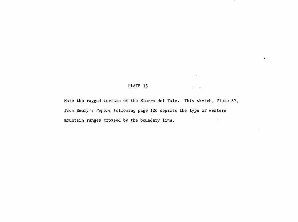
PLATE 15
Note the rugged terrain of the Sierra del Tule. This sketch, Plate 57,
from Emory's RepoPt following page 120 depicts the type of western
mountain ranges crossed by the boundary line.


PLATE 16
Monument 186 placed by the resurvey of the boundary during the
1890s is located on the crest of the Tule Mountains, This photo
and the preceeding sketch depict the same general area. Report on
the Survey and Remarking of the Boundary, ZB9Z-96, II.
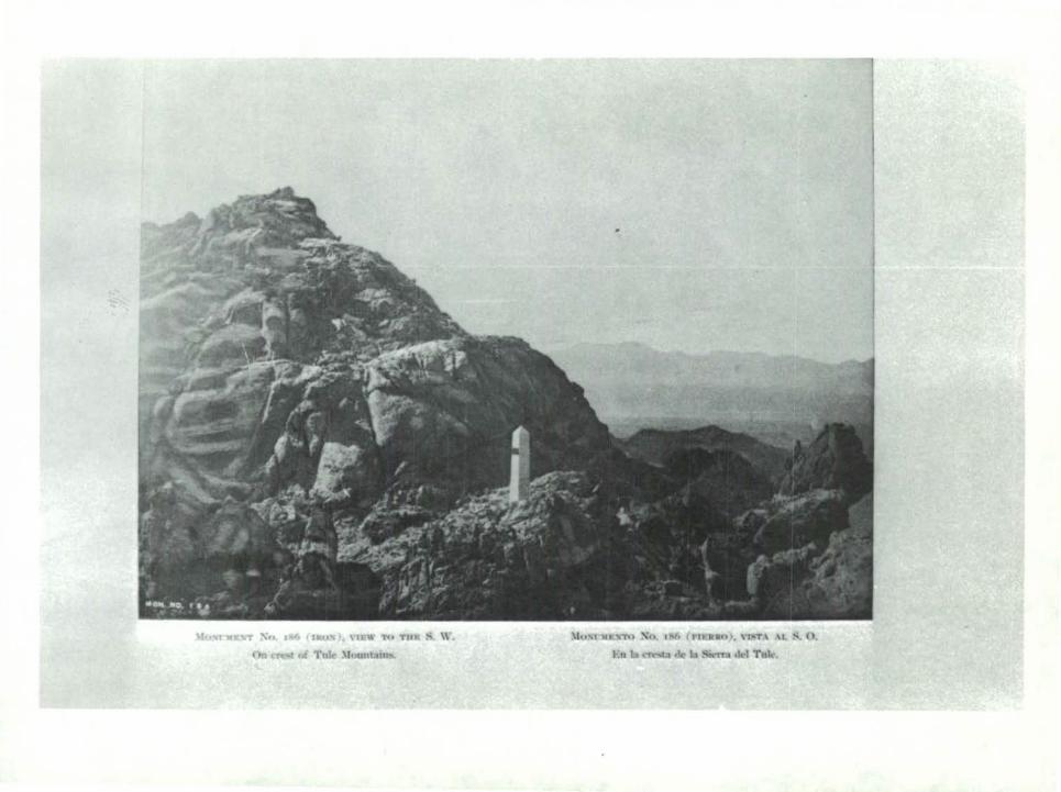

PLATE 17
Monument 4 on the Sierra Tinajas Altas was located by
Lt. N. Michler during the summer of 1855. This sketch
from Emory's RepoPt again dramatizes the hostile rugged
terrain the boundary crossed.


PLATE 18
A comparison of this view and the preceeding one indicate
that they were made from nearly the same spot on the boundary.
Report on Survey and Remarking of the Boundary, ZBBZ-96, II.

luXI'lllf~ Xu. 191 ( tllv~ J, \11\\' ,.., Tlll
On ttc;<l of ·nr~:~j<'L~ llounalu

PLATE 19
Michler described the Yuma Desert as a "dull wide waste." The
soil "a mixture of sand and gravel; the reflection from its white
surface adds still greater torment to the intense scorching heat
of the sun." This photo from the 1891-96 survey and remarking of
the boundary bears this out.

:-\11 . .20J ( III•JS ), \II\\
I)IJ Yon a l lt.~rt .
:MnSI'JIJtl<TI• Xu. :ll>.\ { nl!••o l, \"U!T\
1\a rl l~o de \"ama.

PLATE 20
On the Colorado Desert between New River and the Arizona border.
Note the flat barren conditions in the area, the only vegetation
being low bushes.

IJn \.'vlunuki ,._.,,crt. F•t d 1 ~to dc:l C'o'lorai!"

PLATE 21
Site of the monument placed east of New River on the Emigrant
Trail by Captain Hardcastle and Dr. Ramirez in May 1851.

l~"''il of ~"" Ri\\7. I lloJ Iron IU<HIOOIUI'nt h1•imJ.
:\lol"':lltt"'T11 ~~~ ::70 C t IP,JIJroo \ I"T \ \L :-; I,
,\ 1 N• ck-1 Ri .. ~111:\U AMt,r.• ,....,.._.do lidto "''"'"'lu,

PLATE 22
This monument west of New River replaces the iron monument
placed there over forty years before in 1851.

Most'l~J :."T =-:o 221 tiiiii:SJ \'II" ,.., Tnt: :\, \\'
\\·c. .. t of :s\~ I("'"· • 1J,I wm nt~•tUUit• nt rtJ•un .. l
J:\lm;t':IU{,'Tn ;>o:u, :::1 (Htlllllct), \'L'IT.\ AL :S, 0.
AI .....v dd llio Nan'O \ntl~t"'> _ .... - .... '""',.,... ........

PLATE 23
An example of the rocky and rugged terrain of the mountains west
of the Colorado Desert in Southern California. Report on Survey and
Remarking of the Boundary, l89Z-96, II.


PLATE 24
In the 1890s as in the 1850s the mule proved to be an
invaluable aid in surveying and marking the boundary between
the United States and Mexico.

!.iU'"l')ll STu :'\o, ::-41 t IIIIUIH). \JilT\
lw romr faert. c:IC''IIdo

PLATE 25
The initial monument on the Pacific. The first monument established
by the Boundary Commission in 1849, it was recut in the 1890s and an
iron fence built to protect it from souvenir hunters. Report on Survey
and Remarking of the Boundary, ZB9Z-96, II.

:'\•1 :JS!i ll \11111,1 , \It,\\ ,.., Till!
(ltd imt~:~l JUoliiUUidlt r~~u
)lul<t'"K~• Xn 1'111 ( via.Mol,l, \"lilT.\ \I. :S 0
.\nlip> llli-an..nlo illidel. 1llhndo d&o ........,~

PLATE 26
A color sketch of the church on the plaza of El Paso del Norte
as seen by an artist with Emory during the 1850s. Emory, Repo~t,
l, opposite p. 92.


PLATE 27
The Rio Salado flowed out of Mexico to join the Rio Grande. These
falls were about seven miles from the mouth of the river. Emory,
Report, Z, opposite p. 66.
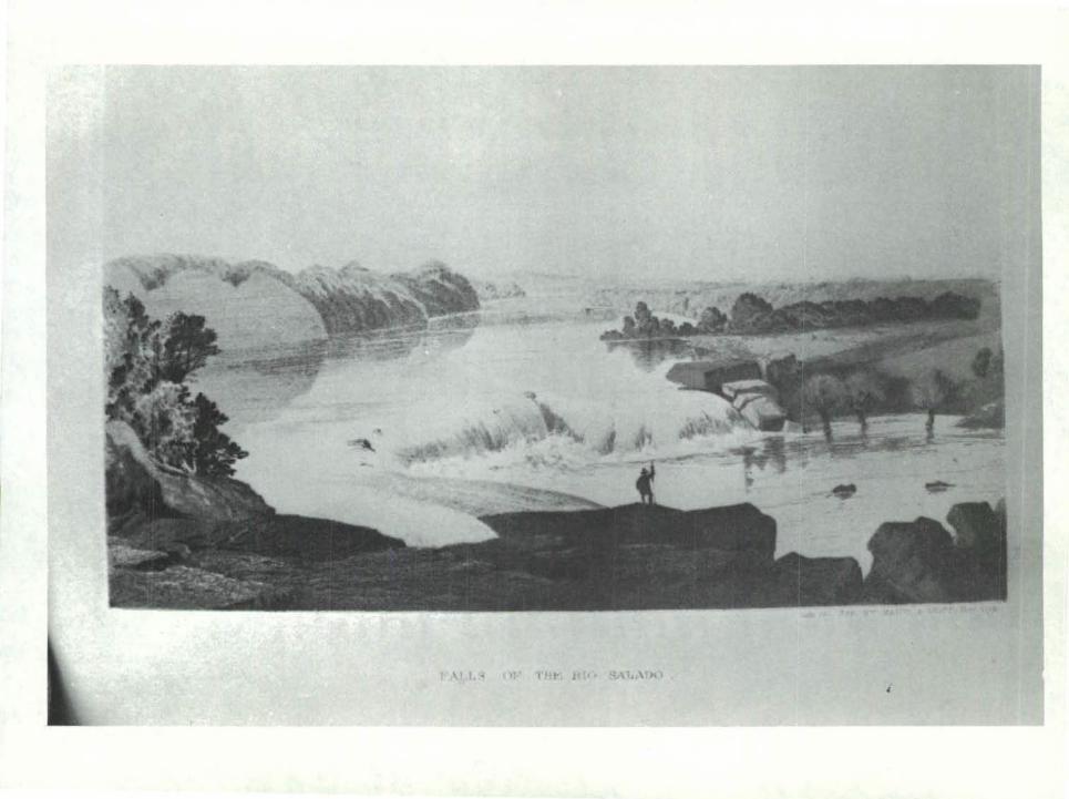

PLATE 28
Black and White sketch showing the junction of the Rio Grande and
Pecos Rivers. Emory, Report, l, 78.


PLATE 29
The northernmost of the canyons in the bend of the Rio Grande below
El Paso. It was terrain such as this that worked such hardship on
the parties of M.T.W. Chandler and Lt. N. Michler during the survey
of the river in 1852 and 1853. Emory, Report, l, 81.

Eotmnce to Call on Doli ·eHIO!, Bio Bravo del
rh·er leaves the canon. and the countrv lose entir<'b· the fcatureR which

PLATE 30
The Lipan Apaches and the Comanches were a constant
threat to the survey crews along the Rio Grande. Emory,
Report, Z, opposite page 78. This color print details
the dress of the Lipan Apache warrior.


PLATE 31
Color plate showing the style of dress of the Yuma Indians
on the Colorado. According to Lt. Nathaniel Michler, Leoch,
the figure on the left, was considered the "belle" of the
tribe. Emory, Report, Z, opposite page 110.

) ~ \ ... 01 I

PLATE 32
Lt. Michler commented on the dress of the Papagos as
follows: "The women are better dressed than most Indian
women; they all wear skirts of manta or calico covering
body from the hips down." This color sketch opposite page
122 of Emory's Report illustrates this very well.

.....

PLATE 33
This page from Bartlett's "Personal Journal" contains a
sketch and description of how a Pima house is constructed.
Often John Russell Bartlett included sketches in his journal
as he recorded the day to day events during the two and a
half years he was away from his home and family. A reading
of this will reveal the meticulous detail found in the
"Personal Journal."

~cd-Hritt ~d', , a~ aY~dr~·.rjd~ ~ ~p~: ~·~~~~·~~~r~~~~ ~~ ff¥~z,u-4/~-~euep·~~ ~ ~ aa, ~ o/~/~ aa})~~.
u La.-~~ /PUr/~;-&~ ~~~/dt ~?'Ia e«~ a.-'$~~· .4'~~~~~ !LN.L ~~~y ~ ~,~h~ ~~~·~~A£,- . ./7
. • . hk ~ ~ ~~ a,u,.~~====~b • • • ~~·e-u~. ~4-~ . ,
j • • ~ ~ u ' a.-~ u.;~~ , /'~,(_ /2-r-V' ~4- Vt1 ~~ ~) ~ ~;&: d~~ .cr.ad kd~v ~./a...~ .. a~~~~ ~ k~. .· .. . . . . ~ ~ --~~~~ ~'IV r~~ ~ •• · • • • . ·. fo~i) U•;~ ~~·'/ ~~ ;' e e • ',: ~H·.,Y
l cz cu..~ 17?-~:. • • • .: ~ I :~a ~a.-?~ d~ ·. · · · · · · · · ··~~d J
IHr/ ~~~~~.?{~ ~~. .-. ~~~- c~£;~, J~ ~~~~J
~ ~~·~~~ 4 ~~d-~ '
; ' - l I 1 --- ~~~A JJ!i ~ ka/~~ -~ ~--4~~ .t: ~ ~-n, ~ 4£~ 41£ ~ a~t-4~ ~ ~· ya -:#-o--~ u..' ~/ ~-L. ~~ ~ ~~ , ;{v7-~· ,~(7_/ .. ~)- ~ ,~ru~
-#a;;..-,G bL~~,· ?~~~~ ~ hr~~~ ~ .
~a.-d t:L6r~~: ~~4-~au~u--'. L~·~& c.i d.?';u. ~~~ ,· aa-r-C ?"~ ~ ~ ~ ~d:;e:-' "F
.... , . , , . / / -. ~.,· / h /_ . - - k...,:,) .../

PLATE 34
The eight drawings that follow are from the Bartlett Collection
at Brown University. In each case the drawing number refers to the
list contained in Appendix I.
Bartlett described the Guadalupe Mountains, shown in drawing 35,
during his trip through them in the fall of 1850. "Our way now
continued through the narrow defiles of elevated hills. At one
time in a deep valley, at another wending our way along the brink
of a gorge the mountain rising some thousand feet above on one side
with the gorge on the other."


PLATE 35
Duape, Sonora, was typical of the small Mexican villages that
Bartlett visited during his trips in Mexico. Number 23 in the
collection.

23. Duape. Sonora, Mexico Pencil sketch. 4 1/2" x 7" (Bart. Draw. 102-s)

PLATE 36
Santa Rita del Cobre, the Copper Mines, was headquarters of the
Boundary Commission from April to August 1851. This water color
by Seth Eastman, done from a rough sketch made at the scene, shows
the village in the center and the camp of the commission to the
left. Bartlett Collection, #187.

\II ' 4 (\' \ ~ I llroJ\\

PLATE 37
In June of 1852 Bartlett and his party traveled up the Gila on
their way back to El Paso. This black and white sketch by Bartlett
(#95) shows the second encampment above the fort at the junction
of the Gila and Colorado.

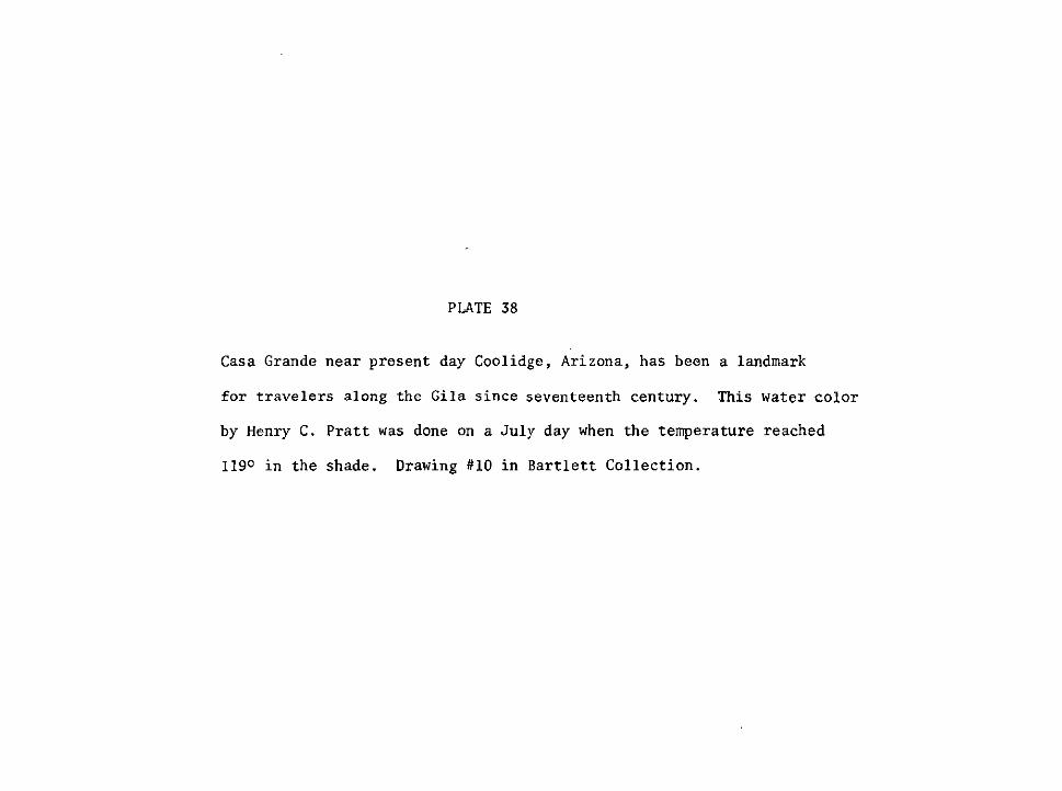
PLATE 38
Casa Grande near present day Coolidge, Arizona, has been a landmark
for travelers along the Gila since seventeenth century. This water color
by Henry C. Pratt was done on a July day when the temperature reached
1190 in the shade. Drawing #10 in Bartlett Collection.

IU. <.'1'1.,(-Jt llh-f,,. lhoJI lh\. liV\ I (till ,\ l ll m "''" ,u)or Ill'\ I~ (II l~llll<ll,:>;olllliV< , \ II . fl .!.7.,, lllhl~I-.IJ>h I (llort ll'•'" 'i'i) c \ 1~11 111 "111.1 h;o luhoo llus~dl ll1r tlo II 'l\o '7 fl
PLATE 39
Drawing #194 of the Santa Cruz Valley by Seth Eastman is a water
color showing some portion of this river valley, possibly near the
town of Santa Cruz, Sonora.

. '
-
)'q ..,,.,, .. 1 n z \,oiJ,., \\ lll'l , ••lor '' ' I.! 1:\t>l '" ~1dl. 111 "" ' 111 I o~t1111111 lltnt. llta\1 14 '>)

PLATE 40
Tucson, Arizona (Sonora) as it appeared in 1852. It appears that
this view is from Sentinel Peak looking east toward the Santa Catalina
Mountains. Drawing #75.


PLATE 41
San Xavier del Bac, the White Dove of the Desert, is nine miles
south of Tucson on the Papago Reservation. Both Bartlett in his
narrative and George Thurber in his letters to the Providence
Journal described this magnificent building in some detail. It
remains in a fine state of preservation today. Drawing ffl9.
GPO 882·95~
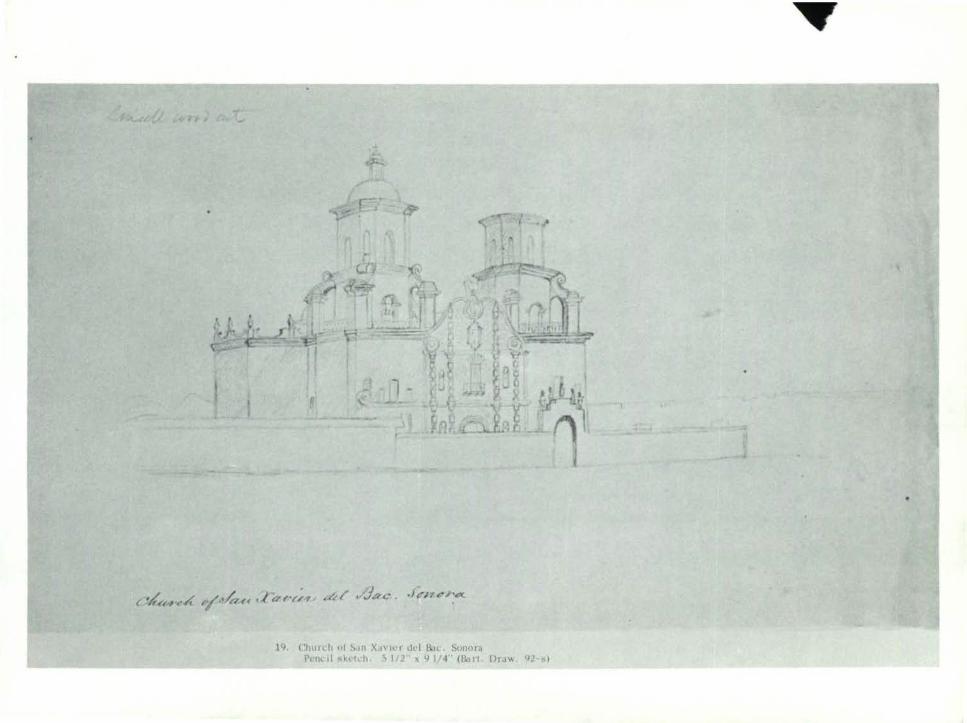
19, Dra\' 'l.? )
