surveying and geomatics program review - evergreen … and... · web viewsg 100* applied math for...
TRANSCRIPT

[ SURVEYING AND GEOMATICS PROGRAM REVIEW]FINAL REPORT
(BASED ON PR-CRITERIA 9-24-2009)
Area Dean: Dr. Wei Zhou
Current Year: 2009-2010
Prepared byDr. John Yu
With Contributions fromDr. Abdie Tabrizi
Ms. Vera NazarovaMr. Tony Perez
April 22, 2010
2009
Division Of Math,Science and Engineering

Surveying and Geomatics Program Review
ContentsI. EVC Mission................................................................................................................6
II. Executive Summary...................................................................................................7
III. Summary of Department/Program...........................................................................8
PART A: Overview of Program...........................................................................................9
1. Identify EVC’s Commitments To Action (CTA) for this year.................................9
2. Identify your program/department’s CTAs for this year..........................................9
3. How did your program/department meet the overall CTA of the College? Describe
how your program/department met the overall CTA of the College. Describe areas
where your program/department needs improvement to meet the overall CTA of the
College. Describe specific plan to achieve this goal.....................................................11
4. Identify Unmet Goals and Accomplishments............................................................11
5. State the goals and focus of this department/program and explain how the program
contributes to the mission, comprehensive academic offerings, and priorities of the
College and District.......................................................................................................13
6. Identify current student demographics. If there are changes in student
demographics, state how the program is addressing these changes..............................14
7. Identify enrollment patterns of the department/program in the last 6 years and
analyze the pattern.........................................................................................................16
8. Identify department/program productivity................................................................17
9. Identify student success rate and patterns within the department/program..............18
10. If the program utilizes advisory boards and/or professional organizations, describe
their roles.......................................................................................................................18
PART B: Curriculum.........................................................................................................19
1. Identify all courses offered in the program and describe how the courses offered
in the program meet the needs of the students and the relevant discipline(s)...............19
2. State how the program has remained current in the discipline(s).......................19
Final Report, April 22, 2010 Page 2

Surveying and Geomatics Program Review
3. All course outlines in this program should be reviewed and, if appropriate,
revised every six years. If this has not occurred, please list the courses and present a
plan for completing the process. (curriculum currency)................................................20
4. Identify and describe innovative pedagogy your department/program
developed/offered to maximize student learning and success. How did they impact
student learning and success?........................................................................................20
5. Discuss plans for future curricular development and/or program (degrees &
certificates included) modification. Use the Curriculum Mapping form to lay out your
plan…………................................................................................................................20
6. Describe how your program is articulated with the High School Districts, CCOC
(if applicable), and/or other four year institutions. (Include articulation agreements,
common course numbering etc.)....................................................................................26
7. If external accreditation or certification is required, please state the certifying
agency and status of the program..................................................................................26
PART C: Student Outcomes...............................................................................................27
1. Course learning outcomes...................................................................................27
2. On the program level, list all programs (and degrees) that have current student
learning outcomes and provide the culture of evidence................................................28
3. List or describe all assessment mechanisms you are using to evaluate SLOs.
Provide results of analysis.............................................................................................29
PART D: Faculty and Staff................................................................................................31
1&2. List current faculty and staff members in the program, areas of expertise, and
how positions contribute to the program success. List major professional development
activities completed by faculty and staff in this department/program in the last six
years and state proposed development and reasoning by faculty in this program.........31
3. Identify current schedule for tenure review, regular faculty evaluation, adjunct
faculty evaluation, and classified staff evaluation.........................................................36
4. Describe the departmental orientation process (or mentoring) for new full-time and
adjunct faculty and staff (please include student workers such as tutors and aides).....37
Final Report, April 22, 2010 Page 3

Surveying and Geomatics Program Review
PART E: Facilities, Equipment, Materials and Maintenance...........................................38
1. Identify facilities allocated to the program (including the facilities often used by
the department/program)...............................................................................................38
2. Describe the use and currency of technology used to enhance the
department/program. Identify projected needs and rationale........................................41
3. If applicable, describe the support the program receives from industry. If the
support is not adequate, what is necessary to improve that support?............................41
PART F: Future Needs......................................................................................................43
1. What faculty positions will be needed in the next six years in order to maintain or
build the department?....................................................................................................43
2. What staff positions will be needed in the next six years in order to maintain or
build the department?....................................................................................................43
3. Identify budget allocated for the department/program through the division budget
(fund 10). Discuss its adequacy and needs if applicable along with rationale.............43
4. What equipment will be needed in the next six years in order to maintain or build
the department? Provide specific purpose and rationale..............................................44
5. What facilities will be needed in the next six years in order to maintain or build the
department? Provide specific purpose and rationale....................................................44
PART G: Additional Information......................................................................................45
Appendix A: Surveying and Geomatics Program Commitments to Action 2009-2011. . .50
Appendix B: Engineering and Surveying Department Commitments to Action
2007-2009..........................................................................................................................54
Appendix C: Student Success and Retention by Course 2005-2009.................................58
TOTAL, all classes: Student Success and Retention....................................................59
ENGR 010 Student Success and Retention..................................................................60
ENGR 018 Student Success and Retention..................................................................65
ENGR 060 Student Success and Retention..................................................................70
ENGR 061 Student Success and Retention..................................................................74
ENGR 063 Student Success and Retention..................................................................78
CADD 130 Student Success and Retention..................................................................82
CET 141 Student Success and Retention......................................................................87
Final Report, April 22, 2010 Page 4

Surveying and Geomatics Program Review
CET 142 Student Success and Retention......................................................................92
CET 143 Student Success and Retention......................................................................96
CET 145 Student Success and Retention....................................................................100
CET 146 Student Success and Retention....................................................................103
CET 147 Student Success and Retention....................................................................108
CET 148 Student Success and Retention....................................................................111
SG 149 Student Success and Retention......................................................................115
Final Report, April 22, 2010 Page 5

Surveying and Geomatics Program Review
I. EVC Mission
With student learning as our primary focus, Evergreen Valley College’s mission is to empower students to expand their human potential and to succeed in a global, multicultural society. We prepare students of all ages and backgrounds for balanced and productive lives, so they can ultimately improve the workforce and quality of life in our communities.
Final Report, April 22, 2010 Page 6

Surveying and Geomatics Program Review
II. Executive Summary
The certificate program in surveying (formerly known as Civil Engineering Technology) has been in existence for over 30 years at Evergreen Valley College (EVC). The program fills a “niche” job market and thus is sensitive to the job market. Due to the increasing demand in fast, accurate and complete surveying and mapping information and the anticipated retirement wave in the field, the prediction for the surveying job market has been strong in the last three to five years. To meet the needs of the workforce development, the surveying program has been revitalized through two major National Science Foundation (NSF) grants.
Guided by the College’s Commitments to Action focusing on Student Centeredness, Community Engagement, and Organizational Transformation, the Surveying and Geomatics program has established an Industry Advisory Committee, established partnerships with local high schools, land surveying community and industry, updated the curriculum with the state-of-the-art equipment through grants and cooperate sponsorship and developed two new degrees in surveying and geomatics, which will broaden students access and provide more career choices for high schools graduates. Through a collective effort and with the help of NSF and Trimble Navigation, the EVC Surveying and Geomatics program has been developed into the ONLY such program in the South and East S.F. Bay.
The anticipated target students for this program are both worker training and high school graduates. However, the majority of the current students enrolled are working professionals needing further training or retraining, which results in unstable enrollment patterns. With the help of the new degree programs, we are committed to attract more high school students through outreach and recruitment.
Final Report, April 22, 2010 Page 7

Surveying and Geomatics Program Review
III. SUMMARY OF THE DEPARTMENT/PROGRAM
The surveying and geomatics program is one of the two programs in the Engineering Department. It has been in existence for over 30 years at Evergreen Valley College (EVC). For many years prior to 2001, when we received our first National Science Foundation (NSF) planning grant, the program was inactive. For example, between 1995 and 2001, no SG (surveying) classes were offered and no SG certificate was awarded. In 2000, we submitted our first NSF proposal and subsequently received a planning grant in 2001 from which a larger grant was received in 2003 when we started to modernize our curriculum and equipment. Another NSF grant was awarded subsequently for the support of the program. Since then, the program has been revitalized without incurring additional cost to the school’s general fund. EVC offers the only comprehensive Surveying and Geomatics program in the South and East Bay.
The program offers three options: an Associate in Science (AS) degree, an Associate in Arts (AA) degree, and a Certificate of Achievement. The program trains students with the necessary skills to become a land surveyor. It provides students with the formal theoretical and laboratory coursework necessary to prepare for the Land Surveyors-In-Training Examination and the Professional Land Surveyors Examination. It also provides coursework for those planning to transfer to a four-year Surveying or Geomatics Engineering program.
Final Report, April 22, 2010 Page 8

Surveying and Geomatics Program Review
PART A: Overview of Program
1. Identify EVC’s Commitments To Action (CTA) for this year.
Our college’s CTAs are organized as follows:
A. Student Centered
1. Improve Access
2. Curriculum & Program Development
3. Services
B. Organizational Transformation
1. Build Community
2. Employee Development
3. Transparent Infrastructure
C. Community Engagement
1. Increase Visibility
2. Develop Strategic Partnerships
3. Bring the College to the Community
See EVC’s CTAs for more details.
2. Identify your program/department’s CTAs for this year.
Surveying and Geomatics program CTAs for this year are:
A. Student Centered
1. Improve Access
Provide students with more choices by implementing two new degrees: AS and AA in Surveying and Geomatics.
Final Report, April 22, 2010 Page 9

Surveying and Geomatics Program Review
2. Curriculum & Program Development
Update and modify six courses and implement the new degree program.
3. Services
Help students with job replacement by recommending them to employers and distributing job announcements and provide them with free copies of the trade magazine the Professional Surveyor. Secure scholarships from CLSA and ACSM for students.
B. Organizational Transformation
1. Build Community
Organize and participate social and professional events. Increase bonding among full-time and adjunct faculty members.
2. Employee Development
Participate in the PPD and at least one national conference.
3. Transparent Infrastructure
Work closely and communicate more with the counseling department.
C. Community Engagement
1. Increase Visibility
Give presentations to various groups, write articles to various publications and participate in High School visits promoting EVC engineering and surveying programs.
2. Develop Strategic Partnerships
Create partnerships with the industry, professional associations, local government and local high schools.
Final Report, April 22, 2010 Page 10

Surveying and Geomatics Program Review
3. Bring the College to the Community
Hold an Advisory Committee meeting and host secondary school students.
See Appendix A – Surveying and Geomatics program CTAs 2009-2011 for more details
3. How did your program/department meet the overall CTA of the College? Describe how your program/department met the overall CTA of the College. Describe areas where your program/department needs improvement to meet the overall CTA of the College. Describe specific plan to achieve this goal.
The program met the overall CTA of the college by implementing the program CTA. We have taken all the actions that we committed to and made many accomplishments as shown in the Item 4 below. Our goal is to build the best Surveying and Geomatics program in the South Bay area. Our plan to achieve this goal includes implementing the new degree program, building new partnerships and aggressive recruiting as shown the Appendix A - Surveying and Geomatics program CTAs 2009-2011.
4. Identify Unmet Goals and Accomplishments
Analysis of unmet goals
Our unmet goal is the best Surveying and Geomatics program in the South Bay. Right now, we are the only such program in the South Bay. To achieve our goal, we need to increase our enrollment.
Eighteen accomplishments
1. Developed the curricula for Associate in Science and Associate in Art Degrees in Surveying and Geomatics. The curricula have been approved by the ACCC and Board of Trustees and the State Chancellor’s office.
2. Revised the surveying curriculum to reflect the modifications necessary per observed deficiencies.
3. Acquired equipment and supplies to support the program.
4. Completed the name change from Civil Engineering Technology to Surveying and Geomatics.
5. Developed and successfully offered a 3D laser scanning for land surveying course. The activities included teaching materials development, equipment acquisition and training, student recruitment and course offering. This is one of the first such courses offered in a community college in the country.
Final Report, April 22, 2010 Page 11

Surveying and Geomatics Program Review
6. A 256-page manuscript for terrestrial 3D laser scanning was written for use by our school and others in the 3D laser scanning course.
7. A national workshop on terrestrial laser scanning was held at Evergreen Valley College. Twenty-nine people from high schools, colleges and universities, from all across the country (including people from Alaska, Upstate New York and South Carolina), participated in the workshop. Preliminary results from the workshop evaluation by the participants are very positive.
8. Successfully solicited $70,469 in-kind support from Trimble as part of the NSF project.
9. Gave four presentations to local middle and high school students about our surveying program and visited two high schools
10. Served on the San Jose Unified School District’s CTE Advisory Committee and Independence High School’s CTE Advisory Committee.
11. Attended several California Land Surveyors Association (CLSA) local chapter meetings and gave a presentation about the degree program in surveying and geomatics.
12. Gave a presentation and learned recruiting strategies at the North American Surveying and Mapping Educators Conference at East Tennessee State University in Johnson City, Tennessee
13. Authored an article about EVC’s surveying program in the professional magazine California Surveyors. The magazine is widely circulated among California land surveyors.
14. Recruited students through CLSA.
15. Held an Advisory Committee Meeting.
16. Recruited adjunct faculty who are from the surveying industry. These faculty have been advertising the program within their organizations and other outlets.
17. Made a presentation at ESUHSD district office to Dr. Jerry Ford and others.
18. Have made yearly presentations to the local high school counselors at EVC campus Counselors Day.
Three new initiatives
1. Implement the new AS and AA degree in Surveying and Geomatics starting Fall, 2009.
2. Presentations at local professional societies. Our experience with the surveying program indicates that the CLSA is a very important partner in the success of our program. Members help us recruit students and provide expertise in implementing our curriculum.
Final Report, April 22, 2010 Page 12

Surveying and Geomatics Program Review
3. Establish partnerships with local high schools. Appendix B - Surveying and Geomatics program CTAs 2009-2011.
5. State the goals and focus of this department/program and explain how the program contributes to the mission, comprehensive academic offerings, and priorities of the College and District.
The goal of the program is to train students with the necessary skills to become a land surveyor. It provides students with the formal theoretical and laboratory course work necessary to prepare for the Land Surveyors-In-Training Examination and the Professional Land Surveyors Examination. It also provides coursework for those planning to transfer to a four-year Surveying or Geomatics Engineering program. The program provides students with three options: an Associate in Science degree, an Associate in Arts degree and a Certificate of Achievement. The program contributes to the District’s mission by increasing the number of degrees awarded and the number of transfer students.
Final Report, April 22, 2010 Page 13

Surveying and Geomatics Program Review
6. Identify current student demographics. If there are changes in student demographics, state how the program is addressing these changes.
Figure 1 shows the student demographics. Similar to other engineering and technology programs, women are significantly underrepresented. We plan to use our successful female alumnae as role model, and work with women professional organizations such as Society for Women Engineers to attract more female students.
(a)
Final Report, April 22, 2010 Page 14

Surveying and Geomatics Program Review
(b)
(c)Figure 1. Demographics: a) Gender; b) Ethnicity and c) Age.
Final Report, April 22, 2010 Page 15

Surveying and Geomatics Program Review
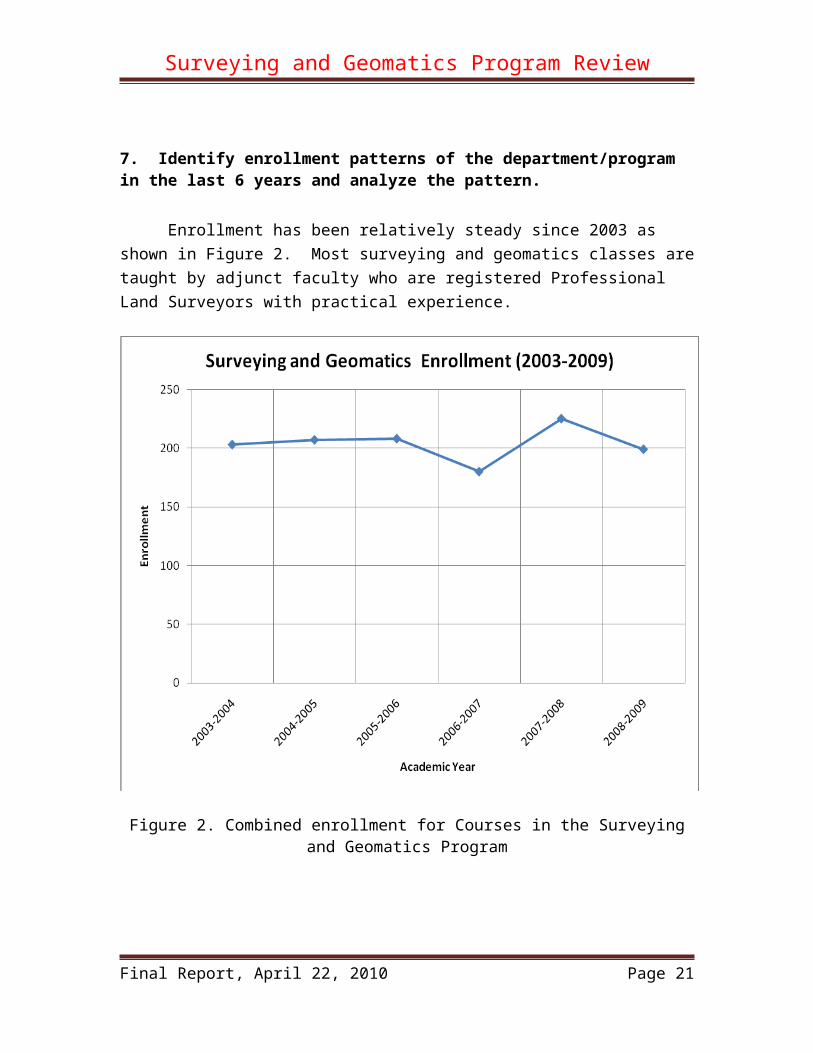
7. Identify enrollment patterns of the department/program in the last 6 years and analyze the pattern.
Enrollment has been relatively steady since 2003 as shown in Figure 2. Most surveying and geomatics classes are taught by adjunct faculty who are registered Professional Land Surveyors with practical experience.
Figure 2. Combined enrollment for Courses in the Surveying and Geomatics Program
Final Report, April 22, 2010 Page 16

Surveying and Geomatics Program Review
8. Identify department/program productivity
Figure 3 show the productivities of the program. The productivity ranges from 480 to 604 WSCH/FTE which is on par with or slightly below college average. Considering that the SG program is a technology program, the productivity is fairly decent.
Figure 3. Combined WSCH/FTE
Final Report, April 22, 2010 Page 17

Surveying and Geomatics Program Review
9. Identify student success rate and patterns within the department/program.
The student success rate in the program varies between 70 to 84% as shown in Figure 4. For science and technology students these rates can be considered high.
Figure 4. Student Completion and Success Rate.
10. If the program utilizes advisory boards and/or professional organizations, describe their roles.
The program has an active advisory committee which is composed of professional land surveyors as well as educators from industry, government, colleges and universities. The committee assists in determining the curriculum and course contents, and help with outreach and recruitment efforts. It serves as bridge between the program and the surveying community. The program is also associated with California Land Surveyor’s Association and American Congress on Surveying and Mapping. These two organizations also assist us in recruiting and provide scholarships for surveying students in the program.
Final Report, April 22, 2010 Page 18

Surveying and Geomatics Program Review
PART B: Curriculum
1. Identify all courses offered in the program and describe how the courses offered in the program meet the needs of the students and the relevant discipline(s).
Here are core courses in the AS, AA and COA (Certificate of Achievement):
ENGR 018 Engineering Design and Graphics OR CADD 130 Fundamentals of AutoCAD 3.0 ENGR 060 Surveying 3.0 ENGR 061 Plane Surveying 3.0 ENGR 063 GIS for Civil Engineering and Surveying 3.0 SG 100* Applied Math for Land Surveying 1.0 SG 141 Boundary Control & Legal Principles 3.0 SG 142 California Coordinate System 1.0 SG 143 Photogrammetry 1.0 SG 145 Astronomy for Surveyors 1.0 SG 146 CAD for Civil Engineering, Surveying and Land Development 3.0 SG 147 Global Positioning System for Surveyors 3.0 SG 148 Maps, the Subdivision Map Act and the Land Surveyors Act 3.0SG 149 3D Laser Scanning for Land Surveying 3.0
These courses were developed based on industry surveys and the recommendations of the Advisory Committee. Successful completion of these courses will enable the student to perform entry-level land surveying functions and enhance their chance of passing the licensing exams.
Some the courses in the program can also be taken by students in Engineering, CADD, Geography, Para-legal and Forensics. For example, SG 141 will help Paral-legal students in dealing with property boundary cases. SG 149 can be taken by students from the Police Academy to assist them in crime investigation.
2. State how the program has remained current in the discipline(s).
The program stays current through curriculum updating, new equipment acquisition and faculty development. With the two NSF projects, the program has been completely updated and is one of the most state-of-the-art programs in the nation. All the courses in the program have been updated in the last two years and five new courses have been developed since 2004. The program possesses the latest surveying equipment and software in GPS, GIS, CAD and 3D laser scanning. Faculty members has participated in numerous development activities such as conferences and workshops.
Final Report, April 22, 2010 Page 19

Surveying and Geomatics Program Review
3. All course outlines in this program should be reviewed and, if appropriate, revised every six years. If this has not occurred, please list the courses and present a plan for completing the process. (curriculum currency)
All the course outlines in the program have been updated in within the last six years.
4. Identify and describe innovative pedagogy your department/program developed/offered to maximize student learning and success. How did they impact student learning and success?
One of the pedagogies that we have adopted is group learning. This is implemented through course and lab projects. Group members work together and develop friendship over time which helps with not only learning but also retention. This is one of the reasons that many of our courses have a student successful rate of over 90%. Group learning also trains students with teamwork skills which are essential for success in today’s working environment.
Our pedagogy also evolves with the introduction of new technologies. In some courses, on-line assisted learning is implemented. In others, more hand-on assignments are given so that students can learn the latest hardware and software.
New exam formats for many of the courses are implemented. The new format tests not only the students’ knowledge, but also the hand-on skills by assigning them a task to be performed in the lab with a specific period of time. This format aligns well with the technical training nature of some of courses and makes the exams more interesting.
5. Discuss plans for future curricular development and/or program (degrees & certificates included) modification. Use the Curriculum Mapping form to lay out your plan.
State Chancellor’s Office just approved our new AS, AA and COA programs last fall. The new programs are being implemented and no major revision is planned in the near future. The only modification would be to incorporate the 3D laser scanning class (SG-149) into the curriculum. Currently, SG-149 is a stand-alone course. Here are the modified programs:
Final Report, April 22, 2010 Page 20
Surveying and Geomatics Program Review
ASSOCIATE IN SCIENCE DEGREESURVEYING AND GEOMATICS
Core Classes:
ENGR 018 Engineering Design and Graphics OR CADD 130 Fundamentals of AutoCAD 3.0 ENGR 060 Surveying 3.0 ENGR 061 Plane Surveying 3.0 ENGR 063 GIS for Civil Engineering and Surveying 3.0 SG 100* Applied Math for Land Surveying 1.0 SG 141 Boundary Control & Legal Principles 3.0 SG 142 California Coordinate System 1.0 SG 143 Photogrammetry 1.0 SG 145 Astronomy for Surveyors 1.0 SG 146 CAD for Civil Engineering, Surveying and
Land Development 3.0 SG 147 Global Positioning System for Surveyors 3.0 SG 148 Maps, the Subdivision Map Act and
the Land Surveyors Act 3.0SG 149 3D Laser Scanning for Land Surveying 3.0Total Core Units 31.0
Nine Elective Units from the Courses belowENGL 001A English Composition 3.0ENGR 010 Engineering Processes and Tools 3.0LA 071 Legal Research and Writing A 3.0BUS 065 Concepts of Management 3.0 BUS 067 Organization Management 3.0 BUS 082 Introduction to Business 3.0Total Elective Units 9
G. E. Requirements
Area A: Communication in the English Language and Critical Thinking 6 units(Minimum 3 units Oral Communication & 3 units WrittenCommunication)
Oral CommunicationsWritten Communication (“C” grade or better)Critical Thinking
Area B: Physical Universe and Its Life Forms 3 units(Minimum one course w/lab and 3 units of Math)
Science with Laboratory ActivityScience without Laboratory ActivityMathematical Concepts (“C” grade or better)
Final Report, April 22, 2010 Page 21

Surveying and Geomatics Program Review
Area C: Arts and Humanities 6 units(Minimum one course from Fine or Performing Arts and onecourse from Humanities)
Fine or Performing ArtsHumanities (Cultural Pluralism/Ethnic Studies)
Area D: Social and Behavioral Sciences 6 units(Six of the units must be in U.S. and California History and Government)
Area E: Lifelong Understanding and Self Development 3 units
Total GE Units 24
_____________________________________________Total Degree Requirements 64* Math 22 also satisfies this requirement.
Final Report, April 22, 2010 Page 22

Surveying and Geomatics Program Review
ASSOCIATE IN ARTS DEGREESURVEYING AND GEOMATICS
Core Classes:
ENGR 018 Engineering Design and Graphics OR CADD 130 Fundamentals of AutoCAD 3.0 ENGR 060 Surveying 3.0 ENGR 061 Plane Surveying 3.0 ENGR 063 GIS for Civil Engineering and Surveying 3.0 SG 100* Applied Math for Land Surveying 1.0 SG 141 Boundary Control & Legal Principles 3.0 SG 142 California Coordinate System 1.0 SG 143 Photogrammetry 1.0 SG 145 Astronomy for Surveyors 1.0 SG 146 CAD for Civil Engineering, Surveying and
Land Development 3.0 SG 147 Global Positioning System for Surveyors 3.0 SG 148 Maps, the Subdivision Map Act and
the Land Surveyors Act 3.0SG 149 3D Laser Scanning for Land Surveying 3.0Total Core Units 31.0
G. E. Requirements
Area A: Communication in the English Language and Critical Thinking 9 units(Minimum 3 units Oral Communication & 3 units WrittenCommunication)
Oral CommunicationsWritten Communication (“C” grade or better)Critical Thinking
Area B: Physical Universe and Its Life Forms 9 units(Minimum one course w/lab and 3 units of Math)
Science with Laboratory ActivityScience without Laboratory ActivityMathematical Concepts (“C” grade or better)
Area C: Arts and Humanities 9 units(Minimum one course from Fine or Performing Arts and onecourse from Humanities)
Fine or Performing ArtsHumanities (Cultural Pluralism/Ethnic Studies)
Final Report, April 22, 2010 Page 23

Surveying and Geomatics Program Review
Area D: Social and Behavioral Sciences 9 units(Six of the units must be in U.S. and California History and Government)
Area E: Lifelong Understanding and Self Development 3 units
Total GE Units 39
_____________________________________________Total Degree Requirements 70* Math 22 also satisfies this requirement.
Final Report, April 22, 2010 Page 24

Surveying and Geomatics Program Review
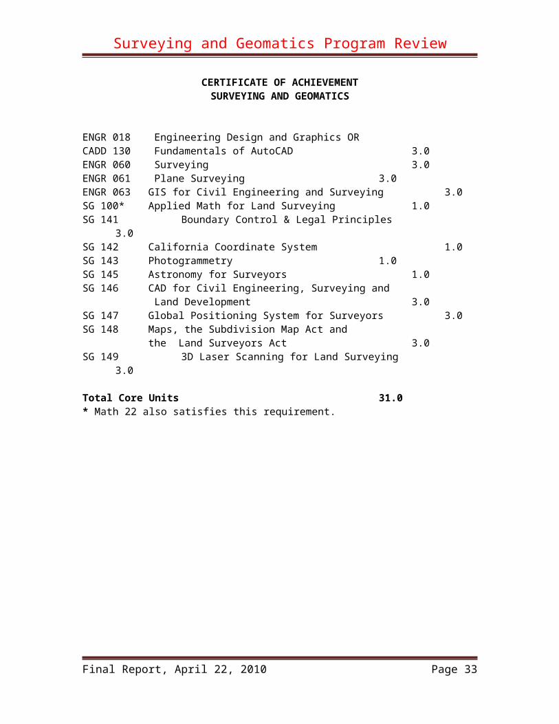
CERTIFICATE OF ACHIEVEMENT SURVEYING AND GEOMATICS
ENGR 018 Engineering Design and Graphics OR CADD 130 Fundamentals of AutoCAD 3.0 ENGR 060 Surveying 3.0 ENGR 061 Plane Surveying 3.0 ENGR 063 GIS for Civil Engineering and Surveying 3.0 SG 100* Applied Math for Land Surveying 1.0 SG 141 Boundary Control & Legal Principles 3.0 SG 142 California Coordinate System 1.0 SG 143 Photogrammetry 1.0 SG 145 Astronomy for Surveyors 1.0 SG 146 CAD for Civil Engineering, Surveying and
Land Development 3.0 SG 147 Global Positioning System for Surveyors 3.0 SG 148 Maps, the Subdivision Map Act and
the Land Surveyors Act 3.0SG 149 3D Laser Scanning for Land Surveying 3.0
Total Core Units 31.0* Math 22 also satisfies this requirement.
Final Report, April 22, 2010 Page 25

Surveying and Geomatics Program Review
6. Describe how your program is articulated with the High School Districts, CCOC (if applicable), and/or other four year institutions. (Include articulation agreements, common course numbering etc.)
CADD 130 is articulated with San Jose Unified School District. The Engineering courses are articulated with four-year institutions. Discussions are on-going with East Union High School District and CSU Fresno about articulating some of the SG courses. Plans to work with CCOC are also in the work.
7. If external accreditation or certification is required, please state the certifying agency and status of the program
N/A
Final Report, April 22, 2010 Page 26

Surveying and Geomatics Program Review
PART C: Student Outcomes
1. Course learning outcomes.
A. list all the courses that have current student learning outcomes (included in the course outline).B. provide link to the course outlines for review purpose andC. Provide a plan and timeline to include student outcomes for the courses that do not have one.
All the courses have current student learning outcomes. Here is the list:
ENGR 018 Engineering Design and Graphics OR CADD 130 Fundamentals of AutoCAD 2007 ENGR 060 Surveying 2007ENGR 061 Plane Surveying 2007ENGR 063 GIS for Civil Engineering and Surveying 2007SG 100* Applied Math for Land Surveying 2009SG 141 Boundary Control & Legal Principles 2009SG 142 California Coordinate System 2009SG 143 Photogrammetry 2009SG 145 Astronomy for Surveyors 2009SG 146 CAD for Civil Engineering, Surveying and
Land Development 2009SG 147 Global Positioning System for Surveyors 2009SG 148 Maps, the Subdivision Map Act and
the Land Surveyors Act 2009SG 149 3D Laser Scanning for Land Surveying 2008
Course outlines and student learning objectives for all of these courses can be found at the following link: \\Do_data_whse\r&p\Curriculum\Course Outlines\6 - Final
Final Report, April 22, 2010 Page 27

Surveying and Geomatics Program Review
2. On the program level, list all programs (and degrees) that have current student learning outcomes and provide the culture of evidence.
The AS, AA degrees and the COA all have program learning outcomes. Here they are:
AS/AA IN SURVEYING AND GEOMATICS Learning Outcomes
Evergreen Valley College offers an Associate in Science degree and Associate in Arts degrees in Surveying and Geomatics program. The program trains students with the necessary skills to become land surveyors. It provides students with the formal theoretical and laboratory course work necessary to prepare for the Land Surveyors-In-Training Examination and the Professional Land Surveyors Examination. It also provides coursework for those planning to transfer to four-year Surveying or Geomatics Engineering programs.
The Surveying and Geomatics program learning outcomes consists of two components – subject specific and supporting subjects’ outcomes. The outcomes for the supporting subjects are broader in nature and are realized and emphasized by the strategic mission of the Evergreen Valley College. The subject specific outcomes are realized through training, theoretical and experimental, offered by the program.
Outcomes for General Supporting Subjects:
Any graduate of the Surveying and Geomatics program should be able to:
1. Identify, define and solve problems2. Make ethical choices and act responsibly3. Critically evaluate information4. Function effectively in a team, exercise initiative, and perform in a leadership role5. Recognize broad societal issues and concerns6. Serve clients and society with sensitivity and accountability7. Interact effectively with diverse cultures8. Adapt to change, recognize the value of life-long learning9. Write, speak, and listen effectively
Outcomes for Core Specific Subjects:
Any graduate of the Surveying and Geomatics program should be able to:Upon completion of the program, students will be able to:
Solve surveying related problem using algebra and trigonometry Perform measurement analysis, and data adjustment Solve problems based on scientific principles Perform Geodesy, Survey Astronomy, and Geodetic Survey Calculation
Final Report, April 22, 2010 Page 28

Surveying and Geomatics Program Review
Use computer and associated tools Write report and boundary descriptions Apply boundary law, cadastral law in property management and litigation Apply knowledge in business law, management, economics, finance, and survey
planning process and procedures Collecting field data with various instrument and perform data reduction Acquire photo/image data and perform reductions Creating engineering graphics and surveying maps Perform plane survey calculation Apply Geographic Information System (GIS) knowledge to surveying Apply land development principles
COA IN SURVEYING AND GEOMATICS Learning Outcomes
Evergreen Valley College offers a Certificate of Achievement in Surveying and Geomatics. The program trains students with the necessary skills to become land surveyors. It provides students with the formal theoretical and laboratory course work necessary to prepare for the Land Surveyors-In-Training Examination and the Professional Land Surveyors Examination. It also provides coursework for those planning to transfer to four-year Surveying or Geomatics Engineering programs.
Upon completion of the program, students will be able to: Solve surveying related problem using algebra and trigonometry Perform measurement analysis, and data adjustment Solve problems based on scientific principles Perform Geodesy, Survey Astronomy, and Geodetic Survey Calculation Use computers and associated tools Write report and boundary descriptions Apply boundary law, cadastral law in property management and litigation Apply knowledge in business law, management, economics, finance, and survey
planning process and procedures Collect field data with various instrument and perform data reduction Acquire photo/image data and perform reductions Create engineering graphics and surveying maps Perform plane survey calculations Apply Geographic Information System (GIS) knowledge to surveying Apply land development principles
3. List or describe all assessment mechanisms you are using to evaluate SLOs. Provide results of analysis.
Exams Students surveys Employment data Licensing exams passing rates
Final Report, April 22, 2010 Page 29

Surveying and Geomatics Program Review
Data collection is on-going and some of these requires the involvement of professional researchers such as the District Research office. Here is an example of using student surveying for assessment:
End of Semester Student Survey Results for the 3D Laser Scanning Class
I am very confident
I am somewhat confident
I am not confident
Learning outcomesExplaining the working principles of 3D laser scanning: 82% 18% 0%Explaining the reflections of laser on various surfaces: 36% 56% 8%Operating terrestrial 3D laser scanner: 27% 64% 9%Collecting data under various field conditions: 27% 64% 9%Using 3D laser scanning software to register the data correctly: 45% 55% 0%
Using 3D laser scanning software to import and export data to and from CAD software: 60% 40% 0%
Performing topographical surveying with 3D laser scanner: 55% 36% 9%
Performing as-built surveying with 3D laser scanner: 45% 55% 0%Applying 3D laser scanning knowledge to solve problems in engineering and land surveying: 45.5% 45.5% 9%
Performing 3D laser scanning data analyses: 27% 64% 9%
Final Report, April 22, 2010 Page 30

Surveying and Geomatics Program Review
PART D: Faculty and Staff
1&2. List current faculty and staff members in the program, areas of expertise, and how positions contribute to the program success. List major professional development activities completed by faculty and staff in this department/program in the last six years and state proposed development and reasoning by faculty in this program
There is no full-time faculty member in this program although the Engineering faculty has been working to develop this program.
A. Full-Time Engineering Faculty
Tabrizi, Abdie
Area of Expertise: Theoretical and experimental focus in thermal sciences in mechanical engineering with a degree of doctor of philosophy. Expertise in computational mathematics and physics.
How Does My Position Contribute to Program Success: Help in curriculum development Help in student guidance Help in laboratory equipment set up and acquisition Help in outreach activities Help with orientation activities Help with operation of laboratories Publicize the program through hosting the Society for the Advancement of
Chicanos and Native Americans in Science (SACNAS) outreach conference every year
Publicize the program through hosting workshops for the local high schools and middle schools such as Oak Grove High, Overfelt High, Geneses High School, Franklin-McKinley school district and others
Participate in the school’s yearly high school counselor’s day to disseminate the program information
The contact person for the division to provide help to the faculty in setting up the campus course management system for online delivery of course material (WebCT, BlackBoard, and Moodle)
Help in evaluating the faculty and providing support, if needed Help with articulating program curriculum between Evergreen Valley College
and Independence High, Yerba Buena High, and San Jose Union School District (SJUSD).
Acquired donated supplies and equipment from local companies such as Roache and Bio-link and others
Final Report, April 22, 2010 Page 31

Surveying and Geomatics Program Review
Helped with the workshops offered through the NSF grants
Professional Development in the Past Six Years: Attended Engineering Liaison Committee (ELC) conferences of California Attend the yearly Hazmat Trainings and hold certificates Attend the local meetings of engineering organizations Member of Silicon Valley Engineer’s Council (SVEC) Obtained a The “Train the Trainer” professional Certificate in Nanotechnology
Obtained a certificate in Vodcasting for providing curriculum content to students through Apple’s iTune facility
Participated in the statewide curriculum development conference Offered workshops in laboratory safety to the campus faculty Participate in Bechtel Engineering Transfer conference Participate in the Project Lead the Way (PLTW) regional center conference. This
is a joint activity between local high schools, community colleges, and universities
Participated in the Juno/GPS/GIS/Geo-Spatial Professional Development Day offered through the Bay Area Community College Consortium and hosted by Mission College
Participated in conferences for developing Student Learning Outcomes for courses and programs
Proposed Professional Development Activities and reason for Such Activities: Gain additional knowledge in the area of GPS, GIS, and 3-D scanning for
curriculum modification and improvement Investigate use of ebooks in classrooms in order to provide students with less
expensive course content and more convenience Investigate possibility of providing videos for laboratory material via online for
student download. This could help in student preparation and understanding of the subject covered in the labs
Attend conferences in surveying and related technology
Zhanjing (John) Yu
Areas of Expertise: Engineering, Mathematics, Surveying and Geomatics, and CADD. Courses taught: Engr 10, 18, 45, 60, 61, 63, 69; Math 11, 61, 71, 73; SG 146, 149; EngrTech 160; CADD 142; and Electronic 122.
How Does My Position Contribute to Program Success:
Final Report, April 22, 2010 Page 32
Surveying and Geomatics Program Review
Primarily responsible for developing the new SG program. Working with others, developed and revised all the core courses in the program and instituted the new degree programs.
Secured three grants from the National Science Foundation providing the funds for curriculum development and equipment acquisition without incurring cost to the school’s general funds.
Organized the Industry Advisory Committee for the program. Secure scholarships from CLSA and ACSM for surveying students. Taught three out of the four new courses in the program. Help with student advising. Help with articulation with high schools and universities. Help with outreach efforts. Help with adjunct faculty recruitment.
Professional Development in the Past Six Years:
I. Publications
Yu, Z., Education in Surveying – Class in 3D, Professional Surveyor Magazine, Vol. 29, No. 11.
Yu, Z., Gee, G., Tabrizi, A., Torres, D., Redd, T., Miller, J. , Crossfield, J. and Mourtos, N. , Development and Implementation of a 3D Laser Scanning Course for Land Surveying, 2009 North America Surveying and Mapping Educators Conference, Johnson City, TN, July 8-10, 2009
Yu, Z. , Terrestrial 3D Laser Scanning with Trimble GX 3D Laser Scanner System and RealWorks Survey, Manuscript, Evergreen Valley College, San Jose, California, 2009
Yu, Z. and Torres, D., 3D Laser Scanning with Trimble GX 3D Laser Scanner, 3D Laser Scanning Curriculum Courseware, NSF Project 0702995, Evergreen Valley College, San Jose, California, 2008
Yu, Z. and Alka, J., Teaching What the Industry Needs, California Surveyor Magazine, Issue #152, Fall, 2007
Yu, Z. and Crossfield, J., Teaching GIS for Land Surveying, 2006 ESRI Education Users Conference, San Diego, CA, August 5-11, 2006
Yu, Z. and Nguyen, C., GPS Surveying with Trimble Equipment and Software, CET/Surveying Curriculum Courseware, NSF Project 0302641, Evergreen Valley College, San Jose, California, 2005
Yu, Z., Tabrizi, A. H., Gee, ., Crossfield, J., Miller, J., and Redd, T., Development of a Curriculum for Civil Engineering Technology, 2004 China-US Conference on Community Colleges, Beijing, China, July 5-8, 2004
Final Report, April 22, 2010 Page 33

Surveying and Geomatics Program Review
Yu, Z., Tabrizi, A. H., Gee, G., and Redd, T., Curriculum Design Based on Industry Needs, AACC/NSF ATE principal Investigators Conference, Washington, D. C., Oct. 22-24, 2003
Yu, Z., Karaca, M. and Deb Hopkins, Finite Element Analysis of the Seismic Response of a Nine Story Reinforced-Concrete Building , Proceedings, Disaster Resistant California Conference 2003, San Jose, CA, April 21 - 23, 2003
II. Conferences and Presentations Offered an national workshop on terrestrial 3D laser scanning in surveying. Participated in every Annual NSF ATE Principal Investigators Conference
since 2002. Participated in at least 8 NSF ATE proposal review panels Participated in one Department of Labor ETA proposal review panel Participated in three CLSA Annual Conferences Participate four ELC meetings and gave a presentation at one of them. Participated a panel discussion at the 48th Geomatics Engineering Conference
at CSU Fresno. Gave a presentation at 2004 China-US Conference on Community
Colleges, Gave a presentation at 2006 ESRI Education Users Conference Gave a presentation at 2009 North America Surveying and Mapping
Educators Conference Participated in the 4th Annual Conference on 3D Laser Scanning Active in Santa Clara Chapter of CLSA Participated in all the PDD activities.
Proposed Professional Development Activities and Reason for Such Activities: Participate in CLSA and Fresno GME conference to keep current with the
development in the surveying and Geomatics field. Learn Moodle to deliver some the surveying courses online. Participate local CLSA and ACSM meeting for outreach, recruiting and
professional enrichment. Investigate the latest developments in GPS, 3D laser scanning, GIS and Civil
CAD Study the possibility of incorporating some of the geomatics technologies into
BIM.
B. Adjunct Faculty
Gwen Gee, County Surveyor of Santa Clara CountyTim Redd, President of Silicon Valley Land SurveyingBarry Ng, Technology Manager, City of San JoseBrett Baker, Geologist and Surveyor of Santa Clara Valley Water DistrictDavid Mulenga, Surveyor, Valley Transportation Authority
Final Report, April 22, 2010 Page 34

Surveying and Geomatics Program Review
Mehran Khodai
C. Staff
Antonio Perez
Area of Expertise: Precision low noise electronics measurement apparatus design and construction, Precision Mechanical apparatus design and construction, significant experience is documentation and technical writing.
How Does My Position Contribute to Program Success: Help in curriculum development Help in student laboratory sessions Help in laboratory equipment set up and acquisition Help in outreach activities Help with orientation activities Help with operation of laboratories Publicize the program through outreach and retention events Publicize the program through outdoor bulletin postings Participate in the school’s yearly high school counselor’s day to disseminate the
program information
Professional Development in the Past Six Years: Attendance at training session for Microchip 32 bit microprocessors Attend the yearly Hazmat Trainings and hold certificates Developed course of instruction for new Electronics Engineers at Hitachi GST Self Study courses on Microprocessors, CAN communication fundamentals.
Proposed Professional Development Activities and reason for Such Activities: Gain additional knowledge in the area of GPS, GIS, and 3-D scanning to support
the equipment and laboratory Create E-BOOK content for usage of equipment, apparatus, and laboratory safety
for student usage Develop a library of video reference materials for student usage Attend training in surveying and related technology to refresh my civil
engineering schooling.
3. Identify current schedule for tenure review, regular faculty evaluation, adjunct faculty evaluation, and classified staff evaluation.
A. Current schedule for tenure reviewThere is no tenure-tracking faculty in this program.
Final Report, April 22, 2010 Page 35

Surveying and Geomatics Program Review
B. Regular faculty evaluationThe department tries to evaluate tenured faculty members in the spirit of FACBA. Each term the Dean sends an email to all the tenured faculty members and urges them to have at least one of their classes visited by another faculty member who will collect the student evaluations. The student evaluations are then summarized and kept on file in the dean’s office. If the dean detects a problem, a conference will then be convened by the dean with the faculty member. If the dean does not detect any problems, a regular conference with the faculty member and the dean will still take place at least once every three years to go over the student evaluations and to discuss issues and concerns related to the faculty members’ teaching.
C. Adjunct faculty evaluationAdjunct faculty have been evaluated according to the procedure as spelled out in Article 19 of the Faculty Association Collective Bargaining Agreement (FACBA). An evaluation committee is formed, which usually consists of the Dean of the Division and two peer faculty members. At least one, and usually all, of the committee members observe the performance of the adjunct faculty member. During the observation, student evaluations are conducted and collected by the committee member. The adjunct faculty member is given a written summary of these evaluations and a post evaluation conference is held with the adjunct faculty and the evaluation committee.
D. Classified staff evaluationClassified staff are periodically evaluated in accordance with the schedule set forth in Article 16.2 of the CSEA contract, as follows: Probationary New-Hire Classified Employees Probationary new-hire classified employees are evaluated three times during the first year (twelve months) of employment. The first two evaluations take place after the third and sixth months of employment, and a final evaluation after eleven months, using the full progress report formProbationary Promotional Classified Employees Classified employees promoted to a higher classification (pursuant to Article 15.4 of the CSEA contract) serve a probationary period of at least six months. Probationary promotional classified employees are evaluated at the end of the third and fifth months of employment in the new classification. Permanent Classified Employees After the probationary period, all classified employees are evaluated annually, on the employee’s anniversary date of hire.
4. Describe the departmental orientation process (or mentoring) for new full-time and adjunct faculty and staff (please include student workers such as tutors and aides).A. The Departmental Orientation Process for New Faculty
No tenure-tracking new faculty is added to the program in the last six years. However, the procedure for new faculty orientation does exist. In addition to the orientation process given by the school, the department also has a mentor program.
Final Report, April 22, 2010 Page 36

Surveying and Geomatics Program Review
For each of the new faculty members, in his/her first semester of service, the Department appoints a tenured faculty member as the mentor for the new faculty member. The mentor serves as a guide and supporting person, assisting the new member in the school environment and answering questions related both to students (such as admission and registration procedures, adding and dropping classes, etc.) and faculty (such as tenure procedure, teaching assignments, and committee work).
B. The Departmental Orientation Process for Adjunct Faculty Most of our adjunct faculty members have been teaching for us for several years. For new adjunct faculty, when he or she is hired to teach a particular class, we provide the learning objectives for the class and the syllabus used by our current faculty members, and describe in detail how our classes are conducted, together with student matters such as adding and dropping students, attendance policy, etc.
C. The Departmental Orientation Process for Staff (including student workers such as tutors and aides) Only one part-time lab assistant was added to the program. He was oriented by the Dean on school procedures and by faculty members on the facilities, equipment and safety issues related in the engineering and surveying programs.
Final Report, April 22, 2010 Page 37
Surveying and Geomatics Program Review
PART E: Facilities, Equipment, Materials and Maintenance
1. Identify facilities allocated to the program (including the facilities often used by the department/program)
The program utilizes a lot specialized equipment/instruments and software. Fortunately, we were able to acquire these through the NSF grants and VTA funds.The program has two small storage rooms for the equipment/instruments and use the engineering computer lab in AB-121 which has 30 desktop computers. The classrooms are located mainly in Acacia building. Here is a list of equipment and software used in the program:
Equipment and Hardware
Quantity Description Manufacturer Model Number
Serial Number
1 Total Station TRIMBLE 3300DR 603762a1 Total Station TRIMBLE 3300DR 603756a
1 Receiver TRIMBLE 580043301249
83
1 Receiver TRIMBLE 570022032019
51 Antenna, Receiver TRIMBLE 124753961 Positioning Data Link TRIMBLE PDL4535 74866011 Base TRIMBLE 12180 nsn1 Base TRIMBLE 12180 nsn1 Base TRIMBLE 12180 nsn1 Base SECO 2070-00 nsn1 AutoLevel TOPCON AT-G1 AV37621 Theodolite, Digital TOPCON DT104 SZ12141 Total Station TOPCON GTS-223 UL01281 GPS, HANDHELD TOPCON TURBO-G1 52006231 Transit, Manual K&E 740040 2226911 Transit, Manual K&E 740095 2270461 Transit, Manual CL Berger Polara P1007741 Transit, Manual DIETZGEN 6000 517331 Level, Dumpy WHITE 8014 826491 Transit, Manual WHITE 3000 802571 Alidade K&E 2437 676111 Level, Dumpy WHITE 8014 825531 Transit, Manual UMECO 575-m-3/4 1506561 Autoranger MK1 K&E Mod1 06a51041 Autoranger MK1 K&E Mod1 06b61471 Autoranger MKII K&E Mod 2 06b72201 Theodolite, Manual WILD T2 T2-179921
1 Theodolite, Manual WILD T1AT1A-
661171 Transit, Manual WHITE 90485
Final Report, April 22, 2010 Page 38

Surveying and Geomatics Program Review
1 Alidade DIETZGEN 6200 704791 Alidade DIETZGEN 6200 704741 Alidade DIETZGEN 6200
1 Datalogger TRIMBLE TSC2ssc65A24
481 Datalogger TRIMBLE TSCe 325951 Datalogger TRIMBLE TSCe 341321 Datalogger TRIMBLE TSCe 34097
1 3D Laser Scanner TRIMBLE GXDR200+50107h16
91 AutoLevel NIKON AC-2s 6380101 AutoLevel NIKON AC-2s 6380281 Digital Level TRIMBLE DiNi 7053011 Digital Level TRIMBLE DiNi 705302
1 Laser Distance MeterSpectra Physics HD150
584271692
1 Base Radio System TRIMBLE HPB450UHF1 Handheld GPS TRIMBLE 20051 Handheld GPS TRIMBLE 2005
1 Battery Charger MeanwellPA-120N-
13CP RA770436841 Battery Charger TRIMBLE1 Battery Charger TRIMBLE1 Battery Charger TRIMBLE1 Battery Charger TRIMBLE1 Battery Charger TRIMBLE1
3 RANGE POLECHICAGO TAPE 8.5 Feet
1 RANGE POLECHICAGO TAPE 6.0 Feet
1 Surveyor Tape 100Ft K&E13 Surveyor Tape 100Ft LUFKIN
6 ROD LEVEL 3/4 InchCHICAGO TAPE 06-750
10 PLANIMETER LEITZ 2000
1 Gunners Quadrant US ARMY 7578398 174319
4 Stadia Rod Leitz 15 Foot
3 PLAN TABLE Leitz
3 PLAN TABLE US ARMY
7 MEASURING ROD Various Various
Final Report, April 22, 2010 Page 39

Surveying and Geomatics Program Review
2 Stadia RodCHICAGO TAPE
10 TRIPOD VARIOUS
2 GPS ANTENNA MOUNT TRIMBLE
2 GPS UHF ANTENNA Trimble
1 GPS ANTENNA Extension Timble
1 CLINOMETER UNKNOWN
1 Compass, Lensatic US ARMY
Battery Kit GXDR200+ Scanner Trimble
2 3d Scanning Target Kit Trimble
4 TRIPOD, Quick Clamp SECO SEC215203BLK
3 Tripod Bracket, Datalogger ST1
2 Leveling Rod, Telescopic 4x1meter Trimble TD24
2 Builders Rod, Aluminum, 9ft/10ths Seco SEC730130
Tribrach Rotating Adapter (WILD) SECO SEC2020
Servo Target Kit GEOSLSUS2001
Tribrach Optical Plummet Black SECO SEC215203BLK
Final Report, April 22, 2010 Page 40

Surveying and Geomatics Program Review
Software
Quantity Software Name Developer
25 AutoCAD 2008 Autodesk25 AutoCAD Civil 3D 2008 Autodesk25 AutoCAD Land Desktop Autodesk25 ArcView GIS ESRI25 ArcGIS Surveying ESRI25 ArcGIS Spatial Analysis ESRI25 Geomatics Office TRIMBLE20 RealWorks Surveying TRIMBLE2 PointScape TRIMBLE
25 Star*Net StarPlus
Maintenance Needs
Due to the field conditions under which they are used, the surveying instruments used in the program requires frequent maintenance. Some of the maintenance items include instrument calibration and frequent battery charges. Cabinets or shelves are needed in AB-132 to store the instruments and electrical strips are needed for charging the instruments.
2. Describe the use and currency of technology used to enhance the department/program. Identify projected needs and rationale.
As shown on the lists of instruments and software in Part E Sec. 1, many of the instruments used in the program such as the high-end Trimble GPS receivers, TSCe Controller, Total Stations, Digital Levels, 3D laser scanner are high-tech equipment. AutoCAD, ArcGIS, Geomatics Office and RealWorks Surveying are all high-tech software and require the best computers to run them. These instruments/hardware and software mostly acquired through the NSF grants make the EVC Surveying and Geomatics program one of the best equipped programs in the country. Due to rapid development in technology, however, these instruments/hard ware and software probably need to be updated in five years. This probably can be achieved through VTEA or other sources of funding that support CTE education.
3. If applicable, describe the support the program receives from industry. If the support is not adequate, what is necessary to improve that support?
The EVC Surveying and Geomatics program has received strong supports from the surveying industry. The industry including companies such as Trimble, Autodesk, ESRI and Bentley has contributed more than $120,000 of equipment/hardware and software to the program.
Final Report, April 22, 2010 Page 41

Surveying and Geomatics Program Review
The Santa Clara/San Mateo Chapters of the California Land Surveyors Association (CLSA) has three scholarships dedicated to the EVC program. Northern California Chapter of American Congress for Surveying and Mapping has also awarded more than $3000 scholarships to our students. CLSA also plays a significant role in student recruitment.
The Industry Advisory Committee, composed of surveying professionals and educators from industry, government organizations, university, college and high schools play a very important role in curriculum development, providing internship, student recruitment and community outreach.
Faculty members attend the local CLSA meetings regularly to build relationships with the industry.
Final Report, April 22, 2010 Page 42

Surveying and Geomatics Program Review
PART F: Future Needs
1. What faculty positions will be needed in the next six years in order to maintain or build the department?
The Surveying and Geomatics program is a new program developed by current faculty in engineering in collaboration with adjunct faculty. There is no full-time faculty member specifically hired for this program although Dr. Yu is teaching some of the classes. In addition, professional land surveyors must be licensed by the state. None of the full-time faculty members is a licensed surveyor though Dr. Yu is a licensed civil engineer. Similar to the Nursing program where the faculty member should be a registered nurse, the Surveying and Geomatics program should be taught by registered (licensed) land surveyor. To maintain and further build this program it is recommended that a licensed land surveyor be hired as a full-time faculty member when the budget situation permits.
2. What staff positions will be needed in the next six years in order to maintain or build the department?
The Engineering and Surveying and Geomatics program shares a half-time technician. This may not be adequate as the program grows, especially considering the heavy maintenance requirements of the surveying instrument/equipment. A full-time technician is recommended for Engineering, Surveying and CADD. The technician should be given admin-authority for the computer/computer network in the engineering areas.
3. Identify budget allocated for the department/program through the division budget (fund 10). Discuss its adequacy and needs if applicable along with rationale. Identify any external (fund 17) funding the department/program receives and describe its primary use.
Over the last six years, the program has been supported primarily by two NSF grants. These grants have provided funding for the development and offering of the curriculum. All the program development activities were fully supported by these grants. The faculty salaries were also funded by these grants. It should be pointed out that we have been fortunate to receive such large grants thus allowing us to launch this program solely with the grant funds. The cost of equipment was also paid partially by the NSF grant and partially by the grants from companies such as Trimble and others. No school funds were used to support the equipment needs. We were also able to secure funding through the VTEA grant. This grant has allowed us to provide for some equipment and technology needed in the labs as well as some supply and other operating monies. In fact our engineering program has also benefited greatly from the acquisition of the equipment, software, and supplies since the surveying and engineering share some courses in common as well as sharing laboratory spaces. There has not been any additional facility cost to EVC. We have
Final Report, April 22, 2010 Page 43

Surveying and Geomatics Program Review
not added any classified staffing for this program. Last couple of years our engineering program has gotten rather small equipment funding from the school but nonetheless due to purchases that we have been able to make through the surveying program we have accommodated the needs of the both programs.We will continue to request VTEA funding for the surveying program in the future. After the completion of the second NSF grant the cost of operation will be that of the faculty (Adjunct and full time) salary. The table below list the expenses associated with this program thus far. As indicated there has been virtually no cost to the college. It should be pointed out that the initial investment on equipment has been made through the NSF grant and the program will not require such a large investment in the near future.
Expenses since 2003-04
Account Equipment/supplies Facility Instruction
Fund 10 $0 $0 $0
Fund 17 (NSF) $400,000.00 $0 $30,000/Yr
Fund 17 (VTEA) $81,000.00 $0 $0
4. What equipment will be needed in the next six years in order to maintain or build the department? Provide specific purpose and rationale.
The program has the state-of-the-art equipment right now. In the next six year, however, some equipment may need upgrade due to technology development. In addition, we may need to add one or two more 3D laser scanners and a couples of specialized photogrammetry cameras for use in the SG-149 and SG-143. VTEA funds can be used for this purpose.
5. What facilities will be needed in the next six years in order to maintain or build the department? Provide specific purpose and rationale.
The two equipment/lab rooms need to be upgraded with power strips for various battery charging and shelved should be added for instrument storage. In addition, a 10-acres lot on District land should be allocated as the Surveying Experimental Field so that surveying labs can conduct their fieldwork in this field. Surveying monuments linked to the national control network should be established on this field.
Final Report, April 22, 2010 Page 44

Surveying and Geomatics Program Review
PART G: Additional Information This section provides additional information about the occupational outlook of
land surveyors and an industry survey that we conducted recently with regard to surveying and geomatics profession.
1. Occupational Outlook, 2008-2009 Edition, Bureau of Statistics, US Department of Labor. The labor Department statistics show a strong job market for land surveying related occupations in the next seven years:”Surveyors, cartographers, photogrammetrists, and surveying and mapping technicians should have favorable job prospects. These occupations should experience much faster than average employment growth”. “Overall employment of surveyors, cartographers, photogrammetrists, and surveying and mapping technicians is expected to increase by 21 percent from 2006 to 2016 (Note: There are about 148,000 employees in the field in 2006), which is much faster than the average for all occupations. Increasing demand for fast, accurate, and complete geographic information will be the main source of growth for these occupations.”“An increasing number of firms are interested in geographic information and its applications. For example, GIS can be used to create maps and information used in emergency planning, security, marketing, urban planning, natural resource exploration, construction, and other applications. Also, the increased popularity of online mapping systems has created a higher demand for and awareness of geographic information among consumers. “In addition to openings from growth, job openings will continue to arise from the need to replace workers who transfer to other occupations or who leave the labor force altogether. Many of the workers in these occupations are approaching retirement age.”Opportunities for surveyors, cartographers, and photogrammetrists should remain concentrated in engineering, surveying, mapping, building inspection, and drafting services firms. However, employment may fluctuate from year to year with construction activity or with mapping needs for land and resource management.”
2. Industry Survey. We just conducted our own survey among California land surveyors. The surveys were sent to the list of employers, including companies, government offices and professional organizations, from the CLSA mailing list. Over 300 questionnaires were sent out and 70 have responded so far. The objective of the survey is to gauge the job market, compensation, educational requirement, employment sectors and recruiting channels, factors affecting the enrollment of the program. Figure 5 through 11 are the preliminary results:
Final Report, April 22, 2010 Page 45

Surveying and Geomatics Program Review
Figure 5. Job Market in the Next Five Years (2009 Survey)
Figure 6. Annual Compensation (2009 Survey)
Final Report, April 22, 2010 Page 46

Surveying and Geomatics Program Review
Figure 7. Education Requirements (2009 Survey)
Figure 8. Postions Available Now with AA degree (2009 Survey)
Final Report, April 22, 2010 Page 47

Surveying and Geomatics Program Review
Figure 9. Positions Available in Five Years (2009 Survey)
Figure 10. Employment Sectors (2009 Survey)
Final Report, April 22, 2010 Page 48

Surveying and Geomatics Program Review
Figure 11. Recruiting Helpers (2009 Survey)
A few observations can be made about the results: Majority of the respondents (64%) think that the job market in the next five years will
be excellent or good. It is down from the 2006 survey. Apparently, the responses are influenced by the current econoic conditions. Still the results is consistent with the Labor Department predictions.
The result on compensation is almost identical to the 2006 survey with $40,000-$50,000 being the dominant number.
Some of the respondants had no positions available and some had a few so on the average each respondant had 0.4 poistions available. The number of land surveying personnel in california is about 15000. Assuming that our respondants are typical surveying practitioner, then the total number of positions currently available in California would be about 6000.
The average positions available per respondent in the next five years is 0.53 and hence the total number of positions available in the next five years in California would be about 7950 per above assumption.
The top recruiter helpers are CLSA, American Congress on Surveying and Mapping(ACSM), CSU-Fresno, American Council of Engineering Companies(ACEC), and Caltran.
Final Report, April 22, 2010 Page 49

Surveying and Geomatics Program Review
Appendix A
Surveying and Geomatics Program
Commitments to Action
2009-2011
Final Report, April 22, 2010 Page 50

2010-2011Surveying and Geomatics Program Commitments to Action
Name: Department: Engineering
Initiative Area of Focus
Organizational Transformation
1. Build Community
2. Employee Development
3. Transparency and Communication
Area of
FocusIndividual Commitments to Action Metrics Time Frame
1Periodically inform the campus of the activities, issues and success of the surveying and geomatics program .
• Amount of information shared • June 2012
2 Recruit San Jose City College (SJCC) students to take our surveying and geometrics programs. Collaboration between the construction technology program at City College and Surveying program at EVC may prove to be mutually beneficial..
• 2 meetings • June 2011•
3 This fall we are planning on a major presentation to our counseling department about our programs as soon as we receive our two-year AA/AS degree approval from the state which is expected shortly. We will seek their active participation and recruitment. With the existence of associate degrees our students will have an additional choice of a vocational program..
• 2 meetings attended. • June 2011
2010-2011Surveying and Geomatics Program Commitments to Action

Surveying and Geomatics Program Review
Name: Department: Engineering
Initiative Area of Focus
Student Centered
1. Access
2. Curriculum and Programs
3. Services
Area of Focus Individual Commitments to Action Metrics Time Frame
1 • Create a couple of certificates with fewer numbers of units, e.g. 9 units, to provide greater flexibility for our students. This is especially useful for those who are seeking a specific training such as GPS or 3D Laser Scanning and would benefit from such certificates for employment purposes..
• Certificates listed in the catalog
• June, 2012
2 • Add an online surveying course or a hybrid course or Internet-enhanced surveying classes.
• Number of courses modified • June, 2012
3 • Identify at-risk students early in the semester and provide support.• Provide tutoring to surveying students.• Identify students with special needs and refer them to various
programs on campus.
• Increased head count after drop date.
• Number of students served.• Number of students helped.
• Every semester
2010-2011Surveying and Geomatics Program Commitments to Action
Name: Department: Engineering
Initiative Area of Focus
52

Surveying and Geomatics Program Review
Community Engagement
1. Increase Visibility
2. Develop Strategic Partnerships
3. Bring the College to the Community
Area of Focus Individual Commitments to Action Metrics Time Frame
1 • Make presentations at local high schools. Many high school students do not know that we have a surveying and geomatics program. Out program is especially valuable to those students who are interested in vocational programs that are high tech. We need to explain the advantages of attending our program and what a surveying and geomatics technician career looks like. This activity requires the help of our outreach personnel
• Number of presentations in collaboration with college outreach team
• June, 2012
2 Presentations at local professional societies. Our experience with the surveying program indicates that the CLSA is a very important partner in the success of our program. Members help us recruit students and provide expertise in implementing our curriculum.
• 2 presentations conducted. • June, 2012
3 Establish partnerships with local high schools. Collaborate with San Jose Unified School District (SJUSD) on
the PLTW (Project Lead the Way) project. PLTW is the nationwide project trying to incorporate engineering contents into high school curricula and recruit students into our program.
Collaborate with East Side Union High School District (ESUHSD). ESUHSD is interested in articulating some courses with us and sending students to take our classes.
• Relationship established • June, 2011
Appendix B
53

Surveying and Geomatics Program Review
Engineering and Surveying Department
Commitments to Action
2007-2009
54

2007-08 Individual Commitments to Action
Name: Department: Engineering
Initiative Area of Focus
Organizational Transformation
1. Build Community
2. Employee Development
3. Transparency and Communication
Area of
FocusIndividual Commitments to Action Point Person Metrics Time Frame
1 • Participate in college-wide activities.• Provide workshops to the college on
current engineering issues/topics.• Make a presentation about the program
activities and accomplishments.
• Tabrizi • Tabrizi • Yu
• Number of functions attended.• 1 workshop conducted.• 1 presentation made at a
division meeting with invited guests.
• Done• Done • Done
2 • Conduct workshops on laboratory safety.• Provide workshops on GIS (Geographic
Information System) to help in outreach efforts.
• Attend pertinent conferences.
• Tabrizi • Yu • Tabrizi/Yu
• 1 workshop conducted.• 1 workshop conducted.• 2 conferences attended.
• Done• Done• Done
3 • Work collaboratively with the counseling department to share concerns.
• Work collaboratively with the Financial Aid, EOPS, AFFIRM, WIN, Fastrack, and Enlace programs to share program information.
• Tabrizi • Tabrizi
• 2 meetings attended.• 6 meetings attended.
• Done• Done
2007-08 Individual Commitments to Action

Surveying and Geomatics Program Review
Name: Department: Engineering
Initiative Area of Focus
Student Centered
1. Access
2. Curriculum and Programs
3. Services
Area of Focus Individual Commitments to Action Point Person Metrics Time
Frame
1 • Establish ties with ESUHSD to get high school students enroll in an engineering or surveying course.
• Publicize the engineering/Surveying program via various media.
• Set up recurring high school visits for outreach.
• Tabrizi • Yu • Yu
• Registered high school students.• Increased number of student
inquires. • Outreach calendar established
• Done• Done• Done
2 • Add an online engineering or surveying course.
• Add a hybrid engineering or surveying course.
• Add Internet-enhanced engineering or surveying classes.
• Tabrizi • Tabrizi • Tabrizi
• 1 online course added.• 1 hybrid course added.• 2 Internet-enhanced courses
added.
• Done• Done• Done
3 • Identify at-risk engineering and surveying students early in the semester and provide support.
• Provide tutoring to engineering and surveying students.
• Identify students with special needs and refer them to various programs on campus.
• Yu • Tabrizi • Tabrizi
• Increased head count after drop date.
• Number of students served.• Number of students helped.
• Done• Done• Done
2007-08 Individual Commitments to Action
Name: Department: Engineering
56

Surveying and Geomatics Program Review
Initiative Area of Focus
Community Engagement 1. Increase Visibility
2. Develop Strategic Partnerships
3. Bring the College to the Community
Area of Focus Individual Commitments to Action Point Person Metrics Time Frame
1 • Make presentations at local high schools• Make presentations at CCOC• Create website• Contact and inform the local industry of the
engineering program.• Create and publish program flyer and
brochure
• Tabrizi • Yu • Tabrizi • Yu • Yu
• 4 presentations made• 1 presentation made• Website created and populated
with program announcements.• 4 industry contacted• Program flyers and brochure
created and published or distributed.
• Done• Done• Done• Done• Done
2 • Explore partnership with Morgan Hill high schools
• Explore partnership with local industry to establish internship for engineering students.
• Create an industry advisory committee• Establish a partnership with ESUHSD
• Yu • Tabrizi • Yu • Tabrizi
• 2 presentations conducted.• 4 industry contacted and at least
1 industry provide internship.• An Engineering & Engineering
Technology advisory committee established.
• Partnership with ESUHSD established.
• Done• Done• Done• Done
3 • Explore possibility of offering engineering classes for the Milpitas high school students.
• Tabrizi • Contact initiated and recommendations were made for future offerings.
• Done
57

Surveying and Geomatics Program Review
Appendix C
Student Success and Retention by Course
2005-2009
58

Surveying and Geomatics Program Review
TOTAL, all classes: Student Success and Retention
Term
2005
SUR
2005
FAR
2006
SPR
2006
SUR
2006
FAR
2007
SPR
2007
SUR
2007
FAR
2008
SPR
2008
SUR
2008
FAR
2009
SPR
2009
FAR
Gran
d To
tal
All Students Total, all classes # Students 11 136 77 13 113 83 16 136 94 12 120 117 138 1066Total, all classes # Retention 11 118 70 12 97 67 14 115 85 11 106 96 125 927Total, all classes % Retention 100% 87% 91% 92% 86% 81% 88% 85% 90% 92% 88% 82% 91% 87%Total, all classes # Success 9 107 61 11 88 52 14 100 78 9 86 82 103 800Total, all classes % Success 82% 79% 79% 85% 78% 63% 88% 74% 83% 75% 72% 70% 75% 75%
59

Surveying and Geomatics Program Review
ENGR 010 Student Success and Retention
Term
2005
SUR
2005
FAR
2006
SPR
2006
SUR
2006
FAR
2007
SPR
2007
SUR
2007
FAR
2008
SPR
2008
SUR
2008
FAR
2009
SPR
2009
FAR
Gran
d To
tal
All Students # Students 18 15 22 14 13 17 19 21 30 169# Retention 16 13 18 9 10 16 17 19 29 147% Retention 89% 87% 82% 64% 77% 94% 89% 90% 97% 87%# Success 16 13 18 8 9 16 14 19 29 142% Success 89% 87% 82% 57% 69% 94% 74% 90% 97% 84%
By Gender Female # Students 2 3 3 2 1 3 2 2 1 19
# Retention 2 1 2 0 1 2 2 2 1 13 % Retention 100% 33% 67% 0% 100% 67% 100% 100% 100% 68% # Success 2 1 2 0 1 2 2 2 1 13 % Success 100% 33% 67% 0% 100% 67% 100% 100% 100% 68%
Male # Students 16 12 18 12 12 14 17 19 29 149# Retention 14 12 15 9 9 14 15 17 28 133% Retention 88% 100% 83% 75% 75% 100% 88% 89% 97% 89%# Success 14 12 15 8 8 14 12 17 28 128% Success 88% 100% 83% 67% 67% 100% 71% 89% 97% 86%
Unreported # Students 1 1 # Retention 1 1 % Retention 100% 100% # Success 1 1
60

Surveying and Geomatics Program Review
% Success 100% 100%
By Age Grp 1: Under 18 # Students 1 1 2
# Retention 1 1 2% Retention 100% 100% 100%# Success 1 1 2% Success 100% 100% 100%
Grp 2: 18-19 # Students 4 3 1 3 2 3 4 2 9 31 # Retention 3 3 1 3 2 3 3 2 9 29 % Retention 75% 100% 100% 100% 100% 100% 75% 100% 100% 94% # Success 3 3 1 3 2 3 3 2 9 29 % Success 75% 100% 100% 100% 100% 100% 75% 100% 100% 94%
Grp 3: 20-22 # Students 5 5 5 5 3 5 6 11 15 60# Retention 5 4 4 4 2 4 6 9 14 52% Retention 100% 80% 80% 80% 67% 80% 100% 82% 93% 87%# Success 5 4 4 3 1 4 5 9 14 49% Success 100% 80% 80% 60% 33% 80% 83% 82% 93% 82%
Grp 4: 23-24 # Students 2 2 7 2 3 3 6 4 29 # Retention 2 1 5 1 3 3 6 4 25 % Retention 100% 50% 71% 50% 100% 100% 100% 100% 86% # Success 2 1 5 1 3 3 6 4 25 % Success 100% 50% 71% 50% 100% 100% 100% 100% 86%
Grp 5: 25-29 # Students 4 2 6 1 2 5 6 1 27# Retention 3 2 5 0 1 5 5 1 22% Retention 75% 100% 83% 0% 50% 100% 83% 100% 81%# Success 3 2 5 0 1 5 4 1 21% Success 75% 100% 83% 0% 50% 100% 67% 100% 78%
61

Surveying and Geomatics Program Review
Grp 6: 30-39 # Students 3 1 3 2 1 1 1 1 13 # Retention 3 1 3 1 1 1 1 1 12 % Retention 100% 100% 100% 50% 100% 100% 100% 100% 92% # Success 3 1 3 1 1 1 0 1 11 % Success 100% 100% 100% 50% 100% 100% 0% 100% 85%
Grp 7: 40-49 # Students 1 1 1 1 1 5# Retention 1 0 1 1 1 4% Retention 100% 0% 100% 100% 100% 80%# Success 1 0 1 1 1 4% Success 100% 0% 100% 100% 100% 80%
Grp 8: 50+ # Students 1 1 2 # Retention 1 0 1 % Retention 100% 0% 50% # Success 1 0 1 % Success 100% 0% 50%
By Ethnic Benchmark African American # Students 2 3 1 1 2 1 10
# Retention 2 3 1 0 1 1 8% Retention 100% 100% 100% 0% 50% 100% 80%# Success 2 3 1 0 0 1 7% Success 100% 100% 100% 0% 0% 100% 70%
Asian (All Other) # Students 2 2 4 2 1 2 1 2 16 # Retention 2 2 3 2 1 2 0 2 14 % Retention 100% 100% 75% 100% 100% 100% 0% 100% 88% # Success 2 2 3 2 1 2 0 2 14 % Success 100% 100% 75% 100% 100% 100% 0% 100% 88%
Asian/Cambodian # Students 1 1
62

Surveying and Geomatics Program Review
# Retention 1 1% Retention 100% 100%# Success 1 1% Success 100% 100%
Asian/Chinese # Students 3 1 1 1 1 7 # Retention 2 1 1 1 1 6 % Retention 67% 100% 100% 100% 100% 86% # Success 2 1 1 1 1 6 % Success 67% 100% 100% 100% 100% 86%
Asian/Indian # Students 2 1 1 2 2 6 3 17# Retention 2 1 1 1 2 5 3 15% Retention 100% 100% 100% 50% 100% 83% 100% 88%# Success 2 1 1 1 2 5 3 15% Success 100% 100% 100% 50% 100% 83% 100% 88%
Asian/Vietnamese # Students 6 2 4 3 3 2 3 5 11 39 # Retention 5 2 4 2 3 2 3 5 11 37 % Retention 83% 100% 100% 67% 100% 100% 100% 100% 100% 95% # Success 5 2 4 1 2 2 3 5 11 35 % Success 83% 100% 100% 33% 67% 100% 100% 100% 100% 90%
Filipino # Students 1 4 2 2 3 3 3 1 19# Retention 1 2 1 1 3 3 3 1 15% Retention 100% 50% 50% 50% 100% 100% 100% 100% 79%# Success 1 2 1 1 3 3 3 1 15% Success 100% 50% 50% 50% 100% 100% 100% 100% 79%
Latino/a # Students 1 4 3 1 2 8 3 3 10 35 # Retention 1 3 3 0 2 7 2 3 9 30 % Retention 100% 75% 100% 0% 100% 88% 67% 100% 90% 86% # Success 1 3 3 0 2 7 1 3 9 29
63

Surveying and Geomatics Program Review
% Success 100% 75% 100% 0% 100% 88% 33% 100% 90% 83%Other/Unknown # Students 1 2 1 1 2 1 1 1 10
# Retention 1 1 0 1 1 1 1 1 7% Retention 100% 50% 0% 100% 50% 100% 100% 100% 70%# Success 1 1 0 1 1 0 1 1 6% Success 100% 50% 0% 100% 50% 0% 100% 100% 60%
White # Students 1 3 4 1 1 4 1 15 # Retention 1 3 3 1 1 4 1 14 % Retention 100% 100% 75% 100% 100% 100% 100% 93% # Success 1 3 3 1 1 4 1 14 % Success 100% 100% 75% 100% 100% 100% 100% 93%
64

Surveying and Geomatics Program Review
ENGR 018 Student Success and Retention
Term
2005
SUR
2005
FAR
2006
SPR
2006
SUR
2006
FAR
2007
SPR
2007
SUR
2007
FAR
2008
SPR
2008
SUR
2008
FAR
2009
SPR
2009
FAR
Gran
d To
tal
All Students # Students 11 12 13 18 25 17 23 119# Retention 9 12 11 17 20 16 18 103% Retention 82% 100% 85% 94% 80% 94% 78% 87%# Success 9 12 11 16 15 15 15 93% Success 82% 100% 85% 89% 60% 88% 65% 78%
By Gender Female # Students 3 3 3 2 3 3 17
# Retention 3 3 3 2 2 1 14 % Retention 100% 100% 100% 100% 67% 33% 82% # Success 3 3 3 1 1 1 12 % Success 100% 100% 100% 50% 33% 33% 71%
Male # Students 7 12 10 15 23 14 20 101# Retention 5 12 8 14 18 14 17 88% Retention 71% 100% 80% 93% 78% 100% 85% 87%# Success 5 12 8 13 14 14 14 80% Success 71% 100% 80% 87% 61% 100% 70% 79%
Unreported # Students 1 1 # Retention 1 1 % Retention 100% 100% # Success 1 1
65

Surveying and Geomatics Program Review
% Success 100% 100%
By Age Grp 1: Under 18 # Students 1 1
# Retention 1 1% Retention 100% 100%# Success 0 0% Success 0% 0%
Grp 2: 18-19 # Students 2 1 1 6 1 4 15 # Retention 2 1 1 5 1 3 13 % Retention 100% 100% 100% 83% 100% 75% 87% # Success 2 1 1 3 1 3 11 % Success 100% 100% 100% 50% 100% 75% 73%
Grp 3: 20-22 # Students 7 4 4 5 11 8 10 49# Retention 5 4 4 4 8 8 8 41% Retention 71% 100% 100% 80% 73% 100% 80% 84%# Success 5 4 4 3 5 8 7 36% Success 71% 100% 100% 60% 45% 100% 70% 73%
Grp 4: 23-24 # Students 1 2 3 1 4 4 4 19 # Retention 1 2 2 1 4 4 3 17 % Retention 100% 100% 67% 100% 100% 100% 75% 89% # Success 1 2 2 1 4 4 3 17 % Success 100% 100% 67% 100% 100% 100% 75% 89%
Grp 5: 25-29 # Students 1 1 1 5 2 3 1 14# Retention 1 1 1 5 1 3 1 13% Retention 100% 100% 100% 100% 50% 100% 100% 93%# Success 1 1 1 5 1 2 1 12% Success 100% 100% 100% 100% 50% 67% 100% 86%
66

Surveying and Geomatics Program Review
Grp 6: 30-39 # Students 2 4 2 1 1 2 12 # Retention 2 3 2 1 0 1 9 % Retention 100% 75% 100% 100% 0% 50% 75% # Success 2 3 2 1 0 1 9 % Success 100% 75% 100% 100% 0% 50% 75%
Grp 7: 40-49 # Students 2 2 1 5# Retention 2 2 1 5% Retention 100% 100% 100% 100%# Success 2 2 1 5% Success 100% 100% 100% 100%
Grp 8: 50+ # Students 1 2 1 4 # Retention 1 2 1 4 % Retention 100% 100% 100% 100% # Success 1 2 0 3 % Success 100% 100% 0% 75%
By Ethnic Benchmark African American # Students 2 1 1 1 1 2 8
# Retention 2 1 1 1 0 2 7% Retention 100% 100% 100% 100% 0% 100% 88%# Success 2 1 1 0 0 2 6% Success 100% 100% 100% 0% 0% 100% 75%
Asian (All Other) # Students 3 1 1 2 2 9 # Retention 3 0 1 2 2 8 % Retention 100% 0% 100% 100% 100% 89% # Success 3 0 1 2 2 8 % Success 100% 0% 100% 100% 100% 89%
Asian/Cambodian # Students 1 1 2
67

Surveying and Geomatics Program Review
# Retention 1 0 1% Retention 100% 0% 50%# Success 1 0 1% Success 100% 0% 50%
Asian/Chinese # Students 1 1 1 1 4 # Retention 1 0 1 1 3 % Retention 100% 0% 100% 100% 75% # Success 1 0 1 1 3 % Success 100% 0% 100% 100% 75%
Asian/Indian # Students 2 1 2 3 1 9# Retention 2 1 1 3 1 8% Retention 100% 100% 50% 100% 100% 89%# Success 2 1 1 3 1 8% Success 100% 100% 50% 100% 100% 89%
Asian/Vietnamese # Students 3 1 2 3 2 3 14 # Retention 2 1 2 2 2 2 11 % Retention 67% 100% 100% 67% 100% 67% 79% # Success 2 1 2 2 2 2 11 % Success 67% 100% 100% 67% 100% 67% 79%
Filipino # Students 1 2 3 2 2 4 2 16# Retention 1 2 3 2 2 4 1 15% Retention 100% 100% 100% 100% 100% 100% 50% 94%# Success 1 2 3 2 2 4 1 15% Success 100% 100% 100% 100% 100% 100% 50% 94%
Latino/a # Students 3 1 4 3 9 7 4 31 # Retention 2 1 4 3 6 7 3 26 % Retention 67% 100% 100% 100% 67% 100% 75% 84% # Success 2 1 4 3 3 7 3 23
68

Surveying and Geomatics Program Review
% Success 67% 100% 100% 100% 33% 100% 75% 74%Native American # Students 1 1
# Retention 1 1% Retention 100% 100%# Success 1 1% Success 100% 100%
Other/Unknown # Students 1 2 2 3 1 4 13 # Retention 1 1 2 3 1 4 12 % Retention 100% 50% 100% 100% 100% 100% 92% # Success 1 1 1 3 0 3 9 % Success 100% 50% 50% 100% 0% 75% 69%
Pacific Islander # Students 1 1# Retention 1 1% Retention 100% 100%# Success 1 1% Success 100% 100%
White # Students 2 1 3 1 4 11 # Retention 2 1 3 1 3 10 % Retention 100% 100% 100% 100% 75% 91% # Success 2 1 3 0 1 7 % Success 100% 100% 100% 0% 25% 64%
69

Surveying and Geomatics Program Review
ENGR 060 Student Success and Retention
Term
2005
SUR
2005
FAR
2006
SPR
2006
SUR
2006
FAR
2007
SPR
2007
SUR
2007
FAR
2008
SPR
2008
SUR
2008
FAR
2009
SPR
2009
FAR
Gran
d To
tal
All Students # Students 10 16 16 27 20 89# Retention 10 16 15 25 17 83% Retention 100% 100% 94% 93% 85% 93%# Success 9 15 12 21 16 73% Success 90% 94% 75% 78% 80% 82%
By Gender Female # Students 2 2 2 6 3 15
# Retention 2 2 2 6 3 15 % Retention 100% 100% 100% 100% 100% 100% # Success 2 2 2 5 3 14 % Success 100% 100% 100% 83% 100% 93%
Male # Students 8 14 14 21 17 74# Retention 8 14 13 19 14 68% Retention 100% 100% 93% 90% 82% 92%# Success 7 13 10 16 13 59% Success 88% 93% 71% 76% 76% 80%
By Age Grp 2: 18-19 # Students 1 1 2
# Retention 1 0 1
70

Surveying and Geomatics Program Review
% Retention 100% 0% 50% # Success 1 0 1 % Success 100% 0% 50%
Grp 3: 20-22 # Students 2 4 4 7 17# Retention 2 4 4 5 15% Retention 100% 100% 100% 71% 88%# Success 2 4 4 5 15% Success 100% 100% 100% 71% 88%
Grp 4: 23-24 # Students 1 2 2 1 6 # Retention 1 2 2 1 6 % Retention 100% 100% 100% 100% 100% # Success 0 2 1 1 4 % Success 0% 100% 50% 100% 67%
Grp 5: 25-29 # Students 7 1 7 6 21# Retention 7 1 7 6 21% Retention 100% 100% 100% 100% 100%# Success 6 1 5 5 17% Success 86% 100% 71% 83% 81%
Grp 6: 30-39 # Students 3 4 6 8 3 24 # Retention 3 4 6 6 3 22 % Retention 100% 100% 100% 75% 100% 92% # Success 3 4 3 5 3 18 % Success 100% 100% 50% 63% 100% 75%
Grp 7: 40-49 # Students 2 3 3 4 2 14# Retention 2 3 2 4 2 13% Retention 100% 100% 67% 100% 100% 93%# Success 2 3 2 4 2 13% Success 100% 100% 67% 100% 100% 93%
Grp 8: 50+ # Students 2 2 1 5 # Retention 2 2 1 5
71

Surveying and Geomatics Program Review
% Retention 100% 100% 100% 100% # Success 2 2 1 5 % Success 100% 100% 100% 100%
By Ethnic Benchmark African American # Students 1 2 1 4
# Retention 1 2 1 4% Retention 100% 100% 100% 100%# Success 1 2 1 4% Success 100% 100% 100% 100%
Asian (All Other) # Students 2 1 3 # Retention 2 1 3 % Retention 100% 100% 100% # Success 1 1 2 % Success 50% 100% 67%
Asian/Chinese # Students 1 2 1 1 5# Retention 1 2 1 1 5% Retention 100% 100% 100% 100% 100%# Success 0 2 1 1 4% Success 0% 100% 100% 100% 80%
Asian/Indian # Students 1 1 # Retention 1 1 % Retention 100% 100% # Success 1 1 % Success 100% 100%
Asian/Vietnamese # Students 3 2 1 3 4 13# Retention 3 2 1 2 4 12% Retention 100% 100% 100% 67% 100% 92%# Success 3 1 1 2 4 11% Success 100% 50% 100% 67% 100% 85%
72

Surveying and Geomatics Program Review
Filipino # Students 1 1 2 1 5 # Retention 1 1 2 0 4 % Retention 100% 100% 100% 0% 80% # Success 1 1 2 0 4 % Success 100% 100% 100% 0% 80%
Latino/a # Students 2 2 2 9 6 21# Retention 2 2 2 8 4 18% Retention 100% 100% 100% 89% 67% 86%# Success 2 2 2 5 3 14% Success 100% 100% 100% 56% 50% 67%
Native American # Students 1 1 # Retention 1 1 % Retention 100% 100% # Success 1 1 % Success 100% 100%
Other/Unknown # Students 2 5 2 3 7 19# Retention 2 5 2 3 7 19% Retention 100% 100% 100% 100% 100% 100%# Success 2 5 1 3 7 18% Success 100% 100% 50% 100% 100% 95%
White # Students 1 3 9 4 17 # Retention 1 3 8 4 16 % Retention 100% 100% 89% 100% 94% # Success 1 3 6 4 14 % Success 100% 100% 67% 100% 82%
73

Surveying and Geomatics Program Review
ENGR 061 Student Success and Retention
Term
2005
SUR
2005
FAR
2006
SPR
2006
SUR
2006
FAR
2007
SPR
2007
SUR
2007
FAR
2008
SPR
2008
SUR
2008
FAR
2009
SPR
2009
FAR
Gran
d To
tal
All Students # Students 9 5 9 23# Retention 9 5 6 20% Retention 100% 100% 67% 87%# Success 9 5 5 19% Success 100% 100% 56% 83%
By Gender Female # Students 2 1 3
# Retention 2 1 3 % Retention 100% 100% 100% # Success 2 1 3 % Success 100% 100% 100%
Male # Students 7 5 8 20# Retention 7 5 5 17% Retention 100% 100% 63% 85%# Success 7 5 4 16% Success 100% 100% 50% 80%
By Age Grp 4: 23-24 # Students 1 1 2
# Retention 1 1 2
74

Surveying and Geomatics Program Review
% Retention 100% 100% 100% # Success 1 1 2 % Success 100% 100% 100%
Grp 5: 25-29 # Students 1 1 1 3# Retention 1 1 1 3% Retention 100% 100% 100% 100%# Success 1 1 0 2% Success 100% 100% 0% 67%
Grp 6: 30-39 # Students 3 3 4 10 # Retention 3 3 3 9 % Retention 100% 100% 75% 90% # Success 3 3 3 9 % Success 100% 100% 75% 90%
Grp 7: 40-49 # Students 2 1 2 5# Retention 2 1 0 3% Retention 100% 100% 0% 60%# Success 2 1 0 3% Success 100% 100% 0% 60%
Grp 8: 50+ # Students 2 1 3 # Retention 2 1 3 % Retention 100% 100% 100% # Success 2 1 3 % Success 100% 100% 100%
By Ethnic Benchmark African American # Students 1 1
# Retention 1 1% Retention 100% 100%
75

Surveying and Geomatics Program Review
# Success 1 1% Success 100% 100%
Asian (All Other) # Students 1 1 # Retention 1 1 % Retention 100% 100% # Success 1 1 % Success 100% 100%
Asian/Chinese # Students 2 2# Retention 2 2% Retention 100% 100%# Success 1 1% Success 50% 50%
Asian/Vietnamese # Students 2 1 3 # Retention 2 1 3 % Retention 100% 100% 100% # Success 2 1 3 % Success 100% 100% 100%
Latino/a # Students 2 2 4# Retention 2 1 3% Retention 100% 50% 75%# Success 2 1 3% Success 100% 50% 75%
Native American # Students 1 1 # Retention 1 1 % Retention 100% 100% # Success 1 1 % Success 100% 100%
Other/Unknown # Students 2 2 4
76

Surveying and Geomatics Program Review
# Retention 2 2 4% Retention 100% 100% 100%# Success 2 2 4% Success 100% 100% 100%
White # Students 2 2 3 7 # Retention 2 2 1 5 % Retention 100% 100% 33% 71% # Success 2 2 1 5 % Success 100% 100% 33% 71%
77

Surveying and Geomatics Program Review
ENGR 063 Student Success and Retention
Term
2005
SUR
2005
FAR
2006
SPR
2006
SUR
2006
FAR
2007
SPR
2007
SUR
2007
FAR
2008
SPR
2008
SUR
2008
FAR
2009
SPR
2009
FAR
Gran
d To
tal
All Students # Students 5 12 4 21# Retention 5 8 4 17% Retention 100% 67% 100% 81%# Success 5 8 4 17% Success 100% 67% 100% 81%
By Gender Female # Students 1 2 1 4
# Retention 1 2 1 4 % Retention 100% 100% 100% 100% # Success 1 2 1 4 % Success 100% 100% 100% 100%
Male # Students 4 10 3 17# Retention 4 6 3 13% Retention 100% 60% 100% 76%# Success 4 6 3 13% Success 100% 60% 100% 76%
By Age Grp 3: 20-22 # Students 1 1
# Retention 0 0
78

Surveying and Geomatics Program Review
% Retention 0% 0% # Success 0 0 % Success 0% 0%
Grp 4: 23-24 # Students 1 1 2# Retention 1 1 2% Retention 100% 100% 100%# Success 1 1 2% Success 100% 100% 100%
Grp 5: 25-29 # Students 2 1 3 # Retention 1 1 2 % Retention 50% 100% 67% # Success 1 1 2 % Success 50% 100% 67%
Grp 6: 30-39 # Students 3 5 2 10# Retention 3 3 2 8% Retention 100% 60% 100% 80%# Success 3 3 2 8% Success 100% 60% 100% 80%
Grp 7: 40-49 # Students 1 3 4 # Retention 1 3 4 % Retention 100% 100% 100% # Success 1 3 4 % Success 100% 100% 100%
Grp 8: 50+ # Students 1 1# Retention 1 1% Retention 100% 100%# Success 1 1% Success 100% 100%
79

Surveying and Geomatics Program Review
By Ethnic Benchmark African American # Students 1 1
# Retention 1 1 % Retention 100% 100% # Success 1 1 % Success 100% 100%
Asian (All Other) # Students 1 1# Retention 1 1% Retention 100% 100%# Success 1 1% Success 100% 100%
Asian/Chinese # Students 1 1 # Retention 1 1 % Retention 100% 100% # Success 1 1 % Success 100% 100%
Asian/Vietnamese # Students 2 1 3# Retention 2 1 3% Retention 100% 100% 100%# Success 2 1 3% Success 100% 100% 100%
Latino/a # Students 2 4 1 7 # Retention 2 2 1 5 % Retention 100% 50% 100% 71% # Success 2 2 1 5 % Success 100% 50% 100% 71%
Other/Unknown # Students 1 1# Retention 1 1% Retention 100% 100%
80

Surveying and Geomatics Program Review
# Success 1 1% Success 100% 100%
White # Students 1 5 1 7 # Retention 1 3 1 5 % Retention 100% 60% 100% 71% # Success 1 3 1 5 % Success 100% 60% 100% 71%
81

Surveying and Geomatics Program Review
CADD 130 Student Success and Retention
Term
2005
SUR
2005
FAR
2006
SPR
2006
SUR
2006
FAR
2007
SPR
2007
SUR
2007
FAR
2008
SPR
2008
SUR
2008
FAR
2009
SPR
2009
FAR
Gran
d To
tal
All Students # Students 44 31 36 43 43 25 41 46 42 351# Retention 35 26 25 37 34 23 37 38 38 293% Retention 80% 84% 69% 86% 79% 92% 90% 83% 90% 83%# Success 27 17 19 24 30 18 29 26 25 215% Success 61% 55% 53% 56% 70% 72% 71% 57% 60% 61%
By Gender Female # Students 7 4 6 8 10 5 9 9 3 61
# Retention 5 4 4 7 7 5 9 8 3 52 % Retention 71% 100% 67% 88% 70% 100% 100% 89% 100% 85% # Success 5 3 3 6 6 5 7 7 1 43 % Success 71% 75% 50% 75% 60% 100% 78% 78% 33% 70%
Male # Students 36 26 29 34 33 19 32 37 39 285# Retention 29 22 20 30 27 17 28 30 35 238% Retention 81% 85% 69% 88% 82% 89% 88% 81% 90% 84%# Success 22 14 16 18 24 12 22 19 24 171% Success 61% 54% 55% 53% 73% 63% 69% 51% 62% 60%
Unreported # Students 1 1 1 1 1 5 # Retention 1 0 1 0 1 3 % Retention 100% 0% 100% 0% 100% 60% # Success 0 0 0 0 1 1 % Success 0% 0% 0% 0% 100% 20%
82

Surveying and Geomatics Program Review
By Age Grp 1: Under 18 # Students 2 1 1 1 3 1 9
# Retention 2 1 1 1 3 1 9% Retention 100% 100% 100% 100% 100% 100% 100%# Success 2 1 1 0 3 0 7% Success 100% 100% 100% 0% 100% 0% 78%
Grp 2: 18-19 # Students 6 4 7 9 3 5 5 4 5 48 # Retention 5 2 4 8 1 4 5 2 3 34 % Retention 83% 50% 57% 89% 33% 80% 100% 50% 60% 71% # Success 2 0 3 4 0 3 3 2 0 17 % Success 33% 0% 43% 44% 0% 60% 60% 50% 0% 35%
Grp 3: 20-22 # Students 3 6 6 4 6 8 6 13 6 58# Retention 2 4 3 3 4 8 6 12 4 46% Retention 67% 67% 50% 75% 67% 100% 100% 92% 67% 79%# Success 2 2 1 3 3 7 6 8 3 35% Success 67% 33% 17% 75% 50% 88% 100% 62% 50% 60%
Grp 4: 23-24 # Students 5 2 1 1 4 3 3 6 25 # Retention 5 1 1 1 4 3 2 6 23 % Retention 100% 50% 100% 100% 100% 100% 67% 100% 92% # Success 5 1 1 1 4 1 0 4 17 % Success 100% 50% 100% 100% 100% 33% 0% 67% 68%
Grp 5: 25-29 # Students 7 5 7 7 6 9 9 6 56# Retention 6 5 6 7 4 8 8 6 50% Retention 86% 100% 86% 100% 67% 89% 89% 100% 89%# Success 2 4 5 4 3 7 5 4 34% Success 29% 80% 71% 57% 50% 78% 56% 67% 61%
Grp 6: 30-39 # Students 11 5 5 13 10 4 9 8 8 73 # Retention 6 5 3 10 8 4 7 6 8 57 % Retention 55% 100% 60% 77% 80% 100% 78% 75% 100% 78%
83

Surveying and Geomatics Program Review
# Success 6 4 2 7 8 4 6 5 5 47 % Success 55% 80% 40% 54% 80% 100% 67% 63% 63% 64%
Grp 7: 40-49 # Students 6 4 4 5 8 4 6 4 10 51# Retention 5 4 4 5 7 3 6 3 10 47% Retention 83% 100% 100% 100% 88% 75% 100% 75% 100% 92%# Success 4 3 3 4 7 0 5 2 8 36% Success 67% 75% 75% 80% 88% 0% 83% 50% 80% 71%
Grp 8: 50+ # Students 4 4 6 3 6 2 5 1 31 # Retention 4 4 4 2 6 1 5 1 27 % Retention 100% 100% 67% 67% 100% 50% 100% 100% 87% # Success 4 2 4 1 5 1 4 1 22 % Success 100% 50% 67% 33% 83% 50% 80% 100% 71%
By Ethnic Benchmark African American # Students 2 1 2 5 1 1 3 15
# Retention 1 0 2 3 1 1 3 11% Retention 50% 0% 100% 60% 100% 100% 100% 73%# Success 0 0 1 3 1 1 1 7% Success 0% 0% 50% 60% 100% 100% 33% 47%
Asian (All Other) # Students 8 2 2 5 2 6 4 3 32 # Retention 5 2 1 3 2 5 4 3 25 % Retention 63% 100% 50% 60% 100% 83% 100% 100% 78% # Success 5 1 1 2 2 4 2 3 20 % Success 63% 50% 50% 40% 100% 67% 50% 100% 63%Asian/Cambodian # Students 1 1
# Retention 1 1% Retention 100% 100%# Success 1 1% Success 100% 100%
Asian/Chinese # Students 1 2 1 2 1 1 2 1 11 # Retention 1 2 1 2 1 1 2 1 11
84

Surveying and Geomatics Program Review
% Retention 100% 100% 100% 100% 100% 100% 100% 100% 100% # Success 1 2 0 2 1 1 2 1 10 % Success 100% 100% 0% 100% 100% 100% 100% 100% 91%Asian/Indian # Students 1 2 1 4
# Retention 1 2 1 4% Retention 100% 100% 100% 100%# Success 1 2 1 4% Success 100% 100% 100% 100%
Asian/Vietnamese # Students 9 4 4 7 9 1 4 9 5 52 # Retention 8 4 4 5 7 1 4 7 5 45 % Retention 89% 100% 100% 71% 78% 100% 100% 78% 100% 87% # Success 6 2 3 4 7 1 3 4 3 33 % Success 67% 50% 75% 57% 78% 100% 75% 44% 60% 63%Filipino # Students 5 2 1 1 3 3 1 2 1 19
# Retention 4 2 0 1 2 2 1 2 1 15% Retention 80% 100% 0% 100% 67% 67% 100% 100% 100% 79%# Success 4 2 0 1 2 1 0 1 0 11% Success 80% 100% 0% 100% 67% 33% 0% 50% 0% 58%
Latino/a # Students 8 10 7 15 12 14 14 14 7 101 # Retention 8 9 5 14 11 14 12 10 6 89 % Retention 100% 90% 71% 93% 92% 100% 86% 71% 86% 88% # Success 6 6 2 7 9 10 8 7 4 59 % Success 75% 60% 29% 47% 75% 71% 57% 50% 57% 58%Native American # Students 1 1 1 3
# Retention 1 1 1 3% Retention 100% 100% 100% 100%# Success 0 0 1 1% Success 0% 0% 100% 33%
Other/Unknown # Students 2 3 8 1 3 1 8 8 16 50 # Retention 1 1 7 1 2 1 7 8 13 41
85

Surveying and Geomatics Program Review
% Retention 50% 33% 88% 100% 67% 100% 88% 100% 81% 82% # Success 0 1 7 1 2 1 6 5 8 31 % Success 0% 33% 88% 100% 67% 100% 75% 63% 50% 62%Pacific Islander # Students 1 1 2
# Retention 0 0 0% Retention 0% 0% 0%# Success 0 0 0% Success 0% 0% 0%
White # Students 6 7 11 10 8 3 4 6 6 61 # Retention 4 5 7 9 6 2 4 5 6 48 % Retention 67% 71% 64% 90% 75% 67% 100% 83% 100% 79% # Success 3 3 6 6 4 2 4 5 5 38 % Success 50% 43% 55% 60% 50% 67% 100% 83% 83% 62%
86

Surveying and Geomatics Program Review
CET 141 Student Success and Retention
Term
2005
SUR
2005
FAR
2006
SPR
2006
SUR
2006
FAR
2007
SPR
2007
SUR
2007
FAR
2008
SPR
2008
SUR
2008
FAR
2009
SPR
2009
FAR
Gran
d To
tal
All Students # Students 11 13 16 12 12 64# Retention 11 12 14 11 12 60% Retention 100% 92% 88% 92% 100% 94%# Success 9 11 14 9 9 52% Success 82% 85% 88% 75% 75% 81%
By Gender Female # Students 1 3 1 4 9
# Retention 1 3 1 4 9 % Retention 100% 100% 100% 100% 100% # Success 1 3 1 3 8 % Success 100% 100% 100% 75% 89%
Male # Students 11 12 13 10 8 54# Retention 11 11 11 9 8 50% Retention 100% 92% 85% 90% 100% 93%# Success 9 10 11 7 6 43% Success 82% 83% 85% 70% 75% 80%
Unreported # Students 1 1 # Retention 1 1 % Retention 100% 100% # Success 1 1
87

Surveying and Geomatics Program Review
% Success 100% 100%
By Age Grp 2: 18-19 # Students 1 2 3
# Retention 1 2 3% Retention 100% 100% 100%# Success 1 0 1% Success 100% 0% 33%
Grp 3: 20-22 # Students 1 1 2 # Retention 1 1 2 % Retention 100% 100% 100% # Success 1 0 1 % Success 100% 0% 50%
Grp 4: 23-24 # Students 1 1 2# Retention 1 1 2% Retention 100% 100% 100%# Success 1 0 1% Success 100% 0% 50%
Grp 5: 25-29 # Students 1 1 4 1 3 10 # Retention 1 1 2 1 3 8 % Retention 100% 100% 50% 100% 100% 80% # Success 1 1 2 1 2 7 % Success 100% 100% 50% 100% 67% 70%
Grp 6: 30-39 # Students 3 3 7 6 1 20# Retention 3 3 7 5 1 19% Retention 100% 100% 100% 83% 100% 95%# Success 2 2 7 5 1 17% Success 67% 67% 100% 83% 100% 85%
Grp 7: 40-49 # Students 4 5 3 2 1 15 # Retention 4 5 3 2 1 15
88

Surveying and Geomatics Program Review
% Retention 100% 100% 100% 100% 100% 100% # Success 3 5 3 2 1 14 % Success 75% 100% 100% 100% 100% 93%
Grp 8: 50+ # Students 2 3 1 1 5 12# Retention 2 2 1 1 5 11% Retention 100% 67% 100% 100% 100% 92%# Success 2 2 1 1 5 11% Success 100% 67% 100% 100% 100% 92%
By Ethnic Benchmark African American # Students 1 1 2
# Retention 0 1 1 % Retention 0% 100% 50% # Success 0 1 1 % Success 0% 100% 50%
Asian (All Other) # Students 1 2 2 5# Retention 1 2 2 5% Retention 100% 100% 100% 100%# Success 1 2 2 5% Success 100% 100% 100% 100%
Asian/Chinese # Students 1 2 3 # Retention 1 2 3 % Retention 100% 100% 100% # Success 1 2 3 % Success 100% 100% 100%
Asian/Vietnamese # Students 2 4 6# Retention 2 4 6% Retention 100% 100% 100%# Success 2 3 5% Success 100% 75% 83%
89
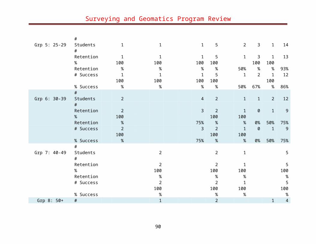
Surveying and Geomatics Program Review
Filipino # Students 1 1 # Retention 1 1 % Retention 100% 100% # Success 1 1 % Success 100% 100%
Latino/a # Students 2 1 4 4 4 15# Retention 2 1 2 3 4 12% Retention 100% 100% 50% 75% 100% 80%# Success 1 1 2 1 2 7% Success 50% 100% 50% 25% 50% 47%
Native American # Students 1 1 # Retention 1 1 % Retention 100% 100% % Success 0% 0%
Other/Unknown # Students 3 1 4 1 5 14# Retention 3 1 4 1 5 14% Retention 100% 100% 100% 100% 100% 100%# Success 3 1 4 1 4 13% Success 100% 100% 100% 100% 80% 93%
Pacific Islander # Students 1 1 # Retention 1 1 % Retention 100% 100% # Success 1 1 % Success 100% 100%
White # Students 1 2 8 4 1 16# Retention 1 2 8 4 1 16% Retention 100% 100% 100% 100% 100% 100%# Success 1 2 8 4 1 16
90

Surveying and Geomatics Program Review
% Success 100% 100% 100% 100% 100% 100%
91

Surveying and Geomatics Program Review
CET 142 Student Success and Retention
Term
2005
SUR
2005
FAR
2006
SPR
2006
SUR
2006
FAR
2007
SPR
2007
SUR
2007
FAR
2008
SPR
2008
SUR
2008
FAR
2009
SPR
2009
FAR
Gran
d To
tal
All Students # Students 11 6 12 29# Retention 11 6 10 27% Retention 100% 100% 83% 93%# Success 11 4 10 25% Success 100% 67% 83% 86%
By Gender Female # Students 1 1 2
# Retention 1 1 2 % Retention 100% 100% 100% # Success 1 1 2 % Success 100% 100% 100%
Male # Students 11 4 11 26# Retention 11 4 9 24% Retention 100% 100% 82% 92%# Success 11 2 9 22% Success 100% 50% 82% 85%
Unreported # Students 1 1 # Retention 1 1 % Retention 100% 100% # Success 1 1
92

Surveying and Geomatics Program Review
% Success 100% 100%
By Age Grp 4: 23-24 # Students 1 1 2
# Retention 1 1 2% Retention 100% 100% 100%# Success 1 1 2% Success 100% 100% 100%
Grp 5: 25-29 # Students 2 2 2 6 # Retention 2 2 2 6 % Retention 100% 100% 100% 100% # Success 2 0 2 4 % Success 100% 0% 100% 67%
Grp 6: 30-39 # Students 2 5 7# Retention 2 4 6% Retention 100% 80% 86%# Success 2 4 6% Success 100% 80% 86%
Grp 7: 40-49 # Students 4 1 5 10 # Retention 4 1 4 9 % Retention 100% 100% 80% 90% # Success 4 1 4 9 % Success 100% 100% 80% 90%
Grp 8: 50+ # Students 4 4# Retention 4 4% Retention 100% 100%# Success 4 4% Success 100% 100%
93

Surveying and Geomatics Program Review
By Ethnic Benchmark African American # Students 1 1
# Retention 1 1 % Retention 100% 100% # Success 1 1 % Success 100% 100%
Asian (All Other) # Students 1 1# Retention 0 0% Retention 0% 0%# Success 0 0% Success 0% 0%
Asian/Indian # Students 1 1 # Retention 1 1 % Retention 100% 100% # Success 1 1 % Success 100% 100%
Asian/Vietnamese # Students 1 2 1 4# Retention 1 2 1 4% Retention 100% 100% 100% 100%# Success 1 1 1 3% Success 100% 50% 100% 75%
Filipino # Students 1 1 # Retention 1 1 % Retention 100% 100% # Success 1 1 % Success 100% 100%
Latino/a # Students 1 4 5
94

Surveying and Geomatics Program Review
# Retention 1 4 5% Retention 100% 100% 100%# Success 1 4 5% Success 100% 100% 100%
Native American # Students 1 1 # Retention 1 1 % Retention 100% 100% # Success 1 1 % Success 100% 100%
Other/Unknown # Students 3 1 2 6# Retention 3 1 2 6% Retention 100% 100% 100% 100%# Success 3 1 2 6% Success 100% 100% 100% 100%
White # Students 3 2 4 9 # Retention 3 2 3 8 % Retention 100% 100% 75% 89% # Success 3 1 3 7 % Success 100% 50% 75% 78%
95

Surveying and Geomatics Program Review
CET 143 Student Success and Retention
Term
2005
SUR
2005
FAR
2006
SPR
2006
SUR
2006
FAR
2007
SPR
2007
SUR
2007
FAR
2008
SPR
2008
SUR
2008
FAR
2009
SPR
2009
FAR
Gran
d To
tal
All Students # Students 10 6 11 27# Retention 10 6 11 27% Retention 100% 100% 100% 100%# Success 8 6 9 23% Success 80% 100% 82% 85%
By Gender Female # Students 1 1 2
# Retention 1 1 2 % Retention 100% 100% 100% # Success 1 1 2 % Success 100% 100% 100%
Male # Students 10 4 10 24# Retention 10 4 10 24% Retention 100% 100% 100% 100%# Success 8 4 8 20% Success 80% 100% 80% 83%
Unreported # Students 1 1 # Retention 1 1 % Retention 100% 100% # Success 1 1
96

Surveying and Geomatics Program Review
% Success 100% 100%
By Age Grp 4: 23-24 # Students 1 2 3
# Retention 1 2 3% Retention 100% 100% 100%# Success 0 2 2% Success 0% 100% 67%
Grp 5: 25-29 # Students 2 1 1 4 # Retention 2 1 1 4 % Retention 100% 100% 100% 100% # Success 2 1 1 4 % Success 100% 100% 100% 100%
Grp 6: 30-39 # Students 2 5 7# Retention 2 5 7% Retention 100% 100% 100%# Success 2 4 6% Success 100% 80% 86%
Grp 7: 40-49 # Students 3 1 5 9 # Retention 3 1 5 9 % Retention 100% 100% 100% 100% # Success 3 1 4 8 % Success 100% 100% 80% 89%
Grp 8: 50+ # Students 4 4# Retention 4 4% Retention 100% 100%# Success 3 3% Success 75% 75%
97

Surveying and Geomatics Program Review
By Ethnic Benchmark Asian (All Other) # Students 1 1
# Retention 1 1 % Retention 100% 100% # Success 0 0 % Success 0% 0%
Asian/Chinese # Students 1 1# Retention 1 1% Retention 100% 100%# Success 1 1% Success 100% 100%
Asian/Indian # Students 1 1 2 # Retention 1 1 2 % Retention 100% 100% 100% # Success 0 1 1 % Success 0% 100% 50%
Asian/Vietnamese # Students 1 1 1 3# Retention 1 1 1 3% Retention 100% 100% 100% 100%# Success 1 1 1 3% Success 100% 100% 100% 100%
Filipino # Students 1 1 # Retention 1 1 % Retention 100% 100% # Success 1 1 % Success 100% 100%
Latino/a # Students 1 3 4
98

Surveying and Geomatics Program Review
# Retention 1 3 4% Retention 100% 100% 100%# Success 1 3 4% Success 100% 100% 100%
Native American # Students 1 1 # Retention 1 1 % Retention 100% 100% # Success 0 0 % Success 0% 0%
Other/Unknown # Students 4 1 2 7# Retention 4 1 2 7% Retention 100% 100% 100% 100%# Success 4 1 2 7% Success 100% 100% 100% 100%
White # Students 1 2 4 7 # Retention 1 2 4 7 % Retention 100% 100% 100% 100% # Success 1 2 3 6 % Success 100% 100% 75% 86%
99

Surveying and Geomatics Program Review
CET 145 Student Success and Retention
Term
2005
SUR
2005
FAR
2006
SPR
2006
SUR
2006
FAR
2007
SPR
2007
SUR
2007
FAR
2008
SPR
2008
SUR
2008
FAR
2009
SPR
2009
FAR
Gran
d To
tal
All Students # Students 9 7 12 28# Retention 9 7 11 27% Retention 100% 100% 92% 96%# Success 9 7 9 25% Success 100% 100% 75% 89%
By Gender Female # Students 1 1 2
# Retention 1 1 2 % Retention 100% 100% 100% # Success 1 1 2 % Success 100% 100% 100%
Male # Students 9 5 11 25# Retention 9 5 10 24% Retention 100% 100% 91% 96%# Success 9 5 8 22% Success 100% 100% 73% 88%
Unreported # Students 1 1 # Retention 1 1 % Retention 100% 100% # Success 1 1
100

Surveying and Geomatics Program Review
% Success 100% 100%
By Age Grp 4: 23-24 # Students 1 2 3
# Retention 1 2 3% Retention 100% 100% 100%# Success 0 2 2% Success 0% 100% 67%
Grp 5: 25-29 # Students 2 1 1 4 # Retention 2 1 1 4 % Retention 100% 100% 100% 100% # Success 2 1 1 4 % Success 100% 100% 100% 100%
Grp 6: 30-39 # Students 2 5 7# Retention 2 5 7% Retention 100% 100% 100%# Success 2 4 6% Success 100% 80% 86%
Grp 7: 40-49 # Students 3 1 5 9 # Retention 3 1 5 9 % Retention 100% 100% 100% 100% # Success 3 1 4 8 % Success 100% 100% 80% 89%
Grp 8: 50+ # Students 4 4# Retention 4 4% Retention 100% 100%# Success 3 3% Success 75% 75%
101

Surveying and Geomatics Program Review
By Ethnic Benchmark African American # Students 1 1
# Retention 1 1 % Retention 100% 100% # Success 1 1 % Success 100% 100%
Asian (All Other) # Students 1 1# Retention 1 1% Retention 100% 100%# Success 0 0% Success 0% 0%
Asian/Chinese # Students 1 1 # Retention 1 1 % Retention 100% 100% # Success 1 1 % Success 100% 100%
Asian/Indian # Students 1 1# Retention 1 1% Retention 100% 100%# Success 1 1% Success 100% 100%
Asian/Vietnamese # Students 1 1 1 3 # Retention 1 1 1 3 % Retention 100% 100% 100% 100% # Success 1 1 1 3 % Success 100% 100% 100% 100%
Filipino # Students 1 1
102

Surveying and Geomatics Program Review
# Retention 1 1% Retention 100% 100%# Success 1 1% Success 100% 100%
Latino/a # Students 1 3 4 # Retention 1 3 4 % Retention 100% 100% 100% # Success 1 3 4 % Success 100% 100% 100%
Native American # Students 1 1# Retention 1 1% Retention 100% 100%# Success 1 1% Success 100% 100%
Other/Unknown # Students 4 1 2 7 # Retention 4 1 2 7 % Retention 100% 100% 100% 100% # Success 4 1 2 7 % Success 100% 100% 100% 100%
White # Students 1 2 5 8# Retention 1 2 4 7% Retention 100% 100% 80% 88%# Success 1 2 3 6% Success 100% 100% 60% 75%
103

Surveying and Geomatics Program Review
CET 146 Student Success and Retention
Term
2005
SUR
2005
FAR
2006
SPR
2006
SUR
2006
FAR
2007
SPR
2007
SUR
2007
FAR
2008
SPR
2008
SUR
2008
FAR
2009
SPR
2009
FAR
Gran
d To
tal
All Students # Students 16 8 8 5 11 48# Retention 11 7 7 5 11 41% Retention 69% 88% 88% 100% 100% 85%# Success 11 7 7 5 9 39% Success 69% 88% 88% 100% 82% 81%
By Gender Female # Students 1 1 3 1 6
# Retention 1 1 3 1 6 % Retention 100% 100% 100% 100% 100% # Success 1 1 3 1 6 % Success 100% 100% 100% 100% 100%
Male # Students 15 7 8 2 10 42# Retention 10 6 7 2 10 35% Retention 67% 86% 88% 100% 100% 83%# Success 10 6 7 2 8 33% Success 67% 86% 88% 100% 80% 79%
By Age Grp 4: 23-24 # Students 2 2
# Retention 2 2
104

Surveying and Geomatics Program Review
% Retention 100% 100% # Success 2 2 % Success 100% 100%
Grp 5: 25-29 # Students 1 1 1 3# Retention 1 1 1 3% Retention 100% 100% 100% 100%# Success 1 1 1 3% Success 100% 100% 100% 100%
Grp 6: 30-39 # Students 2 5 7 # Retention 2 5 7 % Retention 100% 100% 100% # Success 2 4 6 % Success 100% 80% 86%
Grp 7: 40-49 # Students 4 1 6 11# Retention 4 1 5 10% Retention 100% 100% 83% 91%# Success 4 1 4 9% Success 100% 100% 67% 82%
Grp 8: 50+ # Students 4 1 5 # Retention 4 1 5 % Retention 100% 100% 100% # Success 4 1 5 % Success 100% 100% 100%
By Ethnic Benchmark African American # Students 2 2 4
# Retention 1 2 3% Retention 50% 100% 75%
105

Surveying and Geomatics Program Review
# Success 1 2 3% Success 50% 100% 75%
Asian (All Other) # Students 1 1 2 # Retention 1 1 2 % Retention 100% 100% 100% # Success 1 1 2 % Success 100% 100% 100%
Asian/Chinese # Students 1 1# Retention 1 1% Retention 100% 100%# Success 1 1% Success 100% 100%
Asian/Indian # Students 1 1 2 # Retention 0 1 1 % Retention 0% 100% 50% # Success 0 1 1 % Success 0% 100% 50%
Asian/Vietnamese # Students 1 1 2 1 2 7# Retention 0 1 1 1 2 5% Retention 0% 100% 50% 100% 100% 71%# Success 0 1 1 1 1 4% Success 0% 100% 50% 100% 50% 57%
Filipino # Students 2 2 # Retention 2 2 % Retention 100% 100% # Success 2 2 % Success 100% 100%
Latino/a # Students 3 3 1 1 1 9
106

Surveying and Geomatics Program Review
# Retention 3 3 1 1 1 9% Retention 100% 100% 100% 100% 100% 100%# Success 3 3 1 1 1 9% Success 100% 100% 100% 100% 100% 100%
Native American # Students 1 1 # Retention 0 0 % Retention 0% 0% # Success 0 0 % Success 0% 0%
Other/Unknown # Students 4 1 1 3 9# Retention 3 0 1 3 7% Retention 75% 0% 100% 100% 78%# Success 3 0 1 3 7% Success 75% 0% 100% 100% 78%
Pacific Islander # Students 1 1 2 # Retention 1 1 2 % Retention 100% 100% 100% # Success 1 1 2 % Success 100% 100% 100%
White # Students 2 2 2 3 9# Retention 2 2 2 3 9% Retention 100% 100% 100% 100% 100%# Success 2 2 2 2 8% Success 100% 100% 100% 67% 89%
107

Surveying and Geomatics Program Review
CET 147 Student Success and Retention
Term
2005
SUR
2005
FAR
2006
SPR
2006
SUR
2006
FAR
2007
SPR
2007
SUR
2007
FAR
2008
SPR
2008
SUR
2008
FAR
2009
SPR
2009
FAR
Gran
d To
tal
All Students # Students 10 10 16 36# Retention 10 7 15 32% Retention 100% 70% 94% 89%# Success 10 7 14 31% Success 100% 70% 88% 86%
By Gender Female # Students 1 2 3
# Retention 1 2 3 % Retention 100% 100% 100% # Success 1 2 3 % Success 100% 100% 100%
Male # Students 9 10 14 33# Retention 9 7 13 29% Retention 100% 70% 93% 88%# Success 9 7 12 28% Success 100% 70% 86% 85%
By Age Grp 3: 20-22 # Students 1 1 1 3
# Retention 0 1 1 2
108

Surveying and Geomatics Program Review
% Retention 0% 100% 100% 67% # Success 0 1 1 2 % Success 0% 100% 100% 67%
Grp 4: 23-24 # Students 1 3 4# Retention 1 3 4% Retention 100% 100% 100%# Success 1 1 2% Success 100% 33% 50%
Grp 5: 25-29 # Students 3 3 # Retention 3 3 % Retention 100% 100% # Success 3 3 % Success 100% 100%
Grp 6: 30-39 # Students 1 4 2 2 1 10# Retention 1 4 2 2 1 10% Retention 100% 100% 100% 100% 100% 100%# Success 1 4 2 2 1 10% Success 100% 100% 100% 100% 100% 100%
Grp 7: 40-49 # Students 8 2 1 1 12 # Retention 6 2 1 1 10 % Retention 75% 100% 100% 100% 83% # Success 6 2 1 1 10 % Success 75% 100% 100% 100% 83%
Grp 8: 50+ # Students 7 1 1 1 6 16# Retention 4 0 1 1 6 12% Retention 57% 0% 100% 100% 100% 75%# Success 4 0 1 1 6 12% Success 57% 0% 100% 100% 100% 75%
109

Surveying and Geomatics Program Review
By Ethnic Benchmark African American # Students 1 1
# Retention 1 1 % Retention 100% 100% # Success 1 1 % Success 100% 100%
Asian (All Other) # Students 2 1 3# Retention 0 1 1% Retention 0% 100% 33%# Success 0 1 1% Success 0% 100% 33%
Asian/Chinese # Students 1 1 # Retention 1 1 % Retention 100% 100% # Success 1 1 % Success 100% 100%
Asian/Vietnamese # Students 3 1 1 5# Retention 3 0 1 4% Retention 100% 0% 100% 80%# Success 3 0 1 4% Success 100% 0% 100% 80%
Filipino # Students 1 1 # Retention 1 1 % Retention 100% 100% # Success 1 1 % Success 100% 100%
Latino/a # Students 1 1 7 9
110

Surveying and Geomatics Program Review
# Retention 1 1 7 9% Retention 100% 100% 100% 100%# Success 1 1 6 8% Success 100% 100% 86% 89%
Other/Unknown # Students 3 2 1 6 # Retention 3 2 0 5 % Retention 100% 100% 0% 83% # Success 3 2 0 5 % Success 100% 100% 0% 83%
Pacific Islander # Students 1 1# Retention 1 1% Retention 100% 100%# Success 1 1% Success 100% 100%
White # Students 4 5 9 # Retention 4 5 9 % Retention 100% 100% 100% # Success 4 5 9 % Success 100% 100% 100%
111

Surveying and Geomatics Program Review
CET 148 Student Success and Retention
Term
2005
SUR
2005
FAR
2006
SPR
2006
SUR
2006
FAR
2007
SPR
2007
SUR
2007
FAR
2008
SPR
2008
SUR
2008
FAR
2009
SPR
2009
FAR
Gran
d To
tal
All Students # Students 7 11 6 24# Retention 7 9 6 22% Retention 100% 82% 100% 92%# Success 7 8 6 21% Success 100% 73% 100% 88%
By Gender Female # Students 1 1 2
# Retention 1 1 2 % Retention 100% 100% 100% # Success 1 1 2 % Success 100% 100% 100%
Male # Students 7 9 5 21# Retention 7 7 5 19% Retention 100% 78% 100% 90%# Success 7 7 5 19% Success 100% 78% 100% 90%
Unreported # Students 1 1 # Retention 1 1 % Retention 100% 100% # Success 0 0
112

Surveying and Geomatics Program Review
% Success 0% 0%
By Age Grp 4: 23-24 # Students 2 1 3
# Retention 2 1 3% Retention 100% 100% 100%# Success 2 1 3% Success 100% 100% 100%
Grp 5: 25-29 # Students 1 1 # Retention 1 1 % Retention 100% 100% # Success 1 1 % Success 100% 100%
Grp 6: 30-39 # Students 1 4 3 8# Retention 1 2 3 6% Retention 100% 50% 100% 75%# Success 1 2 3 6% Success 100% 50% 100% 75%
Grp 7: 40-49 # Students 3 4 2 9 # Retention 3 4 2 9 % Retention 100% 100% 100% 100% # Success 3 3 2 8 % Success 100% 75% 100% 89%
Grp 8: 50+ # Students 1 2 3# Retention 1 2 3% Retention 100% 100% 100%# Success 1 2 3% Success 100% 100% 100%
113

Surveying and Geomatics Program Review
By Ethnic Benchmark African American # Students 1 1
# Retention 1 1 % Retention 100% 100% # Success 1 1 % Success 100% 100%
Asian/Chinese # Students 1 1# Retention 1 1% Retention 100% 100%# Success 1 1% Success 100% 100%
Asian/Indian # Students 1 1 # Retention 1 1 % Retention 100% 100% # Success 1 1 % Success 100% 100%
Asian/Vietnamese # Students 1 3 1 5# Retention 1 1 1 3% Retention 100% 33% 100% 60%# Success 1 1 1 3% Success 100% 33% 100% 60%
Filipino # Students 1 1 # Retention 1 1 % Retention 100% 100% # Success 1 1 % Success 100% 100%
Latino/a # Students 2 1 3
114

Surveying and Geomatics Program Review
# Retention 2 1 3% Retention 100% 100% 100%# Success 2 1 3% Success 100% 100% 100%
Other/Unknown # Students 2 2 1 5 # Retention 2 2 1 5 % Retention 100% 100% 100% 100% # Success 2 1 1 4 % Success 100% 50% 100% 80%
Pacific Islander # Students 1 1# Retention 1 1% Retention 100% 100%# Success 1 1% Success 100% 100%
White # Students 2 1 3 6 # Retention 2 1 3 6 % Retention 100% 100% 100% 100% # Success 2 1 3 6 % Success 100% 100% 100% 100%
115

Surveying and Geomatics Program Review
SG 149 Student Success and Retention
Term
2005
SUR
2005
FAR
2006
SPR
2006
SUR
2006
FAR
2007
SPR
2007
SUR
2007
FAR
2008
SPR
2008
SUR
2008
FAR
2009
SPR
2009
FAR
Gran
d To
tal
All Students # Students 20 20# Retention 13 13% Retention 65% 65%# Success 13 13% Success 65% 65%
By Gender Female # Students 2 2
# Retention 1 1 % Retention 50% 50% # Success 1 1 % Success 50% 50%
Male # Students 18 18# Retention 12 12% Retention 67% 67%# Success 12 12% Success 67% 67%
By Age Grp 2: 18-19 # Students 1 1
# Retention 0 0
116

Surveying and Geomatics Program Review
% Retention 0% 0% # Success 0 0 % Success 0% 0%
Grp 5: 25-29 # Students 3 3# Retention 2 2% Retention 67% 67%# Success 2 2% Success 67% 67%
Grp 6: 30-39 # Students 4 4 # Retention 2 2 % Retention 50% 50% # Success 2 2 % Success 50% 50%
Grp 7: 40-49 # Students 4 4# Retention 4 4% Retention 100% 100%# Success 4 4% Success 100% 100%
Grp 8: 50+ # Students 8 8 # Retention 5 5 % Retention 63% 63% # Success 5 5 % Success 63% 63%
By Ethnic Benchmark African American # Students 2 2
# Retention 2 2% Retention 100% 100%# Success 2 2
117

Surveying and Geomatics Program Review
% Success 100% 100%Asian/Chinese # Students 2 2
# Retention 1 1 % Retention 50% 50% # Success 1 1 % Success 50% 50%
Asian/Indian # Students 1 1# Retention 1 1% Retention 100% 100%# Success 1 1% Success 100% 100%
Asian/Vietnamese # Students 1 1 # Retention 1 1 % Retention 100% 100% # Success 1 1 % Success 100% 100%
Latino/a # Students 6 6# Retention 1 1% Retention 17% 17%# Success 1 1% Success 17% 17%
Other/Unknown # Students 4 4 # Retention 4 4 % Retention 100% 100% # Success 4 4 % Success 100% 100%
White # Students 4 4# Retention 3 3% Retention 75% 75%# Success 3 3
118

Surveying and Geomatics Program Review
% Success 75% 75%
119