sustainable ecosystem management in clayoquot … of contents clayoquot sound scientific panel...
TRANSCRIPT
Clayoquot Sound Scientific Panel ABCDESustainable Ecosystem Management in Clayoquot Sound: Planning and Practices
April 1995 i
Sustainable EcosystemManagement inClayoquot SoundPlanning and Practices
Tofin
o In
let
Tofin
o In
let
Flores Island
Hesquiat Harbour
Vargas Island Meares
Island
Hot Springs Cove
Hesquiat
Opitsat
Tofino
Ucluelet
Ahousat
Her
bert
Inle
t
Kennedy Lake
Sydney R
.
Meg
in R
.
Moy
eha R.
Cyp
re R
.
Bedwell R.
Ursus R.
Bul
son
Cr.
Tran
quil
Cr.
Tofin
o C
r.
Cla
yoqu
ot R
.K
enne
dy R
.
Flores Island
Hesquiat Harbour
Vargas Island Meares
Island
Hot Springs Cove
Hesquiat
Opitsat
Tofino
Ucluelet
Ahousat
Her
bert
Inle
t
Kennedy Lake
Sydney R
.
Meg
in R
.
Moy
eha R.
Cyp
re R
.
Bedwell R.
Ursus R.
Bul
son
Cr.
Tran
quil
Cr.
Tofin
o C
r.
Cla
yoqu
ot R
.K
enne
dy R
.
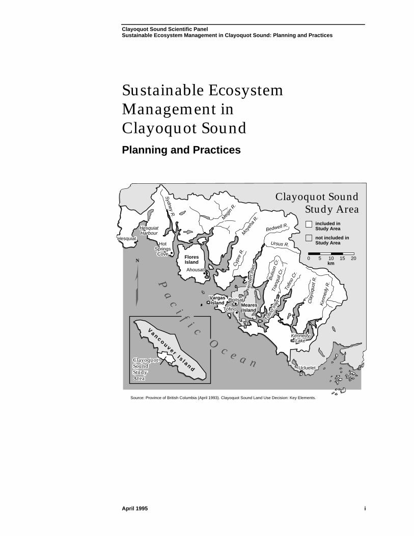
Clayoquot Sound Study Area
Clayoquot Sound Study Area
Pa
ci
f i cO
c e a n
V a n c o u v e r I s l a n d
N
Clayoquot Sound Study Area
included in Study Area
not included in Study Area
0 5 10 15km
20
Source: Province of British Columbia (April 1993). Clayoquot Sound Land Use Decision: Key Elements.

Clayoquot Sound Scientific Panel ABCDESustainable Ecosystem Management in Clayoquot Sound: Planning and Practices
April 1995 ii
Table of Contents Clayoquot Sound Scientific PanelSustainable Ecosystem Management in Clayoquot Sound: Planning and Practices
April 1995 iii
Table of Contents
List of Figures ..................................................................................................... vii
Acknowledgments ............................................................................................... ix
Executive Summary ............................................................................................ xi
1.0 Introduction ........................................................................................................... 1
1.1 Panel Mandate ............................................................................................... 1
1.2 Report Context ............................................................................................... 2
1.2.1 Previous Panel Reports ...................................................................... 2
1.2.2 Complexity of Timber Production Activities ......................................... 3
1.3 Terminology ................................................................................................... 4
1.4 Report Organization ....................................................................................... 5
2.0 The Clayoquot Sound Environment:hishuk ish ts’awalk ......................... 7
2.1 The Physical Landscape................................................................................ 7
2.1.1 Climate and Hydrology........................................................................ 8
2.1.2 Terrain and Surficial Material ............................................................ 10
2.1.3 Soils .................................................................................................. 12
2.1.4 Land-Shaping Processes .................................................................. 13
2.2 The Ecological Landscape ........................................................................... 17
2.2.1 Biogeoclimatic Units .......................................................................... 17
2.2.2 Terrestrial Ecosystems: Vegetation .................................................. 21
2.2.3 Terrestrial Ecosystems: Fauna ......................................................... 25
2.2.4 The Hydroriparian Ecosystem ........................................................... 29
2.2.5 From Stream to Sea.......................................................................... 33
2.3 Human Values in the Landscape ................................................................. 37
2.3.1 First Nations’ Values ......................................................................... 38
2.3.2 Values of Non-Indigenous Peoples ................................................... 39
2.3.3 Scenic Values ................................................................................... 40
2.3.4 Recreational and Tourism Values ..................................................... 42
3.0 Silvicultural Systems ....................................................................................... 45
3.1 Conventional Silvicultural Systems .............................................................. 46
3.2 Current Silvicultural Systems in Clayoquot Sound....................................... 49
3.2.1 Advantages and Disadvantages of Clearcutting ............................... 52
3.2.2 Standards for Silvicultural Systems................................................... 54
3.2.3 Summary ........................................................................................... 66
3.3 Findings Regarding Silvicultural Systems.................................................... 67
3.4 Recommendations Regarding Silvicultural Systems ................................... 78
3.4.1 The Planning Context ....................................................................... 80
3.4.2 Recommendations Within the Planning Context ............................... 81
Table of Contents Clayoquot Sound Scientific PanelSustainable Ecosystem Management in Clayoquot Sound: Planning and Practices
April 1995 iv
4.0 Harvesting Systems ......................................................................................... 91
4.1 Current Harvesting Technology and Equipment .......................................... 91
4.1.1 Description of Yarding Methods ........................................................ 91
4.1.2 Factors Affecting Choice of Harvesting System.............................. 101
4.2 Harvesting in Clayoquot Sound ................................................................. 103
4.2.1 Historical Overview ......................................................................... 103
4.2.2 Standards for Harvesting ................................................................ 105
4.2.3 Recent Harvesting in Clayoquot Sound .......................................... 106
4.2.4 Yarding Methods Appropriate to a Variable-RetentionSilvicultural System ......................................................................... 107
4.3 Findings Regarding Harvesting Systems ................................................... 111
4.4 Recommendations Regarding Harvesting Systems .................................. 116
5.0 Transportation Systems ................................................................................ 119
5.1 Road Transportation .................................................................................. 119
5.1.1 Standards for Roads ....................................................................... 122
5.1.2 Findings Regarding Roads ............................................................. 124
5.1.3 Recommendations Regarding Roads ............................................. 126
5.2 Water Transportation ................................................................................. 128
5.2.1 Standards for Log Handling and Water Transportation................... 130
5.2.2 Findings Regarding Water Transportation ...................................... 131
5.2.3 Recommendations Regarding Water Transportation...................... 132
6.0 Scenic, Recreational, and Tourism............................................................. 133
6.1 Scenic Resources ...................................................................................... 134
6.1.1 Standards for Managing Scenic Resources.................................... 134
6.1.2 Findings Regarding Scenic Values ................................................. 138
6.1.3 Recommendations Regarding Scenic Values ................................. 142
6.2 Recreational and Tourism Resources ....................................................... 145
6.2.1 Standards for Recreation and Tourism ........................................... 145
6.2.2 Findings Regarding Recreational and Tourism Resources............. 146
6.2.3 Recommendations Regarding Recreational and Tourism Values .. 149
Table of Contents Clayoquot Sound Scientific PanelSustainable Ecosystem Management in Clayoquot Sound: Planning and Practices
April 1995 v
7.0 Planning for Sustainable Ecosystem ManagementIn Clayoquot Sound ........................................................................................ 151
7.1 Current Approach to Planning ................................................................... 152
7.2 New Planning Framework.......................................................................... 153
7.2.1 Planning Principles ......................................................................... 153
7.2.2 Participation in Planning ................................................................. 155
7.2.3 The Planning Process ..................................................................... 157
7.2.4 Time Frames ................................................................................... 159
7.3 The Levels of Planning .............................................................................. 161
7.3.1 Subregional-Level Planning ............................................................ 162
7.3.2 Watershed-Level Planning .............................................................. 166
7.3.3 Site-Level Planning ......................................................................... 172
7.4 Hydroriparian Reserves ............................................................................. 175
7.4.1 Streams ........................................................................................... 179
7.4.2 Lakes............................................................................................... 183
7.4.3 Wetlands ......................................................................................... 184
7.4.4 Marine Shores ................................................................................. 185
7.4.5 Roads.............................................................................................. 185
7.5 Phasing in the New Planning Framework .................................................. 186
8.0 Monitoring ......................................................................................................... 189
8.1 General Comments on Monitoring ............................................................. 189
8.2 Monitoring Watershed and Coastal Integrity .............................................. 192
8.2.1 Monitoring Hillslopes and Forest Soils ............................................ 192
8.2.2 Monitoring Stream Channels........................................................... 195
8.2.3 Regional Monitoring of Streamflow and Water Quality ................... 198
8.2.4 Monitoring the Coastal Zone ........................................................... 200
8.3 Monitoring Biological Diversity ................................................................... 200
8.3.1 Monitoring Genetic Variation ........................................................... 202
8.3.2 Monitoring Vulnerable and Rare Indigenous Species ..................... 204
8.3.3 Monitoring Terrestrial Environments ............................................... 205
8.3.4 Monitoring Old-Growth Characteristics ........................................... 209
8.3.5 Monitoring Aquatic Environments ................................................... 211
8.4 Monitoring Human Activities and Values ................................................... 213
8.4.1 Monitoring Areas and Sites Important to First Nations ................... 213
8.4.2 Monitoring Scenic, Recreational, and Tourism Values ................... 213
8.4.3 Monitoring Regional Production ...................................................... 217
8.5 Implementation .......................................................................................... 218
9.0 Sources Cited ................................................................................................... 219

Table of Contents Clayoquot Sound Scientific PanelSustainable Ecosystem Management in Clayoquot Sound: Planning and Practices
April 1995 vi
Appendix I ......................................................................................................... 237
Summary of the Panel’s Recommendations ConcerningPlanning and Practices in Clayoquot Sound
Recommendations Relating to Silvicultural Systems ........................................... 237
Recommendations Relating to Harvesting Systems............................................. 241
Recommendations Relating to Transportation Systems....................................... 242
Recommendations Relating to Scenic, Recreational,and Tourism Values and Resources..................................................................... 244
Recommendations Relating to Planning for SustainableEcosystem Management in Clayoquot Sound...................................................... 246
Recommendations Relating to Monitoring............................................................ 254
Appendix II ........................................................................................................ 255
Classification of the Hydroriparian System
1.0 Bases For Classification ............................................................................ 255
2.0 Classification.............................................................................................. 257
2.1 Stream (Lotic) Environment ............................................................ 257
2.2 Standing Waterbodies and Wetlands (Lentic Environment) ........... 258
Appendix III ....................................................................................................... 261
Information Requirements for Planning
1.0 Historical Information ................................................................................. 261
2.0 Subregional-Level Information ................................................................... 262
3.0 Watershed-Level Information ..................................................................... 264
4.0 Site-Level Information ................................................................................ 268
Appendix IV ....................................................................................................... 271
Glossary
Appendix V ........................................................................................................ 295
Members of the Scientific Panel for Sustainable Forest Practicesin Clayoquot Sound
List of Figures Clayoquot Sound Scientific PanelSustainable Ecosystem Management in Clayoquot Sound: Planning and Practices
April 1995 vii
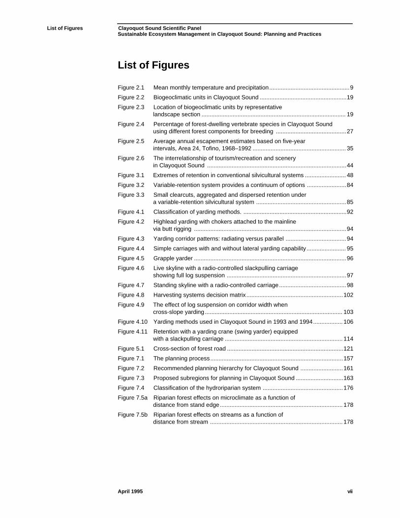
List of Figures
Figure 2.1 Mean monthly temperature and precipitation................................................. 9
Figure 2.2 Biogeoclimatic units in Clayoquot Sound ..................................................... 19
Figure 2.3 Location of biogeoclimatic units by representativelandscape section ........................................................................................ 19
Figure 2.4 Percentage of forest-dwelling vertebrate species in Clayoquot Soundusing different forest components for breeding ........................................... 27
Figure 2.5 Average annual escapement estimates based on five-yearintervals, Area 24, Tofino, 1968–1992 ......................................................... 35
Figure 2.6 The interrelationship of tourism/recreation and sceneryin Clayoquot Sound ..................................................................................... 44
Figure 3.1 Extremes of retention in conventional silvicultural systems ......................... 48
Figure 3.2 Variable-retention system provides a continuum of options ........................ 84
Figure 3.3 Small clearcuts, aggregated and dispersed retention undera variable-retention silvicultural system ....................................................... 85
Figure 4.1 Classification of yarding methods. ............................................................... 92
Figure 4.2 Highlead yarding with chokers attached to the mainlinevia butt rigging ............................................................................................. 94
Figure 4.3 Yarding corridor patterns: radiating versus parallel ..................................... 94
Figure 4.4 Simple carriages with and without lateral yarding capability ........................ 95
Figure 4.5 Grapple yarder ............................................................................................. 96
Figure 4.6 Live skyline with a radio-controlled slackpulling carriageshowing full log suspension ......................................................................... 97
Figure 4.7 Standing skyline with a radio-controlled carriage......................................... 98
Figure 4.8 Harvesting systems decision matrix ........................................................... 102
Figure 4.9 The effect of log suspension on corridor width whencross-slope yarding.................................................................................... 103
Figure 4.10 Yarding methods used in Clayoquot Sound in 1993 and 1994.................. 106
Figure 4.11 Retention with a yarding crane (swing yarder) equippedwith a slackpulling carriage ........................................................................ 114
Figure 5.1 Cross-section of forest road ....................................................................... 121
Figure 7.1 The planning process................................................................................. 157
Figure 7.2 Recommended planning hierarchy for Clayoquot Sound .......................... 161
Figure 7.3 Proposed subregions for planning in Clayoquot Sound ............................. 163
Figure 7.4 Classification of the hydroriparian system ................................................. 176
Figure 7.5a Riparian forest effects on microclimate as a function ofdistance from stand edge........................................................................... 178
Figure 7.5b Riparian forest effects on streams as a function ofdistance from stream ................................................................................. 178

List of Figures Clayoquot Sound Scientific PanelSustainable Ecosystem Management in Clayoquot Sound: Planning and Practices
April 1995 viii

Acknowledgments Clayoquot Sound Scientific PanelSustainable Ecosystem Management in Clayoquot Sound: Planning and Practices
April 1995 ix
Acknowledgments
Cover illustration by Cortex Consultants, adapted from photos providedcourtesy of B.C. Ministry of Forests and Elizabeth Simpson.
Photographs by Catherine Berris, B.C. Ministry of Forests, Dave Dunbar, JerryFranklin, Ken Lertzman, Terry Lewis, Keith Moore, Harry Parsons, DaveShackleton, Nancy Turner, and Doug Williams.
Figures by Cortex Consultants; Chapter 4 illustrations from Cable Logging Systems(Binkley and Studier 1974).

Acknowledgments Clayoquot Sound Scientific PanelSustainable Ecosystem Management in Clayoquot Sound: Planning and Practices
April 1995 x
Executive Summary Clayoquot Sound Scientific PanelSustainable Ecosystem Management in Clayoquot Sound: Planning and Practices
April 1995 xi
Executive Summary
This document presents findings and recommendations of the Scientific Panel forSustainable Forest Practices in Clayoquot Sound based on its review of forestpractices standards in effect in Clayoquot Sound as of September 30, 1994.
Panel findings note the extent to which current standards for forest planning andinformation collection, physical processes of timber extraction, and provisions forincorporating scenic, recreational, and tourism values meet precepts forsustainable ecosystem management.
Ecosystem management must acknowledge the physical structures, processes,and biological constituents of the ecosystem. This document describes thosefeatures for the Clayoquot Sound region and makes recommendationsappropriate to their nature. Panel recommendations seek to create forestpractices standards for Clayoquot Sound that are the best in the world.
Philosophy
Ecosystems, resources, and resource values are interconnected. The Panel assertsthat sustainable forest practices in Clayoquot Sound must be judged by the extentto which all resources are respected and sustained. Sustainability depends onmaintaining ecosystem productivity and connections.
Two key features have shaped the Panel’s recommendations:
• recognition that ecosystems and the values with which they are imbued aredynamic, and that forest practices and policies must both anticipate andaccommodate changing conditions; and
• recognition that forest practices and policies reflect the knowledge,understanding, and values in existence at a point in time.
For such reasons, Panel recommendations invoke the precautionary principle: actcautiously and make subsequent adjustments based on the application ofmethods tested and found successful in similar environments; support change bydiligent monitoring of responses in the Clayoquot environment.
We do not know everything about the ecosystems of Clayoquot Sound, thetechnology of extraction, or the implications of new management options. ThePanel’s mandate is to provide informed advice, supported by science and theexperience and knowledge of the Nuu-Chah-Nulth who made this area theirhome. Policy development and management must proceed adaptively.
Panel recommendations seek to define forest practices that are scientificallysound, operationally achievable, publicly acceptable, and safe. In its deliberationsabout appropriate forestry practices, the Panel respected the following priorities:safety, ecosystem integrity, operational effectiveness, and visual appearance.
Executive Summary Clayoquot Sound Scientific PanelSustainable Ecosystem Management in Clayoquot Sound: Planning and Practices
April 1995 xii
Panel recommendations are intended to provide direction for developingstandards that are measurable and enforceable.
Physical Environment
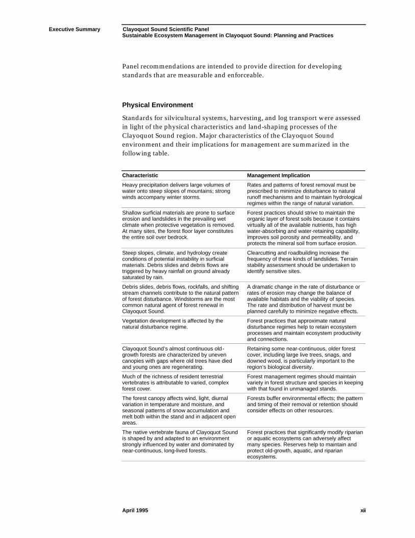
Standards for silvicultural systems, harvesting, and log transport were assessedin light of the physical characteristics and land-shaping processes of theClayoquot Sound region. Major characteristics of the Clayoquot Soundenvironment and their implications for management are summarized in thefollowing table.
Characteristic Management Implication
Heavy precipitation delivers large volumes ofwater onto steep slopes of mountains; strongwinds accompany winter storms.
Rates and patterns of forest removal must beprescribed to minimize disturbance to naturalrunoff mechanisms and to maintain hydrologicalregimes within the range of natural variation.
Shallow surficial materials are prone to surfaceerosion and landslides in the prevailing wetclimate when protective vegetation is removed.At many sites, the forest floor layer constitutesthe entire soil over bedrock.
Forest practices should strive to maintain theorganic layer of forest soils because it containsvirtually all of the available nutrients, has highwater-absorbing and water-retaining capability,improves soil porosity and permeability, andprotects the mineral soil from surface erosion.
Steep slopes, climate, and hydrology createconditions of potential instability in surficialmaterials. Debris slides and debris flows aretriggered by heavy rainfall on ground alreadysaturated by rain.
Clearcutting and roadbuilding increase thefrequency of these kinds of landslides. Terrainstability assessment should be undertaken toidentify sensitive sites.
Debris slides, debris flows, rockfalls, and shiftingstream channels contribute to the natural patternof forest disturbance. Windstorms are the mostcommon natural agent of forest renewal inClayoquot Sound.
A dramatic change in the rate of disturbance orrates of erosion may change the balance ofavailable habitats and the viability of species.The rate and distribution of harvest must beplanned carefully to minimize negative effects.
Vegetation development is affected by thenatural disturbance regime.
Forest practices that approximate naturaldisturbance regimes help to retain ecosystemprocesses and maintain ecosystem productivityand connections.
Clayoquot Sound’s almost continuous old -growth forests are characterized by unevencanopies with gaps where old trees have diedand young ones are regenerating.
Retaining some near-continuous, older forestcover, including large live trees, snags, anddowned wood, is particularly important to theregion’s biological diversity.
Much of the richness of resident terrestrialvertebrates is attributable to varied, complexforest cover.
Forest management regimes should maintainvariety in forest structure and species in keepingwith that found in unmanaged stands.
The forest canopy affects wind, light, diurnalvariation in temperature and moisture, andseasonal patterns of snow accumulation andmelt both within the stand and in adjacent openareas.
Forests buffer environmental effects; the patternand timing of their removal or retention shouldconsider effects on other resources.
The native vertebrate fauna of Clayoquot Soundis shaped by and adapted to an environmentstrongly influenced by water and dominated bynear-continuous, long-lived forests.
Forest practices that significantly modify riparianor aquatic ecosystems can adversely affectmany species. Reserves help to maintain andprotect old-growth, aquatic, and riparianecosystems.
Executive Summary Clayoquot Sound Scientific PanelSustainable Ecosystem Management in Clayoquot Sound: Planning and Practices
April 1995 xiii
The hydroriparian ecosystem—comprised of waterbodies and the immediatelyadjacent terrestrial environment—deserves special consideration in forestplanning and management in Clayoquot Sound. It links estuary to alpineenvironments, is the focus of activity for a large portion of all fauna, and containsthe most diverse flora in a watershed. Populations of some species rarely movebetween watersheds.
Forests in riparian areas play critical roles in shading, food production, and food-gathering processes within streams. These forests affect the rate of watermovement through the soil, are the source of whole trees and smaller woodfragments that help to store gravel in the stream channel and provide habitat fora variety of aquatic organisms, regulate stream velocity, and influence streamchannel morphology.
The hydroriparian ecosystem is the major travel corridor for many terrestrial andall aquatic organisms—essentially the skeleton and circulation system of theecological landscape. About 72% of forest-dwelling vertebrates in ClayoquotSound use riparian areas. Streams, lakes, and estuaries all provide incubationand rearing environments for trout and salmon. Linkages from terrestrialriparian systems to streams continue to the sea.
These land-water systems are strongly affected by logging and roadbuildingactivities which can alter channel morphology, hydrology, water quality, andshading or thermal regimes. Events far upstream, well removed from spawningareas, can influence downstream characteristics and organisms. Changes in theriparian environment that modify physical processes or alter food availabilityinfluence the invertebrate faunas and thus may alter fish species composition orabundance. These points emphasize the importance of maintaining vegetation inriparian areas, restricting rates of forest removal (rate-of-cut) within watersheds,carefully locating and constructing roads, and treating watersheds as discreteunits.
Key recommendations related to the hydroriparian zone include:
• adopting a new classification system based on characteristics of waterbodiesand surrounding land;
• designating the entire hydroriparian zone as a special management zone;and
• defining areas entirely reserved from harvest, or where harvest and roadconstruction are constrained, based on the classification system.
Planning
The Scientific Panel recommends an ecosystem-based approach to planning inwhich the primary planning objective is to sustain the productivity and naturaldiversity of the Clayoquot Sound region. Planning at a variety of spatial andtemporal scales is critical at all stages of forest ecosystem management.
Executive Summary Clayoquot Sound Scientific PanelSustainable Ecosystem Management in Clayoquot Sound: Planning and Practices
April 1995 xiv
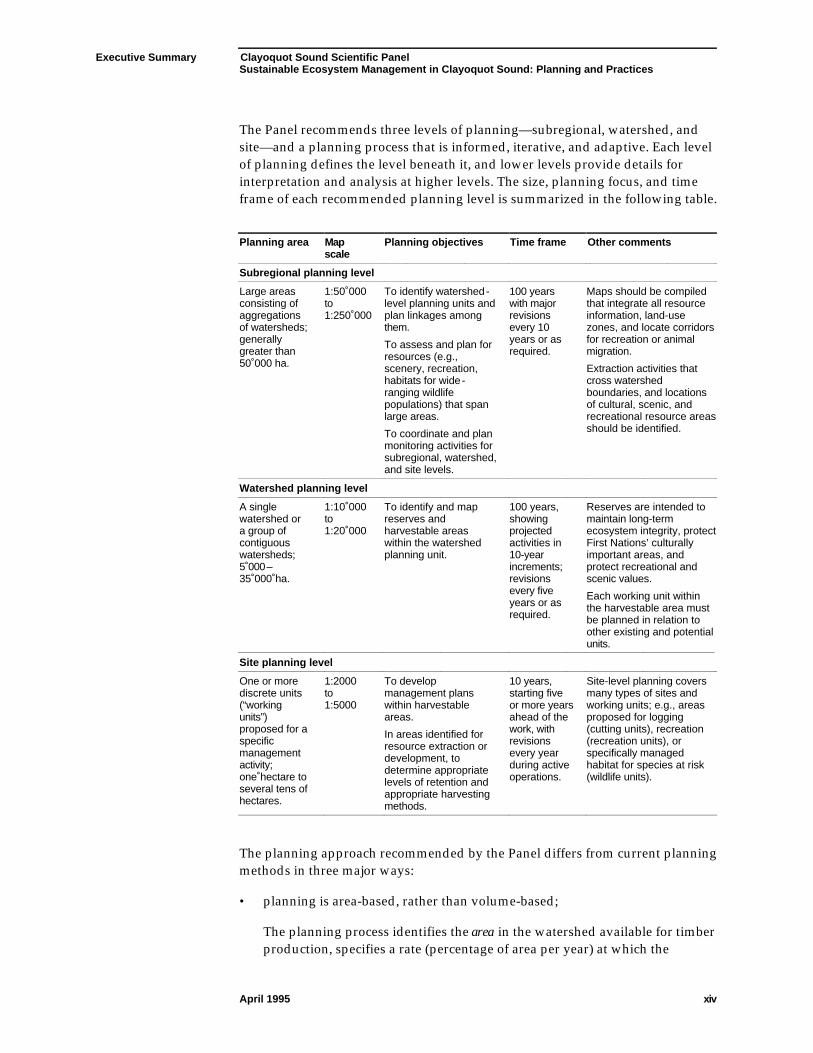
The Panel recommends three levels of planning—subregional, watershed, andsite—and a planning process that is informed, iterative, and adaptive. Each levelof planning defines the level beneath it, and lower levels provide details forinterpretation and analysis at higher levels. The size, planning focus, and timeframe of each recommended planning level is summarized in the following table.
Planning area Mapscale
Planning objectives Time frame Other comments
Subregional planning level
Large areasconsisting ofaggregationsof watersheds;generallygreater than50 000 ha.
1:50 000to1:250 000
To identify watershed-level planning units andplan linkages amongthem.
To assess and plan forresources (e.g.,scenery, recreation,habitats for wide-ranging wildlifepopulations) that spanlarge areas.
To coordinate and planmonitoring activities forsubregional, watershed,and site levels.
100 yearswith majorrevisionsevery 10years or asrequired.
Maps should be compiledthat integrate all resourceinformation, land-usezones, and locate corridorsfor recreation or animalmigration.
Extraction activities thatcross watershedboundaries, and locationsof cultural, scenic, andrecreational resource areasshould be identified.
Watershed planning level
A singlewatershed ora group ofcontiguouswatersheds;5 000–35 000 ha.
1:10 000to1:20 000
To identify and mapreserves andharvestable areaswithin the watershedplanning unit.
100 years,showingprojectedactivities in10-yearincrements;revisionsevery fiveyears or asrequired.
Reserves are intended tomaintain long-termecosystem integrity, protectFirst Nations’ culturallyimportant areas, andprotect recreational andscenic values.
Each working unit withinthe harvestable area mustbe planned in relation toother existing and potentialunits.
Site planning level
One or morediscrete units(“workingunits”)proposed for aspecificmanagementactivity;one hectare toseveral tens ofhectares.
1:2000to1:5000
To developmanagement planswithin harvestableareas.
In areas identified forresource extraction ordevelopment, todetermine appropriatelevels of retention andappropriate harvestingmethods.
10 years,starting fiveor more yearsahead of thework, withrevisionsevery yearduring activeoperations.
Site-level planning coversmany types of sites andworking units; e.g., areasproposed for logging(cutting units), recreation(recreation units), orspecifically managedhabitat for species at risk(wildlife units).
The planning approach recommended by the Panel differs from current planningmethods in three major ways:
• planning is area-based, rather than volume-based;
The planning process identifies the area in the watershed available for timberproduction, specifies a rate (percentage of area per year) at which the
Executive Summary Clayoquot Sound Scientific PanelSustainable Ecosystem Management in Clayoquot Sound: Planning and Practices
April 1995 xv
watershed can be harvested, and identifies the locations where harvestingmay occur.
• forest reserves, based on credible biological and physical criteria, aredesignated at the watershed level before the delineation of harvestable areasand subsequent planning of specific forestry activities; and
• the timber volume available for harvesting each year from a watershedplanning unit is determined by the planning process and depends on thecharacteristics of the area available for harvesting.
These harvest levels functionally replace the allowable annual cut in definingexpectations for harvestable wood volume from planning areas.
The recommended shift to area-based planning is critical to successfullyimplement other Panel recommendations and to achieve sustainable ecosystemmanagement. Watershed-level planning is key because the cumulative effects ofall land-use activities create stress on ecosystems within individual watersheds.
Managing for Timber Production
Most standards regulating forest practices in coastal British Columbia assumethat clearcutting is the silvicultural system of choice. In Clayoquot Sound,clearcutting has been the predominant silvicultural system.
While size of cutblocks and means of forest removal have changed over the pastfew decades, major impacts of clearcutting and associated road constructionremain:
• the essentially even-aged stand structures differ significantly from thosecreated by the natural disturbance regime;
• the morphology of stream channels has been substantially disturbed; and
• other forest values, including cultural, scenic, and recreational, have beennegatively affected.
In keeping with the goal of sustainable ecosystem management, the Panelrecommends a shift in both planning and implementing timber harvesting—froma focus on the trees removed during harvesting to the trees retained. This shift isembodied at the watershed level by delineating reserves to protect ecosystemintegrity and forest values, and carried through at the site level by specifyingtrees to be retained in individual cutting units.
The variable-retention silvicultural system recommended by the Panel provides for:
• the permanent retention of forest “structures” or habitat elements (e.g., largedecadent trees, or groups of trees, snags, and downed wood) from theoriginal stand that provide habitat for forest biota; and
Executive Summary Clayoquot Sound Scientific PanelSustainable Ecosystem Management in Clayoquot Sound: Planning and Practices
April 1995 xvi
• a range of retention levels.
The type, amount, and spatial distribution (e.g., aggregated in small intactpatches or dispersed as individual trees or snags) of the retained material dependon site characteristics and management objectives.
Specific recommendations under the variable-retention silvicultural systeminclude:
• on cutting units with significant values for resources other than timber orwith sensitive areas, implement high levels of retention—at least 70%;
• on cutting units without significant values for resources other than timber orwithout sensitive areas, implement lower levels of retention;
• retain a minimum of 15% of the original stand on all cutting units with theexception of very small cutting units (less than four tree heights across); and
• retain a representative cross-section of species and structures of the originalstand.
Maintaining the natural size- and age-class distributions of trees helps to retainthe natural functioning of the forest-dwelling biota and sustain environmentalintegrity. Retention silvicultural systems meet many ecological objectives, andfacilitate protection of culturally important sites, and scenic and recreationalvalues.
Yarding methods, the means of moving logs from where trees are felled to wherethey are loaded for further transport, are critical to attaining variable-retentionsilvicultural objectives. The variable-retention silvicultural system requiresyarding methods that:
• are efficient and safe;
• can accommodate different levels and distributions of retention;
• are appropriate to steep slopes;
• minimize soil disturbance and damage to retained trees; and
• require low road densities.
Maintaining log control during yarding is critical to minimize site disturbance,and to maximize yarding productivity in variable-retention silvicultural systems.Lateral reach and partial to full suspension capabilities are often required. Forthese reasons, skyline yarding is the cable-yarding method best suited forretention silvicultural systems. Ground-based systems can also be used wheretheir impact on the soil and damage to the residual stand is not excessive. Mostyarding equipment currently used in Clayoquot Sound can be adapted to avariable-retention silvicultural system.

Executive Summary Clayoquot Sound Scientific PanelSustainable Ecosystem Management in Clayoquot Sound: Planning and Practices
April 1995 xvii
Logs and other partly manufactured forest products are transported by bothroads and water in Clayoquot Sound. The road network is used for hauling logs,access by workers, moving equipment (including heavy equipment), and accessby recreational users and residents. Water transport is used to move most logs inClayoquot Sound to processing facilities.
Roads alter slope hydrology and represent a potentially significant source ofnegative impacts on slope stability, stream morphology, and water quality.Existing road standards are insufficient to ensure that terrestrial and aquaticecosystems are adequately protected. With respect to roads, Panelrecommendations include requirements for:
• road location decisions to reflect the following priorities:
- protect sensitive terrain (e.g., stability class V), rare habitats, activefloodplain areas, and heritage and cultural features;
- maintain watershed integrity and ecosystem function; and
- mitigate potential damage to scenic or recreational values;
• the maximum percentage of the harvestable area designated for permanentaccess (roads and landings) to be determined on a watershed-specific basis,and, in general, to represent less than 5% of the harvestable area in awatershed (7% is allowed under current standards);
• full bench cuts and endhaul construction on main or branch roadsconsistently greater than 55% slopes; and
• revegetating (preferably with indigenous, non-invasive species) all disturbedareas associated with roads.
During the last two decades, major log handling improvements have reduced theimpacts of log dumping. Most logs are now sorted and bundled on land, anddumped into the water for storage before transporting to manufacturing centreson log barges. Sheltered waters, however, are still used for dumping, limitedsorting, and booming of logs. To protect the important biological and culturalvalues of estuarine and marine environments, the Panel recommends:
• developing comprehensive standards for log dump development, operation,and maintenance;
• undertaking ecological, physical, and impact assessments on all proposed logdump sites;
• minimizing the time that logs are in water, especially shallow water;
• locating log dumps at sufficient distances from sensitive areas and atsufficient depths to avoid problems; and
Executive Summary Clayoquot Sound Scientific PanelSustainable Ecosystem Management in Clayoquot Sound: Planning and Practices
April 1995 xviii
• restoring sites damaged by excessive accumulations of bark, woody debris,or fine organic material.
Education and training programs will be required to provide forest engineers,technicians, and forest workers with the knowledge and skills to plan andimplement a variable-retention silvicultural system, appropriate harvestingmethods, and environmentally sensitive transportation systems. Training mustaddress both silvicultural objectives, such as habitat and biological diversity, andoperational constraints, such as harvesting system requirements, road locationand construction requirements, windfirmness, and yarding patterns.
Human Values
Clayoquot Sound is important to people for cultural, spiritual, and scenic values,and for recreational and tourism use. Most residents are economically dependenton local forest and marine resources. Landscape appearance is important toresidents and visitors alike for aesthetic reasons and as an indicator of foresthealth. By recommending forest practices that sustain ecosystem integrity thePanel has sought to secure economic benefits and human values for current andfuture generations. First Nations’ values have been addressed specifically in thePanel report First Nations’ Perspectives Relating to Forest Practices Standards inClayoquot Sound.
New approaches to scenic resource management have been occurring inClayoquot Sound as part of the Scenic Corridors Planning Process. Many of thePanel’s suggestions for improving integration of scenic values into forestplanning have already been implemented in this process.
Other Panel recommendations for incorporating non-timber values in forestpractices standards include:
• involving provincial, regional, and local governments, First Nations,recreation and tourism groups, industry and other public groups ininventory, analysis, and planning of scenic, recreational, and tourismresources;
• developing an inventory and analysis system for scenic resources andpreparing a long-term plan for managing and protecting these resources;
• developing a new scale to describe visual quality objectives that is easier forthe public to understand, is unrelated to silvicultural system terminology,and accounts for uses other than forestry;
• developing plans for recreation and tourism at subregional, watershed, andsite levels; and
• integrating the planning of visual landscape management, recreation, andtourism with forest planning and management.
Executive Summary Clayoquot Sound Scientific PanelSustainable Ecosystem Management in Clayoquot Sound: Planning and Practices
April 1995 xix
Monitoring
Monitoring is an essential part of active adaptive management and improvingmanagement practices. Monitoring in the forest ecosystems of Clayoquot Soundwill have three goals:
• to ensure that forest activities and practices comply with prescribedstandards for ecosystem integrity and cultural integrity;
• to determine whether the forest practices standards adopted for ClayoquotSound are appropriate for the intended management objectives; and
• to improve the basis for understanding mechanisms, both natural and thoseinduced by human activity, that cause events and create changes in theecosystem.
Panel recommendations emphasize the second goal—monitoring to evaluatesuccess in attaining objectives. This requires a long-term monitoring programcovering areas that are reserved from land-use practices and areas that willexperience land-use practices. To this end, the Panel recommends objectives formonitoring:
• watershed and coastal integrity – including hillslopes and forest soils, streamchannels, regional streamflow and water quality, and the coastal zone;
• biological diversity – including genetic variation, vulnerable and rareindigenous species, terrestrial environments, old-growth characteristics, andaquatic environments;
• human activities and values – including areas important to First Nations;scenic, recreational, and tourist values; and regional commodity production;and
• implementation of forest management plans.
For each of these areas, the Panel discusses key indicators for evaluating thesuccess of sustainable ecosystem management, as well as specific monitoringactivities. In some cases, alternative monitoring procedures are presented.
Local interest and involvement in monitoring are essential to the success of amonitoring program. To assure program efficacy and technical excellence, aprofessional land manager is also required. Because of labour requirements, thevalue of cumulated experience in many aspects of monitoring, and the need tosecure local commitment to ensure the continuation of the program, manyaspects of monitoring should be the responsibility of participants from localcommunities.
Clayoquot Sound is an excellent place to test the concept of local responsibilityfor sustainable ecosystem management.
Chapter 1 Clayoquot Sound Scientific PanelSustainable Ecosystem Management in Clayoquot Sound: Planning and Practices
April 1995 1
1.0 Introduction
1.1 Panel Mandate
The Panel’s goal is tomake forestpractices inClayoquot Sound thebest in the world.
This is the fifth, and final, report of the Scientific Panel for Sustainable ForestPractices in Clayoquot Sound.1,2 The Scientific Panel was established in responseto a recommendation from the Commission on Resources and Environmentfollowing the provincial government’s April 13, 1993 decision on land use inClayoquot Sound. The Panel is charged with scientifically reviewing currentforest practices standards in Clayoquot Sound and recommending changes toexisting standards to ensure that these practices are sustainable. The Panel’sgoal, as defined by Premier Harcourt, is “to make forest practices in Clayoquotnot only the best in the province, but the best in the world.”3
The Panel’s terms of reference focus on defining sustainable forest practices forthe General Integrated Management Area as designated in the Clayoquot SoundLand Use Decision April 13, 1993. This report, however, considers the ClayoquotSound region as a whole, particularly when discussing the physical setting andecological systems (Chapter 2). Some recommendations (e.g., those involvingplanning) cannot be limited to the General Integrated Management Area.
The Panel’srecommendationsseek to define forestpractices that arescientifically sound,operationallyachievable, publiclyacceptable, and safe.
Panel recommendations seek to define forest practices that are scientificallysound, operationally achievable, publicly acceptable and safe. In its deliberationsabout appropriate forestry practices in the General Integrated Management Areain Clayoquot Sound, the Panel invoked constraints in the order: safety,ecosystem integrity, operational effectiveness, and visual appearance. Theserecommendations are intended to provide direction for the development ofsubsequent standards that are measurable and enforceable.
The Panel recognizes the important influence of human values and interests (ofboth indigenous and non-indigenous people) on the management of resources inClayoquot Sound. The composition and assignment of the Panel, however,allowed it to address only four broad topics:
1 the underlying physical and biological processes sustaining forest growth;
2 the practices of growing and harvesting trees;
3 scenic values, and recreational and tourism opportunities; and
1The Scientific Panel for Sustainable Forest Practices in Clayoquot Sound will be referred to as theClayoquot Scientific Panel, Scientific Panel, or Panel throughout this document. A list of Panelmembers is presented in Appendix V. Clayoquot Sound refers to the 350 000 ha area considered bythe Clayoquot Sound Land Use Decision (British Columbia 1993a) and not the waterbody itself.2The Panel’s previous reports include: Report of the Scientific Panel for Sustainable Forest Practices inClayoquot Sound, Progress Report 2: Review of Current Forest Practice Standards in Clayoquot Sound, FirstNations’ Perspectives Relating to Forest Practices Standards in Clayoquot Sound, and A Vision and ItsContext: Global Context for Forest Practices in Clayoquot Sound.3Premier Harcourt’s announcement of the Clayoquot Scientific Panel, October 22, 1993.
Chapter 1 Clayoquot Sound Scientific PanelSustainable Ecosystem Management in Clayoquot Sound: Planning and Practices
April 1995 2
4 Nuu-Chah-Nulth perspectives on forest values and forest practices.
The Panel has not addressed issues beyond these four broad topics of its mandateand its collective expertise.
1.2 Report Context
1.2.1 Previous Panel Reports
The Panelrecommends forestpractices thatmaintain the integrityof watersheds andthe diversity ofnatural ecosystems,while providing forthe needs of currentand futuregenerations.
In its first report, the Panel outlined guiding principles for forest management inClayoquot Sound (Scientific Panel 1994b). These principles were used to evaluatecurrent forest practices standards in the region. Findings and recommendationsarising from this review are documented in the Panel’s second and third reports(Scientific Panel 1994a, 1995b), and in this document.4
In its second report, the Panel recommended adoption of forest practices thatmaintain the integrity of watersheds and the diversity of natural ecosystems inClayoquot Sound, while providing for the long-term spiritual, cultural, social,and economic needs of current and future generations of humans.
This report presentsPanel findings andrecommendationsrelated to forestplanning andinformationcollection; thephysical processesof timber extraction;scenic, recreational,and tourism values;and monitoring.
This report presents the Panel’s findings and recommendations related to forestplanning and information collection; the physical processes of timberextraction—silvicultural systems, harvesting systems, and transportationsystems; scenic, recreational, and tourism values; and monitoring. Findings arisefrom a review of documents, field reconnaissance, and consideration ofNuu-Chah-Nulth and other local ecological knowledge. Panel recommendationsare based on the following principles:
• Responsible land stewardship, including forest management, must respectthe land and all living things.
• Ecosystems must be recognized as the functional base from which all goodsand services are derived, and provisions must exist for determining andsetting levels of resource extraction within the limits and capabilities ofecosystems.
• Planning must be long term and inclusive, linking provincial, regional, andlocal levels. At each of these levels, sustaining ecosystem productivity musttake precedence over specific product outputs.
• Social, environmental, and economic dimensions of resource managementmust be incorporated into the planning process.
• Inventories must be expanded to include the status, abundance, anddistribution of resources and values in Clayoquot Sound and the critical
4Forest practice standards in documents dated up to September 30, 1994 have been reviewed.Standards under development or in unreleased draft documents on or after this date were notconsidered.
Chapter 1 Clayoquot Sound Scientific PanelSustainable Ecosystem Management in Clayoquot Sound: Planning and Practices
April 1995 3
factors (e.g., slope stability) that affect timber harvesting or other resource-extracting operations. Some undeveloped areas must remain as baselinereference areas against which managed areas can be compared.
• An effective monitoring program must be implemented and adaptivemanagement practised to improve forest practices and procedures asexperience and knowledge are gained.
• As part of adaptive management, research must be undertaken to ensure thatthe standards set are adequate to maintain long-term ecosystem integrity.
• Information and education are essential for successful implementation ofnew forest practices standards.
• Resource management policies reflect human values, understanding, andknowledge at a particular point and time. They must be reviewed andrevised to keep pace with changes in these states.
1.2.2 Complexity of Timber Production Activities
Few peopleappreciate thecomplexity of timberproduction.
Remarkably few people appreciate the complexity of timber production.Focusing on a single facet, such as method of harvesting, is akin to focusing onthe surgical procedure while ignoring the patient’s state of health and thepurpose of the operation. In this report the inherent complexity of forestrymanifests itself in three ways.
• First, to offer an integrated, internally consistent approach to timberproduction, it was necessary for the Panel to address activities from planningthrough silviculture, harvesting, and log transport. These diverse sets ofactivities had to be considered in terms of their suitability to the physicalsetting and ecological systems of Clayoquot Sound.
The report isarranged in a fashionthat allows readersto accumulateexplanatorybackground tosubsequent sections.
• Second, because these sets of activities are themselves integrated andinterdependent, it is potentially misleading to examine any one section of thereport in isolation of other sections. The report is arranged in a fashion thatallows readers to accumulate explanatory background to subsequentsections.
A consequence of this organization is that planning—an activity that shouldembrace and precede all others—is addressed near the end of the report. Ithas been assigned that position so that readers will appreciate the need for anew planning hierarchy in light of the significant changes that the Panelrecommends in silvicultural, harvesting, and transportation systems, and inmanaging for scenic, cultural, and tourism values.
• Third, complexity almost always is burdened by uncertainty. The approachto forestry recommended by the Panel incorporates a philosophicaldeparture from previous approaches, which itself invokes uncertainty.
Chapter 1 Clayoquot Sound Scientific PanelSustainable Ecosystem Management in Clayoquot Sound: Planning and Practices
April 1995 4
Because of this uncertainty and the range and magnitude of forest valuesinvolved, the Panel’s approach to forest management is “conservative” in thesense of Kaufmann et al. (1994):
“Conservative” management means giving the benefit of doubt to theresource rather than to its extraction or development. (Kaufmann et al.1994:3)
Panelrecommendationsinvoke theprecautionaryprinciple: bothmanagement andpolicy developmentproceed adaptively.
The principle of proceeding cautiously or conservatively in the face ofuncertainty has been elaborated formally as the “precautionary principle.”The principle applies when there is uncertainty about possible cumulativeeffects, irreversible changes, adverse interaction, or negative long-termeffects (e.g., Bella and Overton 1972; Perrings 1991). The Panel explicitlyrecognizes the principle in its recommendations that both management andpolicy development proceed adaptively.
1.3 Terminology
Ecosystem orwatershed “health”or “integrity” arebridging concepts.
In this report, frequent reference is made to ecosystem “health” and toecosystem “integrity.” These terms are meant to signify functioning, self-sustaining systems undergoing no systematic changes as the result of unnatural(i.e., human-induced) manipulations. These are not strictly scientific terms. Theyare what Ehrenfeld (1992) calls “bridging concepts”—concepts which connect ascientific concept about the state or properties of a system with a social valueabout the normative or desired state. For example, when referring to our bodies,“health” incorporates human values that are not amenable to strictly scientificmeasurement. “Health” can be used, however, as a useful reference concept foridentifying the stresses (another bridging concept) to which bodies, watersheds,or ecosystems are subjected. Identifying symptoms of ecosystem stress andresponse to stress might lead to a set of diagnostic principles for assessingecosystem state (Schaeffer et al. 1988). It is difficult, however, to define a normalstate for ecosystems that are also subject to natural disturbances. Scientificmethods can describe changes to a system in response to disturbances, and candetermine causal mechanisms for most major disturbances (including majorhuman interventions) but the question whether the system is “healthy” (or“unhealthy”) remains a question of value and interpretation. This is appropriate.Managing forests (or any other aspect of the natural environment) entails therecognition and incorporation of human objectives for the system, even when aconscious attempt is made to ground management firmly in scientific principles.Used with care, bridging concepts such as “ecosystem health” and “ecosystemintegrity” “…can enrich scientific thought with the values and judgements thatmake science a human endeavour” (Ehrenfeld 1992:142).
Chapter 1 Clayoquot Sound Scientific PanelSustainable Ecosystem Management in Clayoquot Sound: Planning and Practices
April 1995 5
1.4 Report Organization
Chapter 1 provides the background and context for the Panel’s review of currentforest practices standards in Clayoquot Sound and notes how this documentrelates to previous Panel reports.
Chapter 2 describes the physical characteristics, ecological features, and humanvalues associated with Clayoquot Sound. These characteristics, in combinationwith the Panel’s guiding principles, provide the framework for the review ofcurrent forest practices standards.
Chapter 3 describes silvicultural systems historically used in British Columbia,discusses clearcutting as the prevalent system currently used in ClayoquotSound, and presents the Panel’s findings and recommendations relating tosilvicultural systems in Clayoquot Sound.
Chapter 4 focuses on yarding methods as a major component of harvestingsystems, and presents the Panel’s findings and recommendations related toyarding methods in Clayoquot Sound.
Chapter 5 describes road and water transportation systems for wood and woodproducts in Clayoquot Sound, and presents the Panel’s findings andrecommendations related to roads and water transportation in Clayoquot Sound.
Chapter 6 describes scenic, recreational, and tourism values and resources inClayoquot Sound, and presents the Panel’s related findings andrecommendations.
Chapter 7 summarizes the planning hierarchy and process that the Panel assertsto be critical to the successful implementation of its recommendations. Inparticular, it describes the system of reserves the Panel considers essential tomaintain ecosystem integrity.
Chapter 8 describes the role of monitoring in forest ecosystem management inClayoquot Sound, and recommends monitoring procedures to assess the successof new forest practices (that follow Panel recommendations) in achieving theirintended objectives.
Chapter 9 lists sources cited in the report.
The recommendedapproach tosustainableecosystemmanagement is intactand complete onlywhen all chapters areconsidered.
The necessarily linear nature of a document hinders communication of whollyintegrated concepts. It is ineffective and potentially dangerous, for example, toconsider silvicultural systems separately from harvesting and transportationsystems. Similarly, the silvicultural system recommended by the Panel cannot beseparated from the recommended approach to planning. Chapter boundaries arenecessarily arbitrary. Although each chapter provides information critical tounderstanding subsequent chapters, the recommended approach to sustainableecosystem management is intact and complete only when all chapters areconsidered.

Chapter 1 Clayoquot Sound Scientific PanelSustainable Ecosystem Management in Clayoquot Sound: Planning and Practices
April 1995 6
Appendices to the report include a list of all Panel recommendations in thisreport (Appendix I), a classification system for the hydroriparian zone (AppendixII), a discussion of inventory requirements to support planning (Appendix III), aglossary (Appendix IV), and a list of Scientific Panel Members (Appendix V).
Chapter 2 Clayoquot Sound Scientific PanelSustainable Ecosystem Management in Clayoquot Sound: Planning and Practices
April 1995 7
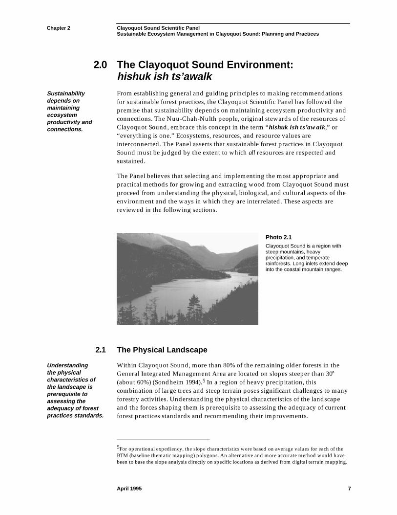
2.0 The Clayoquot Sound Environment:hishuk ish ts’awalk
Sustainabilitydepends onmaintainingecosystemproductivity andconnections.
From establishing general and guiding principles to making recommendationsfor sustainable forest practices, the Clayoquot Scientific Panel has followed thepremise that sustainability depends on maintaining ecosystem productivity andconnections. The Nuu-Chah-Nulth people, original stewards of the resources ofClayoquot Sound, embrace this concept in the term “hishuk ish ts’awalk,” or“everything is one.” Ecosystems, resources, and resource values areinterconnected. The Panel asserts that sustainable forest practices in ClayoquotSound must be judged by the extent to which all resources are respected andsustained.
The Panel believes that selecting and implementing the most appropriate andpractical methods for growing and extracting wood from Clayoquot Sound mustproceed from understanding the physical, biological, and cultural aspects of theenvironment and the ways in which they are interrelated. These aspects arereviewed in the following sections.
Photo 2.1Clayoquot Sound is a region withsteep mountains, heavyprecipitation, and temperaterainforests. Long inlets extend deepinto the coastal mountain ranges.
2.1 The Physical Landscape
Understandingthe physicalcharacteristics ofthe landscape isprerequisite toassessing theadequacy of forestpractices standards.
Within Clayoquot Sound, more than 80% of the remaining older forests in theGeneral Integrated Management Area are located on slopes steeper than 30°(about 60%) (Sondheim 1994).5 In a region of heavy precipitation, thiscombination of large trees and steep terrain poses significant challenges to manyforestry activities. Understanding the physical characteristics of the landscapeand the forces shaping them is prerequisite to assessing the adequacy of currentforest practices standards and recommending their improvements.
5For operational expediency, the slope characteristics were based on average values for each of theBTM (baseline thematic mapping) polygons. An alternative and more accurate method would havebeen to base the slope analysis directly on specific locations as derived from digital terrain mapping.
Chapter 2 Clayoquot Sound Scientific PanelSustainable Ecosystem Management in Clayoquot Sound: Planning and Practices
April 1995 8
2.1.1 Climate and Hydrology
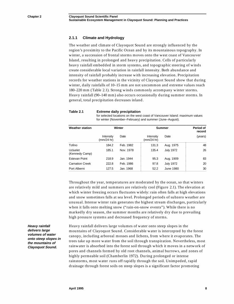
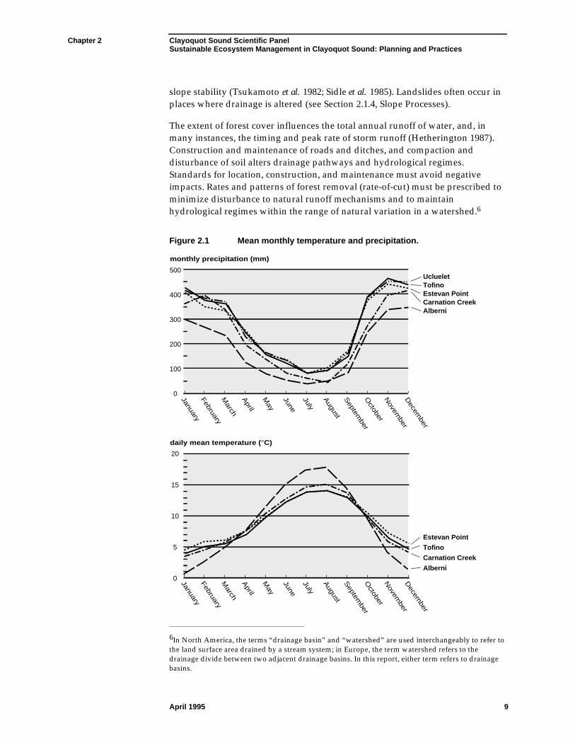
The weather and climate of Clayoquot Sound are strongly influenced by theregion’s proximity to the Pacific Ocean and by its mountainous topography. Inwinter, a succession of frontal storms moves onto the west coast of VancouverIsland, resulting in prolonged and heavy precipitation. Cells of particularlyheavy rainfall embedded in storm systems, and topographic steering of windscreate considerable local variation in rainfall intensity. Both abundance andintensity of rainfall probably increase with increasing elevation. Precipitationrecords for weather stations in the vicinity of Clayoquot Sound show that duringwinter, daily rainfalls of 10–15 mm are not uncommon and extreme values reach180–220 mm (Table 2.1). Strong winds commonly accompany winter storms.Heavy rainfall (90–140 mm) also occurs occasionally during summer storms. Ingeneral, total precipitation decreases inland.
Table 2.1 Extreme daily precipitationfor selected locations on the west coast of Vancouver Island: maximum valuesfor winter (November–February) and summer (June–August).
Weather station Winter Summer Period ofrecord
Intensity(mm/24 hr)
Date Intensity(mm/24 hr)
Date (years)
Tofino 184.2 Feb. 1982 131.3 Aug. 1975 48
Ucluelet(Kennedy Camp)
185.1 Nov. 1978 135.4 July 1972 26
Estevan Point 218.9 Jan. 1944 95.3 Aug. 1909 83
Carnation Creek 222.8 Feb. 1986 97.8 July 1972 20
Port Alberni 127.5 Jan. 1968 52.2 June 1980 30
Throughout the year, temperatures are moderated by the ocean, so that wintersare relatively mild and summers are relatively cool (Figure 2.1). The elevation atwhich winter freezing occurs fluctuates widely: rain often falls at high elevationsand snow sometimes falls at sea level. Prolonged periods of subzero weather areunusual. Intense winter rain generates the highest stream discharges, particularlywhen it falls onto melting snow (“rain-on-snow events”). While there is nomarkedly dry season, the summer months are relatively dry due to prevailinghigh pressure systems and decreased frequency of storms.
Heavy rainfalldelivers largevolumes of wateronto steep slopes inthe mountains ofClayoquot Sound.
Heavy rainfall delivers large volumes of water onto steep slopes in themountains of Clayoquot Sound. Considerable water is intercepted by the forestcanopy, including arboreal mosses and lichens, from where it evaporates. Thetrees take up more water from the soil through transpiration. Nevertheless, mostrainwater is absorbed into the forest soil through which it moves in a network ofpores and channels formed by old root channels, animal burrows, and zones ofhighly permeable soil (Chamberlin 1972). During prolonged or intenserainstorms, most water runs off rapidly through the soil. Unimpeded, rapiddrainage through forest soils on steep slopes is a significant factor promoting
Chapter 2 Clayoquot Sound Scientific PanelSustainable Ecosystem Management in Clayoquot Sound: Planning and Practices
April 1995 9
slope stability (Tsukamoto et al. 1982; Sidle et al. 1985). Landslides often occur inplaces where drainage is altered (see Section 2.1.4, Slope Processes).
The extent of forest cover influences the total annual runoff of water, and, inmany instances, the timing and peak rate of storm runoff (Hetherington 1987).Construction and maintenance of roads and ditches, and compaction anddisturbance of soil alters drainage pathways and hydrological regimes.Standards for location, construction, and maintenance must avoid negativeimpacts. Rates and patterns of forest removal (rate-of-cut) must be prescribed tominimize disturbance to natural runoff mechanisms and to maintainhydrological regimes within the range of natural variation in a watershed.6
Figure 2.1 Mean monthly temperature and precipitation.
Estevan Point
Tofino
Carnation Creek
Alberni
Ucluelet Tofino Estevan Point Carnation Creek Alberni
monthly precipitation (mm)
daily mean temperature (°C)
0
0
5
10
15
20
100
200
300
400
500
JanuaryFebruaryM
arch
April
May
June
July
August
Septem
berO
ctoberN
ovember
Decem
ber
JanuaryFebruaryM
arch
April
May
June
July
August
Septem
berO
ctoberN
ovember
Decem
ber
6In North America, the terms “drainage basin” and “watershed” are used interchangeably to refer tothe land surface area drained by a stream system; in Europe, the term watershed refers to thedrainage divide between two adjacent drainage basins. In this report, either term refers to drainagebasins.
Chapter 2 Clayoquot Sound Scientific PanelSustainable Ecosystem Management in Clayoquot Sound: Planning and Practices
April 1995 10
2.1.2 Terrain and Surficial Material7
The Clayoquot Sound area encompasses parts of two contrasting physiographicregions: the Estevan Coastal Plain and the Vancouver Island Mountains (Holland1964). The Estevan Coastal Plain consists of gently undulating or almost flat landthat is subdivided into numerous islands and peninsulas by inlets, channels, andKennedy Lake. The continuity of the plain is further broken by steep, rocky hills,some of which—such as Meares Island—are outliers of the mountains.
The VancouverIsland Mountains aresteep and highlydissected.
The Vancouver Island Mountains are steep and highly dissected, with sharpridgetops and only very small remnants of the gently sloping uplands that arewidespread on other parts of Vancouver Island. Valleys are deep glaciallyeroded troughs, with gentle slopes restricted to valley floors. In the inland partsof the main drainage basins, ridgetops commonly rise to over 1000 m, peaksattain heights of more than 1300 m, and valley sides are commonly steeper than30° (about 60%). Toward the coast, summit elevations become lower, withridgetops descending to about 500 m. The coastal inlets extend across thistransition zone and well into the mountains.
Both mountains and plain are underlain by a variety of rock types (Jeletzky 1954;Muller and Carson 1969). Most widespread are coarse crystalline metamorphicand intrusive rocks. Older volcanic rocks and sedimentary rocks, includinglimestone, occupy relatively small areas. All these rocks are cut by numeroussteeply dipping faults, most of which run from northwest to southeast, parallel tothe general trend of the coast. Erosion of the fault zones has created manytributary valleys and deep gullies. Bedrock outcrops are common on steep slopesand at high elevations. On gentle slopes and in the coastal lowlands, bedrock isgenerally buried by glacial and post-glacial deposits.
Landforms andland surfacecharacteristics, suchas slope stability, areclosely related to thedistribution andcharacteristics ofsurficial materials.
In most parts of Clayoquot Sound, landforms and land surface characteristics,such as slope stability, are closely related to the distribution and characteristicsof surficial materials, such as glacial deposits, stream and marine sediments, andcolluvium (slope deposits). The physical properties of these materials weredetermined by their processes of deposition. Deposition took place during thelast glaciation, about 12 000 years ago, and continues today (Howes 1981).
Till, the most common glacial material, was deposited directly by melting ice.Basal till, a compact mixture of sand, silt, clay, and stones, accumulated underthe ice. Ablation till is the loose debris that melted out on top of the ice. Tillcovers most gentle to moderately steep slopes in Clayoquot Sound. On steeperslopes, weathered till is naturally susceptible to debris slides and debris flows.Both basal and ablation tills have been modified by gully erosion, most of whichprobably occurred in early post-glacial time prior to the establishment of aprotective cover of vegetation.
7The term “surficial materials” refers to relatively young geological materials, such as glacial till andstream deposits, whereas “soil” refers to the uppermost 1–2 m of these materials that has beenmodified by physical, chemical, and biological processes.
Chapter 2 Clayoquot Sound Scientific PanelSustainable Ecosystem Management in Clayoquot Sound: Planning and Practices
April 1995 11
Glaciofluvial materials, consisting of sand and gravel deposited by glacialmeltwater streams, comprise the raised deltas (now prominent terraces) near theheads of most inlets in Clayoquot Sound. These deltas were formed at the end ofthe last glaciation (about 12 000 years ago), when sea level was as much as 50 mhigher than at present (Friele and Hutchinson 1992). Glaciomarine sediments(chiefly silt and sand), which accumulated in shallow marine waters when sealevel was higher (Clague et al. 1982), now blanket gentle slopes close to sea level.These sediments are most extensive on the coastal plain, but are also presentalong inlets within the mountains. They are prone to surface erosion andlandslides where protective vegetation is removed.
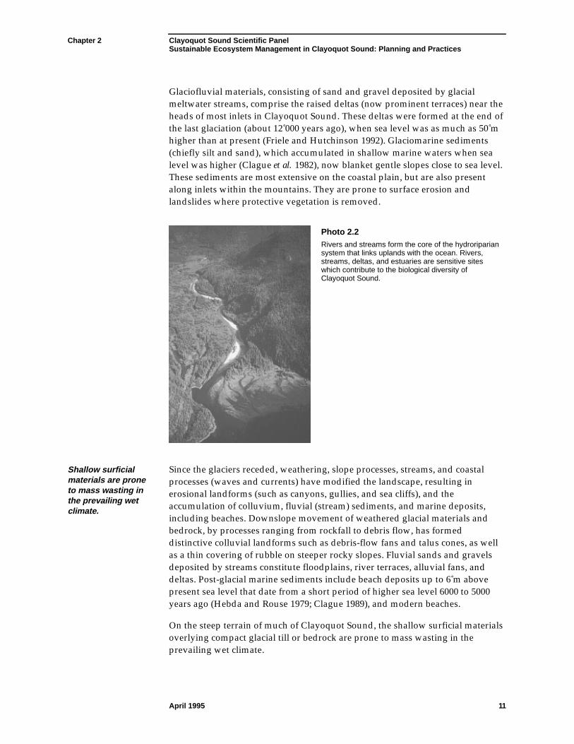
Photo 2.2Rivers and streams form the core of the hydroripariansystem that links uplands with the ocean. Rivers,streams, deltas, and estuaries are sensitive siteswhich contribute to the biological diversity ofClayoquot Sound.
Shallow surficialmaterials are proneto mass wasting inthe prevailing wetclimate.
Since the glaciers receded, weathering, slope processes, streams, and coastalprocesses (waves and currents) have modified the landscape, resulting inerosional landforms (such as canyons, gullies, and sea cliffs), and theaccumulation of colluvium, fluvial (stream) sediments, and marine deposits,including beaches. Downslope movement of weathered glacial materials andbedrock, by processes ranging from rockfall to debris flow, has formeddistinctive colluvial landforms such as debris-flow fans and talus cones, as wellas a thin covering of rubble on steeper rocky slopes. Fluvial sands and gravelsdeposited by streams constitute floodplains, river terraces, alluvial fans, anddeltas. Post-glacial marine sediments include beach deposits up to 6 m abovepresent sea level that date from a short period of higher sea level 6000 to 5000years ago (Hebda and Rouse 1979; Clague 1989), and modern beaches.
On the steep terrain of much of Clayoquot Sound, the shallow surficial materialsoverlying compact glacial till or bedrock are prone to mass wasting in theprevailing wet climate.
Chapter 2 Clayoquot Sound Scientific PanelSustainable Ecosystem Management in Clayoquot Sound: Planning and Practices
April 1995 12
2.1.3 Soils
Most of the forestsoils in ClayoquotSound are podzols;folisols and gleysolsalso occur.
Since the last glaciation, the upper part (about 1–2 m) of surficial materials hasbeen modified by soil-forming processes. Much of the soil-forming activityproceeds invisibly within the forest floor and soil, mediated by microbes, fungi,insects, and other invertebrates.8 The combination of physical and chemicalweathering (breakdown) of mineral material in the moderate perhumidenvironment produces soils with a higher silt and clay content than the originalparent materials. This renders soils more prone to erosion than the surficialmaterials, particularly if surface organic soil horizons are removed. Most forestsoils in Clayoquot Sound are podzols; folisols and gleysols also occur (Jungenand Lewis 1978; Jungen 1985).
Nitrogen andphosphoruscommonly limitplant growth.
Podzol soils have developed in till and other surficial materials on well-drainedto imperfectly drained slopes which have not been greatly affected by land-shaping processes during the past 12 000 years. Podzols are acidic soils and lowin nutrient cations, such as calcium, due to leaching9 from the year-round heavyrainfall (Lewis 1976). Accumulation of oxides in the lower part of a podzol soiloften forms cemented layers of low permeability (“hardpan”), hinderingdrainage even in gravelly materials with initially high permeability.
The content of plant-available nitrogen and phosphorus, which are both storedlargely in soil organic matter, is low in podzols, and nitrogen or both nitrogenand phosphorus commonly limit plant growth. Phosphorus is retained tightly inpodzols, either in organic forms or as very slowly soluble mineral forms becauseof low soil pH. As a result, its release to groundwater and then to streams isminimal. The resulting shortage of phosphorus in west coast streams is thelimiting factor for primary production in streams (Stockner and Shortreed 1976,1978; Mundie et al. 1991).
Podzols exert a significant influence on both physical and biological processes.The organic layer (i.e., the forest floor of accumulated forest litter) is usually only10–30 cm thick, yet it protects against soil erosion, supplies most availablenutrients, and supports diverse life in the soil.
At many sites, the forest floor layer constitutes the entire soil over bedrock. Suchsoils, consisting entirely of forest litter in various stages of decomposition, aretermed folisols. These folisols typically occupy 20–40% of the landscape inClayoquot Sound, being most extensive in rocky terrain, such as in the Bulsonwatershed. Gleysols are poorly drained mineral soils that occur in flat todepressional areas, commonly on glaciomarine materials and floodplains. Thewettest sites have organic soils, ranging from the mucks of western redcedarswamps to the thicker, peaty organics of shore pine bogs and open bogs.
8Invertebrates are creatures without a backbone (vertebrae) (e.g., insects, worms, slugs, spiders,crustaceans).9Leaching is the washing out of nutrients released during weathering and organic matter decay.
Chapter 2 Clayoquot Sound Scientific PanelSustainable Ecosystem Management in Clayoquot Sound: Planning and Practices
April 1995 13
It is critical tomaintain the organicmatter of forest soils.
Maintaining the organic matter of forest soils is critical, because it containsvirtually all of the available nutrients, has high water-absorbing and water-retaining capability, improves soil porosity and permeability, and protects themineral soil from surface erosion.
2.1.4 Land-Shaping Processes
Slope processes,stream erosion anddeposition, andcoastal processesare continuallyshaping the land.
Although the present-day landscape of Clayoquot Sound may appear static tothe casual observer, slope processes, stream erosion and deposition, and coastalprocesses, all of which are natural agents of forest disturbance, are continuallyshaping the land. Slope processes and stream processes are strongly influencedby the passage of water through the landscape, and thus are driven by theintense winter rains and snowmelt.
Slope Processes
Debris slides anddebris flows are themost common typesof slope movementin Clayoquot Sound.
Clearcutting androadbuildingincrease thefrequency of debrisslides and flows.
Debris slides and debris flows10 are the most common types of slope movementin Clayoquot Sound. A debris slide is triggered when shallow subsurface watersaturates the lower part of the soil zone, reducing soil strength sufficiently thatthe overlying soil and vegetation cover slides downslope (O’Loughlin 1968;Buchanan and Savigny 1989). Usually, the “slip plane” is the sharp boundarythat separates the soil from unweathered surficial material or bedrock. Mostdebris slides involve only a thin (1–2 m) layer of material, yet they result insignificant loss of soil and trees, and exposure of unweathered material—usuallytill or bedrock—in the slide scar. As the sliding, saturated soil moves rapidlydownslope, it commonly changes into a debris flow—a highly viscous slurry ofsoil, stones, trees, and other organic debris that can travel a considerabledistance, even on relatively low gradients. Debris flows and slides often entersteep watercourses where they are augmented by streamflow. Debris flows canalso start in steep stream channels during floods, when dams of woody debrisfail and the sediments that have accumulated behind them begin to movedownstream.
Debris slides and associated flows are triggered by heavy rainfall on groundalready saturated by rain (Church and Miles 1987); by wind stress transmitted tothe ground via trees and by tree blowdown (Chatwin et al. 1991); by impacts ofother gravitational movements such as rockfall or snow avalanches; and byseismic vibrations, which are common (in geological time) on the tectonicallyactive west coast.
10In the Pacific Northwest, including British Columbia, debris flows are commonly referred to as“debris torrents.”
Chapter 2 Clayoquot Sound Scientific PanelSustainable Ecosystem Management in Clayoquot Sound: Planning and Practices
April 1995 14
Instability associatedwith older, poorlyconstructed roadsis still apparent.
It has repeatedly been demonstrated from other parts of coastal British Columbia(e.g., O’Loughlin 1968; Rood 1984; Sidle et al. 1985; Howes 1987) that clearcuttingand roadbuilding increase the frequency of debris slides and flows. Decreasedsoil strength due to root decay (Buchanan and Savigny 1989), increased soilwater, soil disturbance associated with yarding, and increased tree movement inwind, particularly on the edges of cutblocks, all contribute to slope failures inclearcuts. Road construction has contributed to instability by loading steep slopeswith sidecast material. Roads also intercept and redirect shallow subsurfacewater. Investigation of slides initiated in clearcuts at a considerable distancedownslope of roads often implicates changes to slope drainage brought about byroads. Montgomery (1994), using observations of ridgetop roads, has shown thatincreased surface runoff from the compacted road surface above can initiatesurface erosion or debris slides downslope. Although practices of building,maintaining, and deactivating roads have improved considerably over the lastdecade (Chatwin et al. 1991), a legacy of instability associated with older, poorlyconstructed roads is still apparent.
Other slope processes active in Clayoquot Sound, such as rockfalls and rockslidesare largely restricted to rocky bluffs and mountainsides that are too steep forlogging; their occurrence is therefore less affected by human activities.
Steep slopes,climate, andhydrology createconditions ofpotential instabilityin surficial materials.
Steep slopes, climate, and hydrology create conditions of potential instability insurficial materials at many sites in the Clayoquot Sound region. Assessing slopestability, avoiding activities on unstable slopes, and carefully prescribingappropriate harvesting practices on steep and marginally stable slopes areessential to avoid increasing erosion rates above natural levels. The location,method, rate, and patterns of tree removal, and the location, construction, andmaintenance of roads are particularly significant. The local variability oftopography, terrain, and drainage necessitates detailed evaluation of theseconditions to permit identification and assessment of potentially unstable areas.
Stream Processes
Within each watershed, the drainage network comprises a variety of channel andlake types, each with distinctive ecological habitats. Streams range from tinyrivulets at the highest elevations, to large channels on the floors of major valleys.All drainage components, even ephemeral channels on steep mountainsides,have riparian areas along streambanks where increased soil moisture supportsdistinctive vegetation. The presence of water and its influence on adjacentvegetation results in high levels of animal use of riparian areas. Riparian areasare most extensive on valley floors where they commonly include the alluvialflats of floodplains, alluvial fans, and deltas. The morphology of these landformsand the variety of ecological habitats that they support—such as side channels,backswamps, bars, and islands—result from the long-term behaviour of thestreams.
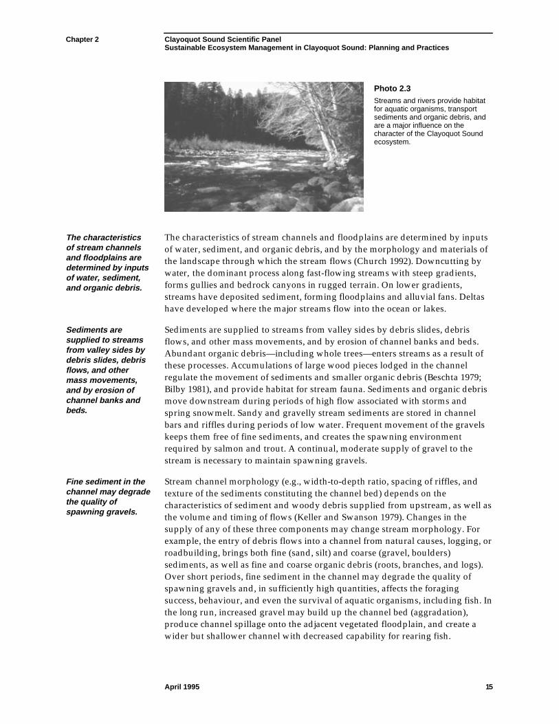
Chapter 2 Clayoquot Sound Scientific PanelSustainable Ecosystem Management in Clayoquot Sound: Planning and Practices
April 1995 15
Photo 2.3Streams and rivers provide habitatfor aquatic organisms, transportsediments and organic debris, andare a major influence on thecharacter of the Clayoquot Soundecosystem.
The characteristicsof stream channelsand floodplains aredetermined by inputsof water, sediment,and organic debris.
The characteristics of stream channels and floodplains are determined by inputsof water, sediment, and organic debris, and by the morphology and materials ofthe landscape through which the stream flows (Church 1992). Downcutting bywater, the dominant process along fast-flowing streams with steep gradients,forms gullies and bedrock canyons in rugged terrain. On lower gradients,streams have deposited sediment, forming floodplains and alluvial fans. Deltashave developed where the major streams flow into the ocean or lakes.
Sediments aresupplied to streamsfrom valley sides bydebris slides, debrisflows, and othermass movements,and by erosion ofchannel banks andbeds.
Sediments are supplied to streams from valley sides by debris slides, debrisflows, and other mass movements, and by erosion of channel banks and beds.Abundant organic debris—including whole trees—enters streams as a result ofthese processes. Accumulations of large wood pieces lodged in the channelregulate the movement of sediments and smaller organic debris (Beschta 1979;Bilby 1981), and provide habitat for stream fauna. Sediments and organic debrismove downstream during periods of high flow associated with storms andspring snowmelt. Sandy and gravelly stream sediments are stored in channelbars and riffles during periods of low water. Frequent movement of the gravelskeeps them free of fine sediments, and creates the spawning environmentrequired by salmon and trout. A continual, moderate supply of gravel to thestream is necessary to maintain spawning gravels.
Fine sediment in thechannel may degradethe quality ofspawning gravels.
Stream channel morphology (e.g., width-to-depth ratio, spacing of riffles, andtexture of the sediments constituting the channel bed) depends on thecharacteristics of sediment and woody debris supplied from upstream, as well asthe volume and timing of flows (Keller and Swanson 1979). Changes in thesupply of any of these three components may change stream morphology. Forexample, the entry of debris flows into a channel from natural causes, logging, orroadbuilding, brings both fine (sand, silt) and coarse (gravel, boulders)sediments, as well as fine and coarse organic debris (roots, branches, and logs).Over short periods, fine sediment in the channel may degrade the quality ofspawning gravels and, in sufficiently high quantities, affects the foragingsuccess, behaviour, and even the survival of aquatic organisms, including fish. Inthe long run, increased gravel may build up the channel bed (aggradation),produce channel spillage onto the adjacent vegetated floodplain, and create awider but shallower channel with decreased capability for rearing fish.
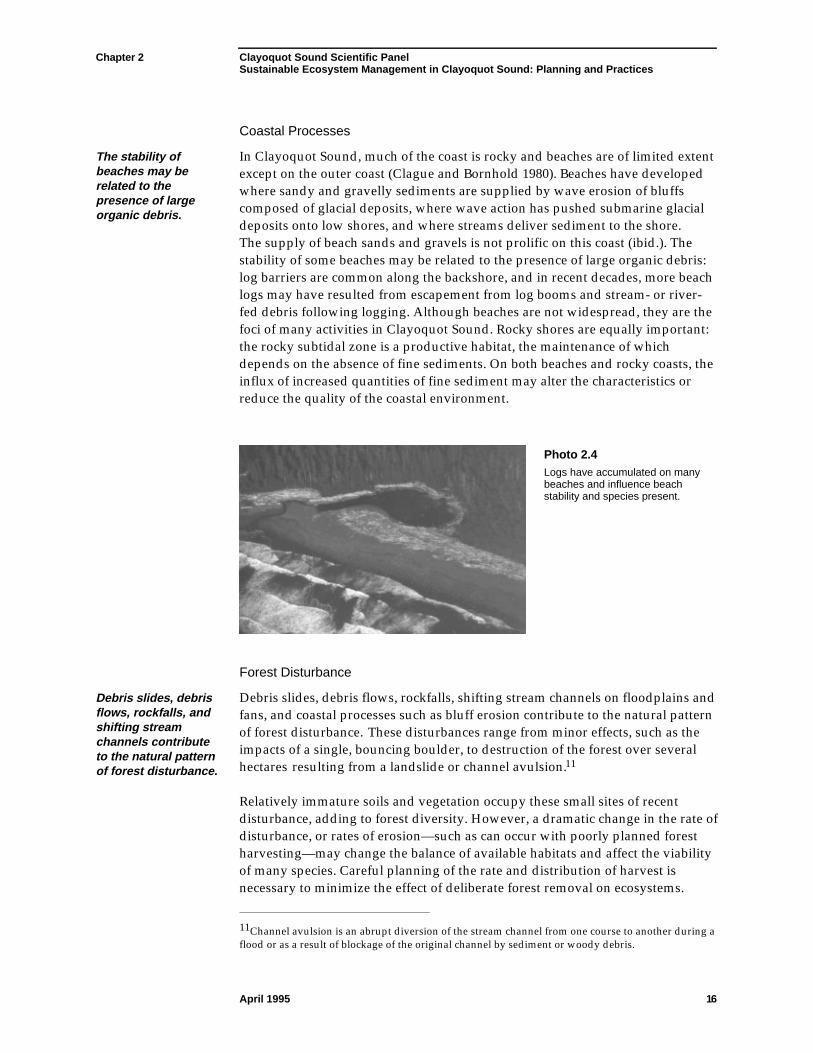
Chapter 2 Clayoquot Sound Scientific PanelSustainable Ecosystem Management in Clayoquot Sound: Planning and Practices
April 1995 16
Coastal Processes
The stability ofbeaches may berelated to thepresence of largeorganic debris.
In Clayoquot Sound, much of the coast is rocky and beaches are of limited extentexcept on the outer coast (Clague and Bornhold 1980). Beaches have developedwhere sandy and gravelly sediments are supplied by wave erosion of bluffscomposed of glacial deposits, where wave action has pushed submarine glacialdeposits onto low shores, and where streams deliver sediment to the shore.The supply of beach sands and gravels is not prolific on this coast (ibid.). Thestability of some beaches may be related to the presence of large organic debris:log barriers are common along the backshore, and in recent decades, more beachlogs may have resulted from escapement from log booms and stream- or river-fed debris following logging. Although beaches are not widespread, they are thefoci of many activities in Clayoquot Sound. Rocky shores are equally important:the rocky subtidal zone is a productive habitat, the maintenance of whichdepends on the absence of fine sediments. On both beaches and rocky coasts, theinflux of increased quantities of fine sediment may alter the characteristics orreduce the quality of the coastal environment.
Photo 2.4Logs have accumulated on manybeaches and influence beachstability and species present.
Forest Disturbance
Debris slides, debrisflows, rockfalls, andshifting streamchannels contributeto the natural patternof forest disturbance.
Debris slides, debris flows, rockfalls, shifting stream channels on floodplains andfans, and coastal processes such as bluff erosion contribute to the natural patternof forest disturbance. These disturbances range from minor effects, such as theimpacts of a single, bouncing boulder, to destruction of the forest over severalhectares resulting from a landslide or channel avulsion.11
Relatively immature soils and vegetation occupy these small sites of recentdisturbance, adding to forest diversity. However, a dramatic change in the rate ofdisturbance, or rates of erosion—such as can occur with poorly planned forestharvesting—may change the balance of available habitats and affect the viabilityof many species. Careful planning of the rate and distribution of harvest isnecessary to minimize the effect of deliberate forest removal on ecosystems.
11Channel avulsion is an abrupt diversion of the stream channel from one course to another during aflood or as a result of blockage of the original channel by sediment or woody debris.
Chapter 2 Clayoquot Sound Scientific PanelSustainable Ecosystem Management in Clayoquot Sound: Planning and Practices
April 1995 17
Disturbances other than land-shaping processes, such as windthrow, alsosignificantly affect forest development in Clayoquot Sound (Section 2.2).
2.2 The Ecological Landscape
Knowledge of how ecosystems maintain and renew themselves is a necessaryprerequisite to selecting silvicultural systems and determining harvesting andtransportation systems.
A distinguishingcharacteristic of anecosystem is itsnatural disturbanceregime.
There is a continual turnover of living organisms—even in what appear to bestable ecosystems. Forest trees are long-lived but not immortal. Their deaths aremost often due to natural changes such as the land-shaping processes noted,windthrow, and fire. Because forest cover is naturally renewed by events thatmay dramatically alter or disturb existing cover, the common pattern of theseevents is called the “natural disturbance regime.” One of the distinguishingcharacteristics of any given ecosystem is its natural disturbance regime, which isgoverned by the regional climate and physiography. For example, in the wetclimate of the west coast portion of the coastal temperate rainforest, fires aresmaller on average, and less frequent than on the drier east coast of VancouverIsland. On the west coast of Vancouver Island, windthrow is the principal agentof disturbance, whereas on the east coast of the island, fire often dominates.
Wild forests renew themselves naturally in a manner that depends on the naturaldisturbance regime of their region. Logging is a recent disturbance thatinevitably alters the pattern of renewal. Ecological knowledge can be used,however, to ensure that the changes caused by logging, and the forests thatregenerate after logging, are not dramatically different from those created by thenatural disturbance regimes. Forest practices that approximate naturaldisturbance regimes help to retain ecosystem processes and maintain ecosystemproductivity and connections.
2.2.1 Biogeoclimatic Units
Based on vegetation and climate, the forests of Clayoquot Sound have beenclassified in terms of biogeoclimatic units (Meidinger and Pojar (editors) 1991),that is, into “zones,” “subzones,” and “variants” as shown in Figure 2.2. In theCoastal Western Hemlock zone, a fourth hierarchical level (below variant),referred to as the “phase,” is commonly recognized. Phases relate to forestpatterns resulting from natural disturbances.
All forests of theCoastal WesternHemlock (CWH) zoneare recognized as“coastal temperaterainforest.”
All forests of the Coastal Western Hemlock zone are recognized as “coastaltemperate rainforest.” These rainforests occur in widely scattered locationsaround the world but the global distribution is centred on the Pacific coasts ofNorth and South America. In North America, which accounts for approximatelyhalf of the world’s coastal temperate rainforest, rainforest distribution is centredon Vancouver Island. Researchers have distinguished four major subgroups of
Chapter 2 Clayoquot Sound Scientific PanelSustainable Ecosystem Management in Clayoquot Sound: Planning and Practices
April 1995 18
In North America,rainforestdistribution iscentred onVancouver Island.
coastal temperate rainforest (Kellogg 1992). Forests on Vancouver Island belongto two of these subgroups: perhumid and seasonal temperate rainforests. Theboundary between these two subgroups is presently uncertain; forests of theCoastal Western Hemlock zone in Clayoquot Sound are predominantlyperhumid temperate rainforests. Seasonal temperate rainforests, if they occur,would be restricted to the valley of the upper Kennedy River.12
The CWH zone isdivided intosubzones based onannual and growingseason precipitation,and maritimeinfluence.
The Coastal Western Hemlock (CWH) zone includes all forests less than 900 mabove sea level in Clayoquot Sound (Figure 2.3). Western hemlock (Tsugaheterophylla) is a dominant or codominant tree species throughout; westernredcedar (Thuja plicata), amabilis fir (Abies amabilis), yellow-cedar (Chamaecyparisnootkatensis), Sitka spruce (Picea sitchensis), Douglas-fir (Pseudotsuga menziesii),and red alder (Alnus rubra) also occur under differing conditions. This zone isdivided into subzones based on annual and growing season precipitation, andmaritime influence.
The Very Wet Hypermaritime subzone lies along the outer coast of ClayoquotSound in areas of relatively subdued terrain where the marine influencesgovern the climate. Temperatures rarely become very hot or very cold,evapotranspiration is low, low cloud and fog are frequent, and the soil remainscool and wet throughout the summer. Extensive bogs with poorly drainedorganic soils have developed, notably on the low-lying Estevan Coastal Plain.Western redcedar and western hemlock are abundant, lodgepole pine (“shorepine,” Pinus contorta) and sometimes yellow-cedar occur on bogs, and a band ofSitka spruce forest grows along exposed shores where winds carry salt sprayinland. Two variants are described for the Very Wet Hypermaritime subzone;only one, the Southern Very Wet Hypermaritime biogeoclimatic variant, occursin Clayoquot Sound, at elevations generally below 150 m.
12The boundary between the perhumid and seasonal temperate rainforests as illustrated inConservation International et al. (1994) is apparently in error.
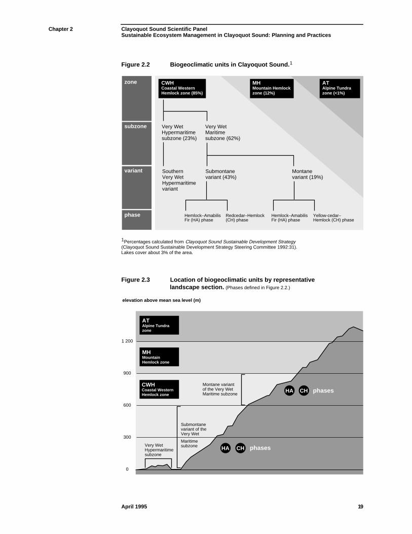
Chapter 2 Clayoquot Sound Scientific PanelSustainable Ecosystem Management in Clayoquot Sound: Planning and Practices
April 1995 19
Figure 2.2 Biogeoclimatic units in Clayoquot Sound.1
CWH Coastal Western Hemlock zone (85%)
MH Mountain Hemlock zone (12%)
AT Alpine Tundra zone (<1%)
zone
subzone
variant
phase
Very Wet Hypermaritime subzone (23%)
Very Wet Maritime subzone (62%)
Submontane variant (43%)
Southern Very Wet Hypermaritime variant
Hemlock–Amabilis Fir (HA) phase
Redcedar–Hemlock (CH) phase
Yellow-cedar– Hemlock (CH) phase
Hemlock–Amabilis Fir (HA) phase
Montane variant (19%)
1Percentages calculated from Clayoquot Sound Sustainable Development Strategy(Clayoquot Sound Sustainable Development Strategy Steering Committee 1992:31).Lakes cover about 3% of the area.
Figure 2.3 Location of biogeoclimatic units by representativelandscape section. (Phases defined in Figure 2.2.)
1 200
900
600
300
0
elevation above mean sea level (m)
Very Wet Hypermaritime subzone
Submontane variant of the Very Wet
Maritime subzone
Montane variant of the Very Wet Maritime subzone
HA CH
HA CH
MH Mountain Hemlock zone
AT Alpine Tundra zone
CWH Coastal Western Hemlock zone
phases
phases
Chapter 2 Clayoquot Sound Scientific PanelSustainable Ecosystem Management in Clayoquot Sound: Planning and Practices
April 1995 20
Windstorms causemajor naturaldisturbances toforests in ClayoquotSound, and are themost commonnatural agent offorest disruptionand renewal.
Most of the forests of Clayoquot Sound occur in the Very Wet Maritime subzone;western hemlock, western redcedar, and amabilis fir are characteristic treespecies. The subzone is divided into two variants on the basis of elevation. TheSubmontane variant lies below about 600 m above sea level (Figure 2.3). Thisvariant can be differentiated into two phases (HA and CH) which are associatedwith different patterns of disturbance.
The two dominant tree species of the Hemlock–Amabilis Fir (HA) phase appearto be favoured by a disturbance regime in which patches of forest ranging fromclumps of a few trees to stands of several hundred hectares are episodicallyblown down by wind. Blowdowns provide space for the growth of young trees(“advanced regeneration”) that were previously shaded by the windthrowntrees. Low mounds of soil produced by the upturned root wads of windthrowntrees are a seedbed for western hemlock, amabilis fir and other species. The HAphase appears to be self-perpetuating because the stand structure followingwindfall (dense canopies with high “sail” area, and shallow-rooted trees often onthe tops of hummocks) makes the forest susceptible to further windfall andsubsequent recruitment of the same species. Forests of this phase have anunderstory dominated by Vaccinium species and mosses.
The Cedar–Hemlock (CH) phase is dominated by western redcedar with asubcanopy of western hemlock and, frequently, a dense understory of salal.Stands have a more open structure than those of HA-phase forests: the crownsare less dense and many of the western redcedars are spike-topped.Consequently, the canopy offers less resistance to wind. This, along with westernredcedar’s somewhat firmer rooting habit, makes CH-phase stands morewindfirm than HA-phase stands. Wind is still a major factor in the naturaldisturbance regime, but the trees blown down in CH-phase forests tend to beisolated individuals; clumped windfalls rarely occur, even along cutblock edges.
Between 600 and 900 m above sea level lies the Montane variant, the secondvariant of the Very Wet Maritime subzone. This variant is a transition betweenlow- and high-elevation forests. Rising from sea level, the climate becomessteadily cooler and foggier than in the Submontane variant. Fog here is fromcloud drift onto mountains; fog at the lowest elevations in the Very WetHypermaritime and Maritime subzones (Figure 2.3) results from surfaceadvection over the cool ocean. At higher levels, a short-lived snowpack up to 2 mdeep forms in winter; it is often dissipated by major rain-on-snow events. Goingupslope, yellow-cedar gradually replaces western redcedar. Two disturbancephases of the Montane variant are discernible as in the Submontane variant.However, in the Montane variant, the HA phase contains a comparatively highproportion of amabilis fir, while the CH phase is dominated by yellow-cedarrather than by western redcedar.
The second major biogeoclimatic zone represented in Clayoquot Sound is theMountain Hemlock (MH) zone. This zone, where mountain hemlock (Tsugamertensiana) replaces western hemlock, occupies the land above 900 m elevationup to the Alpine Tundra (AT) zone (i.e., to tree line). Yellow-cedar is alsoabundant, and amabilis fir is common. In the lower part of the MH zone, the
Chapter 2 Clayoquot Sound Scientific PanelSustainable Ecosystem Management in Clayoquot Sound: Planning and Practices
April 1995 21
forest canopy is closed. Upslope, the forest opens up markedly into a parkland,where individual trees and clumps of trees are interspersed with heathcommunities. The AT zone occurs above the MH zone and, by definition, is notforested.
The biogeoclimaticclassification systemreflects ecosystemcapabilities andhelps to definesustainable limits ofresource extraction.
The biogeoclimatic ecological classification system is used to assist planning. Byreflecting the capabilities of ecosystems it helps to define the sustainable limits ofresource extraction. This classification system guides Pre-harvest SilviculturePrescriptions, including the choice of site preparation method, tree species forregeneration (both preferred and acceptable species), and stocking levels formanaged stands (e.g., Klinka et al. 1984) . It also suggests the natural patterns ofdisturbance expected on different sites.
2.2.2 Terrestrial Ecosystems: Vegetation
Vegetationdevelopment isaffected by thenatural disturbanceregime.
Vegetation development is affected by the natural disturbance regime.Clayoquot Sound forests are shaped by both major stand-initiating disturbancesand minor within-stand disturbances. The former are much less common thanthe latter. The combination of large- and small-scale disturbances createsstructurally and biologically diverse environments.
The intensity of disturbance also varies. High-intensity disturbances, such aslandslides or very hot fires, kill most of the vegetation in the affected area. Low-intensity disturbances, such as partial blowdown or “cool” wildfires, damagebut do not destroy all local vegetation. In Clayoquot Sound, large-scaledisturbances such as extensive blowdowns or wildfires are often of low intensityand recur after long intervals—400–1000 years or more. Small-scale, intensedisturbances, while more common, are still relatively infrequent; in ClayoquotSound, hot wildfires are particularly rare.
The big openings created by infrequent large-scale disturbances usually exhibit ahigh degree of internal heterogeneity. Residual pockets of undamaged vegetationand numerous isolated living trees, as well as abundant standing dead trees(snags) and fallen dead trees (downed wood) often survive these disturbances.These remnants of the old forest provide valuable structural (and, therefore,habitat) diversity within the young, natural forests that subsequently grow in thearea (Bunnell and Allaye-Chan 1984; Hansen et al. 1991; Swanson and Franklin1992; Dupuis et al. 1995). Individual stumps, logs, and snags can persist forseveral hundred years.
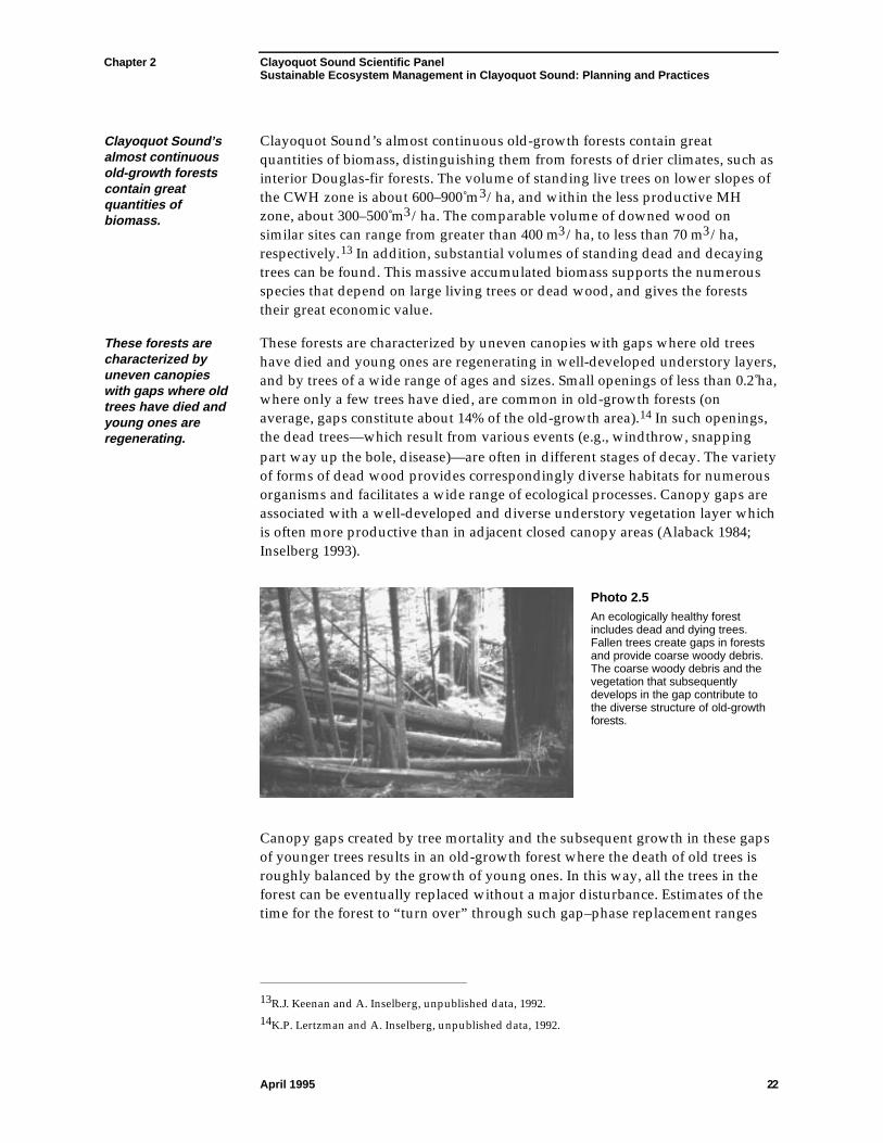
Chapter 2 Clayoquot Sound Scientific PanelSustainable Ecosystem Management in Clayoquot Sound: Planning and Practices
April 1995 22
Clayoquot Sound’salmost continuousold-growth forestscontain greatquantities ofbiomass.
Clayoquot Sound’s almost continuous old-growth forests contain greatquantities of biomass, distinguishing them from forests of drier climates, such asinterior Douglas-fir forests. The volume of standing live trees on lower slopes ofthe CWH zone is about 600–900 m3/ha, and within the less productive MHzone, about 300–500 m3/ha. The comparable volume of downed wood onsimilar sites can range from greater than 400 m3/ha, to less than 70 m3/ha,respectively.13 In addition, substantial volumes of standing dead and decayingtrees can be found. This massive accumulated biomass supports the numerousspecies that depend on large living trees or dead wood, and gives the foreststheir great economic value.
These forests arecharacterized byuneven canopieswith gaps where oldtrees have died andyoung ones areregenerating.
These forests are characterized by uneven canopies with gaps where old treeshave died and young ones are regenerating in well-developed understory layers,and by trees of a wide range of ages and sizes. Small openings of less than 0.2 ha,where only a few trees have died, are common in old-growth forests (onaverage, gaps constitute about 14% of the old-growth area).14 In such openings,the dead trees—which result from various events (e.g., windthrow, snappingpart way up the bole, disease)—are often in different stages of decay. The varietyof forms of dead wood provides correspondingly diverse habitats for numerousorganisms and facilitates a wide range of ecological processes. Canopy gaps areassociated with a well-developed and diverse understory vegetation layer whichis often more productive than in adjacent closed canopy areas (Alaback 1984;Inselberg 1993).
Photo 2.5An ecologically healthy forestincludes dead and dying trees.Fallen trees create gaps in forestsand provide coarse woody debris.The coarse woody debris and thevegetation that subsequentlydevelops in the gap contribute tothe diverse structure of old-growthforests.
Canopy gaps created by tree mortality and the subsequent growth in these gapsof younger trees results in an old-growth forest where the death of old trees isroughly balanced by the growth of young ones. In this way, all the trees in theforest can be eventually replaced without a major disturbance. Estimates of thetime for the forest to “turn over” through such gap–phase replacement ranges
13R.J. Keenan and A. Inselberg, unpublished data, 1992.14K.P. Lertzman and A. Inselberg, unpublished data, 1992.
Chapter 2 Clayoquot Sound Scientific PanelSustainable Ecosystem Management in Clayoquot Sound: Planning and Practices
April 1995 23
from 300 to 1000 years for a variety of sites in Clayoquot Sound and related foresttypes on the Lower Mainland of British Columbia (Lertzman and Krebs 1991).15
Most stands aredominated by oldtrees of species thatare among thelargest and mostlong-lived in theworld.
Because of the long intervals between disturbances, most stands are dominatedby old trees of species that are among the largest and most long-lived in theworld (e.g., western redcedar and yellow-cedar; Pojar and MacKinnon (editors)1994:16). Old-growth forests in Clayoquot Sound can represent true all-agedstands. For instance, in one stand containing amabilis fir, western redcedar,yellow-cedar, and western hemlock, ages were distributed continuously fromyoung saplings to trees almost 1000 years in age.16 These forests are structurallycomplex and provide microhabitats for a great variety of plants, animals, fungi,and micro-organisms. Some plant and lichen species in Clayoquot Sound do bestin, or are limited to, such old-growth forests. In some cases, the association withold-growth or closed-canopy forests is a function of microclimate.
The forest canopy affects wind, light, diurnal variation in temperature andmoisture, and seasonal patterns of snow accumulation and melt both within thestand and in adjacent open areas. This microclimatic influence of the forestcanopy extends from less than half a tree height17 to as much as six to eight treeheights into a stand (and likely as far from a stand into an opening), dependingon the variable measured. For most variables, the microclimatic influence of thecanopy is negligible beyond two to three tree heights from the stand edge (Chenet al. 1995). Examples of direct responses to these microclimatic variables can beseen in the distribution, reproduction, and growth of various species of plants.
Forests offer a widerange of habitats,many of which areimportant to small,non-vascular plants,lichens, and fungi.
Forests offer a wide range of habitats, many of which are important to small non-vascular plants, lichens, and fungi.18 Unfortunately, very little is known of thenon-vascular flora of Clayoquot Sound. One species of lichen, however, is foundonly near the shores of Clayoquot Sound (Goward 1994).19 More is known aboutthe area’s vascular plants (herbs, grasses, shrubs, and trees), but nocomprehensive survey has yet been attempted. Generally, forests of the CWHzone have fewer vascular plant species than the forests in some otherbiogeoclimatic zones; nonetheless, a 400 m2 plot typically contains about 20different species (Pojar et al. 1992).
15Also, K.P. Lertzman and A. Inselberg, unpublished data, 1992; A. Arsenault, unpublished data,1994.16A. Arsenault, unpublished data, 1994.17All references to tree heights refer to average “site potential tree height.” Although taller trees arepresent, the Panel has assumed that 50 m is representative potential for stands growing on productivesites.18Non-vascular plants include algae, mosses and liverworts.19The Status Report on the Seaside Centipede Lichen Heteroderma sitchensis recommends that theCommittee on the Status of Endangered Wildlife in Canada list this species as endangered.
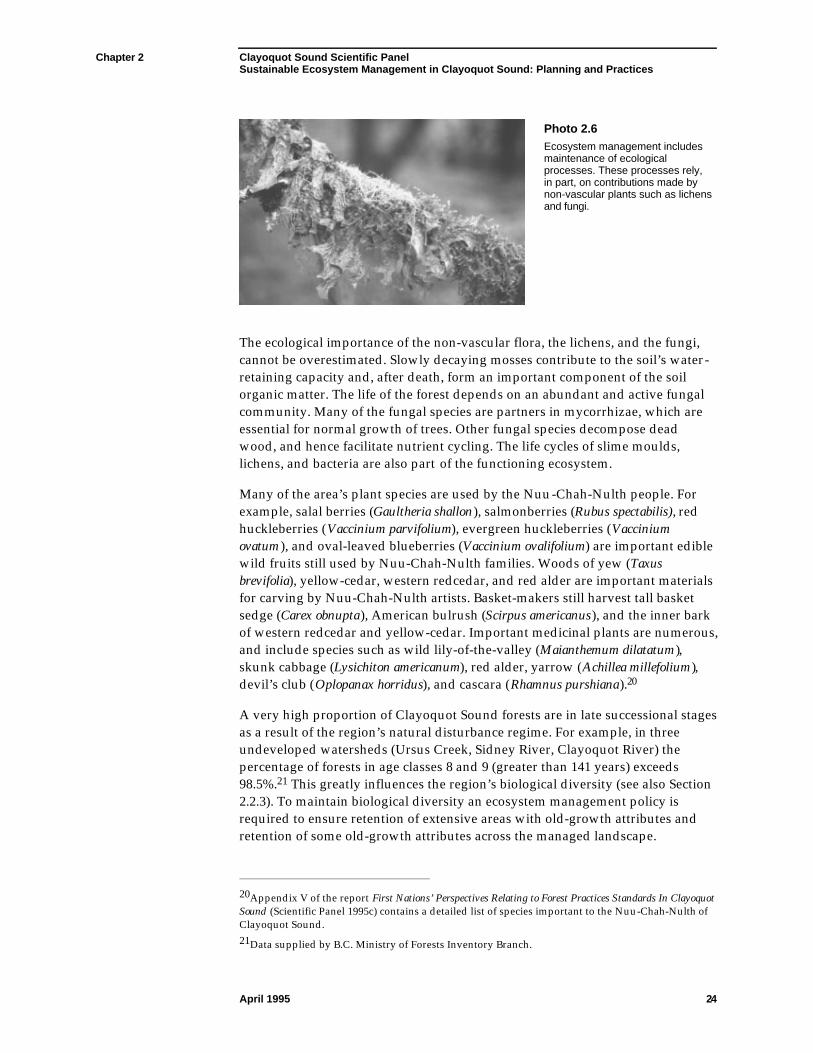
Chapter 2 Clayoquot Sound Scientific PanelSustainable Ecosystem Management in Clayoquot Sound: Planning and Practices
April 1995 24
Photo 2.6Ecosystem management includesmaintenance of ecologicalprocesses. These processes rely,in part, on contributions made bynon-vascular plants such as lichensand fungi.
The ecological importance of the non-vascular flora, the lichens, and the fungi,cannot be overestimated. Slowly decaying mosses contribute to the soil’s water-retaining capacity and, after death, form an important component of the soilorganic matter. The life of the forest depends on an abundant and active fungalcommunity. Many of the fungal species are partners in mycorrhizae, which areessential for normal growth of trees. Other fungal species decompose deadwood, and hence facilitate nutrient cycling. The life cycles of slime moulds,lichens, and bacteria are also part of the functioning ecosystem.
Many of the area’s plant species are used by the Nuu-Chah-Nulth people. Forexample, salal berries (Gaultheria shallon), salmonberries (Rubus spectabilis), redhuckleberries (Vaccinium parvifolium), evergreen huckleberries (Vacciniumovatum), and oval-leaved blueberries (Vaccinium ovalifolium) are important ediblewild fruits still used by Nuu-Chah-Nulth families. Woods of yew (Taxusbrevifolia), yellow-cedar, western redcedar, and red alder are important materialsfor carving by Nuu-Chah-Nulth artists. Basket-makers still harvest tall basketsedge (Carex obnupta), American bulrush (Scirpus americanus), and the inner barkof western redcedar and yellow-cedar. Important medicinal plants are numerous,and include species such as wild lily-of-the-valley (Maianthemum dilatatum),skunk cabbage (Lysichiton americanum), red alder, yarrow (Achillea millefolium),devil’s club (Oplopanax horridus), and cascara (Rhamnus purshiana).20
A very high proportion of Clayoquot Sound forests are in late successional stagesas a result of the region’s natural disturbance regime. For example, in threeundeveloped watersheds (Ursus Creek, Sidney River, Clayoquot River) thepercentage of forests in age classes 8 and 9 (greater than 141 years) exceeds98.5%.21 This greatly influences the region’s biological diversity (see also Section2.2.3). To maintain biological diversity an ecosystem management policy isrequired to ensure retention of extensive areas with old-growth attributes andretention of some old-growth attributes across the managed landscape.
20Appendix V of the report First Nations’ Perspectives Relating to Forest Practices Standards In ClayoquotSound (Scientific Panel 1995c) contains a detailed list of species important to the Nuu-Chah-Nulth ofClayoquot Sound.21Data supplied by B.C. Ministry of Forests Inventory Branch.
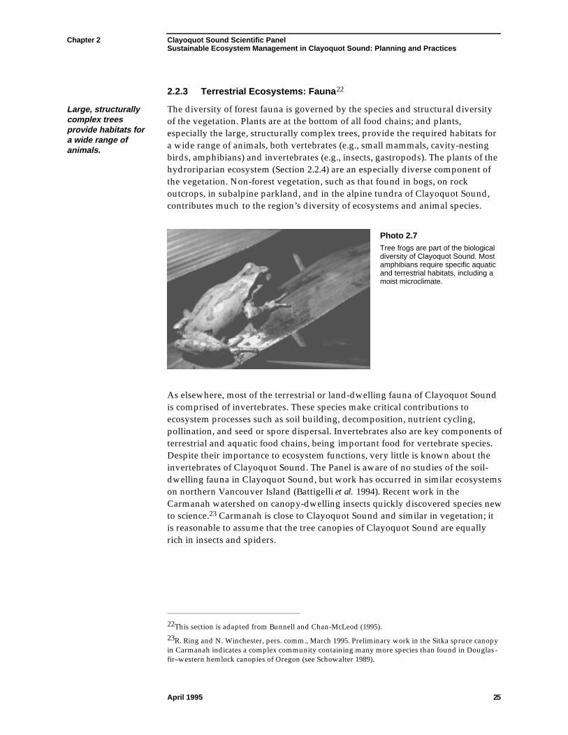
Chapter 2 Clayoquot Sound Scientific PanelSustainable Ecosystem Management in Clayoquot Sound: Planning and Practices
April 1995 25
2.2.3 Terrestrial Ecosystems: Fauna22
Large, structurallycomplex treesprovide habitats fora wide range ofanimals.
The diversity of forest fauna is governed by the species and structural diversityof the vegetation. Plants are at the bottom of all food chains; and plants,especially the large, structurally complex trees, provide the required habitats fora wide range of animals, both vertebrates (e.g., small mammals, cavity-nestingbirds, amphibians) and invertebrates (e.g., insects, gastropods). The plants of thehydroriparian ecosystem (Section 2.2.4) are an especially diverse component ofthe vegetation. Non-forest vegetation, such as that found in bogs, on rockoutcrops, in subalpine parkland, and in the alpine tundra of Clayoquot Sound,contributes much to the region’s diversity of ecosystems and animal species.
Photo 2.7Tree frogs are part of the biologicaldiversity of Clayoquot Sound. Mostamphibians require specific aquaticand terrestrial habitats, including amoist microclimate.
As elsewhere, most of the terrestrial or land-dwelling fauna of Clayoquot Soundis comprised of invertebrates. These species make critical contributions toecosystem processes such as soil building, decomposition, nutrient cycling,pollination, and seed or spore dispersal. Invertebrates also are key components ofterrestrial and aquatic food chains, being important food for vertebrate species.Despite their importance to ecosystem functions, very little is known about theinvertebrates of Clayoquot Sound. The Panel is aware of no studies of the soil-dwelling fauna in Clayoquot Sound, but work has occurred in similar ecosystemson northern Vancouver Island (Battigelli et al. 1994). Recent work in theCarmanah watershed on canopy-dwelling insects quickly discovered species newto science.23 Carmanah is close to Clayoquot Sound and similar in vegetation; itis reasonable to assume that the tree canopies of Clayoquot Sound are equallyrich in insects and spiders.
22This section is adapted from Bunnell and Chan-McLeod (1995).23R. Ring and N. Winchester, pers. comm., March 1995. Preliminary work in the Sitka spruce canopyin Carmanah indicates a complex community containing many more species than found in Douglas-fir–western hemlock canopies of Oregon (see Schowalter 1989).
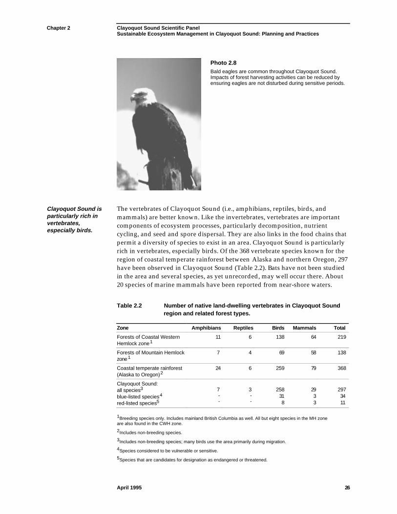
Chapter 2 Clayoquot Sound Scientific PanelSustainable Ecosystem Management in Clayoquot Sound: Planning and Practices
April 1995 26
Photo 2.8Bald eagles are common throughout Clayoquot Sound.Impacts of forest harvesting activities can be reduced byensuring eagles are not disturbed during sensitive periods.
Clayoquot Sound isparticularly rich invertebrates,especially birds.
The vertebrates of Clayoquot Sound (i.e., amphibians, reptiles, birds, andmammals) are better known. Like the invertebrates, vertebrates are importantcomponents of ecosystem processes, particularly decomposition, nutrientcycling, and seed and spore dispersal. They are also links in the food chains thatpermit a diversity of species to exist in an area. Clayoquot Sound is particularlyrich in vertebrates, especially birds. Of the 368 vertebrate species known for theregion of coastal temperate rainforest between Alaska and northern Oregon, 297have been observed in Clayoquot Sound (Table 2.2). Bats have not been studiedin the area and several species, as yet unrecorded, may well occur there. About20 species of marine mammals have been reported from near-shore waters.
Table 2.2 Number of native land-dwelling vertebrates in Clayoquot Soundregion and related forest types.
Zone Amphibians Reptiles Birds Mammals Total
Forests of Coastal WesternHemlock zone1
11 6 138 64 219
Forests of Mountain Hemlockzone1
7 4 69 58 138
Coastal temperate rainforest(Alaska to Oregon)2
24 6 259 79 368
Clayoquot Sound:all species3
blue-listed species4
red-listed species5
7--
3--
25831 8
29 3 3
2973411
1Breeding species only. Includes mainland British Columbia as well. All but eight species in the MH zoneare also found in the CWH zone.
2Includes non-breeding species.
3Includes non-breeding species; many birds use the area primarily during migration.
4Species considered to be vulnerable or sensitive.
5Species that are candidates for designation as endangered or threatened.
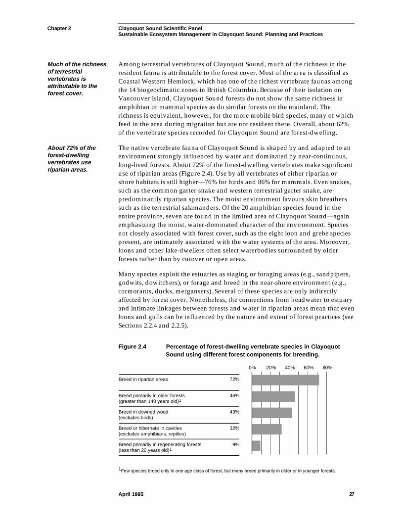
Chapter 2 Clayoquot Sound Scientific PanelSustainable Ecosystem Management in Clayoquot Sound: Planning and Practices
April 1995 27
Much of the richnessof terrestrialvertebrates isattributable to theforest cover.
Among terrestrial vertebrates of Clayoquot Sound, much of the richness in theresident fauna is attributable to the forest cover. Most of the area is classified asCoastal Western Hemlock, which has one of the richest vertebrate faunas amongthe 14 biogeoclimatic zones in British Columbia. Because of their isolation onVancouver Island, Clayoquot Sound forests do not show the same richness inamphibian or mammal species as do similar forests on the mainland. Therichness is equivalent, however, for the more mobile bird species, many of whichfeed in the area during migration but are not resident there. Overall, about 62%of the vertebrate species recorded for Clayoquot Sound are forest-dwelling.
About 72% of theforest-dwellingvertebrates useriparian areas.
The native vertebrate fauna of Clayoquot Sound is shaped by and adapted to anenvironment strongly influenced by water and dominated by near-continuous,long-lived forests. About 72% of the forest-dwelling vertebrates make significantuse of riparian areas (Figure 2.4). Use by all vertebrates of either riparian orshore habitats is still higher—76% for birds and 86% for mammals. Even snakes,such as the common garter snake and western terrestrial garter snake, arepredominantly riparian species. The moist environment favours skin breatherssuch as the terrestrial salamanders. Of the 20 amphibian species found in theentire province, seven are found in the limited area of Clayoquot Sound—againemphasizing the moist, water-dominated character of the environment. Speciesnot closely associated with forest cover, such as the eight loon and grebe speciespresent, are intimately associated with the water systems of the area. Moreover,loons and other lake-dwellers often select waterbodies surrounded by olderforests rather than by cutover or open areas.
Many species exploit the estuaries as staging or foraging areas (e.g., sandpipers,godwits, dowitchers), or forage and breed in the near-shore environment (e.g.,cormorants, ducks, mergansers). Several of these species are only indirectlyaffected by forest cover. Nonetheless, the connections from headwater to estuaryand intimate linkages between forests and water in riparian areas mean that evenloons and gulls can be influenced by the nature and extent of forest practices (seeSections 2.2.4 and 2.2.5).
Figure 2.4 Percentage of forest-dwelling vertebrate species in ClayoquotSound using different forest components for breeding.
72%
46%
43%
32%
9%
Breed in riparian areas
Breed primarily in older forests (greater than 140 years old)1
Breed in downed wood (excludes birds)
Breed or hibernate in cavities (excludes amphibians, reptiles)
Breed primarily in regenerating forests (less than 20 years old)1
0% 20% 40% 60% 80%
1Few species breed only in one age class of forest, but many breed primarily in older or in younger forests.
Chapter 2 Clayoquot Sound Scientific PanelSustainable Ecosystem Management in Clayoquot Sound: Planning and Practices
April 1995 28
Features of thevertebrate faunareflect closeassociations withthe area’s large,long-lived trees andcomplex foreststructure.
Other features of the vertebrate fauna reflect close associations with the area’slarge, long-lived trees and complex forest structure. The small forest gaps andabundant understory support numerous shrub nesters, such as Wilson’s warblerand gray-cheeked thrush, along with cavity-nesting woodpeckers andnuthatches in the adjacent forest. At least 47 species (37 birds and 10 mammals)in Clayoquot Sound use the cavities of large trees—living and dead—to raisetheir young or hibernate. These species constitute about one-third of the forest-dwelling vertebrate fauna (Figure 2.4). Still more species rely on trees that havefallen to the ground (downed wood). Within the CWH zone, more species thanin forests of any other biogeoclimatic zone use downed wood as breeding sites;about 40 of these species occur in Clayoquot Sound. Winter wrens, marten, andblack bears nest or den in the root wads or hollows of windthrown trees. Aremarkably high percentage (43%) of the amphibians, reptiles, and mammals inforests of Clayoquot Sound use downed wood to breed (Figure 2.4).
About 45% of thearea’s forest-dwelling vertebratesbreed primarily inolder forests, whileless than 10% breedbest in youngforests.
Both abundant cavity-sites and significant amounts of downed wood areproducts of older forests and long intervals between disturbances. Some speciesin Clayoquot Sound, such as breeding marbled murrelets, are largely restrictedto old-growth forests. Others depend on old-growth attributes. For example,bald eagle and great blue heron require large, structurally complex trees asbreeding sites, while black-tailed deer profit from closed, older forests withsmall openings during years of deep snowfall. A few species, such as thewestern red-backed salamander, require at least limited areas of closed forest tallenough to maintain a humid microclimate. Among forest-dwelling vertebrates inClayoquot Sound, about 45% breed primarily in older forests, while less than10% breed best in young forests less than 20 years old (Figure 2.4). Other speciesare more general in their habits.
Effects of forest openings on animal behaviour vary widely. Many species thatuse both forest and open areas prefer edge habitats where canopy influence issubstantial. For instance, black-tailed deer often feed on early seral vegetation24
in openings, but prefer to stay within two to three tree heights of the canopy edge(Kremsater and Bunnell 1992). Some smaller mammals usually stay much closerto the edge. Provided appropriate habitat structures are available (e.g., wildlifetrees25 of sufficient diameter), forest birds such as woodpeckers will useopenings with minimal canopy influence.
24Early seral vegetation is vegetation appearing soon after disturbance (e.g., fireweed).25Wildlife trees are dead, decaying, deteriorating, or other designated trees that provide present orfuture critical habitat for the maintenance or enhancement of wildlife.
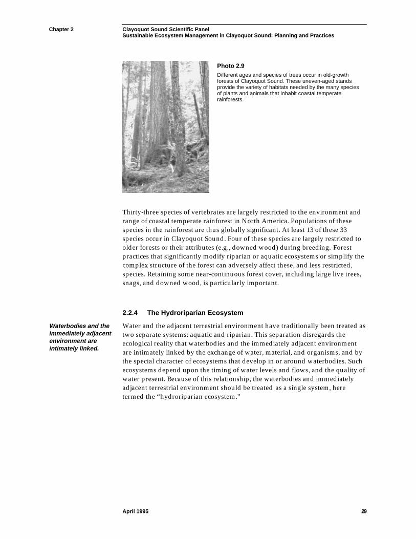
Chapter 2 Clayoquot Sound Scientific PanelSustainable Ecosystem Management in Clayoquot Sound: Planning and Practices
April 1995 29
Photo 2.9Different ages and species of trees occur in old-growthforests of Clayoquot Sound. These uneven-aged standsprovide the variety of habitats needed by the many speciesof plants and animals that inhabit coastal temperaterainforests.
Thirty-three species of vertebrates are largely restricted to the environment andrange of coastal temperate rainforest in North America. Populations of thesespecies in the rainforest are thus globally significant. At least 13 of these 33species occur in Clayoquot Sound. Four of these species are largely restricted toolder forests or their attributes (e.g., downed wood) during breeding. Forestpractices that significantly modify riparian or aquatic ecosystems or simplify thecomplex structure of the forest can adversely affect these, and less restricted,species. Retaining some near-continuous forest cover, including large live trees,snags, and downed wood, is particularly important.
2.2.4 The Hydroriparian Ecosystem
Waterbodies and theimmediately adjacentenvironment areintimately linked.
Water and the adjacent terrestrial environment have traditionally been treated astwo separate systems: aquatic and riparian. This separation disregards theecological reality that waterbodies and the immediately adjacent environmentare intimately linked by the exchange of water, material, and organisms, and bythe special character of ecosystems that develop in or around waterbodies. Suchecosystems depend upon the timing of water levels and flows, and the quality ofwater present. Because of this relationship, the waterbodies and immediatelyadjacent terrestrial environment should be treated as a single system, heretermed the “hydroriparian ecosystem.”
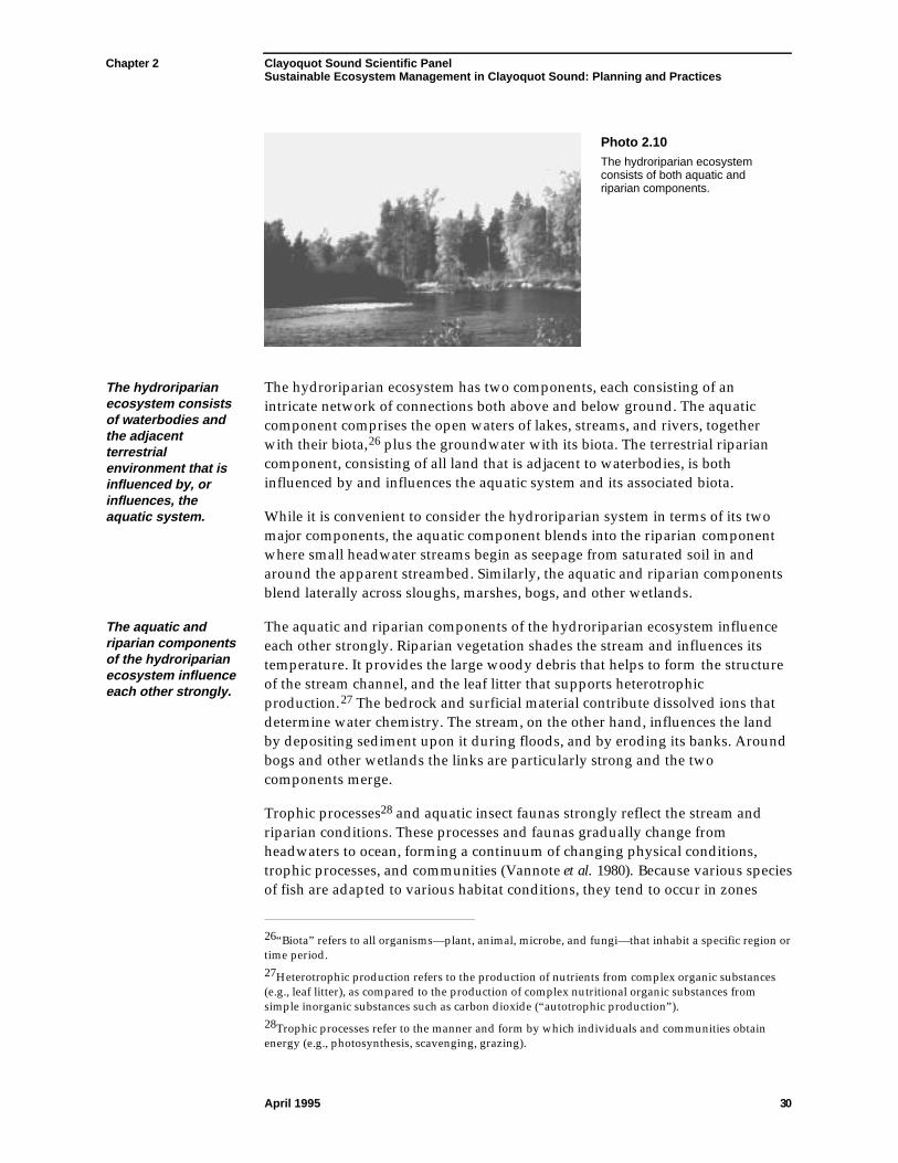
Chapter 2 Clayoquot Sound Scientific PanelSustainable Ecosystem Management in Clayoquot Sound: Planning and Practices
April 1995 30
Photo 2.10The hydroriparian ecosystemconsists of both aquatic andriparian components.
The hydroriparianecosystem consistsof waterbodies andthe adjacentterrestrialenvironment that isinfluenced by, orinfluences, theaquatic system.
The hydroriparian ecosystem has two components, each consisting of anintricate network of connections both above and below ground. The aquaticcomponent comprises the open waters of lakes, streams, and rivers, togetherwith their biota,26 plus the groundwater with its biota. The terrestrial ripariancomponent, consisting of all land that is adjacent to waterbodies, is bothinfluenced by and influences the aquatic system and its associated biota.
While it is convenient to consider the hydroriparian system in terms of its twomajor components, the aquatic component blends into the riparian componentwhere small headwater streams begin as seepage from saturated soil in andaround the apparent streambed. Similarly, the aquatic and riparian componentsblend laterally across sloughs, marshes, bogs, and other wetlands.
The aquatic andriparian componentsof the hydroriparianecosystem influenceeach other strongly.
The aquatic and riparian components of the hydroriparian ecosystem influenceeach other strongly. Riparian vegetation shades the stream and influences itstemperature. It provides the large woody debris that helps to form the structureof the stream channel, and the leaf litter that supports heterotrophicproduction.27 The bedrock and surficial material contribute dissolved ions thatdetermine water chemistry. The stream, on the other hand, influences the landby depositing sediment upon it during floods, and by eroding its banks. Aroundbogs and other wetlands the links are particularly strong and the twocomponents merge.
Trophic processes28 and aquatic insect faunas strongly reflect the stream andriparian conditions. These processes and faunas gradually change fromheadwaters to ocean, forming a continuum of changing physical conditions,trophic processes, and communities (Vannote et al. 1980). Because various speciesof fish are adapted to various habitat conditions, they tend to occur in zones
26“Biota” refers to all organisms—plant, animal, microbe, and fungi—that inhabit a specific region ortime period.27Heterotrophic production refers to the production of nutrients from complex organic substances(e.g., leaf litter), as compared to the production of complex nutritional organic substances fromsimple inorganic substances such as carbon dioxide (“autotrophic production”).28Trophic processes refer to the manner and form by which individuals and communities obtainenergy (e.g., photosynthesis, scavenging, grazing).
Chapter 2 Clayoquot Sound Scientific PanelSustainable Ecosystem Management in Clayoquot Sound: Planning and Practices
April 1995 31
within the stream continuum. This zonation reflects connections with both theriparian and aquatic environments.
Small streams arecritically influencedby the surroundingvegetation.
Small headwater streams in Clayoquot Sound usually are heavily shaded. Mostnourishment for animals in the stream comes from outside the stream itself. Thetrophic processes within these streams are based on input of insects, leaves, andtwigs from adjacent riparian areas. Water temperatures tend to be relativelystable and low throughout the day, and there is relatively little algal growth orprimary production within the stream. Small streams are critically influenced bythe surrounding vegetation.
Progressing downstream, the nature of trophic processes changes. The streamchannel becomes less shaded, the daily range of temperature increases, algalproduction increases, and more food energy is produced within the stream itself.Insect faunas contain more species that graze algae from stream bottom stonesand more species that collect drifting organic matter. The increased daily rangeof water temperature permits greater diversity of insect lifestyles and species.These small organisms form the bases of several food chains—at the top of whichare the commercially or culturally valuable salmonid fish, and herons, eagles,and bears. Maximum faunal diversity tends to occur in the largest, low-gradientstreams in Clayoquot Sound, such as the Megin or Kennedy rivers. In theselarger streams, the trophic system is driven primarily by processes within thestream, although linkages between streams and adjacent riparian areas are stillevident.
In the upper estuary, insect faunas change dramatically and species compositionshifts to other forms of macroinvertebrates, particularly crustaceans. The upperpart of the stream system, although distant, influences the estuary and the near-estuary marine environment; for example, by providing organic matter rangingfrom detritus to whole trees.
Forestry activities may alter not only stream channel morphology andhydrological and sediment regimes, but may also modify trophic processes. Incausing these changes, forestry activities may modify life histories and success ofvarious riparian and aquatic species, shift the zones in which maximumbiological diversity occurs, and change the distribution of fish (Hartman andScrivener 1990).
Forests in riparianareas play criticalroles.
Forests in riparian areas play critical roles beyond shading, food production, andfood-gathering processes. In upslope and riparian areas, plant roots that die anddecompose leave channels through the soil, which transport water rapidly to thestream channel. The presence and condition of forest vegetation thus affect therate of water movement through the soil. Trees along streambanks are the sourceof whole trees and smaller wood fragments that, when they fall into the streamand lodge, help to store gravel in the stream channel, regulate stream velocity,and influence stream channel morphology. Woody debris in the stream channelprovides a variety of habitats for aquatic organisms.
Chapter 2 Clayoquot Sound Scientific PanelSustainable Ecosystem Management in Clayoquot Sound: Planning and Practices
April 1995 32
Effects of the aquatic system on the riparian area are no less strong. An obviousfactor is the proximity of two distinct habitats (water and land), both critical tosemi-aquatic species such as American dippers, mink, and river otter, as well asto aquatic species. An equally strong effect is the continuous or seasonalinfluence of water which encourages a productive and diverse plant communitydifferent from communities found on adjacent hill slopes. This diversity andproductivity is reflected in the use of riparian areas by many animal species.
Subterranean wateris newly recognizedas an importanthabitat.
Subterranean water is newly recognized as an important habitat containing itsown unique communities; groundwater forms two contrasting zones, each withits own biota (Stanford and Ward 1988). The hyporheic (flowing water) zoneprovides habitat for the immature stages of several insect species which, onreaching maturity, join the biota of the riparian area. The phreatic zone, wheregroundwaterflows much more slowly, is the habitat of several species ofpermanently subterranean crustaceans. The waters of these zones are continuouswith each other but, except in a narrow transition zone, quite distinct in theirchemical properties and their speed of flow. Floodplain plants, part of theriparian biota, obtain their water and mineral nutrients from the hyporheic andphreatic waters beneath them.
Four points about the hydroriparian ecosystem merit emphasis.
The hydroriparianecosystem is theskeleton andcirculation systemof the ecologicallandscape.
• The hydroriparian ecosystem is the focus of activity for a large portion of allfauna, and the site of the most diverse flora in a watershed. Thehydroriparian ecosystem is the major travel corridor for many terrestrial andall aquatic organisms—essentially the skeleton and circulation system of theecological landscape.
• These land-water systems are strongly affected by logging and roadbuilding(Hartman and Scrivener 1990). Such activities can alter channel morphology(Section 2.1.4), hydrology, and shading or thermal regimes. Changes in theriparian environment that modify physical processes influence theinvertebrate faunas and thus may alter fish species composition or shift fishspecies zones within a stream system.
Natural pathsand regimes ofsubsurface waterfloware important toplants and animals,as well as to slopestability.
• The maintenance of natural paths and regimes of subsurface waterflow isimportant to plant and animal biological diversity, as well as to slopestability. This is particularly true for wetlands and steep slopes, and forsubterranean organisms.
• Each watershed contains its own hydroriparian ecosystem, largely isolatedfrom the hydroriparian ecosystems in other watersheds. Many species inhydroriparian ecosystems, especially wingless aquatic invertebrates, cannotsurvive outside the system even for short periods. These species aregenetically isolated from those in other watersheds for most of the time.Genetic exchange is possible only when uncommon events, such as whenexceptionally high floods dilute seawater sufficiently for freshwaterorganisms to survive drifting between stream mouths, permit intermingled
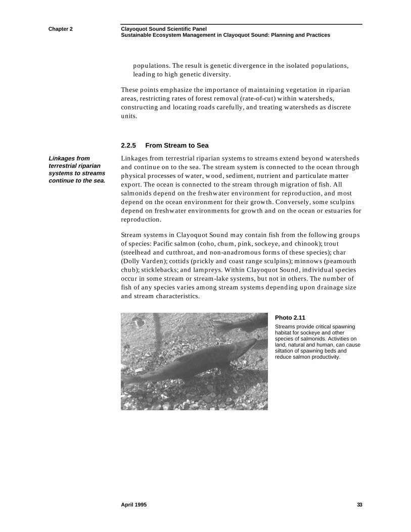
Chapter 2 Clayoquot Sound Scientific PanelSustainable Ecosystem Management in Clayoquot Sound: Planning and Practices
April 1995 33
populations. The result is genetic divergence in the isolated populations,leading to high genetic diversity.
These points emphasize the importance of maintaining vegetation in riparianareas, restricting rates of forest removal (rate-of-cut) within watersheds,constructing and locating roads carefully, and treating watersheds as discreteunits.
2.2.5 From Stream to Sea
Linkages fromterrestrial ripariansystems to streamscontinue to the sea.
Linkages from terrestrial riparian systems to streams extend beyond watershedsand continue on to the sea. The stream system is connected to the ocean throughphysical processes of water, wood, sediment, nutrient and particulate matterexport. The ocean is connected to the stream through migration of fish. Allsalmonids depend on the freshwater environment for reproduction, and mostdepend on the ocean environment for their growth. Conversely, some sculpinsdepend on freshwater environments for growth and on the ocean or estuaries forreproduction.
Stream systems in Clayoquot Sound may contain fish from the following groupsof species: Pacific salmon (coho, chum, pink, sockeye, and chinook); trout(steelhead and cutthroat, and non-anadromous forms of these species); char(Dolly Varden); cottids (prickly and coast range sculpins); minnows (peamouthchub); sticklebacks; and lampreys. Within Clayoquot Sound, individual speciesoccur in some stream or stream-lake systems, but not in others. The number offish of any species varies among stream systems depending upon drainage sizeand stream characteristics.
Photo 2.11Streams provide critical spawninghabitat for sockeye and otherspecies of salmonids. Activities onland, natural and human, can causesiltation of spawning beds andreduce salmon productivity.

Chapter 2 Clayoquot Sound Scientific PanelSustainable Ecosystem Management in Clayoquot Sound: Planning and Practices
April 1995 34
About 100 streams inthe Clayoquot Soundarea have beenidentified ascontaining one ormore species ofsalmon.
About 100 streams in the Clayoquot Sound area have been identified ascontaining one or more species of salmon; sockeye, chum (in lower streamreaches), and coho are the species most commonly found (Canada 1991). Streamsusually contain only one or two species (e.g., chum or coho salmon, cutthroattrout). Some streams and lake systems support several species of fish withpopulations numbering in the tens of thousands. In most streams, however,populations of individual species are small, less than 100 adults.
Escapement29 data represent spawning adult numbers rather than accuratemeasures of fish production.30 The trends in escapement of salmon reported bythe Department of Fisheries and Oceans (Canada 1991) are, for manypopulations, similar to the trends in run strength reported by theNuu-Chah-Nulth members of the Panel.
The numbers ofsome species ofsalmon in ClayoquotSound streams havedeclined.
Estimated average escapements to Clayoquot Sound streams differ amongspecies of salmon (Table 2.3) and have varied widely from year to year. Sockeyeand chum have been the most abundant species, and chinook the least abundant(Figure 2.5). Estimated numbers of some species of salmon in Clayoquot Soundstreams have declined while those of other species appear to have remainedabout the same. These data are not precise, but indicate the relative magnitude ofruns and long-term trends in populations.31 Average annual coho and chinooknumbers, based on five-year intervals, declined from 1968 to 1992. Available datasuggest that pink salmon became virtually extinct after the 1978–82 estimates(Figure 2.5). No trend is apparent, or numbers appear stable, for sockeye andchum salmon.
Table 2.3 Average annual escapement to Clayoquot Sound streams,Area 24, Tofino, 1968–1992.
Chum Sockeye Coho Pink * Chinook
Average 55 070 26 232 6 278 2 701 424
Range 9 506–117 795 6 275–93 960 940–21 875 1 600–26 700 52–1 079
*Data are shown for the “high” years; 0–50 fish for “low” years. No information available for steelhead.
29Escapement is an estimate of the numbers of adult fish returning to a stream to spawn.30Data of Table 2.3 and Figure 2.5 are derived from Canada (1991) and other records from theDepartment of Fisheries and Oceans.31Because escapement data may not be based on estimates from the same streams each year,interpretations must be made cautiously. Effective data gathering and interpretation to estimatespawning runs has been hindered by the limited extent of local monitoring. Nuu-Chah-Nulthexperience is that formerly productive streams, excluded from some estimates, are now barren.
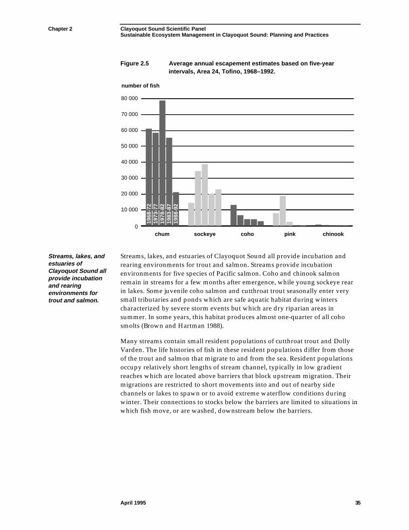
Chapter 2 Clayoquot Sound Scientific PanelSustainable Ecosystem Management in Clayoquot Sound: Planning and Practices
April 1995 35
Figure 2.5 Average annual escapement estimates based on five-yearintervals, Area 24, Tofino, 1968–1992.
chum
number of fish
sockeye coho pink chinook0
10 000
20 000
30 000
40 000
50 000
60 000
70 000
80 000
1968
-72
1973
-77
1978
-82
1983
-87
1988
-92
Streams, lakes, andestuaries ofClayoquot Sound allprovide incubationand rearingenvironments fortrout and salmon.
Streams, lakes, and estuaries of Clayoquot Sound all provide incubation andrearing environments for trout and salmon. Streams provide incubationenvironments for five species of Pacific salmon. Coho and chinook salmonremain in streams for a few months after emergence, while young sockeye rearin lakes. Some juvenile coho salmon and cutthroat trout seasonally enter verysmall tributaries and ponds which are safe aquatic habitat during winterscharacterized by severe storm events but which are dry riparian areas insummer. In some years, this habitat produces almost one-quarter of all cohosmolts (Brown and Hartman 1988).
Many streams contain small resident populations of cutthroat trout and DollyVarden. The life histories of fish in these resident populations differ from thoseof the trout and salmon that migrate to and from the sea. Resident populationsoccupy relatively short lengths of stream channel, typically in low gradientreaches which are located above barriers that block upstream migration. Theirmigrations are restricted to short movements into and out of nearby sidechannels or lakes to spawn or to avoid extreme waterflow conditions duringwinter. Their connections to stocks below the barriers are limited to situations inwhich fish move, or are washed, downstream below the barriers.
Chapter 2 Clayoquot Sound Scientific PanelSustainable Ecosystem Management in Clayoquot Sound: Planning and Practices
April 1995 36
Resident fish mayrequire the highestdegree of protection.
Resident fish, such as Dolly Varden, have been isolated from downstream fishfor thousands of years, and the population in each stream where residentpopulations occur may be genetically distinct (Northcote and Hartman 1988).Because resident populations spend most of their life within relatively shortreaches of stream channel, and are genetically isolated, they are especiallyvulnerable. They have no refuge from damage to their stream channel, and noopportunity to rebuild their populations by immigration from the sea or adjacentstreams. For these reasons, resident fish may require the highest degree ofprotection. However, because the fish are small and do not provide acommercial or recreational fishery, they generally have been overlooked inprotection measures. It is likely that many such resident fish stocks have sufferedfrom habitat damage resulting from past logging practices.
Although we tend to think of fish as occupying either a marine or freshwaterenvironment, or migrating from one environment to the other, the distinction inhabitat use is often less clear than that. Chum salmon spawn in the lowerreaches, within 0.6 km of the sea in most streams where they occur, and spawn inthe intertidal zone in some streams (e.g., Carnation Creek, Barkley Sound).32
Chum egg-to-fry survival in the intertidal zone is comparable to that infreshwater sections of the creek (Groot 1989). A part of the juvenile cohopopulation in coastal streams may undergo some maturation in the estuarinezone. Prickly sculpins may use both estuarine and stream environments atdifferent times in their lives. Other species, predominantly marine, move intoestuaries during some phases of their life history (e.g., herring use estuaries asfeeding areas). Such combined use of freshwater-marine, estuary-freshwater,marine-estuary, or marine-freshwater systems reveals that these environmentsare functionally linked for many species of fish, and emphasize the importantrole of estuaries.
Events far upstream,well removed fromspawning areas,can influencedownstreamcharacteristicsand organisms.
The number and importance of land-to-sea connections are becoming betterunderstood. Events far upstream, well removed from spawning areas, caninfluence downstream characteristics and organisms. Transport of organicmaterial (e.g., detritus, twigs, small woody debris, and whole trees) downstreamto estuaries enforces both trophic and structural links among freshwater,estuarine, and marine environments. Activities carried out upstream or on theshore zone may affect marine conditions and organisms. The Nuu-Chah-Nulthhave observed that upstream or onshore activities that affect water quality, byaddition of sediment or dissolved organic material, may disrupt herringspawning. They are strongly concerned that log dumping may affect herringspawning and geoduck numbers.
32Barkley Sound is a source of detailed data on instream fish natural history. Because Barkley Soundis immediately adjacent to Clayoquot Sound, the Panel deems that this information is relevant toClayoquot Sound. See Hartman and Scrivener (1990) for a summary presentation.
Chapter 2 Clayoquot Sound Scientific PanelSustainable Ecosystem Management in Clayoquot Sound: Planning and Practices
April 1995 37
Woody debris, farout at sea, providescover and foodfor more than100 species ofinvertebrates and130 species of fish.
Some relationships between the terrestrial and marine environments have beenrecognized only recently. Large, sunken woody debris plays a vital role in theecology of the ocean. As well, windrows of debris and trees, far offshore wherewater converges and downwells, provide cover and food for more than 100species of invertebrates and 130 species of fish (Sedell and Maser 1994). Theseobservations emphasize the importance of maintaining the integrity and naturalprocesses of stream systems along their entire length. Forestry practices need toretain sufficient vegetative cover and natural drainage patterns to maintain soilstability, natural stream discharge regimes, and habitats of stream-dwellingorganisms.
Some of the watersheds within Clayoquot Sound contain lakes. Thesewaterbodies reflect the regional climate and geology, and are relativelyoligotrophic or low in nutrients. Lakes within the drainage systems modify theconditions of the streams that pass through them. They dampen floods, alterwater temperatures, intercept sediment, and store large woody debris. Trophicprocesses in lakes differ from those in the streams. Production, almost entirelyautotrophic, maintains planktonic algae in the lakes. The insect and crustaceanfaunas of the lakes are almost entirely planktonic as opposed to being benthic, asin streams.33
Fish faunas withinlakes includecommercially andrecreationallyvaluable species.
Fish faunas within the lakes include some of the commercially and recreationallyvaluable species, such as sockeye and coho salmon juveniles, trout and DollyVarden, as well as non-commercial species such as three-spined stickleback,peamouth chub (Kennedy Lake), and sculpins. The peamouth chub andstickleback are, predominantly, lake species. The stickleback is a significantspecies because it may compete with juvenile sockeye in Kennedy Lake.
Lakes, as a whole, may be less vulnerable than streams to ecological impactsfrom logging activities. However, high levels of suspended sediment in thestreams may lead to increased suspended sediment in the lakes. At highconcentrations such material would reduce plankton production in the lake.Shore zones, in much the same way as streams, are vulnerable to the effects offorest removal at the shoreline.
2.3 Human Values in the Landscape
Clayoquot Sound isimportant to peoplefor cultural, spiritual,and scenic values,and for recreationaland tourism use.
Many aspects of the Clayoquot Sound environment are important to people—both First Nations and others—for cultural, spiritual, and scenic values, and forrecreational and tourism use. The resources in Clayoquot Sound also provideeconomic benefits for residents and the province of British Columbia.
33Plankton are the chiefly microscopic organisms drifting or floating in the sea or fresh water; benthicorganisms are the flora and fauna found at the bottom of a sea, lake, or stream.
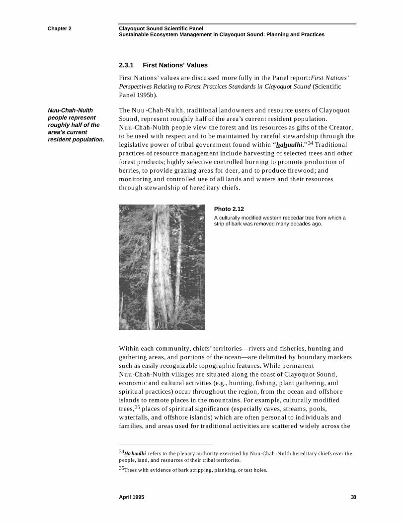
Chapter 2 Clayoquot Sound Scientific PanelSustainable Ecosystem Management in Clayoquot Sound: Planning and Practices
April 1995 38
2.3.1 First Nations’ Values
First Nations’ values are discussed more fully in the Panel report: First Nations’Perspectives Relating to Forest Practices Standards in Clayoquot Sound (ScientificPanel 1995b).
Nuu-Chah-Nulthpeople representroughly half of thearea’s currentresident population.
The Nuu-Chah-Nulth, traditional landowners and resource users of ClayoquotSound, represent roughly half of the area’s current resident population.Nuu-Chah-Nulth people view the forest and its resources as gifts of the Creator,to be used with respect and to be maintained by careful stewardship through thelegislative power of tribal government found within “hahuulhi.”34 Traditionalpractices of resource management include harvesting of selected trees and otherforest products; highly selective controlled burning to promote production ofberries, to provide grazing areas for deer, and to produce firewood; andmonitoring and controlled use of all lands and waters and their resourcesthrough stewardship of hereditary chiefs.
Photo 2.12A culturally modified western redcedar tree from which astrip of bark was removed many decades ago.
Within each community, chiefs’ territories—rivers and fisheries, hunting andgathering areas, and portions of the ocean—are delimited by boundary markerssuch as easily recognizable topographic features. While permanentNuu-Chah-Nulth villages are situated along the coast of Clayoquot Sound,economic and cultural activities (e.g., hunting, fishing, plant gathering, andspiritual practices) occur throughout the region, from the ocean and offshoreislands to remote places in the mountains. For example, culturally modifiedtrees,35 places of spiritual significance (especially caves, streams, pools,waterfalls, and offshore islands) which are often personal to individuals andfamilies, and areas used for traditional activities are scattered widely across the
34Hahuulhi refers to the plenary authority exercised by Nuu-Chah-Nulth hereditary chiefs over thepeople, land, and resources of their tribal territories.35Trees with evidence of bark stripping, planking, or test holes.
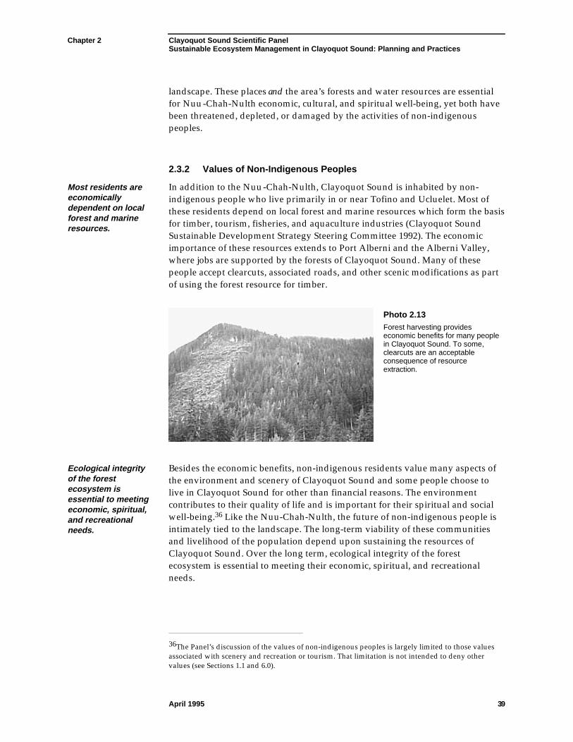
Chapter 2 Clayoquot Sound Scientific PanelSustainable Ecosystem Management in Clayoquot Sound: Planning and Practices
April 1995 39
landscape. These places and the area’s forests and water resources are essentialfor Nuu-Chah-Nulth economic, cultural, and spiritual well-being, yet both havebeen threatened, depleted, or damaged by the activities of non-indigenouspeoples.
2.3.2 Values of Non-Indigenous Peoples
Most residents areeconomicallydependent on localforest and marineresources.
In addition to the Nuu-Chah-Nulth, Clayoquot Sound is inhabited by non-indigenous people who live primarily in or near Tofino and Ucluelet. Most ofthese residents depend on local forest and marine resources which form the basisfor timber, tourism, fisheries, and aquaculture industries (Clayoquot SoundSustainable Development Strategy Steering Committee 1992). The economicimportance of these resources extends to Port Alberni and the Alberni Valley,where jobs are supported by the forests of Clayoquot Sound. Many of thesepeople accept clearcuts, associated roads, and other scenic modifications as partof using the forest resource for timber.
Photo 2.13Forest harvesting provideseconomic benefits for many peoplein Clayoquot Sound. To some,clearcuts are an acceptableconsequence of resourceextraction.
Ecological integrityof the forestecosystem isessential to meetingeconomic, spiritual,and recreationalneeds.
Besides the economic benefits, non-indigenous residents value many aspects ofthe environment and scenery of Clayoquot Sound and some people choose tolive in Clayoquot Sound for other than financial reasons. The environmentcontributes to their quality of life and is important for their spiritual and socialwell-being.36 Like the Nuu-Chah-Nulth, the future of non-indigenous people isintimately tied to the landscape. The long-term viability of these communitiesand livelihood of the population depend upon sustaining the resources ofClayoquot Sound. Over the long term, ecological integrity of the forestecosystem is essential to meeting their economic, spiritual, and recreationalneeds.
36The Panel’s discussion of the values of non-indigenous peoples is largely limited to those valuesassociated with scenery and recreation or tourism. That limitation is not intended to deny othervalues (see Sections 1.1 and 6.0).
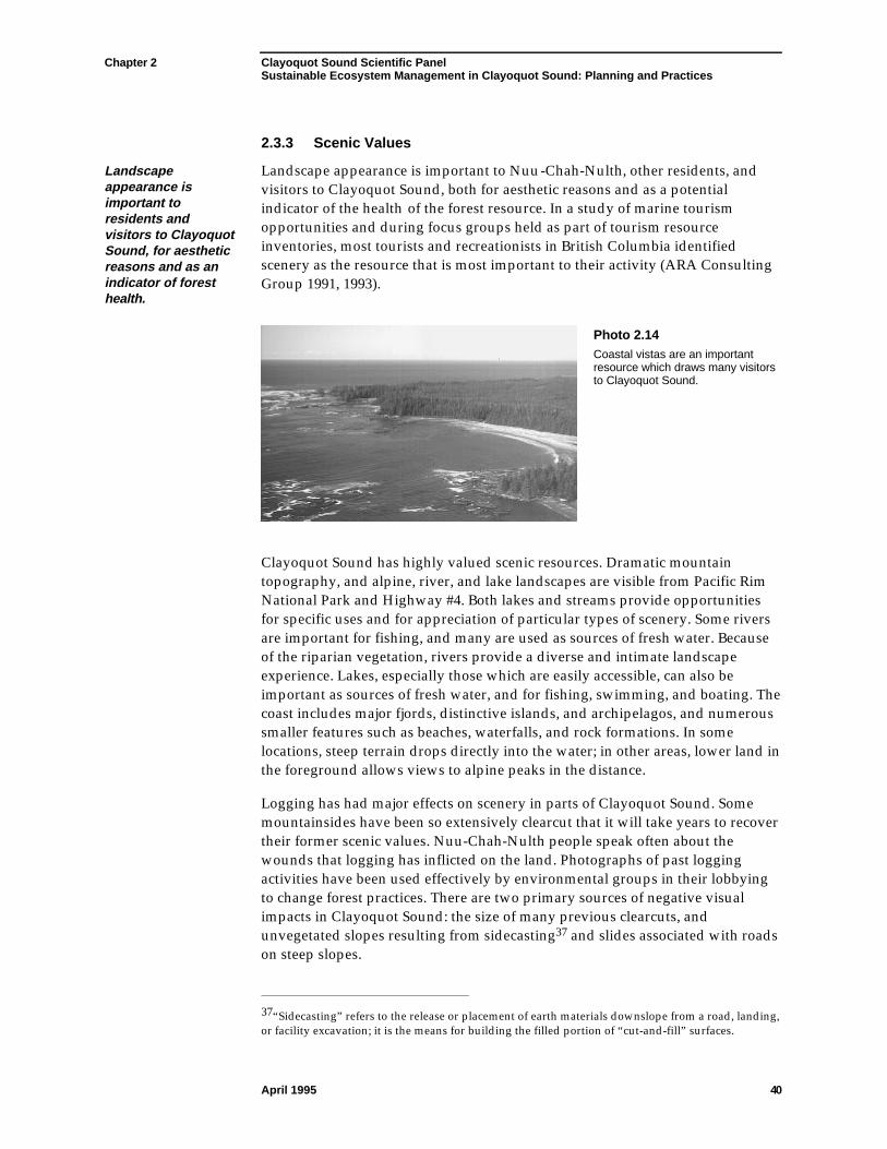
Chapter 2 Clayoquot Sound Scientific PanelSustainable Ecosystem Management in Clayoquot Sound: Planning and Practices
April 1995 40
2.3.3 Scenic Values
Landscapeappearance isimportant toresidents andvisitors to ClayoquotSound, for aestheticreasons and as anindicator of foresthealth.
Landscape appearance is important to Nuu-Chah-Nulth, other residents, andvisitors to Clayoquot Sound, both for aesthetic reasons and as a potentialindicator of the health of the forest resource. In a study of marine tourismopportunities and during focus groups held as part of tourism resourceinventories, most tourists and recreationists in British Columbia identifiedscenery as the resource that is most important to their activity (ARA ConsultingGroup 1991, 1993).
Photo 2.14Coastal vistas are an importantresource which draws many visitorsto Clayoquot Sound.
Clayoquot Sound has highly valued scenic resources. Dramatic mountaintopography, and alpine, river, and lake landscapes are visible from Pacific RimNational Park and Highway #4. Both lakes and streams provide opportunitiesfor specific uses and for appreciation of particular types of scenery. Some riversare important for fishing, and many are used as sources of fresh water. Becauseof the riparian vegetation, rivers provide a diverse and intimate landscapeexperience. Lakes, especially those which are easily accessible, can also beimportant as sources of fresh water, and for fishing, swimming, and boating. Thecoast includes major fjords, distinctive islands, and archipelagos, and numeroussmaller features such as beaches, waterfalls, and rock formations. In somelocations, steep terrain drops directly into the water; in other areas, lower land inthe foreground allows views to alpine peaks in the distance.
Logging has had major effects on scenery in parts of Clayoquot Sound. Somemountainsides have been so extensively clearcut that it will take years to recovertheir former scenic values. Nuu-Chah-Nulth people speak often about thewounds that logging has inflicted on the land. Photographs of past loggingactivities have been used effectively by environmental groups in their lobbyingto change forest practices. There are two primary sources of negative visualimpacts in Clayoquot Sound: the size of many previous clearcuts, andunvegetated slopes resulting from sidecasting37 and slides associated with roadson steep slopes.
37“Sidecasting” refers to the release or placement of earth materials downslope from a road, landing,or facility excavation; it is the means for building the filled portion of “cut-and-fill” surfaces.
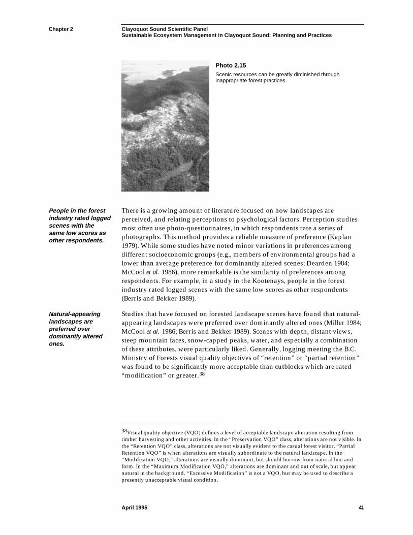
Chapter 2 Clayoquot Sound Scientific PanelSustainable Ecosystem Management in Clayoquot Sound: Planning and Practices
April 1995 41
Photo 2.15Scenic resources can be greatly diminished throughinappropriate forest practices.
People in the forestindustry rated loggedscenes with thesame low scores asother respondents.
There is a growing amount of literature focused on how landscapes areperceived, and relating perceptions to psychological factors. Perception studiesmost often use photo-questionnaires, in which respondents rate a series ofphotographs. This method provides a reliable measure of preference (Kaplan1979). While some studies have noted minor variations in preferences amongdifferent socioeconomic groups (e.g., members of environmental groups had alower than average preference for dominantly altered scenes; Dearden 1984;McCool et al. 1986), more remarkable is the similarity of preferences amongrespondents. For example, in a study in the Kootenays, people in the forestindustry rated logged scenes with the same low scores as other respondents(Berris and Bekker 1989).
Natural-appearinglandscapes arepreferred overdominantly alteredones.
Studies that have focused on forested landscape scenes have found that natural-appearing landscapes were preferred over dominantly altered ones (Miller 1984;McCool et al. 1986; Berris and Bekker 1989). Scenes with depth, distant views,steep mountain faces, snow-capped peaks, water, and especially a combinationof these attributes, were particularly liked. Generally, logging meeting the B.C.Ministry of Forests visual quality objectives of “retention” or “partial retention”was found to be significantly more acceptable than cutblocks which are rated“modification” or greater.38
38Visual quality objective (VQO) defines a level of acceptable landscape alteration resulting fromtimber harvesting and other activities. In the “Preservation VQO” class, alterations are not visible. Inthe “Retention VQO” class, alterations are not visually evident to the casual forest visitor. “PartialRetention VQO” is when alterations are visually subordinate to the natural landscape. In the“Modification VQO,” alterations are visually dominant, but should borrow from natural line andform. In the “Maximum Modification VQO,” alterations are dominant and out of scale, but appearnatural in the background. “Excessive Modification” is not a VQO, but may be used to describe apresently unacceptable visual condition.
Chapter 2 Clayoquot Sound Scientific PanelSustainable Ecosystem Management in Clayoquot Sound: Planning and Practices
April 1995 42
Selectionsilvicultural systemsare perceived asunalteredlandscapes.
The least preferred scenes contained recent, ill-fitting, and/or dominant human-caused alterations in the foreground or middleground. Ill-fitting cutblocks arecharacterized by straight edges and rectilinear corners, large size, high colourand texture contrast, and notched skylines. Individual cutblocks are not asnoticeable in areas where landform and vegetative cover are diverse, or wherethere is already a high level of alteration or development. Studies have alsoshown that selection silvicultural systems are perceived as unaltered landscapes(McCool et al. 1986; Bekker 1987).
Although perceptions based on purely visual factors are generally consistentacross the population, the types of scenery that people seek for their activity varyamong tourist and recreational groups (ARA Consulting Group 1992; CatherineBerris Associates Inc. 1993). To some groups (e.g., kayakers), unaltered scenery isthe most important consideration. To other groups, such as those on cruise boats,varied dramatic scenery such as diverse topography, water, and mountain peaksis most important.
Perception is anactive process inwhich people obtainand interpretinformation.
In the consideration of scenic values, implications go beyond the purely visual.Perception is an active process in which people obtain and interpret informationabout their environment based on their knowledge and experience. Inaddressing scenic values, the perceptions of people are being considered; whatpeople know about forest practices will affect their response. The goal of scenicresource management, therefore, in striving to satisfy visual preferences, is alsoto provide a personal and social comfort level with what is happening in thelandscape.
Given the importance of scenery to resident and non-resident users of ClayoquotSound and the existing and potential economic value of tourism to the area, it iscritical that the scenic resources be appreciated, understood, and properlymanaged in the long term. This will provide people with a desirableenvironment for their activities and indicate that spiritual and forest health alsoare being acknowledged in planning.
2.3.4 Recreational and Tourism Values
There areoutstandingopportunities forrecreation andtourism in ClayoquotSound.
There are outstanding opportunities for recreation and tourism in ClayoquotSound. Natural history excursions along coastlines and to old-growth forests,wildlife tours, air tours, and activities such as kayaking, sailing, and hiking arewell established and expanding. These activities depend greatly on the naturalresources of Clayoquot Sound, including vegetation, wildlife, and scenicresources. They also provide economic opportunities.
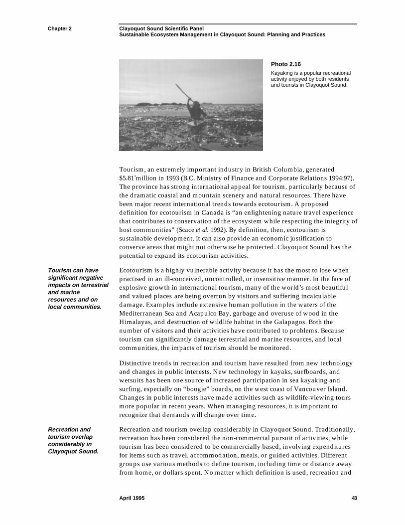
Chapter 2 Clayoquot Sound Scientific PanelSustainable Ecosystem Management in Clayoquot Sound: Planning and Practices
April 1995 43
Photo 2.16Kayaking is a popular recreationalactivity enjoyed by both residentsand tourists in Clayoquot Sound.
Tourism, an extremely important industry in British Columbia, generated$5.81 million in 1993 (B.C. Ministry of Finance and Corporate Relations 1994:97).The province has strong international appeal for tourism, particularly because ofthe dramatic coastal and mountain scenery and natural resources. There havebeen major recent international trends towards ecotourism. A proposeddefinition for ecotourism in Canada is “an enlightening nature travel experiencethat contributes to conservation of the ecosystem while respecting the integrity ofhost communities” (Scace et al. 1992). By definition, then, ecotourism issustainable development. It can also provide an economic justification toconserve areas that might not otherwise be protected. Clayoquot Sound has thepotential to expand its ecotourism activities.
Tourism can havesignificant negativeimpacts on terrestrialand marineresources and onlocal communities.
Ecotourism is a highly vulnerable activity because it has the most to lose whenpractised in an ill-conceived, uncontrolled, or insensitive manner. In the face ofexplosive growth in international tourism, many of the world’s most beautifuland valued places are being overrun by visitors and suffering incalculabledamage. Examples include extensive human pollution in the waters of theMediterranean Sea and Acapulco Bay, garbage and overuse of wood in theHimalayas, and destruction of wildlife habitat in the Galapagos. Both thenumber of visitors and their activities have contributed to problems. Becausetourism can significantly damage terrestrial and marine resources, and localcommunities, the impacts of tourism should be monitored.
Distinctive trends in recreation and tourism have resulted from new technologyand changes in public interests. New technology in kayaks, surfboards, andwetsuits has been one source of increased participation in sea kayaking andsurfing, especially on “boogie” boards, on the west coast of Vancouver Island.Changes in public interests have made activities such as wildlife-viewing toursmore popular in recent years. When managing resources, it is important torecognize that demands will change over time.
Recreation andtourism overlapconsiderably inClayoquot Sound.
Recreation and tourism overlap considerably in Clayoquot Sound. Traditionally,recreation has been considered the non-commercial pursuit of activities, whiletourism has been considered to be commercially based, involving expendituresfor items such as travel, accommodation, meals, or guided activities. Differentgroups use various methods to define tourism, including time or distance awayfrom home, or dollars spent. No matter which definition is used, recreation and
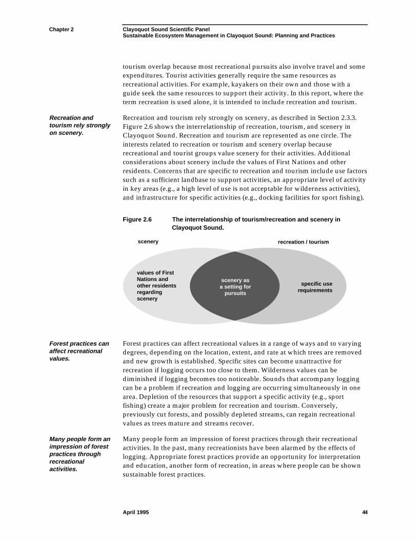
Chapter 2 Clayoquot Sound Scientific PanelSustainable Ecosystem Management in Clayoquot Sound: Planning and Practices
April 1995 44
tourism overlap because most recreational pursuits also involve travel and someexpenditures. Tourist activities generally require the same resources asrecreational activities. For example, kayakers on their own and those with aguide seek the same resources to support their activity. In this report, where theterm recreation is used alone, it is intended to include recreation and tourism.
Recreation andtourism rely stronglyon scenery.
Recreation and tourism rely strongly on scenery, as described in Section 2.3.3.Figure 2.6 shows the interrelationship of recreation, tourism, and scenery inClayoquot Sound. Recreation and tourism are represented as one circle. Theinterests related to recreation or tourism and scenery overlap becauserecreational and tourist groups value scenery for their activities. Additionalconsiderations about scenery include the values of First Nations and otherresidents. Concerns that are specific to recreation and tourism include use factorssuch as a sufficient landbase to support activities, an appropriate level of activityin key areas (e.g., a high level of use is not acceptable for wilderness activities),and infrastructure for specific activities (e.g., docking facilities for sport fishing).
Figure 2.6 The interrelationship of tourism/recreation and scenery inClayoquot Sound.
scenery recreation / tourism
values of First Nations and other residents regarding scenery
specific use requirements
scenery as a setting for
pursuits
Forest practices canaffect recreationalvalues.
Forest practices can affect recreational values in a range of ways and to varyingdegrees, depending on the location, extent, and rate at which trees are removedand new growth is established. Specific sites can become unattractive forrecreation if logging occurs too close to them. Wilderness values can bediminished if logging becomes too noticeable. Sounds that accompany loggingcan be a problem if recreation and logging are occurring simultaneously in onearea. Depletion of the resources that support a specific activity (e.g., sportfishing) create a major problem for recreation and tourism. Conversely,previously cut forests, and possibly depleted streams, can regain recreationalvalues as trees mature and streams recover.
Many people form animpression of forestpractices throughrecreationalactivities.
Many people form an impression of forest practices through their recreationalactivities. In the past, many recreationists have been alarmed by the effects oflogging. Appropriate forest practices provide an opportunity for interpretationand education, another form of recreation, in areas where people can be shownsustainable forest practices.