suzana pasternak and lucia maria machado bogus · the city of extremes: socio-spatial inequalities...
TRANSCRIPT
The city of extremes: Socio-spatial inequalities in São Paulo1
Suzana Pasternak and Lucia Maria Machado Bogus FAU-USP, Faculty of Architecture and Urban Planning, University of São Paulo, and So-cial Sciences Department, PUC-SP, Catholic University, São Paulo; University of São Paulo: Av dos Semaneiros, 166 CEP 05463-020, São Paulo, Brazil, Phone 55 11 3812 5764; Fax 55 11 3815 6661; E-mail : [email protected], [email protected]
1. Recent urbanization trends in the City of São Paulo
1.1 São Paulo urbanization development and outlooks The São Paulo Metropolitan Region (SPMR), currently with about 18 million inhabitants, had only 1.5 million residents in the nineteen forties. The region grew fast and steadily mainly from 1960 to 1980, the period of its consolidation as an area of significant popula-tion concentration, when the metropolitan rates of participation both in the State of São Paulo and in the Brazilian population had a substantial growth. In the early nineteen forties the area that now represents the SPMR included only 11 mu-nicipalities and only about 85% of the region’s population lived in the capital city. In the 1940-1980 period the SPMR population went to 12.6 million, growing at an average an-nual rate of 5.3%, faster than the State of São Paulo’s rate (3.2%) and the Brazilian rate (2.7%). The region continued with its expansion and its 11 initial municipalities grew to today’s 39 cities with their own similarities and specificities. According to MONTALI (1990:430), “one of most remarkable characteristic of the São Paulo Metropolitan Region is the heterogeneity of its space. The roots of such heterogeneity are associated, on the one hand, with the differentiation process of its areas and its distinctive integration in the divi-sion of metropolitan labor and, on the other hand, with the urban soil occupation process under capitalistic production and appropriation rules, outlining the social inequalities contained in such soil.”
1 This study is part of a set of discussions developed in the scope of PRONEX – Programa de Grupos de Ex-celência (Excellence Groups Program), coordinated by Prof. Dr. Luis César de Queiroz Ribeiro, of IPPUR-UFRJ.
2
It should be noted that the region’s peripheral expansion was not a phenomenon exclusive of the São Paulo region as regards metropolitan-urban areas. Such phenomenon has consti-tuted one of the most remarkable characteristics of the urbanization process in all Brazilian regions up to the end of the nineteen eighties. In all those regions, population growth rates of central cities in metropolitan areas that are also state capitals, were systematically lower than those of other surrounding municipalities, producing dense metropolitan regions with large contingents of poor populations. In 2000, the City of São Paulo had a population of 10.44 million, representing 58% of the metropolitan population and 28% of the State of São Paulo’s population. The City of São Paulo’s population growth rates are declining even more strongly than those of the metro-politan region. The relative weight of the capital city’s population in the metropolitan re-gion (85% in 1940) is below 60% six decades later. The factor contributing the most to a stagnation in the City of São Paulo’s population growth was the flow of old city dwellers to the outskirts of town. In the words of JANUZZI and JANUZZI (2003:108), “to understand the current picture of intra-urban occupation and growth in the City of São Paulo, it is worthwhile recalling some elements of its population dynamics in the twentieth century, from the skyrocketing demographic growth rates in the first fifty years, to population overflow towards neighboring munici-palities, to a metropolis growth polarization reversal in the direction of other inland cit-ies.” The municipal population growth rate that corresponded to 3.66% per year in the nineteen seventies, had a strong decline in the following years: from 1980 to 1991, the city’s growth rate decreased to 1.13% per year, and migration balances were negative for the first time in the city’s recent history, with an average 69,000 people leaving São Paulo per year. In the nineteen nineties such trend was maintained in spite of a slowdown in the negative bal-ance, recording an annual outflow average of 50,800 people (SP Demográfico, January 2003). In that decade, the State of São Paulo emerges as a great receiver of migrants, in-creasing its annual migration balance from 77,000 people in the nineteen eighties to 123,000 people per year in the nineteen nineties. “The population recovery recorded in the state is – to a great extent – a result of migration trends in the São Paulo Metropolitan Re-gion. As compared to the nineteen eighties, migration losses were reduced in the metropo-lis, reverting the negative annual migration balance, on the order of –26,000 people re-corded in the 1980-1991 period, to a positive annual balance of 24,000 people in the 1991-2000 period” (PERILLO, 2002:2). In spite of a migration recovery, the capital city’s growth rate kept declining: whereas in the nineteen eighties the annual growth rate was 1.13%, in the 1991-2000 period it de-creased to 0.92% per year. In the other municipalities of the SPMR (except for the capital city), the migration balance was about 75,000 people in the 1991-2000 period, with a 75% increase in relation to the nineteen eighties, when the balance was 42,000 people per year. It is not by chance that one of the fastest growing regions in the State of São Paulo was the belt of municipalities in the Greater São Paulo, with annual rates of 3.15% in the 1980-

3
1991 period and 2.89% in the 1991-2000 period, representing 2.8 and 3.1 times the capital city’s growth rate, respectively. Therefore, the metropolitan population grows, although at a slower pace than in the previ-ous decade, whereas the population growth rate of its central municipality decreases sig-nificantly. The central municipality grew by 824,887 people and 549,069 households in the 1991-2000 period. And that growth was mainly peripheral.
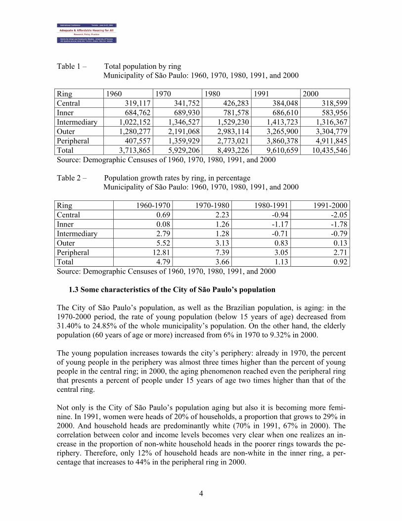
1.2 Maintenance of the peripheral demographic growth standard An analysis of 2000 demographic data reveals a continuous peripheral growth process. The City of São Paulo comprises 96 census districts. Those districts were aggregated into 5 sets, constituting 5 rings (central, inner, intermediary, outer, and peripheral ring) that – similarly to the Burgess circles – structure the city’s intra-urban dynamics starting from the historic downtown area (the central ring). The ring surrounding the central ring (the inner ring) has historically represented the city’s greatest wealth concentration. Incomes are lower towards the periphery in a classical Latin-American city standard that underwent changes only in the last decade of the twentieth century. In spite of a reduced of the center-periphery model as an explanation for the socio-spatial dynamics prevailing in the municipality – a wealthy center and a poor periphery, a vertical center and an infrastructure-lacking horizontal periphery, where periphery was confused with segregation –, considering that verticalization has not been simply central for a long time, and the poor population has not been not limited to the periphery, growth rates are still higher in the peripheral ring than in all other rings. The City of São Paulo’s growth occurred entirely in the outer and peripheral rings where the population increased by more than 1 million people, with rates of 0.13% in the outer ring and 2.71% in the peripheral ring. Such rates, as shown in Table 2, are much lower than those of previous decades. But the positive growth rate tendency in the outer rings has been maintained. Therefore, the peripheral ring accounted for 55% of the population growth in the municipality in the nineteen seventies, 97% in the 1980-1991 period and 127% in the nineteen nineties. The increase of over 1 million residents in the peripheral ring has offset the loss of 65,000 residents in the more central rings. The region between the two rivers (Pinheiros and Tietê) – the central and inner rings – lost almost 130,000 residents in the nineteen eighties and more than 168,000 in the nineteen nineties. On the other hand, the peripheral ring gained about 1,300,000 residents in the 1980-1991 period, and a little over 1,000,000 residents in the nineteen nineties. (see Table 1)
4
Table 1 – Total population by ring Municipality of São Paulo: 1960, 1970, 1980, 1991, and 2000
Ring 1960 1970 1980 1991 2000 Central 319,117 341,752 426,283 384,048 318,599Inner 684,762 689,930 781,578 686,610 583,956Intermediary 1,022,152 1,346,527 1,529,230 1,413,723 1,316,367Outer 1,280,277 2,191,068 2,983,114 3,265,900 3,304,779Peripheral 407,557 1,359,929 2,773,021 3,860,378 4,911,845Total 3,713,865 5,929,206 8,493,226 9,610,659 10,435,546Source: Demographic Censuses of 1960, 1970, 1980, 1991, and 2000 Table 2 – Population growth rates by ring, in percentage
Municipality of São Paulo: 1960, 1970, 1980, 1991, and 2000 Ring 1960-1970 1970-1980 1980-1991 1991-2000Central 0.69 2.23 -0.94 -2.05Inner 0.08 1.26 -1.17 -1.78Intermediary 2.79 1.28 -0.71 -0.79Outer 5.52 3.13 0.83 0.13Peripheral 12.81 7.39 3.05 2.71Total 4.79 3.66 1.13 0.92Source: Demographic Censuses of 1960, 1970, 1980, 1991, and 2000
1.3 Some characteristics of the City of São Paulo’s population The City of São Paulo’s population, as well as the Brazilian population, is aging: in the 1970-2000 period, the rate of young population (below 15 years of age) decreased from 31.40% to 24.85% of the whole municipality’s population. On the other hand, the elderly population (60 years of age or more) increased from 6% in 1970 to 9.32% in 2000. The young population increases towards the city’s periphery: already in 1970, the percent of young people in the periphery was almost three times higher than the percent of young people in the central ring; in 2000, the aging phenomenon reached even the peripheral ring that presents a percent of people under 15 years of age two times higher than that of the central ring. Not only is the City of São Paulo’s population aging but also it is becoming more femi-nine. In 1991, women were heads of 20% of households, a proportion that grows to 29% in 2000. And household heads are predominantly white (70% in 1991, 67% in 2000). The correlation between color and income levels becomes very clear when one realizes an in-crease in the proportion of non-white household heads in the poorer rings towards the pe-riphery. Therefore, only 12% of household heads are non-white in the inner ring, a per-centage that increases to 44% in the peripheral ring in 2000.

5
Schooling levels of household heads has improved: the percent of household heads with more than 12 years of schooling increased from 16.72% in 1991 to 18.53% in 2000. The schooling level of household heads is higher in the inner ring where more than 50% of household heads have more than 12 years of formal schooling. Household heads with the lowest schooling levels are concentrated in the periphery: 8% without any formal school-ing. Even so, an increase in the schooling level may be perceived in the peripheral ring: in 1991, 12% of peripheral-ring household heads had no formal schooling, a proportion that decreases to 6% in 2000. The correlation between schooling and income levels is very clear. The highest incomes are found in the inner ring where schooling levels are higher. The percent of household heads with incomes lower than two minimum wages decreased in the 1991-2000 period, showing a slight increase in the decade’s average income. However, such increase proved to be extremely concentrated: it attains 53% in the inner ring and is negative for poorer household heads in the peripheral ring, with an average income loss of 21%. In the 1991-2000 period, income distribution in the City of São Paulo became more concentrated. No income level increase corresponded to schooling level increase. 2. The history of urbanization in São Paulo
2.1 City formation
In the context of the Brazilian urbanization, characterized by intense migration move-ments, space reorganization and significant transformations in the process of social divi-sion of labor, conceiving the urban phenomenon as a social process includes specificities that have to be considered in their multiple dimensions, including historic, demographic, political-economic and socio-spatial aspects. As from the nineteen fifties, the Brazilian wealth accumulation standard was based on the expansion of manufacturing activities, with a less significant growth of agricultural activi-ties. In fact, already in the nineteen thirties the Brazilian State started to implement a pol-icy to transfer resources from the agricultural-exporting industry to the manufacturing in-dustry, and began to regulate capital-labor relations. At that time, Brazilian cities, mainly those located in the Southeast and South regions, were already the place where major manufacturing companies installed their head offices, and their development strictly de-pended on manufacturing industry’s growth. The manufacturing industry constitutes the “cornerstone” of the national development project, and the national manufacturing indus-try’s complex, concentrated in the Rio de Janeiro-São Paulo axis, started to receive larger and larger groups people coming from rural areas. Already in the nineteen thirties, after the Great Depression period, the State of São Paulo’s economy strengthened its hegemonic position in the national scene, and the City of São Paulo became the country’s main immigration center. “Unlike the other regions, São Paulo had the essential elements for a diversified and concentrated expansion: advanced capital-
6
istic production relations, a broad domestic market and, since the beginning, an advanced mercantile agriculture, even not considering coffee plantations, therefore leading to the emergence of the industrial concentration process. And already before the nineteen thir-ties, its manufacturing industry’s structure was the most advanced in the country (...) es-tablishing – from the beginning – a relationship of strong predominance of the State of São Paulo’s economic center over the other regions in the country” (CANO, 1977:15).
As regards this process, it is also worthwhile mentioning the role played by foreign immi-gration since the first industrialization outbreak occurred in São Paulo by the end of the nineteenth century, that has largely contributed to the fast growth of the city, whose popu-lation went from 65,000 to about 240,000 inhabitants between 1890 and 1900. The rural-urban migration in the State of São Paulo towards the capital city has probably had some importance in the last decade of the nineteenth century. The fact is that, from that time on, the capital city started to stage important social and economic transformations, in which, in addition to the manufacturing industry’s development, there was a growth of small busi-nesses, the emergence of a professional or bureaucratic middle class and emergence of the first working-class neighborhoods (FAUSTO, 1977). Such transformations were strongly reflected on the forms of urban space occupation. The space distribution of social classes, with the segregation of the low-income working class from the wealthy classes in different areas of the city, has its roots in the history of São Paulo itself, reflecting the conditions caused by the manufacturing production process. Until the nineteen thirties São Paulo had little segregation, although its residential spaces were very well delimited. In this sense, there was a discrimination of areas inhabited by workers in relation to the location of services and urban infrastructure. Those were swampy areas close to the factories with the worse public service and transportation condi-tions. However, from a space perspective, the working-class neighborhoods were relatively close to the bourgeois residential areas where the mansions of emerging industrial com-pany owners and the so-called “coffee barons” were built. Such proximity was justified by the impossibility to accommodate the working class in more distant urban areas owing to the inexistence of suitable transportation means for their use. Therefore, working class families usually resided close to the factories whether in precarious collective houses (tenements) or in working-class neighborhoods (‘vilas’) especially built for such purpose. “Although one cannot describe the spatial structuring being acquired by the city with the emergence of social segregation, where race or social class are absolute selective ele-ments for housing conditions, there is, however, a predominance of certain social layers in the space. Spatial structuring is combined with the social conformation acquired by the city: working-class neighborhoods as well as high-bourgeoisie neighborhoods are estab-lished (...). Workers’ homes may be occasionally found amidst bourgeois houses. Tenement buildings and working-class neighborhoods are also formed amidst those bourgeois homes, but they are not predominant. And, mainly, no plants are built in neighborhoods [intended to accommodate the elites] such as those of Paulista (near the avenue), Cer-queira César and Jardins” (BLAY, 1985:51).
7
In 1892, the opening of Viaduto do Chá, connecting the so-called Old Center (where the city was founded by Jesuits) to the New Center, to the west of Vale do Anhangabaú, gen-erated new spaces, providing the city’s central area with an almost definitive roadway structure. The new city has only actually developed after the death of Baron of Itapetininga (the owner of Chácara do Chá) in the second half of the nineteenth century. MEYER (1993) calls those streets of the new city “streets of ordinances code.” One of the first writ-ten regulations referring to São Paulo’s urban space, the document called Código de Postu-ras (Ordinances Code) of 1886, proposed a minimum street standard: 16-meter wide, straight alignment, preservation of existing trees, and special attention given to sanitation. The ideal of the late nineteenth century is marked by ‘higienism’. Pressed by frequent epi-demics, sanitation was a critical issue. The installation of the Municipal Theater in 1911 deeply marked the use of the city center, organizing urban life around that new center area. An important urban intervention at the time was that of Bouvard, graduated from the pres-tigious École des Beaux Arts in Paris, with all his esthetic bias. Bouvard recommended the construction of urban parks and was responsible for the urbanization of Vale do Anhan-gabaú (garden construction and elimination of tenement buildings), Parque D. Pedro, and Parque do Trianon. At that time, among the priorities of urban intervention were esthetic issues, opening of bourgeois spaces and green areas. The Anglo-Saxon influence emerges clearly in the city with the construction of garden-city neighborhoods (garden cities), the first individual neighborhoods specifically intended to the emerging bourgeoisie. In 1911, Edouard Lavelaye, a Belgian specializing in manipulat-ing tropical raw materials, perceived a great real-estate development potential in the city. He went to the City Hall accompanied by Bouvard, former director of Travaux Publiques in Paris, who had already been a consultant on landscaping and urban remodeling works. Vitor Freire, the City of São Paulo’s public works director, put Lavayale into contact with major landowners, including Cincinato Braga and Horácio Sabino. Those contacts resulted in a real-estate organization in which the Brazilian shareholders agreed to sell land to the Company, and the Belgian agreed to obtain financial resources (acting as a financing agent). Back in Europe, Lavayale conquers investors and incorporates City of São Paulo Improvements and Freehold Land Company Limited (City Company), with headquarters in London, Rio de Janeiro, and São Paulo (ROLNIK, 1997). The following were members of City Company’s Board of Directors: Lord Balfour, President of São Paulo Railways, Bou-vard, Cincinato Braga, landowner and later a Federal Representative for the State of São Paulo; other individuals connected to Light & Power Company and, later on, Vitor Freire himself. In 1912, City Company owned 37% of São Paulo’s whole urban area. In 1913, in a tract of land close to Rio Pinheiros, the company develops the first garden-city neighborhood in São Paulo, Jardim América, designed by Barry Parker and Raymond Unwin, one of the architects who designed Letchworth, the garden city inspired in Ebenezer Howard’s ideas. City Company required special laws guaranteeing the residential nature of its real-estate developments (allotments), as well as a very specific urban implementation that followed curved lines according to the teachings of Camilo Sitte. This was done by specifying the
8
guidelines regarding occupation rates, minimum lots, minimum front size, wall height, lo-cation of outbuildings (secondary edifications), etc. in the lots’ purchase and sale agree-ments. In 1941, City Company’s regulations were made official by a municipal decree law. There-fore, some of the neighborhoods specifically intended to accommodate high-income classes in São Paulo, with large lots, a small occupation rate, curved streets, located in strictly residential zones were created.
2.2 Urban expansion: São Paulo in the period from the nineteen twenties to the forties
The nineteen twenties and thirties may be considered as a transition period, when condi-tions were created to expand the urban network, characterizing the passage from a spe-cially-concentrated to a “spread-out” city, with the incorporation of new areas into the ur-ban fabric. Such process would be consolidated in the nineteen forties. In fact, the expansion of the public transportation network and emergence of public buses around 1924 enabled that new areas were allotted/developed and gradually occupied by those dwellers who, up to then, had no access to a house or a tract of land of their own. In 1926 about 200 buses already circulated in the City of São Paulo (cf. STIEL, 1984), belonging to several private companies and that, combined with the growing number of cars and trucks, rapidly imposed changes in the use of public roadways. For this reason, in the second half of the nineteen twenties two important roadway system reform plans were designed, covering the whole urban structure: the Light & Power Company’s Project (1927) and the Prestes Maia Avenues Plan (1930). Each of those plans was based on a different conception of the city: a) The Light & Power Company’s Project provided for small changes in the city’s central zone and greater densities along the lines heading towards peripheral areas, propos-ing a directed growth – based on transportation – and also greater density. b) The Prestes Maia Avenues Plan proposed major changes in the city’s central area, heavy spending with expropriations, and an expansion that was not merely related to the “rails” of electric streetcars or to the expansion of railway lines. It proposed a renewal of the central urban area and expansion of the city to unseen limits.
The City Government opted for the Prestes Maia Avenues Plan, whose implementation started in the nineteen thirties in perfect harmony with the “Roadway Expansion Policy” then current in Brazil. During the period called Estado Novo (New State), important re-gional integration roadways were opened with the support of federal funds that not only enabled a fast circulation of goods but also made viable new areas for the implementation of manufacturing plants that gradually left the central urban area leaving space for new commerce and service activities.
9
Mayor Prestes Maia was one of the great transformers of the city space. Similarly to his antecessors (Vitor Freire, Anhaia Melo, among others), he defended verticalization and greater density whenever allowed by the roadway system. In his 1930 “Study of an Ave-nues Plan for the City of São Paulo,” he expresses his admiration for Chicago’s Burnham plan, including radial avenues and large boulevards irradiating from the city center. He points to zoning as an adequate instrument. Given his option for roadway transportation, he proposes a system of roadways starting from an irradiation perimeter towards all city quad-rants and establishing connections with the perimeter roadways (LEME, 1999). It should be noted that the Avenues Plan has an urban conception implied in the radial-perimeter system, preference for surface rather than underground transportation, and the historic cen-ter expansion proposal. In this sense, public policies oriented to urban transformation and changes in the use of the urban soil on the local, state or federal level, eventually created the required conditions to change the City of São Paulo’s standards of occupation by the manufacturing industry, commerce and services activities, or housing units. As regards the housing issue, particularly in reference to the working class, new possibili-ties of residential locations were accompanied by express measures on the part of the State, having in mind subsidies to low-income workers housing. In 1937 the Social Security’s building portfolios – the first concrete State intervention in the low-income housing seg-ment – were created. However, they soon proved to be insufficient to meet the huge de-mand at the time, often relying on political clientelism (patronage criteria) when establish-ing priorities to meet such demand. Such although-restricted State intervention in the housing segment raised workers’ aspira-tion level in relation to having their own homes. Such fact, in addition to the possibility of access to new areas in the city, was combined with a number of other events that caused the emergence of a new urban structuring (and segregation) pattern based on peripheral allotments and on self-built homes. Among those factors, special attention should be given to real-estate speculation and the low salary levels that prevented access to the real-estate market of the city’s most central areas. In a first phase, the city’s expansion towards areas more distant from the center area was connected both to the existence of a railway network with the formation of the so-called “suburb train stations” and the expansion of streetcar rails. The expansion of those road-ways with the introduction of buses made viable the occupation of some allotments (real-estate developments) already opened before the nineteen thirties, and led to the emergence of many others, starting the rapid process of urban sprawling (called “urban stain” in Bra-zil). In the words of LANGENBUCH (1971:136), “Residential suburbanization was enabled to a great extent by the city’s type of development. Exaggerated real-estate speculation, ex-pelling – so to say – a part of the functionally urban population to the outskirts of town and industrialization alongside the railways, making advantageous the settlement of work-
10
ers close to train stations outside the city. In both cases, as a matter of fact, largely over-lapping, residential suburbanization mainly impacts residents of modest socio-economic categories.” It is also worthwhile mentioning the disorderly and discontinued manner in which such allotments were opened, once the action of real-estate speculators left empty – and expecting appreciation – large more central tracts of land, so as to allot and sell other more distant and infrastructure-lacking tracts of land.
2.3 São Paulo as from the nineteen forties: urbanization and peripherization The actual occupation of most allotments started in the nineteen twenties and thirties has only occurred as from the nineteen forties. As from 1940, the roadways traveled by buses that gradually replaced trains and electric streetcars as means of transportation to the al-ready-formed suburbs and the new periphery being settled in the city were already very numerous. The nineteen forties and fifties “were marked by the city’s expansion towards what we could call a first periphery, or near periphery, a time when areas far from the center but still inside the boundaries of São Paulo were occupied” (BOGUS, 1992:34). It is worth-while mentioning the importance of the roadway system connecting the City of São Paulo with the neighboring cities of Guarulhos and the so-called ABC (Santo André, São Bernardo and São Caetano) that, already in the nineteen forties, were important industrial centers absorbing large contingents of workers. The expansion of the periphery throughout the Metropolitan Region, officially constituted as an administrative area in 1973, took place mainly as from the nineteen seventies with the opening of numerous allotments, many of them “clandestine,” that were designed and sold without the city government’s approval and disregarding the law of land division and use. The low-income working class built houses in small tracts of land in those allotments, financed by the real-estate agents themselves, without any mediation on the part of the government, that was called only af-ter the sale of the lots and settlement of dwellers to provide the essential public services and facilities, such as piped water, residential and public lighting, and transportation. The families generally built their own homes during weekends and/or the free time of some of their members, a characteristic process called “self-help construction,” that was gradually extended to the production of areas surrounding the homes. Actually, the construction of street curbing and gutters, the erection of public lighting poles, and the construction of some collective use facilities such as churches and schools were also provided by the dwellers themselves. In relation to the construction of the periphery, MAUTNER points out that “although fol-lowing a fragmented pattern, discontinued in time and space, the predominant form of ur-ban space production in São Paulo could be presented as a sequence of three layers, the first two consisting of ‘labor’, covering and preparing the land for the third layer, the ‘capital’” (MAUTNER, in DEAK & SCHIFFER, 1999:256). That process is still present at a smaller scale in the production of space in São Paulo.

11
The land is transformed into real property, fragmented and put to sale. Houses are erected, both by pure domestic production and by contracting paid labor for the whole construction. Here, one may perceive distinctions between what occurred up to the nineteen eighties with the predominance of self-help construction and in the nineteen nineties when ordered production emerges at a higher frequency. This is the first labor layer. The second labor layer, now always paid labor, corresponds to the response of local gov-ernments to infrastructure pressures. This second layer paves the way to a third layer, in a process that varies in time, and may take decades, where cheap taverns and improvised grocer stores are replaced with bakeries, supermarkets and bars, in a mimetic process that eventually conceals the original production type, often expelling old dwellers to a more distant periphery, where they will originate a first layer again. This process now occurs with invasions and allotments by Neighborhood Residents’ Associations – no longer the old clandestine developers – but always operating in the construction of a periphery by and for the poorer workers. This movement towards the periphery first impacted the migrant population, coming from several regions of the country, to which the arrival in the metropolis did not mean as a rule the end of a migration movement, already often prolonged by a process of gradual migra-tion to the large city. In addition, if before arriving in the metropolitan region, migration causes are strongly connected with work opportunities; when reaching the metropolis, not only did migrants need a job but also they were confronted with other problems such as scarce and expensive housing. Therefore, migrants depend on housing conditions to settle in the city. Whereas in the nineteen seventies those migrants from several regions of Bra-zil, mainly from the Northeast, started occupying peripheral allotments more and more dis-tant from the center of São Paulo, in the previous decades (the nineteen fifties and sixties), they had already settled in the nearer periphery, still within the limits of São Paulo. The residential segregation that was worsened from then on may be attributed to a combination of the effects of the real-estate market (non-accessible to the low-income population in ur-ban-facilities provided areas) and the State intervention benefiting the real-estate market to the detriment of the population.
2.4 São Paulo at the turn of the twenty-first century Considering the City of São Paulo specifically, the existing data also point to a continuous peripherization process, with indications that the squatter settlement expansion has in-creased in peripheral areas in recent years. The contrast between wealth and poverty has worsened. Describing the types of housing in São Paulo, BRANT (1989) states some important points:
• Self-owned houses were more and more distant from the center in a continuous ex-pansion of the urban fabric that is translated into a 3.05% growth rate per year;
• Squatter settlements were seen as a “solution” for the housing problem. In the 1980-1991 period, the rate of squatter dwellers in the municipal population went

12
from 3.95% to 7.46% (data provided by the IBGE – Instituto Brasileiro de Geografia e Estatística (Brazilian Institute of Geography and Statistics))
• The State production of dwelling units for the poor population, started through the SFH – Sistema Financeiro de Habitação (Housing Financing System) during the military governments after 1964, showed its result in the 1991 Census: 4.77% of São Paulo’s housing units were located in public housing agglomerates, mainly in the peripheral ring. Almost 10% of housing units in that ring belonged to State-owned agglomerates.
In this process of poverty distribution throughout the city space, disorderly occupation at-tained water supply source protection areas, jeopardizing water supply and air quality, in addition to giving rise to other problems and leading to the risk of urban chaos. Common areas in popular allotments – theoretically intended to the construction of collective facili-ties and preservation of green areas – were eventually occupied by the poorer segments, with the emergence of new squatter settlements. The back of the lots that was to be kept clear of constructions was eventually used to contain precariously built rooms for rent, which contributed to making the urban soil even more impermeable. All those factors con-tributed to generating a periphery that is ‘uninhabitable.’ “The growth of the City of São Paulo may even be characterized by the expansion of urban zones considered illegal, in which a growing portion of its population lives” (ROLNIK et al, 1990:90). From the urban-structuring point of view, the confirmation of the peripheral expansion pat-tern takes us beyond the municipal limits, incorporating the peripheries of neighboring cit-ies that constitute the metropolitan region. As has already been pointed out, an analysis of the 2000 demographic data reveals a continuous peripherization process. Growth rates in the central, inner and intermediary rings are even more negative than in the previous dec-ade, showing a strong outflow of the population residing in the central areas: those 3 rings recorded an absolute loss of more than 265,000 residents in the 1991-2000 period. In the words of JANUZZI and JANUZZI (2003:110), “Therefore, there is an absolute population ‘emptying’ movement at a growing pace in time and space starting from the more central districts.” The segregation issue should be pointed out again: if the city is actually little segregated in its most central area with the presence of collective housing units (tenement buildings) and squatter settlements “invading” elite neighborhoods, the reverse of the phenomenon also starts to occur frequently in the periphery where, side by side with popular housing areas, high-income residential condominiums are erected surrounded by tall walls to conceal the luxury and sophistication of their mansions. Not only do those condominiums constitute a symbol of the separation between the rich and the poor living in an area marked by ine-qualities but they are also true “wealth islands” amidst the poor periphery.
13
3. Dwelling of wealth and dwelling of poverty: closed condominiums and squatter settlements
3.1 From the fragmented city to closed condominiums.
Summarizing the aforementioned São Paulo metropolitan region’s and City of São Paulo’s structuring and expansion process as regards urban space organization and residential loca-tion of social groups and classes, it may be stated that “throughout the twentieth century, social segregation assumed at least three different patterns of urban space expression. The first lasted from the end of the nineteenth century to the nineteen forties and produced a concentrated city where different social groups were squeezed in a small urban area and segregated by type of dwelling. The second urban pattern, the center–periphery pattern, dominated the city’s development from the nineteen forties to the nineteen eighties. During this phase, different social groups live far apart: middle and high-income classes are con-centrated in central neighborhoods with suitable infrastructure and the poor live in pre-carious and distant peripheries. Although city residents and social scientists still conceive and discuss the city in terms of the second pattern, a third pattern has emerged since the nineteen eighties and significantly changed the city as well as the metropolitan region. By replacing the center-periphery pattern, recent changes are generating spaces where differ-ent social groups are often close to each other, but separated by tall walls and security technologies, and tend not to circulate or interact in common areas. The main instrument of this new spatial segregation pattern is what I refer to as fortified enclaves” (CALDEIRA, 2000: 211). Until the mid-nineteen seventies, homes and apartment buildings constructed on conven-tional urban lots were the only housing options for the City of São Paulo’s population. Apartment buildings were always constructed on more central areas and were usually in-tended to middle-class families. High-standard dwellings accommodated high-income population, while low-income families lived in peripheral areas, often in self-built homes as already pointed out. Exceptions to such pattern were found in tenement buildings and squatter settlements existing in several regions of the city, but still close to central areas and closed condominiums recently built by real-estate developers’ initiative. The first vertical condominiums appeared in the City of São Paulo still in the late nineteen fifties. An innovative intervention on the part of building companies, whose performance in the Higienópolis neighborhood, a residential area close to the downtown area, offered a new type of apartment building with significant front and side space, underground garage, and back space intended for car parking. The Bretagne and Louveira buildings are worth mentioning because, “subject to a new type of lot organization, such buildings comprised true exceptions to the traditional implementation scheme, with differentiating form and volume from the building construction of that time” (MACEDO, 1987:159). The 20-floor Bretagne became the tallest apartment building in the area and a landmark owing to its broad recreational area provided with swimming pool, playground, games-room, party-room, bar and other facilities encouraging sociability among dwellers of any age. Such

14
apartment building can be considered the precursor of the vertical condominiums that spread throughout almost all city areas as from the nineteen seventies. In 1973 the first large closed vertical condominium – Ilhas do Sul – made up of 5 apart-ment buildings was built in the Alto de Pinheiros neighborhood located in the west area of the city. In a large landscaped area the complex sheltered a true club provided with sports courts, swimming pools, movie-theater, in addition to facilities and services for the exclu-sive use of residents such as day care center, child recreation school, and sports school. At that time the appeal was the comfort – rather than the security provided by living in a walled area – of living in a place where several requirements were met without having to travel long distances, therefore eliminating transportation problems. Such residential solu-tion gradually reached other city areas, and vertical condominiums became a housing solu-tion also for the high-income population who, due to the escalation of urban violence, started to search new housing options offering comfort and security in sophisticated city areas. On the other hand, and on the back of urban violence increase, closed horizontal condo-miniums proliferated. Their precursor was landmark “Alphaville,” located in the munici-pality of Barueri in the metropolitan periphery. Similarly to the first vertical condominium in São Paulo – Ilhas do Sul –, the first appeal of the Alphaville condominium was not the security issue, which at that time was not yet a problem. It was the new lifestyle offered by green areas far from the hubbub and pollution of the large city, but close enough to resi-dents’ workplaces and schools. However, the daily need to drive on a heavy-traffic road-way to get to the City of São Paulo almost made the sale of lots unfeasible. The long time it took to sell such lots almost led the building company in charge of the enterprise to bankruptcy. The main boost to Alphaville occupation and expansion occurred in the mid-nineteen eighties, when providers of several essential services such as schools, banks, stores, supermarkets, etc. were established in the condominium’s surrounding area. At first there was a limited number of horizontal walled residential complexes provided with extensive common areas with sports and recreational facilities and exclusive service provision, which were intended to higher-income groups owing to the high price of the land where they were built. As from the nineteen nineties, however, that housing option was rapidly extended to lower-income population. Walled condominiums with smaller and less equipped common areas and smaller floor space, based on simpler construction stan-dards, started to be built in less sophisticated areas of the City of São Paulo and the metro-politan region. The entrepreneurs responsible for implementing closed vertical condominiums first sought cheap large tracts of land located far from the downtown area such as the region compris-ing Vila Andrade and Morumbi districts, whereas the entrepreneurs responsible for closed condominiums opted for the cities of Barueri, Santana do Parnaíba, and Cotia. Therefore, they created new expansion areas in the City of São Paulo and the metropolitan region, fo-cusing on the west and south regions, which until then were poor and unpopulated areas.

15
On the other hand, the entrepreneurs responsible for closed horizontal condominiums were interested in the possibility of implementing them in strictly residential zones (Z1), with strict occupancy levels, where verticalization is forbidden, and are usually the city’s most valued neighborhoods. Today the location of such enterprises in the City of São Paulo and the metropolitan region is changing. The so-called Law of “Vilas” (the Portuguese word for a dead-end alley with identical houses) of 1994 authorized indiscriminate implementation of horizontal condominiums in all residential zones of the City of São Paulo, becoming instrumental for the implementa-tion and proliferation of such enterprises in the city. Real-estate marketing has also signifi-cantly contributed to expanding such enterprises. Controversial issues regarding responsi-bility for roadway system construction, service maintenance, and especially controlled access – which actually involve discussions between the public and private authorities – are still pending. As already mentioned, closed condominium proliferation in the City of São Paulo (as in other Brazilian cities) cannot be explained solely by the concern with security, although this is a recurring argument. There is also the search for status, for acquiring distinctive symbols of power, because people in our society are differentiated by their consumption capacity – understood here as a dimension involving life projects and lifestyles. In fact, the emergence of closed condominiums and allotments in the City of São Paulo is part of a more encompassing process, characterizing a new pattern of spatial segregation and social inequality in the city. This new pattern is gradually replacing the wealthy-center vs. poor-periphery dichotomy with other types of segregated, fragmented, and heterogene-ous spaces. Violence escalation is only part of the argument involving real-estate and marketing strate-gies to sell condominiums. However, such strategies are the most exploited ones, persuad-ing consumers who are daily bombed by the media with reports on violent crimes or even with data and records on public space insecurity. What is not always explicit is the appeal to the exclusiveness and status of living in such places, where residents’ social homogene-ity is also seen as a guarantee of tranquility in terms of neighborhood. As far as publicity is concerned, living in closed horizontal condominiums creates an illusion of a perfect world. However some concrete measures taken by condominiums – tall walls, metal fences, so-phisticated security systems – show a social organization expressing not only fear but also sociability and community-life patterns based on segregation, social discrimination, and social class distinction. Data on the launching of housing units in horizontal condominiums in the nineteen nineties clearly show the growing trend of this type of housing both in the City of São Paulo and other cities of the Metropolitan Region, pointing to a consolidation of the new pattern. Charts 1 and 2 show this growth both in number of housing units located in horizontal condominiums and in number of condominiums themselves in the 1992-2000 period. It is worthwhile mentioning the growth in the number of condominiums in the City of São

16
Paulo, located both in noble neighborhoods in the southwest and south regions of the city and in middle-class residential areas, where insecurity and fear encourage this type of con-struction.
Chart 1: Housing units launched in horizontal condominiums per year
1992 1993 1994 1995 1996 1997 1998 1999 2000 São Paulo 168 355 358 730 739 908 757 472 990 Other SPMR cities 0 475 401 124 1865 1437 371 816 1545 TOTAL 168 830 759 854 2604 2345 1128 1288 2535 Source: Real Estate Bulletin published by EMBRAESP – Empresa Brasileira de Estudos do Patrimônio (Brazilian Company for Real-Property Studies) – 2002 Annual Report.
Chart 2: Number of launched horizontal condominiums per year
1992 1993 1994 1995 1996 1997 1998 1999 2000 São Paulo 4 10 7 20 22 18 21 29 55 Other SPMR cities 0 4 4 2 6 8 4 5 15 TOTAL 4 14 11 22 28 26 25 34 70 Source: Real Estate Bulletin published by EMBRAESP – Empresa Brasileira de Estudos do Patrimônio (Brazilian Company for Real-Property Studies) – 2002 Annual Report.
It is significant that, since 1992 when EMBRAESP started collecting data on horizontal condominiums, total annual housing units launched in the SPMR have grown from 168 to 2,535 in only eight years, and total annual condominiums launched has gone from 4 to 70, as shown in charts 1 and 2. Although the data shown above indicate that the demand for closed condominiums is at full speed, the real-estate market admits that there is a slowdown trend. The reasons for this may be the shortage of tracts of land and their rough topography, difficult zoning ordi-nance compliance, and the reaction of traditional areas’ residents against the implementa-tion of such enterprises. As regards this last factor, the arguments presented by residents’ associations are the urban deterioration that certain elite neighborhoods have been under-going due to the disorganized proliferation of condominiums, higher population density, and destruction of green areas. However, what seems to be actually bothering the residents of those areas is the risk of losing exclusiveness. The existence of exclusive areas side by side with extremely poor ones raises radical issues as regards poverty and society. An urban war is somehow underway, a war of the wealthy against the poor. The wealthy and the middle class defend themselves. According to CLAVAL (1979:15), “space interferes in several manners with social life and, therefore,
17
with the game of power.” It may represent a hurdle to community relations and prevent them. It also serves as basis for symbolic activity. In Rome, “the visual order and the impe-rialist power were inextricably connected. The emperor needed to have his power evi-denced by monuments and public works. The government did not exist without stone”(SENNET, 1997:81). Affluent social classes’ current “weapons,” whose symbolic content cannot be dismissed, are closed condominiums, metal fences, flower pots on sidewalks, chains separating spaces. To such powerful bricks, the excluded respond with other forms of urban space appropriation. Such forms include squatter settlements. Who are the City of São Paulo’s squatter dwellers? How many are they? What is their specificity? How do they live and where are they located in this unequal and segregated metropolis?
3.2 Squatter settlements in São Paulo In the Southeast region of Brazil, squatter settlements emerged more significantly in Rio de Janeiro than in São Paulo. The book organized by Alba ZALUAR (1998) expresses, in its name, the time of existence of such a housing alternative in the City of Rio de Janeiro: “Um século de favela” (A century of squatter settlements). The Portuguese word for squatter settlement (favela) seems to originate from a bush usu-ally found in the region of Canudos. The soldiers of the Brazilian army returning from the war against Antonio Conselheiro and his followers had no place to live in the City of Rio de Janeiro. They went to live in the Morro da Providência, where they were installed in shacks that spread as the favela bush found on the hills of the Canudos region. Hence the name given to this type of settlement. In addition, the urban remodeling implemented by Pereira Passos, changing the urban lay-out and structure of Central Avenue (currently called Presidente Vargas Avenue) and regu-larizing the building constructions in the periphery, like a tropical Haussmann, led the poor to seek shelter on the hills, where construction was not regulated. This reminds the event occurred in São Paulo in the region of water supply sources: excess zeal leads paradoxi-cally to the total absence of rules. Urban contradictions... In São Paulo, the place of the proletariat with industrial jobs and self-built peripheral dwellings, squatter settlements were the exception to the rule. Statistical studies conducted in 1940 pointed to the existence of squatter settlements in Vila Prudente, in the Vergueiro area (now extinct), squatter settlements in the neighborhood of Lapa and Ibirapuera, the Ordem e Progresso squatter settlement (located in the place now occupied by the Barra Funda Court Building), and some few others. Up to the nineteen seventies, the squatter population represented about 1% of the City of São Paulo’s population, whereas in Rio de Janeiro it attained more than 10%, similarly to Recife and Salvador. In São Paulo, in addition to IBGE data, there are other data collected by the Municipal Government since 1973.
18
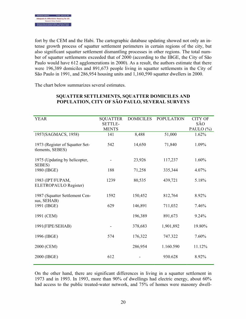
The first Register of Squatter Settlements was prepared in 1973. The definition applied was: “units located in parcels of land with ownership-related problems, generally precari-ous units, with deficient infrastructure, winding roads, disorganized urban space.” Such definition was preserved until the last 1973 survey, considering that the cutoff variable was the land’s legal ownership. In 1975, the Register of Squatter Settlements was updated using a helicopter flight. The percent of the population living in squatter settlements had already grown. In 1980, a field survey conducted by IPT/FAU – Instituto de Pesquisas Tecnológicas/Faculdade de Ar-quitetura e Urbanismo (Technological Research Institute/School of Architecture and Urban Planning) made it possible to renew the characterization of squatter population and dwell-ings. Data collected by Eletropaulo (São Paulo Electric Power Company) enabled an even more accurate estimate of the squatter population and domiciles: the implementation of a program called PRO-LUZ (a program to provide electrification to squatter settlements at subsidized rates) had already started. Therefore, the vast majority of homes (Eletropaulo’s technical people estimated at 95%) were already connected to the electric energy network, thus enabling a reliable estimate of the number of dwellings. In 1987, SEHAB-SP (São Paulo Municipal Office of Housing and Urban Development) updated the Squatter Settle-ment Census. The use of census data showed about 335,000 squatter dwellers in 1980, and 711,000 squatter dwellers living in 147,000 domiciles in squatter settlements in 1991. In 1993 the FIPE – Fundação de Pesquisas Econômicas (Economic Research Foundation) updated the data upon request of the Municipal Government. The FIPE used the 1987 da-tabase, making a sampling recount. The result was impressive: 1.9 million squatter dwell-ers in the capital city! And this figure refers only to the increase in the population of squat-ter settlements already existing in 1987. The greater density of squatter population was substantial: already in 1987, the average demographic density in the City of São Paulo’s squatter settlements was about 400 inhabitants per hectare. In 1993, such density was al-ready greater, with the occupation of the few free spaces within the squatter settlements. Squatter dwellings had verticalized. FIPE estimates were the subject matter of several con-troversies. To most scholars, the growth of the City of São Paulo’s squatter settlements was empirically verifiable, but hardly at such higher rates. It was known that census data underestimated the squatter population because only settlements with more than 50 domi-ciles were computed. However the difference between the FIPE survey and the 1991 cen-sus data was beyond expectations. The populations and squatter settlements provided by Census Data differ to a great extent from the estimates of the Municipal Government and FIPE, as shown in the table below.

19
Table 3 – Squatter settlements, squatter domiciles and population in the City of São Paulo 1980 1991 1996 2000 Agglomerations 188 629 574 612 Domiciles 71,258 146,891 176,905 Population 335,334 711,032 747,322 930,628 % of total population 4.07% 7.46% 7.60% 8.92% Source: Preliminary Synopsis of 1980 Census; 1991 and 2000 Demographic Censuses; 1996 Population Count A paper recently presented by the CEM – Centro de Estudo da Metrópole (Metropolis Study Center) at the 10th National Meeting of the ANPUR – Associação Nacional de Planejamento Urbano e Regional (National Association of Urban and Regional Planning) sought to revise the estimated squatter population in the City of São Paulo. According to its authors “by comparing 1987 and 1993 information with the IBGE Demographic Census data, we developed a new low-cost methodology, potentially applicable to other urban contexts. The model is based on a geographic information system, enabling to estimate the population by comparing squatter settlement designs (Municipal Government’s) with cen-sus sectors’ (IBGE’s) designs. With this methodology we intend to simultaneously profit from the best features of Municipal Government’s data (and the definition of squatter set-tlement) and IBGE field work in demographic censuses” (pages 1-2). The paper applies squatter settlement Cartography periodically generated and updated by Habi/Sehab (Municipal Housing Office) in the City of São Paulo and the digital maps of the 1996 census sectors. Population estimates were then obtained by using geographic in-formation systems (GISs) to compare squatter settlement designs (Municipal Govern-ment’s) with census sectors’ (IBGE’s) designs using the overlay feature. It could be noted that Municipal Government’s designs and subnormal sectors’ designs of squatter settlement showed significant differences. Although there were squatter settle-ments completely overlaying subnormal sectors, there were also squatter settlements over-laying normal sectors and subnormal sectors not recorded as squatter settlements by the Municipal Government. For purposes of estimating the squatter population, the authors decided to use the density of sectors with high-level cartographic overlay of squatter set-tlements and subnormal sectors. The authors worked with four assumptions to obtain squatter settlement density. They eventually opted for considering an intermediate squatter settlement density between that of the group with 100% overlay of subnormal census sectors and Municipal Government squatter settlement designs (367-inhabitant/hectare density) and the density of the group with 80%-90% overlay (487-inhabitant/hectare density). The authors attempted to update the Municipal Government’s cartographic database of squatter settlements with aerial photos of 2000 squatter settlements (approximately 8,400 photos) and a large number of field inspections (over 800 inspections) made in a joint ef-
20
fort by the CEM and the Habi. The cartographic database updating showed not only an in-tense growth process of squatter settlement perimeters in certain regions of the city, but also significant squatter settlement dismantling processes in other regions. The total num-ber of squatter settlements exceeded that of 2000 (according to the IBGE, the City of São Paulo would have 612 agglomerations in 2000). As a result, the authors estimate that there were 196,389 domiciles and 891,673 people living in squatter settlements in the City of São Paulo in 1991, and 286,954 housing units and 1,160,590 squatter dwellers in 2000. The chart below summarizes several estimates.
SQUATTER SETTLEMENTS, SQUATTER DOMICILES AND POPULATION, CITY OF SÃO PAULO, SEVERAL SURVEYS
YEAR SQUATTER SETTLE-MENTS
DOMICILES POPULATION CITY OF SÃO
PAULO (%) 1957(SAGMACS, 1958)
141 8,488 51,000 1.62%
1973 (Register of Squatter Set-tlements, SEBES)
542 14,650 71,840 1.09%
1975 (Updating by helicopter, SEBES)
- 23,926 117,237 1.60%
1980 (IBGE) 188 71,258 335,344 4.07%
1983 (IPT/FUPAM, ELETROPAULO Register)
1239 80,535 439,721 5.18%
1987 (Squatter Settlement Cen-sus, SEHAB)
1592 150,452 812,764 8.92%
1991 (IBGE)
629 146,891 711,032 7.46%
1991 (CEM)
196,389 891,673 9.24%
1991(FIPE/SEHAB)
- 378,683 1,901,892 19.80%
1996 (IBGE)
574 176,322 747.322 7.60%
2000 (CEM) 286,954 1.160.590 11.12%
2000 (IBGE) 612 - 930.628 8.92%
On the other hand, there are significant differences in living in a squatter settlement in 1973 and in 1993. In 1993, more than 90% of dwellings had electric energy, about 60% had access to the public treated-water network, and 75% of homes were masonry dwell-
21
ings; whereas in 1973 only 1.3% of homes had outside masonry walls, and in 1980 65.4% were connected to the electric energy network and 33% had access to the treated-water network.
3.3 City of São Paulo’s squatter settlement spatialization Most squatter settlement units in the Capital City of São Paulo are located in the south quadrant, in the region of water supply sources; such proportion, that exceeded 40% in 1980, decreased slightly to 37% in 1993-94 owing to the increase in invasions in the north quadrant, in the Cantareira region. The consequences of such fact for the city are devastat-ing: ▪ Erosion and deforestation of north hills; ▪ Pollution in the Cantareira area; ▪ Degrading of the south water-supply-source areas, considering that 70% of squatter
dwelling units are not connected to the sewer system; ▪ Less possibility to capture underground waters from the borders of the dam; ▪ Increase in water treatment costs; ▪ Difficult use of the Billings dam for water supply and electric energy. In addition, most squatter settlements are located on the banks of waterways (59% in 1993), close to railroads (1.6% in 1993) and close to highways, in steep lands (30%) sub-ject to floods and significant erosion. Therefore, they face a risk situation: risk for both the squatter dwellers themselves and the population as a whole, owing to the contamination of water supply sources and destruction of protected areas. In the City of São Paulo squatter population grows at higher rates than the municipal popu-lation: between 1980 and 2000, the squatter population grew at an annual rate of 5.12%, whereas the municipal population grew at an annual rate of 1.07% in the same period. And, similarly to municipal population growth, squatter population growth was peripheral (Ta-ble 4).
22
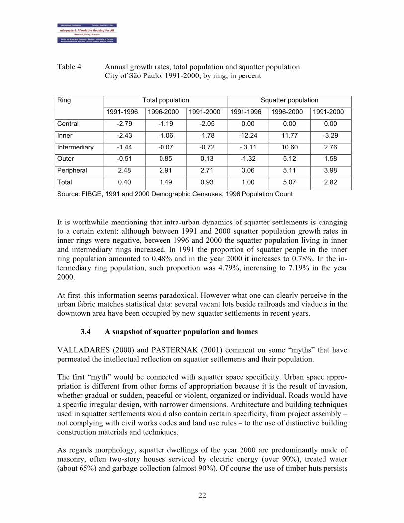
Table 4 Annual growth rates, total population and squatter population City of São Paulo, 1991-2000, by ring, in percent
Total population Squatter population Ring
1991-1996 1996-2000 1991-2000 1991-1996 1996-2000 1991-2000
Central -2.79 -1.19 -2.05 0.00 0.00 0.00
Inner -2.43 -1.06 -1.78 -12.24 11.77 -3.29
Intermediary -1.44 -0.07 -0.72 - 3.11 10.60 2.76
Outer -0.51 0.85 0.13 -1.32 5.12 1.58
Peripheral 2.48 2.91 2.71 3.06 5.11 3.98
Total 0.40 1.49 0.93 1.00 5.07 2.82
Source: FIBGE, 1991 and 2000 Demographic Censuses, 1996 Population Count
It is worthwhile mentioning that intra-urban dynamics of squatter settlements is changing to a certain extent: although between 1991 and 2000 squatter population growth rates in inner rings were negative, between 1996 and 2000 the squatter population living in inner and intermediary rings increased. In 1991 the proportion of squatter people in the inner ring population amounted to 0.48% and in the year 2000 it increases to 0.78%. In the in-termediary ring population, such proportion was 4.79%, increasing to 7.19% in the year 2000. At first, this information seems paradoxical. However what one can clearly perceive in the urban fabric matches statistical data: several vacant lots beside railroads and viaducts in the downtown area have been occupied by new squatter settlements in recent years.
3.4 A snapshot of squatter population and homes VALLADARES (2000) and PASTERNAK (2001) comment on some “myths” that have permeated the intellectual reflection on squatter settlements and their population. The first “myth” would be connected with squatter space specificity. Urban space appro-priation is different from other forms of appropriation because it is the result of invasion, whether gradual or sudden, peaceful or violent, organized or individual. Roads would have a specific irregular design, with narrower dimensions. Architecture and building techniques used in squatter settlements would also contain certain specificity, from project assembly – not complying with civil works codes and land use rules – to the use of distinctive building construction materials and techniques. As regards morphology, squatter dwellings of the year 2000 are predominantly made of masonry, often two-story houses serviced by electric energy (over 90%), treated water (about 65%) and garbage collection (almost 90%). Of course the use of timber huts persists

23
although not as predominantly as in 1987 (when approximately 50% of dwelling units were made of timber). However, timber huts no longer prevail in the squatter settlement landscape, now showing the gray color of concrete blocks in lower pavements and the red color of hollow bricks in upper pavements. As regards infrastructure, the critical point of squatter dwellings is in the destination given to domestic residues: only 26% of homes were connected to the public sewer network in 1991. In the city as a whole, such percent was 84% in 1991 and 87% in the year 2000 (PASTERNAK, 2001). Although the value for use has prevailed in the appropriation of invaded land, both lots and dwellings are marketable products. There are “formal” marketing structures for dwelling units, especially in larger squatter settlements. In his work, BALTRUSIS (2000), analyzing Nova Conquista (located in the City of Diadema) and Paraisópolis (one of the largest in the City of São Paulo, with about 40,000 people) squatter settlements, noted that in the latter there were 110 offers to sell real estates, representing 1.2% of squatter domiciles. “In the nineteen nineties, the first real-estate agency appears in a squatter settlement, Ms. Helena’s Real-Estate Agency. There are currently three agencies, accounting for a large part of real-estate transactions made there” (BALTRUSIS, 2000: 46). In relation to price, one may no-tice a certain price homogeneity in several squatter settlements, where the price for a 4-room dwelling ranges between 12,000 and 15,000 reais, and the selling price is close to 250.00 reais per useful square meter. EMBRAESP data point out that the average building space price for a domicile in the City of São Paulo’s popular neighborhoods is about 967.00 reais (8 minimum wages in 1998). Therefore, squatter settlement price represented 25% of the price for a new housing unit in popular neighborhoods. Even land is often sold: parcels of land are “reserved” during invasions and later marketed. The product’s scarcity and its growing demand put a price to something that did not exist before: in 1987, 4% of interviewed respondents stated that they paid for their parcels of land; in 1993, 14% did so, suggesting that the phenomenon of squatter land purchase is growing. Although specific, the land and home market in squatter settlements has brokers similar to those working on the formal market. BALTRUSIS states that “the underground real-estate market in squatter settlements operates as an extension of the formal market, it is a sub-segment with its own characteristics. Ms. Helena’s statement provides a fine picture of such reality: to her, her agency operates as a regular real-estate agency, with brokers, promotion structure, real-estate management, in addition to purchasing, selling and rent-ing several types of real estates” (2003: 226). The continuous appearance of a jobsite, such as that of the city’s poor periphery, is main-tained in squatter settlements. Narrow and disordered streets remind a winding and confus-ing medieval town, provided with a design not complying with the demands of car traffic. The first “dogma” – spatial and squatter dwelling specificity – is partly true. The second “myth” would correspond to the idea that the squatter settlement is the place of poverty, the urban territory exclusively of the poor, the spatial translation of social exclu-

24
sion, corresponding to the “ghost town” of MARCUSE (1996). Squatter population would be specific. In the popular imaginary, essentially prejudiced, squatter dwellers would be black, Northeast migrants, idle, and criminal. Data show that the squatter population has proportionally less whites than the municipal population as a whole: for the City of São Paulo’s population, the percent of blacks and dark people attained 29% in 1991; in the squatter settlements, they total 53% in the same year. Although squatter dwellers have migrated mostly from Northeast of Brazil (70% of migrant squatter dwellers came from the Northeast), they are not recent migrants. There-fore, the squatter dweller route is very different from that prevailing in the popular imagi-nary that was a route coming directly from the Northeast rural region to the squatter set-tlement in the City of São Paulo. Most often, squatter dwellers have experienced a housing situation different from the squatter settlements in the City of São Paulo, usually living in rented homes previously. The impossibility to pay rent or to remain at relatives’ home de-termines the route to the squatter settlement. The proportion of squatter dwellers with a formal and regular job is similar when compar-ing the squatter settlement and the municipal population as a whole. This demystifies the idea of the squatter dweller as an idle person. The squatter dweller is, first and foremost, a poor worker: in 1980, squatter household heads were mostly industrial workers; already in 1993, outsourced jobs prevail within squatter settlements and outside them. The average income for the squatter population over 10 years of age was 2 minimum wages, whereas the total population income was 4.5 minimum wages in 1991. Therefore, the population segment living in squatter settlements is clearly poorer than the city average. On the other hand, the average income for those residing in the peripheral ring was 3.34 minimum wages. The comparison of the 3 population groups shows a higher poverty level among squatter dwellers. On the other hand, the average squatter dweller income has been grow-ing for the past decades (PASTERNAK, 2001). Squatter settlements currently include not only the destitute but also many families that previously had some other type of domicile, mainly rented homes. The impoverishment as well as the downgrading process of low-income class sectors led new social groups to squatter settlements. In the long run, this may change the traditional profile of squatter dwellers: what seemed to be a mere expression of social and spatial segregation is now a complex and intricate reality. The third “myth” would turn the squatter settlement into a homogenous space, both for so-ciological analysis and political action. Of course there are significant differences in the physical structure: precarious or consolidated squatter settlements, recently or previously occupied, located in flat or rough parcels of land, in the downtown area or in the periphery. However the social heterogeneity and diversity within and among squatter settlements is not often studied. PRETECEILLE and VALLADARES (2000) refute such “myths” for the squatter settle-ments in the City of Rio de Janeiro. They point out that most of the metropolis’ poor popu-
25
lation lives outside squatter settlements. In the City of São Paulo a different typology among metropolitan squatter settlement sectors is clearly noted. There are proletarian squatter settlements, where the secondary proletariat prevails; the so-called popular squat-ter settlements, where house help and unskilled employees prevail; agricultural squatter settlements, where people working in the agricultural sector prevail. And there are also “superior” squatter settlements, with a strong presence of office employees and some pres-ence of higher-income strata. Squatter settlements are not a social world apart, as wrote Olavo Bilac2. Squatter settle-ments’ spatial proximity to different urban segments result in several socioeconomic pro-files. As stated by VALLADARES (2000:15), “squatter settlements are, on average, poor zones, but not uniform ones, and they are not the only ones in the City of Rio de Janeiro’s agglomeration presenting such social characteristics. They concentrate neither mostly the poor nor the most destitute spaces nor even the poor alone. In squatter settlements low so-cial categories can be found, but they are not destitute, and even intermediary categories, revealing a diversified social structure and certainly significant social mobility processes.” As for the City of São Paulo, such “myths” correspond partially to the empirical reality. There are specificities both in the squatter settlement space and population. However there are also many common features. Therefore, squatter settlements integrate the urban space and have diversities within and among them. Squatter dwellers are workers who produce and consume like many other people living in different segments of the urban fabric. 4. Final Considerations Although segregation is a characteristic of cities in general, the instruments and rules gen-erating it have been changing throughout the years. In the City of São Paulo, segregation processes have significantly affected both the low-income (squatter dwellers) and high-income segments, residing first in garden-city neighborhoods and more recently in closed vertical and horizontal condominiums. As is the case of the myths relating to squatter settlement space, other myths may be men-tioned in relation to closed condominiums, namely: • Condominiums are the places of residence for high-income groups • Condominiums preserve clean air and green areas • Condominium dwellers are protected from crime and violence As condominiums became more popular and started to be built within the urban fabric, amid air pollution, the first two myths fell apart. In fact, if we analyze the figures relating 2 In 1890 Olavo Bilac wrote a chronic under the title “Fora da vida” (Out of life), where he mentions his meeting a washer on the Morro da Conceição, who had been descending the hill to go downtown for 34 years. “She has been living on the hill so physically closed to us for 33 years and yet so morally distant from us, so far apart from our lives as if, in fact, back in space and time she lived in the last century or in the backs of China...”
26
to the number of horizontal condominiums launched in the past three years, we will see that a large number of them are located in the city’s peripheral neighborhoods. In addition, traditional popular and working-class neighborhoods now present this type of housing such as Vila Prudente, Vila Formosa, and Tatuapé. In those areas, house sales to middle-income social groups are made easier by a reduced square-meter price and the security appeal. One may not disregard, however, the condominiums launched in the city’s noble, although not so exclusive, areas. As to the “security” issue, data relating to crime and deviating behaviors in closed condo-miniums help refute such myth. Whereas government authorities are absent from squatter settlements owing to the existence of a parallel authority usually connected to drug traf-ficking, in closed condominiums such absence is due to the presence of private security in charge of residents’ protection and surveillance. Such security scheme, however, does not curb deviating behaviors occurring behind condominium walls that express the irrationali-ties of a supposedly peaceful housing system. When we refer to condominiums located in areas of smaller dimensions intended to lower-income population, the lack of space worsens the situation, where small houses (around 70 square meters) are lined along the walls, leaving space only for car parking. In those con-dominiums, security gates and walls give the illusion of a wide collective space, but actu-ally reproduce the crowded spaces typical of avenue-type tenements3 wishing to resemble a closed condominium. The last aspect to be pointed out in this paper refers to the new sociability standards pre-vailing in condominiums, which stress the negation of the other and the different. Cher-ished values of the modern democratic city include equality before the law, free access to public spaces, the right to circulate freely, i.e., the existence of a free and equitable public space. Negating such values, the idea that social groups should live in homogenous en-claves, takes away from the city its Agora character, impoverishing social life. In a micro-scale, this is the phenomenon currently existing in the City of São Paulo.
3 Classic tenement typologies already accepted in several studies include:
• Cortiço de quintal (backyard tenement): occupies the center of the block, with access through a nar-row passageway;
• Cortiço casinha (little-house tenement): independent construction facing the street (may be con-fused with a boardinghouse);
• Casa de cômodos (rooming house): two-story building, with several internal subdivisions; • Cortiço improvisado (improvised tenement): precarious occupation of free areas in the back yard of
houses, warehouses, bars, etc. • Cortiço avenida (avenue-type tenement): rooms or even little houses lined along the inner street and
opening to it. Common access through a gate facing the street; • Hotel-cortiço (hostel-type tenement): operates as restaurant in daytime (classification included in
the Report of Tenement Buildings of Santa Ifigênia District, 1986, mentioned in BLAY, 1986) VAZ (1985) mentions a ruling on sanitary services to be provided by the Federal Government that, in a publication of March 8, 1904, characterized unsavory collective housing units as avenues, lodgings, tenements, shelters, rooming houses, boardinghouses, and hostels.

27
5. Bibliography
BALTRUSIS, N (2000) A dinâmica no mercado imbiliário informal na Região Metropolitana de São Paulo: um estudo de caso nas favelas de paraisópolis e Nova Conquista Campinas, dissertação de mestrado apresentada à- FAU PUCCAMP
BALTRUSIS, N (2003) O mercado imobiliário informal nas favelas de Paraisópolis e Nova Con-quista In FERNANDES, E A lei e a ilegalidade na produção do espaço urbano Belo Horizonte, Del Rey, pp 215-228
BLAY, E. A. (1985) Eu Não Tenho Onde Morar: Vilas Operárias na Cidade de São Paulo. São Paulo, Nobel
BOGUS, L & TASCHNER, SP ( 1986) “Mobilidade Espacial da População Brasileira: Aspectos e Tendências,” in Revista Brasileira de Estudos Populacionais. Vol. 3, n°2, jul./dez.
BOGUS, L (1992) “Urbanização e Metropolização: o caso de São Paulo” in A Luta pela Cidade em São Paulo org. BÓGUS, Lucia M. e WANDERLEY, Luiz. São Paulo, Cortez
BRANT, V (coord, 1989) São Paulo: trabalhar e viver São Paulo, Comissão de Justiça e Paz/Bra-siliense
CALDEIRA, Teresa Pires do Rio. Cidade dos Muros: Crime, Segregação e Cidadania em São Paulo. São Paulo, EDUSP e Editora 34, 2000.
CANO, Wilson. Raízes da concentração Industrial em São Paulo. Rio de Janeiro, Difel, 1977.
____________ e NEGRI, B. Interiorização da Industria Paulista. Campinas, UNICAMP, 1986.
____________ . et al. São Paulo no Limiar do Século XXI. Campinas, UNICAMP, Doc. Final 2.21, 1990.
CALDEIRA, T (2000) Cidade de muros: crime, segregação e cidadania São Paulo, Ed 34/EDUSP
EMBRAESP (2002) Empresa Brasileira de Estudos de Patrimônio S/C Ltda Relatório Anual 2000 São Paulo, Informativo Imobiliário EMBRAESP
JANUZZI, P de M & JANUZZI, N ( 2002) Crescimento urbano, saldos migratórios e atratividade residencial dos distritos da Cidade de São Paulo Revista Brasileira de Estudos Urbanos e Regionais vol 4, nº ½ São Paulo, ANPUR
FAUSTO, Bóris. Trabalho Urbano e Conflito Social. Rio de Janeiro, Difel, 1977.
KOWARICK, L. A Exploração Urbana. Rio de Janeiro, Paz e Terra, 1980.
LANGENBUCH, J. A Estruturação da Grande São Paulo. Rio de Janeiro, IBGE, 1971.
LEME, M C da S. (coord, 1999) Urbanismo no Brasil 1895-1965 São Paulo, FUPAM/ Studio No-bel
MARCUSE, P (1996) Space and race in the post Fordist city: the outcast guetto and advanced homelessness in the United States today In MINGIONE, E ( ed) Urban Poverty and the Underclass Oxford, Blackwell Publishers, pp 176-216

28
MACEDO, S S ( 1987) Higienópolis e arredores São Paulo, EDUSP/PINI
MARQUES, E, TORRES, H e SARAIVA, C (2003) Favelas no Município de São Paulo: estimati-vas de população para os anos de1991,1996 e 2000. Artigo apresentado no X Encontro Anual da Associação Nacional de Planejamento Urbano e Regional (ANPUR), Belo Horizonte, maio de 2002
MAUTNER, Y (1999) A periferia como fronteira de expansão do capital In DEAK, C & SCHIFFER,S O processo de urbanização no Brasil São Paulo, EDUSP/FUPAM, pp 285-299
MEYER, R (1993) O papel da rua na urbanização paulista Cadernos de História de São Paulo 2 São Paulo, MPUSP, pp 26-38
MONTALI, L. Região Metropolitana de São Paulo: Expansão e Heterogeneidade. São Paulo, mimeo., 1991.
MUNICÍPIO DE SÃO PAULO. Secretaria de Habitação (SEHAB). Censo de favelas. São Paulo, 1987.
PASTERNAK, S (2001) Desenhando os espaços da pobreza Tese de livre docência apresentada à FAU-USP, 2001
PERILLO, S (2002) Vinte anos de migração no Estado de São Paulo: uma análise do período 1980-2000 Trabalho apresentado no XIII Encontro da Associação Brasileira de Estudos Populacionais, Ouro Preto, novembro de 2002
PRETECEILLE, E & VALLADARES, L do P (2000) Favela, favelas: unidade ou diversidade da favela carioca In QUEIROZ RIBEIRO, L C (org) O futuro das metrópolis: desigualdade e govern-abilidade Rio de Janeiro, Revan/FASE, pp 375-403
ROLNIK, R (1997) A cidade e a lei. Legislação,política urbana e território na cidade de São Paulo São Paulo, FAPESP/Studio Nobel
ROLNIK, R et al (1990) São Paulo: crise e mudança São Paulo, SEMPLA/ Brasiliense
SENNET, R (1997) Carne e Pedra Rio de Janeiro, Record.
STIEL, W C (1984) História do transporte urbano no Brasil : bondes e troleibus São Paulo: PINI; Brasília: EBTU
VALLADARES, L ( 2000) Les favelas dans la mondialization, les favelas em tant que marché Col-loque Mondialisation Economique et Gouvernment des Societés. L’ Ámerique Latine, um labora-toire. Greid, IRD et lês Universités de Paris 1 ( IEDES) e Paris 13, Paris
VAZ. L F (985) Contribuição ao estudo da produção e transformação da habitação popular. As habitações coletivas do Rio antigo. Rio de Janeiro, dissertação de mestrado apresentada ao IPPRU/UFRJ
ZALUAR, A e ALVITO,M (org, 1998) Um século de favela Rio de Janeiro, Editora a Fundação Getúlio Vargas