sweden ore deposit field trip report, 2007ubcseg.sites.olt.ubc.ca › files › 2011 › 04 ›...
TRANSCRIPT

KiirunavaaraKiirunavaara
AitikAitik
StorlidenStorliden
KristinebergKristineberg
Falun
Kiruna
Gällivare
LuleåMalå
Umeå
Uppsala
FalunFalunGävle
Stockholm
Skellefteå
100 km
N
road city
mine
smelter
train
air
GarpenbergGarpenberg
Rönnsknnskärsverkenrsverken
Arctic
Circle
SWEDEN2007
Ore DepositsField Trip
April 29th - May 13th
Society of Economic Geologists
Student Chapter
University of British Columbia
Sponsored by:
Barrick Gold Corp.Kaminak Gold Corp.
Society of Economic GeologistsEquity Engineering Ltd.
Geological Association of CanadaEd Balon
Mineral Deposits Research Unit

SWEDEN 2007 Field Trip Report
April 29 – May 13
Kirsten Rasmussen With contributions by:
Elspeth Barnes, Lyle Hansen, Stefan Wallier, and Nick Williams
Society of Economic Geologists Student Chapter University of British Columbia
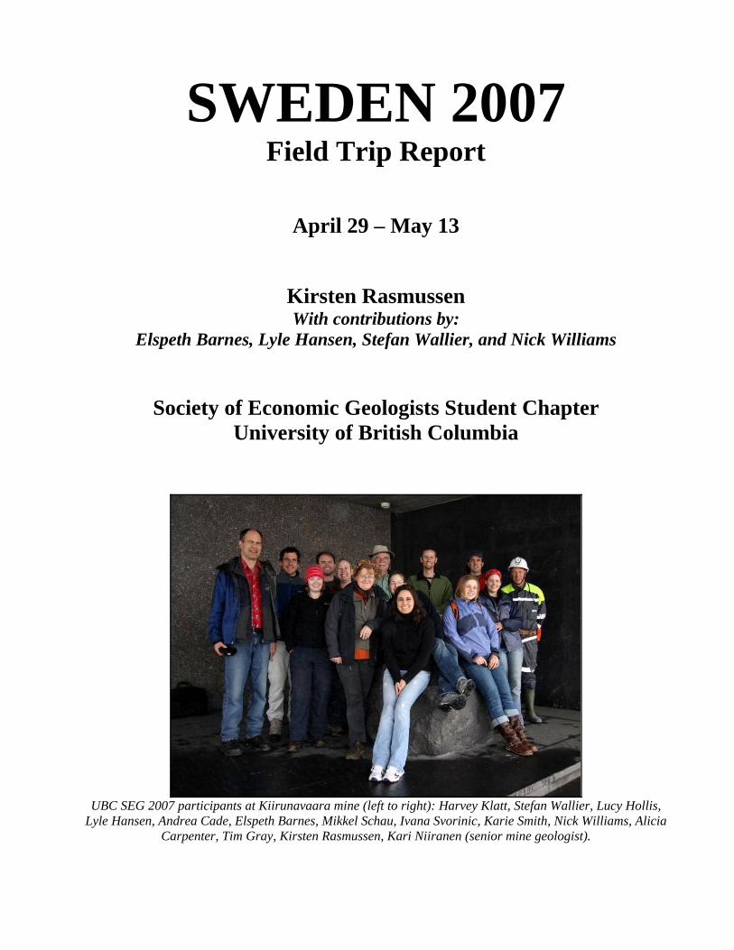
UBC SEG 2007 participants at Kiirunavaara mine (left to right): Harvey Klatt, Stefan Wallier, Lucy Hollis,
Lyle Hansen, Andrea Cade, Elspeth Barnes, Mikkel Schau, Ivana Svorinic, Karie Smith, Nick Williams, Alicia Carpenter, Tim Gray, Kirsten Rasmussen, Kari Niiranen (senior mine geologist).


Contents
Contents ...............................................................................................................................i
Acknowledgements.............................................................................................................i
Executive Summary ...........................................................................................................1
Introduction.........................................................................................................................2
Utö Island – Wednesday May 2, 2007 ...............................................................................3
Sala Silvergruva – Thursday May 3, 2007.........................................................................5
Garpenberg – Friday May 4, 2007......................................................................................8
Storliden – Sunday May 6, 2007 ......................................................................................10
Kristineberg – Monday May 7, 2007 ................................................................................13
Swedish Geological Survey, Malå – Monday May 7, 2007.............................................15
Rönnskär smelter – Tuesday May 8, 2007 ......................................................................16
Aitik – Wednesday May 9, 2007 .......................................................................................18
Kiirunavaara – Thursday May 10, 2007 ...........................................................................21
Acknowledgements Our trip was a great educational and cultural experience and we thank the following organisations and people whose generous contributions made the trip possible: Barrick Gold Corp., Kaminak Gold Corp., Equity Engineering Ltd., Ed Balon, Mikkel Schau, Lyle Hansen, Harvey Klatt, the the Society of Economic Geologists, Geological Association of Canada, and the Mineral Deposit Research Unit at UBC. We also offer our sincere thanks to: Boliden AB, Lundin Mining, LKAB, and the Geological Survey of Sweden who gave us access to their mines and facilities; Pär Weihed of the Division of Ore Geology and Applied Geophysics, Luleå University of Technology, for recommendations and help; and to all the people (including several that are not named in this report) that we spoke to while planning the trip and that we met along the way, and who left us with such a favorable impression of the geology and mining industry in Sweden.
i

Executive Summary The University of British Columbia SEG student chapter organized and led a field trip to Sweden from April 30 to May 13, 2007. The group had 13 participants, a mix of four industry representatives from Canada and the UK, and nine undergraduate and graduate students from the University of British Columbia. The trip covered the three major mining districts in Sweden, providing an opportunity to visit a variety of Paleoproterozoic deposits of the Fennoscandian Shield, such as banded iron formation (BIF), volcanogenic massive sulphide (VMS), Cu-Au porphyry style, and Fe-oxide-apatite (Kiruna-type) deposits. Some of the deposits have been mined for over a millennium which gave us an astonishing insight into the importance of mining in Sweden dating back to Viking times. The group assembled in Stockholm, where we spent one day of sight seeing, before we started the geology trip in Sweden’s southernmost mining district of Bergslagen, which has been interpreted as an intra-continental extensional or continental margin back-arc region developed between 1.90 to 1.87 Ga. Our first stop was the island of Utö, accessible by a short ferry through the Stockholm archipelago. We learned about the history of the island and the importance of the magnetite-quartz BIF mine for the local economy, from their discovery in 1150 through to 1879. Other interesting aspects of the island’s geology are the occurrence of lithium-rich pegmatites, from which the element lithium was first isolated, and the sole exposure of the oldest volcanic rocks found in southern Sweden. Heading northwest from Stockholm to Falun in rented Volvo station wagons, we stopped at the former Salå Ag-Zn-Pb-Au mine, where an epigenetic vein was mined underground from the 14th century to the early 20th century. Here, an unplanned but thorough geological tour was led by Nils Jansson, a geology graduate student at the Uppsala University. Our subsequent late arrival at Falun, an UNESCO World Heritage Site formerly the world’s largest copper producer and operated for more then 1000 years, only allowed us a view of the open pit and the well-maintained mine infrastructure, as well as an hour or so in the waste piles. A visit to the Garpenberg underground Zn-Ag-Cu-Pb-Au VMS mine (owned and operated by Boliden AB) was our final stop in the Bergslagen district. A presentation by exploration geologist Simon Granbacka and mining engineer Sari Koivisto gave us an excellent overview of the mine geology and history, as well as the mining methods currently employed for mining the metamorphosed strata-bound deposit; this was followed by a tour 1000 m down into the mine. After a day’s drive north along the coastline of the Gulf of Bothnia, we arrived in the Skellefte mining district in northern central Sweden, which has been suggested to be a remnant of a strongly extensional intra-arc region, coeval with the Bergslagen district. We first visited the Storliden mine owned by Lundin Mining and operated by Boliden AB, where the project geologist, Marcello Imaña, and the mine geologist, Stig Liedberg, gave a presentation on the metamorphosed Zn-Cu-Ag-Au-VMS deposit discovered in 1998. Our hosts led us underground where we saw the few remaining exposures of the ore body, with a spectacular average grade of 10.3 % Zn, supplemented by a brief stop in the surface ore piles where massive coarse-grained sphalerite-chalcopyrite-pyrrhotite wowed the group. The Kristineberg Zn-Au-Cu-Ag-Pb VMS deposit, owned and operated by Boliden AB, was our second mine tour in the district. The mine manager Karl-Erik Rånman showed us several exposures of the ore body underground followed by a visit to the core shack and a presentation. We were also warmly welcomed by the members of the Geological Survey of Sweden in Malå, where allowed to have a quick glance into the world’s largest drill core collection. A highlight of the trip was our visit to the Boliden Rönnskär copper and lead smelter, where we were
1

given an overview of the copper smelting process and a fascinating tour under the supervision of Jens Christiansen, the smelter manager. Leaving our vehicles in Luleå on the morning of May 9 we boarded the back-haul ore train that took us north of the Arctic Circle into the Northern Norbotten mining district to visit the world class Aitik and Kiruna deposits. These deposits were formed during the evolution of a Paleoproterozoic continental margin arc- ± plume-related magmatism and later sedimentation and granitic plutonism ca. 1.93 to 1.75 Ga. In Gällivare, we were brought to the Aitik open pit mine, owned by Boliden AB. Torbjörn Kjellsson (mining engineer) and Riikka Aaltonen (mine geologist) gave an introduction into the geology of the metamorphosed Cu-Au porphyry style mineralization and led us on a tour into one of Europe’s largest open pits. Last on our itinerary, but certainly not least, we visited LKAB’s Kiirunavaara Fe-oxide-apatite deposit in Kiruna, the world’s largest underground iron mine with a pre-mining ore tonnage of more then 2000 Mt at a grade of >60 % Fe. We were greeted by Kari Niiranen (senior mine geologist) who gave us a thorough overview on the regional and mine geology. We then slipped on mine gear and hard hats and were off on the long bus trip underground to view the ore body, and the underground cinema and cafeteria developed for tourism purposes. Back on surface we saw the control room from where the automated ore graders, loaders, and trains are quietly controlled by technicians surrounded by computer screens displaying maps and camera shots of the underground workings. After a snowy day off in Kiruna with individual activities, we flew back to Stockholm, finished up on last-minute shopping, and caught our flights back to Vancouver the following morning.
Introduction Sweden’s Palaeoproterozoic rocks are tremendously well endowed sulphide and oxide ore deposits including two of Europe’s largest ore deposits at Kiruna and Aitik. The UBC Student Chapter of the SEG selected Sweden for its 2007 ore deposits field trip for a chance to observe a range of mineralisation styles, to discover what environments are conducive to producing such large endowments of mineralisation, to learn how such ancient deposits are modified through time, and to gain an appreciation of the historic importance of mining in Sweden. There are three historic mining districts in Sweden: (1) Bergslagen in south-central Sweden; (2) Skellefte in northern-central Sweden; and (3) Northern Norbotten in northern Sweden. The Bergslagen and Skellefte districts are dominantly underlain by 1.95-1.85 Ga, hydrothermally altered and upper greenschist to amphibolite facies metamorphosed felsic to intermediate Svecofennian metavolcanic rocks interlayered with subordinate metasedimentary rocks (including turbidites, carbonates, and re-sedimented felsic volcanics). Two magmatic episodes described as the “older” or “early” granites (1.95-1.86 Ga) and the “younger/youngest” or “late” granites (1.82-1.76 Ga) have intruded the Svecofennian rocks. The Skellefte district to the north is separated from the Bergslagen district by a broad Bothnian metasedimentary basin. Whereas the Svecofennian rocks in the Bergslagen district are interpreted to represent shallow-submarine volcanism in an extensional and subsiding back-arc region, the Skellefte district has been interpreted to comprise (shallow?) submarine volcanism in an extensional, continental intra-arc setting. The Northern Norbotten district is underlain by Archean (c. 2.83 Ga) tonalitic to granodioritic granitoids and gneissic rocks of the Råstojaure Group which intrude amphibolite-grade rocks that possibly represent fragments of preserved greenstone belts. These are overlain by a 10 km thick, 2.5-2.0 Ga metamorphosed sequence of rift-related Karelian greenstone rocks (basalts, komatiites, clastic and volcaniclastic sedimentary rocks, and carbonates) and a 1.9 Ga succession of Svecofennian metavolcanic, metasedimentary and intrusive rocks, which hosts most of the mineralisation.
2

Throughout Sweden we were continually impressed by the extensive history of mining; many of the mines we visited had been mined for several hundred years, even over 1000 years! Most of the mines also had active and successful near-mine exploration programs that continually extend and expand their mining operations and projected mine lives, and with a high potential for further discoveries few of the mines we visited had restricted mine lives. We visited at least two mines in each of the three districts. In Bergslagen: Utö (magnetite-quartz BIF), Sala Silvergruva (Ag-Zn-Pb-Au epigenetic vein), and Garpenberg (Zn-Ag-Cu-Pb-Au VMS); in Skellefte: Storliden (Zn-Cu-Ag-Au-Pb VMS) and Kristineberg (Zn-Au-Cu-Ag-Pb VMS); and in Northern Norbotten: Aitik (Cu-Au porphyry) and Kiirunavaara (the magnetite-apatite type example). The deposit summaries below are essentially based upon presentations and underground/pit tours at each of the mines, which we have attempted to report as accurately as possible, augmented by a collection of available literature presented in the associated UBC Student Chapter Sweden field trip guidebook; any inaccuracies are our own. The trip was a great educational and cultural experience and we thank the following organisations and people whose generous contributions made the trip possible: Barrick Gold Corp., Kaminak Gold Corp., Equity Engineering Ltd., Ed Balon, Mikkel Schau, Lyle Hansen, Harvey Klatt, the Geological Association of Canada, the Society of Economic Geologists, and the Mineral Deposit Research Unit at UBC. We would also extend a sincere thank you to: Boliden AB, Lundin Mining, and LKAB, who allowed us access to the mines; Pär Weihed of the Division of Ore Geology and Applied Geophysics, Luleå University of Technology, for recommendations and help; and to all the people (including several that are not named in this report) that we spoke to while planning the trip, and that we met along the way, all of whom left us with a favorable impression of the geology and mining industry in Sweden.
Utö Island – Wednesday May 2, 2007 Our first introduction to Swedish geology, after a day of recovery from the 16+ hour flight to Sweden, was a daytrip to the island of Utö in the Stockholm Archipelago. This region of Sweden has been most recently interpreted as an extensional back-arc setting dominated by shallow water sub-marine volcanism (mainly rhyolitic in the east) largely resulting in syn-volcanic pyroclastic and mass-flow or ignimbrite deposits interbedded with post-volcanic re-sedimented volcanic ash-siltstone facies and minor carbonates. After a short 40 minute ferry ride through the archipelago, and a walk through the village, with the typical Swedish deep red painted houses with white trim, to the local mining museum we were met by Mariann Kajerdal, who kindly opened the museum especially for our group. The displays focus on former mining activities on the island; however there is also a short overview of the history of the island, which was settled by the Vikings in the 8th century. The local economy was centred on mining the banded iron formations found on the northern half of the island from their discovery in 1150 through to 1879, when low iron prices forced the closure of the mines and people turned to logging and tourism for income. The museum also has an excellent, well-labelled display of the minerals and mineralisation characteristic of not only of the banded iron mineralisation but also of the lithium-rich pegmatites, including the mineral holmquistite (a Mg-Fe-Mn-Li amphibole unique to the island). Interestingly, it is from these pegmatites that the element lithium was first isolated in a lab. After our tour of the museum and an excellent lunch of Swedish meatballs and lingonberry jam, we walked to two fenced open pits on the margins of the village from which fine- to medium-grained magnetite-quartz-rich iron ore was extracted from metamorphosed rhyolitic ash-siltstone units
3

interlayered with volcanic sandstones, carbonates, and skarn horizons. Iron mineralisation here is “banded” with coarse-grained quartz +/- microcline associated with minor chalcopyrite, galena, and brown sphalerite, and is interpreted as chemical precipitates interbedded with the ash-siltstone facies that underlies much of the island. The iron deposits (and local stratiform Zn-Pb-Cu-Ag deposits) are all located in/near the hinge zone of the large syncline that occupies the northern portion of Utö Island. The pegmatites for which the island is truly known for are dominated by graphitic quartz and very coarse-grained pink microcline, with lesser very fine-grained pale purple lepidolite, pale green cleavelandite, schorl, and minor deep blue apatite. After about an hour of combing through the nearby talus piles most of us had satisfactory samples of the iron ore and the pegmatites and were ready to move on. Our last stop was on the south-eastern limb of the syncline, on the east side of the island where the “base” of the metavolcanic succession is reported to be exposed as an ignimbrite layer overlying a metasedimentary (turbiditic) sequence: at 1904 +/- 4 Ma this is the oldest exposure of the metavolcanic rocks in all southern Sweden. As not one of our group members was a verifiable volcanologist, we depended largely on the papers and their photos in the trip guidebook as “cheat sheets.” Here we puzzled over the interbedded/interlayered post-eruptive (re-worked and re-sedimented) rhyolitic metasediments where sub-vertical beds with trough crossbedding and normal grading indicated tops to the northwest. Syn-eruptive rhyolitic mass-flow deposits with erosive bases and minor local pyroclastic interbeds displayed what appeared to be remnant lapilli and even fiamme, and blocky clasts of porphyritic rhyolite or ignimbrite fragments were observed in some thin beds. Amphibolite facies metamorphism and pervasive shearing of these units were the most obvious features with a strongly developed north-trending sub-vertical cleavage in the siltstone-ash facies and the stretching and realignment of relict lapilli in mass-flow ignimbrite facies. The day was completed with a trip to the local bakery on the island followed by much napping on the ferry ride back to the mainland, which we will attribute solely to jet-lag and not the group dinner the previous night consisting of a traditional Swedish smorgasbord and aquavit.
Intercalated siltstone-ash and lapilli ignimbrite turbidites with erosive base cutting laminated
siltstone-ash; note realignment of relict lapilli to north (hammer handle points up).
4

Quartz vein with dark selvage cutting thick volcanic bed with stringy dark fiamme (hammer handle
points up).
Sala Silvergruva – Thursday May 3, 2007 Heading northwest from Stockholm in our newly rented Volvo station wagons, an unplanned lunch/tourist stop at the Sala Pb-Zn-Ag mine, en-route to Falun in the Bergslagen district of Sweden led to an offer for a geological tour of the underground deposit from Nils Jansson, a geology graduate student completing a thesis on the Sala deposit at the Uppsala University. Sala operated from the 14th century until the early 20th century but currently the mine site is solely a tourist attraction and the wood and brick buildings and infrastructure have been well-maintained and, not surprisingly, are painted the characteristic red with white trim. Initially we had planned to take one of the tourist tours of the historic Falun mine for that afternoon, but it was an easy decision to opt for the more immediate, geology-focused tour that Nils promised us at Sala. Unlike the former miners who entered the underground portion of the mine in water-powered ore buckets lowered down one of the shafts and precariously swung so that they could jump from the shaft to the current mine workings, our descent into the mine to a depth of 160 metres was facilitated by a new, glass-walled tourist elevator funded by the European Union. We were immediately impressed by the smooth, rounded, blackened and somewhat cramped workings, and even more so after learning that the entire mine had been mined by “fire mining” where heat from stacked logs left to burn overnight cracked the dolomite face and allowed for a 2-3 cm advance in each drift every second day(!). Only galena-rich ore shoots were mined by more efficient methods from top to bottom. Despite the primitive mining methods, it is estimated that roughly 400-500 kilograms of silver were removed from the mine each year since the late 15th century. Although it is not certain how the mine was discovered, both oral traditions involve the discovery of a chuck of galena under a fallen tree in a field (“sala” is thought to signify “pasture”) either by a Swedish farmer or by Finnish pirates. The orebody is interpreted to be an epigenetic deposit with local supergene enrichment (mined-out of the open stoping pit). Incomplete records indicate that over Sala’s 400 year mine life at least 450 t of silver were extracted, mainly as native silver, pyrargyrite, dyscrasite, and polybasite inclusions within galena (grading 1500-10,000 g/t Ag in the galena). Average grades were: 200-3000 g/t Ag (up to 10,000 g/t in areas of interpreted supergene
5
enrichment), 12% Zn, and 2% Pb. Some magnetite is also present and significant mercury and antimony accompanies the mineralisation, particularly in the silver-rich supergene zone(s). The host rock is an uncommonly thick sequence of carbonate rocks for the Bergslagen district: a pale, stromatolitic dolomite marble deposited during a period of waning shallow sub-marine volcanism in a back-arc. Stromatolites are observed as hydrothermally altered, serpentinised, and sheared domal horizons, sometimes with darker mud infill between domes. This is one of the few locations in Bergslagen where primary sedimentary structures have been preserved and are not destroyed, despite having undergone the upper greenschist to lower amphibolite grade metamorphism typical of the Bergslagen district. Several boudinaged volcanic blocks and later talc-tremolite-salite-chlorite-phlogopite skarns are interlayered with the marble; a period of renewed volcanism is interpreted to be responsible for the mineralisation after the deposition of the carbonate rocks. A nearby intrusion of sub-alkaline “early” granite is also present (of the 1.87-1.89 Ga group of intrusions). The country rocks have undergone two generations of folding and, also atypical of the Bergslagen district, are quite shallowly dipping. The orebody is elongate (700 m long, 80 m wide) and plunges about 30 degrees, sub-parallel to the local foliation. Due to competency contrasts in the country rock and ore, at least one large dextral and sub-vertical, but barren shear zone consisting of talc-chlorite-serpentinite-dolomite has been localised sub-parallel to the orebody and probably displaces the ore zone to different depths. This 10 cm to 2 m thick, anastomosing shear zone, and a smaller secondary shear define a down-dropped block of mercury-rich mineralisation (grading ~100 g/t native Hg). Small marble breccia zones with a serpentinite matrix are spatially associated with ore. Mineralisation, where preserved in the walls and back, consists of fine-grained veins and disseminated blebs of galena +/- sphalerite and/or pyrite in the marble with local networks of anastomosing veins. The tour ended with a rest stop and chat in the heated banquet hall at the 160-m level, where several weddings feasts (and wedding nights in the adjacent bedroom!) have been held recently. Fortunately we did not encounter the “Lady of the Mine” who haunts Sala; all disturbances that could have summoned her (including whistling, swearing, and spitting) were carefully avoided by our group. Later that evening in the town of Falun, anyone with any energy remaining drove to the Falun mine site from our hostel and admired the orange-red open pit in the setting sun and spent an hour investigating the sulphide-rich rocks on the waste dumps until hunger forced us to find one of the many O’Leary’s pubs for food (popular amongst the Swedes, but for us a poor choice).
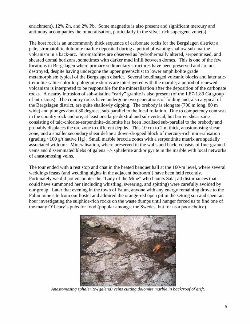
Anastomosing sphalerite-(galena) veins cutting dolomite marble in back/roof of drift.
6

Dolomite marble breccias with serpentine matrix (indicator for nearby ore).
Sheared stromatolites defined by dark green serpentine horizons in dolomite marble; one of the few places
these are preserved in Bergslagen.
7

Typical bundles of stacked wood that would have been used for “fire mining” to drive a shaft down.
Garpenberg – Friday May 4, 2007 The Garpenberg mine (owned and operated by Boliden AB), operating almost continuously since ~1200, was our first tour of an active mine in Sweden and our first introduction to a common theme for the mines we visited in Sweden: new discoveries of, and a high potential for further discoveries of, ore zones extending the mine’s operating life. A short presentation by exploration geologist Simon Granbacka and mining engineer Sari Koivisto gave us a good overview of the geology and history of the deposit. Since Boliden acquired Garpenberg in 1957, >28 Mt of ore has been milled with grades averaging 3-6% Zn, 75-175 g/t Ag, and <2% Pb. Ore concentrates grade 55% Zn, 15% Cu, and 40,000 g/t Ag, and about 90% of the Zn, 78% of the Ag, and 80% of the Pb are recovered. The most recent reserves and resources estimates for the mine total ~38 Mt including: proven reserves = 12.2 Mt; probable reserves = 5.4 Mt; measured resource = 1.4 Mt; indicated resource = 1.9 Mt; and inferred resource = 17.4 Mt (with an additional 1.35 Mt in pillars). Each of these estimates are based on a range of metal grades: 4-7.3% Zn, 65-212 g/t Ag, 0-0.1% Cu, 1.6-2.5% Pb, and 0.3-0.4 g/t Au (as low as 0.1). The recent discovery of several new ore zones (including the major Lappberget resource) included within these figures has extended the current projected mine life by at least another 15-20 years. Mining is mainly by cut and fill methods, combined with more recently introduced long-hole mining and rill mining; currently mining is operating down to the 1100-m level although mineralisation is known to extend to at least 1500 m, and annual mine development consists of >30,000 m of underground drilling and 100 m of drift development. Production is currently limited by the mill’s 1.18 Mt/y capacity. Like Sala and Utö, the Garpenberg deposit is hosted in the felsic to intermediate Svecofennian metavolcanic-metasedimentary back-arc deposits deformed during the Svecokarelian orogeny (at 1.9-1.8 Ga), and intruded extensively by the “early” granites (1.95-1.86 Ga) and less voluminous “late” granites. Host rocks at Garpenberg are a proximal (or domal) rhyolitic pumice-breccia, underlain by rhyolitic ash-siltstones. Small dacite intrusions, mafic volcanics, and a stromatolitic limestone-marble horizon are also present as mappable units and it is within the margins of the 10-80 metre thick marble unit that essentially all of the known mineralisation at Garpenberg is focused, with the exception of the lower grade Zone C in the Lappberget orebody. Locally, a large syncline controls mineralisation and in the past at Garpenberg most of the ore has been removed from parasitic tight fold hinges on both limbs of the syncline; current exploration is directed towards larger structures and possibly larger orebodies inside the syncline.
8

At least 13 known deposits with multiple orebodies exist at Garpenberg, most significantly the Norra deposit with 3 orebodies (producing since 1972); Dammsjön with 3 orebodies; Lappberget (discovered in 1998; comprising >50% of total long-hole reserves and ~20% of total cut and fill reserves), Tyskgården with 2 orebodies; Kuarberget (most recently discovered and still to be drilled off); Finnhyttan, Strand, and Kanal. Adjacent to ore, silicification in the carbonate unit and the volcanics is typical, and several ore types have been identified in the deposits: (1) replacement style Ag-Zn-Pb; (2) tectonically mobilised Pb-Zn or Pb-Ag (related to faults); (3) tectonically mobilised FeS-Zn-Pb (related to faults); (4) replacement style Ag-Zn-Pb with Fe-oxide in limestone skarn and ash-siltstone; (5) epithermal Au-Cu stockwork; and (6) Au-Cu quartz veins. Gold is typically associated with copper, and it was also reported that silver is typically associated with copper and some lead but, unlike at Sala, there is no mercury-silver association. After a short ride down the elevator shaft following lunch in the cafeteria, we piled into two ‘jeeps’ with Sari and Lars Bergkuist (mine engineer) and continued down to the 1080-m and 1060-m levels to the Lappberget C-zone. Mineralisation in the C-zone is one of the few locations where ore is hosted dominantly in the metavolcanics and not the carbonate units and it comprises lower grade, fine to medium-grained, disseminated, red-brown sphalerite mineralisation. The host rocks are banded dark grey schistose and/or siliceous metavolcanics, and light grey thin calcareous (locally silicified) strata (nearby finely crystalline white calcite marble unit with <10% impurities was also observed), with frequently boudinaged white quartz plugs/horizons around which the foliation wraps. Production from the C-zone is done by long-hole mining where a 15-20 metre long (6 x 5 m high and wide, respectively) access drift is driven through waste rock to the ore zone, holes are drilled upwards in a vertical fan pattern and the ore is blasted and removed from primary blocks. The resulting 20-metre high rooms are subsequently filled hydraulically with paste of sand, waste, cement, and binding chemicals. When the paste in the primaries has hardened (at least 21 days), the secondary blocks are then mined out. After both primaries and secondaries on one level (e.g., 1080) have been mined out and filled with paste, a timber and concrete floor is laid overtop of the paste and the next level up (e.g., 1060) is then mined by the same method. Although long-hole mining has only recently been introduced in the mine, it is expected to become the dominant mining method in the future.
Host inter-bedded/layered marble and schist with boudinaged quartz veins adjacent to ore (bolt is 6”);
Mechanical shop, 910-m level.
9

Fine-grained, disseminated, banded red-brown sphalerite horizons hosted in
interbedded/interlayered siliceous marble and schistose metavolcanic rocks; Kyrken, 840-m level. The Storliden mine (owned by Lundin Mining; operated by Boliden AB) is one of the two mines we visited in the Skellefte mining district in northern central Sweden. It is located within the metavolcanic-dominated Svecofennian rocks found in northern Sweden and immediately north of the transition to the metasedimentary-dominated Bothnian Basin to the south. Storliden was discovered in 1998 after following up on an aerial EM survey and the subsequent discovery of steeply-dipping 4-5 metre thick veins of massive sulphide exposed at the surface (detected by EM). By March 2002, mine development had reached the underground orebody; however the mine life was never intended to exceed 6 years; 1-1.5 years remain. Upon start-up in 2002, the resource was defined as 1.8 Mt with metal grades of 0.2-0.25 g/t Au, 24 g/t Ag, 3.4% Cu, 10.3% Zn, and 0.06% Pb; an additional 4000 t (not originally detected by exploration drilling) were mined by following the steepening orebody west and up towards the surface. Gold and silver make a richer concentrate than initially expected; however gold and lead are mostly concentrated in or remobilised to alteration zones near the fringes of the orebody that are considered waste despite the 4-5 g/t Au grades (up to 26 g/t Au). About 50% of Au, 56% of Ag, 91.5% of Cu, 90.6% of Zn, and 13-28% of Pb are recovered from the 300,000 t of ore that are mined, stockpiled, and milled (at Boliden) each year, a total of 1.4 Mt of ore to date. Volcanic and sedimentary strata hosting the deposit are interfingered with granitoid sills to the north of the deposit near the granite contact. Ongoing exploration is focussed around the granitoid body where several deeper but higher tonnage 1940’s era mines with similar mineralisation operated (including the Alec mine). In addition to being the shallowest orebody in the district (lying 100-70 m below the surface) and hosted in remarkably shallowly dipping rocks for the Skellefte district, Storliden is also the only orebody that is not hosted in felsic-dominated metavolcanic rocks; the host rocks at Storliden are typically coherent and volcaniclastic, andesitic in composition, and metamorphosed to lower amphibolite facies. Interlayered distal marine metasedimentary rocks and rhyolites are also present in the mine area. The area was originally mapped as granite due to lack of exposure, although the actual granite contact lies at least 2 km to the north. Storliden was defined as a very small but high-grade, Cu-Zn VMS deposit that had been deformed and then contact metamorphosed by the adjacent intrusion, resulting in a very coarse relative grain size of ore minerals. The deposit has been locally thickened by folding the orebody, and has been overturned. A feeder zone (~8 m thick) and
10

alteration styles typical of VMS deposits are present and extend to the surface, but below the orebody these features have been largely removed by a large shear (thrust) zone that hosts 1-1.5 g/t Au (as well as arsenopyrite-galena-tellurides) and runs sub-parallel to the orebody; gold-rich shears are not uncommon near deformed and metamorphosed VMS deposits in the district. Siliceous (quartz, humite) alteration and potassic (biotite, muscovite, cordierite) alteration occurs distal to the mineralisation, whereas Mg-rich alteration minerals (gahnite, Zn-rich spinel, anthophyllite) are present more proximal to the orebody. Tectonic enclaves of altered country rocks are found within the mineralisation, and the orebody thins to the north where 10-metre thick wedges/slices are dislocated by faulting. Three ore types have been defined within the mine: (A) massive to semi-massive sphalerite-chalcopyrite-pyrrhotite-(arsenopyrite) with calcite gangue; (B) disseminated pyrrhotite-chalcopyrite with a partially chloritised, amphibole (anthophyllite)-spinel-ilmenite matrix; and (C) irregular veins/stringers breccia of chalcopyrite-pyrrhotite-sphalerite in a highly silicified host (in the underlying feeder zone). The majority of the gangue is quartz-calcite-(dolomite); both the alteration and the gangue at Storliden are relatively Mg-rich relative to other VMS deposits. The mine is divided into several zones: west upper, west lower, central, east upper, and east lower. All zones are mined by essentially the same methods: primary stopes are mined out, and filled with cement; secondary stopes (or pillars) are then blasted out and mined by a rill method where alternating horizontal slices in each stope are mined, filled with loose sand and waste rock (to allow expansion during blasting of interstitial horizons), then interstitial horizontal slices are mined. Each horizontal slice amounts to 3000-4000 t of ore. The west upper zone, although currently mined by room and pillar, will have the pillars removed before the closure of the mine; primary pillars are cement-filled. Our tour began in Malå where we met Marcello Imaña, a project geologist for Lundin Mining who is just completing a PhD on the Storliden deposit. Our tour underground with Marcello, Stig Liedberg (mine geologist), and Johnny Hedman took us to the upper west and the central zones. Several mineralised pillars from the narrow ore lenses steepening upwards to the north in the upper west zone contained very hard, dominantly massive, medium-grained, dark grey sphalerite (up to 20% Zn) with intergranular/interstitial chalcopyrite and lots of pyrrhotite (little to no pyrite); this is the only region of the mine with non-magnetic pyrrhotite. Very fine (mm- to cm-scale) layering of chalcopyrite- and sphalerite-rich bands was observed locally in the pillars; this layering has been attributed to tectonism and is not stratigraphic in origin. Much of the central zone had been completely mined out but we were still able to see some decimetre-scale layering in the sulphides in the walls, and small sub-horizontal cm-scale chalcopyrite veinlets and masses with some associated sphalerite and galena in the metamorphosed and altered volcanic host rock adjacent to the mined out ore zone. A visit to the ore pile shortly before leaving the mine was unforgettable in that we were able to truly appreciate the spectacularly high grades and extreme coarse grain size of the sulphides in better light; large boulders of almost pure chalcopyrite or sphalerite, with very coarse-grained pinkish pyrrhotite kept most of us occupied for longer than the 10 minutes we were initially given. Marcello managed to coax us out of the ore pile with promises of more mineralised samples in his office and an overview of a poster detailing the geology and mineralisation at Storliden.
11

Decimetre-scale layering in sphalerite ore (6” bolt for scale); central zone, Stope 3.
Coarse-grained, massive, high-grade chalcopyrite and sphalerite (grey) ore; ore pile.
Massive, coarse-grained sphalerite (grey) ore; ore pile.
12

Sphalerite +/- chalcopyrite veinlet stockwork from the highly silicified feeder zone (8 m thick zone
stratigraphically below the mineralisation; pen magnet for scale); ore pile.
Kristineberg – Monday May 7, 2007 Like Storliden, the Kristineberg mine (owned and operated by Boliden AB) is located within the metamorphosed Svecofennian volcanic and sedimentary strata. Mineralisation exposed at the surface was discovered in the 1930’s and the mine has been in operation since 1940, initially as 4 open pits following a WSW trending, steeply dipping body down to 1000 m depth known as the A-zone. All other mineralised zones are shallowly dipping to sub-horizontal, but occur at much greater depths (>1000 m). Since 1970 the mine life has been extended multiple times, the most recent estimate is an additional 12-15 years. As it stands, infrastructure requires significant upgrades in order to deal with the increased mine life and the discovery of mineralisation further to the west; however Kristineberg is about 3rd or 4th on Boliden’s list for upgrading of infrastructure, after Garpenberg and Aitik. The management at Kristineberg would like to increase production to 800,000 t of ore each year, but the current mine shaft dates from the 1940’s, the hoist is from 1953, the crusher is located at the 670-m level (far from the 1100-m mining level), and a new shaft is needed 2 km to the west where mineralisation is still open and where mining activity will be concentrated in the future. Zinc accounts for about 2/3 of the mine’s revenue, followed by gold, then some copper, silver, and a little lead. 2006 was a record year for metal production and of the 604,000 t of ore removed, grades in the zinc-rich ore consisted of: 4.5% Zn, 1.3 g/t Au, 60.0 g/t Ag, 1.2% Cu, and 0.3% Pb; grades in the gold-rich ore consisted of: 7.4 g/t Au, 8 g/t Ag, 1.3% Cu, and no zinc and lead. Out of the zones identified at Kristineberg, the A-zone (the original open pit) and the E-zone-west have been mined out; the E-zone, K-zone, and J-zone all have remaining ore, and the L-zone has not yet been mined. The average zinc grade milled is ~5% (e.g., J-zone); however zinc grades vary amongst the orebodies, and typically increases with copper (up to 15-17% Zn in the K-zone). Secondary metal recoveries consist of 40% of the gold, 60% of the silver, 90% of the copper, and 45% of the lead. There are two gold- (plus copper-) rich orebodies (E-zone and E-zone-west) that are separate from the zinc-rich mineralisation and grade ~7 g/t Au. Currently, ~450,000 t of zinc ore and 150,000 t of gold ore are removed from the mine annually, although with the subsequent depletion of the gold-rich E-zone orebodies the latter is expected to decrease to 50,000 t/yr. Magnetite and pyrrhotite are rare in the mineralisation but are locally present. Mineralisation is
13
known to continue to at least 1300 m but is open to the west and depth). A second orebody (the L-zone) sub-parallel to the main zone of mineralisation (~200m thick, dipping 40 degrees, and striking up to 2 km) has also been recently discovered with exploration drilling (one 5 m thick intersection contains 20% Zn over <2 m, 7 g/t Au over <2 m, and 4% Cu over <2 m). After a brief overview on the mine from Karl-Erik Rånman (mine manager), we went underground in a comfortable bus with Karl-Erik and our driver, Roger Westerlund. Our first stop was the unusually Zn-rich K-zone at the 1100-m level where up to 17% Zn is mined from layered/banded ore dipping moderately to the north. Dark grey, coarsely crystalline, banded sphalerite with interstitial disseminated pyrite +/- pyrrhotite is hosted in highly foliated, chlorite-sericite, phyllic to schistose host rocks with quartz vugs. In this area we also had the chance to see what is considered an exceptionally high-grade Zn-rich face: a $0.5 million, 800 t round (5 x 5 x 5.5 m) planned for one face (most rounds at the mine are 600 t and worth about ¼ of the above value). A quick look at exploration drill core from a platform in the south-western most extent of the workings and targeting the L-zone (a newly discovered zone), Karl-Erik was able to tell us that we were looking at rocks about 10 metres from the mineralisation based on the degree of alteration the host rocks in the drill core had undergone. They were silicified with a fine- to medium-grained schistose texture (chlorite) containing about 5 % large, disseminated pyrite that appeared to be either porphyroblastic or partially “eaten up”. This is the same site as the 5-m intersection reported above for the L-zone, and exploration drilling to delineate the mineralisation was done by vertical fan-style drilling at 50 metre intervals. Our next stop was in the J-zone, also at 1100 metres depth, where more typical zinc ore (grading ~5% Zn) was observed; here the sub-horizontal mineralisation is distinctly banded (it is uncertain whether or not this is due to primary deposition or to later tectonism). Mineralisation here is also hosted in chloritic schist with quartz veins and plugs, with the typical 5% disseminated pyrite. In addition to a presentation on the deposit by Karl-Erik, a quick stop in the core logging facility and conversations with several exploration geologists (Annika Kruuna, Jonas Wiik, and Mikko Nikkilå) gave us some more insight into what is actually considered significant with respect to finding mineralisation. Away from mineralisation and associated alteration, the hanging wall is a rhyolite and the footwall is Viterliden porphyry. Near the mine, all primary textures in the metavolcanic rocks are destroyed by the alteration, thus alteration mapping is the most significant feature logged in the drill core. Schistose host rocks are altered to a quartz-sericite mineral assemblage near the orebody, but the closer in proximity to mineralisation the more chlorite-rich the alteration assemblage becomes, which has proved to be a useful exploration tool for ore zones where the rock is almost entirely chloritised and is very soft and green. Cordierite and andalusite are also indicator minerals for mineralisation, with cordierite typically more abundant in the hanging wall. Disseminated pyrite (5-10%) is present everywhere, and the host rocks are typically banded and contain abundant quartz vugs and veins. Mining is by conventional cut and fill mining with stopes ~5 metres wide, which corresponds to the width of most mineralised zones. Backfill in primary stopes is mostly loose waste, with some solidified concrete, and is blocked off by concrete block walls. This allows the secondary stopes to be mined out. Some rill mining is also done in areas of the mine. The roof is somewhat “plastic” in the zinc-rich mineralisation and it descends up to 6” into the stope (a descent of more than 1 mm/day requires reinforcement); overall the mine is extensively shotcreted with steel fibres, and rock bolted (about 75,000 bolts/year for a production of ~600,000 t of ore per year). After drilling, charging, blasting, and leading ore from each round, the stopes are machine-scaled, mucked, shotcreted, bolted, possibly re-scaled and re-mucked, then each face is geologically mapped…this
14

allows for a total of about 2 rounds per stope each week based on 16-17 12-hour shifts a week. Interestingly, ore is transported out of the mine by 6 Volvo dump trucks, rather than the standard ore hauling trucks, and it was explained that these are less expensive for parts and faster at hauling. All ore is trucked 95 km to the Boliden mill although before 1991 the ore was transported by cable-car to the Boliden mill. At the mill, the ore is crushed and ground, then undergoes a flotation process that produces 3 zinc concentrates.
Steeply to moderately dipping, pyrite- and grey sphalerite-rich banding (up to 17% Zn) cut by quartz veins in pyritic (disseminated and coarse-grained or porphyroblastic) chlorite-sericite schist; K-Zone, 1100-m level.
Medium-grained, banded pyrite and grey sphalerite ore in 0.5 million dollar round (grading 15-20% Zn); K-
zone, 1100-m level.
Swedish Geological Survey, Malå – Monday May 7, 2007 Perhaps an unusual visit for an ore deposit tour but a very worthwhile stop was our visit to the Swedish Geological Survey (SGU) office in Malå. Christina Lundmark gave us an overview of the SGU’s rich history, mandate and operations. Apparently the office was the original site of development of the Slingram horizontal-loop electromagnetic method which led to the discovery of the Boliden deposit in the 1920s. The current roles of the SGU office are to 1) keep archives, 2)
15
provide service to the mining and exploration industry, 3) market mining and exploration opportunities in Sweden, and 4) maintain high quality in all they do. The tour continued with a visit to their famous drill core archive where > 3.5 million meters of core covering some 5000 m2 of storage space are stored. Their core archive would stretch from Malå to Barcelona and would apparently take 1 person 47 years to log working 365 days a year. Approximately 20% of the core is from exploration companies and the rest was drilled by the SGU, mainly prior to 1993 when the Swedish government still performed much of the mineral exploration in Sweden. They have an excellent setup with a nice large core logging facility on site. We were particularly impressed by their oldest core, 74 metres from Routivare drilled in 1897! But core is useless without documentation and the SGU also houses a massive report archive with > 7000 exploration reports; we saw some fine notebooks from early explorers and hand-drawn geophysical surveys dating from the late 1800s.
Rönnskär smelter – Tuesday May 8, 2007 We had an early start on Monday, May 8th to travel from Malå to the Boliden Rönnskär smelter, about 20 km east of Skellefteå. There was some confusion on our arrival because thinking we were German, they had raised the German flag in our honour! After a welcome coffee and cake, Jens Christiansen (smelter manager) gave us an overview of the smelting process and some of the environmental and economic challenges the smelter has faced during its 70 year history. Approximately 40% of the concentrate material processed at the smelter is from mines in Sweden; the remaining is shipped in from locations all over the world. Coincidentally, although the smelter once had the highest stack in Europe at 145 metres, the existing 100-m stack is unnecessary and not used except in emergencies like power outages; instead the sulphuric acid and liquid sulphur dioxide produced during copper and lead smelting is collected and sold as a product. Also, the Fe-Si slag is also sold off to use for road building and is a preferred material for northern Sweden as it does not retain water and is therefore resistant to frost heave. Typically, the smelter processes about 600,000 t/yr of copper concentrate; in 2006 this produced a total of ~275 kt of copper, lead, and zinc clinker products, specifically: 230 kt of Cu, 30 kt of Pb, 40 kt of Zn clinker, 475 t of Ag, 17 t of Au, 625 kt of H2S, and 35 kt of liquid SO2. The process starts by mixing various ore concentrates (Cu and Pb) to obtain favourable mixtures with appropriate grades (for the copper concentrate: ~65% Cu). The concentrates are then roasted and dried before smelting in the facility’s new flash furnace (installed in 2000) which uses the reaction of sulphur within the concentrates with enriched oxygen as an energy source thus reducing its electricity consumption. The flash furnace produces a copper matte (FeCuS) of 50-60% Cu. A traditional electric furnace is used for non sulphurous materials, producing a copper matte of ~65% Cu. The copper matte is then poured into a converter in 300 t batches (totalling ~1050 t/day) where it is heated and oxidised for 8 hours to remove iron first, followed by sulphur; iron slag that forms is sent back to the electric furnace to remove any remaining copper. Electronic scrap material is also smelted onsite in a Kaldo plant (which also smelts lead concentrates) that burns off plastic (to help generate heat) and is then gas treated to extract mercury, lead, and dioxins, producing a “black copper” (CuAgZn) concentrate, which is also added into the converter. The 98% copper concentrate that comes out of the converter aisle goes to the anode casting plant where liquid ammonia is used in the place of natural gas to remove oxygen before casting anodes at 1200 °C. The smelter produces 830 t of anodes per day. The anodes are cooled by water then placed in giant racks of alternating anodes and steel cathode plates in baths of sulphuric acid with a weak electric current for sixteen
16

days. The copper dissolves off the anodes and plates onto the steel while a precious metal slag accumulates on the bottom of the tanks to be transferred to the precious metal smelter on site; copper-coated steel plates are replaced after the first five days. After drying and washing, 50 kg, 99.998 % copper sheets are peeled off the steel cathodes (which are reused) and packed into 2.5 t pallets for shipping. Precious metal slimes from the electrolytic copper refining stage are transferred to the precious metals plant where they are pressure leached for Cu-Ni-Te, dried and mixed with chemicals roasted in the “candle” furnace (a Boliden innovation). The smelting process is complicated in order to separate silver and gold products, but essentially cast into 45 kg anodes and electrolytically refined to form a variety of high purity precious metal products including gold and silver ingots and granules, selenium powder, and raw Pt/Pd concentrates. From 1932-2005, a total of 432.3 t of gold and 11,790 t of silver have been produced in the precious metals plant. Our spur of moment request to see the precious metals smelting process was very kindly granted and although no precious metal pours were scheduled that day we were treated to a very special tour led by Stig Larsson, and were allowed to dive our hands into a huge box of silver granules, pick up gold bars and play with jars of platinum powder…before going through random security searches. Our tour was extensive and we were fortunate to witness almost every stage of the process. Watching from the control room, we were awed by the 50 t ladles that transferred the copper matte from the furnace to the converter and were even more impressed by watching the anodes being poured. Another interesting site was several enormous piles of electronic waste that the smelter also processes, an important source of income for times when metal prices are low and the source of most of the zinc clinker, and approximately a third of the gold, a quarter of the silver, and an eighth of the lead and copper products. It was a real highlight of the trip to see how the rocks we were seeing at the mines were processed, and how this can be done in an environmentally responsible manner.
Pouring of molten, ~98% copper, water-cooling during rotation on a wheel, and removal of copper anodes
for acid baths where copper moves into solution and precipitates at 99.998% Cu on steel plates.
17

Final product of approximately 2.5 t of 99.998% copper sheets, bundled and ready for transport.
Aitik – Wednesday May 9, 2007 We finally said good-bye to our surprisingly comfortable and roomy Volvo station wagons in Luleå, and despite poor odds we all managed to be onboard the 6:15am train to Gällivare. For most of us, the excitement of crossing the Arctic Circle for the first time kept us awake for the 3 hour trip. We, along with all of our luggage, were picked up by Leif Grahn (part-time taxi driver/diamond driller for LKAB) in a bus at the train terminal. After a very warm welcome at the mine site our tour at Aitik (another Boliden operation) our tour started off with a conversation with Torbjörn Kjellsson (mining engineer) and Riikka Aaltonen (mine geologist) over lunch. This was followed by a presentation on the deposit by Torbjörn and Riikka , and the distribution of information packets and little gifts promoting the upcoming expansion of Aitik (including certificates for crossing the Arctic Circle and some snazzy new Boliden backpacks, both of which were a huge hit!). The deposit was found in 1932 by tracing boulders with disseminated chalcopyrite to the mineralised outcrop. Thorough EM, magnetic, and geochemical surveys, as well as exploration drilling were carried out over the next 32 years, and finally in 1966 construction for a 2 Mt/yr mine began with an estimated ore reserve of 50 Mt. Since 1968, the mine has produced >450 Mt of ore, has shipped 5.7 Mt of copper concentrate to Rönnskär (the mine’s sole customer), and has extracted 1.6 Mt of Cu, 43,300 kg Au, and 1,219,000 kg Ag. Production has expanded multiple times since start-up in 1968: 6 Mt/yr by 1972, 11.3 Mt/yr by 1981, and 16 Mt/yr by 1991. The mine is currently operating at capacity at ~18 Mt/yr; in 2006, 21.7 Mt waste and 18.5 Mt ore grading 0.4% Cu, 0.25 g/t Au, and 2.7 g/t Ag were removed from the open pit. This produced 0.24 Mt of concentrate grading 27.6% Cu, 9.8 g/t Au, and 149 g/t Ag resulting in a profit of 2000 million SEK in 2006 (~C$315 million) thanks to the rise in copper prices over the last 5 years. As of 2007, reserves and resources amount to over 1550 Mt(!) giving a projected mine life until at least 2025. This is based on a cut-off grade of 0.11% Cu, even though with today’s metal prices a true cut-off value as low as 0.04-0.05 % Cu could be profitably mined! The numbers and success of Aitik were astounding. In 2006, the decision was made for another expansion of the pit and mine infrastructure over 2007-2011 to accommodate a projected production of 36 Mt/yr ore, which will involve moving and reconstructing at least the concentrator, as well as portions of several massive waste piles; 5.2 billion SEK (C$800 million) is being invested just to move and upgrade the concentrator alone…there are
18

even indications of lower grade ore under the mine plant, and concentrator and mills. Two satellite orebodies are also planned for small pits: Salmijärvi immediately to the south of the current open pit with 40 Mt of ore, and Liikavaara Östra several kilometres to the northeast with 31 Mt of ore. With the 36 Mt upgrade, ore reserves change from 200 Mt to 600 Mt, adding at least another ten years to the mine life. Furthermore, molybdenum will become a viable product and copper-gold-silver recovery will increase, particularly with cyanide leaching of gold from the pyrite concentrate. Currently the mine is producing 43 t of ore for every man hour (compared to an average world-wide of 15 t/man hour); however, even this statistic will increase with the upcoming upgrade, to ~55 t/man hour! Exploration drilling has also increased significantly, from 4000 metres drilled in 2000 up to 36 000 metres planned for 2007. The open pit is currently 3000 x 1000 x 390 metres (walls dip 46º and 55º for the footwall and hanging wall, respectively), and is actually comprised of two joined pits: north and south. The ore zone is at least 3000 x 400 metres long and wide, trends north-south, dips 50º degrees west, plunges north, and is open to depth: at least to 500 metres depth in the south pit and 800 metres depth in the north pit. The average grade of the ore zone is 0.28% Cu, 0.2 g/t Au, and 3 g/t Ag; the highest copper grades are found in the bottom of the north pit (up to 1%). The east end of the deposit is sharply delineated by the contact between the barren hangingwall banded hornblende gneiss and the mineralised schistose rocks. From east to west, host rocks vary from muscovite schist and biotite gneiss, to biotite schist, to garnet biotite gneiss, and to amphibole gneiss in the footwall. Mineralisation occurs as thin veins/veinlets and/or disseminations in schistose rocks, with a low-grade stockwork developed in adjacent quartz monzonite intrusions found in the footwall of the main deposit; although not currently mined, these mineralised intrusions comprise some of the reserves defined for the 36 Mt expansion. Dominant sulphides are chalcopyrite, pyrite, and pyrrhotite with rare bornite; minor magnetite is also present with the mineralisation. All units are cross-cut by east-dipping pegmatites oriented sub-parallel to the regional foliation; the narrower pegmatites may be mineralised with remobilised copper at ore grades, as well as 2-200 g/t molybdenum, which will be recovered in the future. Chlorite-epidote-K-feldspar alteration is present, and chalcopyrite-bearing veins are typically associated with chloritised selvages. Our tour of the open pit with Torbjörn, Riikka, and Leif began at the viewing platform located on the east side of the pit in the footwall and looking west into the north open pit. Foliation and pegmatite dykes dip to the west sub-parallel to the mineralisation. Green staining is present locally on the pit walls, due to epidote alteration and higher grades of mineralisation. Our next stop was partway down the eastern wall of the pit where the footwall quartz monzodiorite and footwall amphibole gneisses are exposed on the ramp. Here low-grade mineralisation (typically 0.25% Cu) is present as a pyrite-chalcopyrite quartz vein stockwork and disseminated sulphides throughout the diorite. The contact between the footwall gneisses and the diorite is obscured by alteration and difficult to locate. We continued into the north pit to one of the middle to lower benches in the north-western corner where mineralisation is present as chalcopyrite-quartz veins with chloritised selvages, and as disseminated pyrite-chalcopyrite-pyrrhotite bands in garnetiferous, muscovite>biotite schist (near the hanging wall contact). Pink pegmatite talus was also present (dominantly K-feldspar, lesser quartz, and minor muscovite and schorl) and we had a chance to observe the fine- to relatively coarse-grained (up to 2 cm) molybdenite mineralisation concentrated in vugs and on fractures in the dykes; discontinuous veins of chalcopyrite-pyrite-(pyrrhotite) are also present in the dykes. Our last stop was at the hangingwall contact where finely-crystalline and thinly to thickly (cm-scale) banded amphibole gneiss is in sharp contact with coarse-grained, muscovite> biotite schist: the only sharp contact in the mine.
19

The mining process involves mining 15-m benches by drilling 8x9 m spacing and 17 m deep holes (away from pit walls), blasting, mucking, hauling with 172 and 218 t trucks, crushing in the pit followed by a conveyor to the ore stockpile. After the autogenous concentrator (where ore grinds itself along 5 grinding lines), milling, grinding, a 38-cell flotation removes pyrite and chalcopyrite, and chalcopyrite is separated out (0.03% Cu and >50% Au are lost with pyrite). The chalcopyrite concentrate undergoes thickening, dewatering, and drying, and then is stockpiled at an average grade of 28.5% Cu). Finally the copper concentrate is transported to Rönnskär smelter by train. Tailings are transported from the mill to the tailings pond along a 4.2 km pipe; water returns and is reused. The large waste dumps have been covered with several metres of soil, till, and fertiliser, and testing is ongoing to identify which grasses and trees will grow best on this surface. About 5000 million litres of water are pumped from the pit daily.
Looking south from the northern end of the north pit; note the pale pink, west-dipping pegmatite dykes in the
western pit wall.
Chalcopyrite-pyrite quartz vein stockwork in quartz monzonite intrusion in footwall to orebody (~0.25% Cu);
ramp along east wall, north pit.
20

Chalcopyrite-pyrite-(pyrrhotite) quartz veins with chloritic selvages in garnetiferous muscovite>biotite schist
(pen for scale); northwest wall, north pit.
Coarse-grained plates of molybdenite associated with calcite in vug within a pegmatite dyke; northwest wall near bottom of north pit. These dykes are also known for vugs filled with well-preserved crystalline zeolite
minerals.
Kiirunavaara – Thursday May 10, 2007 Only two days before our tour of Kiirunavaara (owned by LKAB) was scheduled, a wildcat strike by the mine workers was announced in the news: the first strike at the mine since 1969 when workers went on strike for 56 days. Uncertain as to whether or not we would be able to go underground and tour the mine, we proceeded to the town of Kiruna anyways where we learned the evening before our tour was scheduled that the strike had ended and everyone would be back at work the following day! LKAB has been offering underground tours to visitors since 1998, and to date more than 400,000 people have visited the mine and have gone underground to see the mining museum, have a coffee, watch a slideshow on the history of the mining and LKAB in a state of the art theatre, as well as tour the underground mushroom-growing operation and the paved underground roads (~1000 km of tunnels and drifts have been developed underground, with another 20-30 km developed each year). The story of the Kiirunavaara mine goes back several hundred years to the first reporting of
21

“two iron mountains” in 1706; one of these mountains was called Kiirunavaara, a breeding ground for the ptarmigan or Kiiruna. Despite the shuffling of claim ownership for the iron ore, it wasn’t until the development of the Thomas Process in 1878 (allowing the production of quality steel from high phosphorus iron ore) and the successful building of a complete railroad to transport ore from Kiruna to an all season port in Narvik, Norway, in 1902 that the massive reserves of iron ore became an economic enterprise. LKAB (Luossavaara-Kiirunavaara Aktiebolag) was formed in 1890 to develop the Kiirunavaara deposit. Our host for the day was Kari Niiranen, the sole mine geologist at Kiirunavaara. The most current estimates for reserves and resources are: 662 Mt proven and 77 Mt probable reserves, with 122 Mt measured, and 133 Mt indicated resources; this totals about one billion tons at a cut-off grade of 50% Fe (the cut-off grade is not really necessary since it’s either >50% Fe-ore or barren). In 2006, 23.5 Mt of crude iron ore was extracted from the mine; this is expected to increase to 35 Mt/yr. The current mine life is projected to 2035-2040; however the deposit is still open to the north. Regionally there are three main geological domains in northern Sweden: an Archean domain (Rostojaure Complex; 2.7-2.8 Ga), overlain by the Kovo (2.3-2.5 Ga) and Kiruna (2.0-2.3 Ga) groups, both rift-related rocks, which are in turn overlain by the Porphyrite (1.89-1.93 Ga) and Kiirunavaara (1.88-1.89 Ga) groups, related to arc magmatism and/or plume magmatism for the latter, finally overlain by the Hauki Group (~1.9 Ga sediments). The Porphyrite Group is intruded by the Haparanda Suite (of the “older” granites, and the Kiirunavaara Group is intruded by the Perthite Monzonite Suite (of the “younger” granites). Iron ore is hosted in the Kiirunavaara Group: magnetite-dominant ores in the district (like the Kiirunavaara deposit) are typically hosted at a lower stratigraphic level in the Luossavaara Formation rhyodacites, whereas hematite-dominant ores (or “Nelsonites”) are hosted in greywackes and basalts of the overlying Matojärvi Formation. A magmatic model for the formation of the deeper Kiirunavaara orebody, where the mineralisation is due to injection of sills below an extrusive deposit, is preferred over hydrothermal and other options (e.g., SEDEX). Such a model requires the separation of an iron-rich immiscible melt from silica-rich melt during cooling, combined with partial or complete melting of iron-rich crustal rocks, and contact metamorphism +/- replacement of wall rocks by iron-rich fluids. Kiruna-type iron ore in the district is dominated by magnetite and consists of 3 ore types: (a) low phosphorous type (P < 2%; magnetite-apatite-actinolite); (b) high phosphorous type (P = 2-5%; magnetite-hematite-apatite-quartz-calcite); and (c) Hauki type (hematite-quartz). At Kiirunavaara itself, ore is mapped as one of 5 facies: • B1 - low phosphorous type (Fe > 66%; P < 0.1%) is typically very fine-grained, massive, and
homogenous; narrow carbonate veinlets are common and magnetite has skeleton structure (averages 66-68% Fe);
• B2 – low phosphorous type (Fe > 50%; P < 0.1%) is as above but contains green actinolite and pyrite, and is found near the contacts of the orebody (averages 61-63% Fe);
• D1, D3, D5 – “high” phosphorous ore (>50% Fe; 0.1-0.8, 0.8-2.2, and >2.2 % P, respectively) comprises about 20-25% of the ore mined at Kiirunavaara; magnetite has a skeleton structure, apatite bands are present as schlieren sub-parallel to the margins of the orebody, and these phases, found near the margins and the top of the orebody, appear to be intruded by the higher grade B-ores.
22

The deposit forms a four kilometre-long sheet dipping ~65º east, plunging ~45º to the north, and typically 80-100 metres thick (up to 200 metres thick in the north). The orebody is still open to depth in the north where B1 ore dominates, and exploration drill holes here consistently return grades of 65-71% Fe (up to 71.82% Fe over 3 m...essentially pure magnetite). Exploration drill holes are spaced every 200 metres initially, and go at least 100 metres into the footwall to gauge the rock quality for mine planning; infill drilling is spaced every 50 metres. Generally, rock quality is very good, ore contacts are sharp, and the orebody is not deformed and is so consistent that only one mine geologist is needed. The southern portion of the orebody ends abruptly at about 1200 metres depth, possibly faulted off to the east. Our first stop underground was at the mining museum on the 540-metre level, an impressive exhibit of the history of the Kiruna area and the discovery and mining of iron ores as well as the role of mining, particularly for iron, in our daily lives. After an excellent 20-minute movie on the history of the region and the mine (that apparently brings tears to the eyes of many a tourist), we had a short break for coffee prepared by the only workers we saw on our tour underground, then went further down to the 716-m level in Block 12 (~500 m below the surface). Here, we had the chance to see both the high phosphorous (6-7% P) ore with hematite infilling fractures and discontinuous creamy apatite veinlets, and the low phosphorous ore (up to 80% Fe) cut by pyrite veinlets and with a metre-scale zone of massive fine- to coarse-grained actinolite at the contact with the country rocks. Initially ore was extracted (beginning in 1898) by open shaft mining with terraces on the mountains edges and loading by vertical shoots; all ore was then transported out by horse. In 1907, the Swedish state acquired 50% of LKAB, and by 1957 was the majority owner. Underground mining started in the 1950’s, and since the 1960’s sub-level caving has been the main mining method. Today almost all of the production process is automated and controlled from a room above the surface; the only manual operation in the mine now is the loading of ore from blasts and dumping into ore shoots. Even distinguishing between high-phosphorous ore vs. low-phosphorous ore vs. waste is done by automated weighing of scoop loads; this determines which ore shoot the ore is dumped down (high-phosphorous ore mistakenly dumped down the low-phosphorous ore shoot requires manual cleaning of the ore shoot!). Despite controlling most of the equipment from surface, of the ~3600 employees at LKAB, about 700 people work below the surface. Currently, mining is by large-scale sub-level caving with all infrastructure located in the footwall. The mine is divided into ten 400-metre long blocks; each block has separate drifts and 2-4 ore passes. About 1000 kilometres of production drilling is done each year, with 50-55 metre long holes drilling into 10-hole fans that are spaced 3 metres apart in each sub-level (7 x 5.2 x 28.75 metres). A raise is blasted first at the end of the sub-level and each subsequent blast and loading of ore produces between 10-15 metric tons of material. Blasting can take place in one block while mine operations continue in other blocks. Ore is dumped down appropriate ore passes to automated trains on the main haulage level (now at 1045 metres). Assays of ore from each train allow for the almost-immediate detection of ore type and thus the type of crushing required for each load, and a blue chip on each train gives the weight of the total ore transported each day. Each train hauls and dumps 400-600 t each to the crushing station, and from there 100,000 t ore is hoisted to the surface up a single shaft each day. Due to the sub-level caving mining method, fractures are developing on the ground surface where the hanging wall is collapsing; these are closely monitored with over 200 GPS control points; however the prognosis for the Kiruna townsite is that serious problems will begin in 2013 and at least half the townsite will have to be moved by 2033 when the main haulage level will be at ~2500 metres depth.
23

LKAB sells its iron ore as pellets, composed of about 70-80% iron and mixed with various additives (olivine, dolomite, etc.) specific to each customer’s needs (product specifications are determined for individual customers in LKAB’s own labs); the pellets produce about 85% less carbon dioxide emissions when roasted in furnaces and are one of the cleanest iron ores in the world. Concentration and pelletising of the high phosphorous ore is currently done at the mine but low phosphorous ore goes to Svappavaara for pelletising; however, there is a plan to develop a flotation system at Svappavaara whereby both ore types can go directly there for pelletising. Today, 12-16 trains transport ore to Narvik and about two trains travel to Luleå, daily.
High phosphorous D-ore (6-7% P) with pale brown-cream sub-vertical “veinlets” of apatite and silvery
hematite veinlets (image is ~2 m across); Block 12, 716-m level.
Low phosphorous B-ore (up to 80% Fe); note actinolite on fracture surfaces; Block 12, 716-m level.
24

One-metre wide actinolite zone (left) at contact between B-ore (right) and barren country rocks (not shown);
Block 12, 716-m level.
25