sweeney creek resource area d - epa tasmaniaepa.tas.gov.au/documents/venture minerals riley mine...
TRANSCRIPT

Cut off drain
Temporary creek diversion following mine
access road drainage system
Sediment basin Temporary culvert
Fence protecting Micrantheum serpentinum patches
Fence protecting Micrantheum serpentinum patches
Sweeney Creek Resource area D
Buffer zone
Temporary culvert
Infrastructure site drainage using natural topography and internal
road drainage feeding into Sweeney Creek channel to divert all run-off
flow to sediment basin
PARKING


transport infrastructure | community infrastructure | industrial infrastructure | climate change
Prepared for: Venture Minerals Date: October 2012 Rev 04
Riley Mine Project Traffic Impact Assessment

pitt&sherry ref: HB11411H001 TIA 31P Rev 04/AJM/bb
Table of Contents Glossary of Terms ............................................................................................... i 1. Introduction ............................................................................................... 1
1.1 Background ....................................................................................... 1 1.2 Objective .......................................................................................... 1
2. Location and Site Description .......................................................................... 1 3. Existing Traffic Conditions .............................................................................. 3
3.1 Road Network .................................................................................... 3 3.2 Crash History ..................................................................................... 3 3.3 Existing Traffic Volumes ........................................................................ 3
4. Proposed Development .................................................................................. 4 4.1 General ............................................................................................ 4 4.2 Site Access ........................................................................................ 4 4.3 Parking ............................................................................................ 4
5. Review of Proposed Development ..................................................................... 6 5.1 Traffic Analysis ................................................................................... 6 5.2 Riley Mine Site Access .......................................................................... 9 5.3 Pieman Road/Bastyan Dam Access Road Junction ....................................... 11 5.4 Bastyan Dam Loading Facility Access ...................................................... 14 5.5 Road Safety ..................................................................................... 14 5.6 Parking Assessment ............................................................................ 16
6. Summary of Findings ................................................................................... 16
Appendix A Crash History
Appendix B Site Access Agreement Requirements
Appendix C Pieman Road Existing Conditions Road Safety Audit
© 2012 pitt&sherry This document is and shall remain the property of pitt&sherry. The document may only be used for the purposes for which it was commissioned and in accordance with the Terms of Engagement for the commission. Unauthorised use of this document in any form is prohibited.

pitt&sherry ref: HB11411H001 TIA 31P Rev 04/AJM/bb
Prepared by: ____________________________ Date: 31 October 2012 Angela Moore
Reviewed by: ____________________________ Date: 31 October 2012 Ross Mannering
Authorised by: ____________________________ Date: 13 October 2012 Brian Williams
Report Revision History
Rev No.
Description Prepared by Reviewed by Authorised by Date
00 TIA R. Mannering B. Williams B. Williams 24/04/12
01 TIA A. Moore R. Mannering B. Williams 01/10/12
02 TIA A. Moore R. Mannering B. Williams 04/10/12
03 TIA A. Moore R. Mannering B. Williams 11/10/12

pitt&sherry ref: HB11411H001 TIA 31P Rev 04/AJM/bb i
Glossary of Terms AADT Annual Average Daily Traffic - The total number of vehicles
travelling in both directions passing a point in a year divided by the number of days in a year.
Acceleration Lane An auxiliary lane used to allow vehicles to increase speed
without interfering with the main traffic stream. It is often used on the departure side of intersections.
Access The driveway by which vehicles and/or pedestrians enter
and/or leave property adjacent to a road. ADT Average Daily Traffic - The average 24-hour volume being
the total number of vehicles travelling in both directions passing a point in a stated period divided by the stated number of days in that period.
Austroads The association of Australian and New Zealand road
transport and traffic authorities and includes the Australian Local Government Association.
Crash An apparently unpremeditated event which results in death
or injury to a person or property damage and is attributable to the movement of a road vehicle on a public road (including vehicles entering or leaving a public road).
Degree of Saturation The degree of saturation is defined as the ratio of demand
flow to capacity, also known as the volume/capacity ratio. Delay The additional travel time experienced by a vehicle or
pedestrian with reference to a base travel time (e.g. the free flow travel time).
DIER Department of Infrastructure, Energy and Resources - The
Tasmanian Government Department which manages the State Road Network.
km/h kilometres per hour. Level of Service (LOS) Level of service is a qualitative measure describing
operational conditions within a traffic stream, based on service measures such as speed and travel time, freedom of manoeuvre traffic interruptions, comfort and convenience. Level of service ranges from A to F with A being the best rating.
m metres Movement A stream of vehicles that enters from the same approach
and departs from the same exit (i.e. with the same origin and destination).
Sight Distance The distance, measured along the road over which visibility
occurs between a driver and an object or between two drivers at specific heights above the carriageway in their lane of travel.

pitt&sherry ref: HB11411H001 TIA 31P Rev 04/AJM/bb ii
SISD Safe Intersection Sight Distance - The sight distance provides sufficient distance for a driver of a vehicle on the major road to observe a vehicle on a minor road approach moving into a collision situation and to decelerate to a stop before reaching the collision point.
Speed Distance travelled per unit time. 85th percentile speed The speed at which 85% of car drivers will travel slower and
15% will travel faster. Trip A one-way vehicular movement from one point to another
excluding the return journey. Therefore, a vehicle entering and leaving a land use is counted as two trips. (RTA Guide to Traffic Generating Developments).
TIA Traffic Impact Assessment. Turning Movement Count The number of vehicles observed to make a particular
turning movement (left or right turn, or through movement) at an intersection over a specified period.
vpd vehicles per day - The number of vehicles travelling in both
directions passing a point during a day from midnight to midnight.
vph vehicles per hour - The number of vehicles travelling in both
directions passing a point during an hour.

pitt&sherry ref: HB11411H001 TIA 31P Rev 04/AJM/bb 1
1. Introduction
1.1 Background Venture Minerals Ltd is proposing to develop a direct shipping ore (DSO) hematite mine near Riley Creek in north western Tasmania. The Riley deposit is situated within granted exploration licence (EL21/2005) held 100% by Venture Minerals. Venture Minerals Ltd has engaged pitt&sherry to undertake a traffic impact assessment for the proposed Riley DSO Mine as well as two other proposed mining developments to the west, namely Mt Lindsay and Livingstone. This report documents the potential impacts of the Riley DSO mine with respect to vehicular access, parking and operation of the surrounding road network. The report also considers the potential traffic impacts of all three proposed mines proceeding to operation. This TIA has been prepared in accordance with the Department of Infrastructure, Energy and Resources (DIER) publication Traffic Impact Assessments (TIA) Guidelines September 2007 and the Austroads Guide to Traffic Management Part 12: Traffic Impacts of Developments.
1.2 Objective The objective of this TIA is to assess the proposed cartage routes and to determine the traffic impact of the cartage of ore to the rail loading facility (to be constructed by others) near Bastyan Dam.
2. Location and Site Description The development site is located in northwest Tasmania approximately 18 km west of the township of Tullah (25 km by road) and approximately 125 km southwest of Burnie. Figure 1 is a locality plan. All of the project area is located to the south of the Meredith Range Regional Reserve in an area of Crown Land managed by Forestry Tasmania. The site is located within the West Coast Council municipal area. The location of the other proposed mines west of the Riley Project are shown in Figure
1.

pitt&sherry ref: HB11411H001 TIA 31P Rev 04/AJM/bb 2
Figure 1 – Riley Locality Plan

pitt&sherry ref: HB11411H001 TIA 31P Rev 04/AJM/bb 3
3. Existing Traffic Conditions
3.1 Road Network The site is accessed via Pieman Road which is a sealed road owned by Hydro Tasmania. Under the Road Rules 2009 (S.R. 2009, No. 142) Pieman Road is classified as a road as it is open to use by the public. Pieman Road is considered to be categorised as a Category V road under the West Coast Planning Scheme. A site inspection was undertaken by Brian Williams and David Gregs from pitt&sherry on 5 March 2012 where the width of Pieman Road was measured. The sealed width varies between 5.8 m and 6.8 m. On average the sealed width is 6.0 m. There are minimal gravel shoulders adjacent to the road. The speed limit on Pieman Road is the default rural speed limit of 100 km/h. However, the geometry of Pieman Road commonly restricts the operating speed to less than 100 km/h.
3.2 Crash History The crash history for Pieman Road between the site and the planned rail loading facility at Bastyan Dam over the past five years is included in Appendix A. The crash history indicates that there have only been two crashes between the site and the planned rail loading facility at Bastyan Dam. Both crashes involved a single motorcycle with one resulting in minor injury and the other resulting in serious injury due to a collision with a road side object. Based on the crash history it can be concluded that there are no significant existing safety problems along the proposed transport route for the mine.
3.3 Existing Traffic Volumes The most recent traffic volume count undertaken on Pieman Road was a weeklong survey conducted by DIER in April 2006. A daily traffic volume of 17 vehicles was recorded during this survey. It is anticipated that there would be a reasonable amount of seasonal variation on the Pieman Road. Based on this data, a conservative estimate of 50 vpd has been assumed as a 2012 AADT figure. The traffic count data provided no indication as to the proportion of heavy vehicles using Pieman Road. Traffic data collected by DIER in 2003 indicates that north and south of the township of Tullah traffic volumes on the Murchison Highway are in the order of 600 to 700 vpd with approximately 4% of these vehicles being semi-trailers. Traffic data recorded within the vicinity of the Tullah township was in the order of 1200 to 1500 vpd. Traffic volumes in the township are expected to be higher than on the outskirts due to internal trips.

pitt&sherry ref: HB11411H001 TIA 31P Rev 04/AJM/bb 4
4. Proposed Development
4.1 General The proposed mine will involve the extraction of direct shipping ore in the form of hematite through strip mining technique. The ore will be crushed and screened on site and then trucked to the Bastyan Dam Loading Facility where it will be transported by rail to the port of Burnie for export. The mine is expected to have a life of approximately 2 years over which time approximately 3 million tonnes of ore is expected to be extracted. Figure 2 shows the proposed layout of the site. The site will operate 24 hours per day, seven days per week with two 12 hour shifts per day. Approximately 30 staff will be on site during any one shift. Ore will be transported to the Bastyan Dam Loading Site using a truck and dog trailer vehicle combination. Approximately 74 loads of ore are expected to be transported each day.
4.2 Site Access Access to the mine site will be from Pieman Road. Staff working at the facility will be accommodated at Tullah and transported to the site on buses. The access road will make use of an existing track.
4.3 Parking No details on the parking facilities to be provided at the site are currently available.

pitt&sherry ref: HB11411H001 TIA 31P Rev 04/AJM/bb 5
Figure 2 – Proposed Riley Mine Layout

pitt&sherry ref: HB11411H001 TIA 31P Rev 04/AJM/bb 6
5. Review of Proposed Development
5.1 Traffic Analysis
5.1.1 Trip Generation
The trip generation for the proposed development has been established based on information supplied by the developer. The information provided is as follows:
The mine will operate 24 hours per day, seven days per week
There will be two 12 hour shifts per day, with approximately 30 staff on site during each shift
Staff will be accommodated at Tullah and will travel to and from the site via buses
Ore will be transported from the mine to the Bastyan Dam Loading Facility using a truck and dog trailer vehicle combination with an approximate capacity of 37 tonnes
The haulage operation will take place 24 hours per day, seven days per week
There will be approximately 74 loads of ore transported to the rail loading facility every 24 hours. This results in a total of 518 return trips per week and will be undertaken utilising seven operating trucks
The estimated return journey time between the Riley Mine site and the Bastyan Dam Loading Facility is approximately 105 minutes.
Venture Minerals has provided the following information regarding the timing and operational life for each of the three mining developments currently proposed along Pieman Road:
It is anticipated that the Riley Mine will commence operation in March 2013 and that extraction and transportation of the ore will be completed in December 2014
In October 2014 construction at the Livingstone Mine will commence with materials extracted from the site being transported from March 2015. The Livingstone Mine is expected to operate through to the end of 2016
Construction of the processing facilities at the Mt Lindsay Mine will commence in September 2013 and extraction at the site will commence in March 2014 with materials being transported from October 2014. The Mt Lindsay Mine is expected to have an operational life of approximately 10 years (until May 2024).
It can be seen that although this report considers the impact of the operation of the Riley Mine there are two time periods where the traffic impacts will be greatest due to a combination of the Riley operations and activity from the other nearby mine sites. The two scenarios that are considered to be a “worst case” for traffic on the Pieman Road are:
1. When carting operations from the Riley mine and construction of the Mt Lindsay mine are undertaken concurrently (September 2013 to February 2014).
2. When carting from the Riley mine, carting from the Mt Lindsay mine and construction of the Livingstone mine are all underway (during October and November 2014).

pitt&sherry ref: HB11411H001 TIA 31P Rev 04/AJM/bb 7
Riley Mine (operation)
During the operation of the Riley Mine there would be approximately 148 additional truck movements each day on Pieman Road. There would also be four additional bus movements (assuming that a bus with a capacity of 45 seats is used). In addition to the truck and bus traffic generated by the mining operations it is anticipated that small volumes of light vehicle and medium vehicle traffic will be generated through maintenance activities, deliveries and professional staff such as geologists and the like travelling to the site for short stay inspections. The number of light and medium vehicle traffic volumes generated during a given day could be expected to be less than
20. This results in a total additional 172 vpd using Pieman Road from the Riley Mine.
Mt Lindsay Mine (construction)
While the exact volumes of traffic that will be generated by the construction activities at Mt Lindsay are unknown, it is expected that these will only take place during daylight hours and would generate a mixture of light, medium and heavy vehicles of which the majority would be light vehicles. Based on the scale of the construction works required at Mt Lindsay it is envisaged that the total traffic volumes generated during construction would be in the order of 60 vehicles per day. Similar to during mining operations, most staff involved in construction are expected to be transported to and from the site in buses. As a result the light, medium and heavy vehicle movements could be expected to generally be evenly distributed across the hours that
construction personnel are on site.
Mt Lindsay Mine (operation)
During the operation of the Mt Lindsay Mine it is assumed that there would be approximately 20 B-doubles each day on Pieman Road, carting material to the Port of Burnie or Port Latta. The 20 b-doubles would be travelling to and from the site each day resulting in 40 additional trips per day on Pieman Road. There would also be eight additional bus movements (assuming that a bus with a capacity of 45 seats is used to transport the 90 employees per shift). In addition to the truck and bus traffic generated by the mining operations it is anticipated that small volumes of light vehicle and medium vehicle traffic will be generated through maintenance activities, deliveries and professional staff such as geologists and the like travelling to the site for short stay inspections. The number of light and medium vehicle traffic volumes generated during a given day could be expected to be less than 20. This results in a
total additional 68 vpd using Pieman Road from the Mt Lindsay Mine.
Livingstone Mine (construction)
During October and November 2014 there will also be traffic on Pieman Road generated from the construction of the Livingstone Mine. Based on the scale of the construction works required at the Livingstone mine it is envisaged that the total traffic volumes generated during construction would be in the order of 30 trips per day. It is expected that construction traffic activity will only take place during daylight hours and would generate a mixture of light, medium and heavy vehicles. Similar to during mining operations most staff involved in construction are expected to be transported to and from the site in buses.
Scenario 1 (Riley operation +
Mt Lindsay construction)
Scenario 2 (Riley operation +
Mt Lindsay operation + Livingstone construction)
Existing AADT 50 vpd 50 vpd
Riley (operation) 172 vpd 172 vpd
Mt Lindsay (construction) 60 vpd -
Mt Lindsay (operation) - 68 vpd
Livingstone (construction) - 30 vpd
TOTAL 282 vpd 320 vpd
Table 1 – Traffic Generation Scenarios

pitt&sherry ref: HB11411H001 TIA 31P Rev 04/AJM/bb 8
Based on the available information, during operation of the proposed Riley Mine, the AADT on Pieman Road is expected to be between 300 vpd and 350 vpd. This takes into account both of the scenarios detailed in Table 1.
5.1.2 Capacity
Route Capacity
The Austroads Guide to Traffic Management Part 3: Traffic Studies and Analysis provides guidance on the determination of the capacity of a section of road way. Due to the relatively low existing traffic volumes on Pieman Road and the low volumes of traffic expected to be generated by the Riley Mine the development is expected to have negligible impact on the operational performance of Pieman Road.
Junction Capacity
Table 2.4 of the Austroads Guide to Traffic Management – Part 6: Intersections, Interchanges and Crossings provides an indication of the volumes of traffic that are required at give-way controlled junctions to warrant an investigation of the capacity. As the traffic volumes during the peak hour on Pieman Road, the site access road and the Bastyan Dam Access Road are estimated to be significantly lower than those in Table 2.4 the junctions associated with the proposed development are expected to operate efficiently.
Table 2.4 from Austroads Guide to Traffic Management Part 6 Intersections, Interchanges and Crossings
Tullah Local Road Network
As staff working at the Riley Mine will be accommodated in Tullah and transported to the site via buses, the operation of the mine is not expected to generate traffic volumes that would result in a discernible reduction in the operational efficiency of the internal road network within Tullah.

pitt&sherry ref: HB11411H001 TIA 31P Rev 04/AJM/bb 9
5.2 Riley Mine Site Access
5.2.1 Cross Section
No details of the proposed cross section for the access road are currently available. Due to the estimated volumes of material that will be extracted in the life of the mine it is expected that the access road will need to be constructed to a Class 1 Road standard in accordance with the Forest Practices Code 2000. The Forest Practices Code requires that Class 1 Roads have an all weather pavement width of between 5.5 m and 6.0 m and a shoulder width of between 0.6 m and 1.0 m.
5.2.2 Sight Distance
Although it is usually expected that the design speed of a road will be slightly higher than the posted speed limit, the horizontal and vertical alignment of Pieman Road has a number of geometric elements which will restrict vehicle speed and it is not anticipated that the operating speed would be greater than 100 km/h at the proposed access location. Table 15.5 of the West Coast Planning Scheme and Table 3.2 of the Austroads Guide to Road Design Part 4A: Unsignalised and Signalised Intersections require that Safe Intersection Sight Distance of approximately 250 m is provided for a design speed of 100 km/h. The available site distance at the proposed access is in excess of 300 m to both the east and west. Figure 3 and Figure 4 show the available sight distance east and west of the access respectively. The sight distance at the access satisfies the requirements of both the West Coast Planning Scheme and the Austroads Guide.
Figure 3 – Sight Distance to the East (Riley Mine Site)

pitt&sherry ref: HB11411H001 TIA 31P Rev 04/AJM/bb 10
Figure 4 – Sight Distance to the West (Riley Mine Site)
5.2.3 Turning Movements
Based on the traffic volumes that will be generated by the development and the intent of the West Coast Planning Scheme it is considered that the junction of the site access and Pieman Road should be upgraded so that the geometry meets the requirements of the Austroads Guide – Part 4A: Unsignalised and Signalised Intersections for a Type BAR/BAL junction (refer Appendix B). This upgrade is only necessary for the left turn in movement at the Riley Mine access and would require the provision of a rural basic left-turn treatment (BAL) intersection on Pieman Road. For the purpose of the Type BAL geometry requirements the design vehicle should be a truck and dog trailer vehicle combination. To enable vehicles to exit the site safely the site access road should be sealed for approximately 30 m back from the edge of Pieman Road. This will provide vehicles exiting the site with suitable skid resistance to pull out and accelerate along Pieman Road safely and reduce the amount of loose gravel and mud that is dragged onto the Pieman Road. It is recommended that the tracking of mud onto Pieman Road from mining operations be monitored so that further measures can be taken if necessary. It is also recommended that signage be erected on Pieman Road in the vicinity of the mine access to warn motorists of approaching heavy vehicles. If solar access allows for their operation, it is recommended that flashing warning signage be erected, otherwise fixed signage should be erected in accordance with AS 1742.

pitt&sherry ref: HB11411H001 TIA 31P Rev 04/AJM/bb 11
5.3 Pieman Road/Bastyan Dam Access Road Junction
5.3.1 Sight Distance
Access to the proposed loading site is on Pieman Road approximately 9.3 km west of the Murchison Highway junction, utilising an existing gravel roadway that accesses the Bastyan Dam and Farrell Transformer Yard. In the vicinity of the access there are a number of horizontal curves that restrict the speed of vehicles approaching the access and limiting the speed of vehicles travelling on Pieman Road. The speed of vehicles approaching the access have been calculated1 as 64 km/h (for westbound vehicles) and 96 km/h (for eastbound vehicles). Currently, the available sight distance at the junction is approximately 120 m to the east and 110 m to the west. However, through the clearing of some vegetation either side of the junction the sight distances could be increased to 135 m to the east and 155 m to the west. Available sight distance and the proposed extent of vegetation clearing are shown in the sketch at Figure 5. Figure 6 and Figure 7 show the available sight distance east and west of the access road respectively.
Figure 5 – Sight Distance & Vegetation Clearing at Rail Siding Access Road
1 Assuming single curve sections with radii of 100 m and 350 m, and determined from Table 3.3 of Austroads Guide to Road Design Part 3: Geometric Design.

pitt&sherry ref: HB11411H001 TIA 31P Rev 04/AJM/bb 12
Figure 6 – Sight Distance to the East (Bastyan Dam Access Road)
Figure 7 – Sight Distance to the West (Bastyan Dam Access Road)
Sight distance requirements have been assessed against the AUSTROADS Guide to Road Design Part 4A: Unsignalised and Signalised Junctions and Issue 2.2 of the West Coast Council Road Asset Code. This assessment is summarised in Table 2 below where green shading indicates the sight distance is achieved, orange shading indicates that sight distance probably can be achieved and red indicates that sight distance cannot be achieved without significant changes. It can be seen in Table 2 that sight distance is substandard compared with the requirements of Table 15.5 of the West Coast Council Road Asset Code. However, sight distance to the right meets the Austroads sight distance requirements and this is the sight distance required to be available for the right-in / left-out manoeuvres proposed by trucks servicing the Riley Mine site. Sight distance to the left (for vehicles turning right out of the side road) cannot be provided in accordance with the Austroads requirements. However, the additional traffic movements associated with the proposed development of the Riley Mine will not be making the right turn manoeuvre.

pitt&sherry ref: HB11411H001 TIA 31P Rev 04/AJM/bb 13
Pieman Road Approach Speed
64 km/h (from right)
96 km/h (from left)
Available Sight Distance from Rail Siding Access Road (with clearing of vegetation)
135 m 150 m
SISD (West Coast Planning Scheme)1
Car 140 m 250 m
Approach Sight Distance (ASD)2
Car 81 m 154 m
Truck 92 m 179 m
Safe Intersection Sight Distance (SISD)3
Car 134 m 234 m
Truck 136 m 246 m
Minimum Gap Sight Distance (MGSD)4
Car 97 m 139 m
Table 2 – Sight Distance Requirements Based on Approach Speeds
Notes:
1. From Table 15.5 from the West Coast Council Road Asset Code
2. Calculated using Equation 1 from Austroads Guide to Road Design Part 4A: Unsignalised and Signalised Junctions
3. Calculated using Equation 2 from Austroads Guide to Road Design Part 4A: Unsignalised and Signalised Junctions
4. Based on Table 3.4 and Table 3.5 of Austroads Guide to Road Design Part 4A: Unsignalised and Signalised Junctions.
It is considered that the sight distance at this junction is adequate for the additional traffic movements associated with the proposed development of the Riley Mine and that that the level of risk is acceptable in relation to the avoidance of collisions at this location.
5.3.2 Turning Movements
Similar to the site access road junction, the junction of the Bastyan Dam Access Road and Pieman Road should be upgraded to meet the requirements of the Austroads Guide to Road Design Part 4A: Unsignalised and Signalised Intersections for a Type BAR/BAL junction (Refer Appendix B) for the turning movements that will be undertaken by truck and dog trailer vehicle combinations. This location requires the provision of a rural basic right-turn treatment on Pieman Road. It is also recommended that signage be erected on Pieman Road in the vicinity of the Bastyan Dam Access Road to warn motorists of approaching heavy vehicles. If solar access allows for their operation, it is recommended that flashing warning signage be erected otherwise fixed signage should be erected in accordance with AS 1742.
pitt&sherry ref: HB11411H001 TIA 31P Rev 04/AJM/bb 14
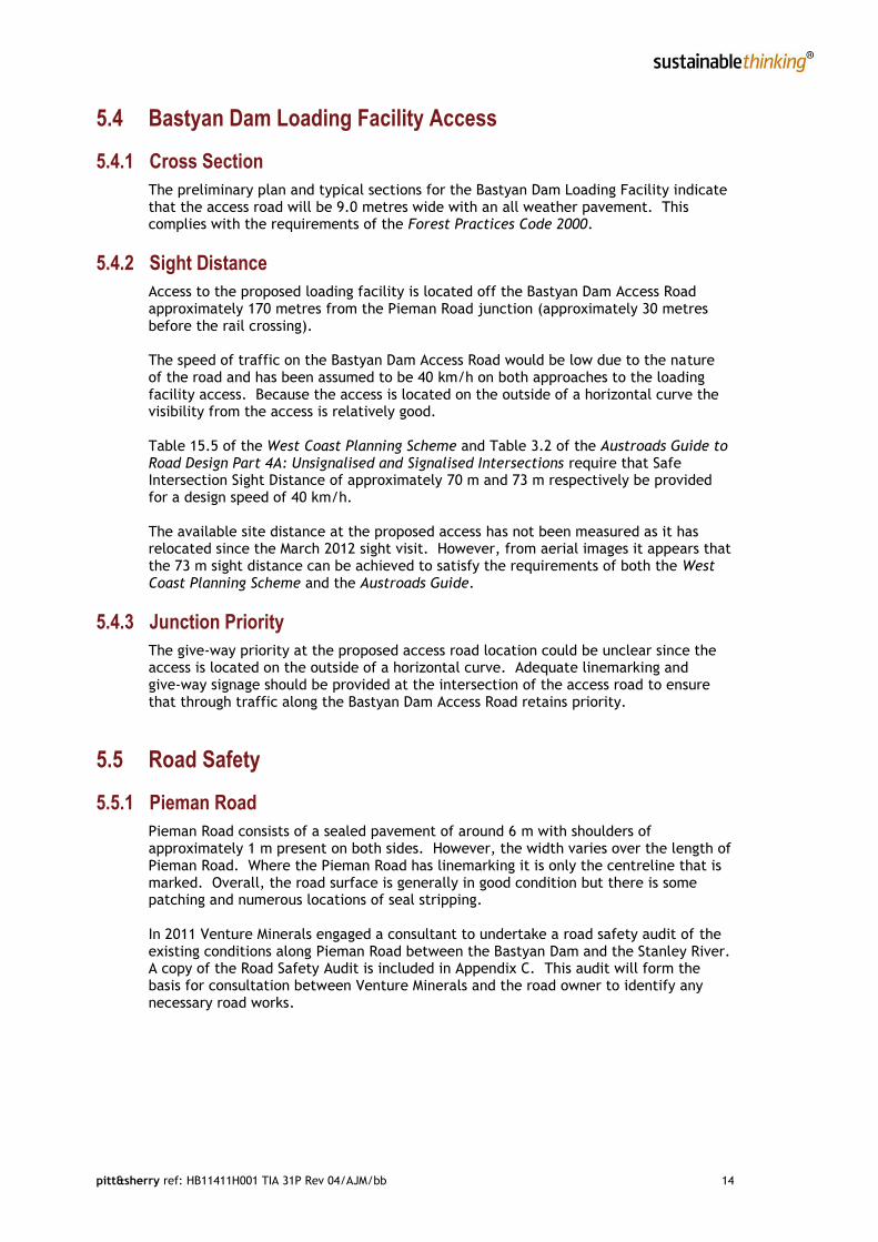
5.4 Bastyan Dam Loading Facility Access
5.4.1 Cross Section
The preliminary plan and typical sections for the Bastyan Dam Loading Facility indicate that the access road will be 9.0 metres wide with an all weather pavement. This complies with the requirements of the Forest Practices Code 2000.
5.4.2 Sight Distance
Access to the proposed loading facility is located off the Bastyan Dam Access Road approximately 170 metres from the Pieman Road junction (approximately 30 metres before the rail crossing). The speed of traffic on the Bastyan Dam Access Road would be low due to the nature of the road and has been assumed to be 40 km/h on both approaches to the loading facility access. Because the access is located on the outside of a horizontal curve the visibility from the access is relatively good. Table 15.5 of the West Coast Planning Scheme and Table 3.2 of the Austroads Guide to Road Design Part 4A: Unsignalised and Signalised Intersections require that Safe Intersection Sight Distance of approximately 70 m and 73 m respectively be provided for a design speed of 40 km/h. The available site distance at the proposed access has not been measured as it has relocated since the March 2012 sight visit. However, from aerial images it appears that the 73 m sight distance can be achieved to satisfy the requirements of both the West Coast Planning Scheme and the Austroads Guide.
5.4.3 Junction Priority
The give-way priority at the proposed access road location could be unclear since the access is located on the outside of a horizontal curve. Adequate linemarking and give-way signage should be provided at the intersection of the access road to ensure that through traffic along the Bastyan Dam Access Road retains priority.
5.5 Road Safety
5.5.1 Pieman Road
Pieman Road consists of a sealed pavement of around 6 m with shoulders of approximately 1 m present on both sides. However, the width varies over the length of Pieman Road. Where the Pieman Road has linemarking it is only the centreline that is marked. Overall, the road surface is generally in good condition but there is some patching and numerous locations of seal stripping. In 2011 Venture Minerals engaged a consultant to undertake a road safety audit of the existing conditions along Pieman Road between the Bastyan Dam and the Stanley River. A copy of the Road Safety Audit is included in Appendix C. This audit will form the basis for consultation between Venture Minerals and the road owner to identify any necessary road works.

pitt&sherry ref: HB11411H001 TIA 31P Rev 04/AJM/bb 15
The DIER Standards for Professional Services, T3 Road Design Standards indicates that the required cross section for a truck and dog vehicle combination operating on a Category 4 road would be 2.75 m lane width plus a 0.5 m shoulder. Pieman Road would generally meet the section requirements given by DIER. Using a combination of GIS analysis and on site measurement four curves have been identified that would benefit from minor widening or shoulder rehabilitation. These curves are located 3.2, 9.4, 17.2 & 17.4 km west of the Bastyan Dam Access Road. Due to terrain constraints it may not be practical to widen these curves. Further investigations should be undertaken to establish the practicality of undertaking curve widening. There are a number of overtaking opportunities (as indicated by the centreline marking) along Pieman Road between the mine site and the Bastyan Dam Access Road. The proposed traffic volumes on Pieman Road do not warrant the need for dedicated auxiliary lanes (such as overtaking lanes or slow vehicle turnout lanes). To this end, it is recommended that warning signage be erected along Pieman Road indicating that the road is predominantly used by heavy vehicles. Due to the terrain and climate in the area, it is anticipated that at times drizzle and fog will restrict the ability of drivers to detect a slow moving truck on the road in front of them. To account for this, it is recommended that trucks be fitted with warning lights so that in periods of poor visibility drivers will be able to identify a vehicle and adjust their travel speed accordingly. There may be issues in the event of a vehicle breakdown. It is recommended that a suitable action plan be written which allows for the normal operation of Pieman Road to resume as quickly as practicable in the event of a vehicle breakdown. Also, it is anticipated that Pieman Road will be subject to snow and ice events during winter which would impact on the safety of haulage operations and other road users. It was recommended in the DIER Transport Task Discussion Paper that an ice/snow event management plan be put in place. Whilst Pieman Road has a number of geometric elements which do not comply with the requirements of the Austroads Guide, due to the relatively low volumes of traffic that will be generated by the proposed Riley Mine the increased traffic on Pieman Road is not expected to cause a significant decrease in the safety performance of Pieman Road. During the final three months of operation at the Riley mine there may be B-double vehicles on the Pieman Road associated with cartage from the Mt Lindsay mine site. However, the need to upgrade the Pieman Road to accommodate these vehicles has not been considered as part of this report. It has been assumed that the traffic impact assessment for the Mt Lindsay mine will make comments and recommendations in relation to the requirements for accommodating B-doubles on Pieman Road. An alternative to the use of B-doubles at Mt Lindsay may be to use truck and dog trailer combinations, which would result in an increase in the number of vehicles required to cart the same volume of material from the site. However, even if there needs to be twice the number of vehicles carting material from the Mt Lindsay site the overall traffic volumes on the Pieman Road would still be in the order of 350 vpd.
5.5.2 Bastyan Dam Access Road
The Bastyan Dam Access Road consists of a sealed pavement. It should be ensured that the 170 m length of the Bastyan Dam Access Road between the loading site and Pieman Road has a cross section in accordance with the requirements set out in the DIER Standards for Professional Services, T3 Road Design Standards for a Category 4 road. That is, 2.75 m lane width plus a 0.5 m shoulder.
pitt&sherry ref: HB11411H001 TIA 31P Rev 04/AJM/bb 16
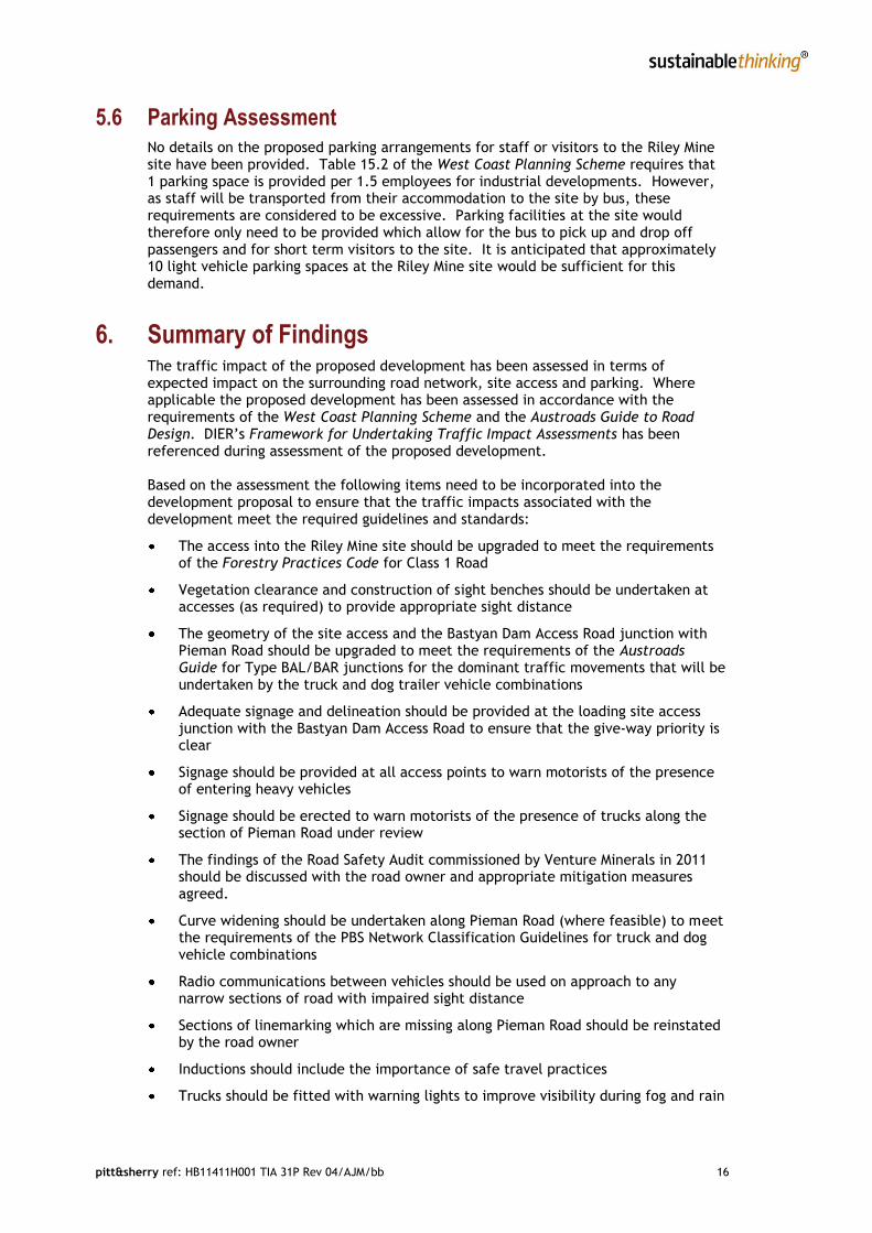
5.6 Parking Assessment No details on the proposed parking arrangements for staff or visitors to the Riley Mine site have been provided. Table 15.2 of the West Coast Planning Scheme requires that 1 parking space is provided per 1.5 employees for industrial developments. However, as staff will be transported from their accommodation to the site by bus, these requirements are considered to be excessive. Parking facilities at the site would therefore only need to be provided which allow for the bus to pick up and drop off passengers and for short term visitors to the site. It is anticipated that approximately 10 light vehicle parking spaces at the Riley Mine site would be sufficient for this demand.
6. Summary of Findings The traffic impact of the proposed development has been assessed in terms of expected impact on the surrounding road network, site access and parking. Where applicable the proposed development has been assessed in accordance with the requirements of the West Coast Planning Scheme and the Austroads Guide to Road Design. DIER’s Framework for Undertaking Traffic Impact Assessments has been referenced during assessment of the proposed development. Based on the assessment the following items need to be incorporated into the development proposal to ensure that the traffic impacts associated with the development meet the required guidelines and standards:
The access into the Riley Mine site should be upgraded to meet the requirements of the Forestry Practices Code for Class 1 Road
Vegetation clearance and construction of sight benches should be undertaken at accesses (as required) to provide appropriate sight distance
The geometry of the site access and the Bastyan Dam Access Road junction with Pieman Road should be upgraded to meet the requirements of the Austroads Guide for Type BAL/BAR junctions for the dominant traffic movements that will be undertaken by the truck and dog trailer vehicle combinations
Adequate signage and delineation should be provided at the loading site access junction with the Bastyan Dam Access Road to ensure that the give-way priority is clear
Signage should be provided at all access points to warn motorists of the presence of entering heavy vehicles
Signage should be erected to warn motorists of the presence of trucks along the section of Pieman Road under review
The findings of the Road Safety Audit commissioned by Venture Minerals in 2011 should be discussed with the road owner and appropriate mitigation measures agreed.
Curve widening should be undertaken along Pieman Road (where feasible) to meet the requirements of the PBS Network Classification Guidelines for truck and dog vehicle combinations
Radio communications between vehicles should be used on approach to any narrow sections of road with impaired sight distance
Sections of linemarking which are missing along Pieman Road should be reinstated by the road owner
Inductions should include the importance of safe travel practices
Trucks should be fitted with warning lights to improve visibility during fog and rain

pitt&sherry ref: HB11411H001 TIA 31P Rev 04/AJM/bb 17
A suitable management plan should be in place for vehicle breakdown events
A suitable management plan should be in place for ice/snow events
Approximately 10 light vehicle parking spaces should be provided at the Riley Mine site, as well as a designated area for the buses to pick up and drop off passengers.
Should the above items be incorporated into the development the traffic generated by the mine operations would not be expected to detrimentally impact on the safety or efficiency of Pieman Road. It should be noted that although it has been assumed that there would be B-doubles using Pieman Road during the last few months of the operation of the Riley mine site, the traffic impacts and road upgrading requirements associated with this type of vehicle would need to be addressed as part of the Mt Lindsay mine assessment.

pitt&sherry ref: HB11411H001 TIA 31P Rev 04/AJM/bb
Appendix A
Crash History

Department ofInfrastructure,Energy and Resources
cdmr0010/1.7
RIMS (Production)
Page 1 of 5
Crash History from 01/01/2007 to 15/03/2012
Report Details:
Parameters Used:
Request Id:Requested by:Date:
DIER Road Carriageway:DIER Road End Chainage:DIER Road Start Chainage:Dier Road Link:Dier Road No:End Date:End Time:Intersection Name:Intersection PointLGA:Light Condition:List Road:Locality:No Units:Non Road:Police Attended:Police District:Quality Assured:Radius (m):Recipient Name:
Recipient Type:Release Delay:Retired Road:Road Type:Show BAC:Show Graph:Show Map:Start Date:Start Time:Surface Condition:Surface Type:Visibility:Weekend:Crash Factor:DCA Ids:DCA Sub Ids:DCA Sub Sup Ids:Days Of Week:Driver Town:Entire State:
42123863R BEZZANT15/03/2012 14:57:27
15/03/201223:59
<spatial value>
Pieman RoadWest Coast
Ross
CDM0Y
NNY01/01/200700:00
N

Department ofInfrastructure,Energy and Resources
cdmr0010/1.7
RIMS (Production)
Page 2 of 5
Parameters Used:
Severity:Speed Zone:Toxicology:Traffic Control:Unit Type:

cdmr0010/1.7
Crash History from 01/01/2007 to 15/03/2012
RIMS (Production)
Requested by: R BEZZANT Date: 15/03/2012 14:57:27Request Id: 42123863 End Date: 15/03/2012 End Time: 23:59 Intersection Point <spatial value> List Road: Pieman Road Locality: West Coast Recipient Name: Ross Recipient Type: CDM Release Delay: 0 Retired Road: Y Show BAC: N Show Graph: N Show Map: Y Start Date: 01/01/2007 Start Time: 00:00 Entire State: NInformation contained in this document has been released in accordance with the Commonwealth Privacy Act 1988, Section 14.
CDM
Ross
Department ofInfrastructure,Energy and Resources
Page 3 of 5
1
1
1
Motorcycle
Motorcycle
Light Vehicle
Not controlled
Not controlled
Not controlled
30073553
30071764
30071823
10/01/2009 12:45 SAT
01/11/2009 15:45 SUN
02/05/2011 03:00 MON
Minor
Serious
Minor
184 - Out of control on carriageway
181 - Off right bend into object/parked vehicle
182 - Off carriageway left bend
Clear
Clear
Light rain, drizzle
Sealed
Unsealed
Sealed
Dry
Dry
Wet
Daylight
Daylight
Darkness (without street light)
100
100
100
Crash No Crash Date Time Severity Description VisibilitySurface Type
Surface Condition Light Condition
SpeedLimit
Unit No BAC*
Unit Type(s)
Traffic Control
Pieman Road, West Coast, West Coast (372258.99,5378594.85) Trips Ref N/APieman Road, West Coast, West Coast (362202.75,5380388.71) Trips Ref N/APieman Road, West Coast, West Coast (347236.05,5375796.31) Trips Ref N/A
Location

cdmr0010/1.7
Crash History from 01/01/2007 to 15/03/2012
RIMS (Production)
Requested by: R BEZZANT Date: 15/03/2012 14:57:27Request Id: 42123863 End Date: 15/03/2012 End Time: 23:59 Intersection Point <spatial value> List Road: Pieman Road Locality: West Coast Recipient Name: Ross Recipient Type: CDM Release Delay: 0 Retired Road: Y Show BAC: N Show Graph: N Show Map: Y Start Date: 01/01/2007 Start Time: 00:00 Entire State: NInformation contained in this document has been released in accordance with the Commonwealth Privacy Act 1988, Section 14.
CDM
Ross
Department ofInfrastructure,Energy and Resources
Page 4 of 5

cdmr0010/1.7
Crash History from 01/01/2007 to 15/03/2012
RIMS (Production)
Requested by: R BEZZANT Date: 15/03/2012 14:57:27Request Id: 42123863 End Date: 15/03/2012 End Time: 23:59 Intersection Point <spatial value> List Road: Pieman Road Locality: West Coast Recipient Name: Ross Recipient Type: CDM Release Delay: 0 Retired Road: Y Show BAC: N Show Graph: N Show Map: Y Start Date: 01/01/2007 Start Time: 00:00 Entire State: NInformation contained in this document has been released in accordance with the Commonwealth Privacy Act 1988, Section 14.
CDM
Ross
Department ofInfrastructure,Energy and Resources
Page 5 of 5
*****End of Report*****

pitt&sherry ref: HB11411H001 TIA 31P Rev 04/AJM/bb
Appendix B
Site Access Agreement Requirements

pitt&sherry ref: HB11411H001 App B 31P Rev 00/RM/rm

pitt&sherry ref: HB11411H001 App B 31P Rev 00/RM/rm

pitt&sherry ref: HB11411H001 TIA 31P Rev 04/AJM/bb
Appendix C
Pieman Road Existing Conditions Road Safety Audit

Venture Minerals
Report for Pieman River RoadExisting Conditions Road
Safety Audit
December 2011

32/16102/55819 Pieman River RoadExisting Conditions Road Safety Audit
This Road Safety Audit(“Report”):
1. has been prepared by GHD Pty Ltd (“GHD”) for Venture Minerals;
2. may only be used and relied on by Venture Minerals;
3. must not be copied to, used by, or relied on by any person other than Venture Mineralswithout the prior written consent of GHD;
4. may only be used for the purpose of identifying road safety deficiencies (and must notbe used for any other purpose).
GHD and its servants, employees and officers otherwise expressly disclaim responsibility to anyperson other than Venture Minerals arising from or in connection with this Report.
To the maximum extent permitted by law, all implied warranties and conditions in relation to theservices provided by GHD and the Report are excluded unless they are expressly stated toapply in this Report.
The services undertaken by GHD in connection with preparing this Report:
were limited to those specifically detailed in section 1 of this Report;
did not include pavement condition investigations.
Subject to the paragraphs in this section of the Report, the opinions, conclusions and anyrecommendations in this Report are based on conditions encountered and information reviewedat the time of preparation and may be relied on for 3 months, after which time GHD expresslydisclaims responsibility for any error in, or omission from, this Report arising from or inconnection with those opinions, conclusions and any recommendations.

32/16102/55819 Pieman River RoadExisting Conditions Road Safety Audit
Contents
1. Introduction 1
1.1 Audit Team 1
1.2 Audit Process 1
1.3 Background Information 1
2. Risk Assessment Criteria 3
2.1 Risk Assessment System 3
2.2 Treatment 5
3. Key Findings 6
4. Audit Statement 8
Table IndexTable 1 Crash Frequency 3Table 2 Crash Severity 4Table 3 Level of Risk 4Table 4 Treatment 5Table 5 Audit Findings 7
Figure IndexFigure 1-1 Study Location 2
AppendicesA Photos
132/16102/55819 Pieman River RoadExisting Conditions Road Safety Audit
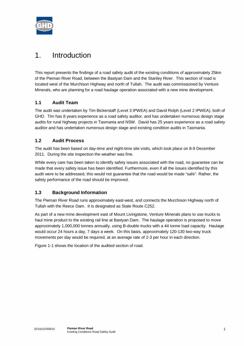
1. Introduction
This report presents the findings of a road safety audit of the existing conditions of approximately 25kmof the Pieman River Road, between the Bastyan Dam and the Stanley River. This section of road islocated west of the Murchison Highway and north of Tullah. The audit was commissioned by VentureMinerals, who are planning for a road haulage operation associated with a new mine development.
1.1 Audit TeamThe audit was undertaken by Tim Bickerstaff (Level 3 IPWEA) and David Rolph (Level 2 IPWEA), both ofGHD. Tim has 8 years experience as a road safety auditor, and has undertaken numerous design stageaudits for rural highway projects in Tasmania and NSW. David has 25 years experience as a road safetyauditor and has undertaken numerous design stage and existing condition audits in Tasmania.
1.2 Audit ProcessThe audit has been based on day-time and night-time site visits, which took place on 8-9 December2011. During the site inspection the weather was fine.
While every care has been taken to identify safety issues associated with the road, no guarantee can bemade that every safety issue has been identified. Furthermore, even if all the issues identified by thisaudit were to be addressed, this would not guarantee that the road would be made “safe”. Rather, thesafety performance of the road should be improved.
1.3 Background InformationThe Pieman River Road runs approximately east-west, and connects the Murchison Highway north ofTullah with the Reece Dam. It is designated as State Route C252.
As part of a new mine development east of Mount Livingstone, Venture Minerals plans to use trucks tohaul mine product to the existing rail line at Bastyan Dam. The haulage operation is proposed to moveapproximately 1,000,000 tonnes annually, using B-double trucks with a 44 tonne load capacity. Haulagewould occur 24 hours a day, 7 days a week. On this basis, approximately 120-130 two-way truckmovements per day would be required, at an average rate of 2-3 per hour in each direction.
Figure 1-1 shows the location of the audited section of road.

232/16102/55819 Pieman River RoadExisting Conditions Road Safety Audit
Figure 1-1 Study Location
Image referenced from DIPIPWE, www.thelist.tas.gov.au
332/16102/55819 Pieman River RoadExisting Conditions Road Safety Audit
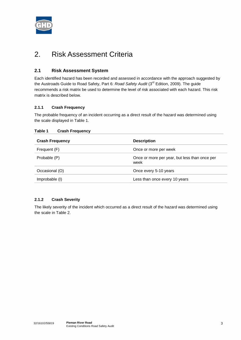
2. Risk Assessment Criteria
2.1 Risk Assessment SystemEach identified hazard has been recorded and assessed in accordance with the approach suggested bythe Austroads Guide to Road Safety, Part 6: Road Safety Audit (3rd Edition, 2009). The guiderecommends a risk matrix be used to determine the level of risk associated with each hazard. This riskmatrix is described below.
2.1.1 Crash Frequency
The probable frequency of an incident occurring as a direct result of the hazard was determined usingthe scale displayed in Table 1.
Table 1 Crash Frequency
Crash Frequency Description
Frequent (F) Once or more per week
Probable (P) Once or more per year, but less than once perweek
Occasional (O) Once every 5-10 years
Improbable (I) Less than once every 10 years
2.1.2 Crash Severity
The likely severity of the incident which occurred as a direct result of the hazard was determined usingthe scale in Table 2.

432/16102/55819 Pieman River RoadExisting Conditions Road Safety Audit
Table 2 Crash Severity
Severity Description Examples
Catastrophic (C) Likely multiple deaths -High-speed multi-vehicle crash on a freeway
-Car runs into crowded bus stop
-Bus and petrol tanker collide
-Collapse of a bridge or tunnel
Serious (S) Likely death orserious injury
-High or medium-speed vehicle/ vehicle collision.
-High or medium-speed collision with a fixed roadside object.
-Pedestrian struck at high speed.
-Cyclist is hit by a car
Minor (M) Likely minor injury -Some low-speed vehicle collisions.
-Cyclist falls from bicycle at low speed.
-Left-turn rear-end crash in a slip lane.
Limited (L) Likely trivial injury orproperty damage only
-Some low speed collisions.
-Pedestrian walks into object (no head injury).
-Car reverses into post.
2.1.3 Deemed Level of Risk
The Risk matrix in Table 3 was used to assess the level of risk for each hazard. The risk matrix uses theFrequency and Severity determined above to determine the likely level of risk for each hazard.
Table 3 Level of Risk
Frequent Probable Occasional Improbable
Catastrophic Intolerable Intolerable Intolerable High
Serious Intolerable Intolerable High Medium
Minor Intolerable High Medium Low
Limited High Medium Low Low

532/16102/55819 Pieman River RoadExisting Conditions Road Safety Audit
2.2 TreatmentEach hazard was then aligned with a suggested treatment, as outlined in Table 4.
Table 4 Treatment
Risk Suggested Treatment Approach
Intolerable Must be corrected
High Should be corrected or the risk significantlyreduced, even if the treatment cost is high.
Medium Should be corrected or the risk significantlyreduced, if the treatment cost is moderate, but nothigh.
Low Should be corrected or the risk reduced, if thetreatment cost is low.

632/16102/55819 Pieman River RoadExisting Conditions Road Safety Audit
3. Key Findings
In general, the audited section of road was found to be in good condition, with few safety concerns. Theaudited section of road winds through rugged terrain, with the alignment variously winding and steep.Driven at a speed appropriate to the standard of road the potential for a major accident is minimal.
The full list of identified issues, and their assessed level of risk, is provided in Table 5, overleaf.Common issues identified by the audit include:
Guard rail terminals built to a previous standard, which can pose a hazard if struck;
Guard rails not extending far enough to protect an errant vehicle from potential hazards;
Roadside vegetation obscuring guide posts and guard rails, reducing their visibility (especially atnight) and effectiveness;
Roadside vegetation obscuring hazards such as drainage culverts and drop-offs;
Inadequate delineation of curves at night, due to missing or poorly spaced guide posts;
Inadequate Safe Intersection Sight Distance and Approach Sight Distance at the intersection ofPieman River Road with Bastyan Dam Road.
Many of the high-risk hazards can be treated with relative ease through the improved placement of guideposts, and the clearing of vegetation from around them, or other maintenance activities.
In terms of the implications for a road haulage operation, one of the major hazards is the width of theroad pavement, at less than 6m, and the potential speed of vehicles. Two trucks passing at speed arelikely to affect each other’s handling and increase the potential for run-off road type crashes. This riskcould be addressed by engineering measures such as road shoulder widening, or operationalprocedures relating to vehicle speeds.

Table 5: Audit Findings
Pieman River Road - Existing Conditions Road Safety AuditDirection Chainage Description Frequency Severity Risk X Y PhotoEB 0 Stanley River Bridge 357745 5381566EB 0 Guard rail does not adequately protect run-off area Improbable Serious Medium 357745 5381566 1EB 0.8 Roadside drop-off Improbable Minor Low 358571 5381308EB 1.5 Sign is non-standard, which reduces its effectiveness Improbable Minor Low 359085 5380894EB 2 Exposed roadside culvert Improbable Minor Low 359548 5380584EB 2.3 Guard rail does not adequately protect run-off area Improbable Minor Low 359847 5380566EB 2.7 Damaged guard rail Improbable Minor Low 360185 5380393EB 2.9 Guard rail does not adequately protect run-off area Improbable Minor Low 360314 5380383EB 3.2 Non-standard departure terminal on guard rail Improbable Minor Low 360573 5380340EB 4.4 Roadside drop-off Improbable Minor Low n.a. n.a.EB 4.5 Guard rail does not adequately protect run-off area Improbable Minor Low 361805 5380009EB 4.6 Non-standard departure terminal on guard rail Improbable Minor Low 361873 5380088 2EB 4.7 Sudden change in road surface level Occasional Minor Medium n.a. n.a.EB 5.2 Guard rail does not adequately protect run-off area; approach terminal is non-standard Improbable Minor Low 362194 5380371EB 5.3 Non-standard departure terminal on guard rail Improbable Minor Low 362298 5380451EB 5.4 Trucks entering sign is non-standard Improbable Minor Low 362403 5380496EB 5.7 Roadside drop-off Improbable Minor Low n.a. n.a.EB 5.8 Gravel spilled onto road from access track, creating slip hazard Improbable Serious Medium 362658 5380677EB 6.6 Guard rail does not adequately protect run-off area; approach terminal is non-standard Improbable Minor Low 362977 5381396EB 6.7 Non-standard departure terminal on guard rail Improbable Minor Low 363011 5381464EB 7.3 Roadside drop-off on bend, after downhill grade Occasional Serious High 363603 5381366EB 7.6 Guard rail does not adequately protect run-off area Improbable Minor Low 363851 5381182EB 7.7 Non-standard departure terminal on guard rail Improbable Minor Low 363890 5381137EB 8 Fallen tree protruding into clear zone - spear hazard Improbable Serious Medium 364054 5381163EB 8.5 Guard rail stops short of table drain hazard Improbable Serious Medium 364236 5381657EB 8.7 Sudden change in road surface level Improbable Minor Low 364314 5381605EB 9.3 Non-standard approach terminal on guard rail Improbable Minor Low 364836 5381502EB 9.3 Non-standard departure terminal on guard rail Improbable Minor Low 364888 5381528EB 10.1 Rough surface Improbable Minor Low 365590 5381401EB 10.8 Roadside drop-off Improbable Serious Medium 366121 5381124EB 11 Roadside drop-off Improbable Serious Medium 366217 5381015EB 11.1 Guard rail does not adequately protect run-off area; approach terminal is non-standard Improbable Minor Low n.a. n.a.EB 11.5 Non-standard approach terminal on guard rail Improbable Minor Low 366525 5380514EB 11.7 Non-standard departure terminal on guard rail Improbable Minor Low 366603 5380348EB 12.4 Rough surface Improbable Minor Low n.a. n.a.EB 13.6 Rough surface Improbable Minor Low 367877 5379113EB 15.2 Fallen tree protruding into clear zone - spear hazard Improbable Minor Low 369462 5378770EB 15.6 Inadequate delineation of left-hand bend Occasional Serious High n.a. n.a.
G:\32\16102\Tech\Road Safety Audit\RSA Findings.xlsx Page 1 of 3 21/12/2011 3:11 PM

Pieman River Road - Existing Conditions Road Safety AuditDirection Chainage Description Frequency Severity Risk X Y PhotoEB 16.2 Curve advisory sign in poor condition and not reflecting Improbable Minor Low 370124 5378884 3EB 16.3 Guard rail does not adequately protect run-off area; vegetation obscures guard rail Occasional Minor Medium 370238 5378896 4EB 17.1 Exposed roadside culvert Improbable Serious Medium 370650 5378377EB 17.6 Roadside drop-off Improbable Minor Low 371063 5378540EB 17.9 Fallen tree protruding into clear zone - spear hazard Improbable Serious Medium 371354 5378453EB 18.5 Guard rail does not adequately protect run-off area Improbable Serious Medium 371953 5378568EB 18.6 Non-standard departure terminal on guard rail Improbable Minor Low 372046 5378565EB 18.7 Rough surface Improbable Minor Low 372136 5378533EB 20 Inadequate delineation of right-hand bend Occasional Serious High n.a. n.a.EB 20.2 Creek with no protection Improbable Serious Medium 373224 5379272EB 21.6 Guide post fallen over Improbable Minor Low 374574 5379391EB 21.7 Inadequate delineation of right-hand bend Occasional Serious High n.a. n.a.EB 22.3 Damaged guard rail Improbable Minor Low 375156 5379390EB 22.7 Guard rail does not adequately protect run-off area; departure terminal is non-standard Improbable Minor Low n.a. n.a.EB 23.5 Exposed roadside culvert Improbable Minor Low 376198 5378701EB 24.8 Roadside drop-off Improbable Minor Low 377362 5378835EB 24.9 Limited sight distance (SISD) at Bastyan Power Station road Improbable Serious Medium 377444 5378868EB 25.2 Limited sight distances (ASD and SISD) at Bastyan Dam road Occasional Serious High 377736 5378946 5EB 25.2 Bastyan Dam Road 377736 5378946WB 0 Bastyan Dam Road 377736 5378946WB 0 Inadequate delineation on approach to Bastyan Dam Road Occasional Serious High 377736 5378946WB 0.1 Guideposts not reflecting Improbable Serious Medium n.a. n.a.WB 0.4 Roadside drop-off on start of RH bend Improbable Minor Low 377319 5378807WB 1.4 Creek with no protection Improbable Minor Low 376283 5378709WB 1.7 Rough surface Improbable Minor Low 375971 5378679WB 2.9 No guideposts on left-hand side of road at embankment Improbable Serious Medium n.a. n.a.WB 3.7 Inadequate delineation of right-hand bend Occasional Serious High n.a. n.a.WB 5.3 Guide posts obscured by vegetation Improbable Minor Low n.a. n.a.WB 6.2 Roadside drop-off Improbable Minor Low 372291 5378652WB 6.5 Rough surface Improbable Minor Low n.a. n.a.WB 6.7 Roadside drop-off Improbable Serious Medium 371809 5378469WB 6.9 Roadside drop-off Improbable Minor Low 371602 5378423WB 7.2 Fallen tree protruding into clear zone - spear hazard Improbable Serious Medium 371373 5378424 6WB 7.6 Guard rail does not adequately protect run-off area Improbable Minor Low 370993 5378549WB 8.1 Rough surface Improbable Minor Low 370601 5378408WB 8.4 Inadequate delineation of right-hand bend Occasional Serious High n.a. n.a.WB 9.4 Inadequate delineation of left-hand bend Occasional Serious High n.a. n.a.WB 11.8 Roadside drop-off Improbable Minor Low 367681 5379181
G:\32\16102\Tech\Road Safety Audit\RSA Findings.xlsx Page 2 of 3 21/12/2011 3:11 PM

Pieman River Road - Existing Conditions Road Safety AuditDirection Chainage Description Frequency Severity Risk X Y PhotoWB 12.6 RHS Roadside drop-off Improbable Minor Low 367012 5379589WB 13 Roadside drop-off Improbable Serious Medium 366747 5379937WB 13.2 RHS Roadside drop-off Improbable Serious Medium 366632 5380209WB 14 Roadside drop-off Improbable Serious Medium 366275 5380888WB 14.1 Guard rail does not adequately protect run-off area Improbable Serious Medium 366275 5380888WB 14.3 Non-standard departure terminal on guard rail Improbable Minor Low 366157 5381072WB 14.3 Roadside drop-off Occasional Serious High 366122 5381108WB 14.4 Guard rail does not adequately protect run-off area Improbable Minor Low 366045 5381228WB 14.8 Guard rail does not adequately protect run-off area Improbable Minor Low 365754 5381388WB 14.9 Guard rail does not adequately protect run-off area Improbable Minor Low 365607 5381402WB 15.7 Roadside drop-off Improbable Serious Medium 364842 5381506WB 15.8 Non-standard departure terminal on guard rail Improbable Minor Low 364732 5381404WB 16 Guard rail does not adequately protect run-off area Improbable Minor Low n.a. n.a.WB 16.3 Guard rail does not adequately protect run-off area Improbable Minor Low 364462 5381524WB 16.6 Guard rail does not adequately protect run-off area Improbable Minor Low 364189 5381637WB 17 Guard rail does not adequately protect run-off area; approach terminal is non-standard Improbable Minor Low 364094 5381293WB 17.6 Guard rail does not adequately protect run-off area; approach terminal is non-standard Improbable Minor Low 363777 5381193WB 17.7 Non-standard departure terminal on guard rail Improbable Minor Low 363718 5381254WB 17.9 Guard rail does not adequately protect run-off area Improbable Minor Low 363465 5381376WB 18.4 Non-standard approach terminal on guard rail Improbable Minor Low 363015 5381469WB 18.4 Non-standard departure terminal on guard rail Improbable Minor Low 362981 5381413WB 18.7 Non-standard approach terminal on guard rail Improbable Minor Low 362991 5381211WB 18.8 Non-standard departure terminal on guard rail Improbable Minor Low 362945 5381036WB 19.2 Sign is non-standard, which reduces its effectiveness Improbable Minor Low 362744 5380777WB 19.4 Guard rail does not adequately protect run-off area Improbable Minor Low 362633 5380623WB 19.5 Non-standard departure terminal on guard rail Improbable Minor Low 362589 5380563WB 19.8 Guard rail does not adequately protect run-off area; approach terminal is non-standard Improbable Minor Low 362293 5380450WB 20 Non-standard departure terminal on guard rail Improbable Minor Low 362167 5380375WB 20.4 Guard rail on RHS of road does not protect a large drop-off Occasional Serious High 361854 5380084WB 20.7 Guard rail does not adequately protect run-off area Improbable Minor Low 361735 5379917WB 21.1 Guard rail does not adequately protect run-off area Improbable Serious Medium 361327 5380022WB 22.1 Guard rail does not adequately protect run-off area Improbable Minor Low 360427 5380349WB 22.2 Non-standard departure terminal on guard rail Improbable Minor Low 360343 5380353WB 23.2 Roadside drop-off Improbable Minor Low 359513 5380593WB 24.4 Roadside drop-off Improbable Serious Medium 358471 5381332WB 24.6 Roadside drop-off Improbable Minor Low 358319 5381411WB 24.9 Sign is non-standard, which reduces its effectiveness Improbable Minor Low 358008 5381597WB 25.2 Stanley River Bridge
G:\32\16102\Tech\Road Safety Audit\RSA Findings.xlsx Page 3 of 3 21/12/2011 3:11 PM


32/16102/55819 Pieman River RoadExisting Conditions Road Safety Audit
Appendix A
Photos

32/16102/55819 Pieman River RoadExisting Conditions Road Safety Audit
Photo 1 Guard Rail at Stanley River Bridge
Photo 2 Non-standard Departure Terminal on Guard Rail

32/16102/55819 Pieman River RoadExisting Conditions Road Safety Audit
Photo 3 Damaged Advisory Sign
Photo 4 Vegetation Obstructing Guard Rail

32/16102/55819 Pieman River RoadExisting Conditions Road Safety Audit
Photo 5 Bastyan Dam Road Intersection
Photo 6 Fallen Tree Spear Hazard


transport infrastructure | community infrastructure | industrial infrastructure | climate change
Incorporating
E: [email protected] www.pittsh.com.au incorporated as Pitt and Sherry (Operations) Pty Ltd ABN 67 140 184 309
Winner - Tasmanian Large
Business Sustainability Award 2011
Brisbane 2nd Floor 276 Edward Street Brisbane QLD 4000 T: (07) 3221 0080 F: (07) 3221 0083 Canberra 1st Floor 20 Franklin Street PO Box 4442 Manuka ACT 2603 T: (02) 6295 2100 F: (02) 6260 6555 Devonport 1st Floor 35 Oldaker Street PO Box 836 Devonport TAS 7310 T: (03) 6424 1641 F: (03) 6424 9215 Hobart GF, 199 Macquarie Street GPO Box 94 Hobart TAS 7001 T: (03) 6210 1400 F: (03) 6223 1299
Launceston 4th Floor 113 – 115 Cimitiere Street PO Box 1409 Launceston TAS 7250 T: (03) 6323 1900 F: (03) 6334 4651 Melbourne Level 1, HWT Tower 40 City Road, Southbank VIC 3006 PO Box 259 South Melbourne VIC 3205 T: (03) 9682 5290 F: (03) 9682 5292 Perth 3rd Floor 267 St Georges Terrace Perth WA 6000 T: (08) 9261 7775 F: (08) 9261 7700 Sydney 1st Floor 56 Clarence Street Sydney NSW 2000 T: (02) 8216 4700 F: (02) 8216 4747

See Appendix D for
Infrastructure drainage plan
Sediment basin
Example indicative
location of silt fences
Sediment basin
Ponded water collected at topographic low points
during mining pumped to sediment basin
Ponded water collected at topographic low points
during mining pumped to sediment basin
Buffer zone between mining topographic low points and
the Riley Creek channel proper (see section 3.4.5)
Upstream from this point Riley
Creek is no longer a continuous
well defined channel (see
section 3.4.5)
Natural watercourse buffers
maintained