table of content backwater km from km to name th k th...
TRANSCRIPT

Administration of the Navigable Canals - Atlas of Berth Page 1
Table of Content
backwater km from km to name
len
gth
wid
th
rive
r b
ank
loca
tio
n
con
stru
ctio
n
con
dit
ion
Danube Black Sea Canal
58.88 59.68 Mooring place for entrance into Cernavoda Lock
800 150 L DL DO 0
Danube Black Sea Canal
0.89 1.29 Mooring place for entrance into Agigea Lock
400 150 R DL DO 0
Danube Black Sea Canal
0.89 1.29 Mooring place for entrance into Agigea Lock
400 150 L DL DO 0
Danube Black Sea Canal
2.13 2.93 Mooring place for entrance into Agigea Lock
800 150 R UL QW 0
Danube Black Sea Canal
37.78 38.44 Mooring place for entrance into Medgidia port
650 120 R OTH DO 0
Danube Black Sea Canal
2.13 2.93 Mooring place for entrance into Agigea Lock
800 150 L UL QW 0
Danube Black Sea Canal
60.52 61.32 Mooring place for entrance into Cernavoda Lock
800 150 R UL DO 0
Poarta Alba Midia Navodari Canal
1.7 1.85 Mooring place for entrance into Navodari Lock
145 90-150
L DL DO 0
Poarta Alba Midia Navodari Canal
1.7 1.85 Mooring place for entrance into Navodari Lock
145 90 - 150
R DL DO 0
Poarta Alba Midia Navodari Canal
2.4 2.69 Mooring place for entrance into Navodari Lock
290 90-150
R UL DO 0
Poarta Alba Midia Navodari Canal
12.43 12.72 Mooring place for entrance into Ovidiu Lock
290 90 L UL QW 0
Poarta Alba Midia Navodari Canal
12.43 12.72 Mooring place for entrance into Ovidiu Lock
290 90 R UL QW 0
Danube Black Sea Canal
59.28 59.68 Mooring place for entrance into Cernavoda Lock
400 150 R DPP DO 0
Poarta Alba Midia Navodari Canal
11.75 12.04 Mooring place for entrance into Ovidiu Lock
290 90 L DL QW 0
Poarta Alba Midia Navodari
11.8 12.04 Mooring place for entrance into Ovidiu Lock
240 90 R DL QW 0

Administration of the Navigable Canals - Atlas of Berth Page 2
Canal Danube Black Sea Canal
29.71 30.01 Mooring place for entrance into Poarta Alba Midia Navodari Canal
300 160 L OTH QW 0
Danube Black Sea Canal
36.91 37.31 Mooring place for entrance into Medgidia port
400 120 R OTH DO 0
Danube Black Sea Canal
25.08 25.46 Mooring place for entrance into Murfatlar port
375 150 R OTH DO 0
Danube Black Sea Canal
60.52 61.22 Mooring place for entrance into Cernavoda Lock
700 150 L UL DO 0

Administration of the Navigable Canals - Atlas of Berth Page 3
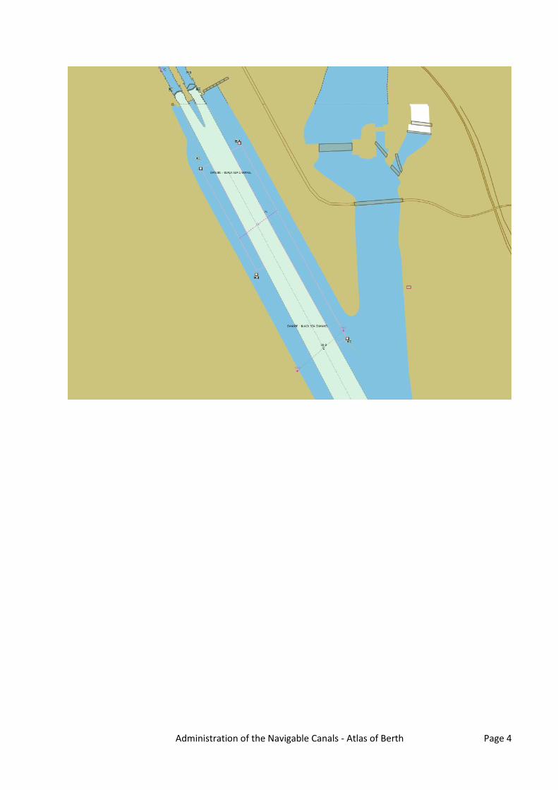
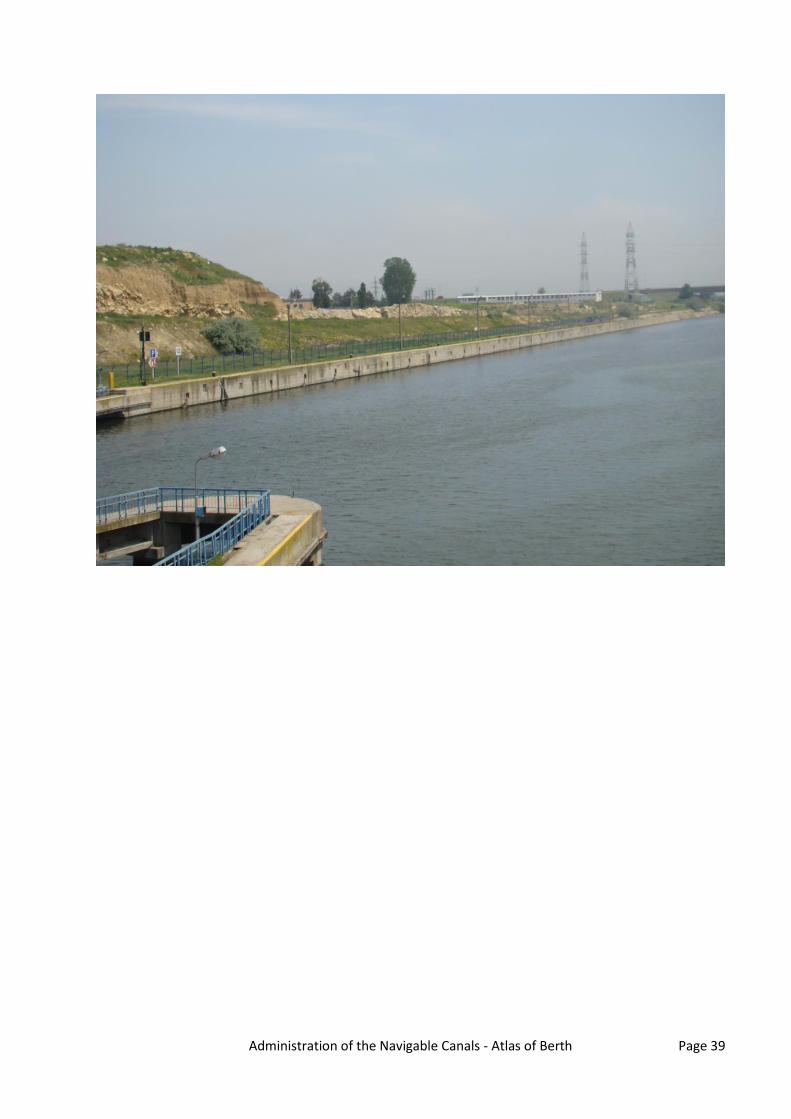
Mooring place for entrance into Cernavoda Lock
Danube km: 58.88 - 59.68 GPS coordinates: North: 44° 18' 28.64" East: 28° 3' 1.44" berths information length: 800 m river bank ☒ L left river bank ☐ R right river bank ☐ T at the dam location ☐ DPP "downstream" side of a power plant ☒ DL "downstream" side of o lock (lock
entrance area) ☐ UL "upstream" side of o lock (lock entrance
area) ☐ UPP "upstream" side of a power plant ☐ ARS along the river stretch ☐ OTH others (before a harbour entrance in an
old river branch)
river bank construction ☐ sheet pile wall ☐ embankment (slope) ☐ quay walls ☐ dam ☒ dolphins ☐ pontoon ☐ natural (wild) specimen widths ☐ 1 beam ☐ 2 beams ☐ 3 beams ☒ 150
local berths conditions ☒ 0 berthing permitted (i.e. anchoring or
making fast to the bank) ☐ 1 berthing area reserved for pushing-
navigation vessels that are required to carry one blue cone
☐ 2 berthing area reserved for pushing-navigation vessels that are required to carry two blue cones
☐ 3 berthing area reserved for pushing-navigation vessels that are required to carry three blue cones
☐ OTH other restrictions (only for small motor crafts, only for border control, only for damaged vessels after an accident, max. time allowed for berthing, ...)
connections ports/harbours in the surrounding area ☒ < 5 km Cernavoda villages, cities in the surrounding area ☒ < 5 km Cernavoda access road ☒ yes ☐ no
facilities stairs to go ashore ☒ yes ☐ no possibility to load and unload cars from a vessel ☐ yes ☒ no lightning ☒ yes ☐ no
maintenance and disposal facilities electricity supply ☐ yes ☒ no fresh water supply ☐ yes ☒ no waste disposal ☐ yes ☒ no petrol station ☐ yes ☒ no safety in case of flood or storm ☒ yes ☐ no Parking fees/costs ☒ yes ☐ no
Administration of the Navigable Canals - Atlas of Berth Page 4

Administration of the Navigable Canals - Atlas of Berth Page 5

Administration of the Navigable Canals - Atlas of Berth Page 6
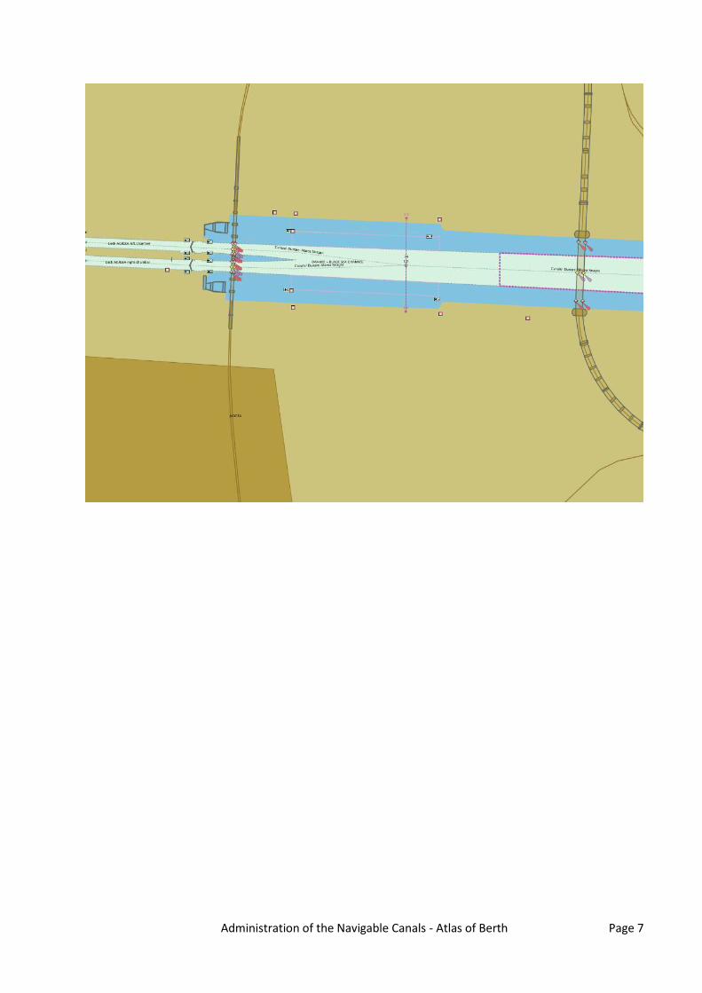
Mooring place for entrance into Agigea Lock
Danube km: 0.89 - 1.29 GPS coordinates: North: 44° 5' 58" East: 28° 37' 39.7" berths information length: 400 m river bank ☐ L left river bank ☒ R right river bank ☐ T at the dam location ☐ DPP "downstream" side of a power plant ☒ DL "downstream" side of o lock (lock
entrance area) ☐ UL "upstream" side of o lock (lock entrance
area) ☐ UPP "upstream" side of a power plant ☐ ARS along the river stretch ☐ OTH others (before a harbour entrance in an
old river branch)
river bank construction ☐ sheet pile wall ☐ embankment (slope) ☐ quay walls ☐ dam ☒ dolphins ☐ pontoon ☐ natural (wild) specimen widths ☐ 1 beam ☐ 2 beams ☐ 3 beams ☒ 150
local berths conditions ☒ 0 berthing permitted (i.e. anchoring or
making fast to the bank) ☐ 1 berthing area reserved for pushing-
navigation vessels that are required to carry one blue cone
☐ 2 berthing area reserved for pushing-navigation vessels that are required to carry two blue cones
☐ 3 berthing area reserved for pushing-navigation vessels that are required to carry three blue cones
☐ OTH other restrictions (only for small motor crafts, only for border control, only for damaged vessels after an accident, max. time allowed for berthing, ...)
connections ports/harbours in the surrounding area ☒ < 5 km Constanta Port villages, cities in the surrounding area ☒ < 5 km Agigea ☒ < 10 km Constantza access road ☒ yes ☐ no
facilities stairs to go ashore ☒ yes ☐ no possibility to load and unload cars from a vessel ☐ yes ☒ no lightning ☒ yes ☐ no
maintenance and disposal facilities electricity supply ☐ yes ☒ no fresh water supply ☐ yes ☒ no waste disposal ☐ yes ☒ no petrol station ☐ yes ☒ no safety in case of flood or storm ☒ yes ☐ no Parking fees/costs ☒ yes ☐ no
Administration of the Navigable Canals - Atlas of Berth Page 7

Administration of the Navigable Canals - Atlas of Berth Page 8

Administration of the Navigable Canals - Atlas of Berth Page 9
Mooring place for entrance into Agigea Lock
Danube km: 0.89 - 1.29 GPS coordinates: North: 44° 6' 2.86" East: 28° 37' 40" berths information length: 400 m river bank ☒ L left river bank ☐ R right river bank ☐ T at the dam location ☐ DPP "downstream" side of a power plant ☒ DL "downstream" side of o lock (lock
entrance area) ☐ UL "upstream" side of o lock (lock entrance
area) ☐ UPP "upstream" side of a power plant ☐ ARS along the river stretch ☐ OTH others (before a harbour entrance in an
old river branch)
river bank construction ☐ sheet pile wall ☐ embankment (slope) ☐ quay walls ☐ dam ☒ dolphins ☐ pontoon ☐ natural (wild) specimen widths ☐ 1 beam ☐ 2 beams ☐ 3 beams ☒ 150
local berths conditions ☒ 0 berthing permitted (i.e. anchoring or
making fast to the bank) ☐ 1 berthing area reserved for pushing-
navigation vessels that are required to carry one blue cone
☐ 2 berthing area reserved for pushing-navigation vessels that are required to carry two blue cones
☐ 3 berthing area reserved for pushing-navigation vessels that are required to carry three blue cones
☐ OTH other restrictions (only for small motor crafts, only for border control, only for damaged vessels after an accident, max. time allowed for berthing, ...)
connections ports/harbours in the surrounding area ☒ < 5 km Constanta Port villages, cities in the surrounding area ☒ < 10 km Constanta ☒ < 5 km Agigea access road ☒ yes ☐ no
facilities stairs to go ashore ☒ yes ☐ no possibility to load and unload cars from a vessel ☐ yes ☒ no lightning ☒ yes ☐ no
maintenance and disposal facilities electricity supply ☐ yes ☒ no fresh water supply ☐ yes ☒ no waste disposal ☐ yes ☒ no petrol station ☐ yes ☒ no safety in case of flood or storm ☒ yes ☐ no Parking fees/costs ☒ yes ☐ no

Administration of the Navigable Canals - Atlas of Berth Page 10

Administration of the Navigable Canals - Atlas of Berth Page 11
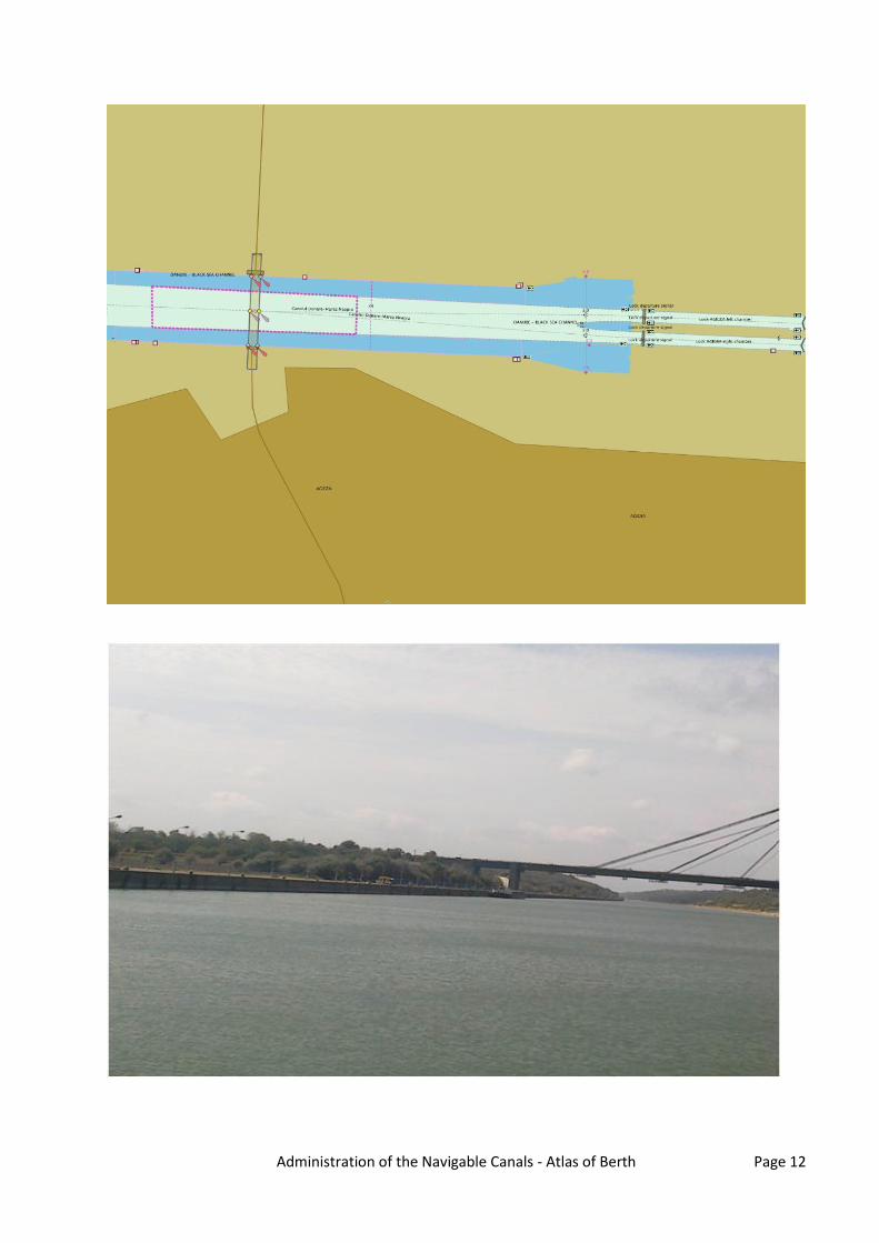
Mooring place for entrance into Agigea Lock
Danube km: 2.13 - 2.93 GPS coordinates: North: 44° 5' 59.67" East: 28° 36' 47.51" berths information length: 800 m river bank ☐ L left river bank ☒ R right river bank ☐ T at the dam location ☐ DPP "downstream" side of a power plant ☐ DL "downstream" side of o lock (lock
entrance area) ☒ UL "upstream" side of o lock (lock entrance
area) ☐ UPP "upstream" side of a power plant ☐ ARS along the river stretch ☐ OTH others (before a harbour entrance in an
old river branch)
river bank construction ☐ sheet pile wall ☐ embankment (slope) ☒ quay walls ☐ dam ☐ dolphins ☐ pontoon ☐ natural (wild) specimen widths ☐ 1 beam ☐ 2 beams ☐ 3 beams ☒ 150
local berths conditions ☒ 0 berthing permitted (i.e. anchoring or
making fast to the bank) ☐ 1 berthing area reserved for pushing-
navigation vessels that are required to carry one blue cone
☐ 2 berthing area reserved for pushing-navigation vessels that are required to carry two blue cones
☐ 3 berthing area reserved for pushing-navigation vessels that are required to carry three blue cones
☐ OTH other restrictions (only for small motor crafts, only for border control, only for damaged vessels after an accident, max. time allowed for berthing, ...)
connections ports/harbours in the surrounding area ☒ < 5 km Constanta Port villages, cities in the surrounding area ☒ < 5 km Agigea ☒ < 10 km Constanta access road ☒ yes ☐ no
facilities stairs to go ashore ☒ yes ☐ no possibility to load and unload cars from a vessel ☒ yes ☐ no lightning ☒ yes ☐ no
maintenance and disposal facilities electricity supply ☒ yes ☐ no fresh water supply ☒ yes ☐ no waste disposal ☐ yes ☒ no petrol station ☐ yes ☒ no safety in case of flood or storm ☒ yes ☐ no Parking fees/costs ☒ yes ☐ no
Administration of the Navigable Canals - Atlas of Berth Page 12

Administration of the Navigable Canals - Atlas of Berth Page 13
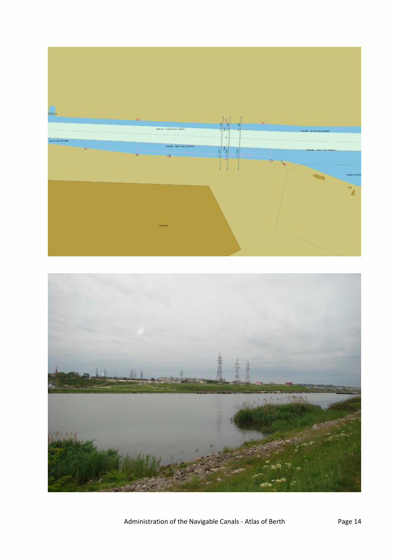
Mooring place for entrance into Medgidia port
Danube km: 37.78 - 38.44 GPS coordinates: North: 44° 14' 54.57" East: 28° 17' 24.45" berths information length: 650 m river bank ☐ L left river bank ☒ R right river bank ☐ T at the dam location ☐ DPP "downstream" side of a power plant ☐ DL "downstream" side of o lock (lock
entrance area) ☐ UL "upstream" side of o lock (lock entrance
area) ☐ UPP "upstream" side of a power plant ☐ ARS along the river stretch ☒ OTH others (before a harbour entrance in an
old river branch)
river bank construction ☐ sheet pile wall ☐ embankment (slope) ☐ quay walls ☐ dam ☒ dolphins ☐ pontoon ☐ natural (wild) specimen widths ☐ 1 beam ☐ 2 beams ☐ 3 beams ☒ 120
local berths conditions ☒ 0 berthing permitted (i.e. anchoring or
making fast to the bank) ☐ 1 berthing area reserved for pushing-
navigation vessels that are required to carry one blue cone
☐ 2 berthing area reserved for pushing-navigation vessels that are required to carry two blue cones
☐ 3 berthing area reserved for pushing-navigation vessels that are required to carry three blue cones
☐ OTH other restrictions (only for small motor crafts, only for border control, only for damaged vessels after an accident, max. time allowed for berthing, ...)
connections ports/harbours in the surrounding area ☒ < 5 km Medgidia villages, cities in the surrounding area ☒ < 5 km Medgidia access road ☒ yes ☐ no
facilities stairs to go ashore ☒ yes ☐ no possibility to load and unload cars from a vessel ☐ yes ☒ no lightning ☐ yes ☒ no
maintenance and disposal facilities electricity supply ☐ yes ☒ no fresh water supply ☐ yes ☒ no waste disposal ☐ yes ☒ no petrol station ☐ yes ☒ no safety in case of flood or storm ☒ yes ☐ no Parking fees/costs ☒ yes ☐ no
Administration of the Navigable Canals - Atlas of Berth Page 14

Administration of the Navigable Canals - Atlas of Berth Page 15
Mooring place for entrance into Agigea Lock
Danube km: 2.13 - 2.93 GPS coordinates: North: 44° 6' 4.88" East: 28° 36' 36.03" berths information length: 800 m river bank ☒ L left river bank ☐ R right river bank ☐ T at the dam location ☐ DPP "downstream" side of a power plant ☐ DL "downstream" side of o lock (lock
entrance area) ☒ UL "upstream" side of o lock (lock entrance
area) ☐ UPP "upstream" side of a power plant ☐ ARS along the river stretch ☐ OTH others (before a harbour entrance in an
old river branch)
river bank construction ☐ sheet pile wall ☐ embankment (slope) ☒ quay walls ☐ dam ☐ dolphins ☐ pontoon ☐ natural (wild) specimen widths ☐ 1 beam ☐ 2 beams ☐ 3 beams ☒ 150
local berths conditions ☒ 0 berthing permitted (i.e. anchoring or
making fast to the bank) ☐ 1 berthing area reserved for pushing-
navigation vessels that are required to carry one blue cone
☐ 2 berthing area reserved for pushing-navigation vessels that are required to carry two blue cones
☐ 3 berthing area reserved for pushing-navigation vessels that are required to carry three blue cones
☐ OTH other restrictions (only for small motor crafts, only for border control, only for damaged vessels after an accident, max. time allowed for berthing, ...)
connections ports/harbours in the surrounding area ☒ < 5 km Constanta villages, cities in the surrounding area ☒ < 5 km Agigea ☒ < 10 km Constanta access road ☒ yes ☐ no
facilities stairs to go ashore ☒ yes ☐ no possibility to load and unload cars from a vessel ☒ yes ☐ no lightning ☒ yes ☐ no
maintenance and disposal facilities electricity supply ☐ yes ☒ no fresh water supply ☐ yes ☒ no waste disposal ☐ yes ☒ no petrol station ☐ yes ☒ no safety in case of flood or storm ☒ yes ☐ no Parking fees/costs ☒ yes ☐ no

Administration of the Navigable Canals - Atlas of Berth Page 16

Administration of the Navigable Canals - Atlas of Berth Page 17
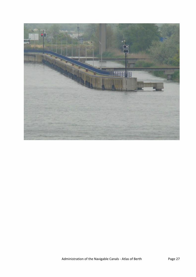
Mooring place for entrance into Cernavoda Lock
Danube km: 60.52 - 61.32 GPS coordinates: North: 44° 19' 11.54" East: 28° 2' 20.85" berths information length: 800 m river bank ☐ L left river bank ☒ R right river bank ☐ T at the dam location ☐ DPP "downstream" side of a power plant ☐ DL "downstream" side of o lock (lock
entrance area) ☒ UL "upstream" side of o lock (lock entrance
area) ☐ UPP "upstream" side of a power plant ☐ ARS along the river stretch ☐ OTH others (before a harbour entrance in an
old river branch)
river bank construction ☐ sheet pile wall ☐ embankment (slope) ☐ quay walls ☐ dam ☒ dolphins ☐ pontoon ☐ natural (wild) specimen widths ☐ 1 beam ☐ 2 beams ☐ 3 beams ☒ 150
local berths conditions ☒ 0 berthing permitted (i.e. anchoring or
making fast to the bank) ☐ 1 berthing area reserved for pushing-
navigation vessels that are required to carry one blue cone
☐ 2 berthing area reserved for pushing-navigation vessels that are required to carry two blue cones
☐ 3 berthing area reserved for pushing-navigation vessels that are required to carry three blue cones
☐ OTH other restrictions (only for small motor crafts, only for border control, only for damaged vessels after an accident, max. time allowed for berthing, ...)
connections ports/harbours in the surrounding area ☒ < 5 km Cernavoda villages, cities in the surrounding area ☒ < 5 km Cernavoda access road ☒ yes ☐ no
facilities stairs to go ashore ☒ yes ☐ no possibility to load and unload cars from a vessel ☐ yes ☒ no lightning ☒ yes ☐ no
maintenance and disposal facilities electricity supply ☐ yes ☒ no fresh water supply ☐ yes ☒ no waste disposal ☐ yes ☒ no petrol station ☐ yes ☒ no safety in case of flood or storm ☒ yes ☐ no Parking fees/costs ☒ yes ☐ no

Administration of the Navigable Canals - Atlas of Berth Page 18

Administration of the Navigable Canals - Atlas of Berth Page 19
Mooring place for entrance into Navodari Lock
Danube km: 1.7 - 1.85 GPS coordinates: North: 44° 19' 27.65" East: 28° 37' 37.87" berths information length: 145 m river bank ☒ L left river bank ☐ R right river bank ☐ T at the dam location ☐ DPP "downstream" side of a power plant ☒ DL "downstream" side of o lock (lock
entrance area) ☐ UL "upstream" side of o lock (lock entrance
area) ☐ UPP "upstream" side of a power plant ☐ ARS along the river stretch ☐ OTH others (before a harbour entrance in an
old river branch)
river bank construction ☐ sheet pile wall ☐ embankment (slope) ☐ quay walls ☐ dam ☒ dolphins ☐ pontoon ☐ natural (wild) specimen widths ☐ 1 beam ☐ 2 beams ☐ 3 beams ☒ 90-150
local berths conditions ☒ 0 berthing permitted (i.e. anchoring or
making fast to the bank) ☐ 1 berthing area reserved for pushing-
navigation vessels that are required to carry one blue cone
☐ 2 berthing area reserved for pushing-navigation vessels that are required to carry two blue cones
☐ 3 berthing area reserved for pushing-navigation vessels that are required to carry three blue cones
☐ OTH other restrictions (only for small motor crafts, only for border control, only for damaged vessels after an accident, max. time allowed for berthing, ...)
connections ports/harbours in the surrounding area ☒ < 5 km MIDIA Port villages, cities in the surrounding area ☒ < 5 km Navodari access road ☒ yes ☐ no
facilities stairs to go ashore ☒ yes ☐ no possibility to load and unload cars from a vessel ☐ yes ☒ no lightning ☒ yes ☐ no
maintenance and disposal facilities electricity supply ☐ yes ☒ no fresh water supply ☐ yes ☒ no waste disposal ☐ yes ☒ no petrol station ☐ yes ☒ no safety in case of flood or storm ☒ yes ☐ no Parking fees/costs ☒ yes ☐ no

Administration of the Navigable Canals - Atlas of Berth Page 20

Administration of the Navigable Canals - Atlas of Berth Page 21

Administration of the Navigable Canals - Atlas of Berth Page 22
Mooring place for entrance into Navodari Lock
Danube km: 1.7 - 1.85 GPS coordinates: North: 44° 19' 24.74" East: 28° 37' 40.5" berths information length: 145 m river bank ☐ L left river bank ☒ R right river bank ☐ T at the dam location ☐ DPP "downstream" side of a power plant ☒ DL "downstream" side of o lock (lock
entrance area) ☐ UL "upstream" side of o lock (lock entrance
area) ☐ UPP "upstream" side of a power plant ☐ ARS along the river stretch ☐ OTH others (before a harbour entrance in an
old river branch)
river bank construction ☐ sheet pile wall ☐ embankment (slope) ☐ quay walls ☐ dam ☒ dolphins ☐ pontoon ☐ natural (wild) specimen widths ☐ 1 beam ☐ 2 beams ☐ 3 beams ☒ 90 - 150
local berths conditions ☒ 0 berthing permitted (i.e. anchoring or
making fast to the bank) ☐ 1 berthing area reserved for pushing-
navigation vessels that are required to carry one blue cone
☐ 2 berthing area reserved for pushing-navigation vessels that are required to carry two blue cones
☐ 3 berthing area reserved for pushing-navigation vessels that are required to carry three blue cones
☐ OTH other restrictions (only for small motor crafts, only for border control, only for damaged vessels after an accident, max. time allowed for berthing, ...)
connections ports/harbours in the surrounding area ☒ < 5 km MIDIA Port villages, cities in the surrounding area ☒ < 5 km Navodari access road ☒ yes ☐ no
facilities stairs to go ashore ☒ yes ☐ no possibility to load and unload cars from a vessel ☐ yes ☒ no lightning ☒ yes ☐ no
maintenance and disposal facilities electricity supply ☐ yes ☒ no fresh water supply ☐ yes ☒ no waste disposal ☐ yes ☒ no petrol station ☐ yes ☒ no safety in case of flood or storm ☒ yes ☐ no Parking fees/costs ☒ yes ☐ no

Administration of the Navigable Canals - Atlas of Berth Page 23

Administration of the Navigable Canals - Atlas of Berth Page 24

Administration of the Navigable Canals - Atlas of Berth Page 25
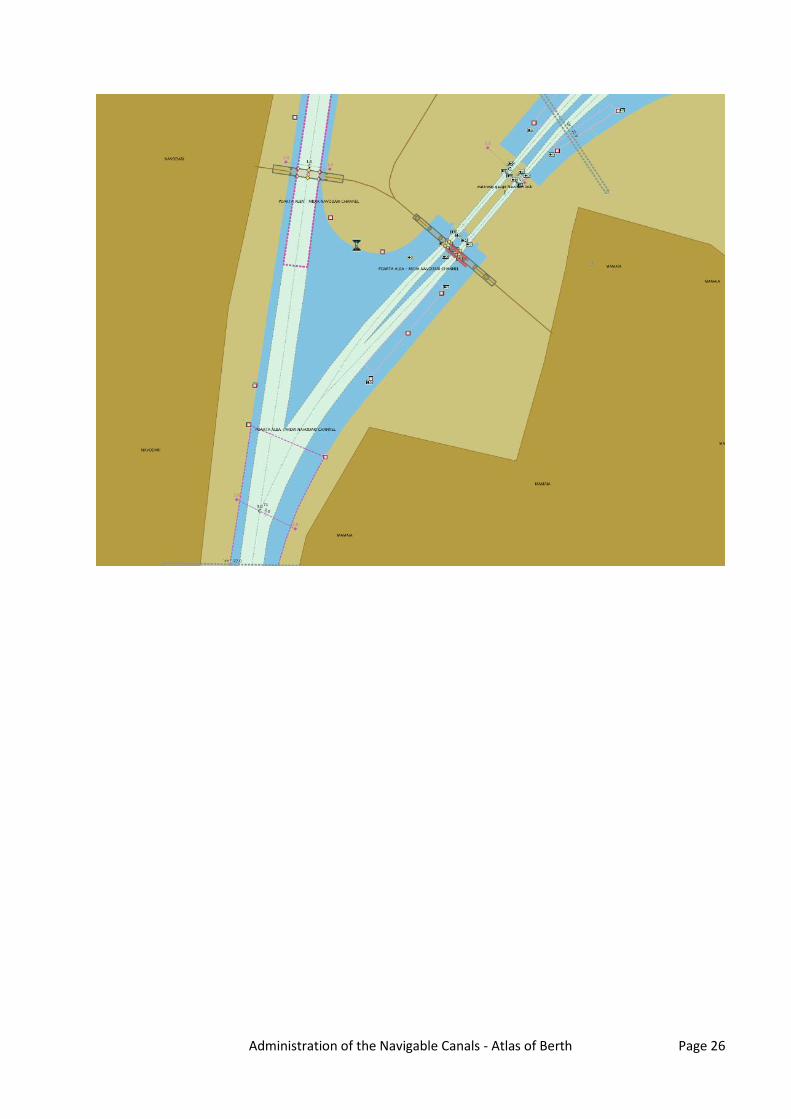
Mooring place for entrance into Navodari Lock
Danube km: 2.4 - 2.69 GPS coordinates: North: 44° 19' 10.43" East: 28° 37' 23.04" berths information length: 290 m river bank ☐ L left river bank ☒ R right river bank ☐ T at the dam location ☐ DPP "downstream" side of a power plant ☐ DL "downstream" side of o lock (lock
entrance area) ☒ UL "upstream" side of o lock (lock entrance
area) ☐ UPP "upstream" side of a power plant ☐ ARS along the river stretch ☐ OTH others (before a harbour entrance in an
old river branch)
river bank construction ☐ sheet pile wall ☐ embankment (slope) ☐ quay walls ☐ dam ☒ dolphins ☐ pontoon ☐ natural (wild) specimen widths ☐ 1 beam ☐ 2 beams ☐ 3 beams ☒ 90-150
local berths conditions ☒ 0 berthing permitted (i.e. anchoring or
making fast to the bank) ☐ 1 berthing area reserved for pushing-
navigation vessels that are required to carry one blue cone
☐ 2 berthing area reserved for pushing-navigation vessels that are required to carry two blue cones
☐ 3 berthing area reserved for pushing-navigation vessels that are required to carry three blue cones
☐ OTH other restrictions (only for small motor crafts, only for border control, only for damaged vessels after an accident, max. time allowed for berthing, ...)
connections ports/harbours in the surrounding area ☒ < 5 km MIDIA Port villages, cities in the surrounding area ☒ < 5 km Navodari access road ☒ yes ☐ no
facilities stairs to go ashore ☒ yes ☐ no possibility to load and unload cars from a vessel ☐ yes ☒ no lightning ☒ yes ☐ no
maintenance and disposal facilities electricity supply ☐ yes ☒ no fresh water supply ☐ yes ☒ no waste disposal ☐ yes ☒ no petrol station ☐ yes ☒ no safety in case of flood or storm ☒ yes ☐ no Parking fees/costs ☒ yes ☐ no
Administration of the Navigable Canals - Atlas of Berth Page 26
Administration of the Navigable Canals - Atlas of Berth Page 27

Administration of the Navigable Canals - Atlas of Berth Page 28
Mooring place for entrance into Ovidiu Lock
Danube km: 12.43 - 12.72 GPS coordinates: North: 44° 16' 20.89" East: 28° 32' 28.69" berths information length: 290 m river bank ☒ L left river bank ☐ R right river bank ☐ T at the dam location ☐ DPP "downstream" side of a power plant ☐ DL "downstream" side of o lock (lock
entrance area) ☒ UL "upstream" side of o lock (lock entrance
area) ☐ UPP "upstream" side of a power plant ☐ ARS along the river stretch ☐ OTH others (before a harbour entrance in an
old river branch)
river bank construction ☐ sheet pile wall ☐ embankment (slope) ☒ quay walls ☐ dam ☐ dolphins ☐ pontoon ☐ natural (wild) specimen widths ☐ 1 beam ☐ 2 beams ☐ 3 beams ☒ 90
local berths conditions ☒ 0 berthing permitted (i.e. anchoring or
making fast to the bank) ☐ 1 berthing area reserved for pushing-
navigation vessels that are required to carry one blue cone
☐ 2 berthing area reserved for pushing-navigation vessels that are required to carry two blue cones
☐ 3 berthing area reserved for pushing-navigation vessels that are required to carry three blue cones
☐ OTH other restrictions (only for small motor crafts, only for border control, only for damaged vessels after an accident, max. time allowed for berthing, ...)
connections ports/harbours in the surrounding area ☒ < 5 km Ovidiu Port villages, cities in the surrounding area ☒ < 5 km Ovidiu access road ☒ yes ☐ no
facilities stairs to go ashore ☒ yes ☐ no possibility to load and unload cars from a vessel ☒ yes ☐ no lightning ☐ yes ☒ no
maintenance and disposal facilities electricity supply ☐ yes ☒ no fresh water supply ☐ yes ☒ no waste disposal ☐ yes ☒ no petrol station ☐ yes ☒ no safety in case of flood or storm ☒ yes ☐ no Parking fees/costs ☒ yes ☐ no

Administration of the Navigable Canals - Atlas of Berth Page 29

Administration of the Navigable Canals - Atlas of Berth Page 30

Administration of the Navigable Canals - Atlas of Berth Page 31
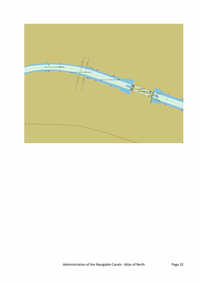
Mooring place for entrance into Ovidiu Lock
Danube km: 12.43 - 12.72 GPS coordinates: North: 44° 16' 17.96" East: 28° 32' 27.36" berths information length: 290 m river bank ☐ L left river bank ☒ R right river bank ☐ T at the dam location ☐ DPP "downstream" side of a power plant ☐ DL "downstream" side of o lock (lock
entrance area) ☒ UL "upstream" side of o lock (lock entrance
area) ☐ UPP "upstream" side of a power plant ☐ ARS along the river stretch ☐ OTH others (before a harbour entrance in an
old river branch)
river bank construction ☐ sheet pile wall ☐ embankment (slope) ☒ quay walls ☐ dam ☐ dolphins ☐ pontoon ☐ natural (wild) specimen widths ☐ 1 beam ☐ 2 beams ☐ 3 beams ☒ 90
local berths conditions ☒ 0 berthing permitted (i.e. anchoring or
making fast to the bank) ☐ 1 berthing area reserved for pushing-
navigation vessels that are required to carry one blue cone
☐ 2 berthing area reserved for pushing-navigation vessels that are required to carry two blue cones
☐ 3 berthing area reserved for pushing-navigation vessels that are required to carry three blue cones
☐ OTH other restrictions (only for small motor crafts, only for border control, only for damaged vessels after an accident, max. time allowed for berthing, ...)
connections ports/harbours in the surrounding area ☒ < 5 km Ovidiu Port villages, cities in the surrounding area ☒ < 5 km Ovidiu access road ☒ yes ☐ no
facilities stairs to go ashore ☒ yes ☐ no possibility to load and unload cars from a vessel ☒ yes ☐ no lightning ☐ yes ☒ no
maintenance and disposal facilities electricity supply ☐ yes ☒ no fresh water supply ☐ yes ☒ no waste disposal ☐ yes ☒ no petrol station ☐ yes ☒ no safety in case of flood or storm ☒ yes ☐ no Parking fees/costs ☒ yes ☐ no
Administration of the Navigable Canals - Atlas of Berth Page 32

Administration of the Navigable Canals - Atlas of Berth Page 33

Administration of the Navigable Canals - Atlas of Berth Page 34
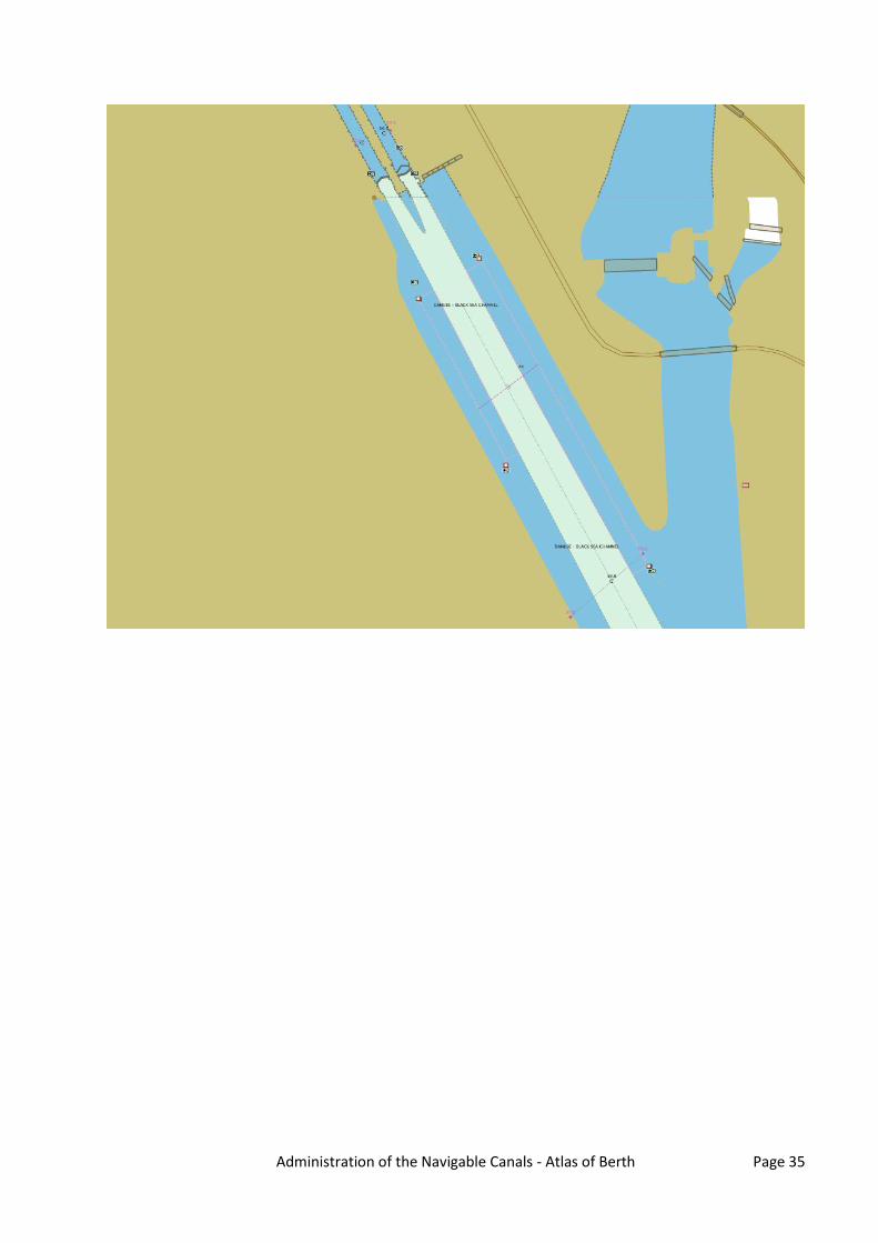
Mooring place for entrance into Cernavoda Lock
Danube km: 59.28 - 59.68 GPS coordinates: North: 44° 18' 30.87" East: 28° 2' 51.91" berths information length: 400 m river bank ☐ L left river bank ☒ R right river bank ☐ T at the dam location ☒ DPP "downstream" side of a power plant ☐ DL "downstream" side of o lock (lock
entrance area) ☐ UL "upstream" side of o lock (lock entrance
area) ☐ UPP "upstream" side of a power plant ☐ ARS along the river stretch ☐ OTH others (before a harbour entrance in an
old river branch)
river bank construction ☐ sheet pile wall ☐ embankment (slope) ☐ quay walls ☐ dam ☒ dolphins ☐ pontoon ☐ natural (wild) specimen widths ☐ 1 beam ☐ 2 beams ☐ 3 beams ☒ 150
local berths conditions ☒ 0 berthing permitted (i.e. anchoring or
making fast to the bank) ☐ 1 berthing area reserved for pushing-
navigation vessels that are required to carry one blue cone
☐ 2 berthing area reserved for pushing-navigation vessels that are required to carry two blue cones
☐ 3 berthing area reserved for pushing-navigation vessels that are required to carry three blue cones
☐ OTH other restrictions (only for small motor crafts, only for border control, only for damaged vessels after an accident, max. time allowed for berthing, ...)
connections ports/harbours in the surrounding area ☒ < 5 km Cernavoda villages, cities in the surrounding area ☒ < 5 km Cernavoda access road ☒ yes ☐ no
facilities stairs to go ashore ☒ yes ☐ no possibility to load and unload cars from a vessel ☐ yes ☒ no lightning ☒ yes ☐ no
maintenance and disposal facilities electricity supply ☐ yes ☒ no fresh water supply ☐ yes ☒ no waste disposal ☐ yes ☒ no petrol station ☐ yes ☒ no safety in case of flood or storm ☒ yes ☐ no Parking fees/costs ☒ yes ☐ no
Administration of the Navigable Canals - Atlas of Berth Page 35

Administration of the Navigable Canals - Atlas of Berth Page 36

Administration of the Navigable Canals - Atlas of Berth Page 37
Mooring place for entrance into Ovidiu Lock
Danube km: 11.75 - 12.04 GPS coordinates: North: 44° 16' 13.66" East: 28° 32' 57.8" berths information length: 290 m river bank ☒ L left river bank ☐ R right river bank ☐ T at the dam location ☐ DPP "downstream" side of a power plant ☒ DL "downstream" side of o lock (lock
entrance area) ☐ UL "upstream" side of o lock (lock entrance
area) ☐ UPP "upstream" side of a power plant ☐ ARS along the river stretch ☐ OTH others (before a harbour entrance in an
old river branch)
river bank construction ☐ sheet pile wall ☐ embankment (slope) ☒ quay walls ☐ dam ☐ dolphins ☐ pontoon ☐ natural (wild) specimen widths ☐ 1 beam ☐ 2 beams ☐ 3 beams ☒ 90
local berths conditions ☒ 0 berthing permitted (i.e. anchoring or
making fast to the bank) ☐ 1 berthing area reserved for pushing-
navigation vessels that are required to carry one blue cone
☐ 2 berthing area reserved for pushing-navigation vessels that are required to carry two blue cones
☐ 3 berthing area reserved for pushing-navigation vessels that are required to carry three blue cones
☐ OTH other restrictions (only for small motor crafts, only for border control, only for damaged vessels after an accident, max. time allowed for berthing, ...)
connections ports/harbours in the surrounding area ☒ < 5 km Ovidiu Port villages, cities in the surrounding area ☒ < 5 km Ovidiu access road ☒ yes ☐ no
facilities stairs to go ashore ☒ yes ☐ no possibility to load and unload cars from a vessel ☒ yes ☐ no lightning ☐ yes ☒ no
maintenance and disposal facilities electricity supply ☐ yes ☒ no fresh water supply ☐ yes ☒ no waste disposal ☐ yes ☒ no petrol station ☐ yes ☒ no safety in case of flood or storm ☒ yes ☐ no Parking fees/costs ☒ yes ☐ no

Administration of the Navigable Canals - Atlas of Berth Page 38
Administration of the Navigable Canals - Atlas of Berth Page 39

Administration of the Navigable Canals - Atlas of Berth Page 40
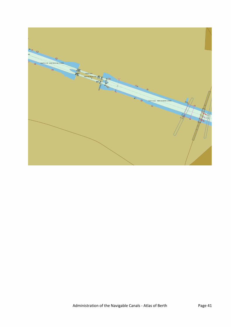
Mooring place for entrance into Ovidiu Lock
Danube km: 11.8 - 12.04 GPS coordinates: North: 44° 16' 10.62" East: 28° 32' 53.79" berths information length: 240 m river bank ☐ L left river bank ☒ R right river bank ☐ T at the dam location ☐ DPP "downstream" side of a power plant ☒ DL "downstream" side of o lock (lock
entrance area) ☐ UL "upstream" side of o lock (lock entrance
area) ☐ UPP "upstream" side of a power plant ☐ ARS along the river stretch ☐ OTH others (before a harbour entrance in an
old river branch)
river bank construction ☐ sheet pile wall ☐ embankment (slope) ☒ quay walls ☐ dam ☐ dolphins ☐ pontoon ☐ natural (wild) specimen widths ☐ 1 beam ☐ 2 beams ☐ 3 beams ☒ 90
local berths conditions ☒ 0 berthing permitted (i.e. anchoring or
making fast to the bank) ☐ 1 berthing area reserved for pushing-
navigation vessels that are required to carry one blue cone
☐ 2 berthing area reserved for pushing-navigation vessels that are required to carry two blue cones
☐ 3 berthing area reserved for pushing-navigation vessels that are required to carry three blue cones
☐ OTH other restrictions (only for small motor crafts, only for border control, only for damaged vessels after an accident, max. time allowed for berthing, ...)
connections ports/harbours in the surrounding area ☒ < 5 km Ovidiu Port villages, cities in the surrounding area ☒ < 5 km Ovidiu access road ☒ yes ☐ no
facilities stairs to go ashore ☒ yes ☐ no possibility to load and unload cars from a vessel ☒ yes ☐ no lightning ☒ yes ☐ no
maintenance and disposal facilities electricity supply ☐ yes ☒ no fresh water supply ☐ yes ☒ no waste disposal ☐ yes ☒ no petrol station ☐ yes ☒ no safety in case of flood or storm ☒ yes ☐ no Parking fees/costs ☒ yes ☐ no
Administration of the Navigable Canals - Atlas of Berth Page 41

Administration of the Navigable Canals - Atlas of Berth Page 42

Administration of the Navigable Canals - Atlas of Berth Page 43
Mooring place for entrance into Poarta Alba Midia
Navodari Canal
Danube km: 29.71 - 30.01 GPS coordinates: North: 44° 13' 25.55" East: 28° 22' 40.13" berths information length: 300 m river bank ☒ L left river bank ☐ R right river bank ☐ T at the dam location ☐ DPP "downstream" side of a power plant ☐ DL "downstream" side of o lock (lock
entrance area) ☐ UL "upstream" side of o lock (lock entrance
area) ☐ UPP "upstream" side of a power plant ☐ ARS along the river stretch ☒ OTH others (before a harbour entrance in an
old river branch)
river bank construction ☐ sheet pile wall ☐ embankment (slope) ☒ quay walls ☐ dam ☐ dolphins ☐ pontoon ☐ natural (wild) specimen widths ☐ 1 beam ☐ 2 beams ☐ 3 beams ☒ 160
local berths conditions ☒ 0 berthing permitted (i.e. anchoring or
making fast to the bank) ☐ 1 berthing area reserved for pushing-
navigation vessels that are required to carry one blue cone
☐ 2 berthing area reserved for pushing-navigation vessels that are required to carry two blue cones
☐ 3 berthing area reserved for pushing-navigation vessels that are required to carry three blue cones
☐ OTH other restrictions (only for small motor crafts, only for border control, only for damaged vessels after an accident, max. time allowed for berthing, ...)
connections ports/harbours in the surrounding area ☒ < 5 km Murfatlar villages, cities in the surrounding area ☒ < 5 km Murfatlar ☒ < 5 km Poarta Alba access road ☒ yes ☐ no
facilities stairs to go ashore ☒ yes ☐ no possibility to load and unload cars from a vessel ☒ yes ☐ no lightning ☒ yes ☐ no
maintenance and disposal facilities electricity supply ☒ yes ☐ no fresh water supply ☒ yes ☐ no waste disposal ☐ yes ☒ no petrol station ☐ yes ☒ no safety in case of flood or storm ☒ yes ☐ no Parking fees/costs

Administration of the Navigable Canals - Atlas of Berth Page 44
☒ yes ☐ no

Administration of the Navigable Canals - Atlas of Berth Page 45

Administration of the Navigable Canals - Atlas of Berth Page 46
Mooring place for entrance into Medgidia port
Danube km: 36.91 - 37.31 GPS coordinates: North: 44° 14' 54.57" East: 28° 18' 21.86" berths information length: 400 m river bank ☐ L left river bank ☒ R right river bank ☐ T at the dam location ☐ DPP "downstream" side of a power plant ☐ DL "downstream" side of o lock (lock
entrance area) ☐ UL "upstream" side of o lock (lock entrance
area) ☐ UPP "upstream" side of a power plant ☐ ARS along the river stretch ☒ OTH others (before a harbour entrance in an
old river branch)
river bank construction ☐ sheet pile wall ☐ embankment (slope) ☐ quay walls ☐ dam ☒ dolphins ☐ pontoon ☐ natural (wild) specimen widths ☐ 1 beam ☐ 2 beams ☐ 3 beams ☒ 120
local berths conditions ☒ 0 berthing permitted (i.e. anchoring or
making fast to the bank) ☐ 1 berthing area reserved for pushing-
navigation vessels that are required to carry one blue cone
☐ 2 berthing area reserved for pushing-navigation vessels that are required to carry two blue cones
☐ 3 berthing area reserved for pushing-navigation vessels that are required to carry three blue cones
☐ OTH other restrictions (only for small motor crafts, only for border control, only for damaged vessels after an accident, max. time allowed for berthing, ...)
connections ports/harbours in the surrounding area ☒ < 5 km Medgidia villages, cities in the surrounding area ☒ < 5 km Medgidia access road ☒ yes ☐ no
facilities stairs to go ashore ☒ yes ☐ no possibility to load and unload cars from a vessel ☐ yes ☒ no lightning ☐ yes ☒ no
maintenance and disposal facilities electricity supply ☐ yes ☒ no fresh water supply ☐ yes ☒ no waste disposal ☐ yes ☒ no petrol station ☐ yes ☒ no safety in case of flood or storm ☒ yes ☐ no Parking fees/costs ☒ yes ☐ no

Administration of the Navigable Canals - Atlas of Berth Page 47

Administration of the Navigable Canals - Atlas of Berth Page 48

Administration of the Navigable Canals - Atlas of Berth Page 49
Mooring place for entrance into Murfatlar port
Danube km: 25.08 - 25.46 GPS coordinates: North: 44° 11' 6.09" East: 28° 23' 39.02" berths information length: 375 m river bank ☐ L left river bank ☒ R right river bank ☐ T at the dam location ☐ DPP "downstream" side of a power plant ☐ DL "downstream" side of o lock (lock
entrance area) ☐ UL "upstream" side of o lock (lock entrance
area) ☐ UPP "upstream" side of a power plant ☐ ARS along the river stretch ☒ OTH others (before a harbour entrance in an
old river branch)
river bank construction ☐ sheet pile wall ☐ embankment (slope) ☐ quay walls ☐ dam ☒ dolphins ☐ pontoon ☐ natural (wild) specimen widths ☐ 1 beam ☐ 2 beams ☐ 3 beams ☒ 150
local berths conditions ☒ 0 berthing permitted (i.e. anchoring or
making fast to the bank) ☐ 1 berthing area reserved for pushing-
navigation vessels that are required to carry one blue cone
☐ 2 berthing area reserved for pushing-navigation vessels that are required to carry two blue cones
☐ 3 berthing area reserved for pushing-navigation vessels that are required to carry three blue cones
☐ OTH other restrictions (only for small motor crafts, only for border control, only for damaged vessels after an accident, max. time allowed for berthing, ...)
connections ports/harbours in the surrounding area ☒ < 5 km Murfatlar villages, cities in the surrounding area ☒ < 5 km Murfatlar access road ☒ yes ☐ no
facilities stairs to go ashore ☒ yes ☐ no possibility to load and unload cars from a vessel ☐ yes ☒ no lightning ☐ yes ☒ no
maintenance and disposal facilities electricity supply ☐ yes ☒ no fresh water supply ☐ yes ☒ no waste disposal ☐ yes ☒ no petrol station ☐ yes ☒ no safety in case of flood or storm ☒ yes ☐ no Parking fees/costs ☒ yes ☐ no
Administration of the Navigable Canals - Atlas of Berth Page 50

Administration of the Navigable Canals - Atlas of Berth Page 51
Administration of the Navigable Canals - Atlas of Berth Page 52
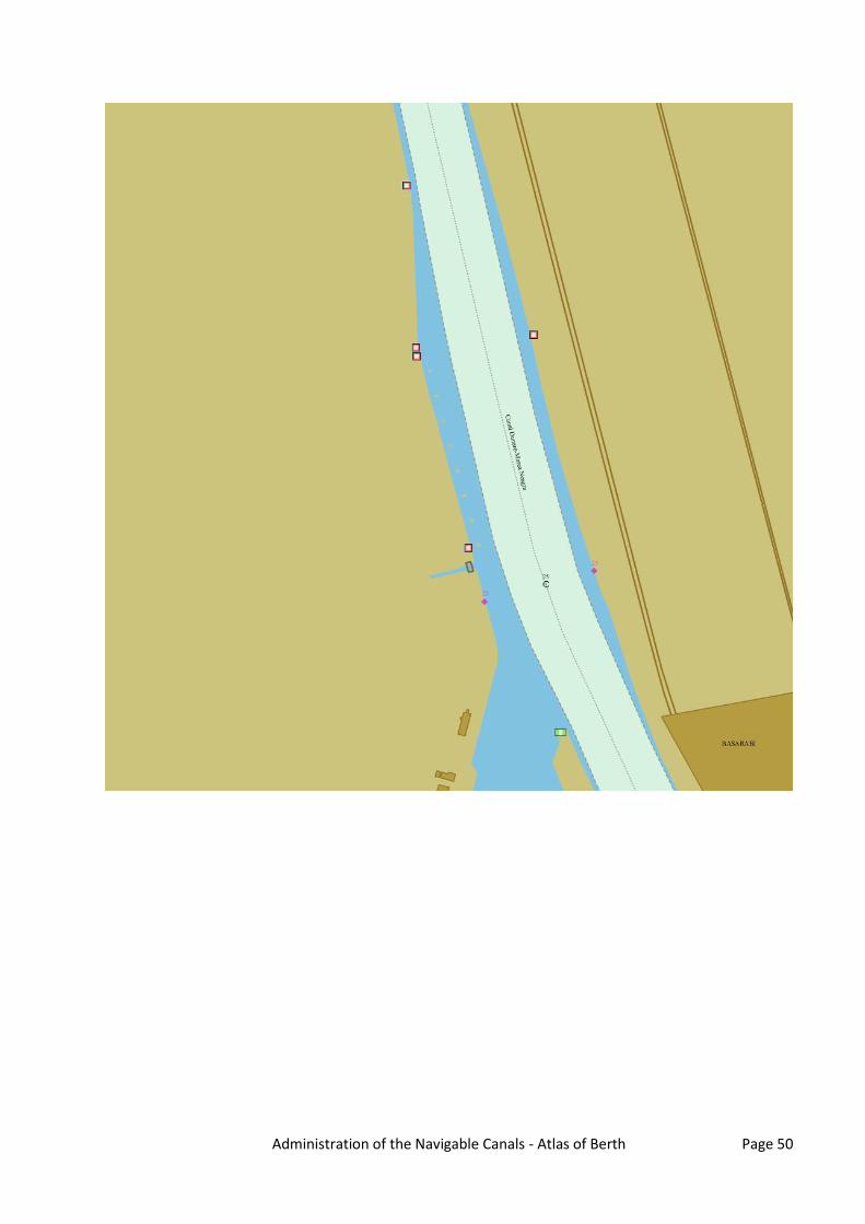
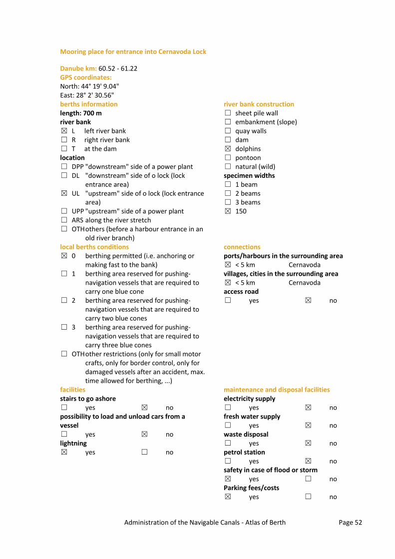
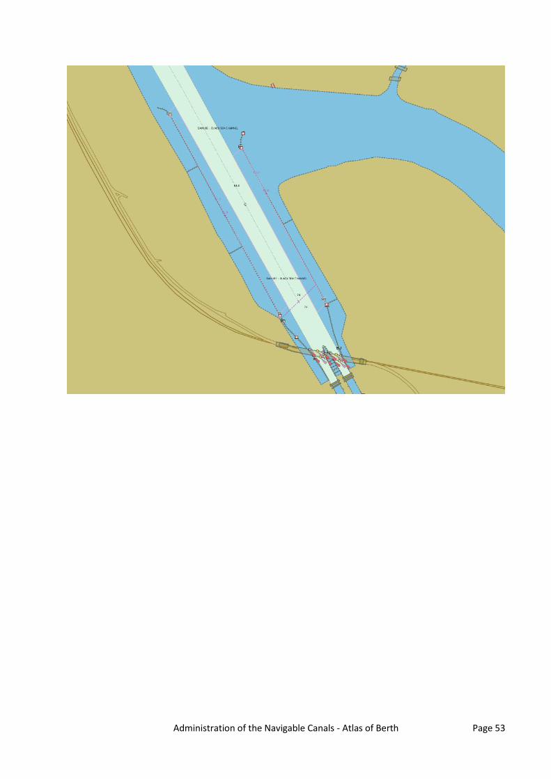
Mooring place for entrance into Cernavoda Lock
Danube km: 60.52 - 61.22 GPS coordinates: North: 44° 19' 9.04" East: 28° 2' 30.56" berths information length: 700 m river bank ☒ L left river bank ☐ R right river bank ☐ T at the dam location ☐ DPP "downstream" side of a power plant ☐ DL "downstream" side of o lock (lock
entrance area) ☒ UL "upstream" side of o lock (lock entrance
area) ☐ UPP "upstream" side of a power plant ☐ ARS along the river stretch ☐ OTH others (before a harbour entrance in an
old river branch)
river bank construction ☐ sheet pile wall ☐ embankment (slope) ☐ quay walls ☐ dam ☒ dolphins ☐ pontoon ☐ natural (wild) specimen widths ☐ 1 beam ☐ 2 beams ☐ 3 beams ☒ 150
local berths conditions ☒ 0 berthing permitted (i.e. anchoring or
making fast to the bank) ☐ 1 berthing area reserved for pushing-
navigation vessels that are required to carry one blue cone
☐ 2 berthing area reserved for pushing-navigation vessels that are required to carry two blue cones
☐ 3 berthing area reserved for pushing-navigation vessels that are required to carry three blue cones
☐ OTH other restrictions (only for small motor crafts, only for border control, only for damaged vessels after an accident, max. time allowed for berthing, ...)
connections ports/harbours in the surrounding area ☒ < 5 km Cernavoda villages, cities in the surrounding area ☒ < 5 km Cernavoda access road ☐ yes ☒ no
facilities stairs to go ashore ☐ yes ☒ no possibility to load and unload cars from a vessel ☐ yes ☒ no lightning ☒ yes ☐ no
maintenance and disposal facilities electricity supply ☐ yes ☒ no fresh water supply ☐ yes ☒ no waste disposal ☐ yes ☒ no petrol station ☐ yes ☒ no safety in case of flood or storm ☒ yes ☐ no Parking fees/costs ☒ yes ☐ no
Administration of the Navigable Canals - Atlas of Berth Page 53

Administration of the Navigable Canals - Atlas of Berth Page 54