table of contents 1...9.10 traffic and road safety ..... 101 9.11 open space requirements..... 103...
TRANSCRIPT

South Tipperary County Development Plan 2009-2015.
TABLE OF CONTENTS
SCHEDULE OF PLATES................................................................................................................ 9
ABBREVIATIONS USED IN TEXT............................................................................................... 10
GLOSSARY OF TERMS............................................................................................................... 11
MEMBERS PAGE ......................................................................................................................... 15
FOREWORD FROM THE CATHAOIRLEACH............................................................................. 16
FOREWORD FROM THE COUNTY MANAGER ......................................................................... 17
CHAPTER 1: THE COUNTY DEVELOPMENT PLAN IN CONTEXT .......................................... 18 1.0 Introduction.......................................................................................................................... 18 1.1 Composition of the County Development Plan ................................................................... 18
1.1.1 Strategic Environmental Assessment .......................................................................... 19 1.1.2 Appropriate Assessment.............................................................................................. 19 1.1.3 Maps ............................................................................................................................ 19
1.2 The County Development Plan, the Elected Members and the Community ...................... 20 1.2.1 Workshops with Elected Representatives ................................................................... 20 1.2.2 Strategic Policy Committees (SPCs) ........................................................................... 20 1.2.3 The Community & Public Participation ........................................................................ 20
1.2.3.1 Pre-Draft Stage ................................................................................................... 20 1.2.3.2 Draft Stage .......................................................................................................... 21 1.2.3.3 Proposed Material Amendment Stage.............................................................. 22
1.2.4 Service Providers......................................................................................................... 22 1.3 Relationship with other Plans/Guidelines............................................................................ 22
1.3.1 National Spatial Strategy 2002 .................................................................................... 23 1.3.2 National Development Plan 2007-2013....................................................................... 23 1.3.3 South East Regional Planning Guidelines 2004.......................................................... 23 1.3.4 Sustainable Development: A Strategy for Ireland 1997............................................... 24 1.3.5 National Climate Change Strategy 2007-2012 ............................................................ 24 1.3.6 The Water Framework Directive 2000......................................................................... 24 1.3.7 Draft Flood Guidelines (DoEHLG September 2008) ................................................... 25 1.3.8 Sustainable Residential Development in Urban Areas 2008....................................... 25 1.3.9 Delivering Homes, Sustaining Communities 2007 ...................................................... 25 1.3.10 Sustainable Rural Housing Guidelines 2005 ............................................................. 26 1.3.11 Other Strategies and Policy Documents.................................................................... 26
1.4 Monitoring of the County Development Plan ...................................................................... 26 1.5 South Tipperary in Context ................................................................................................. 29
1.5.1 Geographical Features ................................................................................................ 29 1.5.2 National Infrastructure in South Tipperary................................................................... 29
1.6 The Atlantic Gateways Initiative 2006................................................................................. 30
CHAPTER 2: CURRENT TRENDS............................................................................................... 32 2.0 Introduction.......................................................................................................................... 32 2.1 Population ........................................................................................................................... 32
2.1.1 Spatial Distribution of Population Growth .................................................................... 32
- 1 -

South Tipperary County Development Plan 2009-2015.
2.2 Population Projections ........................................................................................................ 33 2.3 Population Structure & Profile ............................................................................................. 34
2.3.1 In Migration .................................................................................................................. 35 2.4 Employment ........................................................................................................................ 35 2.5 Unemployment .................................................................................................................... 37 2.6 Education ............................................................................................................................ 37
CHAPTER 3: LOCATION AND PATTERN OF DEVELOPMENT................................................ 39 3.0 Introduction.......................................................................................................................... 39 3.1 Settlement Pattern in South Tipperary................................................................................ 39
3.1.1 Current Context............................................................................................................ 39 3.2 Population Context of South Tipperary Settlements ........................................................... 39
3.2.1 Towns .......................................................................................................................... 39 3.2.2 Villages ........................................................................................................................ 40 3.2.3 Open Countryside........................................................................................................ 41
3.3 Purpose of the Settlement Strategy .................................................................................... 41 3.4 Methodology Employed in Designating the Settlement Tiers ............................................. 41 3.5 Settlement Strategy for South Tipperary............................................................................. 42
3.5.1 Urban Settlement Strategy .......................................................................................... 43 3.5.1.1 Primary Service Centre ...................................................................................... 43 3.5.1.2 Secondary Service Centres ............................................................................... 44
3.5.2 Rural Settlement Strategy............................................................................................ 44 3.5.2.1 District Service Centres ..................................................................................... 44 3.5.2.2 Local Service Centres ........................................................................................ 45 3.5.2.3 Rural Settlement Nodes ..................................................................................... 46 3.5.2.4 Open Countryside Settlement Form................................................................. 46
CHAPTER 4: HOUSING ............................................................................................................... 48 4.0 Introduction.......................................................................................................................... 48 4.1 Housing Strategy Review 2008........................................................................................... 49 4.2 Traveller Accommodation ................................................................................................... 51 4.3 Housing Design and Development on Zoned Lands .......................................................... 51 4.4 Dwelling Design in the Open Countryside .......................................................................... 52 4.5 Nursing Homes/Retirement Villages ................................................................................... 52 4.6 Retaining Buildings of Merit and Building Reuse. ............................................................... 52 4.7 Sustainable Building Design ............................................................................................... 53 4.8 Specific Housing Objectives................................................................................................ 54
CHAPTER 5: ECONOMY ............................................................................................................. 55 5.0 Economic Profile and Occupations ..................................................................................... 55 5.1 Labour Force ....................................................................................................................... 56 5.2 Employment Creation.......................................................................................................... 56 5.3 Location of Employment...................................................................................................... 56
5.3.1 Lands for Strategic Employment Use .......................................................................... 57 5.3.2 Primary and Secondary Service Centres Employment Land Use Requirements ....... 58
- 2 -
South Tipperary County Development Plan 2009-2015.
5.3.3 District Service Centres Employment Land Use Requirements .................................. 58 5.3.4 Local Service Centres Employment Land Use Requirements .................................... 59 5.3.5 Open Countryside Enterprise Requirements............................................................... 59 5.3.6 Disused Farm Buildings and Industrial Buildings in the Countryside: ......................... 60
5.4 Non-Conforming Uses......................................................................................................... 60 5.5 Retail Development ............................................................................................................. 61 5.6 Rural Resources.................................................................................................................. 62
5.6.1 Sustainable Tourism and Recreation........................................................................... 62 5.6.2 Extractive Industry ....................................................................................................... 63 5.6.3 Agriculture.................................................................................................................... 64 5.6.4 Equine.......................................................................................................................... 65
5.7 Prevention of Major Accidents ............................................................................................ 66 5.8 Specific Economic Objectives ............................................................................................. 66
CHAPTER 6: AMENITY, ENVIRONMENT AND HERITAGE ...................................................... 67 6.0 Introduction.......................................................................................................................... 67 6.1 Community Amenity ............................................................................................................ 67 6.2 The Built Environment......................................................................................................... 67
6.2.1 Derelict and Brownfield Sites....................................................................................... 67 6.2.2 Enhancing Settlement Character................................................................................. 68
6.3 Natural Landscape Amenity ................................................................................................ 68 6.3.1 Landscape Amenity Areas........................................................................................... 68 6.3.2 Protected Assets: Views and Trees............................................................................. 69 6.3.3 Designated Environmental Sites.................................................................................. 69 6.3.4 Water Environment ...................................................................................................... 70 6.3.5 Groundwater Protection............................................................................................... 70 6.3.6 Water Quality ............................................................................................................... 70 6.3.7 Access and Public Rights of Way................................................................................ 71
6.4 Built Heritage....................................................................................................................... 72 6.4.1 Conservation and Management of Protected and other Structures ............................ 72 6.4.2 Architectural Conservation Areas ................................................................................ 73 6.4.3 Archaeology ................................................................................................................. 73
6.5 South Tipperary County Heritage Plan ............................................................................... 74 6.6 Specific Environment, Amenity and Heritage Objectives.................................................... 75
CHAPTER 7: INFRASTRUCTURE............................................................................................... 76 7.0 Introduction.......................................................................................................................... 76 7.1 Transport ............................................................................................................................. 76
7.1.1 Roads Infrastructure .................................................................................................... 76 7.1.2 Preserving Route Capacity .......................................................................................... 77 7.1.3 Public Transport........................................................................................................... 79
7.1.3.1 Rail ....................................................................................................................... 79 7.1.3.2 Bus ....................................................................................................................... 80
7.1.4 Pedestrian and Cycle Routes ...................................................................................... 81 7.2 Water Services .................................................................................................................... 81
7.2.1 Water Supply ............................................................................................................... 81 7.2.2 Borewell Augmentation................................................................................................ 82 7.2.3 Waste Water Treatment............................................................................................... 83 7.2.4 Current Water Services Investment Programme......................................................... 83
- 3 -

South Tipperary County Development Plan 2009-2015.
7.2.5 Surface Water .............................................................................................................. 85 7.2.6 Flood Risk Assessment ............................................................................................... 86
7.3 Access to Electrical Supply Networks ................................................................................. 86 7.4 Access to Natural Gas Supply ............................................................................................ 87 7.5 Wind Energy........................................................................................................................ 87 7.6 Bio-Energy........................................................................................................................... 87 7.7 Broadband and Communications........................................................................................ 88 7.8 Waste Management ............................................................................................................ 89 7.9 Agricultural Waste ............................................................................................................... 89 7.10 Specific Infrastructure Objectives...................................................................................... 90
CHAPTER 8: COMMUNITY AND SOCIAL .................................................................................. 91 8.0 Introduction.......................................................................................................................... 91 8.1 Economic Programme Management Group ....................................................................... 91 8.2 Social Inclusion Measures Group ....................................................................................... 91 8.3 Cultural Programme Management Group........................................................................... 92 8.4 Library Services................................................................................................................... 92 8.5 Community Amenity ............................................................................................................ 92 8.6 Burial Grounds .................................................................................................................... 93 8.7 Local Agenda 21 Programme Management Group ............................................................ 93 8.8 Childcare Facilities .............................................................................................................. 94 8.9 Conclusion........................................................................................................................... 95
9: DEVELOPMENT MANAGEMENT............................................................................................ 96 9.0 Introduction.......................................................................................................................... 96 9.1 Enforcement ........................................................................................................................ 96 9.2 Development Contributions................................................................................................. 96 9.3 Bonds .................................................................................................................................. 96 9.4 Design Considerations. ....................................................................................................... 97 9.5 Residential Development in the Open Countryside ............................................................ 97 9.6 Residential Development in Settlements ............................................................................ 99 9.7 Apartment Buildings .......................................................................................................... 100 9.8 Development Impact Assessment (DIA) ........................................................................... 100 9.9 Settlement Centre Master Plan Designations ................................................................... 101 9.10 Traffic and Road Safety .................................................................................................. 101 9.11 Open Space Requirements............................................................................................. 103 9.12 Waste Water Treatment Infrastructure............................................................................ 105
9.12.1 District Service Centres ........................................................................................... 105 9.12.2 Local Service Centres/Settlement Nodes................................................................ 106
9.13 Construction and Demolition Waste................................................................................ 106
- 4 -

South Tipperary County Development Plan 2009-2015.
9.14 Reuse of Surface Water.................................................................................................. 106 9.15 Waste Maceration ........................................................................................................... 107 9.16 Petrol Filling and Service Stations .................................................................................. 107 9.17 Industrial Developments.................................................................................................. 108 9.18 Industrial and Enterprise/Employment use in the Open Countryside ............................. 108 9.19 Tourism activities and ancillary development ................................................................. 109 9.20 Forestry ........................................................................................................................... 109 9.21 Agriculture Development................................................................................................. 110 9.22 Shopfronts ....................................................................................................................... 110 9.23 Advertising Structures and Signs.................................................................................... 110 9.24 Retaining Retail Function in Settlement Centres ............................................................ 111 9.25 Taking in Charge............................................................................................................. 111 9.26 Archaeology .................................................................................................................... 111 9.27 External Lighting.............................................................................................................. 111 9.28 Noise Levels.................................................................................................................... 112 9.29 Satellite Dishes................................................................................................................ 112 9.30 Parking and Loading ....................................................................................................... 112 9.31 Landuse Zoning Objectives............................................................................................. 113
INDEX CHAPTERS 1 - 9............................................................................................................. 115 SCHEDULE OF FIGURES Figure 1.1 Illustration of Plan Hierarchy ....................................................................................... 23 Figure 1.2 South East Region as defined in the NSS and the RPG’s .......................................... 24 Figure 1.3 River Basin Districts .................................................................................................... 25 Figure 1.4: South Tipperary’s Physical Features & National Infrastructure ................................. 30 Figure 1.5 Illustration of the Atlantic Gateways Initiative .............................................................. 31 Figure 2.1 Population Projections................................................................................................. 33 Figure 2.2 Age Profile 1996-2006................................................................................................. 34 Figure 2.3 Percentage Unemployed 2006.................................................................................... 37 Figure 2.4 Levels of Education Completed by Population............................................................ 37 Figure 3.1 Settlement Strategy ..................................................................................................... 42 Figure 5.1 Strategic Economic Locations ..................................................................................... 58 Figure 7.1 Strategic Route Proposals........................................................................................... 77 Figure 7.2 Strategic Route Corridors............................................................................................ 79 Figure 7.3 Regional Water Supply Schemes................................................................................ 82 Figure 7.4 Municipal Waste Water Treatment Plants ................................................................... 83 Figure 8.1 Additional Pre-School Requirements to 2010 ............................................................. 94 Figure 9.1 Safe Access Sightlines .............................................................................................. 102 Figure 9.2 Forward Visibility Requirements................................................................................ 102 Figure 9.3 Traffic and Transport Assessment ............................................................................ 103
- 5 -

South Tipperary County Development Plan 2009-2015.
SCHEDULE OF TABLES Table 2.1 Census Results 2002 - 2006 ......................................................................................... 32 Table 2.2 10-34 Age Cohorts ........................................................................................................ 34 Table 2.3 Persons in South Tipperary’s main settlements originally from outside the State ........ 35 Table 2.4 Labour Force ................................................................................................................. 35 Table 2.5 Occupation Group ......................................................................................................... 36 Table 3.1 Settlement Population ................................................................................................... 40 Table 3.2 Settlement Population Change...................................................................................... 40 Table 3.3 Settlement Hierarchy ..................................................................................................... 43 Table 4.1 Housing Unit Requirements 2009-2020 ........................................................................ 48 Table 4.2 Provision of Zoned Residential Lands........................................................................... 48 Table 4.3 Required Housing Units in District Service Centres...................................................... 49 Table 4.4 Categories of persons in need of housing/accommodation. ......................................... 50 Table 5.1 Distribution of Employment 2006 .................................................................................. 55 Table 5.2 Retail Floorspace........................................................................................................... 61 Table 5.3 Main Visitor Attractions.................................................................................................. 62 Table 7.1 County Roads................................................................................................................ 76 Table 7.2 Water Services Investment Programme........................................................................ 84 Table 7.3 Small Scheme Investment Priorities.............................................................................. 85 Table 8.1 Capacity of Burial Grounds in South Tipperary as at 31st December 2008 .................. 93 Table 8.2 Anticipated County Childcare Place Requirements 2010 ............................................. 94 Table 9.1 Minimum Standards for Residential Development in the Open Countryside................ 98 Table 9.2 Minimum Standards for Residential development......................................................... 99 Table 9.3 Sight Line Requirements ............................................................................................. 101 Table 9.4 Recreational Facility Requirements............................................................................. 104 Table 9.5 Minimum Standards for Industrial Developments ....................................................... 108 Table 9.6 Car Parking Standards ................................................................................................ 113 Table 9.7 Key to Development Plan Zoning Objectives .............................................................. 114 SCHEDULE OF POLICIES
Policy Page No. Chapter 2: Current Trends CT 1: Population/Education/Employment 38 Chapter 3: Location and Pattern of Development SS 1: Settlement Strategy 43 SS 2: District Service Centres 45 SS 3: Local Service Centres 45 SS 4: Settlement Nodes 46 SS 5: Individual Houses in the Open Countryside 46 & 47 Chapter 4: Housing HSG 1: Housing Strategy 50 HSG 2: Traveller Accommodation 51 HSG 3: Housing Mix and Development Impact Assessment (DIA) 52 HSG 4: Design of Individual Houses 52 HSG 5: Nursing Homes/Retirement Villages 52 HSG 6: Retaining Buildings of Merit 53 HSG 7: Sustainable Building Design 53 Chapter 5: Economy ECON 1: Employment Growth Opportunities 56 ECON 2: Employment Creation 56 ECON 3: Strategic Employment 58 ECON 4: Facilitating Local Employment in District Service Centres 59 ECON 5: Employment Land Bank 59 ECON 6: Local Service Centres 59
- 6 -

South Tipperary County Development Plan 2009-2015.
ECON 7: Enterprise in the Open Countryside 60 ECON 8: On Farm Diversification 60 ECON 9: Non-Conforming Uses 61 ECON 10: South Tipperary County Retail Strategy 61 ECON 11: Tourist Activities 63 ECON 12: Extractive Industry 64 ECON 13: Protecting Agricultural Practices 64 ECON 14: Protecting and Promoting Equine Industries 66 ECON 15: Prevention of Major Accidents 66 Chapter 6: Amenity, Environment & Heritage AEH 1: Community Amenity 67 AEH 2: Derelict Sites 67 AEH 3: Enhancing Settlement Character 68 AEH 4: Primary and Secondary Amenity Areas 69 AEH 5: Protected Assets: Views and Trees 69 AEH 6: Designated Environmental Sites 70 AEH 7: Water Environment 70 AEH 8: Groundwater Protection 70 AEH 9: Waste Water Treatment and Disposal 70 AEH 10: Access and Public Rights of Way 72 AEH 11: Protected Structures 73 AEH 12: Architectural Conservation Areas 73 AEH 13: Archaeology 74 AEH 14: South Tipperary Heritage Plan 74 Chapter 7: Infrastructure INF 1: Preserving Strategic Road Networks 78 INF 2: Traffic and Transport Assessment 79 INF 3: Public Transport 80 INF 4: Pedestrian and Cycle Routes 81 INF 5: Water Supply and Waste Water 85 INF 6: Surface Water 86 INF 7: Flood Risk Assessment 86 INF 8: Access to Electricity Supply Networks 87 INF 9: Access to Natural Gas 87 INF 10: Wind Energy 87 INF 11: Bio-Energy 88 INF 12: Broadband 88 INF 13: Telecommunications 89 INF 14: Waste Management 89 INF 15: Agricultural Waste 90 Chapter 8: Community and Social CS 1: Interagency Cooperation and Collaboration 91 CS 2: Addressing Social Inclusion 92 CS 3: Arts and Culture 92 CS 4: Library and Information Access 92 CS 5: Community Amenity 93 CS 6: Provision of Burial Grounds 93 CS 7: Community Involvement in Decision Making 94 CS 8: Childcare Facilities 95 Chapter 9: Development Management DM 1: Development Standards 96
- 7 -

South Tipperary County Development Plan 2009-2015.
APPENDICES
Appendix 1 Land Use Matrix Appendix 2 Settlement and ACA Design Guidelines Appendix 3 Wind Energy Development Appendix 4 Rural Design Guide for individual houses in the countryside Appendix 5 Record of Protected Structures Appendix 6 Schedule of Protected Views Appendix 7 Schedule of Natural Heritage Sites Appendix 8 Schedule of Protected Trees Appendix 9 Housing Strategy Review 2008 Appendix 10 - Volume 2 Appendix 11 - Volume 2 Appendix 12 - Volume 2
SEA Statement, Environmental Report Appropriate Assessment
Appendix 13 - Volume 3 County Maps and Settlement Plans
- 8 -

South Tipperary County Development Plan 2009-2015.
SCHEDULE OF PLATES Image No/Page No Photographer Location
VOLUME 1 Front Cover - Main Joe Boland Hoare Abbey Cashel Filmstrip (left) Sean Keating Bay Lough at Vee Clogheen Filmstrip (centre) Damian Lizun Swiss Cottage Cahir Filmstrip b(right) Kevin Phelan M8 at Cashel 1(Members Page) Michael Pollard Ardfinnan 2 (page 16) Caroline Conway Ruins of Church & Graveyard at Shanrahan 3 (page 17) Planning Department Mature Trees at Knocklofty 4 (page 29) Margaret O’ Gorman Comeragh Mts taken from north of Clonmel 5 (page 51) Caroline Conway Playing Field at Killenaule 6 (page 52) Seamus Maher Thatch Pub Cloneen 7 (page 62) Sean Carey Glen of Aherlow 8 (page 63) Margo Hayes View from Sliabh na mBan looking south 9 (page 64) Ruth Maher Corn Field beside M8 at Cashel 10 (page 65) Jonathan Flood Duke of Marmalade at Cooolmore Stud 11 (page 67) Caith O’ Neill Cahir Park Golf Club 12 (page 68) Seamus Maher Walking on Galteemore 13 (page 69) Jim Healy Swan at Marlfield Lake 14 (page 72) Anthony Caplice Skeheenarinky National School 15 (page 72) Marie McMahon Clonmel Town Walls Day 16 (page 74) Ruth Maher Open doorway at the Rock of Cashel 17 (page 76) Anthony Caplice Overpass bridge at Caherghaul in progress 18 (page 78) Alan Walsh Interchange for Cashel/Dundrum on M8 19 (page 79) Joe Boland Railway Tracks at Clonoulty 20 (page 92) Seamus Maher Cashel Library 21 (page 95) Planning Department Recently constructed Childcare Facility at Monard 22 (page 97) Allan Ryan Existing Streetscape in Ballingarry 23 (page 100) Planning Department Ballingarry Secondary School Back Cover Ruth Maher Snow capped Mountains form Cashel By Pass
APPENDICES 1 – 9 COVER PAGE Top row left Alan Walsh Interchange at Cashel Top row centre Aidan Finn Golden Top row right Sharon Heffernan Emly Church Centre left Joe Boland Bridge in Ardmayle Centre Caith O’ Neill Faugheen 50 Motor Bike Race Centre right Sean Keating Stream near V Clogheen Bottom left Sean Keating Heading Sheep Bottom centre Margaret O’ Gorman Clonmel View Bottom right Margo Hayes Duck on Marlfield For Photo Titles and Credits in Appendix 4 please see list compiled by Consultants
VOLUME 2 – FRONT COVER Main Danny Scully Marlfield Church Filmstrip (left) Clare Lee Pond at Bay Lough Filmstrip (centre) Damian Lizun Early Crocuses at Connolly Park, Clonmel Filmstrip (right) Clare Lee Sheep on Slievenamon
VOLUME 3 – FRONT COVER Top left Sean Keating Bridge at Swiss Cottage Bottom left Joe Boland Ardmayle Church Centre Sean Keating Tea House at Shanbally Top right Marie O’ Donnell Athasil Abbey from Cloughaleigh Bottom right Caroline Conway Pedestrian Bridge at Ballylooby
Secondary Service Centre Cover Page Main Damien Lizun Cahir Castle
District Service Centre Left Planning Department Newcastle Primary School Centre Kevin Phelan Ardfinnan Right Ruth Maher Fethard River View
Local Service Centre Left Brendan Fennessy Rosegreen Church Centre Allan Ryan Wind Turbine at Hollyford Right Kevin Phelan Clonoulty
Settlement Node Left Francis Keogh St. Patricks Well Marlfield Centre Planning Department Public Art at Goatenbridge Right Planning Department Ballylooby Church
- 9 -

South Tipperary County Development Plan 2009-2015.
- 10 -
ABBREVIATIONS USED IN TEXT AA – Appropriate Assessment ACA – Architectural Conservation Area C & D – Construction & Demolition CFRAM – Catchment Flood Risk Assessment & Management Study CLSS – Capital & Loan Subsidy Scheme COMAH – Control of Major Accident Hazard Sites DBO – Design Build & Operate Scheme DED – District Electoral Division DIA – Development Impact Assessment DoCENR – Department of Community Enterprise and Natural Resources DoEHLG – Department of the Environment Heritage and Local Government DOT – Department of Transport DTO – Dublin Transportation Office EIA – Environmental Impact Assessment EIS – Environmental Impact Statement END – Environmental Noise Directive EPA – Environmental Protection Agency ESB – Electricity Supply Board EU – European Union GDSDS – Greater Dublin Strategic Drainage Study HAS – Health and Safety Authority HGV – Heavy Goods Vehicles IDA – Industrial Development Agency LAP – Local Area Plan LAP’S – Local Areas for Play
LCA – Landscape Character Assessment LEAP’S – Local Equipped Areas for Play MAN’S – Metropolitan Area Networks MUGA’s – Multi-use games areas NBS – National Broadband Scheme NCIP – National Childcare Investment Programme NDP – National Development Plan 2007-2013 NHA – Natural Heritage Area NIAH – National Inventory of Architectural Heritage NRA – National Roads Authority NSS – National Spatial Strategy 2002-2020 OPW – Office of Public Works RBD – River Basin Districts RMP – Record of Monuments & Places RPG – Regional Planning Guidelines RPS – Record of Protected Structures SAC – Special Areas of Conservation SEA – Strategic Environmental Assessment SERPANT – South East Regional Public Access Network and Telecommunications SPA – Special Protection Areas SPC – Strategic Policy Committee SUDS – Sustainable Urban Drainage System WFD – The Water Framework Directive WWTP – Waste Water Treatment Plant
South Tipperary County Development Plan 2009-2015.
GLOSSARY OF TERMS Appropriate Assessment: An Appropriate Assessment is an evaluation of the potential impacts of a plan on the conservation objectives of a Natura 2000 site, and the development, where necessary, of mitigation or avoidance measures to preclude negative effects. Affordable Housing: Housing or lands made available by the planning authority to persons who need accommodation but whose income would not be adequate to meet the payments on a mortgage for the purchase of a house to meet his or her accommodation needs. Architectural Conservation Area: Architectural Conservation Area’s are places, areas, groups of structures or townscapes, that are of special architectural, historic, archaeological, artistic, cultural, scientific, social or technical character, or that contribute to the appreciation of a protected structure. Biodiversity: The variety of life (wildlife and plant life) on earth. Brownfield Sites: A site that has been previously built on but is currently unused. Building Line: A visual line created by existing development along a street or roadway. Building Regulations: The Building Control Act 1990 – 2007 and the Building Regulations 1997 - 2008 constitutes a system for regulating building works and lays down the minimum standards for design, construction, workmanship, materials etc. Different standards apply depending on the use of the building. Carrying Capacity: This is the largest volume of traffic that a particular road or route can carry. Catchment Area: An area from which a place draws its population (i.e. a town, hospital or school) or the area served by a water/sewerage scheme. Community Facilities: Facilities which are open to and provided for the benefit of the public. Comparison Goods: The Retail Planning Guidelines 2005 define Comparison Goods as clothing and footwear, furniture, furnishings and household equipment (excluding non-durable household gods), medical and pharmaceutical products, therapeutic appliances and equipment, educational and recreation equipment and accessories, books, newspapers and magazines, goods for personal care and goods not elsewhere classified. Convenience Goods: The Retail Planning Guidelines 2005 define convenience goods as food, alcoholic and non-alcoholic beverages, tobacco and non-durable household goods. Development Contribution Scheme: Scheme which allows a Planning Authority to levy financial contributions for the provision of public infrastructure, facilities, project or service as a condition of planning. District Centre: Either a traditional or purpose built group of shops, separate from the town centre and either located within the built up urban area or in a suburban location on the edge of an urban area, usually containing at least one food supermarket or superstore and non-retail services, such as banks, building societies and restaurants (Retail Planning Guidelines 2005). District Centres should not be confused with District Service Centres. District Electoral Division: Low level territorial division. Emissions: Carbon Dioxide, greenhouse gas or other noxious emissions.
- 11 -
South Tipperary County Development Plan 2009-2015.
EU Water Framework Directive: Directive 2000/60/EC of the European Parliament and of the Council established a framework for the Community action in the field of water policy or the E.U. Water Framework Directive was adopted on 23 October 2000. The following are key aims of the Directive:
• expanding the scope of water protection to all waters, surface waters and groundwater • Achieving "good status" for all waters by a set deadline • Water management based on river basins • "Combined approach" of emission limit values and quality standards • Getting the prices right • Getting the citizen involved more closely • Streamlining legislation.
Gateway City: Five Gateways Cities have been identified in the National Spatial Strategy (NSS). It is expected that the Gateways will drive development across the urban and rural areas they influence and support more balanced patterns of national level development. Groundwater Protection: Protection of underground sources of water (groundwater aquifer). Hedgerows: A natural or semi-natural row of bushes, shrubs and/or trees forming a boundary. Hedgerows help define places, act as shelterbelts, and add to biodiversity. They also offer significant wildlife habitat, including wildlife corridors which allow wild animals to move across open countryside, and provide food, nesting and roosting places. Infrastructure: Drainage, water supplies, sewage treatment plants, sewerage networks, lighting, communication lines, electricity supply, gas supply, rail, roads, buildings, schools, community facilities and recreational facilities. Landscape Plans: A detailed plan illustrating hard and/or soft landscaping on a site. Local Agenda 21: The UN Conference on Environment and Development took place in Rio de Janerio in 1992. This has become known as the Earth Summit. The summit produced a blueprint for sustainable development policies towards the 21st Century known as Agenda 21. Agenda 21 indicates how countries can work towards sustainable development. The Irish Government endorsed Agenda 21 at the summit. Local Area Plan: A Plan prepared and adopted in accordance with Section 10 of the Planning and Development Acts 2000 - 2007. These plans must be prepared for designated towns with a population in excess of 2,000 persons within the functional area of the Authority. They may also be prepared for areas which the Authority considers require economic, physical and social renewal and for areas likely to be subject to large scale development within the lifetime of the plan. Monument (Recorded Monument): An archaeological monument protected under Section 12 of the National Monuments (Amendments) Act, 1994. Master Plan: A Master Plan establishes some broad strategic principles relative to an area of land such as access and circulation, permeability and sustainable modes of transport, identification of infrastructure and service requirements and natural heritage and amenity features. Guidance on the manner in which the Local Authority will assess a Master Plan is set out under Section 9.9 of this Plan.
- 12 -

South Tipperary County Development Plan 2009-2015.
Natural Heritage Area (NHA): The basic designation for wildlife is the Natural Heritage Area (NHA) as provided for under the Wildlife (Amendment) Act 2000. This is an area considered important for the habitats present or which holds species of plants and animals whose habitat needs protection.
National Spatial Strategy 2002-2020: National framework for spatial development over a 20 year period to achieve balanced and sustainable regional development. Population Density: The number of people per unit area (hectare, square kilometre, acre, square mile) determined by dividing the number of people in an area by the size of the area. Protected Structure: A building, feature, site, or structure identified in the Development Plan as worthy of protection or preservation in accordance with Part IV of the Planning and Development Acts 2000 - 2007. Recorded Monuments and Places: The Record of Monument and Places (RMP) is a statutory list of all known archaeological monuments provided for in the National Monuments Acts. There are over 120,000 Recorded Monuments included in the national RMP. The RMP consists of a published county-by-county set of Ordnance Survey maps on which monuments are marked by a circle and an accompanying book which specifies the type of monuments. It should be borne in mind that the circle does not necessarily define the extent of the site or monument. An archaeological monument is protected under Section 12 of the National Monuments (Amendments) Act, 1994. Residential Densities: The number of residential units per area unit (hectare, acre). Serviced Land Initiative: A special fund, set up by the Minister for the Environment and Local Government, to part – finance local authority water and sewerage schemes providing services to open up development land. Service Sector: This is the employment sector, which involves the provision of services, frequently referred to as the tertiary sector. Set Back: This relates to the distance a building line, or a portion of a building line, should be set back from a street, roadway or watercourse. Seveso Site: A Major Accident Hazard Site (Seveso site) is a site where the occupier has notified the Health and Safety Authority that they meet a specified threshold for quantities of hazardous substances as outlined by the European Communities (Control of Major Accident Hazards involving Dangerous Substances) Regulations 2000. Social Housing: This is housing provided for persons who are registered with the Local Authority on the Social Housing Waiting List, and assessed as being eligible for social housing. The broad categories of households who are eligible for social housing are set out in Section 9(2) of the 1988 Housing Act and include the homeless, travellers; persons living in unfit or overcrowded accommodation, the elderly, persons with disabilities, persons who cannot reasonable afford to provide their own accommodation. Sustainable Development: Development that meets the needs of the present without compromising the ability of future generations to meet their own needs. Special Areas of Conservation (SAC): Special Areas of Conservation (Habitats Directive (92/43/EEC) - the directive was transposed into Irish law by S.I. 94 of 1997, the European Communities (Natural Habitats) Regulations 1997. SACs are marine and terrestrial areas of internationally importance that have been designated for the protection of wildlife habitats and species (other than birds), which form part of EU Natura 2000 network of ecologically significant sites throughout Europe.
- 13 -
South Tipperary County Development Plan 2009-2015.
Special Protection Areas (SPA): Sites designated to protect internationally important and rare bird species and their associated habitats. The legal basis for their designation is the EU Birds directive. The designation is required for listed rare and vulnerable species, migratory species such as wildfowl and for wetlands which attract large numbers of wildfowl every year. Topography: Features of a place or district, the position of its rivers, mountains, roads, buildings etc. Tree Preservation Orders: T.P.O. or Tree Preservation Order is used to protect selected trees and woodlands if their removal would have a significant impact on the environment or amenity. Trees, which are the subject of a TPO, cannot be felled unless the owner applies for planning permission to the local authority.
- 14 -

EEELLLEEECCCTTTEEEDDD MMMEEEMMMBBBEEERRRSSS OOOFFF SSSOOOUUUTTTHHH TTTIIIPPPPPPEEERRRAAARRRYYY CCCOOOUUUNNNTTTYYY CCCOOOUUUNNNCCCIIILLL
County Manager: Edmund O’ Connor Director of Services Planning, Community and Enterprise: Sinead Carr Senior Planner: James O’ Mahoney Senior Executive Planner (Forward Planning): Sonja Reidy Administrative Officer, Planning: Marie McGivern/Tom O’ Dwyer Forward Planning Section 2007 – 2009: Hugh O’ Brien/Clare Lee & Caroline Conway (Executive Planners), Aidan Walsh (Assistant Planner), Kevin Phelan (Graduate Planner), Alan Walsh (Executive Technician), Breda Ryan (Staff Officer), Ann Power/Kathryn Lonergan (Assistant Staff Officers), Cliona Tobin/Brenda Carroll/Phyl Ryan (Clerical Officers) Other Acknowledgements: Finance Department, Community & Enterprise Department, Corporate Affairs Department, Environment Department, Housing Department, IT Department, Roads Department & Water Services Department and the staff of all the directorates of South Tipperary County Council
FFFeeettthhhaaarrrddd CCClll lll rrr ... KKKiiieeerrraaannn BBBooouuurrrkkkeee,,, CCClll lll rrr ... JJJooohhhnnn FFFaaahhheeeyyy CCClll lll rrr ... DDDeeennniiisss LLLaaannndddyyy CCClll lll rrr ... SSSuuusssaaannn MMMeeeaaaggghhheeerrr CCClll lll rrr ... JJJiiimmmmmmyyy OOO’’’ B BBrrr iiieeennn CCClll lll rrr ... EEEddddddiiieee OOO’’’ MMMeeeaaarrraaa TTTiiippppppeeerrraaarrryyy CCClll lll rrr ... JJJooohhhnnn CCCrrrooosssssseee CCClll lll rrr ... JJJoooeee D DDooonnnooovvvaaannn CCClll lll rrr ... MMMiiiccchhhaaaeeelll FFFiii tttzzzgggeeerrraaalllddd CCClll lll rrr ... CCChhhrrr iiissstttyyy KKKiiinnnaaahhhaaannn CCClll lll rrr ... MMMiiiccchhhaaaeeelll MMMcccGGGuuuiii rrreee
CCClllooonnnmmmeeelll CCClll lll rrr ... TTTooommm AAAmmmbbbrrrooossseee CCClll lll rrr ... DDDeeerrrrrryyy FFFooollleeeyyy CCClll lll rrr ... SSSeeeaaammmuuusss HHHeeeaaalllyyy CCClll lll rrr ... PPPaaattt NNNooorrrrrr iiisss CCClll lll rrr ... SSSeeeaaannn NNNyyyhhhaaannn CCClll lll rrr ... DDDaaarrrrrreeennn RRRyyyaaannn CCClll lll rrr ... BBBiii lll lllyyy SSShhhoooeeerrr
CCCaaassshhheeelll CCClll lll rrr ... JJJaaaccckkk CCCrrrooowwweee CCClll lll rrr ... RRRooogggeeerrr KKKeeennnnnneeedddyyy CCClll lll rrr ... SSSeeeaaannn MMMcccCCCaaarrrttthhhyyy CCClll lll rrr ... TTTooommm WWWooooooddd CCCaaahhhiiirrr CCClll lll rrr ... LLLiiiaaammm AAAhhheeeaaarrrnnneee CCClll lll rrr ... MMMiiiccchhhaaaeeelll AAAnnnggglll iiimmm CCClll lll rrr ... SSSeeeaaannniiieee LLLooonnneeerrrgggaaannn CCClll lll rrr ... AAAnnndddyyy MMMooolllooonnneeeyyy

South Tipperary County Development Plan 2009-2015.
FOREWORD FROM THE CATHAOIRLEACH
I welcome the publication of this County Development Plan 2009-2015 which is the result of a shared process of research and consultation which extended over a two year period involving the Forward Planning Team, the Elected Members, staff from various directorates within the Council, a whole range of stakeholders and the wider general public. The Elected Members and Officials, through the process of making this County Development Plan, addressed the needs and aspirations identified during the various consultation periods resulting in what I believe to be a balanced plan specific to the future development of South Tipperary. This has only been possible with the much appreciated assistance of the officials in the Planning Department and the support of the County Manager. The tangible outcome of this process is a plan which represents the best course of development for South Tipperary over the coming years whilst also respecting the character and integrity of existing communities. I would like to thank the officials involved in this process for the assistance given to the Elected Members in making the plan. Furthermore I would like to thank the public for their involvement in the process by way of making submissions and attending public meetings all of which helped to make the core objectives of this plan both relevant and achievable. Yours sincerely,
2Cathaoirleach Tom Ambrose
- 16 -

South Tipperary County Development Plan 2009-2015.
FOREWORD FROM THE COUNTY MANAGER
This County Development Plan sets out the framework for the development of South Tipperary for the next six years. The core objective of this plan is to provide the strategic framework and policy context for guiding physical development, promoting sustainable growth and improving the competitiveness of South Tipperary in attracting inward investment. The Plan simultaneously aims to cultivate balanced and socially inclusive communities which can enjoy a good quality of life in attractive and sustainable natural and man made environments. The policies contained in the Plan address the range of development pressures and needs that are facing the county during this time of change. Of utmost importance is that this Plan is the result of a long process involving a high level of meaningful engagement between the Elected Members, the Local Authority Officials, the Community and Voluntary Forum and the general public. It is hoped that this process which was rich in participation has empowered the counties local communities and will foster a sense of ownership within the wider community ultimately resulting in the shared vision set out in this plan being realised. Yours sincerely;
3
County Manager
- 17 -

South Tipperary County Development Plan 2009-2015.
CHAPTER 1: THE COUNTY DEVELOPMENT PLAN IN CONTEXT 1.0 Introduction This County Development Plan recognises the important role that South Tipperary performs within the South East Region in terms of maintaining the economic competitiveness of the Region. South Tipperary County Council will strengthen the county through its promotion as an attractive place to live, work and invest. A Shared Vision for South Tipperary; South Tipperary will have an inclusive economy and an excellent quality of life. It will be a place where all families and individuals can prosper. South Tipperary will balance the demands of a vibrant economy with the demands of a healthy and sustainable environment.1 Five key principles underpin the County Development Plan;
• Sustainability; To enhance the economic, social and cultural potential of the county in a manner that will secure such aims for future generations.
• Competitiveness; To promote Clonmel as a regional growth centre supported by the existing hierarchy of urban and rural settlements, to maximise the county’s strategic and central location at the junction of the N8 and N24 National Primary Roads and the Dublin-Cork and Limerick-Waterford Rail Links, and utilise these strategic transportation networks as a driver of economic prosperity. The Secondary Service Centres of Carrick on Suir, Tipperary Town, Cashel and Cahir will provide supporting roles to Clonmel but will adopt their own role as service centres offering an improved service provision in terms of retail, employment and community facilities to their own hinterlands.
• Quality of Life; To seek balanced communities in order to promote social, environmental and economic well-being.
• Quality of Environment; To ensure responsible guardianship of the natural and cultural heritage so that current and future generations can enjoy a healthy environment.
• Social Inclusion; To seek to promote social equality and engage the public to seek consensus on planning for the future.
The fundamental concept of sustainable development is that the economic, social and environmental components combine sympathetically and in harmony with each other so as to achieve a balance between human activity, development and the protection of the environment. The County Development Plan provides the strategic framework and policy context for guiding development within the administrative area of South Tipperary County Council. The principles contained in this Plan will provide a basis for the sustainable development of land in the interests of the common good, during the life of the County Development Plan 2009-2015 (unless otherwise revised) and beyond. The successful implementation of the policies and objectives of this Development Plan will be assessed through a range of monitoring measures explained in detail in section 1.4 of this Development Plan. 1.1 Composition of the County Development Plan This County Development Plan has been prepared in accordance with the requirements of the Planning and Development Acts 2000-2007 and the Planning and Development Regulations 2001-2008 and will replace the South Tipperary County Development Plan 2003 when adopted. The County Development Plan consists of a written statement and maps.
- 18 -
1 Vision as per the, “South Tipperary County Strategy for Economic, Social and Cultural Development” published by the South Tipperary
County Development Board in 2002.

South Tipperary County Development Plan 2009-2015.
The written statement contains the following sections; Section A: Strategic Context including current trends and the County Development Plan Strategy (Chapter 1 & Chapter 2) and Section B; Policies and Objectives to implement the Strategy including; Chapter 3 Location and Pattern of Development Chapter 4 Housing Chapter 5 Economy Chapter 6 Amenity, Environment & Heritage Chapter 7 Infrastructure Chapter 8 Community & Social Chapter 9 Development Management Section C: Appendices, supporting technical information Appendix 1 Land Use Matrix Appendix 2 Settlement and ACA Design Guidelines Appendix 3 Wind Energy Development Appendix 4 Rural Design Guide for individual houses in the countryside Appendix 5 Record of Protected Structures Appendix 6 Schedule of Protected Views Appendix 7 Schedule of Natural Heritage Sites Appendix 8 Schedule of Protected Trees Appendix 9 Housing Strategy Review 2008 Appendix 10 Volume 2 Appendix 11 Volume 2 Appendix 12 Volume 2
SEA Statement, Environmental Report Appropriate Assessment
Appendix 13 Volume 3 County Maps and Settlement Plans 1.1.1 Strategic Environmental Assessment The Council has to comply with the requirements of the Planning and Development (Strategic Environmental Assessment) Regulations 2004, which requires an assessment of the effects of the implementation of the policies of the County Development Plan on the environment. The Strategic Environmental Assessment (SEA) Directive applies to the preparation or review of plans and programmes that take place on or after 21 July 2004. Strategic Environmental Assessment (SEA) is the formal, systematic evaluation of the likely significant environmental effects of implementing a plan or programme before a decision is made to adopt the plan or programme. The SEA Statement is attached to the County Development Plan as Appendix 10 (Volume 2); the Environmental Report is attached as Appendix 11 (Volume 2) and the Appropriate Assessment forms Appendix 12 (Volume 2). The Council will implement the findings and recommendations of the Strategic Environmental Assessment and will undertake the measures proposed in the Environmental Report. 1.1.2 Appropriate Assessment The Appropriate Assessment of this Plan has shown that the impacts of the County Development Plan 2009-2015 on the integrity of the Natura 2000 sites together with the mitigation measures included for in the Plan and identified in Appendix 3 of the Appropriate Assessment will not be subject to adverse impacts. Full details of the Appropriate Assessment of this Plan are attached as Appendix 12 (Volume 2). 1.1.3 Maps The maps and plans attached in Appendix 13 (Volume 3) provide a graphic representation of the proposals of the County Development Plan, illustrating land-use, conservation designations and other management standards together with the development objectives of the Council specific to each settlement. Should any conflict arise between the maps and the statement, the statement shall prevail.
- 19 -
South Tipperary County Development Plan 2009-2015.
1.2 The County Development Plan, the Elected Members and the Community The making of a Development Plan is the reserved function of the Elected Members of South Tipperary County Council. The Planning and Development Acts 2000-2007 provides that in making a Development Plan;
“The Members shall be restricted to considering the proper planning and sustainable development of the area, the statutory obligations of the Local Authority and the relevant policies and objectives for the time being of the Government or any Minister of the Government.”
In order to fully involve the community and to ascertain the needs and aspirations of the people, the Planning Authority undertook extensive pre-plan consultations with all stakeholders, the public, elected representative (in workshops) and service providers. 1.2.1 Workshops with Elected Representatives A total of 24 workshops were held with the Elected Representatives regarding the preparation of the County Development Plan. The meetings took place between the 27th February 2007 and the 9th February 2009 and discussed the Plan at pre-draft, draft and proposed material amendment stages. The discussions and the agreed outcomes from these workshops formed the basis of the development of the policies and objectives contained in this County Development Plan. There were a number of key issues discussed with the Elected Representatives throughout the preparation of this County Development Plan, providing for an increased involvement of the Elected Representatives from an early stage and throughout the review process. 1.2.2 Strategic Policy Committees (SPCs) Meetings were also held with the Strategic Policy Committee regarding the preparation of the County Development Plan on the following dates; Date Topic Discussed 21st February 2007 Introduction to the Development Plan Review process 4th April 2007 Economic Development 2nd May 2007 Farming and the Rural Environment 4th July 2007 Water Management and Water Conservation 12th September 2007 Tourism 24th October 2007 Settlement Strategy 5th March 2008 Update on progress of the Draft County Development Plan 30th April 2008 Update on progress of the Draft County Development Plan 17th September 2008 Update regarding Section 12(4) Managers Report 19th November 2008 Update regarding Proposed Material Amendments
The issues raised and discussed in the early stages of the review process at the SPC meetings are reflected in the County Development Plan. 1.2.3 The Community & Public Participation As required under Section 11(3)(a), Section (12)(2) and Section 12(7) of the Planning and Development Acts 2000 - 2007 the Planning Authority undertook three public consultation periods during the review of the Plan at pre-draft, draft and proposed material amendment stages. 1.2.3.1 Pre-Draft Stage The South Tipperary Community & Voluntary Forum is the nominating body for the voluntary and community sector onto 39 statutory and local development boards and committees. The Forum, in consultation with the network of community groups throughout the county, has actively engaged with the Council in the preparation of this County Development Plan and has carried out a survey of community needs as a means of informing the County Development Plan review. The Planning Section held a series of public meetings in conjunction with the Community and
- 20 -

South Tipperary County Development Plan 2009-2015.
Voluntary Forum around the County at pre-draft stage. Members of the Community and Enterprise Section facilitated workshops at these meetings on the following dates;
22nd May ’07 – Carrick on Suir 28th May ’07 – Cahir 29th May ’07 – Tipperary 30th May ’07 – Clonmel (two meetings, one afternoon, one evening) 31st May ’07 – Cashel
The purpose of these meetings was to engage with individuals and communities across the county at the earliest stage of the review process. All meetings were well attended and identified a wide number of issues relevant to the Plan. Some of the main themes were as follows;
• Need for coordinated village development of appropriate scale, density and design, • Need for services to be delivered in tandem with residential development, • Need to deliver new high quality recreational and amenity facilities, • Need for improvements to the built and natural environment in some settlements and to
continue to protect the environmental assets of the county, • Need for improvements to our strategic route corridors, both road and rail, • Need to attract both multi national employers to the county but also to encourage
indigenous employers. 222 submissions and observations were received during the pre-draft public consultation period, which ran from Monday 21st May 2007 to Monday 23rd July 2007. An analysis of each submission was carried out, followed by a systematic categorisation of the topics and issues raised. The submissions related to several issues, including;
• Zoning of land, • Community concerns, • Village housing, • Heritage, • The overall vision for South Tipperary, • Transportation Networks, and • Employment/Enterprise.
These issues and all the issues raised at the Public Consultation meetings were fully considered in the preparation of the Draft County Development Plan and contributed to the formulation of the policies and objectives contained in this Plan. 1.2.3.2 Draft Stage The Draft County Development Plan and the Draft Environmental Report were placed on public display in accordance with Section 12(2) of the Planning and Development Acts 2000 – 2007 and Section 13 (c) of the Planning and Development (Strategic Environmental Assessment) Regulations 2004 on the 21st April 2008 and written submissions/observations invited over a 10 week period until the 30th June 2008. During this statutory public consultation period the Council undertook a number of initiatives and measures to promote public participation in the review process such as; Six information sessions/public meetings were held in each electoral area as follows;
Date Electoral Area 24th April ‘08 Cahir 28th April ‘08 Fethard 29th April ‘08 Clonmel 30th April ‘08 Tipperary 1st May ‘08 Cashel
19th May ‘08 Fethard
- 21 -
South Tipperary County Development Plan 2009-2015.
Copies of the Draft County Development Plan 2009-2015 and the Draft Environmental Report were made widely available for inspection. The Council also endeavoured to reach as wide an audience as possible through the use of The South Tipperary County Council’s Website (www.southtippcoco.ie ), newspaper notices and radio announcements (Tipp FM and Mid West Radio). In total 231 submissions were received on the Draft Plan and Draft Environmental Report during the public consultation period. The issues raised by these submissions/observations were fully considered prior to the publication of the Proposed Material Amendments to the Draft Plan and Draft Environmental Report and the publication of the Draft Appropriate Assessment of the Draft County Development Plan. 1.2.3.3 Proposed Material Amendment Stage The Proposed Material Amendments were placed on public display for a four week period from the 17th November 2008 to the 15th December 2008 with submissions/observations invited from the members of the public. During this public consultation period the Council again undertook a number of proactive measures to raise awareness of the Proposed Material Amendments and the Draft Appropriate Assessment to encourage public participation in the County Development Plan preparation process including making the relevant documents widely available for inspection, accessible for download with newspaper notices in local and national newspapers announcing this stage of the Plan preparation process. A further 22 submissions were received during this 4 week public consultation period and were fully considered by the Elected Representatives prior to the making of this County Development Plan on the 9th February 2009. In summary, the planning officials, the elected members and the public engaged in very meaningful participation throughout the Development Plan process resulting in a well informed plan which has regard to the public’s concerns and priorities and is sensitive to community values. The process has also fostered a sense of ownership within the communities and created a positive foundation for all parties to work towards reaching the stated objectives in the plan. 1.2.4 Service Providers The Planning Authority consulted with as many service providers as practicable to obtain vital information as to their plans and programmes to ensure service provision and the policies of the County Development Plan would be complimentary. 1.3 Relationship with other Plans/Guidelines Ireland’s planning system is described as a ‘plan-led’ system, based on a hierarchy of plans (see Figure 1.1 below). The plans lower down in the hierarchy must reflect the policy approach of the plans above it in the hierarchy. In preparing the County Development Plan, the Planning Authority has had regard to all Ministerial Guidelines as well as the relevant policies and objectives set out in the following principle documents.
- 22 -

South Tipperary County Development Plan 2009-2015.
NSSRegional Planning
Guidelines
Development Plans
Local Plans
Other National Level Plans/Guidelines e.g.;Policies and programmes of Govt. Depts.
•Capital programmes
•Planning Guidelines
•Urban and Village Renewal programmes
•Serviced Land Initiative
Other Regional / Local Level Plans
e.g.;•CDB Strategies
•Captial Programmes
•Housing Strategy
•Waste Strategy
•Water Quality Management Plan
Figure 1.1 Illustration of Plan Hierarchy
1.3.1 National Spatial Strategy 2002 The National Spatial Strategy (NSS) is a 20-year planning framework that aims to achieve a better balance of social, economic and physical development across the Country supported by more effective planning. The strategy is based on a hierarchy of settlement; Gateways, Hubs and county towns along with the need to support the role of smaller towns, villages and diverse rural economies. 1.3.2 National Development Plan 2007-2013 The National Development Plan (NDP) identifies investment funding for significant projects in sectors such as health services, social housing, education, roads, public transport, rural development, industry, water and waste services. The NDP is designed to strengthen and improve the international competitiveness of the Country so as to support continued, but more balanced, economic and social development in line with the NSS. 1.3.3 South East Regional Planning Guidelines 2004 The Regional Planning Guidelines (RPG’s) for the South East were published in May 2004 and seek to achieve a better spatial balance of social, economic and physical development throughout the region. The South East Region covers five counties and six local authority areas in the South-East of Ireland - Carlow, Kilkenny, South Tipperary, Waterford City, Waterford County, and Wexford. The RPG’s inform and influence the formulation of Development Plans at a county and local level, seeking the implementation of objectives and policies identified in the NSS. With respect to County Development Plans, the RPG’s state that each of the Planning Authorities in the South-East Region have identified broadly similar goals and objectives for their functional areas. These can be summarised as follows:
• To ensure sufficient provision of public services to allow for orderly development. • To facilitate the creation of jobs and industrial development to meet employment needs. • To maintain and develop existing towns and villages. • To develop and renew obsolete areas. • To preserve and improve amenities. • To regulate and control development in the interest of the common good.
- 23 -
South Tipperary County Development Plan 2009-2015.
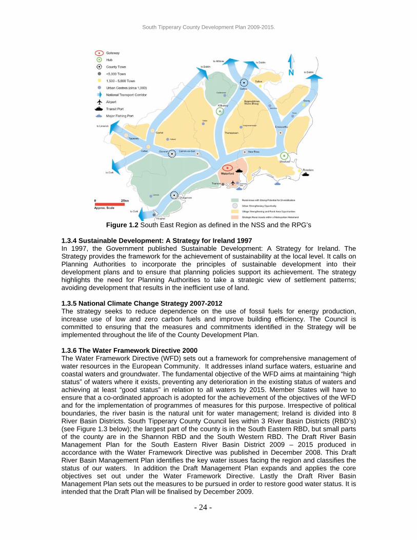
Figure 1.2 South East Region as defined in the NSS and the RPG’s
1.3.4 Sustainable Development: A Strategy for Ireland 1997 In 1997, the Government published Sustainable Development: A Strategy for Ireland. The Strategy provides the framework for the achievement of sustainability at the local level. It calls on Planning Authorities to incorporate the principles of sustainable development into their development plans and to ensure that planning policies support its achievement. The strategy highlights the need for Planning Authorities to take a strategic view of settlement patterns; avoiding development that results in the inefficient use of land. 1.3.5 National Climate Change Strategy 2007-2012 The strategy seeks to reduce dependence on the use of fossil fuels for energy production, increase use of low and zero carbon fuels and improve building efficiency. The Council is committed to ensuring that the measures and commitments identified in the Strategy will be implemented throughout the life of the County Development Plan. 1.3.6 The Water Framework Directive 2000 The Water Framework Directive (WFD) sets out a framework for comprehensive management of water resources in the European Community. It addresses inland surface waters, estuarine and coastal waters and groundwater. The fundamental objective of the WFD aims at maintaining “high status” of waters where it exists, preventing any deterioration in the existing status of waters and achieving at least “good status” in relation to all waters by 2015. Member States will have to ensure that a co-ordinated approach is adopted for the achievement of the objectives of the WFD and for the implementation of programmes of measures for this purpose. Irrespective of political boundaries, the river basin is the natural unit for water management; Ireland is divided into 8 River Basin Districts. South Tipperary County Council lies within 3 River Basin Districts (RBD’s) (see Figure 1.3 below); the largest part of the county is in the South Eastern RBD, but small parts of the county are in the Shannon RBD and the South Western RBD. The Draft River Basin Management Plan for the South Eastern River Basin District 2009 – 2015 produced in accordance with the Water Framework Directive was published in December 2008. This Draft River Basin Management Plan identifies the key water issues facing the region and classifies the status of our waters. In addition the Draft Management Plan expands and applies the core objectives set out under the Water Framework Directive. Lastly the Draft River Basin Management Plan sets out the measures to be pursued in order to restore good water status. It is intended that the Draft Plan will be finalised by December 2009.
- 24 -

South Tipperary County Development Plan 2009-2015.
Figure 1.3 River Basin Districts
1.3.7 Draft Flood Guidelines (DoEHLG September 2008) These guidelines introduce comprehensive mechanisms for the incorporation of flood risk identification, assessment and management into the planning process, building upon the longstanding acknowledgement in the planning system of the importance of addressing the issue. Implementation of the guidelines is to be achieved through specific actions at the national, regional, local authority and site specific levels. 1.3.8 Sustainable Residential Development in Urban Areas 2008 These statutory Guidelines and accompanying Urban Design Manual set out and illustrate essential criteria for sustainable urban residential development and demonstrate how new development can be integrated and facilitated across a range of locations. These Guidelines assist planning authorities, developers, architects and designers in achieving high standards for new residential development. They update and revise the 1999 Guidelines for Planning Authorities on Residential Density and benefit from the extensive experience gained over recent years. Importantly specific guidance is provided for the first time on residential development for smaller towns and villages, acknowledging that different solutions are required to meet different scales and patterns of urban development. 1.3.9 Delivering Homes, Sustaining Communities 2007 Delivering Homes, Sustaining Communities produced by the Department of the Environment, Heritage and Local Government, provides an overarching vision to guide the development of the Irish housing sector over the next ten years. It seeks to deliver better quality housing through more strategic methods, with a primary focus on the building of sustainable communities. The policy statement sets out a range of actions geared at:
• Building sustainable communities; • Responding to housing need in a way that improves choice and encourages individual
responsibility within communities. There is a clear emphasis on a services approach – one that tailors supports to households taking account of their position in the life cycle; and,
• Effectively delivering housing programmes, to get better outcomes for the households’ supported and better value for money for the tax-payer.
- 25 -

South Tipperary County Development Plan 2009-2015.
1.3.10 Sustainable Rural Housing Guidelines 2005 The Sustainable Rural Housing Guidelines 2005 (DoEHLG) have identified a number of key policy requirements to be considered in any development plan. These include: (i) To ensure that the needs of rural communities are identified in the Development Plan
process and that policies are put in place to ensure that the type and scale of residential and other development in rural areas, at appropriate locations, necessary to sustain rural communities is accommodated; and,
(ii) Pressure for overspill development in rural areas generated from larger urban settlements should be managed.
The Guidelines suggest that the key aims of the development plan should be to: (i) Encourage development which is needed to sustain and renew established rural
communities in both smaller rural towns and villages and the wider countryside areas; (ii) Guide residential and other development to the right locations in rural areas in the interest
of natural and man-made assets in those areas; and, (iii) Tailor planning policies to respond to varying local conditions and circumstances. 1.3.11 Other Strategies and Policy Documents The following strategies and policy documents have also been consulted in preparing the County Development Plan: (i) Development Plans and Local Area Plans of adjoining Counties; (ii) Joint Waste Management Plan for the South East Region 2006; (iii) South Tipperary County Retail Strategy 2003; (iv) South Tipperary County Strategy for Economic, Social & Cultural Development 2002; (v) Review of County Strategy for Economic, Social & Cultural Development and 2005-2008
Action Plan Priorities; (vi) Wind Energy Guidelines 2006 (vii) South Tipperary County Spatial Strategy 2002 (viii) Housing Strategy Review 2008 (ix) South Tipperary County Council Traveller Accommodation Programme 2004-2008 (x) Social and Affordable Housing Action Plan 2004-2008; (xi) South Tipperary County Council Play Policy 2003; (xii) South Tipperary Arts Strategy 2002-2005; (xiii) South Tipperary County Heritage Plan 2004 – 2008; (xiv) National Inventory of Architectural Heritage 2007; (xv) Residential Density Guidelines for Planning Authorities 1999 (xvi) Sustainable Urban Housing: Design Standards for New Apartments 2007; and (xvii) Urban Archaeological Survey of County Tipperary South Riding 1993. 1.4 Monitoring of the County Development Plan Introduction It is set out in the Planning & Development Acts 2000 to 2007 under Section 15 (1) that it shall be the duty of a Planning Authority to take such steps within its powers as may be necessary for securing the objectives of the Development Plan. Furthermore, under Section 15 (2) the Manager of the Planning Authority shall give a report to the members of the Planning Authority on the progress achieved in securing the objectives referred to in subsection (1) not more than 2 years after the making of a Development Plan. In addition, it is set out in the Development Plan Guidelines for Planning Authorities (DoEHLG 2007), that Planning Authorities should endeavour to monitor the implementation of their development plans on an ongoing basis. In view of these requirements, measures for monitoring and review of the Development Plan have been prepared.
- 26 -

South Tipperary County Development Plan 2009-2015.
SEA and Monitoring Article 10 of the SEA Directive requires Member States to monitor the significant environmental effects of the implementation of plans and programmes. The monitoring strategy for the assessment of the environmental effects of the implementation of the Plan is set out in Chapter 9 of the Environmental Report (Appendix 11 – Volume 2). Therefore, monitoring of the implementation of the Development Plan itself and its resultant environmental effects as part of the SEA process should be carried out in tandem. Monitoring and Review - Timeframe Monitoring and review of the implementation of the County Development Plan 2009-2015 shall be undertaken and reported on at two key stages in the lifetime of the Plan, as follows;
• Within 2 years of the date of adoption of the Plan as part of the section 15(2) 2-Year Progress Report. New Census 2010 data may be considered as part of this review where available.
• Within 4 years of the date of the adoption of the Plan as part of the commencement of the Development Plan review process.
Monitoring Strategy Monitoring of the County Development Plan will be carried out by the Forward Planning Section of South Tipperary County Council. The monitoring strategy will be based on the policies and objectives of the Plan. Key areas and strategic objectives have been identified as priorities on which the Plan will be monitored as set out below:
1. Balanced Development (Policy CT 1) Population/Education/Employment (Chapter 1 and 2)
• Population change – Census 2010 • Sectoral Employment – Change as provided by Census 2010 data. • Third level education provision update.
2. Location & Pattern of Development (Policy SS 1: Settlement Strategy)(Chapter 3)
• Continued application of settlement hierarchy. • Assess level of environmental, community & infrastructural
improvements in the settlements of the county. • Assess the population breakdown within the county.
3. Housing (Policy HSG 1: Housing Strategy) (Chapter 4 & Appendix 9) • Number of new multiple unit residential developments commenced in
each settlement since the adoption of the Plan • Numbers of units completed in each of these new developments. • Numbers of planning permissions granted to single housing units in the
Plan area. • Numbers of Local Authority and housing association housing built within
the Plan area. • Number of serviced sites permitted/developed (SHO1) • Number and impact of District Service Centre Enhancement Schemes
(SHO5)
4. Economy (Chapter 5) • Update on Third Level education in the county. • Progress of employment provision in the county. • Progress of Retail Strategy (Policy ECON 10) • Assess the state of the tourism, extractive, equine & agricultural
industries.
- 27 -

South Tipperary County Development Plan 2009-2015.
• Review of Tipperary Land Use and Economic Strategy process (SEO4) • Progress on Strategic Economic Landbanks. • Number of employment units provided/developed.
5. Amenity, Built and Natural Environment and Heritage (Chapter 6) • Numbers of statutory declarations issued within the Plan area under
Section 57 of the Act since the adoption of the Plan. • Protection of all archaeological sites/features and all Architectural
Conservation Areas. • Progress of provision of objectives of the Heritage Plan (SEAHO4). • Update on groundwater protection and wastewater disposal. • Update on protection of amenity areas, views and sites. • Update on Heritage Assets Database (SEAHO1). • Progress of LCA (SEAHO6). • Progress of RPS Review (SEAHO8)
6. Infrastructure (Chapter 7) • Progress in the preservation of strategic road networks and the
development of new routes. • Progress in the improvement of the public transport and pedestrian/cycle
routes. • Progress of the upgrading of water and wastewater networks and the
expansion of medium & high power electricity supply and gas networks in the county.
• Provision of broadband & telecommunications throughout the county. • Waste management actions.
7. Community & Social (Chapter 8) • Actions undertaken to ensure social inclusion. • Update on access to arts/culture and libraries for the public. • Update on provision of open space and burial grounds for communities
across the county. • Update on level of community involvement in the decision making
process. • Provision of high quality childcare facilities – number of places
permitted/developed and geographical spread.
8. Development Management (Chapter 9) • Number and breakdown of planning applications granted. • Number of Development Impact Assessments (DIA) submitted with
planning applications.
Conclusion It is considered that the monitoring strategy as set out above addresses key issues for South Tipperary and that the assessment of progress/change in each of these areas will be key indicators of the health and growth of the county and the protection of its assets. This strategy will play a key role in the on-going review of the Development Plan and in the provision of review data for the consideration of the Elected Members of South Tipperary County Council.
- 28 -

South Tipperary County Development Plan 2009-2015.
1.5 South Tipperary in Context South Tipperary is an inland county in the Southeast of Ireland and it is 2,258 km2 in area. There are 5 significant urban areas in South Tipperary, four of which have their own statutory Development Plan;
• Clonmel Town and Environs Development Plan 2008. • Carrick on Suir Town Development Plan 2008 • Tipperary Town and Environs Plan 2007 • Cashel Town and Environs Plan 2003 (currently under review)
While Cahir has its own Local Area Plan -Cahir Local Area Plan 2005. 1.5.1 Geographical Features The River Suir flows through the county in a south to south-easterly direction. The centre of the county comprises a plain formed by valleys of the Suir and its tributaries. This plain is fringed by the Comeragh and Knockmealdown mountains to the south, the Galtee Mountains to the west, the Hollyford and Slieveardagh hills to the north and Slievenamon to the east. 1.5.2 National Infrastructure in South Tipperary The National Primary Roads N8 (Dublin to Cork) and N24 (Limerick to Waterford) traverse South Tipperary, as do the National Secondary Routes N74 (Cashel to Tipperary) and N76 (Clonmel to Kilkenny). The single-line Waterford to Limerick railway serves Carrick-on-Suir, Clonmel, Cahir and Tipperary carrying passengers and freight. This line intersects with the main Dublin to Cork twin-track line at Limerick Junction. The Waterford to Limerick rail line is severely under-developed and it is an objective of this County Development Plan to highlight the importance of this transportation network in the future development of the county, providing interlinkage with the Gateways of Limerick and Waterford, for passenger/commuter traffic, freight along with rail access to deep water ports.
4
- 29 -

South Tipperary County Development Plan 2009-2015.
Figure 1.4: South Tipperary’s Physical Features & National Infrastructure
1.6 The Atlantic Gateways Initiative 2006 The publication of the National Spatial Strategy in November 2002 represented a comprehensive statement of Government policy on regional development. The NSS furthermore recognised the combined development potential of Cork, Limerick-Shannon, Galway and Waterford – otherwise known as the Atlantic Gateways – in establishing a metropolitan zone in the western and southern parts of Ireland with the critical mass of population, infrastructure, connectivity and competitiveness capable of acting, in development terms, at the international level. Furthermore, the NSS envisaged the Atlantic Gateways complementing the emerging metropolitan corridor on the eastern side of Ireland and encompassing Dublin to Belfast. The Atlantic Gateways Initiative report of September 2006 sets out in more detail the proposals for the Atlantic Gateways. Since 2006, an implementation team comprised of representatives of the Department of the Environment, Heritage and Local Government, the relevant Regional and Local Authorities, Shannon Development and private sector interests has been focused on driving forward the implementation of the Atlantic Gateways concept. The National Primary Road, N24, and the Waterford-Limerick Rail line form the key east-west transport corridors for the region, linking the two ‘Atlantic Gateway’ cities of Waterford and Limerick via Carrick-on-Suir, Clonmel, Cahir, Tipperary and Limerick Junction. The corridor extends to the north, north east and west of the N24 principally. South Tipperary will continue to support the Atlantic Gateways Initiative.
- 30 -

South Tipperary County Development Plan 2009-2015.
Figure 1.5 Illustration of the Atlantic Gateways Initiative
- 31 -

South Tipperary County Development Plan 2009-2015.
CHAPTER 2: CURRENT TRENDS 2.0 Introduction This chapter examines a range of statistics in order to set out the baseline data, which has been considered during the formulation of the policies and objectives contained in the County Development Plan. Trends examined relate to existing and projected population, demographic profiles, employment and education. 2.1 Population The population of South Tipperary exceeded 83,000 in 2006 for the first time since 1926. This increase has been largely influenced by inward net migration amounting to 7,236 persons and representing 8.7% of the county population. The population growth for the county over the period 2002-2006 was 5.2% and the population of South Tipperary now accounts for 18% of the total for the South East Region. From Table 2.1 the growth rate of South Tipperary, in comparison with other south east counties, does not appear remarkable but it is recognised that a proportion of the growth attributed to the other counties within the region is influenced by commuting patterns to Dublin and Cork.
- 32 -
The population growth of 5.2% from 2002-2006 in South Tipperary is viewed positively and indicative of likely sustained population growth in future periods. However, the population structure illustrated in Figure 2.2 below and the outward flow of indigenous population needs to be carefully addressed. 2.1.1 Spatial Distribution of Population Growth In relation to the five main settlements of Clonmel, Carrick on Suir, Tipperary Town, Cahir and Cashel there were trends of note over the 2002-20063 period. The urban areas recorded low levels of growth in Carrick, Tipperary Town and Cashel and there was a decline in population in the urban area of Clonmel. The greatest population increase occurred in the environs of all the main towns.
Generally across South Tipperary, increases in population were recorded at District Electoral Division (DED) Level. There were five notable District Electoral Divisions (DEDs) where population declined; Clogheen, Ardfinnan, Bansha, Killenaule and Ballingarry. • Clogheen DED recorded a net decrease in population of 29 persons that is accounted for
by the loss of 41 persons from the village of Clogheen. • Ardfinnan DED recorded a net decrease in population of 32 persons that is entirely
accounted for by the loss of 32 persons from the village of Ardfinnan. • Bansha DED recorded a net decrease in population of 39 persons with a direct loss of 30
persons from Bansha Village. • Killenaule DED recorded a net decrease in population of 127 persons whereby 118 of
those persons are attributed to a loss from Killenaule Village.
2 Inclusive of Waterford City and County
3 Central Statistics Office
Table 2.1 Census Results 2002 - 2006 Increase
Area 2002 2006 Actual % South Tipperary 79,121 83,221 4,100 5.2Waterford2
101,546 107,961 6,415 6.3Carlow 46,014 50,349 4,335 9.4Kilkenny 80,339 87,558 7,219 9 Wexford 116,596 131,749 15,153 13 South East Region 423,616 460,838 37,222 8.8State 3,917,203 4,239,848 322,645 8.2

South Tipperary County Development Plan 2009-2015.
• Ballingarry DED recorded a net decrease in population of 28 persons. The population of Ballingarry village decreased by 185 persons and while minor increases in population in the adjoining DED’s were noted it would appear that there is a trend emerging whereby people are leaving the overall area.
It is critical therefore that a sustainable settlement strategy is implemented to address declining population in such settlements and to reinvigorate and reinforce these villages making them desirable places to live.
2.2 Population Projections The 2006 Census figures indicated unforeseen levels of population growth throughout the State with an overall increase of 8.2% in the 4 years to 2006. The population figures necessitated a review of national and regional population projections. The revised population projections to 2020 for the South East Region provide for a 25.8% increase. Keeping in line with past trends it is reasonable to assume that 18% of the anticipated regional growth will occur within South Tipperary. If the revised regional growth rate occurs and the current distribution between the counties is maintained South Tipperary will have a population of 104,376 in 2020. Opportunities have been created for South Tipperary as a result of the designation of Cork City, Waterford City and Limerick City as Gateways under the NSS. The Council considers that the current population share of 18% may be exceeded taking into account the development of the Gateways and the spin off for development in South Tipperary within the influence of the Gateways. It is anticipated that greater connectivity and improved travel times between Waterford and Limerick, attributed to the N24 Waterford - Limerick National Primary Route and the Waterford – Limerick Rail Link, will have a positive influence on towns within South Tipperary. By recognising the opportunity South Tipperary’s location between these Gateways presents, and by supporting the Atlantic Gateways Initiative (along the N24 corridor in particular) it is considered that a population share of 20% of the South East Region is a very achievable objective of the County Development Plan. This revised figure of 20% represents a population potential of 115,994 persons by 2020.
Growth Projections for South Tipperary as a % of the South East Region
83,221
91,10798,935
104,376
115,994
80,00085,00090,00095,000
100,000105,000110,000115,000120,000
2006 2011 2016 2020
Year
Popu
latio
n
18%20%
Figure 2.1 Population Projections
- 33 -

South Tipperary County Development Plan 2009-2015.
2.3 Population Structure & Profile Figure 2.2 illustrates the Age Profile for South Tipperary for the last three census periods.
Age Profile
010002000300040005000600070008000
0-4
5-9
10-1
4
15-1
9
20-2
4
25-2
9
30-3
4
35-3
9
40-4
4
45-4
9
50-5
4
55-5
9
60-6
4
65-6
9
70-7
4
75-7
9
80-8
4
85+
Age Bracket
Pers
ons
199620022006
Figure 2.2 Age Profile 1996-2006
In 1996 the 10-19 age bracket consisted of 14,216 persons and 10 years later the 20-29 age bracket consists of 11,503 persons, a shortfall of 2,713 persons. This fall off would most likely be accounted for through out migration for third level education or employment purposes over the period. Table 2.2 allows for greater analysis of the age brackets 10-34 from 1996-2006. The age brackets have been coloured coded to allow each group of the population be tracked as their position in the relevant age bracket changes. In 1996, the age bracket 10-14 accounted for 7,219 persons. Ten years later this age bracket (now the 20-24 age group) accounted for 5,619 persons. The lack of a university in the South East Region must be seen as a factor in this outflow. It is noted that between 1996-2006 for the age brackets 20-34 the numbers have increased from 5052 to 5958 which indicates persons returning after 3rd level education and also inward migration (from within and outside the State). The age groupings 35-64 shows steady increase, consistent with the increasing age profile for the State as a whole and reflect an ageing population (Figure 2.2). On the basis of the foregoing, it is vital that strong 3rd level educational facilities are provided in the county and within the Region. South Tipperary County Council supports the strengthening of Tipperary Institute (TI) and the establishment of a university in the South East Region. Furthermore, the Council recognises the necessity to provide quality employment opportunities within South Tipperary for persons who wish to return or relocate to South Tipperary. The creation of employment opportunities will be complemented by the strengthening of South Tipperary’s perception as a desirable place to live through the implementation of the Settlement Strategy set out in Chapter 3.
Table 2.2 10-34 Age Cohorts Age Bracket 1996 2002 200610-14 7219 6,219 5,916 15-19 6997 6,484 5,817 20-24 5052 5,326 5,619 25-29 4847 5,226 5,884 30-34 5200 5,586 5,958
- 34 -

South Tipperary County Development Plan 2009-2015.
2.3.1 In Migration The population composition in South Tipperary has also changed over the period 2002-2006. The number of persons originally from outside the state has increased to 8.7% of the county’s population as outlined at Section 2.1 above, with the highest number of foreign nationals residing in the five main towns of the county as illustrated in Table 2.3 below.
Table 2.3 Persons in South Tipperary’s main settlements originally from outside the State
2002 2006 Foreign Nationals Total % of Total Foreign Nationals Total % of TotalClonmel 228 16,132 1.41 461 16,274 2.83Carrick 90 5,542 1.62 148 5,856 2.53Tipperary 60 4,964 1.21 168 5,065 3.32Cahir 71 2,794 2.54 243 3,381 7.19Cashel 32 2,770 1.16 150 2,936 5.11
Statistical information relating to the employment/occupation of these in-migrants is not available. However, given the increased numbers engaged in construction and retail/services it is likely that these occupations form the greater number of in-migrants. These areas of employment are the most vulnerable to economic fluctuations and likely to give rise to unemployment. It is necessary therefore, that the occupational groups as outlined in Table 2.5 below be reviewed on a precautionary basis to ensure a continued and vibrant employment/ occupational structure for the county’s population. 2.4 Employment Table 2.44 below illustrates that 65% of the total potential workforce (those aged 15-64) are in employment with 5% of the county’s population identified as unemployed. Table 2.4 Labour Force Totals in 2006 As % of Population aged 15-64 Total in Employment 35,792 65% Total Unemployed 2,859 5% Total Labour Force 38,651 70% Total not in Labour Force 16,391 30% Population aged 15-64 55,042 100%
4 Source: Census 2006
- 35 -

South Tipperary County Development Plan 2009-2015.
Table 2.5 provides comparison between a range of occupational groups in South Tipperary across the two Census periods of 2002 and 2006.
Table 2.5 Occupation Group
2002 2006 % Change Agriculture, Forestry and Fishing 4,006 3,926 -2.0
Mining Quarrying and Turf Production 179 244 +36.3
Manufacturing Industry 5,539 5,628 +1.6
Electricity Gas and Water Supply 141 148 +5.0
Construction 3,249 4,789 +47.4
Wholesale and Retail Trade 4,186 4,740 +13.2
Hotels and Restaurants 1,428 1,631 +14.2
Transport Storage and Communications 1,228 1,268 +3.2
Banking and Financial Services 695 726 +4.4
Real Estate, Renting and Business Activities 1,550 1,746 +12.6
Public Administration and Defence 1,482 1,506 +1.6
Education 1,960 2,273 +15.9
Health and Social Work 2,740 3,796 +38.5
Other Community, Social and Personal Services Activities 1,196 1,621 +35.5
Industry Not Stated 1,757 1,750 -0.4
Total at Work 31,336 35,792 +14%
Total Population 79,121 83,221 +5.2%
Percentage of Total Population at Work 39.6% 43% +3.4% From examination of this Table the following points are of note; • The number of people directly involved in agriculture continues to decline, although this
decline is marginal. • The proportion of people dependent on the manufacturing sector has remained stable over
the 10-year period, with marginal growth. • The proportion of people involved in the construction sector has almost doubled over the
10-year period. • Employment in the Financial Services is increasing, though from a low threshold. • Tourism employment represented by hotels and restaurants has also increased its
employment share. • Health and social services has shown a significant increase in the 4-year period 2002-
2006.
The division of sectoral employment is of some concern in that the largest growth area is in construction, which can be very volatile and seasonal. The higher value added occupations; banking and financial, education, research and development - while increasing in importance, are coming from relatively low employment thresholds. Tourism employment is also relatively low compared with other traditional employment sectors such as agriculture. The county is home to a number of major industrial employers, which assists greatly in retaining and strengthening the retail and service functions of our towns. The value of small and medium employers to South Tipperary is also fully recognised.
- 36 -

South Tipperary County Development Plan 2009-2015.
2.5 Unemployment From table 2.4, 5% of the total workforce is identified as unemployed in Census 2006. Figure 2.3 below shows the breakdown of unemployment among the different age cohorts within South Tipperary in comparison with the South East Region and the State. It is noted that the unemployment rate within the age brackets 15-24 is higher in South Tipperary than both the Region and the State. In the higher age groups 35-64, the unemployment levels at county level outperform the Region and the State.
012345678
Perc
enta
ge
15-19 20-24 25-34 35-44 45-54 55-64
Age Cohort
Percentage Unemployed 2006 (Excluding First Time Job Seekers)
South TipperarySouth East RegionNational
Figure 2.3 Percentage Unemployed 2006
2.6 Education Figure 2.4 outlines the educational status of the workforce of South Tipperary and demonstrates that the proportion of the labour force educated to at least upper secondary level is above the national average. The participation rates in third level education are lower in South Tipperary than that for the State as a whole. The continued support and expansion of the Tipperary Institute will provide further educational opportunities at the local level.
05
1015202530
Perc
enta
ge
Primary
Lr. Sec
onda
ry
Up. Sec
ondary
3 Lev
el no
n deg
ree
3 Lev
el de
gree +
Not Cea
sed
Education Status 2006CountyNational
Figure 2.4 Levels of Education Completed by Population
- 37 -

South Tipperary County Development Plan 2009-2015.
Policy CT 1: Population/Education/Employment It is the policy of the Council to; • Foster population growth in settlements; the aim being to achieve 20% of the South East
Region’s population share in the county; • Provide quality employment for all sectors of the population • Work with relevant agencies to assist in addressing third level educational deficits and
provide an attractive, thriving environment for all residents. • Support the expansion of Tipperary Institute as a third level college of excellence. • Support the development of a University in the South East Region.
- 38 -

South Tipperary County Development Plan 2009-2015.
CHAPTER 3: LOCATION AND PATTERN OF DEVELOPMENT 3.0 Introduction This chapter sets out the Settlement Strategy for South Tipperary. The overall objective of the Settlement Strategy is to provide strong service centres at strategic locations throughout the county. This approach shall support the local population, provide a strong basis to encourage and expand employment growth and strengthen community and social services for all, while providing important linkages and connectivity between these service centres and their adjoining hinterlands. The County Settlement Strategy identifies a range of settlement types with a good spatial distribution throughout South Tipperary. These different settlement types are envisaged to perform differing roles but ultimately to ensure that no area in the county is peripheral or becomes isolated. Through implementation of the Settlement Strategy, South Tipperary County Council shall seek to provide all necessary services, enterprise and social development to establish strong settlements and maximise community participation. The Settlement Strategy will ensure that by taking cognisance of each settlement’s positive attributes, future development will be carried out in a coordinated manner and that the proportion of overall housing and other development types, such as community and employment, will reflect the role and function of the settlement within the identified settlement hierarchy.
3.1 Settlement Pattern in South Tipperary 3.1.1 Current Context The findings of the 1996, 2002 and 2006 Census’ show that approximately 40% of South Tipperary’s population reside in the five main settlements of South Tipperary; Clonmel, Carrick on Suir, Tipperary Town, Cahir and Cashel. This means that approximately 60% of people in South Tipperary reside in settlements of less then 1500 population or in the open countryside5. Whilst in the past this proportionate split may have been attributable to the strong agricultural economy, this explanation is no longer sufficient given the decline in agriculture and the changing lifestyle choices of our population. More significantly perhaps is the fact that many of the village settlements of less than 1500 population have been subject to a decline in population; in some cases a significant decline. Hence the growth that has occurred is in the open countryside rather than within these settlements. For the future, a balance needs to be struck between maintaining and growing populations in existing settlements by catering for the future needs of the residents and at the same time catering for the needs of persons who need to live in the countryside. This County Development Plan therefore promotes development in all our designated settlements in order to accommodate, sustain and drive various types and levels of development, including residential, employment, community and commercial activities. Strong settlements will also anchor and sustain the existing rural community base and ensure retention and growth of services. 3.2 Population Context of South Tipperary Settlements 3.2.1 Towns Table 3.1 details population figures for the larger urban settlements. It also indicates the percentage of South Tipperary’s population residing in the particular settlements.
5 Areas with a population of less than 1500 are defined as rural areas in the Sustainable Rural Housing Guidelines for Planning Authorities,
2005 issued by the DoEHLG
- 39 -

South Tipperary County Development Plan 2009-2015.
- 40 -
An analysis of the current populations and rates of growth in the principle towns indicates that Cahir town has experienced the greatest level of growth. Cashel and Carrick on Suir have increased relative to countywide population, but Tipperary Town (+2%) and Clonmel (+0.9%) have preformed poorly. The population growth of Clonmel represents 142 persons over the period ’02 – ’06 and the growth potential of Clonmel has taken place in outlying villages such as Ballyclerihan, Lisronagh and Ballypatrick. It will be necessary to reverse this trend for the future, to maintain the focus of Clonmel as the county capital.
3.2.2 Villages Table 3.2 details population patterns in some of the larger villages6 in South Tipperary. Of the villages listed, 58% experienced population decline or zero growth in the period 2002-2006. Of the villages that experienced growth, only Ballyclerihan, Holycross, and Newcastle experienced significant population increases (greater than 10%). The remainder of villages that experienced growth in population were at levels that would not normally support socio economic growth. It has been recorded in Chapter 2 that the population losses of the DED’s of Clogheen, Ardfinnan, Bansha, Killenaule and Ballingarry are attributable to the population loss from the villages within those DED’s. Population loss in villages is of particular concern in that the ties that the bind community are weakened, services suffer and obsolescence of the built and social fabric can occur. The settlement strategy being developed, therefore, is designed to promote development within settlements to strengthen communities and provide critical mass to support associated services.
6 The villages listed are those for which Census data is available.
Table 3.1 Settlement Population
Settlement 02 Pop. 06 Pop. % change from ’02 –‘06.
% of South Tipp. Pop ‘06
Clonmel and Environs 16,132 16,274 0.9% 19.5%
Carrick on Suir 5,542 5,856 5.6% 7.0%
Tipperary and Environs 4,964 5,065 2.0% 6.1%
Cahir 2,794 3,381 21.0% 4.1%
Cashel and Environs 2,770 2,936 6.0% 3.5%
Table 3.2 Settlement Population Change
Settlement Population
2002 2006 Actual
Change %
ChangeFethard 1,388 1,374 -14 -1.0 Ardfinnan 779 747 -32 -4.1 Ballyclerihan 408 678 +270 +66.2Killenaule 715 597 -118 -16.5 Kilsheelan 497 520 +23 +4.6 Clogheen 550 509 -41 -7.4 Mullinahone 348 372 +24 +6.9 Holycross 229 357 +128 +55.9Cappawhite 340 328 -12 -3.5 Ballyporeen 295 304 +9 +3.0 Emly 278 293 +15 -5.3 Bansha 302 272 -30 -9.9 Golden 268 255 -13 -4.8 Newcastle 201 245 +44 +21.9Gortnahoo 207 219 +12 +5.8 Dundrum 191 191 No change Ballingarry 314 129 -185 -58.9

South Tipperary County Development Plan 2009-2015.
3.2.3 Open Countryside Many dwellings constructed recently in the open countryside were not constructed to meet rural-generated housing needs but developed as a lifestyle choice. The reason to move from the urban environment to the countryside is often motivated by perception of a poor environment in settlements, antisocial behaviour, particular family circumstances, health etc. While these considerations are relevant, the resultant move away from towns and villages considerably weakens the settlement fabric and sense of community, reduces population (critical mass), results in obsolescence and reduces the impetus for further socio-economic development, causes decline in services in the settlements which would be a significant loss to the rural community and undermines the ability to attract quality employers to the county. Demand for sites in the open countryside may also inflate land prices creating local affordability issues. Urban generated individual houses in the open countryside can be ably accommodated in our various settlement centre options described above, through the second hand housing market and through the reuse of existing, but under-utilised, dwellings in the open countryside. 3.3 Purpose of the Settlement Strategy The preceding chapters and paragraphs have outlined some of the key issues facing the county in terms of managing its population growth. The growth of our towns and villages is not purely to address population but it is an acknowledgement that strong vibrant towns and villages are an essential requirement for our county if we are to remain an attractive location for future employment initiatives and if we are to grow a sustainable employment base for our local population. It is therefore vital that towns and villages are actively supported so that strong communities are fostered, a range of house types can be delivered and social and community services, employment, enterprise, infrastructure and amenities can be adequately addressed. In order to achieve the Vision as set out in Chapter 1 and to address the challenges as identified above, it is critical that South Tipperary continues to build on the settlement strategy that it drew up under the County Spatial Strategy in 2002. The county settlement strategy concept is based on the “creation of a hierarchy of growth nodes” which reflects the development role of each settlement type. This strategy will contribute in a positive way to the growth of each settlement, ensuring that permitted development will be linked to the capacity of the settlement to ensure that the relevant services, facilities and social capital will be rolled out in line with residential development. 3.4 Methodology Employed in Designating the Settlement Tiers Building on the County Spatial Strategy 2002, a survey was undertaken of all settlements in the county and all were rated in accordance with the criteria listed below;
• The overall built form of each settlement. • The existing facilities serving each settlement and their multiple users were recorded. • Population base is also a highly significant factor for a number of settlements;
• Services exist within some settlement but population has been lost to the surrounding rural areas in recent years.
• Some settlements have seen large numbers of residential units being delivered with the necessary services lagging behind.
• Existing and proposed infrastructural developments and the proximity of a settlement to such services.
• Spatial distribution within the county The settlements were ranked in terms of their role within the county based on the above criteria. Figure 3.1 below provides a spatial overview of the survey outcome and the resultant Settlement Strategy.
- 41 -

South Tipperary County Development Plan 2009-2015.
Figure 3.1 Settlement Strategy
3.5 Settlement Strategy for South Tipperary The strategy provides for the creation of a settlement hierarchy reflecting the development role of each settlement type. The purpose of the hierarchy is to ensure that future development is guided into existing settlements and contributes in a positive way to the built form and character of each settlement, with good service base, excellent communication network and interconnectivity between settlements. The population analysis from the Housing Strategy Review 2008 indicates that there is a 50% distribution of houses between the county’s more significant settlements and their environs, which is reflected in the outcomes of the 2006 Census. An aim of the County Settlement Strategy is to strengthen the settlements and this will require a change of the proportional distribution to a 60/40 split. This split will provide for 60% of the population being accommodated in the Primary, Secondary and District Service Centres and the remaining 40% of the population being accommodated in the Local Service Centres, Settlement Nodes and the open countryside. In particular, this plan aims to achieve 20% of the county’s population and household distribution being accommodated in the District Service Centres. A sustainable level of growth is possible through the supply of developments based on the assimilative capacity of the existing environment. The designated settlements are presented in Table 3.3 below which illustrates the urban hierarchy comprising of Primary and Secondary Services Centres and the rural hierarchy comprising of District and Local Service Centres and Settlement Nodes.
- 42 -

South Tipperary County Development Plan 2009-2015.
Table 3.3 Settlement Hierarchy
Urban Settlements Rural Settlements
Primary Service Centre
Secondary Service Centre
District Service Centre
Local Service Centre Settlement Nodes
Clonmel Cahir Ardfinnan Annacarthy Ahenny Knocklofty Carrick on Suir Ballingarry Ballysloe Ardmayle Lisronagh Cashel Ballyclerihan Boherlahan Ballagh Marlfield Tipperary Town Ballyporeen Burncourt Ballinure Monard Bansha Cloneen Ballylooby Moyglass Cappawhite Clonoulty Ballyneill Ninemilehouse Clogheen Donohill Ballynonty Rossadrehid Dundrum Drangan Kilcash Rossmore Emly Dualla Coalbrook Solohead Fethard Glengoole Cullen The Commons Golden Gortnahoo Donaskeagh Thomastown Holycross Grangemockler Faugheen Toem Killenaule Hollyford Goatenbridge Kilsheelan Ballypatrick Gouldscross Limerick Junction Kilfeackle Grange Lisvarrinane Lattin Grange (Clonmel) Mullinahone Rosegreen Killusty Newcastle Kilross New Inn Knockavilla Policy SS 1: Settlement Strategy • The Council shall prioritise the allocation of funding towards consolidating settlements and
ensuring appropriate amenity, environmental and community facilities are provided in association with economic, commercial and service infrastructure with the key objective of building sustainable communities throughout the county.
• The Council will seek environmental, community and infrastructural improvements in settlements, where appropriate, to ensure that they become attractive settlement centres and assist in the long term vitality and viability of rural South Tipperary.
• The Council will seek to obtain a 20% share of the South-East Region’s population with a targeted distribution of the county’s population at 40% in the Primary and Secondary Service Centres, 20% in the District Service Centres and 40% in the Local Service Centres, Settlement Nodes and the open countryside.
3.5.1 Urban Settlement Strategy 3.5.1.1 Primary Service Centre Clonmel with a catchment population of over 50,000 is the administrative capital and the Primary Service Centre for South Tipperary. Clonmel currently operates at the top level in terms of services, facilities and an employment base. The Council will continue to support the role of Clonmel as a desired location for high-tech industry, as the primary retail centre, a third-level education provider and a strong and attractive residential centre to cater for a growing population and as the driver for countywide development.
- 43 -

South Tipperary County Development Plan 2009-2015.
Clonmel is located within a national transport corridor (as designated under the NSS) between the gateways of Limerick and Waterford. Furthermore Clonmel also benefits from being within commutable distance of Cork City. Clonmel, designated as a county town under the NSS, is located 47km to the north west of Waterford, whilst the designated hubs of Kilkenny and Wexford are located 49km and 60km respectively from the Gateway. Clonmel provides a supporting role to the Waterford Gateway in terms of critical mass needed for the Gateway to compete at a national level. The links between Clonmel and Waterford City will be further developed during the life of the County Development Plan for mutual benefit. Any new developments in Clonmel will be subject to the provisions of the Clonmel Town and Environs Development Plan 2008.
3.5.1.2 Secondary Service Centres Carrick-on-Suir, Tipperary Town, Cashel and Cahir are the Secondary Service Centres acting as service centres for their hinterlands and driving development within their catchment areas. The residential function of these service centres will be strengthened, retail/employment/heritage functions improved and their overall perception as desirable places to live and work will be promoted and enhanced. The Secondary Service Centres will provide supporting roles to Clonmel but, in the context of the settlement strategy, will adopt their own role as service centres offering an improved service provision in terms of retail, employment and community facilities to their own hinterlands. These settlements have their own Statutory Plans; • Carrick on Suir Town Development Plan 2008 • Tipperary Town and Environs Development Plan 2007 • Cashel Town and Environs Development Plan 2003 (currently under review) • Cahir Local Area Plan 2005 Each of these documents allows a greater focus to be placed on these settlements 3.5.2 Rural Settlement Strategy The Rural Settlement Strategy, as well as being informed by the County Spatial Strategy and the methodology identified in Section 3.4 above, is also framed within the context of the National Spatial Strategy 2002-2020, the South East Regional Planning Guidelines 2004 and the Sustainable Rural Housing Guidelines for Planning Authorities 2005 (DoEHLG). Rural Settlements have a pivotal role in not only sustaining a strong rural community but also in providing much needed services and ensuring those in the more remote areas (and indeed, within these areas, the more vulnerable in our society) have reasonable access to appropriate services, facilities and amenities. Table 3.3 above outlines the three distinct type of rural settlements identified by way of the survey discussed under section 3.4 above; District Service Centres, Local Service Centres and Settlements Nodes. 3.5.2.1 District Service Centres These centres are robust settlement forms that have a capacity to accommodate a reasonable degree of growth and an ability to facilitate employment and other appropriate uses. The District Service Centres are so designated because they are important resources for their sub-region, providing community, commercial and infrastructural facilities and services with a population base to maintain them. These settlements have also been targeted for infrastructural improvements (upgrade of water supply and waste water treatment plants, communications and improved transportation linkages) and again, have the supporting environment to enable this to happen.
- 44 -

South Tipperary County Development Plan 2009-2015.
Policy SS 2: District Service Centres It is the policy of the Council to promote, encourage and enhance the role and function of District Service Centres. Within these settlements, the Council shall facilitate proposed development subject to the following i) The scale, layout, design and siting of new residential development shall reflect the
character of the existing settlement and residential developments shall be appropriately phased to synchronise with the roll out of necessary services, facilities and social capital.
ii) The development of these centres shall provide for serviced sites and cluster forms of development and a variety of other house types and densities as appropriate.
iii) New commercial developments, particularly convenience retail uses, shall be located within the settlement core area.
iv) Employment/industrial uses shall be located on appropriately zoned lands and shall be designed and landscaped so as to contribute positively to the visual appearance of the town and associated entrance points.
v) Where master plans are identified on Settlement Plans in Appendix 13 (Volume 3), developers will be required to comply with the specific development objectives relating to the lands.
vi) Infrastructure shall be provided in compliance with the relevant policies and development management standards set out in this County Development Plan.
3.5.2.2 Local Service Centres Local Service Centres will support the District Service Centre and provide for a lower level of development and incorporate a mixture of land uses. In the Local Service Centres, the infrastructure will be provided/improved in tandem with development, as needs arise. Local Service Centres will provide a lower range of services and facilities for the population of their immediate hinterlands. Market interests will lead development and those wishing to develop in these areas will be required to provide the necessary upgrades to infrastructure as part of any new development. Policy SS 3: Local Service Centres It is the policy of the Council to promote, encourage and enhance the role and function of Local Service Centres. Within these settlements, the Council shall facilitate proposed development subject to the following i) The scale, layout, design and siting of new residential development shall reflect the
character of the existing settlement and residential developments shall be appropriately phased and of an appropriate scale taking into account the established pattern of development in the area.
ii) The development of these centres shall provide for serviced sites and cluster development forms and a variety of other house types and densities as appropriate.
iii) New convenience retail uses and other local shops/pubs shall be located with the village core area. All commercial uses shall be of a scale and design that contributes positively to the visual appearance of the village and associated streetscape.
iv) New community or social capital facilities shall be accommodated as appropriate to the area and as required.
v) Appropriate expansion of existing employment/industrial uses will be accommodated where appropriate and shall be designed and landscaped so as to contribute positively to the visual appearance of the village and associated entrance points. In appropriate circumstances consideration will also be given to smaller scale employment uses where there is the capacity to accommodate same, and where it will not have an adverse impact on surrounding uses or the environment.
vi) The developer, in compliance with all relevant policies, shall provide infrastructure and comply with development management standards as set out in this County Development Plan.
- 45 -

South Tipperary County Development Plan 2009-2015.
3.5.2.3 Rural Settlement Nodes The purpose of this settlement form is to provide for natural local growth to meet the demand of their immediate hinterland. Small-scale services shall be provided where they are not already present or improved as the case may be. Policy SS 4: Settlement Nodes It is the policy of the Council to promote, encourage and enhance the role and function of Rural Settlement Nodes as centres for the local community. Within these settlements, the Council shall facilitate development subject to the following i) Residential development, which meets the needs of the local population. The scale,
layout, design and siting of new residential development shall reflect the local character of the existing settlement and shall also be capable of accommodating serviced sites.
ii) New commercial and retail uses should be appropriate in size and scale to accommodate local needs and such uses shall be located within the village centre only.
iii) Some local indigenous employment uses may be accommodated here provided it is of a scale appropriate to the village setting, the infrastructure has the capacity to accommodate same and adjoining uses are not adversely affected.
iv) The developer, in compliance with all relevant policies, shall provide infrastructure and comply with development management standards as set out in the County Development Plan.
3.5.2.4 Open Countryside Settlement Form This is the final settlement form in the county. The Council recognises the need to permit the development of rural housing, at suitable locations and in accordance with technical considerations and other policies of this County Development Plan, to the category of persons who meet the criteria set out below. Policy SS 5: Individual Houses in the Open Countryside It is the policy of this Council to facilitate individual houses in the open countryside at locations removed from the following pressure areas; a) Areas identified as Primary/Secondary Amenity Areas as referred to in Chapter 6 and
illustrated in the Appendices of the County Development Plan; b) National Primary, National Secondary and Regional Roads; c) On the approach roads to Towns and Villages; and d) On local roads where there is an existing pattern of ribbon development as set out in the
Sustainable Rural Housing Guidelines 2005 (DoEHLG) and any amendment thereof And where the following criteria are met a) The proposal is for an individual house; and b) It is being made by any one of the following persons i) a farmer of the land ii) a direct descendent7 of i) above iii) a person who has lived in the open countryside, outside of the Service Centres,
within 10km of the proposed location for any 10 year period of that person’s life c) The house design, siting and layout is in accordance with the Rural Design Guide for
Individual Houses in the Countryside as set out in Appendix 4; and d) The house is for that person’s own use; and e) The applicant can reasonably demonstrate that he/she has a housing need and is eligible
under the above criteria 7 Sons, daughters or one special niece/nephew or grandchild.
- 46 -

South Tipperary County Development Plan 2009-2015.
SS 5 Continued An exception may only be made in Amenity Areas, on Agriculturally zoned land within settlements, on approach roads to towns and villages and on Regional Roads where: the proposal is for an individual house; and a) it is being made by any one of the following persons; i) a farmer of the land ii) a direct descendent of i) above b) it is not possible to locate the house on other lands within the family landholding and
outside the pressure area; and c) the house design, siting and layout is in accordance with the Rural Design Guide for
Individual Houses in the Countryside as set out in Appendix 4; and d) the house is for that persons own use; and e) the applicant has a housing need; and f) the applicant can demonstrate that he/she is eligible under the above criteria g) the proposed development will not prejudice the potential future development of the
landholding.
- 47 -

South Tipperary County Development Plan 2009-2015.
CHAPTER 4: HOUSING 4.0 Introduction The settlement strategy for the county for the period 2009 - 2015 is set out in Chapter 3, Location and Pattern of Development. This Chapter identifies the Council’s policy towards the achievement of residential development as part of the settlement strategy. As noted in Chapter 2, the expected population range for the county up to 2020 is between 104,000 and 116,000. On the basis of a household size of between 2.4 and 2.8 persons, the number of housing units required, not accounting for units becoming obsolete, is set out in Table 4.1 below and takes into consideration a low and high rate of population increase at the two different household sizes. Table 4.1 Housing Unit Requirements 2009-2020 Population Change
2006* Population
2020 Population
Difference
Units @ 2.8 Units @ 2.4 Units P/A**
Low (18% of Region)
83,221 104,000
20,779 7,421 8,657 674-787
High (20% of Region
83,221 116,000
32,779 11,706 13,657 1,064-1,241
*Household formation rate, which in 2006 was at the national average of 2.7 persons per dwelling. **Housing units required per annum 2009-2020. Table 4.2 shows the levels of zoned residential land in the District and Local Service Centres and Settlement Nodes, amounting in total to 651 hectares. Applying a mean density figure of 17.5 units per hectare (7 units per acre8) to the figures in Table 4.1, there will be a requirement to provide between 269 and 364 hectares (644 to 899 acres) of land for new residential development over the life of this County Development Plan. This represents a total residential land bank of between 1.7 and 2.39 times to accommodate housing development for the projected population to 2015. The total area of residentially zoned land and its location will allow for flexibility and choice within the housing market for all purposes. As outlined in Chapter 3, the distribution of houses in the District Service Centres will be 20% of the county. Table 4.3 below shows the total number of housing units required to achieve this aim taking account of the low and high population growth scenarios outlined in Table 4.1 above.
- 48 -
8 Seven units per acre is acceptable mean value taking into consideration high, medium and low densities of housing envisaged in the
Settlement Strategy along with the need to provide serviced sites at the rate of approximately four per acre.
9 The figures do not include for the 202 hectares (498 acres) zoned for Village Centre development which can accommodate mixed-use
developments.
Table 4.2 Provision of Zoned Residential Lands Centre Classification
Hectares Acres
District Service Centres
395 976
Local Service Centres
129 318
Settlement Nodes
127 313
Total
651 1,607

South Tipperary County Development Plan 2009-2015.
- 49 -
4.1 Housing Strategy Review 2008 The Council adopted the Housing Strategy Review 2008 on the 18th November 2008 (Appendix 9). The projected social housing and accommodation requirements identified in the Review are set out in Table 4.4 below. The Review has also identified that of the total social housing requirement, approximately 50% of households are 1 and 2 person households and only a small percentage of households exceed 4 persons. If dwellings were to be provided to facilitate this current requirement it would be expected that house sizes would range from approximately one quarter one-bedroom units to a small number of dwellings with more than four bedrooms.
10 Based on accommodating 20% of Population in these centres over the Development Plan Period
11 Based on the number of habitable dwellings and those under construction, identified in the Geodirectory as of the 1st January 2006.
12 Based on current trends and providing for a total of 4,722 units in the county over the life of the Development Plan utilising the per-
annum unit figure for a population projection of 104,000 in 2020 as set out in Table 4.1 based on a 2.4 household formation rate.
13 Based on current trends and providing for a total of 7,446 units in the county over the life of the Development Plan utilising the per-
annum unit figure for a population projection of 116,000 in 2020 as set out in Table 4.1 based on a 2.4 household formation rate.
Table 4.3 Required Housing Units in District Service Centres10
Settlement 2006 Population Current Units11 & (% of total)
Proposed Additional Units12
Proposed Additional Units13
Fethard 1,374 624 (19) 179 285Ardfinnan 747 242 (7.3) 70 110Ballyclerihan 678 247 (7.5) 71 112Killenaule 597 288 (8.7) 82 130Kilsheelan 520 205 (6.2) 59 95Clogheen 509 229 (6.9) 65 105Mullinahone 372 166 (5.0) 48 75Holycross 357 127 (3.8) 36 57Cappawhite 328 169 (5.1) 48 75Ballyporeen 304 152 (4.6) 44 70Emly 293 111 (3.3) 32 50Bansha 272 122 (3.7) 35 55Golden 255 121 (3.7) 35 55Newcastle 245 101 (3.0) 29 45Dundrum 191 79 (2.4) 24 36Ballingarry 129 80 (2.4) 24 36
Limerick Junction N/A 112 (3.3) 32 50
Lisvarrinane N/A 41 (1.2) 12 20
New Inn N/A 63 (1.9) 19 28
Total 3279 (100) 944 1,489

South Tipperary County Development Plan 2009-2015.
A critical objective of the Housing Strategy Review 2008, having regard to Part V of the Planning and Development Acts 2000 - 2007, is the provision of an adequate supply of social and affordable housing and to promote social integration. The Review has identified the continued need for 20% social and affordable housing as part of developments subject to Section 94 of the Planning and Development Acts 2000 - 2007. Generally, the 20% shall be comprised of an equal provision of social and affordable housing, though the Council reserves the right to require that the full 20% provision be for an alternative mix of social and affordable units, as it deems necessary in each particular case. In relation to developments that have commenced or have been completed to date, agreements have been finalised for the provision of 96 social units and 125 affordable units. A further 43 social units & 42 affordable units have been agreed in principle from housing schemes already under construction. The Housing Strategy Review 2008 and this County Development Plan will seek to ensure that a range of dwelling sizes and types are provided to meet the needs of the total population, including those that are in need of housing being provided for them under the social and affordable housing obligations of the Council. The continued provision of dwelling types and mix, and in particular two-bed units will be central to meeting the housing needs of the county. In supplying these units, the Council will have regard to the Quality Housing for Sustainable Communities Design Guidelines 2007 as produced by the DoEHLG and any revision thereof. It is also the intention to facilitate a flexible approach in the design of private schemes, promoting mixed developments which include executive style housing, extendible housing, serviced sites etc, so that families can remain in their initial community of establishment. The Housing Section of South Tipperary County Council is proactive in facilitating developers reaching an agreement with the local authority in relation to providing the 20% social and affordable housing requirement as per Part V of the Planning and Development Acts 2000 – 2007. Detailed Part V information and information on the design of social housing is available from the Housing Section.
- 50 -
Policy HSG 1: Housing Strategy It is the policy of the Council to have regard to the South Tipperary County Housing Strategy Review 2008 and any amendment thereof when implementing local authority housing programmes and when assessing proposals for private residential development. The Council will facilitate the provision of appropriate housing accommodation to meet the needs of the community in a way that achieves social integration.
Table 4.4 Categories of persons in need of housing/accommodation.
Total 2009-2015
Annual Average
1. Homeless 2 1
2. Persons living in accommodation that is unfit or materially unsuitable
17 3
3. Persons living in overcrowded accommodation 57 10
4. Persons in need of accommodation on medical and compassionate grounds
462 77
5. Travellers
29 5
6. Elderly persons
41 7
7. Disabled or handicapped persons
29 5
8. Young persons leaving institutional care 24 4
9. Persons not reasonably able to meet the cost of the accommodation or to obtain suitable alternative accommodation
899 150
10. Persons sharing accommodation in-voluntarily
15 3
Total 1575 265

South Tipperary County Development Plan 2009-2015.
4.2 Traveller Accommodation From Table 4.4 above, the Housing Strategy Review 2008 addresses the provision of accommodation for the traveller community. The Council has adopted the South Tipperary County Traveller Accommodation Programme 2004-2008 and this will be reviewed in the near future to provide for a new Traveller Accommodation Programme for the period 2009-2013 and the Council will facilitate the provision of accommodation for the travelling community in accordance with the Programme or any review of thereof. There is currently a need to provide 6 additional accommodation units by the end of the Programme period. The design and layout of all accommodation will be undertaken in conjunction with members of the travelling community, having regard to the Housing (Traveller Accommodation) Act, 1998, and to the Revised Guidelines for Residential Caravan Parks for Travellers 1997 (DoEHLG). In addition, where traveller accommodation needs has been identified, the Council will ensure such is catered for in an integrated way as part of the social housing programme. Traveller accommodation encompasses halting sites, group housing, village housing and the refurbishment of existing single rural dwellings. Policy HSG 2: Traveller Accommodation It is the policy of the Council to provide accommodation for the travelling community in line with the South Tipperary County Traveller Accommodation Programme and the South Tipperary County Housing Strategy Review 2008 and any amendment thereof. 4.3 Housing Design and Development on Zoned Lands A central function of this County Development Plan is to ensure that new residential developments present a high quality private and public living environment based on the principles of social integration and affordability. Residential developments will be required to provide a mix of house types and site sizes to cater for the needs of the community and that are accessible to persons with disabilities. The main challenge for future development is to provide urban design and housing layout options that deliver an excellent environment, with strong community services and facilities to encourage people into villages and towns and at the same time fulfil the social requirements of the population. In this regard, planning applications for multiple housing units will be required to include a Development Impact Assessment (DIA) with the application identifying the impact of the development on existing services and community facilities in the settlement and identify how they propose to address any deficiencies. In this regard developers will be encouraged to consult with local community group representatives in order to identify any such deficiencies and possible solutions that can be facilitated as part of the proposed development. The requirement to provide facilities as part of the DIA will depend on the size and nature of the proposed development and the range of existing facilities available within each settlement and the wider community. Minimum requirements are set out in Chapter 9 Development Management with regard to general amenity provision; however, the Council will assess each development on its own merits, having regard to the specific features of the development, the nature and use(s) proposed, significant cumulative effects and the range of existing services available to the community.
5
The Council will require the provision of a Master Plan to ensure a cohesive and co-ordinated approach to the development of certain strategic sites within settlement centres. These sites are identified on the village maps set out in Appendix 13 (Volume Three). The preparation of Master Plans shall be to the agreement of the Council and shall conform to the requirements for Master Plans as set out in Chapter 9 – Development Management Standards.
- 51 -

South Tipperary County Development Plan 2009-2015.
The Council will require financial contributions as per the adopted Development Contribution Scheme (see Chapter 9) towards the capital expenditure necessary for the provision of infrastructure works required which facilitates development. Such works include drainage, water supply, roads, footpaths and traffic management, open space, community facilities, bus stops, bus shelters and car parking. The Council will also require adequate security by way of a cash deposit or bond to ensure the satisfactory completion and maintenance of multi-unit developments. Policy HSG 3: Housing Mix and Development Impact Assessment (DIA) It is the policy of the Council to require the following to be submitted in support of proposals for new multi-unit residential development; • Proposals for complying with Part V of the Planning and Development Acts 2000 - 2007 • A Development Impact Assessment in support of the development. 4.4 Dwelling Design in the Open Countryside Residential development in the open countryside in compliance with the criteria set out in the Settlement Strategy (Chapter 3) and the Development Management Standards (Chapter 9) shall be informed by the Rural Design Guide for Individual Houses in the Countryside, included as Appendix 4 of this County Development Plan. The guidelines have been informed through a process of consultation with architects/agents, the Elected Members and the Planning Section. Policy HSG 4: Design of Individual Houses It is the policy of the Council to ensure that all new individual houses in the Open Countryside, including the refurbishment and extension of existing structures, are sited, designed and landscaped having regard to the criteria outlined in the Rural Design Guide for Individual Houses in the Countryside set out in Appendix 4 of this County Development Plan. 4.5 Nursing Homes/Retirement Villages To cater adequately for an ageing population, the council considers that the development of nursing homes and retirement villages will be a feature of future development in the county. The development of nursing homes and/or retirement villages will only be facilitated on suitably zoned lands in serviced settlements, particularly Primary, Secondary and District Service Centres in order to ensure that direct access to services such as shops, places of worship, medical care etc is available and to ensure integration of such centres into the local community. Policy HSG 5: Nursing Homes/Retirement Villages It is the policy of the Council to encourage and facilitate the sustainable development of nursing homes and retirement villages on appropriately zoned land in Primary, Secondary and District Service Centres. All proposals shall comply with the Development Management Standards set out in Chapter 9 of this County Development Plan. 4.6 Retaining Buildings of Merit and Building Reuse. The Council recognises that there are a number of underutilised and disused dwellings and other buildings in both the settlements and the open countryside that are capable of accommodating a new use and offer an alternative to new build. The Council considers that these structures provide an opportunity for reuse and in the open countryside they provide an opportunity to persons who may not meet the housing criteria to build in the open countryside as set out in the Settlement Strategy (Chapter 3). Where reuse is proposed, the Council will require that existing entrances and services be upgraded to the requirements set out in Chapter 9 of this County Development Plan.
6
- 52 -

South Tipperary County Development Plan 2009-2015.
Policy HSG 6: Retaining Buildings of Merit It is the policy of the Council to seek the retention and reuse, where practicable, of existing buildings and structures which are of aesthetic merit and which make a positive contribution to the unique character of the streetscape and/or countryside. The refurbishment of underutilised dwellings in the open countryside is encouraged provided that the structure is suitable to be used as a dwelling and can be adequately serviced to comply with the development management standards set out in Chapter 9. 4.7 Sustainable Building Design The National policy document Delivering Homes Sustaining Communities supports the adoption of new technology and innovative approaches to design and construction of dwellings, aimed at improving productivity and enhancing their quality and energy performance over their lifetime. The Department of Environment, Heritage and Local Government has also published the National Climate Change Strategy 2007-2012, which states that one way of meeting our international commitments on climate change is through the integration of climate change considerations into all policy areas. Taking cognisance of these National policies, the Council seeks to ensure that all new developments contribute positively towards ensuring reduced energy consumption and the associated carbon footprint of the county. Development proposals will be required to demonstrate reduced energy consumption in their design and construction, seeking ultimately to provide developments with zero-heating requirements by way of innovative design solutions and high performance building/insulation materials in their construction. It is widely considered that the best time to introduce energy and carbon dioxide saving measures is when specifying, designing and or constructing a new building. This provides the opportunity to: • Optimise the location and orientation within a site; • Make use of the layout, form and fabric to moderate energy needs; • Reduce heat demand by using high insulation standards with heat recovery ventilation
systems; • Meet the remaining heat demand with efficient plant and controls; • Minimise cooling needs through the use of fabric; • Maximise the use of natural ventilation; • Consider the use of renewable energy sources; and, • Meet residual cooling needs with innovative plant and controls.
Designs should incorporate alternative energy technologies such as bio-energy, solar energy, heat pumps, heat recovery while larger developments could consider the use of district/block heating/cooling systems, combined heat and power and wind energy. Policy HSG 7: Sustainable Building Design It is the policy of the Council to require that all dwellings and buildings shall be designed and constructed to have minimum energy requirements [A3-B1 BER (50-100KWh/sqm/year)] and dwellings in excess of 250 sqm floor area shall have further reduced energy requirements [A1/A2 BER (<50 KWh/sqm/year)]. At planning application stage applicants will be required to submit relevant supporting documentation/energy audits, including Dwelling Energy Assessment Procedure (DEAP) calculation, to identify the sustainable building technologies to be incorporated in the development.
- 53 -
South Tipperary County Development Plan 2009-2015.
4.8 Specific Housing Objectives. SHO 1: As opportunities arise the Council will acquire lands in villages in order to provide
serviced sites so as to stimulate growth and to assist in meeting the rural housing requirements of the county.
SHO 2: The Council will seek streetscape and roadside improvements as part of new
development that contributes to traffic calming and improvement in the visual appearance of villages and their approach roads.
SHO 3: As need arises, the Council will seek to provide permanent/temporary traveller
accommodation on suitably zoned land located within settlement boundaries identified in this County Development Plan and in so doing will consult with the Traveller Accommodation Committee where appropriate.
SHO 4: Through the implementation of the South Tipperary County Housing Strategy Review
2008, the Council will require the provision of 20% social and affordable housing units where development is proposed on land zoned for residential or village centre use which is subject to the provisions of Part V of the Planning and Development Acts 2000 - 2007.
SHO 5: During the life of this County Development Plan, the Council will obtain the services of
an appropriate professional to draw up, in consultation with the local communities, a minimum of 15 District Centre Enhancement Schemes and commence implementation of same. Where an enhancement scheme has been prepared developers will be required to conform to the provisions of the scheme.
- 54 -

South Tipperary County Development Plan 2009-2015.
CHAPTER 5: ECONOMY 5.0 Economic Profile and Occupations Section 2.4 and section 2.5 of the County Development Plan provide details regarding recent trends in employment within the county and Table 5.1 below gives a snap shot of the distribution of occupations across the employment sectors. The table illustrates that Service Industry with 28.2% gainfully employed is the largest employer in the county, followed by Manufacturing (15.7%) and Construction (13.4%). The Agricultural Sector, though in decline, accounts for a substantial number of jobs with 10.9% of the workforce. It is acknowledged that the Equine Industry is a vital growth industry and an important employer in the Agricultural Sector. The county has a strong background in the pharmaceuticals and healthcare industrial areas and the Council will continue to support the development and expansion of these employment sectors and seek to encourage and facilitate the expansion of the research and development end of the pharmaceutical and healthcare industries. The Council also recognises the need to diversify and expand its employment base so as not to be over dependent upon any one sector. In particular, there is a need to reduce dependence on the more vulnerable sectors such as construction and the Council will support continued diversification of the agricultural industry to prevent further decline. For future employment it is essential that the Council continues to focus support on growing and developing indigenous small and medium enterprises and to attract alternative key economic drivers into the county which have a more robust growth base. An important element in this will be the up-skilling and re-skilling of the workforce, as appropriate, to ensure the proper skills will be available when required. The Council will work with industrialist and training agencies to provide the proper and relevant skills base. One of the key objectives of the County Development Plan is to provide gainful employment for the workforce of South Tipperary. The Council recognises there are many factors at play in attracting viable industry to the county, among these are good industrial landbanks at strategic locations and within our strong urban settlements; excellent communications networks and power source; good infrastructural provision, roads networks, water services, workforce availability with appropriate skills, Research and Development linked to higher education, agglomeration economies of scale and locational synergies. There are other ‘non-economic’ factors at play also, such as good environmental conditions, strong settlements with good services and social facilities, etc. The list is by no means exhaustive but sets out the challenges for the Council in meeting its responsibilities for employment provision. Some of the issues outlined above have been dealt with in preceding chapters and other issues will be dealt with in more detail in the succeeding chapters of this County Development Plan.
Table 5.1 Distribution of Employment 2006 Occupation Group 2006 Percentage
Agriculture, Forestry and Fishing 3,926 10.9
Mining Quarrying and Turf Production 244 0.6
Manufacturing Industry 5,628 15.7
Electricity Gas and Water Supply 148 0.4
Construction 4,789 13.4
General Services 10,111 28.2
Public Administration and Defence 1,506 4.2
Education 2,273 6.3
Health and Social Work 3,796 10.6 Other Community, Social and Personal Services Activities 1,621 4.5
Industry Not Stated 1,750 4.8
Total at Work 35,792 100
Total Population 83,221
Percentage at Work 43.0
- 55 -

South Tipperary County Development Plan 2009-2015.
5.1 Labour Force Retaining an active labour force is a key issue for this county and as presented in Table 2.2 (Chapter 2) there has been a fall off of those of a working age within the County over a 10-year period. There are a variety of reasons for this which range from 3rd level educational requirements to a lack of opportunities for appropriate work. However, as was highlighted during the public consultations on this issue, one of the key issues facing larger employers is the ability to retain employees to live in the county. Reasons provided included the need to build up settlements to a standard that supported critical community/recreational and social facilities; providing a quality choice in residential area and enabling employees to up skill as required. It is therefore a key challenge that employment growth is prioritised during the plan period and that the Council follow through with the following policy objective Policy ECON 1: Employment Growth Opportunities It is the policy of the Council to enhance opportunities for employment in the county through the following: (i) Facilitating and supporting the further development and expansion of Tipperary Institute; (ii) Supporting the development of a South East university; (iii) Building up strong, well serviced and attractive settlements so that choice and opportunities
can be afforded to potential employees and their families; (iv) Working with key agencies to promote and support up-skilling of current and future labour
force to meet the market needs and providing appropriate opportunities for its citizens; (v) Working with key agencies to enhance research and development market opportunities;
and, (vi) Addressing infrastructural deficits and ensuring that future infrastructural needs are met in
advance of development. 5.2 Employment Creation. The County Strategy for Economic, Social and Cultural Development 2002-2011 has been drawn up by the County Development Board for the purpose of coordinating and collaborating on the implementation of strategies that combine local programmes for the social, economic and cultural development of the county over the period 2002-2011. There are a number of agencies that work within the county and have responsibility for progressing employment opportunities and creating a positive environment for employment creation and enhanced economic activity. The County Development Board is the key agency that brings these various stakeholders together. Under the Economic element of the County Strategy for Economic, Social and Cultural Development, a co-ordinated and in some instances collaborative approach is being taken to actively address this issue. The Council has taken a lead role in the area and will continue to work with these agencies and stakeholders through the support of the County Development Board, but also through the policies set out in the County Development Plan that are designed to facilitate the achievement of sustainable development. Policy ECON 2: Employment Creation It is the policy of the Council to continue to co-operate with private enterprise and employment creation agencies in order to promote South Tipperary as an attractive location for investment and associated employment creation. 5.3 Location of Employment Whilst there are numerous agencies whose responsibility it is to deliver and/or facilitate the delivery of employment to an area, the Planning Authority has a critical role to play in enabling economic activity to thrive and facilitating employment growth. In particular, it is a function of the Planning Authority to designate appropriate lands for such uses. The Council is aware that different employment uses have different landuse requirements and the County Development Plan seeks, in so far as it is possible, to allocate land use accordingly.
- 56 -

South Tipperary County Development Plan 2009-2015.
In particular, the Planning Authority has addressed employment landuses within the following context;
• Strategic employment land use requirements • Primary and Secondary Service Centre employment land use requirements • District Service Centre land use requirements • Local Service Centre Land use Requirements
There is a need to set aside lands for strategic employment uses that may include national or regional distribution centres, high quality integrated specific employment uses or gateway employment initiatives14. The Council will protect these locations from inappropriate development that would undermine or limit the future potential for economic development. Under this Plan the Council has zoned 101 hectares (249 acres) and 28 hectares (70 acres) for light industrial and general industrial uses respectively within settlements. This employment landbank is in addition to the industrial lands zoned and located within the boundaries of the larger county towns that are covered with their own Development Plans or Local Area Plans. The Council will require the provision of a Master Plan to ensure a cohesive and co-ordinated approach to the development of certain strategic sites within settlement centres. These sites are identified on the village maps set out in Appendix 13 (Volume Three). The preparation of Master Plans shall be to the agreement of the Council and shall conform to the requirements for Master Plans as set out in Chapter 9 – Development Management Standards. 5.3.1 Lands for Strategic Employment Use These lands have characteristics which make them strategically important for employment uses e.g. lands at Ballingarrane (significant for reasons of direct access to the N24, the mix of educational and employment uses and associated synergies, proximity to the gateway of Waterford and its airport and the role played by the IDA and the local authority) and lands at Limerick Junction (significant for reasons identified in the Limerick Junction Local Area Plan 2005, the strategic connections to the national rail and road networks, the proximity to Foynes, Ringaskiddy, Rosslare and Bellview ports and gateway cities). Other strategic locations are outlined below and identified on Figure 5.1 below. These locations include: (i) Lands located at Ballingarrane, Clonmel; (ii) Lands located on the Cashel Road, Clonmel; (iii) Lands located at Moangarriff, Clonmel; (iv) Lands located at new interchanges on the proposed N24 at Tipperary Town, Carrick on
Suir and Limerick Junction15; (v) Lands located at the southern interchange of the N8 at Cashel; and, (vi) Lands located at the northern interchange of the N8 and N24 at Cahir. In recognition of the strategic geographical location of our county towns, adjacent to the National Roads Networks M/N8 and N24 and Rail Lines Cork/Dublin & Limerick/Waterford/Rosslare, the Planning Authority will identify and provide strategically placed landbanks for industrial/logistic/distribution purposes at locations that can take advantage of and be accessed from these important transportation networks, without inhibiting the carrying capacity or the future development of these transportation networks.
- 57 -
14 Such development does not include retail warehousing, other retail uses or uses which can be accommodated in the settlements.
15The Council would consider that the development of the lands prior to the opening of the respective road improvement schemes could
lead to excessive traffic volumes in town centre locations, however, the Council may consider the appropriate timing of development on
foot of an agreed master plan. In forming its decision with regard to the appropriate timing, the Council will have regard to the final route
determination and the likely completion/opening dates of the Western Corridor, the nature, extent and phasing of development as set out in
the master plan and the likely significant impacts on amenity and traffic congestion in town centres.

South Tipperary County Development Plan 2009-2015.
Proposals for strategic employment use under this policy will be required to demonstrate that the proposed use requires a significant land take, requires significant access to the national road network and that the proposed development could not be accommodated within existing settlement centres for logistical reasons. The Council intends to put in place a Strategic Industrial Landbank Policy to copper fasten its commitment to the provision of proper and adequate industrial landbank throughout the county. The sub-committee of the Economic and Planning Strategic Planning Committees will steer this initiative. Policy ECON 3: Strategic Employment It is the policy of the Council to facilitate the sustainable development of strategic employment uses at the identified locations set out in the County Development Plan subject to the provision of a satisfactory master plan to be prepared by the relevant landowner(s)/developer(s) for the agreement of the Council. Any master plan shall comply with the relevant policies and development management standards set out in Chapter 9 of the County Development Plan.
Figure 5.1 Strategic Economic Locations16
5.3.2 Primary and Secondary Service Centres Employment Land Use Requirements These land banks are associated with the large urban settlements of the county and consist of large dedicated land banks that can facilitate employment/industrial uses. Such lands are predominantly located in close proximity to the regional and national road network and can facilitate activities with heavy vehicular dependence and are detailed in the relevant Development or Local Area Plans. 5.3.3 District Service Centres Employment Land Use Requirements These land banks are identified in order to stimulate and accommodate economic activities at the District level. The key objectives are to foster local employment opportunities, to anchor and support community development; prevent excessive travel for employment; and provide synergy and “value added” spin-off employment opportunities, at the local level. It will be important that sufficient land is available for starter/incubator enterprise units at these centres and it is intended 16 Refer to Appendix 13 (Volume 3) for larger map.
- 58 -

South Tipperary County Development Plan 2009-2015.
that 20% of the landbank be made available for this purpose and will of necessity be included at the ‘first phase’ of land development. As already outlined the Council will use its powers to facilitate development of these landbanks and will look at options of acquiring landbanks for immediate delivery, where demand exists. Where private development of enterprise lands is proposed, the Council will require that the first proposal for development be accompanied by a master plan for the entire zoned land bank which shall clearly identify the proposed phasing, details and specifications of infrastructure including vehicular access arrangements, landscaping and general compliance with the development management standards set out in Chapter 9. Policy ECON 4: Facilitating Local Employment in District Service Centres It is the policy of the Council to facilitate enterprise land banks within all District Service Centres with provision for incubator/starter units of a minimum land area of 20% of each landbank. The Council recognises that there are genuine difficulties experienced by individuals who are interested in starting up their own business or who are seeking to move to the next level but find it difficult to source appropriate land or purchase zoned lands at a reasonable cost. In order to facilitate this sector, the Council will seek to purchase a rolling land back in selected key villages to address this need. Policy ECON 5: Employment Land Bank It is the policy of the Council to purchase a rolling stock of land in key settlements for the purpose of assisting start up or set up enterprises in a sustainable manner.
5.3.4 Local Service Centres Employment Land Use Requirements The Settlement Strategy envisages that these centres will provide a lower range of employment opportunities which may facilitate the population of their immediate hinterlands where infrastructure will be enhanced in tandem with development as needs arise. Policy ECON 6: Local Service Centres It is the policy of the Council to facilitate the appropriate expansion of existing employment/industrial uses in Local Service Centres provided such development is designed and landscaped so as to contribute positively to the visual appearance of the settlement and associated entrance points. The Council may also facilitate new small scale employment uses where there is capacity to accommodate same, and where such development would not have an adverse impact on existing amenities, the environment or public and traffic safety. 5.3.5 Open Countryside Enterprise Requirements The Councils first priority will always be to facilitate and encourage all employment uses to locate on appropriately zoned lands that are being made available in serviced centres and which have access to an active labour force. However, the Council also acknowledges that economic activity does occur in rural areas, such as cottage industry and agri-tourism that will be location specific. There are also other economic activities that occur in the countryside, mainly from persons living in the countryside with a desire to establish some business/enterprise venture. There is a need to foster this “entrepreneurship” and put in place a framework to assist its establishment. The challenge for this Plan, in promoting ‘countryside’ economic activity, is to ensure that such activities do not:
undermine the function, role and purpose of towns/villages; provide a cheap, unsustainable and unserviceable alternative location; and result in a significant dis-amenity to residents and other uses.
- 59 -

South Tipperary County Development Plan 2009-2015.
Economic activity in the open countryside will be considered on the basis of; a) type of use, b) scale, c) appropriateness, d) residential amenity, e) traffic and f) public safety issues.
The Council will have to balance individual’s expectations with the over-arching policy of the protection of settlement based economic/enterprise activity. The ‘countryside option’ would have to be dealt with on a case-by-case basis and have as its sole purpose to facilitate the young business start up entrepreneur in meeting an initial difficulty in relation to accessing appropriate sites. The premises should ideally be an existing part of the site but where new build is required it will need to be of domestic proportions and capable of return to domestic use once the premises is vacated by the original occupier. When the business has developed on the home site to the maximum allowable level, such an operation will then be expected to move into the nearest service centre where either private land or council owned appropriately zoned land would be available and where appropriate expansion capacity is available. For clarification, it should be noted that uses such as retail shops, nursing homes, crèches and other similar “services” will not be considered appropriate uses under this policy context. The Criteria for assessment of countryside location for enterprise is set out under section 9.18 of this County Development Plan. Policy ECON 7: Enterprise in the Open Countryside It is the policy of the Council to facilitate the development of appropriate start up enterprise in the open countryside subject to compliance with the relevant development management standards set out in Chapter 9 of the County Development Plan. 5.3.6 Disused Farm Buildings and Industrial Buildings in the Countryside: Farm diversification is a common trend in agriculture today and it has resulted in a number of farm buildings lying idle or being under-utilised. Similarly, there are industrial buildings such as former creameries, mill buildings etc in the countryside that are disused and have potential for alternative use. The reuse of these agricultural and industrial buildings may provide for uses associated with rural based activities that would, by reason of noise propagation, time of operation, etc be inappropriately located in settlements, such as agricultural machinery repair/maintenance, welding and steel working. Each case will be dealt with on a case-by-case basis having regard to impacts on adjoining uses, road issues, traffic and public safety, environmental quality and landscape issues. For clarification, it should be noted that uses such as retail shops, car/bus/truck repairs/maintenance activities, machinery and car sales outlets and other similar “services” will not be considered appropriate uses under this policy context. Policy ECON 8: On Farm Diversification It is the policy of the Council to facilitate the development of appropriate farm diversification through the reuse of existing farm buildings in the open countryside subject to compliance with the relevant development management standards set out in Chapter 9 of the County Development Plan. 5.4 Non-Conforming Uses Existing minority uses within any Landuse Zone and in unzoned areas, will be supported except where such use is incompatible with the predominant use of the area. In such event the minority use will be encouraged to relocate. In the same light, the expansion of existing minority Tourism/Commercial/Industrial uses will be allowed where such use conforms to sustainability principles and good planning practices and contributes to the economic and social well-being of the area as a whole. Whilst the policy will be to secure conformity of use through discouragement of a continuation of non-conforming uses, it is recognised that it may be necessary to allow minor
- 60 -

South Tipperary County Development Plan 2009-2015.
building extension and alterations to enable the continuation of the use, provided that the continued use does not prejudice the proper planning and sustainable development of the area and the preservation and improvement of amenities thereof. It is important that all development proposals are designed and planned so as to protect the visual character of the area. The Development standards set out in Chapter 9 outline enhancement criteria to achieve good design, layout and operation to maintain zoning objectives, amenities, safety and environmental quality of the area. Policy ECON 9: Non-Conforming Uses Where commercial/employment/industrial enterprises exist as non-conforming but long-established uses, it is the policy of the Council to facilitate their continued operation where appropriate. Where such uses have ceased, the Council will generally only consider redevelopment for new uses that conform with the land use zoning for the area or on unzoned lands, shall conform to the predominate use in the area. 5.5 Retail Development The County Retail Strategy was prepared in 2003 to sustainably manage the retail sector in terms of floorspace requirements and location of retail functions in the county. It is the Councils intention to review the current Retail Strategy in 2009 in line with the methodology set out under the Retail Planning Guidelines for Planning Authorities 2005. . As of July 2008 the county had a total estimated retail floorspace of 89,624 sq m in 2006, which is located in the Primary and Secondary Service Centres as per Table 5.2.
It is anticipated that there is significant capacity for comparison floorspace in both the medium term (to 2015), and the longer term i.e. to 2020 and beyond. There is also a more limited capacity for convenience floorspace over the same periods.
The provision of retail and other commercial activity in District and Local Service Centres and Settlement Nodes is promoted by the settlement strategy and facilitated by the respective settlement zoning maps set out in Appendix 13 (Volume 3). The Council recognises the importance of providing quality convenience floorspace to meet the needs of the local population in conjunction with other commercial activities to enhance employment opportunities and the range of facilities available to the local community while also enhancing the vitality of settlements. When considering proposals for retail development, the Council will have regard to the following: (i) The proposal, either by itself, or cumulatively with other such proposals, should enhance
the vitality and viability of the settlement centre; (ii) The application should not have a negative impact on the existing uses of the surrounding
lands by reason of noise, smell or visual impact; (iii) The proposed development complies with the Retail Planning Guidelines 2005 (DoEHLG)
and the County Retail Strategy documents in place at the time; and, (iv) The development should be easily accessed with adequate parking and servicing facilities
without having a negative impact on the traffic safety.
- 61 -
Policy ECON 10: South Tipperary County Retail Strategy The Council will have regard to the County Retail Strategy when guiding and regulating retail development countywide.
Table 5.2 Retail Floorspace Settlement Area (sqm) Clonmel 55,887 Tipperary Town 13,573 Carrick on Suir 7,040 Cashel 6,844 Cahir 4,949
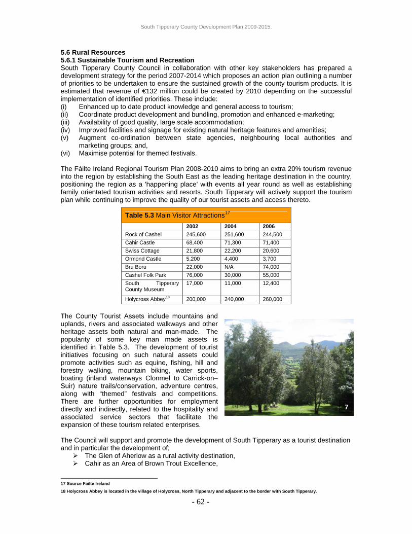
South Tipperary County Development Plan 2009-2015.
5.6 Rural Resources 5.6.1 Sustainable Tourism and Recreation South Tipperary County Council in collaboration with other key stakeholders has prepared a development strategy for the period 2007-2014 which proposes an action plan outlining a number of priorities to be undertaken to ensure the sustained growth of the county tourism products. It is estimated that revenue of €132 million could be created by 2010 depending on the successful implementation of identified priorities. These include: (i) Enhanced up to date product knowledge and general access to tourism; (ii) Coordinate product development and bundling, promotion and enhanced e-marketing; (iii) Availability of good quality, large scale accommodation; (iv) Improved facilities and signage for existing natural heritage features and amenities; (v) Augment co-ordination between state agencies, neighbouring local authorities and
marketing groups; and, (vi) Maximise potential for themed festivals. The Fáilte Ireland Regional Tourism Plan 2008-2010 aims to bring an extra 20% tourism revenue into the region by establishing the South East as the leading heritage destination in the country, positioning the region as a 'happening place' with events all year round as well as establishing family orientated tourism activities and resorts. South Tipperary will actively support the tourism plan while continuing to improve the quality of our tourist assets and access thereto.
- 62 -
The County Tourist Assets include mountains and uplands, rivers and associated walkways and other heritage assets both natural and man-made. The popularity of some key man made assets is identified in Table 5.3. The development of tourist initiatives focusing on such natural assets could promote activities such as equine, fishing, hill and forestry walking, mountain biking, water sports, boating (inland waterways Clonmel to Carrick-on–Suir) nature trails/conservation, adventure centres, along with “themed” festivals and competitions. There are further opportunities for employment directly and indirectly, related to the hospitality and associated service sectors that facilitate the expansion of these tourism related enterprises. The Council will support and promote the development of South Tipperary as a tourist destination and in particular the development of;
The Glen of Aherlow as a rural activity destination, Cahir as an Area of Brown Trout Excellence,
17 Source Failte Ireland
18 Holycross Abbey is located in the village of Holycross, North Tipperary and adjacent to the border with South Tipperary.
Table 5.3 Main Visitor Attractions17 2002 2004 2006 Rock of Cashel 245,600 251,600 244,500 Cahir Castle 68,400 71,300 71,400 Swiss Cottage 21,800 22,200 20,600 Ormond Castle 5,200 4,400 3,700 Bru Boru 22,000 N/A 74,000 Cashel Folk Park 76,000 30,000 55,000 South Tipperary County Museum
17,000 11,000 12,400
Holycross Abbey18 200,000 240,000 260,000
7

South Tipperary County Development Plan 2009-2015.
A Regional Park in the county, and The expansion of looped/linked walkways and cycle ways throughout the county. Town Walls and associated built heritage at Clonmel, Cashel and Fethard
Integrated tourism ventures, based on major, high quality base facility such as golf courses, equestrian centres, and high quality hotels, will be supported and assisted in developing their core products. The Council will consider ancillary uses, appropriate to the core use as further add-on facilities. The following key sustainable tourism principles will be employed when considering proposals for tourism development: 8 (i) Tourism, when it is well managed and properly located, should be recognised as a
positive activity which has potential to benefit the host community, the place itself and the visitor alike;
(ii) The county landscapes, cultural heritage, environment and linguistic heritage all have an intrinsic value which outweighs their value simply as a tourism asset. However, sustainable tourism planning makes sure that they can continue to be enjoyed and cherished by future generations;
(iii) Built development and other activities associated with tourism should in all respects be appropriate to the character of the place in which they are situated;
(iv) Strategic tourism assets should be safeguarded from encroachment by inappropriate development; and,
(v) Visitor accommodation, interpretation centres, and commercial/ retail facilities serving the tourism sector should generally be located within established settlements thereby fostering strong links to a whole range of other economic and commercial sectors and sustaining the host communities.
Policy ECON 11: Tourist Activities It is the policy of the Council to facilitate expansion and encourage new tourist activities in existing settlement centres, adjacent to existing tourism activities or as part of an integrated tourism development to include for sporting and recreational facilities where they can be supported by, and provide support for, existing services and communities. In all cases development will be required to comply with the development management standards set out in Chapter 9 and the key sustainable tourism principles. 5.6.2 Extractive Industry South Tipperary contains extensive reserves of sand and gravel and the Council recognises the importance of quarrying and other extractive industries to the economic life of the county. The Council will facilitate new quarries, extensions to existing quarries or other ancillary activities where appropriate, and where it is demonstrated that the development will not have significant negative impacts on any neighbouring landuse, designated site or protected view etc. When considering proposals associated with the extractive industry, the Council will require the developer to outline compliance with the Quarry Planning Guidelines 2004, the Code of Practice between the Irish Concrete Federation and the Minister for Arts, Heritage, Gaelteacht and the Islands 2002, the Irish Concrete Federation Environmental Code 2005 and the Guidelines for Environmental Management in the Extractive Sector 2006 (or any revision to the above
- 63 -

South Tipperary County Development Plan 2009-2015.
documents) and all impacts on, and proposed mitigation measures where appropriate for: (i) the quality of the landscape, particularly sensitive/designated landscapes and protected
views; (ii) adjoining existing land uses; (iii) the archaeological, architectural and natural heritage, and on any existing walking paths
and rights of way; (iv) the local road infrastructure and impact of the increased traffic on road safety; (v) the amenities of the surrounding community; (vi) the current land/quarry resource and the purpose of the current proposal. The Council will
require that current quarries are worked out and restored before the commencement of works on new related sites;
(vii) A phasing plan demonstrating that each phase is rehabilitated before the next phase is developed/commenced, detailing the manner and timing of restoration;
(viii) that with open cast workings the direction of operation to be screened from public view (and boundaries of working areas adjusted to preserve trees and hedgerows for screening) and noise propagation is minimised, dust emissions are contained, etc.
The Planning Authority will consider applications for longer term permissions for extractive developments on a case by case basis noting the proposed extraction period, phasing and rehabilitation proposals. Policy ECON 12: Extractive Industry The Council will support sustainable extractive industries where such operations ensure that existing environmental quality and amenity is protected and which comply with the development management standards as set out in Chapter 9 of this County Development Plan. 5.6.3 Agriculture The county’s countryside is reliant to a large degree on good farming practices for the management and maintenance of its rural character. Agriculture is still the predominant land-use in South Tipperary with 170,500 hectares of land under mixed agricultural use including tillage, dairy, horticulture, grassland and forestry. The Council recognises the importance of agricultural employment and farm diversification related to enterprises such as open farms, associated shops, farmers markets and specialist food. Outside of settlement centres, the Council acknowledges that there is a hierarchy of needs in respect of the use of finite land resources where the production of food and the need to protect quality land for food production is paramount. The Council will continue to facilitate, encourage and support the maintenance and expansion of an environmentally appropriate and competitive agriculture sector in South Tipperary.
9
Policy ECON 13: Protecting Agricultural Practices Where new developments are proposed, the Council will seek to balance the need for rural based economic activity with the need to protect, promote and enhance the viability and environmental quality of existing farms, and high quality agricultural land. The Council will continue to support and promote farming in South Tipperary encouraging the establishment/expansion of new enterprises where it is appropriate to do so.
- 64 -

South Tipperary County Development Plan 2009-2015.
5.6.4 Equine Ireland’s bloodstock industry enjoys international recognition and it is the third largest producer of thoroughbred foals in the world with over 40% of thoroughbred foals born in Ireland. South Tipperary is synonymous as a centre of excellence for the thoroughbred bloodstock industry at both national and international level and accommodates stud farms and racing stables of international renown. The success of the equine industry in South Tipperary can be attributed to the top quality soil, limestone bedrock and highly mineralised water supply. Quality land coupled with an experienced labour force, whose renowned affinity and tradition of working with horses has resulted in some of the world’s best nurseries, training establishments and stallions being located in the area. The Council will seek to ensure that the vitality and viability of the equine industry will be maintained through the appropriate management of the rural environment on which the equine industry is reliant.
10 It is estimated that over 25% of the national bloodstock industry turnover occurs in South Tipperary and the industry employs in excess of 2,600 persons directly. In addition to the 74 stud farms, it is acknowledged that there is considerable economic growth potential in the equine area ranging from increasing the number of trainers (sport and thoroughbred), livery yards, riding centres to indirect expansion in the area of farriers, veterinary support, equine tourism, horse dentists, equine shops/specialities and the development of bloodstock enterprises on small family farms. The Council recognises the increasing importance of the equine industry in South Tipperary, particularly the positive contribution that the industry makes towards agricultural diversification and rural employment in the county. In view of this, the Council will seek to protect, promote and enhance the development of the equine industry in South Tipperary and to continue to promote South Tipperary as a recognised centre of excellence for the bloodstock industry. Policy ECON 14 Protecting and Promoting Equine Industries Where new developments are proposed, the Council will seek to balance the need for rural based economic activity with the need to protect, promote and enhance the viability and environmental quality of existing equine operations and high quality agricultural land. The Council will continue to promote South Tipperary as a recognised centre of excellence for the bloodstock industry and will support the establishment/expansion of new equine enterprises where it is appropriate to do so.
- 65 -

South Tipperary County Development Plan 2009-2015.
5.7 Prevention of Major Accidents Guidance in relation to the prevention of major accidents is set out in Directive 96/82/EC, superseded by the European Communities (Control of Major Accident Hazards Involving Dangerous Substances) Regulations, 2000 (SI 476 of 2000) and by the Planning and Development Regulations, 2001 (SI No 600 of 2001). The Directive defines major-accident hazard sites (COMAH sites) as those that store or could generate quantities of dangerous substances in excess of specified thresholds. The Directive seeks to prevent major industrial accidents, limiting the consequences of accidents on people and the environment, imposing obligations on operators and requiring Member States to place restrictions on development in the vicinity of COMAH sites. Land use provision must take account of the need to maintain appropriate distances between major accident hazard establishments and residential areas, buildings and areas of public use, major transport routes as far as possible, recreational areas and areas of particular natural sensitivity or interest, and in the case of existing establishments, of the need for additional technical measures so as not to increase the risks to people. Currently within South Tipperary this Directive only applies to Merck Sharpe & Dohme at Ballydine, Kilsheelan, which is the only Seveso Site within the county. The location of this site is illustrated on Map No. 11 of Appendix 13 (Volume Three) of this Development Plan. Policy ECON 15: Prevention of Major Accidents The Council, in assessing applications for new development, expansion of existing development involving hazardous substances, or other proposed developments located within designated consultation areas, will have regard to: (i) The Major Accidents Directive (Seveso II); (ii) Potential adverse impacts on public health and safety; (iii) The requirements of the Health and Safety Authority (HSA) (iv) The need to maintain appropriate safe distances between residential areas, areas of public
use and areas of particular natural sensitivity. 5.8 Specific Economic Objectives SEO 1: As opportunities arise, the Council will facilitate the enhancement of tourist trails and
designated walking and cycling routes throughout the county in order to enhance the network of such routes and interconnectivity between same.
SEO 2: The Council recognises the need to provide a major entertainment venue/performance space in the county and will facilitate the development of same subject to compliance with the policies of the County Development Plan.
SEO 3: It is an objective of the Council to enhance, develop and promote tourist facilities/products throughout the county in conjunction with statutory and other local groups.
SEO 4: It is an objective of the Council to carry out a review of the Tipperary Land Use and Economic Strategy during the life of the County Development Plan.
SEO 5: The Council will continue to invest in the development of Ballingarrane and seek to ensure the development of strategic economic, employment, educational and amenity uses therein.
SEO 6: Where development is proposed on zoned lands within settlements, the Council will require all proposed development to comply with the specific objectives as identified in the Settlement plans in Appendix 13 (Volume 3).
SEO 7: It is an objective of the Council to investigate Aggregate Potential Mapping for South Tipperary in conjunction with GSI.
- 66 -

South Tipperary County Development Plan 2009-2015.
CHAPTER 6: AMENITY, ENVIRONMENT AND HERITAGE 6.0 Introduction South Tipperary contains a rich and varied landscape and a wealth of heritage assets that form the basis for the high level of amenity in the county. Quality environment, amenity and heritage all play a vital role in sustaining vibrant community and places to live and a major consideration in attracting inward investment. This chapter seeks to provide policy guidance that will ensure the maintenance and where necessary the improvement of natural and built environments, general amenities and heritage assets having regard to the settlement strategy set out in Chapter 3. 6.1 Community Amenity Access to opportunities for recreation, amenity and community facilities is an important consideration in determining quality of life. The demand for recreation and leisure facilities is growing due to increased mobility, shorter working hours and rising incomes, combined with an increasing demand for tourist facilities by visitors. To cater for such demand the county is well served with recreational facilities including sports complexes/clubs, swimming pools, playing pitches, golf courses, theatres, libraries and good access to natural amenity areas. The Council aims to facilitate the enhancement of existing and the provision of additional facilities in appropriate locations to cater for the population of the county and its visitors.
11
Policy AEH 1: Community Amenity It is the policy of the Council to ensure that adequate and safe amenity and recreational open space and facilities, including community facilities and centres, are available for all groups of the population at a convenient distance from their homes and places of work. 6.2 The Built Environment 6.2.1 Derelict and Brownfield Sites The Council continually seeks improvements in all settlement centres as opportunities arise and as part of new development. The Council will seek to reuse or remove derelict and obsolete buildings and sites. The need to prevent such dereliction has been identified through the process of public consultation particularly where neighbouring properties are being assembled in order to redevelop larger sites. The Council will provide assistance to developers in identifying appropriate reuses for brownfield and derelict sites in order to secure their redevelopment. These include but are not exclusive to:
1. Site of former Gortdrum Mines, 2. Numerous former quarries, 3. Mill Buildings, Cahir, 4. Mill buildings, Ardfinnan, 5. Former creamery, Ardfinnan, 6. Barracks in New Inn, 7. Mill Buildings, Bansha, 8. Undeveloped Town Renewal sites in Cahir, Fethard and Killenaule.
Policy AEH 2: Derelict Sites It is the policy of the Council to implement the provisions of the Derelict Sites Act, 1990, the Sanitary Services Act 1964 and the Planning and Development Acts 2000 - 2007 to prevent or remove injury to amenity arising from underutilisation and dereliction.
- 67 -

South Tipperary County Development Plan 2009-2015.
6.2.2 Enhancing Settlement Character In developing our settlements, it is important that the distinctiveness and the unique character is enhanced and should not be threatened by overdevelopment. The Council, through the Development Impact Assessment mechanism will require a design brief for proposed developments showing how their proposed development will integrate into the existing village structure. The Council, in conjunction with local interest groups, The Heritage Council and Fáilte Ireland produced Public Realm Plans for both Cashel and Fethard in 2008. The purpose of these plans is to enhance the visual and physical appearance of the towns and identify policies and objectives which will manage future development proposals so that all such developments enhance the built quality. Policy AEH 3: Enhancing Settlement Character It is the policy of the Council to implement the objectives and policies of public realm plans, village design statements and similar plans as completed during the life of the County Development Plan. The Council will require that all development proposed in settlements to which such plans/statements apply, shall comply with the respective policies and objectives of the plans/statements.
6.3 Natural Landscape Amenity 6.3.1 Landscape Amenity Areas In June 2000 the Department of the Environment, Heritage and Local Government published the Landscape and Landscape Assessment Consultation Draft Guidelines for Planning Authorities. The process of Landscape Character Assessment (LCA) identified in the guidelines provides advice in the delineation, description and sensitivity assessment of recognisable areas of common landscape character, thereby determining the capacity of particular areas and sites to accommodate development types. South Tipperary County Council, in June 2002, undertook Phase 1 of the LCA which concentrates on the upland areas of the county, namely Sliabh na mBan, the Galtee Mountains and Slievenamuck Hills, the Knockmealdown Mountains, the Hollyford Hills and Slieveardagh Hills. Phase 2 of the LCA, will address the lowland areas of the county and will culminate in a comprehensive LCA of South Tipperary. The Council has utilised Phase 1 of the LCA to identify primary and secondary amenity areas that equate to special sensitivity areas and high sensitivity areas respectfully as set out in the LCA. In primary amenity areas (specially sensitive) it is considered that landscape values are too high to absorb more than limited change while in secondary amenity areas (highly sensitive) the landscape is capable of absorbing change that reflects and enhances the current landscape condition. In assessing applications for development within these areas, the Council will have regard to the capacity of the landscape to absorb the development. In so doing, the Council will balance the need to protect the landscape character against the requirement for the appropriate and sustainable socio-economic development of the area while also having regard to the relevant policies on wind energy.
12
- 68 -

South Tipperary County Development Plan 2009-2015.
Policy AEH 4: Primary and Secondary Amenity Areas It is the policy of the Council to protect and enhance the visual quality of primary and secondary amenity areas. The scale, design and siting of new developments shall enhance this visual quality. 6.3.2 Protected Assets: Views and Trees Critical to the protection of landscape amenity areas is the protection of views and prospects, particularly of upland areas. Existing trees are also of value to the general rural character of the landscape and form a valuable part of the environment. They provide visual amenity and interest and add to the diversity of the landscape and wider environment. Trees also provide roosting place for birds and food for a wide variety of wildlife. Where development is proposed on lands that contain protected trees, the submitted landscape plan shall identify their protection and enhancement as part of the overall development. Proposals for new development will be required to ensure that such trees are not felled or rendered vulnerable by excavation around the root system. The Council may also request that a tree survey is completed as part of a development proposal, to ensure that proposals for development will not damage or result in the loss of trees listed for protection or of any mature hardwoods. In addition the Council will make Tree Preservation Orders (TPO) as deemed necessary following inspection and report by a qualified arboriculturist. Policy AEH 5: Protected Assets: Views and Trees It is the policy of the Council to protect views of special amenity value and mature trees as set out respectively in Appendix 6 and Appendix 8 of the County Development Plan. 6.3.3 Designated Environmental Sites There are four such designations relevant to South Tipperary; Natural Heritage Areas (NHA’s), Special Protection Areas (SPA’s), Special Areas of Conservation (SAC's) and Geological Sites. NHA’s are intended to conserve nationally important semi-natural and natural habitats, landforms, wild plants and animal species and it is important that the conservation value of these be maintained. Special Protection Areas (SPA’s), along with Special Areas of Conservation (SAC's), are designated under the Habitats Directive (EU Directive No. 92/43/EEC) and collectively form part of “Natura 2000”, a network of protected areas throughout the European Union. These areas support habitats and plant/animal species that are rare or threatened in Europe and require particular measures to conserve them. Geological Sites have been identified for their unique geological attributes and are the subject of local designations.
13
Proposals for development affecting such Designated Environmental Sites will be required to; • Maintain and, where necessary, restore the conservation value of European Sites (SPA’s
and SAC’s) and to ensure that appropriate assessments are carried out and submitted as part of the planning application.
• Maintain the conservation value of all Natural Heritage Areas. • Encourage biodiversity protection including the management of features of the landscape
that are of major importance for fauna and flora. • Protect species of plants listed in the Flora Protection Order (SI No. 94 of 19999) and their
habitats, species and habitats of species that require strict protection under the Habitats Regulations (SI No. 94 of 1997, 233 of 1998 and 378 of 2005), and animal and bird species and their habitats protected under the Wildlife Acts 1976-2000.
- 69 -
It is an objective to maintain the conservation value of all European Sites (Special Areas of Conservation, Special Protection Areas or lands proposed for inclusion in such sites) notified by the Minister for the Environment, Heritage and Local Government, either before or during the lifetime of this Plan, and to ensure that appropriate assessments are carried out where development projects are likely to have significant effects on these sites.
South Tipperary County Development Plan 2009-2015.
Policy AEH 6: Designated Environmental Sites It is the policy of the Council to maintain the quality of designated environmental sites and when assessing proposals will provide for the protection, conservation and enhancement of wildlife habitats and designated sites. 6.3.4 Water Environment Water bodies form a valuable natural asset for a number of settlements throughout the county and in a number of cases are underutilised for their amenity value. The Council will continue to improve access to such amenities where opportunities arise and will require the enhancement of such amenities where development is proposed adjacent to rivers and other water bodies. Economic recreational opportunities also exist where both natural and man-made water bodies exist, the latter often being a result of previous and abandoned uses such as quarrying. The Council will encourage the redevelopment of these water bodies subject to compliance with environmental, traffic and access and development management standards. Policy AEH 7: Water Environment It is the policy of the Council to preserve an undisturbed edge or buffer zone between new developments and river corridors and other water bodies in order to maintain the natural functions of existing ecosystems and to encourage increased public access and enhance water-related recreation opportunities. 6.3.5 Groundwater Protection The Council has compiled the Groundwater Protection Scheme 1998 (amended 2001), which identifies the main sources for groundwater within the county and the vulnerability of such resources, to pollution. The report outlines the geology, hydrogeology and groundwater quality of South Tipperary, using this information to prepare interpretive maps, that facilitate planning and resource development in the form of a Groundwater Protection Scheme and associated Groundwater Protection Response Matrices. The Council will use statutory powers under relevant planning and environmental legislation to protect groundwater, including environmental impact assessment, integrated pollution control and/or water pollution legislation in balancing the need to protect the environment with the need for development. All proposals for development that entail discharge of waste water to ground will be discouraged and will be required to comply with the EPA Codes of Practice for on-site wastewater treatment systems. Policy AEH 8: Groundwater Protection It is the policy of the Council to protect groundwater resources and drinking water catchments having regard to the South Tipperary Ground Water Protection Scheme 1998 (as amended 2001) and any amendment/review thereof and Environmental Protection Agency guidelines applicable at the time. 6.3.6 Water Quality European and Irish legislation continues to place a consistent emphasis on maintaining and improving water quality. The 1998 Phosphorus Regulations require that baseline water quality recorded in 1997 be maintained and improved to achieve water quality targets by 2007 while the Water Framework Directive requires that “good status” is achieved in all water bodies by 2015. This is particularly relevant for South Tipperary as approximately 20% of public water supplies within the county are from groundwater. All new residential developments will only be permitted where, following an appropriate ecological assessment, it is shown not to result in (a) increased nutrient, sediment or containment loadings in wastewater discharges to the local river network, to such an extent that there will be a decline in water quality in the river, and (b) a Sustainable Urban Drainage System (SUDS) will be implemented during design and construction stage where appropriate.
- 70 -

South Tipperary County Development Plan 2009-2015.
The recently published Waste Water Discharge (Authorisation) Regulations 2007, which came into effect on the 9th October 2007, has placed increased obligations on Water Service Authorities relating to the licensing of discharge from waste water treatment plants, facilitating greater implementation of the Water Framework Directive and other relevant EU Directives. Most of South Tipperary is located within the South Eastern River Basin District and the Draft River Basin Management Plan was published in December 2008 and following public consultation, the final plans will be adopted by the relevant Local Authorities in December 2009. The River Basin Management Plans will set the environmental objectives together with actions (known as the Programme of Measures) that will ensure these objectives are achieved in practice. South Tipperary County Council will be obliged to ensure the objectives identified in the management plans are achieved. Policy AEH 9: Waste Water Treatment and Disposal It is the policy of the Council to implement the Urban Waste Water Regulations, the relevant River Basin Management Plans and EU requirements, and will take account of the drainage system and the quality and quantity of receiving waters in the area when assessing development proposals. Proposals will be required to comply with the development management standards set out in Chapter 9 of the County Development Plan 6.3.7 Access and Public Rights of Way The Council will preserve and maintain existing rights-of-way. In order to link amenities and facilities, the Council may seek the provision of pedestrian ways as a condition of planning permission and seek implementation of same inclusive of public lighting, appropriate layout, passive overlooking and landscaping. There are three main walking schemes in Ireland:
• The National Way Marked Way/Walking Programme in the Irish Sports Council • The Sli na Slainte Scheme under the Irish Heart Foundation • Coillte Recreational Forests
There are a number of way marked and other walking routes located in the county, along with public rights of way. These latter routes include the following: (i) Clonmel Borough Boundary on north bank of the River Suir (formerly towpath) to Carrick-
on-Suir Town Council western boundary. (ii) Footpath on the north bank of the River Suir along the main Clonmel – Waterford road at
the boundary between the townlands of Ballinderry and Deerpark. (iii) Footpath on the north bank of the River Suir along the main Clonmel – Waterford road
along the western boundary of the Carrick-on-Suir Town Council (the western boundary of the property known as “The Cottage”)
(iv) Footpath on the north bank of the River Suir along the lay-by at Kilsheelan southwards. (v) Footpath on the north bank of the River Suir by the Grotto by the river bridge at Kilsheelan
southwards along the by-road. There are a number of Sli na Slainte ways located within towns in the county and the Council supports the further development of these routes in association with the Irish Heart Foundation. There is only one Coillte Recreational Forest located in South Tipperary. This is located at Bishops Wood, Gortrush, Dundrum. It is a key action of the County Heritage Plan 2004-2008, to enhance access to the countryside and heritage.
- 71 -

South Tipperary County Development Plan 2009-2015.
- 72 -
Policy AEH 10: Access and Public Rights of Way It is the policy of the Council to preserve and protect existing rights of way and create new access routes to amenity areas and facilities as the opportunity or need arises and will seek to establish a meaningful network throughout the county. 6.4 Built Heritage 6.4.1 Conservation and Management of Protected and other Structures The Planning and Development Acts 2000 - 2007, sets out the legal framework for the protection of buildings/structures which are of special architectural, historical, archaeological, artistic, cultural, scientific, social or technical interest. Such protection is afforded through the mechanism of the Record of Protected Structures (RPS) as set out in Appendix 5 of the County Development Plan. In relation to a protected structure or proposed protected structure, the term ‘structure’ includes the interior of the structure, the land lying within the curtilage of the structure, any other structures lying within that curtilage and their interior, and all fixtures and features which form part of the interior or exterior of that structure. The protection also extends to any features specified as being in the attendant grounds. The DoEHLG has completed the National Inventory of Architectural Heritage (NIAH) for South Tipperary, which was officially launched in 2008. The structures identified in the NIAH will form the basis for making additions and/or deletions to the RPS during the life of the County Development Plan under the process set out in Section 55 of the Planning and Development Acts 2000 - 2007. Once finalised, the Council intends that the RPS will be available as a stand-alone document as well as being incorporated into the County Development Plan.
14
When considering proposals for works to a protected structure or proposed protected structure, the Council will have regard to the Architectural Heritage Protection Guidelines for Planning Authorities 2004 (DoEHLG) and the Architectural Heritage Protection for Places of Public Worship Guidelines for Planning Authorities 2003 (DoEHLG) which set out the conservation principles regarding protected structures. These include issues such as use of expert conservation advice, protecting elements of special interest, promoting minimum intervention, ensuring reversibility of alterations, discouraging the use of architectural salvage from other buildings, etc. A number of key settlements within the county are of particular importance because of the quality of historic features, town walls and fortifications, street layouts, building orientation and amenity spaces. South Tipperary Local Authorities in conjunction with local interest groups, The Heritage Council and Fáilte Ireland in conjunction with appointed consultants have compiled the Cashel and Fethard Town Wall Conservation and Management Plans 2008 which will guide and manage
15

South Tipperary County Development Plan 2009-2015.
conservation works and will identify a suite of policies and objectives to manage the development of respective protected structures and associated lands. These towns, along with Clonmel form part of the Irish Walled Town Network and it is anticipated that a Town Wall Conservation and Management Plan for Clonmel will be completed by October 2009. Proposed developments in areas addressed by the Conservation and Management Plans shall comply with the policies and objectives contained therein. South Tipperary County Council administers the DoEHLG Conservation Grant Scheme for the South Tipperary administrative area. Applications are invited on an annual basis for grant aid for qualifying conservation works to a protected structure. Full details of the scheme are available from the Planning Department. Policy AEH 11: Protected Structures It is the policy of the Council to conserve and protect buildings, structures and sites contained in the Record of Protected Structures that are of special interest and when considering proposals will have regard to the Architectural Heritage Protection Guidelines for Planning Authorities and relevant Conservation and Management Plans where applicable. The Council will proactively work with developers/applicants to facilitate the appropriate reuse/redevelopment of Protected Structures. 6.4.2 Architectural Conservation Areas
In addition to the RPS, the Council has also identified a number of Architectural Conservation Areas (ACA’s) throughout the county. ACA’s are places, areas, groups of structures or townscapes, that are of special architectural, historic, archaeological, artistic, cultural, scientific, social or technical character, or that contribute to the appreciation of a protected structure. There are 11 ACA’s designated under the County Development Plan; Ahenny, Ballinure, Cahir, Cappawhite, Clogheen, Emly, Fethard, Killenaule, Marlfield, Newcastle and Nine-Mile-House and the extent of each ACA is illustrated in Appendix 13 (Volume 3).
Policy AEH 12: Architectural Conservation Areas It is the policy of the Council to conserve and enhance the special character of the ACA’s included in this plan. The special character includes its traditional building stock and material finishes, spaces, streetscape, landscape and setting. 6.4.3 Archaeology The European Convention on the Protection of the Archaeological Heritage (Valetta, 1992) was ratified by Ireland in 1997. Article 1(3) of the Convention states that ‘archaeological heritage shall include structures, constructions, groups of buildings, developed sites, moveable objects, monuments of other kinds as well as their context, whether situated on land or under water.’ Therefore the archaeological heritage of South Tipperary includes any archaeological site that may not have been recorded yet, as well as archaeology beneath the ground surface and the context of any site. The Convention provides the basic framework for policy on the protection of the archaeological heritage in Ireland. The obligations of the State under the Convention relating to the planning and development process can be summarised as follows: (i) Providing for statutory protection measures, including the maintenance of an inventory of
the archaeological heritage and the designation of protected monuments and areas; (ii) The authorisation and supervision of excavations and other archaeological activities; (iii) Providing measures for the physical protection of the archaeological heritage including
acquisition or protection by other means; and, (iv) Providing for consultation between archaeologists and planners in relation to the drawing
up of development plans and development schemes so as to ensure that full consideration is given to archaeological requirements.
- 73 -
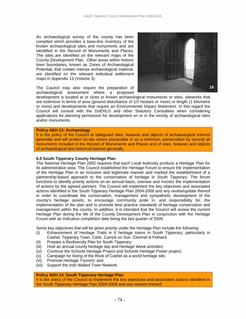
South Tipperary County Development Plan 2009-2015.
An archaeological survey of the county has been compiled which provides a base-line inventory of the known archaeological sites and monuments and are identified in the Record of Monuments and Places. The sites are identified on the relevant maps of the County Development Plan. Other areas within historic town boundaries, known as Zones of Archaeological Potential, that contain intense archaeological material, are identified on the relevant individual settlement maps in Appendix 13 (Volume 3). The Council may also require the preparation of archaeological assessment where a proposed development is located at or close to known archaeological monuments or sites, siteworks that are extensive in terms of area (ground disturbance of 1/2 hectare or more) or length (1 kilometre or more) and developments that require an Environmental Impact Statement. In this regard the Council will consult with the DoEHLG and other Statutory Consultees when considering applications for planning permission for development on or in the vicinity of archaeological sites and/or monuments.
16
Policy AEH 13: Archaeology It is the policy of the Council to safeguard sites, features and objects of archaeological interest generally and will protect (in-situ where practicable or as a minimum, preservation by record) all monuments included in the Record of Monuments and Places and of sites, features and objects of archaeological and historical interest generally. 6.5 South Tipperary County Heritage Plan The National Heritage Plan 2002 requires that each Local Authority produce a Heritage Plan for its administrative area. The Council established the Heritage Forum to ensure the implementation of the Heritage Plan in an inclusive and legitimate manner and marked the establishment of a partnership-based approach to the conservation of heritage in South Tipperary. The forum functions to identify priority actions on an annual basis, oversee and monitor the implementation of actions by the agreed partners. The Council will implement the key objectives and associated actions identified in the South Tipperary Heritage Plan 2004-2008 and any review/update thereof in order to coordinate the conservation, management and sympathetic development of the county’s heritage assets, to encourage community pride in, and responsibility for, the implementation of the plan and to promote best practice standards of heritage conservation and management within the county. In addition, it is intended that the Council will review the current Heritage Plan during the life of the County Development Plan in conjunction with the Heritage Forum with an indicative completion date being the last quarter of 2009. Some key objectives that will be given priority under the Heritage Plan include the following: (i) Enhancement of Heritage Trails in 6 heritage towns in South Tipperary, particularly in
Cashel, Tipperary Town, Cahir, Carrick on Suir, Clonmel & Fethard; (ii) Prepare a Biodiversity Plan for South Tipperary; (iii) Host an annual county heritage day and Heritage Week activities; (iv) Continue the Schools Heritage Project and Schools Heritage Poster project; (v) Campaign for listing of the Rock of Cashel as a world heritage site; (vi) Promote Heritage Tourism; and (vii) Support the Irish Walled Town Network. Policy AEH 14: South Tipperary Heritage Plan It is the policy of the Council to implement the key objectives and associated actions identified in the South Tipperary Heritage Plan 2004-2008 and any revision thereof.
- 74 -
South Tipperary County Development Plan 2009-2015.
6.6 Specific Environment, Amenity and Heritage Objectives SEAHO 1: As opportunities arise, the Council will develop a database of heritage assets
throughout the county. SEAHO 2: The Council will facilitate the use of public buildings for community use where
practicable outside regular office hours.
SEAHO 3. Where new schools are being developed, the Council will seek to ensure “out of hours” use of associated recreational and other facilities by local community groups where possible.
SEAHO 4: As opportunities arise, the Council will continue to implement the key aims and actions as identified in the South Tipperary Heritage Plan 2004 – 2008 and any amendment/review thereof.
SEAHO 5: The Council will develop networks of cycle and pedestrian amenity routes where opportunities arise, particularly in proximity to settlements.
SEAHO 6: During the lifetime of the County Development Plan, the Council will complete
Phase 2 of the LCA and identify ‘archaeological landscapes’ as part of an ongoing landscape character assessment of the county.
SEAHO 7. Where funding allows, the Council will carry out the redevelopment of historic
properties in its ownership in consultation with statutory bodies and community interest groups in order to enhance the community function of such buildings and the viability of centres within which they are located.
SEAHO 8: The Council carry out a comprehensive review of the Record of Protected
Structures and will include for consideration the Ministerial Recommendation. This review will be carried out after the adoption of the County Development Plan.
- 75 -

South Tipperary County Development Plan 2009-2015.
CHAPTER 7: INFRASTRUCTURE
7.0 Introduction In order for the county to achieve inward investment, strong settlements and community development we require an excellent infrastructure package inclusive of transportation, water supply, wastewater treatment, energy, communications, and waste management. This Chapter addresses the existing provision of infrastructure and identifies the infrastructural needs for the future development of the county. 7.1 Transport The county’s transportation infrastructure includes for road, rail, bus, cycling and walking. The Council will promote the efficient and effective use of the county’s transportation infrastructure to ensure the economic, social and community development of the county. 7.1.1 Roads Infrastructure The administrative area of South Tipperary has a road network of 2,859 km as shown on Table 7.1. The Council will continue to maintain, develop and improve this existing road network and construct new roads as planning and resources permit. The Council will have regard to national objectives as set out in the National Development Plan 2007-2013 and Transport 21, the need to promote the economic development of the county and to preserve and enhance the safety, level of service and carrying capacity of the national road network in South Tipperary. The Council will also seek to improve access as a means of supporting the overall land-use plans for the county. Key road transport objectives include: (i) Improvement in road quality particularly between Primary,
Secondary and District Service Centres as identified in the settlement strategy set out in Chapter 3;
- 76 -
(ii) Implementation of South Tipperary Road Safety Action Plan; (iii) Enhanced quality of environment in settlement centres; (iv) Increasing the availability of alternative transport modes to the car; (v) Increasing the availability and choice of fuel types; (vi) Reducing emissions and improving air quality; (vii) Progressing the N24 bypass plans; (viii) Improving the rail network, maximise usage and facilitate the provision of park and ride
facilities; and, (ix) Improve access for the mobility impaired. The N24 traverses the county, linking the gateway cities of Limerick and Waterford. The N24 is identified as a “key national primary route” in Transport 21 and the preferred route alignments have been identified (see Figure 7.1 below). The NRA made a policy decision in August 2007 that the N24 will be a type 2 dual carriageway over the entire length. The Council in association with the South East Regional Authority has prepared a report titled “N24 Prioritisation Study” and are seeking approval to proceed to construction in the post 2010 National Road Construction Scheme.
Table 7.1 County Roads Road Categories
Length km
% of Total
National Primary 121 4.2%
National Secondary 39 1.4%
Regional 415 14.5% Local Primary 925 32.4% Local Secondary 903 31.5%
Tertiary 456 16.0
17

South Tipperary County Development Plan 2009-2015.
Figure 7.1 Strategic Route Proposals
The section of the N8 between Cashel and Cahir, including the N24 link at Molls Cross, was completed in October 2007, removing unnecessary through traffic from Cahir town centre. The southern part of the scheme from Cloghbreeda to Garryane (Mitchelstown) opened to traffic in July 2008 some 11 months ahead of programme. The N8 Cashel to Cullahill dual carriageway is due to be completed in December 2008. In order to further facilitate the development of the national road network in accordance with national policy, it is imperative that the following route corridors are protected from development that would interfere or conflict with route proposals: N8 National Primary Route (i) N8 Cashel to Mitchelstown Proposed Road Development; (ii) M8/N8 Cullahill to Cashel Proposed Road Development; N24 National Primary Route (iii) N24 Western Corridor Improvement – Pallasgreen to Bansha; (iv) N24 Western Corridor Improvement – Cahir to Bansha; (v) N24 Western Corridor Improvement – Rathkeevin to Cahir incorporating N24 Cloghabreedy
to Knockagh Road Improvement Scheme; (vi) N24 Western Corridor Improvement – Clonmel By Pass; and, (vii) N24 Western Corridor Improvement – Carrick-on-Suir to N76 Junction at Kilheffernan. These schemes will be completed as funds are made available through Transport 21 and the NDP 2007-2013. However, revised design proposals are being drafted for the N24 (points iii – vii above) that may result in alternative phasing for the overall improvement works. 7.1.2 Preserving Route Capacity It is vital that the strategic route networks in the county (National and Regional Roads identified in Figure 7.2 below) provide an efficient method of transportation with direct links to and between the Gateways, ports and airports outside the county and the Primary, Secondary and District Service Centres within the county. The ability of users (and goods) to get to their destination safely and efficiently will require that the carrying capacity of the strategic route networks is
- 77 -

South Tipperary County Development Plan 2009-2015.
protected and as such the Council will resist development along such corridors, except where development designed to protect the carrying capacity of the roads can be accommodated in accordance with employment policies at strategic locations as identified in Chapter 5. In assessing applications for development whereby access to national routes outside areas where a 50kph speed limit applies, the Council will have regard to the Department of Environment publications “Development Control Advice and Guidelines” 1982 and “Policy and Planning Framework for Roads” 1985 and the NRA’s “Policy Statement on Development Management and Access to National Roads” 2006.
18
The Council supports the development of on line motorway service areas in accordance with NRA document – Policy for the Provision of Service Areas on Motorways and High Quality Dual Carriageways, October 2007. In the interest of road traffic safety and noting that motorway service areas as set out are considered as part of the National Road Network, such service areas must comply with NRA Design Standard TA 70/08. It is the strategy of the NRA to provide motorway service areas at intervals of approximately 50-60 klms, where feasible/practicable. In view of this it is considered that there will be no requirement for additional off-line motorway services areas in South Tipperary. Policy INF 1: Preserving Strategic Road Networks The Council will safeguard the efficient operation and continued development of the national road network in accordance with the National Development Plan 2007-2013, Transport 21 and the policy of the National Roads Authority. The Council will protect national and regional road corridors free from development that would undermine the implementation of future infrastructure projects and the carrying capacity and safety of the national and regional route corridors identified in Figure 7.2.
- 78 -

South Tipperary County Development Plan 2009-2015.
Figure 7.2 Strategic Route Corridors
Development proposals with potential implications for national, regional and adjoining local roads could, in some circumstances, necessitate changes to the road and/or junction layout and capacity in order to address road safety concerns and maintain a satisfactory level of service for road users and may require a Traffic and Transport Assessment. Thresholds for such developments are set out in the Traffic Management Guidelines 2003. The cost of implementing mitigation measures will be borne by the developer. Policy INF 2: Traffic and Transport Assessment The Council will require that Traffic and Transport Assessment be carried out where, in the opinion of the Council, such a study is considered to be necessary, as part of large-scale development, where new development gives rise to cumulative impact in conjunction with neighbouring developments or where large traffic volumes are anticipated. 7.1.3 Public Transport A detailed survey was carried out of the public transport requirements for rural areas as part of the South Tipperary rural transport needs assessment. This assessment continues to form the basis of a pilot programme for improved rural transport across the county. The Council recognises the importance of good transport service in rural areas as a key element to preserving rural communities. The Council will, therefore, support the implementation of the rural transport programme and will seek to increase the viability of such schemes through the development and implementation of the settlement strategy set out in Chapter 3.
19 7.1.3.1 Rail South Tipperary is traversed by two active rail lines; Dublin-Cork and Limerick-Waterford. The Dublin-Cork route offers an hourly service between Dublin and Cork with at least 20 services to Limerick Junction daily mid-week facilitating effective and efficient access to Dublin, Cork and Limerick. The county is also traversed by a historic, dismantled rail line, which ran from Clonmel to Thurles, via Fethard.
- 79 -

South Tipperary County Development Plan 2009-2015.
The Limerick to Waterford rail line traverses the county from west to east and provides the potential for a realistic alternative to private transport in the county. However, this rail line is underutilised and underdeveloped with the result that direct travel between the two Gateway cities is not accommodated or provided. Eight mid-week daily services are provided between Limerick and Clonmel and Waterford and Clonmel but the current timetables do not facilitate commuter (journey to work passengers) travel. Iarnrod Eireann plans to complete the upgrade of track and signalling on the Limerick to Waterford line and the remodelling project in Limerick Junction by the end of 2008. South Tipperary County Council will work with all transport and development agencies to upgrade and improve the service for intercity and intraurban passengers and freight to ensure that the Limerick to Waterford rail line provides as good a service as the Dublin to Limerick rail line and serves the rail needs of South Tipperary County. It is important that the Limerick to Waterford rail line is developed to a standard comparable to the Dublin-Cork service and upgraded to a standard that renders both lines to be seen as a viable alternative to road transport. In order to ensure long-term viability of these lines, it is equally important that land-use policy and future development takes advantage of rail as a potential transport option. Obvious examples of such sites include Limerick Junction, Tipperary, Dundrum (now closed), Bansha, Cahir, Clonmel, Kilsheelan and Carrick-on-Suir. In land-use terms it is important that land adjacent to stations and corridors are protected for potential expansion of the rail network and other associated uses. The potential for the reinstatement of rail freight has been recognised in the Limerick Junction Local Area Plan 2005 and a land use strategy has been put in place that would facilitate an intermodal transfer, storage and distribution facility. This is of particular strategic importance to the county and both the South East and Mid West Regions, given the possible direct rail access from Limerick Junction to deep sea ports at Foynes, Bellview, Ringaskiddy and Rosslare. Where applications for development are received adjacent to existing active and dismantled railway lines, the Council will have regard to the future potential expansion of the railway line/service. In this regard, applicants are advised to consult with Iarnrod Eireann in advance of submitting planning applications. 7.1.3.2 Bus Bus Eireann and other private bus operators provide expressway and rural routes in the county operating throughout the county on a daily or weekly basis. Bus scheduling for commuter transportation (passenger journey to work) is very poorly scheduled and needs to be reconsidered and rescheduled so as to provide an effective alternative to the private car. South Tipperary County Council will work with Bus Eireann to provide a bus services that will provide a viable alternative to car transport for journey to work and all other passenger services In addition, a number of rural transport initiatives, such as Ring a Link, provide an invaluable service to rural dwellers who have no access to private transport and who, without the service, would be isolated. The Ring a Link Service is continually expanding providing affordable transport to rural areas, particularly serving the Tipperary Town, Clonmel and Slieveardagh areas on a weekly or twice weekly basis. The Council will continue to support pilot schemes such as Ring a Link and those that use the school bus during off peak times for rural public transport. Policy INF 3: Public Transport The Council will support and promote the continued development of a sustainable and integrated public transport network in order to enhance general accessibility and social inclusion throughout the county. In this regard the Council will work with all transportation and development agencies to upgrade and improve public passenger and freight services serving South Tipperary County. The Council will also protect lands adjacent to rail stations and along rail routes against encroachment by uses that could compromise the long-term development of the rail facility. The Council will also preserve free from development the route of the existing dismantled railway line which runs from Clonmel to Thurles.
- 80 -

South Tipperary County Development Plan 2009-2015.
7.1.4 Pedestrian and Cycle Routes In line with the objectives of the European Charter of Pedestrian Rights, adopted in 1988 by the European Parliament, it is the objective of the Council to facilitate and develop walking and cycling as environmentally friendly, fuel efficient and healthy modes of transportation and to strive to ensure that access to buildings and public spaces for all persons is improved. Chapter 6 (Section 6.3.7) has identified a number of defined walking routes in the county. Furthermore, the Council is carrying out an accessibility audit in order to identify improvement works required to ensure public areas and buildings are accessible to all members of the community throughout the county. An implementation plan of specific works based on this audit will be identified during the life of the County Development Plan and the Council will seek its implementation as opportunities arise. South Tipperary County Council will support the development of the Walks Scheme in the county. The scheme is aimed at farmers/private landowners and landholders/users and involves the development, enhancement and maintenance of National Waymarked Ways and priority walks. Cycle routes are also available throughout the county with routes originating in Carrick on Suir, Cahir, Cashel and Clonmel being promoted through Failte Ireland. Cycle lanes have been provided within and adjacent to new residential developments on urban fringes. To expand and promote this transport option and ensure and encourage public interest the Council will seek the provision of cycle friendly linkages as part of new developments and will promote the expansion of cycle facilities throughout the county particularly on cycling touring routes and at other areas of amenity and places of interest. Policy INF 4: Pedestrian and Cycle Routes The Council will seek to improve and create additional facilities for pedestrians and cyclists and improve access facilities for people with mobility needs in line with the recommendations of the accessibility audit for the county once completed. 7.2 Water Services The general objectives of the Council in managing water services are as follows:
(i) To provide water services infrastructure to support current and future sustainable development having regard to relevant national and local plans, the Settlement Strategy, guidelines and policies;
(ii) To improve drinking water quality, to upgrade and extend the water distribution network and to improve river water quality by the provision/facilitation of appropriate waste water treatment systems; and,
(iii) To extend sewer collection networks where possible to safeguard public health and protect groundwater.
7.2.1 Water Supply South Tipperary County Council provides a public water supply through a network of six Regional Water Supply Schemes as indicated on Figure 7.3 below. The comprehensive network includes 28 water sources, 59 reservoirs and 2,100 kms of mains piping, all of which are utilised to supply 55,000 m3 (12 million gallons) per day with an associated total revenue expenditure of €3.5 million annually.
- 81 -

South Tipperary County Development Plan 2009-2015.
Figure 7.3 Regional Water Supply Schemes In order to ensure improvements to the Council Drinking Water Supply from a quantity and quality point of view the Department has allocated funding in the Water Services Investment Programme to progress upgrading of the Major Regional Water Supply Schemes. Funding is also available for Water Conservation measures in order to improve the management of the distribution system and reduce water losses. As a result of the implementation of the Conservation Programme, areas where mains replacement is required have been identified and funding will be sought for this work which, if allocated, will be carried out over the period of this Plan. Monitoring programmes are in place to check the quality of Drinking Water and the most recent EPA Report shows that the quality is above the national average. The Council policy is that development should take place in areas that can be connected to the public water supply. In exceptional circumstances the Council may consider an independent or group water supply where it can be demonstrated that it is not possible to connect to the public supply. The supply of water from private boreholes to housing schemes will not be permitted. 7.2.2 Borewell Augmentation In order to augment the existing supply to support current and future development in the short term a number of borehole supplies have been or are in the process of being developed while other improvements have been made by providing booster pumps, recommissioning old supplies and investigating possible additional sources. It is the Councils policy only to develop or allow development of borehole supplies in areas which will augment existing schemes only.
- 82 -

South Tipperary County Development Plan 2009-2015.
7.2.3 Waste Water Treatment South Tipperary County Council manages an extensive network of waste water treatment plants throughout the county which are provided directly by the Water Services and Housing Sections of the Council or by Design Build and Operate Schemes (DBO’s). These are identified in Figure 7.4 below. There are a total of 32 municipal treatment plants that have capacity to facilitate a population of 78,000 persons. The total revenue expenditure for this network is €4.4 million annually.
Figure 7.4 Municipal Waste Water Treatment Plants 7.2.4 Current Water Services Investment Programme Funding for Water Services Infrastructure comes mainly from the following sources;
• Water Services Investment Programme • Small schemes programme • Development Contributions • Serviced Land Initiative.
Table 7.2 below sets out the Schemes included in the current Water Services Investment Programme which will be progressed during the life of the Plan along with their current status. The value of the programme is €95m. Where necessary further priorities will be identified for funding as the need arises. For example the improvement of the Tipperary Town Water Supply and Sewer Rehabilitation in the main towns has already been identified as a priority to the Department.
- 83 -

South Tipperary County Development Plan 2009-2015.
The other funding streams above will be used to fund smaller projects which are usually identified on an annual basis. It should be noted that the Council is obliged to contribute to the cost of provision of most water services infrastructure which could be up to 40% in some cases. Table 7.2 Water Services Investment Programme Project Estimated
Cost € Current Status
Clonmel Town & Rural Water Supply Scheme
38m Preliminary report approved in principle. Advance works approved and in progress.
Galtee Regional Water Supply Scheme
14.5m Preliminary report to be submitted to Department.
Fethard/Burncourt Water Supply Scheme
14.4m Approval received from Department to proceed with preparation for contract stage
Ardfinnan Regional Supply Scheme (Lisava)
5.5 m Preliminary report submitted to Department.
Carrick on Suir Water Supply Scheme
1.5 m Design brief being prepared.
Dundrum Regional Water Supply Scheme
2.2 m Preliminary Report to be submitted to Dept. by end of April 2009.
Water Conservation 3.6 m Countywide study in progress. Phase 1 completed. Phase 2 commenced February 2009.
Clonmel Main Drainage Scheme. Sewer Rehabilitation Stage 1 & 2
4.3m Stage 1 at contract stage Stage 2 Planning Stage
South Tipperary Sludge Management
5.8m Contract to be signed in February 2009
Fethard Sewerage Scheme Upgrade
4.1m Preliminary report to be submitted to Dept by end of April 2009
Clonmel Storm Drainage Study 0.5m Design brief stage
Grouped Villages Sewerage Schemes Feasibility Study
0.3 m Consultants Brief being prepared
- 84 -

South Tipperary County Development Plan 2009-2015.
Table 7.3 Small Scheme Investment Priorities
Project
Estimated Costs €
Current Status
Golden WWTP 500,000 Site acquisition stage
Newcastle WWTP 500,000 Developer led solution
Emly WWTP 500,000 Contract Stage
Cappawhite WWTP 500,000 Contract Stage
Cloneen WWTP 500,000 Site acquisition stage
Drangan WWTP 75,000 Tertiary treatment to be installed in 2008 Ballynonty WWTP 75,000 Tertiary treatment to be installed in 2008
Mullinahone WWTP 2.4m Consultants report received. New WWTP required
Rosegreen WWTP 100,000 Developer led. Proposal possible
Dundrum WWTP 500,000 Design stage. Site available
Water main replacement at Kilross and Clonoulty
400,000 Continue mains replacement in these areas
Source Protection/Supply improvements
100,000 Ongoing works
Policy INF 5: Water Supply and Waste Water It is the policy of the Council to facilitate the provision and upgrading of the water supply and sewerage schemes throughout the county in accordance with the settlement strategy identified in Chapter 3 and as finances permit and will require; • Proposed developments to connect to the public water mains and public sewers where
available or likely to be available. • Financial contributions in accordance with the Development Contribution Scheme for water
services from developers towards existing and/or future developments. • Bonds to be submitted by developers to ensure the satisfactory completion and maintenance
of water services infrastructure until such time as the Council takes them in charge. 7.2.5 Surface Water The Council will require that surface water be disposed of, where possible, on site and drainage will be achieved by a combination of regulated discharge and source control where the objective is to improve the quality and reduce the quantity and the rate of discharge of surface water release to nearby rivers. Storm water has been identified by the River Basin District (RBD) project teams as one of the causes of poor water quality. Current best practice guidance on Sustainable Urban Drainage Systems (SUDS) is available from the Guidance Documents produced by the Greater Dublin Strategic Drainage Study (GDSDS). Best practice recommendations for discharge of storm water is by way of shared “regional” systems rather than on-site systems. Similarly, surface water attenuation systems are recommended in place of underground storage of water in tanks. In this regard the Council would direct proposed applicants to the GDSDS Policy Documents and the Drainage Code of Practice as well as the website www.irishsuds.com for further detailed information. All proposals for surface water discharge to groundwater shall comply with the requirements of EPA document Policy and Practice for the Protection of Groundwater (1998). The Council also recognises the benefits of harvesting rainwater for reuse within larger developments and individual dwellings. While there is no provision for these systems in the current building regulations, the Council, in granting permission will require surface water reuse in
- 85 -

South Tipperary County Development Plan 2009-2015.
all new developments and will seek design solutions that provide for collection, recycling and reuse of surface water to meet the non-potable needs of the proposed development. Policy INF 6: Surface Water The Council will seek the implementation of rainwater harvesting, SUDS and best practice guidance for the collection and reuse or disposal and treatment of surface water. Such systems will be required to conserve water, protect water quality and regulate the rate of surface water runoff so as not to cause or exacerbate flooding on the relevant site or elsewhere. 7.2.6 Flood Risk Assessment Parts of South Tipperary are subject to periodic flooding. Details of many past flood events have been compiled and are available from the Office of Public Works (OPW) on their national flood hazard mapping website www.floodmaps.ie. The OPW are currently compiling the River Suir Catchment Flood Risk Assessment and Management Study which is due to be completed in 2010. This will assess and map the spatial extent of flood hazards having regard to historic events and climate change and will make recommendations on how to manage appropriate development within the catchment area. The Development Plan Guidelines for Planning Authorities 2007 (DoEHLG) outline that development plan policies dealing with flooding need to recognise the uncertainties inherent in the prediction of flooding and the fact that flood risk is expected to increase due to climate change recommending a precautionary approach to flood risk. Taking cognisance of this precautionary approach and the issue of climate change, the Council notes the findings of the EPA report Climate Change: Regional Climate Model Predictions for Ireland (2005). This estimates that future river discharge will increase by up to 20% in December and January in the South East Region while there is also some evidence of an increase in the frequency of extreme precipitation events. All flood risk assessments should have regard to national flood hazard mapping, predicted changes in flood events resulting from climate change and the Suir Catchment Flood Risk Assessment and Management Study (CFRAM Study) when completed by the Office of Public Works. Policy INF 7: Flood Risk Assessment The Council will require a comprehensive Flood Risk Assessment for proposals in an area at risk of flooding, adjoining same or where cumulative impacts may result in a flood risk elsewhere, in low lying areas and in areas adjacent to streams. 7.3 Access to Electrical Supply Networks Electricity supply and transmission is available throughout the county on the low (10kV) and medium (20kV) three phase networks which are subject to ongoing upgrading and improvement works by the ESB. Access to these networks is available throughout the county. High voltage transmission within the county is available at 38kV and 110kV. These existing networks join the main Primary and Secondary Service Centres with 38kV stations located at Cahir, Tipperary Town, Clonmel, Cashel, Glengoole and Ardfinnan and 110kV stations at Clonmel, Tipperary Town, Cahir and Ballydine. The nearest 220kV line lies inside Limerick County almost parallel to the county boundary with South Tipperary while the nearest 220kv station is located outside Limerick City at Killonan. The development of secure and reliable electricity transmission infrastructure is recognised as a key factor for supporting economic development and attracting investment to the area. It is the policy of the Planning Authority to support the infrastructural renewal and development of electricity networks in the region. Where practicable, electricity supply lines are to be provided underground within the built up areas identified in Table 3.3 of this Development Plan.
- 86 -

South Tipperary County Development Plan 2009-2015.
Policy INF 8: Access to Electrical Supply Networks It is the policy of the Council to promote and facilitate the continued expansion of medium and high power electricity supply networks, particularly in support of new employment uses throughout the county. 7.4 Access to Natural Gas Supply Natural Gas is currently available in Clonmel, Carrick on Suir and Ballyclerihan. Bord Gais have carried out feasibility studies on other towns within the county and have deemed that Cashel and Cahir qualify for connection to the existing pipeline (running through the county in a south-west to north-east direction from Kilkenny to Mitchelstown). These connections will form Phase II of Bord Gais current programme (Phase I currently under construction). Policy INF 9: Access to Natural Gas It is the policy of the Council to promote and facilitate the continued expansion of the natural gas pipeline network in the county. 7.5 Wind Energy The County Wind Energy Policy was adopted by South Tipperary County Council in December 2006. The areas suitable and unsuitable for wind energy development have been identified under the following categories as set out in Appendix 3: (i) Preferred areas: Areas suitable for wind energy development that should be granted
planning permission unless specific local planning circumstances within the context of the Development Plan support a decision to refuse.
(ii) Areas open for consideration: Applications treated on their merits with the onus on the developer to demonstrate why the development should be granted permission.
(iii) No-Go Areas: Areas identified as particularly unsuitable for wind energy development. This category is used for areas, which due to their scenic, ecological, historic or tourism values are unable to accommodate wind development.
The Council will also require prospective developers to scope for wind potential for a period of approximately two years, which could run concurrent with the preparation of an EIS, prior to any planning application being made for subsequent wind energy development. Policy INF 10: Wind Energy The Council will facilitate the exploitation of the natural wind energy resource available, provided that it can be demonstrated that such development, and associated infrastructure, is in accordance with Appendix 3: Policy on Wind Energy Development, and the other policies contained in this County Development Plan. 7.6 Bio-Energy Chapter 2 refers to the National commitments under the National Climate Change Strategy 2007-2012. For South Tipperary to play its role in implementing the Strategy, some relevant measures include: (i) That 15% of electricity to be generated from renewable sources by 2010 and 33% by 2020; (ii) Support for Combined Heat and Power projects; (iii) Support for Biomass harvesting, heating and the use of waste biomass in energy
production; (iv) All street lighting and traffic lights required to be energy efficient; The Regional Bio-Energy Implementation Plan for the South-East Region is due to be launched in March 2008. The objectives of the plan are to provide a structured framework for all stakeholders in the Region for coherent development and progress in the area of bio-energy, to gather data in relation to the scope and potential for bio-energy development in the Region, based on the availability of resources and technology, and to identify and reduce barriers to the development of bio-energy in the Region.
- 87 -

South Tipperary County Development Plan 2009-2015.
While the Regional Bio-energy Implementation Plan seeks to counteract influences of climate change, more importantly it recognises the economic benefits to the region from the direct production of bio-energy and bio-fuels and also the benefits accrued from reduced dependence on fossil fuels. Policy INF 11: Bio-energy The Council will support and have regard to the measures outlined in the South East Regional Bio-Energy Implementation Plan in conjunction with the private sector, Statutory Agencies and other Local Authorities as appropriate. 7.7 Broadband and Communications South Tipperary County Council recognises the importance of advanced communications as a key component for the economic development of the county. To this end, there are a number of initiatives in place under the South-East Regional Public Access Network of Telecommunications (SERPANT) such as the County and Group Broadband Scheme and SERB-II: South-East Regional Broadband Project - Phase 2. The roll out of broadband access throughout the county has most recently taken place under this latter initiative through the development of the fibre-optic Metropolitan Area Networks (MAN's). To date these have been put in place in the Primary and Secondary Service Centres of the county. There are a number of private broadband providers servicing the South Tipperary County Area. Further information as to the providers in any particular locality can be found on www.broadband.gov.ie. However, there remains areas of the county where there is currently no service. The Department of Communications Energy and Natural Resources (DCENR) has established the National Broadband Scheme (NBS) whose objective it is to encourage and secure the provision of broadband services to certain target areas in Ireland in which broadband services are not currently available and are unlikely to be available in the near future. The DCENR has produced an indicative broadband coverage map (see www.dcmnr.gov.ie/Communications/Communications+Development/National+Broadband+Scheme.htm) and it is intended that areas where no service is currently provided and is unlikely to be provided in the future will fall into the scope of the NBS. The Planning Authority will consider the use of 10 year permission for telecommunication antennae and support structures on a case by case basis. Where the antennae and their support structures are no longer being used by the original operator and no new user has been identified they shall be demolished, removed and the site reinstated at the operators expense. Policy INF 12: Broadband The Council will proactively work with key stakeholders to address deficiencies in broadband coverage in the rural areas and will facilitate the continued development of broadband infrastructure throughout the county in line with the policies of the National Development Plan and the Regional Planning Guidelines for the South East Region. The Council will seek to achieve a balance between facilitating the provision of mobile telecommunications services in the interests of social and economic progress and sustaining residential amenities and environmental quality. When considering proposals for telecommunications masts, antennae and ancillary equipment, the Council will have regard to the following: (a) The visual impact of the proposed equipment on the natural or built environment,
particularly in areas of sensitive landscape or historic importance; (b) The potential for co-location of equipment on existing masts; and (c) Telecommunications Antennae and Support Structures Guidelines for Planning Authorities
DoEHLG (1996), or any amendments thereto. All proposals for development must include details of alternative sites, the impact on public health and the long term plans of the developer in the county and the plans of other promoters.
- 88 -

South Tipperary County Development Plan 2009-2015.
Policy INF 13: Telecommunications The Council will facilitate proposals for telecommunications masts, antennae and ancillary equipment where it can be established that there would be no negative impact on the surrounding area and that no other location can be identified which would provide adequate telecommunication cover save in the following locations: (i) Primary and secondary amenity areas or at locations detrimental to the designated
protected views; (ii) Within significant views or settings of national monuments or protected structures; (iii) In close proximity to schools, churches, crèches, community buildings, other public and
amenity/conservation areas and residential areas. 7.8 Waste Management The Waste Management Act 1996 sets out the legislative framework to develop waste management policies on a national basis. The statutory objectives of the Act are to: (i) Prevent and minimise the production of waste and its harmful effects; (ii) Encourage and support the recovery of waste; (iii) Ensure that unrecoverable waste is safely disposed of; and, (iv) Implement the polluter pays principle in relation to waste disposal. The main objectives of the Joint Waste Management Plan for the South East Region 2006 focus on prevention, minimisation, reuse and recycling of waste, provision of a framework for the development and operation of waste infrastructure within the region and the application of the polluter pays principle. While development plans and the waste management plan are both guided by the policies and objectives of the Regional Planning Guidelines for the South East, which in turn are guided by the National Spatial Strategy and the National Development Plan, it should be noted that where the policies and objectives of the waste management plan conflict with those of the development plan, precedence is given to the waste management plan. Policy INF 14: Waste Management The Council will promote minimisation of waste through source reduction, producer responsibility and public awareness. The Council will implement the policies and objectives of the Joint Waste Management Plan for the South East Region. 7.9 Agricultural Waste In order to plan for the disposal of sludge effluent from agriculture, particularly intensive agriculture, the Council has prepared a number of studies, including: • Sludge Management Plan for South Tipperary, prepared, subsequently incorporated into the
Joint Waste Management Plan for the South East Region 2006; and, • The Three Rivers Project and subsequent River Basin Management Plans. S.I. No. 378 of 2006, European Communities (Good Agricultural Practice for Protection of Waters) Regulations 2006 (Nitrates Regulations) sets out the storage requirements for agricultural waste and regulates the spreading of such wastes i.e. time of year, weather conditions, buffer zones etc. In line with the current recommendations of the South Tipperary Sludge Management Plan, expansion of intensive agriculture, particularly where it would increase the areas of spread lands, in the sensitive areas such as Aherlow, Araglin, Duag and Shanbally catchments and source protection areas, shall be discouraged, along with importation of organic waste from intensive agricultural practices outside the catchments. This matter will be reassessed during the review of the Sludge Management Plan and the reassessment of the nutrient balance for the sensitive catchments.
- 89 -
Intensive agricultural enterprises are considered as those that are not land dependent such as piggeries, poultry, mushrooms etc and where most feed is imported onto the site. The resultant sale of meat, eggs or mushrooms only removes a small proportion of the imported ingredients (i.e. nutrients) and the remainder requires to be land spread. Applications for intensive agricultural enterprises must include a Nitrates Management Plan that demonstrates access to sufficient

South Tipperary County Development Plan 2009-2015.
storage facilities and sufficient land bank for land spreading to cater for the recovery of all organic waste produced in compliance with the Nitrates Regulations, the Sludge Management Plan for South Tipperary and the River Basin Management Plans. Policy INF 15: Agricultural Waste The Council will require all agricultural organic waste to be recovered by landspreading and will seek improvement in the management of all agricultural organic waste by requiring the provision of a satisfactory nutrient management plan where intensive agricultural development is proposed. 7.10 Specific Infrastructure Objectives SIO 1. It is an objective of the Council to seek to reinstate of the tow path along the River Suir
from Clonmel to Carrick-on-Suir. SIO 2. It is an objective of the Council to seek to improve the rural walk between Clonmel and
Marlfield along Pond Road and the interchange with Moores Road and Patrick’s Well Road.
SIO 3. It is an objective of the Council to carry out improvements to regional and local roads
on sections that are deficient in respect of alignment or structural conditions as funds permit.
SIO 4. It is an objective of the Council to control inappropriate advertising on all roads and
particularly on approach roads to settlements.
SIO 5. It is an objective of the Council to seek a reduction of unaccounted-for water supply
from the present level to 25% by 2016. SIO 6. It is an objective of the Council to seek to establish a central bus depot within the
county.
- 90 -

South Tipperary County Development Plan 2009-2015.
CHAPTER 8: COMMUNITY AND SOCIAL 8.0 Introduction This chapter looks at the role of the Planning Authority in the broader social, cultural and community landscape of the county and the linkages that it can make to assist the variety of stakeholders achieve their aims within each of their operational areas. It is recognised that the County Development Plan is but one part of the overall system that acts upon and determines the local social, economic, cultural and community landscape of the county. There are many stakeholders operating in the county that impact on the physical development of the county. All of these stakeholders operate, in a co-operative manner under the umbrella of the County Development Board19. All such stakeholders have signed up to the implementation of the South Tipperary County Strategy for Economic, Social and Cultural Development 2000 – 2010. The work of the County Development Board is progressed through four Programme Management Groups, each of which are directed to undertake actions in key areas either singularly or in collaboration with other agencies. Policy CS 1: Interagency Cooperation and Collaboration It is the policy of the Council to assist and support the implementation of the South Tipperary County Strategy for Economic, Social and Cultural Development 2000 – 2010. The Council will proactively engage with all initiatives and all stakeholders operating in the community in order to ensure the achievement of the aims of this Plan. 8.1 Economic Programme Management Group The Economic Programme Management Group is made up of the key stakeholders who have a role to play in developing, supporting and growing business and employment opportunities in South Tipperary20. The key aim of this group is to improve the competitiveness of the South Tipperary Economy in attracting investment, growing business, increasing employment in new business and sustaining existing industries. It also seeks to gain the best economic advantage for South Tipperary by linking the county’s development potential to neighbouring counties; the South East Region, the Island of Ireland and the European Union. The County Development Plan will complement and support the aims and objectives of this group through the implementation of its economic objectives as outlined in Chapter 5. 8.2 Social Inclusion Measures Group This group is made up of the key stakeholders in the county who have a role to play in addressing the social inclusion challenges that face South Tipperary in a co-ordinated way. The key aim of this group is to seek to eliminate poverty and to create a secure and stable environment that will enable South Tipperary residents to enjoy a good quality of life by participating in economic, social and cultural activity. Equality of access by all sectors of society to services, facilities and decision making processes is a key objective of this grouping. The Council is particularly eager to address issues around access for those with a disability. To this end, the Council has carried out an Accessibility Audit of all public buildings and places and a submission in this regard has been made to the DoEHLG. Once the submission is endorsed by the DoEHLG an Implementation Plan will be prepared. It is a key objective of the Council to implement the findings of this audit over a specified time period.
19 Members of the County Development Board include the County Enterprise Board; Enterprise Ireland; IDA; VEC; Tipperary Institute; FAS;
Business Pillar; Farming Pillar; Trade Union Pillar; Community Pillar; Failte Ireland; Health Service Executive; County Council; Town and
Borough Councils; LEADER Companies x 3 ; Partnership Company; DSCFA; DES’ Garda Siochana; Teagasc (it should be noted that the
LEADER Companies and Partnership Company are being amalgamated into the South Tipperary Local Development Company Ltd)
20 Refer to the South Tipperary CDB website for details of programme management group membership.
- 91 -

South Tipperary County Development Plan 2009-2015.
Policy CS 2: Addressing Social Inclusion The Council will actively use the tools available to it to ensure that all new development addresses issues of social inclusion. The Council will also work with other key stakeholders to address issues of equality of access for all to services, facilities and decision making processes. In particular it will actively implement the findings of the Accessibility Audit. 8.3 Cultural Programme Management Group This group is made up of the key stakeholders who are active in the cultural field in South Tipperary. Access to arts, heritage, sport and recreation impacts significantly on quality of life and exposure to a culture that supports creative development is an important indicator of a community’s or county’s well being. The key aim of the programme management group is to provide structures to allow the variety of players in this field to operate in a more professional manner, to increase participation, to source and develop volunteers, to develop facilities and to improve the range of cultural opportunities. The Council has a key role to play in the cultural area. The development in the arts, cultural and entertainment field is a key area of activity and with the appointment of an Arts Officer in 2007; significant additional progress is expected in this area over the period of the County Development Plan. The Arts strategy 2002 – 2005 (which is currently under review and due to be published in the last quarter of 2009) has identified the need for a designated Arts Space in Clonmel and the provision of artists’ studios in Cahir. The Council will continue to support cultural facilities in Fethard (Abbey Mill Theatre), Cashel (Bru Boru), Carrick on Suir (Brewery Lane and Strand Theatre), Clonmel, (South Tipperary Arts centre) and Tipperary (Excel Centre). Policy CS 3: Arts and Culture The Council will seek the provision of arts, cultural and entertainment facilities, new works of art and performing space in association with new development proposals, where appropriate and will seek to support the arts within overall public local services provision for the enhancement of South Tipperary as a place in which to live, work and invest. 8.4 Library Services The County Tipperary Joint Libraries Committee is the authority responsible for providing and promoting an active public library service for the people of both North and South Tipperary. The service now operates a network of thirteen branches throughout the county from its headquarters at Tipperary Libraries, Castle Avenue, Thurles, with relevant branches located in at Cahir, Carrick on Suir, Cashel, Tipperary Town, Clonmel, Killenaule and Fethard. In addition, the Committee operates a schools library system that now extends to over 150 schools.
20
Policy CS 4: Library and Information Access It is the policy of the Council to ensure that everyone has equal opportunity access to a high quality library and information service that is responsive to the changing needs of the community and is fully supportive of the process of life-long learning. The Council will support the upgrading of existing facilities in Cahir and Fethard and the construction of new libraries in South Tipperary in accordance with the Programme for Library Development. 8.5 Community Amenity
- 92 -
The Council will ensure that adequate and safe amenity and recreational open space and facilities, including community facilities and centres, are available for all groups of the population at a convenient distance from their homes and places of work. In this regard the Council operates the amenity grants scheme (since 2003) in order to assist community based projects, which aim for the social, recreational, amenity and cultural betterment of their community. These grants vary from €10,000 to €100,000 and to date the scheme has allocated in excess of

South Tipperary County Development Plan 2009-2015.
€7million. The priorities for the scheme change annually and in the 2008 Scheme it concentrated on youth facilities, playgrounds and heritage. In total 52 projects were granted €1.6m in 2008 and this funding was allocated towards assisting the development of designated youth facilities across the county, enabling several communities to develop their community playgrounds, funding heritage applications and assisting local sports clubs. South Tipperary County Council has also collaborated with other key stakeholders to set up the South Tipperary Sports Partnership with the key aim of developing sport and increasing physical activity in South Tipperary. The partnership has developed the Strategic Plan 2007 – 2010, which will guide the development of sport and recreation in South Tipperary. This identifies 3 strategic areas for development as follows: Active Living, Sports Development and Managing and Promoting the Partnership. Policy CS 5: Community Amenity It is the policy of the Council to ensure that adequate and safe amenity and recreational open space and facilities, including community facilities and centres, are available for all groups of the population at a convenient distance from their homes and places of work. 8.6 Burial Grounds The Council directly manages the provision of burial grounds at 19 different locations as illustrated in Table 8.1. As well as directly providing burial grounds and maintaining facilities that are currently in use, the Council also operates a scheme of grants to assist operative committees in the upkeep and maintenance of burial grounds that are at or near capacity. In 2008 this scheme provided a total of €53,800 to 114 committees for such purposes. For the life of this County Development Plan, the Council will address areas of deficiencies (in line with the Programme for the provision and Management of Burial Grounds) and will provide for future needs in this area.
- 93 -
Policy CS 6: Provision of Burial Grounds It is the policy of the Council to identify land for social and public use in settlements that will facilitate the provision and expansion of burial grounds. 8.7 Local Agenda 21 Programme Management Group This group is made up of the key stakeholders who have a role to play in addressing the four strategic principles for governance in the 21st Century (later formalised as Agenda 21). The key aims of this Group is to promote sustainable development and plan a strategy that links facility development, infrastructure and provision of the requisite level of services at household, village, small town, county town and region. Of relevance to this County Development Plan is the aim to ensure that the institutions include the community sector as an equal partner when developing public policies and responses.
Table 8.1 Capacity of Burial Grounds in South Tipperary as at 31st December 2008 Location Total No.
of Spaces No. Vacant (%)
Anticipated Life (Yrs)
1. Ardfinnan 483 19 (3 %) 8
2. Annacarty 384 182 (47 %) 50+
3. Ballinacourty 1,054 836 (79 %) 50+
4. Clonoulty 539 420 (77 %) 50+
5. Cappawhite (Extn 2002) 949 914 (96 %) 50+ 6. Cloneen 776 418 (53 %) 50+
7. Grange 551 439 (79 %) 50+
8. Emly 641 489 (76 %) 50+
9. Cahir (Extn 1998, 2003) 517 167 (32 %) 20 10. Gortnahoe 1140 883 (77 %) 100+
11. Hollyford 535 325 (60 %) 50+
12. Killenaule 826 521 (63 %) 50+
13. Newcastle 365 303 (83 %) 50+
14. Shanrahan 364 0 (0 %) nil
15. Mullinahone 673 365 (54 %) 50+
16. Ballyclerahan 484 204 (42 %) 20
17. Nine-Mile-House 744 714 (95 %) 50+
18. Lattin 776 750 (96 %) 50+
19. Ballingarry 501 496 (99 %) 50+
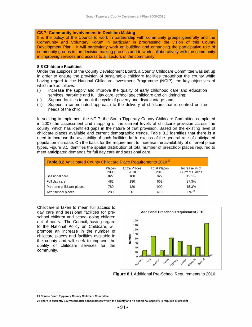
South Tipperary County Development Plan 2009-2015.
- 94 -
020
4060
80100
120140
160
Num
ber
Cloghee
nCah
ir
Dundru
m
Cashe
l
Tipperar
y
Carrick
Killena
ule
Clonmel
Additional Preschool Requirement 2010
CS 7: Community Involvement in Decision Making It is the policy of the Council to work in partnership with community groups generally and the Community and Voluntary Forum in particular in progressing the vision of this County Development Plan. It will particularly work on building and enhancing the participative role of community groups in the decision making process and to work collaboratively with the community in improving services and access to all sectors of the community. 8.8 Childcare Facilities Under the auspices of the County Development Board, a County Childcare Committee was set up in order to ensure the provision of sustainable childcare facilities throughout the county while having regard to the National Childcare Investment Programme (NCIP), the key objectives of which are as follows: (i) Increase the supply and improve the quality of early childhood care and education
services, part-time and full day care, school age childcare and childminding; (ii) Support families to break the cycle of poverty and disadvantage; and, (iii) Support a co-ordinated approach to the delivery of childcare that is centred on the
needs of the child. In seeking to implement the NCIP, the South Tipperary County Childcare Committee completed in 2007 the assessment and mapping of the current levels of childcare provision across the county, which has identified gaps in the nature of that provision. Based on the existing level of childcare places available and current demographic trends, Table 8.2 identifies that there is a need to increase the availability of such facilities far in excess of the general rate of anticipated population increase. On the basis for the requirement to increase the availability of different place types, Figure 8.1 identifies the spatial distribution of total number of preschool places required to meet anticipated demands for full day care and sessional care.
Childcare is taken to mean full access to day care and sessional facilities for pre-school children and school going children out of hours. The Council, having regard to the National Policy on Childcare, will promote an increase in the number of childcare places and facilities available in the county and will seek to improve the quality of childcare services for the community.
Figure 8.1 Additional Pre-School Requirements to 2010
21 Source South Tipperary County Childcare Committee
22 There is currently 133 vacant after school places within the county and no additional capacity is required at present
Table 8.2 Anticipated County Childcare Place Requirements 201021
Places 2008
Extra Places 2010
Total Places 2010
Increase % of Current Places
Sessional care 827 100 927 12.1% Full day care 482 180 662 37.3% Part-time childcare places 780 120 900 15.3% After school places 280 0 413 0%22

South Tipperary County Development Plan 2009-2015.
Appropriate locations for childcare facilities are: (i) On appropriately located sites in major new residential developments; (ii) Industrial estates and business parks and other locations where there are significant
numbers employed; (iii) In the vicinity of schools; (iv) Neighbourhood and settlement centres; and, (v) Adjacent to public transport routes. The Council will require that proposed developments accurately assess the needs for childcare facilities as part of a planning proposal and will require the provision of “pooled” purpose built facilities and expansion of existing facilities, whether community or private, where appropriate, thereby avoiding unnecessary duplication or overcrowding by ensuring collaboration between a number of separate developments. Developers of residential developments in excess of 74 dwelling units are required to consult with the South Tipperary County Childcare Committee regarding the appropriate provision of childcare places as part of the pre-planning process. Evidence of such consultation will be required at planning application stage.
21
Policy CS 8: Childcare Facilities The Council will require the provision of high quality, affordable childcare facilities at easily accessible central locations in association with housing and other development in compliance with the County Childcare Strategy and the Childcare Facilities Guidelines for Planning Authorities 2001(DoEHLG) or any amendments thereto. 8.9 Conclusion The County Development Plan recognises that it will be responsible for the physical manifestation of the initiatives and programmes which the various stakeholders in the county operate. One of the key aims of the County Development Plan is to promote an excellent quality of life. This will be achieved through;
(i) Ensuring that facilities and services are rolled out in parallel with residential development;
(ii) The provision of adequate recreational, cultural and community needs; (iii) Ensuring that the more marginalized in our society (either sectorally or
geographically) will not be further excluded as a result of the policies and objectives of this County Development Plan, and where possible, their inclusion enhanced and promoted;
(iv) The preparation of this County Development Plan will work closely with the Local Agenda 21 Programme Management Group and the Community and Voluntary Forum to ensure a real voice for the community in determining their own future; and,
(v) The promotion of enterprise development by proactive policies and zonings.
- 95 -

South Tipperary County Development Plan 2009-2015.
9: DEVELOPMENT MANAGEMENT 9.0 Introduction Development management is a statutory process, and the Council is required to manage development by ensuring that permissions granted under the Planning and Development Acts 2000 - 2007 are consistent with the policies and objectives of the County Development Plan. Set out in this Chapter are the relevant planning standards and design criteria that will be applied by the Council to development proposals within the County Development Plan area. The Council will require all permitted development to have regard to the requirements and standards of Chapter 9. Policy DM 1: Development Standards It is the policy of the Council to require all development to comply with the relevant standards identified in Chapter 9 Development Management of the County Development Plan. 9.1 Enforcement The Planning Acts give power to the Council to take enforcement action when development is started without planning permission, if conditions attached to permission are not complied with, or when other breaches of planning have occurred. Section 155 of the Planning and Development Acts 2000 - 2007 states that “Any person who has carried out or is carrying out unauthorised development shall be guilty of an offence.” Section 156 of the Act sets out the penalties for an offence that may lead to a considerable fine or prison sentence. The Council will take enforcement action whenever it is expedient to do so, or where planning conditions have been breached, having regard to the provisions of the Planning and Development Acts 2000 - 2007 and associated regulations and guidelines. 9.2 Development Contributions Considerable sums of money have been and will continue to be expended by the Council in the provision of public services. The Council will require financial contributions towards the capital expenditure necessary for the provision of infrastructure works required which facilitate development. Such works include drainage, water supply, roads, footpaths and traffic management, open space, community facilities and car parking. The Council may also seek special contributions in respect to particular developments where specific exceptional costs not covered by a Development Contribution Scheme are incurred by the Local Authority in respect of public infrastructure and facilities that benefit the proposed development. The Council has adopted a Development Contributions Scheme for the period 1st March 2009 to 28th February 2011 inclusive in compliance with the requirements of Sections 48 and 49 of the Planning and Development Acts 2000-2007. Funds raised through this and subsequent contribution schemes will be used for the provision and development of infrastructure and facilities. Copies of the Development Contribution Scheme are available at the offices of South Tipperary County Council. All permitted developments will be subject to the requirements of the Development Contributions Scheme. 9.3 Bonds Developers shall be required to give adequate security by way of a cash deposit or bond to ensure the satisfactory completion and maintenance of developments. To this effect the Council will impose conditions in terms of Section 34(4)(g) of the Planning and Development Acts 2000 - 2007 on planning permissions. The amount of the bond will be calculated on the basis of 25% of the estimated cost of site development works. The developer will be required to provide written certification that infrastructural services have been completed to the required standards before the bond can be released.
- 96 -
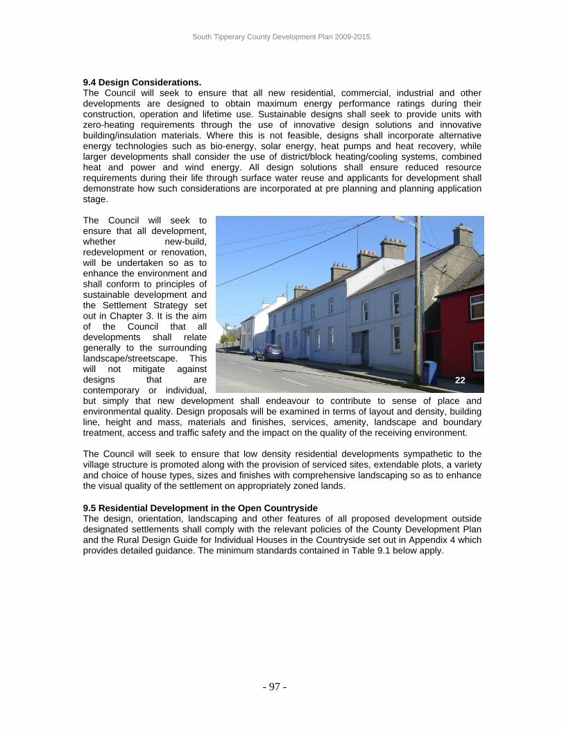
South Tipperary County Development Plan 2009-2015.
9.4 Design Considerations. The Council will seek to ensure that all new residential, commercial, industrial and other developments are designed to obtain maximum energy performance ratings during their construction, operation and lifetime use. Sustainable designs shall seek to provide units with zero-heating requirements through the use of innovative design solutions and innovative building/insulation materials. Where this is not feasible, designs shall incorporate alternative energy technologies such as bio-energy, solar energy, heat pumps and heat recovery, while larger developments shall consider the use of district/block heating/cooling systems, combined heat and power and wind energy. All design solutions shall ensure reduced resource requirements during their life through surface water reuse and applicants for development shall demonstrate how such considerations are incorporated at pre planning and planning application stage. The Council will seek to ensure that all development, whether new-build, redevelopment or renovation, will be undertaken so as to enhance the environment and shall conform to principles of sustainable development and the Settlement Strategy set out in Chapter 3. It is the aim of the Council that all developments shall relate generally to the surrounding landscape/streetscape. This will not mitigate against designs that are contemporary or individual, but simply that new development shall endeavour to contribute to sense of place and environmental quality. Design proposals will be examined in terms of layout and density, building line, height and mass, materials and finishes, services, amenity, landscape and boundary treatment, access and traffic safety and the impact on the quality of the receiving environment.
22
The Council will seek to ensure that low density residential developments sympathetic to the village structure is promoted along with the provision of serviced sites, extendable plots, a variety and choice of house types, sizes and finishes with comprehensive landscaping so as to enhance the visual quality of the settlement on appropriately zoned lands. 9.5 Residential Development in the Open Countryside The design, orientation, landscaping and other features of all proposed development outside designated settlements shall comply with the relevant policies of the County Development Plan and the Rural Design Guide for Individual Houses in the Countryside set out in Appendix 4 which provides detailed guidance. The minimum standards contained in Table 9.1 below apply.
- 97 -

South Tipperary County Development Plan 2009-2015.
Table 9.1 Minimum Standards for Residential Development in the Open Countryside
Site Size 0.2 hectares (0.5 acres). Floor areas shall be related to site size. Building Line 20 metres subject to sight line requirements and building size. Orientation Determined by maximising solar gain, prevailing winds and landscape
features. Boundary/Landscape All existing natural site boundaries should be retained where
practicable. On new site boundaries a double row of hedging shall be planted which reflects in species and diversity other field boundaries in the vicinity. All planning applications shall require a robust landscaping plan and all planting will be required to take place in the first planting season following the commencement of the development. External lighting for security purposes only will be considered where such lighting will not detract from the visual amenity of the area.
Roadside boundary The existing hedgerow shall be retained, where, in the opinion of the Council, there is no conflict with the requirements for the provision of safe site access. Where the roadside boundary is required to be removed, a new boundary hedge which replicates the existing boundary shall be set back behind the sight line to the technical requirements of the Council. Land between the roadside site boundary and carriageway edge shall be suitably drained, set level with the public road and replanted with grass, save where the Council requires an alternative treatment. Any roadside drains shall be piped before the area is surfaced.
Entrance Shall be of masonry or rendered and capped block construction or timber fencing. Wing walls/fences shall be splayed at 45 degrees so as to give a maximum opening at the front boundary of 13 metres and the height of such walls/fences shall not interfere with the required sight lines. All pillars shall be appropriate in scale to the new entrance walls so as not to detract from the existing roadside character.
Supporting Information
• A 1:2500 map illustrating the total landholding from which the site is taken.
• Details of all immediate family members of the landowner who may require sites from the landholding noting that the sale of sites may prejudice sites for family members at some future date.
• A suitably researched statement from a suitably qualified agent that the proposed development will not obviously sterilise substantial natural resources such as aggregates or agricultural land.
- 98 -

South Tipperary County Development Plan 2009-2015.
9.6 Residential Development in Settlements The Council will seek appropriate, efficient and sustainable development on all residential zoned land and will apply the guidelines contained in the Sustainable Residential Development in Urban Areas December 2008 (DoEHLG) or any amendments thereto as appropriate. The Council will require all development proposals to incorporate the standards set out in Table 9.2 below: Table 9.2 Minimum Standards for Residential development Design The establishment of building design and urban design criteria by a suitably
qualified Architect, experienced designer or similar, which shall place an emphasis on modern architecture with a varied building language, avoids standard suburban designs, enhances and augments local vernacular buildings. Opportunity shall be provided for landmark buildings at key nodes and focal points to promote legibility throughout the new development. All proposed residential units will attain high standards of energy efficiency, incorporating sustainable energy technologies, water conservation/reuse, ventilation, daylight analysis and bio-climatic site design.
Amenity Provision of at least 15% of site area for public open space. Integration of buildings and public amenity areas to ensure overlooking and passive supervision. Provision of pedestrian and cycle linkages within and outwit the site. Existing vegetation such as hedgerows, trees and natural features shall be retained and incorporated into the design where practicable. Where it is demonstrated to the satisfaction of the Council that tree removal must take place and is supported by a tree surgeon/arborist report, the developer will be required to provide replacement semi-mature native Irish trees as part of the overall proposal. Rear gardens that will facilitate private vegetable growing shall be provided in low-density developments, and where higher densities are proposed, dedicated vegetable allotment space will be supported.
Housing mix Satisfactory mix of dwelling types including 1-2 bed room units with direct access from ground level, extendable/flexible housing which can accommodate change over their life cycle, semi-detached and detached units, serviced sites and large detached units on generous plots etc, ensuring that a range and choice of building types and sizes are available. All designs, overall layouts and general densities shall comply with the policy requirements and the appendices of the County Development Plan.
Separation Distances
A minimum separation distance of 4m between the gables of dwellings, 22m between directly opposing transparent windows at first floor level, 35m between directly opposing transparent windows at second floor level.
Road Layouts Road layouts shall be designed so that traffic calming is naturally integrated, in accordance with the recommendations in the Traffic Management Guidelines 2003 as produced by the DoEHLG, DTO and DoT. Traffic calming shall be provided on a phased basis as each section of the road is opened to traffic and turning areas must provide for emergency and service vehicles. Proposals should also accommodate improved vehicular and pedestrian access links to the existing settlement centres and priority of movement and accessibility throughout the development for pedestrians and cyclists. Increased utilisation of shared/communal and well defined on-street and off-street car parking shall be considered;
Public Infrastructure
The provision of satisfactory public infrastructure and other services in compliance with the relevant objectives/policies of the County Development Plan.
Waste The provision of a waste management plan covering the construction phase of the development and the provision of adequate waste storage facilities to accommodate the 3 bin scheme for the proposed development.
Built and Natural Heritage
The protection of all existing historical monuments, buildings, building fragments, archaeological material, trees and hedgerows where appropriate.
- 99 -

South Tipperary County Development Plan 2009-2015.
Childcare and other Social Capital Requirements
Proposals for the provision of childcare places at a location to be agreed with the Planning Authority and the South Tipperary County Childcare Committee (refer to Chapter 8) and other amenity/community facilities as considered appropriate to support and sustain the proposed development in accordance with the outcomes of the Development Impact Assessment.
Maintenance and Management
Proposals for the management and maintenance of residential developments are to be submitted at the planning application stage. In this regard developers are advised to consult South Tipperary County Council Taking in Charge Policy. Management Companies will not be deemed acceptable as a maintenance proposal for traditional housing developments, but only for multi-unit buildings. Prior to their taking in charge, developers will be responsible for the maintenance and management of residential developments, where management companies are not employed.
9.7 Apartment Buildings The development of apartment buildings will be considered only at appropriate locations such as part of a mixed use scheme on lands zoned for Village Centre. The Council will apply as minimum standards the guidelines contained in the Sustainable Urban Housing: Design Standards for New Apartments 2007 (DoEHLG). The predominant issues of concern to the Council will be the appropriate zoning, the provision of adequate floor areas, storage space, circulation, public and private open space, access, parking, bin storage (should facilitate segregation of waste into 3 fractions - dry recyclable, residual & organic/food waste), balconies, daylight and sunlight, facilities for children and overall building design and finish. Developments, which fail to meet the standards set out by the DoEHLG will not be favourably considered. The Council will also require the setting up of a management company to maintain the infrastructure of the site and the communal and amenity areas of the development. 9.8 Development Impact Assessment (DIA) The Council will require that all new residential development proposals [which are subject to the provisions of Part V of the Planning and Development Acts 2000 - 2007 be accompanied by a DIA. The preparation of DIA shall consider the guidelines and recommendations as set out in the Sustainable Residential Development in Urban Areas Guidelines for Planning Authorities December 2008(DoEHLG). Scoping for DIA should consider the impact of the proposed development on the visual qualities and distinctive characteristics of the settlement and streetscape, phasing of the development dependent on the relevant function of the settlement within the Settlement strategy, sequential testing, capacity of schools and childcare places, capacity of community facilities including bring bank facilities, open space, retail and other commercial uses, trip generation, car parking particularly in the settlement centre, pedestrian movements and general traffic safety and infrastructure such as waste and surface water treatment/disposal and water supply. Where constraints are identified in the assessment, the developer will be required to identify mitigating measures to address deficits and the Council will require that the assessment is submitted as part of the planning application.
23
- 100 -

South Tipperary County Development Plan 2009-2015.
The Council will assess each development on its own merits, having regard to the statutory requirements of the development, the nature and use(s) proposed, the range of existing services available to the community and having regard to other relevant policies and standards of the County Development Plan. Developers are encouraged to consult with the local community as part of the preparation of the Development Impact Assessment. Where an enhancement scheme has been endorsed by the Council, developers will be required to conform to the provisions of the Scheme and to include for same under the submitted DIA. 9.9 Settlement Centre Master Plan Designations Master Plan designations are outlined on designated sites located within settlements as set out in Volume Three. The purpose of these Master Plan designations is to ensure a co-ordinated approach to the development of strategic village lands. Master Plans shall be prepared by landowners(s)/developer(s) and shall be to the written agreement of the Council. It is recommended that landowners and developers of adjoining lands subject to Master Plans designation liaise with each other regarding the overall approach to adjoining lands. In assessing a Master Plan proposal the Council will require that the following issues are addressed: (a) Cohesive approach to access and circulation throughout the entire Master plan area. (b) Focus on permeability and sustainable modes of transport throughout the Master plan area. (c) Identification of infrastructure/service requirements and proposals for entire area. (d) Identification of significant natural heritage features and proposed amenity features throughout
the Master Plan area No development will be permitted on lands designated with Master Plan status prior to the preparation of a Master Plan and its written agreement with South Tipperary County Council. 9.10 Traffic and Road Safety In the interest of safety for all road users, the following sight lines are required for all development that proposes vehicular access onto the public road network. Adequate sight visibility at the entrance to the development is vital to enable you to see oncoming traffic when using the entrance and also to enable other road users to see you when you are waiting at the entrance. In exceptional circumstances such as demolition of a dwelling and rebuilding of a dwelling, a derogation of sightline requirements may be considered subject to a net road safety benefit being achieved with the agreement of the Roads Section. The sight visibility triangle is measured at the proposed entrance from a set-back distance of 4.5m (the ‘X’ distance) from the road edge24 at the centre of the entrance, to points in both directions on the nearside road edge which are the sight distance (‘Y’ distance) away. For lightly used accesses, for example those serving a single dwelling or a cul-de sac development of not more than 2 no. dwellings, then the set-back ’X’ distance may be reduced to 2.4m. The Value of the sight distance ‘Y’ relates to typical road speeds and can be obtained from Table 9.3.
- 101 -
23 Road width refers to the typical road width (over approximately 70% of the road) when approaching an entrance rather than the width at
the entrance. The County Council has predetermined the applicable width for many of the County Roads.
24 The ‘road edge’ is the edge of road surface (bituminous material) subjected to general vehicular traffic.
Table 9.3 Sight Line Requirements ‘Y’ DistanceRoads with 100kph speed limits 215m General Regional Roads 130m General Local Roads greater than 4.25m wide23 90m Local Roads 4.25m wide1 or less and all Local Tertiary Roads
70m
Within 50kph speed limits (built up areas) 70m Within 60kph speed limits (built up areas) 90m

South Tipperary County Development Plan 2009-2015.
- 102 -
Y distance
Triangle of Visibility to be kept free of obstructions
Proposed Access
Eye Height 1.05m
Object Height 0.6m
X d
Figure 9.1 Safe Access Sightlines
istanceY distance
Object Height 0.6m
Public Road
Forward Visibility measured along centre of inside lane.
Visibility splay
Proposed Entrance Area to be free of visual obstructions
Figure 9.2 Forward Visibility Requirements Proposals for developments with access from roads that are insufficient in width to cater for passing vehicular traffic will be required to upgrade the width/alignment of the lane or provide passing bays. Any such upgrade or passing bays will be required to be a minimum of 6 metres in width while the separation distances between passing bays will be dependent on the alignment of the road and other local conditions. All such development proposals will be considered on a case by case basis having regard to the anticipated traffic generated by the proposal and the volume and type of traffic using the road and shall be subject to the agreement of the landowner(s) on the lane25.
25 Details of landowner(s) agreement to be submitted as part of the planning application.

South Tipperary County Development Plan 2009-2015.
Where certain types of large-scale developments are proposed, the Council will require traffic and transport assessment in accordance with recommendation from the National Roads Authority (NRA) (Policy INF 2). Further details of these can be obtained from the NRA Design Manual for Roads and Bridges (HD 19/01 Road Safety Audits) (HA 42/01 Road Safety Audit Guidelines) and the NRA Traffic and Transport Assessment Guidelines 2007. Thresholds for development types and sizes, which may be subject to these requirements, are set out in the Traffic Management Guidelines 2003. In particular the Council will insist on the satisfactory completion of stage 1, 2 and 3 Road Safety Audits.
Figure 9.3 Traffic and Transport Assessment
- 103 -
Submissions with Planning ApplicationsOver 90 dwellings
9.11 Open Space Requirements Private open space for all residential developments shall, as a minimum, conform to the standards set out in the Residential Density Guidelines for Planning Authorities 1999 (DoEHLG) as amended noting that the Council reserves the right to seek increases in open space provision as appropriate. For development proposing four or more residential units a minimum of 15% of the site area shall be reserved and set out as useable26 public open space. The schedule set out in Table 9.4 below indicates the extent of community facilities required per head of population for each respective development. In deciding on the extent and type of facilities to be provided, the developer(s) will be required to consult with the Council to ensure the optimum benefit is obtained from the amenity facilities to be provided as part of the development. In calculating the area of open space required, the Planning Authority will be guided by the standards contained in the Sustainable Residential Development in Urban Areas Guidelines for Local Authorities December 2008 (Sections 4.14 – 4.20) (DoEHLG) or any amendments thereto.
26 No account will be taken of incidental open space such as grass margins, left over areas or areas that due to nature or topography are
deemed unsuitable for play.
Over 200 dwellings
Over 1,000m2 Retail & Leisure 2,500 Office, Hospital, Education 5,000m2 Industrial 10,000m2 Warehousing Other Sensitive Areas
Transport Assessment
Road Safety Audit
Require RSA where impacts require works • Significant Impact on National Road
• Significant Impact on Nat. Road Junction
• 10% Increase in Traffic • 5% Increase in Congested Areas

South Tipperary County Development Plan 2009-2015.
In addition, where development is proposed which is subject to Part V of the Planning and Development Acts 2000 - 2007 and which is bounded by undeveloped residentially zoned land, the Council will require the developer to consult with the neighbouring land owner in order to put forward a proposal to assemble amenity and open space areas in order to provide large multi-purpose amenity areas (e.g. parkland and playing pitches) in addition to small incidental open spaces within individual housing schemes. Developers should also have regard to the specific objectives identified for each settlement as set out in Appendix 13 (Volume Three). The Council will seek the provision and suitable management in accordance with the South Tipperary County Council Play Policy 2003 (as may be amended or reviewed) of Local Areas for Play and Local Equipped Areas for Play in new housing estates and to implement measures to find suitable sites for their provision in existing residential areas. These shall be provided as follows unless the South Tipperary County Council Play Policy 2003 is amended or reviewed to necessitate alternative standards/requirements: Local Areas for Play: LAPs are small areas (approximately 100 sqm) of unserviced play space located within 1-minute walking time (60m) of houses.
Local Equipped Areas for Play: LEAPs are unsupervised play areas for 4-8 year old children located within 5-minutes walking time (240m) of houses. The area will provide at least five types of play equipment with seating for adults. The surface shall be of grass, bark chip or rubber carpet. Fencing will allow supervision from nearby houses. The Council will require LEAPs to be provided at locations that are accessible by the wider community. Table 9.4 below identifies the minimum quantity and type of open space facility required depending on the number of dwellings in any settlement. Developers will be required to have regard to these requirements in preparation of the Development Impact Statement and will be required to contribute to the provision of open space facilities as set out hereunder either by way of contribution, direct provision or a combination of the two in agreement with the Planning Department.
Table 9.4 Recreational Facility Requirements
Cumulative Total Number of Dwelling Units
Minimum Quantity and Type of Facility Required
25 -50 Open space 2.8 hectares per 1,000 persons. A minimum of 0.25 hectares to be provided.
51-100 Public open space to include: A neighbourhood play area incorporating a local equipped area of play. If a suitable local equipped area of play is already provided within the settlement then a multiple use games area is to be provided.
101-150 Equipped public open space to include: One full size grass pitch; One local equipped area of play; One court multi-use games area with Community/Club Association.
- 104 -

South Tipperary County Development Plan 2009-2015.
151-300
Public open space to include: One full sized grass sports pitch; One district play area or one local play area and additional neighbourhood play area; One court multi-use games area; Two tennis courts or appropriate alternative based on community requirements; One community/leisure building including full sized badminton/basketball court, meeting and facilitation rooms with Community/Club Association.
300 plus
Equipped public open space to include: Two full sized grass sports pitches; One district play area or one local play area and additional neighbourhood play area; One court multi-use games area; Two tennis courts or appropriate alternative based on community requirements; One community/leisure building including full sized badminton/basketball court, meeting and facilitation rooms with Community/Club Association.
9.12 Waste Water Treatment Infrastructure Many of the settlements in South Tipperary have existing waste water treatment systems that have capacity or may require upgrading. Other settlements do not have existing wastewater treatment systems (refer to Appendix 13 Volume Three for details on each settlement). Therefore, the expansion of the settlements in South Tipperary may require the construction or upgrading of waste water treatment plants and the Council would advise developers to enter into pre-planning discussions with the Water Services, Environment and Planning Sections of the Council at an early stage in the design process in order to ensure that development proposals are acceptable and in compliance with the Settlement Strategy and general policies of the County Development Plan. 9.12.1 District Service Centres The Council will prioritise investment in the upgrading of waste water treatment facilities in District Service Centres. Where development is proposed prior to the implementation of upgrading works, the council will require developers to comply with Option 1 or 2 as set out below. Option 1: The developer will pay 100% of the cost of the upgrade of the existing facility where this is possible for use by the development. Option 1(b) would provide the opportunity for a developer to finance the upgrade of the facility but the Council would cover the marginal cost of that aspect which was over and above the developers requirements. However; the developer is required to frontload and carry the full 100% cost initially and be reimbursed through development contributions as and when subsequent development occurs. Option 2: This option will be appropriate where Option 1 is considered impractical by the Council and where the size of the development will not cause any detrimental effects on the operation of the municipal waste water treatment plant or on the quality of receiving waters. A temporary treatment facility would be considered for development where the effluent was treated on site to an agreed standard and then disposed of through the networks to the Council’s system. The temporary waste water treatment plant would be decommissioned by the developer and removed from the site once the new upgraded municipal facility was provided. There will also be a limit placed on the number of temporary treatment plants in any one settlement and the developer must also provide for eventual connection to the municipal facility. The developer will pay the full standard development contribution. The developer would maintain the treatment facility until decommissioning takes place and may be subject to licence or legal arrangement.
- 105 -

South Tipperary County Development Plan 2009-2015.
9.12.2 Local Service Centres/Settlement Nodes Within Local Service Centres/Settlement Nodes the Council will facilitate appropriate sustainable development by requiring developers to provide enabling waste water treatment infrastructure for a proposed development subject to the agreement of the Council. The provision of waste water treatment plants (wwtp) shall be as follows: (i) Where there is an existing facility, the developer will upgrade and consolidate this facility
where possible or cover the cost of same; or, (ii) Where no existing facility exists and/or where the existing facility is not at the optimum
location (not operating satisfactorily and not reasonably possible to make it so) the developer will locate the wwtp on a site identified and/or purchased by the Council or on a site which meets the necessary standards as set out by the Council where no site is purchased.
In all cases the wwtp shall be capable of servicing the proposed development and the existing and future requirements of the settlement and of being upgraded in the future by the Council where required. The developer is advised to have proposals agreed with the Water Services, Environment and Planning Sections of the Council prior to making any planning application and submit evidence of same with the planning application. The Council will also require the developer to enter a contract providing ownership of the wwtp site to the Council, along with necessary way leaves and other rights of way required to operate the facility. Where development is proposed adjacent to a waste water treatment plant site; set back distances will be required from the plant itself in order to minimise impact on the user(s) of the proposed development. Such set back distances will be dependant on the size or potential size of the waste water treatment plant (in terms of person equivalent) and the proposed use. The Environment and Water Services sections of the Council should be contacted for site specific guidance. Where the development of single houses is proposed outside of the identified settlement centres, the Council will require the developer(s) to provide an on site waste water treatment system, designed, installed and operated in compliance with Environmental Protection Agency (EPA) Codes of Practice in force at the time. 9.13 Construction and Demolition Waste Construction and demolition (C&D) waste is seen as a direct by-product of the building industry. The Council will seek to reduce the quantity of C&D waste that goes to landfill and will seek to ensure that such waste is reduced, reused and recycled in the proposed development where possible, especially on brownfield sites. Where significant C&D waste is envisaged arising from a proposed development, the Council will seek the submission of a waste management plan for the construction phase of the development for the written agreement of the Council, which shall be in compliance with the EPA Best Practice Guidelines on the Preparation of Waste Management Plans for Construction & Demolition Projects. 9.14 Reuse of Surface Water Toilets, washing machines and outdoor use (watering plants, washing cars, etc) can account for up to 50% of domestic water consumption. Correctly collected and stored, rainwater can meet all these requirements without further treatment. The simplest rainwater collection method is the garden water butt that can collect and store surface water from roof surfaces and allow this to be reused for external use. These systems are very appropriate and economical solutions for existing buildings. Household rainwater systems are, however, more sophisticated and are best suited to new build developments.
- 106 -

South Tipperary County Development Plan 2009-2015.
There are two main types of systems in use i.e. header tank systems and direct pumped systems, the former utilising a gravity feed to power all applications. While there is no provision for these systems in the current building regulations, the Council, in granting permission will require surface water reuse in all new developments and will seek design solutions that provide for collection, recycling and reuse of surface water to meet the non-potable needs of the proposed development. Benefits accrued from the use of these systems are particularly relevant for large scale commercial/industrial users leading to reduced bills for metered water supply taking cognisance of the large roof surfaces available to collect rainwater. 9.15 Waste Maceration The use of maceration units increases the organic load discharged from residential development by up to 30%. For commercial developments such as restaurants, hotels, etc, this figure can exceed 50%. The Council will therefore discourage the use of under the sink and other waste maceration units for household and other organic waste where discharge to the public sewer is proposed. Where a private waste water system systems are proposed the developer should ensure that the system is designed to accommodate the additional load. Furthermore, where planning permission has been granted for development which does not propose the use of such maceration units and the units are subsequently installed, the council will consider their use to be unacceptable due to the additional unanticipated loading placed on the public sewer network on the basis that this gives rise to new or fresh planning issues. Taking cognisance of these factors the Council will take enforcement action against any development where the unauthorised use of maceration units has been established. 9.16 Petrol Filling and Service Stations The traditional role of filling stations is expanding to include the provision of general convenience retail and sometimes delicatessen. Petrol filling stations can provide a wide range of retail goods in an associated shop. While the important role of such provision is recognised, such shops shall, in general, remain secondary to the use as a filling station. The Retail Planning Guidelines 2005 stipulates that generally the maximum net retail floor space shall not exceed 100sqm. Where floor areas in excess of this figure are proposed, the development shall be subject to the retail sequential test approach. The Council will facilitate new filling stations or redevelopment of existing stations on appropriately zoned land where they comply with the following: (i) The proposed development is within a settlement boundary or the 50 kph or 60kph speed
limits as appropriate, (ii) The proposed development is in accordance with land use zoning objectives; (iii) The net retail sales area does not exceed 100 sqm or detracts from the viability of the
settlement centre; (iv) The proposed development complies with the requirements of the Retail Strategy and the
Retail Planning Guidelines 2005 (DoEHLG), or amendments thereto; and, The Council will require compliance with the requirements of S.I. 311 of the 1979 Dangerous Substances (Retail and Private Petroleum Stores Regulations), Building Regulations 2000 and the following: (i) A minimum of frontage of 30m within a 50 kph area and 45m in other speed limit areas; (ii) A minimum distance of 7m from the pump island to the road boundary; (iii) Two access points, between 7-9m wide, with a minimum junction radius of 10.7m; (iv) A minimum distance of 50m from entrance to nearest major junction and 25m to nearest
minor junction; (v) A footpath of 2m wide with 0.5m high wall along the front boundary; (vi) A petrol/oil interceptor to the surface water drainage; (vii) Adequate facilities for storage of refuse and waste on site; (viii) A scheme of landscaping;
- 107 -

South Tipperary County Development Plan 2009-2015.
(ix) Any associated retail unit shall cater for motor related goods, and ancillary convenience type shops limited to a floor area not exceeding 100 square metres gross. An associated workshop may be permitted where there is no adverse effect on the amenities of the area.
The Council will discourage car wash facilities in unserviced areas and new filling stations outside speed limits and rural locations unless there are robust planning reasons that support isolated rural communities. 9.17 Industrial Developments Table 9.5 below sets out the minimum standards for light and general industrial developments. Table 9.5 Minimum Standards for Industrial Developments Access Single access to multi-unit developments. Access roads shall have a
minimum carriageway width of 7.5m with 1.3m wide grass strip and 2m wide footpath(s).
Site Layouts Adequate space shall be provided for the loading and unloading of goods and the manoeuvring of vehicles within the site. Turning space for 15 metre articulated vehicles and 9 metre fixed axle vehicles. Building line set back of at least 12 metres from estate roadside boundaries.
Fencing & Landscaping
A comprehensive landscape plan providing for a suitable landscaping scheme including details of boundary treatment and planting shall accompany applications. Existing trees and hedgerows shall be incorporated where practicable and new planting shall utilise trees and shrubs that are indigenous to the area. All services shall be laid underground.
Use Full details of the proposed use, including industrial processes involved, any toxic materials, chemicals or solvents used, shall be submitted with the planning application if known. Changes in use may require the grant of a new planning permission in accordance with the Planning & Development Regulations 2001 (as amended).
Storage of Goods & Fuels
Goods, including raw materials, manufactured goods, packaging, crates etc., shall be stored or displayed only within the enclosed factory or industrial unit area behind the front building line. All over-ground oil, chemical storage tanks shall be adequately bunded to protect against spillage. Provide adequate storage to facilitate the segregation & storage of waste materials at source.
Signage Within the curtilage of industrial estates, signage shall be restricted to a single sign identifying all occupiers of the site at the entrance and to fingerpost signs at junctions throughout the estate where the Council considers such necessary.
9.18 Industrial and Enterprise/Employment use in the Open Countryside Such economic activities can conflict with the rural amenities of certain locations and as such the Council will encourage employment/industrial uses into serviced settlements throughout the county. However, the Council may, in exceptional circumstances, facilitate such development in the open countryside where the following criteria are met:
(i) There are robust planning reasons and intrinsic links between the proposed development and it’s location;
(ii) The proposed development is a new start-up enterprise or an appropriate expansion of an existing authorised use;
(iii) The proposal does not impact adversely on traffic safety and environmental quality; (iv) The proposal is accompanied by a robust business plan; (v) The proposal is compatible with the neighbouring land uses; and, (vi) The proposed building/use would not detract from the rural character of the
landscape.
- 108 -

South Tipperary County Development Plan 2009-2015.
All proposals will be required to demonstrate the full extent of anticipated development (including any ancillary development) on the site as over-development of inappropriate employment/industrial uses in the open countryside will not be permitted. In all cases the onus will be on the developer to demonstrate that exceptional circumstances exist and should liaise with the County Enterprise Board when developing proposals. Where small-scale employment activity such as tele-cottages, eco-projects and agri-tourist projects need to locate in the open countryside, the Council will facilitate same provided that such development:
(i) Is a conversion of an existing building or a new building which visually enhances its setting and is ancillary to the existing residential element/use;
(ii) Does not detract from the rural character of the landscape or protected views; and, (iii) Generally has no more than one person engaged/employed in the activity.
9.19 Tourism activities and ancillary development Chapter 5 identifies the need to provide for tourism activities in a sustainable manner in order to protect amenities from inappropriate development. In general it is considered that tourism related developments should be provided in settlements in order to maximise the service base and “value-added” potential. In exceptional circumstances the Council will consider the provision of tourist activities outside settlements subject to the proposed tourist development being based on an Integrated Sustainable Tourism Plan directly linked to, and singularly operated by a major tourism facility such as a golf course, hotel, equestrian tourist venture or a combination of such facilities. Tourist accommodation will be ancillary to and necessary to support the new use on the site and will ensure that the rural landscape and environmental quality of the area is maintained. 9.20 Forestry The Council will ensure that all afforestation is carried out in compliance with the Code of Best Forest Practice - Ireland (2000) as produced by the Department of Communication, Energy and Natural Resources and to monitor forestry against impacts on the following: (i) Designated views, Primary and Secondary Amenity Areas and exposed/elevated
landscapes; (ii) Archaeological and historic monuments/sites, NHA’s, SAC’s, Geological Sites; (iii) Marginal land with high biodiversity, and (iv) Groundwater source protection areas. As initial afforestation is exempt under Class 15, Part 3, Schedule 1 of the Planning and Development Regulations 2001 - 2008, the Council shall, through its consultative role, seek to implement the following guidelines: • The use of geometric shapes, particularly on uplands, shall be avoided. • The edge of the afforestation shall relate to landscape features and not to contours or
straight lines. • Variety of species is important and a minimum of 50% hardwood should be incorporated. • The convergence of forest edge and the skyline shall be avoided. • Afforestation shall be set back from roads and not impact on distant or protected views. • An assessment shall be carried out on potential impact on adjacent or nearby watercourses
and designated habitats.
- 109 -

South Tipperary County Development Plan 2009-2015.
9.21 Agriculture Development Any farm or industrial yards must make adequate provision for run-off. Where there is a danger of groundwater or surface water contamination the council will require treatment of run-off. The council will encourage the use of constructed wetlands for such purposes, where such a constructed wetland will be suitable. The Council will require that any such wetland is designed, constructed, operated and monitored to the appropriate scientific and engineering standards. The construction of wetlands are subject to planning permission, and effluent discharge licences under the Local Government (Water Pollution) Acts. Proposals for both intensive and non-intensive farming practice(s) must provide adequate storage for effluent. New buildings should:
• Avoid breaking the skyline • The colour of buildings should help assimilate buildings into the landscape – dark brown,
dark green and roofs darker in shade to walls • Use existing landscape and hedgerow cover to screen buildings
Sometimes conflicts can arise between established farmers and agricultural practices and new residents to a rural area. For example, persons who reside in the open countryside must recognise that agriculture is the prevailing land use in rural South Tipperary and must accept that standard agricultural practices, including the land spreading of slurry, occur on a regular basis. The Council will have regard to Teagasc guidelines on good farming practice, and will endeavour to ensure that where new applications for rural homes are granted or are minded to be granted, the prospective new residents to a rural area are advised that agricultural practices are likely to be carried out in this area. Please note that the erection of fencing in any land habitually open to or used by the public for recreational purposes or as a means of access, requires a grant of planning permission under the Planning and Development Acts 2000-2007. 9.22 Shopfronts The shopfronts of South Tipperary form an important architectural feature within the county’s towns and villages. The variety of different shop designs and finishes contribute to the identity and character of our settlements. Planning applications for new shopfronts will be considered on their own merits and of importance will be the sympathetic integration of the proposal into its setting. In general, the design of new shopfronts should have regard to the Guidelines set out in Appendix 2 Section 3.0.The external fitting of security shutters does not constitute exempt development and can affect the character and appearance of the property to which they are fitted and the overall streetscape. Therefore the Council will seek alternative proposals for security shutters, which meet the requirements of the developer and the Council. 9.23 Advertising Structures and Signs Advertisement signs should be sensitively designed and not be excessive in terms of scale, size and number. In particular, free-standing advertisements on forecourts, signs or advertisements above fascia level, and more that one projecting sign per commercial/retail unit need careful design and consideration. The Council will discourage excessive advertisements in any designated Architectural Conservation Area or on a Protected Structure. Illuminated box signs are particularly inappropriate in these areas and on such buildings. The Council also recognises the importance of providing appropriate tourist signage from national routes and motorways and will facilitate same subject to compliance with the policies of the County Development Plan and the technical satisfaction of the National Roads Authority.
- 110 -

South Tipperary County Development Plan 2009-2015.
The Council will facilitate advertising and support structures where the following criteria are met: (i) The proposed development would not detract from the visual appearance of a building, a
Protected Structure or the character of the an Architectural Conservation Area or settlement centre by reason of size, siting, design, materials or illumination; and,
(ii) The proposed development would not adversely affect public/traffic safety; and, (iii) The proposed development is appropriate in terms of scale and mass to the principal
structure and its use.
9.24 Retaining Retail Function in Settlement Centres The Council will seek to maintain main shopping areas of Primary, Secondary and larger District Centres free from inappropriate development that would reduce the vitality, viability or amenity of the centre or give rise to noise, odour and litter, and cause disturbance to nearby residents. 9.25 Taking in Charge The Council will require by condition attached to a grant of planning permission the submission of “as constructed” drawings on any grant of planning permission for multi-unit, medium and large scale developments. Such details shall be submitted in both hard copy and digital format and will be required in order to ensure satisfactory compliance with the development management standards and the conditions of the relevant planning permission. Sub surface infrastructure and networks will not be taken in charge and no bonds will be returned prior to the submission of these documents for the written agreement of the Council. Such documents will be required to be submitted as soon as possible following completion of construction. 9.26 Archaeology Permitted developments located within the Zone of Archaeological Potential and/or within close proximity to Recorded Monuments may be required as part of the planning application process or by condition on a grant of permission to carry out archaeological assessment, monitoring, testing or excavation within the area covered by the application/permission, either prior to the planning decision or prior to any development works proceeding on the site following the grant of planning permission. The Council, as a condition on such developments, may also consider the preservation of all or part of the archaeological remains in the area covered by the permission. Each planning application for development within the Zone of Archaeological Potential and within close proximity to recorded archaeological sites shall be assessed on its own merits. (i) An archaeological assessment shall establish the extent of archaeological material
associated with the monument or site. This assessment shall also define the buffer area or area contiguous with the monument which will preserve the setting and visual amenity of the site.
(ii) The area of the monument and buffer shall not be included as part of the open space requirement demanded of a specific development but shall be additional to the required open space.
(iii) If a monument or place included in the RMP lies within the open space requirement of a development, a conservation plan for that monument is required as part of the landscape plan for that proposed open space.
(iv) Shall a monument or site included in the RMP be incorporated into a development the monument and attendant buffer area shall be ceded to Local Authority Ownership once the development and associated landscaping works are complete so that the future protection of the monument can be assured.
9.27 External Lighting The lighting and illumination of buildings can have an effect on the surrounding environment and especially impact on residential, amenity, visual amenity, public and traffic safety. Lighting proposals should consider the following: (i) The illumination scheme would not have a detrimental impact on residential or visual
amenity; (ii) Ensure that all lighting and related equipment is so positioned that it will not interfere with or
- 111 -

South Tipperary County Development Plan 2009-2015.
have an otherwise negative impact upon traffic and pedestrian safety and/or flow. (iii) Incorporate motion sensors, solar power and low wattage units in external lighting schemes
so as to appropriately limit the energy used in the development. A detailed study may be required prior to a grant of planning permission in order to outline probable significant impacts and suggest mitigating measures. The Council will have regard to the guidelines outlined in the E.S.B. booklet "Public Lighting in Residential Estates”, the relevant Building Regulations and any other applicable legislation and guidance which pertains at time of granting planning permission. 9.28 Noise Levels The generation of noise in the community can have undesirable effects on residential areas and the community at large. Noise emissions from specific activities are controlled by the Environmental Protection Agency through Integrated Pollution Prevention Control licensing and Waste licensing (refer to the Guidance Notes for Noise In Relation To Scheduled Activities 2006 (EPA)). The Environmental Noise Directive (END) (2002/49/EC) relates to noise from industries, road, rail & air traffic and requires authorities to assess and manage noise from these sources. The Directive mainly addresses noise emitted by a range of transport sources (road, rail, and air traffic), although the definition of ‘environmental noise’ includes noise from industrial sites. Where planning applications are submitted in close proximity to the national road network (both proposed and existing) and would result in a breach of the NRA’s design goal for sensitive receptors exposed to road traffic noise, the developer shall identify and propose noise mitigation measures within the zone of influence. In this regard the developer should refer to the Environment Noise Regulations 2006. The cost of implementing mitigation measures shall be borne by the developer. 9.29 Satellite Dishes Satellite dishes and telecommunications apparatus are now a regular sight on buildings and other structures in towns and villages and can affect the character and appearance of historic buildings and important townscapes. Some satellite dishes may be erected as exempted development under the Planning and Development Regulations, 2001 (as amended). Where planning permission is required to erect satellite dishes, special consideration will be given to: (i) Protected Structures where the special character may be harmed; (ii) On the front or side of buildings in an ACA; and, (iii) In locations where they would cause unacceptable harm to the visual amenities of the
area. On multi occupancy buildings such as apartment blocks, office blocks etc, the Council will permit one single dish only which should be for communal use. 9.30 Parking and Loading Table 9.6 sets out the Council’s car parking requirements. In addition to the general car parking standards required, service bays may also be required. Within settlement centres the Council will require the provision of off street car parking as part of new developments. The number of service parking bays will depend on the nature of the proposed business, and will be determined by the Council on a case by case basis. Where the developer is unable to meet the requirements relating to car parking, a contribution, commensurate with the shortfall in spaces, shall be paid to the Council to facilitate the provision of car parking facilities elsewhere. Car parking shall be located, where possible, behind established building lines in the interest of good streetscape. Where parking is proposed to the front of a building, it is important that planting and/or boundary walls/railings are used to maintain the visual appearance of the area. In settlement centre mixed-use development proposals, consideration will be given to dual parking where peak times do not coincide. Where parking is associated with late night uses such as places of entertainment, car parking shall be sited so as to reduce noise disturbance to adjoining residents to a reasonable level.
- 112 -

South Tipperary County Development Plan 2009-2015.
The following design dimensions shall apply and all parking facilities shall secure and be subject to passive supervision:
1. Each car space shall be 4.8m x 2.5m with 6.1m wide circulation aisles; 2. Loading bays shall be generally 9m x 5m (but at least 6m x 3m), and 3. Disabled spaces shall be 3m wide, with a one space per 20 provision.
Table 9.6 Car Parking Standards Land-use Operational Standards Non-Operational Standards
Cinema 4 spaces 1 space per 3 seats
Bars/Restaurant 0.5 space per staff member 1 space per 15 sqm public area
Clinics/Surgeries 1 space per staff member 2 spaces per consulting room
Caravan Park 1 space per staff member 2 space per unit of accommodation
Crèches 1 space per staff member 1 space per 4 children
Dance halls/Discos 0.5 space per staff member 1 space per 10 sqm.
Dwelling (up to 2 bedrooms)
Nil 1 space(s) per dwelling unit
Dwelling (3 bedrooms or more)
Nil 2 spaces per unit
Multi Residential Unit Development
2 visitor spaces per 5 dwelling units
1 space per 1 or 2 bed unit 2 spaces per 3 bed + unit
Golf courses 0.5 space per staff member 4 spaces per hole
Hotel/Motel/Guest House 0.5 space per staff member 1 space for every 2 bed spaces
Leisure Centre 0.5 space per staff member 1 space per 50 sqm.
Light Industry 1 space per 35 sqm plus 1 HGC space
Manufacturing 0.5 space per staff member 1 space per 35 sqm plus 1 HGV space
Nursing Homes 1 space per staff member 1 space per 4 residents
Offices 0.5 space per staff member 1 space per 35 sqm.
Retail Shops/Supermarkets
0.5 space per staff member 1 space per 20 sqm.
Retail Warehousing 1 space per staff member 1 space per 35 sqm.
Science & Technology Based Enterprises/Business Park
1 space per staff member 1 space per 25 sqm.
Warehousing 1 space per staff member 1 space per 100 sqm.
Other Individual assessment Individual assessment
The provision of circulation and designated loading space will be assessed on a case by case basis depending on the nature and scale of the proposed use. The Council will require that secure and covered cycle parking facilities of 10% of total car parking space requirements are provided for new office, industrial and commercial uses.
9.31 Landuse Zoning Objectives The purpose of land-use zoning is to indicate the development management objectives of the Council for all zoned lands within the County Development Plan boundary. This ensures that development is guided towards the right location and enhances both commercial stability and the environment of the county.
- 113 -

South Tipperary County Development Plan 2009-2015.
Nine such zones are indicated in this development plan and are set out in Table 9.7. The Land-Use Zoning Matrix is intended as a general guideline in assessing the acceptability or otherwise of development proposals, although the listed uses are not exhaustive. Factors such as density, height, massing, traffic generation, public health, design criteria, visual amenity, and potential nuisance by way of noise, odour and pollution are also significant and relevant to the proper planning and development of the area.
Appendix 1 lists the land-use activities referred to under each zoning objective. It indicates the acceptability or otherwise (in principle) of the specified land-uses in each zone.
Table 9.7 Key to Development Plan Zoning Objectives Zone Objective VC To preserve, enhance and/or provide for village centre facilities. Proposals for
development on lands zoned for Town or Village Centre are to comprise of mixed use developments consisting of a combination of retail, office, service, community and/or residential uses.
R1 To preserve and enhance existing residential amenity, ensuring that any new development does not result in excessive overlooking of existing residential properties, does not reduce general safety for existing residents and does not reduce the usability and security of existing public and private open space.
R2 To provide for low density new residential development. Proposals for development on lands zoned for low density new residential shall provide for a range of housing types, sizes and finishes. Proposals may include cluster developments, serviced sites, large plot sizes, extendable dwellings and executive style housing. As a guide, low density housing provides for an average of 10 units/hectare (4 units/acre).
R3 To provide for medium density new residential development. Proposals for development on lands zoned for medium density new residential shall provide for a range of housing types, sizes and finishes. As a guide, medium density housing provides for an average of 25 units/hectare (10 units/acre).
LI To provide for light industrial and related uses GI To provide for general industrial and related uses A To provide open spaces and amenity uses.
SP To protect and provide for social and public facilities including education, religious
and community uses. Ag To provide for agricultural needs and to protect and enhance rural amenity.
- 114 -

South Tipperary County Development Plan 2009-2015.
INDEX CHAPTERS 1 - 9
- 115 -
A
access, 12, 28, 29, 44, 52, 57, 58, 59, 62, 67, 70, 71, 72, 76, 78, 79, 80, 81, 88, 89, 91, 92, 94, 97, 98, 99, 100, 101, 102, 107, 108, 110
Advertising Structures and Signs, 110 agriculture
agricultural, 36, 39, 60, 64, 89, 110 agri-tourism, 59 Amenity, 7, 19, 28, 46, 47, 67, 68, 69, 75, 92, 93, 99,
109 Apartment, 100 Archaeology
archaeological, 7, 73, 74, 111 Architectural Conservation Areas, 7, 28, 73 Arts, 7, 26, 63, 92
B
Bio-energy, 88 Bonds, 85, 96 Borewell, 82 Broadband, 7, 10, 88 Brownfield Sites, 11, 67 Building Regulations, 11, 107, 112 Buildings of Merit, 6, 52, 53 Burial Grounds, 7, 93 Bus, 80
C
car wash, 108 Childcare, 7, 10, 94, 95, 100 climate change, 53, 86, 88 cluster, 45, 114 Community, 7, 10, 11, 12, 17, 19, 20, 21, 24, 28, 36,
55, 67, 91, 92, 93, 94, 95, 104, 105 conversion, 109 Culture, 92 Cycle Routes, 7, 81
D
demographic, 32 Derelict Sites, 7, 67 Design, 6, 8, 10, 19, 25, 26, 46, 47, 50, 51, 52, 53, 78,
83, 84, 85, 97, 99, 100, 103 Designated Environmental Sites, 7, 69, 70 Development Contributions, 83, 96 Development Impact Assessment, 6, 10, 51, 52,
68, 100, 101 disability, 91 discharge licences, 110 District Service Centres, 6, 42, 43, 44, 45, 48, 49,
52, 58, 59, 76, 77, 105 dwelling, 48, 50, 53, 95, 99, 101, 113
E
economic activity, 56, 59, 64, 65 education, 23, 27, 32, 34, 36, 37, 43, 55, 94, 114 Employment, 6, 21, 27, 35, 36, 38, 45, 55, 56, 58,
59, 108 Enforcement, 96 Enterprise, 7, 10, 21, 59, 60, 91, 108, 109 Environment, 7, 10, 12, 13, 18, 19, 20, 25, 28, 30,
53, 67, 68, 69, 70, 75, 78, 105, 106, 112 Environmental Impact Statement, 10, 74 Equine Industries, 7, 65 Extractive Industry, 7, 63, 64
F
Flood Risk, 7, 10, 86 Forestry
afforestation, 36, 55, 109
G
Geological Sites, 69, 109 Groundwater Protection, 7, 12, 70
H
health services, 23 Heritage, 7, 8, 10, 13, 19, 21, 25, 26, 28, 30, 53, 63,
68, 69, 71, 72, 73, 74, 75, 99 hierarchy, 18, 22, 23, 27, 39, 41, 42, 64 house, 11, 41, 45, 46, 47, 49, 51, 97 Housing mix, 99 Housing Strategy, 6, 8, 19, 26, 27, 42, 49, 50, 51,
54
I
Industrial, 10, 58, 60, 95, 108 infrastructure, 11, 12, 30, 41, 43, 45, 46, 52, 59, 64,
76, 78, 81, 84, 85, 86, 87, 88, 89, 93, 96, 99, 100, 101, 106, 111
Irish Walled Town Network, 73, 74
L
Library, 7, 9, 92 Lighting, 111, 112 Local Areas for Play, 10, 104 Local Equipped Areas for Play, 10, 104 Local Service Centres, 6, 42, 43, 44, 45, 48, 59, 61,
106

South Tipperary County Development Plan 2009-2015.
- 116 -
M
major accidents, 66 Master Plan, 12, 51, 57, 101 monitoring, 18, 26, 27, 28, 111 multi-use games area, 104, 105
N
N24 National Primary Route, 77 N8 National Primary Route, 77 National Development Plan, 10, 23, 76, 78, 88, 89 Natural Gas, 7, 87 Natural Heritage Area, 13 Noise, 10, 112 Non-Conforming Uses, 7, 60, 61 Nursing Homes/Retirement Villages, 6, 52
O
On Farm Diversification, 7, 60 Open Countryside, 6, 7, 41, 46, 52, 59, 60, 97, 98,
108 Open Space, 103
P
Parking, 112, 113 participation, 17, 21, 22, 37, 39, 92 Pedestrian, 7, 9, 81 Primary Service Centre, 43 Protected Assets, 7, 69 Protected Structures, 7, 8, 10, 19, 72, 73, 75, 112 Protected Views, 8, 19 Public Rights of Way, 7, 71, 72 Public Transport
Bus Rail
Cycle Routes. See
R
Rail, 18, 30, 33, 57, 79 Record of Monuments and Places, 74 Recreational Facility Requirements. See Local
Areas for Play & Local Equipped Areas for Play
Regional, 10, 23, 30, 44, 46, 47, 62, 63, 76, 77, 81, 82, 84, 86, 87, 88, 89, 101
Retail, 7, 26, 27, 36, 61, 107, 111, 113 River Basin District, 24, 71, 85 Road Safety, 76, 101, 103 Route Capacity, 77 rural area, 110 Rural Resources, 62
S
Satellite Dishes, 112 schools, 12, 75, 89, 92, 95, 100 Secondary Service Centre, 9, 57 Service Stations
petrol filling stations, 107 Serviced Land Initiative, 13, 83 serviced sites, 27, 45, 46, 48, 50, 54, 97, 99, 114 Settlement Character, 7, 68 Settlement Nodes, 6, 42, 43, 46, 48, 61, 106 Seveso, 13, 66 Shopfronts, 110 Sight Line Requirements, 101 siting, 45, 46, 47, 69, 111 social housing, 13, 23, 49, 50, 51 Social Inclusion, 7, 18, 91, 92 South Tipperary Heritage Plan 2004-2008, 74 Special Areas of Conservation, 10, 13, 69 Special Protection Areas, 10, 14, 69 Strategic Employment, 6, 57, 58 Strategic Route Proposals, 77 Surface Water, 7, 85, 86, 106
T
Taking in Charge, 100, 111 Teagasc, 91, 110 Telecommunications, 7, 10, 88, 89 topography, 103 Tourism
tourist, 20, 36, 60, 62, 63, 74, 109 Traffic and Transport Assessment, 7, 79, 103 Traveller Accommodation, 6, 26, 51, 54
V
vehicular access, 59, 101 vernacular, 99
W
walking schemes, 71 Waste, 7, 10, 26, 28, 71, 83, 85, 89, 90, 99, 105, 106,
107, 112 Waste Maceration, 107 Waste Management, 7, 26, 89, 106 Waste Water Treatment, 7, 10, 71, 83, 105 Water Quality, 70 Water Supply, 7, 36, 55, 81, 82, 83, 84, 85 wetlands, 14, 110 Wind Energy, 7, 8, 19, 26, 87
Z
Zoning Objectives, 113, 114