table of contents - brisbane city council | · web viewcontributes to a well-connected supply chain...
TRANSCRIPT

…
Page 0 of 394
SECURITY LABEL: FOR OFFICAL USE ONLY

TABLE OF CONTENTSLIST OF TABLES.................................................................................................................................. 2
LIST OF MAPS...................................................................................................................................... 2
GLOSSARY........................................................................................................................................... 3
Executive Summary............................................................................................................................... 4
Background........................................................................................................................................... 9
Summary of Proposed Amendments to Brisbane City Plan 2014........................................................10
Part 1 About the planning scheme...................................................................................................12
Part 2 State planning provisions......................................................................................................12
Part 3 Strategic Framework.............................................................................................................12
Part 4 Priority Infrastructure Plan.....................................................................................................12
Part 5 Tables of assessment...........................................................................................................14
Part 6 Zones.................................................................................................................................... 18
Part 7 Neighbourhood plans............................................................................................................18
Part 8 Overlays................................................................................................................................ 25
Part 9 Development codes...............................................................................................................27
Part 10 Other plans.......................................................................................................................... 27
Schedule 1 Definitions..................................................................................................................... 27
Schedule 2 Mapping........................................................................................................................27
Schedule 3 Priority Infrastructure Plan mapping and support material............................................40
Schedule 4 Notations required under the Sustainable Planning Act 2009.......................................42
Schedule 5 Land designated for community infrastructure..............................................................42
Schedule 6 Planning scheme policies (PSP)...................................................................................42
Appendix 1 Index and glossary of abbreviations and acronyms......................................................42
Appendix 2 Table of amendments...................................................................................................42
Appendix A Amendments to Part 4 Priority Infrastructure Plan........................................................43
Page 1

LIST OF TABLESTable 1 – Proposed amendments to Part 1 About the planning scheme.............................................12
Table 2 – Proposed amendments to Part 4 Priority Infrastructure Plan...............................................12
Table 3 – Proposed amendments to Part 5 Tables of assessment......................................................14
Table 4 – Proposed amendments to Part 7 Neighbourhood plans......................................................18
Table 5 – Proposed amendments to Part 8 Overlays..........................................................................25
Table 6 – Proposed amendments to Schedule 2 Mapping..................................................................25
Table 6 – Proposed amendments to Schedule 3 Priority Infrastructure Plan mapping and support material................................................................................................................................................ 40
Table 7 – Proposed amendments to Appendix 2 Table of amendments.............................................42
LIST OF MAPS
Map 1 – ZM-001 Zone map (proposed zone changes)........................................................................29
Map 2 – NPM-001.6 Australia TradeCoast neighbourhood plan map..................................................31
Map 3 – NPM-008.2 Hemmant-Lytton neighbourhood plan map.........................................................32
Map 4 – OM-002.2 Biodiversity areas overlay map.............................................................................33
Map 5 – OM-009.1 Industrial amenity overlay map.............................................................................34
Map 6 – OM-019.1 Significant landscape tree map.............................................................................35
Map 7 – OM-019.2 Streetscape hierarchy overlay map.......................................................................36
Map 8 – OM-020.1 Traditional building character overlay map...........................................................37
Map 9 – OM-023.2 Waterway corridor overlay map............................................................................38
Map 10 – OM-023.3 Wetlands overlay map........................................................................................39
Page 2
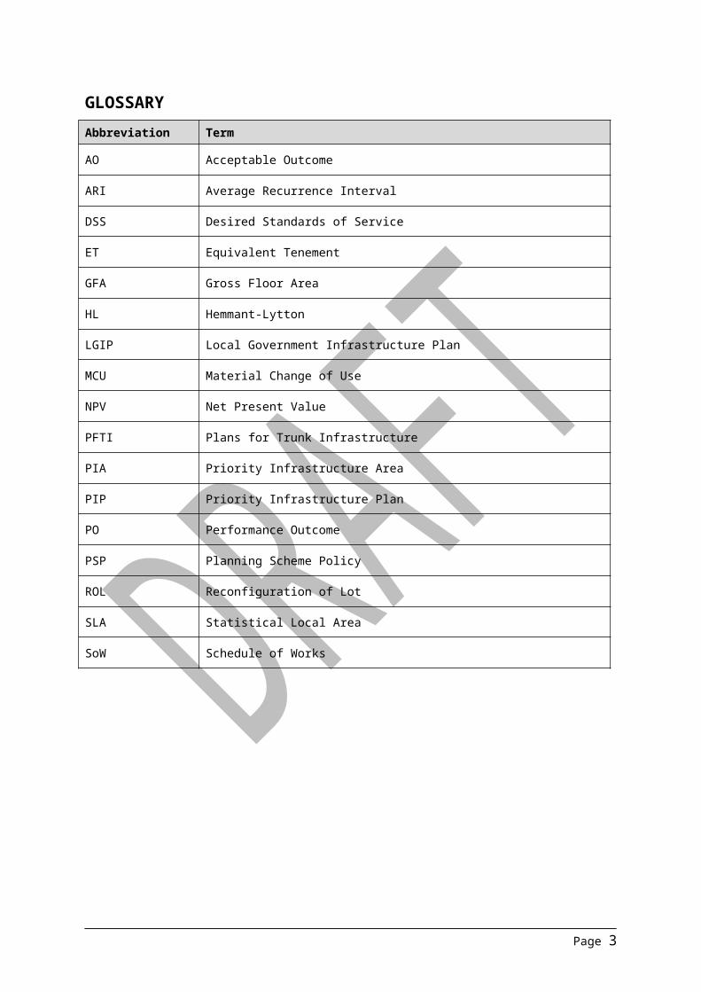
GLOSSARYAbbreviation Term
AO Acceptable Outcome
ARI Average Recurrence Interval
DSS Desired Standards of Service
ET Equivalent Tenement
GFA Gross Floor Area
HL Hemmant-Lytton
LGIP Local Government Infrastructure Plan
MCU Material Change of Use
NPV Net Present Value
PFTI Plans for Trunk Infrastructure
PIA Priority Infrastructure Area
PIP Priority Infrastructure Plan
PO Performance Outcome
PSP Planning Scheme Policy
ROL Reconfiguration of Lot
SLA Statistical Local Area
SoW Schedule of Works
Page 3

Executive Summary
The draft Hemmant-Lytton neighbourhood plan and supporting amendments provides finer grained planning at a local level, will guide future development and coordinate land use and infrastructure.
The area north of the Cleveland rail corridor will continue to be a major industrial area within the Australia TradeCoast and the wider region. The plan supports the establishment of a ‘Mixed industry and business area’ (MIBA) near the Hemmant rail station and the junction of Lytton Road and Hemmant and Tingalpa Road to provide support services to local businesses and provide for the convenience shopping needs of residents.
South of the Cleveland rail corridor and west of Hemmant and Tingalpa Road, residential infill will be consolidated with existing pockets of urban development. South of the Cleveland rail corridor and east of Hemmant and Tingalpa Road the rural and rural residential character will be retained.
Draft Hemmant-Lytton neighbourhood plan boundaryThe draft Hemmant-Lytton neighbourhood plan boundary is outlined in Figure 1 below.
Figure 1: Draft Hemmant-Lytton neighbourhood plan boundary
Page 4

Proposed precincts
Two neighbourhood plan precincts have been proposed to support land use change (see Figure 2 and Figure 3 for the proposed precincts).
NP-001: Mixed industry and business precinct (MIBA)o The MIBA precinct supports a mix of industry, business uses and a small local centre.
Centre uses will be located in the Centre sub-precinct (NPP-001a) and Office uses in the Office sub-precinct (NPP-001b). The siting of these activities is intended to enhance the streetscape and anchor the MIBA. The remainder of the precinct is to provide for a wide range of clean industry and business uses. It is expected that the area will transition from residential to a MIBA over the longer term. Additional parkland is to be provided along Violet Street to support the MIBA.
Figure 2: Mixed industry and business precinct (NPP-001)
NP002: Residential precinct:o This precinct will be characterised by additional low density residential development,
extending from the Cleveland rail corridor south to an area surrounding Fleming Road, Tingalpa. New residential development will be limited to land zoned Emerging community (EC) to facilitate effective and efficient development of the area via a Structure planning process. The new EC areas link up pockets of existing residential areas.
o The existing Industry (General industry A) zone precinct will remain on Fleming Road and any sensitive uses proposing to locate adjacent to this area will need to address amenity issues.
Page 5

o The area comprising rural lots north of Fleming Road and west of Hemmant and Tingalpa Road is zoned Rural residential (RR) to retain existing rural living.
Figure 3: Residential precinct (NPP-002)
Key planning outcomes
The draft Hemmant-Lytton neighbourhood plan is intended to:
ensure the economic importance of the Hemmant-Lytton industrial area is enhanced by:
o consolidating industrial uses, including hard-to-locate Special industry uses, north of the Cleveland rail corridor and transitioning the residential area close to Hemmant rail station to a MIBA;
o making Marine industry in Industry (General industry C) zone precinct areas code assessable;
o facilitating the development of a MIBA with a centre and office sub-precinct to provide support services to local businesses and to meet the convenience needs of workers in the area; and
o preventing the encroachment of incompatible uses.
provide direction to the Hemmant and Tingalpa communities with respect to future residential development by:
o rezoning residential areas close to Hemmant rail station (north of the rail corridor) to Specialised centre 5 (Mixed industry and business) zone to indicate Council’s
Page 6

long-term plan to consolidate industrial uses north of the rail corridor and residential uses south of the rail corridor;
o rezoning areas considered appropriate for low density residential uses to the Emerging community zone, and for rural landscape values to the Rural residential zone that create a residential community west of Hemmant and Tingalpa Road;
o rezoning a large holding south of Fleming Road to the Emerging community and Conservation zones to reflect a recent approval for residential purposes;
o retaining the Rural zoning near the intensive animal husbandry activities (poultry farming) on Burnby Road to protect its continued operation; and
o rezoning a large area of Rural zoned land to the Environmental management zone reflecting the constraints to development identified by the Flood overlay and the Biodiversity areas overlay.
manage the area’s risks and hazards, including flooding and legacy issues associated with historic activities by:
o rezoning Rural land constrained by flooding and areas of biodiversity value to Environmental management;
o amending the Industry amenity overlay to ensure any development for sensitive uses close to established industry on Fleming Road ameliorates impacts from industry; and
o protecting existing intensive animal industry (poultry farming) near Burnby Road from encroachment by sensitive uses by maintaining the Rural zoning over the farms and surrounding areas.
Page 7

Proposed zoning changes
The following areas are proposed to be rezoned.
See Figure 4 below for areas of proposed zoning change (outlined in red).
Page 8

BackgroundThe Hemmant-Lytton (HL) neighbourhood plan area contains a diversity of land uses ranging from multiple dwellings, dwelling houses on low density residential and rural lots, a poultry farm through to warehouses, low, medium and high impact industries. Land in the HL area is included in the Low impact industry zone, Industry (General industry A, General industry B, General industry C zone precincts) zone, Special industry zone, Low density residential and Rural zones, Community facility and Open space zones. The plan area is strategically important as it is located adjacent to the Port of Brisbane, and in close proximity to the Brisbane Airport and key rail and road infrastructure. Specifically, the plan area has high accessibility to the Port of Brisbane and Gateway Motorways, the Cleveland rail line and the Port of Brisbane freight line. The provision of a suitable choice of services is an issue in the area, with workers, residents and business staff having to travel to centres in Cannon Hill, Morningside, Wynnum West and Wynnum for most services. Significant expanses of areas of high ecological significance and areas prone to creek and/or river flooding characterise the area, particularly south of the railway line.
Council proposes to introduce the Hemmant—Lytton neighbourhood plan to guide future development and coordinate land use and infrastructure in Hemmant—Lytton. The preferred planning outcomes for the area seek to:
facilitate industrial development, including marine industry and intensive rural industry; provide opportunities for business support and retail services to meet current and future
needs of industry between Murarrie and Lytton and the convenience needs of local residents by facilitating the development of a mixed industry and business area;
protect community health and wellbeing by separating industrial uses from residential activity; provide direction to the Hemmant and Tingalpa community with respect to future residential
development; deliver a resilient, robust and well-ordered system of non-urban zoned land that responds to
the ecological values and hydrology of the Bulimba Creek catchment; manage the area’s risks and hazards, including flooding and legacy issues associated with
historic activities; and integrate and coordinate land use planning and infrastructure planning.
This document, the Hemmant—Lytton neighbourhood plan Brisbane City Plan 2014 Amendment Package (the amendment package), sets out the statutory amendments to be made to Brisbane City Plan 2014 (the planning scheme) in order to achieve the preferred planning outcomes for the area. The amendment package considers the area’s suitability for future development and surrounding land uses.
The amendment package forms a major amendment to the planning scheme, and has been prepared in accordance with Statutory Guideline 04/14: Making and amending local planning instruments.
Page 9

Summary of Proposed Amendments to Brisbane City Plan 2014The amendment package includes the following:
Neighbourhood plan: the new HL neighbourhood plan code, associated maps and figures, tables of assessment and zoning changes within the area,
Supporting amendments: changes to the city-wide planning scheme provisions to reflect findings of local investigations. These amendments include changes to the overlays and Priority Infrastructure Plan (PIP) / interim Local Government Infrastructure Plan (LGIP).Consequential amendments: include consequential changes to numbering, cross-references and headings.
The amendment package proposes amendments to the following parts of the planning scheme: Part 1 About the planning scheme Part 4 Priority Infrastructure Plan
o Planning assumptionso Desired standards of serviceo Plans for trunk infrastructure
Part 5 Tables of assessmento Hemmant-Lytton neighbourhood plan levels of assessment
Part 7 Neighbourhood planso Australia TradeCoast neighbourhood plan codeo Hemmant-Lytton neighbourhood plan code
Schedule 2 Mapping o Zone maps
Zoning map (21, 22, 29 and 30)o Neighbourhood plan maps
Australia TradeCoast neighbourhood plan map Hemmant-Lytton Neighbourhood plan map
o Overlay maps Biodiversity areas overlay map Industrial amenity overlay map Significant landscape tree overlay map Streetscape hierarchy overlay Traditional building character overlay map Waterway corridor overlay map Wetlands overlay map
Schedule 3 Priority Infrastructure Plan mapping and support materialo Infrastructure corridor planso Priority Infrastructure Plan maps
Schedule of works (SoW) for future trunk infrastructureo Stormwater network SoWo Transport network (local road network) SoW o Transport network (pathways network) SoW o Transport network (public transport (bus stops) network) SoW o Community purposes network (public parks network) SoW
Plans for trunk infrastructure (PFTI) mapso Water supply network PFTI mapso Sewerage network PFTI maps
Page 10

o Stormwater network PFTI mapso Transport network (local road network) PFTI mapso Transport network (pathways and public transport (ferry terminals and bus stops)
networks) PFTI mapso Community purposes network (public parks and land for community facilities
networks) PFTI mapso Predicted existing and future resident populationo Predicted existing and future private residential dwelling supplyo Predicted existing and future employment o Predicted existing and future non-residential floor space
Appendix 2 Table of amendments
The amendment package does not propose amendments to the following parts of the planning scheme:
Citation and commencement Part 2 State planning provisions Part 3 Strategic framework Part 6 Zones Part 8 Overlays Part 9 Development codes Part 10 Other plans Schedule 1 Definitions Schedule 4 Notations required under the Sustainable Planning Act 2009 Schedule 5 Land designated for community infrastructure Schedule 6 Planning scheme policies (PSP) Appendix 1 Index and glossary of abbreviations and acronyms
Page 11

Part 1 About the planning schemeAmendments required to this section of the planning scheme are ‘consequential amendments’ due to the inclusion of the new HL neighbourhood plan area.
Table 1 – Proposed amendments to Part 1 About the planning scheme
Reference Proposed Amendment Type of Change
Table 1.2.2—neighbourhood plans precincts and sub-precinctsHemmant-Lytton neighbourhood plan
Insert ‘Hemmant—Lytton neighbourhood plan’Insert ‘NPP-001: Hemmant and Tingalpa Road’, ‘NPP-002: Hemmant mixed industry and business’
Text
Part 2 State planning provisionsNo amendments are required to this section of the planning scheme.
Part 3 Strategic FrameworkNo amendments are required to this section of the planning scheme.
Part 4 Priority Infrastructure PlanAmendments required to this section of the planning scheme are ‘supporting amendments’ due to the inclusion of the new HL neighbourhood plan area. Amendments reflect the future residential and non-residential growth for HL and changes to the assumed scale of development (the planned demand) based on the proposed land use and the existing and future trunk infrastructure provision for the neighbourhood. The proposed amendments are described in Table 2 and are included Appendix A of this document.
Table 2 – Proposed amendments to Part 4 Priority Infrastructure Plan
Reference Proposed Amendment Type of Change
Table 4.3.10.1—Assumed scale of development for residential and non-residential zones
Insert the assumed scale of development (planned density) for the Specialised centre zone (Mixed industry and business zone precinct) associated with the HL neighbourhood plan
Text and numbering
Table 4.3.11.1—Predicted existing and future resident population
Amend predicted existing and future resident population numbers to reflect the predicted existing and future resident population for the HL neighbourhood plan
Numbering
Table 4.3.12.1—Predicted existing and future private residential dwelling supply
Amend predicted existing and future private residential dwelling supply numbers to reflect the predicted existing and future private residential dwelling supply for the HL neighbourhood plan
Numbering
Table 4.3.13.1—Predicted existing and future employment
Amend predicted existing and future non-residential employees numbers to reflect the predicted existing and future non-residential employees for the HL neighbourhood plan
Numbering
Page 12

Reference Proposed Amendment Type of Change
Table 4.3.14.1—Predicted existing and future non-residential floor space
Amend predicted existing and future non-residential employees numbers to reflect the predicted existing and future non-residential employees for the HL neighbourhood plan
Numbering
Table 4.3.15.1—Planned Infrastructure Demand Rate
Insert the infrastructure demand rates for the Specialised centre zone (Mixed industry and business zone precinct) associated with the HL neighbourhood plan
Text and numbering
Table 4.3.16.1—Water supply network assumed demand summary
Amend cumulative demand (ET) numbers to reflect the water supply network assumed demand associated with the HL neighbourhood plan
Numbering
Table 4.3.16.2—Sewerage network assumed demand summary
Amend cumulative demand (ET) numbers to reflect the sewerage network assumed demand associated with the HL neighbourhood plan
Numbering
Table 4.3.16.3—Stormwater network assumed demand summary
Amend cumulative demand (ET) numbers to reflect the stormwater network assumed demand associated with the HL neighbourhood plan
Numbering
Table 4.3.16.4—Transport network (roads network) assumed demand summary
Amend cumulative demand (ET) numbers to reflect the transport network (roads network) assumed demand associated with the HL neighbourhood plan
Numbering
Table 4.3.16.5—Transport network (pathways and public transport (bus stops and ferry terminals) networks) assumed demand summary
Amend cumulative demand (ET) numbers to reflect the transport network (pathways and public transport) assumed demand associated with the HL neighbourhood plan
Numbering
Table 4.3.16.6—Community purposes (public parks network) assumed demand summary
Amend cumulative demand (ET) numbers to reflect the public parks network assumed demand associated with the HL neighbourhood plan
Numbering
Table 4.3.16.7—Community purposes (land for community facilities network) assumed demand summary
Amend cumulative demand (ET) numbers to reflect the land for community facilities network assumed demand associated with the HL neighbourhood plan
Numbering
Planning assumptionsPlanning assumptions table changes, associated with HL neighbourhood plan are shown in Appendix A.
Page 13

Part 5 Tables of assessmentAmendments required to this section alter the standard levels of assessment in the planning scheme to facilitate desirable development in HL, and to trigger the HL neighbourhood plan code. ‘Consequential amendments’ are also required to the list of neighbourhood plans in the planning scheme, associated references and numbering.
Table 3 – Proposed amendments to Part 5 Tables of assessment
Reference Proposed Amendment Type of Change
Table 5.9.1—neighbourhood plan level of assessment changes
Insert row for ‘Hemmant-Lytton neighbourhood plan’ alphabetically as follows:
MCU: Change ROL: Change Building work: Change Operational work: No change
Text
5.9 Levels of assessment—neighbourhood plan
Insert new Table 5.9.30.A, B, C and D Hemmant—Lytton neighbourhood plan Tables of Assessment as detailed below
Text
Hemmant—Lytton neighbourhood plan levels of assessmentTable 5.9.30.A—Hemmant—Lytton neighbourhood plan: material change of use
Use Level of assessment Assessment criteria
If in the neighbourhood plan area
MCU, if assessable development where not listed in this table
No change Hemmant—Lytton neighbourhood plan code
If in the Specialised centre zone, where in the Hemmant mixed industry and business precinct (NPP-001)
Dwelling house Self assessment
If involving an extension to an existing premises, where gross floor area is less than 25m2 where complying with all self-assessable acceptable outcomes
Dwelling house code if not on a small lot—all acceptable outcomesDwelling house (small lot) code if on a small lot—all acceptable outcomes
Note – When applying the Dwelling house code or the Dwelling house (small lot) code, the Acceptable outcomes are to be read as if the site were located in the Low density residential zone
Code assessment
If involving an extension to an existing premises, where gross floor area is less than 25m2 where not complying with all self-assessable acceptable outcomes
Dwelling house code if not on a small lot—all outcomesDwelling house (small lot) code if on a small lot—all outcomes
Page 14

If in the Hemmant mixed industry and business precinct (NPP-001), where not in the Centre sub-precinct (NPP-001a)
Food and drink outlet
Impact assessment
- The planning scheme including:Hemmant—Lytton neighbourhood plan codeSpecialised centre codeSpecialised centre zone codePrescribed secondary code
Shop Impact assessment
- The planning scheme including:Hemmant—Lytton neighbourhood plan codeSpecialised centre codeSpecialised centre zone codePrescribed secondary code
If in the Centre sub-precinct (NPP-001a) of the Hemmant mixed industry and business precinct (NPP-001)
Shopping centre Self assessment
If involving an existing premises with no increase in gross floor area, where complying with all self-assessable acceptable outcomes, and where:(a) a maximum 1,500m2
gross floor area for an individual tenancy for a shop where a supermarket and only one such tenancy is provided;
(b) a maximum 500m2 gross floor area for any other individual tenancy
Centre or mixed use code – section A acceptable outcomes only
Code assessment
If involving an existing premises with no increase in gross floor area, where not complying with all self-assessable acceptable outcomes, and where:(a) a maximum 1,500m2
gross floor area for an individual tenancy for a shop where a supermarket and only one such
Centre or mixed use code – section A outcomes only
Page 15

tenancy is provided;(b) a maximum 500m2
gross floor area for any other individual tenancy
If involving a new premises or an existing premises with an increase in gross floor area and where:(a) a minimum 6,000m2
site area;(b) a maximum 3,000m2
gross floor area;(c) a maximum 1,500m2
gross floor area for any individual tenancy for a shop where a supermarket;
(d) a maximum 500m2 gross floor area for any other individual tenancy;
(e) a maximum of one shop where a supermarket
Hemmant—Lytton neighbourhood plan codeCentre or mixed use code, excluding gross floor area and plot ratio requirementsSpecialised centre code, excluding gross floor area and site cover provisions onlySpecialised centre zone codePrescribed secondary code
If in the Industry zone, where in the General industry C zone precinct
Marine industry Code assessment
- Hemmant—Lytton neighbourhood plan codeIndustry codeIndustry zone codePrescribed secondary code
Table 5.9.30.B—Hemmant—Lytton neighbourhood plan: reconfiguring a lot (ROL)
Development Level of assessment Assessment criteria
ROL, if assessable development where not listed in this table
No change Hemmant—Lytton neighbourhood plan code
If in the Hemmant and Tingalpa Road precinct (NPP-002), where in the Emerging community zone
Emerging community zone
Code assessment
If a ROL is 4Ha or greater
Hemmant—Lytton neighbourhood plan codeEmerging community zone codeSubdivision codePrescribed secondary code
Impact assessment
If a ROL is less than 4ha with no associated MCU
The planning scheme including:Hemmant—Lytton neighbourhood plan code
Page 16

Emerging community zone codeSubdivision codePrescribed secondary code
Table 5.9.30.C—Hemmant—Lytton neighbourhood plan: building work
Development Level of assessment Assessment criteria
Building work, if assessable development where not listed in this table
No change Hemmant—Lytton neighbourhood plan code
Table 5.9.30.D—Hemmant—Lytton neighbourhood plan: operational work
Development Level of assessment Assessment criteria
Operational work, if assessable development where not listed in this table
No change Hemmant—Lytton neighbourhood plan code
Page 17

Part 6 ZonesNo amendments are required to this section of the planning scheme, however, amendments have been made to the Zone maps in Schedule 2.
Part 7 Neighbourhood plansAmendments are required to this part of the planning scheme to include the Hemmant—Lytton neighbourhood plan code and to amend provisions of intersecting neighbourhood plans as required.
Table 4 – Proposed amendments to Part 7 Neighbourhood plans
Reference Proposed Amendment Type of Change
Table 7.1.1—neighbourhood plan codes
Under section 7.8.2, insert ‘7.2.8.2’ and ‘Hemmant—Lytton neighbourhood plan’ below ‘7.2.8.1’ ‘Holland Park—Tarragindi district neighbourhood plan’, and NPM-008.2 below NPM-008.1
Text
7.2.8.2—Hemmant—Lytton neighbourhood plan
Include new section and the Hemmant—Lytton neighbourhood plan code alphabetically and as detailed below
Text and figure
7.2.1.6.1—Australia TradeCoast neighbourhood plan
In section ‘7.2.1.6.1 Application’ remove:‘(e) Lytton precinct (Australia TradeCoast neighbourhood plan/NPP-002);(f) Hemmant precinct (Australia TradeCoast neighbourhood plan NPP-006);(g) Murarrie precinct (Australia TradeCoast neighbourhood plan/NPP-007)
Deletion
7.2.1.6.1—Australia TradeCoast neighbourhood plan
In section ‘7.2.1.6.2 Purpose’ remove all sections and all subsections of (8) Lytton precinct, (9) Hemmant precinct and (10) Murarrie precinct
Deletion
7.2.1.6.1—Australia TradeCoast neighbourhood plan
Amend Figure to remove detail shown for areas within the Hemmant—Lytton neighbourhood plan area boundary
Deletion
Hemmant—Lytton neighbourhood plan code
Insert the following code and associated figures under 7.2.8.2 – Hemmant—Lytton neighbourhood plan code.
7.2.8.2 Hemmant—Lytton neighbourhood plan code7.2.8.2.1 Application(1) This code applies to assessing a material change of use, reconfiguring a lot, operational work
or building work in the Hemmant—Lytton neighbourhood plan area if:
Page 18

(a) self-assessable or assessable development where this code is an applicable code identified in the assessment criteria column of a table of assessment for a neighbourhood plan (section 5.9); or
(b) impact assessable development.
(2) Land in the Hemmant—Lytton neighbourhood plan area is identified on the NPM-008.2 Hemmant—Lytton neighbourhood plan map and includes the following precincts:
(a) Hemmant mixed industry and business precinct (Hemmant—Lytton neighbourhood plan/NPP-001):
(i) Centre sub-precinct (Hemmant—Lytton neighbourhood plan/NPP-001a);
(ii) Office sub-precinct (Hemmant—Lytton neighbourhood plan/NPP-001b);
(b) Hemmant and Tingalpa Road precinct (Hemmant—Lytton neighbourhood plan/NPP-002).
When using this code, reference should be made to section 1.5, section 5.3.2 and section 5.3.3.
Note—This neighbourhood plan includes a table of assessment with level of assessment variations to those in sections 5.5 and 5.6. Refer to Table 5.9.30.A, Table 5.9.30.B, Table 5.9.30.C and Table 5.9.30.D.
7.2.8.2.2 Purpose (1) The purpose of the Hemmant—Lytton neighbourhood plan code is to provide finer grained
planning at a local level for the Hemmant—Lytton neighbourhood plan area.
(2) The purpose of the Hemmant—Lytton neighbourhood plan code will be achieved through overall outcomes including overall outcomes for each precinct of the neighbourhood plan area.
(3) The overall outcomes for the neighbourhood plan area are:
(a) Development in Industry zones north of the Cleveland railway line accommodates regionally significant business and industrial activities focusing on high impact industry, special industry, marine industry, medium impact industry, transport and logistics, transport support services and food product manufacturing, that capitalise on the area’s strategic location in close proximity to regional transport infrastructure including the Port of Brisbane and separation from residential areas.
(b) Development in the General industry C zone precinct allows for waterfront marine industry and limited non-industrial activities that provide ancillary support or complementary services to industry activities and marine industry.
(c) Development fronting Lytton Road makes a significant landscape contribution at the site frontage that enhances the streetscape of this regionally significant road.
(d) Bill Benham Park provides enhanced open space and recreational opportunities for workers and residents.
(e) Development south of the Cleveland railway line maintains the rural and low density residential character of the area and responds to local values and circumstances, including areas of ecological significance and floodable land. New residential development occurring south of the railway line ensures separation of residential communities from industrial areas located north of the railway line so that community health and wellbeing is protected and industry can continue to operate and grow.
(f) Urban residential development in the neighbourhood plan area is limited to land within the Low density residential zone and Emerging community zone, predominantly within Hemmant and Tingalpa, so as to clearly define future residential areas, protect areas of ecological significance, avoid land subject to environmental constraint and provide for the efficient provision of infrastructure.
(g) The very low density rural and landscape character of land included in the Rural and Environmental management zoned land east of Hemmant and Tingalpa Road is maintained. These zones are unsuitable for urban development.
Page 19

(h) Development supports continuing rural activities, in particular intensive animal industry (poultry and egg production) in Rural-zoned land.
(4) Hemmant mixed industry and business precinct (Hemmant—Lytton neighbourhood plan/NPP-001) overall outcomes are:
(a) The precinct is progressively transitioned from a residential to a mixed business and industry area supported by a single consolidated shopping centre. The precinct services local business, workers and residents and is well located and connected via Lytton Road to the Gateway Motorway and Port of Brisbane Motorway and passenger rail network via the Cleveland railway line.
(b) Increased vehicular accessibility through the precinct is provided by a new road connection located between Ramsay Road and Violet Street (Figure a).
(c) New sensitive uses and extensions to existing dwelling houses that could prejudice the transition to a mix of industrial and business uses are not consistent with the outcomes sought in the precinct.
(d) Development positions centre and office uses to achieve a highly visible presence fronting the principal road network and is arranged to protect the functioning of the principal road network.
(e) Development of food and drink outlet or shop outside of the Centre sub-precinct and Office sub-precinct, that could compromise the creation of a consolidated centre within the precinct or attract retail local traffic movement in proximity to industrial premises, is not consistent with the outcomes sought.
(f) The existing community hall is retained for community use purposes.
(g) Development in the Centre sub-precinct (Hemmant—Lytton neighbourhood plan/NPP-001a):
(i) provides convenience functions, specialist retailers and community services to meet the needs of the plan area’s worker population as well as the daily needs of the surrounding residential community comprises;
(ii) provides these functions in one consolidated shopping centre within the sub-precinct and provides development in accordance with the intent for the Office sub-precinct in the balance of the sub-precinct;
(iii) ensures a shop (supermarket) is no greater than 1,500m2 gross floor area. Larger shops are not consistent with the local service outcomes sought;
(iv) ensures built form addresses the frontage to Lytton Road;
(v) provides a new vehicular connection between Ramsay Road and Violet Street (Figure a).
(h) Development in the Office sub-precinct (Hemmant—Lytton neighbourhood plan/NPP-001b):
(i) comprises higher order professional and technical services to support industry in Hemmant and Lytton provided in an office park setting;
(ii) contributes to a well-connected supply chain for industrial businesses in Hemmant and Lytton;
(iii) ensures built form addresses Hemmant and Tingalpa Road and Lytton Road.
(5) Hemmant and Tingalpa Road precinct (Hemmant—Lytton neighbourhood plan/NPP-002) overall outcomes are:
(a) Development has a layout, form and density that minimises the risk of conflict between sensitive uses and existing industrial uses on nearby land in an Industry zone, to protect the health and wellbeing of future residents.
(b) Development maintains the low density residential character of urban development existing in the precinct and is of a density and configuration that maintains road function and capacity through the neighbourhood plan area.
Page 20

(c) The area consists predominantly of dwelling houses. Development for more intense residential uses, including multiple dwellings, residential care facility or retirement facility, or non-residential uses including child care centre, educational establishment, indoor sport and recreation and place of worship, is not consistent with the outcome sought.
(d) Any neighbourhood centre providing convenience services is well located such that it does not have direct access to Hemmant and Tingalpa Road.
(e) The environmental and flood conveyance values of Bulimba Creek are protected.
7.2.8.2.3 Assessment criteriaThe following table identifies the assessment criteria for assessable development.
Table 7.2.8.2.3.A—Criteria for assessable development
Performance outcomes Acceptable outcomes
If in the Industry zone, where in the General industry C zone precinct
PO1Development for office or shop ancillary to industrial use is limited in size and scale and does not constrain the function or viability of existing or future industrial activities in the zone.
AO1Development for ancillary office or shop has a maximum gross floor area not exceeding 250m2 or 10% of the total gross floor area, whichever is the lesser.
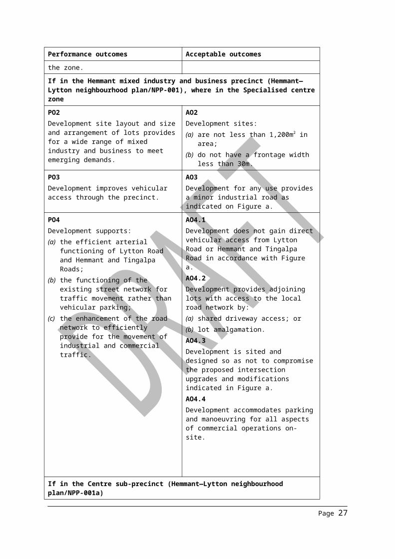
If in the Hemmant mixed industry and business precinct (Hemmant—Lytton neighbourhood plan/NPP-001), where in the Specialised centre zone
PO2Development site layout and size and arrangement of lots provides for a wide range of mixed industry and business to meet emerging demands.
AO2Development sites:(a) are not less than 1,200m2 in area;(b) do not have a frontage width less than
30m.
PO3Development improves vehicular access through the precinct.
AO3Development for any use provides a minor industrial road as indicated on Figure a.
PO4Development supports:(a) the efficient arterial functioning of Lytton
Road and Hemmant and Tingalpa Roads;
(b) the functioning of the existing street network for traffic movement rather than vehicular parking;
(c) the enhancement of the road network to efficiently provide for the movement of industrial and commercial traffic.
AO4.1Development does not gain direct vehicular access from Lytton Road or Hemmant and Tingalpa Road in accordance with Figure a.AO4.2Development provides adjoining lots with access to the local road network by:(a) shared driveway access; or(b) lot amalgamation.AO4.3Development is sited and designed so as not to compromise the proposed intersection upgrades and modifications indicated in Figure a.AO4.4Development accommodates parking and manoeuvring for all aspects of commercial operations on-site.
Page 21

Performance outcomes Acceptable outcomes
If in the Centre sub-precinct (Hemmant—Lytton neighbourhood plan/NPP-001a)
PO5Development for a shopping centre:(a) consolidates sufficient land parcels to
enable the creation of a single consolidated shopping centre in the precinct;
(b) contains a mix of centre activities to support local businesses, employees and the day-to-day convenience needs of residents;
(c) Development improves vehicular access through the precinct.
AO5.1Development for a shopping centre:(a) results in a single consolidated
shopping centre on the corner of:(i) Lytton Road, Violet Street and
Field Avenue; or(ii) Lytton Road, Violet Street and
Ramsay Road;(b) has a minimum site area of 6,000m2;(c) results in:
(i) a maximum of one shop of up to 1,500m2 gross floor area for a supermarket;
(ii) all other shops with a maximum gross floor area of 500m2;
(iii) one shopping centre in the Centre sub-precinct;
(iv) a maximum total combined gross floor area of 3,000m2.
AO5.2Development provides a new vehicular connection as part of the development in accordance with Figure a.
PO6Development other than for a shopping centre:(a) is in accordance with the land use intent
of the Office sub-precinct; and(b) does not prejudice the establishment of
a single consolidated shopping centre in the Centre sub-precinct
AO6No acceptable outcome provided.
PO7Active frontages are provided to Lytton Road and to the new vehicular connection located between Ramsay Road and Violet Street as shown with Figure a.
AO7No acceptable outcome provided.
If in the Office sub-precinct (Hemmant—Lytton neighbourhood plan/NPP-001b)
PO8Development:(a) creates an integrated office park;(b) built form addresses the street frontage
with a sub-tropical pedestrian environment in areas providing an access route to the Hemmant rail station; and
(c) is designed to provide casual
AO8Development:(a) contains only office uses;(b) provides pedestrian openings fronting
the street;(c) where on Hemmant and Tingalpa Road
provides pedestrian awnings along the building frontage where built to the street boundary; and
Page 22

Performance outcomes Acceptable outcomes
surveillance opportunities. is orientated to overlook streets with windows and balconies located on upper levels.
If in the Hemmant and Tingalpa Road precinct (Hemmant—Lytton neighbourhood plan/NPP-002), where in the Emerging community zone
PO9Development ensures new residential communities exhibit a low density character.
AO9Development provides a maximum yield of 15 dwellings/ha.
PO10Development results in a subdivision pattern that presents larger lots where visible from Hemmant and Tingalpa Road.
AO10Development ensures that new lots created with a frontage to Hemmant and Tingalpa Road are a minimum of 1,000m2, with a minimum frontage of 30m to Hemmant and Tingalpa Road.
PO11Development ensures:(a) vehicular access off Hemmant and
Tingalpa Road is only provided where no alternative access is available;
(b) where access is provided off Hemmant and Tingalpa Road it maintains and ensures the safety and functional operation of the road;
(c) through traffic avoids existing residential neighbourhood streets.
AO11Development ensures that:(a) no new vehicular access is created from
Hemmant and Tingalpa Road;(b) the subdivision layout designates Gross
Avenue and/or Oswald Street, and Fleming Road, as the main access streets to Hemmant and Tingalpa Road.
Page 23

Page 24

Part 8 OverlaysAmendments are required to this section of the planning scheme to include additional significant landscape trees in the Significant landscape tree overlay code.
Amendments have also been made to the Overlay maps in Schedule 2.
Table 5 – Proposed amendments to Part 8 Overlays
Reference Proposed Amendment Type of Change
8.2.19 Significant landscape tree overlay code
Table 8.2.19.3.C
Insert the following alphabetically:
Species Address Real property description (lot and plan)
Hemmant2 x Araucaria cunninghamii hoop pine
72 Aquarium Ave (Eastern boundary)
L1 RP162743
Eucalyptus tereticornis forest red gum
50 Bremen St (Front garden)
L13 RP114832
Delonix regia poinciana
163 Fleming Rd (Front garden)
L11 RP33342
Eucalyptus racemosa scibbly gum Mangifera indica mango
214 Fleming Rd (Eucalyptus front garden, mango at rear)
L3 SP118579
Ficus microcarpa var hilli Hill’s fig
165 Hemmant-Tingalpa Rd (Western boundary)
L2 RP71800
Ficus benjamina weeping fig
27 Poppy St (South west area of site)
L54 RP222671
Ficus microcarpa var hilli Hill’s fig
12 Ragnor Rd (Rear garden)
L5 RP71825
Ficus benjamina weeping fig
47 Wyuna Ct (North west corner)
L466 SL6767
Text
Page 25

Reference Proposed Amendment Type of Change
8.2.19 Significant landscape tree overlay code
Table 8.2.19.3.C
Lytton
Araucaria cunninghamii hoop pine, 3 x Ficus obliqua small leaved fig, 2 x Ficus mIcrocarpa small fruited fig
2002 Lytton Rd (Western boundary)
L4 RP852211
Ficus obliqua small leaved fig
2002 Lytton Rd (North eastern boundary)
L1 RP226381
Ficus microcarpa var hilli Hill’s fig
160 South St (Fort Lytton road, east side)
L116 NPW564
Murarrie
Eucalyptus tereticornis forest red gum
39 Paringa Rd (Western side of car park)
L6 SP179372
8 x Eucalyptus tereticornis forest red gum
168 Paringa Rd (South east corner)
L408 CP885750
2 x Ficus microcarpa var hilli Hill’s fig
188 Paringa Rd (South east corner and eastern boundary)
L43 SP227024
Wynnum West26x Mangifera indica mango
59 North Rd (End of Euston St, Iona College adjoining to railway line)
L2 RP192630
Ficus benjamina weeping fig
8 Herswell Ave (Back garden east side)
L22 RP137227
16x Mangifera indica mango
13 North Rd (Railway corridor opp. Bernay’s Rd)
L121 SP130034
Text
Page 26
Part 9 Development codesNo amendments are required to this section of the planning scheme.
Part 10 Other plansNo amendments are required to this section of the planning scheme.
Schedule 1 DefinitionsNo amendments are required to this section of the planning scheme.
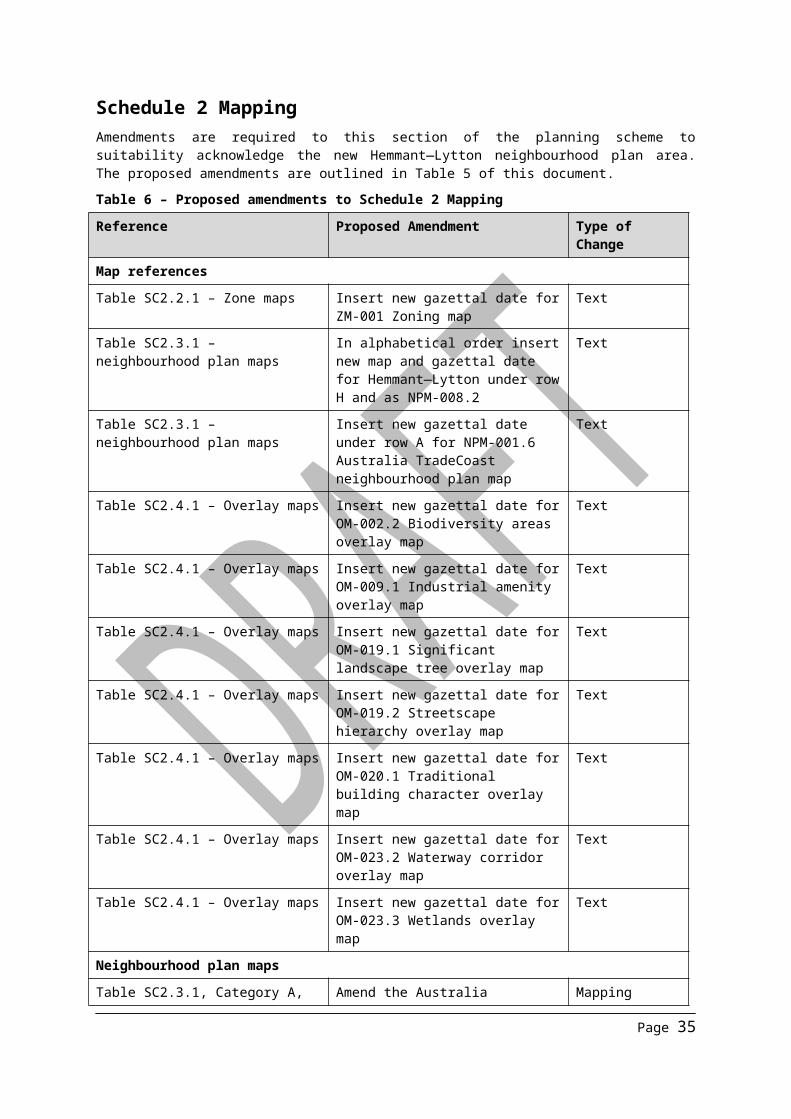
Schedule 2 MappingAmendments are required to this section of the planning scheme to suitability acknowledge the new Hemmant—Lytton neighbourhood plan area. The proposed amendments are outlined in Table 5 of this document.
Table 6 – Proposed amendments to Schedule 2 Mapping
Reference Proposed Amendment Type of Change
Map references
Table SC2.2.1 – Zone maps Insert new gazettal date for ZM-001 Zoning map
Text
Table SC2.3.1 – neighbourhood plan maps
In alphabetical order insert new map and gazettal date for Hemmant—Lytton under row H and as NPM-008.2
Text
Table SC2.3.1 – neighbourhood plan maps
Insert new gazettal date under row A for NPM-001.6 Australia TradeCoast neighbourhood plan map
Text
Table SC2.4.1 – Overlay maps Insert new gazettal date for OM-002.2 Biodiversity areas overlay map
Text
Table SC2.4.1 – Overlay maps Insert new gazettal date for OM-009.1 Industrial amenity overlay map
Text
Table SC2.4.1 – Overlay maps Insert new gazettal date for OM-019.1 Significant landscape tree overlay map
Text
Table SC2.4.1 – Overlay maps Insert new gazettal date for OM-019.2 Streetscape hierarchy overlay map
Text
Table SC2.4.1 – Overlay maps Insert new gazettal date for OM-020.1 Traditional building character overlay map
Text
Table SC2.4.1 – Overlay maps Insert new gazettal date for OM-023.2 Waterway corridor overlay map
Text
Table SC2.4.1 – Overlay maps Insert new gazettal date for OM-023.3 Wetlands overlay map
Text
Neighbourhood plan maps
Table SC2.3.1, Category A, NPM-001.6—Australia TradeCoast neighbourhood plan map
Amend the Australia TradeCoast neighbourhood plan map to remove the areas bounded by the Hemmant—
Mapping
Page 27

Reference Proposed Amendment Type of Change
Lytton neighbourhood plan area. This also includes the removal of the following precincts:
NPP-005. Lytton NPP-006. Hemmant NPP-007. Murarrie
Refer to Appendix A of this document
Neighbourhood plan map — NPM-008.2
Insert new neighbourhood plan map for Hemmant—Lytton neighbourhood plan.Refer to Appendix A of this document
Mapping
Zone maps
Zoning map— (Tiles 21, 22, 29 and 30)
Replace the zoning map with the amended zone map for Hemmant—LyttonRefer to Appendix A of this document
Mapping
Biodiversity areas overlay map (Tiles 21, 22, 29 and 30)
Replace tiles 21, 22, 29 and 30 with the amended Biodiversity areas overlay map.Refer to Appendix A of this document
Mapping
Industrial amenity overlay map (Tiles 21, 22, 29 and 30)
Replace tiles 21, 22, 29 and 30 with the amended Industrial amenity overlay map.Refer to Appendix A of this document
Mapping
Significant landscape tree overlay map (Tiles 21, 22, 29 and 30)
Replace tiles 21, 22, 29 and 30 with the amended Significant landscape tree overlay mapRefer to Appendix A of this document
Mapping
Streetscape hierarchy overlay map (Tiles 21, 22, 29 and 30)
Replace tiles 21, 22, 29 and 30 with the amended Streetscape hierarchy overlay map.Refer to Appendix A of this document
Mapping
Traditional building character overlay map (Tiles 21, 22, 29 and 30)
Replace tiles 21, 22, 29 and 30 with the amended Traditional building character overlay map.Refer to Appendix A of this document
Mapping
Waterway corridor overlay map (Tiles 21, 22, 29 and 30)
Replace tiles 21, 22, 29 and 30 with the amended Waterway corridor overlay mapRefer to Appendix A of this document
Mapping
Wetlands overlay map (Tiles 21, 22, 29 and 30)
Replace tiles 21, 22, 29 and 30 with the amended Wetlands overlay map.Refer to Appendix A of this document
Mapping
Page 28

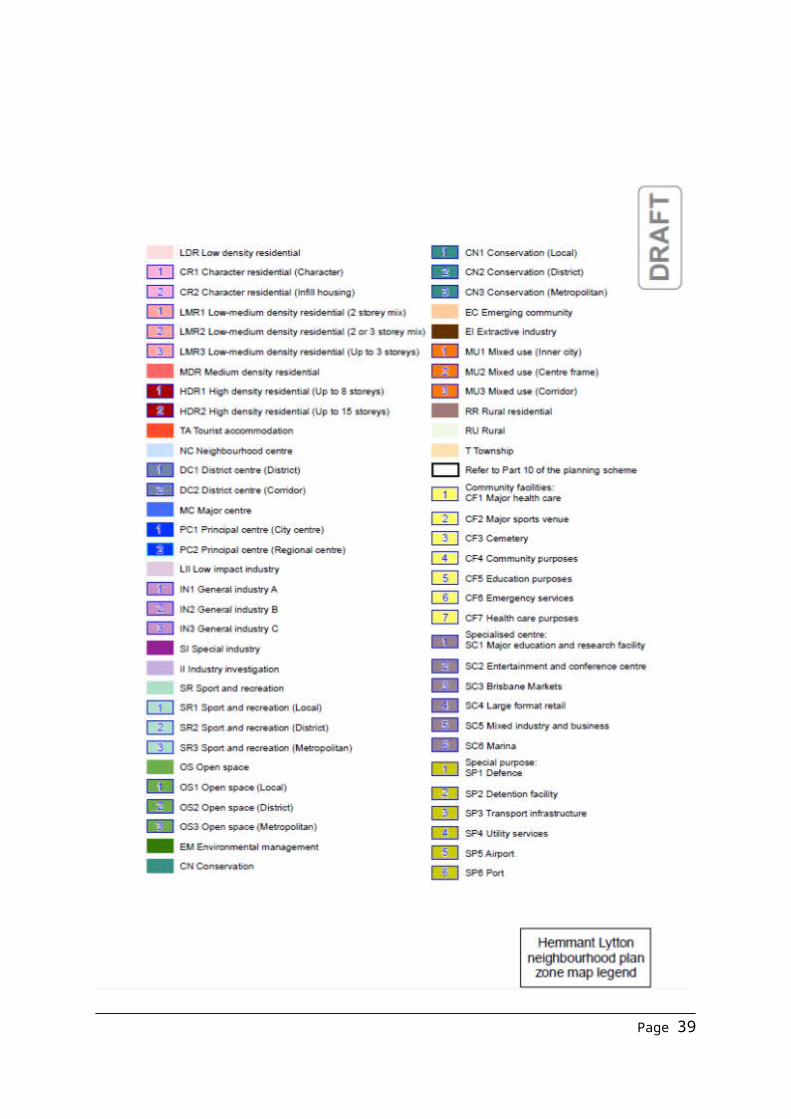
Map 1 – ZM-001 Zone map (proposed zone changes)
Page 29

Page 30

Map 2 – NPM-001.6 Australia TradeCoast neighbourhood plan map
Page 31

Map 3 – NPM-008.2 Hemmant Lytton neighbourhood plan map
Page 32

Map 4 – OM-002.2 Biodiversity areas overlay map
Page 33

Map 5 – OM-009.1 Industrial amenity overlay map
Page 34
Map 6 – OM-019.1 Significant landscape tree map
Page 35

Map 7 – OM-019.2 Streetscape hierarchy overlay map
Page 36

Map 8 – OM-020.1 Traditional building character overlay map
Page 37

Map 9 – OM-023.2 Waterway corridor overlay map
Page 38
Map 10 – OM-023.3 Wetlands overlay map
Page 39

Schedule 3 Priority Infrastructure Plan mapping and support material Amendments are required to this section of the planning scheme are primarily ‘supporting amendments’ to Part 4 Priority Infrastructure Plan. The proposed amendments are described in Table 7 and included in the road infrastructure corridors section, predicted and existing residential and non-residential growth tables section and Appendix A of this document.
Table 7 – Proposed amendments to Schedule 3 Priority Infrastructure Plan mapping and support material
Reference Proposed Amendment Type of Change
Table SC3.1.1.1—Road infrastructure corridors
Modify road infrastructure corridor projects associated with the Hemmant-Lytton neighbourhood plan
Text
Table SC3.2.1—Priority Infrastructure Plan maps (Map D2)
Replace map with amended Map D2—Stormwater Network DSS Conveyance Standards in Appendix A.Amendments relate to the inclusion of certain parts of Hemmant-Lytton within DSS conveyance standard A area to reflect increased growth potential within these areas
Mapping
Table SC3.3.1—Schedule of works for future trunk infrastructure (Tables SW1, R1, APT1, APT3 and CP1)
Update the Table SW1, Table R1, Table APT1, Table APT3 and Table CP1 hyperlinks to reflect new, modified and new trunk infrastructure in the schedule of works.Trunk infrastructure amendments are located in Appendix A
Hyperlink (includes text and word amendments to excel spread sheets)
Table SC3.4.1—Plans for trunk infrastructure networks (PFTI maps)
Replace maps with the following amended maps in Appendix A:
SW156, SW176; R175, R176, R196; APT156, APT157, APT175,
APT176, APT177, APT195; APT196;
CP136, CP155, CP156, CP175, CP176
Amendments reflect changes to future residential and non-residential growth for the Hemmant-Lytton neighbourhood plan
Mapping
Table SC3.5.1—Predicted existing and future resident population
Amend the predicted existing and future resident population numbers (as per Appendix A) to reflect the Hemmant-Lytton neighbourhood plan’s increased future resident populationConsequential amendments are made to the balance of the table schedules.
Text and numbers
Table SC3.6.1—Predicted existing Amend the predicted existing and Text and
Page 40

Reference Proposed Amendment Type of Change
and future private residential dwelling supply
future private residential dwelling supply numbers (as per Appendix A) to reflect the Hemmant-Lytton neighbourhood plan’s private dwelling supplyConsequential amendments are made to the balance of the table schedules.
numbers
Table SC3.7.1—Predicted existing and future employment
Amend the predicted existing and future employment numbers (as per Appendix A) to reflect the Hemmant-Lytton neighbourhood plan’s increased employee growthAmendments are proposed to the predicted existing and future employment numbers of the statistical local areas of Hemmant, Lytton and Tingalpa
Text and numbers
Table SC3.8.1— Predicted existing and future non-residential floor space
Amend the predicted existing and future non-residential floor space numbers (as per Appendix A) to reflect the Hemmant-Lytton neighbourhood plan’s increased non-residential growthAmendments are proposed to the predicted existing and future non-residential floor space numbers of the statistical local areas of Hemmant, Lytton and Tingalpa
Text and numbers
Road infrastructure corridors Amendments to Table SC3.1.1.1, associated with the Hemmant-Lytton neighbourhood plan, have been prepared in accordance with the template used for Brisbane City Plan 2014 and are outlined in Appendix A.
Page 41

Schedule 4 Notations required under the Sustainable Planning Act 2009No amendments are required to this section of the planning scheme.
Schedule 5 Land designated for community infrastructureNo amendments are required to this section of the planning scheme.
Schedule 6 Planning scheme policies (PSP)No amendments are required to this section of the planning scheme.
Appendix 1 Index and glossary of abbreviations and acronymsNo amendments are required to this section of the planning scheme.
Appendix 2 Table of amendmentsAmendment is required to this section to reflect the adoption and effect date of the Hemmant—Lytton neighbourhood plan. This is outlined in Table 7.
Table 8 – Proposed amendments to Appendix 2 Table of amendments
Reference Proposed Amendment Type of Change
Table AP2.1 – Table of amendments Insert date of adoption and effective date, planning scheme version number, amendment type and summary of amendments as a result of the Hemmant—Lytton neighbourhood plan
Text
Page 42

Appendix A Amendments to Part 4 Priority Infrastructure Plan - refer to Appendix A attachment
Page 43