table of contents - tugis conference · table of contents page ... richard j. biery northern tier...
TRANSCRIPT

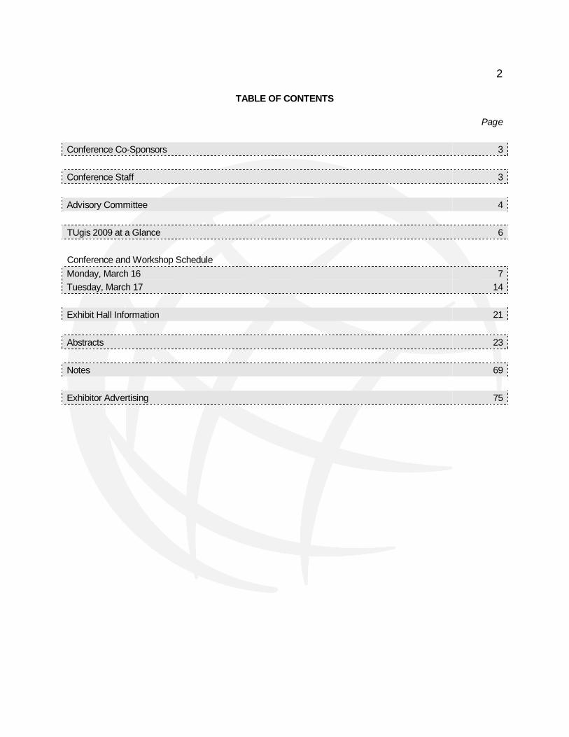
2
TABLE OF CONTENTS
Page
Conference Co-Sponsors 3
Conference Staff 3
Advisory Committee 4
TUgis 2009 at a Glance 6
Conference and Workshop Schedule
Monday, March 16 7
Tuesday, March 17 14
Exhibit Hall Information 21
Abstracts 23
Notes 69
Exhibitor Advertising 75

3
CONFERENCE CO-SPONSORS Towson University Department of Geography and Environmental Planning Environmental Systems Research Institute KCI Technologies, Inc.
California University of Pennsylvania Johnson, Mirmiran & Thompson Maryland State Highway Administration
CONFERENCE STAFF
John M. Morgan, III, Ph.D. Conference Organizer Bobby Fleury Montgomery County Planning Department Coordinator, Volunteers Douglas Goldsmith Coordinator, Exhibit Area Kang Shou Lu, Ph.D. Coordinator, Job Mart Thomas R. Mueller, Ph.D. California University of Pennsylvania Coordinator, Concurrent Sessions
Martin C. Roberge, Ph.D. Coordinator, Student Paper Competition Phillip L. Reese Assistant Coordinator, Exhibit Area Erica Cress Coordinator, Registration Paporn Thebpanya, Ph.D. Coordinator, Map Gallery

4
CONFERENCE ADVISORY COMMITTEE Douglas M. Adams Baltimore County Government Rowland O. Agbede Maryland Department of Agriculture Roger Barlow U.S. Geological Survey Richard J. Biery Northern Tier Regional Planning and Development Commission Kevin T. Boone Maryland Department of Natural Resources Philip R. Canter Baltimore County Police Department John G. Coleman, Jr. Maryland Department of Planning Charles M. Croner, Ph.D. Centers for Disease Control and Prevention (retired) Jeffrey D. Edgin, GISP St. Mary's County Government David A. Gillum, GISP Anne Arundel County Office of Information Technology Michael S. Herzberger Maryland Environmental Service Christopher P. Heyn, P.E., GISP KCI Technologies, Inc. Kenneth C. Juengling Geospatial Training and Consulting, Inc. Michael J. Kevany PlanGraphics, Inc.
Michael B. Mahaffie Delaware Office of State Planning Lindsay Major Ringgold Maryland Governor’s Office John P. Martin Anne Arundel County Office of Information Technology Kenneth M. Miller Maryland Department of Natural Resources Thomas R. Mueller, Ph.D., GISP California University of Pennsylvania Virginia I. Peterman Howard County Government Douglas A. Reedy Frederick County Division of Public Works Alison Rice Environmental Systems Research Institute Martin C. Roberge, Ph.D. Towson University Marcus Z. Rouhani Maryland Aviation Administration Ronald T. Santos U.S. Army Corps of Engineers Martin F. Schmidt, Jr. McDonogh School Jennifer Schottke Environmental Systems Research Institute Michael S. Scott, Ph.D., GISP Salisbury University
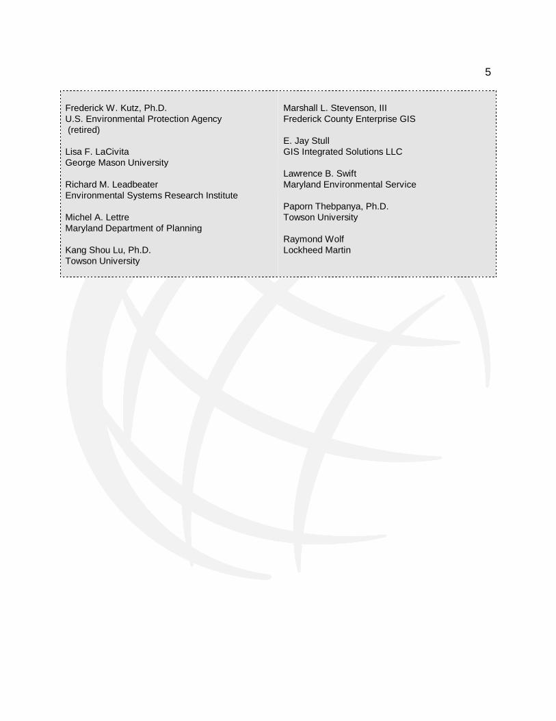
5
Frederick W. Kutz, Ph.D. U.S. Environmental Protection Agency (retired) Lisa F. LaCivita George Mason University Richard M. Leadbeater Environmental Systems Research Institute Michel A. Lettre Maryland Department of Planning Kang Shou Lu, Ph.D. Towson University
Marshall L. Stevenson, III Frederick County Enterprise GIS E. Jay Stull GIS Integrated Solutions LLC Lawrence B. Swift Maryland Environmental Service Paporn Thebpanya, Ph.D. Towson University Raymond Wolf Lockheed Martin

6
TUgis 2009 AT A GLANCE
Day and Event Page Monday, March 16, 2009
7:30 – 9:00 Registration and Continental Breakfast 7
9:00 - 10:30 Opening Session and Plenary Presentation by Dr. Sean Gorman, FortiusOne 7
10:15 - 10:45 Coffee Break 7
10:45 - 12:15 Concurrent Sessions #1 7
12:15 - 1:30 Lunch 9
1:30 - 3:00 Concurrent Sessions #2 9
3:00 - 3:30 Refreshment Break 11
3:30 - 5:00 Concurrent Sessions #3 11
5:00 – 7:00 Ice Breaker Social and Drawing for Door Prizes* 13
Tuesday, March 17, 2009
7:30 – 9:00 Registration and Continental Breakfast 14
9:00 - 10:30 Opening Session and Plenary Presentation by Clint Brown, ESRI 14
10:30 - 10:45 Coffee Break 14
10:45 - 12:15 Concurrent Sessions #4 14
12:15 - 1:30 Lunch 16
1:30 - 3:00 Concurrent Sessions #5 16
3:00 - 3:30 Refreshment Break, Ice Cream Social, and Drawing for Door Prizes* 18
3:30 - 5:00 Concurrent Sessions #6 18
5:00 - 5:15 Drawing for Door Prizes* 20
*You must be present to win.

7
PRELIMINARY CONFERENCE PROGRAM
Monday, March 16, 2009 7:30 – 9:00 Continental Breakfast and Opening Session
Sponsored by Environmental Systems Research Institute (ESRI)
Chesapeake I, II, and III
9:00 – 9:30 Welcome and Opening Remarks 10:45 – 12:15 Plenary Presentation by Dr. Sean Gorman, CEO and Founder, FortiusOne
The Benefits and Pitfalls of Democratizing Geographic Data and Analysis: Lesson Learned from the Creation of GeoCommons
10:30 – 10:45 Coffee Break
Potomac Lounge
10:45 – 12:15 Concurrent Sessions #1
Data Sharing
Room 305
Session Moderator: Rick Biery, Northern Tier Regional Planning and Development Commission (Pennsylvania) Creating Incentives and Pathways for Sharing Public GIS Data Josh Knauer, Rhiza Labs, LLC Automated Data Integration and Sharing Using ESRI Replication Russell Minich, Timmons Group Web-Based Spatial Processing, Analysis, and Compliance to Facilitate Data Sharing and Re-Use Gregory T. Reinecke, Laser Scan, Inc.
Environmental Applications I
Chesapeake II
Session Moderator: Dr. Rick Kutz, Towson University Geospatial Research and Education Laboratory A Watershed Based Digital Map Atlas for Sussex County Nicole M. Minni, GISP, University of Delaware A Focused Data Fusion Strategy Using Image Processing Techniques and GIS to Delineate Dynamic Shorelines Using High Resolution Data and the NOAA Datum Transformation Tool VDatum Vitad Pradith, NOAA, National Ocean Service
8
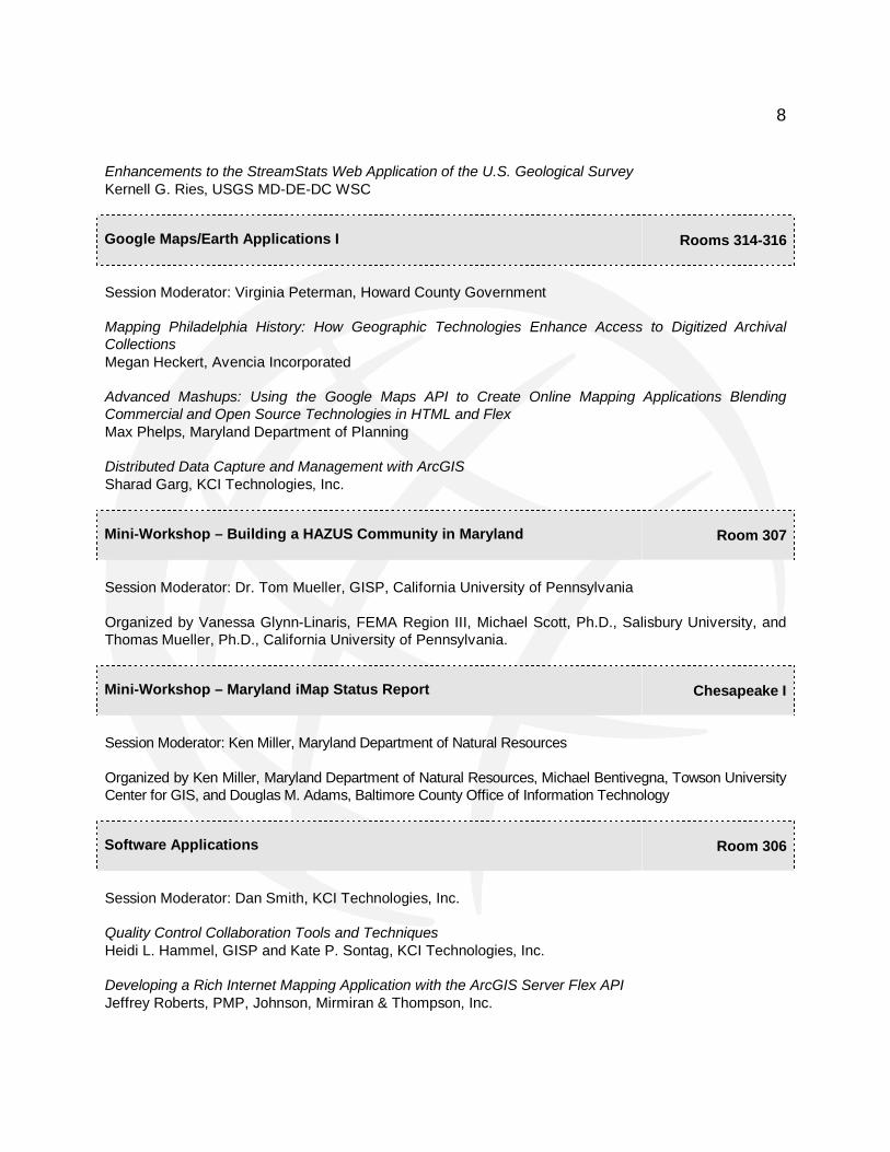
Enhancements to the StreamStats Web Application of the U.S. Geological Survey Kernell G. Ries, USGS MD-DE-DC WSC
Google Maps/Earth Applications I
Rooms 314-316
Session Moderator: Virginia Peterman, Howard County Government Mapping Philadelphia History: How Geographic Technologies Enhance Access to Digitized Archival Collections Megan Heckert, Avencia Incorporated Advanced Mashups: Using the Google Maps API to Create Online Mapping Applications Blending Commercial and Open Source Technologies in HTML and Flex Max Phelps, Maryland Department of Planning Distributed Data Capture and Management with ArcGIS Sharad Garg, KCI Technologies, Inc.
Mini-Workshop – Building a HAZUS Community in Maryland
Room 307
Session Moderator: Dr. Tom Mueller, GISP, California University of Pennsylvania Organized by Vanessa Glynn-Linaris, FEMA Region III, Michael Scott, Ph.D., Salisbury University, and Thomas Mueller, Ph.D., California University of Pennsylvania.
Mini-Workshop – Maryland iMap Status Report
Chesapeake I
Session Moderator: Ken Miller, Maryland Department of Natural Resources Organized by Ken Miller, Maryland Department of Natural Resources, Michael Bentivegna, Towson University Center for GIS, and Douglas M. Adams, Baltimore County Office of Information Technology
Software Applications
Room 306
Session Moderator: Dan Smith, KCI Technologies, Inc. Quality Control Collaboration Tools and Techniques Heidi L. Hammel, GISP and Kate P. Sontag, KCI Technologies, Inc. Developing a Rich Internet Mapping Application with the ArcGIS Server Flex API Jeffrey Roberts, PMP, Johnson, Mirmiran & Thompson, Inc.

9
Leveraging Virtualization Technology for GIS Application Development Brendan Carroll and Ian Botts, KCI Technologies, Inc.
Web Mapping Applications
Chesapeake III
Session Moderator: Mike Herzberger, Maryland Environmental Service Web GIS Monitoring of Probation and Parole Offenders in Maryland Stewart Bruce, Washington College and Bruce Stauffer, geographIT Web Mapping with Open Standards and Software: Building a WMS Crime Viewer with OpenLayers Douglas G. Sheldon, GISP, County of Spotsylvania GIS Web-Sites: Current Trends, Future Directions, and the State-of-the-Art Steven J. Anderson, GISP, Applied Geographic, Inc. 12:15 – 1:30 Lunch
Sponsored by KCI Technologies, Inc.
Susquehanna Rooms
1:30 – 3:00 Concurrent Sessions #2
Cadastral Applications
Room 305
Session Moderator: Kevin Boone, Maryland Department of Natural Resources Building a Statewide Vector Parcel Geodatabase Douglas M. Adams, Baltimore County Office of Information Technology Updating Landbase Data James Cannistra, CP, Sanborn Map Company Maintaining an Evolving Parcel Geodatabase in Baltimore County Scott Messier, Baltimore County Office of Information Technology
Environmental Applications II
Chesapeake II
Session Moderator: Christopher Heyn, KCI Technologies, Inc. Geospatial Characterization of Agriculture in the Chincoteague Bay Sub-Basin Frederick W. Kutz, Ph.D. and John M. Morgan, III, Ph.D., Towson University Geospatial Research and Education Laboratory and Jeremy Monn, Towson University Center for GIS
10
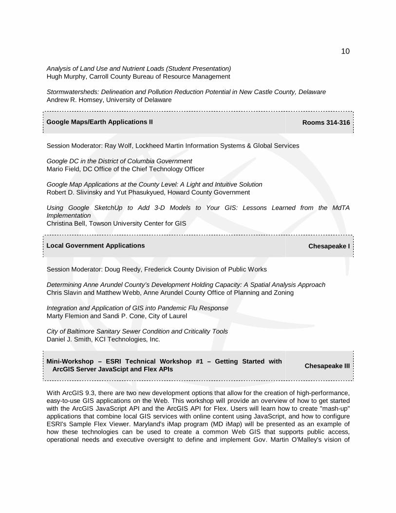
Analysis of Land Use and Nutrient Loads (Student Presentation) Hugh Murphy, Carroll County Bureau of Resource Management Stormwatersheds: Delineation and Pollution Reduction Potential in New Castle County, Delaware Andrew R. Homsey, University of Delaware
Google Maps/Earth Applications II
Rooms 314-316
Session Moderator: Ray Wolf, Lockheed Martin Information Systems & Global Services Google DC in the District of Columbia Government Mario Field, DC Office of the Chief Technology Officer Google Map Applications at the County Level: A Light and Intuitive Solution Robert D. Slivinsky and Yut Phasukyued, Howard County Government Using Google SketchUp to Add 3-D Models to Your GIS: Lessons Learned from the MdTA Implementation Christina Bell, Towson University Center for GIS
Local Government Applications
Chesapeake I
Session Moderator: Doug Reedy, Frederick County Division of Public Works Determining Anne Arundel County’s Development Holding Capacity: A Spatial Analysis Approach Chris Slavin and Matthew Webb, Anne Arundel County Office of Planning and Zoning Integration and Application of GIS into Pandemic Flu Response Marty Flemion and Sandi P. Cone, City of Laurel City of Baltimore Sanitary Sewer Condition and Criticality Tools Daniel J. Smith, KCI Technologies, Inc.
Mini-Workshop – ESRI Technical Workshop #1 – Getting Started with ArcGIS Server JavaScipt and Flex APIs
Chesapeake III
With ArcGIS 9.3, there are two new development options that allow for the creation of high-performance, easy-to-use GIS applications on the Web. This workshop will provide an overview of how to get started with the ArcGIS JavaScript API and the ArcGIS API for Flex. Users will learn how to create "mash-up" applications that combine local GIS services with online content using JavaScript, and how to configure ESRI's Sample Flex Viewer. Maryland's iMap program (MD iMap) will be presented as an example of how these technologies can be used to create a common Web GIS that supports public access, operational needs and executive oversight to define and implement Gov. Martin O'Malley's vision of
11
"One Maryland, one map." Mini-Workshop organized by Alison Rice, ESRI and conducted by Bonnie Strayer, ESRI.
Mini-Workshop – Oblique Imagery – New Developments
Room 307
Presentation of four new applications related to the use of oblique imagery. Mini-workshop organized by Thomas Burns, Pictometry International Corp.
Transportation Applications I
Room 306
Session Moderator: Larry Swift, Maryland Environmental Service More Cost Effective Highway Maintenance Using Remote-Sensed Images Brad A. Davis, Maryland Environmental Service Using GIS for Pedestrian and Bicycle Planning Kirk A. Weaver, PMP, GISP, Michael Baker Jr., Inc. Converting SHA’s DGN Maps to ArcGIS Laurie Goudy, Enterprise Information Solution, Inc. and Clay Supensky, Maryland State Highway Administration 3:00 – 3:30 Refreshment Break
Potomac Lounge
3:30 – 5:00 Concurrent Sessions #3
Economic Applications
Room 306
Session Moderator: Marshall L. Stevenson, III, Frederick County Enterprise GIS Priority Places: Ashville, North Carolina’s Web-Based Economic Development Tool Megan Heckert, Avencia Incorporated Developing Frederick County Business Parks and Retail Centers Mapping Applications Using ArcGIS Server Bangyeon Kim, Tara Wolf, Chris Corbelli, Geoff Caruso, Marshall L. Stevenson, III, and Mike Stranovsky, Frederick County Enterprise GIS and Sandy Wagerman, Frederick County Office of Economic Development Promoting Land Use Planning and Economic Development with Web GIS: Two Case Studies Sara Siskavich, GISP, Applied Geographics, Inc.

12
Environmental Applications III
Chesapeake II
Session Moderator: Dr. Martin Roberge, Towson University Department of Geography and Environmental Planning Contributing to an Institutional Carbon Footprint Francis Precht, Ph.D., Frostburg State University Moving the Line: Critical Area Boundary Mapping Michael Scott, Ph.D., Salisbury University, and Mary Owens and Bob Cicconetti, Critical Area Commission for the Chesapeake and Atlantic Coastal Bays Digital Floodplain Mapping in Maryland: A Status Report and Next Steps David Guignet, P.E., C.F.M., Maryland Department of the Environment and Michael S. Herzberger, Maryland Environmental Service
Google Maps/Earth Applications III
Rooms 314-316
Session Moderator: Dr. Tom Mueller, GISP, California University of Pennsylvania Using Google Earth for Visualization and Collaboration of Archaeological Data William Dickinson, Jr., Exceptional Software Strategies, Inc. Using Google Earth as an Instructional Tool in Secondary Education Classrooms Katie L. Mercadante, California University of Pennsylvania Using the Google Maps API to Create an Accessible and Intuitive Campus Map Mashup for Towson University (Student Presentation) Phillip L. Reese, Towson University Geospatial Research and Education Laboratory
Mini-Workshop – MarylandView Update
Room 305
Organized by John M. Morgan, III, Ph.D., Towson University Geospatial Research and Education Laboratory. Topics to be discussed will include development of a land cover map for Maryland, application of the agricultural cropland data layer, development of products from the State of Maryland’s true color and false color infrared digital orthophotography, and the current status of the MarylandView Consortium.
Mini-Workshop – ESRI Technical Workshop #2 – ArcGIS Online and ESRI Datasets: Overview and Best Practices
Chesapeake III
ArcGIS Online Services and ESRI Data provide a variety of comprehensive Web-based resources and datasets that can be used to enhance and extend your ArcGIS products, with both Desktop and Server.

13
This session will provide an overview on the wide variety of content that is available on ArcGIS Online, and how to use these services in your projects, as well as an overview of the ESRI datasets (demographics, business data and consumer spending, for example) and how they can enable your organization to make better decisions. Mini-Workshop organized by Alison Rice, ESRI and conducted by Rachel Weeden, ESRI.
Poster Session
Loch Raven Room
North Hill Tree Inventory Project Utilizing GIS Emily Lux, Greenhorne & O’Mara, Inc. Using GIS to Locate Harry Dorsey Gough’s Final Resting Place Daniel J. Smith, KCI Technologies, Inc. Identifying and Contributing Geospatial Tools and Services Using NASA’s Global Change Master Directory (GCMD) Tyler B. Stevens, NASA Goddard Space Flight Center
Transportation Applications II
Chesapeake I
Session Moderator: Larry Swift, Maryland Environmental Service Automated Sequencing in the Production of the Official Montgomery County Bus Stop Listing Matthew Yeh, Greenhorne & O’Mara, Inc. Map Book Extension with ArcGIS: Maryland State Highway Vegetation and Invasive Species Management Kristin McCauley Tarr and Erin Lesh, GISP, Maryland Environmental Service Identifying Areas of High Bus Ridership in Montgomery County, Maryland Matthew Yeh and Errol Dufour, Greenhorne & O’Mara, Inc. 5:00 – 7:00 Ice Breaker Social and Drawing for Door Prizes*
Sponsored by the Maryland State Highway Administration
Potomac Lounge
*You must be present to win.

14
Tuesday, March 17, 2009
7:30 – 9:00 Continental Breakfast
Sponsored by URS Corporation
Potomac Lounge
9:00 – 9:30 Welcome And Opening Remarks
Chesapeake I, II, and III
9:30 – 10:30 Plenary Presentation by Clint Brown, Environmental Systems Research Institute
A Framework for Implementing Web GIS
10:30 – 10:45 Coffee Break
Potomac Lounge
10:45 – 12:15 Concurrent Sessions #4
Addressing Applications
Chesapeake II
Session Moderator: Marshall L. Stevenson, III, Frederick County Enterprise GIS Maryland Statewide Addressing Initiative Ashley Buzzeo and Tom Earp, Towson University Center for GIS Frederick County Street Centerline and Addressing Project: Are We There Yet? Marshall L. Stevenson, III, Bangyeon Kim, Frederick County Enterprise GIS and Amy Purves, P.E. and Kate Sontag, KCI Technologies, Inc. Addresses and Addressing: Anomalies, Oddities, and Just Plain Problems Michael Kevany, PlanGraphics, Inc.
3D Applications
Room 307
Session Moderator: David Gillum, GISP, Anne Arundel County Office of Information Technology Efficient Encoding of 2D and 3D Geospatial RDF Data with Near-Linear Search Time Steve Haflich, Franz Inc. Integrating the Web and the GPU to Advance 3D GIS Visualization Robert Holicky, Geoweb3d, Inc. 3D Urban Modeling Is No Longer Just for the “Big Cities” Geoff Zeiss and Neal Niemiec, Autodesk, Inc.

15
Federated Data Creation
Chesapeake I
Session Moderator – Kevin Boone, Maryland Department of Natural Resources Federated Data Creating, Maintenance, and Update: Using OGC Standards-Based Technologies (60 minutes) Mark E. Reichardt and Sam Bacharach, Open Geospatial Consortium, Inc. Sharing Regional Data to the National Map Mary Valentino and Kenneth C. Juengling, Towson University Center for GIS
GPS Applications
Room 305
Session Moderator: Rick Biery, Northern Tier Regional Planning and Development Commission (Pennsylvania) Prince William County Service Authority: Quickly Deploying Mobile GIS/GPS Jim Owecke, Earth Vector Systems Techniques for Achieving the Expected Level of Accuracy Using GPS for GIS Franck E. Boynton, NavtechGPS Trimble VRS Technology: High Accuracy GPS/GIS Mapping in Real-Time Jim Owecke, Earth Vector Systems
Mini-Workshop – ESRI Technical Workshop #3 – Introduction to ArcLogistics
Chesapeake III
With ArcLogistics, ESRI offers a complete desktop solution for creating optimized routes and solving scheduling problems that can cut costs and improve customer service. This workshop will familiarize users with the 9.3 release of ArcLogistics, and apply the integrated problem-solving tools to real-world situations to demonstrate how efficiencies can be gained. Mini-Workshop organized by Alison Rice, ESRI and conducted by Matt Kennedy, ESRI.
Mini-Workshop – FLYOVER MARYLAND: Bridging the GAP with Google Enterprise
Rooms 314-316
Organized by Kaushik Dutta, Maryland Transportation Authority, David Side, Towson University Center for GIS, and Michael Evanoff, Google

16
Public Safety Applications
Room 306
Session Moderator: Phil Canter, Baltimore County Police Department Incident Crime Data Collection and Display with Google Map Mashup Colin Drane, SpotCrime.com Using Spatial Statistics to Improve Crime Fighting in Large Police Districts Robert Cheetham, Avencia Incorporated Spatial Analysis of Crimes/Personal Injury Vehicle Crashes for Data Drive Approaches to Crime and Traffic Safety (DDACTS) Planning Wenjuan Lu and Sam Helms, Baltimore County Police Department 12:15 – 1:30 Lunch
Sponsored by Johnson, Mirmiran & Thompson (JMT)
Susquehanna Rooms
1:30 – 3:00 Concurrent Sessions #5
ArcGIS Server Applications
Rooms 314-316
Session Moderator: Ken Juengling, GISP, Towson University Center for GIS Leveraging ArcGIS Server for Custom Application Development Kenneth C. Juengling and Steven Fabijanski, Towson University Center for GIS SpiresGIS for ArcGIS Server: Tips, Tricks, and Lessons Learned in Providing Data Via ArcGIS Server to the Public by a Local Government Matt Bowman and Bill Adkins, City of Frederick GIS Extending GIS Analysis with Python Libraries James Tedrick, Maryland-National Capital Park and Planning Commission
Election Applications
Room 305
Session Moderator: Phil Canter, Baltimore County Police Department Election Day Incident Mapping and Automated Analysis Robert Cheetham, Avencia Incorporated Geospatial Efficiency Analysis of the 2008 Presidential Election in Pennsylvania J. Brian Adams, Franklin & Marshall College

17
Using GIS to Measure and Rank Gerrymandering of Electoral Districts Megan Heckert, Avencia Incorporated
GIS Education I
Room 306
Session Moderator: Lisa LaCivita, George Mason University Making Spatial Decisions Using GIS: A New Take on GIS Curriculum Kathryn Keranen and Bob Kolvoord, Ph.D., James Madison University Examining Local Land Use Changes in Schools Using Free GIS Software and Data Martin F. Schmidt, Jr., McDonogh School Elementary Students Use a Field GPS Unit to Establish a Geographic Information System to Monitor for Mosquito Larvae in Standing Water Sandy Hoar, PGDip, MPAS, PA-C, George Washington University and Dana R. Thomson
Mini-Workshop – ESRI Technical Workshop #4 – Building Better Maps: Tips and Tricks for Preparing and Transferring Maps to the Web
Chesapeake III
With so many GIS applications on the Web, it's more important than ever for users to understand how to build better maps for the Web. This session will address common problem areas that arise when transforming Desktop map projects to Web maps and how to resolve them. New techniques that will be available at the 9.3.1 release will also be introduced. Mini-Workshop organized by Alison Rice, ESRI and conducted by Darren Baird, ESRI.
Mini-Workshop – GIS Managers I
Chesapeake I
Session Moderator: Jeff Edgin, GISP, St. Mary’s County Government Organized by Curt Hinton and David Holdstock, Geographic Technologies Group. Learning the fundamentals for providing a manager’s perspective to GIS solutions is key to the success for any enterprise GIS. The purpose of this mini-workshop is to provide GIS coordinators, IT directors, and anyone in a GIS management position with the tools necessary to properly implement and maintain a successful GIS program. Topics to be discussed will include managing GIS, governance of GIS, the enterprise Implementation of GIS, and the business case for GIS.
Miscellaneous Applications I
Room 307
Session Moderator: Dr. Kang Shou Lu, Towson University Department of Geography and Environmental Planning

18
Integrating Disparate Data Sources and Evaluating Real-Time Information to Support Enhanced Collaboration Within a Web 2.0 Framework David Braig, BAE SYSTEMS Network Systems A Cadastral Model for Post-Conflict Reconstruction and Stability Operations: Overcoming Obstacles to Data Sharing or Spatial Analysis and Modeling Douglas E. Batson, National Geospatial-Intelligence Agency Accurately Predicting Pedestrian Movement in Desert Environments: An Archaeologically-Informed Human Terrain Geospatial-Intelligence Application Devin A. White, Ph.D., ITT Visual Information Solutions and Crow Canyon Archaeological Center
Transportation Applications III
Chesapeake II
Session Moderator: Marcus Zadi Rouhani, Maryland Aviation Administration Using GIS to Monitor and Report ADA Compliance Carl Henderson, Maryland State Highway Administration and Joe Bizzell, Johnson, Mirmiran & Thompson Environmental Compliance Tracking and Management Tools on the ICC Natalie Roye and Amanda O’Shea, KCI Technologies, Inc. Enterprise GIS Spreads Its Wings at BWI Marcus Zadi Rouhani, Maryland Aviation Administration
3:00 – 3:30 Refreshment Break, Ice Cream Social, And Drawing For Door Prizes*
Potomac Lounge
*You must be present to win. 3:30 – 5:00 Concurrent Sessions #6
Emergency Management Applications
Room 314-316
Session Moderator: David Gillum, GISP, Anne Arundel County Office of Information Technology Emergency Management Visualization and Analysis with ArcGIS Explorer Russell Minich, Timmons Group From a Paper Map to a 3D Centerline: Maryland SHA Explores the Use of 3D GIS Data for Hurricane Evacuation Planning Michel N. Sheffer, GISP, CFM, Maryland State Highway Administration GIS Weather Advances Emergency Operations

19
Eric Weller, WeatherBug Professional
GIS Education II
Room 306
Session Moderator: Lisa LaCivita, George Mason University Introducing High School Students to Geospatial Technologies Tracie J. Earl, University of Maryland Eastern Shore Hopeworks ‘N Camden Youth GIS: Camden Street Map Father Jeff Putthoff, Tarren Anderson, Michael Osborne, and Adriana Castro, Hopeworks ‘N Camden The Geospatial Semester: Connecting High School Students, Geospatial Tools, and the Real World Bob Kolvoord, Ph.D., and Kathryn Keranen, James Madison University
Mini-Workshop – GIS Managers II
Chesapeake I
Session Moderator: Jeff Edgin, GISP, St. Mary’s County Government Organized by Curt Hinton and David Holdstock, Geographic Technologies Group. Continuation of GIS Managers I Mini-Workshop.
Infrastructure/Facilities Management Applications
Chesapeake II
Session Moderator: Doug Reedy, Frederick County Division of Public Works Stormwater Infrastructure Data Development and Uses: An Overview for Municipalities Brent Reeves and Peter Mattejat, P.E., KCI Technologies, Inc. Developing Geospatial Facilities Management Solutions from Legacy CAD Data Matthew Sadecki, Exceptional Software Strategies, Inc. I Know Where and What It Is and How to Get It. Now What?: The Case for GIS as the Driving Force Behind an Enterprise Utility Asset Management System Steve Beck, ECMs, BPMs, PMP, GISP, Johnson, Mirmiran & Thompson
Mini-Workshop - LIDAR Fundamentals and Applications
Room 305
Session Moderator: Ray Wolf, Lockheed Martin Information Systems & Global Services Organized by Qassim A. Abdullah, Ph.D., PLS, C.P., Fugro Earth Data.

20
Miscellaneous Applications II
Chesapeake III
Session Moderator: Dr. Martin Roberge, Towson University Department of Geography and Environmental Planning Homeless and Transitional Shelters in Baltimore City, Maryland: A Mapping Analysis of Basic Services and Poverty Demographics (Student Presentation) Bineeta Sihota, Baltimore County Office of Information Technology and Terri Hoselton, Towson University Center for GIS Sensor Web Enablement Sam Bacharach, Open Geospatial Consortium, Inc. Mapping the Urban Park Environment: An Update to the Patterson Park GPS Survey Jaime Alvarez, Community College of Baltimore County
Time and GIS
Room 307
Session Moderator: Virginia Peterman, Howard County Government GeoTemporal Reasoning in a Web 3.0 World Jans Aasman, Ph.D, Franz Inc. GeoTime for Visual Intelligence: Connecting GIS and Time Drew Mattison, Oculus Info Inc. 5:00 – 5:10 Drawing For Door Prizes*
Lobby Outside Chesapeake I
*You must be present to win.

21
EXHIBIT HALL INFORMATION
Alphabetical by Vendor Name
1 Axis GeoSpatial LLC
28 BAE Systems
25 Bentley Systems
17 EA Engineering
41 Earth Vector Systems
5 Enterprise Information Solutions, Inc.
42 Environmental Systems Research Institute
2 Exceptional Software Strategies, Inc.
19 geographIT
18 GIS Integrated Solutions LLC
36 Greenhorne & O’Mara
11 ITT Visual Information Solutions
24 Johnson, Mirmiran & Thompson
40 KCI Technologies
4 Keystone Precision Instruments
7 Laser Scan, Inc.
9 LizardTech, Inc.
32 Maryland Department of Natural Resources
33 Maryland Department of Planning
39 Maryland Environmental Service
30/31 Maryland State Geographic Information
Committee (MSGIC)
38 Maryland State Highway Administration
8 Montgomery County Planning Department
23 National Geodetic Survey (National
Oceanic and Atmospheric Administration)
35 NavtechGPS
13 Oculus Info Inc.
22 Onix Networking Corporation
16 Photo Science
3 Pictometry International Corp.
26 Salisbury University Eastern Shore
Regional GIS Cooperative
10 Techna-Graphics Inc.
12 Sanborn Map Company Inc.
20/29 Towson University Center for GIS
27 Towson University Division of Economic
and Community Outreach
14 URS Corporation
15 U.S. Department of Commerce, Bureau of
the Census
34 U.S. Department of the Interior, Geological
Survey
37 U.S. Department of Transportation, Federal
Highway Administration
6 WeatherBug Professional
21 Williams & Heintz Map Corporation
Exhibit Hall Hours
Monday, March 16 – 10:30 am – 7:00 pm Tuesday, March 17 – 7:30 am – 3:30 pm

22
EXHIBIT HALL INFORMATION
Numerical by Booth Number
1 Axis GeoSpatial LLC
2 Exceptional Software Strategies, Inc.
3 Pictometry International Corp.
4 Keystone Precision Instruments
5 Enterprise Information Solutions, Inc.
6 WeatherBug Professional
7 Laser Scan, Inc.
8 Montgomery County Planning Department
9 LizardTech, Inc.
10 Techna-Graphics Inc.
11 ITT Visual Information Solutions
12 Sanborn Map Company Inc.
13 Oculus Info Inc.
14 URS Corporation
15 U.S. Department of Commerce, Bureau of
the Census
16 Photo Science
17 EA Engineering
18 GIS Integrated Solutions LLC
19 geographIT
20/29 Towson University Center for GIS
21 Williams & Heintz Map Corporation
22 Onix Networking Corporation
23 National Geodetic Survey (National
Oceanic and Atmospheric Administration)
24 Johnson, Mirmiran & Thompson
25 Bentley Systems
26 Salisbury University Eastern Shore
Regional GIS Cooperative
27 Towson University Division of Economic
and Community Outreach
28 BAE Systems
30/31 Maryland State Geographic Information
Committee (MSGIC)
32 Maryland Department of Natural Resources
33 Maryland Department of Planning
34 U.S. Department of the Interior, Geological
Survey
35 NavtechGPS
36 Greenhorne & O’Mara
37 U.S. Department of Transportation, Federal
Highway Administration
38 Maryland State Highway Administration
39 Maryland Environmental Service
40 KCI Technologies
41 Earth Vector Systems
42 Environmental Systems Research Institute
Exhibit Hall Hours
Monday, March 16 – 10:30 am – 7:00 pm Tuesday, March 17 – 7:30 am – 3:30 pm

23
ABSTRACTS GeoTemporal Reasoning in a Web 3.0 World Jans Aasman, Ph.D, CEO Franz Inc. 2201 Broadway, Suite 715 Oakland, CA 94612 510-452-2000 x165 510-452-0182 (fax) [email protected] Web 3.0 envisages software agents that know how to reason over activities, events, locations, people, companies, and their inter-relationships. Learning more about customers through location, behavioral and activity recognition is here today through currently available semantic technologies and is a showcase for how these technologies will evolve. This presentation will demonstrate real world examples of activity recognition using a combination of industry standard RDF and OWL, reasoning with geotemporal primitives and some well-known social network analytics. The semantic Web community has made great strides in the area of ontologies and description logic, and some breakthrough work in the areas of geotemporal reasoning and social network analysis. Combining all these different reasoning capabilities in one unified framework will further propel adoption of semantic technology in government and the enterprise. Building a Statewide Vector Parcel Geodatabase Douglas M. Adams GIS Program Manager Office of Information Technology, Baltimore County 400 Washington Avenue, Room 33 Towson, MD 21204 410-887-2289 410-821-8024 (fax) [email protected] During the fall semester 2008, the students in Towson University, Department of Geography and Environmental Planning, Geography 474/574 – GIS Database Design worked on a class project for developing the business case for building a statewide vector parcel geodatabase. The proposal included information on the requirements analysis, geodatabase design, compilation/maintenance procedures and quality plan for a statewide vector parcel geodatabase. Analysis of the information collected provided strong indications that such a database is within the realm of possibilities for the state. The proposal for the geodatabase has been turned over to the State’s GIS coordinating bodies, the Maryland State Geographic Information Committee (MSGIC) and the MD iMap Steering Committee for consideration. This presentation will walk through the geodatabase design and the specifications for mapping. Geospatial Efficiency Analysis of the 2008 Presidential Election in Pennsylvania J. Brian Adams, Ph.D.
24
Department of Mathematics and Computer Science Franklin & Marshall College PO Box 3003 Lancaster, PA 17604-3003 717-330-5627 [email protected] At the conclusion of a long, hard fought campaign, the voters are often ready to drop their interest in the election and move on. Nevertheless, for the candidates this is the perfect time to analyze the results. More than just who won and by how much, this analysis can be used to delve into the spatial and demographic results of the election. A geospatial analysis of the results can identify many important aspects of the election as well as the electorate. This election analysis often consists of a red-blue choropleth map showing which candidate won each state, county, or even precinct. While informative, it is limited in the type of information that it depicts. Instead, this can be extended beyond the win or loss to the relative efficiency that a candidate had in obtaining votes in each region. Data Envelopment Analysis, an efficiency analysis technique, has been very effective in analyzing management units. But it can be adapted to analyzing the relative efficiency where the units are geographical. By applying this technique spatially, the relative efficiency of each region can be determined. Further, this technique can also indicate which variables in inefficient regions are the cause of the inefficiencies. Mapping the Urban Park Environment: An Update to the Patterson Park GPS Survey Jamie Alvarez Instructor Geography & Geospatial Applications School of Mathematics and Science Community College of Baltimore County 410-780-6315 410-780-6145 (fax) [email protected] Since Fall, 2007, students and faculty from the Geospatial Applications Program at the Community College of Baltimore County (CCBC), along with staff and volunteers from the Friends of Patterson Park (FPP), have been developing a tree and infrastructure inventory of historic Patterson Park in east Baltimore. CCBC and FPP have teamed up to put GPS and GIS technology to work in this urban microcosm. Through these efforts, FPP will be able to better visualize, manage, and maintain park features such as trees, benches, utilities, and structures. The completed inventory will allow FPP, the liaison group between Baltimore City and the community around the park, to keep the City better informed of the conditions of trees, maintenance needs, and risk potential throughout the park. GIS Web-Sites: Current Trends, Future Directions, and the State-of-the-Art Steven J. Anderson, GISP Applied Geographics, Inc.

25
48 Purnell Place, Suite 16 Manchester, CT 06040 860-643-4401 x302 860-643-8028 (fax) [email protected] GIS web-sites continue to be the primary mechanism by which most end-users gain access to GIS data and capabilities. With the release of ESRI’s ArcGIS Server 9.3 (AGS) users have more choices than ever about how to build web-based GIS applications and create mash-ups (integrate multiple GIS services). This presentation will describe the range of possibility with current technologies. It will also address how organizations are adapting new technologies, building new applications, and determining if/how to migrate older applications to new platforms. In addition to discussing ESRI's platform technology this presentation will describe the types of web applications that are getting built and the trend from "general GIS viewing" applications to more targeted "workflow oriented" web-sites such as cemetery, document, addressing, and conservation management crime mapping and analysis, and homeland security. Hopeworks ‘N Camden Youth GIS: Camden Street Map Tarren Anderson, Father Jeff Putthoff, Michael Osborne, Adriana Castro Hopeworks ‘N Camden 543 State Street Camden, NJ 08102 856-365-4673 [email protected] Hopeworks ‘N Camden’s Youth GIS Team has created the first street map of Camden in years. The youth team handled every aspect of creation from the base work in ArcMap, to artwork in Adobe Illustrator, to selling and producing advertisements. 8000 Copies of this map were produced and distributed around the Camden/Philadelphia region. The team, along with GIS Director Tarren Anderson and Executive Director Father Jeff Putthoff, will share their experiences producing the map along with a comprehensive look at the Hopeworks Program. Sensor Web Enablement Sam Bacharach Open Geospatial Consortium, Inc (OGC) 483B Carlisle Drive Herndon, VA 20170 508-655-5858 [email protected] The OGC's Sensor Web Enablement (SWE) initiative has produced an internationally recognized open standards framework that enables Web accessible sensors, sensor networks and archived sensor data to be discovered and accessed through standard protocols and interfaces (APIs). The ocean observation community, the GEOSS community, and others are deploying systems with interfaces and encodings that implement these standards. NASA is using the standards in systems for scheduling and controlling Earth imaging systems. Mr. Bacharach will discuss the SWE standards, describe applications, and

26
explain how SWE will be important in a broad range of research and environmental management activities. A Cadastral Model for Post-Conflict Reconstruction and Stability Operations: Overcoming Obstacles to Data Sharing or Spatial Analysis and Modeling Douglas Batson Political Geography Analyst National Geospatial-Intelligence Agency, D-61 4600 Sangamore Road Bethesda MD 20816 301-227-5716 301-227-5585 (fax) [email protected] Land is often a significant factor in widespread violence and a critical element in post-conflict nation-building. Drawing from the situation in Afghanistan, that cadastral (land and property) data is essential to recovery from natural disasters or wars was the topic of my 2007 study published by the National Defense Intelligence College at http://ndic.edu/press/10279.htm. Until now there has never been an internationally accepted standard or method for evaluating land administration systems. The Land Administration Domain Model (LADM) is compelling because it makes explicit the various types of land rights, restrictions, or responsibilities. It is flexible enough to record both Western-style, registered land rights and customary, informal socio-tenure relationships typical of the developing world. In a word, the LADM aspires to be a repository for the myriad of land issues faced by civil-military Reconstruction and Stability personnel in post-conflict societies. As a new work item with the International Standards Organization (ISO), the LADM merits close attention by NATO, the U.S. State and Defense Departments, and USAID because it represents one of the most important tools being developed for facilitating land administration in countries where it has been weak or totally absent. “I Know Where and What It Is and How to Get To It. Now What?”: The Case for GIS as the Driving Force Behind an Enterprise Utility Asset Management System Steve Beck, ECMs, BPMs, PMP, GISP Program Manager Johnson, Mirmiran & Thompson 72 Loveton Circle Sparks, MD 21152 410-528-2700 410-528-2701 (fax) [email protected] Departments of Transportation and Public Works are some of the many agencies that require the day-to-day development, operations and maintenance of the physical assets for which they maintain. In order to retain these assets, these basic questions are asked: 1) Where is the asset?; 2) What is the asset?; 3) What size is the asset?; 4) What material is the asset made of?; 5) If I need to get to I, how do I do that?; 6) When was it constructed or installed?; 7) When was the asset last inspected?; 8) When was the asset last repaired?; 9) Which maintenance crew last worked on it?; and 10) What is the asset’s repair history? Five of these questions can be readily answered through the use of utility asset GIS and it’s spatial and

27
attribute data elements. Answering the remaining questions normally involve an external system or systems. The challenge is how to combine the information into a single, integrated source. This session will focus on successfully addressing this challenge with GIS as the driving force along with a live demonstration of a real life scenario. SpiresGIS for ArcGIS Server: Tips, Tricks, and Lessons Learned in Providing Data via ArcGIS Server to the Public by a Local Government. Matt Bowman GIS Manager City of Frederick GIS 101 North Court Street Frederick, MD 21701 301-600-6209 [email protected] Bill Adkins GIS Analyst City of Frederick GIS 101 North Court Street Frederick, MD 21701 301-600-6271 [email protected] The City of Frederick launched SpiresGIS in the summer of 2005 using ESRI’s ArcIMS technology. The goal of SpiresGIS was to provide accurate and up to date information to both staff and citizens. After two years of implementation SpiresGIS grew to around 8 public services and 4 private services. At this point staff began to look at new ways to provide data to the City’s audiences as we felt that the new requests were outgrowing the software. Staff researched ArcGIS Server and decided that it provided the best solution to meet our future needs. Staff wanted to customize the out of the box ArcGIS Server Web Application template to closely mirror the previous SpiresGIS ArcIMS format. The City purchased Microsoft Visual Studio 2008 and sent staff to ESRI training in order to perform all of our custom changes to our web applications. The end result is a site that is completely customized with a look and feel all to itself. Some customizations were borrowed from other users and some were custom built in house. This presentation will go over how we implemented our custom changes, how we utilized the out of the box tools, and what lessons we learned from this experience. The City of Frederick would like to share with other jurisdictions how this technology has allowed us to better meet the needs of our staff and citizens. Techniques for Achieving the Expected Level of Accuracy Using GPS for GIS Franck E. Boynton Vice President, Technical Sales NavtechGPS 5501 Backlick Road, Suite 230 Springfield, VA 22151 703-256-8900 [email protected]

28
GPS has become an integral and indispensable part of GIS and GIS data collection. Positioning is but a single component to GIS and yet consistence in accuracy is critical to maximizing the effectiveness of the total geographic information system. Achieving the expected level of accuracy from a GPS receiver, as stated by the manufacturer, is often based on optimal conditions, the use of an appropriate form of differential correction and “best-practices” execution on the part of field personnel. There are techniques and procedures that give data collection technicians the best fighting chance at solid accuracy results. Additionally, there are systems and factors coming in the future that will have a profound impact on data collection. This presentation provides some GPS basics and background of how accuracy is affected by some of the technical aspects of the Global Positioning System. Integrating Disparate Data Sources and Evaluating Real-Time Information to Support Enhanced Collaboration within a Web 2.0 Framework David Braig Director GIS Technologies BAE SYSTEMS Network Systems 124 Gaither Drive, Suite 100 Mount Laurel, NJ 08054 856-793-4283 [email protected] Recent research and development efforts within BAE SYSTEMS have focused on leveraging advanced GIS functionality within an Open Source Software environment. These efforts have lead to the creation of a Service Oriented Architecture (SOA) enterprise data fabric platform that provides the ability to quickly integrate multiple data streams from real-time data sources. This platform can be implemented in numerous combinations to support web based collaboration and mash-up development activities within any industry. Through simple XML configuration files, disparate data streams can be ingested, interrogated, and converted automatically into useful, valuable and pertinent information. Some of the currently available map visualization formats include KML, GML, GeoRSS, GPX, ESRI JSON, GeoJSON. These data streams can then be utilized for on-the-fly geoprocessing, alert generation, and dissemination to stakeholders and supporting systems. The platform supports the agility, flexibility, and openness required to integrate legacy systems with modern web-service capabilities without the need to replace or upgrade those older systems. This presentation will highlight our research and development efforts in integrating Open Source Software such as Liferay's Portal Framework, ICEfaces AJAX enabled components, OGC standards, and ESRI’s suite of visualization applications such as the JavaScript API, ArcGIS Explorer and the Flex API within this context. A Framework for Implementing Web GIS Clint Brown Director of Software Products Environmental Systems Research Institute 380 New York Street Redlands, CA 92373-8100 909-793-2853 [email protected]

29
In the past few years, there has been phenomenal interest in 2D and 3D web maps and broad adoption of web mapping tools such as Google Earth, Microsoft Virtual Earth, and ArcGIS Explorer. Consequently, many in society are beginning to grasp the fundamentals of GIS – that the locations of their observations can be georeferenced and overlaid on digital maps that are readily available on the Web. This creates huge opportunities, as well as challenges, for GIS practitioners. We think that GIS will become more relevant and provide the framework for many solutions deployed on the web. The challenge that GIS practitioners face is how to bridge GIS with the web. Many users are searching for a common approach that is simple and that works in making GIS more relevant. GIS users have valuable information. The GIS community has been creating and managing authoritative geographic information for their subject matter and areas of interest. However, the value of this information is not realized nor well understood outside of the GIS community. Use of GIS on the web provides the opportunity to open up GIS to many more users and to make a real impact. This requires that we begin to make our information more useable and consumable for everyday users, but how do we meet that vision? The goal of this presentation will be to describe and demonstrate a framework that GIS users can leverage to publish their geographic information, make it consumable, and build successful Web GIS deployments. Web GIS Monitoring of Probation and Parole Offenders in Maryland Stewart Bruce GIS Program Instructor Washington College 300 Washington Avenue Chestertown, MD 21620-1197 410-810-7177 [email protected] Bruce Stauffer Vice President geographIT 1525 Oregon Pike, Suite 202 Lancaster, PA 17601-7300 717-399-7007 [email protected] The Washington College Department of Sociology and Anthropology, in conjunction with the Washington College GIS Program, was awarded a grant from the Maryland Governor’s Office of Crime Control and Prevention to assist the Division of Parole and Probation in a statewide effort to build a web-based GIS application to search, retrieve, analyze, map and report on individuals currently serving parole or probation. The grant award aligns with Governor O'Malley’s emphasis on reducing crime by improving monitoring of violent repeat offenders. It also recognizes Washington College’s reputation as a leader in criminology studies and innovation in the application of GIS in crime mapping. This presentation will be of interest to anyone involved in law enforcement and criminology who wants to learn how GIS can be applied to monitoring individuals serving parole and probation. Presentation topics will include the rationale for developing the web-based GIS application, an overview of the application architecture, data maintenance considerations, and plans for extending the application’s user community and capabilities. A live demonstration of key features will also be included during the presentation.

30
Maryland Statewide Addressing Initiative Ashley Buzzeo GIS Specialist Center for GIS Towson University 8000 York Road Towson, MD 21252 [email protected] Tom Earp Project Manager Center for GIS Towson University 8000 York Road Towson, MD 21252 [email protected] Identifying address locations for emergency preparedness, along with improving acquisition and access to the information, is mission-critical for federal, state and local government agencies throughout Maryland and the Nation. To respond to this need, the Maryland State Geographic Information Committee (MSGIC), in cooperation with the Towson University Center for GIS and ESRI, led an initiative to coordinate distribution of road centerline address data for the entire State of Maryland. Using ESRI’s ArcGIS Server 9.2 data replication, Maryland counties share their road centerline data producing a consistent, statewide product that provides central and unrestricted access to the most current address data for emergency preparedness and response. Updating Landbase Data James Cannistra, CP Director, Strategic Accounts Sanborn Map Company 232 Main Street Gaithersburg, MD 20878 301-519-9650 [email protected] Local government agencies and utilities are increasingly faced with questions on how to update and maintain their planimetric/topographic and digital orthophoto base map data. The update process may involve remapping entire datasets or performing change analysis to identify specific updates. Update programs may be comprehensive, or may focus on selected areas of change. This presentation some of the best practices being used to support landbase update programs. It will specifically focus on update mapping experiences and lessons learned in completing update programs for Baltimore City and for Washington, DC. Collaborative efforts to identify areas of change, establish update mapping rules, incorporate lessons learned and new technologies, and to perform QA/QC and data acceptance will also be discussed.

31
Leveraging Virtualization Technology for GIS Application Development Brendan Carroll Solutions Architect KCI Technologies, Technology Services Divison 936 Ridgebrook Road Sparks, MD 21152 410-316-7800 800-572-7496 [email protected] Ian Botts Operations Manager KCI Technologies Technology Services Divison 936 Ridgebrook Road Sparks, MD 21152 410-316-7800 800-572-7496 [email protected] Application developers must retain access to a diverse set of development environments in order to accomplish development tasks in an efficient and timely manner. Service pack interoperability constraints, vendor specific database function, development IDE version disparities, and varied software version adoption rates among clients present a seemingly limitless combination of possible environment configurations. To address these issues, desktop and server virtualization technology can be leveraged to build a virtual “library” of development environments. Once setup and configured, an environment can be stored as a template or cloned and distributed, alleviating the tedious and repetitive task of software installation and configuration. A vast number of software environment configurations can be supported with a minimal amount of dedicated computer hardware. There are many virtualization technologies on the market today. This presentation will highlight VMWare’s free desktop and server virtualization solutions. Leveraging VMware Server and VMware Player, it is possible to begin virtualized application development without a significant investment in either hardware or software. Using Spatial Statistics to Improve Crime Fighting in Large Police Departments Robert Cheetham Avencia Incorporated 340 North 12th
Street, Suite 402 Philadelphia, PA 19107 215-701-7713 [email protected] The Philadelphia Police Department (PPD) established its Crime Analysis Unit in 1997 with a goal of using GIS to track and analyze crime across the city. However, the three person unit was limited in its ability to address the needs of the 7,000 officer police force attempting to tackle nearly 2 million incidents each year. Understanding these limitations, the PPD sought to develop an automated system using statistical data mining techniques to enable more rapid discovery and communication of geographic patterns in crime, leveraging existing investment in web-based crime analysis.

32
HunchLab, a web-based statistical crime spike detector application, uses GIS Technology, to nightly comb millions of police incident records, look for recent, geographically-clustered crime frequencies outside the norm, and alert users of these spikes. Beyond simply detecting hot spots in crime, HunchLab analyzes changes in crime density over time and highlights locations where the change is statistically significant, providing early warning of crime spikes or places where crime density is higher than expected based on historical knowledge of the area. More Cost Effective Highway Maintenance Using Remote-Sensed Images Brad Davis GIS Specialist Maryland Environmental Service 259 Najoles Road Millersville MD 21108 410-729-8933 (MES) 410-545-0587 (SHA) [email protected] [email protected] With fluctuating fuel costs and limited budgets, new methods are required to survey and collect highway assets. Remote Sensing allows a rapid and inexpensive method to completely survey the entire State Highway System with a minimum of personnel involved. Advantages over using field crews include: low or no vehicle and fuel cost, consistent methods and results and reduced labor cost. This program focuses on obtaining road line work from six inch, RGB imagery that has been segmented into tiles. Each tile is modified using mathematical morphology in ENVI 4.5 to produce a dilated image. The images are then exported to the feature extraction workflow where objects in the image are identified by edge characteristics. The objects obtained are then classified by a set of geometric and spectral rules. The classified objects are exported in Shape file format to ArcGIS. In ArcGIS, a buffered road centerline is used to clip the objects appearing on the roadway. Final cleanup is then performed by an analyst and the results are exported as a geodatabase. Introducing High School Students to Geospatial Technologies Tracie J. Earl GIS Program Manager University of Maryland Eastern Shore GeoTech Lab, Crop Research & Aquaculture Building Princess Anne, MD 21853 410-651-6383 410-651-7946 (fax) [email protected] A Geospatial Information Technologies Internship Program held at UMES was designed to introduce high school students to Geospatial Technologies (GT). The program began in 2002, and each year between twelve and twenty student interns participated for two to three weeks during the summer. Interns, from Maryland and other states, received intensive training in Geographic Information Systems (GIS), Global Position Systems (GPS) and Remote Sensing.

33
Subsequent to the GT training session, interns applied their new skills to various assigned projects. During the first few years, students had to map a park using GPS units. They determined how to collect and represent data (points, lines, or polygons). In the later years, interns participated in laboratory water quality management research exercises associated with on-going research on campus. They collected and analyzed water and soil samples and mapped the results. All interns were required to keep data journal and also develop and present scientific posters and slide shows on their assigned GIS project, either park mapping or water quality management. A major objective of these internships was to provide high school interns, especially minorities, with exposure and experiences in GT as well as exposure to assessment tools and methods used in water quality management. Google DC in the District of Columbia Government Mario Field GIS Data Coordinator Office of the Chief Technology Officer 441 4th
Street, NW, Suite 930 South Washington, DC 20001 202-727-1761 202-727-5660 (fax) On September 26, 2007, Mayor Adrian M. Fenty and Chief Technology Officer Vivek Kundra announced that the District Government would partner with Google, Inc. to provide district residents with easier access to district programs and services. To help achieve this initiative, DC GIS launched several internet solutions in 2007 and 2008, utilizing Google geospatial technology, including web mapping applications and geospatial data (KMZ Google format) delivery services. DC GIS has enhanced the District of Columbia's comprehensive geospatial data warehouse by making it available within Google, Inc's innovative visualization software, Google Earth. Called Google DC, the familiar interface enables users of any technical sophistication level to use all DC GIS data. There are over 250 data layers available in Google DC. This presentation will highlight and demonstrate Google Geospatial technology developed, served, and utilized in the District Government. It will also cover the relationship between existing ESRI technology and processes with Google DC implementation. Integration and Application of GIS into Pandemic Flu Response Marty Flemion and Sandi P. Cone City of Laurel 8103 Sandy Spring Road Laurel, MD 20707 410-382-0887 x214 [email protected] [email protected]

34
The City of Laurel was selected to participate in the 2008 Maryland state-wide pandemic flu exercise. The event included working with the Center for Disease Control (accessing their web-based countermeasure response administration system (CRA) and the National Medical Stockpile), CERT Teams, Prince Georges County Department of Health and Emergency Services. The task was to create a GIS response protocol for a simulated flu outbreak within the city limits for a constituency observing voluntary isolation. This protocol was based upon concepts of social distancing; assessing the needs of the residents without face-to-face contact. Through the successes of the exercise, it was shown that integration and application of geospatial technology would result in faster response to the constituency while also creating alternate communication pathways. Two data collection processes were utilized: a web component allowing residents to enter their status online, which was in turn geocoded, and a field data assessment using ArcPAD and Trimble Junos. Once integrated, the attribute information was given to county health officials in report/mailing label format and used for medication deployment. We are further developing the process by testing the use of ArcGIS Mobile instead of or in conjunction with ArcPad. This will enable data collected in the field by volunteers to be served back to emergency responders faster. Distributed Data Capture and Management with ArcGIS Sharad Garg KCI Technologies, Inc. 936 Ridgebrook Road Sparks, Maryland 21152 410-891-1721 410-316-7972 (fax) [email protected] ESRI’s ArcGIS 9.3 platform provides robust capabilities for geodatabase replication and data visualization. Microsoft Access personal geodatabases and file geodatabases can participate in one-way replication as child geodatabases, replicating data to an enterprise SDE database. Two-way replication with an enterprise SDE database can be configured utilizing Personal ArcSDE and SQL Server Express. Map services published with ArcGIS Server 9.3 can be accessed directly in clients that support KML and the results of geoprocessing, queries, and geocoding can also be returned as KML. KCI will demonstrate how two-way replication can be leveraged for field GIS data collection and the resulting data presented to Non-ArcGIS users in a KML compliant applications like Google Earth and Microsoft Virtual Earth that users may be more accustomed to as compared to a custom ArcGIS based web application. Converting SHA’s DGN maps to ArcGIS Laurie Goudy Enterprise Information Solutions, Inc. 9002 Red Branch Road Columbia, MD 21046 800-889-6990 410-545-5681 (SHA) [email protected]

35
Clay Supensky State Highway Administration 707 North Calvert Street, Mail Stop C-607 Baltimore, MD 21202 410-545-2945 410-290-5033 (fax) [email protected] The State Highway Administration (SHA) grid maps were maintained in MicroStation design files (DGN) with no attribution. SHA converted the 1:24,000 DGN grid maps to 1:12,000 ArcGIS products. The project was an extensive data conversion and database management effort resulting in a central repository of GIS data available for all mapping and GIS needs. However, SHA faced a few challenges. The DGN files were not intelligent, so SHA attributed and verified the data using several sources. Also, the annotation was not scalable. SHA used an application called Label-EZ (Maptext, Inc) for the text. SHA is on its second year of grid map production in ArcGIS, which increased efficiency and data sharing. Digital Floodplain Mapping in Maryland: A Status Report and Next Steps David Guignet, P.E., CFM Water Resources Engineer Maryland Department of the Environment 1800 Washington Boulevard, Suite 430 Baltimore, Maryland 21230 410-537-3775 410-537-3751 (fax) [email protected] Michael S. Herzberger Supervisor - GIS Services Maryland Environmental Service 259 Najoles Road Millersville, Maryland 21108 410-729-8250 410-729-8340 (fax) [email protected] Most communities in Maryland have recently completed or are in the process of converting their FEMA 100-year floodplain maps from a paper format into a digital product. This presentation will focus on the status of each county in the mapping process and the modeling enhancements built into the updates for the 13 counties that the Maryland Department of the Environment acted as the mapping coordinator. These enhancements include updated Hydrology, additional Hydraulics, field verification of hydraulic structures, and geo-referenced floodplain models. Most of the improvements were made possible by utilizing GIS techniques and data to store, collect, or process the data. The next steps include the development of an outreach model to aide local communities with the distribution of the new maps to property owners within the floodplain.

36
Due to federal budget allocations, the funding provided for converting paper floodplain maps into a digital product has been limited to map production, and does not include a public outreach component. Since many communities, in Maryland and nationwide, have struggled with public outreach related to the new maps, MDE will be working with each county to develop an outreach methodology using GIS for distributing floodplain information to property owners to ensure they are aware of potential insurance and regulatory issues. Efficient Encoding of 2-D and 3-D Geospatial RDF Data with Near-Linear Search Time Steve Haflich Senior Research Scientist Franz Inc. 2201 Broadway, Suite 715 Oakland, CA 94612 510-452-2000 x165 510-452-0182 (fax) [email protected] The obvious schema for tuple data (e.g. longitude-latitude or longitude-latitude-time) in RDF is to maintain each ordinate as the object of a separate triple. But this does not provide efficient search for data points proximate to a given position (e.g. bounding box) and scales badly as the data set grows. There are known techniques outside RDF technology for efficient multi-dimensional search, and some could plausibly be adapted. However this talk develops a novel encoding that represents 2D and 3D tuples as a single RDF datum. It provides very fast proximity search and scales roughly linearly with the number of data points in the region of interest, independent of the number of points in the entire store. The operational requirement is that the DBA must know in advance the approximate size of search regions of interest. Performance, trade-offs, and limitations will be discussed. This is an in-depth technical discussion covering a novel RDF encoding scheme. It will be of interest to the geospatial community, and perhaps also to those more generally concerned with efficient encoding and search. Quality Control Collaboration Tools and Techniques Heidi L. Hammel, GISP Senior GIS Consultant KCI Technologies, Inc. 936 Ridgebrook Road Sparks, MD 21152 410-527-4415 410-316-7972 (fax) [email protected] Kate P. Sontag GIS Analyst KCI Technologies, Inc. 936 Ridgebrook Road

37
Sparks, MD 21152 410-316-7804 410-316-7972 (fax) [email protected] A comprehensive Quality Assurance and Quality Control (QA/QC) plan and procedures are an integral part to a successful GIS data production process. Quality Assurance is performed by personnel directly involved in the production and has the goal of preventing errors before they occur, or quickly identifying them and making adjustments to the production process before delivery. The goal of QC is to independently verify that the product or service complies with the original specification. KCI Technologies has designed and developed QA/QC workflows for clients receiving data from independent vendors as well as for in-house developed products. The workflows involve both automated routines and visual inspections of the data product. In order to streamline the process, the data vendor, QA/QC consultant and client collaborated together to develop a set of acceptance criteria as well as QA/QC procedures. QA/QC was done using ESRI’s Production Line Toolset (PLTS) Data Reviewer in order to create automated routines and a comprehensive error reporting database for use by all parties in the process. Utilization of common tools and techniques served to reduce costs, time and feedback cycles. This presentation will present the final workflow as well as key success factors and lessons learned. Mapping Philadelphia History: How Geographic Technologies Enhance Access to Digitized Archival Collections Megan Heckert Business Development Manager Avencia Incorporated 340 North 12th Street, Suite 402 Philadelphia, PA 19107 215-701-7712 215-925-2663 (fax) [email protected] Philadelphia’s City Archives, managed by the City’s Department of Records (DoR), contains an estimated 2 million photographs, some dating as far back as the 1860s. The DoR is digitizing these photographs and making them available to the public via PhillyHistory.org. The key feature of PhillyHistory, setting it apart from other digitized archival collections, is that geography is at the center of the project. Each image is geocoded as it is uploaded, enabling visitors to search and display images based on location as well as traditional options such as date and keyword. New images are regularly added to the site, and users can save searches and subscribe to RSS feeds for updates on the latest photos of their favorite locations. GeoRSS enables users to display recently updated images in GoogleMaps, and images can also be displayed in Google Earth. Users can share images with friends, a mobile edition literally brings PhillyHistory’s resources to the man on the street, and an e-commerce module facilitates purchase of print copies of the images. The geographic approach has spurred PhillyHistory’s growth into an invaluable asset for the Department and a beloved site for users.

38
PriorityPlaces: Asheville, NC’s Web-Based Economic Development Tool Megan Heckert Business Development Manager Avencia Incorporated 340 North 12th
Street, Suite 402 Philadelphia, PA 19107 215-701-7712 215-925-2663 (fax) [email protected] Decisions about where to locate are critical to businesses, often determining their success or failure in a new location. Recognizing the importance of this choice and the lack of tools to assist business owners in making location decisions, the City of Asheville, NC has developed PriorityPlaces, a web-based siting application to assist business owners seeking to locate or relocate in the area. The tool enables business owners to make smart location choices based on a customizable set of location preferences. Users are presented with a set of criteria such as proximity to rail or density of college educated citizens. Slider bars enable users to assign weights to the criteria and a hotspot map is dynamically generated based on weighted overlay of these inputs. The interactive map is tied to parcel-level data and linked with ESRI’s Business Analyst Online for retrieval of critical demographic and consumer profile information. Using GIS to Measure and Rank Gerrymandering of Electoral Districts Megan Heckert Business Development Manager Avencia Incorporated 340 North 12th Street, Suite 402 Philadelphia, PA 19107 215-701-7712 215-925-2663 (fax) [email protected] If you vote in congressional elections and you live in many parts of the United States, the chances are good that your vote does not matter. In fact, you may already know this and so decline to vote. The United States has one of the lowest voter turnout rates of any democracy in the world. There are many factors contributing to these electoral ills, but one of them, gerrymandering – the practice of crafting district boundaries for political gain – appears to be getting worse. This presentation will describe how Avencia used ArcView and shapefiles of Congressional districts and city council districts of over 50 cities to develop a gerrymandering index, rating federal congressional districts and local council districts across the country to determine the 10 most gerrymandered local and federal districts in the United States Using GIS to Monitor and Report ADA Compliance Carl Henderson Maryland State Highway Administration 707 North Calvert Street
39
Baltimore, MD 21202 410-545-8949 410-209-5002 (fax) [email protected] Joe Bizzell GIS Applications Developer Johnson, Mirmiran & Thompson 72 Loveton Circle Sparks, MD 21152 410-316-2676 410-472-0731 (fax) [email protected] The Maryland State Highway Administration has set goals to improve compliance with the Americans with Disabilities Act (ADA) for sidewalks along state maintained roadways for each reporting year. Compliance is assessed in relation to SHA’s Accessibility Policy and Guidelines for Pedestrian Facilities along State Highways, which are more restrictive than the national ADA guidelines. SHA has developed a comprehensive data model, migrated existing inventory information into the new database and developed a web-based compliance reporting application using ESRI technology. The application allows SHA to report on sidewalks, ramps, and other related features to compare compliance on a user-defined and quarterly basis when preparing their reports. SHA now has ADA compliance data at their fingertips, dramatically reducing the hours necessary to create the required reports and ultimately improving the quality of mobility for citizens with disabilities. This presentation will discuss the business need, the technical solution and next steps for system and program enhancements. Elementary Students Use a Field GPS Unit to Establish a Geographic Information System to Monitor for Mosquito Larvae in Standing Water Sandy Hoar, PGDip, MPAS, PA-C Assistant Clinical Professor of Healthcare Sciences and of Global Health George Washington University Department of Health Care Sciences 900 23rd Street, NW, 6th
Floor Washington, DC 20037 202-994-8237 202-994-8400 (FAX) [email protected] Dana Thomson [email protected] Elementary school students have established a system to monitor standing water for mosquito larvae in a rural area of Mexico in which Dengue has recently become a problem. The students have been able to take photos, use a map and a field GPS unit, identify standing water and mosquito larvae, collect trash, hand out information sheets and explain procedures to disrupt the mosquito life cycle and prevent bites. The children were enthusiastic about helping their community, participating after school and on weekends. Unfortunately their results are discouraging. Of the sites with trash, 83% had standing water and 39% had mosquito larvae, and of the sites with standing water 58% had mosquito larvae. The

40
information already has been given to local officials and there are plans to expand the program to include additional health education and clinician training and to use the geographic information system to include disease monitoring. The children will continue to be an integral part of the program. Stormwatersheds: Delineation and Pollution Reduction Potential in New Castle County, Delaware Andrew R. Homsey University of Delaware Institute for Public Administration, Water Resources Agency DGS Annex Academy Street Newark, DE 19716 302-831-4932 302-831-4924 (fax) [email protected] Under Delaware law, new developments are required to mitigate the effects of all stormwater produced on-site. The GIS Services Group at the University of Delaware’s Institute for Public Administration, Water Resources Agency (IPA-WRA), under contract with the Delaware Department of Natural Resources and Environmental Control (DNREC), has developed a method for assessing the extent of stormwater runoff treated by on-site methods such as wet or dry stormwater ponds. Using LIDAR data and derived products and stormwater infrastructure data, we precisely delineated the area captured by the ponds of the Christina Basin—the source of drinking water for more than 60% of the state’s population. These catchments could then be compared to the areas of the subdivision or property they serve, to assess the effectiveness of the state regulations governing stormwater runoff. Using simple land use based loading models, and published reduction efficiencies it was also possible to determine the degree to which these stormwater ponds affected the downstream water quality, including Total Nitrogen (TN), Total Phosphorous (TP), bacteria, and Total Suspended Sediment (TSS). This information is useful in determining the effectiveness of stormwater Best Management Practices (BMPs) at meeting clean water standards, such as Total Maximum Daily Loads (TMDLs). Leveraging ArcGIS Server for Custom Application Development Kenneth C. Juengling Project Manager, GISP Center for GIS Towson University 8000 York Road Towson, MD 21252-0001 410-704-5289 410-704-3888 (fax) [email protected] Steven Fabijanski Center for GIS Towson University 8000 York Road

41
Towson, MD 21252-0001 [email protected] The Towson University Center for GIS (CGIS) is a regional coordinating organization for Maryland and surrounding jurisdictions. This presentation will focus on custom projects recently completed for Maryland state agencies. For example, using ArcGIS Server’s framework approach, CGIS created a GIS viewer and document retrieval system for the Maryland Transit Administration (MTA) to manage, map, and disseminate safety and environmental information. Project overviews will be illustrated with live demonstrations. Making Spatial Decisions Using GIS: A New Take on GIS Curriculum Kathryn Kernanen Instructor Integrated Science and Technology and GIS Consultant MSC 4102 James Madison University 800 South Main Street Harrisonburg, VA 22807 540-568-2752 540-568-2761 (fax) [email protected] Bob Kolvoord, Ph.D. Professor Integrated Science and Technology MSC 4102 James Madison University 800 South Main Street Harrisonburg, VA 22807 540-568-2752 540-568-2761 (fax) [email protected] Making Spatial Decisions Using GIS is a new collection of curricular materials recently published ESRI Press. Unlike previous sets of published activities, this volume features scenario-based activities that focus on the use of GIS for decision-making. This emphasis combined with the use of GIS workflow provides a set of activities that offer a much more “real world” GIS experience than many of the cookbook activities that are commercially available, while being connected to important content. The activities also feature more advanced skills, including geodatabases and model building and use. For example, one module features a hazardous materials spill evacuation scenario. Another module explores land use in the wake of Hurricane Katrina and yet another explores the changing patterns of urban demographics in Chicago and Washington, DC. The authors of Making Spatial Decisions Using GIS will introduce the collection and guide attendees through a sample lesson. Addresses and Addressing: Anomalies, Oddities, and Just Plain Problems Mike Kevany

42
Senior Vice President PlanGraphics, Inc. Silver Spring MD 301-588-8535 301-588-5979 (fax) [email protected] Lessons learned, often the hard way, in the complexity of addresses from 40+ years of experience with addresses and addressing in many jurisdictions and for many purposes here and abroad. Vanities, good ideas gone bad, real world v. the office, and mistakes, honest and otherwise! This presentation will describe several particularly interesting examples and will make suggestions on what to do about them. Developing Frederick County Business Parks and Retail Centers Mapping Application Using ArcGIS Server Bangyeon Kim, Tara Wolf, Chris Corbelli, Geoff Caruso, Marshall Stevenson, and Mike Stranovsky Frederick County Government Division of Interagency Information Technologies Enterprise GIS 117 East Church Street Frederick, Maryland 21701 301-600-2310 301-600-2369 (fax) [email protected] Sandy Wagerman
Frederick County Government Office of Economic Development 5340 Spectrum Drive, Suite A Frederick, Maryland 21703 301-600-1578 301-600-2340 (fax) [email protected] Today, people want to find the information they are looking for quickly and easily. The internet often becomes the first place to begin searching for information because it is fast and cost effective. Due to the need for clear and detailed information on business parks and retail centers in Frederick County, the Office of Economic Development teamed up with IIT’s Enterprise GIS to create an ArcGIS Server Application to fulfill this need. This application’s development included creating base data for the business parks and retail centers, creating multiple map services, customizing the ArcGIS Server application with ASP.NET and JavaScript, creating customized Help pages, and creating a demo for how to use the site. Frederick County’s Office of Economic Development believes that this application, which ties geographical components and data together in an easy to use format, will give Frederick County a competitive advantage. This GIS tool can be used by the public, realtors, brokerage firms, and anyone who is looking for information on business parks or retail centers in the county. Most importantly this

43
application will help to bring good jobs to Frederick County so residents can work where they live. Creating Incentives and Pathways for Sharing Public GIS Data Josh Knauer Chief Executive Officer Rhiza Labs, LLC 2730 Sidney Street, Suite 300 Pittsburgh, PA 15203 412-488-0600 412-488-2940 (fax) [email protected] While they might share common goals, motivating advocates, scientists, and policy makers to share public data is no easy task. Issues of trust, reciprocity, reliability, and usability all can cause collaborative public GIS platforms to fail. Rhiza Labs CEO Josh Knauer will discuss the design process behind Insight, a project that overcomes these obstacles by combining the power of social networking with easy-to-use online GIS tools. Key to Insight’s versatility is its use of the Information Commons, a free repository of community information, to foster meaningful collaboration between data producers and data consumers. Information World, Where 2.0, URISA, C|NET, Google, the R.K. Mellon Foundation, and the Brookings Institution have all recognized the Information Commons for its innovative incentivization of data sharing. Knauer will help participants uncover the incentives that motivate individuals and organizations to share data. He will address social and political challenges, as well as strategies for raising public and private financial support. He will also explain technical issues like data integrity, standardization, and fusion, as well as distributed data management, support for multiple taxonomies and integration of IT systems. Participants will receive free trial Insight accounts to put the information from the session to use. The Geospatial Semester: Connecting High School Students, Geospatial Tools and the Real World Bob Kolvoord, Ph.D. Professor Integrated Science and Technology MSC 4102 James Madison University 800 South Main Street Harrisonburg, VA 22807 540-568-2752 540-568-2761 (fax) [email protected] Kathryn Kernanen Instructor Integrated Science and Technology and GIS Consultant MSC 4102

44
James Madison University 800 South Main Street Harrisonburg, VA 22807 540-568-2752 540-568-2761 (fax) [email protected] The Geospatial Semester at James Madison University is an innovative attempt to engage high school seniors with geospatial tools and have them pursue locally-based projects as they earn college credit. Too often, the senior year of high school (especially the spring semester) is not a time of academic engagement. In the Geospatial Semester, we have created a dual-enrollment program that allows students to earn college credit as they learn about GIS, GPS, and remote sensing and pursuer locally-based projects using these tools. In high schools spanning Virginia, we have students developing community evacuation plans, working with conservation groups, mapping invasive species and much more. This presentation will describe the Geospatial Semester, give examples of student work, and discuss the successes and challenges of bringing this opportunity to high schools. Geospatial Characterization of Agriculture in the Chincoteague Bay Sub-Basin Frederick W. Kutz, Ph.D. Geospatial Research and Education Laboratory Department of Geography and Environmental Planning Towson University 4967 Moonfall Way Columbia, MD 21044-1511 410-730-8865 410-992-0364 (fax) [email protected] John M. Morgan, III, Ph.D. Professor and Director Geospatial Research and Education Laboratory Department of Geography and Environmental Planning Towson University 8000 York Road Baltimore, Maryland 21252-0001 410-704-2964 410-704-4702 (fax) [email protected] Jeremy Monn Center for GIS Towson University 8000 York Road Baltimore, Maryland 212352-0001 410-704-5296 410-704-3888 (fax) [email protected]

45
Most agricultural information is reported on a State or County basis. The purpose of this presentation is to demonstrate the use of a geospatial dataset, the 2002 Agricultural Cropland Data Layer for the mid-Atlantic region, to characterize agricultural and other scientific parameters for the Chincoteague Bay Sub-basin (USGS HUC 02060010) and its HUC-12 sub-watersheds. Using GIS, agriculture now can be studied accurately on a variety of geospatial bases. Approximately 28 percent of the dry land area in this sub-basin is devoted to cropland. Field corn was the most prominent crop followed closely by soybeans either singly or double-cropped with wheat. Although this sub-basin is relatively small, cropping practices in the northern sub-watersheds were different from those in the southern ones. Other crops, such as fresh vegetables and vegetables grown for processing, occupied less than 10 percent of the total cropland. A conservative estimate of the total pesticide usage in the sub-basin in 2002 was over 277,000 pounds of active ingredients. Nutrient inputs to cropland from animal manure, chemical fertilizer and atmospheric deposition were estimated at over 30 million pounds of nitrogen and over 7 million pounds of phosphorous. Crops under conservation tillage had the largest input of nutrients. North Hill Tree Inventory Project Utilizing GIS (Poster) Emily Lux Project Manager/Environmental Scientist Greenhorne & O’Mara, Inc. 3635 Concorde Parkway, Suite 300 Chantilly, VA 20151 703-674-5771 703-263-1221 (fax) [email protected] For the North Hill Project, a tree inventory was conducted within the approximately 33-acre site. We used ArcGIS 9 to produce a Tree Inventory Map showing all 1,427 individual trees on the site (40 different tree species), which were GPS located using a Trimble GeoXH handheld device. The resulting Tree Inventory Map identifies each tree by common name represented by a symbol/color and is labeled by its corresponding field identification number followed by its diameter at breast height (dbh) in inches. The field identification number correlates to additional data in an Excel spreadsheet and database, which lists the tree condition (poor, fair, good, or excellent) and comments on why a particular condition rating was given. The resulting Tree Inventory Map and data will aid planners with determining which trees on-site should be preserved where feasible and will allow for the better management of the trees in the future. The tree inventory data will also assist the project to meet new 2009 regulatory requirements. GeoTime for Visual Intelligence: Connecting GIS and Time Drew Mattison Oculus Info Inc. 1655 North Fort Meyer Drive, Suite 700 Arlington, VA 22209 740-417-6388 [email protected] Analyzing observations over time and geography is a common task but typically requires multiple, separate tools. GeoTime® displays data over both space and time within a single, highly interactive 3D view. Events are represented within an X, Y, T coordinate space, in which the X and Y plane represents

46
geographic space, and the Z axis represents time. This visual analytics system is designed for the perception and understanding of entity movement patterns, events, relationships, and interactions over time within a geospatial context. Seeing events, connections and movements in a combined geo-temporal view allows analysts to detect, examine and understand events and behaviors more quickly than with traditional analysis tools. Convergence, velocity, pauses, repetition and other behaviors all become apparent when events are viewed in both space and time. The overall result is enhanced visual intelligence capabilities within an organization, which results in improved decision making. This presentation will discuss the next-generation of geo-temporal analysis that focuses on ease of use, connectivity, and workflow enhancements. The implications and opportunities for better trade-craft communication and reporting will be discussed. The presentation will also include a short technical demonstration. “Tracking Taxis" shows both basic and advanced GeoTime capabilities, including visualizing speed and behavior of tracks, and meetings and communications between them. Using Google Earth as an Instructional Tool in Secondary Education Classrooms Katie L. Mercadante California University of Pennsylvania Department of Earth Sciences 250 University Avenue Box 55 California, PA 15419 724-938-4180 [email protected] Technology is an integral part of education in today’s society. With students belonging to the “point and click” generation, integration of technology is essential. By utilizing technology in geography classrooms, teachers are able to integrate their curriculum over several sets of national standards for education. Though the use of GIS technology, and applications such as Google Earth, teachers are able to teach students to explore real-world problems thru the use of digital tools and resources, a concept stressed in the national educational technology education standards. This presentation will give examples of hands on activities for students, using Google Earth, to apply geography skills to a digital format. These activities are aligned with National Education Standards for Geography, Science and Technology. Maintaining an Evolving Parcel Geodatabase in Baltimore County Scott Messier GIS Technician Baltimore County Office of Information Technology 400 Washington Avenue, Room 33 Towson, MD 21204 410-887-8537 410-821-8024 (fax) [email protected] In 2003, Baltimore County GIS elected to adopt the ArcGIS land parcel model to map its cadastral data. Since then, Baltimore County has customized the original model to more accurately meet the needs of

47
its users. This presentation focuses on the changes Baltimore County has made to the model since its adoption and the inherent dynamics of maintaining a topologically coincident cadastral dataset in Baltimore County. This includes enhancements to the geodatabase design, maintenance procedures, and source inventory/preparation for maintaining the geodatabase. Automated Data Integration and Sharing Using ESRI Replication Russell Minich Timmons Group 117 South 14th Street Richmond, VA 23219 804-200-6966 [email protected] This is a presentation about a joint project with The Harrisonburg Rockingham Communications Center, The City of Harrisonburg GIS, The County of Rockingham GIS, and Timmons Group. The project focuses on defining the functional requirements and implementation of an automated data integration and distribution capability using ArcGIS replication. The presentation will address the technical, infrastructure, and work processes necessary for implementation. Emergency Management Visualization and Analysis with ArcGIS Explorer Russell Minich Timmons Group 117 South 14th
Street Richmond, VA 23219 804-200-6966 [email protected] The use of Geospatial technologies in Emergency Planning, Response and Communications is well documented and exists in many capacities. These Geospatial tools are most useful to planners and responders if they possess the ability to quickly consume and display information facilitating the decision-making process. This talk will focus on the integration capabilities within ESRIs ArcGIS Explorer to assist in the visualization and interoperability efforts between local government, state agencies and other consumers and providers. Integration with ESis WebEOC will be profiled. A Watershed Based Digital Map Atlas for Sussex County Nicole M. Minni University of Delaware Institute for Public Administration, Water Resources Agency 700 Pilottown Road Pollution Ecology Lab, Room 109 Lewes, DE 19958 302-645-4353 302-645-4332 (fax) [email protected]

48
Sussex County is home to twenty-five municipal governments, and over 1,000 communities, each with its own set of challenges to plan for the protection of diverse natural environmental resources. This web site provides municipal and community leaders’ data and information needed to conduct a natural, cultural, and economic resource inventory to help protect, preserve and restore their watersheds. An inventory of data and information can serve as a basis for many watershed-based planning and resource management efforts, including the development of local source water protection ordinances, community efforts toward water protection and storm water control, and even more regional planning efforts. The main focus of this project is the creation of a natural, cultural, and economic map atlas for Sussex County on a watershed basis. A primary objective of the web-based atlas will be its use as a resource for municipal officials, local homeowner associations, grass-roots tributary action teams, and non-profit groups interested in the protection of the waters and watersheds of the county. This project follows the approach laid out by the Nonpoint Education for Municipal Officials (NEMO) program, initiated at the University of Connecticut in the early 1990s, in conjunction with their Cooperative Extension and Sea Grant programs. MarylandView Update John M. Morgan, III, Ph.D. Professor and Director Geospatial Research and Education Laboratory Department of Geography and Environmental Planning Towson University 8000 York Road Baltimore, Maryland 21252-0001 410-704-2964 410-704-4702 (fax) [email protected] Topics to be discussed in this mini-workshop include development of a land cover map for Maryland, application of the agricultural cropland data layer, development of products from the State of Maryland’s true color and false color infrared digital orthophotography, and the current status of the MarylandView Consortium including the MarylandView Web site (http://marylandview.towson.edu). MarylandView was awarded full member status by the AmericaView Consortium (http://www.americaview.org) in October, 2008. Analysis of Land Use and Nutrient Loads (Student Presentation) Hugh Murphy Water Resources Specialist Carroll County Government Bureau of Resource Management 225 North Center Street Westminster, MD 21157 410-386-2868 410-386-2924 (fax)
49
[email protected] The Federal Clean Water Act of 1972 includes provisions that Total Maximum Daily Loads (TMDLs) be calculated for all impaired water bodies. TMDLs establish the maximum quantity of an impairing substance a water body can assimilate without exceeding water quality standards and to allocate that load among pollution contributors within the watershed. The Maryland Department of the Environment established a total phosphorus TMDL for the Prettyboy Reservoir watershed, located partially in northeast Carroll County in August 2006. This TMDL was derived from a land-use based computer model of the watershed during the 1992–1997 time period. Land use was based on 1994 Maryland Department of Planning data. The results indicate a significant reduction in total phosphorus from Carroll County is necessary. The purpose of this research was to determine how more recent land use changes have affected the total phosphorus load. GIS analysis was used to delineate watersheds and derive land use quantities by type for the watersheds. A land-use based nutrient load model was run for the Prettyboy Watershed using the most recent (2007) Maryland Department of Planning data. Further, the updated model was calibrated with water quality data collected by Carroll County Government. Prince William County Service Authority: Quickly Deploying Mobile GIS/GPS Jim Owecke Earth Vector Systems 1710 Allied Street Charlottesville, VA 22903 434-817-5000 434-817-5010 (fax) [email protected] With a 27% population growth rate Prince William County Service Authority (PWCSA) must quickly manage the ever-changing GIS layers for critical facilities. To assist with this challenge PWCSA recently implemented CartoPac Enterprise Solutions from Spatial Data Technologies to deploy mobile GIS/GPS. Now field inspectors can collect GPS location and facility information anywhere in the county with a simple, easy-to-use application which incorporates a powerful relational database engine. In addition, this data is transferred and updated directly from ArcMap/Oracle databases. See how PWCSA has empowered their field inspectors with mobile GIS/GPS. Trimble VRS Technology: High Accuracy GPS/GIS Mapping in Real-Time Jim Owecke Earth Vector Systems 1710 Allied Street Charlottesville, VA 22903 434-817-5000 434-817-5010 (fax) [email protected] Use of VRS corrections helps ensure the accuracy of your GPS data, independent of the distance to the
50
nearest reference station. VRS corrections have become even more important and one of the best ways to achieve decimeter (four-inch) accuracy using mapping-grade GPS receivers. And this accuracy can be achieved not only after post-processing but in real time, on the spot, in the field. Learn about VRS Corrections and their benefits. Advanced Mashups: Using the Google Maps API to Create Online Mapping Applications Blending Commercial and Open Source Technologies in HTML and Flex Max Phelps Maryland Department of Planning 301 West Preston Street Baltimore, MD 21201 410-767-2620 [email protected] The Google Maps API offers tremendous opportunities for creating web mapping mashups. These mashups typically consist of overlays created using the GMarker, GPolyline, or GPolygon objects, but these objects quickly become overwhelmed when attempting to represent layers with a large number of features or features with a large number of points. The GTileLayer object, while more complex to implement, offers the ability to create much more sophisticated online mapping applications. The Maryland Department of Planning has made extensive use of the Google Maps API and tile layers to pull together GIS layers from both commercial and Open Source server tools into seamless online web-mapping applications. This session will provide an overview of the various ways to leverage the Google Maps JavaScript and Flex API’s for creating online mashup applications. Topics will include replacing the Google Maps base layer with a cached ArcGIS Server service (including Maryland’s new IMap Base Layers), overlaying a cached ArcGIS Server service on the Google Maps canvas without having to reproject the layer, and using the Open Source Mapserver’s ASP.NET extensions to create high-performance overlays. A Focused Data Fusion Strategy Using Image Processing Techniques and GIS to Delineate Dynamic Shorelines Using High Resolution Data and the NOAA Datum Transformation Tool VDatum Vitad Pradith, Physical Scientist NOAA, National Ocean Service, NOAA R/V Bay Hydro II 1315 East-West Hwy SSMC 3 N/CS53 Silver Spring, MD 20910 415-235-4241 [email protected] The coastal land/sea interface provides a unique area of study. While the ability to visually distinguish this terrain from other landforms is instinctive, determining or providing a metric of shoreline position at any given time between tidal regimes can be inherently complex caused by varying datums amongst the data. This project takes a multi-disciplinary approach to shoreline extraction by combining optical image processing techniques with adjoining digital elevation models acquired by LIDAR and SONAR spatially analyzed in a Geographic Information System. The tidal variations of derived shorelines are then
51
calculated using the National Oceanic and Atmospheric Administration’s VDatum datum transformation tool. This project provides a technological proof of concept of dynamic shoreline derivations using an amalgamation of present mapping and geospatial technologies that utilize high resolution data sources taken from the NOAA Coastal Services Center Digital Coast web-based geospatial data warehouse. The significance of this study may provide support to fields such as Coastal Zone Management. Contributing to an Institutional Carbon Footprint Francis Precht, Ph.D. Department of Geography Frostburg State University 101 Braddock Road Frostburg, Maryland 21532 301/687-4440 [email protected] Increasing attention on environmental issues during the past several years has lead numerous individuals and organizations to attempt to estimate their own impacts on the environment. Atmospheric carbon dioxide is believed to be a principal “greenhouse” gas that, with increasing concentrations, may be responsible for anthropogenic climate change. Frostburg State University’s president is an early signatory to the University President’s Commission on Climate Change, which represents a significant commitment toward achieving carbon neutrality. An early step in this process is the preparation of an institutional carbon footprint. The purpose of this project was to assist in the calculation of the university’s carbon footprint by using GIS to estimate that portion of the carbon footprint resulting from employee and local student commuting patterns. Separate databases for each of Maryland, Pennsylvania, and West Virginia were constructed by extracting appropriate data from StreetsUSA. Network indices were then prepared as geometric networks using street name and zip code. Employee and local student addresses were obtained with names omitted to ensure anonymity. Addresses were then sorted by state and geo-coded. Straight line distances were calculated from each geo-coded address to a point in the center of the FSU campus. Travel distances were doubled to represent roundtrip travel and summed. EPA fleetwide average mileage was used to estimate the number of gallons of gas used and the amount of CO2 emitted from commuting to and from work. Using the Google Maps API to Create an Accessible and Intuitive Campus Map Mashup for Towson University (Student Presentation) Phillip L. Reese Geospatial Research and Education Laboratory Department of Geography and Environmental Planning Towson University 5439 Lineboro Road East Manchester, MD 21102 443-536-8104 [email protected]

52
While open source web-based mapping resources have existed for over a decade, the launch of Google Maps and the subsequent official Google Maps Application Programming Interface (API) has made open source mapping applications visible to mainstream audiences. The dynamic loading of map tiles in response to user action has created an intuitive experience that has popularized the use of slippy maps in Web 2.0 applications. Non-expert neogeographers now have the resources to create approachable and colloquial Distributed GIS applications: anyone with the knowledge or ability to learn scripting languages such as JavaScript can use one of several web mapping APIs and open source web mapping utilities to create mashups that display information spatially. This paper will focus on the creation of a Towson University campus map mashup using the Google Maps API as well as user-created utility libraries and third party extensions to deliver relevant spatial and location-based information to users in a simple and intuitive manner. Stormwater Infrastructure Data Development and Uses: An Overview for Municipalities Brent Reeves Senior Field Inspector KCI Technologies, Inc. 936 Ridgebrook Road Sparks, MD 21152 410-316-7884 [email protected] Peter Mattejat, P.E. Water Quality Practice Leader KCI Technologies, Inc. 14502 Greenview Drive, Suite 100 Laurel, MD 20708 301-317-7581 [email protected] Local and state governments are tasked to maintain their aging and expanding stormwater infrastructure, as well as larger municipalities are being mandated to develop and maintain a Stormwater NPDES Municipal Separate Storm Sewer System (MS4) Program. At various levels local governments are creating program to inventory and inspect stormwater infrastructure that includes storm drain structures and stormwater Best Management Practices (BMPs). The data may be compiled in various formats, such databases, spreadsheets, GIS layers, CADD drawings; and in some cases within a comprehensive geodatabase. Over last several years, great strides have been made to catalog and organize this data. The next phase is the ability to use this data for a range of purposes. This data is immediately beneficial as utility information to be used by a wide variety of staff. Another typical need is to develop remedial actions, such as simple maintenance work orders to comprehensive retrofit designs. Other uses are related to planning such as watershed studies or developing capital budgets. The objective of the presentation is to provide over-sight on the collection of data and the likely uses of the data. The presentation will provide steps involved in the development of a storm drain geodatabase including inventory and inspection results; and the uses and deployment of the data for a variety of users. The presentation will provide “lessons learned” from past local projects. Federated Data Creating, Maintenance, and Update: Using OGC Standards-Based Technologies

53
Mark E. Reichardt President and CEO Open Geospatial Consortium, Inc (OGC) 483B Carlisle Drive Herndon, VA 20170 301-840-1361 240-899-8026 Sam Bacharach Open Geospatial Consortium, Inc (OGC) 483B Carlisle Drive Herndon, VA 20170 508-655-5858 [email protected] The Open Geospatial Consortium (OGC) Interoperability Program (IP) is a global, hands-on and collaborative prototyping program for rapid development of proven candidate specifications for consideration for consensus adoption and public release by the OGC Specification Program. Using OGC standards based technologies, provinces, localities, and the Federal Government in Canada successfully illustrated the ability to actively maintain and update vital geospatial data “close to source”, with the capability to update with partner jurisdictions as desired. OGC Web Feature Service (Transactional) services were featured as a major aspect of this pilot initiative. This research will discuss in detail the work we recently completed with the Canadian government to demonstrate “federated data creation, maintenance and update.” Web-Based Spatial Processing, Analysis, and Compliance to Facilitate Data Sharing and Re-Use Gregory T. Reinecke Laser Scan, Inc. 45945 Center Oak Plaza, Suite 190 Sterling, VA 20166 703-444-9488 x256 703-444-4922 (fax) [email protected] Driven by the popularity of web-based tools from companies such as Google, Yahoo and Microsoft, current demand for mapping data by a broad range of users is on the increase. The ability to provide high quality, task specific geospatial information on an increasingly dwindling budget requires the re-purposing and efficient sharing of data. With an increasing number of outlets supplying information, the number of users will also steadily expand and increasingly rely on the capabilities of the data steward to oversee and assure the quality of both spatial and non-spatial content. Efficient, comprehensive and accurate data processing will only be realized through the availability of clean geospatial information and compliant rule sets governing use, re-use and re-purposing of disparate data sets. All of this expanding capability and reliance on quality will ultimately have to be delivered across the enterprise via efficient, reliable web services. We will take an in depth look at a technology specifically focused on providing centrally located, enterprise-wide rules technology comprised of a dynamic

54
framework that can accommodate business and data changes while consistently supporting the re-purposing of geospatial information. Enhancements to the StreamStats Web Application of the U.S. Geological Survey Kernell G. Ries Hydrologist USGS MD-DE-DC WSC 5522 Research Park Drive Baltimore, MD 21228 443-498-5617 443-498-5510 [email protected] StreamStats (http://streamstats.usgs.gov) is a GIS-based Web application that was developed by the U.S. Geological Survey (USGS) to provide users with streamflow statistics, basin characteristics, and other information for USGS data-collection stations and for ungaged sites. Engineers, land and water-resource managers, biologists, and many others use this information on a regular basis for decision making. Users can select data-collection station locations shown on the map interface to obtain previously published information. Users can also select any location along a stream to obtain the drainage-basin boundary, basin and climatic characteristics, and estimated streamflow statistics for that location. The estimates are determined from regional regression equations and usually can be obtained in only a few minutes. A new version of StreamStats was released recently that provides several enhancements, including allowing users to: 1) navigate the stream network to locate upstream or downstream stream gaging stations, dams, point discharges and other water-related features and get information about those features; 2) estimate flows at ungaged sites based on the flows at nearby stream gaging stations; and 3) access StreamStats functionality through Web services. This presentation will explain the enhancements as well as indicate where StreamStats has been implemented and where work on implementation is ongoing. Developing a Rich Internet Mapping Application with the ArcGIS Server Flex API Jeff Roberts Director of Geospatial Services Johnson, Mirmiran & Thompson 72 Loveton Circle Sparks, MD 21152 410-316-2304 410-472-0731 (fax) [email protected] In the last several years significant advances in GIS technology and an alignment of this technology with the mainstream IT field have increased the possibilities and raised the bar for web-based GIS applications. User’s expectations with regard to responsiveness, usability, and cartography have been elevated and the mechanisms by which robust GIS functionality is delivered have changed.

55
The Adobe Flex framework and the ArcGIS Server 9.3 Flex API provide a platform against which a new generation of powerful, extensible, and user friendly mapping applications can be developed to meet these expectations. JMT has leveraged this platform to develop a GIS solution to support the Land Development Review program of the Delaware Department of Transportation. This presentation will discuss the ArcGIS Server Flex API in the context of the development life-cycle for this project. Enterprise GIS Spreads its Wings at BWI Marcus Zadi Rouhani Enterprise GIS Manager Maryland Aviation Administration Office of Engineering and Construction Management Division of Facilities Design 991 Corporate Boulevard, Linthicum, MD 21240 410-859-7961 410-859-5440 (fax) [email protected] In 2007, the MAA deployed an enterprise GIS to enable the design, building, operation and maintenance of BWI and Martin State airports. Housed in the engineering division, the GIS has grown to support planning, environmental compliance, operations, security, finance, property management and maintenance. MAA is also one of the first airports to extend its internal GIS to consultants and contractors via the internet. The presentation will discuss the evolution of MAA's enterprise GIS, lessons learned, and the applications deployed which include document, property, interior space and utilities management. Also to be covered: underlying software and hardware technologies including the use of virtual servers, technical approaches to providing access to the data beyond MAA's firewall and organizational policies to protect sensitive information, and a summary of the benefits and the costs. Environmental Compliance Tracking and Management Tools on the ICC Natalie Roye Environmental Specialist KCI Technologies, Inc. 2 Taft Court Rockville, MD 20850 301-354-1333 [email protected] Amanda O’Shea Senior GIS Analyst KCI Technologies, Inc. 936 Ridgebrook Drive Sparks, MD 21152 [email protected] The Inter-County Connector (ICC), a Maryland State Highway Administration (SHA) project, is a 30-mile highway proposed to link existing and proposed development areas between the I-270 and I-95 corridors. Contract A, the focus of this abstract, is a 7.2 mile section affecting many natural resources. The project,

56
which has had a long and sensitive history, requires an extraordinary effort and commitment to balance the transportation, environmental, cultural, and socio-economic needs through an aggressive environmental compliance program. To achieve this desired outcome, the Environment Compliance Team (ECT) instituted a comprehensive environmental monitoring and tracking program to ensure the goals and permit conditions are met and that all stakeholders are kept informed of project progress, issues, and concerns. The key to a complete and effective program is providing a complete system that is easy to use, well organized, and makes available timely information to all members of the project team. To aide in this effort, ECT utilized OnBase® as the central document control system, GeoPDF® as a means to transfer data to and from the field, and ArcGIS® to track design efforts and construction impacts. Together these programs provide the tools needed to ensure the ICC conforms and exceeds the standards established to maintain the highest level of environmental stewardship. Developing Geospatial Facilities Management Solutions from Legacy CAD Data Matthew Sadecki GIS Engineer Exceptional Software Strategies, Inc. 849 International Drive, Suite 310 Linthicum, MD 21090 (410) 694-0240, ext 246 [email protected] Facilities management has long been the domain of CAD. Recent movement has been made in this area from simple CAD drawings and data to a fully functioning GIS, expanding the scope and abilities of such systems. Exceptional Software Strategies, Inc (ESS) is a small engineering firm that specializes in the creation of interactive systems for presenting Facilities management data in a geographic environment. Recent projects have involved the conversion of legacy CAD drawings into geospatial data formats, making that data compliant to existing geospatial standards, and presenting it in both traditional and web-based GIS environments. This presentation details our progress and method for CAD/GIS translation, compliance with the SDSFIE Data Standard, and the dynamic output of that data into varying formats through ESRI ModelBuilder, Python, and the Google Earth API. The use of Google Earth for data management will also be discussed. The end product is an interactive GIS application for use by facilities management professionals. Examining Local Land Use Changes in Schools Using Free GIS Software and Data Martin F. Schmidt, Jr. Teacher McDonogh School P.O. Box 380 Owings Mills, MD 21117 410-581-4757 410-581-7038 (fax) [email protected] [email protected] This session will demonstrate multiple ways to use the internet and free GIS software, to visually or quantitatively examine land use changes, from local to US scales, for educational use. Handouts will

57
include detailed instructions suitable for teachers or students. This type of lesson & data could be used in environmental science or social studies classes, and might also be useful for local citizen organizations. Moving the Line: Critical Area Boundary Mapping Michael Scott, Ph.D. Geography and Geosciences Department Salisbury University 1101 Camden Avenue Salisbury, MD 21804 410-677-5390 410-548-4506 (fax) [email protected] Mary Owens Education and Conservation Coordinator Critical Area Commission for the Chesapeake and Atlantic Coastal Bays 1804 West Street, Suite 100 Annapolis, MD 21401 410-260-3480 410-974-5338 (fax) [email protected] Bob Cicconetti Administrative Specialist Critical Area Commission for the Chesapeake and Atlantic Coastal Bays 1804 West Street, Suite 100 Annapolis, MD 21401 410-260-3488 410-974-5338 (fax) [email protected] In 2008, the General Assembly passed House Bill 1253, which comprehensively revised Maryland’s Critical Area Law, which regulates land use and development activity within 1,000 feet of tidal waters and tidal wetlands throughout the State. The Critical Area was originally designated by drafting a 1,000-foot boundary from tidal waters and tidal wetlands as depicted on the 1972 State Tidal Wetlands Maps. This delineation of the Critical Area was more than 20 years old, based on maps that were never ortho-rectified or georeferenced, and did not reflect current shoreline and wetland conditions. The legislation requires the 1,000-foot Critical Area boundary throughout the State to be updated based on current aerial imagery. The State is required to develop electronic maps appropriate for integration into a GIS and accurate to a scale of 1:1200. A Statewide base map is to be used to identify the shoreline and landward boundary of tidal wetlands. The 1,000-foot boundary will then be digitally generated and georeferenced based on current conditions. The State will work cooperatively with each local government to develop and refine the maps and make them available in an appropriate format. The legislation also called for a pilot project to develop procedures, identify source documents, and draft regulations. Baltimore County and Talbot County were selected for the pilot project, and the initial mapping effort is approximately 75 percent complete. This session will provide an overview of this effort

58
and the collaboration involved in creating a mapping methodology, identifying the shoreline and edge of wetlands, and creating a new Critical Area boundary. Issues that will be addressed in a regulatory framework, as well as challenges that have been successfully resolved will be discussed. From a Paper Map to a 3D Centerline: Maryland SHA Explores the Use of 3D GIS Data for Hurricane Evacuation Planning Michel N. Sheffer, GISP, CFM 707 North Calvert Street, Mail Stop C-607 Baltimore, MD 21202 410-545-5537 [email protected] The GIS Services Team, part of the Maryland State Highway Administration's (SHA), Highway Information Services Division (HISD), has developed a series of Hurricane Evacuation Maps for Maryland's Coastal Counties. This effort is in support the SHA Office of Maintenance (OOM), which is responsible for the establishment and manning of Traffic Control Points (TCPs) at key intersections during all hazard events. The GIS Services Team began exploring the further use of 3D road centerlines, and presentation alternatives to augment and support the analog (paper) Evacuation Maps. This effort led to developing a 3D centerline based on 1/10th, 1/100th, and 1/1000th of mile points, merged with LiDAR elevation values, as well as Sea, Lake and Overland Surge (SLOSH) flood depths from Hurricane modeling. These data points can then be used to analyze the micro-depth changes not evident in the SLOSH depth contours, but may be of interest to the Office of Maintenance and Emergency Management personnel during an event. Web Mapping with Open Standards and Software: Building a WMS Crime Viewer with OpenLayers Douglas Sheldon, GISP GIS Applications & Database Administrator Department of Information Services County of Spotsylvania P.O. Box 865 Spotsylvania, VA 22553 540-507-7562 540-582-7677 (fax) [email protected] Open standards facilitate communication and interoperability between computer systems. Open software implementing open standards can reduce or eliminate the need for proprietary software. This presentation demonstrates use of the Open Geospatial Consortium (OGC) Web Map Service (WMS) standard to serve data to a thin client built with OpenLayers. A brief overview of select OGC standards and existing open software is followed by a detailed description of the development of an example website--a crime map for Spotsylvania County, Virginia. Homeless and Transitional Shelters in Baltimore City, Maryland: A Mapping Analysis of Basic Services and Poverty Demographics (Student Presentation)

59
Bineeta Sihota Community College of Baltimore County 1529 Williams Avenue Essex, MD 21221 443-413-5105 [email protected] Terri Hoselton Center for GIS Towson University 304 Stevenson Lane, Apt B8 Towson, MD 21204 443-286-3017 [email protected] Homelessness is a problem faced by Baltimore city residents, it is estimated that in 2007 the minimum number of homeless people in Baltimore city was over 3000, with over half being homeless for more than a year. Unfortunately in the current economic situation many more individuals and families might be facing the reality of homelessness themselves or by that of a loved one. Our study focuses on the distribution of both public and private homeless transitional shelters in Baltimore city and the services provided by each shelter. We also looked at additional services, such as soup kitchens, food pantries, and medical facilities that are near the homeless transitional shelters. The accessibility of public transportation, such as bus, light rail, and subway routes from each shelter was also analyzed. Additionally, US census data on income was combined with the shelter location information to analyze which zip codes had high levels of poverty and limited shelter access. Promoting Land Use Planning and Economic Development with Web GIS: Two Case Studies Sara Siskavich, GISP Applied Geographics, Inc. 24 School Street, Suite 500 Boston, MA 02108 617-447-2477 617-259-1688 (fax) Attracting and retaining businesses and skilled workers is crucial for an area’s economic vitality. Planners, businesses, policy makers, and the public involved in economic planning require access to property, demographic, and environmental data in order to make sound decisions regarding site suitability. For example, available workforce, relative quality of government services, and environmental characteristics such as proximity to water bodies may influence land use potential. Web GIS is a user-friendly technology that can unify relevant datasets and promote information discovery to a wide audience interested in these issues. AppGeo will demonstrate two example web-sites created for the Rhode Island Economic Development Corporation (RIEDC) and the Vermont Department of Economic Development and share critical lessons learned regarding application design, functionality, and data source, scale, and quality. Determining Anne Arundel County’s Development Holding Capacity: A Spatial Analysis
60
Approach Chris Slavin GIS Program Manager Anne Arundel County Office of Planning and Zoning 2664 Riva Road Annapolis, MD 21401 410-222-7744 [email protected] Matthew Webb GIS Technician Anne Arundel County Office of Planning and Zoning 2664 Riva Road Annapolis, MD 21401 410-222-7744 [email protected] In 2008 Anne Arundel County completed a land use analysis to estimate the remaining development capacity in the County. The purpose of the study is to provide public officials, planners, and the public with the best possible estimate of the amount of development capacity available in the County under current conditions, taking into consideration current development practices and regulatory and physical constraints. The study will serve as a baseline for measuring the need for, and impact of, changes to current plans, practices, and regulations. It will also be used to help prepare forecasts for future development, which in turn will be used for public facilities planning. Google Map Applications at the County Level: A Light and Intuitive Solution Robert D. Slivinsky GIS Coordinator, GIS Division Howard County Government 3450 Court House Drive Ligon Building Ellicott City, MD 21043 410-313-3094 [email protected] Yut Phasukyued GIS Programmer, GIS Division Howard County Government 3450 Court House Dr. Ligon Building Ellicott City, MD 21043 410-313-3093 [email protected] The Howard County GIS division was tasked with providing county police cruisers with a simple, fast, and easy-to-use web application showing points of interest and relevant phone numbers. The GIS Division decided to give the Google Maps API a try. Within nine months, the GIS Division created three

61
active Google Map applications, with seven others in development. With the ease of application development and end user simplicity, Howard County is using the Google Map API to develop most minor web applications as well as redesign existing ones. This presentation will demonstrate some of these web applications, the stories behind them, and the challenges and opportunities ahead using the Google Map API. City of Baltimore Sanitary Sewer Condition and Criticality Tools Daniel J. Smith GIS Analyst KCI Technologies, Inc. 936 Ridgebrook Road Sparks, MD 21152 410-316-7938 [email protected] In 2002, The City of Baltimore entered into a Consent Decree with the USEPA and MDE that required the City to eliminate sanitary overflows and combined sewer overflows within 14 years. It would be cost-prohibitive to inspect all of the sanitary sewers and structures in the City at once, so GIS is being used to prioritize pipes that should be taken care of first. To meet the goals of the Consent Decree, each pipe was to be rated on its condition (based largely on inspections) and criticality (based on proximity to other features). In order to calculate these ratings, a series of models were written in Modelbuilder to combine the values derived from the inspections as well as perform some overlay mapping techniques and proximity analysis to ultimately prioritize each pipe for repair or replacement. This presentation will focus on the development of the models and some of the challenges faced when dealing with the large datasets that represent a system with over 7 million linear feet of sanitary sewer, as well as demonstrating the advantage of displaying these types of pipe ratings as maps instead of a traditional spreadsheet. Using GIS to Locate Harry Dorsey Gough’s Final Resting Place (Poster) Daniel J. Smith GIS Analyst KCI Technologies, Inc. 936 Ridgebrook Road Sparks, MD 21152 410-316-7938 [email protected] Baltimore County has purchased the Perry Hall Mansion, which dates back to the late 1700’s and was the centerpiece of a large plantation on which the Perry Hall area of Baltimore County is now built. A group named “The Friends of the Perry Hall Mansion” is restoring it and conducting excavations on the property, but the final resting place of the mansion’s prominent owner, Harry Dorsey Gough, is a bit of a mystery.

62
Based on information discovered through research by local historians, the Gough’s family plot was located 500 feet south east of the mansion at the head of a freshwater spring. GIS seemed like a good solution to provide the Friends of the Perry Hall Mansion with a map of the potential family plot on the property. The map quickly showed, however, that the most likely site was, in fact, 500 foot south west of the mansion where the data showed that the 500 foot buffer intersected a stream. The most likely spot of the plot is on private property now, and the final resting spot has not been confirmed, but this project really demonstrated the power of GIS mapping to find quick answers to spatial questions. Identifying and Contributing Geospatial Tools and Services Using NASA’s Global Change Master Directory (Poster) Tyler B. Stevens GIS and Services Coordinator NASA’s Global Change Master Directory (GCMD) NASA Goddard Space Flight Center Code 610.2 Greenbelt, MD 20771 301-614-6898 301-614-5268 (fax) [email protected] To ease the task of identifying and accessing geospatial tools and web services, the Global Change Master Directory (GCMD) offers search and retrieval of relevant geospatial tools to perform analysis and modeling. Direct links to the tools and services are available within the metadata descriptions. A metadata authoring tool is available for users to easily contribute descriptions of known geospatial tools and services, and subsequently allows them to be discoverable thru the GCMD. Specialized “portals” have been developed to facilitate sharing, collaboration, and contribution of geospatial tools. This poster will highlight the features of the GCMD and the specialized “portals” offered to the scientific community. Frederick County Street Centerline and Addressing Project: Are We There Yet? Marshall L. Stevenson, III Division of Interagency Information Technologies Enterprise GIS 117 East Church Street Frederick, Maryland 21701 301-600-2310 301-600-2369 (fax) [email protected] Bangyeon Kim Frederick County Government Division of Interagency Information Technologies Enterprise GIS 117 East Church Street Frederick, Maryland 21701 301-600-2310 301-600-2369 (fax)

63
[email protected] Amy Purves, P.E. KCI Technologies, Inc. 936 Ridgebrook Road Sparks, MD 202-441-0377 410-316-7972 (fax) [email protected] Kate Sontag KCI Technologies, Inc. 936 Ridgebrook Road Sparks, MD 21152 410-316-7804 410-316-7972 (fax) [email protected] As reported at TUgis 2008, Frederick County, Maryland Enterprise GIS has undertaken a comprehensive addressing and centerline development project intended to integrate and conflate many data sources with a goal of streamlining operations and improving the quality of data that is needed throughout the County to support many critical and public safety related functions. KCI has supported the County in this effort by performing design and planning tasks and is now nearing completion of the actual address database development and conflation of centerline geography and attribution. The development effort has proceeded smoothly with just minor bumps and bruises along the way. A combination of client and web tools will support the workflows and ensure countywide access for ongoing corrections and enhancements to address data resources. The Enterprise GIS organization has successfully revamped workflows and responsibilities to support the new centralized data resources and has played well with the rest of the County in terms of swapping and adjusting staff and/or responsibilities as needed. As the final database nears completion, the focus is shifting to publication and sharing of the processes conducted and the documentation of the final data structures, translation procedures, synchronization and sharing requirements. Map Book Extension with ArcGIS: Maryland State Highway Vegetation and Invasive Species Management Kristin McCauley Tarr GIS Specialist Maryland Environmental Service 259 Najoles Road Millersville, MD 21108 410-545-8807 [email protected] [email protected] Erin Lesh, GISP GIS Specialist III Maryland Environmental Service

64
259 Najoles Road Millersville, MD 21108 410-353-2085 [email protected] [email protected] The Green Highways Partnership has spawned the Maryland State Highway Administration (SHA) to concentrate efforts in promoting and improving environmental sustainability and stewardship in transportation. As part of this effort, the Maryland Environmental Service (MES) aided SHA in using GPS and GIS to help manage vegetation and invasive species along Maryland state roadways. In the past, location of Canada Thistle patches were collected by windshield surveys; the locations were documented by stretches of roadway or distances between mile points, and the size of patches were guesstimated by length and width. These generalizations made it hard to get an accurate total of Canada Thistle acreage for reporting and tracking spraying efforts. This presentation will showcase two projects completed in 2008, in which map books were created to help standardize data collection and more accurately manage spraying application. The role of the map book throughout the lifecycle of these projects will be discussed, as well as the benefits map books provide to field crews and office staff. Extending GIS Analysis with Python Libraries James Tedrick GIS Specialist M-NCPPC 8787 Georgia Avenue Silver Spring, MD 20910 301-650-5603 [email protected] ArcGIS Server enables web access of GIS analysis by creating models; these models can further be extended by using the Python programming language. Using freely available libraries, M-NCPPC has developed a set of python programs that extend geoprocessing tasks by enabling report generation into Excel & PDF formats, map creation, and e-mail delivery of the results. The external libraries and their use within a geoprocessing context will be presented, as well as sample applications developed by the M-NCPPC. Sharing Regional Data to the National Map Mary Valentino Center for GIS Towson University 8000 York Road Towson, Maryland 21252 410-704-3887 [email protected] Kenneth C. Juengling
65
Center for GIS Towson University 8000 York Road Towson, Maryland 21252 410-704-5289 [email protected] The National Map is a USGS initiative to build a seamless, continuously maintained set of public domain geographic base information and make it available online interactively. The benefit to Federal, state, and local governments is in better integration, easier data sharing, and ready access to current, accurate, nationally consistent digital data. The Towson University Center for GIS (CGIS) is working to improve GIS coordination among local governments in the National Capitol Region. A primary goal is regional data sharing beyond jurisdictional boundaries. With National Spatial Data Infrastructure Cooperative Agreement Program assistance, CGIS is currently working with regional partners to overcome political and technical issues hindering contributions to The National Map. Recently, CGIS completed projects resulting in a regional landmark structures dataset and a transportation dataset. These datasets and the processes developed through the projects form the foundation for further regional data sharing. Using GIS for Pedestrian and Bicycle Planning Kirk Weaver, PMP, GISP GIS Project Manager Michael Baker Jr., Inc. 300 American Metro Boulevard, Suite 154 Hamilton, NJ 08619 609-807-9575 609-807-9550 (fax) [email protected] The New Jersey Department of Transportation contracted with Michael Baker Jr., Inc. to perform a digital video inventory along 13,000 miles of county roads across New Jersey. The high-resolution video images obtained were used to determine the spatial and linear location, condition, and attributes of sidewalks, bike paths, and other pedestrian friendly roadway features. The populated geodatabase of these items is currently being used to further bicycle and pedestrian facility planning initiatives on a statewide basis. The data collected is compatible with earlier images and feature data collected along state jurisdiction roadways and is used to populate the Statewide New Jersey Bicycle/Pedestrian GIS. The images collected from the project will be shared with the 21 individual counties in New Jersey for asset management and videolog purposes. The presentation will focus on the challenges of collecting, attributing, storing, and sharing the images and data with the project participants. GIS Weather Advances Emergency Operations Eric Weller Director of GIS and Data Services WeatherBug 12410 Milestone Center Drive, Suite 300

66
Germantown, MD 20876 800-544-4429 x4214 301-250-4214 [email protected] Access to live, local weather is critical for preparation and response during emergency events. Integrated weather data into a GIS platform creates the Common Operating Picture necessary for optimal EOC operations. The use of GIS weather information in Emergency Operations Centers (EOCs) is critical for any emergency preparation and response. Access to real-time and local information on approaching and current conditions including temperature, winds, humidity and lightning activity creates a Common Operating Picture for a thorough visualization of all elements in one location. Using GPS thru Navigation and Mobile devices, enables users to receive proactive warnings of severe weather based on their location. Warnings can be issued for pre-defined weather parameters including heat index, freeze warnings, flooding and lightning. Emergency personnel equipped with real-time weather information and maps updated by their current location can be much more effective in protecting their community and teams. GIS weather data also empowers plume modeling with intelligence on current conditions for Public Safety Officials during HAZMAT events. Several variables of wind speed and direction, humidity, radar and precipitation, along with detailed forecast conditions can greatly impact the response and recovery efforts in a chemical dispersion. Data and maps can be provided in real-time with seamless integration depicting current and forecast conditions. This information can allow First Responders to perform their triage duties more efficiently and effectively, knowing they are not in harm’s way of the ever changing weather. Accurately Predicting Pedestrian Movement in Desert Environments: An Archaeologically-Informed Human Terrain Geospatial-Intelligence Application Devin A. White, Ph.D. Senior Programming Consultant ITT Visual Information Solutions 2600 Park Tower Drive, Suite 601 Vienna, VA 22180 703-336-0909 703-342-1680 (fax) [email protected] This presentation will discuss the results of a multi-year Human Terrain Geospatial-Intelligence research project that was designed to make sense of the massive pedestrian trail networks present along the US-Mexico border in Arizona (visible in imagery) by differentiating trails made in the distant past from those made more recently through the activities of undocumented aliens and smugglers entering the United States illegally via the Barry M. Goldwater Air Force Range. The approach used was a geospatial predictive modeling framework implemented in ENVI, IDL, and ArcGIS that leveraged information derived from remotely sensed imagery, digital elevation models, graph theory, and human biodynamics, as well as information from anthropological, archaeological, ethnographic, and historical databases to generate networks of potential travel routes for multiple theoretical ancient and modern scenarios, which were then extensively ground-truthed for accuracy. The study area, straddling the border, was 6.5 million acres in size and the model’s predictive accuracy varied by sub-region and scenario, but was generally

67
between 75% and 95%. Automated Sequencing in the Production of the Official Montgomery County Bus Stop Listing Matthew Yeh Greenhorne & O’Mara, Inc. 6110 Frost Place Laurel, MD 20707 301-982-2800 866-322-8905 [email protected] [email protected] The Passenger Facilities Unit of the Montgomery County Department of Transportation, Transit Services releases an annual bus stop report, which lists every bus stop within the County grouped by the street and listed in sequential order. GIS was used to automatically determine the directional sequence of the bus stops. A custom ArcMap tool was created in Visual Basic for Applications (VBA) which took advantage of geometric and geoprocessing libraries within ArcObjects. Identifying Areas of High Bus Ridership in Montgomery County, Maryland Matthew Yeh Greenhorne & O’Mara, Inc. 6110 Frost Place Laurel, MD 20707 301-982-2800 866-322-8905 [email protected] [email protected] Errol Dufour Greenhorne & O’Mara, Inc. 6110 Frost Place Laurel, MD 20707 301-982-2800 866-322-8905 [email protected] A kernel density analysis was conducted using the 3D Analyst Extension in ArcMap. The density of current non-transit center bus stops was factored by the total number of boardings at the stop based on ridership data from 2004 to 2007. The output raster was recalculated and converted to contours to generate high ridership zones. Identifying high ridership areas have allowed decision-makers in the County to target improvements for bus stop services and amenities. 3D Urban Modeling Is No Longer Just for the “Big Cities” Geoff Zeiss

68
Director of Technology Autodesk, Inc. 427 Laurier Ave W, Suite 500 Ottawa, Ontario K1R 7Y2 Canada 403-294-0090 403-264-1442 (fax) [email protected] Neal Niemiec Geospatial Application Engineer Autodesk, Inc. 100 Commercial Street Manchester, NH 03101 603-621-3100 603-621-3383 (fax) [email protected] In the past 3D urban modeling required sophisticated modeling skills, was expensive, and was only undertaken by the largest urban municipalities. Technical advances are now making 3D urban modeling available to a much broader market including small to medium sized municipalities who may have felt that in the past that 3D urban modeling was out of their reach.