table of intersections in pompeii - diva-portal.org437213/fulltext04.pdf · table of intersections...
TRANSCRIPT
Table of intersections in Pompeii
Marina Weilguni, Department of Archaeology and Ancient History, Uppsala University, Box
626, 751 26 Uppsala, Sweden
The following table forms part of my dissertation presented at Uppsala University in September 2011. The main part of the thesis is called Streets, spaces and
places: three Pompeiian movement axes analysed, Uppsala 2011. There, I present my analysis of three urban environments in Pompeii. As an appendix, Karin
Fridell Anter presents a study of colour in public space. This table, and another table called Table of interior spatial units lining the Stabiana, Mercurio and Fauno movement axes in Pompeii, (found at the website http://urn.kb.se/resolve?urn=urn:nbn:se:uu:diva-153180) display the facts underpinning my study and
are scientifically inseparable from the printed analyses. The table underpins Chapter 6 in my printed dissertation, Circulation of wheeled traffic in Pompeii,
pages 167-222.
The dissertation builds upon an extensive gathering of facts, both by literature studies and, above all, fieldwork. The data presented in this table were gathered
together with Karin Fridell Anter, and I later used them to establish this table. The large scale plans in Corpus Topographicum Pompeianum
IIIb. The RICA maps of Pompeii, ed. H.B. van der Poel, Roma 1988, and in L. Eschebach & J. Müller-Trollius, Gebäudeverzeichnis und Stadtplan der antiken Stadt Pompeji, Köln 1993 were used as complements to these observations. The work done by S. Tsujimura on vehicular traffic in Pompeii, „Ruts in
Pompeii. The traffic system in the Roman city‟, Opuscula Pompeiana 1, 1991, 58-86 also was of paramount importance in detailing the intersections. In
Chapter 6 of my printed dissertation further references to relevant literature can be found.
The numbers of the street intersections are shown on Fig. 43 in the thesis, here appended as Fig. 1. As for assumed street intersections in the not yet excavated
parts of Pompeii, these are most often left unnumbered in Fig 1. Before my field work I was sometimes uncertain about the excavation status of an
intersection, which has led to some of the unexcavated ones being included in this table. This is also true regarding some places that turned out not to be intersections for wheeled traffic at all in 79 AD. Some intersections also needed to be reconsidered which resulted in numbers like “70a”. For instance, what I
had first understood as a four-way crossroads could turn out to be two T-intersections.
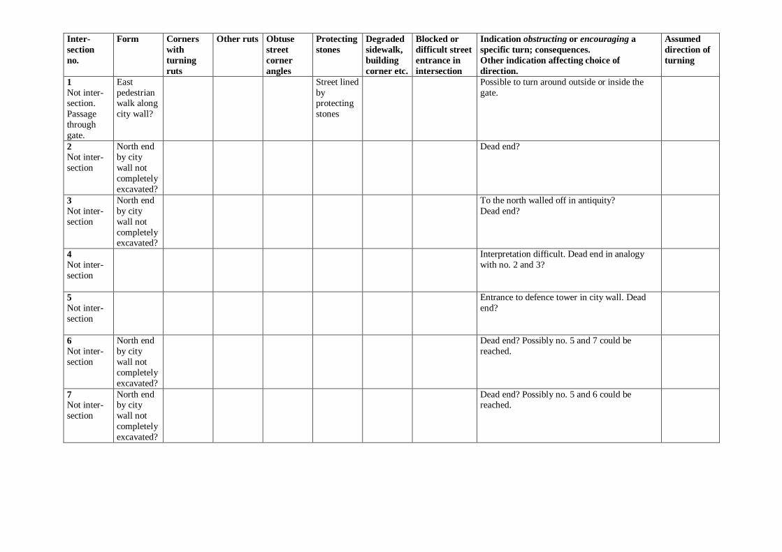
In the table, top of page is given as north, and the true north-west on a map of Pompeii (for instance, where the Via Stabiana leaves by the Porta del Vesuvio)
is considered as “north” in descriptions, all other directions following. The street corners are given as NW (north-west), NE (north-east), SW (south-west) and
SE (south-east). Corner NE in the intersection between the Via dell‟Abbondanza and the Via Stabiana (intersection 80) is thus the south-west corner of insula IX 1.
In column 1 the number of the intersection and sometimes a brief comment as to its status is given. In column 2 the form of the intersections is rendered
schematically and not to scale. Streets issuing from an intersection may have been labeled “N” or “S1”, which simply means “north street” or “south street no 1”. Column 3 details corners around which wheel ruts are in evidence, and column 4 other types of wheel ruts. When wheel ruts going straight along a street
are noted, this does not mean they are present exactly in the intersection – they are noted only as proof positive that this street was used for wheeled traffic. In
column 5 the corners where the buildings surrounding the intersection have an obtuse angle (easy to turn around) to their corners are marked, and in column 6 and 7, stones protecting the sidewalks and/or buildings and degradation of street/sidewalk corners are detailed. Column 8 gives the streets that are blocked or
made difficult for carts in intersections – here obstacles that are possible to overcome with a cart are noted in the same way as absolutely blocked street
entrances, since they would make turns into such a street infrequent. Column 9 lists other features of an intersection – what can be seen, what encourages a specific direction or makes it less inviting? Possibilities to turn around, etc. are also listed. And finally in column 10, my conclusions about turns around
insula corners in Pompeii are given.
The assumed direction of turnings in the last column shows my hypothetical conclusions from the indications perceived. Conclusions regarding turnings, that are part of the routes between city gates and important foci of the town presented in my dissertation, or otherwise extensively discussed in the text, are
rendered in bold lettering. Thus, those not rendered in bold lettering are more hypothetical than the rest, since they are not focused upon in my study. Many
intersections have a blank in column 10, meaning either there is no evidence, or the existing evidence yields little information relevant to my survey.
Some signs are used in the table:
+ a feature is near the intersection, but cannot be said to be part of the intersection proper
a turning which could not be/usually was not used. It is either blocked or provided with a marker possible to pass, but indicating that it may be unsuitable
* turning wheel ruts or blocking noted by S. Tsujimura, „Ruts in Pompeii. The traffic system in the Roman city‟, Opuscula Pompeiana 1, 1991,
58-86, that I could not verify during my fieldwork. ** turning wheel ruts or blocking noted by me 2004, not in S. Tsujimura „Ruts in Pompeii. The traffic system in the Roman city‟, Opuscula
Pompeiana 1, 1991, 58-86
largo an extension of a street or intersection, not a planned square or public place
N, S, E, W streets entering the intersection from the north, the south, the east and the west n, s, e, w indication of direction, “to the north” or “along the north side” etc.
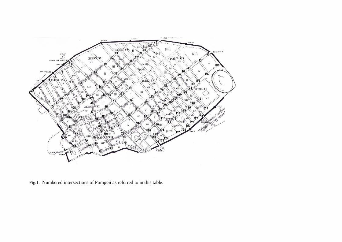
Fig.1. Numbered intersections of Pompeii as referred to in this table.
Inter-
section
no.
Form Corners
with
turning
ruts
Other ruts Obtuse
street
corner
angles
Protecting
stones
Degraded
sidewalk,
building
corner etc.
Blocked or
difficult street
entrance in
intersection
Indication obstructing or encouraging a
specific turn; consequences.
Other indication affecting choice of
direction.
Assumed
direction of
turning
1
Not inter-section.
Passage
through
gate.
East
pedestrian walk along
city wall?
Street lined
by protecting
stones
Possible to turn around outside or inside the
gate.
2
Not inter-
section
North end
by city
wall not
completely
excavated?
Dead end?
3
Not inter-
section
North end
by city
wall not
completely excavated?
To the north walled off in antiquity?
Dead end?
4
Not inter-
section
Interpretation difficult. Dead end in analogy
with no. 2 and 3?
5 Not inter-
section
Entrance to defence tower in city wall. Dead
end?
6
Not inter-
section
North end
by city
wall not
completely
excavated?
Dead end? Possibly no. 5 and 7 could be
reached.
7 Not inter-
section
North end by city
wall not
completely
excavated?
Dead end? Possibly no. 5 and 6 could be reached.
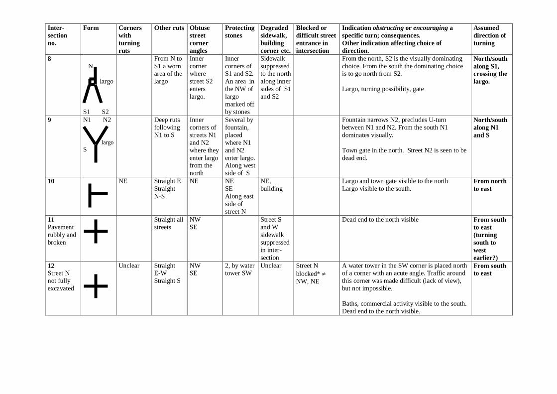
Inter-
section
no.
Form Corners
with
turning
ruts
Other ruts Obtuse
street
corner
angles
Protecting
stones
Degraded
sidewalk,
building
corner etc.
Blocked or
difficult street
entrance in
intersection
Indication obstructing or encouraging a
specific turn; consequences.
Other indication affecting choice of
direction.
Assumed
direction of
turning
8
N
largo
S1 S2
From N to
S1 a worn area of the
largo
Inner
corner where
street S2
enters
largo.
Inner
corners of S1 and S2.
An area in
the NW of
largo
marked off
by stones
Sidewalk
suppressed to the north
along inner
sides of S1
and S2
From the north, S2 is the visually dominating
choice. From the south the dominating choice is to go north from S2.
Largo, turning possibility, gate
North/south
along S1,
crossing the
largo.
9
N1 N2
largo
S
Deep ruts
following
N1 to S
Inner
corners of
streets N1
and N2
where they
enter largo from the
north
Several by
fountain,
placed
where N1
and N2
enter largo. Along west
side of S
Fountain narrows N2, precludes U-turn
between N1 and N2. From the south N1
dominates visually.
Town gate in the north. Street N2 is seen to be
dead end.
North/south
along N1
and S
10
NE Straight E
Straight
N-S
NE NE
SE
Along east
side of
street N
NE,
building Largo and town gate visible to the north
Largo visible to the south. From north
to east
11
Pavement
rubbly and
broken
Straight all
streets
NW
SE
Street S
and W
sidewalk
suppressed
in inter-
section
Dead end to the north visible From south
to east
(turning
south to
west
earlier?)
12 Street N
not fully
excavated
Unclear Straight E-W
Straight S
NW SE
2, by water tower SW
Unclear Street N
blocked*
NW, NE
A water tower in the SW corner is placed north of a corner with an acute angle. Traffic around
this corner was made difficult (lack of view),
but not impossible.
Baths, commercial activity visible to the south.
Dead end to the north visible.
From south
to east

Inter-
section
no.
Form Corners
with
turning
ruts
Other ruts Obtuse
street
corner
angles
Protecting
stones
Degraded
sidewalk,
building
corner etc.
Blocked or
difficult street
entrance in
intersection
Indication obstructing or encouraging a
specific turn; consequences.
Other indication affecting choice of
direction.
Assumed
direction of
turning
13
NW**
SE** possibly
caused by
slewing
E-W
Straight
E-W Straight S
NW
SE Indications
may also
be due to
the offset
between
streets W
and E.
NW
By
fountain
SW
A fountain (placed on west side of street S)
makes traffic from the south hold to the east of street S and thus effects a wide turn around
corner SW. Turning around corner SE is not
affected by the fountain, as street S is wide.
Forum and commercial Via del Foro, marked
by arches, visible to the south. Dead end to the
north visible.
From south
to east
14
Street N
not fully
excavated
NW
SE
NW Street S
unpaved turns SW, SE
Outjutting stone in sidewalk border with acute
angle NE prohibits turning around NE in
conjunction with a stepping stone. This is
emphasized by a possible white stone marker in
the corner.
Dead end to the north visible.
15
Street S
accumula-
ted dirt
Straight
E-W
NW
SE
By
fountain
SE, and
several
along north
side streets
E, W
A fountain (placed on the east side in street S)
in obtuse corner SE makes traffic from the
south hold to the west of street S and thus
effects a wide turn around corner SE. Turning
around corner with acute angle SW difficult.
Dead end to the north visible.
16
NW** NW
SE
NW
Several
along north
side street W, and
south side
street E
A water tower placed exactly in acute corner
SW obstructs view to the west and makes
turning difficult. From the south a turn east is
thus preferable.
Possibility to reverse by castellum acquae in
the north visible
From west
to north
From south
to east
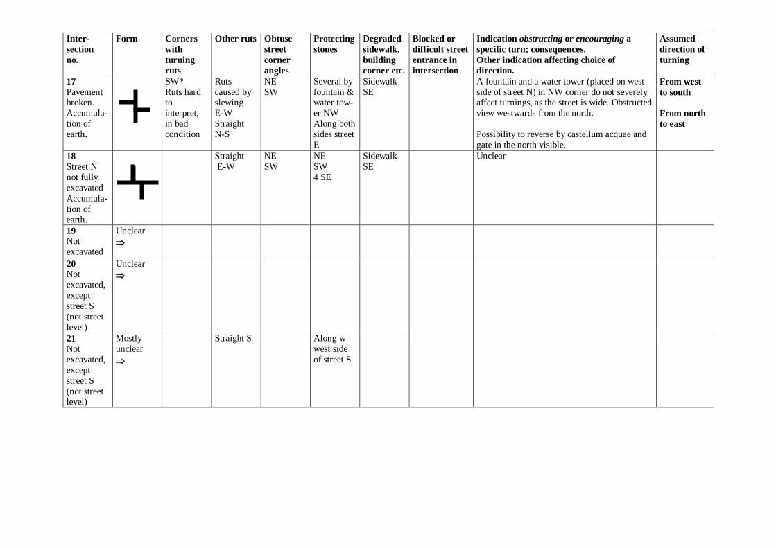
Inter-
section
no.
Form Corners
with
turning
ruts
Other ruts Obtuse
street
corner
angles
Protecting
stones
Degraded
sidewalk,
building
corner etc.
Blocked or
difficult street
entrance in
intersection
Indication obstructing or encouraging a
specific turn; consequences.
Other indication affecting choice of
direction.
Assumed
direction of
turning
17
Pavement broken.
Accumula-
tion of
earth.
SW*
Ruts hard to
interpret,
in bad
condition
Ruts
caused by slewing
E-W
Straight
N-S
NE
SW
Several by
fountain & water tow-
er NW
Along both
sides street
E
Sidewalk
SE
A fountain and a water tower (placed on west
side of street N) in NW corner do not severely affect turnings, as the street is wide. Obstructed
view westwards from the north.
Possibility to reverse by castellum acquae and
gate in the north visible.
From west
to south
From north
to east
18
Street N
not fully
excavated
Accumula-
tion of
earth.
Straight
E-W
NE
SW
NE
SW
4 SE
Sidewalk
SE
Unclear
19 Not
excavated
Unclear
20 Not
excavated,
except
street S
(not street
level)
Unclear
21
Not
excavated,
except
street S
(not street level)
Mostly
unclear
Straight S Along w
west side
of street S
Inter-
section
no.
Form Corners
with
turning
ruts
Other ruts Obtuse
street
corner
angles
Protecting
stones
Degraded
sidewalk,
building
corner etc.
Blocked or
difficult street
entrance in
intersection
Indication obstructing or encouraging a
specific turn; consequences.
Other indication affecting choice of
direction.
Assumed
direction of
turning
22
N
largo
S1 S2
Deep ruts
N to S2 (Ruts N to
S1 before
79 AD)
Inner
corners of S1 and S2
where they
come into
largo
Where S2
merges into N,
west side
Rounded
corners of sidewalk
between S1
and S2
S1 is blocked
by bridge further south
From the north S2 dominates visually. From
the intersection the bridge in S1 is visible.
Largo, commercial area visible in the south.
North- and
southwards
via S2,
possible to
await turns
on largo
south of S2
23
Not inter-
section in
79 AD
Street in E-W
direction cuts
street in N-S
direction by
ramp up to
bridge
Street E dead end leading to entrance of private
dwelling.
24
N1 N2
largo
W E
Deep ruts
from N1 to E, crossing
largo.
Faint ruts
N2 to E.
Inner
corners between
N1 and N2
where they
come into
largo
Several by
fountain, between
N2 & N1
merging
with largo
Sidewalk
on the north side
of street E
joining
largo
A fountain between N1 & N2, where they
merge into the largo on the north side, makes U-turn between them difficult. From the east
on street E, the dead end of street W is visible,
and turning into N1 is visually dominant over
N2.
Reversing and waiting possibility in largo.
Baths to the south.
From north
on N1 to
east
From east to
north on N1
& N2
24a
Straight
E-W
SW Street S is
widened at
inter-
section
Street W dead end, but continuation to the
north in intersection 24visible. Baths adjacent.
Temple of Fortuna Augusta visible to the east.
From west
to south.
25
NE**
(NW ** predate 79
AD)
Straight
(faint) N Straight
(faint) S
NW NO sidewalk
NW, NE
A guiding stone has probably been removed in
the intersection. This was placed so as to impede turning round NW corner, and
encourage turning round NE corner.
Street W dead end. Baths adjacent. Temple of
Fortuna Augusta visible to the east.
From east to
north
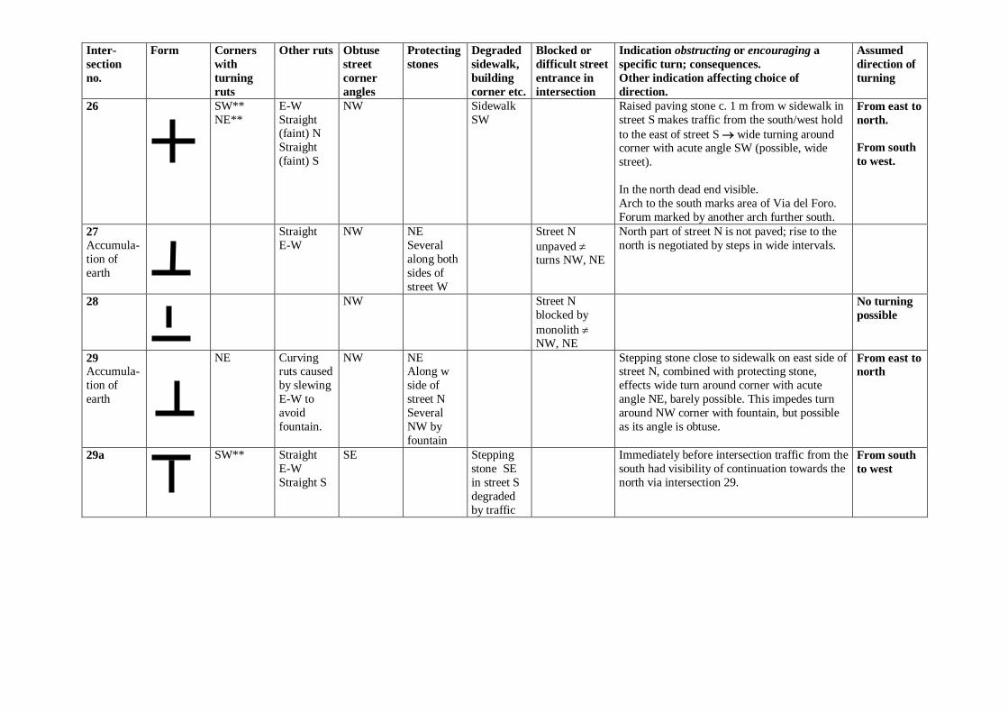
Inter-
section
no.
Form Corners
with
turning
ruts
Other ruts Obtuse
street
corner
angles
Protecting
stones
Degraded
sidewalk,
building
corner etc.
Blocked or
difficult street
entrance in
intersection
Indication obstructing or encouraging a
specific turn; consequences.
Other indication affecting choice of
direction.
Assumed
direction of
turning
26
SW**
NE**
E-W
Straight (faint) N
Straight
(faint) S
NW Sidewalk
SW
Raised paving stone c. 1 m from w sidewalk in
street S makes traffic from the south/west hold
to the east of street S wide turning around corner with acute angle SW (possible, wide
street).
In the north dead end visible.
Arch to the south marks area of Via del Foro.
Forum marked by another arch further south.
From east to
north.
From south
to west.
27
Accumula-
tion of
earth
Straight
E-W
NW NE
Several
along both
sides of
street W
Street N
unpaved turns NW, NE
North part of street N is not paved; rise to the
north is negotiated by steps in wide intervals.
28
NW Street N
blocked by
monolith NW, NE
No turning
possible
29 Accumula-
tion of
earth
NE Curving ruts caused
by slewing
E-W to
avoid
fountain.
NW NE Along w
side of
street N
Several
NW by
fountain
Stepping stone close to sidewalk on east side of street N, combined with protecting stone,
effects wide turn around corner with acute
angle NE, barely possible. This impedes turn
around NW corner with fountain, but possible
as its angle is obtuse.
From east to
north
29a
SW** Straight
E-W
Straight S
SE Stepping
stone SE
in street S
degraded
by traffic
Immediately before intersection traffic from the
south had visibility of continuation towards the
north via intersection 29.
From south
to west
Inter-
section
no.
Form Corners
with
turning
ruts
Other ruts Obtuse
street
corner
angles
Protecting
stones
Degraded
sidewalk,
building
corner etc.
Blocked or
difficult street
entrance in
intersection
Indication obstructing or encouraging a
specific turn; consequences.
Other indication affecting choice of
direction.
Assumed
direction of
turning
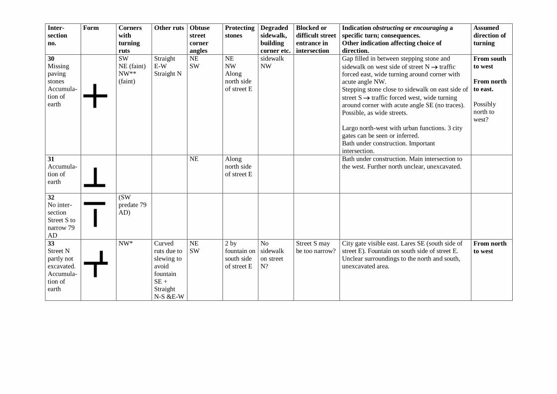
30
Missing paving
stones
Accumula-
tion of
earth
SW
NE (faint) NW**
(faint)
Straight
E-W Straight N
NE
SW
NE
NW Along
north side
of street E
sidewalk
NW
Gap filled in between stepping stone and
sidewalk on west side of street N traffic forced east, wide turning around corner with acute angle NW.
Stepping stone close to sidewalk on east side of
street S traffic forced west, wide turning around corner with acute angle SE (no traces).
Possible, as wide streets.
Largo north-west with urban functions. 3 city
gates can be seen or inferred.
Bath under construction. Important
intersection.
From south
to west
From north
to east.
Possibly
north to
west?
31
Accumula-
tion of
earth
NE Along
north side
of street E
Bath under construction. Main intersection to
the west. Further north unclear, unexcavated.
32
No inter-
section
Street S to
narrow 79
AD
(SW
predate 79
AD)
33
Street N
partly not
excavated.
Accumula-
tion of earth
NW* Curved
ruts due to
slewing to
avoid
fountain
SE + Straight
N-S &E-W
NE
SW
2 by
fountain on
south side
of street E
No
sidewalk
on street
N?
Street S may
be too narrow?
City gate visible east. Lares SE (south side of
street E). Fountain on south side of street E.
Unclear surroundings to the north and south,
unexcavated area.
From north
to west
Inter-
section
no.
Form Corners
with
turning
ruts
Other ruts Obtuse
street
corner
angles
Protecting
stones
Degraded
sidewalk,
building
corner etc.
Blocked or
difficult street
entrance in
intersection
Indication obstructing or encouraging a
specific turn; consequences.
Other indication affecting choice of
direction.
Assumed
direction of
turning
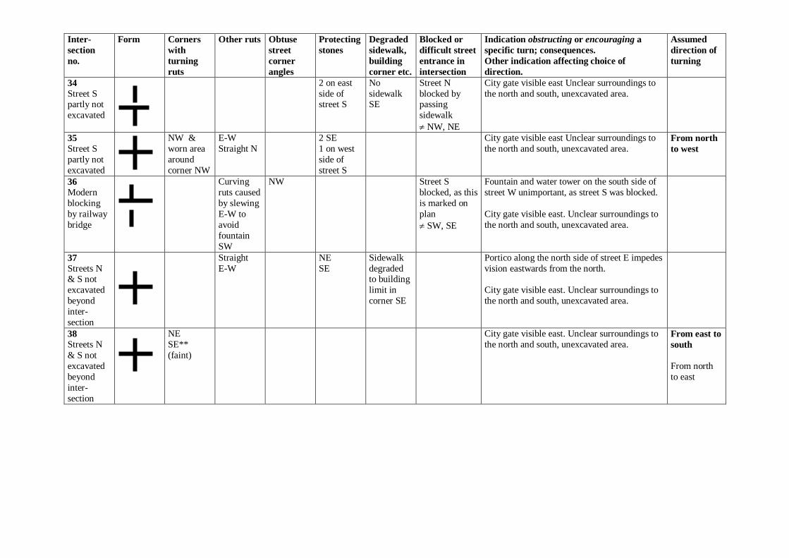
34
Street S partly not
excavated
2 on east
side of street S
No
sidewalk SE
Street N
blocked by passing
sidewalk
NW, NE
City gate visible east Unclear surroundings to
the north and south, unexcavated area.
35
Street S
partly not
excavated
NW &
worn area
around
corner NW
E-W
Straight N
2 SE
1 on west
side of
street S
City gate visible east Unclear surroundings to
the north and south, unexcavated area. From north
to west
36
Modern
blocking
by railway
bridge
Curving
ruts caused
by slewing
E-W to
avoid
fountain
SW
NW Street S
blocked, as this
is marked on
plan
SW, SE
Fountain and water tower on the south side of
street W unimportant, as street S was blocked.
City gate visible east. Unclear surroundings to
the north and south, unexcavated area.
37
Streets N & S not
excavated
beyond
inter-
section
Straight
E-W
NE
SE
Sidewalk
degraded to building
limit in
corner SE
Portico along the north side of street E impedes
vision eastwards from the north.
City gate visible east. Unclear surroundings to
the north and south, unexcavated area.
38
Streets N
& S not
excavated
beyond
inter-
section
NE
SE**
(faint)
City gate visible east. Unclear surroundings to
the north and south, unexcavated area. From east to
south
From north
to east
Inter-
section
no.
Form Corners
with
turning
ruts
Other ruts Obtuse
street
corner
angles
Protecting
stones
Degraded
sidewalk,
building
corner etc.
Blocked or
difficult street
entrance in
intersection
Indication obstructing or encouraging a
specific turn; consequences.
Other indication affecting choice of
direction.
Assumed
direction of
turning
39
Streets N & S not
excavated
beyond
inter-
section
Straight
E-W Straight? S
SE (not in
situ?)
Streets N
& S lack sidewalks.
Sidewalk
NE
rounded.
City gate visible east. Unclear surroundings to
the north and south, unexcavated area.
40
Street N
not
excavated.
Street S
overgrown.
Straight
E-W
SW
Several SE
by fountain
Along both
sides of
street S
Sidewalk
SE.
Sidewalk
lacking on
east side of
street N.
Street N
blocked by
passing
sidewalk E-W
NW, NE
Fountain in corner SE (placed on south side of
street E) makes turn around 90 corner slightly more difficult. Blocks degraded the corner.
City gate visible east. Unclear surroundings to
the north and south, unexcavated area.
40a
Possible,
not cleared
inter-section 12
m east of
no. 40
Street N
could be a
paved
entrance-way. No
street S.
Mostly
unclear
City gate visible east. Unclear surroundings to
the north and south, unexcavated area.
41
Overgrown
Partly not
excavated.
Form
according
to plan
N, along
city
wall
gate
S1 S2
Along
city
wall
Unclear
E-W Possibility of reversal inside and outside city
gate may be assumed.
42
No inter-
section Accumula-
tion of soil
Straight S
Straight E
SE Street S
possibly
without sidewalk
90 turn in street, not
inter-section
Inter-
section
no.
Form Corners
with
turning
ruts
Other ruts Obtuse
street
corner
angles
Protecting
stones
Degraded
sidewalk,
building
corner etc.
Blocked or
difficult street
entrance in
intersection
Indication obstructing or encouraging a
specific turn; consequences.
Other indication affecting choice of
direction.
Assumed
direction of
turning
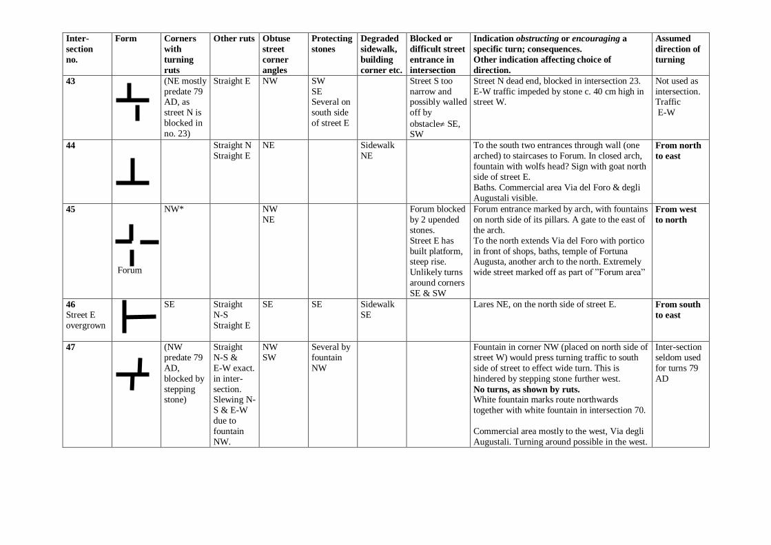
43 (NE mostly
predate 79 AD, as
street N is
blocked in
no. 23)
Straight E NW SW
SE Several on
south side
of street E
Street S too
narrow and possibly walled
off by
obstacle SE, SW
Street N dead end, blocked in intersection 23.
E-W traffic impeded by stone c. 40 cm high in street W.
Not used as
intersection. Traffic
E-W
44
Straight N
Straight E
NE Sidewalk
NE
To the south two entrances through wall (one
arched) to staircases to Forum. In closed arch,
fountain with wolfs head? Sign with goat north
side of street E.
Baths. Commercial area Via del Foro & degli
Augustali visible.
From north
to east
45
Forum
NW* NW
NE
Forum blocked
by 2 upended
stones.
Street E has
built platform, steep rise.
Unlikely turns
around corners
SE & SW
Forum entrance marked by arch, with fountains
on north side of its pillars. A gate to the east of
the arch.
To the north extends Via del Foro with portico
in front of shops, baths, temple of Fortuna Augusta, another arch to the north. Extremely
wide street marked off as part of ”Forum area”
From west
to north
46
Street E
overgrown
SE
Straight
N-S
Straight E
SE SE Sidewalk
SE
Lares NE, on the north side of street E. From south
to east
47
(NW
predate 79
AD,
blocked by
stepping stone)
Straight
N-S &
E-W exact.
in inter-
section. Slewing N-
S & E-W
due to
fountain
NW.
NW
SW
Several by
fountain
NW
Fountain in corner NW (placed on north side of
street W) would press turning traffic to south
side of street to effect wide turn. This is
hindered by stepping stone further west.
No turns, as shown by ruts. White fountain marks route northwards
together with white fountain in intersection 70.
Commercial area mostly to the west, Via degli
Augustali. Turning around possible in the west.
Inter-section
seldom used
for turns 79
AD
Inter-
section
no.
Form Corners
with
turning
ruts
Other ruts Obtuse
street
corner
angles
Protecting
stones
Degraded
sidewalk,
building
corner etc.
Blocked or
difficult street
entrance in
intersection
Indication obstructing or encouraging a
specific turn; consequences.
Other indication affecting choice of
direction.
Assumed
direction of
turning
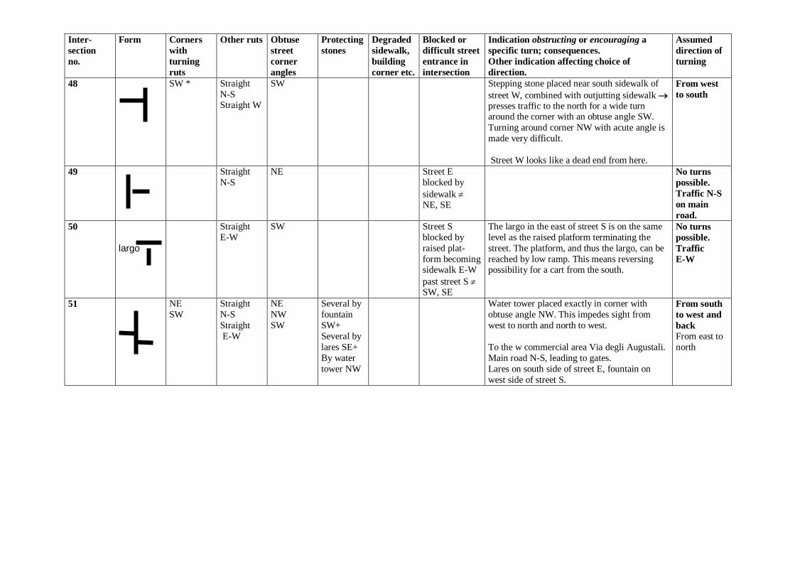
48 SW * Straight
N-S Straight W
SW Stepping stone placed near south sidewalk of
street W, combined with outjutting sidewalk
presses traffic to the north for a wide turn around the corner with an obtuse angle SW.
Turning around corner NW with acute angle is
made very difficult.
Street W looks like a dead end from here.
From west
to south
49 Straight
N-S
NE Street E
blocked by
sidewalk NE, SE
No turns
possible.
Traffic N-S
on main
road.
50 largo
Straight
E-W
SW Street S
blocked by
raised plat-
form becoming sidewalk E-W
past street S SW, SE
The largo in the east of street S is on the same
level as the raised platform terminating the
street. The platform, and thus the largo, can be
reached by low ramp. This means reversing possibility for a cart from the south.
No turns
possible.
Traffic
E-W
51 NE
SW
Straight
N-S
Straight
E-W
NE
NW
SW
Several by
fountain
SW+
Several by
lares SE+
By water
tower NW
Water tower placed exactly in corner with
obtuse angle NW. This impedes sight from
west to north and north to west.
To the w commercial area Via degli Augustali.
Main road N-S, leading to gates.
Lares on south side of street E, fountain on
west side of street S.
From south
to west and
back
From east to
north
Inter-
section
no.
Form Corners
with
turning
ruts
Other ruts Obtuse
street
corner
angles
Protecting
stones
Degraded
sidewalk,
building
corner etc.
Blocked or
difficult street
entrance in
intersection
Indication obstructing or encouraging a
specific turn; consequences.
Other indication affecting choice of
direction.
Assumed
direction of
turning
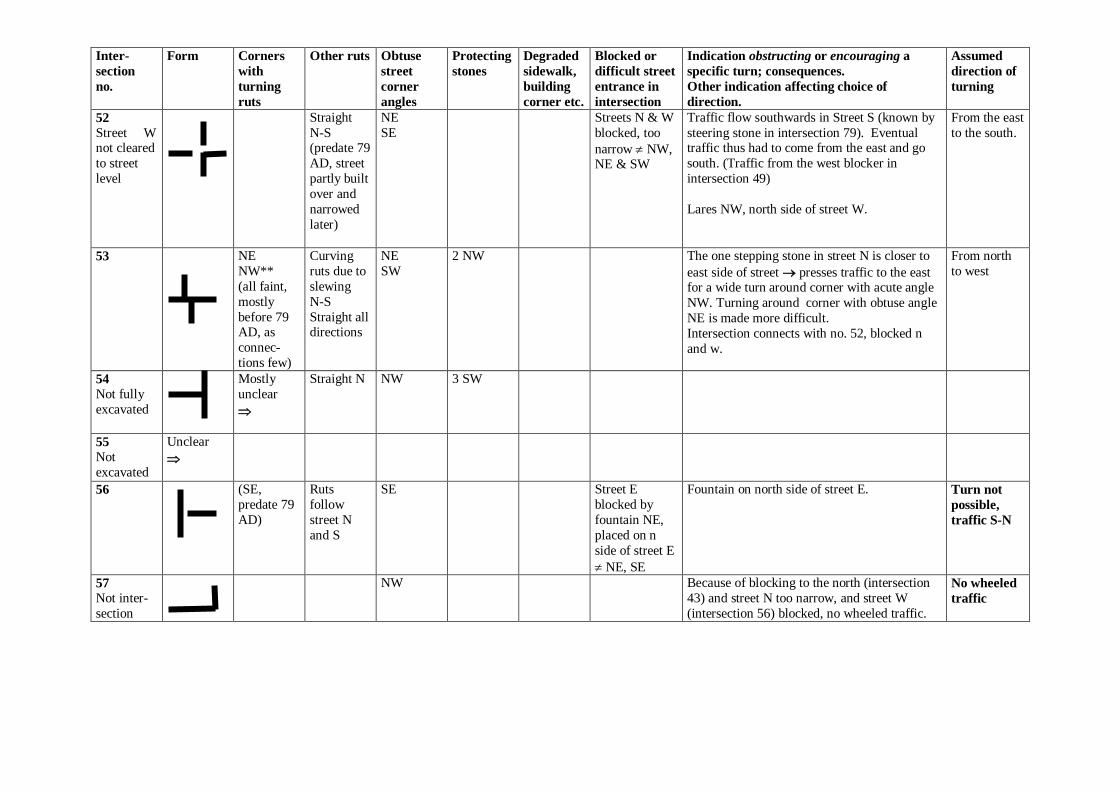
52
Street W not cleared
to street
level
Straight
N-S (predate 79
AD, street
partly built
over and
narrowed
later)
NE
SE
Streets N & W
blocked, too
narrow NW, NE & SW
Traffic flow southwards in Street S (known by
steering stone in intersection 79). Eventual traffic thus had to come from the east and go
south. (Traffic from the west blocker in
intersection 49)
Lares NW, north side of street W.
From the east
to the south.
53
NE
NW**
(all faint,
mostly
before 79 AD, as
connec-
tions few)
Curving
ruts due to
slewing
N-S
Straight all directions
NE
SW
2 NW The one stepping stone in street N is closer to
east side of street presses traffic to the east for a wide turn around corner with acute angle
NW. Turning around corner with obtuse angle
NE is made more difficult.
Intersection connects with no. 52, blocked n
and w.
From north
to west
54
Not fully
excavated
Mostly
unclear
Straight N NW 3 SW
55
Not
excavated
Unclear
56
(SE,
predate 79
AD)
Ruts
follow
street N
and S
SE Street E
blocked by
fountain NE,
placed on n
side of street E
NE, SE
Fountain on north side of street E. Turn not
possible,
traffic S-N
57
Not inter-
section
NW Because of blocking to the north (intersection
43) and street N too narrow, and street W
(intersection 56) blocked, no wheeled traffic.
No wheeled
traffic
Inter-
section
no.
Form Corners
with
turning
ruts
Other ruts Obtuse
street
corner
angles
Protecting
stones
Degraded
sidewalk,
building
corner etc.
Blocked or
difficult street
entrance in
intersection
Indication obstructing or encouraging a
specific turn; consequences.
Other indication affecting choice of
direction.
Assumed
direction of
turning
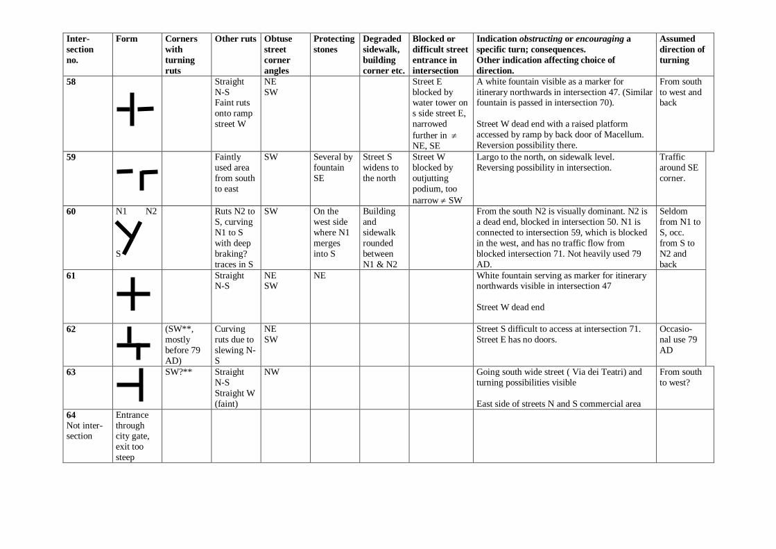
58
Straight
N-S Faint ruts
onto ramp
street W
NE
SW
Street E
blocked by water tower on
s side street E,
narrowed
further in NE, SE
A white fountain visible as a marker for
itinerary northwards in intersection 47. (Similar fountain is passed in intersection 70).
Street W dead end with a raised platform
accessed by ramp by back door of Macellum.
Reversion possibility there.
From south
to west and back
59 Faintly
used area
from south
to east
SW
Several by
fountain
SE
Street S
widens to
the north
Street W
blocked by
outjutting
podium, too
narrow SW
Largo to the north, on sidewalk level.
Reversing possibility in intersection.
Traffic
around SE
corner.
60
N1 N2
S
Ruts N2 to
S, curving
N1 to S
with deep
braking?
traces in S
SW On the
west side
where N1
merges
into S
Building
and
sidewalk
rounded
between
N1 & N2
From the south N2 is visually dominant. N2 is
a dead end, blocked in intersection 50. N1 is
connected to intersection 59, which is blocked
in the west, and has no traffic flow from
blocked intersection 71. Not heavily used 79
AD.
Seldom
from N1 to
S, occ.
from S to
N2 and
back
61 Straight N-S
NE SW
NE White fountain serving as marker for itinerary northwards visible in intersection 47
Street W dead end
62
(SW**,
mostly
before 79
AD)
Curving
ruts due to
slewing N-
S
NE
SW
Street S difficult to access at intersection 71.
Street E has no doors.
Occasio-
nal use 79
AD
63 SW?** Straight
N-S
Straight W
(faint)
NW Going south wide street ( Via dei Teatri) and
turning possibilities visible
East side of streets N and S commercial area
From south
to west?
64
Not inter-section
Entrance
through city gate,
exit too
steep
Inter-
section
no.
Form Corners
with
turning
ruts
Other ruts Obtuse
street
corner
angles
Protecting
stones
Degraded
sidewalk,
building
corner etc.
Blocked or
difficult street
entrance in
intersection
Indication obstructing or encouraging a
specific turn; consequences.
Other indication affecting choice of
direction.
Assumed
direction of
turning
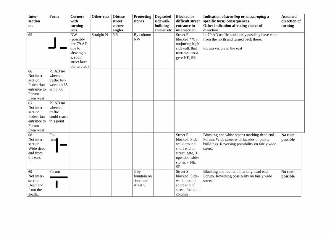
65
NW
(possibly pre-79 AD,
due to
slewing n-
s, south
street later
obliterated)
Straight N NE By column
NW
Street E
blocked **by outjutting high
sidewalk that
narrows passa-
ge NE, SE
In 79 AD traffic could only possibly have come
from the north and turned back there.
Forum visible in the east
66
Not inter-
section.
Pedestrian
entrance to
Forum from west
79 AD no
wheeled
traffic bet-
ween no.65
& no. 66
67
Not inter-
section.
Pedestrian
entrance to
Forum
from west
79 AD no
wheeled
traffic
could reach
this point
68
Not inter-
section.
Wide dead
end from the east.
Fo-
rum
Street E
blocked. Side-
walk around
short end of
street, gate, 3 upended white
stones NE, SE
Blocking and white stones marking dead end.
Forum. Wide street with facades of public
buildings. Reversing possibility on fairly wide
street.
No turn
possible
69
Not inter-
section.
Dead end
from the
south..
Forum 3 by
fountain on
short end
street S
Street S
blocked. Side-
walk around
short end of
street, fountain,
column
Blocking and fountain marking dead end.
Forum. Reversing possibility on fairly wide
street.
No turn
possible
Inter-
section
no.
Form Corners
with
turning
ruts
Other ruts Obtuse
street
corner
angles
Protecting
stones
Degraded
sidewalk,
building
corner etc.
Blocked or
difficult street
entrance in
intersection
Indication obstructing or encouraging a
specific turn; consequences.
Other indication affecting choice of
direction.
Assumed
direction of
turning
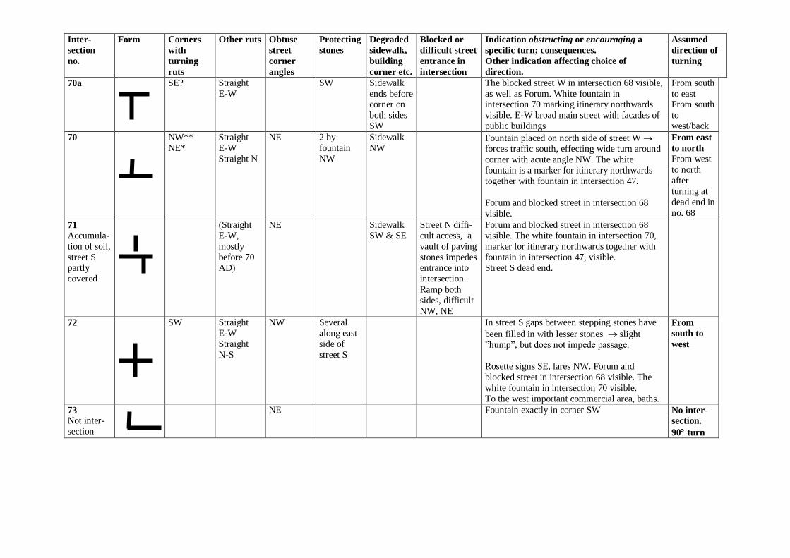
70a SE? Straight
E-W
SW Sidewalk
ends before corner on
both sides
SW
The blocked street W in intersection 68 visible,
as well as Forum. White fountain in intersection 70 marking itinerary northwards
visible. E-W broad main street with facades of
public buildings
From south
to east From south
to
west/back
70
NW**
NE*
Straight
E-W
Straight N
NE 2 by
fountain
NW
Sidewalk
NW
Fountain placed on north side of street W forces traffic south, effecting wide turn around
corner with acute angle NW. The white
fountain is a marker for itinerary northwards
together with fountain in intersection 47.
Forum and blocked street in intersection 68
visible.
From east
to north
From west
to north
after
turning at
dead end in
no. 68
71
Accumula-
tion of soil,
street S partly
covered
(Straight
E-W,
mostly
before 70 AD)
NE Sidewalk
SW & SE
Street N diffi-
cult access, a
vault of paving
stones impedes entrance into
intersection.
Ramp both
sides, difficult
NW, NE
Forum and blocked street in intersection 68
visible. The white fountain in intersection 70,
marker for itinerary northwards together with
fountain in intersection 47, visible. Street S dead end.
72
SW Straight
E-W
Straight
N-S
NW Several
along east
side of
street S
In street S gaps between stepping stones have
been filled in with lesser stones slight ”hump”, but does not impede passage.
Rosette signs SE, lares NW. Forum and
blocked street in intersection 68 visible. The
white fountain in intersection 70 visible.
To the west important commercial area, baths.
From
south to
west
73 Not inter-
section
NE Fountain exactly in corner SW No inter-
section.
90 turn
Inter-
section
no.
Form Corners
with
turning
ruts
Other ruts Obtuse
street
corner
angles
Protecting
stones
Degraded
sidewalk,
building
corner etc.
Blocked or
difficult street
entrance in
intersection
Indication obstructing or encouraging a
specific turn; consequences.
Other indication affecting choice of
direction.
Assumed
direction of
turning
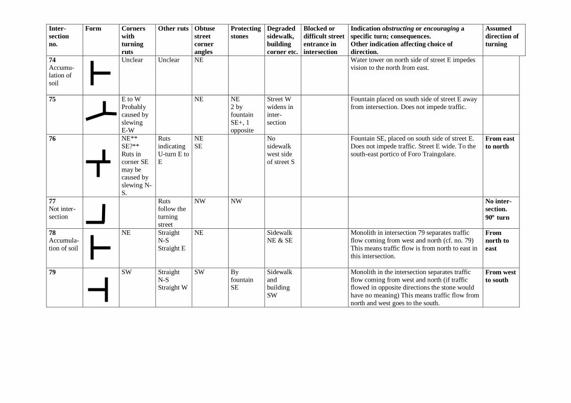
74
Accumu-lation of
soil
Unclear Unclear NE Water tower on north side of street E impedes
vision to the north from east.
75
E to W
Probably
caused by
slewing
E-W
NE NE
2 by
fountain
SE+, 1
opposite
Street W
widens in
inter-
section
Fountain placed on south side of street E away
from intersection. Does not impede traffic.
76
NE**
SE?**
Ruts in
corner SE
may be caused by
slewing N-
S.
Ruts
indicating
U-turn E to
E
NE
SE
No
sidewalk
west side
of street S
Fountain SE, placed on south side of street E.
Does not impede traffic. Street E wide. To the
south-east portico of Foro Traingolare.
From east
to north
77
Not inter-
section
Ruts
follow the
turning
street
NW NW No inter-
section.
90 turn
78
Accumula-
tion of soil
NE Straight
N-S
Straight E
NE Sidewalk
NE & SE
Monolith in intersection 79 separates traffic
flow coming from west and north (cf. no. 79)
This means traffic flow is from north to east in
this intersection.
From
north to
east
79
SW Straight
N-S Straight W
SW By
fountain SE
Sidewalk
and building
SW
Monolith in the intersection separates traffic
flow coming from west and north (if traffic flowed in opposite directions the stone would
have no meaning) This means traffic flow from
north and west goes to the south.
From west
to south
Inter-
section
no.
Form Corners
with
turning
ruts
Other ruts Obtuse
street
corner
angles
Protecting
stones
Degraded
sidewalk,
building
corner etc.
Blocked or
difficult street
entrance in
intersection
Indication obstructing or encouraging a
specific turn; consequences.
Other indication affecting choice of
direction.
Assumed
direction of
turning
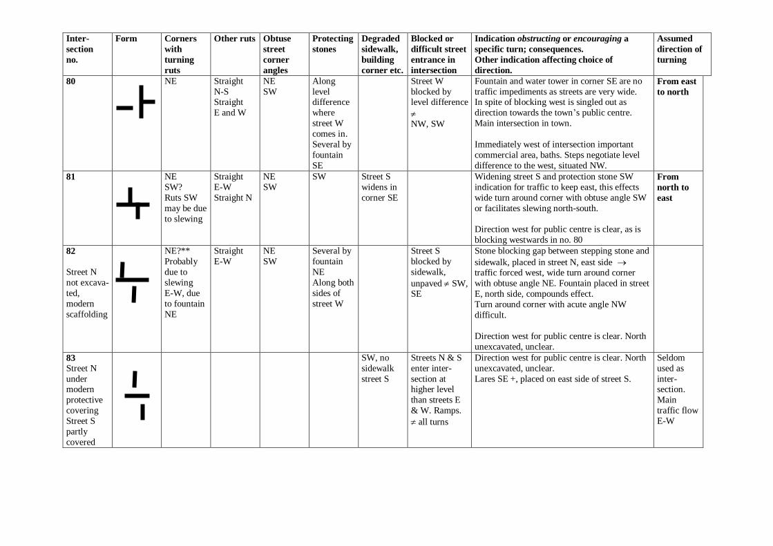
80
NE Straight
N-S Straight
E and W
NE
SW
Along
level difference
where
street W
comes in.
Several by
fountain
SE
Street W
blocked by level difference
NW, SW
Fountain and water tower in corner SE are no
traffic impediments as streets are very wide. In spite of blocking west is singled out as
direction towards the town‟s public centre.
Main intersection in town.
Immediately west of intersection important
commercial area, baths. Steps negotiate level
difference to the west, situated NW.
From east
to north
81
NE
SW?
Ruts SW
may be due
to slewing
Straight
E-W
Straight N
NE
SW
SW Street S
widens in
corner SE
Widening street S and protection stone SW
indication for traffic to keep east, this effects
wide turn around corner with obtuse angle SW
or facilitates slewing north-south.
Direction west for public centre is clear, as is
blocking westwards in no. 80
From
north to
east
82
Street N
not excava-
ted,
modern
scaffolding
NE?**
Probably
due to
slewing
E-W, due
to fountain
NE
Straight
E-W
NE
SW
Several by
fountain
NE
Along both
sides of
street W
Street S
blocked by
sidewalk,
unpaved SW, SE
Stone blocking gap between stepping stone and
sidewalk, placed in street N, east side traffic forced west, wide turn around corner
with obtuse angle NE. Fountain placed in street
E, north side, compounds effect.
Turn around corner with acute angle NW
difficult.
Direction west for public centre is clear. North
unexcavated, unclear.
83
Street N
under modern
protective
covering
Street S
partly
covered
SW, no
sidewalk
street S
Streets N & S
enter inter-
section at higher level
than streets E
& W. Ramps.
all turns
Direction west for public centre is clear. North
unexcavated, unclear.
Lares SE +, placed on east side of street S.
Seldom
used as
inter-section.
Main
traffic flow
E-W
Inter-
section
no.
Form Corners
with
turning
ruts
Other ruts Obtuse
street
corner
angles
Protecting
stones
Degraded
sidewalk,
building
corner etc.
Blocked or
difficult street
entrance in
intersection
Indication obstructing or encouraging a
specific turn; consequences.
Other indication affecting choice of
direction.
Assumed
direction of
turning
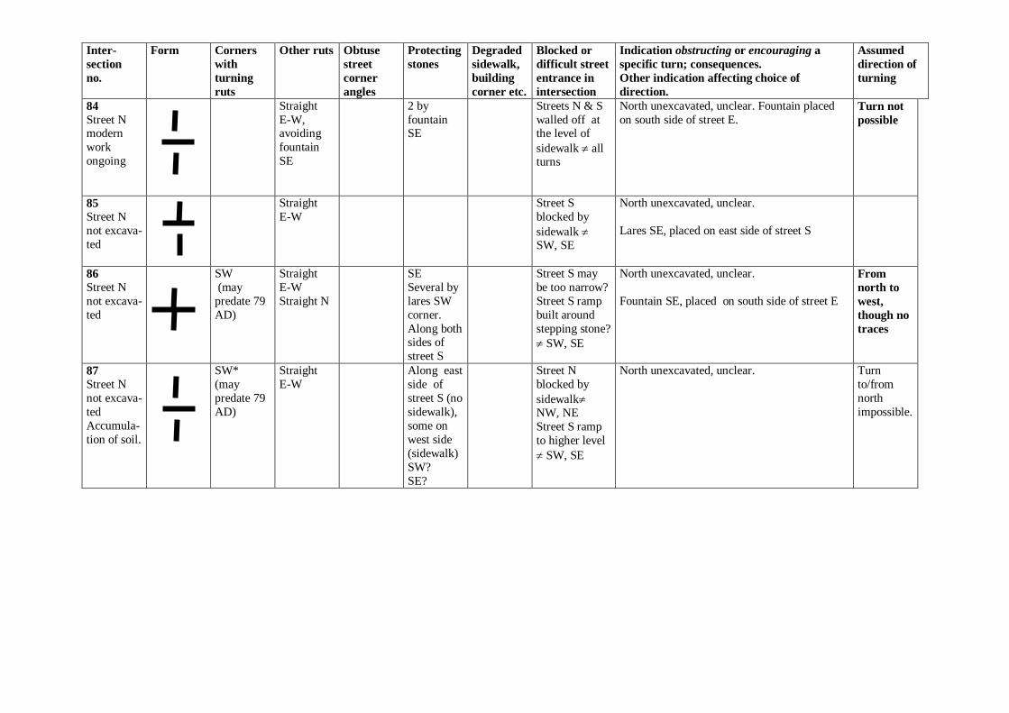
84
Street N modern
work
ongoing
Straight
E-W, avoiding
fountain
SE
2 by
fountain SE
Streets N & S
walled off at the level of
sidewalk all turns
North unexcavated, unclear. Fountain placed
on south side of street E.
Turn not
possible
85
Street N
not excava-
ted
Straight
E-W
Street S
blocked by
sidewalk SW, SE
North unexcavated, unclear.
Lares SE, placed on east side of street S
86
Street N
not excava-
ted
SW
(may
predate 79
AD)
Straight
E-W
Straight N
SE
Several by
lares SW
corner.
Along both sides of
street S
Street S may
be too narrow?
Street S ramp
built around
stepping stone?
SW, SE
North unexcavated, unclear.
Fountain SE, placed on south side of street E
From
north to
west,
though no
traces
87
Street N
not excava-
ted
Accumula-
tion of soil.
SW*
(may
predate 79
AD)
Straight
E-W
Along east
side of
street S (no
sidewalk),
some on
west side
(sidewalk)
SW?
SE?
Street N
blocked by
sidewalk NW, NE
Street S ramp
to higher level
SW, SE
North unexcavated, unclear.
Turn
to/from
north
impossible.
Inter-
section
no.
Form Corners
with
turning
ruts
Other ruts Obtuse
street
corner
angles
Protecting
stones
Degraded
sidewalk,
building
corner etc.
Blocked or
difficult street
entrance in
intersection
Indication obstructing or encouraging a
specific turn; consequences.
Other indication affecting choice of
direction.
Assumed
direction of
turning
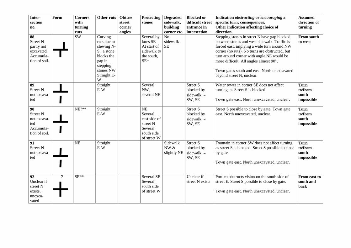
88
Street N partly not
excavated
Accumula-
tion of soil.
SW Curving
ruts due to slewing N-
S, a stone
blocks the
gap in
stepping
stones NW
Straight E-
W
Several by
lares SE At start of
sidewalk to
the south,
SE+
No
sidewalk SE
Stepping stones in street N have gap blocked
between stones and west sidewalk. Traffic is forced east, implying a wide turn around NW
corner (no ruts). No turns are obstructed, but
turn around corner with angle NE would be
more difficult. All angles almost 90.
Town gates south and east. North unexcavated
beyond street N, unclear.
From south
to west
89
Street N
not excava-
ted
Straight
E-W
Several
NW,
several NE
Street S
blocked by
sidewalk SW, SE
Water tower in corner SE does not affect
turning, as Street S is blocked
Town gate east. North unexcavated, unclear.
Turn
to/from
south
impossible
90
Street N
not excava-
ted
Accumula-
tion of soil.
NE?** Straight
E-W
NE
Several
east side of
street N
Several
south side
of street W
Street S
blocked by
sidewalk SW, SE
Street S possible to close by gate. Town gate
east. North unexcavated, unclear. Turn
to/from
south
impossible
91
Street N
not excava-
ted
NE Straight
E-W
Sidewalk
NW &
slightly NE
Street S
blocked by
sidewalk SW, SE
Fountain in corner SW does not affect turning,
as street S is blocked. Street S possible to close
by gate.
Town gate east. North unexcavated, unclear.
Turn
to/from
south
impossible
92
Unclear if
street N
exists,
unexca-
vated
? SE** Several SE
Several
south side
of street W
Unclear if
street N exists
Portico obstructs vision on the south side of
street E. Street S possible to close by gate.
Town gate east. North unexcavated, unclear.
From east to
south and
back
Inter-
section
no.
Form Corners
with
turning
ruts
Other ruts Obtuse
street
corner
angles
Protecting
stones
Degraded
sidewalk,
building
corner etc.
Blocked or
difficult street
entrance in
intersection
Indication obstructing or encouraging a
specific turn; consequences.
Other indication affecting choice of
direction.
Assumed
direction of
turning
93
Unclear. Partly not
excavated.
Form
according
to plan
walk
along wall ?
gate
Unclear
Probably only pedestrian street along the wall
to the south and north.
94
NE**
SW**
(possibly
ruts caused
by slewing
E-W)
Straight
N-S
Straight
E-W
NE
SW
Several
north side
of street E
Theatre area to the southwest, town gate south.
Wide street west, turning possibility. From south
to west
From north
to east
95
NE?** Straight
E-W Straight
N-S Ruts due to
slewing
N-S
NE
SW
NW
2 NE West side
of street S
In the east the impression is of a dead end
street, but it is wide with turning possibility From north
to east
96
SW** SW
2 NW
SW by
fountain
Street W
widens
Street N
unpaved,
formed in plat-
forms, gate NW, NE
The widening street W gives reversing
possibilities. Paving up to gate north also
permits reversing.
From west
to south
97
Street E
not excava-
ted to
street level
Unclear Street N
partly
unpaved?
Modern
work.
NE Unclear Street S gives the visual impression of being a
dead end
From north
to east
98
Not
excavated
to street
level
Unclear
Inter-
section
no.
Form Corners
with
turning
ruts
Other ruts Obtuse
street
corner
angles
Protecting
stones
Degraded
sidewalk,
building
corner etc.
Blocked or
difficult street
entrance in
intersection
Indication obstructing or encouraging a
specific turn; consequences.
Other indication affecting choice of
direction.
Assumed
direction of
turning
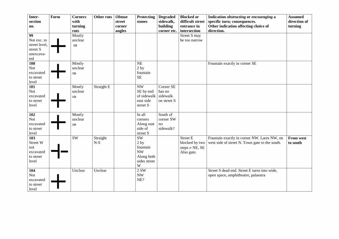
99
Not exc. to street level,
street S
unexcava-
ted
Mostly
unclear
Street S may
be too narrow
100
Not
excavated
to street
level
Mostly
unclear
NE
2 by
fountain
SE
Fountain exactly in corner SE
101
Not
excavated
to street level
Mostly
unclear
Straight E NW
SE by end
of sidewalk
east side street S
Corner SE
has no
sidewalk
on street S
102
Not
excavated
to street
level
Mostly
unclear
In all
corners
Along east
side of
street S
South of
corner SW
no
sidewalk?
103
Street W
not
excavated
to street
level
SW Straight
N-S
SW
2 by
fountain
NW
Along both
sides street W
Street E
blocked by two
steps NE, SE Also gate.
Fountain exactly in corner NW. Lares NW, on
west side of street N. Town gate to the south. From west
to south
104
Not
excavated
to street
level
Unclear Unclear 2 SW
NW
NE?
Street S dead end. Street E turns into wide,
open space, amphitheatre, palaestra
Inter-
section
no.
Form Corners
with
turning
ruts
Other ruts Obtuse
street
corner
angles
Protecting
stones
Degraded
sidewalk,
building
corner etc.
Blocked or
difficult street
entrance in
intersection
Indication obstructing or encouraging a
specific turn; consequences.
Other indication affecting choice of
direction.
Assumed
direction of
turning
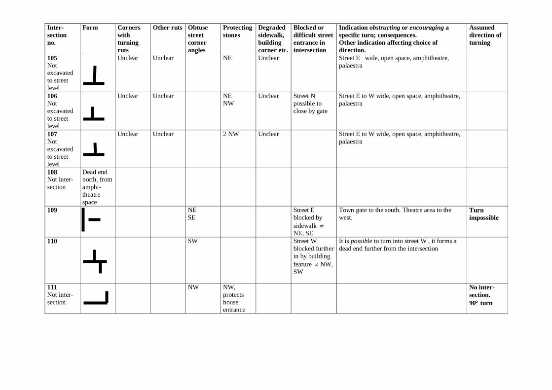
105
Not excavated
to street
level
Unclear Unclear NE Unclear Street E wide, open space, amphitheatre,
palaestra
106
Not
excavated
to street
level
Unclear Unclear NE
NW
Unclear Street N
possible to
close by gate
Street E to W wide, open space, amphitheatre,
palaestra
107
Not
excavated
to street
level
Unclear Unclear 2 NW Unclear Street E to W wide, open space, amphitheatre,
palaestra
108 Not inter-
section
Dead end north, from
amphi-
theatre
space
109
NE
SE
Street E
blocked by
sidewalk NE, SE
Town gate to the south. Theatre area to the
west. Turn
impossible
110
SW Street W
blocked further
in by building
feature NW, SW
It is possible to turn into street W , it forms a
dead end further from the intersection
111
Not inter-
section
NW NW,
protects
house entrance
No inter-
section.
90 turn
Inter-
section
no.
Form Corners
with
turning
ruts
Other ruts Obtuse
street
corner
angles
Protecting
stones
Degraded
sidewalk,
building
corner etc.
Blocked or
difficult street
entrance in
intersection
Indication obstructing or encouraging a
specific turn; consequences.
Other indication affecting choice of
direction.
Assumed
direction of
turning
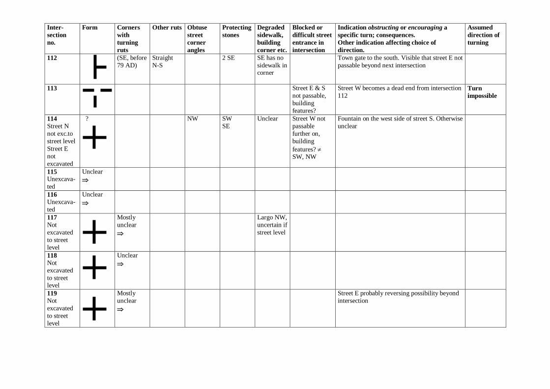
112
(SE, before
79 AD)
Straight
N-S
2 SE SE has no
sidewalk in corner
Town gate to the south. Visible that street E not
passable beyond next intersection
113
Street E & S
not passable,
building
features?
Street W becomes a dead end from intersection
112 Turn
impossible
114
Street N
not exc.to
street level
Street E
not
excavated
? NW SW
SE
Unclear Street W not
passable
further on,
building
features? SW, NW
Fountain on the west side of street S. Otherwise
unclear
115 Unexcava-
ted
Unclear
116
Unexcava-
ted
Unclear
117
Not
excavated
to street
level
Mostly
unclear
Largo NW,
uncertain if
street level
118
Not
excavated
to street level
Unclear
119
Not
excavated
to street
level
Mostly
unclear
Street E probably reversing possibility beyond
intersection
Inter-
section
no.
Form Corners
with
turning
ruts
Other ruts Obtuse
street
corner
angles
Protecting
stones
Degraded
sidewalk,
building
corner etc.
Blocked or
difficult street
entrance in
intersection
Indication obstructing or encouraging a
specific turn; consequences.
Other indication affecting choice of
direction.
Assumed
direction of
turning
120
SW Sidewalk
SW
Street E
blocked by
sidewalk NE, SE
Town gate to the south From south
to west
121
Not
excavated
to street
level
Unclear
Street S dead end
122
Not inter-
section,
passage
through
town gate
Walkways
to the east
and west?
Possibility of turning/waiting inside gate
123 - 129
Partly
unexcava-ted
Unclear
130
Not inter-
section
Passage
through
town gate
Possibly
walkways
east and
west
No turning possibilities inside gate, only
outside. Large enough space to let other carts
pass by.
131
Not inter-
section
dead end
street from north
Possibly
walkways
east and
west