tactical urbanism with pattern language toolkits-mehaffy
DESCRIPTION
Tactical Urbanism With Pattern Language Toolkits-mehaffyTRANSCRIPT

Tactical Urbanism Using “Pattern Language” Toolkits
Abstract
In recent years “tactical urbanism” has arisen as an approach to make beneficial urban changes catalytically, using limited resources. But to be most effective, such an approach requires effective tools that can work together in coordinated “toolkit” form. The tools must be able to evolve and adapt to specific project requirements and barriers. We describe herein a methodology aimed at meeting these requirements, using an expanded system of “pattern languages.” Such systems have proven enormouslty effective in software design and other fields, though they have been neglected in the fields of urban planning and design. As we discuss, this presents an intriguing opportunity for tactical urbanists.
Introduction
Over the last several years, the topic of “tactical urbanism” has arisen along with related concepts of “urban acupuncture,” “peer-to-peer urbanism,” and “economic gardening.” All of these concepts and approaches follow the insight, perhaps first discussed thoroughly by Jane Jacobs, that urban planning and design are not linear processes, but require an understanding and exploitation of the dynamics of self-organization – an understanding, as Jacobs put it, of “the kind of problem a city is” (Jacobs, 1961).
These insights have been given special urgency by the evident challenges of achieving more walkable, compact, mixed-use developments in urban and suburban settings. Economic resources are scarce – particularly since the 2008 financial crisis – and at the same time, significant barriers remain to this kind of development, relative to more conventional, specialized, segregated forms of development. A more “leveraged” kind of approach is needed, and one that makes more effective use of limited resources (Mehaffy, 2012a). This is the challenge for a more effective “tactical urbanism.”
The problem is particularly challenging in existing urban areas seeking “infill” projects. A successful infill development strategy must move beyond well-intentioned plans to carefully assess these barriers, and identify the specific tools needed to overcome them. It must also recognize that different sites will often require very different tools, types of tools, and combinations of tools. Finally, it must make these tools and resources available to the diverse parties who are actually implementing development – some of them at fine-grained scales. This is especially important in the current economic environment.
An approach that meets this need is to develop flexible “toolkits” that can bring a range of tools to bear on different sites with varying needs. These toolkits need to be able to combine the different kinds of tools that are needed in the development process – design types, regulatory and entitlement processes, funding mechanisms, partnership structures, collaborative planning processes, and other resources. But they must do so in a way that allows the tools to work together, and to do so in a relatively simple, easy-to-use form. This capability has been referred to as “plug and play” – a format in which different tools are made available, relatively easy to use,

and able to work together.
The Nature of the Barriers
While the mix and intensity may vary by location, many of the barriers are common to any infill project in almost any city. Some of these barriers are more challenging in suburb-heavy cities like Phoenix, Arizona, in part because that region, like others, has developed a major portion of its economy around edge or “greenfield” development, and existing tools, skills and resources are still geared largely to support this class of development. By contrast, tools to support infill development have limited availability or, where they do exist, limited functionality in the present environment.
As part of our research in Phoenix, New Orleans, Portland and other cities, we consulted with an array of stakeholders and gathered their input about barriers. For Portland's Metro government, we co-authored a report on barriers to sustainable development in the “Centers and Corridors” (Kelley et al., 2009). We can summarize the identified barriers as follows:
Uncertainty in the entitlement process, in part because of high scrutiny and potential opposition by stakeholders, within a public process that does not yet provide substantial regulatory support for more walkable mixed-use, compact infill development.
Relative cost of higher-density projects, especially when structured parking is needed to fulfill parking requirements or expectations.
Regulatory complications from mixed-use and infill development, which tend to make this form of development slower and more costly than greenfield development.
Fragmented land ownership patterns. It is often difficult to assemble parcels of land that are of sufficient size to make a viable redevelopment project.
Competitive advantages for suburban edge development relative to infill development. These include natural advantages (such as lower development costs) and artificial advantages (such as lower permit fees and other effective subsidies). This has the effect of making infill development relatively uncompetitive, and more difficult to finance and sell.
“Chicken and egg” problem of weak markets in areas where amenities have not yet been developed (e.g. lack of groceries, etc) and where there are negative aspects of amenities within existing neighborhoods (e.g. empty buildings, etc). This is a particular challenge within large areas of central cities that have experienced economic depression as a result of sprawl policies.
There is one other factor that is very important at the present time, but may become less important as financial markets stabilize:
Lack of capital for larger, more conventional development projects. There are notable exceptions in larger multi-family rental, but other markets, especially mixed-use retail, are likely to remain weak for the foreseeable future.

Overcoming the Barriers: Changing the Structure of Incentives and Disincentives
To understand the tools and strategies needed, we should begin by recognizing that every act of development occurs within a context of incentives and disincentives – a kind of “operating system” that governs how much something costs, in relation to how much it is rewarded. This “operating system” includes the laws, rules, fees, standards, and all the other parameters that govern what can be done and where, and for what cost and reward.
For most projects, the market itself provides perhaps the most obvious set of incentives and disincentives -- namely, whether buyers (or renters) are prepared to pay a price sufficient to cover the cost of development, plus a competitive profit. The more they are willing to pay above the threshold of profitability, the more there is an incentive for that development to occur. Conversely, if they are not willing to pay enough to make a minimum threshold project, then developers say the project “doesn't pencil” - and in most cases, it simply doesn't get built.
But market behavior does not arise in a vacuum. Buyers have their own set of incentives and disincentives, which often depend on conditions set by the public sector. Construction and expansion of public infrastructure (roads, water, etc) is clearly a major incentive to development, and a disincentive when that infrastructure becomes inadequate. Other sources of buyer incentives and disincentives include the cost of resources and services, the structure of tax policy, and the “pricing signals” of such services as toll roads and parking charges.
Buyers also have non-economic incentives, of course, including neighborhood aesthetic appeal, amenities, convenience, attractiveness, and peer-group desirability. These in turn are sensitive to public investments in area services and amenities, and the perceived quality and effort made by the public sector in things like schools, parks, streetscapes, public transportation and other amenities. Many of these conditions develop slowly, and are difficult (and usually expensive) to change quickly.
There are also important incentives and disincentives in the cost of development itself. This includes the cost of planning and entitlement, the cost of regulatory requirements, the cost and complexity of construction, and – one of the most significant for the public sector – the cost structure of development fees, including infrastructure system development charges. These are often consciously structured in a way that incentivizes suburban edge development, which is used to generate new tax base and additional economic activity. The regulatory and entitlement process is often also greatly streamlined in smaller suburban jurisdictions, adding more powerful incentives to this form of development.
Therefore it is not a surprise to see that while many infill sites stand vacant, including many along the new Phoenix light rail line, for example, the overwhelming volume of development activity in Phoenix and other similar regions remains at the suburban edge. This pattern of uneven regional development reflects an uneven playing field when it comes to incentives. If the public sector wants to see a more spatially efficient form of development that makes greater use of existing inner-city resoures, and likely lowers worrisome externality costs – which will hit future taxpayers and citizens especially hard - then it must examine the steps needed to re-balance the incentives and disincentives.

Therefore we can express the steps that the public sector can take, in partnership with private and NGO entities, to help overcome the infill development barriers previously summarized:
Increase certainty in the entitlement process by providing a clear framework, and clear, workable regulatory requirements such as zoning codes. Provide a more formalized process for public and stakeholder involvement that increases neighborhood confidence in the quality of the result.
Lower the relative cost of higher-density projects, by easing parking requirements and other major drivers of cost. Work to reduce cost through economies of standardization in the process.
Streamline regulations for mixed-use and infill development, by coordinating otherwise conflicting requirements, and by offering pre-approved types that overcome regulatory barriers.
Work to overcome fragmented land ownership patterns by partnering with entities that can identify and assemble “opportunity sites.” Provide incentives for owners to collaborate with each other and with other developers to create coordinated development. Use codes that provide maximum flexibility in use, while assuring maximum coordination of form (such as form-based codes).
Level the playing field relative to suburban edge development by eliminating hidden subsidies and requiring all development to pay its true cost to taxpayers and citizens. Examine fees and other “pricing signals,” and consider tools such as “feebates” to equalize incentives for infill development. Consider targeted public investment catalytic projects across a range of scales (a few large, many small, etc.) to promote additional growth.
Overcome the “chicken and egg” problem of weak markets by identifying areas with weak amenities (e.g. “food deserts”) and by incentivizing needed amenities that can be provided reasonably (e.g. farmers' markets). Build on existing resources to create desirable amenities, if necessary through modest means (e.g. artist studios, galleries, etc).
Compensate for lack of capital for larger, more conventional development projects, by incentivizing smaller, pay-as-you-go development, and by preparing sites for incremental development as capital becomes more available.
All of these issues are interrelated, and the specific tools developed to address them must also be interrelated and coordinated. Moreover, they must be made available within a coordinated planning framework that is sensitive to the varying requirements of different development sites. This is the intention of the “Place Types” system, which we discuss below.
“Place Types” Concept
The concept of “place types” has been used by a number of planners to identify the unique
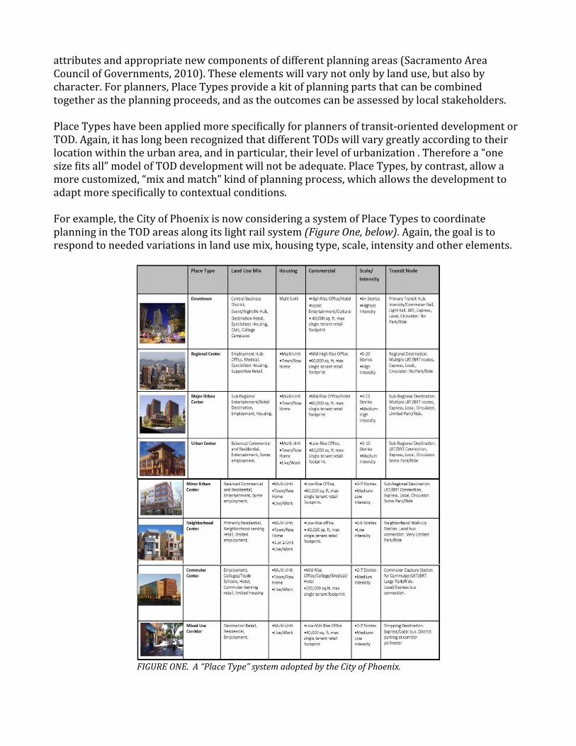
attributes and appropriate new components of different planning areas (Sacramento Area Council of Governments, 2010). These elements will vary not only by land use, but also by character. For planners, Place Types provide a kit of planning parts that can be combined together as the planning proceeds, and as the outcomes can be assessed by local stakeholders.
Place Types have been applied more specifically for planners of transit-oriented development or TOD. Again, it has long been recognized that different TODs will vary greatly according to their location within the urban area, and in particular, their level of urbanization . Therefore a “one size fits all” model of TOD development will not be adequate. Place Types, by contrast, allow a more customized, “mix and match” kind of planning process, which allows the development to adapt more specifically to contextual conditions.
For example, the City of Phoenix is now considering a system of Place Types to coordinate planning in the TOD areas along its light rail system (Figure One, below). Again, the goal is to respond to needed variations in land use mix, housing type, scale, intensity and other elements.
FIGURE ONE. A “Place Type” system adopted by the City of Phoenix.

But for Phoenix and other cities, the question remains: will it be enough to identify the planning types, without also identifying the tools needed to overcome the barriers, and plan strategically for “bottom-up” growth? Given the need for a coordinated strategy, could (and indeed, should) these approaches perhaps be combined into one expanded methodology? This is the central subject of our research, and the proposal that we present herein for further research and development.
And if such a combined, expanded methodology is to be undertaken, what is the model that will be used to coordinate the elements, so as to preserve maximum flexibility while achieving maximum coordination? Can the Place Types model be used as a basis for an expanded system that includes incentives and other process tools?
The Capabilities of Pattern Languages
A tool for such an expansion might well come in the form of a design system known as a “pattern language.” The system was developed by architect Christopher Alexander, and it has recently seen a dramatic increase in research and application across a wide range of fields, including engineering, product design, economics and biology. The system is perhaps best known for its success in computer software, where “patterns” are used in many common programs, and in the Mac and iPhone operating systems.
Pattern langauges have demonstrated a remarkable capability to coordinate a range of disparate design elements, through a modular “plug and play” kit of parts that is adaptable to a range of conditions and problems. Although they were developed originally to handle physical design, their success in other fields shows that pattern languages are suitable for the design of processes and other non-physical systems – including, it would seem, the physical and non-physical aspects of urban development. What has not been done, as far as we are aware, is to combine these approaches into one coordinated system.
This, we believe, could mean that there is an important but unrealized opportunity to develop such a resource as a tool for “tactical urbanism” within existing urban areas. Indeed, that has been an important quesiton for our research, and we can report that we do see great promise in this work. But at the same time, the pattern language system also illustrates well the wider point that such a “toolkit approach,” by any other name, is very much needed to unlock the development potential of urban areas.
Our project has therefore focused on developing a representative sample of just such flexible tools, within a “toolkit” system. Such tools may include:
- Building types and elements- Landscape features- Community amenities- Financial tools- Process tools (e.g. partnership models)- Diagnostic tools (e.g. checklists, certifications)

The Concept of “Place Networks”
It is important to understand that patterns and pattern languages provide an essential capability that is not easy to achieve within a more linear technology: the ability to create functional networks, in both structure and process. Many of the successes within software design are attributable to this capability (Mehaffy and Salingaros, 2012; Salingaros, 2000). Moreover, urban systems can also be understood as inter-connected networks, and this capability gives them a much greater character of richness and complexity (Alexander, 1965).
This inter-connected network pattern stretches across kinds of structures as well as scales of structure. For example, street networks, pedestrian paths, small and large room-like urban spaces, even building details, all manifest this same type of network structure (Salingaros, 2008). Likewise, the processes that people undergo to structure such spaces, and the tools and approaches they use, also manifest the characteristics of networks. All of these structures extend across a wide range of scales (Salingaros, 2003).
Therefore, it is beneficial to Tactical Urbanists to have a “unified map” of the kind of phenomenon they are dealing with – the “kind of problem a city is,” as Jacobs put it – and such a unified map or theory might be termed “the theory of place networks.” Our job is to understand the networks that exist, and moreover, that are constantly being organized and re-organized by the users themselves.
These re-organizations take the form of minor mutations to their connective relationships (closing or opening doors, drawing of blinds, closing of gates etc.) to larger and more permanent mutations (planting of hedges, addition of fences etc), to the more permanent kinds of changes (addition of doors, reconstruction of facades, construciton of new spaces entirely, etc).
The job of the Tactical Urbanist is not to anticipate these mutations and make them for the users – an approach that is closer to the old “top-down” model of arhcitecture and urbanism – but to actually empower the users to make these mutations themselves, as autocatalytic agents. In this way, the Tactical Urbanist is not creating urban growth, which will always be inherently limited, but is facilitating growth on a possibly much larger, certainly more complex scale. It is the growth of many agents interacting in a more complex pattern, as opposed to the growth directed by a single agent, no matter how brilliant. (See also Mehaffy, 2012b)
This approach has the additional advantage, essential to the goals of tactical urbanism, of requiring far fewer initial resources. Instead, the tools provided are targeted and catalytic, and, if they are well-designed, can greatly leverage very limited resources to achieve better urban changes sooner.
Structure of the “Place Pattern” System
The “place patterns,” then, are in effect “master” patterns that refer to a specific place, for example, along a light rail line (a town center, neighborhood center, etc.) and that allow modular coordination with other patterns that provide details, address barriers and offer resources. In some cases these other patterns (which we refer to here as “sub-patterns”) will be specific to one or more Place Patterns, and in other cases they will be applicable to a range of Place Patterns. But
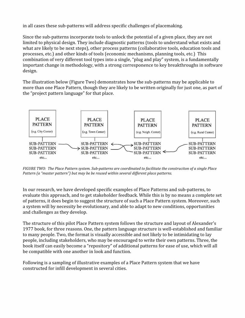
in all cases these sub-patterns will address specific challenges of placemaking.
Since the sub-patterns incorporate tools to unlock the potential of a given place, they are not limited to physical design. They include diagnostic patterns (tools to understand what exists and what are likely to be next steps), other process patterns (collaborative tools, education tools and processes, etc.) and other kinds of tools (economic mechanisms, planning tools, etc.) This combination of very different tool types into a single, “plug and play” system, is a fundamentally important change in methodology, with a strong corresponence to key breakthroughs in software design.
The illustration below (Figure Two) demonstrates how the sub-patterns may be applicable to more than one Place Pattern, though they are likely to be written originally for just one, as part of the “project pattern language” for that place.
FIGURE TWO: The Place Pattern system. Sub-patterns are coordinated to facilitate the construciton of a single Place Pattern (a “master pattern”) but may be be reused within several different place patterns.
In our research, we have developed specific examples of Place Patterns and sub-patterns, to evaluate this approach, and to get stakeholder feedback. While this is by no means a complete set of patterns, it does begin to suggest the structure of such a Place Pattern system. Moreover, such a system will by necessity be evolutionary, and able to adapt to new conditions, opportunities and challenges as they develop.
The structure of this pilot Place Pattern system follows the structure and layout of Alexander's 1977 book, for three reasons. One, the pattern language structure is well-established and familiar to many people. Two, the format is visually accessible and not likely to be intimidating to lay people, including stakeholders, who may be encouraged to write their own patterns. Three, the book itself can easily become a “repository” of additional patterns for ease of use, which will all be compatible with one another in look and function.
Following is a sampling of illustrative examples of a Place Pattern system that we have constructed for infill development in several cities.

Figure Three: examples of a master pattern (Town Center) and a sub-pattern (Farmers' Market). These are designed to be written and/or chosen by local people, as they seek coordinated small-scale approaches to local urban problems and needs.
Figure Four: a pattern language developed for New Orleans after Katrina, displayed on the “Smallest Federated Wiki” computer-based system.

Figure Five: another example of the computer-based system, showing “process tools” as well as “type tools.” Note that the “Smallest Federated Wiki” platform allows handling and processing of metrics, and modeling of the effects of various scenarios.
Figure Six: the “Smallest Federated Wiki” system is well-adapted to hand-held technology such as iPhones. Here a “feeling map” diagnostic tools allows tactical urbanists to gather “peer to peer” and “crowdsource” data about an urban site.

Conclusions
The promise of tactical urbanism is in its ability to leverage limited resources and trigger much wider beneficial changes. But that promise can only be realized with neighborhood-scale technologies that allow people to identify and resolve their own local challenges. Pattern languages were developed to meet just such a challenge – and yet ironically, have found much greater success in other communities. We believe they await much greater success in the built environment – but to do so, will need to be develped further in actual projects, with actual users. This, too, is in the spirit of peer-to-peer collaboration, local capacity-building, and “tactical urbanism.”
References
Alexander, C. (1965) “A city is not a tree.” Architectural forum. Vol. 122. No. 1. 1965. Jacobs, J. (1961) The Death and Life of Great American Cities. New York: Random House.Kelley, G et al., “Achieving Sustainable, Compact Development in the Portland Metropolitan
Area: New Tools and Approaches for Developing Centers and Corridors.” Accessed 12/20/2012 at http://www.oregonmetro.gov/index.cfm/go/by.web/id=31931
Mehaffy, M (2012a) “Urban Acupuncture in Medellin”. On Resilient Architecture (blog), accessed 12/20/2012 at http://mehaffy.posterous.com/urban-acupuncture-in-medellin-colombia
Mehaffy, M (2012b). “Toward a theory of place networks.” Accessed 12/20/2012 at http://mehaffy.posterous.com/toward-a-theory-of-place-networks
Mehaffy, M and Salinagros, N. (2012) “The pattern technology of Christopher Alexander.” Metropolis POV (blog). Accessed 12/20/2012 at http://www.metropolismag.com/pov/20111007/the-pattern-technology-of-christopher-alexander
Sacramento Area Council of Governments, “Place Type Menu.” Accessed 12/20/2012 at http://www.sacog.org/publications/placetypemenu.pdf
Salingaros, N. (2003) “Connecting the Fractal City.” Accessed 12/20/2012 at http://www.fractal.org/Samenhang-Industrieel-Ontwerpen/Connecting-the-Fractal-City.htm
Salingaros, N. (2000). “The structure of pattern languages.” Architectural Research Quarterly, 4, pp 149-162.