taking measure of the ocean’s depth - washington post...
TRANSCRIPT
Volume 13, Issue 2
An Integrated Curriculum For The Washington Post Newspaper In education Program
October 4, 2013 ©2013 THE WASHINGTON POST
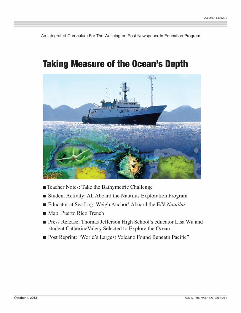
Taking Measure of the Ocean’s Depth
■ Teacher Notes: Take the Bathymetric Challenge■ Student Activity: All Aboard the Nautilus Exploration Program■ Educator at Sea Log: Weigh Anchor! Aboard the E/V Nautilus■ Map: Puerto Rico Trench■ Press Release: Thomas Jefferson High School’s educator Lisa Wu and student CatherineValery Selected to Explore the Ocean■ Post Reprint: “World’s Largest Volcano Found Beneath Pacific”
Volume 13, Issue 2
An Integrated Curriculum For The Washington Post Newspaper In education Program
October 4, 2013 ©2013 THE WASHINGTON POST
W e return to the theme of discovery and exploration of the ocean. Although space is considered the last frontier, the depths of the seas have wide unexplored expanses. During three weeks in October, Lisa Wu, Oceanography
& Geophysical Systems Lab Director and marine biology educator, is aboard E/V Nautilus as a 2013 Educator at Sea. Her senior student, Catherine “Katie” Valery at Thomas Jefferson H.S. for Science and Technology was selected an Honors Research Student in the Nautilus Exploration Program. This year’s 47 educators and students from 21 states and five countries are involved in projects in the Gulf of Mexico, Caribbean Sea and Mediterranean Sea. Wu and Valery will set sail from Puerto Rico to explore the deep waters of the Puerto Rico Trench. “I’ll be able to watch Remotely Operated Vehicles, or ROVs, dive into some of the deepest parts of our oceans and make discoveries right before my very eyes, as well as see parts of the seafloor that no human has ever laid eyes on!” stated Valery. “I will also get to work alongside some very distinguished scientists and work as a data logger with other Corps members. In addition, I will be helping make bathymetric maps of the seafloor with a special software I received training for over the summer. I’ll be taking multibeam sonar data collected right from the sonar system on the Nautilus, processing it, and using it to construct three-dimensional maps.” Teachers are provided with activities to acquaint students with bathymetric maps, excerpts from Wu’s logs and maps of the Puerto Rico Trench. From October 4-18, teachers and their students may follow activities on the Nautilus, send questions, and receive real-time answers. To watch activities of the Ocean Exploration Trust visit Nautilus Live (www.nautiluslive). Look for the space to type in a question that will be sent directly to the scientists on watch at that time. Earlier exploration may be found at http://www.nautiluslive.org/mission/2013.
Volume 13, Issue 2
An Integrated Curriculum For The Washington Post Newspaper In education Program
October 4, 2013 ©2013 THE WASHINGTON POST
#2
TEACHER NOTES
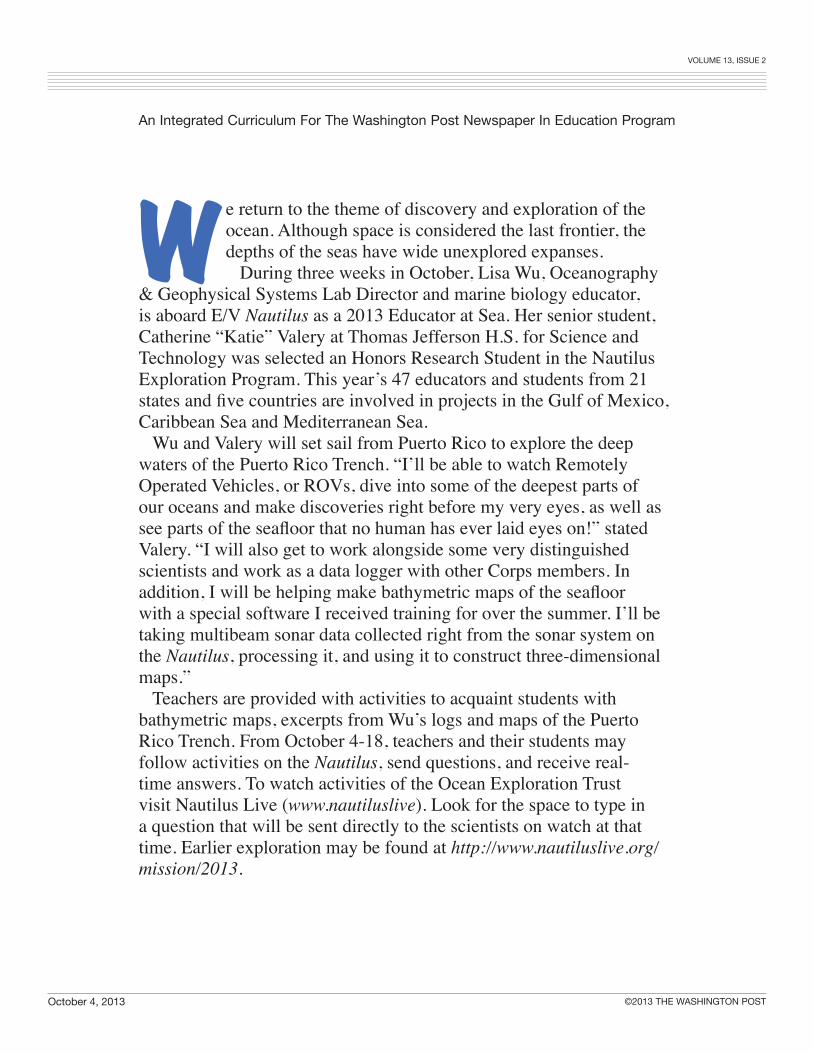
Take the Bathymetric Challenge Have your students waded into a shallow, clear stream and felt something at their feet before they looked down to see what it was? They had already taken a measure of the water to know they would not be over their heads. Their legs verified the depth, their feet sensed a change in the floor of the streambed, and their eyes told them whether it was a stone, an old shoe or debris that had settled after a heavy rain. In a simple way, your students were taking a bathymetric measure. Bathymetry is the measurement of the depth of bodies of water. The USGS Coastal & Marine Geology InfoBank defines bathymetry as “the water depth relative to sea level.” NOAA also calls it the “depths and shapes of underwater terrain.” Topography or elevations are the terms used for above sea level measurements. How do scientists, sailors and sea-going vessels know the depth of the waters on which they sail? They use sonar and access maps that have charted the ocean floor. Today, the measurement of depth is almost always found by the time required for a signal to travel from a transmitter to the bottom and back. NOAA Office of Coast Survey conducts high-resolution multibeam and LIDAR surveys. In this activity, you will create an underwater world for your students to map an underwater terrain.
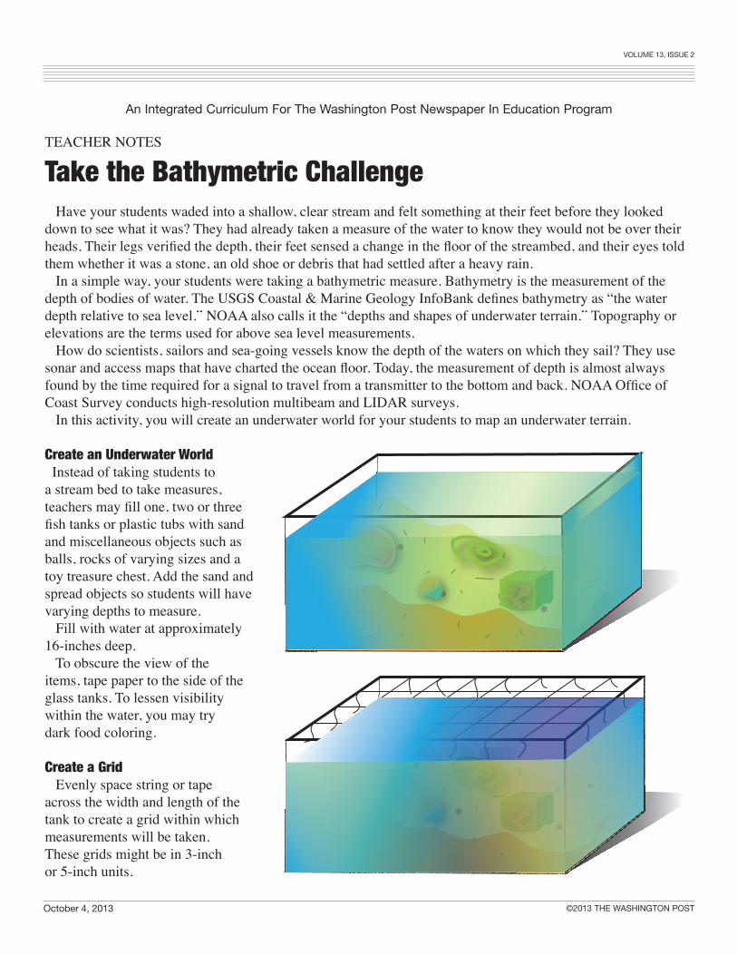
Create an Underwater World Instead of taking students to a stream bed to take measures, teachers may fill one, two or three fish tanks or plastic tubs with sand and miscellaneous objects such as balls, rocks of varying sizes and a toy treasure chest. Add the sand and spread objects so students will have varying depths to measure. Fill with water at approximately 16-inches deep. To obscure the view of the items, tape paper to the side of the glass tanks. To lessen visibility within the water, you may try dark food coloring.
Create a Grid Evenly space string or tape across the width and length of the tank to create a grid within which measurements will be taken. These grids might be in 3-inch or 5-inch units.
#1
Volume 13, Issue 2
An Integrated Curriculum For The Washington Post Newspaper In education Program
October 4, 2013 ©2013 THE WASHINGTON POST
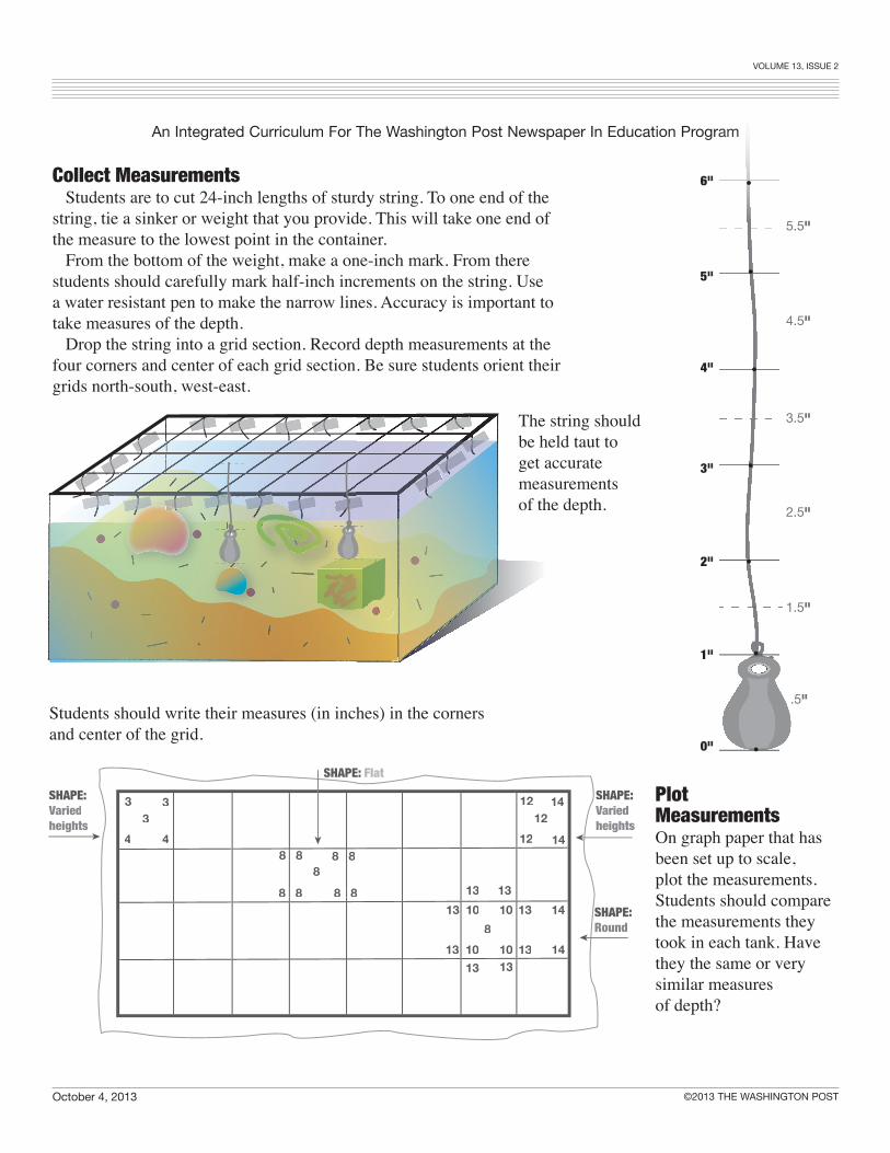
Collect Measurements Students are to cut 24-inch lengths of sturdy string. To one end of the string, tie a sinker or weight that you provide. This will take one end of the measure to the lowest point in the container. From the bottom of the weight, make a one-inch mark. From there students should carefully mark half-inch increments on the string. Use a water resistant pen to make the narrow lines. Accuracy is important to take measures of the depth. Drop the string into a grid section. Record depth measurements at the four corners and center of each grid section. Be sure students orient their grids north-south, west-east.
#3
16 -14” Deep Blue
13.5 -11” Turquoise
10.5 - 9 “Green
8.5 - 7” Yellow
6.5 - 5” Orange
4.5 -1” Red
12 14
12 14
12
101313
10 13
1013
13 1013
13 14
148
8 8 8 8
8 8 8 8
8
SHAPE: Flat
SHAPE:Variedheights
SHAPE:Round
3 3
4 43
SHAPE: Variedheights
13
Plot MeasurementsOn graph paper that has been set up to scale, plot the measurements. Students should compare the measurements they took in each tank. Have they the same or very similar measures of depth?
The string shouldbe held taut to get accurate measurementsof the depth.
0"
1"
2"
3"
4"
5"
6"
4.5"
5.5"
3.5"
2.5"
1.5"
.5"
•
•
•
•
•
•
•
Students should write their measures (in inches) in the corners and center of the grid.
Volume 13, Issue 2
An Integrated Curriculum For The Washington Post Newspaper In education Program
October 4, 2013 ©2013 THE WASHINGTON POST 5
Bathymetric Maps
http://oceanservice.noaa.gov/facts/bathymetry.htmlBathymetry is the study of the “beds” or “floors” of water bodies, including the ocean, rivers, streams and lakes.
http://www.nauticalcharts.noaa.gov/csdl/bathywarehouse.htmlBathymetric Warehouse
http://serc.carleton.edu/usingdata/datasheets/MBARI.htmlExploring Oceanography in the Classroom Using Data from the Monterey Bay Aquarium Research Institute
http://maps.ngdc.noaa.gov/viewers/bathymetry/National Geophysical Data Center
http://www.ngdc.noaa.gov/mgg/bathymetry/maps/National Ocean Service (NOS) Office of Coast Survey US Bathymetric & Fishing Maps
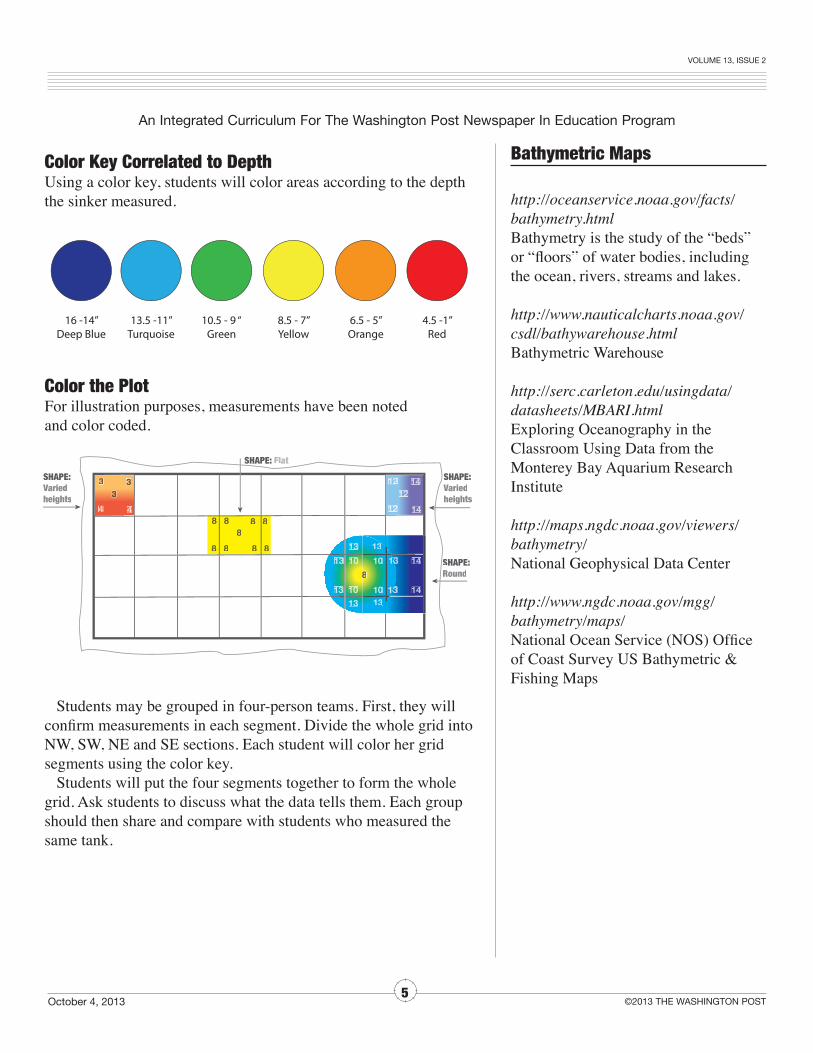
Color Key Correlated to DepthUsing a color key, students will color areas according to the depth the sinker measured.
Color the PlotFor illustration purposes, measurements have been noted and color coded.
Students may be grouped in four-person teams. First, they will confirm measurements in each segment. Divide the whole grid into NW, SW, NE and SE sections. Each student will color her grid segments using the color key. Students will put the four segments together to form the whole grid. Ask students to discuss what the data tells them. Each group should then share and compare with students who measured the same tank.
16 -14” Deep Blue
13.5 -11” Turquoise
10.5 - 9 “Green
8.5 - 7” Yellow
6.5 - 5” Orange
4.5 -1” Red
12 14
12 14
1122
110101313331313
100011 313
100111313
13133 110100313
313 14
1488
8 8 8 8
8 8 8 8
8
SHAPE: Flat
SHAPE:Variedheights
SHAPE:Round
3 3
4 4
333
SHAPE: Variedheights
313
16 -14” Deep Blue
13.5 -11” Turquoise
10.5 - 9 “Green
8.5 - 7” Yellow
6.5 - 5” Orange
4.5 -1” Red
12 14
12 14
1122
110101313331313
100011 313
100111313
13133 110100313
313 14
1488
8 8 8 8
8 8 8 8
8
SHAPE: Flat
SHAPE:Variedheights
SHAPE:Round
3 3
4 4
333
SHAPE: Variedheights
313
Name ___________________________________________________________ Date _____________________________
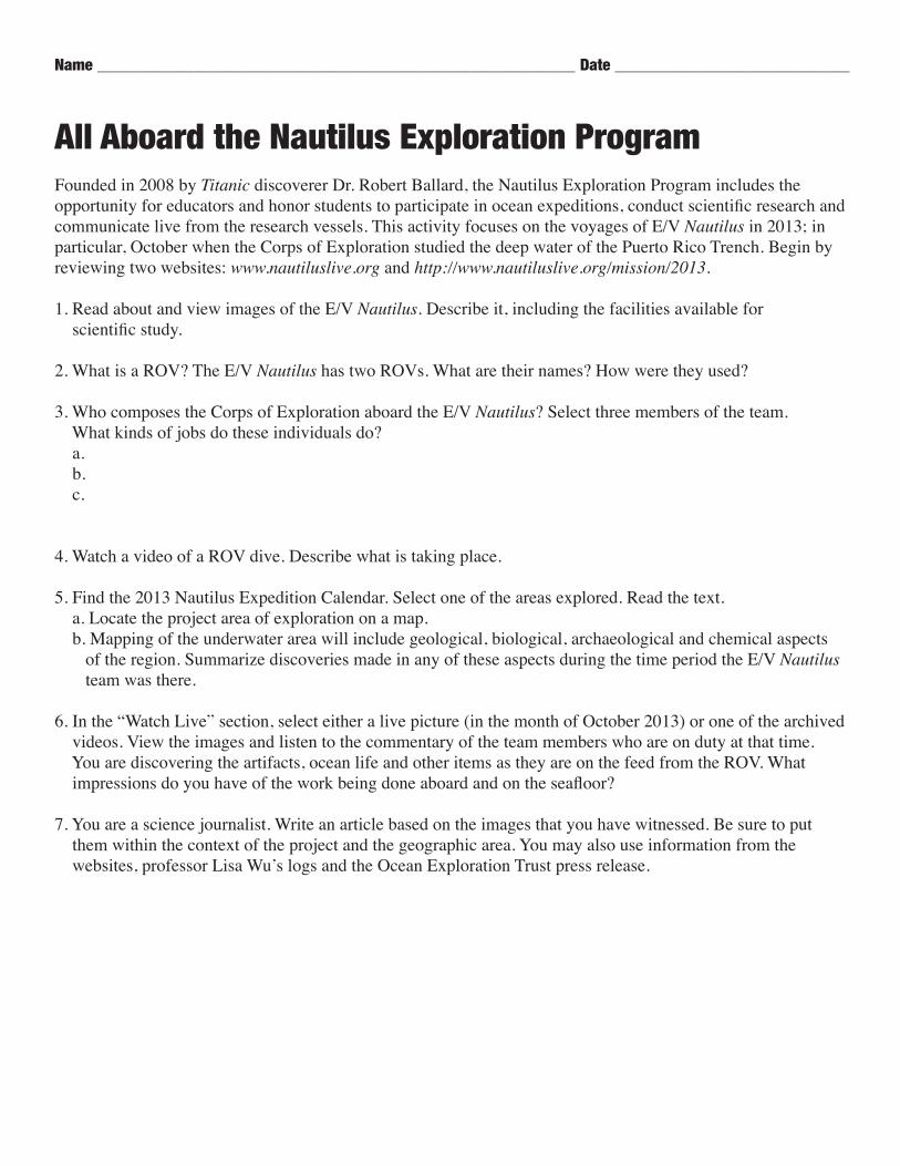
All Aboard the Nautilus Exploration ProgramFounded in 2008 by Titanic discoverer Dr. Robert Ballard, the Nautilus Exploration Program includes the opportunity for educators and honor students to participate in ocean expeditions, conduct scientific research and communicate live from the research vessels. This activity focuses on the voyages of E/V Nautilus in 2013; in particular, October when the Corps of Exploration studied the deep water of the Puerto Rico Trench. Begin by reviewing two websites: www.nautiluslive.org and http://www.nautiluslive.org/mission/2013.
1. Read about and view images of the E/V Nautilus. Describe it, including the facilities available for scientific study.
2. What is a ROV? The E/V Nautilus has two ROVs. What are their names? How were they used?
3. Who composes the Corps of Exploration aboard the E/V Nautilus? Select three members of the team. What kinds of jobs do these individuals do? a. b. c.
4. Watch a video of a ROV dive. Describe what is taking place.
5. Find the 2013 Nautilus Expedition Calendar. Select one of the areas explored. Read the text. a. Locate the project area of exploration on a map. b. Mapping of the underwater area will include geological, biological, archaeological and chemical aspects of the region. Summarize discoveries made in any of these aspects during the time period the E/V Nautilus team was there.
6. In the “Watch Live” section, select either a live picture (in the month of October 2013) or one of the archived videos. View the images and listen to the commentary of the team members who are on duty at that time. You are discovering the artifacts, ocean life and other items as they are on the feed from the ROV. What impressions do you have of the work being done aboard and on the seafloor?
7. You are a science journalist. Write an article based on the images that you have witnessed. Be sure to put them within the context of the project and the geographic area. You may also use information from the websites, professor Lisa Wu’s logs and the Ocean Exploration Trust press release.

Volume 13, Issue 2
An Integrated Curriculum For The Washington Post Newspaper In education Program
October 4, 2013 ©2013 THE WASHINGTON POST
Weigh Anchor! Aboard the E/V NautilusLog of Educator at Sea Lisa Wu
Its mountainous features dwarf the highest peaks on land while the deepest canyons have yet to be explored. It is a source of valuable minerals, fuels, and food and more than half the oxygen you breathe is generated here. Its heat exchange with the atmosphere drives our weather and its conveyor belts circumnavigate the globe transporting adventurers, militia, commercial and recreational vessels alongside the smallest and largest creatures on Earth.
The ships that sail these oceans keep logs of position at sea, weather, change of command, orders received and the many details that form a record of the voyage. Lisa Wu, Oceanography & Geophysical Systems Lab Director and marine biology educator at Thomas Jefferson H.S. for Science and Technology, Alexandria, Va., while aboard E/V Nautilus as a 2013 Educator at Sea shares her personal log.
October 4, 2013 Today was amazing. We left port in San Juan and are currently steaming to our first site. During the steam we have had all hands meetings, safety drills, and I did three live shows to the Texas State Aquarium, Houston Museum of Natural History, and the Aquarium of the Pacific in Long Beach, Calif. Yesterday, we had approximately 250 local students join us on ship tours. Many of them were middle school students who also brought their ROVs along to show us. They are competing this weekend in the Sea Perch competition. This evening we made a brief stop to deploy a benthic lander that Scripps scientists brought with them to collect and study deep sea organisms such as microbes and invertebrates. The lander was hoisted with a crane and lowered into the water. It is going to 7800 meters at approximately 1 meter/sec to the bottom. It is controlled by sonar. Different codes tell the lander what to do – such as to close the Niskin bottle that samples water or drop the ballast so that it will float up to the surface. It takes approx. 2.5 hours for it to surface or sink. The samples will be prepared here on the ship for study back at the lab. Sometimes this means pressurizing them and keeping them at freezing temp (4 degrees C) so that they do not degrade. The scientist is hoping to reculture these new organisms back at Scripps. My watch is 4 to 8 so I am going to get some rest before I’m on my first watch.
Cheers,Lisa

Volume 13, Issue 2
An Integrated Curriculum For The Washington Post Newspaper In education Program
October 4, 2013 ©2013 THE WASHINGTON POST
October 5, 2013 I found the most interesting story last night about Charles Bonneycastle — using the concept of trying to see the ocean floor by using sound. In 1838, he was a professor at the University of Virginia, and became the first man to attempt to determine the depth of the open ocean by echosounding. He was about 75 years ahead of his time! The ship orientation is over and my day began with my 04:00 (4:00 a.m.) watch. On a military ship, standing watch might mean reading the radar screen or standing on deck looking for other ships. On another type of research vessel, it might mean being on the deck of a ship and pulling in nets and measuring fish. On the E/V Nautilus, watches take place in a van on the deck of the ship. Imagine stepping into a dark, chilly space lined with a series of large monitors. Chairs position those on
watch in front of the screens reminiscent of mission control at NASA and hold places for a navigator, ROV pilots, several scientists, and an educator. It is here that our eyes in the sea view high definition images sent through fiber optic cables. Video, sensor, and audio data are transmitted via cables to the ship and by satellite to the Exploration Command Centers, Exploration Learning Centers, and Ocean Exploration Centers. This Exploration Now Network allows scientists, engineers, and students to participate in expeditions in the field in real time. Our first dive with the ROVs Hercules and Argus (they are tethered together) was on Mona Block. The ROVs were deployed separately by cranes from the
ship at approximately 14:30 (2:30) this afternoon. The ROVs descended at approximately 26 meters per sec downward into the abyss and took several hours to reach depth. It is a beautiful site to view the Hercules ROV from the view of its companion Argus, with only the lights of the vehicle illuminating this alien landscape. It is addictive to watch the discovery live. And apparently, I am not the only one who feels this way. From many of the viewers who write in, they feel the same way — some following the E/V Nautilus for years!
When I began my watch at 16:00 the ROV was still descending into the deep. At approximately 3,000 meters the temperature read 2.7C. A transect began at a depth of 3,000 meters and is working its way up to a depth of 500 meters. This geologic cross section is collecting rocks, sediments, that should reveal the nature of the Block’s
crust. As we have moved up the slope the terrain has become more rugged. These deep water ecosystems display beautiful sponges, brittle stars, sea cucumbers, anemones, mollusks and large foraminifera (imagine an amoeba with a chalk skeleton) as big as a tennis ball.
Volume 13, Issue 2
An Integrated Curriculum For The Washington Post Newspaper In education Program
October 4, 2013 ©2013 THE WASHINGTON POST
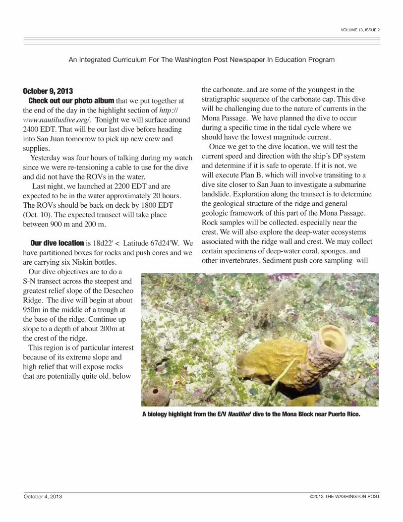
October 9, 2013 Check out our photo album that we put together at the end of the day in the highlight section of http://www.nautiluslive.org/. Tonight we will surface around 2400 EDT. That will be our last dive before heading into San Juan tomorrow to pick up new crew and supplies. Yesterday was four hours of talking during my watch since we were re-tensioning a cable to use for the dive and did not have the ROVs in the water. Last night, we launched at 2200 EDT and are expected to be in the water approximately 20 hours. The ROVs should be back on deck by 1800 EDT (Oct. 10). The expected transect will take place between 900 m and 200 m.
Our dive location is 18d22' < Latitude 67d24'W. We have partitioned boxes for rocks and push cores and we are carrying six Niskin bottles. Our dive objectives are to do a S-N transect across the steepest and greatest relief slope of the Desecheo Ridge. The dive will begin at about 950m in the middle of a trough at the base of the ridge. Continue up slope to a depth of about 200m at the crest of the ridge. This region is of particular interest because of its extreme slope and high relief that will expose rocks that are potentially quite old, below
the carbonate, and are some of the youngest in the stratigraphic sequence of the carbonate cap. This dive will be challenging due to the nature of currents in the Mona Passage. We have planned the dive to occur during a specific time in the tidal cycle where we should have the lowest magnitude current. Once we get to the dive location, we will test the current speed and direction with the ship’s DP system and determine if it is safe to operate. If it is not, we will execute Plan B, which will involve transiting to a dive site closer to San Juan to investigate a submarine landslide. Exploration along the transect is to determine the geological structure of the ridge and general geologic framework of this part of the Mona Passage. Rock samples will be collected, especially near the crest. We will also explore the deep-water ecosystems associated with the ridge wall and crest. We may collect certain specimens of deep-water coral, sponges, and other invertebrates. Sediment push core sampling will
A biology highlight from the E/V Nautilus’ dive to the Mona Block near Puerto Rico.

Puerto Rico Trench
Above: 3-D bathymetry of the Caribbean Sea. The Nautilus Corps of Exploration conducted research in the Puerto Rico Trench area in October 2013. Left: Perspective view of part of the Puerto Rico Trench.
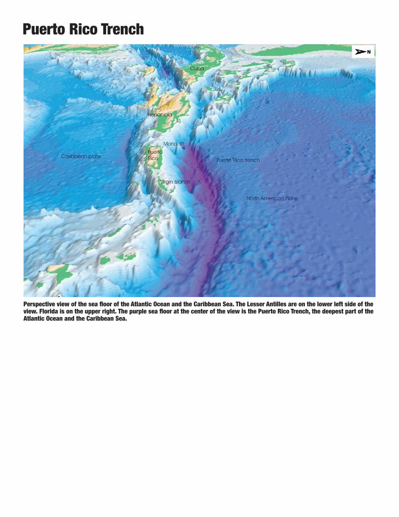
Puerto Rico Trench
Perspective view of the sea floor of the Atlantic Ocean and the Caribbean Sea. The Lesser Antilles are on the lower left side of the view. Florida is on the upper right. The purple sea floor at the center of the view is the Puerto Rico Trench, the deepest part of the Atlantic Ocean and the Caribbean Sea.
Volume 13, Issue 2
An Integrated Curriculum For The Washington Post Newspaper In education Program
October 4, 2013 ©2013 THE WASHINGTON POST
September 18, 2013 FOR IMMEDIATE RELEASE Contact: Liz Smith Director of Communications Ocean Exploration Trust Email: [email protected] Phone: 858-228-7513
Thomas Jefferson High School’s educator Lisa Wu and student Catherine Valery Selected to Explore the Ocean
with Titanic Discoverer Dr. Robert Ballard’s Nautilus Exploration Program
20 Educators at Sea and 27 students will sail aboard E/V Nautilus and other research vessels during 2013 expeditions in the Gulf of Mexico, Caribbean Sea, and Mediterranean Sea
Alexandria VA – Forty-seven educators and students from around the world have been selected from a competitive pool of applicants by the Ocean Exploration Trust (OET) to participate at sea during their 2013 Nautilus Exploration Program. The selected educators and students hail from schools, universities, and science centers in twenty-one states and five countries. They will join the Nautilus Corps of Exploration during ocean expeditions from June through November in the Gulf of Mexico, Caribbean Sea, and Mediterranean Sea. Lisa Wu and Catherine Valery from Thomas Jefferson High School for Science and Technology have been selected as a 2013 Educator at Sea and Honors Research Student and will sail with the Nautilus Exploration Program during their 2013 expedition season. Lisa Wu is the Oceanography & Geophysical Systems Lab Director and marine biology instructor at Thomas Jefferson and Catherine (Katie) is one of her research students this year and will graduate from TJ in June of 2014. They will set sail in October from Puerto Rico exploring the deep waters of the Puerto Rico Trench. “This is a wonderful opportunity to be able to explore science at sea with top scientists and researchers on a ship that embodies the spirit and passion of explorer Dr. Robert Ballard,” said educator, Lisa Wu. “My student, Katie, and I look forward to not only experiencing the adventure but to helping with and contributing to data collection and processing, as well as communicating these discoveries to others both during and after the expedition.” The 2013 educator and student selectees will embark on several expeditions aboard Dr. Robert Ballard’s ship of exploration, E/V Nautilus, and other research vessels off the coast of the United States and Puerto Rico, as well as Montserrat, Cayman Islands, Bahamas, Grenada, Trinidad & Tobago, and Turkey. As members of the Corps of Exploration, educators and students will stand watch alongside scientists and engineers, as well as participate in live interactions with shore-based audiences via Exploration Now. Launched in June, Exploration Now is a 24-hour online portal bringing expeditions from the field to future explorers on shore via telepresence technology. “One of the major goals of our Nautilus Exploration Program is to inspire the next generation of explorers in STEM fields,” said Expedition Leader and OET Vice President, Dr. Katherine Croff Bell, “so we’re

Volume 13, Issue 2
An Integrated Curriculum For The Washington Post Newspaper In education Program
October 4, 2013 ©2013 THE WASHINGTON POST

Volume 13, Issue 2
An Integrated Curriculum For The Washington Post Newspaper In education Program
October 4, 2013 ©2013 THE WASHINGTON POST
World’s largest volcano found beneath PacificExtinct giant covers an area the size of New Mexico
__________________
BY MEERI KIM__________________
• Originally Published September 7, 2013The largest single volcano on Earth
lay quietly hiding in the depths of the Pacific Ocean, about a thousand miles east of Japan, having been extinct for millions of years. Scientists have now discovered the dome-shaped behemoth, which has a footprint the size of New Mexico.
The discovery topples the previous world-record holder for largest volcano — Mauna Loa, one of the five that form the Big Island of Hawaii. The area covered by the newly discovered volcano rivals the biggest volcano in the solar system, Olympus Mons on Mars.
“Olympus Mons is the 800-pound gorilla of the solar system,” said geophysicist William W. Sager of the University of Houston, the study’s lead author. “We didn’t know these massive volcanoes were here on Earth.”
The team named it Tamu Massif. TAMU is the abbreviation for Texas A&M University, Sager’s home institution when he and colleagues first studied the undersea mountain range that contains the giant.
Tamu Massif formed layer by layer as fast-moving lava flowed from a central area at the peak and ran down its flank, cooling in place. The volcano is completely submerged, and Sager doesn’t believe that its peak ever rose above sea level over its 145-million-year lifetime.
A 3-D map of the Tamu Massif volcano. For an Olympus Mons-size volcano to form on Earth, magma must have flowed out extremely quickly in order to keep adding layers before the plates moved away from the hot spot.