tareeg: a mapreduce-based system for extracting …eldawy/publications/tareeg-full-paper.pdf ·...
TRANSCRIPT

TAREEG: A MapReduce-Based System for ExtractingSpatial Data from OpenStreetMap
Louai Alarabi, Ahmed Eldawy, Rami Alghamdi, Mohamed F. Mokbel
Department of Computer Science and Engineering, University of Minnesota, Minneapolis, MN
{louai,eldawy,alghamdi,mokbel}@cs.umn.edu
ABSTRACT
Real spatial data, e.g., detailed road networks, rivers, build-ings, parks, are not easily available for most of the world.This hinders the practicality of many research ideas thatneed a real spatial data for testing and experiments. Suchdata is often available for governmental use, or at major soft-ware companies, but it is prohibitively expensive to buildor buy for academia or individual researchers. This paperpresents TAREEG; a web-service that makes real spatialdata, from anywhere in the world, available at the fingertipsof every researcher or individual. TAREEG gets all its databy leveraging the richness of OpenStreetMap data set; themost comprehensive available spatial data of the world. Yet,it is still challenging to obtain OpenStreetMap data due tothe size limitations, special data format, and the noisy na-ture of spatial data. TAREEG employs MapReduce-basedtechniques to make it efficient and easy to extract Open-StreetMap data in a standard form with minimal effort.Experimental results show that TAREEG is highly accurateand efficient.
Categories and Subject Descriptors
H.2.8 [Database Applications]: Spatial databases andGIS
Keywords
Spatial, MapReduce, Hadoop, GIS, OpenStreetMap
1. INTRODUCTIONThere is a major need to have full access to underlying
real road networks to experiment and evaluate various al-gorithms, which include shortest path queries [14, 28, 35,
∗This work is supported in part by KACST GIS TechnologyInnovation Center at Umm Al-Qura University, under projectGISTIC-13-14, and was done while all the authors were visitingthe center
Permission to make digital or hard copies of all or part of this work forpersonal or classroom use is granted without fee provided that copies are notmade or distributed for profit or commercial advantage and that copies bearthis notice and the full citation on the first page. Copyrights for componentsof this work owned by others than ACM must be honored. Abstracting withcredit is permitted. To copy otherwise, or republish, to post on servers or toredistribute to lists, requires prior specific permission and/or a fee. Requestpermissions from [email protected]’14, November 04 - 07 2014, Dallas/Fort Worth, TX, USACopyright 2014 ACM 978-1-4503-3131-9/14/11$15.00http://dx.doi.org/10.1145/2666310.2666403.
36, 38, 39], k-nearest-neighbor queries [4, 11, 12, 13, 17,19, 37, 40], reverse nearest neighbor query [15, 30], rangequeries [3], skyline query [5, 33], among others (e.g., [16, 32,39]). Unfortunately, it is always challenging to get such realroad network, which imposes a major obstacle in advancingthe research in such algorithms. Usually, researchers either:(a) buy actual and accurate spatial data from specializedcompanies (e.g., NavTeq Here [20]). Yet, this is prohibitivelyexpensive for academia and small startups. (b) share somecommon road network data among themselves, which resultin the case that many research papers use the same roadnetwork data for their evaluation. While this may be usedas a benchmark, but it also limits the applicability of thedeveloped algorithms to a wide variety of road networks, or(c) rely on their own efforts on extracting road networks frompublicly available datasets, e.g., Tiger/Line files [34] (avail-able only for USA road network) and OpenStreetMap [24](available for the whole world).
However, such approach needs a learning curve, which isnot easy for all researchers. In addition, Tiger/Line files [34]are only limited to USA, and hence is of no use to get theroad network anywhere else in the world. To fill in thisgap, OpenStreetMap [24] has been launched in 2004 to al-low volunteers to combine their efforts in building an ex-haustive and trustworthy map for the whole world with anincreased focus given to road networks in a single 500 GB filePlanet.osm. Despite its richness, using OpenStreetMap datais not an easy task due to its huge size and non-standard for-mat. For example, to extract the road network of Istanbul,Turkey, one needs to: (1) understand the XML file formatand its tags, (2) parse the whole 500 GB file to extract onlythe parts within the area of Istanbul, (3) within the ex-tracted parts, parse records carefully to extract the XMLtags that are related to road networks and exclude every-thing else, and (4) overcome the noisy data as many of theOpenStreetMap data are voluntarily contributed.
Several attempts were proposed to extract data fromOpenStreetMap. For example, the GeoFabrik project [8]allows users to download a predefined area from Open-StreetMap, yet it does not provide any kind of extractionof specific map features (e.g., road network). It is basi-cally a range query service over existing data without anyattempt to read the noisy format. Also, osmosis [26] andosm2pgsql [25] are two proposed tools that attempt to pro-cess the whole Planet.osm by loading it on spatial databases.However these tools may take up to several days for loadingthe entire Planet.osm file. For instance, in [18], the authorsreport that they spent 305 hours (approximately 12 days) for

loading and extracting the data for their experiments. In an-other benchmark of osm2pgsql, importing the Planet.osm
to database takes up to 7 days of processing [25].In this paper, we present TAREEG; an easy and effi-
cient system to extract spatial data from OpenStreetMap.TAREEG is set up as an online web service available 24/7at [31]. An initial version of TAREEG has been demon-strated in SIGMOD 2014 [1]. Unlike all previous approaches,TAREEG overcomes the challenges of processing Open-StreetMap dataset (i.e., Planet.osm) with a high accuracy,efficiency, and performance. Users of TAREEG can: (1) ex-tract geographical information for anywhere in the world us-ing a nicely designed web service, (2) export the extracteddata in various data formats that include Comma SeparatedValues (CSV), Keyhole Markup Language (KML), EsriShapefiles, and/or Well-known-Text (WKT) formats and(3) visualize the extracted geographical data on TAREEGusing four different mapping engines, which include Open-StreetMap, Google Maps, Google Hybrid Maps, and EsriMaps. All TAREEG services are made available online 24/7at [31] to the community in large to give a full access tospatial data. Available spatial data does not only includeall road networks in the whole world, but also other spatialfeatures (e.g., lakes, buildings, rivers, and parks). The re-quested data are sent back to the requesting user in a formof an email with hyperlinks to download the requested datain different formats. The turnaround time to send the re-quested data back to the users highly depends on the sizeof the requested data. Yet, it is always a a matter of fewseconds for city level requests.
TAREEG is composed of the following four main module(1) The Data Extraction module, which runs on a weeklybasis to download a 500 GB file from OpenStreetMap, ex-tracts its spatial features, and cleans its noisy data, (2) TheIndexing module, which runs right after the Data Extrac-
tion module to index the extracted data using an R-tree-like indexing technique over multiple machines as a meansfor achieving scalability, (3) The Query Processor module,which receives the user requests for obtaining spatial data,converts the request to a range query with the user specifiedarea and a predicate filter for the spatial feature, and fi-nally exploits the R-tree-like index structure to retrieve therequested data in an efficient way, and (4) The Front-end
Visualizer module, which is a nicely designed web interfacethat allows users to express their data requests, calls theQuery Processor module for execution, sends an email to theusers with links to the requested data and finally visualizethe extracted data on various mapping engines that includeGoogle Maps, Google Hybrid Maps, OpenStreetMap, andEsri Maps.
The efficiency and scalability of TAREEG is mainly dueto the fact that it leverages the power of MapReduce-basedprocessing. In particular, TAREEG is powered by Spatial-Hadoop [6]; an extended MapReduce framework that dealsefficiently with spatial data. TAREEG takes advantage ofSpatialHadoop and its distributed nature, along with largenumber of machines, in the following: (1) each machine in-dependently downloads part of the OpenStreetMap data,efficiently parses its own part, and extracts the spatial fea-tures from its share of the data, (2) TAREEG uses theindexing capabilities of SpatialHadoop to partition the ex-tracted data on multiple computing nodes (machines) us-ing a spatial index partitioning scheme, and (3) Satisfy-
<?xml version="1.0" encoding="UTF-8"?><osm version="0.6"/>
<node id="1" lat="21.4219827" lon="39.8336534">
<tag k="traffic" v="light"/></node>
<node id="2" lat="21.4221823" lon="39.8331833"><tag k="highway" v="motorway_junction"/>
</node>. . .<way id="6">
<nd ref="1"/><nd ref="2"/>
<tag k="highway" v="service"/></way><way id="8">
<nd ref="4"/><nd ref="5"/>
<tag k="type" v="multipolygon"/></way>
. . .<relation id="2">
<member type="relation" ref="1" role="inner"/>
<member type="way" ref="6" role="inner"/><tag k="highway" v="primary"/>
</relation>. . .
</osm>
Figure 1: OpenStreetMap Data Format.
ing the user requests is done through a querying enginethat exploits the partitioned data over multiple nodes doneby SpatialHadoop. As a result, downloading and indexingthe whole OpenStreetMap (a weekly offline process) takesfew hours in TAREEG instead of few days if done withoutthe MapReduce-based way in TAREEG. Also, querying thewhole dataset to satisfy user requests takes few seconds inTAREEG instead of hours if done in a traditional way.
The rest of this paper is organized as follows: Section 2gives a brief background about OpenStreetMap. Section 3gives system overview of TAREEG. The main modules ofTAREEG, Data Extraction, Indexing, Query Processing,and Front-end Visualization are described in Sections 4, 5,6, and 7, respectively. Experimental evaluation is presentedin Section 8. Finally, Section 10 concludes the paper.
2. OVERVIEW OF OPENSTREETMAPOpenStreetMap (OSM) [24], lunched in 2004, is a col-
laborative community project to create a free editable mapof the world. It is considered as the Wikipedia project formaps, where the community can help in building the mapsaround the world. OpenStreetMap has over 1.6 million reg-istered users, where around 30% of them have made actualcontributions to the maps [21]. As it stands now, Open-StreetMap has a very high accuracy [10] that is compara-ble to proprietary datasources [10]. OpenStreetMap wholeworld dataset is free and accessible as an XML 500 GB filecalled Planet.osm, updated on weekly basis.
Figure 1 gives a snippet of the Planet.osm XML file.The file consists of the following three primitive data types:(1) Node, which is defined as a point in the space associatedwith a node identifier, latitude and longitude coordinates,(2) Way, which represents a line between two nodes, andassociated with the way identifer and the two nodes iden-tifers of the two end points of the line. The line could besimply a road segment, part of a boundary of a building,city/country boundary, or part of a lake contour, (3) Rela-
tion, which represents the relation between nodes, ways, oreven other relation, and is used to express polygons. For ex-ample, to express the boundaries of a certain lake, the nodes

planet.osm
Data Extraction
Query
User
Result
Front-End
Roads LakesParks
Automatic Updater
Map-Reduced
Extractor
Indexing
Spatial Indexer
Spatial
Index
Query Processing
Web-Based Front-
End and Visualizer
Query Processor
Query
RequestResult
Figure 2: System Overview
need to be defined, then the ways that connect nodes to eachother, then a relation that connects the ways together to ex-press the lake boundary. As the dataset is contributed bydifferent volunteers, one lake may be expressed in variousrelations that could be separated or nested (e.g., a relation
inside a relation), where each relation is composed of eitherways or nodes. For example, one lake is composed of twoseparate relations X and Y . Relation X includes a set ofways that form part of the lake, while relation Y is composedon one way and a relation Z. Then, relation Z is composedof a set of ways that form other part of the lake. Together,relations X, Y , and Z form the whole shape of the lake.
Each of the three primitive data types node, way, and re-
lation is associated with a set of tags. A tag is basicallya (key, value) pair that gives extra information about theprimitive data type. Unlike the three basic primitives, tagsare not predefined, where volunteers can add new tags andmodify existing one. This makes OpenStreetMap data noisywith non-standard tags. In TAREEG, we have experiencedseveral tags that are misinterpreted by volunteers. For ex-ample, some volunteers added a skyway as road networkbridge and vice versa.
3. SYSTEM OVERVIEWFigure 2 gives TAREEG system overview. TAREEG is
set up as an online web service available 24/7 at [31] to re-ceive user requests of obtaining certain kind of spatial datafrom anywhere in the world. From inside, TAREEG is com-posed of four main modules, namely, Data Extraction, In-dexing, Query Processor, and Front-End Visualizer, brieflydiscussed below:
Data Extraction. This module runs as a backgroundprocess that wakes up on a weekly basis to download a500 GB file Planet.osm from OpenStreetMap, extracts itsspatial features, and cleans its noisy data. This module alsoclassifies the extracted data into separate files, each repre-sents one kind of spatial data, e.g., parks, road, or lakes.This module faces two main challenges: (1) The large vol-ume of the dataset and (2) the noisy dataset coming fromusing non-standard tags. Details of the Data Extraction
module are presented in Section 4.Indexing. This module runs immediately after the Data
Extraction module to index the extracted data. Hence, it isalso a background process runs on a weekly basis to index thenew downloaded data. Given the large size of the extracteddata, TAREEG leverages SpatialHadoop [6] to partition andindex the extracted data over a set of computing nodes inan R-tree-like way. It is important to note that each typeof spatial data (e.g., parks, roads, and lakes) are partitionedand indexed separately. Hence, there will be one index des-
ignated for road network data over all available computingnodes, while another completely separate index will be des-ignated for lakes data, and so on. Details of the Indexing
module are presented in Section 5.Query Processor. This module receives the user re-
quests for obtaining spatial data, converts the request toa range query with the user specified area and a predi-cate filter for the spatial feature (e.g., road network, lakes),and finally exploits the R-tree-like index structure to re-trieve the requested data in an efficient way. In this mod-ule, TAREEG Takes advantage of the fact that the Index-
ing module has partitioned the extracted data into multiplecomputing nodes to execute its range query over multiplenodes in parallel. Hence, an efficient query processing canbe achieved. Details of the Query Processing module arepresented in Section 6.
Front-End Visualizer. This module is basically a nicelydesigned web interface that allows users to express their datarequests, calls the Query Processor module for execution,sends an email to the users with links to the requested data,and finally visualize the extracted data on various mappingengines that include Google Maps, Google Hybrid Maps,OpenStreetMap, and Esri Maps. This module is also respon-sible on producing the output data in various formats thatinclude Comma Separated Values (CSV), Keyhole MarkupLanguage (KML), Esri Shapefiles, and/or Well-known-Text(WKT). Users can also upload their extracted data any timeto just visualize it on TAREEG. This also helps in checkingthe accuracy of the extracted data as it can be contrasted toa ground truth from Google maps and other mapping ser-vices, available in TAREEG. Details of front-end visualizer
module are presented in Section 7.
4. DATA EXTRACTIONExtracting information from OpenStreetMap is not a triv-
ial task. The whole OpenStreetMap dataset is stored se-quentially in one large volume file in a semi-structured XMLformat. The XML file starts with nodes, then ways, and fi-nally, relations, while tags are nested in each of these datatypes. A main challenge in extracting information fromOpenStreetMap is identifying the annotations (i.e., tags)that imply categorized spatial data.
The Data Extraction module in TAREEG basically trig-gers a script that runs weekly to execute two map-reducejobs, which take the URL of the compressed Planet.osm fileas an input, and outputs several categorized files. Each out-put file contains a homogeneous spatial set of information,e.g., road network data will be stored in one file and lakesin another one, and so on. The first map-reduce job is con-cerned with spatial features in a form of points and limes,e.g., road network and rivers, while the second map-reducejob is concerned with spatial features in a from of polygons,e.g., lakes, parks, and building. In the rest of this section,we will discuss each map-reduce job separately.
4.1 Line-based Data ExtractorTo extract line-based data, e.g., road network and rivers,
TAREEG runs a map-reduce job with three main compo-nents, namely, splitter, record reader, and mapper, describedbelow.
4.1.1 Splitter
The splitter component breaks the input file Planet.osm

Algorithm 1: Line-based Extractor-Record Reader
Input : Split SOutput: Position of last byte Key , Primitive OSM
element Value
1 Record reader R;2 Element e ;3 End byte end ← S length;4 Current byte position ← 0;
5 while R has next OR e has child do
6 line ← R line read by record reader;7 position ← number of read byte;8 if line is a root e then
9 Value ← append line;10 if e doesn’t have child then
11 Key ← set position;12 return Value;
13 else if e has child then
14 Value ← append line;15 if line is end of root e then
16 return Value;
17 else
18 e doesn’t have child And position > end
19 return Null;
into chunks of size 64 MB (the default block size in HDFS).Since the file is compressed in a block zip format, it is possiblethat each chunk is downloaded and decompressed separatelyto extract part of the XML file. Such splitting may causeinconsistent XML structures in each split, which is handledlater by the Record Reader. Thus, splitting the Planet.osm
will parallelize and distribute the processing load into severalmap tasks, which is much faster than processing on a singlenode machine.
4.1.2 Record Reader
The default record reader in Hadoop processes text filesline-by-line, so we can not process the data of Planet.osminline. Due to the inconsistent representation of each split,we implemented an XML element reader instead of the de-fault line reader provided by Hadoop framework. The out-put of this component is an XML element, which will besent later to the mapper. In addition, record reader is re-sponsible on completing inconsistent elements in each split.To elaborate more, if a split has some missing informationabout one concise type (i.e., spatial feature) such as build-
ings, the record reader will fetch these missing informationfrom the next split. Then the element(s) are passed to themapper. Therefore, when the next split is being processedby the Record Reader, the head of the inconsistent element
will be ignored, as it has been already processed and sent tothe mapper with the previous split.
Algorithm. Algorithm 1 presents the pseudo code ofthe Record Reader, where we process each split and returna structured XML elements as a result. Since processingsplits are parallelized and distributed into several mappertask, we need to keep track of the last byte processed bythe record reader. First, an XML Element that stores theresult, and the current end byte position are initialized (lines
1-4). Each processed split consists of a number of lines. Weiterate split lines one by one, while tracking the last positionof the iterated line (lines 6-7). The last byte position will bereturned in the result with the compact XML elements. Theiterated line will be appended to the result if it is part ofthe compact element type (i.e., OpenStreetMap data type),otherwise, if the iterated line exceeds the split length andelement does not have a root XML element, then it will beignored (lines 8-18). While processing a split, there couldbe one of the following three possibilities:
1. Compacted element: Append the line that consistsof concise XML element e , where e has root of anXML, and it does not have any nested elements e′. Inother words, if the iterated line represents a full semi-structured OpenStreetMap element (i.e., nodes, ways,relations), then line will be reported to the result andno more lines need to be processed (lines 8-12). For ex-ample, if we have node information stored in one line,and this node does not have any associated tags.
2. Semi-compacted element: If the split contains the rootof an element e, with either closing tag not found inthe same split, or the same line. The Record Reader
will iterate more lines from the same split or next splituntil closing tag of the root element e found (lines 13-16). For instance, if iterated line begins with Open-StreetMap way information. This way information ex-tends into several lines. Record Reader will iterate linestill it finds the end tags of that way.
3. Uncompacted element: Ignoring iterated lines if it doesnot have a root element e. The main reason for ignor-ing lines is that these lines must be processed with theprevious split (line 17). For example, if split beginswith subset of a way followed by a relation, then rela-tion lines will be reported in the result. On the otherhand, way information will be ignored.
4.1.3 Mapper
This component receives elements sent by the Record
Reader and classifies each element based on its annotation(i.e., tags). Then, it extracts and writes the results into sep-arate files, based on the spatial feature of the extracted data.These spatial features are stored randomly as a set of nodesN , which consists of N = {node id, longitude, latitude,tags} and another set of extracted spatial features R thatconsists of R = {edge id, node1 id, node2 id, tags}. Themain challenge of the mapper is how to deal with extract-ing spatial features from the noisy dataset. For example,in TAREEG, we have experienced many misinterpreted an-notations (i.e., tags) used to describe a downtown skyway,while it is has other tags that are related to road networks.Also in other cases, some tags are used to describe tunnel ina road network, while in a map matching, it shows that it isa tunnel between two buildings. TAREEG mapper handlesthis kind of noise data by studying carefully each spatialfeature tags and filters tags on the fly while data is passedto the mapper by the Record Reader.
Algorithm. Algorithm 2 gives the pseudo code of themapper. Once primitive XML elements received from Record
Reader, theMapper will process this element. Mapper classi-fies primitive elements by checking the associated tags witheach element. XML element could be either compact ele-ment or semi-compact element. Therefore, mapper writes
Algorithm 2: Line-based Extractor-Mapper
Input : Primitive Elements
Output: geographical data File
1 Event reader R;2 while R has next element e do
3 type flag of classification;4 if e is start element then
5 CategorizeElementFeature() → Get elementannotation;
6 if e is end element then
7 File type ← Write classified data;
8 return geographical data File
the classification of the processed element once the wholeelement is being categorized based on its annotation (i.e.,tags).
The Result of the Mapper is a set of files, each file repre-sents a relation R that has a specific spatial feature. We usePig [2] to combine the extracted data in R with its spatialinformation (i.e., geolocation) from nodes N in a way similarto the join operation in any relational database. The out-put of the Pig map-reduce program is a spatial set R′ thatconsists of R′ = {edge id, node1 id, longitude1, latitude1,node2 id, longitude2, latitude2, tags}. Each record r′ ∈ R′
is now associated with the corresponding geo-location. Yet,R′ is neither sparsely nor spatially stored in Hadoop Dis-tributed File System (HDFS).
4.2 Polygon-based Data ExtractorThis section discusses the second Map-Reduce job run by
the Data Extraction module to extract polygon data, e.g.,lakes, buildings, and parks.
The line-based extractor described above works well forextracting some datasets such as road networks and rivers.However, other datasets contained in the Planet.osm filesuch as lakes and buildings are better represented in terms ofprimitive geometric shapes such as polygons and line strings.
Therefore, TAREEG provides this polygon-based extrac-tor, which extracts datasets as objects. Each object is rep-resented by a triple (id, geometry, tags), where id is a uniqueidentifier, geometry is the geometric shape and tags are theassociated tags as a list of 〈 key, value〉 pairs. In additionto the large size and non-standard format of Planet.osm file,there are additional challenges which face the polygon-basedextractor. First, the spatial attribute (i.e., location) is onlyincluded in the nodes section of the Planet.osm file whileother attributes (i.e., ID and tag) are in other sections. Sec-ond, depending on the size and complexity of the geometricshape, an object (e.g., lake) might be located in the nodessection (simplest), in the ways section (complex) or in therelations section (very complex). The data from the threesections must be unified and merged in order to generateone output file.
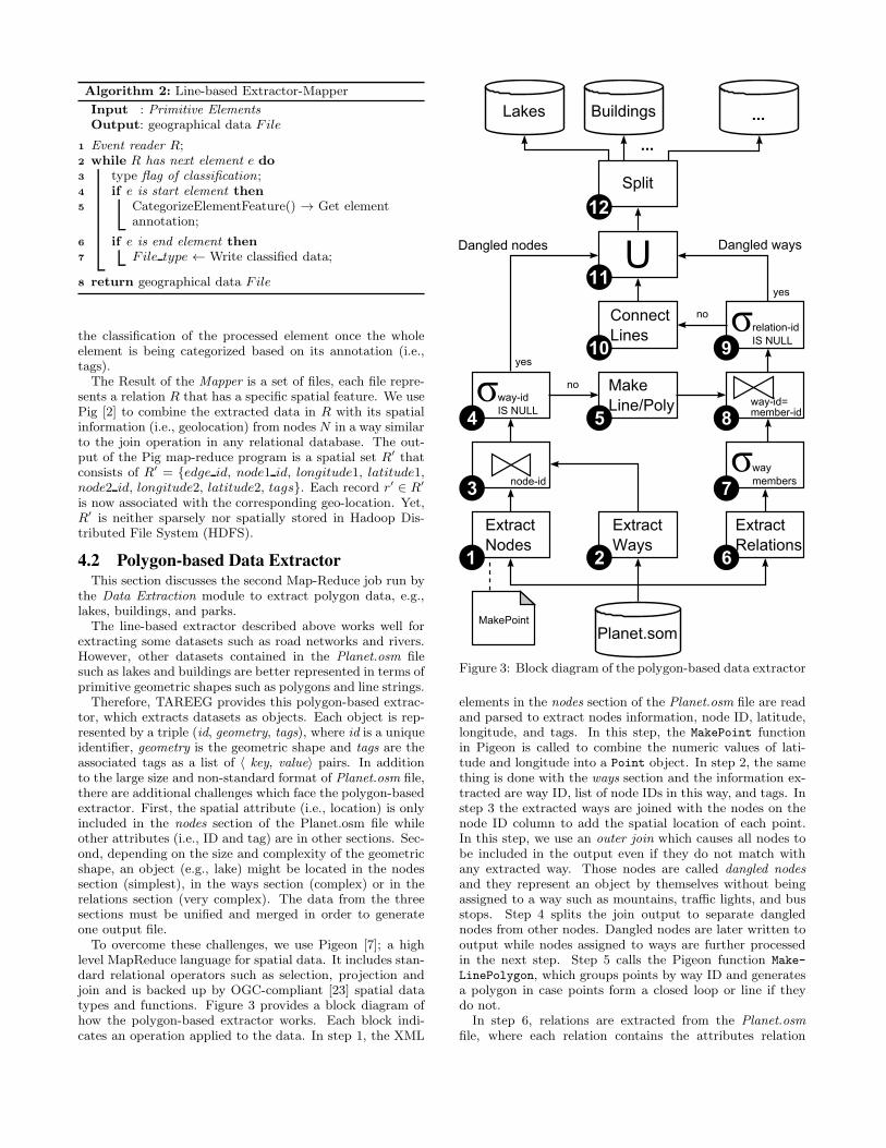
To overcome these challenges, we use Pigeon [7]; a highlevel MapReduce language for spatial data. It includes stan-dard relational operators such as selection, projection andjoin and is backed up by OGC-compliant [23] spatial datatypes and functions. Figure 3 provides a block diagram ofhow the polygon-based extractor works. Each block indi-cates an operation applied to the data. In step 1, the XML
Planet.som
Extract
Nodes
Extract
Ways
node-id
Make
Line/Poly
Extract
Relations
way
members
way-id=member-id
Connect
Lines
way-id
IS NULL
relation-id
IS NULL
UDangled nodes Dangled ways
no
yes
no
1 2
7
6
54
3
910
11
MakePoint
8
yes
Split
12
...
BuildingsLakes ...
Figure 3: Block diagram of the polygon-based data extractor
elements in the nodes section of the Planet.osm file are readand parsed to extract nodes information, node ID, latitude,longitude, and tags. In this step, the MakePoint functionin Pigeon is called to combine the numeric values of lati-tude and longitude into a Point object. In step 2, the samething is done with the ways section and the information ex-tracted are way ID, list of node IDs in this way, and tags. Instep 3 the extracted ways are joined with the nodes on thenode ID column to add the spatial location of each point.In this step, we use an outer join which causes all nodes tobe included in the output even if they do not match withany extracted way. Those nodes are called dangled nodes
and they represent an object by themselves without beingassigned to a way such as mountains, traffic lights, and busstops. Step 4 splits the join output to separate danglednodes from other nodes. Dangled nodes are later written tooutput while nodes assigned to ways are further processedin the next step. Step 5 calls the Pigeon function Make-
LinePolygon, which groups points by way ID and generatesa polygon in case points form a closed loop or line if theydo not.
In step 6, relations are extracted from the Planet.osm
file, where each relation contains the attributes relation
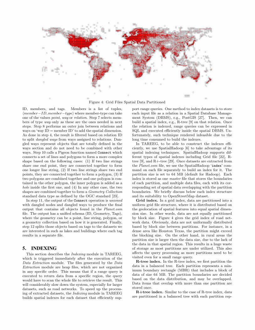
Figure 4: Grid Files Spatial Data Partitioned
ID, members, and tags. Members is a list of tuples,〈member−ID,member−type〉where member-type can takeone of the values point, way or relation. Step 7 selects mem-bers of type way only as these are the ones needed in nextsteps. Step 8 performs an outer join between relations andways on ‘way ID =member ID’ to add the spatial dimension.As done in step 4, the result is filtered based on relation IDto split dangled ways from ways assigned to relations. Dan-gled ways represent objects that are totally defined in theways section and do not need to be combined with otherways. Step 10 calls a Pigeon function named Connect whichconnects a set of lines and polygons to form a more complexshape based on the following cases: (1) If two line stringsshare one end point, they are connected together to formone longer line string, (2) If two line strings share two endpoints, they are connected together to form a polygon, (3) Iftwo polygons are combined together and one polygon is con-tained in the other polygon, the inner polygon is added as ahole inside the first one, and (4) In any other case, the twoshapes are combined together to form a Geometry Collection
standard data type as defined by the OGC standard [23].In step 11, the output of the Connect operation is unioned
with dangled nodes and dangled ways to produce the finaloutput that contains all objects found in the Planet.osm
file. The output has a unified schema (ID, Geometry, Tags),where the geometry can be a point, line string, polygon, ora geometry collection based on how it is generated. Finally,step 12 splits those objects based on tags to the datasets weare interested in such as lakes and buildings where each tagresults in a separate file.
5. INDEXINGThis section describes the Indexing module in TAREEG,
which is triggered immediately after the execution of theData Extraction module. The files generated by the Data
Extraction module are heap files, which are not organizedin any specific order. This means that if a range query isexecuted to return data from a specific region, the querywould have to scan the whole file to retrieve the result. Thiswill considerably slow down the system, especially for largerdatasets, such as road networks. To speed up the process-ing of extracted datasets, the Indexing module in TAREEGbuilds spatial indexes for each dataset that efficiently sup-
port range queries. One method to index datasets is to storeeach input file as a relation in a Spatial Database Manage-ment System (DBMS), e.g., PostGIS [27]. Then, we canbuild a spatial index, e.g., R-tree [9] on that relation. Oncethe relation is indexed, range queries can be expressed inSQL and executed efficiently inside the spatial DBMS. Un-fortunately, such technique rendered infeasible due to thelong time consumed to build the indexes.
In TAREEG, to be able to construct the indexes effi-ciently, we use SpatialHadoop [6] to take advantage of itsspatial indexing techniques. SpatialHadoop supports dif-ferent types of spatial indexes including Grid file [22], R-tree [9], and R+-tree [29]. Once datasets are extracted fromthe Planet.osm file, we use the SpatialHadoop ‘index’ com-mand on each file separately to build an index for it. Thepartition size is set to 64 MB (default for Hadoop). Eachindex is stored as one master file that stores the boundariesof each partition, and multiple data files, each with its cor-responding set of spatial data overlapping with the partitionboundaries. We briefly discuss below each index structureand its suitability to OpenStreetMap dataset.
Grid index. In a grid index, data are partitioned into auniform grid file structure, where it is distributed based onthe geolocation of spatial features into equal spatial dimen-sion size. In other words, data are not equally partitionedby block size. Figure 4 gives the grid index of road net-work data. Obviously, data are not uniformally distributedbased by block size between partitions. For instance, in adense area like Houston Texas, the partition might exceedthe blocking size. On the other hand, in rural areas thepartition size is larger then the data size, due to the lack ofthe data in that spatial region. This results in a huge wasteof storage as most partitions are under utilized. This alsoaffects the query processing as more partitions need to bevisited even for a small range query.
R-tree index. In the R-tree index, we first partition thedata in a balanced tree. Each partition represents a min-imum boundary rectangle (MBR) that includes a block ofdata of size 64 MB. The partition boundaries are decidedbased on the data distribution, and may be overlapped.Data items that overlap with more than one partition arestored once.
R+tree index. Similar to the case of R-tree index, dataare partitioned in a balanced tree with each partition rep-

Figure 5: R+tree Spatial Data Partitioned
resenting a minimum boundary rectangle of a set of pointsof size 64 MB. The only difference is that the partitions inthe R+-tree are not overlapped. Hence, one object may bestored with all the partitions it overlaps with.
Figure 5 gives the main reason behind the efficiency ofspatial data indexing and querying in TAREEG. The fig-ure shows an R+-tree partitioning scheme for the wholeroad network file. All road networks are depicted in bluelines, while the black rectangles indicate partition bound-aries. While some road segments cross multiple partitions,partition boundaries remain disjoint due to the properties ofthe R+-tree. As each partition is sufficient for ONLY 64 MBworth of data, we can see that dense areas (e.g., Europe) arecontained in very small partitions, while sparse areas (e.g.,oceans) are contained in very large partitions. One wayto look at this figure is that this is the way that Spatial-Hadoop divides a dataset of 500 GB into small chunks, eachof 64 MB. Recall that in Hadoop, this 500 GB file will bedivided into chunks of 64 MB as sequential heap file, whichdefinitely does not fit spatial operations.
6. QUERY PROCESSINGQueries sent to TAREEG are basically range queries that
request extracting a certain type of spatial data (e.g., roadnetworks, lakes, buildings, borders) within a certain areaof interest, presented as a rectangular area. When a rangequery is sent to TAREEG, it first executes that query on themaster file to retrieve partitions that overlap with the rangequery. For each matching partition, the records in the corre-sponding data file are compared to the query range and allmatching records are stored as part of the answer. If match-ing records lie in more than one data partition, TAREEGexploits the parallelism of computing nodes to execute thequery simultaneously on different partitions. Since in R+-tree some records overlapping multiple partitions are repli-cated, a post processing duplicate avoidance step is executedto ensure the correctness of the answer as described in [6].
7. SYSTEM FRONT-ENDThe system front-end provides a set of tools for users
to extract and visualize their requested spatial data. AsTAREEG is deployed as 24/7 online web service, it is de-signed for simplicity, where user can extract, download,
and visualize the spatial features. The system front-end ofTAREEG consists of two main modules: (1) Data extraction
request, where users can submit extraction requests throughnicely designed web interface, by selecting any arbitrary re-gion of world map and the type of spatial data they want toextract. (2) Spatial data download and visualization, whereusers can download and visualize exported data on eitherOpenStreetMap, Google Maps, Google Hybrid Maps (i.e.,hybrid satellite images with labels), and Esri Maps (i.e Na-tional Geographic map).
7.1 Spatial Data Extraction RequestInitially, users interact with TAREEG system by request-
ing different spatial data types as shown in Figure 6a, follow-ing few steps: (1) the user selects any arbitrary region fromthe world map, either by zooming and draging the map tothe geographical area of interest, or by searching the area ofinterest using the search bar, (2) the user specifies a bound-ary rectangle of the selected region, (3) the user provides anemail address, in which TAREEG will send an email whenthe request is satisfied with links to download the requesteddata, and (4) the user submits the request by hitting the‘Extract button’.
Once a request is received, TAREEG processes this re-quest by querying the requested spatial data from the back-end of the system, and notifies the requester through emailonce the data is available. It is important to note here thatall requests to TAREEG are satisfied from its own local data,as there is no need to contact OpenStreetMap servers, andhence requests are usually satisfied within a few seconds.Once the requested data is available, the user will receivean email from TAREEG with hyperlinks to download therequested data. The time of processing the request dependson the size of the selected region and complexity of the re-quested dataset.
7.2 Spatial Data Download & VisualizationTAREEG users receive their extracted data in four com-
mon standard formats, a Comma Separated Values (CSV)files, a Keyhole Markup Language (KML), Esri shape files,and Well-Know Text (WKT) formats. TAREEG only sup-ports visualizing (CSV) format, where others can be alreadyvisualized through various applications (e.g., QGIS, GoogleEarth, and Esri ArcGIS). The CSV format has the following
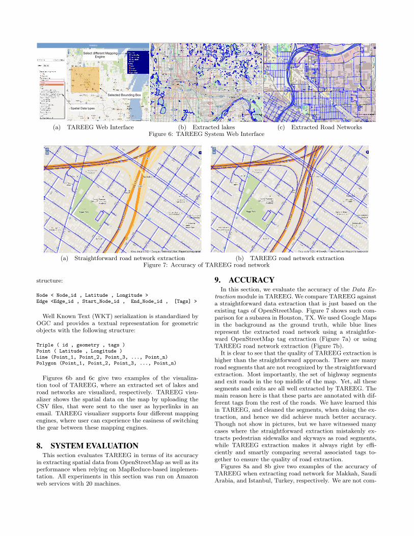
(a) TAREEG Web Interface (b) Extracted lakes (c) Extracted Road NetworksFigure 6: TAREEG System Web Interface
(a) Straightforward road network extraction (b) TAREEG road network extractionFigure 7: Accuracy of TAREEG road network
structure:
Node < Node_id , Latitude , Longitude >Edge <Edge_id , Start_Node_id , End_Node_id , [Tags] >
Well Known Text (WKT) serialization is standardized byOGC and provides a textual representation for geometricobjects with the following structure:
Triple ( id , geometry , tags )Point ( Latitude , Longitude )Line (Point_1, Point_2, Point_3, ..., Point_n)Polygon (Point_1, Point_2, Point_3, ..., Point_n)
Figures 6b and 6c give two examples of the visualiza-tion tool of TAREEG, where an extracted set of lakes androad networks are visualized, respectively. TAREEG visu-alizer shows the spatial data on the map by uploading theCSV files, that were sent to the user as hyperlinks in anemail. TAREEG visualizer supports four different mappingengines, where user can experience the easiness of switchingthe gear between these mapping engines.
8. SYSTEM EVALUATIONThis section evaluates TAREEG in terms of its accuracy
in extracting spatial data from OpenStreetMap as well as itsperformance when relying on MapReduce-based implemen-tation. All experiments in this section was run on Amazonweb services with 20 machines.
9. ACCURACYIn this section, we evaluate the accuracy of the Data Ex-
traction module in TAREEG.We compare TAREEG againsta straightforward data extraction that is just based on theexisting tags of OpenStreetMap. Figure 7 shows such com-parison for a subarea in Houston, TX. We used Google Mapsin the background as the ground truth, while blue linesrepresent the extracted road network using a straightfor-ward OpenStreetMap tag extraction (Figure 7a) or usingTAREEG road network extraction (Figure 7b).
It is clear to see that the quality of TAREEG extraction ishigher than the straightforward approach. There are manyroad segments that are not recognized by the straightforwardextraction. Most importantly, the set of highway segmentsand exit roads in the top middle of the map. Yet, all thesesegments and exits are all well extracted by TAREEG. Themain reason here is that these parts are annotated with dif-ferent tags from the rest of the roads. We have learned thisin TAREEG, and cleaned the segments, when doing the ex-traction, and hence we did achieve much better accuracy.Though not show in pictures, but we have witnessed manycases where the straightforward extraction mistakenly ex-tracts pedestrian sidewalks and skyways as road segments,while TAREEG extraction makes it always right by effi-ciently and smartly comparing several associated tags to-gether to ensure the quality of road extraction.
Figures 8a and 8b give two examples of the accuracy ofTAREEG when extracting road network for Makkah, SaudiArabia, and Istanbul, Turkey, respectively. We are not com-

(a) Makkah TAREEG road network (b) Istanbul TAREEG road networkFigure 8: Accuracy of TAREEG road network
Figure 9: Extraction time
paring here against the straightforward extraction, as wewill end up having similar accuracy as that of Figure 7. Thepurpose of this experiment is just to shows the quality ofTAREEG road extraction in various cities around the world.
9.1 PerformanceThis section discusses the performance of index building,
data extraction, and querying time in TAREEG.
9.1.1 Data Extraction
Figure 9 compares the extraction time of TAREEG (usingMapReduce) with the extraction time of a single-machineprocess (centralized) and using a traditional spatial database(PostGIS [27]), for different data sets with different sizesstarting from a small data set with only Central America tothe whole data set of the planet. In all cases, TAREEG isconsistently superior than other techniques with at least oneorder of magnitude better performance. For example, for thewhole planet, it takes about two hours from TAREEG to doall the extraction in high accuracy, however, it takes morethan a whole day from PostGIS and centralized processingto extract the same data. In fact, in many cases, we had tokill and rerun the experiment for PostGIS, as in sometimesthe experiment goes forever without finishing.
9.1.2 Index Building
Table 10 compares the usage of three indexing techniques,Grid file, R-tree, and R+-tree for spatial data indexing inTAREEG. The three indexing structures have similar build-
- Grid File R-tree R+treeBuild index (sec) 674 601 690# number of partition 3559 10654 10583Avg Partitionsize (MB) 38.5 12.8 12.9
Figure 10: Index Evaluation of Road Network
ing time in the order of 600 seconds. However, it is clear thatboth R-tree and R+-tree have higher number of partitionsthan that of the grid structure. This goes in favor for thetree indexing for two main reasons: (1) Higher number ofpartitions means that the incoming query can be better donein parallel over the 20 machines we have, and (2) Wheneverreading from a partition, we only read a small set of datathat is relevant to the query we have. This is in contrast tolarge-sized partitions that result in reading a lot of redun-dant data.
In TAREEG, we opt for using R+-tree index as it hasa similar performance to R-tree, yet, it ensure that parti-tions are not overlapping, which is a property we need whendealing with MapReduce environment. Meanwhile, R+-treegives way much performance better query processing thanthat of a gird structure.
10. CONCLUSIONThis paper presents TAREEG; a web-service that makes
real spatial data, from anywhere in the world, available atthe fingertips of every researcher or individual. TAREEGgets all its data by leveraging the richness of OpenStreetMapdataset; the most comprehensive available spatial data ofthe world. Yet, it is still challenging to obtain Open-StreetMap data due to the size limitations, special data for-mat, and the noisy nature of spatial data. TAREEG em-ploys MapReduce-based techniques to make it efficient andeasy to extract OpenStreetMap data in a standard form withminimal effort through four main components. Data Extrac-
tion. is responsible for extracting spatial data and clean thenoise data. Data Indexing. where each spatial feature is in-dexed spatially with high efficiency. Query processor. thatreceives the user requests for obtaining spatial data, andconverts the request to a range query with the user speci-fied area and a predicate filter for the spatial feature (e.g.,road network, lakes). and Finally, visualization a nicely de-signed web interface that allows users to express their datarequests. Experimental results show that TAREEG is highlyaccurate and efficient in terms of the time taken to satisfydata extraction of user requests.

11. REFERENCES
[1] L. Alarabi, A. Eldawy, R. Alghamdi, and M. F.Mokbel. TAREEG: A MapReduce-Based Web Servicefor Extracting Spatial Data from OpenStreetMap(System Demonstration). In SIGMOD, pages 897–900,Snowbird, UT, June 2014.
[2] Apache pig. http://pig.apache.org/.
[3] Z. Chen, Y. Liy, R. C.-W. Wong, J. Xiong, G. Mai,and C. Long. Efficient algorithms for optimal locationqueries in road networks. In SIGMOD, 2014.
[4] Z. Chen, H. T. Shen, X. Zhou, and J. X. Yu.Monitoring path nearest neighbor in road networks. InSIGMOD, pages 591–602, 2009.
[5] K. Deng, X. Zhou, and H. T. Shen. Multi-sourceskyline query processing in road networks. In ICDE,pages 796–805, 2007.
[6] A. Eldawy and M. F. Mokbel. A Demonstration ofSpatialHadoop: An Efficient MapReduce Frameworkfor Spatial Data (System Demo). In VLDB, Riva delGarda, Italy, Aug. 2013.
[7] A. Eldawy and M. F. Mokbel. Pigeon: A spatialmapreduce language. In ICDE, pages 1242–1245, 2014.
[8] Geo fabrik. http://download.geofabrik.de/.
[9] A. Guttman. R-Trees: A Dynamic Index Structure forSpatial Searching. In SIGMOD, pages 47–57, 1984.
[10] M. Haklay. How good is Volunteered GeographicalInformation? A Comparative Study ofOpenStreetMap and Ordnance Survey Datasets.Environment and Planning B: Planning and Design,37(4):682–703, 2010.
[11] L. Hu, Y. Jing, W.-S. Ku, and C. Shahabi. Enforcingk nearest neighbor query integrity on road networks.In SIGSPATIAL GIS, pages 422–425, 2012.
[12] C. S. Jensen, J. Kolarvr, T. B. Pedersen, andI. Timko. Nearest neighbor queries in road networks.In SIGSPATIAL GIS, pages 1–8, 2003.
[13] Y. Jing, L. Hu, W.-S. Ku, and C. Shahabi.Authentication of k nearest neighbor query on roadnetworks. TKDE, 26(6):1494–1506, 2014.
[14] C.-C. Lee, Y.-H. Wu, and A. L. P. Chen. Continuousevaluation of fastest path queries on road networks. InSSTD, pages 20–37, 2007.
[15] G. Li, Y. Li, J. Li, L. Shu, and F. Yang. Continuousreverse k nearest neighbor monitoring on movingobjects in road networks. Information Systems,35(8):860–883, 2010.
[16] S. Luo, Y. Luo, S. Zhou, G. Cong, and J. Guan.DISKs: a system for distributed spatial group keywordsearch on road networks. Proceedings of the
International Conference on Very Large Data Bases,
VLDB, 5(12):1966–1969, 2012.
[17] X. Ma, S. Shekhar, and H. Xiong. Multi-type nearestneighbor queries in road networks with time windowconstraints. In SIGSPATIAL GIS, pages 484–487,2009.
[18] P. Mooney and P. Corcoran. Characteristics of heavilyedited objects in openstreetmap. Future Internet,2012.
[19] K. Mouratidis, M. L. Yiu, D. Papadias, andN. Mamoulis. Continuous nearest neighbor monitoringin road networks. In VLDB, pages 43–54, 2006.
[20] Navteq.http://here.com/navteq-redirect/?lang=en-GB .
[21] P. Neis and A. Zipf. Analyzing the ContributorActivity of a Volunteered Geographic InformationProject U The Case of OpenStreetMap. ISPRSInternational Journal of Geo-Information,1(2):146–165, 2012.
[22] J. Nievergelt, H. Hinterberger, and K. Sevcik. TheGrid File: An Adaptable, Symmetric Multikey FileStructure. TODS, 9(1):38–71, 1984.
[23] Open geospatial consortium (ogc).http://www.opengeospatial.org/.
[24] Openstreetmap.http://www.openstreetmap.org/export.
[25] Osm benchmarks, june 2012.http://wiki.openstreetmap.org/wiki/Osm2pgsql/benchmarks.
[26] Osm tools, june 2012.http://wiki.openstreetmap.org/wiki/Osmosis.
[27] PostGIS, 2007. http://postgis.refractions.net/.
[28] M. N. Rice and V. J. Tsotras. Graph indexing of roadnetworks for shortest path queries with labelrestrictions. PVLDB, 4(2):69–80, 2010.
[29] T. K. Sellis, N. Roussopoulos, and C. Faloutsos. TheR+-Tree: A Dynamic Index for Multi-DimensionalObjects. In VLDB, pages 507–518, 1987.
[30] S. Shang, B. Yuan, K. Deng, K. Xie, and X. Zhou.Finding the Most Accessible Locations: Reverse PathNearest Neighbor Query in Road Networks. InSIGSPATIAL GIS, pages 181–190, 2011.
[31] TAREEG. www.tareeg.org.
[32] J. R. Thomsen, M. L. Yiu, and C. S. Jensen. Effectivecaching of shortest paths for location-based services.In SIGMOD, 2012.
[33] Y. Tian, K. C. K. Lee, and W.-C. Lee. Finding skylinepaths in road networks. In SIGSPATIAL GIS, pages444–447, 2009.
[34] TIGER files.http://www.census.gov/geo/www/tiger/.
[35] S. Vanhove and V. Fack. An effective heuristic forcomputing many shortest path alternatives in roadnetworks. International Journal of Geographical
Information Science, 26(6):1031–1050, 2012.
[36] L. Wu, X. Xiao, D. Deng, G. Cong, A. D. Zhu, andS. Zhou. Shortest path and distance queries on roadnetworks: An experimental evaluation. PVLDB,5(5):406–417, 2012.
[37] M. L. Yiu, N. Mamoulis, and D. Papadias. Aggregatenearest neighbor queries in road networks. TKDE,17(6):820–833, 2005.
[38] W. Zeng and R. Church. Finding shortest paths onreal road networks: The case for a*. InternationalJournal of Geographical Information Science,23(4):531–543, 2009.
[39] A. D. Zhu, H. Ma, X. Xiao, S. Luo, Y. Tang, andS. Zhou. Shortest path and distance queries on roadnetworks: Towards bridging theory and practice. InSIGMOD, pages 857–868, 2013.
[40] L. Zhu, Y. Jing, W. Sun, D. Mao, and P. Liu.Voronoi-based aggregate nearest neighbor queryprocessing in road networks. In SIGSPATIAL GIS,pages 518–521, 2010.