teaching environmental issues: integrating field-based experiences
TRANSCRIPT

Teaching environmental issues: Integrating field-based experiences and Web-based inquiry activities
Alec M. Bodzin, Lehigh University
Paper presented in the multiple paper set, Integrating Environmental Education Content andPedagogy into Preservice Science Teacher Education (Klein, Bodzin, & Weaver) at the 2007Association for Science Teacher Education (ASTE) International Conference in Clearwater
Beach, Florida. January 3-7, 2007.
Environmental Issues Course
EDUC 394, Special Topics in Environmental Education: Environmental Issues, at Lehigh
University takes advantage of using Web-based inquiry activities and GIS maps to promote
learning. Environmental Issues was designed to meet Pennsylvania Department of Education
program standards for environmental education (EE) certification and preparation competencies.
The course primarily focuses on an in-depth study of environmental issues in the Lehigh River
watershed. Course instruction uses a hybrid approach that includes field trips, Web-based
learning modules and face-to-face instruction. In a face-to-face session, students are introduced
to a variety of topics including EE learning theories, education standards and frameworks, GIS
use in Earth and environmental science curricula, and data collection with Pasco probeware.
Students then complete a series of Web-based modules and meet weekly for all-day field trips to
areas of environmental concern. The Web-based modules consist of the following topics:
teaching and learning about environmental issues; GIS in environmental education;
implementing water quality curricular projects; environmental laws and regulations;
environmental education essentials; and designing activities for environmental education. The
Web-based modules take advantage of many instructional materials we have developed to
promote the teaching and learning of environmental issues. These materials are housed on the

Lehigh Earth Observatory EnviroSci Inquiry Web site (http://www.leo.lehigh.edu/envirosci).
Since these materials are interdisciplinary and Web-based, they are both flexible and portable to
use in other disciplines in select secondary and college level courses that include geology,
geography, environmental science, environmental studies, Earth system science, or ecology.
Select materials include:
• Stockertown Sinkhole Dilemma (http://www.leo.lehigh.edu/envirosci/enviroissue/sinkholes)
In the intended use of this activity, students learn about the Stockertown sinkholes and decide
who should be responsible for compensating property damage caused by a sinkhole. Students
read a description of a stakeholder's role and access a variety of resources that they will use to
develop a position statement about who should be responsible for the investigation and
remediation of the sinkholes. They decide what should be done to solve the sinkhole problem,
what might be causing the sinkholes, and what new policies should be created to protect the
interest of homeowners affected by sinkholes. In this activity, students are responsible for
presenting a long-term action plan to prevent and/or remediate sinkhole destruction in class
during a simulated town hall meeting. The instructional use of this activity’s materials and
resources may be customized to emphasize the geologic occurrence of sinkholes and its
implications for geoenvironmental engineering.
• Abandoned Mine Drainage in Pennsylvania
(http://www.leo.lehigh.edu/envirosci/enviroissue/amd/)
Abandoned Mine Drainage in Pennsylvania is a science-technology-society role-playing debate
simulation. In this activity, learners investigate the abandoned mine drainage (AMD) issue from
differing perspectives. In their investigation, they identify AMD problems, search for a solution,
evaluate options, and decide on a course of action to treat and clean up AMD in Pennsylvania.

• Lehigh River Photojournal (http://www.leo.lehigh.edu/envirosci/watershed/pjournal/)
This virtual photojournal of the Lehigh River watershed contains digital images and panoramas
to explore the watershed. Historical information is provided for many locations.
• Geology of the Lehigh Gorge (http://www.leo.lehigh.edu/envirosci/geology/gorge/)
This Web site includes interactive maps with picture links, surface and aerial pictures of the
Lehigh River and its tributaries, a stratagraphic column, geologic map, digital shaded relief map
and a 3D flyby through the Lehigh Gorge. The laboratory section contains several activities
designed for learners to investigate the geologic formations of the Lehigh Gorge, relationships
between rock types, topography, and river morphology.
The course field trips consist of site visits to abandon mine drainage and remediation sites
to discuss issues pertaining to remediation efforts, a cement plant to discuss legislative issues
involved in obtaining permits for recycling use in a manufacturing process, a state park to look at
issues involved with land use planning and management practices, an area experiencing sinkhole
problems to discuss who is responsible for the remediation of sinkholes, and a canoe trip through
ten miles of the Lehigh River to gather water quality data and discuss pollution and water quality
issues.
GIS for Lehigh Watershed Investigations
Given the emphasis on incorporating inquiry teaching and learning in Earth system
science education, it is important that our students gain a theoretical and practical understanding
about how to take advantage of Web-enhanced instructional materials and approaches to promote
inquiry learning. The Web can provide access to GIS maps, interactive images that are
information-rich (they include layers representing various types of information) and dynamic

(learners can explore them by observing spatial patterns and by selecting more or less detail). For
this reason, we have developed a series of Web-based GIS maps to use to promote scientific
inquiry and environmental literacy using a watershed theme for use in the environmental issues
course. The GIS maps are disseminated over the Web using an Arc IMS server. The Web-based
interface is designed well and is intuitive to use. No special software is needed to view these
maps other that a Web browser with an Internet connection.
We use four main topic areas to help learners understand the complex networks of
interactions and dependencies within watersheds: underlying science, human resources, people
centers, and human impacts. Underlying science focuses on the interdisciplinary study of the
complex and interconnected issues of natural watershed processes, natural resources,
populations, and pollution. Human resources addresses materials consumed or reused by humans
to meet their needs, including air, water, minerals, fuels, building materials, and open space.
People centers deals with societal needs for human activities, including housing, transportation,
agriculture, industry, and recreation; while human impacts attends to how human activities affect
both biotic and abiotic conditions of the environment.
As a way of illuminating these interactions and complexities, we have developed a series
of specific GIS maps each organized to promote inquiry with driving investigative questions
about a particular aspect of the Lehigh Valley watershed. We have designed our inquiry-based
activities to incorporate two main properties: scalability and portability. Scalability refers to the
need for the problems addressed by the learner to be small enough that they can derive
conclusions in a reasonable length of time, but also of sufficient detail that in completing them
will understand concepts that apply to larger and more complex environmental problems.
Portability means the problems addressed in our activities should involve concepts and practices

that apply to diverse locations and situations, allowing learners to extrapolate their derived
understandings to problems other than those to which they were exposed.
Select investigative questions and GIS maps are described below. The GIS maps are
available online at: http://www.leo.lehigh.edu/envirosci/watershed/gis/investigations.html
Where have people concentrated their settlements and conducted their activities during human
history in the Lehigh River watershed?
This GIS map (see Figure 1) enables learners to examine the location of cities, towns, and major
industries in relation to the Lehigh River. A map that displays these data layers shows a pattern
of settlements along the Lehigh River. With the addition of the geology layer to this map,
learners may observe that many industries are located on carbonate rock more so than any other
rock type in the watershed.
------------------------------Insert Figure 1 about here-----------------------------------------
Which part of the Lehigh River watershed is the best place to build your new home?
This GIS map (see Figure 2) provides learners with a variety of different data layers one may
wish to examine when selecting a site to build a new home. Learners can display land use types
to determine locations of urban, forested, and agricultural areas in the watershed. Map layers of
major, state, and local roads can be shown to determine transportation patterns throughout the
watershed. The map also contains data about sites that may be prone to natural hazards. A
limestone data layer may be displayed to consider locations that may be prone to sinkhole
occurrences, and a flood plains data layer may be viewed to identify areas where flooding may
occur. Industries that release regulated toxic chemicals into the environment can also be located.

The toxic chemical release inventory data layer provides the name, address, and location of the
industry and a complete list of chemicals that the site discharges. Recreational and preserved
land areas including County and PA State Parks and State Game Lands areas may also be
displayed. Census data for each municipality in the watershed for the years 1990 and 2000 are
included and can be explored to determine population growth trends in the area.
------------------------------Insert Figure 2 about here-----------------------------------------
What are some natural processes in the Lehigh River watershed and how do human actions
modify them?
The GIS map for this driving question provides learners with opportunities to see how people
over time have altered the natural landscape of the watershed by establishing urban and
agricultural areas, and building transportation routes that include roadways, railroads, and canals.
For example, in the Little Lehigh Creek catchment, agricultural land cover decreased by 48%
and urban land cover increased by 700% between 1947 and 1999. Differential effects of land
cover change throughout the Lehigh River watershed provide a natural laboratory for GIS-based
Earth system science research and education.
In what ways are different parts of society in the Lehigh River watershed economically
interdependent today? What role do science and technology play in this interdependence? How
would this interdependence have been different 150 years ago?
This GIS map (see Figure 3) used in conjunction with the historical background provided on the
LEO EnviroSci Web site (http://www.leo.lehigh.edu/envirosci/watershed/history/) provides

learners with the opportunity to understand the limitations of the use of a canal route to transport
anthracite coal from the coal fields in the northwest area of the watershed to the confluence of
the Lehigh River with the Delaware River. Displaying both inactive railroads and active
railroads on the map illustrates the importance of using railroad transportation to connect cities
and towns that contain major industries in the watershed area. The zoning layer (see Figure 4)
illustrates how land is designated for use today. A careful examination of this portion of the
watershed shows predominantly residential and commercial land uses located near the Lehigh
River, especially in the southern areas of this map display. Agricultural areas surround this area
to the north and west and a tract of land designated as open space is observed along the northern
tract of this map section.
------------------------------Insert Figure 3 about here-----------------------------------------
------------------------------Insert Figure 4 about here-----------------------------------------
What environmental issues should planners consider when designing and locating a site for a
new information technology company that will create jobs for 7000 new workers in the Lehigh
River watershed? Build a case for the site you think will do the least damage to the watershed.
This driving question is an authentic issue that faces the Lehigh River watershed today. This
GIS contains all map layers previously discussed. When examining these map layers, learners
must consider the anthropogenic effects of a significant population increase in a watershed area.
Issues of resource management and use of available space must be considered for environmental
decision-making.
Sprawl in the Lehigh River Watershed activity
Land use and development in the form of urban or suburban sprawl has always been a problem
in the minds of many people. We have developed an activity available online at
http://www.leo.lehigh.edu/envirosci/enviroissue/sprawl/ that uses Web-based GIS maps to
explore sprawl issues in the Lehigh River watershed. Learners are first introduced to historical
population growth patterns in the Lehigh Valley watershed. Next, they are prompted to use a GIS
map to explore trends in population change in the watershed area. The impacts of zoning laws
created by multiple municipalities are then presented. Learners are prompted to use a GIS map
to explore the effects of transportation infrastructure on land use. Information on the effects of
sprawl on human and environmental health is then presented in the activity. Environmental
issues that include pollution, effects of creating impervious surfaces, deforestation of riparian
buffers, and the reduction of open spaces and farmlands are discussed. Learners are then guided
to use GIS maps to examine patterns of land use and population centers. Best practices in land
use including smart growth initiatives, brownfield redevelopment, and the creation of
conservation easements are discussed. As a culminating activity, learners are presented with two
differing viewpoints about creating a new highway extension in the area. They are prompted to
select a viewpoint and write a position statement with supporting facts if the highway extension
should be constructed or if the land should be preserved.
Concluding Remarks
In the activities and ideas described in this article, students learn spatial concepts and data
analysis skills essential for disciplinary science and Earth system science education using
inquiry-based instructional methods. In the course, environment and ecology content and EE

pedagogy are integrated and interdisciplinary. Investigating driving questions about one’s
immediate environment promotes a sense of personal involvement in understanding authentic
issues in one’s geographical area. When learners critically examine a local environmental issue
with inquiry-based methods, they develop conceptual understandings and practices that can be
transferred to related issues in different geographical areas. The use of the materials and
activities described in this article are portable; they can be used by other instructors at
universities and in secondary school settings in different geographic locations to understand
associated issues. For example, the concepts and understandings one learns from the
Stockertown Sinkhole Dilemma can be transferred to understand geoenvironmental engineering
and policy issues in other areas of the United States that contain limestone geology that might be
prone to sinkhole occurrences.
Instructional activities that incorporate GIS maps can be effective for learning about
interdisciplinary connections among the Earth and environmental sciences, providing a broader
systems view of an area under study. Using Web-based GIS provides learners with opportunities
to explore spatial concepts and participate in real-world environmental problem solving.

Figure 1. GIS map of the Lehigh River watershed showing land cover patterns, the location ofpopulation centers and industries along the Lehigh River and its major tributaries. Shaded colorsillustrate the different geology types.
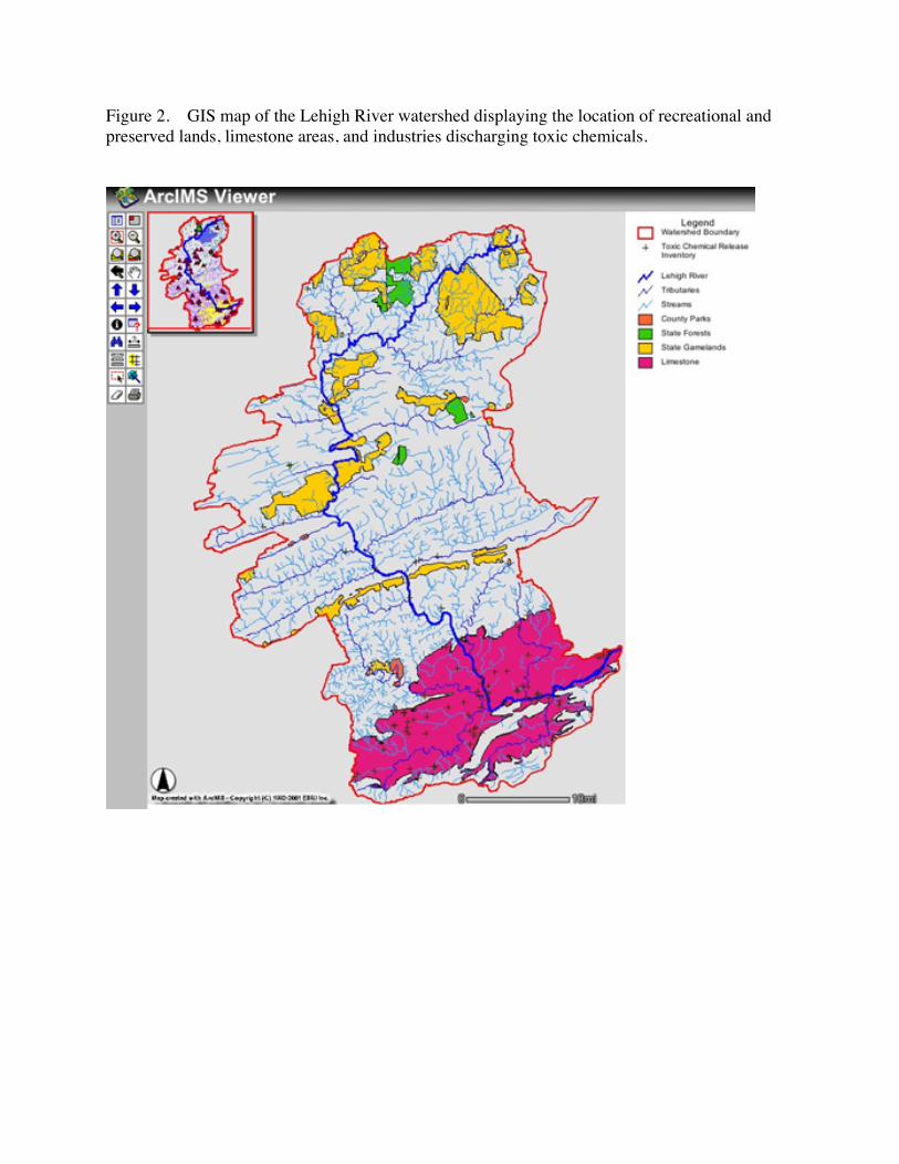
Figure 2. GIS map of the Lehigh River watershed displaying the location of recreational andpreserved lands, limestone areas, and industries discharging toxic chemicals.

Figure 3. GIS map of the Lehigh River watershed displaying the location of canal and railroadtransportation routes from coal fields to cities.

Figure 4. GIS map displaying land use zoning in a subsection of the Lehigh River watershed.