technical memorandum 6 existing land use analysis
TRANSCRIPT
Technical Memorandum 6 Existing Land Use Analysis
March 2013

Technical Memorandum 6 – Existing Land Use Analysis I-24 Multimodal Corridor Study March 2013 Page i
Technical Memorandum 6 Existing Land Use Analysis
T h i s d o c u m e n t i s p o s t e d a t : http://www.tdot.state.tn.us/i24/
This document was prepared by Atkins for the
Tennessee Department of Transportation Project No. 99108-1154-04

Technical Memorandum 6 – Existing Land Use Analysis I-24 Multimodal Corridor Study March 2013 Page ii
Table of Contents
1.0 Introduction .............................................................................................. 1
1.1 Corridor Location and Overview .............................................................................. 1
1.2 Purpose of This Document in the Study Process ...................................................... 1
2.0 Evaluation of Land Use Policies in the I-24 Corridor ................................... 4
2.1 Clarksville Area ....................................................................................................... 4
2.1.1 Montgomery County ............................................................................................... 4
2.1.2 Cheatham County ................................................................................................... 6
2.2 Nashville Area ........................................................................................................ 7
2.2.1 Robertson County .................................................................................................... 7
2.2.2 Davidson County ..................................................................................................... 7
2.2.3 Williamson County .................................................................................................. 9
2.2.4 Rutherford County ................................................................................................... 9
2.2.5 Bedford County ..................................................................................................... 10
2.2.6 Coffee County ........................................................................................................ 10
2.3 Chattanooga Area ................................................................................................. 10
2.3.1 Grundy County ...................................................................................................... 10
2.3.2 Marion County ...................................................................................................... 11
2.3.3 Hamilton County ................................................................................................... 11
3.0 Parcel Level Ownership and Land Use Data ............................................. 13
Technical Memorandum 6 – Existing Land Use Analysis I-24 Multimodal Corridor Study March 2013 Page iii
List of Figures
Figure 1.1: Study Corridor Map ...................................................................................................... 2
Figure 1.2: Study Corridor Areas .................................................................................................... 3
Figure 2.1: Montgomery County Growth Plan Map ...................................................................... 6
Figure 2.2: Nashville-Davidson County Community Areas ............................................................ 8
Figure 2.3: Chattanooga-Hamilton County Development Plan ................................................... 13
Figure 3.1: Study Corridor Parcels ............................................................................................... 14

Technical Memorandum 6 – Existing Land Use Analysis I-24 Multimodal Corridor Study March 2013 Page 1
1.0 Introduction
1.1 Corridor Location and Overview
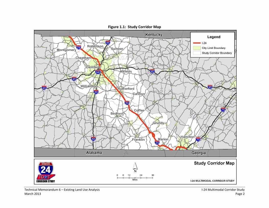
The purpose of the I-24 Multimodal Corridor Study is to examine potential multimodal transportation improvements that would address existing and emerging transportation system issues associated with this strategic corridor through central Tennessee connecting the Clarksville, Nashville and Chattanooga urban areas. The corridor extends from the Kentucky border to where it meets I-75 in Hamilton County, a distance of approximately 185 miles (refer to Figure 1.1). The analysis of corridor needs will go through a structured process of characterizing existing and projected corridor conditions, describing the purpose and need for corridor improvements, defining a set of performance measures against which to evaluate improvement options, and evaluating potential corridor improvements against these performance measures to develop a set of recommended improvements.
1.2 Purpose of This Document in the Study Process
Technical Memorandum 2 provided an overview of land use planning in Tennessee and an inventory of the documents that were compiled from internet sources that related to each county’s land use planning efforts for those counties within or adjacent to the I-24 Corridor. This document, Technical Memorandum 6, evaluates existing land use policies and development patterns for those counties adjacent to the I-24 Corridor within Tennessee and how these policies and development patterns may influence improvement alternatives for the I-24 Corridor. As I-24 improvement alternatives are considered, it will be important to monitor their consistency with local land use and growth plans and to solicit the input of local governments on proposed improvements that have implications for their land use and zoning. Corridor Areas were also developed and used to summarize land use data and analysis completed for the I-24 Multimodal Corridor Study. Figure 1.2 shows the Corridor Areas defined for the I-24 Multimodal Corridor Study and the counties that are included in each Corridor Area. The development of the Corridor Areas was based on commuting patterns in the I-24 Corridor.
Technical Memorandum 6 – Existing Land Use Analysis I-24 Multimodal Corridor Study March 2013 Page 2
Figure 1.1: Study Corridor Map

Technical Memorandum 6 – Existing Land Use Analysis I-24 Multimodal Corridor Study March 2013 Page 3
Figure 1.2: Study Corridor Areas

Technical Memorandum 6 – Existing Land Use Analysis I-24 Multimodal Corridor Study March 2013 Page 4
2.0 Evaluation of Land Use Policies in the I-24 Corridor
In Technical Memorandum 2, it was generally established that those counties that are the most urban and developed within the corridor tended to have the most sophisticated and comprehensive land use planning and development controls. This memorandum will examine the specifics of those land use policies identified in Technical Memorandum 2 and prevailing and planned development within the I-24 Corridor to attempt to ascertain what they imply for potential I-24 Corridor transportation alternatives. This memorandum will follow the same general format by looking at land use policies and development from north to south within the I-24 Corridor, from the border with Kentucky in Montgomery County to the southern terminus of I-24 with I-75 in Hamilton County. Each Corridor Area from north to south and the counties therein will be examined in sequence. 2.1 Clarksville Area
2.1.1 Montgomery County
In Clarksville and Montgomery County, the City/County Regional Planning Commission adopts a land use plan that is supported through generally consistent zoning and subdivision controls. The Montgomery Growth Plan Map is exhibited in Figure 2.1. Two arterial corridors in the northwest portion of Montgomery County, US-79 (exit 4) and Trenton Road/State Route 48 (exit 1), bracket Commerce Park, a Tennessee Regional Megasite, that is home to a large industrial park containing Hemlock Semiconductor and Dow Corning Corporation. Governor’s Square Mall and other retail and commercial outlets are situated to the west of I-24 along US-79/Wilma Rudolph Boulevard/Guthrie Highway. The Gateway Medical Center lies to the west of I-24 and the Clarksville-Montgomery County Industrial Park lies to the east of I-24 between US-79 (exit 4) and Rossview Road/State Route 237 (exit 8). Although currently the east side of I-24 in this area is less developed than the west side, it would appear that it has been prepared for extensive additional development. The expected future development in this portion of the I-24 Corridor is consistent with the Montgomery County Growth Plan that identifies this as one of five Planned Growth Areas in the County. Given the opportunity for additional employment growth in this area, maintaining or improving access from I-24 should be carefully considered. This portion of the county adjacent to I-24 has seen relatively rapid growth in commercial retail and is anticipated to continue to grow given that there is available land for development. The Trenton Road Corridor is treated as a separate planning area in the land use plan and is noted to have significant potential for additional growth in residential mixed land-uses as formerly agricultural areas have been subdivided and rezoned, and the area has available infrastructure and good accessibility. Concerns are expressed about adequacy of drainage, emergency service access and access to high pressure water for this area in the land use plan. The Karst soils and adequacy of drainage in this area present barriers to some development. This portion of the I-24 Corridor is shown as a widening project in the CUAMPO 2035 LRTP. In addition, there are numerous projects to widen roads that connect to or cross I-24 in this area. No new I-24
Technical Memorandum 6 – Existing Land Use Analysis I-24 Multimodal Corridor Study March 2013 Page 5
interchanges are listed in the financially constrained portion of the 2035 MTP, but a new interchange at I-24 in the vicinity of Dunlap Lane is mentioned in the un-funded needs section (illustrative list) of the 2035 MTP. The Rossview Road Corridor (exit 8) is also a separate planning area in the land use plan. The land use plan notes that the land is not best suited to urban development in the southern portion of the area due to poor soils although it has some of the best remaining agricultural land in Montgomery County and is important to some larger industrial uses. Rossview High School is adjacent to I-24 to the north of Rossview Road west of I-24. This area is also flagged for current concerns about drainage, floodplain issues, and emergency service response times. Additional residential development will likely occur to the west of I-24 due to the availability of land and infrastructure. The Sango Planning Area straddles I-24 (exit 11) in the southeast portion of Montgomery County. Development is primarily residential and has occurred mostly to the west of I-24. Additional development in this area is limited currently due to sewerage/septic and drainage concerns but is anticipated by current zoning. Again, growth in this part of the county is consistent with the Montgomery County Growth Plan that identifies it as a Planned Growth Area outside the current urban growth boundary. Fort Campbell, home to the Army 101st Airborne Infantry, is within Montgomery County, Tennessee and Christian County, Kentucky to the west of I-24 and has joint land use plans prepared with local jurisdictions to preclude incompatible land use/development that could negatively impact the mission of the military installation. The Army Compatible Use Buffer (ACUB) Program creates land conservation partnerships between the Army and outside organizations to protect land from development that is incompatible with the military mission primarily through legal conservation easements with agricultural or forested lands. Although Fort Campbell should be consulted on proposed improvements to I-24, it would appear that it has no direct land use impact on I-24 within Tennessee. Nevertheless, Fort Campbell is the largest employer in the Clarksville area with 30,000 military and 10,000 civilian employees and has an indirect land use impact on I-24 relative to housing and supportive retail, education and institutional uses. Fort Campbell’s primary concern is apt to be maintaining or improving the quality of its access to I-24. As mentioned earlier, there are two widening projects for I-24 identified in the 2035 CUAMPO LRTP; one from US-41A in Kentucky to the Kentucky/Tennessee state line, and one from the Kentucky/Tennessee state line to the State Route 374 extension. These projects may present opportunities to improve access to Fort Campbell. In addition to the US Army at Fort Campbell, large employers in Montgomery County include the Clarksville-Montgomery County School System, Trane Corporation, Convergys Corporation, Austin Peay State University, Jostens, and Akebono Brake Corporation.

Technical Memorandum 6 – Existing Land Use Analysis I-24 Multimodal Corridor Study March 2013 Page 6
Figure 2.1: Montgomery County Growth Plan Map
Source: Montgomery County Growth Plan
2.1.2 Cheatham County
Unincorporated Cheatham County has primarily agricultural zoning adjacent to I-24 except in the extreme northeast of the county in the vicinity of I-24 exit 31 at State Route 249/New Hope Road where there is a combination of General Commercial, Mixed Use, General Industrial, and Medium and High Density Residential zoning categories adjacent to I-24. Development is limited at present near I-24 exit 31, particularly to the east of I-24, although there are some service businesses that cater to interstate travelers. Most of I-24 lies to the east of Cheatham County in Robertson County. The Town of Pleasant View accesses I-24 via State Route 49 at exit 24. There is some existing residential development just to the west of I-24 adjacent to exit 24. Although Cheatham County is projected to have a relatively high rate of growth by 2040, it’s currently among the least populous counties in the I-24 Corridor and, because most of I-24 lies outside Cheatham County, its growth and land use impacts on I-24 will be indirect and
Technical Memorandum 6 – Existing Land Use Analysis I-24 Multimodal Corridor Study March 2013 Page 7
relatively minor. Large employers in Cheatham County include AO Smith Water Products Corporation, Trinity Industries, and the Bix Manufacturing Corporation. 2.2 Nashville Area
2.2.1 Robertson County
I-24 Exits 19 and 24 are within Robertson County. Robertson County is currently working on a Growth and Development Plan but has no adopted Land Use Plan. Robertson County is included in the Tri-County Transportation and Land Use Plan prepared by the Nashville MPO in 2011. The current Zoning map for Robertson County shows areas of commercial zoning along Charlie Maxey Road/State Route 256 (exit 19) to the east of I-24; however current development in this area is very sparse and rural in character. Robertson County is projected to have a relatively moderate rate of growth, with approximately 32% growth in population between 2010 and 2040, such that it’s 2040 population will be over 87,000. The rate of growth in employment is significantly higher such that Robertson County’s projected employment by 2040 will be close to 50,000. The Tri-County Transportation and Land Use Plan shows a band of residential development along State Route 49 to the east of I-24 at exit 24 connecting to an urban node at Springfield. It seems likely that the State Route 49 corridor will have a significant level of development between now and 2040.
2.2.2 Davidson County
Nashville-Davidson County is the largest county in the I-24 Corridor in terms of population and employment and projected to remain the largest although it has among the lower rates of growth in the corridor for population and employment (see Technical Memorandum 4). Much of this growth will be through redevelopment and infill of existing areas. The Community Area Plans listed below highlight specific growth areas for each community. Many of these growth areas anticipate development near or connecting to I-24. However, given that overall development is relatively low for the county, impacts to the I-24 corridor are apt to be at specific locations and operational in nature. Nashville-Davidson County is divided into fourteen Community Areas, as shown in Figure 2.2, that encompass the county for planning purposes. I-24 traverses eight of these Community Areas for which specific Land Use Policy Plans are prepared:
1. Joelton 2. Parkwood-Union Hill 3. Bordeaux-Whites Creek 4. East Nashville 5. Downtown 6. South Nashville 7. Southeast 8. Antioch-Priest Lake

Technical Memorandum 6 – Existing Land Use Analysis I-24 Multimodal Corridor Study March 2013 Page 8
Figure 2.2: Nashville-Davidson County Community Areas
Source: Nashville-Davidson County Metro Planning Department website
Nashville-Davidson County is a major employment center. Eight of the twenty five largest employers in Davidson County are hospitals or other health related businesses. Vanderbilt University and Tennessee State University are major employers and trip generators. Downtown Nashville is the center of Tennessee governance with the state capital and state government offices, and important local government offices, in addition to being a center of commerce and music industry and cultural tourism. I-24 is one of the major access routes to downtown Nashville along with I-40 and I-65. These routes all need to work together to provide access and service through traffic. Event traffic operations will be an important consideration for the I-24 Multimodal Corridor Study, in addition to peak hour operations and service to longer trips and through travel. I-24 provides access to the Tennessee Titans football stadium. Downtown Nashville hosts many large music and community events. The Nashville MPO LRTP lists a number of projects on I-24 including a redesigned interchange at Harding Place on I-24, HOV ramps to I-24 from Shelby Avenue, widening of I-24 westbound from I-65 to Old Hickory Boulevard, among others. These projects may help to maintain access

Technical Memorandum 6 – Existing Land Use Analysis I-24 Multimodal Corridor Study March 2013 Page 9
to Downtown Nashville, and provide some benefit to non-SOV modes in addition to easing peak hour congestion. Just a few miles south of downtown Nashville, CSX has a major rail facility and intermodal yard between I-65 and I-24. Although I-65 provides the most access to this facility due to its proximity, the I-24 Multimodal Corridor Study should consider the extent to which trucks servicing this facility use I-24. I-24 provides access, though not directly, to the Nashville International Airport. There is a large industrial complex at I-24 exits 56 and 57 just to the south of the Nashville International Airport. Accessibility for trucks to this industrial complex is primarily from I-24, and will merit consideration when looking at operations and improvement alternatives. There are three Tennessee River Port Facilities within Davidson County. To the east of I-24 at exit 59 is a regional commercial center including the Hickory Hollow Mall with relatively high density residential areas on either side of the Interstate.
2.2.3 Williamson County
Although I-24 is not within Williamson County, Williamson County land use has considerable influence on I-24, and the accessibility I-24 provides influences land use development and intensity in Williamson County. Williamson County expects continued high growth in population with a projected 2040 total population of over 330,000. Employment in Williamson County, currently at approximately 120,000, is anticipated to grow to over 300,000 by 2040. Williamson County accesses I-24 indirectly at exits 56 through 74, and through connections to I-65 which bisects Williamson County. Current major employers within Williamson County include: M Modal Inc., Carlisle Transportation Products, Community Health Systems Inc., Nissan North America, and Comdata Corporation.
2.2.4 Rutherford County
Rutherford County updated its Comprehensive Plan in 2011. An Employment Center is recommended on I-24 south of Murfreesboro around Epps Mill Road (exit 89). This area is currently lightly developed with a truck stop and some interstate travel oriented businesses. Transportation projects listed within the document include new I-24 interchanges at the Christiana Connector Route and the NW Loop Road. Rutherford County is projected to have the second highest population of counties in the I-24 Corridor by 2040 at approximately 530,000. Transitioning south from Davidson County into Rutherford County along I-24 beginning at exit 62 and spanning to exit 66, there is a large area of industrial development, truck depots and logistics centers. In the southeast quadrant of I-24 at exit 66 in Smyrna, there is the Stonecrest Regional Medical Center. At I-24 exit 70, there is a group of truck depots to the west of I-24 along State Route 102. At exits 76 and 78 to the east of I-24, there is a large regional commercial area including the Stones River Mall, Towne Center Shops and The Avenue Murfreesboro Outlet Mall. At I-24 at exits 80 and 81, there is another large area of industrial land uses and interstate travel oriented businesses. At I-24 exit 84, there are several truck depots and warehousing logistics centers. Between I-24 exit 84 and exit 89, there is less

Technical Memorandum 6 – Existing Land Use Analysis I-24 Multimodal Corridor Study March 2013 Page 10
development and the existing development is more rural in character. To the south of exit 89, the topography becomes more rugged. The scale, number and extent of industrial, warehousing and trucking related businesses in Rutherford County will be an important aspect of the I-24 Corridor Study. Large employers in Rutherford County include: Nissan North America, State Farm Insurance Operations Center, Middle Tennessee Medical Center, and Vi-John Laboratories.
2.2.5 Bedford County
Only a very small section of I-24 traverses Bedford County with no direct access and most of I-24 lies to the east of the county line. Bedford County accesses I-24 via State Route 64/Beech Grove Road (exit 97). Existing land use in Bedford County along I-24 is rural in character and likely to stay that way due to the generally rugged topography and distance from urban centers. Bedford County is forecast to have among the lower growth rates for employment of counties in the I-24 Corridor. Shelbyville, the principal city in Bedford County, accesses I-24 most directly via US-231 at exit 81 in Rutherford County. For these reasons, land use policies in Bedford County are apt to have small bearing on I-24. The largest employer in Bedford County is Tyson Foods Incorporated. Other large employers include Calsonic Kansei North America (associated with Nissan), Jostens and Star Manufacturing.
2.2.6 Coffee County
Coffee County is projected to have moderate growth between 2010 and 2040, although employment in the county doubles to over 60,000. Major employers in the county include: the US Air Force Arnold Engineering Development Complex (AEDC), Batesville Casket Company, and the Harton Regional Medical Center. Land use adjacent to I-24 within Coffee County is predominantly rural in character except in the vicinity of Manchester, the largest city within Coffee County near I-24. The County Zoning map generally shows commercial zoning along I-24 in the vicinity of McMinnville Highway/State Route 55 (exit 111) and at US-41/Hillsboro Boulevard (exit 114). The Arnold Engineering Development Complex (AEDC) is to the west of I-24 in Coffee County with primary access at exit 117. Although there is apt to be some additional commercial development in Coffee County adjacent to I-24, it is unlikely to be of such a scale to have detrimental impact on the interstate. 2.3 Chattanooga Area
2.3.1 Grundy County
Grundy County has no Comprehensive Plan, Growth Plan or Land Use Plan available on its website. There is also no mention of a Planning Commission or an entity responsible for zoning or subdivision control. Approximately 8 miles of I-24 traverses Grundy County with an interchange at State Route 50 (exit 127) and an interchange at US-41 (exit 134). The land use within Grundy County adjacent to I-24 is almost exclusively rural or forested and undeveloped in character. Grundy County is the least populated county in the I-24 Corridor among those with direct access to I-24, and expected to experience only moderate growth in population and

Technical Memorandum 6 – Existing Land Use Analysis I-24 Multimodal Corridor Study March 2013 Page 11
employment. Even in the apparent absence of formal land use planning or zoning and subdivision regulation, this growth is unlikely to have significant impact on I-24.
2.3.2 Marion County
There is no zoning in unincorporated Marion County. Marion County has no Comprehensive Plan, Growth Plan or Land Use Plan available on its website. Marion County contains the Nickajack Dam along the Tennessee River and most of Nickajack Lake. Approximately 35 miles of I-24 lie within Marion County including all or part of seven interchanges (exit 134 to exit 161). To the east and west of the Tennessee River Valley, within Marion County, the land is predominantly mountainous, rugged, and sloped making development adjacent to I-24 difficult. Close to the Tennessee River, although there is flood control, development is limited by the flood plain. The north and southbound lanes of I-24 diverge to over a mile apart to the south of exit 135 for a distance of approximately three miles before coming together approximately two miles to the north of exit 143. There is some development intensity along US-41/64 and I-24 at exit 134 serving Monteagle, but almost none between there and exit 152. At I-24 and US-64/72, with exit 152 serving the cities of South Pittsburg and Kimball, there is some commercial development and businesses serving interstate travel. The Grandview Medical Center is located immediately to the south of I-24 at exit 155. A number of industrial land uses and highway travel oriented businesses are also served by I-24 at this exit. Major employers in Marion County include the Grandview Medical Center, Ply Gem Siding Group, Lodge Manufacturing and Rock-Tenn Corporation. There is a Tennessee River Port Facility, the Port of Nickajack, within Marion County. Marion County is projected to decline in population between 2010 and 2040, from about 28,000 to 26,000. The topography of the county adjacent to I-24 likely precludes large scale land use developments but the I-24 Multimodal Corridor Study should examine the impacts of expected growth at the key interchanges of exits 134, 152 and 155 that serve key roads within the county providing access to I-24.
2.3.3 Hamilton County
Hamilton County is forecast to grow relatively little between 2010 and 2040, although more for employment than for population and households. Population and households are projected to grow by 21% whereas employment is forecast to grow by only 14%. Hamilton County is the site of the Enterprise South Industrial Park, a Tennessee Regional Megasite in which Volkswagen Group of America is located, which expects additional large industrial developments. Hamilton County is the southern terminus of I-24 at I-75 at exit 185. I-24 briefly leaves Tennessee in Hamilton County and enters Georgia for approximately four miles before reentering Tennessee, again in Hamilton County.
Technical Memorandum 6 – Existing Land Use Analysis I-24 Multimodal Corridor Study March 2013 Page 12
In addition to Volkswagen, major employers in Hamilton County include: Erlanger Children’s Hospital and Health System, Covenant Transportation Group, CMJ Manufacturing, Little Debbie Snack Cakes, Pilgrim’s Pride Corporation, Sequoyah Nuclear Plant, Unum Insurance Group, Provident Life and Accident Insurance, and the University of Tennessee Chattanooga. There are two Tennessee River Port Facilities in Hamilton County. To the west of the Tennessee River, the land in Hamilton County is rugged and mountainous and unlikely to sustain additional significant development. There is existing development at exits 174 and 175 most of which is either residential or oriented toward serving interstate travel. There are some industrial uses and an intermodal facility that access I-24 at exit 174 via US-41/64/72 Cummings/Lee Highway and at exit 175 via Browns Ferry Road. Figure 2.3 shows the Chattanooga-Hamilton County Development Plan and addresses some of the constraints of development within Hamilton County. To the east and south of the Tennessee River at Lookout Mountain within the City of Chattanooga, the land adjacent to I-24 is largely developed. Major access to downtown Chattanooga is provided between exits 178 and 180 via US-27 which acts as a collector-distributor road. There are significant industrial land uses to the north and south of I-24 at exit 178 along the Tennessee River. There are also significant industrial land uses to the north of I-24 at exit 180, and to the south of I-24 at exit 181. Land use adjacent to I-24 at exit 183 is primarily residential. Just south of I-24 at exit 184 is the South Terrace Plaza Shopping Center. To the north of I-24 with its junction at I-75 is the Eastgate regional shopping and mixed use center, and to the south is the Parkridge East Hospital Complex. Given that the land adjacent I-24 within Hamilton County is either developed or difficult to develop, and projected growth for the county is relatively low, it is unlikely that future land use development or redevelopment will have a significant impact on I-24 except at the key interchanges between exit 181 and exit 185, the southern terminus of I-24 at I-75.

Technical Memorandum 6 – Existing Land Use Analysis I-24 Multimodal Corridor Study March 2013 Page 13
Figure 2.3: Chattanooga-Hamilton County Development Plan
Source: Chattanooga-Hamilton County Comprehensive Plan
3.0 Parcel Level Ownership and Land Use Data
Although the study team has compiled parcel level land use data for the entire I-24 Corridor, the length of the corridor precludes a detailed description in a technical memorandum. In addition, this information is from different sources and so varies in its content. Table 4.1, from Technical Memorandum 2, lists the study corridor counties for which we have parcel level data and the coverage area within each county, and Figure 3.1 shows the parcels for which we have data in the I-24 Corridor. In aggregate, there are over 700,000 parcels. This data may prove useful when looking at specific corridor segments and to notify and engage existing landowners who have an interest in the I-24 Corridor Study outcomes.

Technical Memorandum 6 – Existing Land Use Analysis I-24 Multimodal Corridor Study March 2013 Page 14
Figure 3.1: Study Corridor Parcels