technical regulations - world meteorological … · 2016-05-24 · dealing with matters pertaining...
TRANSCRIPT
WMO-No. 49
Technical RegulationsBasic Documents No. 2
Volume I – General Meteorological Standards and Recommended Practices2011 edition
Updated in 2012


WMO-No. 49
Technical RegulationsBasic Documents No. 2
Volume I – General Meteorological Standards and Recommended Practices 2011 edition
Updated in 2012
WMO-No. 49
© World Meteorological Organization, 2012
The right of publication in print, electronic and any other form and in any language is reserved by WMO. Short extracts from WMO publications may be reproduced without authorization, provided that the complete source is clearly indicated. Editorial correspondence and requests to publish, reproduce or translate this publication in part or in whole should be addressed to:
Chair, Publications BoardWorld Meteorological Organization (WMO)7 bis, avenue de la Paix Tel.: +41 (0) 22 730 84 03P.O. Box 2300 Fax: +41 (0) 22 730 80 40CH-1211 Geneva 2, Switzerland E-mail: [email protected]
ISBN 978-92-63-10049-8
NOTE
The designations employed in WMO publications and the presentation of material in this publication do not imply the expression of any opinion whatsoever on the part of WMO concerning the legal status of any country, territory, city or area, or of its authorities, or concerning the delimitation of its frontiers or boundaries.
The mention of specific companies or products does not imply that they are endorsed or recommended by WMO in preference to others of a similar nature which are not mentioned or advertised.
EDITORIAL NOTE
The following typographical practice has been followed: standard practices and procedures have been printed in semi-bold roman. Recommended practices and procedures have been printed in light-face roman. Notes have been printed in smaller type, light-face roman, and preceded by the indication: Note.
METEOTERM, the WMO terminology database, may be consulted at: http://www.wmo.int/pages/prog/lsp/meteoterm_wmo_en.html. Acronyms may also be found at: http://www.wmo.int/pages/themes/acronyms/index_en.html.
DOCUMENT REVISION TRACK RECORD
DateParagraph/
SectionPurpose of amendment Proposed by Approved by
July 2012Whole document
Consolidation of amendments approved by the Sixteenth Congress
EC-64Resolution 26 (EC-64)

GENERAL PROVISIONS
1. The WMO Technical Regulations (WMO-No. 49) are presented in four volumes:
Volume I – General meteorological standards and recommended practicesVolume II – Meteorological service for international air navigationVolume III – HydrologyVolume IV – Quality management
Purpose of the Technical Regulations
2. The Technical Regulations of the World Meteorological Organization are determined by Congress in accordance with Article 8 (d) of the Convention.
3. These Regulations are designed:
(a) To facilitate cooperation in meteorology and hydrology between Members;(b) To meet, in the most effective manner, specific needs in the various fields of application of
meteorology and operational hydrology in the international sphere; and(c) To ensure adequate uniformity and standardization in the practices and procedures
employed in achieving (a) and (b) above.
Types of Regulations and notes
4. The Technical Regulations comprise standard practices and procedures and recommended practices and procedures.
5. The definitions of these two types of Regulations are as follows:
The standard practices and procedures:
(a) Shall be the practices and procedures which it is necessary that Members follow or implement; and therefore
(b) Shall have the status of requirements in a technical resolution in respect of which Article 9 (b) of the Convention is applicable; and
(c) Shall invariably be distinguished by the use of the term shall in the English text, and by suitable equivalent terms in the Arabic, Chinese, French, Russian and Spanish texts.
The recommended practices and procedures:
(a) Shall be the practices and procedures which it is desirable that Members follow or implement; and therefore
(b) Shall have the status of recommendations to Members, to which Article 9 (b) of the Convention shall not be applied;
(c) Shall be distinguished by the use of the term should in the English text (except where otherwise provided by decision of Congress) and by suitable equivalent terms in the Arabic, Chinese, French, Russian and Spanish texts.
6. In accordance with the above definitions, Members shall do their utmost to implement the standard practices and procedures. In accordance with Article 9 (b) of the Convention and in conformity with the provisions of Regulation 128 of the General Regulations, Members shall formally notify the Secretary-General, in writing, of their intention to apply the standard practices and procedures of the Technical Regulations, except those for which they have lodged a specific deviation. Members shall also inform the Secretary-General, at least three months in advance, of any change in the degree of their implementation of a standard practice or procedure as previously notified and the effective date of the change.
GENERAl METEOROlOGICAl STANdARdS ANd RECOMMENdEd PRACTICESvi
7. Members are urged to comply with recommended practices and procedures, but it is not necessary to notify the Secretary-General of non-observance except with regard to those contained in Volume II, C.3.1.
8. In order to clarify the status of the various Regulations, the standard practices and procedures are distinguished from the recommended practices and procedures by a difference in typographical practice, as indicated in the editorial note.
9. Certain notes (preceded by the indication Note) are included in the Technical Regulations for explanatory purposes; they may, for instance, refer to relevant WMO Guides and publications. These notes do not have the status of Technical Regulations. The WMO Guides describe practices, procedures and specifications which Members are invited to follow or implement in establishing and conducting their arrangements in compliance with the Technical Regulations and in developing meteorological and hydrological services in their respective countries.
Status of annexes and appendices
10. The following WMO publications, which contain regulatory material having the status of the Technical Regulations, are annexes to the Technical Regulations (Volumes I to IV):
I International Cloud Atlas (WMO-No. 407), Volume I – Manual on the Observation of Clouds and Other Meteors, Part I; Part II: paragraphs II.1.1, II.1.4, II.1.5 and II.2.3; subparagraphs 1, 2, 3 and 4 of each paragraph from II.3.1 to II.3.10; paragraphs II.8.2 and II.8.4; Part III: paragraph III.1 and the definitions (in italics) of paragraph III.2 (not attached);
II Manual on Codes (WMO-No. 306), Volume I (not attached);III Manual on the Global Telecommunication System (WMO-No. 386), Volume I (in part) (not
attached);IV Manual on the Global Data-processing and Forecasting System (WMO-No.485), Volume I (not
attached);V Manual on the Global Observing System (WMO-No. 544), Volume I (not attached);VI Manual on Marine Meteorological Services (WMO-No. 558), Volume I (not attached);VII Manual on the WMO Information System (WMO-No. 1060), (not attached);VIII Manual on the Implementation of Education and Training Standards in Meteorology and
Hydrology (WMO-No. 1083), Volume I (not attached);
These annexes, normally also called manuals, are established by decision of Congress and are intended to facilitate the application of Technical Regulations to specific fields. In principle, annexes may contain both standard and recommended practices and procedures.
11. Texts called appendices appearing in the Technical Regulations or in an annex to the Technical Regulations have the same status as the Regulations to which they refer.
Updating of the Technical Regulations and their annexes (Manuals)
12. The Technical Regulations are updated, as necessary, in the light of developments in meteorology and hydrology and meteorological and hydrological techniques, and in the applications of meteorology. Certain principles previously agreed upon by Congress and applied in the selection of material for inclusion in the Technical Regulations are reproduced below. These principles provide guidance for constituent bodies, in particular technical commissions, when dealing with matters pertaining to the Technical Regulations:
(a) Technical commissions should not recommend that a Regulation be a standard practice unless it is supported by a strong majority;
(b) Technical Regulations should contain appropriate instructions to Members regarding implementation of the provision in question;
(c) No major changes should be made to the Technical Regulations without consulting the appropriate technical commissions;
GENERAl PROVISIONS vii
(d) Any amendments to these Technical Regulations submitted by Members or by constituent bodies should be communicated to all Members at least three months before they are submitted to Congress.
13. Amendments to the Technical Regulations – as a rule – are approved by Congress.
14. If a recommendation for an amendment is made by a session of the appropriate technical commission and if the new regulation needs to be implemented before the next session of Congress, the Executive Council may, on behalf of the Organization, approve the amendment in accordance with Article 14 (c) of the Convention. Amendments to annexes to the Technical Regulations proposed by the appropriate technical commissions are normally approved by the Executive Council.
15. If a recommendation for an amendment is made by the appropriate technical commission and the implementation of the new regulation is urgent, the President of the Organization may, on behalf of the Executive Council, take action as provided by Regulation 9 (5) of the General Regulations.
Note: A fast-track procedure can be applied for additions to certain codes and associated code tables, contained in
Annex II (Manual on Codes (WMO-No. 306)). Application of the fast-track procedure is described in detail in Annex II.
16. After each session of Congress (every four years), a new edition of the Technical Regulations, including the amendments approved by Congress, is issued. With regard to the amendments to WMO-No. 49 between sessions of Congress, Volumes I, III and IV are updated, as necessary, upon approval of changes thereto by the Executive Council. The Technical Regulations updated as a result of an approved amendment by the Executive Council are considered a new update of the current edition. The material in Volume II is prepared by the World Meteorological Organization and the International Civil Aviation Organization working in close cooperation, in accordance with the Working Arrangements agreed by these Organizations. In order to ensure consistency between Volume II and Annex 3 – Meteorological Service for International Air Navigation to the Convention on International Civil Aviation, the issuance of amendments to Volume II is synchronized with the respective amendments to Annex 3 by the International Civil Aviation Organization.
Note: Editions are identified using the year of the respective session of Congress while updates are identified by the
year of approval by the Executive Council, for example “Updated in 2012”.
WMO Guides
17. In addition to the Technical Regulations, appropriate guides are published by the Organization. The guides describe practices, procedures and specifications which Members are invited to follow or implement. The guides are updated, as necessary, in the light of scientific and technological developments in hydrometeorology, climatology and their applications. The WMO technical commissions are responsible for the selection of material to be included in the guides. Recommendations for amendments made by an appropriate technical commission are subject to the approval of the Executive Council.

CONTENTS
DEFINITIONS � � � � � � � � � � � � � � � � � � � � � � � � � � � � � � � � � � � � � � � � � � � � � � � � � � � � � � � � � � � � � � �xiii
REQUIREMENTS FOR THE INTERNATIONAL EXCHANGE OF OBSERVATIONAL DATA AND PRODUCTS � � � � � � � � � � � � � � � � � � � � � � � � � � � � � � � � � � � � � � � � � � � � � � � � � � � � � � xvii
PART I� WORLD WEATHER WATCH � � � � � � � � � � � � � � � � � � � � � � � � � � � � � � � � � � � � � � � � � � � � � � 1
1� GLOBAL OBSERVING SYSTEM � � � � � � � � � � � � � � � � � � � � � � � � � � � � � � � � � � � � � � � � � � � � � 11.1 Meteorological observing networks, stations and observations . . . . . . . . . . . . . . . . . 1
1.1.1 General – Scope, purpose and operation of the Global Observing System . . . . . . . . . . . . . . . . . . . . . . . . . . . . . . . . . . . . . . . . . . . . 1
2� GLOBAL DATA-PROCESSING AND FORECASTING SYSTEM � � � � � � � � � � � � � � � � � � � � � � 12.1 Organization and functions of the Global data-processing and
Forecasting System . . . . . . . . . . . . . . . . . . . . . . . . . . . . . . . . . . . . . . . . . . . . . . . . . . 12.1.1 General . . . . . . . . . . . . . . . . . . . . . . . . . . . . . . . . . . . . . . . . . . . . . . . . . . . . 12.1.2 Functions of centres . . . . . . . . . . . . . . . . . . . . . . . . . . . . . . . . . . . . . . . . . . . 2
2.2 Analysis and forecasting practices . . . . . . . . . . . . . . . . . . . . . . . . . . . . . . . . . . . . . . . 22.2.1 General – Constants, definitions and specifications . . . . . . . . . . . . . . . . . . . 22.2.2 Weather charts – Projections, scales and symbols . . . . . . . . . . . . . . . . . . . . . 22.2.3 Properties of aerological diagrams – General requirements . . . . . . . . . . . . . 22.2.4 Upper-air analyses – Reference surfaces . . . . . . . . . . . . . . . . . . . . . . . . . . . . 22.2.5 General – Publication of synoptic observations . . . . . . . . . . . . . . . . . . . . . . 3
2.3 International codes . . . . . . . . . . . . . . . . . . . . . . . . . . . . . . . . . . . . . . . . . . . . . . . . . . 32.3.1 General – Code forms . . . . . . . . . . . . . . . . . . . . . . . . . . . . . . . . . . . . . . . . . 32.3.2 Symbolic words, groups and letters . . . . . . . . . . . . . . . . . . . . . . . . . . . . . . . 32.3.3 Code figures . . . . . . . . . . . . . . . . . . . . . . . . . . . . . . . . . . . . . . . . . . . . . . . . 3
3� WMO INFORMATION SYSTEM � � � � � � � � � � � � � � � � � � � � � � � � � � � � � � � � � � � � � � � � � � � � � 33.1 Purpose . . . . . . . . . . . . . . . . . . . . . . . . . . . . . . . . . . . . . . . . . . . . . . . . . . . . . . . . . . 33.2 Principles . . . . . . . . . . . . . . . . . . . . . . . . . . . . . . . . . . . . . . . . . . . . . . . . . . . . . . . . . 33.3 Organization . . . . . . . . . . . . . . . . . . . . . . . . . . . . . . . . . . . . . . . . . . . . . . . . . . . . . . . 43.4 Responsibilities . . . . . . . . . . . . . . . . . . . . . . . . . . . . . . . . . . . . . . . . . . . . . . . . . . . . . 53.5 Practices, procedures and specifications . . . . . . . . . . . . . . . . . . . . . . . . . . . . . . . . . . 5
PART II� OTHER GENERAL STANDARDS AND RECOMMENDED PRACTICES � � � � � � � � � � � � � � � 7
1� CLIMATOLOGY � � � � � � � � � � � � � � � � � � � � � � � � � � � � � � � � � � � � � � � � � � � � � � � � � � � � � � � � � 71.1 General – Climatological data . . . . . . . . . . . . . . . . . . . . . . . . . . . . . . . . . . . . . . . . . . 71.2 Collection of climatological data . . . . . . . . . . . . . . . . . . . . . . . . . . . . . . . . . . . . . . . . 7
1.2.1 National arrangements . . . . . . . . . . . . . . . . . . . . . . . . . . . . . . . . . . . . . . . . 71.3 Exchange of climatological data . . . . . . . . . . . . . . . . . . . . . . . . . . . . . . . . . . . . . . . . 7
1.3.1 International requirements . . . . . . . . . . . . . . . . . . . . . . . . . . . . . . . . . . . . . . 71.4 Climatological statistics . . . . . . . . . . . . . . . . . . . . . . . . . . . . . . . . . . . . . . . . . . . . . . . 8
1.4.1 Time units . . . . . . . . . . . . . . . . . . . . . . . . . . . . . . . . . . . . . . . . . . . . . . . . . . 81.4.2 Climatological frequencies, sums and averages . . . . . . . . . . . . . . . . . . . . . . 8
1.5 Publication of climatological data . . . . . . . . . . . . . . . . . . . . . . . . . . . . . . . . . . . . . . . 91.5.1 General . . . . . . . . . . . . . . . . . . . . . . . . . . . . . . . . . . . . . . . . . . . . . . . . . . . . 91.5.2 Publication of surface observations . . . . . . . . . . . . . . . . . . . . . . . . . . . . . . . 91.5.3 Publication of upper-air observations . . . . . . . . . . . . . . . . . . . . . . . . . . . . . 101.5.4 Publication of old climatological data . . . . . . . . . . . . . . . . . . . . . . . . . . . . . 11
1.6 Climatic atlases . . . . . . . . . . . . . . . . . . . . . . . . . . . . . . . . . . . . . . . . . . . . . . . . . . . . 11
GENERAl METEOROlOGICAl STANdARdS ANd RECOMMENdEd PRACTICESx
2� GLOBAL ATMOSPHERE WATCH � � � � � � � � � � � � � � � � � � � � � � � � � � � � � � � � � � � � � � � � � � � 112.1 General . . . . . . . . . . . . . . . . . . . . . . . . . . . . . . . . . . . . . . . . . . . . . . . . . . . . . . . . . . 112.2 Principles of implementation . . . . . . . . . . . . . . . . . . . . . . . . . . . . . . . . . . . . . . . . . 122.3 Requirements for data on the chemical composition and related physical
characteristics of the atmosphere . . . . . . . . . . . . . . . . . . . . . . . . . . . . . . . . . . . . . . 132.3.1 Classification of requirements . . . . . . . . . . . . . . . . . . . . . . . . . . . . . . . . . . 132.3.2 Systems for meeting the requirements . . . . . . . . . . . . . . . . . . . . . . . . . . . . 13
2.4 Networks of stations . . . . . . . . . . . . . . . . . . . . . . . . . . . . . . . . . . . . . . . . . . . . . . . . 132.4.1 General . . . . . . . . . . . . . . . . . . . . . . . . . . . . . . . . . . . . . . . . . . . . . . . . . . . 132.4.2 Global stations . . . . . . . . . . . . . . . . . . . . . . . . . . . . . . . . . . . . . . . . . . . . . . 142.4.3 Regional stations . . . . . . . . . . . . . . . . . . . . . . . . . . . . . . . . . . . . . . . . . . . . 14
2.5 location of the stations . . . . . . . . . . . . . . . . . . . . . . . . . . . . . . . . . . . . . . . . . . . . . . 142.6 Information about the stations . . . . . . . . . . . . . . . . . . . . . . . . . . . . . . . . . . . . . . . . 152.7 Supervision of the stations . . . . . . . . . . . . . . . . . . . . . . . . . . . . . . . . . . . . . . . . . . . 162.8 Measurement programme . . . . . . . . . . . . . . . . . . . . . . . . . . . . . . . . . . . . . . . . . . . 162.9 Quality Assurance/Quality Control . . . . . . . . . . . . . . . . . . . . . . . . . . . . . . . . . . . . . 172.10 Monitoring of the operation of GAW . . . . . . . . . . . . . . . . . . . . . . . . . . . . . . . . . . . 17
3� METEOROLOGICAL BIBLIOGRAPHY AND PUBLICATIONS � � � � � � � � � � � � � � � � � � � � � � 183.1 Meteorological documents and abstracts . . . . . . . . . . . . . . . . . . . . . . . . . . . . . . . . 18
3.1.1 General form of meteorological documents and abstracts . . . . . . . . . . . . . 183.1.2 Classification of meteorological documents and abstracts . . . . . . . . . . . . . 183.1.3 Preparation of catalogues of meteorological documents . . . . . . . . . . . . . . 18
4� EDUCATION AND TRAINING OF METEOROLOGICAL PERSONNEL � � � � � � � � � � � � � � � 194.1 General . . . . . . . . . . . . . . . . . . . . . . . . . . . . . . . . . . . . . . . . . . . . . . . . . . . . . . . . . . 194.2 Categories of personnel . . . . . . . . . . . . . . . . . . . . . . . . . . . . . . . . . . . . . . . . . . . . . 194.3 Basic Instruction Package for Meteorologists . . . . . . . . . . . . . . . . . . . . . . . . . . . . . 194.4 Basic Instruction Package for Meteorological Technicians . . . . . . . . . . . . . . . . . . . . 194.5 Meteorological education and training facilities . . . . . . . . . . . . . . . . . . . . . . . . . . . 194.6 Status of meteorological personnel . . . . . . . . . . . . . . . . . . . . . . . . . . . . . . . . . . . . . 20
5� COMPETENCE OF METEOROLOGICAL, HYDROLOGICAL AND CLIMATOLOGICAL PERSONNEL � � � � � � � � � � � � � � � � � � � � � � � � � � � � � � � � � � � � � � � � � � � 205.1 Competence of Aeronautical Meteorological Personnel . . . . . . . . . . . . . . . . . . . . . 20
6� METEOROLOGICAL RESEARCH� � � � � � � � � � � � � � � � � � � � � � � � � � � � � � � � � � � � � � � � � � � � 216.1 Units . . . . . . . . . . . . . . . . . . . . . . . . . . . . . . . . . . . . . . . . . . . . . . . . . . . . . . . . . . . . 216.2 Standard atmosphere . . . . . . . . . . . . . . . . . . . . . . . . . . . . . . . . . . . . . . . . . . . . . . . 21
PART III� METEOROLOGICAL SERVICES � � � � � � � � � � � � � � � � � � � � � � � � � � � � � � � � � � � � � � � � � � 23
1� METEOROLOGICAL SERVICES FOR MARINE ACTIVITIES � � � � � � � � � � � � � � � � � � � � � � � � 231.1 General . . . . . . . . . . . . . . . . . . . . . . . . . . . . . . . . . . . . . . . . . . . . . . . . . . . . . . . . . . 231.2 Marine Meteorological Services for the high seas . . . . . . . . . . . . . . . . . . . . . . . . . . 23
1.2.1 General responsibilities . . . . . . . . . . . . . . . . . . . . . . . . . . . . . . . . . . . . . . . 231.2.2 Provision of weather and sea bulletins . . . . . . . . . . . . . . . . . . . . . . . . . . . . 231.2.3 Marine meteorological support to maritime search and rescue . . . . . . . . . 241.2.4 Provision of information by radio-facsimile . . . . . . . . . . . . . . . . . . . . . . . . . 241.2.5 Marine Climatological Summary Scheme . . . . . . . . . . . . . . . . . . . . . . . . . . 241.2.6 Special marine climatological information . . . . . . . . . . . . . . . . . . . . . . . . . 241.2.7 Provision of marine meteorological information and expert
advice . . . . . . . . . . . . . . . . . . . . . . . . . . . . . . . . . . . . . . . . . . . . . . . . . . . . 241.3 Marine meteorological services for coastal and offshore areas . . . . . . . . . . . . . . . . . 25
1.3.1 International responsibilities . . . . . . . . . . . . . . . . . . . . . . . . . . . . . . . . . . . . 251.3.2 Regional cooperation . . . . . . . . . . . . . . . . . . . . . . . . . . . . . . . . . . . . . . . . . 251.3.3 National responsibilities . . . . . . . . . . . . . . . . . . . . . . . . . . . . . . . . . . . . . . . 25
1.4 Marine meteorological services for main ports and harbour areas . . . . . . . . . . . . . . 251.4.1 International responsibilities . . . . . . . . . . . . . . . . . . . . . . . . . . . . . . . . . . . . 251.4.2 General services . . . . . . . . . . . . . . . . . . . . . . . . . . . . . . . . . . . . . . . . . . . . . 261.4.3 Port Meteorological Officer services . . . . . . . . . . . . . . . . . . . . . . . . . . . . . . 26
CONTENTS xi
1.5 Training in marine meteorology . . . . . . . . . . . . . . . . . . . . . . . . . . . . . . . . . . . . . . . 261.5.1 General . . . . . . . . . . . . . . . . . . . . . . . . . . . . . . . . . . . . . . . . . . . . . . . . . . . 26
2� METEOROLOGICAL SERVICES FOR AGRICULTURE � � � � � � � � � � � � � � � � � � � � � � � � � � � � 262.1 Presentation of agricultural meteorological data . . . . . . . . . . . . . . . . . . . . . . . . . . . 26
2.1.1 Publication of agricultural meteorological data . . . . . . . . . . . . . . . . . . . . . 262.2 Agricultural meteorological reports . . . . . . . . . . . . . . . . . . . . . . . . . . . . . . . . . . . . . 27
2.2.1 Crop-weather reports . . . . . . . . . . . . . . . . . . . . . . . . . . . . . . . . . . . . . . . . 272.3 Forecasts for agriculture . . . . . . . . . . . . . . . . . . . . . . . . . . . . . . . . . . . . . . . . . . . . . 27
2.3.1 Forecasting programme . . . . . . . . . . . . . . . . . . . . . . . . . . . . . . . . . . . . . . . 27
APPENDIX A� VALUES OF SOME PHYSICAL FUNCTIONS AND CONSTANTS USED IN METEOROLOGY � � � � � � � � � � � � � � � � � � � � � � � � � � � � � � � � � � � � � � � � � � � � � � � � � � � � � � � � � � 29
APPENDIX B� DEFINITIONS AND SPECIFICATIONS OF WATER VAPOUR IN THE ATMOSPHERE � � � � � � � � � � � � � � � � � � � � � � � � � � � � � � � � � � � � � � � � � � � � � � � � � � � � � � � � � � � � � � 33
APPENDIX C� UNIVERSAL DECIMAL CLASSIFICATION � � � � � � � � � � � � � � � � � � � � � � � � � � � � � � 37
APPENDIX D� BASIC INSTRUCTION PACKAGES � � � � � � � � � � � � � � � � � � � � � � � � � � � � � � � � � � � � 51
APPENDIX E� CRITERIA FOR THE RECOGNITION OF WMO REGIONAL TRAINING CENTRES � � � � � � � � � � � � � � � � � � � � � � � � � � � � � � � � � � � � � � � � � � � � � � � � � � � � � � � � � � � � � � � � � � 55

DEFINITIONS
Introductory note: A definition does not have independent status but is an essential part of each standard and recommended practice in which the term is used, since a change in the meaning of the term would affect the specification. The following terms, when used in Volume I of the Technical Regulations, have the meanings given below:
Aeronautical meteorological station. A station designated to make observations and meteorological reports for use in international air navigation.
Agricultural meteorological station. A station that provides meteorological data for agricultural and/or biological purposes and makes other meteorological observations under the programmes of Agrometeorological Research Centres and other relevant organizations.
Aircraft meteorological station. A meteorological station situated on an aircraft.
Altitude. The vertical distance of a level, a point, or an object considered as a point, measured from mean sea level (MSl).
Auxiliary ship station. A mobile ship station, normally without certified meteorological instruments, that transmits reports in code form or in plain language, either as a routine or on request, in certain areas or under certain conditions.
Bulk density. The ratio of mass to volume of an undisturbed sample of oven-dried soil expressed as grams per cubic centimetre.
Climatological data. Various types of data – instrumental, proxy, historical – which constitute the major source of climate study and theory.
Climatological record. Any record made of meteorological events in alphanumerical, graphical or map form.
Climatological standard normals. Averages of climatological data computed for the following consecutive periods of 30 years: 1 January 1901–31 december 1930, 1 January 1931–31 december 1960, etc.
Note: When data are not continuous, adjusted normals may be computed.
Climatological station. A station whose observations are used for climatological purposes.
Elevation. The vertical distance of a point or a level on, or affixed to, the surface of the Earth, measured from mean sea level.
Field capacity. Water content that a given soil reaches and maintains after it has been thoroughly wetted and allowed to drain freely for a day or two.
Fixed ship station. An ocean weather station or a station situated aboard a light-ship.
Geostationary satellite. A type of meteorological satellite orbiting the Earth at an altitude of approximately 36 000 km with the angular velocity of the Earth and within the equatorial plane, thus providing nearly continuous information in an area within a range of about 60° from a fixed sub-satellite point located at the Equator.
Global Climate Observing System (GCOS) Upper-Air Network (GUAN). The global baseline network of about 150 selected RBSN upper-air stations established with relatively homogenous distribution to meet the requirements of GCOS for the compilation of long-term climate records.
GENERAl METEOROlOGICAl STANdARdS ANd RECOMMENdEd PRACTICESxiv
Global Data-processing and Forecasting System (GDPFS). The coordinated global system of meteorological centres and arrangements for meteorological analyses and forecasting, and the processing, storage and retrieval of meteorological information within the framework of the World Weather Watch.
Global Observing System (GOS). The coordinated system of methods, techniques and facilities for making observations on a worldwide scale within the framework of the World Weather Watch.
Global Telecommunication System (GTS). The coordinated global system of telecommunication facilities and arrangements for the rapid collection, exchange and distribution of observations and processed information within the framework of the World Weather Watch.
Height. The vertical distance of a level, a point or an object considered as a point, measured from a specified datum.
Note: The datum may be specified either in the text or in an explanatory note in the publication concerned.
Land station. A meteorological observing station situated on land.
Meteorological analysis (Analysis). A statement of analysed meteorological conditions for a specified time or period, and for a specified area or portion of airspace.
Meteorological bulletin. A text comprising meteorological information preceded by an appropriate heading.
Meteorological forecast (Forecast). A statement of expected meteorological conditions for a specified time or period, and for a specified area or portion of airspace.
Meteorological message. A message comprising a single meteorological bulletin, preceded by a starting line and followed by end-of-message signals.
Note: details on the starting line, the end-of-message signals and the structure of a meteorological bulletin are
contained in Annex III (Manual on the Global Telecommunication System (WMO-No. 386), Volume I).
Meteorological observation (Observation). The evaluation of one or more meteorological elements.
Meteorological observing network. A group of meteorological observing stations spread over a given area for a specific purpose.
Meteorological observing station (Station). A place where meteorological observations are made with the approval of the Member or Members concerned.
Meteorological report (Report). A statement of observed meteorological conditions related to a specified time and location.
Meteorological satellite. An artificial Earth satellite making meteorological observations and transmitting these observations to Earth.
Meteorological technician. A person who has successfully completed the requirements of the Basic Instruction Package for Meteorological Technicians (BIP-MT).
Meteorologist. A person who has successfully completed the requirements of the Basic Instruction Package for Meteorologists (BIP-M) at university degree level.
Mobile ship station. A station aboard a mobile ship.
dEFINITIONS xv
National Meteorological Centre (NMC). A centre responsible for carrying out national functions including those under the World Weather Watch.
Near-polar orbiting satellite. A type of meteorological satellite with nearly circular, nearly polar orbit. The combination of satellite motion and the Earth’s rotation beneath the orbit provides overlapping strips of satellite data covering swaths (up to 3 000 km) from pole to pole. The satellite’s altitude can be chosen within a wide range (between 600 and 1 500 km) in order to provide data over the entire globe twice a day.
Nephanalysis. The graphical depiction of analysed cloud data on a geographical map.
Normals. Period averages computed for a uniform and relatively long period comprising at least three consecutive ten-year periods.
Ocean weather station. A station aboard a suitably equipped and staffed ship that endeavours to remain at a fixed sea position and that makes and reports surface and upper-air observations and may also make and report sub-surface observations.
Ordinary radiation station. A radiation station whose observing programme includes at least the continuous recording of the global solar radiation.
Note: The terminology of radiation quantities and measuring instruments is given in the Guide to Meteorological
Instruments and Methods of Observation (WMO-No. 8).
Period averages. Averages of climatological data computed for any period of at least ten years starting on 1 January of a year ending with the digit 1.
Permanent wilting point. The point reached by a plant when the moisture content of the soil is reduced and the plant wilts and does not recover its turgidity when placed in a humid atmosphere.
Principal radiation station. A radiation station whose observing programme includes at least the continuous recording of global solar radiation and of sky radiation and regular measurements of direct solar radiation.
Prognosis. A representation of the future state of the atmosphere.
Note: This representation can be obtained from the integration of a numerical prediction model, from the
judgment of a forecaster, or from any other appropriate method or combination of several methods.
Reanalysis data. data obtained by reanalysis – a method for constructing a high-quality record of past climate conditions by combining observations with model information.
Reference climatological station. A climatological station the data of which are intended for the purpose of determining climatic trends. This requires long periods (not less than thirty years) of homogeneous records, where man-made environmental changes have been and/or are expected to remain at a minimum. Ideally the records should be of sufficient length to enable the identification of secular changes of climate.
Regional Basic Climatological Network (RBCN). A network of climatological stations with a specified observational programme within a WMO Region, which is a minimum regional requirement to permit Members to fulfil their responsibilities within the World Weather Watch and also serves as a target list for WWW monitoring of climatological data. It is based primarily on Regional Basic Synoptic Network stations and includes all Global Climate Observing System (GCOS) Surface Network (GSN) and GCOS Upper-air Network (GUAN) stations.
GENERAl METEOROlOGICAl STANdARdS ANd RECOMMENdEd PRACTICESxvi
Regional Basic Synoptic Network (RBSN). A network composed of synoptic stations with a specified observational programme within a WMO Region, which is a minimum regional requirement to permit Members to fulfil their responsibilities within the World Weather Watch and in the application of meteorology.
Regional Specialized Meteorological Centre (RSMC). A centre that specialises either in an activity or in a geographical area of the Global data-processing and Forecasting System:
(a) The Regional Specialized Meteorological Centre with activity specialization has the primary purpose of providing tailored-made products to service users in a particular area of activity;
(b) The Regional Specialized Meteorological Centre with geographic specialization has the primary purpose of issuing meteorological analyses and prognoses on a regional scale for a specified geographical area.
Sea station. An observing station situated at sea.
Selected ship station. Mobile ship station which is equipped with sufficient certified meteorological instruments for making observations, and which transmits the required observational data in the appropriate code form.
Space-based sub-system. A complementary part of the Global Observing System composed of near-polar orbiting meteorological satellites and geostationary satellites.
Standard isobaric surface. An isobaric surface used on a worldwide basis for representing and analysing the conditions in the atmosphere.
Standard time of observation (Standard time). A time specified in Annex V (Manual on the Global Observing System (WMO-No.544), Volume I) for making meteorological observations.
Supplementary ship station. A mobile ship station that is equipped with a limited number of certified meteorological instruments for making observations and that transmits the required observations in an abbreviated code form for ships.
Surface observation. An observation, other than an upper-air observation, made on the Earth’s surface.
Surface synoptic station. A station at which surface synoptic observations are made.
Synoptic observation. A surface or upper-air observation made at a standard time.
Synoptic station. A station at which synoptic observations are made.
Upper-air observation. An observation made in the free atmosphere either directly or indirectly.
Upper-air synoptic station. A station at which upper-air synoptic observations are made.
Weather chart. A geographical map on which meteorological conditions or elements are represented by figures, symbols or isopleths.
World Meteorological Centre (WMC). A centre of the Global data-processing and Forecasting System which has the primary purpose of issuing meteorological analyses and prognoses on a global scale.
World Weather Watch (WWW). The worldwide, coordinated, developing system of meteorological facilities and services provided by Members for the purpose of ensuring that all Members obtain the meteorological information they require both for operational work and for research. The essential elements of the World Weather Watch are: the Global Observing System, the Global data-processing and Forecasting System, and the Global Telecommunication System.
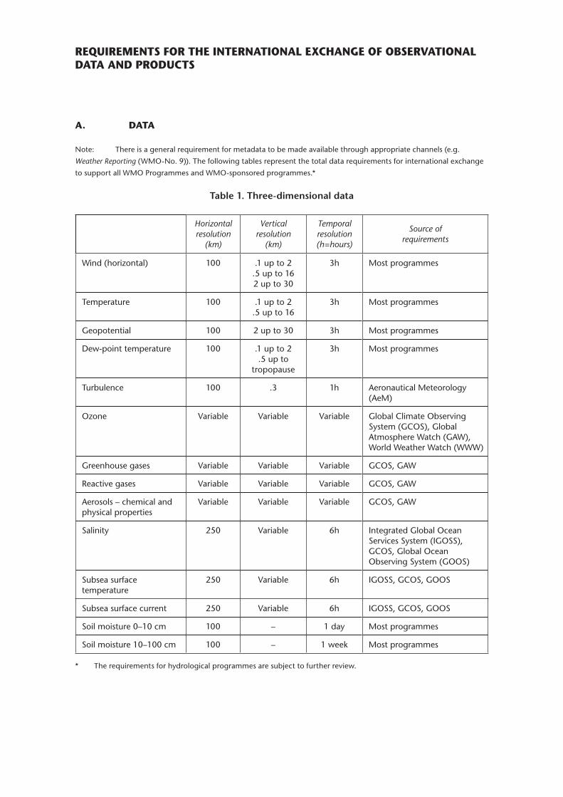
REQUIREMENTS FOR THE INTERNATIONAL EXCHANGE OF OBSERVATIONAL DATA AND PRODUCTS
A. DATA
Note: There is a general requirement for metadata to be made available through appropriate channels (e.g.
Weather Reporting (WMO-No. 9)). The following tables represent the total data requirements for international exchange
to support all WMO Programmes and WMO-sponsored programmes.*
Table 1� Three-dimensional data
Horizontal resolution
(km)
Vertical resolution
(km)
Temporal resolution (h=hours)
Source of requirements
Wind (horizontal) 100 .1 up to 2 .5 up to 162 up to 30
3h Most programmes
Temperature 100 .1 up to 2 .5 up to 16
3h Most programmes
Geopotential 100 2 up to 30 3h Most programmes
dew-point temperature 100 .1 up to 2 .5 up to
tropopause
3h Most programmes
Turbulence 100 .3 1h Aeronautical Meteorology (AeM)
Ozone Variable Variable Variable Global Climate Observing System (GCOS), Global Atmosphere Watch (GAW), World Weather Watch (WWW)
Greenhouse gases Variable Variable Variable GCOS, GAW
Reactive gases Variable Variable Variable GCOS, GAW
Aerosols – chemical and physical properties
Variable Variable Variable GCOS, GAW
Salinity 250 Variable 6h Integrated Global Ocean Services System (IGOSS), GCOS, Global Ocean Observing System (GOOS)
Subsea surface temperature
250 Variable 6h IGOSS, GCOS, GOOS
Subsea surface current 250 Variable 6h IGOSS, GCOS, GOOS
Soil moisture 0–10 cm 100 – 1 day Most programmes
Soil moisture 10–100 cm 100 – 1 week Most programmes
* The requirements for hydrological programmes are subject to further review.
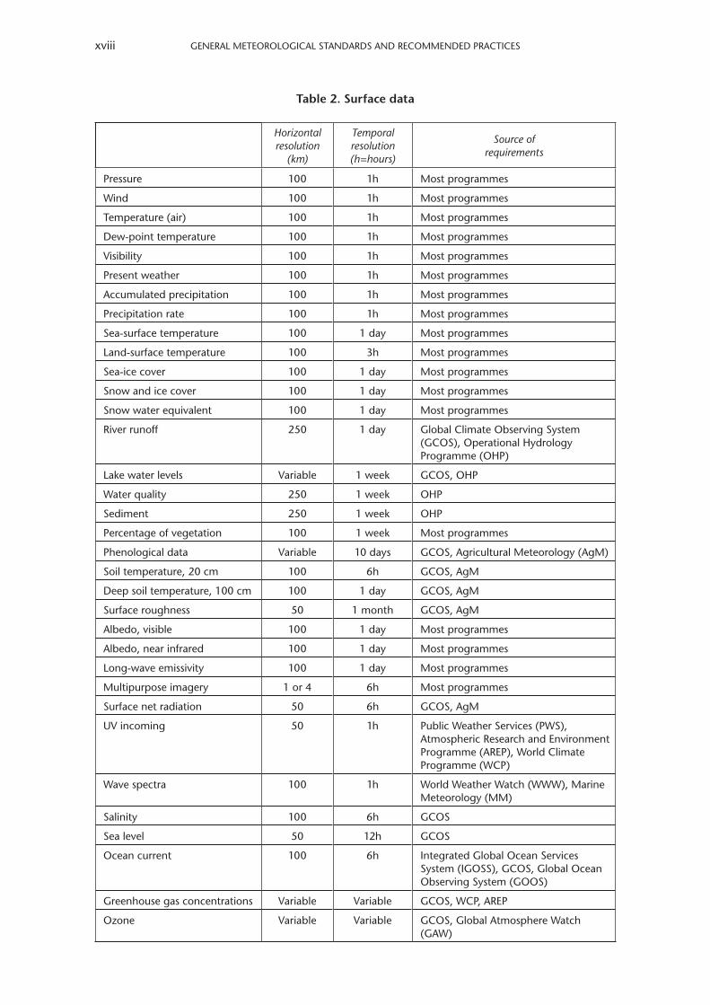
GENERAl METEOROlOGICAl STANdARdS ANd RECOMMENdEd PRACTICESxviii
Table 2� Surface data
Horizontal resolution
(km)
Temporal resolution (h=hours)
Source of requirements
Pressure 100 1h Most programmes
Wind 100 1h Most programmes
Temperature (air) 100 1h Most programmes
dew-point temperature 100 1h Most programmes
Visibility 100 1h Most programmes
Present weather 100 1h Most programmes
Accumulated precipitation 100 1h Most programmes
Precipitation rate 100 1h Most programmes
Sea-surface temperature 100 1 day Most programmes
land-surface temperature 100 3h Most programmes
Sea-ice cover 100 1 day Most programmes
Snow and ice cover 100 1 day Most programmes
Snow water equivalent 100 1 day Most programmes
River runoff 250 1 day Global Climate Observing System (GCOS), Operational Hydrology Programme (OHP)
lake water levels Variable 1 week GCOS, OHP
Water quality 250 1 week OHP
Sediment 250 1 week OHP
Percentage of vegetation 100 1 week Most programmes
Phenological data Variable 10 days GCOS, Agricultural Meteorology (AgM)
Soil temperature, 20 cm 100 6h GCOS, AgM
deep soil temperature, 100 cm 100 1 day GCOS, AgM
Surface roughness 50 1 month GCOS, AgM
Albedo, visible 100 1 day Most programmes
Albedo, near infrared 100 1 day Most programmes
long-wave emissivity 100 1 day Most programmes
Multipurpose imagery 1 or 4 6h Most programmes
Surface net radiation 50 6h GCOS, AgM
UV incoming 50 1h Public Weather Services (PWS), Atmospheric Research and Environment Programme (AREP), World Climate Programme (WCP)
Wave spectra 100 1h World Weather Watch (WWW), Marine Meteorology (MM)
Salinity 100 6h GCOS
Sea level 50 12h GCOS
Ocean current 100 6h Integrated Global Ocean Services System (IGOSS), GCOS, Global Ocean Observing System (GOOS)
Greenhouse gas concentrations Variable Variable GCOS, WCP, AREP
Ozone Variable Variable GCOS, Global Atmosphere Watch (GAW)
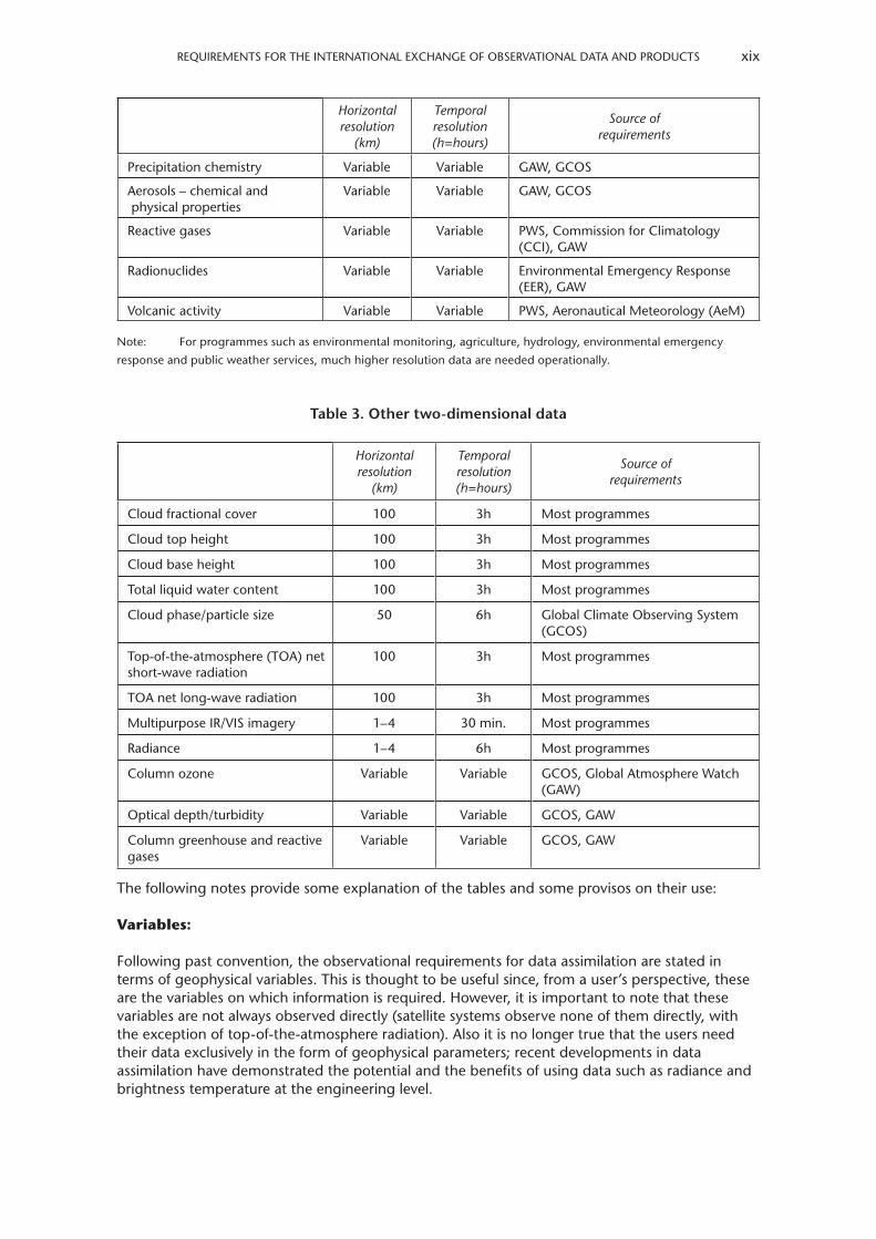
REQUIREMENTS FOR THE INTERNATIONAl EXCHANGE OF OBSERVATIONAl dATA ANd PROdUCTS xix
Horizontal resolution
(km)
Temporal resolution (h=hours)
Source of requirements
Precipitation chemistry Variable Variable GAW, GCOS
Aerosols – chemical and physical properties
Variable Variable GAW, GCOS
Reactive gases Variable Variable PWS, Commission for Climatology (CCI), GAW
Radionuclides Variable Variable Environmental Emergency Response (EER), GAW
Volcanic activity Variable Variable PWS, Aeronautical Meteorology (AeM)
Note: For programmes such as environmental monitoring, agriculture, hydrology, environmental emergency
response and public weather services, much higher resolution data are needed operationally.
Table 3� Other two-dimensional data
Horizontal resolution
(km)
Temporal resolution (h=hours)
Source of requirements
Cloud fractional cover 100 3h Most programmes
Cloud top height 100 3h Most programmes
Cloud base height 100 3h Most programmes
Total liquid water content 100 3h Most programmes
Cloud phase/particle size 50 6h Global Climate Observing System (GCOS)
Top-of-the-atmosphere (TOA) net short-wave radiation
100 3h Most programmes
TOA net long-wave radiation 100 3h Most programmes
Multipurpose IR/VIS imagery 1–4 30 min. Most programmes
Radiance 1–4 6h Most programmes
Column ozone Variable Variable GCOS, Global Atmosphere Watch (GAW)
Optical depth/turbidity Variable Variable GCOS, GAW
Column greenhouse and reactive gases
Variable Variable GCOS, GAW
The following notes provide some explanation of the tables and some provisos on their use:
Variables:
Following past convention, the observational requirements for data assimilation are stated in terms of geophysical variables. This is thought to be useful since, from a user’s perspective, these are the variables on which information is required. However, it is important to note that these variables are not always observed directly (satellite systems observe none of them directly, with the exception of top-of-the-atmosphere radiation). Also it is no longer true that the users need their data exclusively in the form of geophysical parameters; recent developments in data assimilation have demonstrated the potential and the benefits of using data such as radiance and brightness temperature at the engineering level.
GENERAl METEOROlOGICAl STANdARdS ANd RECOMMENdEd PRACTICESxx
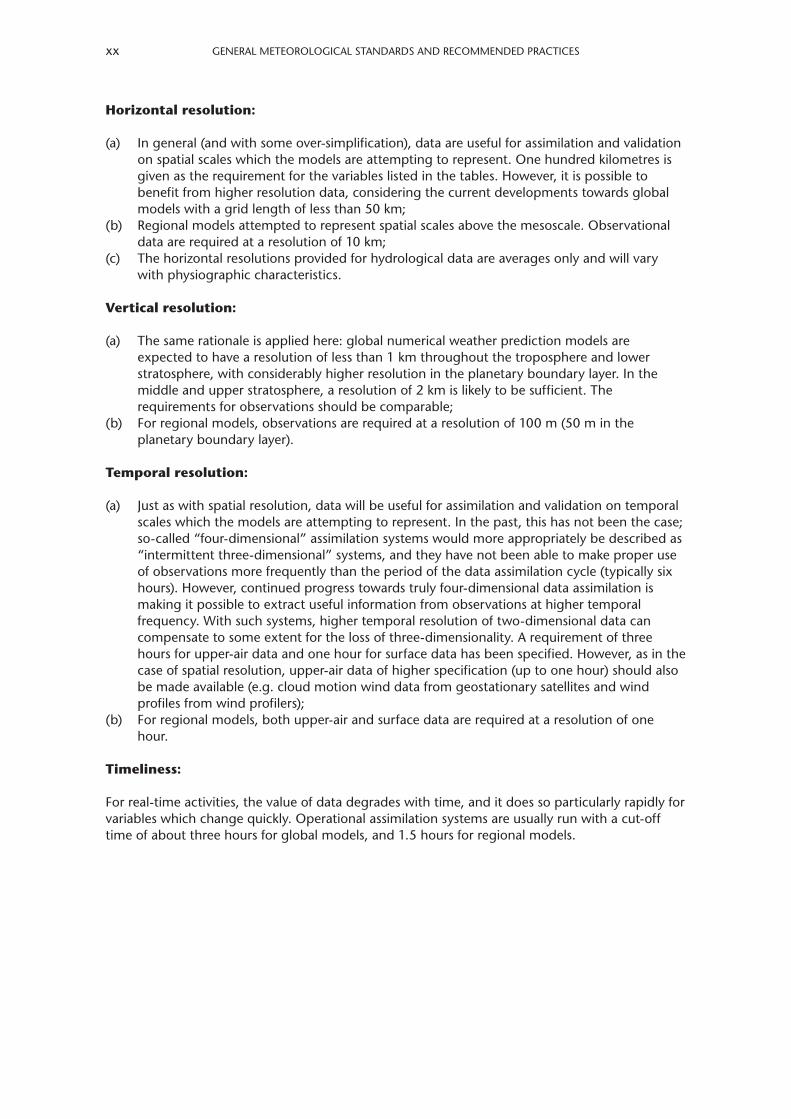
Horizontal resolution:
(a) In general (and with some over-simplification), data are useful for assimilation and validation on spatial scales which the models are attempting to represent. One hundred kilometres is given as the requirement for the variables listed in the tables. However, it is possible to benefit from higher resolution data, considering the current developments towards global models with a grid length of less than 50 km;
(b) Regional models attempted to represent spatial scales above the mesoscale. Observational data are required at a resolution of 10 km;
(c) The horizontal resolutions provided for hydrological data are averages only and will vary with physiographic characteristics.
Vertical resolution:
(a) The same rationale is applied here: global numerical weather prediction models are expected to have a resolution of less than 1 km throughout the troposphere and lower stratosphere, with considerably higher resolution in the planetary boundary layer. In the middle and upper stratosphere, a resolution of 2 km is likely to be sufficient. The requirements for observations should be comparable;
(b) For regional models, observations are required at a resolution of 100 m (50 m in the planetary boundary layer).
Temporal resolution:
(a) Just as with spatial resolution, data will be useful for assimilation and validation on temporal scales which the models are attempting to represent. In the past, this has not been the case; so-called “four-dimensional” assimilation systems would more appropriately be described as “intermittent three-dimensional” systems, and they have not been able to make proper use of observations more frequently than the period of the data assimilation cycle (typically six hours). However, continued progress towards truly four-dimensional data assimilation is making it possible to extract useful information from observations at higher temporal frequency. With such systems, higher temporal resolution of two-dimensional data can compensate to some extent for the loss of three-dimensionality. A requirement of three hours for upper-air data and one hour for surface data has been specified. However, as in the case of spatial resolution, upper-air data of higher specification (up to one hour) should also be made available (e.g. cloud motion wind data from geostationary satellites and wind profiles from wind profilers);
(b) For regional models, both upper-air and surface data are required at a resolution of one hour.
Timeliness:
For real-time activities, the value of data degrades with time, and it does so particularly rapidly for variables which change quickly. Operational assimilation systems are usually run with a cut-off time of about three hours for global models, and 1.5 hours for regional models.
REQUIREMENTS FOR THE INTERNATIONAl EXCHANGE OF OBSERVATIONAl dATA ANd PROdUCTS xxi
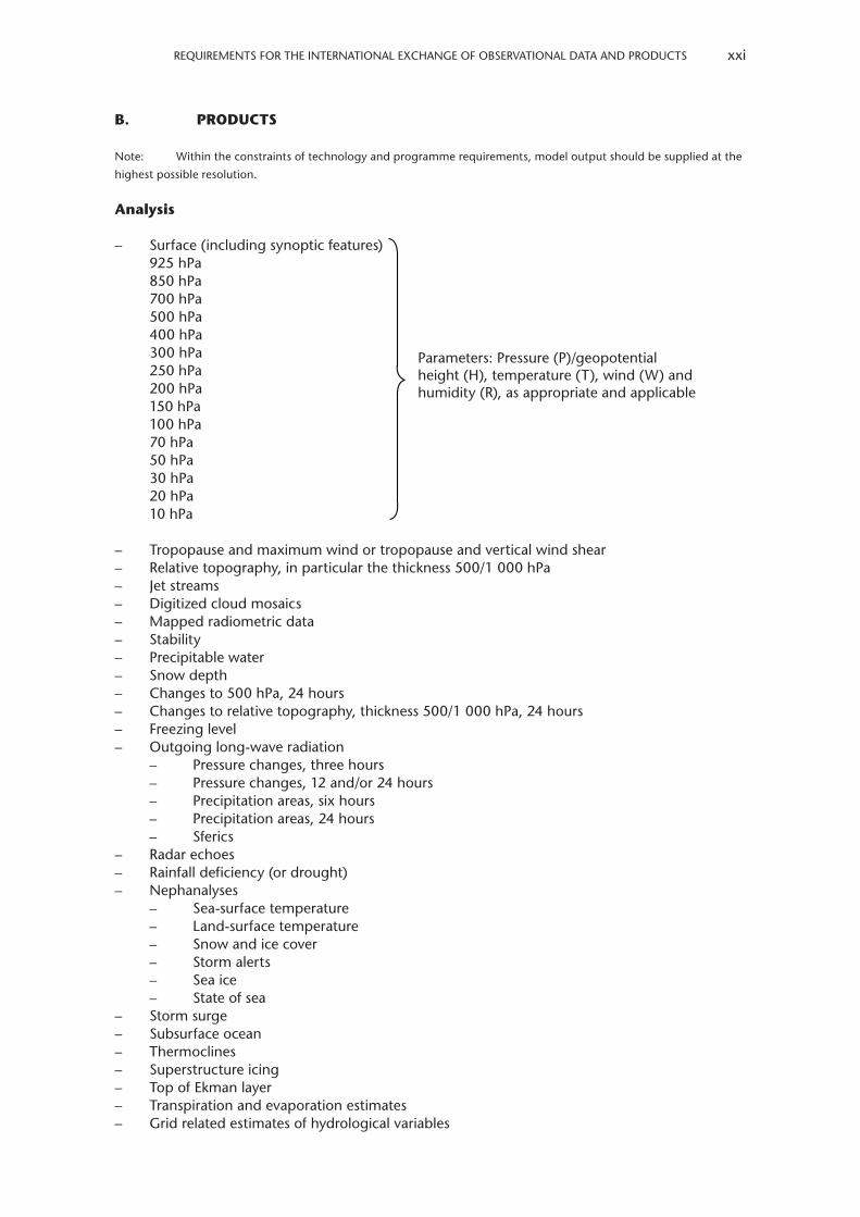
B. PRODUCTS
Note: Within the constraints of technology and programme requirements, model output should be supplied at the
highest possible resolution.
Analysis
– Surface (including synoptic features)925 hPa850 hPa700 hPa500 hPa400 hPa300 hPa250 hPa200 hPa150 hPa100 hPa70 hPa50 hPa30 hPa20 hPa10 hPa
– Tropopause and maximum wind or tropopause and vertical wind shear– Relative topography, in particular the thickness 500/1 000 hPa– Jet streams– digitized cloud mosaics– Mapped radiometric data– Stability– Precipitable water– Snow depth– Changes to 500 hPa, 24 hours– Changes to relative topography, thickness 500/1 000 hPa, 24 hours– Freezing level– Outgoing long-wave radiation
– Pressure changes, three hours– Pressure changes, 12 and/or 24 hours– Precipitation areas, six hours– Precipitation areas, 24 hours– Sferics
– Radar echoes– Rainfall deficiency (or drought)– Nephanalyses
– Sea-surface temperature– land-surface temperature– Snow and ice cover– Storm alerts– Sea ice– State of sea
– Storm surge– Subsurface ocean– Thermoclines– Superstructure icing– Top of Ekman layer– Transpiration and evaporation estimates– Grid related estimates of hydrological variables
Parameters: Pressure (P)/geopotential height (H), temperature (T), wind (W) and humidity (R), as appropriate and applicable
GENERAl METEOROlOGICAl STANdARdS ANd RECOMMENdEd PRACTICESxxii
– Water balance assessments involving estimates of soil moisture deficits or soil moisture contents
– Estimates of potential photosynthesis (possible dry matter production)– Surface-air trajectories– 850 hPa air trajectories– 700 hPa air trajectories– 500 hPa air trajectories– Health risk index for travellers– Stratospheric ozone bulletins– diagnostic analyses of:
– Spatial distributions– Temporal variations– Atmospheric reactions and mechanisms based on atmospheric composition and
radiation measurements– Assessments of satellite ground-truthing radiation experiments– Climate-related analyses (e.g. climate system monitoring and climate normals)
Five-day, 15-day and 30-day mean analysed values and anomalies
Surface850 hPa500 hPa
Sea-surface temperature anomaly
Plotted data
Plotted surface data (three-hourly)Plotted upper-air data (850, 700, ..., 100 hPa)Tabulated windsAerological diagrams
Forecasts
– Surface (including synoptic features)925 hPa850 hPa700 hPa500 hPa400 hPa300 hPa250 hPa200 hPa150 hPa100 hPa70 hPa50 hPa30 hPa20 hPa10 hPa
– Jet-stream location and tropopause/layer of maximum wind– Significant weather– Relative topography, thickness 500/1 000 hPa– Freezing level
Note: The above list includes products which are required as part of the ICAO World Area Forecast System in
accordance with the requirements determined by ICAO.
Parameters: P/H, T, W and R, as appropriate and applicable
Parameters: P/H, T, W and R, as appropriate and applicable
REQUIREMENTS FOR THE INTERNATIONAl EXCHANGE OF OBSERVATIONAl dATA ANd PROdUCTS xxiii
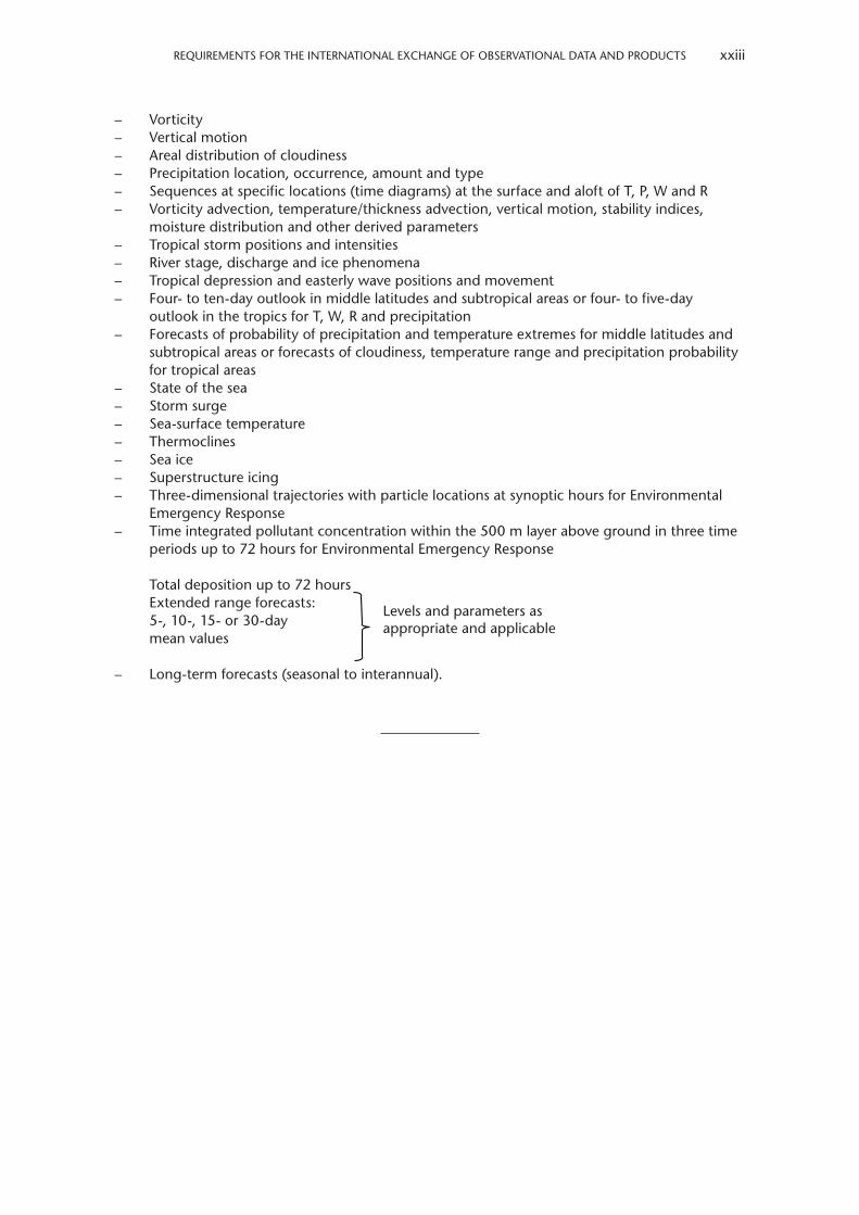
– Vorticity– Vertical motion– Areal distribution of cloudiness– Precipitation location, occurrence, amount and type– Sequences at specific locations (time diagrams) at the surface and aloft of T, P, W and R– Vorticity advection, temperature/thickness advection, vertical motion, stability indices,
moisture distribution and other derived parameters– Tropical storm positions and intensities– River stage, discharge and ice phenomena– Tropical depression and easterly wave positions and movement– Four- to ten-day outlook in middle latitudes and subtropical areas or four- to five-day
outlook in the tropics for T, W, R and precipitation– Forecasts of probability of precipitation and temperature extremes for middle latitudes and
subtropical areas or forecasts of cloudiness, temperature range and precipitation probability for tropical areas
– State of the sea– Storm surge– Sea-surface temperature– Thermoclines– Sea ice– Superstructure icing– Three-dimensional trajectories with particle locations at synoptic hours for Environmental
Emergency Response– Time integrated pollutant concentration within the 500 m layer above ground in three time
periods up to 72 hours for Environmental Emergency Response
Total deposition up to 72 hoursExtended range forecasts:5-, 10-, 15- or 30-daymean values
– long-term forecasts (seasonal to interannual).
levels and parameters as appropriate and applicable

PART I. WORLD WEATHER WATCH
1. GLOBAL OBSERVING SYSTEM
1.1 Meteorological observing networks, stations and observations
1.1.1 General – Scope, purpose and operation of the Global Observing System
1.1.1.1 The Global Observing System shall be constituted as a coordinated system of methods, techniques and facilities for making observations on a worldwide scale and defined as one of the main components of the World Weather Watch�
1.1.1.2 The purpose of the Global Observing System shall be to provide the meteorological and related environmental observations from all parts of the globe that are required by Members for operational and research purposes�
1.1.1.3 The Global Observing System shall consist of two sub-systems: the surface-based sub-system and the space-based sub-system, the former being composed of the regional basic synoptic networks of surface and upper-air stations, climatological stations, agricultural meteorological stations, aircraft meteorological stations, and other networks of synoptic stations on land and at sea as detailed in Annex V (Manual on the Global Observing System (WMO-No� 544), Volume I) and the latter of near-polar-orbiting and geostationary meteorological satellites�
1.1.1.4 The Global Observing System shall be established and operated in accordance with the procedures and practices set out in Annex V (Manual on the Global Observing System (WMO-No� 544), Volume I)�
2. GLOBAL DATA-PROCESSING AND FORECASTING SYSTEM
2.1 Organization and functions of the Global Data-processing and Forecasting System
2.1.1 General
2.1.1.1 The Global Data-processing and Forecasting System shall include World Meteorological Centres, Regional Specialized Meteorological Centres and National Meteorological Centres�
2.1.1.2 Members which have accepted the responsibility of establishing and operating World Meteorological Centres and Regional Specialized Meteorological Centres specified in the World Weather Watch plan shall:
(a) Prepare and make available to other Members processed meteorological information;(b) Archive and process data for research and applications;(c) Provide opportunities for training, conducting of both basic and applied research and
publishing of selected data�
GENERAl METEOROlOGICAl STANdARdS ANd RECOMMENdEd PRACTICES2
2.1.1.3 The Global Data-processing and Forecasting System shall be established and operated in accordance with procedures and practices set out in Annex IV (Manual on the Global Data-processing and Forecasting System (WMO-No� 485), Volume I)�
2.1.2 Functions of centres
Real-time and non-real-time functions of World Meteorological Centres, Regional Specialized Meteorological Centres and National Meteorological Centres should be as given in Annex IV (Manual on the Global Data-processing and Forecasting System (WMO-No. 485), Volume I).
2.2 Analysis and forecasting practices
2.2.1 General – Constants, definitions and specifications
2.2.1.1 If the formula for a function or the value of a constant is given in Appendix A, Members shall use that formula or value, when required, for meteorological purposes�
2.2.1.2 Each Member shall use the definitions and specifications of water vapour in the atmosphere given in Appendix B�
2.2.2 Weather charts – Projections, scales and symbols
2.2.2.1 Appropriate projections and scales along the standard parallels used for weather charts should be as given in Annex IV (Manual on the Global Data-processing and Forecasting System (WMO-No. 485), Volume I).
2.2.2.2 The symbols used for the pictorial representation of observed data and for analysis and prognosis on weather charts should be those set out in Annex IV (Manual on the Global Data-processing and Forecasting System (WMO-No. 485), Volume I, Appendix II.4).
2.2.3 Properties of aerological diagrams – General requirements
2.2.3.1 diagrams used for representation and analysis of upper-air observations of pressure, temperature and humidity should be as given in Annex IV (Manual on the Global Data-processing and Forecasting System (WMO-No. 485), Volume I).
2.2.3.2 diagrams used for the accurate computation of geopotential from upper-air observations of pressure, temperature and humidity should possess the features given in Annex IV (Manual on the Global Data-processing and Forecasting System (WMO-No. 485), Volume I).
2.2.4 Upper-air analyses – Reference surfaces
2.2.4.1 Rules and procedures for representing and analysing the conditions in the free atmosphere, including standard isobaric surfaces to be used (except above 100 hPa), shall be as given in Annex IV (Manual on the Global Data-processing and Forecasting System (WMO-No� 485), Volume I)�
2.2.4.2 The standard isobaric surfaces for representing and analysing the conditions in the atmosphere above 100 hPa should be as given in Annex IV (Manual on the Global Data-processing and Forecasting System (WMO-No. 485), Volume I).
PART I. WORld WEATHER WATCH 3
2.2.5 General – Publication of synoptic observations
Each Member should publish, with as little delay as possible, a daily or monthly bulletin consisting, if so desired, of reports in the international code form, including:
(a) Reports made at main standard times by its surface land stations included in the regional basic synoptic network, or a selection of them if the network is dense;
(b) Reports from all its upper-air stations;(c) Reports from sea stations, or a selection of them if the network is dense.
2.3 International codes
2.3.1 General – Code forms
Coded information exchanged for international purposes shall be in the appropriate international code forms specified in Annex II (Manual on Codes (WMO-No� 306), Volume I)�
Note: Coded information exclusively for exchange between one Member and another may be in other forms by
bilateral agreement.
2.3.2 Symbolic words, groups and letters
2.3.2.1 The symbolic words, groups and letters (or groups of letters) used in international code forms and their meanings or specifications shall be as given in Annex II (Manual on Codes (WMO-No� 306), Volume I)�
2.3.2.2 Symbolic words, groups and letters (or groups of letters) required for regional or national purposes only shall be selected so as not to duplicate those used in international code forms�
2.3.3 Code figures
Specifications of code figures (code tables) used in international code forms specified in 2�3�1 above shall be as given in Annex II (Manual on Codes (WMO-No� 306), Volume I)�
3. WMO INFORMATION SYSTEM
3.1 Purpose
Note: WMO recognizes that its mission in weather, climate, water and related environmental issues depends upon
the collection, distribution and open sharing of information, often using rapid and highly reliable methods. The WMO
Information System is a key tool for optimizing the efficiency and effectiveness of WMO.
3.2 Principles
3.2.1 The WMO Information System shall:
(a) Be used for the collection and sharing of information for all WMO and related international programmes;
GENERAl METEOROlOGICAl STANdARdS ANd RECOMMENdEd PRACTICES4
(b) Provide a flexible and extensible data management and data communication structure that allows the participating centres to enhance their capabilities as their national and international responsibilities grow;
(c) Make use of international standards for relevant practices, procedures and specifications�
3.2.2 The basic engineering principles adopted for the WMO Information System data communication networks shall provide for the integration of global, regional and national data communication systems to ensure transmission of the required information within the specified acceptable time delays�
3.3 Organization
3.3.1 The WMO Information System shall be organized primarily by data management functions and also incorporate the required information exchange functions� The WMO Global Telecommunication System shall be incorporated into the WMO Information System and be operated as part of it�
3.3.2 Centres participating in the WMO Information System shall be categorized as follows:
(a) Global Information System Centres;(b) Data Collection or Production Centres;(c) National Centres�
3.3.3 Based on the recommendations of the Commission for Basic Systems, coordinated with relevant technical commissions and regional associations, as appropriate, the Congress and Executive Council shall:
(a) Consider the designation of Global Information System Centres and Data Collection or Production Centres;
(b) Regularly review previously designated Global Information System Centres and Data Collection or Production Centres, including the reconsideration of their designation�
3.3.4 Members shall designate National Centres�
3.3.5 The WMO Information System functions and operation shall be based on catalogues that contain metadata for data and products available across WMO, and metadata describing dissemination and access options� These catalogues shall be maintained by WMO Information System Centres�
3.3.6 Members operating Global Information System Centres shall:
(a) Provide comprehensive search across catalogues, through collaboration amongst all Global Information System Centres;
(b) Provide access to and disseminate WMO data and products intended for global exchange;
(c) Be associated with Data Collection or Production Centres and National Centres within their area of responsibility�
3.3.7 Members operating Data Collection or Production Centres shall:
(a) Use WMO Information System to collect, disseminate, provide access to, and store relevant regional or programme-specific data and products;
(b) Maintain catalogues of their holdings and services, and provide appropriate parts of these catalogues to the Global Information System Centres to ensure a comprehensive catalogue of WMO Information System holdings�
PART I. WORld WEATHER WATCH 5
3.3.8 Members operating National Centres shall:
(a) Use the WMO Information System to provide data and products in accordance with their programme responsibilities;
(b) Provide associated metadata to other WMO Information System Centres to become part of the comprehensive catalogue of WMO Information System holdings�
3.3.9 Members operating Global Information System Centres, Data Collection or Production Centres and National Centres shall monitor the performance of the WMO Information System�
3.3.10 The WMO Information System shall feature data communication network management that includes dedicated data network services, especially for mission-critical information exchange, and public data network services such as the Internet, to ensure the efficiency and effectiveness of the required information exchange�
3.4 Responsibilities
3.4.1 Members operating Global Information System Centres, Data Collection or Production Centres, and National Centres shall ensure that all appropriate measures are taken for the installation and good functioning of their centres, and of the required data communication systems and services, in relation to their needs and the roles which they have accepted�
3.4.2 Members shall ensure that their national information collecting systems allow not only national but also international needs to be met�
3.5 Practices, procedures and specifications
3.5.1 The WMO Information System data management and information exchange functions shall be established and operated in accordance with practices, procedures and specifications set out in Annex VII (Manual on the WMO Information System (WMO-No� 1060))�
3.5.2 The Global Telecommunication System shall be operated in accordance with practices, procedures and specifications set out in Annex III (Manual on the Global Telecommunication System (WMO-No� 386), Volume I)�
Note: The Manual on the WMO Information System (WMO-No. 1060) complements the Manual on the Global
Telecommunication System (WMO-No. 386). Eventually, the Manual on the WMO Information System (WMO-No. 1060) will
replace the Manual on the Global Telecommunication System (WMO-No. 386) while incorporating relevant content.

PART II. OTHER GENERAL STANDARDS AND RECOMMENDED PRACTICES
1. CLIMATOLOGY
1.1 General – Climatological data
Note: detailed guidance regarding the collection, processing and publication of climatological data is given in the
Guide to Climatological Practices (WMO-No.100, Second edition).
1.1.1 Members should establish, maintain and update explanatory metadata and ensure data homogeneity. Such metadata should provide details and history of local conditions of the observing stations, instruments, operating procedures as well as information describing data sets and data processing algorithms and other factors pertinent to using and interpreting the data in accordance with Annex V (Manual on the Global Observing System (WMO-No. 544), Volume I, Part III 2.8.4).
Note: detailed guidance regarding the establishment, maintenance and update of metadata is given in the Guide to
Climatological Practices (WMO-No. 100), Chapter 3, 3.3.4, the Guide to Meteorological Instruments and Methods of
Observation (WMO-No. 8), Part I, Chapter 1, 1.3.4 and Part III, Chapter 1, 1.9, and in the Guide to the Global Observing
System (WMO-No. 488), Appendix III.3.
1.1.2 Climatological data should include the results of observations made at the meteorological observing stations specified in Annex V (Manual on the Global Observing System (WMO-No. 544), Volume I, Part III).
1.1.3 Members should collect, quality control and process, on at least a monthly basis, data from a selection of representative high-quality stations for climatological purposes.
1.2 Collection of climatological data
1.2.1 National arrangements
1.2.1.1 Collection, maintenance and transfer of climatological data and records should be carried out by Members as indicated in Annex IV (Manual on the Global Data-processing and Forecasting System (WMO-No. 485), Volume I).
1.2.1.2 The international maritime meteorological tape format shown as Appendix I.15 of Annex VI (Manual on Marine Meteorological Services (WMO-No. 558), Volume I) should be used for recording surface synoptic observations made at sea stations.
1.3 Exchange of climatological data
1.3.1 International requirements
1.3.1.1 Each Member shall arrange for the distribution of the climatological data for a selection of its stations, in accordance with the provisions of Annex II (Manual on Codes (WMO-No� 306), Volume I) and Annex III (Manual on the Global Telecommunication System (WMO-No� 386), Volume I)� The data shall be available as soon as possible after the end of the month�
1.3.1.1.1 The climatological data referred to in Regulation 1.3.1.1 above should be available not later than the fifth day of the following month.
GENERAl METEOROlOGICAl STANdARdS ANd RECOMMENdEd PRACTICES8
1.3.1.1.2 The distribution of stations from which monthly surface climatological data are transmitted should be such that every 250 000 km2 is represented by at least one station and up to 10 stations where the density of the regional basic synoptic network permits; the distribution of stations from which monthly upper-air climatological data are transmitted should be such that every 1 000 000 km2 is represented by at least one station.
1.3.1.2 Each Member should establish normals (including climatological standard normals) and periodically revise them as appropriate, for stations whose climatological data are distributed on the Global Telecommunication System in accordance with the provisions of Annex II (Manual on Codes (WMO-No. 306), Volume I) and forward those normals to the Secretariat.
1.3.1.3 Members should exchange routine and special climatological publications by mutual agreement.
1.3.1.4 Copies of climatological data, either in ordinary script or on digital media, microfilm or in some other suitable form, should be made available on request, provided that the requesting Member undertakes to bear any additional expenditure involved.
1.3.1.5 When supplying synoptic surface observational data from mobile ship stations to meteorological services for international use, the international maritime meteorological tape format reproduced as Appendix I.15 of Annex VI (Manual on Marine Meteorological Services (WMO-No. 558), Volume I) should be used; when supplying such data originating before 1960, the coding procedure given in Appendix I.15 of Annex VI (Manual on Marine Meteorological Services (WMO-No.558), Volume I) should also be used, or some mutually acceptable format.
Note: Regulations pertaining to the Marine Climatological Summary Scheme are contained in Part III, 1.2.5.
1.3.1.6 Members which have agreed to compute and distribute monthly mean surface pressure values for oceanic areas should arrange for the distribution in accordance with the provisions of Annex II (Manual on Codes (WMO-No. 306), Volume I) and Annex III (Manual on the Global Telecommunication System (WMO-No. 386), Volume I). The data should be available as soon as possible after the end of the month and not later than the fifth day of the following month.
1.4 Climatological statistics
1.4.1 Time units
The time units used in processing climatological data should be selected from the following:
(a) The Gregorian calendar year;(b) The months of this calendar;(c) The mean solar day, from midnight to midnight, according to the zonal time or the mean
solar time of the station, when the climatological data permit.
1.4.2 Climatological frequencies, sums and averages
1.4.2.1 Frequencies, sums or averages, whichever applicable, of the observations of a meteorological element at a fixed time of the day or of extreme values for the day should be computed, either for individual time units or for a sequence of recurring time units (e.g. ten successive Januaries, etc.), using international time designation.
PART II. OTHER GENERAl STANdARdS ANd RECOMMENdEd PRACTICES 9
1.4.2.2 Frequencies, sums or averages, whichever applicable, of all or most of the following data from a selection of climatological stations should be computed for each month:
(a) Atmospheric pressure at fixed times at the reference level appropriate to the station, as indicated in 1.5.2.2.2 (b) below;
(b) Air temperature at fixed times;(c) daily air temperature extremes;(d) Relative humidity at fixed times;(e) Vapour pressure at fixed times;(f) Wind speed at fixed times, and for fixed periods;(g) Wind direction at fixed times;(h) Cloud amount at fixed times;(i) Amounts of precipitation for fixed periods;(j) duration of bright sunshine for fixed periods.
1.4.2.3 Frequencies, sums and averages of hourly values at a selection of climatological stations should be computed for each month for at least the following elements:
(a) Atmospheric pressure at the reference level appropriate to the station as indicated in 1.5.2.2.2 (b) below;
(b) Air temperature;(c) Relative humidity or vapour pressure;(d) Wind speed and direction;(e) Precipitation;(f) Hours of bright sunshine.
1.4.2.3.1 In so far as the type of observation permits, frequencies, sums, averages, anomalies and percentages of normals from ocean weather stations should be computed on a monthly and annual basis.
1.4.2.4 Annual averages should be computed by dividing the sum of the monthly averages by twelve, without consideration of the varying lengths of the months.
1.4.2.5 Members should compute for representative stations within their territory period averages, normals and climatological standard normals.
Note: When records are not available for the computation of period averages, normals or climatological standard
normals, averages for shorter periods, for example five years, may be useful, especially for ocean weather stations and for
upper-air stations in tropical countries.
1.5 Publication of climatological data
1.5.1 General
Whenever period averages, normals and climatological standards are published, the period to which they refer should be included as well as the standard hours of the observations used.
1.5.2 Publication of surface observations
1.5.2.1 Each Member should publish annual climatological reports.
Note: Monthly reports plus an annual summary may constitute an annual report.
GENERAl METEOROlOGICAl STANdARdS ANd RECOMMENdEd PRACTICES10
1.5.2.2 The general information contained in annual climatological reports should consist of:
1.5.2.2.1 A statement giving:
(a) The standards of time used;(b) The types of instrument used;(c) The methods of applying corrections;(d) The methods with which conventional means are computed;(e) The times at which extreme temperatures are read.
1.5.2.2.2 A list for each station giving:
(a) Name and geographical coordinates using as reference the geodetic system WGS 84 (reference for GPS);
(b) The altitude of the reference level for station pressure;(c) The heights of the thermometer bulb, the anemometer head and the rim of the raingauge
above ground level.
Note: Model tables for climatological summaries are given in the Guide to Climatological Practices (WMO-No. 100).
1.5.2.3 If the main language of a publication is not English, French, Russian or Spanish, all headings of tables should be in one of these official languages, or in internationally recognized symbols or letters.
Note: Although Arabic and Chinese are official languages of WMO, Congress has not yet approved their use in all
aspects of the work of WMO.
1.5.2.4 Each Member should publish or make available on a national and regional basis at least the following radiation data:
(a) For principal radiation stations, hourly totals of global solar radiation and of sky radiation, in accordance with Annex V (Manual on the Global Observing System (WMO-No. 544), Volume I, Part III);
(b) For ordinary radiation stations, daily totals of global solar radiation, in accordance with Annex V (Manual on the Global Observing System (WMO-No. 544), Volume I, Part III).
1.5.3 Publication of upper-air observations
1.5.3.1 Where publication of checked data from upper-air observations is impracticable, the data shall be made available on request by other means�
1.5.3.2 Members, either individually or in groups under mutual agreement, should publish checked data from upper-air observations with their monthly means and extremes, including those from ocean weather stations.
Note: Model tables for climatological summaries are given in the Guide to Climatological Practices (WMO-No. 100).
1.5.3.3 Published upper-air data should include data for the standard isobaric surfaces referred to in Part I, 2.2.4.1 and 2.2.4.2.
Note: Upper-air data may also be published for additional isobaric surfaces as indicated in the Guide to
Climatological Practices (WMO-No. 100) and for the significant levels as defined in this Guide.
PART II. OTHER GENERAl STANdARdS ANd RECOMMENdEd PRACTICES 11
1.5.4 Publication of old climatological data
Members should publish or make available on request old series of reliable data which have not previously been published.
Note: Publication of data from reference climatological stations is especially desirable.
1.6 Climatic atlases
Members should prepare and keep up to date national climatic atlases.
Note: Specifications for the layout and content of these atlases are given in the Guide to Climatological Practices
(WMO-No. 100).
2. GLOBAL ATMOSPHERE WATCH
2.1 General
2.1.1 The purpose and long-term goal of the Global Atmosphere Watch (GAW) shall be to provide data and other information on the atmospheric chemical composition and related physical characteristics of the background atmosphere from all parts of the globe, required to improve understanding of the behaviour of the atmosphere and its interactions with the oceans and the biosphere, and to enable prediction of the future states of the Earth system�
Notes:
1. The GAW measurements will facilitate the preparation of scientific assessments of the state of the atmospheric
environment that are required for operational, research, policy and other appropriate purposes.
2. In particular, the GAW measurements will be essential to the investigation of:
(a) The links between meteorological and chemical phenomena in the atmosphere;
(b) The relationship between changes in atmospheric composition and physical characteristics and changes in
the global and regional climate;
(c) The impact of changes in climate and other aspects of the Earth system on the chemical composition and
related physical characteristics of the atmosphere;
(d) The long-range atmospheric transport, transformation and deposition of potentially harmful substances;
(e) The natural cycling of chemical elements in the global atmosphere/ocean/biosphere system, and
anthropogenic impacts thereon.
2.1.2 GAW shall be a coordinated system of networks of observing stations, facilities and arrangements encompassing the many monitoring and related scientific assessment activities devoted to the investigation of the changing chemical composition and related physical characteristics of the global atmosphere�
2.1.3 Existing WMO networks of stations, such as the Global Ozone Observing System and the Background Air Pollution Monitoring Network, shall be consolidated into GAW�
2.1.4 The GAW system should also encompass a number of other relevant existing and new networks, both within and outside WMO.
2.1.5 GAW shall be organized, to the extent feasible, in cooperation with other international programmes concerned with aspects of the chemical composition and related physical characteristics of the evolving state and behaviour of the atmosphere and the climate�
GENERAl METEOROlOGICAl STANdARdS ANd RECOMMENdEd PRACTICES12
2.1.6 GAW shall be composed of networks of stations and central facilities operated by Members and shall include arrangements for:
(a) Scientific leadership and continuing involvement of scientists in the component programmes;
(b) The collection of samples of atmospheric precipitation, gases and particles, and the chemical analysis of the samples for selected chemical constituents;
(c) The direct measurement of selected chemical constituents and physical properties of the atmosphere;
(d) The provision of concurrent meteorological data;(e) The collection of air, aerosol and precipitation samples for archiving;(f) Central facilities for, inter alia, the preparation and supply of standards, and for carrying
out calibrations and intercomparisons;(g) Central facilities for, inter alia, the processing, archiving and publication of data, derived
products and information, which provide a means to assess the integrity and uncertainties of the basic data;
(h) Quality control and quality assurance procedures;(i) The continuing use and scientific assessments of the data;(j) The training of appropriate operational, managerial and scientific personnel�
2.1.7 GAW shall be designed as a flexible and evolving system, capable of continual improvement in response to advances in scientific knowledge and technology, and in accordance with changing needs for data on atmospheric composition and related physical characteristics�
2.1.8 The planning, implementation and ongoing coordination of GAW shall be realized through the recommendations of the Commission for Atmospheric Sciences in consultation with Members, regional associations, other technical commissions and other organizations, as necessary�
2.2 Principles of implementation
GAW should be implemented in accordance with the following principles:
(a) All activities connected with its implementation in the territories of individual countries should be the responsibility of the countries themselves and should, as far as possible, be met from national resources;
(b) The implementation of GAW in the territory of developing countries should be based on the principle of the utilization of national resources. However, where necessary and so requested, particularly by least developed countries, full assistance should be provided through WMO within joint bilateral (including “twinning”) and/or multilateral projects with other Members or organizations such as the United Nations development Programme, the United Nations Environment Programme and the WMO Voluntary Cooperation Programme;
(c) The implementation of GAW in regions outside the territories of individual countries – for example in outer space, the oceans or the Antarctic – should be based on the principle of voluntary participation of countries that desire and are able to contribute by providing facilities and services, on a sporadic or regular basis, either individually or jointly from their national resources, or by having recourse to collective financing. The possibility of granting assistance under the WMO Voluntary Cooperation Programme or other international sources should not, however, be excluded;
(d) In the implementation of GAW, maximum use should be made of existing facilities, personnel and arrangements in the different related fields of activity involved.
Notes:
1. The implementation of GAW includes the improvement of existing facilities and the establishment of new ones
called for in the GAW planning, and any necessary further work concerning these facilities;
PART II. OTHER GENERAl STANdARdS ANd RECOMMENdEd PRACTICES 13
2. The establishment and/or operation of existing, improved and new facilities and services require a considerable
amount of scientific research, development, engineering, coordination of procedures and standardization of
methods;
3. The further development of GAW will include an important feature of GAW planning which aims at the following:
(a) The establishment of additional stations, laboratories and centres, especially in developing countries;
(b) The short- and long-term training of experts and scientists in developing countries with a view to the full
participation of those countries in GAW activities;
(c) The extension and improvement of the operation of the stations and related facilities with a view to achieving
system effectiveness, reliability and stability as measured by promptness in data processing and publication,
the high quality and completeness of the data produced and the quality of the scientific assessments;
(d) The rapid adaptation to opportunities provided by scientific and technological advances;
(e) Placing additional emphasis on the analysis, interpretation and application of the collected data, in particular
by linking the chemical data and data on related physical characteristics of the atmosphere with both
conventional meteorological data and theoretical models;
(f) The timely response to changing environmental needs;
(g) The provision of the support needed by other WMO programmes and by relevant international programmes
established by other organizations such as the Global Environment Monitoring System of the United Nations
Environment Programme, the Cooperative Programme for Monitoring and Evaluation of the long-range
Transmission of Air Pollutants in Europe, and the International Geosphere-Biosphere Programme/International
Global Atmosphere Chemistry Project.
2.3 Requirements for data on the chemical composition and related physical characteristics of the atmosphere
2.3.1 Classification of requirements
2.3.1.1 Requirements for data from global stations shall be related to Members’ needs to address environmental issues of global scale and importance such as climate change, stratospheric ozone changes and the oxidizing capacity of the atmosphere�
2.3.1.2 Requirements for data from regional stations shall be related to regional aspects of global environmental issues, to environmental issues of regional scale and importance such as acid rain, photo-oxidants including ozone and long-range transport of pollutants across national boundaries, and to recommendations by regional and national bodies�
2.3.2 Systems for meeting the requirements
The networks of surface-based stations, complemented by satellites, shall be the main source of the data�
Note: data from satellites are of increasing importance in GAW.
2.4 Networks of stations
2.4.1 General
2.4.1.1 To satisfy the requirements for data on the chemical composition and related physical characteristics of the atmosphere, two categories of stations – global and regional – shall be established�
2.4.1.2 The global stations shall have extensive research and monitoring programmes and shall focus on the measurement of a broad spectrum of variables related to atmospheric composition, climate and atmospheric ozone changes and other environmental issues of global scale and importance�
GENERAl METEOROlOGICAl STANdARdS ANd RECOMMENdEd PRACTICES14
2.4.1.3 They should serve as reference stations for regional networks and have facilities for visiting investigators to conduct complementary short-term research and development studies.
2.4.1.4 The regional stations shall be similar to the existing Background Air Pollution Monitoring Network and Global Ozone Observing System stations but shall have a more loosely defined measurement programme� Their goal shall be to satisfy regional needs in different parts of the world as well as the specific needs of individual Members�
2.4.1.5 The frequency and spacing of the various observations shall be appropriate to the temporal and spatial requirements of the specific issues addressed�
2.4.2 Global stations
2.4.2.1 Global stations shall be designed to meet the global requirements for data to address environmental issues of global scale and importance�
2.4.2.2 The specifications for the network configuration, observing programmes and frequency of observations for global stations should be as laid down in the recommendations of the Commission for Atmospheric Sciences, based on the Quality Assurance/Quality Control Plan.
2.4.2.3 Subject to the specific observational requirements of the various issues under investigation, Members should establish or cooperate in the establishment of a minimum of about 30 global stations worldwide.
Note: It would be desirable to locate at least one global station in each principal climate zone and in each major
biome.
2.4.3 Regional stations
Regional stations shall be designed primarily to address regional aspects of global environmental issues and environmental problems of regional scale and importance�
Notes:
1. In addition to global and regional stations, Members may wish to establish other stations to satisfy specific national
requirements for data on the chemical composition and related physical characteristics of the atmosphere.
2. However, when establishing such stations, Members should take into account the need to complete the networks
of global and regional stations and the desirability of using global and regional stations as reference stations for
national networks.
3. The list of all global and regional stations can be found on the GAW Station Information System website at http://gaw.
empa.ch/gawsis.
2.5 Location of the stations
2.5.1 Each global station should preferably be located in a remote area where no significant changes in land-use practices are expected for the coming decades within a reasonable distance (30–50 km) in all directions from the station. The site should be away from major population centres and major highways, preferably in a principal terrestrial biome or on an island, entirely free of the effects of local pollution and nearly free of the influence of regional pollution sources at least 60 per cent of the time evenly distributed over the year. The site should at most infrequently experience direct effects from natural phenomena such as volcanic activity, forest fires and severe dust storms.
PART II. OTHER GENERAl STANdARdS ANd RECOMMENdEd PRACTICES 15
2.5.2 Each global station should have a complete set of surface meteorological observations and be located on or near (50–70 km) an upper-air synoptic station.
2.5.3 locations for GAW regional stations should be selected in such a way that the observations collected there are representative of a significant portion of the region and are not unduly affected by nearby pollution sources such as roads, combustion, industrial and extensive farming activities, etc. Furthermore, sites should be avoided where significant land-use changes are foreseen. Regional stations should also have a complete set of surface meteorological observations and be co-located with, or located near (50–70 km), upper-air synoptic stations.
Notes:
1. For regional stations which are dedicated to studies on the atmospheric transport, transformation and deposition
of potentially harmful substances, the representativity of the station site and the avoidance of local pollution
sources ought to take priority over co-location with upper-air synoptic stations.
2. The surface meteorological observations obtained at a GAW station or at a co-located surface synoptic station, and
the upper-air observations from a co-located or nearby upper-air synoptic station are essential for a thorough
interpretation of the GAW data set.
3. The definitions of “surface synoptic station”, “upper-air synoptic station”, “meteorological observing station”,
“surface observation” and “upper-air observation” are given in the definitions section of this volume.
4. Since baseline conditions are not necessary for the measurements of total column ozone and/or those of the
vertical distribution of ozone, GAW Global Ozone Observing System stations may be located farther (100–150 km)
away from GAW background stations.
5. The figures given in 2.5.1 to 2.5.3 above are approximate and for guidance only. The situation will differ for each
station. Each station must, however, establish and record its conditions for the background mode of operation.
2.6 Information about the stations
2.6.1 When a Member establishes a GAW global or regional station, the Member shall send the following information to the WMO Secretariat within six months of the start of operations:
(a) Name, address and, if the station is also a synoptic station, the WMO index number;(b) Latitudinal and longitudinal coordinates in degrees and minutes of arc;(c) Elevation above mean sea level in whole metres;(d) List of variables to be measured, with a description of the initial measurement programme
and, for each variable, details of the instrument(s) used such as type, serial number, calibration method and factors;
(e) A brief description of the local topography and other major characteristics of the station’s surroundings;
(f) Name and address of the chemical laboratory where samples are analysed, with the name of the person in charge and, for each variable, the method(s) of analysis used;
(g) Name and address of the organization, agency or institution supervising the station, with the name and title of the person in charge;
(h) Any other information required for the completion of each entry in data reporting forms prepared by the Secretariat�
2.6.2 Members shall send the necessary amendments to the information supplied under 2�6�1 (a) to (h) above to the Secretariat as soon as possible after any change occurs, but not later than 31 December of the year in which the change occurs�
2.6.3 Each Member should maintain and publish or make available in a convenient form an up-to-date directory of its atmospheric composition monitoring stations participating in GAW. The description of each station should give the information mentioned in 2.6.1 (a) to (h) above and should be in sufficient detail to enable the assessment of eventual departures from site representativeness.
GENERAl METEOROlOGICAl STANdARdS ANd RECOMMENdEd PRACTICES16
2.7 Supervision of the stations
In order to promote high-quality measurements of the chemical composition and related physical characteristics of the atmosphere and the proper functioning of the instruments, Members shall arrange for annual inspections of their GAW stations, including systems and performance audit based on the Quality Assurance/Quality Control Plan by qualified scientists�
Note: An additional reason for annual station visits is to maintain direct contact with the station personnel as such
contact is vital to maintain their morale and commitment.
2.8 Measurement programme
2.8.1 Members shall ensure that a record of all the measurements made at each of their stations and the supporting information to assess the integrity and uncertainties of the data are preserved in the country and that the final data set and supporting information are submitted without undue delay to the appropriate WMO data centre for publication and archiving�
2.8.2 At each global station, measurements shall be carried out in accordance with the Quality Assurance/Quality Control Plan and shall include as many of the following variables as possible:
(a) Greenhouse gases (concentration near the surface, total column density and vertical profile): carbon dioxide; chlorofluorocarbons, their substitutes, intermediates and final products; methane, nitrous oxide, tropospheric ozone, and water vapour;
(b) Ozone (concentration near the surface, total column density and vertical profile) and related precursor gases such as volatile organic compounds and oxides of nitrogen;
(c) Radiation and the optical depth or transparency of the atmosphere: turbidity, solar radiation, ultraviolet B radiation, visibility, total aerosol load (concentration near the surface, in a marine or continental background and, when possible, vertical profile up to the tropopause);
(d) Chemical composition of rain, snow and clouds;(e) Reactive gas species (concentration near the surface, total column density and vertical profile):
sulphur dioxide, reduced sulphur species, oxides of nitrogen, reduced nitrogen species, carbon monoxide, volatile organic compounds, peroxyacetyl nitrate, hydrogen peroxide and others;
(f) Physical and chemical characteristics of atmospheric particles, including mineral aerosols and their vertical distribution;
(g) Radionuclides: krypton-85, radon, tritium and isotopes of selected substances;(h) Routine measurements of the classical meteorological elements, in particular wind
direction and speed, wet- and dry-bulb air temperature, relative humidity, atmospheric pressure, present weather and aerological soundings;
(i) Chemical composition of water in the soil and plants, in collaboration with other interested organizations;
(j) Cloud condensation nuclei and ice nuclei;(k) Integrated air samples for archiving�
2.8.3 At regional stations, measurements shall be made of as many or few of the variables listed in 2�8�2 (a) to (k) above and others as the needs of the region or country dictate� However, the following variables shall constitute the core measurement programme at GAW regional stations, with the highest priority given to the first four:
(a) Ozone concentration near the surface;(b) Precipitation chemistry;(c) Carbon black (in precipitation and in aerosols);(d) Meteorological parameters;(e) Solar radiation (visible, ultraviolet B);(f) Methane;(g) Carbon monoxide;(h) Total ozone;(i) Aerosol composites�
PART II. OTHER GENERAl STANdARdS ANd RECOMMENdEd PRACTICES 17
Notes:
1. Surface and upper-air synoptic and asynoptic observations at or near GAW sites are required for calculations of
pollutant trajectories and studies of the effects of meteorological variables on the dispersion, transport, chemical
transformations and deposition of the chemical compounds.
2. The observational needs listed in 2.8.2 above are those that, at present, appear to be established clearly enough to
be regarded as priority measurements at existing and new GAW stations. They are not a hard and fast set of
variables to be measured at each and every station but recommendations to serve as a guide to the spectrum of
observational requirements assessed as appropriate for current scientific objectives. This list is likely to evolve
steadily with the development of the science of atmospheric physics and chemistry.
3. Consideration ought to be given to obtaining ground measurements with coincident satellite observations.
2.9 Quality Assurance/Quality Control
2.9.1 Within the framework of GAW, the purpose of the assurance and control of data quality shall be error detection, possible error correction and, therefore, error prevention, in order to ensure that the data meet and/or exceed the stated standards of accuracy and precision for the optimum use of these data by as many users as possible�
2.9.2 The primary responsibility for Quality Assurance/Quality Control of all GAW observational data shall rest with the Members from whose stations the observations originate�
2.9.3 Members shall implement minimum standards of Quality Assurance/Quality Control at all levels of GAW data flow for which they are responsible (e�g� stations, chemical laboratories and data centres), including relevant inspection procedures�
2.9.4 Methods and recommended minimum standards of Quality Assurance/Quality Control at the levels of the stations, chemical laboratories and data centres shall be published in the form of a GAW Quality Assurance/Quality Control Plan�
2.9.5 Members not capable of implementing these standards should establish agreements with appropriate global stations to perform the necessary Quality Assurance/Quality Control.
2.9.6 In addition to the Quality Assurance/Quality Control established by individual Members for their measurement programmes, GAW shall have the responsibility of maintaining a network-wide quality assurance programme which shall promote data completeness and representativeness and data comparability between the participating Members�
2.10 Monitoring of the operation of GAW
2.10.1 The objectives of GAW operational monitoring shall be to:
(a) Improve the performance of GAW;(b) Ensure that the global and regional stations, the chemical laboratories analysing samples
of precipitation and other variables, and the designated data centres are applying the prescribed standards and adhering to the established procedures and practices;
(c) Identify deficiencies and propose corrective action�
2.10.2 The basic responsibility for monitoring the operation of GAW shall rest with the participating Members�
2.10.3 The procedures to be used in monitoring the operation of GAW shall be determined by the Commission for Atmospheric Sciences in consultation with the participating Members� The Secretary-General shall arrange the details of the monitoring and shall make the results available to participating Members�
GENERAl METEOROlOGICAl STANdARdS ANd RECOMMENdEd PRACTICES18
3. METEOROLOGICAL BIBLIOGRAPHY AND PUBLICATIONS
3.1 Meteorological documents and abstracts
3.1.1 General form of meteorological documents and abstracts
3.1.1.1 Official publications which give the results of research in meteorology and which may be distributed internationally should include an abstract in at least one of the following official languages of WMO: English, French, Russian and Spanish.
Note: Although Arabic and Chinese are official languages of WMO, the Congress has not yet approved their use in
all aspects of the work of WMO.
3.1.1.2 The International Organization for Standardization (ISO) system of Cyrillic transliteration should be used in all meteorological documents and publications for international use.
3.1.1.3 Films, perforated or not, used for making microfilm copies of meteorological documents should have a width of 16, 35 or 70 mm.
3.1.2 Classification of meteorological documents and abstracts
Official meteorological documents, abstracts and bibliographies intended for international dissemination shall be classified in conformity with the Universal Decimal Classification (UDC), Section 551�5, as given in Appendix C and shall bear the relevant number�
3.1.3 Preparation of catalogues of meteorological documents
3.1.3.1 The catalogue cards prepared by Members and intended for international dissemination shall contain the relevant UDC numbers of the meteorological documents, books, pamphlets and periodicals to which the cards pertain�
3.1.3.2 Catalogue cards prepared by Members for books, pamphlets and periodicals should contain the following information: the UdC indexes, the name or names of the author(s), the title and its translation where applicable, the name of the editor, the number of the edition, the volume number, the year of publication or of reprinting (in the case of a series or periodicals), the number of fascicle or issue, the place of publication, the publisher and date of publication, the number of volumes of a single work, the format, the pagination of the book or article, the illustrations and plates, the collection or series to which the work belongs, a note on the existence of an author’s abstract, if any, and any amplification of the title.
4. EDUCATION AND TRAINING OF METEOROLOGICAL PERSONNEL
4.1 General
4.1.1 Each Member shall ensure that, in the fulfilment of its national and international responsibilities as prescribed in other chapters of these Technical Regulations, the personnel involved are educated and trained to the standards recognized by WMO for their respective duties� The education and training requirements shall apply both to initial recruitment and to
PART II. OTHER GENERAl STANdARdS ANd RECOMMENdEd PRACTICES 19
continuing professional development and be in line with advances in science and technology, changing service requirements and responsibilities, and the ongoing need for refresher training�
Note: The education standards are outlined below and job specific competencies are included in the relevant
chapters of these Technical Regulations.
4.1.2 Members should maintain records of the education and training of their personnel as part of their Quality Management System, for their human resource development activities and for auditing purposes, where appropriate, in accordance with Annex VIII (Manual on the Implementation of Education and Training Standards in Meteorology and Hydrology (WMO-No. 1083), Volume I).
4.2 Categories of personnel
The meteorological personnel shall be classified as follows:
(a) Meteorologist;(b) Meteorological Technician�
Note: The definitions of “Meteorologist” and “Meteorological Technician” are given in the definitions section of
this volume.
4.3 Basic Instruction Package for Meteorologists
The Basic Instruction Package for Meteorologists, as defined in Appendix D, shall be used by Members to ensure that the meteorological personnel in the category Meteorologist are provided with a robust and broad range of knowledge of atmospheric phenomena and processes, together with skills related to the application of this knowledge�
4.4 Basic Instruction Package for Meteorological Technicians
The Basic Instruction Package for Meteorological Technicians, as defined in Appendix D, shall be used by Members to ensure that the meteorological personnel in the category Meteorological Technician are provided with basic knowledge of atmospheric phenomena and processes, together with skills related to the application of this knowledge�
4.5 Meteorological education and training facilities
4.5.1 Members should endeavour to provide national facilities, or participate in regional facilities, for the education and training of their personnel.
4.5.2 As not all national training facilities are recognized as regional training facilities, the criteria given in Appendix E should apply for the designation of a WMO Regional Training Centre.
4.6 Status of meteorological personnel
Each Member should ensure that meteorological personnel referred to in 4.1.1 above are accorded status, conditions of service and general recognition within that country commensurate with the technical and other qualifications required for the fulfilment of their respective duties.
GENERAl METEOROlOGICAl STANdARdS ANd RECOMMENdEd PRACTICES20
5. COMPETENCE OF METEOROLOGICAL, HYDROLOGICAL AND CLIMATOLOGICAL PERSONNEL
5.1 Competence of Aeronautical Meteorological Personnel
Notes:
1. The Competence Standards of Aeronautical Meteorological Personnel are maintained by the Commission for
Aeronautical Meteorology.
2. Information on the competence standards is given in Guidance on Implementation of Aeronautical Meteorological
Forecaster Competency Standards (in preparation) and in Guidance on Implementation of Aeronautical
Meteorological Observer Competency Standards (in preparation).
3. Competence standards of other meteorological, hydrological and climatological personnel will be developed in due
course and subsequently included in this chapter.
5.1.1 Members, taking into consideration the area and airspace of responsibility, the impact of meteorological phenomena and parameters on aviation operations, aviation user requirements, international regulations, local procedures and priorities, should ensure that an aeronautical meteorological forecaster has successfully completed the Basic Instruction Package for Meteorologists as defined in Appendix d.
Note: This provision, which defines the requirements for underpinning qualifications, will become a standard
practice on 1 december 2016.
5.1.2 Members should ensure that an Aeronautical Meteorological Forecaster is able to:
(a) Analyse and monitor continuously the weather situation;(b) Forecast aeronautical meteorological phenomena and parameters; (c) Warn of hazardous phenomena;(d) Ensure the quality of meteorological information and services; and (e) Communicate meteorological information to internal and external users
for the area and airspace of responsibility, in consideration of the impact of meteorological phenomena and parameters on aviation operations, and in compliance with aviation user requirements, international regulations, local procedures and priorities.
Note: This provision will become a standard practice on 1 december 2013.
5.1.3 Members should ensure that an Aeronautical Meteorological Observer is able to:
(a) Monitor continuously the weather situation;(b) Observe and record aeronautical meteorological phenomena and parameters;(c) Ensure the quality of system performance and of meteorological information; and(d) Communicate meteorological information to internal and external users
for the area and airspace of responsibility, in consideration of the impact of meteorological phenomena and parameters on aviation operations, and in compliance with aviation user requirements, international regulations, local procedures and priorities.
Note: This provision will become a standard practice on 1 december 2013.
PART II. OTHER GENERAl STANdARdS ANd RECOMMENdEd PRACTICES 21
6. METEOROLOGICAL RESEARCH
6.1 Units
6.1.1 Except where WMO practices indicate otherwise, Members should use the International System of Units (SI units), as defined by the International Organization for Standardization (ISO), in scientific publications and other scientific documents.
Note: Guidance on the use of these units is given by ISO.
6.1.2 The hectopascal shall be used as the unit of atmospheric pressure for both the operational and research work of WMO�
6.2 Standard atmosphere
Members should use as the standard atmosphere that which has been defined by ISO and specified in International Standard ISO-2533.

PART III. METEOROLOGICAL SERVICES
1. METEOROLOGICAL SERVICES FOR MARINE ACTIVITIES
Note: detailed guidance is given in the Guide to Marine Meteorological Services (WMO-No. 471).
1.1 General
1.1.1 Members shall provide, to the extent possible, marine meteorological, climatological and other related geophysical information for all activities on the high seas, in offshore and coastal areas and in main ports and harbour areas, required for the safety of life and for the promotion of efficiency and economy of marine operations�
1.1.2 The marine meteorological and other related geophysical information shall be provided in accordance with internationally or regionally established procedures, in order to achieve the required uniformity�
1.2 Marine Meteorological Services for the high seas
Note: In this context, the term “high seas” applies to open oceans or sea areas for which Members bear the
responsibility of issuing weather and sea bulletins, governed by the procedures given in Annex VI (Manual on Marine
Meteorological Services (WMO-No. 558), Volume I, Part I).
1.2.1 General responsibilities
1.2.1.1 For the regular issue of warnings, synopses and forecasts for shipping, fishing and other marine activities in the high seas, Members shall establish defined geographical areas of responsibility to ensure complete coverage of these services�
1.2.1.2 Geographical areas of responsibility and procedures concerning their allocation shall be as given in Annex VI (Manual on Marine Meteorological Services (WMO-No� 558), Volume I)�
1.2.1.3 Members having accepted the responsibility of issuing marine meteorological information for the high seas shall:
(a) Issue weather and sea bulletins comprising warnings, synopses and forecasts, for the areas for which they have assumed responsibility;
(b) Provide, in addition to the regular weather and sea bulletins, sea ice information and forecasts and, to the extent possible, other marine meteorological information, as required, for the areas for which they have assumed responsibility;
(c) Maintain a close liaison with users in order to ensure that the information provided meets user requirements�
Note: details concerning the action to be taken in the case of discontinuance of the issue of weather and sea
bulletins are given in the Guide to Marine Meteorological Services (WMO-No. 471).
1.2.2 Provision of weather and sea bulletins
International procedures concerning the form, content and issue of weather and sea bulletins, comprising warnings, synopses and forecasts, shall be as given in Annex VI (Manual on Marine Meteorological Services (WMO-No� 558), Volume I)�
GENERAl METEOROlOGICAl STANdARdS ANd RECOMMENdEd PRACTICES24
1.2.3 Marine meteorological support to maritime search and rescue
1.2.3.1 Members shall arrange to provide, to the extent possible, any marine meteorological information requested by a Rescue Coordination Centre�
1.2.3.2 Marine meteorological services to maritime search and rescue shall be as given in Annex VI (Manual on Marine Meteorological Services (WMO-No� 558), Volume I)�
1.2.4 Provision of information by radio-facsimile
1.2.4.1 Members should endeavour to issue radio-facsimile charts containing marine meteorological information and covering areas of interest to mariners.
1.2.4.2 Members issuing radio-facsimile charts for marine use shall ensure that these charts as regards projection, scale, symbols and information content meet the requirements as given in Annex VI (Manual on Marine Meteorological Services (WMO-No� 558), Volume I)�
1.2.5 Marine Climatological Summary Scheme
1.2.5.1 Members operating fixed ship stations and selected, supplementary and auxiliary ship stations should ensure that all surface observations from these stations are put on magnetic tape in accordance with the layout of the international maritime meteorological tape format and despatched at quarterly intervals to the Members (Global Collection Centres) having accepted the responsibility for processing these data.
1.2.5.2 Members having accepted the responsibility for the preparation of marine climatological summaries annually for a number of selected representative areas in their area of responsibility shall make these summaries available in the internationally agreed formats�
1.2.5.3 Procedures for international arrangements for the Marine Climatological Summary Scheme shall be as given in Annex VI (Manual on Marine Meteorological Services (WMO-No� 558), Volume I)�
1.2.6 Special marine climatological information
1.2.6.1 Members operating fixed ship stations and selected, supplementary and auxiliary ship stations should arrange through cooperative action for the provision of climatological information on the occurrence and magnitude of special phenomena of importance to the safety of marine operations, such as sea ice, ocean waves and ocean currents as well as information on factors relevant to the preservation of the marine environment, such as floating pollutants, oil films and slicks.
1.2.6.2 Procedures for international arrangements regarding the collection, storage and eventual processing of observations of specified phenomena shall be as given in Annex VI (Manual on Marine Meteorological Services (WMO-No� 558), Volume I)�
1.2.7 Provision of marine meteorological information and expert advice
1.2.7.1 Members should arrange for the provision, on request, of meteorological and related oceanographic information and expert advice on the use and interpretation of marine meteorological data for special applications such as marine engineering or marine operational planning and for questions requiring marine meteorological expertise.
PART III. METEOROlOGICAl SERVICES 25
1.2.7.2 Procedures for the provision of marine meteorological information and expert advice shall be as given in Annex VI (Manual on Marine Meteorological Services (WMO-No� 558), Volume I)�
1.3 Marine meteorological services for coastal and offshore areas
Note: In this context, the term “coastal and offshore areas” applies to areas for which Members issue weather and
sea bulletins, governed by the procedures given in Annex VI (Manual on Marine Meteorological Services (WMO-No. 558),
Volume I, Part II).
1.3.1 International responsibilities
1.3.1.1 Members shall issue warnings, synopses and forecasts for general use in international marine activities, such as shipping, in coastal and offshore areas�
1.3.1.2 Procedures for the provision of marine meteorological services for international activities in coastal and offshore areas shall be as given in Annex VI (Manual on Marine Meteorological Services (WMO-No� 558), Volume I)�
1.3.2 Regional cooperation
In servicing coastal or offshore activities which are of interest to more than one country bordering the same sea basin, Members should arrange for mutual exchange of marine meteorological information including observational data, warnings and forecasts which might contribute in any way to the safety of human life and preservation of the marine environment.
1.3.3 National responsibilities
Services provided in response to national requirements should follow, as far as possible, international procedures.
Note: Requirements for services and possible ways of implementation are given in the Guide to Marine
Meteorological Services (WMO-No. 471).
1.4 Marine meteorological services for main ports and harbour areas
Note: In this context, the term “main ports and harbour areas” applies to areas for which Members issue port
weather and sea bulletins, governed by the procedures given in Annex VI (Manual on Marine Meteorological Services
(WMO-No.558), Volume I, Part III).
1.4.1 International responsibilities
1.4.1.1 Members should arrange for marine meteorological services based on international procedures to be provided for main ports frequented by international shipping.
1.4.1.2 Members establishing marine meteorological services shall designate forecasting offices or facilities responsible for the provision of services for main ports and harbour areas�
1.4.1.3 International procedures for marine meteorological services for main ports and harbour areas shall be as given in Annex VI (Manual on Marine Meteorological Services (WMO-No� 558), Volume I)�
GENERAl METEOROlOGICAl STANdARdS ANd RECOMMENdEd PRACTICES26
1.4.2 General services
1.4.2.1 Members shall issue warnings, synopses and forecasts, where appropriate and to the extent possible, for main ports and harbour areas�
1.4.2.2 Members establishing marine meteorological services for main ports and harbour areas should:
(a) Make available facilities for the provision of oral briefings;(b) Arrange for the provision of climatological information pertaining to the port or harbour
areas;(c) Maintain a close liaison with users in order to ensure that the information provided meets
user requirements.
1.4.3 Port Meteorological Officer services
Port Meteorological Officer services shall include at least those specified in Annex V (Manual on the Global Observing System (WMO-No� 544), Volume I, Part III)�
1.5 Training in marine meteorology
1.5.1 General
1.5.1.1 Members supplying marine meteorological services should provide opportunities for training of meteorological personnel in marine meteorology and relevant subjects of physical oceanography.
1.5.1.2 Members concerned shall ensure that attention is given to meteorology in their navigation schools taking into account international requirements and recommendations with respect to the training and certification of seafarers�
1.5.1.3 Members concerned shall provide facilities for the training in marine meteorology of Port Meteorological Officers, seafarers whilst at sea and marine observers on board ships�
1.5.1.4 Procedures for the training in marine meteorology shall be as given in Annex VI (Manual on Marine Meteorological Services (WMO-No� 558), Volume I)�
2. METEOROLOGICAL SERVICES FOR AGRICULTURE
Note: In addition to the regulations contained in this chapter, detailed advice is given in the Guide to Agricultural
Meteorological Practices (WMO-No. 134).
2.1 Presentation of agricultural meteorological data
2.1.1 Publication of agricultural meteorological data
2.1.1.1 Each Member should periodically publish its agricultural meteorological data, when the need for this information is not met by other climatological publications, and should make them available to users.
PART III. METEOROlOGICAl SERVICES 27
2.1.1.2 Published agricultural meteorological data should include the following:
(a) Frequency, duration and threshold values of the different elements;(b) Mean values, and also such statistical parameters (standard deviation, mean error, quintiles,
etc.) as are necessary for determining the probability of different values.
2.1.1.3 Published soil-temperature data should include information concerning:
(a) Soil type;(b) Soil cover and surface management;(c) degree and direction of slope of ground.
Whenever possible, the following information should also be included with published soil-temperature data:
(a) Physical soil constants such as bulk density, thermal conductivity at field capacity and moisture content at field capacity;
(b) level of water table if it is within five metres of the surface.
2.1.1.4 When soil-moisture data are published, the following information should be given:
(a) Soil type;(b) Soil cover;(c) Physical constants of the soil, including bulk density, moisture content at field capacity and
moisture content at permanent wilting point.
2.1.1.5 Published potential or actual evapotranspiration data should include:
(a) Short description of equipment or method used;(b) Type of soil in the area of observation;(c) Vegetation cover and surrounding conditions.
2.2 Agricultural meteorological reports
2.2.1 Crop-weather reports
2.2.1.1 Members should arrange that reports on weather development and state of crops and pastures (crop-weather reports) are prepared and issued at intervals of five, seven or ten days, or at longer intervals, as convenient.
2.2.1.2 The contents of crop-weather reports should include the following elements:
(a) State of development and prospects of principal crops;(b) Favourable and unfavourable weather factors;(c) data on significant meteorological elements or derived parameters.
2.3 Forecasts for agriculture
2.3.1 Forecasting programme
2.3.1.1 Members should ensure that special forecasts are issued for agricultural purposes.
GENERAl METEOROlOGICAl STANdARdS ANd RECOMMENdEd PRACTICES28
2.3.1.2 The forecasting programme for agricultural purposes should include:
(a) Regular and detailed forecasts for agriculturists and foresters and seasonal to interannual predictions of the likelihood of climatic anomalies, including temperature, rainfall and other climate variables, specifying local variations in weather to the greatest possible extent;
(b) Forecasts related to the selection of the most favourable weather conditions for preparing the soil, planting, cultivating and harvesting crops, and for other agricultural operations;
(c) Forecasts for the control of crop and animal pests and diseases;(d) Warnings of hazardous weather conditions (such as hail, frost, droughts, floods, gales,
tornadoes, tropical cyclones, etc.).
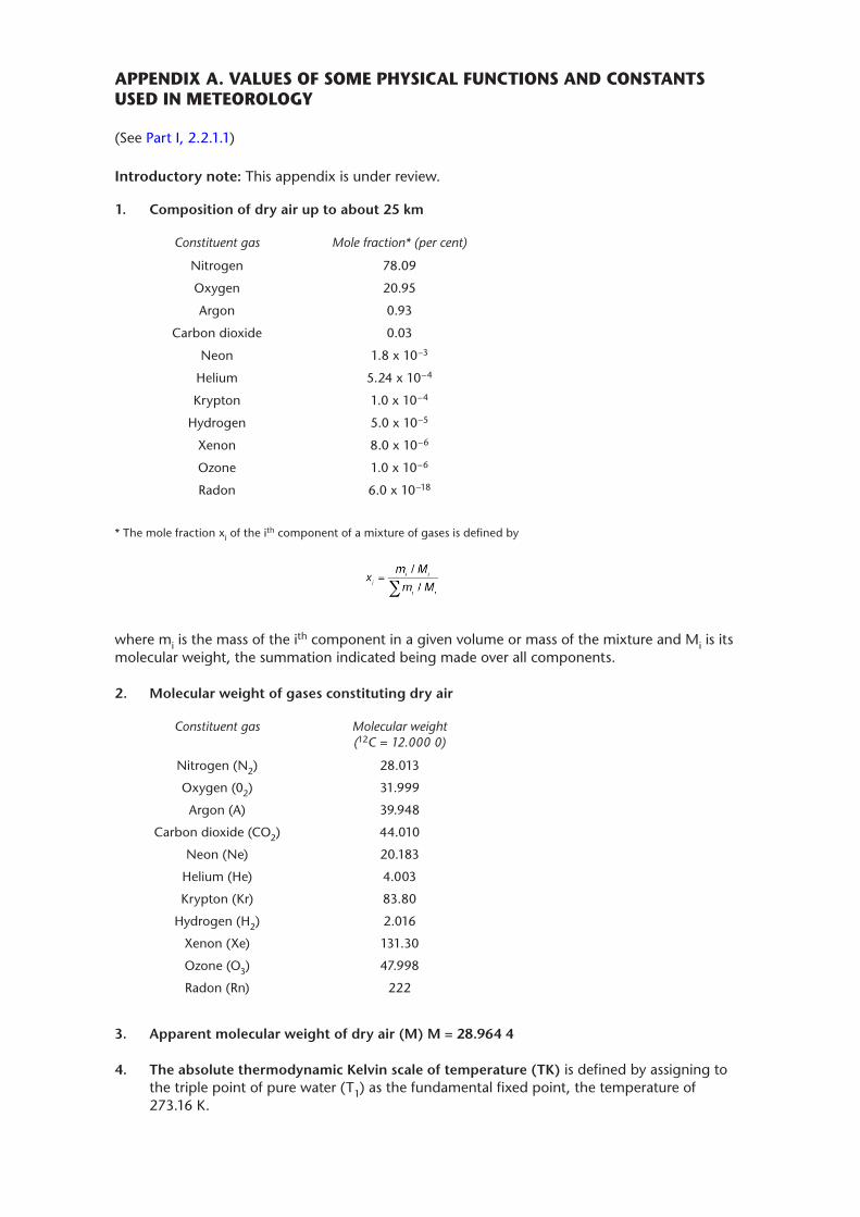
APPENDIX A. VALUES OF SOME PHYSICAL FUNCTIONS AND CONSTANTS USED IN METEOROLOGY
(See Part I, 2.2.1.1)
Introductory note: This appendix is under review.
1� Composition of dry air up to about 25 km
Constituent gas Mole fraction* (per cent)
Nitrogen 78.09
Oxygen 20.95
Argon 0.93
Carbon dioxide 0.03
Neon 1.8 x 10⁻³
Helium 5.24 x 10⁻⁴
Krypton 1.0 x 10⁻⁴
Hydrogen 5.0 x 10⁻⁵
Xenon 8.0 x 10⁻⁶
Ozone 1.0 x 10⁻⁶
Radon 6.0 x 10⁻¹⁸
* The mole fraction xi of the ith component of a mixture of gases is defined by
where mi is the mass of the ith component in a given volume or mass of the mixture and Mi is its molecular weight, the summation indicated being made over all components.
2� Molecular weight of gases constituting dry air
Constituent gas Molecular weight (12C = 12.000 0)
Nitrogen (N2) 28.013
Oxygen (02) 31.999
Argon (A) 39.948
Carbon dioxide (CO2) 44.010
Neon (Ne) 20.183
Helium (He) 4.003
Krypton (Kr) 83.80
Hydrogen (H2) 2.016
Xenon (Xe) 131.30
Ozone (O3) 47.998
Radon (Rn) 222
3� Apparent molecular weight of dry air (M) M = 28�964 4
4� The absolute thermodynamic Kelvin scale of temperature (TK) is defined by assigning to the triple point of pure water (T1) as the fundamental fixed point, the temperature of 273.16 K.
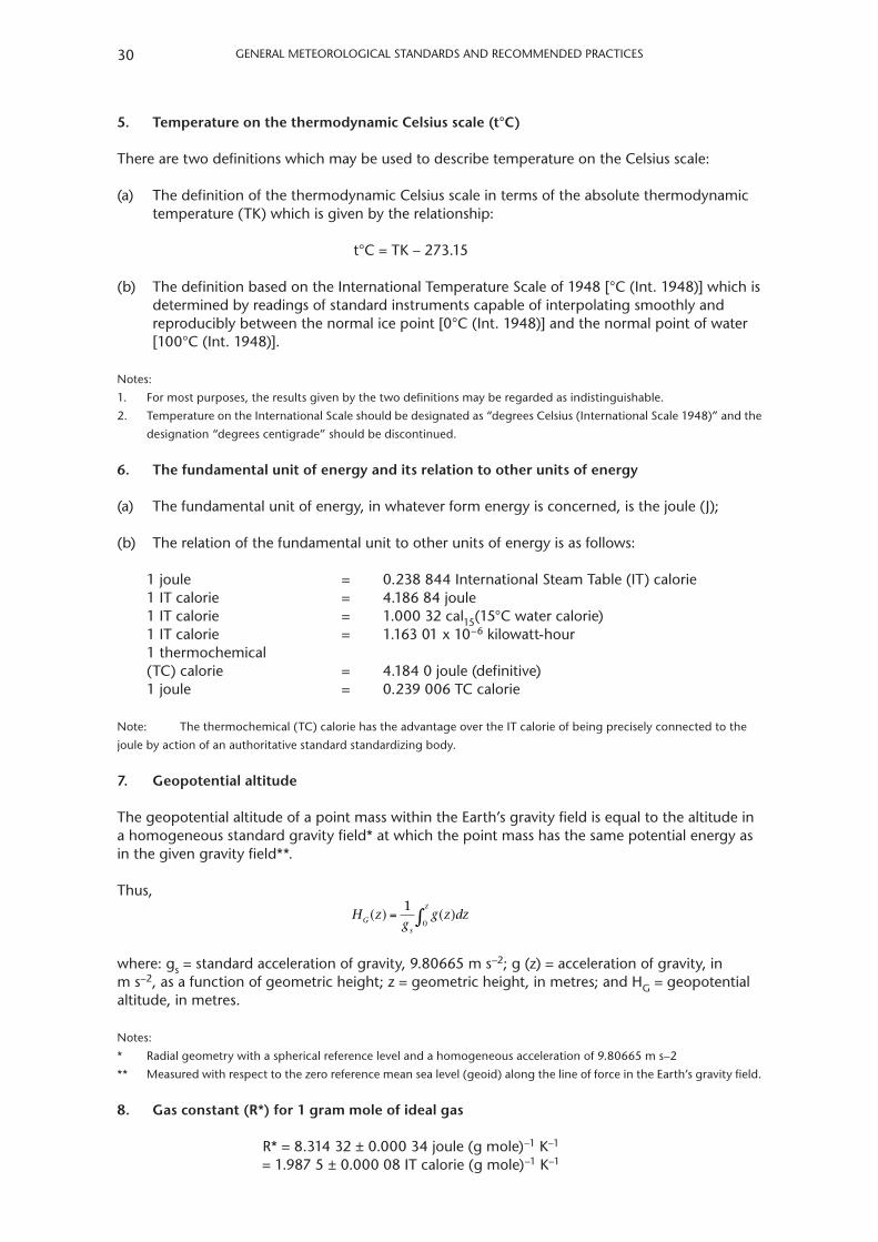
GENERAl METEOROlOGICAl STANdARdS ANd RECOMMENdEd PRACTICES30
5� Temperature on the thermodynamic Celsius scale (t°C)
There are two definitions which may be used to describe temperature on the Celsius scale:
(a) The definition of the thermodynamic Celsius scale in terms of the absolute thermodynamic temperature (TK) which is given by the relationship:
t°C = TK – 273.15
(b) The definition based on the International Temperature Scale of 1948 [°C (Int. 1948)] which is determined by readings of standard instruments capable of interpolating smoothly and reproducibly between the normal ice point [0°C (Int. 1948)] and the normal point of water [100°C (Int. 1948)].
Notes:
1. For most purposes, the results given by the two definitions may be regarded as indistinguishable.
2. Temperature on the International Scale should be designated as “degrees Celsius (International Scale 1948)” and the
designation “degrees centigrade” should be discontinued.
6� The fundamental unit of energy and its relation to other units of energy
(a) The fundamental unit of energy, in whatever form energy is concerned, is the joule (J);
(b) The relation of the fundamental unit to other units of energy is as follows:
1 joule = 0.238 844 International Steam Table (IT) calorie1 IT calorie = 4.186 84 joule1 IT calorie = 1.000 32 cal15(15°C water calorie)1 IT calorie = 1.163 01 x 10–6 kilowatt-hour1 thermochemical(TC) calorie = 4.184 0 joule (definitive)1 joule = 0.239 006 TC calorie
Note: The thermochemical (TC) calorie has the advantage over the IT calorie of being precisely connected to the
joule by action of an authoritative standard standardizing body.
7� Geopotential altitude
The geopotential altitude of a point mass within the Earth’s gravity field is equal to the altitude in a homogeneous standard gravity field* at which the point mass has the same potential energy as in the given gravity field**.
Thus, H z
gg z dzG
s
z( ) ( )= ∫
10
where: gs = standard acceleration of gravity, 9.80665 m s–2; g (z) = acceleration of gravity, in m s–2, as a function of geometric height; z = geometric height, in metres; and HG = geopotential altitude, in metres.
Notes:
* Radial geometry with a spherical reference level and a homogeneous acceleration of 9.80665 m s–2
** Measured with respect to the zero reference mean sea level (geoid) along the line of force in the Earth’s gravity field.
8� Gas constant (R*) for 1 gram mole of ideal gas
R* = 8.314 32 ± 0.000 34 joule (g mole)–1 K–1
= 1.987 5 ± 0.000 08 IT calorie (g mole)–1 K–1
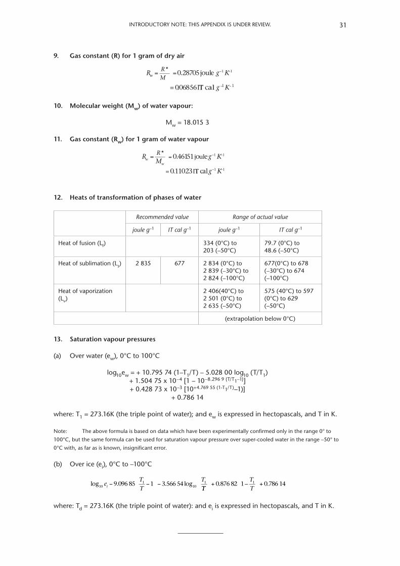
INTROduCTORy NOTe: THIS APPeNdIX IS uNdeR RevIew. 31
9. Gas constant (R) for 1 gram of dry air
R RM
g Kw = = − −* 0.28705jo ule
= 0.06856I
1 1
TT c al g K− −1 1
10. Molecular weight (Mw) of water vapour:
Mw = 18.015 3
11. Gas constant (Rw) for 1 gram of water vapour
R RM
g Kww
= = − −* 0. 46151joule
= 0.11023I
1 1
TT calg K− −1 1
12. Heats of transformation of phases of water
Recommended value Range of actual value
joule g–1 IT cal g–1 joule g–1 IT cal g–1
Heat of fusion (lf) 334 (0°C) to 203 (–50°C)
79.7 (0°C) to 48.6 (–50°C)
Heat of sublimation (ls) 2 835 677 2 834 (0°C) to 2 839 (–30°C) to 2 824 (–100°C)
677(0°C) to 678 (–30°C) to 674 (–100°C)
Heat of vaporization (lv)
2 406(40°C) to 2 501 (0°C) to 2 635 (–50°C)
575 (40°C) to 597 (0°C) to 629 (–50°C)
(extrapolation below 0°C)
13. Saturation vapour pressures
(a) Over water (ew), 0°C to 100°C
log10ew = + 10.795 74 (1–T1/T) – 5.028 00 log10 (T/T1) + 1.504 75 x 10–4 [1 – 10–8.296 9 {T/T1–1}] + 0.428 73 x 10–3 [10+4.769 55 (1-T1/T)–1)] + 0.786 14
where: T1 = 273.16K (the triple point of water); and ew is expressed in hectopascals, and T in K.
Note: The above formula is based on data which have been experimentally confirmed only in the range 0° to
100°C, but the same formula can be used for saturation vapour pressure over super-cooled water in the range –50° to
0°C with, as far as is known, insignificant error.
(b) Over ice (ei), 0°C to –100°C
log log101
1011e
TT
Ti − − −9.096 85 3.566 54
TTTT
+ +0.876 82 0.786 141 1–
where: Td = 273.16K (the triple point of water): and ei is expressed in hectopascals, and T in K.

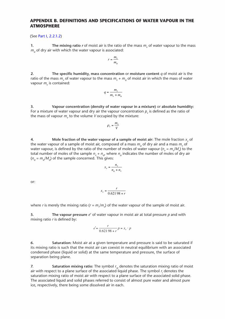
APPENDIX B. DEFINITIONS AND SPECIFICATIONS OF WATER VAPOUR IN THE ATMOSPHERE
(See Part I, 2.2.1.2)
1. The mixing ratio r of moist air is the ratio of the mass mv of water vapour to the mass ma of dry air with which the water vapour is associated:
r mmv
a=
2. The specific humidity, mass concentration or moisture content q of moist air is the ratio of the mass mv of water vapour to the mass mv + ma of moist air in which the mass of water vapour mv is contained:
q mm m
v
v a=
+
3. Vapour concentration (density of water vapour in a mixture) or absolute humidity: For a mixture of water vapour and dry air the vapour concentration pv is defined as the ratio of the mass of vapour mv to the volume V occupied by the mixture:
ρvvmV
=
4. Mole fraction of the water vapour of a sample of moist air: The mole fraction xv of the water vapour of a sample of moist air, composed of a mass ma of dry air and a mass mv of water vapour, is defined by the ratio of the number of moles of water vapour (nv = mv/Mv) to the total number of moles of the sample nv + na, where na indicates the number of moles of dry air (na = ma/Ma) of the sample concerned. This gives:
x nn nv
v
a v=
+
or:
x rrv = +0 621 98.
where r is merely the mixing ratio (r = mv/ma) of the water vapour of the sample of moist air.
5. The vapour pressure e’ of water vapour in moist air at total pressure p and with mixing ratio r is defined by:
=+
= ⋅e rrp x pv0 621 98.
’
6. Saturation: Moist air at a given temperature and pressure is said to be saturated if its mixing ratio is such that the moist air can coexist in neutral equilibrium with an associated condensed phase (liquid or solid) at the same temperature and pressure, the surface of separation being plane.
7. Saturation mixing ratio: The symbol rw denotes the saturation mixing ratio of moist air with respect to a plane surface of the associated liquid phase. The symbol ri denotes the saturation mixing ratio of moist air with respect to a plane surface of the associated solid phase. The associated liquid and solid phases referred to consist of almost pure water and almost pure ice, respectively, there being some dissolved air in each.
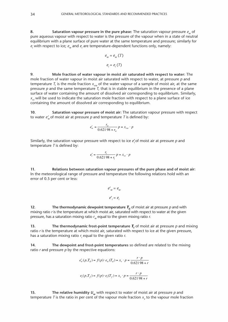
general MeTeorologIcal STandardS and recoMMended PracTIceS34
8. Saturation vapour pressure in the pure phase: The saturation vapour pressure ew of pure aqueous vapour with respect to water is the pressure of the vapour when in a state of neutral equilibrium with a plane surface of pure water at the same temperature and pressure; similarly for ei with respect to ice; ew and ei are temperature-dependent functions only, namely:
ew = ew (T)
ei = ei (T)
9. Mole fraction of water vapour in moist air saturated with respect to water: The mole fraction of water vapour in moist air saturated with respect to water, at pressure p and temperature T, is the mole fraction xvw of the water vapour of a sample of moist air, at the same pressure p and the same temperature T, that is in stable equilibrium in the presence of a plane surface of water containing the amount of dissolved air corresponding to equilibrium. Similarly, xvi will be used to indicate the saturation mole fraction with respect to a plane surface of ice containing the amount of dissolved air corresponding to equilibrium.
10. Saturation vapour pressure of moist air: The saturation vapour pressure with respect to water e’w of moist air at pressure p and temperature T is defined by:
ʹew =rw
0.621 98 + rwp = xvw ⋅ p
Similarly, the saturation vapour pressure with respect to ice e’i of moist air at pressure p and temperature T is defined by:
ʹei =ri
0.621 98 + rip = xvi ⋅ p
11. Relations between saturation vapour pressures of the pure phase and of moist air: In the meteorological range of pressure and temperature the following relations hold with an error of 0.5 per cent or less:
e’w = ew
e’i = ei
12. The thermodynamic dewpoint temperature Td of moist air at pressure p and with mixing ratio r is the temperature at which moist air, saturated with respect to water at the given pressure, has a saturation mixing ratio rw equal to the given mixing ratio r.
13. The thermodynamic frost-point temperature Tf of moist air at pressure p and mixing ratio r is the temperature at which moist air, saturated with respect to ice at the given pressure, has a saturation mixing ratio ri equal to the given ratio r.
14. The dewpoint and frost-point temperatures so defined are related to the mixing ratio r and pressure p by the respective equations:
ʹew (p,Td ) = f (p) ⋅ ew (Td ) = xv ⋅ p =r ⋅ p
0.621 98 + r
e p T f p e T x p r pri f i f v( , ) ( ) ( )
.= ⋅ = ⋅ =
⋅
+0 621 98
15. The relative humidity Uw with respect to water of moist air at pressure p and temperature T is the ratio in per cent of the vapour mole fraction xv to the vapour mole fraction
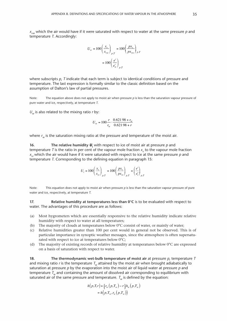
aPPendIX B. deFInITIonS and SPecIFIcaTIonS oF WaTer VaPoUr In THe aTMoSPHere 35
xvw which the air would have if it were saturated with respect to water at the same pressure p and temperature T. accordingly:
Uw = 100 xvxvw
⎛
⎝⎜
⎞
⎠⎟p,T
= 100 pxvpxvw
⎛
⎝⎜
⎞
⎠⎟p,T
= 100 ʹeʹew
⎛
⎝⎜
⎞
⎠⎟p,T
where subscripts p, T indicate that each term is subject to identical conditions of pressure and temperature. The last expression is formally similar to the classic definition based on the assumption of dalton’s law of partial pressures.
note: The equation above does not apply to moist air when pressure p is less than the saturation vapour pressure of
pure water and ice, respectively, at temperature T.
Uw is also related to the mixing ratio r by:
U rr
rrw
w
w= ⋅+
+100 0 621 98
0 621 98..
where rw is the saturation mixing ratio at the pressure and temperature of the moist air.
16. The relative humidity Ui with respect to ice of moist air at pressure p and temperature T is the ratio in per cent of the vapour mole fraction xv to the vapour mole fraction xvi which the air would have if it were saturated with respect to ice at the same pressure p and temperature T. corresponding to the defining equation in paragraph 15:
Ui = 100xvxvi
⎛
⎝⎜
⎞
⎠⎟p,T
= 100 pxvpxvi
⎛
⎝⎜
⎞
⎠⎟p,T
=ʹeʹei
⎛
⎝⎜
⎞
⎠⎟p,T
note: This equation does not apply to moist air when pressure p is less than the saturation vapour pressure of pure
water and ice, respectively, at temperature T.
17. Relative humidity at temperatures less than 0°C is to be evaluated with respect to water. The advantages of this procedure are as follows:
(a) Mosthygrometerswhichareessentiallyresponsivetotherelativehumidityindicaterelativehumiditywithrespecttowateratalltemperatures;
(b) Themajorityofcloudsattemperaturesbelow0°Cconsistofwater,ormainlyofwater;(c) Relativehumiditiesgreater than100percentwould ingeneralnotbeobserved.This isof
particularimportanceinsynopticweathermessages,sincetheatmosphereisoftensupersatu-ratedwithrespecttoiceattemperaturesbelow0°C;
(d) Themajorityofexistingrecordsofrelativehumidityattemperaturesbelow0°Careexpressedonabasisofsaturationwithrespecttowater.
18. The thermodynamic wet-bulb temperature of moist air at pressure p, temperature T and mixing ratio r is the temperature Tw attained by the moist air when brought adiabatically to saturation at pressure p by the evaporation into the moist air of liquid water at pressure p and temperature Tw and containing the amount of dissolved air corresponding to equilibrium with saturated air of the same pressure and temperature. Tw is defined by the equation:
h p,T,r( ) + rw p,Tw( ) − r⎡⎣ ⎤⎦hw p,Tw( )= h p,Tw ,rw p,Tw( )( )
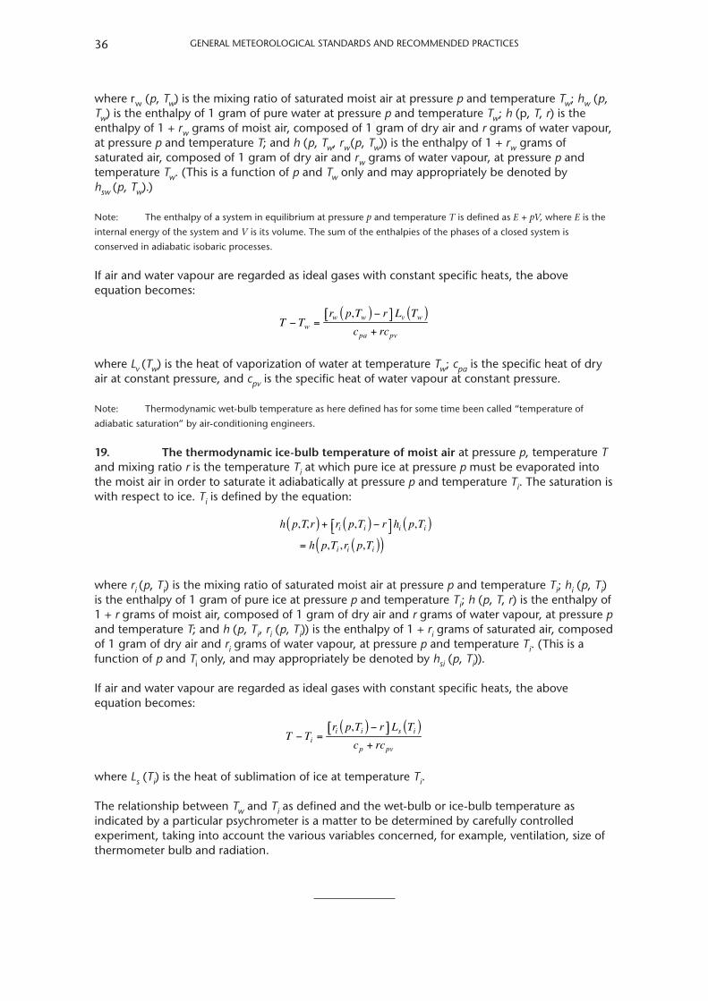
general MeTeorologIcal STandardS and recoMMended PracTIceS36
where rw (p, Tw) is the mixing ratio of saturated moist air at pressure p and temperature Tw; hw (p, Tw) is the enthalpy of 1 gram of pure water at pressure p and temperature Tw; h (p, T, r) is the enthalpy of 1 + rw grams of moist air, composed of 1 gram of dry air and r grams of water vapour, at pressure p and temperature T; and h (p, Tw, rw(p, Tw)) is the enthalpy of 1 + rw grams of saturated air, composed of 1 gram of dry air and rw grams of water vapour, at pressure p and temperature Tw. (This is a function of p and Tw only and may appropriately be denoted by hsw (p, Tw).)
note: The enthalpy of a system in equilibrium at pressure p and temperature T is defined as E + pV, where E is the
internal energy of the system and V is its volume. The sum of the enthalpies of the phases of a closed system is
conserved in adiabatic isobaric processes.
If air and water vapour are regarded as ideal gases with constant specific heats, the above equation becomes:
T − Tw =rw p,Tw( ) − r⎡⎣ ⎤⎦Lv Tw( )
cpa + rcpv
where Lv (Tw) is the heat of vaporization of water at temperature Tw; cpa is the specific heat of dry air at constant pressure, and cpv is the specific heat of water vapour at constant pressure.
note: Thermodynamic wet-bulb temperature as here defined has for some time been called “temperature of
adiabatic saturation” by air-conditioning engineers.
19. The thermodynamic ice-bulb temperature of moist air at pressure p, temperature T and mixing ratio r is the temperature Ti at which pure ice at pressure p must be evaporated into the moist air in order to saturate it adiabatically at pressure p and temperature Ti. The saturation is with respect to ice. Ti is defined by the equation:
h p,T,r( ) + ri p,Ti( ) − r⎡⎣ ⎤⎦hi p,Ti( )= h p,Ti ,ri p,Ti( )( )
where ri (p, Ti) is the mixing ratio of saturated moist air at pressure p and temperature Ti; hi (p, Ti) is the enthalpy of 1 gram of pure ice at pressure p and temperature Ti; h (p, T, r) is the enthalpy of 1 + r grams of moist air, composed of 1 gram of dry air and r grams of water vapour, at pressure p and temperature T; and h (p, Ti, ri (p, Ti)) is the enthalpy of 1 + ri grams of saturated air, composed of 1 gram of dry air and ri grams of water vapour, at pressure p and temperature Ti. (This is a function of p and Ti only, and may appropriately be denoted by hsi (p, Ti)).
If air and water vapour are regarded as ideal gases with constant specific heats, the above equation becomes:
T − Ti =ri p,Ti( ) − r⎡⎣ ⎤⎦Ls Ti( )
cp + rcpv
where Ls (Ti) is the heat of sublimation of ice at temperature Ti.
The relationship between Tw and Ti as defined and the wet-bulb or ice-bulb temperature as indicated by a particular psychrometer is a matter to be determined by carefully controlled experiment, taking into account the various variables concerned, for example, ventilation, size of thermometer bulb and radiation.
APPENDIX C. UNIVERSAL DECIMAL CLASSIFICATION
(See Part II, 3.1.2)
Introductory note: This appendix is under consideration by the relevant constituent bodies.
Geographical subdivision (Table e) is essential for papers classified under numbers accompanied by the letter (e)
551�5 METEOROLOGY551�50 PRACTICAL METEOROLOGY (METHODS, DATA, INSTRUMENTS, FORECASTS
AND OTHER APPLICATIONS)551�501 Methods of observation and computation – Observatories
.1 Instructions for observers
.3 Systems of units, weather notations and scales (e.g. Beaufort Scale)
.4 Methods of and tables for reduction and computation
.42 Methods of and tables for reduction
.45 Methods of and tables for statistical computation
.5 Graphical methods of representation – Isopleths
.6 Methods of data control. Quality control.
.7 Upper air, methods of observation and computation
.71 Methods of observation and computation of composition and density including twilight spectrum and searchlight methods
.721 Methods of observation and computation of radiation
.724 Methods of observation and computation of air temperature
.74 Methods of observation and computation of pressure
.75 Methods of observation and computation of wind
.755 Methods of observation and computation of atmospheric turbulence parameters
.771 Methods of observation and computation of humidity
.774 Methods of observation and computation of condensation and deposits
.776 Methods of observation and computation of cloud properties
.777 Methods of observation and computation of precipitation
.79 Methods of observation and computation by various techniques
.793 Methods of observation and computation using optical techniques
.795 Methods of observation and computation using microwave techniques
.796 Methods of observation and computation using acoustical techniques
.8 Methods of observation by radar, radio, and satellite-borne instruments
.81 Radar storm detection and radar weather reconnaissance
.815 Use of doppler radar
.816 Use of lIdAR
.83 Uses of sferics
.86 Use of satellite-borne instruments
.89 Other uses
.9 Construction and maintenance of observatories. Exposure of instruments. Site
551�502 Meteorological networks.1 General principles. Theory of network density.2 Synoptic-aerological networks.21 Surface networks.22 Upper air networks.3 Climatological networks.4 Agricultural networks.42 Phenological networks.5 Radiation networks.6 Air pollution networks .9 Other special purpose networks
GENERAl METEOROlOGICAl STANdARdS ANd RECOMMENdEd PRACTICES38
551�506 Periodical observational data (from pentadal to annual means).1 Pentadal, weekly, monthly and annual weather reports, charts, maps and bulletins (e).2 Observations and reports referring to particular periods (e).21 First and Second Polar years.22 International Geophysical year.23 IQSy (International years of Quiet Sun).24 GARP (Global Atmospheric Research Programme).3 Observations and reports for periods exceeding one year (e).5 Expeditions (e).7 Upper air observations (e).8 Phenology (plants and animals regarded as meteorological indicators).9 Other observational data
551�507 Devices for carrying or supporting meteorological instruments or stations
Note: The subdivisions .1 to .7 are only for use within the meteorological libraries. In the Universal Classification,
629.1 is used for vehicles (.1 to .5), 624.9 for constructions under .7 and 621.22 for supports under .6.
.1 Mobile land vehicles for carrying meteorological instruments or stations
.2 Water-borne vehicles or supports for meteorological instruments or stations (meteorological use of ships, craft and rafts, buoys, etc.)
.22 Ocean weather ships
.23 Selected ships
.25 Other ships
.3 Sounding vehicles for upper air, meteorological uses
.32 Vehicles lighter than air
.321 Balloons without means of propulsion
.321.2 Free balloons; sounding balloons
.321.3 Constant-level balloons
.321.4 Captive balloons
.322 dirigible balloons
.35 Vehicles heavier than air, with wings or planes
.351 Without means of propulsion - kites, gliders
.352 Aircraft
.354 Helicopters, autogyros
.355 Hydroplanes, seaplanes, flying boats
.36 Apparatus heavier than air, without wings
.361 Parachutes
.362 Projectiles, rockets, artificial satellites.362.1 Rockets.362.2 Artificial satellites.362.7 Manned space stations.6 Methods of supporting or fixing meteorological apparatus or instruments.7 Masts, towers, etc. on land or ice
551�508 Meteorological instrumentation.1 Whole section dropped.2 Instruments for determining radiation and temperature.21 Actinometers, pyrheliometers, pyrgeometers, lucimeters.22 Black-bulb thermometers.23 Recorders of sunshine duration, solarigraphs.25 Other instruments for determining radiation.26 Thermometers, thermographs.27 Screens, thermometer stands, etc..29 Other instruments (for determining temperature).4 Instruments for determining atmospheric pressure.41 Barometers and barographs depending upon liquid pressure.43 Metallic barometers(aneroids), barographs, microbarographs –
551.508.43: 551.541.45 Hypsometers
APPENdIX C. UNIVERSAl dECIMAl ClASSIFICATION 39
.49 Other instruments (for determining atmospheric pressure)
.5 Instruments for determining wind
.51 Simple instruments (wind vanes, weathercocks)
.53 Anemometers for direction only
.54 Anemometers for velocity only
.55 Instruments for determining atmospheric turbulence parameters
.56 Pilot-balloon theodolites
.57 Balloon or target radio-direction finders or radar trackers; rawin equipment
.58 Nephoscopes
.59 Other instruments (for determining wind)
.7 Instruments for determining humidity, evaporation, deposits, precipitation, cloud characteristics
.71 Psychrometers, hygrometers, hygrographs
.72 Evaporimeters
.74 drosometers
.76 Instruments for measuring cloud characteristics
.761 Cloud cameras
.762 Cloud base and top indicators. (“Ceilometers”, cloud searchlights)
.765 Cloud water content and drop size meters
.768 Instruments for measuring ice accretion
.769 Other instruments for investigating clouds
.77 Raingauges, pluviographs, snow-gauges, etc.
.79 Other instruments (for determining humidity, evaporation, evapotranspiration, deposits, precipitation, cloud characteristics)
.8 Combined instruments
.82 Meteorographs
.821 Graphical recording meteorographs
.822 Radiosondes and rawinsondes
.823 Wire-transmitting meteorographs
.824 Automatic land station instrumentation (including on ice and on mountains)
.825 Automatic station instrumentation on lakes or sea (meteorological buoys instrumentation)
.826 Automatic instrumentation on space stations, weather satellites, and rockets
.85 Radar equipment for detecting meteorological phenomena
.855 doppler radar
.856 lIdAR
.86 Sferics equipment
.9 Instruments for measuring various physical phenomena
.91 Instruments for measuring nuclei or impurities
.912 Instruments for measuring ice nuclei
.92 lnstruments for measuring visibility such as transmissiometers
.93 Instruments for measuring scattering of light
.94 Instruments for atmospheric electricity, e.g. lightning counters
.95 Instruments for measuring composition and structure of the atmosphere
.951 Instruments for measuring air pollution
.952 Ozonometers
.953 Spectrometer-type instruments for measuring atmospheric structure
.96 Instruments for investigating ionosphere (as part of atmospheric structure)
.964 Instruments for observation on aurorae
.98 Instruments for measuring cooling power and heat loss
.99 Other instruments
GENERAl METEOROlOGICAl STANdARdS ANd RECOMMENdEd PRACTICES40
551�509 Weather forecasting, artificial action on weather.1 Meteorological telecommunications and codes used in weather forecasting
services.13 Meteorological telecommunications and communications networks.15 Meteorological codes and specifications.2 Regular meteorological bulletins, charts and diagrams used in forecasting.21 Synoptic bulletins, charts and diagrams; short-range forecasts (up to
three days).22 Bulletins, charts and diagrams giving mean values for a period.
Extended range forecasts.25 Prognostic charts.3 Bases and methods of forecasting.31 Forecasts from daily synoptic charts.311 Structure of disturbances, including air masses and fronts on a
small scale, as applied to forecasting.312 Kinematics as applied to forecasting. Barometric tendencies.
Isallobaric charts.313 dynamics applied to forecasting, numerical weather prediction
(NWP).313.1 Numerical analysis. Initialization. Integrations.313.11 Atmospheric wave motion.313.12 Initialization. Balancing.313.13 Advection schemes.313.14 Filters. Smoothing. Interpolation.313.2 Initial data.313.21 data sets, grids, resolution.313.22 data assimilation.313.23 Intervention. Manual modification.313.3 Boundary condition data and data handling.313.31 Surface, e.g. albedo, ice, topography.313.32 lateral and vertical, e.g. radiation.313.4 Prediction models.313.41 Global and hemispheric.313.42 limited area (20–200).313.43 Mesoscale (1–20).313.5 Error growth. Verification. Predictability.313.6 Interpretation of numerical weather prediction
products.314 Statistical methods of forecasting.316 Nowcasting.317 Upper-air information as applied to forecasting.318 Types of atmospheric circulation on a large scale as applied to
forecasting.319 Other bases of forecasting from daily synoptic charts.32 Forecasting of particular features and phenomena.321 Radiation.322 Wind.322.7 Upper-air wind, including forecasting of least time
tracks under 551.509.322.7: 629.13 or 551.509.322.7: 656.7
.323 Temperature.323.2 Frosts.323.7 Upper-air temperature.324 Cloud, precipitation, rime, glazed frost.324.1 Cloud type, amount, height of base and thickness.324.2 Precipitation.324.3 Ice accretion (rime or glazed frost on terrestrial
objects or aircraft)
APPENdIX C. UNIVERSAl dECIMAl ClASSIFICATION 41
.325 Visibility, mist, fog
.326 Thunderstorms
.327 Tropical cyclones, hurricanes, typhoons, tornadoes
.328 Pollution events
.329 Other elements and phenomena
.33 Forecasts for longer periods: week, month, season
.331 Statistical bases for long-range forecasting
.332 Pressure waves, symmetry patterns, trend charts
.333 dynamic methods for longer periods 551.509.333 ≅ 551.509.313
.334 Patterns of circulation (long waves, “Grosswetterlagen”, Multanovsky’s methods)
.335 Analogue methods
.336 Solar relations
.338 Climate singularities
.339 Other methods
.34 Single station forecasting (forecasting with only local observation)
.39 Other forecasts
.5 Forecasts: their organization and verification
.51 Weather
.52 Strong winds
.53 Temperature
.532 Frost. Former number 551.509.53
.54 Cloud, precipitation, rime, glazed frost. Subdivisions as for 551.509.324
.55 Visibility, mist, fog
.56 Thunderstorms
.57 Tropical cyclones, waterspouts, tornadoes
.58 Forecasts for special purposes
.59 Other forecasts
.6 Artificial actions on the weather
.61 deliberate action on the weather
.612 Temperature or radiation. Former number 551.509.62
.615 Fog. Former number 551.509.65
.616 Cloud. Former number 551.509.66
.617 Precipitation. Former number 551.509.67
.62 Number dropped. New number 551.509.612
.65 Number dropped. New number 551.509.615
.66 Number dropped. New number 551.509.616
.67 Number dropped. New number 551.509.617
.68 Accidental action on the weather (artificial explosions, fires, forest fires)
.8 Weather lore
.9 Other questions relating to weather forecasting and artificial action on the weather
551�51 PHYSICS OF THE ATMOSPHERE� COMPOSITION AND STRUCTURE OF THE ATMOSPHERE� DYNAMIC METEOROLOGY 504�3, 523�31–852
551�510 Physical properties, composition and general structure of the atmosphere.3 density.4 Composition of the atmosphere.41 Natural and background (chemical) composition of the atmosphere.411 Surface and planetary boundary layer (PBl).411.2 Spatial variations.411.3 Time variations.411.43 Cyclic or periodic.411.35 Non-cyclic.412 Tropospheric.413 Atmospheric above tropopause.413.2 Stratospheric.413.3 Mesopheric
GENERAl METEOROlOGICAl STANdARdS ANd RECOMMENdEd PRACTICES42
.413.5 Ionospheric
.413.6 Exospheric
.413.7 Magnetospheric
.42 Compositions of the impurities or dust of the atmosphere 551.510.42 ≅ 551.510.41
.43 Photochemical processes in the atmosphere
.5 General description of structure of the atmosphere
.52 Troposphere
.522 Surface and planetary boundary layer (PBl)
.528 Tropopause
.529 Interaction between troposphere and stratosphere
.53 Atmosphere above the tropopause (highest tropopause if there is a multiple arrangement)
.532 Stratosphere
.533 Mesosphere
.534 Ozone layer.534.1 Physics of the ozone layer.534.2 Chemistry of the ozone layer.534.3 Variations in the ozone layer.535 Ionosphere and thermosphere.535.2 Cold layer at 80 km.535.4 Ionosphere.536 Extreme exterior layers, exosphere.537 Magnetosphere.61 Optical refractive index.62 Radio refractive index. Former number 551.594.7.7 Radioactivity of the atmosphere. Former number 551.594.14.71 Natural radioactivity.72 Artificial radioactivity.721 Radioactive fall-out
551�511 Mechanics and thermodynamics of the atmosphere.1 Statics and quasi-statics.12 Hydrostatics. Standard atmospheres.13 Static and quasi-static thermodynamic states and processes. Thermal
equilibrium.2 Kinematics.3 dynamics.31 Gravity waves.32 Hydrodynamics.33 Thermodynamics.331 Stratisfactions of the atmosphere.6 Turbulence and diffusion.61 Theoretical or mathematical models of atmospheric turbulence and
diffusion.62 Energy budget of atmospheric turbulence.63 Experimental studies of turbulence and diffusion.632 Wind tunnel experiments.639 Other experiments
551�513 General circulation of the atmosphere.1 Mechanics and thermodynamics. See 551�511.11 Planetary waves.2 distribution of elements, including air masses.22 Surface.27 Upper level.3 Centres of action.5 ITCZ (Inter-Tropical Convergency Zone).7 Relations between distant regions
APPENdIX C. UNIVERSAl dECIMAl ClASSIFICATION 43
551�515 Weather, atmospheric formations and disturbances.1 Barometrical depressions, extratropical cyclones.11 Mechanics and thermodynamics.12 distribution of elements.127 distribution of elements in the upper air.13 life history, displacement, tracks.17 Upper level.2 Tropical cyclones, hurricanes, typhoons. Subdivisions as for 551�515�1 if necessary.3 Tornadoes, waterspouts, whirlwinds and dust devils. Subdivisions as for 551�515�1
if necessary.4 Convective precipitation systems, thunderstorms and showers. Subdivisions as for
551�515�1 if necessary.5 Tropical atmospheric formations and disturbances other than tropical cyclones,
hurricanes, typhoons. Subdivisions as for 551.515.1.6 Mesoscale systems, e.g. mesoscale cyclones, mesoscale thunderstorms 551.515.6
≊≅ 551.515.1.7 Anticyclones. Subdivisions as for 551�515�1 if necessary.8 Air masses and fronts. Subdivisions as for 551�515�1 if necessary.9 damage caused by weather in general
551�52 RADIATION AND TEMPERATURE551�521 Radiation
–> 550.35.1 Solar radiation in general. Radiation balance.11 Sunshine (e).12 Actinometer or pyrheliometer observations (e).13 Solar constant.14 Reflection of solar radiation from surface of earth or clouds. Albedo.16 daylight illumination.17 Ultra-violet radiation.18 Infra-red component of solar radiation.2 Terrestrial radiation.3 Absorption, scattering and transmission in the atmosphere –> 551.593.31 Solar radiation.32 Terrestrial and atmospheric radiation.321 Infra-red radiation from clear atmosphere.322 Infra-red radiation from earth.324 Infra-red radiation from sea.325 Infra-red radiation from clouds.326 Radiation from the night sky.327 dayglow.33 Irradiation of various surfaces.37 Solar energy studies.6 Cosmic and corpuscular radiation.61 Number dropped.63 Number dropped.64 Cosmic radiation (meteorological aspects).67 Corpuscular radiation from the sun (meteorological aspects).9 Other radiations
551�524 Temperature of the air.1 Structure, microvariations.2 distribution at earth’s surface. Isotherms (e).3 Variations at earth’s surface.31 diurnal variation.32 Annual variation.33 Other periodic variations.34 Secular trend.35 Non-periodic variations
GENERAl METEOROlOGICAl STANdARdS ANd RECOMMENdEd PRACTICES44
.36 Frequencies. Maximum and minimum temperatures
.37 Frosts. Former number
.372 damage caused by frost. For damage to plants see 632�111�5 and for other damages see 624�142
.4 Vertical distribution in the turbulent layer near the earth’s surface
.7 Upper-air temperatures
.72 distribution
.73 Variations. Subdivisions as for 551�543
.77 Vertical gradient
.78 Horizontal gradient551�525 Earth temperature
.2 Surface temperature (including grass minima)
.4 Vertical distribution
.5 Permanently frozen soil For other aspects of permanently frozen soil see 551�345.6 Temperature in soil cavities (e.g. caves, mines, tunnels)
551�526 Temperature of water surfaces as a meteorological element.6 Oceans and seas.64 Vertical distribution.8 lakes and rivers.84 Vertical distribution
551�54 ATMOSPHERIC PRESSURE551�541 Microvariations551�542 Distribution at earth’s surface� Isobars (e)
.1 Barometric gradient551�543 Variations of pressure
.1 diurnal and semi-diurnal variations
.2 Annual variation
.3 Other periodic variations
.4 Secular trend
.5 Non-periodic variations
.6 Frequencies: range of variation551 547 Upper-air pressure
.1 Computation of altitude by barometric observation
.2 Reduction to standard levels
.3 Variations
.5 distribution in space. Isohypses Isobars551�55 WIND551�551 Turbulence, gustiness, micro-variations of wind, turbulent diffusion in the
atmosphere.2 Turbulence in the lower layers defined as the region accessible by instruments
mounted on the ground, on masts, towers or fixed balloon cables.21 Turbulence in the layers up to normal anemometer height.25 Turbulence in the lower layers above normal anemometer height.3 Orographic turbulence.5 Turbulence in the free atmosphere.8 Turbulent diffusion of momentum, heat, water vapour and aerosols
551�552 Horizontal distribution near the earth’s surface� Streamlines (e)551�553 Variations of wind at the earth’s surface
.1 diurnal variation
.11 land and sea or lake breezes
.12 Mountain and valley winds
.2 Annual variation
.21 Monsoons
.22 Other seasonal winds
.3 Other periodic variations
.4 Secular trend
.5 Non-periodic variations
APPENdIX C. UNIVERSAl dECIMAl ClASSIFICATION 45
.6 Frequencies: range of variation. Wind roses
.8 Gales551�554 Vertical distribution in the turbulent layer near the earth’s surface551�555 Winds of special localities (e)
.1 Trade winds, doldrums
.3 Warm catabatic winds (e.g. föhn winds)
.4 Cold catabatic winds (e.g. bora, mistral, bise, tramontana)
.6 Outbreak of polar air (e.g. blizzard, norther, barber)
.8 Sand and dust-bearing winds (e.g. sirocco, harmattan, khamsin, haboob, simoon, chergui, etc.)
.9 Other winds551�556 Effects of wind
.1 damage by wind
.2 Protection against wind
.3 Utilization of wind
.4 Transport of foreign bodies (pollutants) by wind
.42 Short-range: plumes
.44 long-range: tracers
.5 Effects of wind on trees and plants
.6 Effects of wind on buildings
.8 Effects of wind on water surfaces551�557 Upper-air wind
.2 Horizontal distribution of upper winds. Streamlines (e)
.3 Variations of wind in the upper air
.31 diurnal variation
.32 Annual variation
.33 Other periodic variations
.34 Secular trend
.35 Non-periodic variations
.36 Frequencies: range of variation. Wind roses
.4 Vertical variation in upper-air wind. Wind shear
.5 Specific large-scale winds (e.g. jet-stream, anti-trades)551�558 Vertical component of air motions
.1 Convection, thermals, vertical currents of air in or below individual clouds
.2 large-scale vertical components
.21 Orographic disturbance to the winds of the free air (e.g. helm winds, moazagot)
.29 Other large-scale vertical components in the free air551�559 Influence of buildings, vegetations, topography, etc� on the wind551�57 AQUEOUS VAPOUR AND HYDROMETEORS551�571 Humidity
.1 Structure
.2 distribution at earth’s surface (e)
.3 Variations
.31 diurnal variation
.32 Annual variation
.33 Other periodic variations
.34 Secular trend
.35 Non-periodic variations
.36 Frequencies: range of variations
.4 Vertical distribution in the turbulent layer near the earth’s surface
.7 Upper-air humidities551�573 Evaporation and evapotranspiration551�574 Condensation and deposits
.1 Physics of condensation
.11 Nuclei
.12 Cloud droplets
.13 Ice particles in clouds
GENERAl METEOROlOGICAl STANdARdS ANd RECOMMENdEd PRACTICES46
.14 Change of state of cloud particles
.2 Artificial condensation
.4 Condensation on the earth’s surface
.41 liquid (dew)
.42 Solid (rime, hoar-frost, glazed frost, silver thaw, etc.)
.7 Condensation and deposits on objects in the upper air551�575 Fog and mist
.1 Structure, formation and dissolution
.2 distribution (e)
.3 Variations. Subdivisions as for 551�571�3 if necessary
.5 Particular occasions551�576 Cloud
.1 Structure, formation, evolution and dissolution; classification
.11 Structure, formation, evolution and dissolution
.12 Nomenclature, classification, description
.2 Amount, nebulosity (e)
.3 Variations. Subdivisions as for 551�571�3 if necessary
.4 Height
.5 Movement551�577 Precipitation in general
.1 Structure, formation and dissolution, classification
.11 Structure, formation and dissolution
.12 Nomenclature, classification, description
.13 Chemical properties of precipitation. Acid precipitation
.2 distribution at earth’s surface (e)
.21 Amount, isohyets (e)
.22 duration, days with precipitation (e)
.23 (1/9) Intensity of precipitation
.3 Variations
.31 diurnal variation
.32 Annual variation
.33 Other periodic variations
.34 Secular trend
.35 Non-periodic variations
.36 Frequencies
.37 Excessive falls in short or long periods
.38 droughts
.5 Various influences
.51 Influence of topography
.52 Influence of vegetation (e.g. forests)
.53 Influence of human activities (e.g. towns)
.54 Influence of sheets of water
.59 Other influences
.6 damage
.61 damage caused by precipitation
.62 damage caused by droughts
.7 Radioactivity of precipitation551�578 Special forms of precipitation
.1 liquid precipitation (e.g. rain and drizzle)
.11 Structure, composition and temperature
.13 Variations
.16 Precipitation from fog – fog drip
.4 Crystalline precipitation (e.g. snow, sleet, granular snow, ice needles)
.41 Structure, composition and temperature. Form of snow crystals See 551�322: 548�54 Habit, appearance of ice crystals.42 distribution at earth’s surface (e).43 Variations.45 Snow storms
APPENdIX C. UNIVERSAl dECIMAl ClASSIFICATION 47
.46 Snow cover (including depth, temperature and density)
.461 Methods of reporting snow cover. Coding
.462 Ablation. Thermal balance of snow cover See also 551�324�433 Ablation of glaciers.463 Changes in the nature of snow cover. Firnification.465 Stratification of snow cover.466 Snow surface forms. Snow drift formation See 624�144�4 Control of snow drifting, fences, etc..467 Cornices.468 Protection afforded by snow cover: thermal insulation.48 Avalanches See also 624�182 Avalanche counter-measures.481 Types of avalanche.482 Theory of avalanches. Causes.483 Forecasting of avalanches.486 Specific avalanche disasters.7 Solid amorphous precipitation (e.g. hail and soft hail).71 Structure, composition and temperature.72 distribution at earth’s surface (e).73 Variations.8 Precipitation containing foreign matter (e.g. sand).9 Other forms of precipitation
551�579 Soil moisture and hydrology� Hydrometeorology.1 Water supply from precipitation.2 Water supply from snow cover. Water equivalent of snow. Melting of snow.3 Water supply from glaciers.4 Fluctuations of surface water (caused by precipitation).5 Soil moisture, percolation
551�58 CLIMATOLOGY551�581 Theoretical climatology� Climatic models� Solar climate� Climatic zones�
.1 Theoretical climatology. Climate models. Solar climate.
.2 Climatic zones => (211/213).21 Polar climate.22 Temperate climate.23 Subtropical climate.24 Tropical climate
551�582 Climatology of particular places, regions and parts of the earth� Climatological monographs (e)
.1 Qualitative descriptions (e)
.2 Numerical data (e)
.3 Charts and atlases (except periodic weather charts) (e)551�583 Variations of climate
See also 551�324�63 Response of glaciers to climatic changes.1 Instrumental data.13 Periodic variations.14 Secular trend.15 Non-periodic variations.16 Climatic extremes.2 Historical period (non-instrumental).3 Prehistoric and the Quaternary geological period.4 dendroclimatology.7 Paleoclimatology
551�584 Microclimatology and mesoclimatology.1 General principles; concepts.2 Mesoclimates; local climates.3 Microclimates due to minor topographical and soil features.31 Microclimates of slopes; thermal belts; frost pockets
GENERAl METEOROlOGICAl STANdARdS ANd RECOMMENdEd PRACTICES48
.32 Microclimates of bare soil or rocky surfaces
.33 Microclimates of shores or water surfaces
.34 Microclimates of ice and snow surfaces
.4 Microclimates of air layers modified by vegetation
.41 Microclimates of forests and forest clearings
.42 Microclimates of low growing vegetation and small openings within it
.43 Plant climates; the climate of air layers near surfaces of individual plants or plant parts
.5 Microclimates of streets and open spaces in towns
.6 Cryptoclimates; climates of enclosed spaces
.61 Indoor climates
.65 Cave, mine and tunnel climates, ice-caves
.7 Climate of air spaces in soil and snow layers
.9 Other microclimates551�585 Types of climate� Classification of climate
.1 Oceanic climates
.3 Monsoon climates
.4 Mediterranean climate
.5 Continental climates
.53 desert climate
.55 Steppe climate
.7 Mountain climates
.9 Other types of climate551�586 Biometeorology and bioclimatology
Example: 58 In relation to botany551�587 Upper-air climatology� Climate in the free air above specified places or
regions551�588 Influence of environment on climate
.1 land and sea distribution. degree of continentality
.16 Influence of sea surface temperature and currents on climate –> 551.465.7
.2 Topography and aspect
.3 Soil and subsoil
.4 lakes and rivers
.5 Ice
.6 Vegetation and forests
.7 Human influence. Effect of towns, buildings, etc.
.74 Effect of atmospheric pollution (including carbon dioxide)
.9 Other influences
551�589 Synoptic climatology.1 Average or frequency of climatic elements associated with synoptic types See also subdivisions of 551�513 and 551�515.5 Frequency of simultaneous occurrence of two or more climatic elements.6 Special phenomena (e.g. Ice Saints’ days)
551�59 VARIOUS PHENOMENA AND INFLUENCES551�590�2 Cosmical influences
.21 Solar influences (except heat radiation 551.521)
.22 lunar influences
.23 Planetary influences
.24 Phenomena attending eclipses
.25 Phenomena attending meteors
.29 Other cosmical influences
.3 Effects of volcanic eruptions on weather and climate551�591 Visibility
.1 Physics of visibility
.2 distribution at earth’s surface (e)
.3 Variations at earth’s surface
APPENdIX C. UNIVERSAl dECIMAl ClASSIFICATION 49
.31 diurnal variations
.32 Annual variations
.33 Other periodic variations
.34 Secular trend
.35 Non-periodic variations
.36 Frequencies: range of variation
.361 Exceptional visibility
.6 Vertical and slant visibility
.7 Variation with height551�593 Optical phenomena in the atmosphere
.1 Phenomena produced by refraction in the air
.11 Mirage
.12 Scintillation
.13 deformation of the heavenly bodies
.5 Phenomena produced by absorption and scattering
.51 Green ray
.52 Spectra, rainband
.53 Blue of the sky
.54 dry haze, turbidity
.55 Twilight phenomena, alpine glow
.6 Phenomena produced by condensation products
.61 Fog bows. Broken spectra. Glories
.62 Rainbows
.63 Haloes, parhelia, paraselenae, anthelia, sun pillars
.64 Coronae
.65 Coloration of the clouds
.651 Clouds up to Cirrus
.652 Mother-of-pearl clouds
.653 Noctilucent clouds
.7 Polarization. Neutral point
.9 Other optical phenomena551�594 Electrical phenomena in the atmosphere
.1 Electricity of fine weather
.11 Potential gradient
.12 Ionization. Charge
.13 Ion mobility. Conductivity. Current
.14 Number dropped. New number 551�510�7
.18 Relations to other meteorological elements
.2 Electricity of disturbed weather
.21 Electricity of thunderstorms
.22 Electrical discharges
.221 disruptive discharges (lightning)
.222 Silent discharges (St. Elmo’s fire)
.223 Ball lightning
.25 Electricity of aerosols
.252 Electricity of snow and ice crystals, except wind-blown snow
.253 Electricity of water drops including liquid cloud particles, rain and drizzle
.254 Electricity of wind-blown snow
.255 Electricity of sand, dust and smoke particles in the atmosphere
.5 Aurora
.51 Physics of aurora
.52 Height and geographical distribution of aurora
.53 Periodicity
.6 Atmospherics regarded as phenomena of atmospheric electricity. See also 551�508�86 and 621�396�821.7 Number dropped. See 551�510�62.9 Other electrical phenomena
GENERAl METEOROlOGICAl STANdARdS ANd RECOMMENdEd PRACTICES50
551�596 Acoustic phenomena in the atmosphere.1 Propagation of sound. Audibility. Zones of silence.3 Supersonic bang.5 Thunder.9 Other noises caused by meteorological phenomena
APPENDIX D. BASIC INSTRUCTION PACKAGES
(See Part II, 4.3, 4.4 and 5.1.1)
1. BASIC INSTRUCTION PACKAGE FOR METEOROLOGISTS
1.1 General
1.1.1 To satisfy the requirements of the Basic Instruction Package for Meteorologists, Members shall ensure that the meteorological personnel achieve the following learning outcomes:
(a) The acquisition of knowledge concerning physical principles and atmospheric interactions, methods of measurement and data analysis, behaviour of weather systems (through the synthesis of current weather data with conceptual models), and the general circulation of the atmosphere and climate variations.
(b) The ability to apply knowledge based on the use of scientific reasoning to solve problems in atmospheric science, and to participate in the analysis, prediction and communication of the impacts of weather and climate on society.
Note: It is intended that satisfying the requirements of the Basic Instruction Package for Meteorologists will provide
meteorological personnel with the knowledge, skills and confidence to develop their expertise and with a basis for
further specialization.
1.1.2 Members shall ensure that meteorologists wishing to work in areas such as weather analysis and forecasting, climate modelling and prediction, and research and development, undertake further education and training to meet the specialized job competencies in these areas. In addition, Members shall ensure that meteorologists enhance their knowledge and skills by participating in continuous professional development throughout their careers.
Note: The requirements of the Basic Instruction Package for Meteorologists will usually be satisfied through the
successful completion of a university degree in meteorology or a postgraduate programme of study in meteorology
following a university degree that includes the foundation topics in mathematics and physics – such topics are typically
covered in science, applied science, engineering or computational courses. Where this is not the case, educational
institutions will have to demonstrate that their programme of study provides the characteristic learning outcomes
associated with a university degree course.
1.1.3 Members should take the lead in consulting with the appropriate national and regional bodies to define the academic qualifications required by Meteorologists in their country. Members should also work with their national education and training establishments to ensure that meteorological graduates achieve all the learning outcomes of the Basic Instruction Package for Meteorologists as part of the academic qualification.
1.2 Components of the Basic Instruction Package for Meteorologists
Note: The aim is to ensure that a meteorologist has the underlying knowledge and expertise that supports the
learning outcomes associated with physical meteorology, dynamic meteorology and numerical weather prediction,
synoptic and mesoscale meteorology, and climatology.
1.2.1 Foundation topics
Members shall ensure that a meteorologist is able to:
(a) Demonstrate the knowledge of mathematics and physics that is required to successfully complete the meteorological components of the Basic Instruction Package for Meteorologists;
geNeral MeTeorologIcal STaNdardS aNd recoMMeNded PracTIceS52
(b) Demonstrate the knowledge of other sciences and related topics that complements the meteorological expertise covered in the Basic Instruction Package for Meteorologists;
(c) Analyse and utilize data, and communicate and present information.
1.2.2 Physical meteorology
Members shall ensure that a meteorologist is able to:
(a) Explain the structure and composition of the atmosphere, the processes affecting the radiative transfer in the atmosphere and global energy balance, and the causes of optical phenomena in the atmosphere;
(b) Apply the laws of thermodynamics to atmospheric processes, use a thermodynamic diagram to assess the properties and stability of the atmosphere, identify the effect of water on thermodynamic processes and explain the processes leading to the formation of water droplets, clouds, precipitation and electrical phenomena;
(c) Use knowledge of turbulence and surface energy exchanges to explain the structure and characteristics of the atmospheric boundary layer and the behaviour of contaminants;
(d) Compare, contrast and explain the physical principles used in conventional instruments to make surface and upper-air measurements of atmospheric parameters, and explain the common sources of error and uncertainty and the importance of applying standards and using best practices;
(e) Describe the range of meteorological data obtained from remote-sensing systems, explain how radiation measurements are made and the processes by which atmospheric data is derived from those measurements, and outline the uses and limitations of remote-sensing data.
1.2.3 Dynamic meteorology
Members shall ensure that a meteorologist is able to:
(a) Explain the physical basis of the equations of motion in terms of forces and frames of reference, apply scale analysis to identify the dynamic processes in balanced flows, describe the characteristics of balanced flows, and use the equations of motion to explain quasi-geostrophy, ageostrophy, and the structure and propagation of waves in the atmosphere;
(b) Describe and explain the scientific basis, characteristics and limitations of numerical weather prediction for short-, medium- and long-range forecasting, and explain the applications of numerical weather prediction.
1.2.4 Synoptic and mesoscale meteorology
Members shall ensure that a meteorologist is able to:
(a) Use physical and dynamical reasoning to describe and explain the formation, evolution and characteristics (including extreme or hazardous weather conditions) of synoptic-scale weather systems in mid-latitude and polar regions and in tropical regions, and assess the limitations of theories and conceptual models of these weather systems;
(b) Use physical and dynamical reasoning to describe and explain the formation, evolution and characteristics (including extreme or hazardous weather conditions) of convective and mesoscale phenomena and assess the limitations of theories and conceptual models of these phenomena;
(c) Monitor and observe the weather situation, and use real-time or historical data, including satellite and radar data, to prepare analyses and basic forecasts;
aPPeNdIX d. BaSIc INSTrUcTIoN PacKageS 53
(d) Describe service delivery in terms of the nature, use and benefits of the key products and services, including warnings and assessment of weather-related risks.
1.2.5 Climatology
Members shall ensure that a meteorologist is able to:
(a) Describe and explain the Earth’s general circulation and climate system in terms of the physical and dynamical processes that are involved, and describe the key products and services based on climate information and their inherent uncertainty and use;
(b) Apply physical and dynamical reasoning to explain the mechanisms responsible for climate variability and climate change (including the influence of human activity); describe the impacts in terms of possible changes to the global circulation, primary weather elements and potential effects on society; outline the adaptation and mitigation strategies that might be applied, and describe the application of climate models.
2. BASIC INSTRUCTION PACKAGE FOR METEOROLOGICAL TECHNICIANS
2.1 General
2.1.1 To satisfy the requirements of the Basic Instruction Package for Meteorological Technicians, Members shall ensure that the meteorological personnel achieve the following learning outcomes:
(a) The acquisition of basic knowledge concerning physical principles and atmospheric interactions, methods of measurement and data analysis, a basic description of weather systems, and a basic description of the general circulation of the atmosphere and climate variations.
(b) The ability to apply basic knowledge to observe and monitor the atmosphere and interpret commonly used meteorological diagrams and products.
Note: It is intended that satisfying the requirements of the Basic Instruction Package for Meteorological Technicians
will provide meteorological personnel with the knowledge, skills and confidence to develop their expertise and with a
basis for further specialization.
2.1.2 Members shall ensure that meteorological technicians wishing to work in areas such as weather observation, climate monitoring, network management, and provision of meteorological information and products to users, undertake further education and training to meet the specialized job competencies in these areas. In addition, Members shall ensure that meteorological technicians enhance their knowledge and skills by participating in continuous professional development throughout their careers.
Note: The requirements of the Basic Instruction Package for Meteorological Technicians will be usually satisfied
through the successful completion of a post-secondary programme of study at an institution such as a training institution
of a National Meteorological and Hydrological Service or college of further education.
2.2 Components of the Basic Instruction Package for Meteorological Technicians
Note: The aim is to ensure that a meteorological technician has the underlying knowledge and expertise that
supports the learning outcomes associated with basic physical and dynamic meteorology, basic synoptic meteorology,
basic climatology, and meteorological instruments and methods of observation.
geNeral MeTeorologIcal STaNdardS aNd recoMMeNded PracTIceS54
2.2.1 Foundation topics
Members shall ensure that a meteorological technician is able to:
(a) Demonstrate the knowledge of mathematics and physics that is required to successfully complete the meteorological components of the Basic Instruction Package for Meteorological Technicians;
(b) Demonstrate the knowledge of other sciences and related topics that complements the meteorological expertise covered in the Basic Instruction Package for Meteorological Technicians;
(c) Analyse and utilize data, and communicate and present information.
2.2.2 Basic physical and dynamic meteorology
Members shall ensure that a meteorological technician is able to:
(a) Explain the basic physical and dynamic processes that take place in the atmosphere;(b) Explain the physical principles used in instruments to measure atmospheric parameters.
2.2.3 Basic synoptic and mesoscale meteorology
Members shall ensure that a meteorological technician is able to:
(a) Describe the formation, evolution and characteristics of synoptic-scale and mesoscale tropical, mid-latitude and polar weather systems, and analyse weather observations;
(b) Describe the forecast process and the use made of the associated products and services.
2.2.4 Basic climatology
Members shall ensure that a meteorological technician is able to:
(a) Describe the general circulation of the atmosphere and the processes leading to climate variability and change;
(b) Describe the use made of products and services based on climate information.
2.2.5 Meteorological instruments and methods of observation
Members shall ensure that a meteorological technician is able to:
(a) Explain the physical principles used in instruments to measure atmospheric parameters;(b) Make basic weather observations.
APPENDIX E. CRITERIA FOR THE RECOGNITION OF WMO REGIONAL TRAINING CENTRES
(See Part II, 4.5.2)
To be designated as a WMO Regional Training Centre, training institutions should satisfy the following criteria:
(a) A Centre should only be established for the purpose of meeting the expressed requirements of Members, which cannot be met by existing facilities in the same Region;
(b) A Regional Training Centre should be designed to meet the requirements of Members in the Region, as expressed in a decision of the regional association;
(c) Each Centre should be within the particular Region concerned and its location should be decided by the Executive Council in the light of the views of the regional association and the comments of the Secretary-General;
(d) The following conditions should apply to each Centre:(i) The Centre should be open to students from all countries in the Region;(ii) The educational level of the various courses of instruction carried out at the Centre
should be consistent with the guidance material issued by WMO;(iii) The Centre should have adequate buildings and training facilities and competent
instructors;(e) Since the establishment and maintenance of the Centre will largely be the responsibility of
the host country, WMO should have the right to monitor the work of the Centre. The obligations of WMO and the host country should be the subject of a signed agreement to abide by certain principles. This agreement should cover the following matters:(i) The purpose and functions of the Centre;(ii) The numbers and entrance qualifications of the students;(iii) The right of WMO to examine syllabi and other relevant material to ensure that the
level of education is consistent with the guidance material issued by WMO;(iv) The scope and level of the final examinations;(v) The administrative arrangements of the Centre;(vi) WMO obligations – financial or otherwise;(vii) Obligations of the government of the host country;(viii) Obligations of the Centre;(ix) Withdrawal of the designation of the Centre;(x) Termination of the agreement.


For more information, please contact:
World Meteorological Organization
Communications and Public Affairs Office
Tel.: +41 (0) 22 730 83 14/15 – Fax: +41 (0) 22 730 80 27
E-mail: [email protected]
7 bis, avenue de la Paix – P.O. Box 2300 – CH 1211 Geneva 2 – Switzerland
www.wmo.int P-A
SGO
_126
56