tectonic and eustatic controls on sequence stratigraphy of
TRANSCRIPT

ABSTRACT
The Loreto basin formed by rapid west-ward tilting and asymmetric subsidence with-in a broad releasing bend of the Loreto faultduring transtensional deformation along thewestern margin of the active Gulf of Califor-nia plate boundary. Sedimentary rocks rangein age from ~5(?) to 2.0 Ma and consist of sili-ciclastic and carbonate deposits that accumu-lated in nonmarine, deltaic, and marine set-tings. The basin is divided into the central andsoutheast subbasins, which have distinctly dif-ferent subsidence histories and stratigraphicevolution. Sedimentary rocks of the Loretobasin are divided into four stratigraphic se-quences that record discrete phases of fault-controlled subsidence and basin filling. Se-quence boundaries record major changes intilting geometries and sediment dispersal thatwere caused by reorganization of basin-bound-ing faults. Sequence 1 consists of nonmarineconglomerate and sandstone that accumu-lated in alluvial fans and braided streams. Thesequence 1–2 boundary is a marine floodingsurface in both subbasins, and parasequenceswithin sequence 2 consist of progradationalGilbert deltas that are capped by transgres-sive marine shell concentrations and floodingsurfaces. The sequence 2–3 boundary is a low-angle erosional unconformity in the southeastsubbasin and a thin interval of downlap in thecentral subbasin. Sequence 3 is characterizedby bioclastic limestones that were derived fromthe uplifted portion of the hanging-wall tiltblock. The sequence 3–4 boundary is an angu-lar unconformity in the southeast subbasin andan abrupt marine flooding surface in the cen-tral subbasin. Sequence 4 consists dominantlyof in situ shallow-marine carbonate deposits.
By comparing parasequences of sequence 2
with marine oxygen-isotope curves, we can dis-criminate between eustatic and tectonic con-trols on stratigraphic evolution. In the centralsubbasin, sequence 2 accumulated during ashort phase of extremely rapid subsidence(8 mm/yr); it contains 14 paracycles that do notmatch the O-isotope curve, and there are nounconformities. In the southeast subbasin, se-quence 2 accumulated at a rate of ~1.5 mm/yr;it contains 4 paracycles that appear to matchthe O-isotope curve, and sequence boundariesare unconformities. Thus, we conclude thatduring sequence 2 deposition: (1)extremelyrapid subsidence in the central subbasin out-paced eustatic sea-level changes, and Gilbertdelta paracycles were produced by episodicfault-controlled subsidence; and (2) subsidencein the southeast subbasin was slower than therate of eustatic sea-level changes, and the inter-nal stratigraphic cyclicity preserves a record ofeustatic rather than tectonic events.
INTRODUCTION
The stratigraphy of sedimentary basins can beused to reconstruct subsidence histories, evolu-tion of depositional systems, and adjustments tochanging parameters of sediment input and ac-commodation space through time. In tectonicallyactive settings, sediment input and accommoda-tion space are controlled by slip on basin-bound-ing faults and variations in the rates and geome-tries of crustal tilting produced by fault slip and/or folding. Active basins undergo complex spatialand temporal variations in subsidence, uplift,sediment dispersal, and source-area erosion, andthese variations can produce strikingly differentstratigraphic signatures over short distances (e.g.,Christie-Blick and Biddle, 1985; Leeder and Gaw-thorpe, 1987; Gawthorpe and Colella, 1990). Therate of sediment input may vary as a function ofchanging uplift and erosion patterns in source ar-eas, stream-capture events related to faulting,and/or climatically controlled variations in rain-
fall and sediment yield (e.g., Heller and Paola,1992; Koltermann and Gorelick, 1992). In tec-tonically active marine basins, accommodationspace is controlled by the interplay between rateof subsidence (or uplift) and fluctuations in eu-static sea level. In deep half-graben depocenters,for example, rapid steady subsidence may ex-ceed rates of sea-level rise and fall, and preservedstratigraphic cyclicity may record continuouscreation of accommodation space modulated bythe effects of high-frequency eustatic fluctuations(Gawthorpe et al., 1994, 1997; Dart et al., 1994;Hardy and Gawthorpe, 1998). Although the rangeof processes that can influence stratigraphy intectonically active basins is generally well known,identification of those processes based on inter-pretation of the stratigraphic record is difficultand commonly is hindered by lack of adequateage controls on syntectonic strata.
The Pliocene Loreto basin (Fig. 1) is an excel-lent setting within which to evaluate controls onstratigraphic evolution of a tectonically activeoblique-rift marine basin. The basin fill is wellexposed and laterally mappable due to young up-lift and exhumation. The age of stratigraphic unitsis well constrained by high-resolution dating ofinterbedded tuffs, and the history of faultingwithin and around the margins of the basin is wellknown from detailed mapping and fault-kine-matic analysis. This paper presents the results ofa multiyear study of the Loreto basin that has fo-cused on unraveling complex stratigraphic andstructural evolution during a period of rapid slipand subsidence on the basin-bounding Loretofault. Detailed study of map-scale stratal geome-tries, lithofacies assemblages, stratigraphic bound-ing surfaces, and parasequence stacking patternshas enabled us to develop a sequence-stratigraphicframework for interpreting the basin history.
Because of the unique factors that control tec-tonically active basins, application of sequencestratigraphy in active settings tends to departfrom the usage of traditional models, which weredeveloped in passive-margin settings (Vail et al.,
177
Tectonic and eustatic controls on sequence stratigraphy of the PlioceneLoreto basin, Baja California Sur, Mexico
Rebecca J. Dorsey*Department of Geological Sciences, 1272 University of Oregon, Eugene, Oregon 97403-1272
Paul J. Umhoefer† Department of Geology, Northern Arizona University, Flagstaff, Arizona 86011
GSA Bulletin; February 2000; v. 112; no. 2; p. 177–199; 16 figures; 3 tables.
*E-mail: [email protected].†E-mail: [email protected]

1977; Van Wagoner et al., 1988; Jervey, 1988). Inareas where rapid tectonic subsidence produces acontinual rise in relative sea level, erosional un-conformities may be absent and sequence bound-aries may be defined by marine flooding surfacesand thin zones of downlap (Gawthorpe et al.,1994; Dart et al., 1994; Burns et al., 1997). Using amodified sequence-stratigraphic framework in theLoreto basin, we are able to determine variationsin relative sea level, sediment-dispersal patterns,and the ratio of accommodation production versussediment input through time. The results of thisanalysis are useful for comparison with other stud-ies in similar, tectonically active basins wherehigh-resolution age dating may not be possible.
TECTONIC SETTING
The Loreto basin is located on the southwest-ern margin of the Gulf of California, which hasopened during the past 4 to 6 m.y. by transform-rifting along the Pacific–North American plateboundary (Fig.1; Curray and Moore,1984; Stockand Hodges, 1989; Lonsdale, 1989). The axialportion of the Gulf of California is dominated bylarge transform faults connected by short spread-ing-ridge segments that produce deep nascentoceanic basins; these transform faults connectnorthward with the San Andreas fault system insouthern California (Fig. 1A). Thus, the Gulf ofCalifornia is an obliquely rifted, proto-oceanicplate boundary along which transform motion isgreater than rifting. The Main Gulf Escarpment isa large topographic escarpment, about 0.5–2 kmhigh, that follows the eastern margin of the BajaCalifornia peninsula (Fig. 1). Areas west of theMain Gulf Escarpment are underlain by a thick,gently west-dipping and westward-fining assem-blage of lower to middle Miocene volcaniclasticsedimentary rocks that were shed from high-standing, subduction-related stratovolcanoes(Hausback, 1984; Stock and Hodges, 1989;Dorsey and Burns, 1994). Areas east of the MainGulf Escarpment make up the western part of theGulf extensional province, which is a broad re-gion dominated by structures related to the devel-opment of the Gulf of California (Gastil et al.,1975; Stock and Hodges, 1989). The Gulf exten-sional province in eastern Baja California is a~0–30-km-wide zone of hills and plains under-lain by faulted and tilted Miocene volcanicrocks, local Miocene and Pliocene basinal strata(including the Loreto basin), and local volcaniccenters of late Miocene to Quaternary age(Fig. 1). Geologically, the 5–30-km-wide off-shore marine shelf and scattered islands in theGulf of California are the offshore continuationof the Gulf extensional province. Miocenestratigraphy east of the Main Gulf Escarpment
consists of volcanic flows, breccias, tuffs, lahars,and volcaniclastic conglomerate and sandstonepreserved in a complex mosaic of facies beltsrepresenting volcaniclastic alluvial-apron to vol-canic core and vent positions within the Miocenevolcanic arc (Hausback, 1984; Sawlan, 1991).
Early to middle Miocene subduction and calc-alkaline volcanism in Baja California were fol-lowed by late Miocene regional extension, rift-ing, and normal faulting along a zone of thick,thermally weakened crust in the Gulf extensionalprovince (Larson, 1972; Hausback, 1984; Stockand Hodges, 1989). In the Loreto area, there is nosedimentary or volcanic record of late Mioceneextension. Evidence for this phase of deformationis recorded in an angular unconformity betweenMiocene volcanic rocks and overlying Pliocenesedimentary rocks (this study), a greater densityof faults that cut the older rocks, and the observa-tion that Miocene rocks typically are tilted more
steeply to the west than the Pliocene section. Theorientation of regional strain changed, from north-east-southwest–directed extension in late Mio-cene time to east-west extension associated withPliocene opening of the Gulf of California (An-gelier et al., 1981; Stock and Hodges, 1989;Zanchi, 1994; Umhoefer et al., 1997). Pliocene-age structures in the Loreto basin are dominatedby north- to north-northeast–striking normal faultsand subsidiary northwest-striking strike-slip andoblique-slip faults (Zanchi, 1994; Umhoefer andStone, 1996).
Pliocene sedimentary rocks exposed discon-tinuously along the eastern margin of the BajaCalifornia peninsula accumulated in transform-rift basins and depressions during opening of theGulf of California. The Loreto basin (Fig. 2) isthe thickest known accumulation of Pliocene de-posits exposed on land in eastern Baja California,and thus represents an important record of synrift
DORSEY AND UMHOEFER
178 Geological Society of America Bulletin, February 2000
Figure 1. (A) Regional tectonic setting of the Gulf of California and the Baja Californiapeninsula. The Gulf extensional province is a zone of Miocene to Holocene extensional andstrike-slip deformation associated with the opening of the Gulf of California. MGE—MainGulf Escarpment. (B) Simplified geologic map of the Loreto region in Baja California Sur.Black areas represent Pliocene sedimentary rocks. BC—Bahia Concepcion; LF—Loretofault; MVC—Mencenares volcanic complex (Pliocene–Quaternary); Mv—Miocene volcanicrocks; Mv/Ms—Miocene volcanic and sedimentary rocks; PE—Puerto Escondido; Qs—Qua-ternary sediments; Ts—Tertiary sedimentary rocks; SJE—San Juanico embayment.

basin development (McLean, 1988, 1989). TheLoreto fault is a large, oblique-slip dextral-nor-mal fault that bounds the southwestern and west-ern margin of the Pliocene Loreto basin (Figs. 1Band 2). The northern termination of the Loretofault is located west of the late Pliocene Mence-nares volcanic complex, and its southern end isburied beneath young alluvium ~5 km north ofthe town of Loreto (Fig. 1B). Southwest of Loreto,Miocene volcanic rocks dip to the east and are cutby numerous west-dipping normal faults, defin-ing a fault segment that is separated from theLoreto fault by an accommodation zone of rela-tively low strain. Thus, the Loreto fault does notcontinue south of Loreto and its length is about35 km. The late Pliocene Mencenares volcaniccenter is situated at the northern margin of theLoreto basin (Fig. 1B) and consists of a thick as-semblage of andesitic to rhyolitic flows, domes,and pyroclastic rocks and minor basalt flows(Sawlan, 1991; Bigioggero et al., 1995). Its erup-
tive history overlaps in time (and likely played arole in) the latter half of development of thePliocene Loreto basin.
LORETO BASIN OVERVIEW
Previous geologic studies of the Loreto basinand surrounding areas have been carried out by nu-merous workers. During the 1940 Scripps researchcruise in the Gulf of California, a brief (1.5 day) re-connaissance survey was made in the area north ofLoreto. This included paleontological study of ma-rine molluscan fossils (Durham,1950) and the firstattempt to subdivide the stratigraphy of the Loretoarea and correlate formations to Carmen Island(Table 1; Anderson, 1950). McLean (1988, 1989)mapped the structure and stratigraphy of theLoreto area at 1:50 000 scale without subdividingPliocene strata, and recognized the importance ofthe Loreto embayment for understanding the evo-lution of Pliocene structures and basin develop-
ment. The age of Loreto basin deposits was deter-mined from K-Ar dating of ca. 3.3–1.9 Ma in-terbedded tuffs (McLean,1988). Subsequent stud-ies produced a refined understanding of thestratigraphy and structure (Zanchi,1991,1994) andpaleontology (Piazza and Robba, 1994) of sedi-mentary rocks in the Loreto basin. The strati-graphic subdivisions proposed by Zanchi (1994)and Piazza and Robba (1994) are mostly corrobo-rated by our work, and are expanded into a formalsystematic nomenclature in this paper (Table 1).The volcanology and geochemistry of the Men-cenares volcanic center were investigated by Bi-gioggero et al. (1995). Strata in the northernLoreto basin, exposed on the south flank of theMencenares volcanic center (Fig.1B), were exam-ined only in reconnaissance style during our studyand are not treated in detail here. Published studiesof the Loreto basin by our group (Umhoefer et al.,1994; Dorsey et al.,1995,1997a,1997b; Umhoeferand Stone, 1996; Dorsey, 1997; Umhoefer and
SEQUENCE STRATIGRAPHY, PLIOCENE LORETO BASIN, BAJA CALIFORNIA SUR, MEXICO
Geological Society of America Bulletin, February 2000 179
Figure 2. (A) Geologic map of the Loreto basin, showing distribution of pre-Pliocene rocks, Pliocene sedimentary formations and stratigraphicsequences (1–4), and major structures. The central subbasin comprises Pliocene strata located northeast of the Loreto fault, west of the SierraMicroondas, and northwest of the anticline. The southeast subbasin is southeast of the anticline. Figure 7 is a north-south projection of strati-graphic data compiled from the southeast subbasin. PEB—Punta El Bajo (del Tiera Firme). Key for figure is on page 180.

Dorsey, 1997; Falk and Dorsey, 1998) focused onspecific aspects of the tectonic, structural, andstratigraphic evolution of the Loreto basin. Thispaper presents a comprehensive analysis of the en-tire basin and its history of synbasinal faulting,subsidence, and filling, and interprets that historyin terms of controlling factors associated with syn-basinal tectonism, eustasy, and sediment input.
The Loreto basin is divided into two subbasinsthat are separated by a north-northeast–trendinganticline at the south end of the Sierra Microon-das (Fig. 2). The central subbasin is between thedextral-normal Loreto fault on the southwest andthe Sierra Microondas on the east. The southeast
subbasin is the area located east and southeast ofthe anticline, and south of the Sierra Microondas(Fig. 2). A flat pediment (erosion surface) 3–5 kmwide is observed to cut little deformed footwallrocks between the Loreto fault and the Main GulfEscarpment to the west. The pediment is overlainby ~30–50 m of weakly cemented alluvial grav-els of probable Pleistocene age that are cut in thenorth by the northern segment of the Loreto fault(Mayer and Vincent, 1999). The footwall pedi-ment and overlying gravels formed by erosionalfault-scarp retreat that probably postdates themain phase of Pliocene basin subsidence and fill-ing. The central and southeastern parts of the
Loreto basin have been uplifted and dissectedsince late Pliocene time, creating excellent expo-sures of Pliocene sedimentary rocks, while thenorthern part of the basin has continued subsid-ing slowly to form a broad alluvial plain in thenorth (Figs. 1B and 2). This pattern of uplift andsubsidence results from fault-controlled uplift inthe Sierra Microondas combined with gentlenorthward tilting and development of a broad,gently north-plunging syncline (Fig. 2).
The history of stratigraphic nomenclature inthe Loreto basin is presented in Table 1. The firstsubdivision of stratigraphy (Anderson, 1950) re-flected an attempt to correlate strata of the south-
DORSEY AND UMHOEFER
180 Geological Society of America Bulletin, February 2000
Figure 2. (Continued). (B) Geologic serial cross sections through the Loreto basin (no vertical exaggeration).

SEQUENCE STRATIGRAPHY, PLIOCENE LORETO BASIN, BAJA CALIFORNIA SUR, MEXICO
Geological Society of America Bulletin, February 2000 181
east subbasin to Carmen Island (~20 km south-east of Loreto basin) and San Marcos Island(~130 km northwest of Loreto basin), and did notaccurately reflect the complexity of stratal unitsand their geometrical relationships. A detailed as-signment of formation names that describes thelithologies and locations of mappable, distinctivelithosomes in the Loreto basin was proposed byZanchi (1994) and Piazza and Robba (1994). Wehave adopted, revised, and expanded that nomen-clature into a formal designation of formationsand members (Table 1; Fig. 2). An important as-pect of organizing the stratigraphy of the Loretobasin has been the recognition of four strati-graphic sequences that can be correlated betweendifferent parts of the basin (Fig. 3). The sequencesare defined by architectural elements such as un-conformities, zones of onlap and downlap, marineflooding surfaces, and parasequence stacking pat-terns. Sequences have chronostratigraphic signif-icance and are identified by their distinctive fea-tures and vertical position in the section, whereasformations in the Loreto basin are strongly timetransgressive and their boundaries typically crosstime lines at a high angle.
LITHOSTRATIGRAPHY
Six formations, four dominantly siliciclasticand two dominantly carbonate, compose the ma-jor stratigraphic units of the central and south-eastern Loreto basin (Figs. 2 and 3; Tables 2
TABLE 1. STRATIGRAPHIC NOMENCLATURE FOR THE LORETO BASIN
Anderson Piazza and Zanchi Dorsey et al. This study Sequence†
(1950)* Robba (1994) (1994) (1995)
Carmen and Marquer San Juan San Juan Coralgal Punta El Bajo 4Formations Limestone Limestone calcarenite Limestone
El Troquero El Troquero Gypsiferous El Troquero 4Volcaniclastics Formation mudstone and Formation
siltstone
San Marcos Arroyo de Arce Canada de Conglomeratic Arroyo de Arce 3Formation Sur Limestone Arces Limestone bioclastic Limestone
limestone
San Marcos San Antonio San Antonio Marine to Piedras 3Formation Formation Sandstone marginal marine Rodadas
sandstone and Formationconglomerate (upper member)
Uña de Gato Uña de Gato Gypsiferous Uña de Gato 2Sandstone Sandstone mudstone and Formation
siltstone
San Marcos Arroyo de Arce Piedras Marine to Piedras 2Formation Norte Sandstone Rodadas marginal marine Rodadas
Piedras Rodadas Sandstone sandstone and FormationSandstone conglomerate (lower member)
La Vinorama La Vinorama Nonmarine La Vinorama 1–3Conglomerate Conglomerate conglomerate Conglomerate
and sandstone (gray member)
Cerro Cerro Nonmarine La Vinorama 1Microondas Microondas conglomerate Conglomerate Conglomerate Conglomerate and sandstone (red member)
*Anderson (1950) only pertains to the lower (southern) Arroyo de Arce area.†Sequence designations do not strictly follow the conventions for passive margins (Van Wagoner et al., 1988).
Figure 3. Sequence stratigraphy of the Loreto basin, showing the vertical and lateral distrib-ution of formations within this framework for the central and southeast subbasins.

182 Geological Society of America Bulletin, February 2000
La Vinorama Conglomerate (red member)
La Vinorama Conglomerate (gray member)
Piedras Rodadas Formation (lowerand upper members)
Uña de Gato Formation
Arroyo de ArceLimestone
El Troquero Formation
Punta El Bajo Limestone
Red to reddish-brown hematite-cemented conglomerate. Coarse Variant:Thick-bedded, unstratified, poorly sorted, pebble–cobble–small boulderconglomerate (see Fig. 4A). Clast-supported; max. clasts 40–60 cm diame-ter, subangular to subrounded. Minor to moderate amount of pebbly sand-stone matrix. Beds are ungraded and have tabular to lenticular (channel)geometries. Rare, discontinuous thin beds of pebbly sandstone truncatedat base of conglomerate beds. Clasts are andesitic volcanic rocks derivedfrom Miocene volcanic basement. Fine Variant:Trough cross-bedded sandypebble-cobble conglomerate and minor pebbly sandstone. Clasts subangu-lar to rounded.Weakly developed fining-upward channel-fill intervals3–10 m thick, sometimes with coarse variant in lower 1–3 m. Some inter-vals display weak, sheet-like planar to low-angle stratification with no verti-cal grain-size trends in poorly sorted sandy conglomerate.
Gray, weakly indurated conglomerate and sandstone, usually covered withslope wash material except in fresh arroyo cuts. Coarse Variant: Poorlysorted to unsorted, structureless to weakly bedded, matrix-supported cob-ble-boulder conglomerate (see Fig. 4B). Matrix is poorly sorted pebblysandstone. Clasts are angular to subrounded, maximum size 50 cm to>1 m. Some zones display partial clast support. Rare thin beds of pebblysandstone truncated at base of conglomerate beds. Fine Variant:Troughcross-bedded sandy pebble conglomerate, pebbly sandstone, and thin(10–30 cm) caliche horizons. Commonly channelized. Fine and coarsevariants may be interbedded at 4- to 10-m scale; coarse variant dominatesin 2-km-wide belt along Loreto fault (see Fig. 2A).
Diverse gravelly and sandy lithofacies described previously by Dorsey et al.(1995) and Falk and Dorsey (1998). Paleontology described by Durham(1950) and Piazza and Robba (1994). Following summary is modified fromDorsey et al. (1995). GD1: Channelized, massive to trough cross-beddedpebble-cobble conglomerate and pebbly sandstone, locally contains mol-lusk shells. GD2: Pebble-cobble conglomerate and pebbly sandstone withsteep primary dips (15°–25°), tabular-bedded to channelized, erosionalbed bases, locally inverse and normal grading, shells rare to common (seeFig. 4C). GD3:Thin- to medium-bedded, partially bioturbated sandstone,siltstone, and pebbly sandstone, sharp bases and diffuse tops of beds,some normal grading. GD4: Massive, bioturbated siltstone, sandstone,and/or pebbly sandstone, contains variable molluscan faunal assemblage.GD5: Mollusk-rich shell beds with variable matrix (siliciclastic to cal-carenitic sand ± pebbles), and molluscan assemblages ranging from lowto high diversity. Pectens, oysters, infaunal bivalves, and gastropods aremost abundant; echinoids, barnacles, and calcareous worm tubes arecommon accessories; rare bryozoans and crabs.
Gypsiferous, thin to very thin bedded, fine- to medium-grained sand-stone, siltstone, mudstone, and claystone (see Fig. 4D). Appears mas-sive (and yellow) in weathered slopes, bedded nature only visible in freshcuts. Bedding geometry varies from planar-tabular to broadly lenticularwith shallow scoured bases, with rare meter-scale channel fills. Planarstratification is abundant, some low-angle cross-stratification and ripplelamination. Sole marks (load casts) visible at base of some beds. Gyp-sum is coarse and fibrous, and occurs in veins to 1.5 cm thick that areboth parallel and discordant to bedding (as in Fig. 5C).
Dominant facies is white- to gray-weathering, planar stratified, shelly, sandyand pebbly calcarenite, calcarenitic hash, and calcirudite, carbonate ≥50%(see Fig. 5, A and B). Steep primary dips are seen close to Sierra Microon-das. Secondary facies include (1) thin- to thick-bedded, shelly, calcareniticpebbly sandstone, may display normal grading, planar stratification, and/orripple cross-stratification; and (2) medium- to thick-bedded shelly conglom-erate with hashy sandy calcarenitic matrix, commonly ungraded, normaland inverse grading also seen. Pectens and oysters are most commonshell and hash types (Fig. 5B), locally see barnacle hash. Encrusting rho-doliths, bryozoans, and barnacles are common accessories. Shells typi-cally are disarticulated, broken, and current-oriented.
Gypsiferous, bright yellow, massive mudstone and claystone with thin tomedium interbeds of marl, siltstone, very fine grained sandstone, andrare siliceous beds (probably diatomite) (see Fig. 5C). Mudrock is domi-nant, other lithologies minor. Gypsum veins are common to abundantand occur both parallel and discordant to bedding. Diverse assemblageof benthic and planktic forams of outer-shelf to upper-slope affinity recov-ered from several localities (R. Douglas, 1997, personal commun.). Lo-cally near base may include thin to medium-bedded, hummocky cross-bedded sandstone and (rarely) channelized pebble conglomerate andsandstone.
Massive thick beds of sandy coralgal and molluscan calcarenite with thinto medium interbeds of shelly calcarenitic pebbly sandstone. Coralgal va-riety is most abundant, mollusk-rich variety is more common near base(Dorsey, 1997). Thick beds of calcarenite-matrix cobble conglomerateare found in fanning-dip section near basal exposure at Punta El Bajo(de Tierra Firme). Mollusk assemblage is similar to that in Arroyo de ArceLimestone. Coralline algae occur both as broken rounded fragments andas partial to whole rhodoliths.
Hematite cementation probably produced by postdepositional diagene-sis: oxidizing meteoric fluids flushed from uplifted hanging-wall dip slopeon eastern side of central basin. Coarse Variant: Deposition by cohesion-less, mud-poor debris flows in alluvial fan setting. Thin sand beds recordminor surface flow and reworking between constructional events (debrisflows). Fine Variant: Deposition by traction currents in gravelly braid-stream system. Some sheet-flood deposition, probably in distal alluvial-fan setting. Association of coarse and fine variants suggests interactionof alluvial fans and braid streams; coarse variant at the base of fining-upintervals represents channel deposition by large boulder-bearing floodflows, probably involving hybrid clast-support mechanisms.
Lack of cementation results from position within basin that precludedflushing by meteoric waters. Coarse Variant: Deposition by mud-poor de-bris flows in alluvial-fan setting. Belt along Loreto fault represents steepalluvial fans and debris cones shed off seismically active fault scarp. FineVariant: Deposition in gravelly and sandy braid stream with periods ofoverbank soil development. Where occurring in sequence 2 and 3, braidstreams formed in intermediate position between alluvial fans (coarsevariant) and fan deltas (Piedras Rodadas Formation).
These lithofacies represent the diverse components of Gilbert-type fandeltas (GD) that accumulated downstream of footwall-derived alluvialfans and braid streams (La Vinorama Conglomerate) during sequence2–3 time. GD1: Topset strata deposited in distributary channels and inter-distributary shallow-marine bays. GD2: Foreset strata deposited by grav-elly high-density turbidity currents, debris flows, and grain flows on fan-delta slope. GD3: Bottomset strata deposited by distal low-densityturbidity currents, with partial biogenic mixing. GD4: Sandy turbiditesmore distal than GD3, slower sediment accumulation and thus completehomogenization by burrowing organisms. GD5: Hiatal (condensed) shellbeds record marine flooding and drowning of fan-delta plain, and nearlycomplete cessation of detrital input. Episodic alternation of fan-deltaprogradation and marine flooding probably resulted from episodic subsi-dence on Loreto fault (Dorsey et al., 1997b).
Gypsum is secondary and formed by diagenetic oxidation and dissolu-tion of calcite and pyrite, which released Ca2+ and S2–. Deposited by di-lute sand- and mud-bearing turbidites in the most distal part of footwall-derived fan deltas (Piedras Rodadas Formation). Claystone layers recordsuspension settling from deltaic fresh-water plumes. Lack of bioturbationindicates conditions unfavorable for benthic faunas (low oxygen and/orlow light). Paleodepth is fixed by height of correlative Gilbert-delta fore-sets (typically 12–30 m) and low slope of bottomset beds, and probably∼20–30 m.
Mixed carbonate and siliciclastic depositional system in which carbonatematerial consists almost entirely of reworked and transported shells. Car-bonates were derived from uplifted hanging-wall dip slope (Sierra Mi-croondas), and were sourced both in contemporaneous mollusk shoalsand older eroding limestones.Two main styles of transport and deposi-tion: (1) coarse-grained, mixed-composition debris flows and high- to low-density turbidity currents; and (2) high-energy tidal currents and long-shore currents in shoreface to shallow-shelf setting. Fine-grainedvariations of both styles are distal equivalents of coarser facies, in a mo-saic of current-transported, detrital carbonate, and siliciclastic sediments.
Gypsum is secondary and formed by same diagenetic processes as de-scribed for Uña de Gato Formation. Deposition of clay and silt by sus-pension settling in very low energy outer-shelf to upper-slope marine set-ting, far removed from detrital input.
Deposition of carbonate and accessory siliciclastic sediment in a shal-low-marine, moderate-energy shelf setting. Unlike Arroyo de Arce Lime-stone, carbonate was produced in situ. Intermixed siliciclastic sedimentrepresents episodic input by storm events that was thoroughly mixed byburrowing organisms. Interbeds of pebbly sandstone record larger stormevents. Cobble conglomerate near base represents rocky shoreline deposits.
TABLE 2. FORMATION DESCRIPTIONS AND INTERPRETATIONS
Formation Description Interpretation

and 3). Tables 2 and 3 contain detailed descrip-tions, interpretations, and other information re-lated to formal definition of the formations. Eachformation represents an association of lithofaciesthat accumulated in related depositional environ-ments. The La Vinorama Conglomerate consistsof nonmarine conglomerate and pebbly sand-stone and includes facies ranging from thick-bed-ded, structureless debris-flow facies to troughcross-bedded conglomerate and sandstone ofbraid stream origin (Fig. 4, A and B; Table 2).The Piedras Rodadas Formation (Fig. 4C) is avariable assemblage of marine to deltaic fossilif-erous sandstone and conglomerate that accumu-lated in Gilbert-type and shelf-type fan deltas de-rived from the footwall of the Loreto fault(Table 2; Dorsey et al., 1995, 1997b). The Uña deGato and El Troquero Formations (Figs. 4D and5C) are gypsiferous fine-grained siliciclastic fa-cies (fine sand to clay) that represent depositionin distal, low-energy marine settings. The Arroyode Arce Limestone consists of transported car-bonate detritus that is mixed with varying amountsof siliciclastic sand and gravel (Fig. 5, A and B).The Punta El Bajo Limestone is dominantlycoralline-algal and molluscan carbonate that ac-cumulated, in situ, in a shallow carbonate shelfsetting similar to those of the modern Gulf ofCalifornia (van Andel, 1964; Table 2). The SanJuan limestone (Fig. 3) is exposed north of thecentral subbasin, on the southern flank of theMencenares volcanic complex (Fig. 1; Zanchi,1994), and probably is equivalent to the Punta ElBajo Limestone. Additional information aboutsedimentary lithofacies, depositional processes,and paleoenvironments can be found elsewhere(Dorsey,1997; Dorsey et al., 1995, 1997a; Falkand Dorsey, 1998).
SEQUENCE STRATIGRAPHY
Reconstructed physical stratigraphic architec-ture is the basis for defining stratigraphic se-quences in the Loreto basin (Figs. 6 and 7). Thetwo-dimensional stratigraphic panels in Figures 6and 7 were constructed from numerous detailedmeasured sections that were correlated in con-junction with 1:10000 scale field mapping. Moredetailed parts of these panels have been pub-lished for the southwestern part of the centralsubbasin (Fig. 6; Dorsey et al., 1997b) and themarine part of sequence 2 in the southeast sub-basin (Fig. 7; Dorsey et al., 1997a). Internal corre-lations are most reliable in marine sections of thePiedras Rodadas Formation that contain laterallytraceable shell beds; this has permitted detailedreconstruction of prefaulting stratal geometrieseven in the highly faulted southeast subbasin(Fig. 7). The two-dimensional stratigraphic pan-
SEQUENCE STRATIGRAPHY, PLIOCENE LORETO BASIN, BAJA CALIFORNIA SUR, MEXICO
Geological Society of America Bulletin, February 2000 183
TAB
LE 3
.FO
RM
ATIO
N L
OC
ALI
TIE
S A
ND
DE
FIN
ITIO
NS
Form
atio
nTy
pe L
ocal
ityD
efin
ition
Dia
gnos
isLa
Vin
oram
a U
pper
(nor
th) A
rroy
o de
Arc
e.N
orth
wes
t M
akes
up
a be
lt on
eas
t sid
e of
cen
tral b
asin
, wes
t mar
gin
of S
ierr
a M
icro
onda
s.D
istin
guis
hed
from
gra
y m
embe
r bas
ed
Con
glom
erat
e qu
adra
nt o
f [2,
887-
88N
;460
-61E
]*B
asal
bou
ndar
y:an
gula
r non
conf
orm
aity
on
unde
rlyin
g M
ioce
ne v
olca
nic
rock
s.on
wel
l-cem
ente
d na
ture
and
bro
wn
to
(red
mem
ber)
Upp
er b
ound
ary:
base
of P
iedr
as R
odad
as F
orm
atio
n.La
tera
l bou
ndar
ies:
not
red
colo
r.ex
pose
d, n
ot im
port
ant f
or m
appi
ng.
La V
inor
ama
1.C
añad
a E
l Poz
oO
ccup
ies
belt
alon
g so
uthw
est m
argi
n of
cen
tral b
asin
and
sou
ther
n pa
rt o
f sou
th-
Dis
tingu
ishe
d fr
om re
d m
embe
r bas
ed o
n C
ongl
omer
ate
Wes
t 1/2
of [
2,88
3-84
N;4
59-6
0E]
east
bas
in, l
ocal
pat
ches
in n
orth
par
t of c
entra
l bas
in.B
asal
bou
ndar
y:no
t exp
osed
, la
ck o
f cem
enta
tion,
poo
rly c
onso
lidat
ed
(gra
y m
embe
r)pr
esum
ed to
be
nonc
onfo
rmity
on
Mio
cene
vol
cani
c ro
cks.
Upp
er b
ound
ary:
base
of
natu
re, a
nd ty
pica
l gra
y co
lor.
2.A
rroy
os L
a V
inor
mam
a an
d La
s E
l Tro
quer
o Fo
rmat
ion.
Late
ral b
ound
arie
s:la
tera
l tra
nsiti
on n
orth
and
nor
thea
st in
toC
uchi
llas.
[2,8
85-8
6N;4
57-5
8E]†
mar
ine
and
Gilb
ert-
delta
dep
osits
of P
iedr
as R
odad
as F
orm
atio
n (s
eque
nce
2–3)
.
Pie
dras
Rod
adas
2
km a
long
arr
oyo,
nor
thw
est o
f Las
O
ccup
ies
cent
ral a
xis
of c
entra
l bas
in a
nd c
entra
l par
t of s
outh
east
bas
in.B
asal
D
istin
guis
hed
from
La
Vin
oram
a Fo
rmat
ion
(low
er
Pie
dras
Rod
adas
.[2,
886-
87N
;458
-60E
]bo
unda
ry:m
arin
e flo
odin
g su
rface
at t
op o
f La
Vin
oram
a C
ongl
omer
ate
(red
mem
ber)
.C
ongl
omer
ate
base
d on
com
mon
an
d up
per m
embe
rs)
Upp
er b
ound
ary:
in c
entra
l bas
in =
upw
ard
grad
atio
n in
to u
pper
(seq
uenc
e 3)
uni
t of
occu
rren
ce o
f mar
ine
shel
ls a
nd
La V
inor
ama
Con
glom
erat
e;in
sou
thea
st b
asin
= lo
w-a
ngle
unc
onfo
rmity
at b
ase
of
biot
urba
ted
sand
ston
eA
rroy
o de
Arc
e Li
mes
tone
.Lat
eral
bou
ndar
ies:
late
ral t
rans
ition
to s
outh
and
sou
thw
est
into
La
Vin
oram
a C
ongl
omer
ate
(gra
y m
embe
r).L
ower
mem
ber =
seq
uenc
e 2;
uppe
r m
embe
r = s
eque
nce
3 (s
ee F
ig.2
)
Uña
de
Gat
o0.
5 km
nor
thea
st o
f Mex
ico
Hig
hway
1,
Def
ines
a w
edge
in c
entra
l bas
in th
at th
ins
to th
e ea
st, a
lso
occu
pies
a b
and
wes
t of
Dis
tingu
ishe
d fr
om P
iedr
as R
odad
as
Form
atio
nno
rth
half
of [2
,888
-89N
;458
-59E
]La
Vin
oram
a C
ongl
omer
ate
(red
mem
ber)
on
east
sid
e of
cen
tral b
asin
.Bas
al b
ound
ary
Form
atio
n ba
sed
on p
rese
nce
of g
ypsu
m
=de
epen
ing-
up tr
ansi
tion
from
top
of P
iedr
as R
odad
as F
orm
atio
n (lo
wer
mem
ber)
or
vein
s, a
nd th
in- t
o ve
ry th
in-b
edde
d, w
ell-
La V
inor
ama
Con
glom
erat
e (r
ed m
embe
r).U
pper
bou
ndar
y:gr
adua
l tra
nsiti
on th
roug
h be
dded
nat
ure.
Dis
tingu
ishe
d fr
om E
l sa
ndst
one
inte
rval
into
Arr
oyo
de A
rce
limes
tone
in c
entra
l bas
in.L
ater
al b
ound
arie
s:Tr
oque
ro F
orm
atio
n ba
sed
on lo
catio
n la
tera
l tra
nsiti
on to
the
sout
hwes
t int
o m
arin
e sa
ndst
ones
por
tion
of P
iedr
as R
odad
as
and
stra
tigra
phic
pos
ition
.Fo
rmat
ion
(low
er m
embe
r).
Arr
oyo
de A
rce
Low
er (s
outh
ern)
Arr
oyo
de A
rce.
On
Loca
ted
in n
orth
east
par
t of c
entra
l bas
in a
nd n
orth
east
par
t of s
outh
east
bas
in.B
asal
D
istin
guis
hed
from
Pie
dras
Rod
adas
Li
mes
tone
grid
line
465
E, b
etw
een
2,88
4-85
N.
boun
dary
:in
cent
ral b
asin
= u
pwar
d tra
nsiti
on th
roug
h sa
ndst
one
from
Uña
de
Gat
o Fo
rmat
ion
base
d on
abu
ndan
ce o
f Fo
rmat
ion;
in s
outh
east
bas
in =
low
-ang
le u
ncon
form
ity a
t top
of P
iedr
as R
odad
as
trans
port
ed c
arbo
nate
mat
eria
l (≥5
0%).
Form
atio
n.U
pper
bou
ndar
y:an
gula
r unc
onfo
rmity
at b
ase
of P
unta
El B
ajo
Lim
esto
ne.
Dis
tinui
shed
form
Pun
ta E
l Baj
o Li
mes
tone
La
tera
l bou
ndar
ies:
in c
entra
l bas
in, l
ater
al tr
ansi
tion
wes
twar
d in
to s
ilici
clas
tic s
ands
tone
ba
sed
on tr
ansp
orte
d na
ture
of c
arbo
nate
of
Pie
dras
Rod
adas
For
mat
ion
(upp
er m
embe
r, se
quen
ce 3
);in
sou
thea
st b
asin
, lat
eral
an
d ge
nera
l pau
city
of r
hodo
liths
.tra
nsiti
on s
outh
war
d in
to n
onm
arin
e fa
cies
of L
a V
inor
ama
Con
glom
erat
e (g
ray
mem
ber,
sequ
ence
3).
El T
roqu
ero
3 km
nor
th-n
orth
wes
t of E
l Tro
quer
o,
Loca
ted
in c
entra
l, ax
ial p
ositi
on in
nor
ther
n pa
rt o
f cen
tral b
asin
.Bas
al b
ound
ary:
Dis
tingu
ishe
d fr
om U
ña d
e G
ato
Form
atio
nFo
rmat
ion
east
sid
e of
Arr
oyo
San
Ant
onio
, m
arin
e flo
odin
g su
rface
on
top
of u
pper
(seq
uenc
e 3)
uni
t of L
a V
inor
ama
Con
glom
erat
e,
base
d on
loca
tion,
stra
tigra
phic
pos
ition
, w
est h
alf o
f [2,
897-
98N
;455
-56E
]ce
ntra
l bas
in.U
pper
bou
ndar
y:no
t ana
lyze
d in
this
stu
dy.
and
pres
ence
of v
olca
nic
tuffs
.
Pun
ta E
l Baj
oC
oast
al e
xpos
ure
0.8
km w
est-
nort
hwes
t E
xpos
ed in
sm
all a
rea
in n
orth
east
par
t of s
outh
east
bas
in, b
est e
xpos
ed in
coa
stal
D
istin
guis
hed
from
Arr
oyo
de A
rce
Lim
esto
neof
Pun
ta e
l Baj
o de
Tie
rra
Firm
e,
outc
rops
.Bas
al b
ound
ary:
angu
lar u
ncon
form
ity w
ith u
nder
lyin
g A
rroy
o de
Arc
e,
Lim
esto
ne b
ased
on
in s
itu n
atur
e of
10
0–20
0 m
wes
t of [
2,88
7N a
nd 4
67E
].in
clud
es b
asal
con
glom
erat
e in
mos
t loc
aliti
es.U
pper
bou
ndar
y:lo
w-a
ngle
unc
onfo
rmity
ca
rbon
ate
and
gene
ral p
rese
nce
of
at b
ase
of Q
uate
rnar
y al
luvi
um d
epos
its.
rhod
olith
s.
*Bra
cket
s in
dica
te 1
km
2ar
ea d
efin
ed b
y U
TM
grid
s.N
orth
ing
and
east
ing
num
bers
in k
ilom
eter
s.† L
ocal
ity 1
is m
ore
easi
ly a
cces
sibl
e th
an lo
calit
y 2
for w
hich
the
form
atio
n is
nam
ed.

els (Figs. 6 and 7) were produced by projectingdipping strata into a single vertical plane. In thecentral subbasin (a gently north plunging syn-cline), stratigraphy south of the line of section isprojected northward into the section, and stratanorth of the line of section are projected back tothe south (Fig. 2). Data used for construction ofthe southeast subbasin panel (Fig. 7) are unevenlydistributed. Most detailed measured sectionswere collected from sequence 2 and its bound-aries (Dorsey et al., 1997a), whereas input forsequences 1, 3, and 4 was based on 1:10000 fieldmapping and field estimates of stratigraphicthicknesses.
Composite stratigraphic sections for the centraland southeast subbasins illustrate representativevertical trends in lithofacies, grain size, and thick-ness (Fig. 8). We identify three stratigraphic hori-zons that correlate between the two subbasins: thebase of sequence 2, the top of sequence 2, andshell bed 1 (sb1) in the central subbasin, whichcorrelates to sb4 in the southeast subbasin (Fig. 8).Correlation of the base and top of sequence 2 isstraightforward and is supported by detailed map-ping of map units and tuff 1 between the two areas.The intermediate correlation, sb1 (central) to sb4(southeast), is based on inferred ages of shell bedsin the southeast subbasin that were determined bycorrelation to sea-level highstands recorded in themarine oxygen-isotope record (Raymo et al.,1992). Justification for this correlation is presentedand discussed in a later section of this paper.
Sequence 1 unconformably overlies Miocenevolcanic rocks. It consists entirely of nonmarineconglomerate and pebbly sandstone (lower partof the La Vinorama Conglomerate) that recorddeposition in alluvial fans and braided streamsprior to initiation of marine conditions (Figs. 3, 6,and 7; Table 2). Although there are no thicknessdata for sequence 1 in the western part of thebasin, local stratal geometries and an angular un-conformity in the eastern part of the basin (Fig. 6)demonstrate westward tilting toward the Loretofault during this time. Thus it is possible that se-quence 1 is thicker in the deep western part of thebasin than is shown in Figures 2B and 6.
The sequence 1–2 boundary is an abrupt ma-rine flooding surface that is laterally traceable inthe southeast and southern parts of the centralsubbasin (Fig. 2). In the southeast subbasin (lo-cation A, Fig. 2A), the upper part of sequence 1consists of 55 m of disorganized pebble- to boul-der-clast conglomerate (alluvial-fan debris flows)overlain by 10 m of planar to trough-cross-strati-fied sandy pebble conglomerate (braid streamfacies). The pebble conglomerate is sharply over-lain by fine-grained marine deposits at the base ofsequence 2. Sequence 2 begins with a 50 cm in-terval that fines upward from poorly sorted, cal-
DORSEY AND UMHOEFER
184 Geological Society of America Bulletin, February 2000
Figure 4. (A) Coarse variant ofLa Vinorama Conglomerate (redmember), showing well-cementednature of cliff exposure, coarse grainsize, and thick massive bedding.(B) Coarse variant of La VinoramaConglomerate (gray member), show-ing coarse angular clasts, weak bed-ding, and weakly cemented erodablenature of deposit. Light-coloredledge at base is one of numerous ma-rine shell beds that cap prograda-tional paracycles in sequence 2(Fig. 6). Day pack (~45 cm long) is forscale (see arrow). (C) Mixed sandand gravel marine foresets and peb-bly fluvial topsets in Gilbert-type fandelta of the Piedras Rodadas Forma-tion. Thickness of exposed foresets is~7–8 m. (D)Thin-bedded to very thinbedded gypsiferous turbidites com-prising fine-grained sandstone, silt-stone, and claystone in the Uña deGato Formation. Gypsum is presentas thin veins parallel to bedding.Hammer (left center; see arrow) is32.5 cm long.
A
C
D
B

carenitic pebbly sandstone with rare shells andsmall bivalve molds, into silty fine-grained sand-stone with common small bivalves, scatteredgranules, and a thin concentration of bivalves atthe top. Above the bivalve concentration, the sec-
tion passes upward into massive yellow muddysiltstone with small bivalves and gastropods,which is overlain by thin-bedded bioturbatedsandstone beginning ~7 m above the floodingsurface.
Sequence 2 is a mosaic of intertonguing foot-wall-derived nonmarine conglomerate (La Vino-rama Conglomerate), marine conglomerate andsandstone (Piedras Rodadas Formation), andthin-bedded fine-grained marine turbidites (Uñade Gato Formation) (Figs. 3, 6, and 7). In the cen-tral subbasin, sequence 2 is a strongly westwardthickening wedge that coarsens toward the Loretofault and thins eastward onto the flank of the SierraMicroondas (Fig. 6). In the western half of thecentral subbasin, deposits of the Piedras RodadasFormation are organized into ~14 footwall-de-rived Gilbert-type fan deltas (Table 2) that definean aggradational parasequence stacking geome-try (Fig. 6; Dorsey et al.,1995,1997b). The upperpart of sequence 2 reveals a northward prograda-tion of gravel into and along the axis of the basin.Gilbert-type fan deltas comprise parasequences(sensu Van Wagoner et al., 1988) that coarsen up-ward from fine-grained fossiliferous marinesandstone at the base, through sandy bottomsetsand gravely foresets, into channelized conglom-erate and interchannel sandstone of the delta-plainsetting (topsets) (Table 2). Each parasequence iscapped by a 1–2-m-thick marine shell bed thatformed during marine hiatus and drowning of theunderlying deltaic plain. Fine-grained marine tur-bidites represent the most distal and fine grainedof the footwall-derived siliciclastic facies in theeastward-thinning wedge of the central subbasin.In the southeast subbasin, the lower part of se-quence 2 consists of nonmarine conglomerate,conglomeratic and sandy delta-plain facies, andshallow-marine sandstone, and the upper partconsists of marine Gilbert-type fan delta depositssimilar to those in the central subbasin (Fig. 7;Dorsey et al., 1997a). Sequence 2 in the south-east subbasin contains only four parasequencescapped by four laterally continuous shell beds; itis substantially thinner than in the central sub-basin, and Gilbert deltas make up only the upperpart (Figs. 7 and 8).
The sequence 2–3 boundary varies consider-ably around the Loreto basin. In the southeastsubbasin (location B, Fig. 2A), it is a progressivelow-angle unconformity marked by a wedge ofgrowth strata that pinches out updip and is trun-cated between siliciclastic deposits of sequence 2and overlying stratified pebbly carbonate of se-quence 3 (Fig. 9). A vertical transition is ob-served within the stratal wedge, from siliciclas-tic conglomerate and sandstone upward intotransported detrital carbonate with minor lithicsand and granules (Fig. 9). This records a rapidchange from siliciclastic- to carbonate-dominateddeposition and the beginning of major inputfrom the Sierra Microondas during a phase ofminor intrabasinal tilting (~6°–8°) and erosion.The continuous appearance of stratigraphy in the
SEQUENCE STRATIGRAPHY, PLIOCENE LORETO BASIN, BAJA CALIFORNIA SUR, MEXICO
Geological Society of America Bulletin, February 2000 185
Figure 5. (A) Interstratified bioclastic carbonate and thin-pebble conglomerate in lower fewmeters of Arroyo de Arce Limestone, southeast subbasin. Lower half of photo consists of silici-clastic conglomerate in uppermost Piedras Rodadas Formation. (B) Transported molluscanshell debris (including pectens, oysters, and encrusting barnacles) in Arroyo de Arce Limestone.Marker pen (right of center; see arrow) is 13.8 cm long. (C) Gypsiferous mudstone, claystone,and marlstone, El Troquero Formation. Note anastomosing structure of gypsum veins on left.Hammer (lower left; see arrow) is 32.5 cm long.
A
B
C

downdip part of the growth wedge (Fig. 9) indi-cates that little or no time is missing at this con-tact. The sequence 2–3 contact in the eastern halfof the central subbasin is a thin progradationaltransition, from fine-grained siliciclastic sand-stone derived from the footwall of the Loretofault into strongly progradational and downlap-ping Gilbert-type fan deltas composed of trans-ported gravelly bioclastic carbonate derived
from the Sierra Microondas to the east (Fig. 5C).East of there, bioclastic carbonate of sequence 3unconformably overlies sequence 1 conglomer-ate and Miocene volcanic rocks on the westflank of the Sierra Microondas (Fig. 6). In thewestern half of the central subbasin, where noeasterly derived detrital carbonate accumulated,the sequence 2–3 boundary coincides with aparasequence boundary.
Sequence 3 (Arroyo de Arce Limestone; Fig. 5,C–E) is characterized by abundance of trans-ported pebbly and sandy bioclastic carbonatethat makes up several parasequences. In the cen-tral subbasin, sequence 3 has approximately uni-form east-west thickness, in contrast with thestrongly westward-thickening geometry of se-quence 2 (Fig. 6). Here, it consists of coarse-grained shell-rich bioclastic limestone mixed
DORSEY AND UMHOEFER
186 Geological Society of America Bulletin, February 2000
Figure 6. West-east stratigraphic panel across the central subbasin, showing units up through lower part of sequence 4. Patterns representformations as defined in Figures 2 and 3. sb1–sb16 are marine shell beds that cap progradational Gilbert-delta paracycles in footwall-derivedstrata of sequences 2 and 3. Vertical lines represent measured sections that were correlated in detailed field mapping. Note strong westward thick-ening of sequence 2, which thins and pinches out eastward onto west flank of Sierra Microondas. See Figure 2 for location of panel.
Figure 7. North-south stratigraphic panel for the southeast subbasin (Fig. 2). Panel is a composite of detailed mapping and measured sections(sequences 1 and 2; Dorsey et al., 1997a) and reconnaissance mapping and stratigraphy (sequences 3 and 4; our unpublished mapping). Dsb—dou-ble shell bed; sb3–5—other laterally continuous shell beds that define paracycles in southeast subbasin. Shell beds 1 and 2 are between dsb and sb3on the northern margin of the panel, and are not significant in the stratigraphic architecture at this scale.

with lithic sandstone and conglomerate in an as-sociation of distinctive foreset and bottomsetstratal geometries that define large, easterly de-rived marine Gilbert-type fan deltas (Dorsey andKidwell, 1999).
These carbonate fan deltas interfinger withdeltaic and marine sandstone of the Piedras Roda-das Formation to the west, which in turn passwestward into nonmarine conglomerate of the
La Vinorama Conglomerate close to the Loretofault. The upper part of sequence 3 reveals acoarsening- and shallowing-upward gradationaltransition into nonmarine conglomerate that ex-tends across the entire width of the central sub-basin (Figs. 2 and 6). In the southeast subbasin,sequence 3 bioclastic carbonate (Arroyo de ArceFormation) onlaps onto the southern margin of theSierra Microondas and passes laterally to the south
into footwall-derived conglomerate and sandstone(Figs. 2 and 7). Field mapping in the southeastsubbasin indicates the presence of three coarsen-ing-up paracycles that may correlate to paracyclesin the eastern part of the central subbasin, but thatcorrelation is tentative and remains untested.
The sequence 3–4 boundary is an abrupt ma-rine flooding surface in the central subbasin andan angular unconformity in the southeast sub-basin (Figs. 3, 6, and 10). At location C (centralsubbasin, Fig. 2A), poorly sorted nonmarineconglomerate in the upper part of sequence 3 issharply overlain by ~4 m of muddy, very finegrained sandstone with abundant infaunal bi-valves indicative of a low-energy marine shelfsetting. The fossiliferous sandstone passes up-ward into yellow-ochre clayey siltstone and mud-stone of the El Troquero Formation (distal outershelf). At location D (Fig. 2A), the marine flood-ing surface is overlain by a complex assemblage,about 6–8 m thick, of shallow-marine, thin-bed-ded sandstone, mudstone, and channelized sand-stone and sandy pebble conglomerate. Thatpasses upsection over ~2–4 m into thin- to verythin bedded sandstone-mudstone turbidites andinterbedded gypsiferous mudstone. Two shortcross sections in the southeast subbasin reveal theerosional angular unconformity between mod-erately dipping strata of sequences 2 and 3 andshallowly dipping limestone and conglomerateof sequence 4 (Fig. 10, A andB). The angulardiscordance between rocks below and above theunconformity is 20°–25°. A fanning-dip sectionexposed on the coast (Fig. 10C) records syndepo-sitional tilting that produced this unconformity(Dorsey, 1997).
Sequence 4 in the central subbasin contains~200 m of distal marine mudstone and claystone(El Troquero Formation) that is interbedded withpyroclastic tuffs and tuff breccias that thickenrapidly northward toward the Mencenares vol-canic center (Table 2; Fig. 8A; Bigioggero et al.,1995). On the southern flanks of the Mencenarescomplex (Fig. 1B), the upper El TroqueroFormation and interbedded thick tuffs are over-lain by the shallow-marine San Juan Limestone.The San Juan Limestone is defined in the north-central subbasin, and it contains complexlychannelized, interbedded, and intermixed vol-canic tuffs and flows derived from the Men-cenares center (Zanchi, 1994; Bigioggero et al.,1995). In the southeast subbasin, sequence 4 con-sists of shallow-dipping mollusk- and rhodolith-bearing carbonate and two or three patches ofconglomerate in the central part of the southeastsubbasin that unconformably overlie moresteeply dipping strata of sequences 2 and 3(Figs. 2 and 10B; Table 2; Dorsey, 1997). On thebasis of lithologic correlation, we infer that the El
SEQUENCE STRATIGRAPHY, PLIOCENE LORETO BASIN, BAJA CALIFORNIA SUR, MEXICO
Geological Society of America Bulletin, February 2000 187
Figure 8. Composite stratigraphicsections for the central subbasin andsoutheast subbasin, showing keystratigraphic correlations. Modelshell bed ages are based on correla-tion to marine oxygen-isotope record(see Fig. 17 and discussion in text).Patterns as in Figures 2 and 3. FS—marine flooding surfaces at sequenceboundaries.
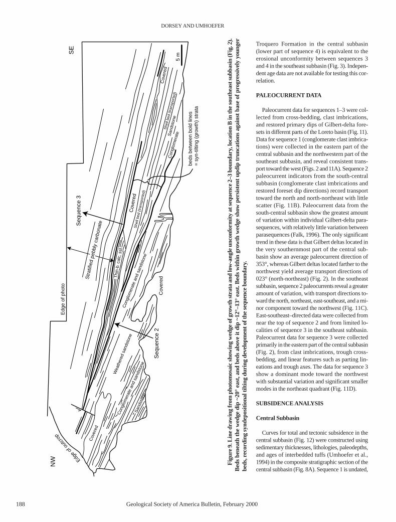
Troquero Formation in the central subbasin(lower part of sequence 4) is equivalent to theerosional unconformity between sequences 3and 4 in the southeast subbasin (Fig. 3). Indepen-dent age data are not available for testing this cor-relation.
PALEOCURRENT DATA
Paleocurrent data for sequences 1–3 were col-lected from cross-bedding, clast imbrications,and restored primary dips of Gilbert-delta fore-sets in different parts of the Loreto basin (Fig.11).Data for sequence 1 (conglomerate clast imbrica-tions) were collected in the eastern part of thecentral subbasin and the northwestern part of thesoutheast subbasin, and reveal consistent trans-port toward the west (Figs. 2 and11A). Sequence 2paleocurrent indicators from the south-centralsubbasin (conglomerate clast imbrications andrestored foreset dip directions) record transporttoward the north and north-northeast with littlescatter (Fig. 11B). Paleocurrent data from thesouth-central subbasin show the greatest amountof variation within individual Gilbert-delta para-sequences, with relatively little variation betweenparasequences (Falk, 1996). The only significanttrend in these data is that Gilbert deltas located inthe very southernmost part of the central sub-basin show an average paleocurrent direction of353°, whereas Gilbert deltas located farther to thenorthwest yield average transport directions of023° (north-northeast) (Fig. 2). In the southeastsubbasin, sequence 2 paleocurrents reveal a greateramount of variation, with transport directions to-ward the north, northeast, east-southeast, and a mi-nor component toward the northwest (Fig. 11C).East-southeast–directed data were collected fromnear the top of sequence 2 and from limited lo-calities of sequence 3 in the southeast subbasin.Paleocurrent data for sequence 3 were collectedprimarily in the eastern part of the central subbasin(Fig. 2), from clast imbrications, trough cross-bedding, and linear features such as parting lin-eations and trough axes. The data for sequence 3show a dominant mode toward the northwestwith substantial variation and significant smallermodes in the northeast quadrant (Fig. 11D).
SUBSIDENCE ANALYSIS
Central Subbasin
Curves for total and tectonic subsidence in thecentral subbasin (Fig. 12) were constructed usingsedimentary thicknesses, lithologies, paleodepths,and ages of interbedded tuffs (Umhoefer et al.,1994) in the composite stratigraphic section of thecentral subbasin (Fig. 8A). Sequence 1 is undated,
DORSEY AND UMHOEFER
188 Geological Society of America Bulletin, February 2000
Cov
ered
Cov
ered
Cov
ered
She
ll be
d (t
rans
port
ed)
Str
atifi
ed p
ebbl
y ca
rbon
ate
She
ll be
d (t
rans
port
ed)
5 m
San
dsto
ne
Wea
ther
ed s
ands
tone
Con
glom
erat
eSan
dsto
ne
Cov
ered
Edg
e of
pho
to
beds
bet
wee
n bo
ld li
nes
= s
yn-t
iltin
g (g
row
th)
stra
ta
NW
SE
Edge
of o
utcr
op
Seq
uenc
e 2
Seq
uenc
e 3
Thi
n-b.
cal
c. s
stC
ongl
omer
ate
and
sand
ston
e
Con
glom
erat
e an
d sa
ndst
one
Fig
ure
9. L
ine
draw
ing
from
pho
tom
osai
c sh
owin
g w
edge
of g
row
th s
trat
a an
d lo
w-a
ngle
unc
onfo
rmity
at s
eque
nce
2–3
boun
dary
,loc
atio
n B
in th
e so
uthe
ast s
ubba
sin
(Fig
.2).
Bed
s be
neat
h th
e w
edge
dip
~20
° ea
st,a
nd b
eds
abov
e it
dip
~12°
–13°
eas
t. B
eds
with
in g
row
th w
edge
sho
w p
ersi
sten
t upd
ip tr
unca
tions
aga
inst
bas
e of
pro
gres
sive
ly y
oung
erbe
ds,r
ecor
ding
syn
depo
sitio
nal t
iltin
g du
ring
deve
lopm
ent o
f the
seq
uenc
e bo
unda
ry.

but because the sequence 1–2 boundary is nonero-sive it is likely that most or all of sequence 1 isPliocene in age. A subsidence curve for this sec-tion first appeared in Dorsey et al. (1995). We havesubsequently refined the curve by adding new in-formation about water depth in the lower part ofsequence 4 (125 ± 25 m; R. Douglas, 1997, writ-ten commun.), computing the tectonic componentof subsidence, adding uncertainties for possiblevariations in eustatic sea level, and expanding thevery rapid part of the curve (2.46–2.36 Ma) with
an interpretation based on constraints from inter-nal stratigraphy (Fig. 12). Standard numericaltechniques for sediment decompaction and back-stripping were used in this analysis (e.g., Stecklerand Watts, 1978; Angevine et al., 1990). Tectonicsubsidence is calculated assuming local isostaticresponse to loading, and represents subsidencethat would occur in the absence of a sedimentaryload. Sea level is generally believed to have fluctu-ated by ~80–120 m during middle to late Pliocenetime (e.g., Raymo et al., 1992). This introduces un-
certainties in total and tectonic subsidence thatrange from ± 40 m to ± 60 m and are representedby an error envelope in Figure 12.
Figure 12A reveals a strongly episodic historyin which relatively slow or moderate subsidence(~0.4 mm/yr) was punctuated by one short burstof extremely rapid subsidence (8 mm/yr) brack-eted between tuffs 2 and 3. Most of the thicknessof stratigraphy in the central subbasin (>800 m;Fig. 8A) accumulated during this short time in-terval (~100 k.y.). This behavior is predicted for
SEQUENCE STRATIGRAPHY, PLIOCENE LORETO BASIN, BAJA CALIFORNIA SUR, MEXICO
Geological Society of America Bulletin, February 2000 189
Figure 10. Three cross sections showing sequence 3–4 boundary in the southeast subbasin. (A) Angular unconformity overlain by sequence 4conglomerate. (B) Angular unconformity overlain by sequence 4 limestone. (C) Fanning-dip section showing progressive decrease in eastwardbedding dip from uppermost sequence 3 into lower sequence 4 (modified from Dorsey, 1997). Dip decrease continues eastward into dips of ~3°–6°at Punta El Bajo. Section C records tilting phase that produced angular unconformity in A and B. Location of sections is shown in Figure 2.

strike-slip–related basins (Christie-Blick andBiddle, 1985; Pitman and Andrews, 1985;Johnson et al., 1983), but rarely is it this tightlyconstrained by high-precision age dating. Therate of tectonic subsidence following the veryrapid pulse is basically zero.
Southeast Subbasin
We calculate subsidence rates for sequence 2in the southeast subbasin using stratal thicknessesand ages shown in Figure 8. The water depth re-mained close to sea level during this interval, andtherefore the subsidence rate is approximatelyequal to the net rate of sediment accumulation.Bracketing ages in this section are provided bytuff 1 (2.61 Ma) near the base of sequence 2 andby the inferred age of the sequence 2–3 contact,which is well correlated to the central subbasinwhere an age of 2.40 Ma is assigned by interpo-lation between tuffs 2 and 3 (Fig. 8). These ageand thickness constraints yield a subsidence rateof ~1.5 mm/yr for sequence 2 in the southeastsubbasin.
STRUCTURAL GEOLOGY
The Loreto basin is bounded on the southwestand west by the Loreto fault (Fig. 2A), which wasthe primary structure responsible for basin subsi-dence. In most of the map area the fault strikesnorthwest and separates Miocene volcanic rocks,Cretaceous granite, and Mesozoic(?) metavol-canic rocks of the footwall from Pliocene strataand underlying Miocene volcanic rocks of thehanging wall. A major northeast-trending anti-cline separates a broad open syncline in the cen-tral subbasin from faulted, east-dipping rocks inthe southeast subbasin (Fig. 2A). The southeastsubbasin contains a dense array of normal anddextral-normal faults, the southeast fault array(Fig. 2; Umhoefer and Stone, 1996). The south-east fault array is thought to merge to the southwith the Loreto fault, but faults are poorly ex-posed in the area where they would merge. TheSierra Microondas fault is a north-striking, down-to-the-east normal fault located near the coast onthe east side of the Sierra Microondas (Fig. 2A).
Loreto Fault and Central Subbasin
The Loreto fault is a major fault with a doglegshape (Figs. 1 and 2). The southern segment ofthe fault is well defined for ~20 km, starting nearthe Baja highway about 5 km north of Loreto(south edge of the geologic map, Fig. 2A) andcontinuing northwest to the dog-leg bend whereit joins the Quaternary northern segment. Thesouthern segment strikes northwest and includes
a 1–2-km-wide zone of antithetic normal anddextral-normal faults in the footwall. There is noevidence for Quaternary or Holocene faultingalong the southern fault segment. In contrast, thenorthern segment has ~4–7-m-high fault scarpsfor its entire 12 km length (Mayer and Vincent,1999). There is no sign of the Loreto fault morethan ~12 km north of the dogleg bend. Althoughthere are no Pliocene strata exposed immediatelyadjacent to the northern part of the Loreto fault,we interpret that the northern part was active inPliocene time based on its lateral continuity withthe southern fault and the presence of Pliocenestrata a few kilometers to the east (Fig. 2A).
In detail, the southern Loreto fault has manysmall bends and jogs. The fault is well exposed infive locations and is best exposed where it crossesArroyo El Leon (location E, Fig. 2A). At one placethe fault has two overlapping strands for ~300 mwith a step between them. In another area, thefault forms a small, northwest-facing graben withhigh-angle boundaries. Where Arroyo El Salto
crosses the fault (location F, Fig. 2A), the fault isa complex, ~2-km- long zone. There, the faultsplays and exposes a small patch of marine stratathat appears to form a buttress unconformityagainst Miocene volcanic rocks within a faultwedge. This suggests that the fault had additionalsteps when it was active, which would allow lo-cal buttress of Pliocene strata against footwallrocks. Where well exposed, the Loreto fault dips~50°–70° to the northeast. It is a ~0.3–1-m-widezone of clay gouge juxtaposed against hanging-wall conglomerate. The gouge is against a vari-ably thick zone of fault breccia that consists ofcentimeter-scale faulted and fractured footwallrocks and is typically 1–2 m thick. The fault brec-cia grades abruptly into an ~5–10-m-thick zone ofdecimeter-scale faults and fractures of the foot-wall rocks. Conglomerate in the hanging wall hasfew faults or fractures and shows local coarseningand increasing clast angularity toward the fault.
A large, open syncline occupies the centralsubbasin between the Loreto fault and the Sierra
DORSEY AND UMHOEFER
190 Geological Society of America Bulletin, February 2000
Figure 11. Paleocurrent data from the Loreto basin plotted as rose diagrams. Number ofdata points (N), percentage contours, location, and stratigraphic sequence are indicated foreach diagram.

Microondas structural block (Fig. 2) and is bestdefined in sequence 2. The syncline plungesgently to the north-northwest (346°) and mergessouthward into a northwest-trending mono-cline. The monocline is about 2.5 km long and300–500 m wide, and locally tilts Pliocenestrata as much as 36° to the northeast. A moder-ately closed anticline and complex growth syn-
cline are exposed just west of the Sierra Mi-croondas. These folds are spatially related tomoderate-size dextral-normal faults that extendalong the Baja Highway and along the south-west side of the Sierra Microondas. A synclinein this area shows evidence for syndepositionalfolding of Gilbert-type fan deltas in the lowerpart of sequence 3.
Southeast Fault Array
The fault array in the southeast subbasin wasdescribed in detail elsewhere (Umhoefer andStone, 1996). It is an anastomosing array of dom-inantly north-striking, west-dipping normal faultsand northwest-striking dextral-normal faults. Aminority of the faults is north-northeast–strikingsinistral-normal faults. The southeast fault arrayappears to diverge from the Loreto fault from thesouth as a series of antithetic faults (Fig. 2). Thedextral-normal faults are primarily found in a nar-row zone along the Baja Highway and the south-west margin of the Sierra Microondas (Fig. 2).The rest of the fault array consists of normal faultsand a few oblique-slip transfer faults. Individualfaults show tens to a few hundred meters of offset,well defined by offset marker beds. Normal faultshave tilted the Pliocene strata 30°–40° to the eastwithin the southeast basin, and they record ~35%extension. The west-dipping faults in the easternpart of the southeast fault array have been mappednorthward into Miocene volcanic rocks, wherethey are difficult to detect. Here they merge north-ward with a complex coastal fault domain (ac-commodation zone) ~1.5 km wide, where thecoastline bends to the north and parallels theSierra Microondas fault (Figs. 2A and 13H).
North of the southeast fault array, the east sideof the Sierra Microondas along the coast hasmany small faults cutting west-dipping Miocenevolcanic rocks that are dominated by east-dip-ping normal faults (Fig. 2; north domain of SierraMicroondas fault, Fig. 13G). The eastern side ofthe Sierra Microondas is topographically steepand rises rapidly from the beach to more than600 m elevation in 1–1.5 km. We infer the pres-ence of a large, active down-to-the-east normalfault located ~1–2 km offshore from the SierraMicroondas, which we call the Sierra Microondasfault. In addition, Nava-Sanchez (1997) mappeda down-to-the-east normal fault about 1–1.5 kmoffshore at the northern end of the Sierra Mi-croondas in Holocene sediments from singlechannel seismic data. This offshore fault coin-cides closely with the proposed Sierra Microon-das fault. We interpret the transitional domain ofcomplex faulting, which is located between thewest-dipping normal faults of the southeast faultarray and the east-dipping Sierra Microondasfault, to be a local accommodation zone. It ap-pears that the southern part of the Sierra Mi-croondas fault bends eastward into an east-westfault just north of Punta El Bajo (Fig. 2), becauseuplifted marine terraces are preserved at the pointand west of it (Mayer and Vincent, 1999).
The angular unconformity at the base of se-quence 4 in the southeast subbasin (Fig. 10, Aand B) provides further evidence that the south-
SEQUENCE STRATIGRAPHY, PLIOCENE LORETO BASIN, BAJA CALIFORNIA SUR, MEXICO
Geological Society of America Bulletin, February 2000 191
Figure 12. Decompacted subsidence curve (A), and interpretive refinement (B) for the centralsubbasin. Data for thickness, lithology, and age are illustrated in Figure 8A. Thin dashed linesrepresent uncertainties related to possible eustatic sea-level fluctuations. See text for discussion.

east fault array and faults on the west side of theSierra Microondas were active prior to and dur-ing sequence 4 time. A fanning-dip section atPunta El Bajo (Fig. 10C) shows that eastward tilt-ing, which produced the angular unconformity,occurred by slip on west-dipping normal faultsduring deposition of rocky shoreline and shallow-marine sediments in the lower part of sequence 4
(Dorsey, 1997). This phase of syndepositional tilt-ing was produced by faulting in the southeast faultarray early in sequence 4 time. The age of se-quence 4 in the central subbasin is 2.36–2.0 Ma.Evidence from the base of sequence 3 (Fig. 9)suggests that deformation in the southeast fault ar-ray began early in sequence 3 time, ca. 2.4 Ma.Based on extrapolation of ages from the central
subbasin, this faulting episode was mostly com-pleted before 2.0 Ma, with a few small faults con-tinuing to slip and cut sequence 4 strata. There isno sign that the onshore southeast fault array is ac-tive today. Thus, we interpret that sometime after2.0 Ma, the southeast fault array became inactive,but the Sierra Microondas fault continued to slipuntil the present day.
DORSEY AND UMHOEFER
192 Geological Society of America Bulletin, February 2000
Figure 13. Equal-area plotsof structural data from theLoreto basin. With the excep-tions noted here, dots are polesto bedding; great circles arefault planes; ball and arrowsymbols on great circles arethe trend and plunge of striae
and the relative motion of the hanging wall. Extension (T) and com-pression (P) axes are from strain analysis (after Marrett and All-mendinger, 1990). (A) Bedding in the central subbasin with a greatcircle girdle and pole to great circle representing the gently north-northwest-plunging open syncline. (B) Faults in the central sub-basin. (C and D) Bedding and faults in the southeast basin. Notethat these are antithetic to the Loreto fault and the eastern limb ofthe syncline. (E) Small faults in clay gouge in the southern Loretofault. The large arrow is the average azimuth of motion of the hang-ing wall of the Loreto fault (cf. extension direction, double-arrowedline, in the late Pliocene southeast fault array in D). (F) Secondaryfaults related to the southern Loreto fault. (G and H) Faults alongthe coast in the footwall of the Sierra Microondas fault (see Fig. 2Afor location) and from the accommodation zone between that faultand the southeast fault array. (I) Bedding in the Miocene volcanicrocks (Mv) and Pliocene sedimentary strata in the Sierra Microon-das. Both rock units have overall similar amounts of tilt, but whereboth rock units display bedding in close proximity to each other,Miocene beds are always tilted ~5°–10° more than the Pliocenerocks. (J) Faults in Miocene volcanic rocks in the Sierra Microon-das. Note that the extension direction is northeast-southwest, dis-tinctly different from that in the Pliocene faults.

Kinematic Analysis
The map distribution and kinematics of faultsin and along the margin of the Loreto basin in-dicate that they were active in the same strainregime and acted as an integrated system of nor-mal and oblique-slip faulting (Fig. 13). Analysisof the Loreto fault shows down-to-the-east mo-tion, which demonstrates that the fault drovebasin subsidence (Fig. 13, E and F). All faults thatcut the Loreto basin have a similar extension di-rection. Dominantly normal faults of the south-east fault array indicate extension to 278°, SierraMicroondas faults record extension to 279°, andthe accommodation zone between them showsextension to 283° (Fig. 13, D, G, and H). Faultstriae on secondary faults related to the Loretofault, along its southeastern part, yield a similar
extension direction (281°, Fig. 13F). One of theplanes defined from strain analysis of the striae inthe clay gouge from the Loreto fault strikes 280°and dips 53°N. This direction, and the averagetrend of the rake on the striae in the clay gouge(94°), are essentially parallel to the direction ofextension documented from the southeast basinfault array (Fig. 13E). There are no kinematic datafrom the northern Loreto fault, but its northerlystrike suggests that it is a nearly pure dip-slip nor-mal fault.
INTERPRETATION AND DISCUSSION
Structural Style of Loreto Basin
The Loreto basin is a transtensional basin thatformed within a broad releasing bend of the nor-
mal and oblique-slip Loreto fault (Figs. 1, 2,and 6). Fault-kinematic data indicate that defor-mation and basin formation occurred by approx-imately east-west extension at the western marginof the Gulf of California transform-rift system(Fig. 13; Umhoefer and Stone,1996). This is con-sistent with modeling studies that predict a simi-lar orientation of extensional strain along anobliquely rifted, transtensional continental mar-gin where the angle between the rift trend and di-rection of relative plate motion is about 20°(Withjack and Jamison, 1986; Fossen and Tikoff,1993; Umhoefer and Dorsey, 1997). In this con-text, the strongly asymmetric geometry of thecentral subbasin is interpreted to record westwardtilting in the hanging wall of the oblique-slip,dextral-normal Loreto fault. The deepest part ofthe basin is located close to the southern Loretofault and indicates a large component of syn-basinal dip-slip displacement (>1500 m; Fig. 6).Westward tilting probably resulted from exten-sional collapse of the hanging wall above a listricgeometry in the Loreto fault (Fig. 14). We there-fore consider the Loreto basin to be an oblique,transtensional half-graben basin that subsidedrapidly in response to the dip-slip component ofdextral-normal slip on the Loreto fault. Althoughmany features of the Loreto basin appear similarto those of orthogonal rift basins,the very shortand extremely rapid history of basin subsidenceis characteristic of basin development in anoverall strike-slip setting (Christie-Blick andBiddle, 1985).
The Loreto basin cannot be represented as asimple pull-apart basin because the Loreto faultterminates west of the northernmost Pliocenedeposits, at a point located approximately west-southwest of the center of the Mencenares vol-canic center (Fig.1). We have considered the pos-sibility that slip on the Loreto fault may step overto the east, and that the Pliocene Mencenares vol-canic center formed along a leaky transfer faultthat connects the Loreto fault to a large fault far-ther north and east, but this hypothesis is not sup-ported by available data. There is no large faultnorth of the Mencenares complex, and no indica-tion that fault slip is transferred through or acrossthe volcano. This latter interpretation would re-quire that slip on the Loreto fault steps eastward toan unknown location offshore, but there is no evi-dence to support this interpretation. Instead, weinterpret that a large strain gradient exists on thenorthern part of the Loreto fault where the totalslip decreases to nearly zero over a horizontal dis-tance of ~10–15 km. The gradient of northwardstrain decrease is difficult to estimate because thethickness of Pliocene deposits (and thus the totalamount of slip on the fault) is not known in thenorthern part of the basin.
SEQUENCE STRATIGRAPHY, PLIOCENE LORETO BASIN, BAJA CALIFORNIA SUR, MEXICO
Geological Society of America Bulletin, February 2000 193
Figure 14. Interpretive three-stage evolution of central subbasin (cross-section view), in whichbasin subsidence is controlled by growth of hanging-wall collapse syncline (sequence 1 and 2),followed by slowing of slip on Loreto fault, initiation of coastal fault in the east, and uplift anderosion of hanging-wall tilt block (sequence 3). Note oblique nature of cross section, which re-sults from oblique nature of controlling structures: cross-section view is west-east for centralsubbasin and northwest-southeast for southeast subbasin (see Fig. 2A).

Sequence-Stratigraphic Record of BasinEvolution
Sequence 1 records deposition in nonmarinealluvial fans during an initial, relatively slow stageof subsidence on the Loreto fault (Figs. 14Aand15A). Paleocurrent data record input from theSierra Microondas in the east (Fig.11), and we in-fer that sediment also was being shed into thebasin from the footwall of the Loreto fault in thewest. Although age data are not available for se-quence 1 deposits, we infer that subsidence duringdeposition of sequence 1 probably was slowerthan early in sequence 2 time. The lower part ofsequence 1 may be as old as 5 or 6 Ma. It there-fore is possible that the early phase of deposition
was initiated in latest Miocene or earliest Pliocenetime when the Gulf of California first underwentsignificant strike-slip faulting (Lonsdale, 1989).
The abrupt marine flooding surface at the baseof sequence 2 marks a major reorganization ofdepositional systems, sediment-dispersal paths,and basin-bounding structures (particularly theLoreto fault) that controlled patterns of subsi-dence and sediment input. Initial marine incur-sion probably resulted from an increase in therate of fault-controlled subsidence at this time,and may have also been amplified by a rise in eu-static sea level ca. 2.62 Ma (Fig. 16). In the cen-tral subbasin, a second increase in subsidencerate occurred soon after deposition of tuff 2, thesubsidence rate increasing to ~8 mm/yr (Fig. 12).
As a result of this increase, 14 Gilbert delta para-sequences occupying ~650 m of section in se-quence 2 accumulated during a short time inter-val (<100 k.y.). Input from the Sierra Microondas,which represents the uplifted portion of the hang-ing-wall tilt block, ceased at this time and did notresume until the beginning of sequence 3 time(Figs. 14B and 15B). Footwall-derived sedimentwas funneled northward along the axis of thecentral subbasin. In the southeast subbasin, sedi-ment was shed northward from the footwall ofthe Loreto fault and redirected eastward throughthe southeast subbasin (Figs. 11 and 15).
During deposition of sequence 2, the centralsubbasin underwent rapid westward tilting thatproduced a pronounced westward thickening and
DORSEY AND UMHOEFER
194 Geological Society of America Bulletin, February 2000
Figure 15. Sequence ofschematic maps depictingevolution of Loreto basinand bounding structuresfrom sequence 1 time to thepresent day. IC—Isla Coro-nado; L—Loreto; MGE—Main Gulf Escarpment;MVC—Menecares volcaniccomplex. See text for dis-cussion.

coarsening of stratigraphy toward the Loreto fault.The footwall of the Loreto fault produced a cor-respondingly rapid influx of coarse detritus to thebasin, which enabled it to stay nearly filled inspite of very rapid subsidence. In order to recon-
cile pronounced westward tilting with lack ofsediment input from the hanging-wall dip slope,we infer that the sequence 2 stage of subsidencein the central subbasin was produced by growthof a basin-scale active syncline that formed by
extensional collapse of the hanging wall above alistric normal fault (Fig. 14B; e.g., Groshong,1989; Xiao and Suppe, 1992). This growth syn-cline was bounded on the east and southeast byan anticline that, due to its oblique orientation inmap view, also made up the northern or north-western margin of the southeast subbasin(Figs. 2, 14B, and 15B). Onlapping of~600–700 m of stratigraphy onto the northernmargin of the southeast subbasin (Fig. 7) indi-cates that this was a major structure that sepa-rated the two subbasins during most of Loretobasin evolution. On the basis of the overwhelm-ing dominance of extensional normal faults andextensional kinematics in the area, we infer thatthe growth anticline formed as an extensionalrollover structure, and that southeastward tiltingon the southeast limb may have been controlledby a bend or step in the Loreto fault at depth.Some aspects of this interpretation remain diffi-cult, however, because stratigraphy in the south-east subbasin reveals no evidence of synbasinaltilting within the units where we have done de-tailed mapping (sequence 2). This could be ex-plained if the north-south panel for the southeastsubbasin (Fig. 7) is oriented close to the strike ofthe growth anticline (north-northeast), in whichcase it would not be likely to reveal fanning dipsproduced by syndepositional tilting.
The transition to sequence 3 records anothermajor change in fault-controlled subsidence andsediment-dispersal patterns. Renewed uplift ofthe Sierra Microondas initiated rapid influx ofbioclastic carbonate material that was shedsouthward into the southeast subbasin and westand northwestward into the central subbasin(Figs. 11 and 15C). In the southeast subbasin, in-trabasinal tilting and erosion produced a low-an-gle unconformity at the base of sequence 3(Fig. 9). In the central subbasin, where subsi-dence was extremely rapid, the transition to se-quence 3 occurred by progradation of bioclasticGilbert-type fan deltas to produce a strong down-lapping geometry with no unconformity (Fig. 6).Initiation of sequence 3 records several majorchanges in structural style: (1) initiation of thenormal fault on the east side of the Sierra Mi-croondas; (2) progradation of carbonates erodedfrom this uplifted area into the flanking sub-basins; (3) slowing of slip on the Loreto faultand initiation of the southeast fault array; and(4) change in subsidence geometry in the centralsubbasin from markedly asymmetric to nearlysymmetrical (Fig. 14C). The latter change in sub-sidence geometry may have resulted from con-tinued growth of the basin-scale growth synclinecoincident with substantially slowed slip rate onthe Loreto fault, resulting in uniform rates of sub-sidence (and uniform cross-basin thickness of se-
SEQUENCE STRATIGRAPHY, PLIOCENE LORETO BASIN, BAJA CALIFORNIA SUR, MEXICO
Geological Society of America Bulletin, February 2000 195
Figure 16. Comparison of Loreto basin paleobathymetry (this study) with eustatic sea-levelfluctuations determined from oxygen isotopes in the North Atlantic (Raymo et al., 1992). High-frequency paracycles in the central subbasin do not match the eustatic curve, indicating tectoniccontrol on stratigraphic evolution due to very rapid, episodic subsidence. In the southeast sub-basin we observe a close correlation between number of laterally extensive shell beds and sea-level highstands, indicating a eustatic control on formation of parasequences.

quence 3) across the central subbasin (Fig. 6). Weinfer that subsidence rate in the central subbasinslowed by the end of sequence 3 time, resultingin progradation of nonmarine alluvial fans overmarine deposits (Figs. 12B and 15C).
Progradation of nonmarine gravel in the upperpart of sequence 3 and the subsequent abrupt onsetof distal marine conditions (base of sequence 4)are interpreted to be the result of changes in sub-sidence rate (Fig. 12B). Although gravel progra-dation could be explained by either slowing ofaccommodation production or an increase in therate of sediment input, the sudden foundering offluvial environments to >100 m water depth canonly be explained by an abrupt subsidence event.This cannot be solely the product of eustatic sea-level rise because the section does not record areturn to shallow-marine or fluvial conditionswithin the appropriate time frame (Fig. 16). Sub-sidence therefore must have been unsteady dur-ing the time interval between tuffs 2 and 3. We in-fer that the stratigraphic architecture bracketedbetween tuffs 2 and 3 in the central subbasin wasproduced primarily by variations in the rate ofsubsidence on the Loreto fault, and the rapid shiftof fault slip to the Sierra Microondas fault andsoutheast fault array (Figs. 6, 8, and12B). Gilbert-delta deposition was initiated by a sharp increasein subsidence rate that coincided with depositionof tuff 2 (see also Dorsey et al., 1995). Near theend of sequence 3 time, slowing of subsidencecaused progradation of nonmarine conglomeratealong the basin axis.
The transition to sequence 4 was markedlydifferent in the central and southeast subbasins(Fig. 15D). In the central subbasin, the basin floorfoundered and subsided quickly to water depthsof 100–150 m. This probably resulted from a finalpulse of very rapid slip on the Loreto fault. In thesoutheast subbasin, faulting, uplift, and erosiontook place during foundering of the central sub-basin, as recorded in the southeast fault array, an-gular unconformity, and fanning-dip section inthe southeast subbasin. Some time later, sedimen-tation resumed in the southeast subbasin in theform of in situ shallow-marine carbonate deposi-tion adjacent to highlands in the Sierra Microon-das and newly emerged portions of the previouslymarine southeast subbasin. Finally, the Loretobasin has been progressively uplifted and erodedsince ca. 2 Ma, in the footwalls of modern, activecoastal and nearshore faults (Fig. 15E).
Tectonic vs. Eustatic Controls on Parasequence Cyclicity
The evolution of the central subbasin differedmarkedly from that of the southeast subbasin. Insequences 2, 3, and 4, we document notable
contrasts in thickness, sedimentology, type ofsequence boundaries, rate of sediment accumula-tion, and number and stacking pattern of para-sequences, all of which were controlled by con-trasting structural behavior of the two areas. Thecentral subbasin formed in a deep, rapidly sub-siding growth syncline that formed in the hang-ing-wall tilt block close to the Loreto fault, whilethe southeast subbasin formed in a structurallyshallower position on the southeast side of an ac-tive anticline that separated the two subbasins(Figs. 14B and 15B). Due to the structurallyperched position of the southeast subbasin, it un-derwent faulting, uplift, and erosion during atime (early sequence 4) when the central sub-basin foundered abruptly to deep water depthsand then slowly filled with marine mudstone.
The contrasting structural behavior of the twosubbasins produced significantly different subsi-dence rates during sequence 2 time: ~8 mm/yr inthe central subbasin and ~1.5 mm/yr in the south-east subbasin. The two subbasins also contain,within sequence 2, a significantly different num-ber of progradational parasequences capped byhiatal transgressive shell beds: 14 in the centralsubbasin compared to 4 in the southeast sub-basin (Fig. 8). Figure 16 shows paleobathymetryfor the two Loreto subbasins compared to tem-poral variations in oxygen isotopes from theNorth Atlantic Ocean (data from Raymo et al.,1992), which are used here as a proxy for eusta-tic sea level. Although it is easy to reconstructchanges in paleoenvironments and paleobathy-metry through time, it is difficult to determinewhether those changes were controlled by varia-tions in eustatic sea level, rate of basin subsi-dence, or sediment supply. This problem is ana-lyzed in the following.
Sequence 2 in the central subbasin contains14Gilbert deltas (paracycles), bracketed betweentuff 2 and the base of sequence 3, which record14 episodes of deltaic progradation and marineflooding (Fig. 16). These paracycles accumulatedduring ~1.5 cycles of eustatic sea-level change asinterpreted from the isotope excursions (41 k.y.per cycle). This obvious mismatch indicates thatglobal eustatic fluctuations did not exert the maincontrol on Gilbert delta cyclicity in the centralsubbasin. On the basis of this and other consider-ations, we infer that high-frequency stratigraphiccycles in the central subbasin were produced byepisodic fault-controlled subsidence possiblyrelated to temporal clustering of earthquakes(Dorsey et al.,1997b). In this model, rapid progra-dation of gravelly Gilbert deltas occurred duringperiods of slow or negligible slip and slow subsi-dence on the Loreto fault. We infer that rapid ma-rine transgression and deposition of capping shellbeds directly on delta-plain deposits (topsets) oc-
curred during short bursts of extremely rapid tec-tonic subsidence on the Loreto fault, which pro-duced back tilting of alluvial fans, decrease ofchannel gradients, and temporary sediment star-vation in the nearshore marine realm. A summaryof competing hypotheses and reasons for favor-ing this model was presented in Dorsey et al.(1997b). From this we conclude that parase-quences in the central subbasin were produced byvery rapid, episodic tectonic subsidence that ef-fectively overwhelmed the influence of eustaticsea-level changes.
A strikingly different pattern is seen in thesoutheast subbasin, where we observe four later-ally continuous shell beds in sequence 2 (Figs. 7and 8) that appear to match four highstands of eu-static sea level between tuff 1 and the base of se-quence 3 (Fig. 16). We favor a correlation ofthese shell beds to the marine isotope curve inpart because it is unlikely that the relatively slowsubsidence rate of ~1.5 mm/yr would be fastenough to swamp out the eustatic signal in a ma-rine setting. Variations in sediment supply cannotbe ruled out, but the close match with the marineisotope record supports the interpretation thatstratigraphic cyclicity of shell beds in the south-east subbasin was controlled by eustasy. Thelowest of these is the double shell bed (dsb), a hi-atal shell concentration that lies stratigraphicallybetween two units of nonmarine conglomerate inthe lower part of sequence 2 (Figs. 7, 8, and 16).We propose that the double shell bed accumu-lated during a eustatic sea-level rise that brieflyoverwhelmed gravel progradation and produceda short interval of marine flooding. We furthersuggest that shell bed 1 in the central subbasincorrelates with shell bed 4 in the southeast sub-basin. This correlation is supported by the anom-alously wide lateral extent of shell bed 1 in thecentral subbasin compared to other delta-cappingshell beds in that area, and implies that it is in parta product of eustatic sea-level rise.
The preceding summary helps to highlightimportant contrasts in the behavior of the twosubbasins during deposition of sequence 2. Inthe central subbasin, extremely rapid subsidence(~8 mm/yr), combined with strong episodic vari-ations in subsidence rate, overwhelmed rates ofeustatic sea-level change and exerted the domi-nant control on internal stratigraphic cyclicity. Inthe southeast subbasin, subsidence was slower(~1.5 mm/yr), and eustatic sea-level change ex-erted the dominant control on progradation andretrogradation of parasequences. It is interestingto note that our model for the southeast subbasinresembles the behavior represented in recentlypublished models for half-graben depocenters lo-cated close to bounding normal faults, in whichhigh-frequency sea-level change is superimposed
DORSEY AND UMHOEFER
196 Geological Society of America Bulletin, February 2000

on background basin subsidence, and eustasy ex-erts the main control on internal stratigraphiccyclicity (e.g., Gawthorpe et al., 1994; Hardy andGawthorpe, 1998). In our model for the centralsubbasin, by contrast, internal stratigraphic vari-ations are driven by very high frequencyepisodic subsidence and there is virtually no ex-pression of eustatic sea-level change. This ap-pears to represent an end member in the possiblerange of interactions between basin subsidenceand eustasy in tectonically active basins. Basedon subsidence rates in the two subbasins, we esti-mate that maximum rates of eustatic sea-levelchange may have been between ~2 and 8 mm/yr.Hypothetically, a sea-level rise of 100 m occur-ring in 20 k.y. (~one-half of the 41 k.y. cyclicityrecorded in Fig. 16) represents a rate of rise of5 mm/yr. Although the magnitudes of sea-levelchange during Pliocene time are not well known,changes on the order of 80–100 m are consideredreasonable (Raymo et al., 1989, 1992; Blanchonand Shaw, 1995), and thus rates of change of~4–5 mm/yr seem reasonable.
Sequence Stratigraphy in Tectonically ActiveBasins
In traditional models of sequence stratigraphy,a sequence is defined as “a relatively conformablesuccession of genetically related strata boundedby unconformities and their correlative confor-mities” (Van Wagoner et al., 1988, p. 39). Type 1sequence boundaries are erosional unconformi-ties produced by a fall in relative sea level, streamincision, and a basinward shift in facies. Type 2sequence boundaries also are erosional unconfor-mities, but they lack evidence for subaerial ero-sion, stream rejuvenation, and basinward shift infacies in the marine realm. Highstands, low-stands, and lateral shifting of the shoreline resultfrom the interplay between rate of production orloss of accommodation space (traditionally at-tributed to rate of eustatic sea-level rise or fall)and rate of sediment input. These and relatedconcepts were developed and refined for passivecontinental margins where rates of subsidenceand sediment input may be several orders ofmagnitude slower that those of tectonically activebasins (e.g., Vail et al., 1977; Van Wagoner et al.,1988; Posamentier et al., 1988). This contrast isespecially acute for strike-slip related basins,which commonly experience subsidence rates≥1 mm/yr (1 m/1 k.y.) (Johnson et al., 1983;Christie-Blick and Biddle, 1985; Pitman andAndrews, 1985).
Early concepts of sequence stratigraphy werelater refined by emphasizing the concept that re-gional basin subsidence can and often does dom-inate the production of accommodation space,
and in concert with variations in sediment supply,may exert the main control on development ofstratigraphic sequences and their boundaries(Galloway, 1989; Embry, 1989; Jordan and Flem-ings, 1991; Coakley and Watts, 1991; Sinclairet al., 1991; Posamentier and Allen, 1993). Morerecently it has been recognized that in tectoni-cally active settings dominated by rapid localsubsidence, basins may undergo a continual risein relative sea level through time, and stratigraphicsequences may be bounded by nonerosive, com-posite surfaces of marine flooding, maximumtransgression and downlap (Gawthorpe et al.,1994, 1997; Dart et al., 1994; Burns et al., 1997;Hardy and Gawthorpe, 1998). In these cases, thedominant architectural features of the stratigraphymay reflect major subsidence or basin-founder-ing events in the basin. Similarly, we have foundit both necessary and useful to define sequencesin the Loreto basin using refined criteria that de-part somewhat from those of the traditional se-quence-stratigraphic paradigm.
The sequence 1–2 boundary and the 3–4boundary in the central subbasin are abrupt sur-faces of marine flooding that mark major changesin relative sea level, stratigraphic architecture, andparasequence stacking patterns. There is no evi-dence for subaerial erosion or lowering of relativesea level at these contacts; instead they recordpronounced and sudden relative sea-level rise.Our work shows that these boundaries are themost internally consistent and useful surfaces formapping and defining sequences in the Loretobasin, consistent with the concept of geneticstratigraphic sequences of Galloway (1989). Thelack of erosional unconformities at these bound-aries reflects the very rapid subsidence history ofthe Loreto basin. In the central subbasin, wheresequence boundaries are not unconformities,subsidence rates outpaced eustatic sea-level fluc-tuations and the basin underwent a continual risein relative sea level. The evolution of the centralsubbasin therefore is recognized as being punc-tuated by major basin-foundering events thatproduced distinctive sequence-bounding marineflooding surfaces.
The sequence 2–3 boundary is an unconfor-mity in some locations, a conformable transitionin others, and in the western half of the centralsubbasin it is a parasequence boundary similar toothers preserved in the thick western part of thebasin (Fig. 6). In the western part of the centralsubbasin the parasequence stacking pattern doesnot require a sequence boundary, and in that areaby that definition we would not subdivide se-quences 2 and 3. However, several other obser-vations bear on this question. First, the base ofsequence 3 becomes a surface of substantialstratigraphic omission on the eastern margin of
the central subbasin, where carbonates directlyoverlie Miocene volcanic basement rocks of theSierra Microondas (Fig. 6). In this case the se-quence boundary is best displayed around the ex-treme margins of the basin, but within most partsof the central subbasin this transition would notbe picked as a sequence boundary. We thereforeemphasize the concept of the sequence-boundingunconformity and its correlative conformity,which is appropriate due to the subsidence-dominated behavior of the central subbasin dur-ing deposition of sequences 2 and 3. Second, thechange from sequence 2 to sequence 3 recordsprofound changes in provenance, sediment dis-persal, and uplift and erosion of the easternsource area, all of which resulted from reorgani-zation of basin-margin faults and large-scale pat-terns of tilting and erosion. Finally, this boundaryin the central subbasin is correlable with a low-angle erosional unconformity in the southeastsubbasin. Thus, the sequence 2–3 boundaryrecords one of the most important tectonic eventsin the Loreto basin, and the influence of thischange is well displayed in the stratigraphicrecord wherever hanging-wall–derived sedimentsare preserved.
CONCLUSIONS
The Pliocene Loreto basin is an oblique, trans-tensional half-graben basin that formed in a zoneof transtensional deformation along the activetransform-rift plate boundary in the Gulf of Cali-fornia. The basin probably was initiated in earlyPliocene time and underwent a rapid phase ofsubsidence and filling between ca. 2.6 and2.0 Ma. Basin formation and westward tilting oc-curred in response to east-west extension and thedip-slip component of oblique slip on the dextral-normal southern Loreto fault. The central sub-basin is located close to the Loreto fault and un-derwent a very short lived pulse of extremelyrapid subsidence (~8 mm/yr) between ca. 2.46and 2.36 Ma during deposition of sequences 2and 3. The southeast subbasin subsided moreslowly (~1–2 mm/yr) in a structural accommoda-tion zone, and was strongly deformed by closelyspaced west-dipping normal faults in the south-east fault array.
Sedimentary deposits of the Loreto basincomprise a diverse assemblage of nonmarine tomarine, coarse- to fine-grained siliciclastic andcarbonate deposits. The stratigraphy is dividedinto four sequences that record four distinctphases of fault-controlled basin evolution. Thesequence 1–2 boundary is a marine flooding sur-face that formed by marine incursion of a previ-ously nonmarine basin in response to increasedsubsidence rate and reorganization of basin-
SEQUENCE STRATIGRAPHY, PLIOCENE LORETO BASIN, BAJA CALIFORNIA SUR, MEXICO
Geological Society of America Bulletin, February 2000 197

bounding faults. Sequence 2 is characterized bysiliciclastic, marginal marine Gilbert-type fandeltas that were fed by steep, footwall-sourcedalluvial fans. The sequence 2–3 and 3–4 bound-aries vary substantially between the central andsoutheast subbasins. In the southeast subbasin,these boundaries are slightly to strongly ero-sional unconformities, but in the central sub-basin they are conformable surfaces of strati-graphic downlap (2–3) and pronounced marineflooding (3–4). The marked difference in se-quence boundaries is a direct result of contrast-ing accommodation space: the southeast sub-basin underwent subtle to strong uplift anderosion during episodes of structural transition,whereas the central subbasin underwent contin-ued subsidence or basin foundering.
We are able to distinguish between tectonicand eustatic controls on stratigraphic signaturesfor sequence 2 in the two subbasins, by compar-ing the well-constrained chronology of paracy-cles and shell beds with oxygen-isotope recordsfrom North Atlantic Ocean Drilling Programcores. In the central subbasin, very rapid subsi-dence (~8 mm/yr) outpaced the rate of sea-levelfluctuations, and the 14 paracycles of sequence 2provide a record of episodic tectonic subsidencewith virtually no eustatic signal. In the southeastsubbasin, however, net subsidence rate was suffi-ciently slower (1–2 mm/yr) that sea-level fluctu-ations exerted the main control on parasequenceevolution.
Deformation within the basin first occurredca. 2.4 Ma near the sequence 2–3 transition, asrecorded in a low-angle unconformity in the south-east subbasin and a growth syncline in the lowerpart of sequence 3 in the central subbasin. Thislocalized deformation was produced by initiationof the southeast Loreto fault array and the begin-ning of a shift of faulting from the Loreto fault toa coastal fault system. The southeast fault arraybecame more active immediately after sequence 3time, producing an angular unconformity andfanning dips at the base of sequence 4 in the south-east subbasin. Initiation of the southeast fault ar-ray was accompanied by a decrease in slip rate onthe southern Loreto fault and related prograda-tion of the shoreline to the north and east. Duringlatest Pliocene to Quaternary time, faulting hastaken place along the northern Loreto fault, theSierra Microondas fault, and a linked east-westfault that apparently projects offshore to Coron-ado Island.
ACKNOWLEDGMENTS
Financial support of this study was providedby the National Science Foundation grants EAR-9117269 and EAR-956506 and the PetroleumResearch Fund of the American Chemical Soci-
ety. We gratefully acknowledge many productiveand insightful conversations with Susan Kidwell,Larry Mayer, Jim Ingle, Bob Douglas, JorgeLedesma, Enrique Nava, Peter Falk, and AndyStone. Bob Douglas kindly provided analysesand interpretations of benthic fauna for depth de-termination of the El Troquero Formation. Wethank Peter Falk for contributing paleocurrentdata from the central subbasin. We express ourgratitude to Miguel Valdes and the people ofLoreto for years of support and friendship duringthis study.
REFERENCES CITED
Anderson, C. A., 1950, Geology of islands and neighboringland areas: Part I of the 1940 E. W. Scripps Cruise to theGulf of California: Geological Society of America Mem-oir 43, part 1, p. 1–53.
Angelier, J., Colletta, B., Chorowicz, J., Ortlieb, L., andRangin, C., 1981, Fault tectonics of the Baja CaliforniaPeninsula and the opening of the Sea of Cortez, Mexico:Journal of Structural Geology, v. 3, p. 347–357.
Angevine, C. L., Heller, P. L., and Paola, C., 1990, Quantitativesedimentary basin modelling: American Association ofPetroleum Geologists Continuing Education Course NoteSeries no. 32, 133 p.
Axen, G., 1995, Extensional segmentation of the Main GulfEscarpment, Mexico and United States: Geology, v. 23,p. 515–518.
Bigioggero, B., Chiesa, S., Zanchi, A., Montrasio, A., andVezzoli, L., 1995, The Cerro Mencenares volcanic center,Baja California Sur; source and tectonic control on post-subduction magmatism within the Gulf Rift: GeologicalSociety of America Bulletin, v. 107, p. 1108–1122.
Blanchon, P., and Shaw, J., 1995, Reef drowning during the lastdeglaciation: Evidence for catastrophic sea-level rise andice-sheet collapse: Geology, v. 23, p. 4–8.
Bosworth, W., 1985, Geometry of propagating continental rifts:Nature, v. 316, p. 625–627.
Burns, B. A., Heller, P. L., Marzo, M., and Paola, C., 1997,Fluvial response in a sequence stratigraphic framework:Example from the Montserrat fan delta, Spain: Journal ofSedimentary Research, v. 67, p. 311–321.
Christie-Blick, N., and Biddle, K. T., 1985, Deformation andbasin formation along strike slip faults,in Biddle, K. T.,and Christie-Blick, N., eds., Strike-slip deformation,basin formation, and sedimentation: Society of EconomicPaleontologists and Mineralogists Special Publication 37,p. 1–34.
Coakley, B. J., and Watts, A. B., 1991, Tectonic controls on thedevelopment of unconformities; the North Slope,Alaska:Tectonics, v. 10, p. 101–130.
Curray, J. R., and Moore, D. G., 1984, Geologic history of theGulf of California,in Frizzell, V. A., ed., Geology of theBaja California Peninsula: Bakersfield, California, PacificSection, Society of Economic Paleontologists and Miner-alogists, p. 17–36.
Dart, C. J., Collier, R. E. L., Gawthorpe, R. L., Keller, J.V. A.,and Nichols, G., 1994, Sequence stratigraphy of (?)Pliocene-Quaternary synrift, Gilbert-type fan deltas,northern Peloponnesos, Greece: Marine and PetroleumGeology, v. 11, p. 545–560.
Dorsey, R. J., 1997, Origin and significance of rhodolith-richstrata in the Punta el Bajo section, southeastern PlioceneLoreto basin,in Johnson, M. E., and Ledesma-Vasquez, J.,eds., Pliocene carbonates and related facies flanking theGulf of California, Baja California Sur, Mexico: Geologi-cal Society of America Special Paper 318, p. 119–126.
Dorsey, R. J., and Burns, B. A., 1994, Regional stratigraphy,sedimentology and tectonic significance of Oligocene-Miocene sedimentary and volcanic rocks, northernBaja California, Mexico: Sedimentary Geology, v. 88,p. 231–251.
Dorsey, R. J., and Kidwell, S. M., 1999, Mixed carbonate-sili-ciclastic sedimentation on a tectonically active margin:Example from the Pliocene of Baja California Sur, Mex-
ico: Geology, v. 27, p. 935–938.Dorsey, R. J., Umhoefer, P. J., and Renne, P. R., 1995, Rapid
subsidence and stacked Gilbert-type fan deltas, PlioceneLoreto Basin, Baja California Sur, Mexico: SedimentaryGeology, v. 98, p. 181–204.
Dorsey, R. J., Stone, K. A., and Umhoefer, P. J., 1997a, Stratig-raphy, sedimentology, and tectonic development of thesoutheastern Loreto basin, Baja California Sur, Mexico,in Johnson, M. E., and Ledesma-Vasquez, J., eds., Plio-cene carbonates and related facies flanking the Gulf ofCalifornia, Baja California Sur, Mexico: Geological Soci-ety of America Special Paper 318, p. 83–109.
Dorsey, R. J., Umhoefer, P. J., and Falk, P., 1997b, Earthquakeclustering and stacked Gilbert-type fan deltas in thePliocene Loreto Basin, Baja California Sur, Mexico: Ge-ology, v. 25, p. 679–682.
Durham, J. W., 1950, Megascopic paleontology and marinestratigraphy: Part 2 of the 1940 E. W. Scripps cruise tothe Gulf of California: Geological Society of AmericaMemoir 43, 216 p.
Embry, A. F., 1989, A tectonic origin for third-order deposi-tional sequences in extensional basins: Implications forbasin modeling,in Cross, T.A., ed., Quantitative dynamicstratigraphy: Englewood Cliffs, New Jersey, Prentice-Hall, p. 491–501.
Falk, P. D., 1996, Stratigraphy and sedimentology of Pliocenefan-delta deposits, Loreto basin, Baja California Sur,Mexico [M.S. thesis]: Flagstaff, Northern Arizona Uni-versity, 173 p.
Falk, P., and Dorsey, R. J., 1998, Rapid development of gravellyhigh-density turbidity currents in marine Gilbert-type fandeltas, Loreto basin, Baja California Sur, Mexico: Sedi-mentology, v. 45, p. 331–349.
Fossen, H., and Tikoff, B., 1993, The deformation matrix forsimultaneous simple shearing, pure shearing, and volumechange, and its application to transpression/transtensiontectonics: Journal of Structural Geology, v. 15, p. 413–422.
Galloway, W. E., 1989, Genetic stratigraphic sequences in basinanalysis 1: Architecture and genesis of flooding-surfacebounded depositional units: American Association ofPetroleum Geologists Bulletin, v. 73, p. 125–142.
Gastil, R. G., Phillips, R. P., and Allison, E. C., 1975, Recon-naissance geology of the state of Baja California: Geo-logical Society of America Memoir 140, 170 p.
Gawthorpe, R. L., and Colella, A., 1990, Tectonic controls oncoarse-grained delta depositional systems in rift basins,inColella, A., and Prior, D. B. eds., Coarse-grained deltas:International Association of Sedimentologists SpecialPublication 10, p. 113–127.
Gawthorpe, R. L., Fraser, A. J., and Collier, R. E., 1994,Sequence stratigraphy in active extensional basins: Impli-cations for the interpretation of ancient basin-fills: Marineand Petroleum Geology, v. 11, p. 642–658.
Gawthorpe, R. L., Sharp, I., Underhill, J. R., and Gupta, S.,1997, Linked sequence stratigraphic and structural evo-lution of propagating normal faults: Geology, v. 25,p. 795–798.
Groshong, R. H., 1989, Half-graben structures; balanced mod-els of extensional fault-bend folds: Geological Society ofAmerica Bulletin, v. 101, p. 96–105.
Hardy, S., and Gawthorpe, R. L., 1998, Effects of variationsin fault slip rate on sequence stratigraphy in fan deltas:Insights from numerical modeling: Geology, v. 26,p. 911–914.
Hausback, B. P., 1984, Cenozoic volcanic and tectonic evolu-tion of Baja California, Mexico,in Frizzell, V. A., ed.,Geology of the Baja California Peninsula: Bakersfield,California, Pacific Section, Society of Economic Pale-ontologists and Mineralogists, p. 219–236.
Heller, P. L., and Paola, C., 1992, The large-scale dynamics ofgrain-size variation in alluvial basins, 2:Application to syn-tectonic conglomerate. Basin Research, v. 4, p. 91–102.
Jervey, M. T., 1988, Quantitative geological modeling of silici-clastic rock sequences and their seismic expression,inWilgus, C. K., Hastings, B. S., Kendall, C. G. S. C., Posa-mentier, H. W., Ross, C. A., and Van Wagoner, J. C., eds.,Sea-level changes: An integrated approach: Society ofEconomic Paleontologists and Mineralogists SpecialPublication 42, p. 47–69.
Johnson, N. M., Officer, C. B., Opdyke, N. D., Woodard, G. D.,Zeitler, P. K., and Lindsay, E. H., 1983, Rates of lateCenozoic tectonism in the Vallecito–Fish Creek basin,
DORSEY AND UMHOEFER
198 Geological Society of America Bulletin, February 2000

SEQUENCE STRATIGRAPHY, PLIOCENE LORETO BASIN, BAJA CALIFORNIA SUR, MEXICO
Geological Society of America Bulletin, February 2000 199
western Imperial Valley, California: Geology, v. 11,p. 664–667.
Jordan, T. E., and Flemings, P. B., 1991, Large-scale strati-graphic architecture, eustatic variation, and unsteady tec-tonism: A theoretical evaluation: Journal of GeophysicalResearch, v. 96, p. 6681–6699.
Koltermann, C. E., and Gorelick, S. M., 1992, Paleoclimatesignature in terrestrial flood deposits: Science, v. 256,p. 1775–1782.
Larson, R. L., 1972, Bathymetry, magnetic anomalies, and platetectonic history of the mouth of the Gulf of California: Ge-ological Society of America Bulletin, v. 83, p. 3345–3359.
Leeder, M. R., and Gawthorpe, R. L., 1987, Sedimentary modelsfor extensional tilt-block/half-graben basins,in Coward, M.P., Dewey, J. F., and Hancock, P. L., eds., Continental ex-tensional tectonics: Geological Society of America SpecialPublication 28, p. 139–152.
Lonsdale, P., 1989, Geology and tectonic history of the Gulf ofCalifornia, in Winterer, E. L., Hussong, D. M., andDecker, R. W., eds., The eastern Pacific Ocean andHawaii: Boulder, Colorado, Geological Society of Amer-ica, Geology of North America, v. N, p. 499–521.
Marrett, R., and Allmendinger, R. W., 1990, Kinematic analysisof fault-slip data: Journal of Structural Geology, v. 12,p. 973–986.
Mayer, L., and Vincent, K., 1999,Active tectonics of the Loretoarea, Baja California Sur, Mexico: Geomorphology, v. 27,p. 243–255.
McLean, H., 1988, Reconnaissance geologic map of the Loretoand part of the San Javier quadrangles, Baja CaliforniaSur, Mexico: U.S. Geological Survey Map MF-2000,scale 1:50000
McLean, H., 1989, Reconnaissance geology of a Pliocene ma-rine embayment near Loreto, Baja California Sur, Mexico,in Abbot, P. L., ed., Geologic Studies in Baja California,Field Trip Guidebook: Pacific Section, Society of Eco-nomic Paleontologists and Mineralogists, v. 63, p. 17–25.
Nava-Sanchez, E. H., 1997, Modern fan deltas of the west coastof the Gulf of California, Mexico [Ph.D. dissertation]:Los Angeles, University of Southern California, 229 p.
Nemec, W., 1990, Aspects of sediment movement on steepdelta slopes,in Colella,A., and Prior, D. B., eds., Coarse-grained deltas: International Association of Sedimentol-ogists Special Publication 10, p. 29–73.
Piazza, M., and Robba, E, 1994, Pectinids and oysters from thePliocene Loreto basin (Baja California Sur, Mexico): Riv-ista Italiana Paleontografia e Stratigrafia, v. 100, p. 33–69.
Pitman, W. C., and Andrews, J. A., 1985, Subsidence and ther-
mal history of small pull-apart basins,in Biddle, K. T.,and Christie-Blick, N., eds., Strike-slip deformation,basin formation, and sedimentation: Society of EconomicPaleontologists and Mineralogists Special Publication 37,p. 45–49.
Posamentier, H. W., and Allen, G. P., 1993, Variability of thesequence stratigraphic model: Effects of local basin fac-tors. Sedimentary Geology, v. 86, p. 91–109.
Posamentier, H. W., Jervey, M. T., and Vail, P. R., 1988, Eustaticcontrols on clastic deposition 1: Conceptual framework,inWilgus, C. K., Hastings, B. S., Kendall, C. G. S. C., Posa-mentier, H. W., Ross, C. A., and Van Wagoner, J. C., eds.,Sea-level changes: An integrated approach: Society ofEconomic Paleontologists and Mineralogists SpecialPublication 42, p. 109–124.
Raymo, M. E., Ruddiman, W. F., Backman, J., Clement, B. M.,and Martinson, D. G., 1989, Late Pliocene variation inNorthern Hemisphere ice sheets and North Atlantic DeepWater circulation: Paleoceanography, v. 4, p. 413–446.
Raymo, M. E., Hodell, D., and Jansen, E., 1992, Response ofdeep ocean circulation to initiation of Northern Hemi-sphere glaciation (3–2 Ma): Paleoceanography, v. 7,p. 645–672.
Rosendahl, B. R., 1987, Architecture of continental rifts withspecial reference to East Africa: Annual Review of Earthand Planetary Sciences, v. 15, p. 445–503.
Sawlan, M. G., 1991, Magmatic evolution of the Gulf of Cali-fornia rift, in Dauphin, J. P., and Simoneit, B. R. T., eds.,The Gulf and Peninsular Province of the Californias:American Association of Petroleum Geologists Mem-oir 47, p. 301–375.
Sinclair, H. D., Coakley, B. J., Allen, P. A., and Watts, A. B.,1991, Simulation of foreland basin stratigraphy using adiffusion model of mountain belt uplift and erosion; anexample from the Central Alps, Switzerland: Tectonics,v. 10, p. 599–620.
Steckler, M. S., and Watts, A. B., 1978, Subsidence of theAtlantic-type continental margin off New York: Earth andPlanetary Science Letters, v. 41, p. 1–13.
Stock, J. M., and Hodges, K. V., 1989, Pre-Pliocene extensionaround the Gulf of California and the transfer of BajaCalifornia to the Pacific plate: Tectonics, v. 8, p. 99–115.
Teyssier, C.,Tikoff, B., and Markley, M.,1995, Oblique plate mo-tion and continental tectonics: Geology, v. 23, p. 447–450.
Umhoefer, P. J., and Dorsey, R. J., 1997, Translation of terranes:Lessons from central Baja California, Mexico: Geology,v. 25, p. 1007–1010.
Umhoefer, P. J., and Stone, K. A., 1996, Description and kine-
matics of the southeast Loreto basin fault array, Baja Cal-ifornia Sur, Mexico: A positive field test of oblique-riftmodels: Journal of Structural Geology, v. 18, p. 595–614.
Umhoefer, P. J., Dorsey, R. J., and Renne, P., 1994, Tectonics ofthe Pliocene Loreto basin, Baja California Sur, Mexico,and the evolution of the Gulf of California: Geology, v. 22,p. 649–652.
Umhoefer, P. J., Mayer, L., and Dorsey, R. J., 1997, Rift segmen-tation on the margin of the Gulf of California near Loreto,Baja California peninsula, Mexico: Geological Society ofAmerica Abstracts with Programs, v. 29, no. 6, p. A-481.
Vail, P. R., Mitchum, R. M., and Thompson, S., 1977, Seismicstratigraphy and global sea level, part 3: Relative changesof sea level from coastal onlap,in Payton, C. E., ed., Seis-mic stratigraphy: Applications to hydrocarbon explo-ration: American Association of Petroleum GeologistsMemoir 26, p. 63–81.
van Andel, T. H., 1964, Recent marine sediments of the Gulf ofCalifornia,in van Andel, T. H., and Shor, G. G., eds., Ma-rine geology of the Gulf of California: American Associ-ation of Petroleum Geologists Memoir 3, p. 216–310.
Van Wagoner, J. C., Posamentier, H. W., Mitchum, R. M., Vail,P. R., Sarg, J. F., Loutit, T. S., and Hardenbol, J., 1988,Anoverview of the fundamentals of sequence stratigraphyand key definitions,in Wilgus, C. K., Hastings, B. S.,Kendall, C. G. S. C., Posamentier, H. W., Ross, C. A., andVan Wagoner, J. C., eds., Sea-level changes:An integratedapproach: Society of Economic Paleontologists and Min-eralogists Special Publication 42, p. 39–45.
Withjack, M. O., and Jamison, W. R., 1986, Deformationproduced by oblique rifting: Tectonophysics, v. 126,p. 99–124.
Xiao, H., and Suppe, J., 1992, Origin of rollover: AmericanAssociation of Petroleum Geologists Bulletin, v. 76,p. 509–529.
Zanchi, A., 1991, Tectonic and liquefaction structures in theLoreto basin, Baja California (Mexico): Synsedimentarydeformation along a fossil fault plane: Geodinamica Acta,v. 5, p. 187–202.
Zanchi, A., 1994, The opening of the Gulf of California nearLoreto, Baja California, Mexico: From basin and rangeextension to transtentional tectonics: Journal of StructuralGeology, v. 16, p. 1619–1639.
MANUSCRIPTRECEIVED BY THESOCIETY JUNE 15, 1998REVISEDMANUSCRIPTRECEIVEDMARCH 30, 1999MANUSCRIPTACCEPTEDAPRIL 23, 1999
Printed in U.S.A.