tectonic evolution of the wedowee and … · canbanis, b. and lecolle, m., 1989, le diagramme...
TRANSCRIPT

Valarie J Smith
Florida State University
Earth, Ocean, Atmospheric Science
SOUTHERN BLUE RIDGE OF EAST CENTRAL ALABAMA: A STUDY OF THE WEDOWEE
AND EMUCKFAW GROUPS OF THE ASHLAND-WEDOWEE-EMUCKFAW BELT
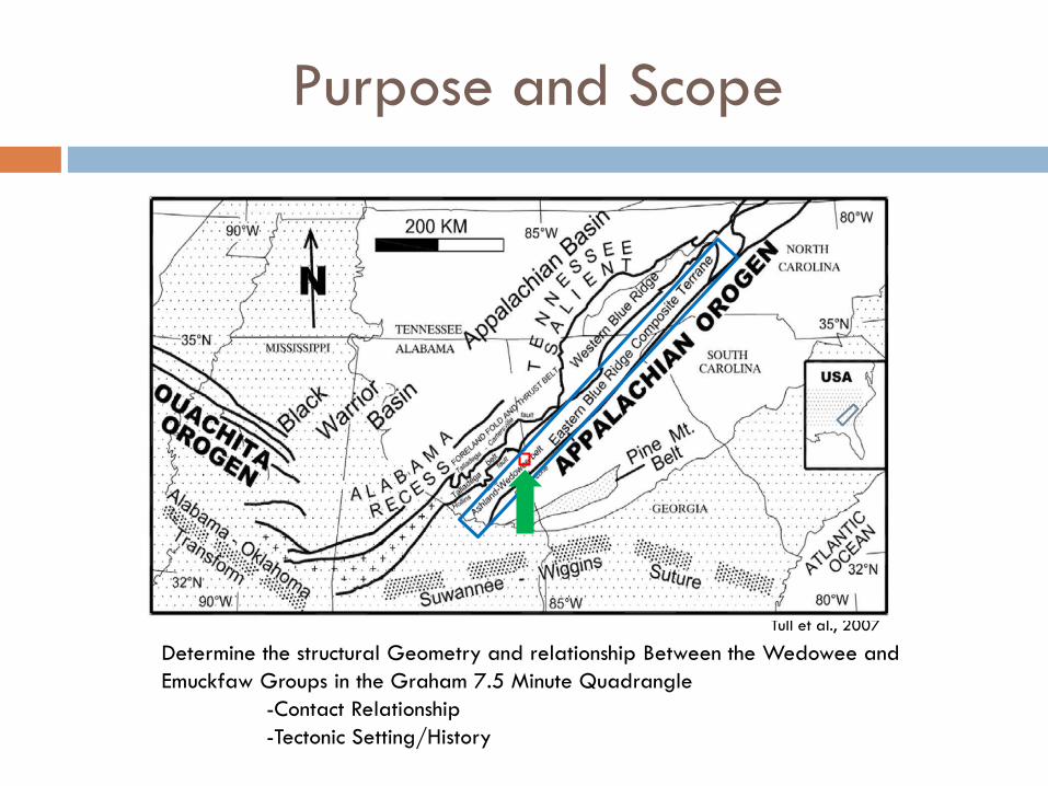
Purpose and Scope
Tull et al., 2007
Determine the structural Geometry and relationship Between the Wedowee and Emuckfaw Groups in the Graham 7.5 Minute Quadrangle
-Contact Relationship-Tectonic Setting/History

Geologic Setting
Northern Piedmont
Inner Piedmont
Southern Piedmont
Research area
Talladega-Cartersville fault
Brevard fault zone
Tawaliga fault
Geographical Setting/Geologic Setting
N
Alabam Geological Survey
Alabama Georgia
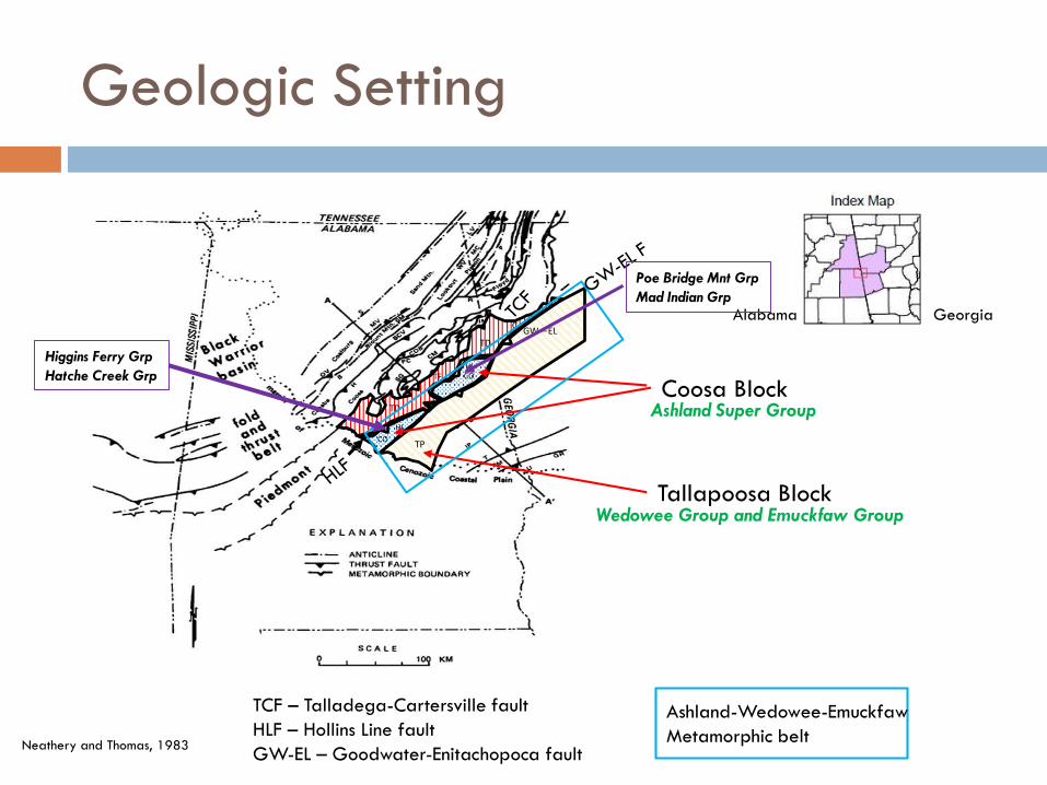
Geologic Setting
TP
GW—EL
CO
CO
HL
HL
TF
TD
TD
C
Coosa Block
Tallapoosa Block
Neathery and Thomas, 1983
TCF – Talladega-Cartersville faultHLF – Hollins Line faultGW-EL – Goodwater-Enitachopoca fault
Ashland-Wedowee-EmuckfawMetamorphic belt
Alabama Georgia
Poe Bridge Mnt Grp
Mad Indian Grp
Higgins Ferry Grp
Hatche Creek Grp
Ashland Super Group
Wedowee Group and Emuckfaw Group

Geologic Setting
Wedowee – EmuckfawContact along the Alexander City fault
Tull, 2011
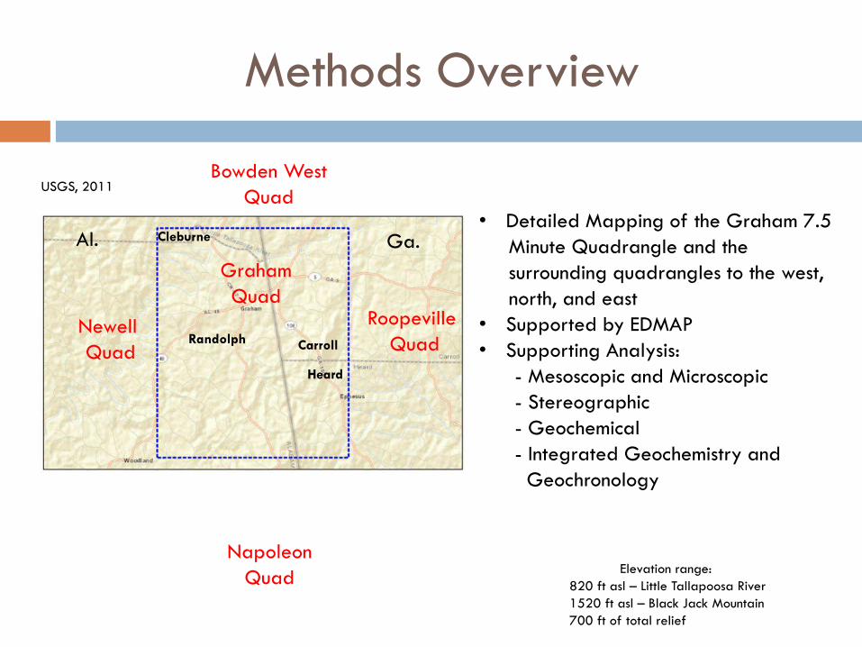
Methods Overview
• Detailed Mapping of the Graham 7.5Minute Quadrangle and thesurrounding quadrangles to the west, north, and east
• Supported by EDMAP• Supporting Analysis:
- Mesoscopic and Microscopic- Stereographic - Geochemical - Integrated Geochemistry and
Geochronology
Bowden WestQuad
Elevation range: 820 ft asl – Little Tallapoosa River1520 ft asl – Black Jack Mountain700 ft of total relief
USGS, 2011
RoopevilleQuad
Newell Quad
GrahamQuad
Carroll
Heard
Randolph
Cleburne Ga.Al.
NapoleonQuad

Mapping and Stereographic Analysis
Emuckfaw Wedowee
Bentley and Neathery, 1970
Purposed Omaha faultBentley and Neathery 1970;Shear schist, mylonite schist, button Schist
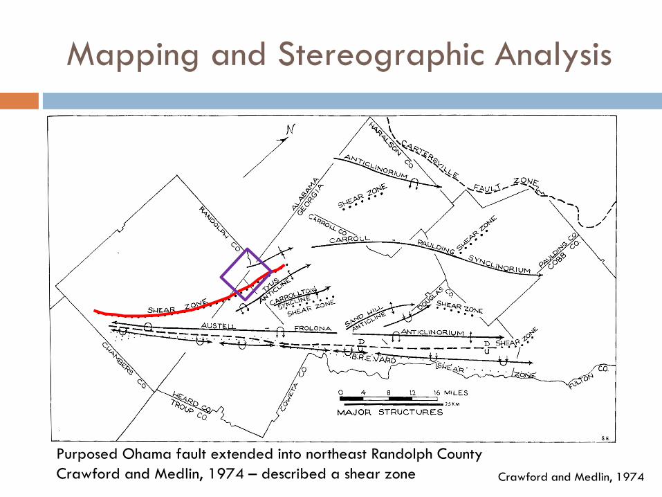
Mapping and Stereographic Analysis
Crawford and Medlin, 1974
Purposed Ohama fault extended into northeast Randolph CountyCrawford and Medlin, 1974 – described a shear zone

Mapping and Stereographic Analysisof the Wedowee and Emuckfaw Groups
S1/S0 southeast Blue Ridge, Al— Wedowee
/Emuckfaw
A
S1 southeast Blue Ridge, Al— Wedowee
B
S1 southeast Blue Ridge, Al— Emuckfaw
C
• The bedding (S0) and foliation (S1) of both groups are parallel and concordant• S1 orientation same over the mapping area• F2 fold trend is NE to SW with an overall shallow plunge to the NE• Separate S1 data shows an inclined fold trend for both groups plunging to NE
Allison, 2011

L1 southeast Blue Ridge, Al —Wedowee
D
L1 southeast Blue Ridge, Al—Emuckfaw
E
S1 and L1 are subparallel for both groupsL1 for both groups trends NE to SW
Allison, 2011
L2 southeast Blue Ridge, Al—Wedowee
F
L2 southeast Blue Ridge, Al— Emuckfaw
G
L1 and L2 for both groups are coaxial to one another
Mapping and Stereographic Analysisof the Wedowee and Emuckfaw Groups

Lithological Descriptions and Thin Section Analysis Wedowee
1000 µm
A) Clinozosite
B) Quartz and feldspar – preferred orientationBiotite crystals – larger than the matrix
1000 µm
Bio
QtzMus
Plg
Grn
Ca Al (SiO) (OH)
Cross Polar Light Plain Light
A B
Metagraywacke
B

Lithological Descriptions and Thin Section Analysis Wedowee
1000 µm
Qtz
Mus
A) Chlorite growth in radial pattern from a single nucleation site, cutting across foliation
1000 µm
Mus
Chl
Qtz
B) Microfold (crenulations) – muscovite crystal growth is parallel to cleavage and defines the cleavage plane.
A B
Cross Polar Light
Metagraywacke

Lithological Descriptions and Thin Section Analysis Wedowee
A BA) Porphyroblastic garnet cutting across foliation with quartz, feldspar, and muscovite
Inclusions
Cross Polar Light
1000 µm
Plg
Grn
Mus
B) Feldspar displaying pericline twinning – possibly detrital
1000 µm
Plg
Qtz
Mus
Chl
Metagraywacke
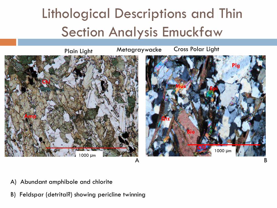
Lithological Descriptions and Thin Section Analysis Emuckfaw
Cross Polar LightMetagraywacke
A B
A) Abundant amphibole and chlorite
Plain Light
1000 µm
Amp
Chl
B) Feldspar (detrital?) showing pericline twinning
1000 µm
Plg
Epi
Chl
Mus
Qtz
Bio
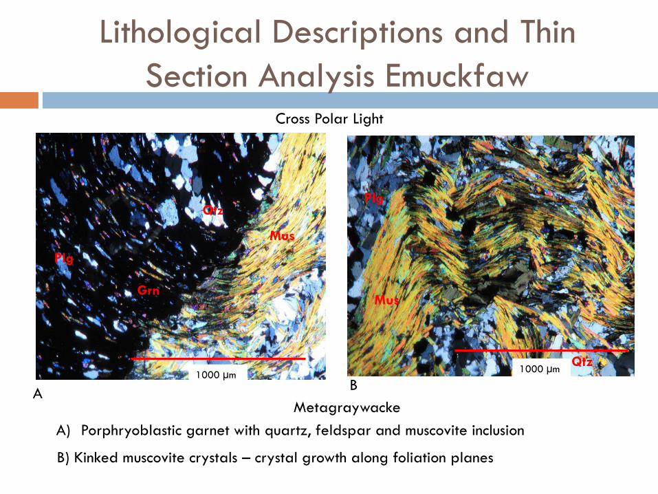
Lithological Descriptions and Thin Section Analysis Emuckfaw
Cross Polar Light
MetagraywackeA
B
A) Porphryoblastic garnet with quartz, feldspar and muscovite inclusion
B) Kinked muscovite crystals – crystal growth along foliation planes
1000 µm
Grn
Qtz
Mus
Plg
1000 µmQtz
Mus
Plg


Barineau, 2015
Recent Observations
Wedowee
Emuckfaw
?Purposed Omaha Fault
Almond PlutonU/Pb Zircon – 334.6+ 3.2 Ma
Geochemistry
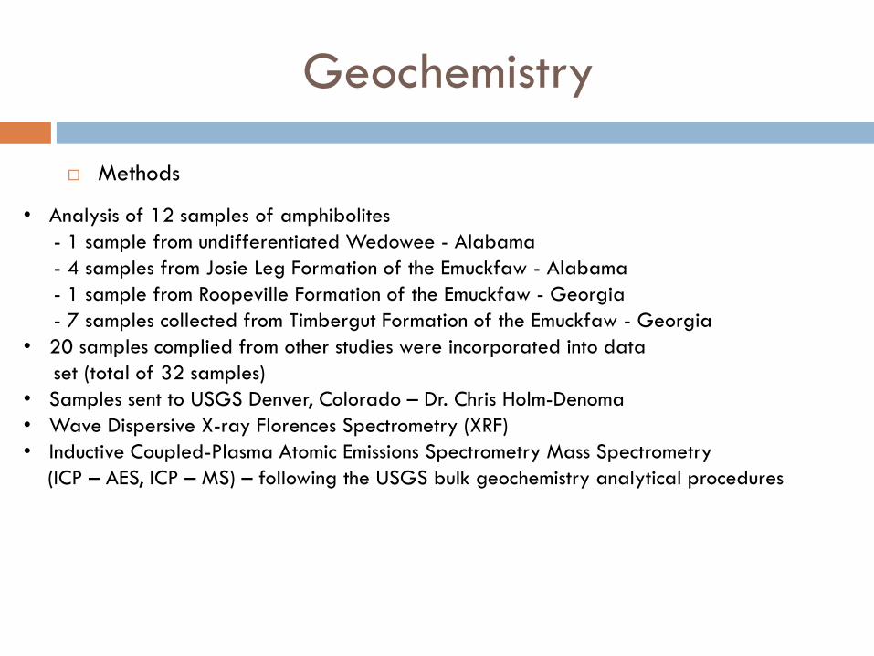
Methods
• Analysis of 12 samples of amphibolites- 1 sample from undifferentiated Wedowee - Alabama- 4 samples from Josie Leg Formation of the Emuckfaw - Alabama- 1 sample from Roopeville Formation of the Emuckfaw - Georgia- 7 samples collected from Timbergut Formation of the Emuckfaw - Georgia
• 20 samples complied from other studies were incorporated into data set (total of 32 samples)
• Samples sent to USGS Denver, Colorado – Dr. Chris Holm-Denoma• Wave Dispersive X-ray Florences Spectrometry (XRF) • Inductive Coupled-Plasma Atomic Emissions Spectrometry Mass Spectrometry
(ICP – AES, ICP – MS) – following the USGS bulk geochemistry analytical procedures
Geochemistry
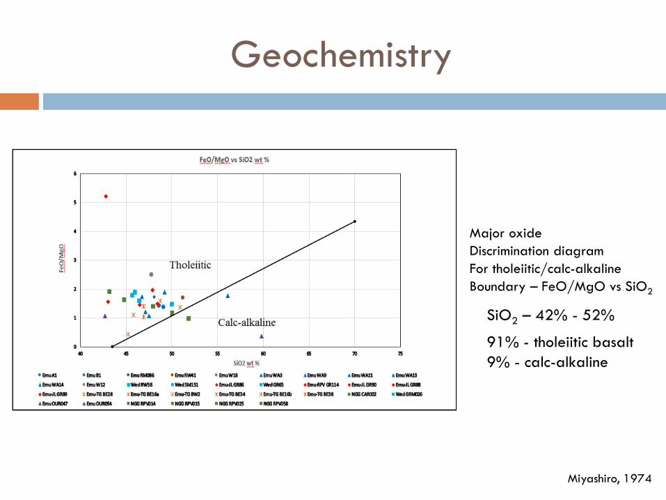
Miyashiro, 1974
Major oxideDiscrimination diagramFor tholeiitic/calc-alkalineBoundary – FeO/MgO vs SiO2
91% - tholeiitic basalt9% - calc-alkaline
SiO2 – 42% - 52%

Geochemistry
Cabanis and Lecolle, 1989
Discrimination diagram for La-Y-Nb
26% - back-arc22% - calc-alkaline basalt30% - arc tholeiites/transitional basalts11% - intracontinental11% - NMORB
Wedowee – back-arc, calc-alkalineEmuckfaw – calc-alkaline, back-arc, NMORB
Geochemistry
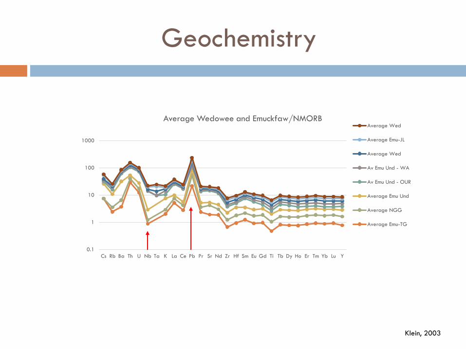
Klein, 2003
0.1
1
10
100
1000
Cs Rb Ba Th U Nb Ta K La Ce Pb Pr Sr Nd Zr Hf Sm Eu Gd Ti Tb Dy Ho Er Tm Yb Lu Y
Average Wedowee and Emuckfaw/NMORBAverage Wed
Average Emu-JL
Average Wed
Av Emu Und - WA
Av Emu Und - OUR
Average Emu Und
Average NGG
Average Emu-TG
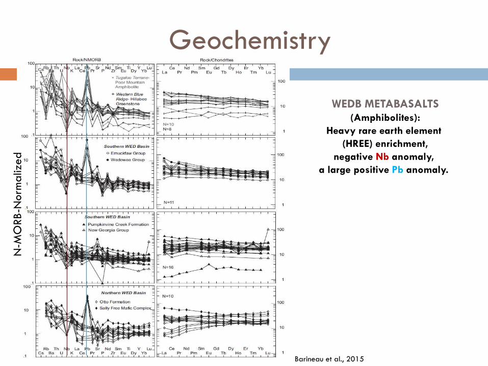
WEDB METABASALTS(Amphibolites):
Heavy rare earth element
(HREE) enrichment,
negative Nb anomaly,
a large positive Pb anomaly.
N-M
ORB-N
orm
aliz
ed
Geochemistry
Barineau et al., 2015

Geochronology
EmuckfawWedowee
• 1012 ma – Grenville crustal source• 460 ma – max depositional age
• 950 ma – Grenville crustal source• 474 ma – max depositional age
The Wedowee and Emuckfaw Groups – early to middle Ordovician basinreceiving detritus from Grenville age source and proximal to a volcanic source.
Metasandstone and Metagraywackes
Tull et al., 2014
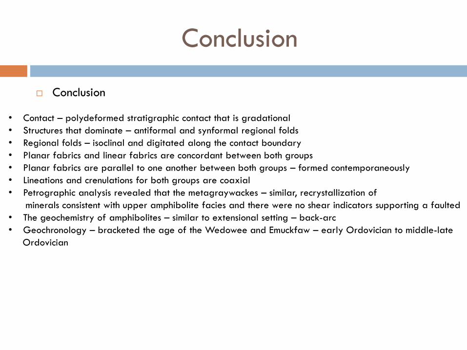
Conclusion
Conclusion
• Contact – polydeformed stratigraphic contact that is gradational• Structures that dominate – antiformal and synformal regional folds• Regional folds – isoclinal and digitated along the contact boundary• Planar fabrics and linear fabrics are concordant between both groups• Planar fabrics are parallel to one another between both groups – formed contemporaneously• Lineations and crenulations for both groups are coaxial • Petrographic analysis revealed that the metagraywackes – similar, recrystallization of
minerals consistent with upper amphibolite facies and there were no shear indicators supporting a faulted • The geochemistry of amphibolites – similar to extensional setting – back-arc • Geochronology – bracketed the age of the Wedowee and Emuckfaw – early Ordovician to middle-late
Ordovician
Thank you

Acknowledgements
Dr. Jim Tull
Dr. Steven Kish
Dr. Roy Odom
Dr. David Farris
Dr. Clint Barineau
Dr. Chris Holm-Denoma
Committee members of the Ken Osmond and Tanner Memorial Fund
Scott Byfield
Justin Mandeville
Mary Beth Lupo/Davis
Danielle Day
References
Allison, D. T., 1992, Structural Evolution and Metamorphic Petrogensis of a Metasediment and Metaigeious Complex, Coosa
County, Alabama [PhD dissertation]: Tallahassee, Florida State University, p. 382
Allison, D. T., 2005, Netprog: Stereographic Analysis Program, v. 5.1, University of Alabama
Barineau, C. I., 2009, Superosed Fault Systems of the Southernmost Appalachian Talladega belt: Implications For Paleozoic
Orogenesis in the southern Appalachains [PhD dissertation]: Tallahassee, Florida State University, p. 136
Barineau, C. I. and Tull, J. F., 2012, The Talladega and Ashland-Wedowee-Emuckfaw Belts of Alabama: Geological Overview:
Geological Society of Alabama 49th Annual Field Trip Guide Book, p. 1-11.
Barineau, C. I, Tull, J. F., Holm-Denoma, C. S., 2014, A Laurentian Margin Back-arc: The Ordovician Wedowee-Emuckfaw-
Dahlonega Basin: The Geological Soicety of America Field Guide, v. 39, p. 21-71.
Beiler, D. B, and Deininger, R. W., 1987, Geologic Setting of the Koweliga Augen Gniess and the Zana Granite, northwestern Alabama Piedmont in Drummond, M. S., and Green, N. L., eds., Granites of Alabama: Tuscaloosa, Alabama:
Geological Servey of Alabama, p. 57-72.
Bentley, R. D. and Neathery, T. L., 1970, Geology of the Brevard Fault Zone and Related Rocks of theInner Piedmont of
Alabama: Alabama Geological Society 8th Annual Field TripGuide Book, p. 5-21.
Bream, B. R. (2003). Tectonic Implications of Para- and Orthogniess Geochronology and GeochemistryFrom the Southern
Appalachian Crystalline Core [Ph. D. thesis]: Knoxville, University ofTennessee, p. 310.
Canbanis, B. and Lecolle, M., 1989, Le Diagramme La/10-Y/15-Nb/8: Un Outil Pour la DiscriminationDes Séries Volcaniques et la Mise en évidence des Processus de Melange et /ou deContamination Crustal: Comtes Rendus de l’Académie des Sciences,
ser. 2A, SciencesDe la Terre et des Planétes, v. 309, p. 2023-2029.
Crawford, T. J. and Medlin, J. H., 1973, Brevard Zone in Western Georgia and Eastern Alabama:Geological Society of America Southeast Section Field Trip Guide Book, v. 12, p. 1-30.
References
Crawford, T. J. and Medlin, J. H., 1974, The western Georgia Piedmont between the Cartersville and Brevard fault
zones: American Journal of Science, v. 273, p. 712-722.
Drummond, M. S.,1986, Igneous, metamorphic, and structural history of the Alabama Tin Belt. CoosaCounty, Alabama [Ph. D. thesis]: Tallahassee, Florida State University, p. 411.
Drummond, M. S., Wesolowski, D., and Allison, D. T.,1988,. Generation, Diversification, and Emplacement of the Rockford Granite, Alabama Appalachians: Mineralogic Petrologic, Isotopic (C & O), and P—T Constraints: Journal of Petrology, v. 29,n. 4, p. 869-897.
Drummond, M. S., Allison, D. T., & Wesolowski, D. J.,1994,. Igneous petrogenesis and tectonic setting of the Elkahatchee Quartz Diorite, Alabama Appalachians; implications for Penobscotian magmatism in the eastern Blue Ridge: American Journal of Science, v. 294, n. 2, p. 173-236.
Drummond, M. S., Neilson, M. J., Allison, D. T., & Tull, J. F., 1997, Igneous petrogenesis and tectonic setting of granitic rocks from the eastern Blue Ridge and Inner Piedmont, Alabama Appalachians: MEMOIRS-GEOLOGICAL SOCIETY OF AMERICA, p. 147-164.
German, J. M., 1989, Geologic Setting and Genesis of Gold Deposits of the Dahlonega and Carroll County Gold Belt, Georgia: Economic Geology, v. 84, p. 903-923.
Guthrie, G. M., 1995, The timing and tectonic mechanism of the Alleghanian orogeny, Alabama Piedmont:
Alabama Geological Society 32nd Annual Field Trip Guidebook: Tuscaloosa, Alabama, Geological Survey of Alabama, p. 98.

References
Guthrie, G. M. and Dean, L., 1989, Geology of the New Site 7.5 Minute Quadrangle, Tallapoosa County and Clay County,
Alabama: Geological Survey of Alabama Quadrangle Series Map 9, p. 41.
Kelemen, P. B., Hanghøj, K., and Greene, A. R., 2003, One View of the Geochemistry of Subduction-Related Magmatic Arcs, with an Emphasis on Primitive Andesite and Lower Crust: Treatise on Geochemistry, v. 3, p. 593-659.
Klein, E. M., 2003, Geochemistry of the igneous oceanic crust: Treatise on geochemistry, v. 3, p. 433-463.
Harstad, R. P., and Barineau, C. I., 2014, Kinematic and age Constraints on the Alexander City fault, eastern Blue Ridge,
Alabama: Geological Society of America Abstracts with Programs, v. 46, n. 6, p. 504
Harker, A., 1909, The natural history of igneous rocks. Methuen, London.
Hatcher, R. D., Jr., Osberg, P. H., Drake, A. A., Jr., Robinson, P., and Thomas, W. A., 1990, Tectonic Map of the U.S.
Appalachians: Boulder Colorado, Geological Society of America, for The Geology of North America, v. F-2, scale 1:250,000.
Holm-Denoma, C. S., 2006, Characterization of Paleozoic terranes and terrane accretion at the southeastern margin of Laurentia: Georgia and Alabama Appalachians, [PhD dissertation], Tallahassee, Florida State University.
Holm-Denoma, C. S. and Das, R., 2010, Bimodal Volcanism as Evidence for Paleozoic Extensional Accretionary Tectonism in the Southern Appalachians, Geological Society Bulletin, v. 122, n. 7/8, p 1220-1234..
Hurst, V. J., & Jones, L. M., 1973,. Origin of amphibolites in the Cartersville–Villa Rica area, Georgia. Geological Society of America Bulletin, v 84, n. 3, p. 905-912.
References
Kish, S. A., 1990,. Timing of middle Paleozoic (Acadian) metamorphism in the southern Appalachians: K-Ar studies in the Talladega belt, Alabama: Geology, v. 18, n. 7, p. 650-653.
Ludwig, K. R., 2012, Direct U-Pb dating of Cretaceous and Paleocene dinosaur bones, San Juan Basin, New Mexico: COMMENT: Geology, p. 40(4), e. 258-e258.
Merschat, A. J., Hatcher, R. D., Jr., Bream, B. R., Miller, C. F., Byers, H. E., Gatewood, M. P. and Wooden, J. L., 2010, Detrital
Zircon geochronology and provenance of southern Appalachian Blue Ridge and Inner Piedmont crystalline terrances, in Tollo,
R. P., Bartholomew, J. j., Hibbard, J. P., and Karabinos, P. M., eds., From Rodinia to Pnagea: The Lithotectionic Record of the Appalachian Region: Geological Society of America Memoir 206, p. 661-699, doi: 10.1130/2010.1206(26).
Miyashiro, A., 1974, Volcanic rock series in island arcs and active continental margins. American Journal of Science, v. 274, n. 4), p. 321-355.
McConnell, K. I., and Abrams, C. E., 1984, Geology of the Greater Atlanta Region: GeorgiaGeologcial Survey Bulletin, v. 96, p. 127.
Muangnoicharoen, N., 1975, The geology and structure of a portion of the northern Piedmont, Tallapoosa County, Alabama in
Drummond, M. S., and Green, N. L., eds., Granites of Alabama:Tuscaloosa, Alabama, University of Alabama, p. 74.
Mullen, E. D., 1983, MnO/TiO 2/P 2 O 5: a Minor Element Discriminant for Basaltic Rocks of OceanicEnvironments and its Implications for Petrogenesis: Earth and Planetary ScienceLetters, v. 62(1), p. 53-62.:
Neathery, T. L., and Reynolds, J. W., 1973, Stratigraphy and Metamorphism of the Wedowee Group: A Reconnaissance: American
Journal of Science, v. 273, p 723-741.
References
Neathery, T. L., 1975, Rock Units in the High-rank Belt of the Northern Alabama Piedmont: Alabama Geological Society, Annual
Field Trip Guide Book, n. 13, Geologic Profiles of the Northern Alabama Piedmont, p. 9-48.
Neathery, T. L., and Thomas, W. A., 1983, Geodynamic Transect of the Appalachian Orogen in Alabama: American Geophysical Union Geodynamic Series, v. 10, p. 301-307.
Osborne, W. E., Szabo, M. W., Neathery, T. L., and Copeland, C. W., Jr., 1988, Geologic Map of Alabama, northeast sheet
(1:250,000): Alabama Geological Survey Special Map 220.
Parker, W. B., 1967, Soil Survey of Randolph County Alabama, Field Survey Report, United States Department of Agriculture, p. 1-50.
Pearce, J. A., & Cann, J. R., 1973, Tectonic Setting of Basic Volcanic Rocks Determined Using Trace Element Analyses: Earth and
Planetary Science Letters, v. 19(2), p. 290-300.
Pearce, J. A., Harris, N. B., & Tindle, A. G., 1984, Trace element discrimination diagrams for the tectonic interpretation of granitic rocks. Journal of petrology, v. 25, n. 4, p. 956-983.
Pearce, J. A., & Stern, R. J., 2006, Origin of Back-arc Basin Magmas: Trace Element and Isotope Perspectives: Geophysical Monograph-American Geophysical Union, v. 166, p. 63.
Prouty, W. F., 1923, Geology and Mineral Resources of Clay County with Special Reference to the Graphite Industry: Alabama Geological Survey Special Report, v. 12, p. 190.
Raymond, D. E., Osborne, W. E., Copeland, C. W., and Neathery, T. L, 1988, Alabama Stratigraphy: Alabama Geological Survey Circular, v. 140, p. 10-15.
Rollinson, H. R., 1993, Using Geochemistry Data: Evaluation, Presentation, Interpretation: Essex, Pearson Education Limited, p. 352.
References
Russell, G. S., 1978, U-Pb, Rb-Sr., and K-Ar isotopic studies bearing on the tectonic development of the southernmost Appalachian Orogen, Alabama: [PhD dissertation]: Tallahassee, Florida State University, p 197.
Shervais, J. W., 1982, Ti-V plots and the Petrogenesis of Modern and Ophiolitic Lavas: Earth and Planetary Science Letters, v. 59(1), p. 101-118.
Steltenpohl, M. G., Horton, J. W., Hatcher, R. D., Jr., Zietz, I., Daniels, D. L. and Higgins, M. W., 2013, Upper Crustal Structure of Alabama from Regional Magnetic and Gravity Data: Using Geology to Interpret Geophysics and vis versa: Geological Society of America Geosphere, v. 9, n. 4, p. 1044-1064.
Smith, E. A., 1903, Carboniferous Fossils in 'Ocoee'Slates in Alabama. Science, p. 244-246.
Stow, S. H., Neilson, M. J., and Neathery, T. L., 1984, Petrography, geochemistry, and tectonic significance of the amphibolites of the Alabama Piedmont. American Journal of Science, v. 284,n. 4-5, p. 414-436.
Taylor, B. and Karner, G. D., 1983, On the Evolution of Marginal Basins: Reviews in Geophysics,v. 21, n. 8, p. 1727-1741.
Thomas, W. A., and Neathery, T. L. (1980). Tectonic framework of the Appalachian orogen in Alabama. Excursions in southeastern geology, v. 2, p. 465-526.
Thomas, W. A., Tull, J. F., Bearce, D. N., Russell, G., & Odom, A. L., 1980, Geologic synthesis of the southernmost Appalachians, Alabama and Georgia. The Caledonides in the United States of America: Virginia Polytechnic Institute, Department of Geological Sciences Memoir, v. 2, p. 91-97. Tull, J. F., 1978, Structural Development of the Alabama Piedmont Northwest of the Brevard Zone: American Journal of Science, v. 278, p. 442-460.
Tull, J. F, 1984, Polyphase late Palaeozoic deformation in the southeastern foreland and northwestern Piedmont of the Alabama Appalachians. Journal of structural geology, v. 6, n. 3, p. 223-234.

References
TULL, J. F., (2009),. Age and tectonic implications of the Elkahatchee Quartz Diorite, Eastern Blue Ridge Province, southern Appalachians, USA, Abstract in 2009 Portland GSA Annual Meeting.
Tull, J. F., 2011,. Significance of late extensional faults in the southwestern Appalachian eastern Blue Ridge. In Geological Society of America Abstracts with Programs (Vol. 43, No. 2, p. 15).
Tull, J. F. and Barineau, C. I., 2012, Overview of the Stratigraphic and Structure Evolution of the Talladega Slate Belt, Alabama Appalachians: Geological Society of America Field Guide Book, v. 29, p. 263-302.
Tull, J. F. and Campbell, K. H., 2012, Structurally Lower Contact of the Emuckfaw Group and The Alexander City Fault Issue: Alabama Geological Society 49th Annual Field Trip Guide Book, p. 27-37.
Tull, J. F., Moore, W. B., Drummond, M. S., & Allison, D. T., 1985, Contrasting fault systems in the crystalline Appalachians ofAlabama. In Geological Society of America Abstracts with Programs (Vol. 17, No. 2, p. 139).
Tull, J. F., Barineau, C. I., Mueller, P. A., & Wooden, J. L., 2007,. Volcanic arc emplacement onto the southernmost AppalachianLaurentian shelf: Characteristics and constraints. Geological Society of America Bulletin, v. 119, n. 3-4, p. 261-274.
Tull, J. F., Holm-Denoma, C. S., and Barineau, C. I., 2014, Early to Middle Ordovician Back-arc Basin in the southern Appalachian Blue Ridge: Characteristics, Extent, and Tectonic Significance: Geological Society of America Bulletin, doi: 10.1130/B30967.1
Wielchowsky, C. C. (1983). The geology of the Brevard zone and adjacent terranes in Alabama: Rice University, unpublished Ph. D (Doctoral dissertation, dissertation, 237 p).