tectonics and sedimentation in the curitiba basin, south ... · tectonics and sedimentation in the...
TRANSCRIPT
Journal of
South AmericanEarth Sciences
PERGAMON Journal of South American Earth Sciences 15 (2003) 901-910www.elsevier.comllocate/jsames
Tectonics and sedimentation in the Curitiba Basin, south of Brazil
Eduardo Salamuni":", Hans Dirk Ebertb, Mauricio da Silva Borges", Yociteru Hasui'',João Batista Sena Costa", Riad Salamuni":"
"Departamento de Geologia, Universidade Federal do Paraná, Centro Politécnico, Jardim das Américas, P.O. Box 19001, zip 81530-990 Curitiba, PR, Brasil"Departamento de Petrologia e Metalogenia, Instituto de Geociências e Ciências Exatas, Universidade Estadual Paulista, Avenida 24-A, 1515, P.O. Box 178,
13506-900 Rio Claro, SP, Brazil I"Ceruro de Geociências, Universidade Federal do Pará, Campus Universitário do Guamá, P.O Box 1611, 66075-900 Belém; PA, Brazil
"lnstituto de Estudos Estratégicos da Amazônia, Avenida Governador José Malcher, 1148, 66055-260 Belém, PA, Brazil
Received 1 April 2002; accepted 1 October 2002
Abstract
The Curitiba Basin, Paraná, lies parallel to the west side of the Serra do Mar range and is part of a continental rift near the Atlantic coast ofsoutheastern Brazil. It bears unconsolidated and poor1y consolidated sediments divided in two formations: the lower Guabirotuba Formationand the overlying Tinguis Formation, both developed over Precambrian basement. Field observations, water well drill cores, and interpretationsof satellite images lead to the inference that regional tectonic processes were responsible for the origin of the Basin in the continental rift contextand for morphotecatonic evolution through block tilting, dissection, and erosion. The structural framework of the sediments and the basement ischaracterized by NE-SW-trending normal fauits (extensional tectonic DI event) reactivated by NE-SW-trending strike-slip and reverseoblique faults (younger transtensional tectonic D2' to transpressional tectonic D2" event). This tectonic event, which started in the Paleogene andcontrolled the basin geometry, began as a halfgraben and was later reactivated as a pull-apart basin. D2 is a neotectonic event that controls thecurrent morphostructures. The Basin is connected to the structural rearrangement of the South American platform, which underwent ageneralized extensional or trantensional process and, in late Oligocene, changed to a compressional to transpressional regime.© 2003 Elsevier Science Ltd. Ali rights reserved.
Keywords: Sedimentary basin; Tertiary and Quaternary tectonics; Morphotectonics; Neotectonics
Resumo
A Bacia de Curitiba, localizada no Estado do Paraná, é paralela à face oeste da Serra do Mar, e faz parte de um rifte continental, próximo àcosta atlântica do sudeste do Brasil. Épreenchida por sedimentos pouco consolidados a inconsolidados e abrange as formações Guabirotuba,inferior, e Tinguis superior, posicionadas sobre o embasamento pré-cambriano. Com base em observações em campo e imagens de satélite, bemcomo perfis de sondagem, conclui-se que processos tectônicos regionais propiciaram a origem da Bacia de Curitiba, no contexto do riftecontinental e, em um segundo momento, controlaram sua evolução morfotectônica através de basculamento de blocos, dissecamento e erosão.Tanto os sedimentos quanto o embasamento são caracterizados por falhas normais de direção NE-SW (regime extensional DI), posteriormentereativadas como direcionais e inversas oblíquas (regime transtensional D2' a transpressional D2")' Os eventos ocorreram a partir do Paleógeno edefiniram a geometria da bacia, iniciada como halfgraben e reativada como bacia pull-apart. O evento Dz também gerou morfoestruturas ecaracteriza processos neotectônicos. A bacia está ligada ao rearranjo estrutural da Plataforma Sul-Americana, que sofria inicialmentegeneralizado processo extensional ou transtensional e passa, a partir do Oligoceno superior, a sofrer processos compressionais e transtensionais.© 2003 Elsevier Science Ltd. All rights reserved.
Palavras chaves: Embasamento pré-cambriano; Plataforma Sul-Americana; Compressionais e transtensionais
1. Introduction* Corresponding author. Te!.: +55-41-361-3147; fax: +55-41-361-3642 ..., In Memorian.
E-mail addresses:[email protected](E.Salamuni). [email protected] (H.D. Ebert), [email protected] (Y. Hasui), [email protected] (J.B.S. Costa).
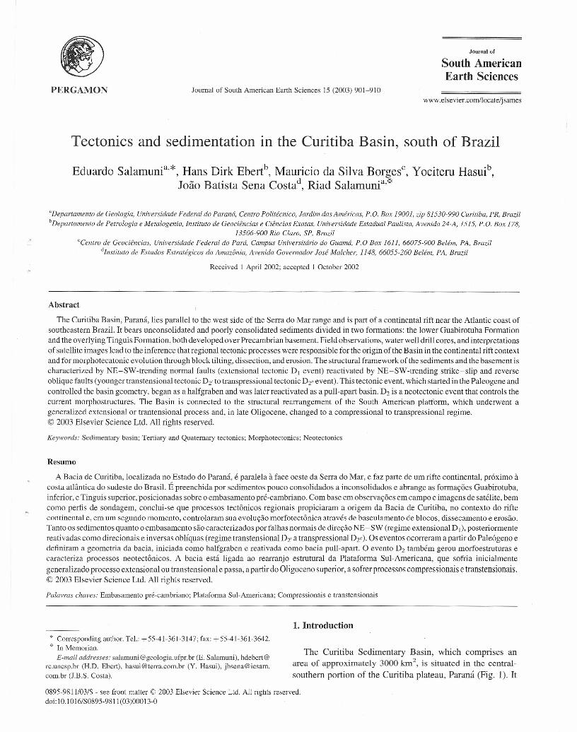
The Curitiba Sedimentary Basin, which comprises anarea of approximately 3000 km", is situated in the central-southem portion of the Curitiba plateau, Paraná (Fig. 1). It
0895-9811103/$ - see front matter © 2003 Elsevier Science Ltd. Ali rights reserved.doi:1 0.1 016/S0895-981I (03)00013-0
902 E. Salamuni et aI. / Journal of South American Earth Sciences 15 (2003) 901-910
D°S
o 2000 km o 500km
Fig. 1. Location of the Curitiba Sedirnentary Basin.
10 km
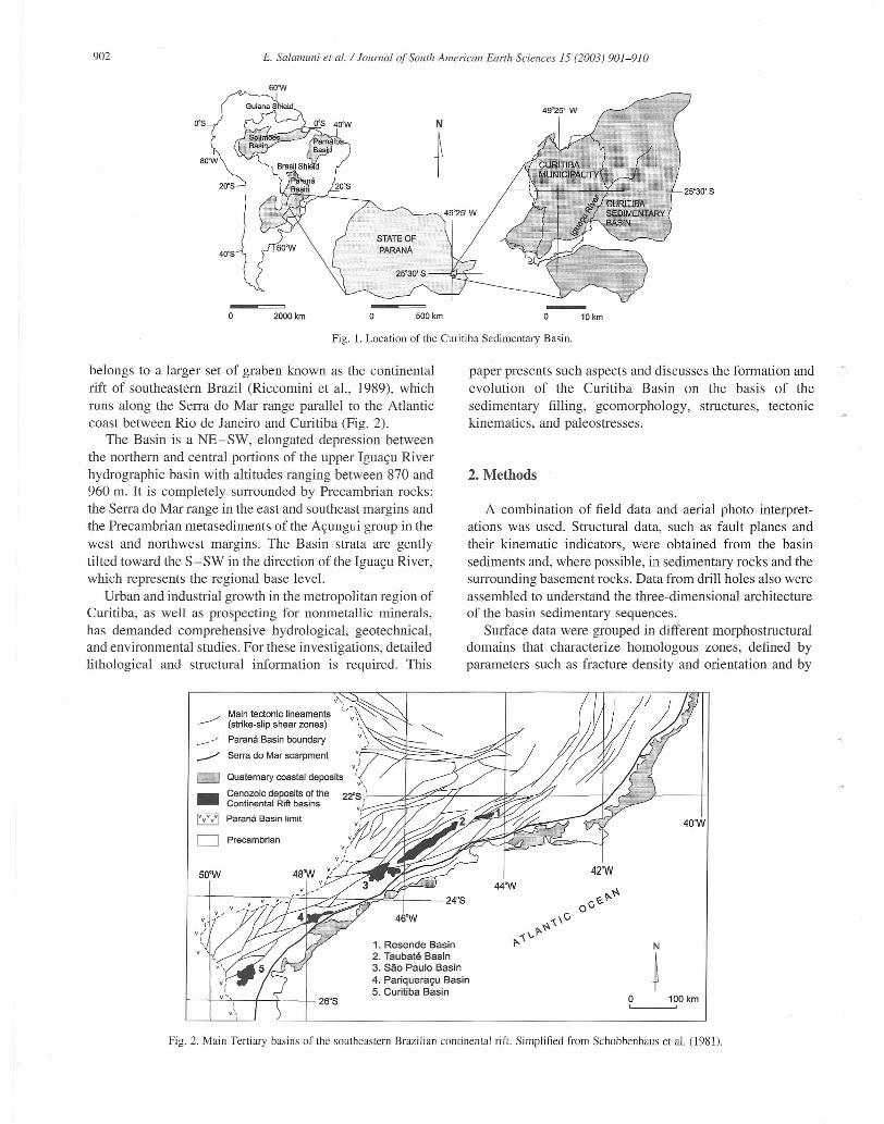
belongs to a larger set of graben known as the continentalrift of southeastem Brazil (Riccomini et al., 1989), whichruns along the Serra do Mar range parallel to the Atlanticcoast between Rio de Janeiro and Curitiba (Fig. 2).
The Basin is a NE-SW, elongated depression betweenthe northern and central portions of the upper Iguaçu Riverhydrographic basin with altitudes ranging between 870 and960 m. It is completely surrounded by Precambrian rocks:the Serra do Mar range in the east and southeast margins andthe Precambrian metasediments of the Açungui group in thewest and northwest margins. The Basin strata are gentlytilted toward the S-SW in the direction ofthe Iguaçu River,which represents the regional base level.
Urban and industrial growth in the metropolitan region ofCuritiba, as well as prospecting for nonmetallic mineraIs,has demanded comprehensive hydrological, geotechnical,and environmental studies. For these investigations, detailedlithological and structural information is required. This
v,
Main leclonic lineaments ~'~ ~(strlke-slip shear zones) ,,'"
-' Paraná Basin boundary v:'Serra do Mar scarpmenl
D- Cenozoic deposils of lheContinental Rift basins
Paraná Basin limi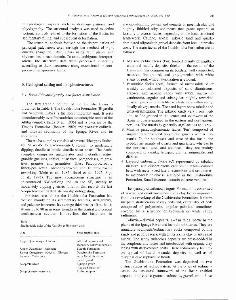
E. Salamuni et al. / Journal af South American Earth Sciences 15 (2003) 901-910
morphological aspects such as drainage patterns andphysiography. The structural analysis was used to definetectonic controls related to the formation of the Basin, itssedimentary filling, and subsequent deformation.
The structural analysis focused on the determination ofprincipal paleostress axes through the method of rightdihedra (Angelier, 1989, 1994) using fault planes andslickensides in each domain. To avoid ambiguous interpret-ations, the structural data were processed separatelyaccording to their occurrence along extensional or com-pressive/transpressive faults.
3. Geological setting and morphostructures
3.1. Basin lithostratigraphy andfacies distribution
The stratigraphic column of the Curitiba Basin ispresented in Table 1. The Guabirotuba Formation (Bigarellaand Salamuni, 1962) is the most important unit. It restsunconformably over Precambrian metamorphic rocks of theAtuba complex (Siga et al., 1995) and is overlain by theTinguis Formation (Becker, 1982) and younger colluvialand alluvial sediments of the Iguaçu River and itstributaries.
The Atuba complex consists of severallithotypes limitedby NE-SW- to E- W-oriented, steeply to moderatelydipping, ductile to brittle-ductile shear zones. The Atubacomplex comprises metabasites and metaultrabasites,granitic gneisses, schists, quartzites, paragneisses, migma-tites, granites, and granulites. These Paleoproterozoiclithotypes reveal Mesoproterozoic and Neoproterozoicreworking (MeIo et al., 1985; Basei et aI., 1992; Sigaet aI., 1995). The most conspicuous structure is ananastomosed NW-striking and, to the SE, steeply tomoderately dipping gneissic foliation that records the lastNeoproterozoic dextral strike-slip deformation.
Previous research on the Guabirotuba Formation hasfocused mainly on its sedimentary features, stratigraphy,and paleoenvironment. Its average thickness is 40 m, but itattains up to 80 m in some troughs in the central and centralsoutheastern sectors. It overlies the basement in
Table 1Stratigraphic units of the Curitiba sedimentary basin
Age Stratigraphic units
Upper Quaternary-Holocene Alluvial deposits andsecondary colluvial depositsTinguis FormationGuabirotuba FormationSerra Geral Formation(basic dykes)Açungui group(Capiru Formation)Atuba complex
Upper Quaternary-HoloceneLower Quaternary-Miocene-PlioceneJurassic -Cretaceous
Neoproterozoic
Neoproterozoic -Archean
903
a nonconforming pattem and consists of greenish clay andslightly lithified silty sediments that grade upward orlateral1y to coarser facies, depending on the local structuralframework. Caliche, arkose, arkosic sand and quartz-dominated oligomictic gravel deposits form local intercala-tions. The main facies of the Guabirotuba Formation are asfollows:
1. Massive pelitic facies (Pm) formed mainly of argillac-eous and muddy deposits, thicker in the center of theBasin and less common on its borders, well compacted,massive, fine-grained, and gray-greenish with whitestains or pink where lateritization is evident.
2. Psammitic facies (Am) formed of unconsolidated orweakly consolidated deposits of sand diamictons,arkoses, and arkosic sands with submillimetric tocentimetric, angular and subangular, slightly reworkedquartz, quartzite, and feldspar clasts in a silty-sandy,locally clayey, matrix. The sand layers show tabular andcross-stratification. The arkosic sands vary from med-ium- to fine-grained in the center and southwest of theBasin to coarse-grained in the eastern and northeasternportions. The matrix is generally argillaceous and gray.
3. Massive paraconglomeratic facies (Pm) composed ofangular to subrounded polymictic gravels with a claymatrix. ln the southwest and west of the Basin, thepebbles are mainly of quartz and quartzites, whereas tothe northeast, east, and southeast, they are mainlycomposed of quartz, feldspar, granite, migmatite, anddiabase.
4. Layered carbonatic facies (C) represented by tabular,massive, and discontinuous caliches in white-coloredbeds with meter-sized lateral extensions and centimeter-to meter-scale thickness scattered in the GuabirotubaFormation. Small fractures contain calcrete venules.
The sparsely distributed Tinguis Formation is composedof arkosic and quartzose sands and a clay facies originatedfrom the reworking of the Guabirotuba Formation. It showsincipient stratification of clay beds and, eventually, of bedscomposed of polymictic, angular pebbles, sometimescovered by a sequence of brownish or white sandysediments.
Colluvial-alluvial deposits, 1-7 m thick, occur in theplains of the Iguaçu River and its main tributaries. They areimmature sediments/sedimentary rocks composed of finesandy and pebbly facies, with either a silty clay or silty sandmatrix. The sandy rudaceous deposits are cross-bedded inthe conglomeratic facies and interbedded with organic claylenses with dark-colored peats. These sedimentary featuresare typical of fluvial meander deposits, as well as ofmarginal dike ruptures or floods.
The Guabirotuba Formation was deposited in twodistinct stages of sedimentation. At the onset of sedimen-tation, the structural framework of the Basin enableddeposition of coarse-grained sediments, grave1, and arkose
904 E. Salamuni et ai. / Journal of South American. Earth Sciences /5 (2003) 901-910
lenses in the eastern part, close to the slopes of the Serra doMar range. Outcrops of finer sediments, clays, and relatedsediments, in addition to fine-grained arkose, appear to thenorth, south and west and in the Curitiba urban area. Duringthe second stage, in the Quaternary, sediments were moreuniformly deposited on the surface, with coarser onesdominating in the marginal areas and finer sedimentsgradually increasing in quantity toward the center of theBasin.
Sedimentation processes varied in accordance withmorphotectonic changes in the Curitiba plateau during theextensional tectonics that began in the upper Oligocene. Themain phase of deposition of the Guabirotuba Formationoccurred between the Oligocene and Miocene (Salamuniet aI., 1999) in response to strong subsidence, as has beendescribed in other basins along the Serra do Mar RiftSystem. Almeida (1976) reports an increase in subsidence ofthe Taubaté and Resende Basins and the generation of theSão Paulo Basin during that time as well.
According to Bigarella and Salamuni (1962), the Guabir-otuba Formation was deposited along extensive alluvial fansformed by intermittent channels. These fans, when enteringthe center of the Basin, gave way to a playa lake environmentthat filled the trough. The sedimentation was cyclic andlaterally variable, probably from a viscous f1ow, whichadvanced or retreated in accordance with the geometry andwas episodically controlled by successive tectonic pulses.Sharp climatic changes during the Upper Tertiary and theLower Quaternary gave rise to recurrent debris-f1ow-typesedimentation drained in from intermediate parts throughintermittent braided channels (Salamuni, 1998).
Advance or retreat of the fans into the Basin center wascontrolled by differential water volume, the nature of thesediments, the degree of rock alteration in the original sites,and, mainly, the continuous tectonic compression thatuplifted marginal topographic highs. These factors createdfavorable conditions for the deposition of debris flows indistal parts of the source area. Lenticular deposits of arkosicsancls or arkoses represent channel cleposits found inintermediate positions between the fine- and coarse-grainedfacies of the alluvia! fans. Some larger channels appear tohave prograded into the lacustrine environment, thusenabling deposition of coarser sediments. The pelitic faciesrepresent ephemeral playa lake environments with reason-able amplitudes and accumulations, which form massivebeds several meters thick. The intermittent nature of the lakesand water saturation with carbonates enabled deposition ofcaliches. The interbedding of finer and coarser sedimentsreveals an episodic stratigraphic evolution in cycles ofextension and subsidence due to periods of different degreesof tectonic activity (Salamuni et al., 1999).
3.2. Structural features
Observation of satellite images and aerial photographsreveals many Jineaments, ranging from several tens of
meters to ten kilometers in length, that cut across the Basinand its surrounding basement. These Iineaments correspondto faults and large fracture zones observed in loco.
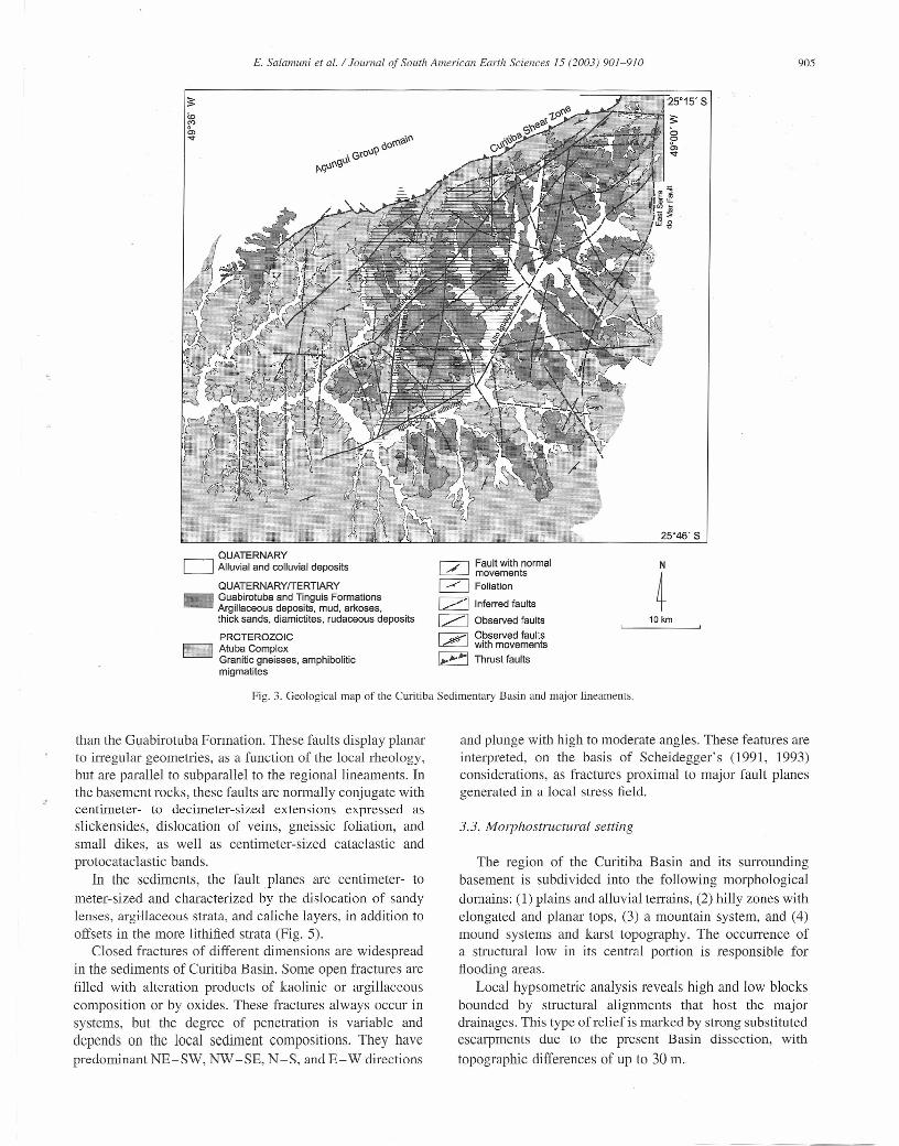
The simplified geologic map (Fig. 3) shows the largerlineaments, where major drainage channels are located.Three major lineaments that influenced the originalformation of the Basin now control its dissection: thePassaúna fault along the northwestern Curitiba Basin limit;the Eastern Serra do Mar fault along the. southeastem toeastem limit; and the Alto Iguaçu fault, which is inferred tocross the Basin depocenter. These faults were initially high-angle normal faults that were subsequently reactivated asoblique strike-slip faults and that now control the rhombo-hedral architecture of the Basin.
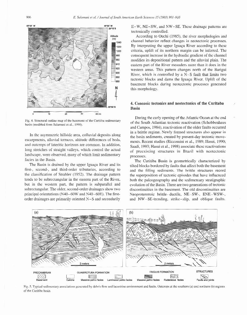
Analysis of borehole loggings offers a good degree ofcertainty about the geometric model of the Curitiba Basinand the morphostructures of its basement. The surfacetrencl enables researchers to delimitate, with a greaterdegree of confidence, the structural contour of thebasement (Fig. 4) and intermecliate structural heights,which were responsible for the presence of isolated andasymmetric depocenters.
The structural characterization of the Basin was moredifficult to establish than that of the basement, because ofthe homogeneous nature of the sediments. Moreover, recentalluvial deposits cover some of the lineaments in the Basin,so the traces of these structural features are inferred inplaces. To characterize the structure of the Basin sediments,morphostructural criteria (e.g. the strong linear orientationof the main drainages, with several sectors where smallscarpments occur; anomalous sectors; the angularity and thealignment of the relief) were used to identify fracture tracesin both the basement rocks and the sedimentary cover.
Analysis of structural features both in field (Fig. 5) and insatellite images shows that the most abundant and largestfaults, cutting both basement and sediments, trend in a NE-SW direction. In the basement, these lineaments predomi-nantly trend in a N40-60E direction with a subordinateN30-50W direction. In the sediments, however, these faultsare expressed in both N50- 70E and E- W orientations.
The segmented structure of the Basin is controlled bylineaments, present in the basement since the Precam-brian, that were reacti vated during and after the infillingof the Basin. The NW -SE-trending fractures, associatedwith the intrusion of Mesozoic dolerite dikes, appear tooffset the NE-SW lineaments. The N-S-trending linea-ments, possibly associated with the last tectonic pulse, areless significant in the basement than in the overlyingsediments. Jackson et al, (1996) show that offsets in deepfaults are expressed at the surface of the sedimentarycover through discontinuous and subtle fracture zonescharacterized by anomalous, aligned
jdrainage patterns.
These morphostructural characteristics are observed in theCuritiba Basin.
Medium-sca1e faults appear in ali of the geologic units,from the basement through colluvial deposits even younger
E. Salamuni et alo / Journal of Soutli American Earth Sciences 15 (2003) 901-910
QUATERNARYD Alluvial and colluvial deposits
QUATERNARYfTERTIARYGuabirotuba and Tinguis FormationsArgillaceous deposits, mud, arkoses,thick sands, diamictites, rudaceous deposits
PROTEROZOICD Atuba ComplexGranitic gneisses, amphiboliticmigmatites
25'15' S~7,~~~
sc"...
'7' Faul! with normal~ movements[2J Foliation
1 -1 Inferred faults
[ZJ Observed faults
~ Observed faults~ with movements
I~"''''IThrust faul!s
Fig. 3. Geological map of the Curitiba Sedimentary Basin and major lineaments.
than the Guabirotuba Formation. These faults display planarto irregular geometries, as a function of the local rheology,but are parallel to subparallel to the regional lineaments. Inthe basement rocks, these faults are normally conjugate withcentimeter- to decimeter-sized extensions expressed asslickensides, dislocation of veins, gneissic foliation, andsmall dikes, as well as centimeter-sized cataclastic andprotocataclastic bands.
ln the sediments, the fault planes are centimeter- tometer-sized and characterized by the dislocation of sandylenses, argillaceous strata, and caliche layers, in addition tooffsets in the more lithified strata (Fig. 5).
Closed fractures of different dimensions are widespreadin the sediments of Curitiba Basin. Some open fractures arefilled with alteration products of kaolinic or argillaceouscomposition or by oxides. These fractures always occur insystems, but the degree of penetration is variable anddepends on the local sediment compositions. They havepredominant NE-SW, NW-SE, N-S, and E-W directions
905
25°46' S
N
410 km
and plunge with high to moderate angles. These features areinterpreted, on the basis of Scheidegger's (1991, 1993)considerations, as fractures proximal to major fault planesgenerated in a local stress field.
3.3. Morphostructural setting
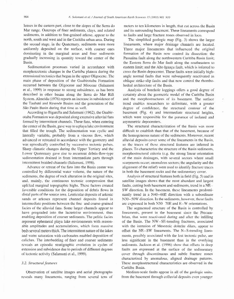
The region of the Curitiba Basin and its surroundingbasement is subdi vided into the following morphologicaldomains: (1) plains and alluvial terrains, (2) hilly zones withelongated and planar tops, (3) a mountain system, and (4)mound systems and karst topography. The occurrence ofa structural low in its central portion is responsible forftooding areas.
Local hypsometric analysis reveals high and low blocksbounded by structural alignments that host the majordrainages. This type of relief is marked by strong substitutedescarpments due to the present Basin dissection, withtopographic differences of up to 30 m.
906
49"40' W
E. Salamuni etal. / Iournal of South American Earth Sciences 15 (2003) 901-910
49'OO'W•••••....-~-==-1r-r-,-~~~~~~+25·10·S
Altitude(m)
1040
1020
1000
900
880
860
N
~
10 30 40km20
Fig. 4. Structural outline map of lhe basement of lhe Curitiba sedimentarybasin (modified from SaJamuni et al., 1998).
In the asymmetric hillside area, colluvial deposits alongescarpments, alluvial terraces, altitude differences of beds,and outcrops of lateritic horizons are common. In addition,long stretches of straight valleys, which control the actuallandscape, were observed, many of which limit sedimentaryfacies in the Basin.
The Basin is drained by the upper Iguaçu River and itsfirst-, second-, and third-order tributaries, according tothe classification of Strahler (1952). The drainage patterntends to be subrectangular in the eastern part of the River,but in the western part, the pattern is subparallel andsubrectangular. The older, second-order drainages show twoprincipal orientations (N40-60W and N40-60E). The first-order drainages are primarily oriented N -S and secondarily
E- W, NE-SW, and NW -SE. These drainage patterns aretectonically controlled,
According to Ouchi (1985), the river morphologies andchanne1 behavior reflect changes in neotectonic processes.By interpreting the upper Iguaçu River according to thesecriteria, uplift of its northern margin can be inferred. Theconseguent increase in the hydraulic gradient of the channelmodifies its depositional pattern and the alluvial plain. Theeastern part of the River meanders more than it does in thewestern areas. This pattern changes north of the BariguiRiver, which is controIled by a N-S fault that limits twotectonic blocks and dams the Iguaçu River. Uplift of thebasement blocks during neotectonic processes generatedthis morphology.
4. Cenozoic tectonics and neotectonics of the CuritabaBasin
During the early opening of the Atlantic Ocean at the endof the South Atlantian tectonic reactivation (Schobbenhausand Campos, 1984), reactivation of the older faults occurredin a brittle regime. Newly formed structures aiso appear inthe basin sediments, created by present-day tectonic move-ments. Recent studies (Riccomini et al., 1989; Hasui, 1990;Saadi, 1993; Hasui et al., 1998) associate these reactivationsof preexisting structures in Brazil with neotectonicprocesses.
The Curitiba Basin is geometrically characterized bytilted blocks bordered by faults that affect both the basementand the filling sediments. The brittle structures recordthe superposition of tectonic episodes that have influencedboth the paleogeography and the sedimentary stratigraphicevolution of the Basin. There are two generations of tectonicdiscontinuities in the basement. The old discontinuities areNeoproterozoic brittle-ductile, NE-SW-, ENE-WSW-,and NW -SE-trending, strike-slip, and oblique faults,
PRECAMBRIAN
~Basement
~Caliche
GUABIROTUBA FORMATION
1:>1 c:=JMassive pelitic facies Laminated pelitic facies
TINGUIS FORMATION STRUCTURES
1-..;;;;:·.1Faults ano jaints
- ~og;g%"ogjMassive pelitie faeies Rudaceaus faeies
Fig. 5. TypicaJ sedimentary associations generated by debris Aaw and lacustrine environrnent and faults. Outcrops at lhe southern (a) and northern (b) regionsof lhe Curitiba basin.
E. Salamuni et aI. / Joumal of South. American Earth Sciences 15 (2003) 901-910
The second generation of tectonic discontinuities, con-sidered to be of Tertiary age, which dissect the oldestsedimentary strata of a possible protobasin (lower strata ofthe Guabirotuba Formation), is characterized by a set ofNE-SW- and N-S-trending normal faults. The geometricdistinction between the generations is difficult because ofthe reactivation of preexisting faults in the Brazilian shield(Hasui, 1990). In the study area, the fault planes showoblique displacements between blocks.
Because of geometric complications, the precise deter-mination of the rel ative chronology of normal faultsgenerated in different events is hampered. Offsets of blocksalong preexistent faults can form new slickensides thatoverprint previous ones.
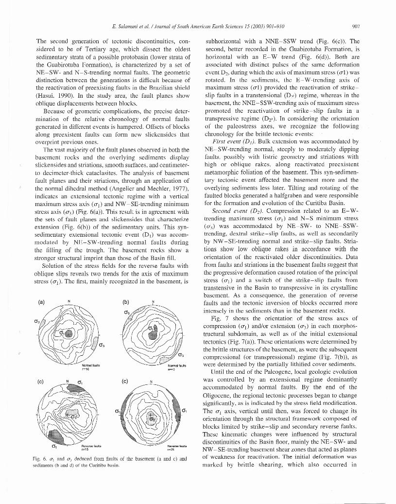
The vast majority of the fault planes observed in both thebasement rocks and the overlying sediments displayslickensides and striations, smooth surfaces, and centimeter-to decimeter-thick cataclasites. The analysis of basementfault planes and their striations, through an application ofthe normal dihedral method (Angelier and Mechler, 1977),indicates an extensional tectonic regime with a verticalmaximum stress axis (0-1) and NW -SE-trending minimumstress axis (0-3) (Fig. 6(a)). This result is in agreement withthe sets of fault planes and slickensides that characterizeextension (Fig. 6(b)) of the sedimentary units. This syn-sedimentary extensional tectonic event (Di) was accom-modated by NE-SW -trending normal faults duringthe filling of the trough. The basement rocks show astronger structural imprint than those of the Basin fil!.
Solution of the stress fields for the reverse faults withoblique slips reveals two trends for the axis of maximumstress (Ui). The first, main1y recognized in the basement, is
(a) N N
Normal faultsn=16
(c) (c) NN
Reverse faultsn=13
Reverse faults
n=25
Fig. 6. (TI and (T3 deduced from faults of the basement (a and c) andsedirnents (b and d) of lhe Curitiba basin.
907
subhorizontal with a NNE-SSW trend (Fig. 6(c)). Thesecond, better recorded in the Guabirotuba Formation, ishorizontal with an E- W trend (Fig. 6(d)). Both areassociated with distinct pulses of the same deformationevent D2, during which the axis ofmaximum stress (o-l ) wasrotated. In the sediments, the E- W-trending axis ofmaximum stress (o-l) provided the reactivation of strike-slip faults in a transtensional (D2,) regime, whereas in thebasement, the NNE-SSW-trending axis of maximum stresspromoted the reactivation of strike-slip faults in atranspressive regime (D2"). In considering the orientationof the paleostress axes, we recognize the followingchronology for the brittle tectonic events:
First event (DI). Bulk extension was accommodated byNE-SW-trending normal, steeply to moderately dippingfaults, possibly with listric geometry and striations withhigh or oblique rakes, along reactivated preexistentmetamorphic foliation of the basement. This syn-sedimen-tary tectonic event affected the basement more and theoverlying sediments less later, Tilting and rotating of thefaulted blocks generated a halfgraben and were responsiblefor the formation and evolution of the Curitiba Basin.
Second event (D2). Compression related to an E- W-trending maximum stress (UI) and N -S minimum stress(u3) was accommodated by NE-SW- to NNE-SSW-trending, dextral strike-slip faults, as well as secondarilyby NW -SE-trending normal and strike-slip faults, Stria-tions show low oblique rakes in accordance with theorientation of the reactivated older discontinuities. Datafrom faults and striations in the basement faults suggest thatthe progressive deformation caused rotation of the principalstress (u,) and a switch of the strike-slip faults fromtranstensive in the Basin to transpressive in its crystallinebasement. As a consequence, the generation of reversefaults and the tectonic inversion of blocks occurred moreintensely in the sediments than in the basement rocks.
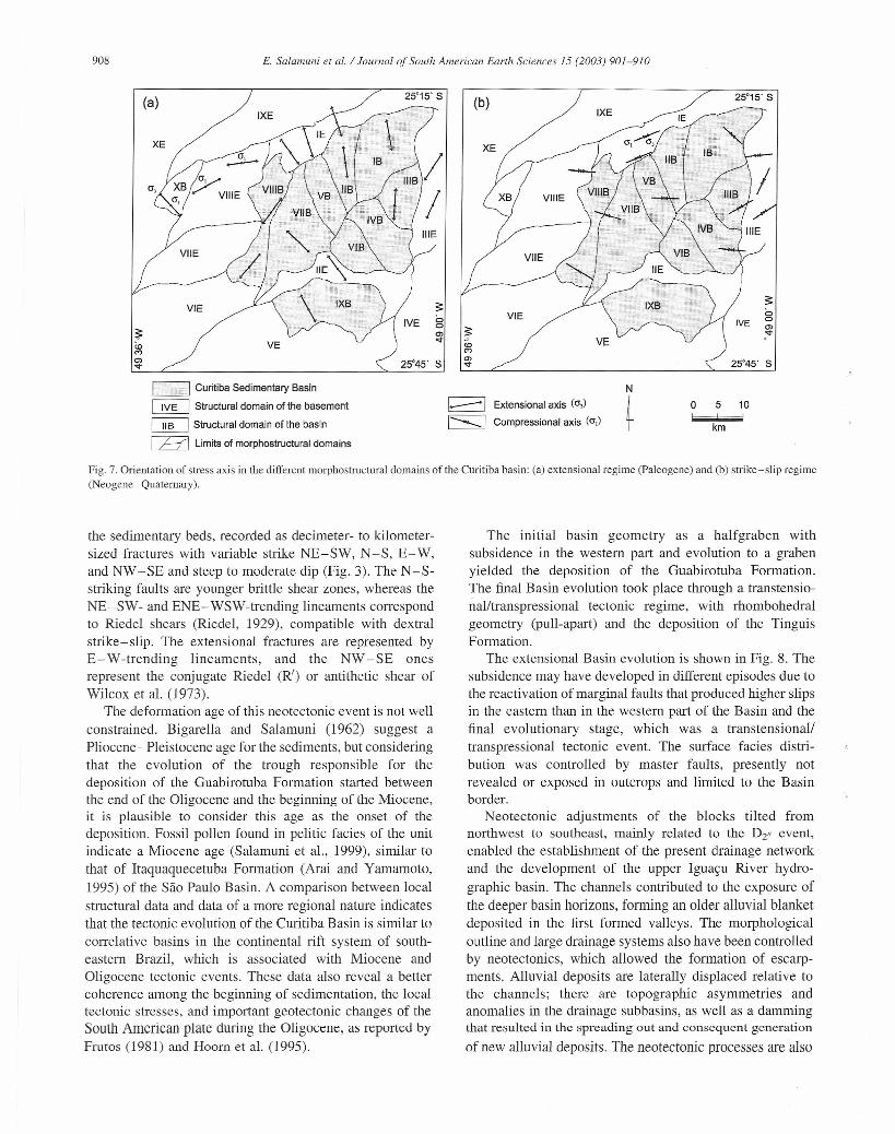
Fig. 7 shows the orientation of the stress axes ofcompression (Ui) and/or extension (0-3) in each morphos-tructural subdomain, as well as of the initial extensionaltectonics (Fig. 7(a)). These orientations were determined bythe brittle structures of the basement, as were the subsequentcompressional (or transpressional) regime (Fig. 7(b)), aswere determined by the partially lithified cover sediments.
Until the end of the Paleogene, local geologic evolutionwas controlled by an extensional regime dominantlyaccommodated by normal faults. By the end of theOligocene, the regional tectonic processes began to changesignificantly, as is indicated by the stress field modification.The ui axis, vertical until then, was forced to change itsorientation through the structural framework composed ofblocks limited by strike-slip and secondary reverse faults.These kinematic changes were influenced by structuraldiscontinuities of the Basin floor, mainly the NE-SW- andNW -SE-trending basement shear zones that acted as planesof weakness for reactivation. The initial deformation wasmarked by brittle shearing, which also occurred in
908 E. Salamuni et aI. / Journal of South American Earlh Sciences 15 (2003) 901-910
c=J Curiliba Sedimenlary Basin
~ Structural domain of lhe basemenl
~ Slruclural domain of lhe basin
~ Limils of morphostructural domains
25°15' S
1-----1 Extensional axis (o])
I~ 1Compressional axis (0\)
N
~ km
o 5 10
Fig. 7. Orientation of stress axis in the different morphostructural domains of the Curitiba basin: (a) extensional regime (paleogene) and (b) strike-slip regime(Neogene-Quatemary).
the sedimentary beds, recorded as decimeter- to kilometer-sized fractures with variable strike NE-SW, N -S, E- W,and NW -SE and steep to moderate dip (Fig. 3). The N -S-striking faults are younger brittle shear zones, whereas theNE-SW- and ENE- WSW-trending lineaments correspondto Riedel shears (Riedel, 1929), compatible with dextralstrike-slip. The extensional fractures are represented byE- W -trending lineaments, and the NW -SE onesrepresent the conjugate Riedel (R') ar antithetic shear ofWilcox et al. (1973).
The deformation age of this neotectonic event is not wellconstrained. Bigarella and Salamuni (1962) suggest aPliocene- Pleistocene age for the sediments, but consideringthat the evolution of the trough responsible for thedeposition of the Guabirotuba Formation started betweenthe end of the Oligocene and the beginning of the Miocene,it is plausible to consider this age as the onset of thedeposition. Fossil pollen found in pelitic facies of the unitindicate a Miocene age (Salamuni et aI., 1999), similar tothat of Itaquaquecetuba Formation (Arai and Yamamoto,1995) of the São Paulo Basin. A comparison between localstructural data and data of a more regional nature indicatesthat the tectonic evolution of the Curitiba Basin is similar tocorrelative basins in the continental rift system of south-eastern Brazil, which is associated with Miocene andOligocene tectonic events. These data also reveal a bettercoherence among the beginning of sedimentation, the localtectonic stresses, and important geotectonic changes of theSouth Amerícan plate during lhe Oligocene, as reported byFrutos (1981) and Hoorn et al. (1995).
The initial basin geometry as a halfgraben withsubsidence in the western part and evolution to a grabenyielded the deposition of the Guabirotuba Formation.The final Basin evolution took place through a transtensio-nal/transpressional tectonic regime, with rhombohedralgeometry (pull-apart) and the deposition of the TinguisFormation.
The extensional Basin evolution is shown in Fig. 8. Thesubsidence may have developed in different episodes due tothe reacti vation of marginal faults that produced higher slipsin the eastern than in the western part of the Basin and thefinal evolutionary stage, which was a transtensional/transpressional tectonic event. The surface facies distri-bution was controIled by mas ter faults, presently notrevealed ar exposed in outcrops and limited to the Basinborder.
Neotectonic adjustments of the blocks tilted fromnorthwest to southeast, mainly re1ated to the Dz" event,enabled the establishment of the present drainage networkand the development of the upper Iguaçu River hydro-graphic basin. The channels contributed to the exposure ofthe deeper basin horizons, forming an older alluvial blanketdeposited in the first formed valleys. The morphologicaloutline and large drainage systems also have been controlledby neotectonics, which allowed the formation of escarp-ments. Alluvial deposits are laterally displaced rei ative tothe channels; there are topographic asymmetries andanomalies in the drainage subbasins, as well as a dammingthat resulted in the spreading out and consequent generation
of new alluvial deposits. The neotectonic processes are also
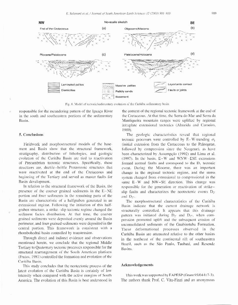
NW
E. Salamuni et al.! Journal ofSouth American Earth Sciences 15 (2003) 901-9/0 909
End of the Cretaceous (a)
No-scale sketch
Oligocene/Miocene
SE(b)
Pliocene/Pleistocene (c)
c=J Laminated pelites
~ Diamictites
Pleistocene/Holocene (d)
~ Massive pelites I ~ I Layer/units contact
I ~ I Faults or joints
Fig. 8. Model of tectonic/sedimentary evolution of the Curitiba sedimeniary basin.
responsible for'úre meandering pattern of the Iguaçu River the context of the regional tectonic framework at the end ofin the south and southeastern portions of the sedimentary the Cretaceous. At that time, the Serra do Mar and Serra daBasin. Mantiqueira rnountain ranges were uplifted by regional
intraplaie extensional tectonics (Almeida and Carneiro,1989).
The geologic characteristics reveal that regionaltectonic processes were controlJed by E- W -trending (Tj
(initial extension frorn the Cretaceous to the Paleogene,followed by compression sinee the Neogene), as havebeen eharaeterized by Assumpção (1992) and Lima et al.(1997). In the basin, E-W and WNW-ESE extensionsformed normal faults anel correspond to the DI tectonieevent. During the Miocene, there was an importantchange in the regional teetonie regime, and the stresssystem changed frorn extensional to eompressional in thesame E- W and NW -SE direction. This change wasresponsible for the generation or reacti vation of strike-slip faults and characterizes the neotectonic events D2'anel D2'"
The morphostructural characteristics of the CuritibaBasin indicare that the current drainage network isstructurally eontrolled. It appears that this drainagepattern was initiated eluring D2' and D2", when com-pression promoted uplift anel the subsequent erosion ofunconsolidated sediments of the Guabirotuba Formation.These deformational processes observed in theCuritiba Basin are attenuated rei ative to the other basins
in the northeast of the continental rift of southeasternBrazil, sueh as the São Paulo, Taubaté, and ResendeBasins.
5. Conclusions
Fieldwork and morphostructural models of the base-ment and Basin show that the struetural frarnework,stratigraphy, distribution of lithologies, and geologicevolution of the Curitiba Basin are tied to reacti vation01' Precambrian tectonic structures. Speeifically, thesestructures are, ductile-brittle Proterozoic structures thatwere reactivated at the end of the Cretaeeous andbeginning of the Tertiary and served as master faults forBasin development.
In relation to the strucrural framework of the Basin, thepresence of the coarser grained sediments in the E-NEportion and finer seeliments in the remaining parts of theBasin are eharaeteristie of a halfgraben generated in anextensional regime. Following the initiation of this half-graben strueture, a strike-slip tectonic regime ehanged thesediment facies distribution. At that time, the eoarsergrained sediments were elepositecl evenly around the Basinperimeter, and finer grained sediments were deposited in thecentral portion. This framework is eonsistent with arhombohedral basin eontrolJed by transtension.
Through direct anel indirect evidence and observationsmentioned herein, we conelude that the regional MiddleTertiary to Quaternary tectonic processes responsible for thestructural rearrangement of the South Ameriean platforrn(Frutos, 1981) controlled the forrnation and evol ution of theCuritiba Basin.
This study eoncludes that the neotectonic process of thelatest evolution of the Curitiba Basin is certainly of lowintensity when compareci with the active margins of SouthAmérica. The evolution of tbis Basin is best understood in
Acknowledgcments
This work was supported by FAPESP (Grant 95/04417-3).The authors thank Prof. C. Vita-Finzi and an anonyrnous
910 E. Salamuni et aI. / Iournal of Soutn American Earth Sciences 15 (2003) 901-910
referee for suggestions and contributions to improve thispaper, and Dr A. Fetter for text review.
References
Almeida, F.F.M., 1976. The system of continental rifts bordering the SantosBasin Brazil. Rio de Janeiro, Anais da Academia Brasileira de Ciências48 (Suplemento), 15-16.
Almeida, F.F.M., Carneiro, C.D.R., 1998. Origem e evolução da SeITa doMar. Revista Brasileira de Geociências, São Paulo 28 (2), 135-150.
Angelier, J., J 989. From orientation to magnitudes in paleostressdeterminations using fault slip data. Journa1 of Structural Geology l l ,37-50.
Angelier, J., 1994. In: Hancock, P.L., (Ed.), Fault analysis and paleostressreconsrruction, Continental Deformation, Pergamon Press, New York,pp.53-100.
Angelier, 1., Mechler, P., 1977. Sur une méthode graphique de res. descontraintes principales également. Bulletin de Ia Societé Geologique deFrance, Paris, 1309-1318.
Arai, M., Yamamoto, LT., 1995. Novos dados sobre a idade da FormaçãoItaquaquecetuba: uma contribuição palinológica. Simpósio de Geologiado Sudeste 4, Boletim de Resumos, Águas de São Pedro-SP, SBG-SP/RJIES, p. 84.
Assumpção, M., 1992. The regional stress field in South America. Journalof Geophysical Research 97 (88),1189-11903.
Basei, M.A.S., Siga, O. Jr., Machiavel1i, A., Mancini, F., 1992.Evolução tectônica dos terrenos entre os cinturões Ribeira e DomFeliciano (PR-SC). São Paulo, Revista Brasileira de Geociências 22(2), 212-227.
Becker, R.D., 1982. Distribuição dos sedimentos cenozóicos na RegiãoMetropolitana de Curitiba e sua relação com a estrutura geológica emorfológica regional. Porto Alegre, Universidade Federal do RioGrande do Sul, PhD Thesis.
Bigarella, J.J., Salarnuni, R., 1962. Caracteres texturais dos sedimentos daBacia de Curitiba. Curitiba, Boletim da UFPR-Geologia 7,1-164.
Frutos, J., 1981. Andean tectonics as a consequence of sea-floor spreading.Tectonophysics 72, T21-T32.
Hasui, Y., 1990. Neotectônica e aspectos fundamentais da tectônicaressurgente no Brasil. Belo Horizonte, Sociedade Brasileira deGeologia, Boletim li, 1-3l.
Hasui, Y., Costa, J.B.S., Borges, M.S., Morales, N., Jirnenez-Rueda, J.R.,1998. Evolução morfotectônica do sudeste do Brasil. Belo Horizonte,Anais do 400 Congresso Brasileiro de Geologia 1, 78.
Hoorn, e, Guerreiro, J., Sarmiento, G.A., 1995. Andean tectonics as causefor changing drainage patterns in Miocene northem South America.Geology 23 (3),237-240.
Jackson, J., Norrio, R., Youngson, J., 1996. The structural evolution ofactive fault and fold sysrerns in Central Otago New Zealand: evidencerevealed by drainage pattems. Journal of Structural Geology 18 (2),217-234.
Lima, e, Cobbold, P.R., Soudarian, L., 1997. Topographic and structuralexpression of Andean-related tectonics in midplate South America.Simpósio Nacional de Estudos Tectônicos, Anais, SBG-Brasília,Pirinópolis, MG, 27-30.
Meio, M.S., Riccomini, C., Hasui, Y., Almeida, F.F.M., Coirnbra, A.A.M.,1985. Geologia e evolução do sistema de bacias tafrogênicascontinentais do sudeste do Brasil. Revista Brasileira de Geociências15, 193-201.
Ouchi, S., 1985. Response of alluvial rivers to slow active tectonicmovement. Bulletin of the Geological Society of America 96,504-515.
Riccomini, e, Pellogia, A.U.G., Saloni, J.eL., Kohnke, M.W., Figueira,R.M., 1989. Neotectonic activity in the SeITa do Mar rift systems(Southeastem Brazil). Journal of South Arnerica Earth Science 2 (2),191-197.
Riedel, W., 1929. Zur mechanik geologischer brucherscheinungen. Einbeitrag zum problem der fiederspalten. Zentrablat fur Mineralogie1919b, 354-368.
Saadi, A., 1993. Neotectônica da plataforma brasileira: esboço einterpretação preliminares. Geonomos 1 (1), l-S.
Salamuni, E., 1998. Tectônica da Bacia Sedimentar de Curitiba (PR). RioClaro, Universidade Estadual Paulista, PhD Thesis, 214p.
Salamuni, E., Hasui, Y., Costa, J.B.S., Borges, M.S., Ebert, H.D., 1998.Sobre a tectônica da bacia sedimentar de Curitiba (PR/BR). Actasdel 20
Congreso Uruguayo de Geologia I, 10-15 ..Salamuni, E., Salarnuni, R., Ebert, H.D., 1999. Contribuição à geologia da
Bacia Sedimentar de Curitiba. Curitiba, Boletim Paranaense deGeociências 47,123-142.
Scheidegger, A.E., 1991. Neotectonic joints: discussion. Bulletin of theGeological Society of Arnerica 103, 432.
Scheidegger, A.E., 1993. Joints as neotectonics plate signatures. Tectono-physics 219, 235-239.
Schobbenhaus, e, Campos, D.A., 1984. A evolução da Plataforma Sul-Americana no Brasil e suas principais concentrações minerais. In:Schobbenhaus, C., Campos, D.A., Derze, G.R., Asmus, H.E. (Eds.),Geologia do Brasil, Departamento Nacional da Produção Mineral, Riode Janeiro, pp. 9-56.
Schobbenhaus, C., Campos, D.A., Derze, G.R., Asmus, H.E., 1981. Mapageológico do Brasil e da área oceânica adjacente, incluindo depósitosminerais. 1:2.500.000, Departamento Nacional da Produção Mineral,Rio de Janeiro.
Siga, O. Jr., Basei, M.A.S., Reis Neto, J.M., Machiavelli, A., Harara,O.M., 1995. O Complexo Atuba: um cinturão Paleoproterozóicointensamente retalhado no Neoproterozóico. São Paulo, Instituto deGeociências, Universidade de São Paulo, Boletim (Série Científica)26, 69-98.
Strahler, A.N., J 952. Hypsometric (areal-altitude) analysis of erosionaltopography. Bulletin of the Geological Society of America 63,1117-1142.
Wilcox, R.E., Harding, T.P., Seel, Y.D.R., 1973. Basin wrench tectonics.Bul1etin of the Arnerican Association of Petroleum Geologists 57,74-96.