temp.cityofsalem.nettemp.cityofsalem.net/departments/communitydevelopment/planning... · the...
TRANSCRIPT


Salem municipal airport
maSter plan executive Summary
Capital Improvement Plan SummaryYear Improvement Project Cost Estimate1
2012 Runway lighting repairs $350,000
Taxiway lighting repairs $300,000
Runway signage replacement $350,000
2013 Runway extension engineering2 $3,500,000
2014 Runway extension construction2, 3 $10,500,000
2015 Apron rehabilitation engineering $315,000
2016 Apron rehabilitation construction $2,650,000
2017 Deicing containment facility $470,000
2018 Emergency generator $480,000
Airport Layout Plan $400,000
2019 East parallel taxiway2 $3,700,000
2020 Runway end hold apron2 $900,000
Total $24,000,000
1: Cost estimates include design contingencies to account for unknowns at time of estimate. Estimates are subject to revision as data becomes available.
2: Denotes part of the runway extension project.
3: Runway extension costs include easement or acquisition costs and improvements to navigational aids.
Project implementation is subject to need and funding availability. Projects will require evaluation pursuant to the National Environmental Policy Act.
project FundingFunding for the airport improvement projects is expected to come from federal, state and local sources.
Federal FundingThe primary source of funding will be the FAA Airport Improvement Program, which is funded through excise taxes paid by users of the national airspace system. Salem Airport receives annual entitlement funding and may compete with other airports for additional discre-tionary funding. Federal funding may be used for up to 95 percent of a project’s cost. The 5 percent local match for federal funding is expected to come from the State of Oregon or the Salem Airport enterprise fund not the City’s general fund.
State of oregon FundingConnectOregon is a lottery-based funding source for air, rail, marine and transit infrastructure. ConnectOregon funds may be used to pay for up to 80 percent of a proj-ect’s cost or as a match for FAA funding. The Salem Air-port was awarded a $2.6 million ConnectOregon grant to extend the runway and complete other related projects.
local FundingThe Salem Airport does not receive general fund support from the City of Salem and instead generates revenue through airport operations including property leases, landing fees and fuel flowage fees. As an enterprise fund airport, revenue generated by the Airport may only be used to fund airport-related expenses.
For additional informationPlease visit the City of Salem’s airport website at www.cityofsalem.net/visitors/airport and look for the Airport Master Plan link. The Master Plan website includes documents for download, meeting announcements, frequently asked questions and a comment form.
201 NE Park Plaza Drive, Suite 167
Vancouver, WA 98684
360-883-0047
meadhunt.com
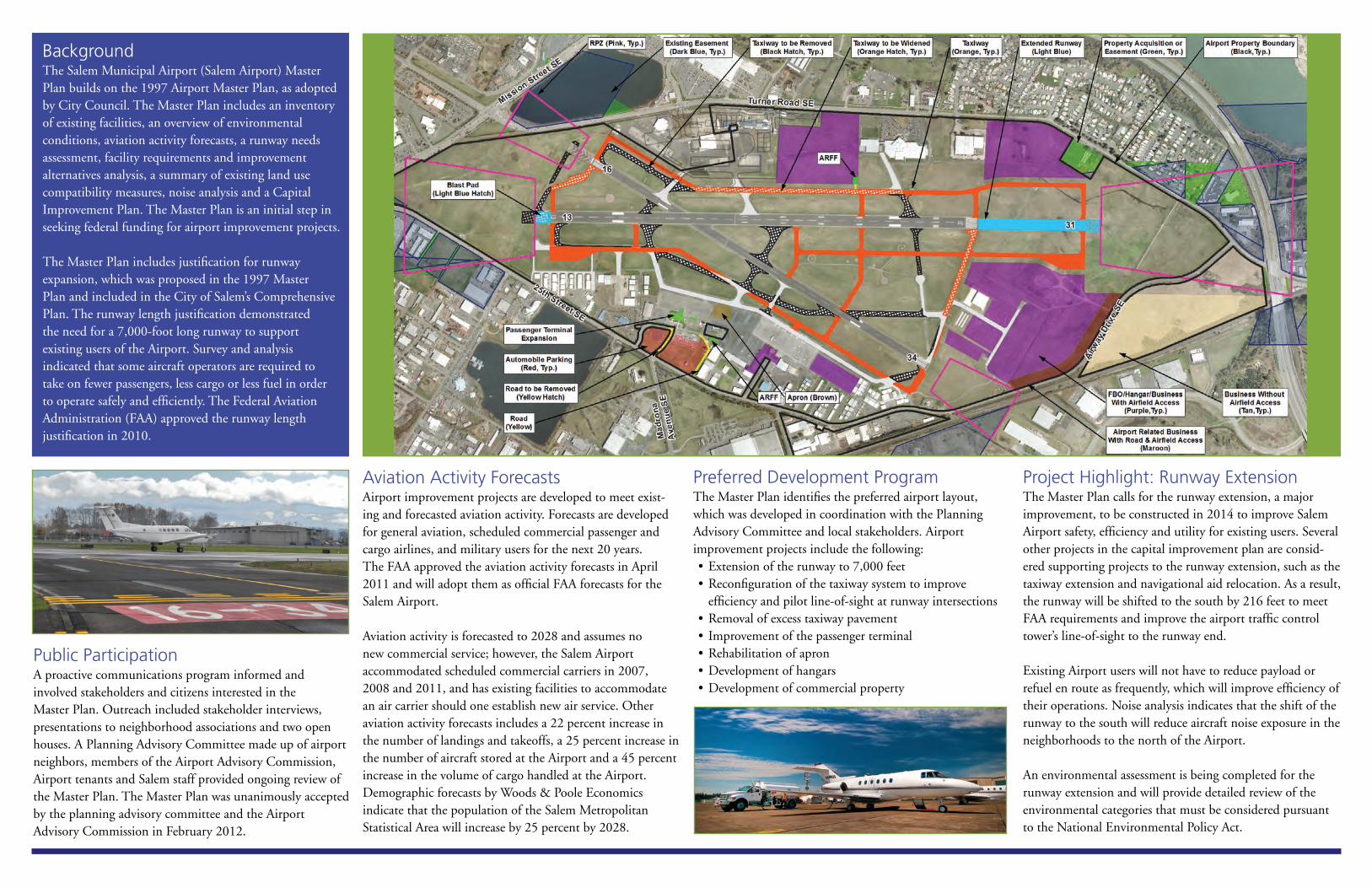
Background The Salem Municipal Airport (Salem Airport) Master Plan builds on the 1997 Airport Master Plan, as adopted by City Council. The Master Plan includes an inventory of existing facilities, an overview of environmental conditions, aviation activity forecasts, a runway needs assessment, facility requirements and improvement alternatives analysis, a summary of existing land use compatibility measures, noise analysis and a Capital Improvement Plan. The Master Plan is an initial step in seeking federal funding for airport improvement projects. The Master Plan includes justification for runway expansion, which was proposed in the 1997 Master Plan and included in the City of Salem’s Comprehensive Plan. The runway length justification demonstrated the need for a 7,000-foot long runway to support existing users of the Airport. Survey and analysis indicated that some aircraft operators are required to take on fewer passengers, less cargo or less fuel in order to operate safely and efficiently. The Federal Aviation Administration (FAA) approved the runway length justification in 2010.
public participationA proactive communications program informed and involved stakeholders and citizens interested in the Master Plan. Outreach included stakeholder interviews, presentations to neighborhood associations and two open houses. A Planning Advisory Committee made up of airport neighbors, members of the Airport Advisory Commission, Airport tenants and Salem staff provided ongoing review of the Master Plan. The Master Plan was unanimously accepted by the planning advisory committee and the Airport Advisory Commission in February 2012.
aviation activity ForecastsAirport improvement projects are developed to meet exist-ing and forecasted aviation activity. Forecasts are developed for general aviation, scheduled commercial passenger and cargo airlines, and military users for the next 20 years. The FAA approved the aviation activity forecasts in April 2011 and will adopt them as official FAA forecasts for the Salem Airport. Aviation activity is forecasted to 2028 and assumes no new commercial service; however, the Salem Airport accommodated scheduled commercial carriers in 2007, 2008 and 2011, and has existing facilities to accommodate an air carrier should one establish new air service. Other aviation activity forecasts includes a 22 percent increase in the number of landings and takeoffs, a 25 percent increase in the number of aircraft stored at the Airport and a 45 percent increase in the volume of cargo handled at the Airport. Demographic forecasts by Woods & Poole Economics indicate that the population of the Salem Metropolitan Statistical Area will increase by 25 percent by 2028.
preferred Development program The Master Plan identifies the preferred airport layout, which was developed in coordination with the Planning Advisory Committee and local stakeholders. Airport improvement projects include the following:•Extension of the runway to 7,000 feet•Reconfiguration of the taxiway system to improve
efficiency and pilot line-of-sight at runway intersections•Removal of excess taxiway pavement• Improvement of the passenger terminal •Rehabilitation of apron•Development of hangars•Development of commercial property
project Highlight: runway extension The Master Plan calls for the runway extension, a major improvement, to be constructed in 2014 to improve Salem Airport safety, efficiency and utility for existing users. Several other projects in the capital improvement plan are consid-ered supporting projects to the runway extension, such as the taxiway extension and navigational aid relocation. As a result, the runway will be shifted to the south by 216 feet to meet FAA requirements and improve the airport traffic control tower’s line-of-sight to the runway end. Existing Airport users will not have to reduce payload or refuel en route as frequently, which will improve efficiency of their operations. Noise analysis indicates that the shift of the runway to the south will reduce aircraft noise exposure in the neighborhoods to the north of the Airport. An environmental assessment is being completed for the runway extension and will provide detailed review of the environmental categories that must be considered pursuant to the National Environmental Policy Act.


Approximation of Grant , NEN, and SESNA based on Census Tracts 3, 6, and 9
Legend:Boundaries
State
'10 County
'10 Census Tract
FeaturesMajor Road
Street
Stream/Waterbody
Your SelectionsYour Selections
Items in grey text are not visible at this zoom level
1 of 1 10/23/2012

Population315,335
30,491
10.7%
Poverty by Age - 2006-10
Poverty Rates Oregon United States
596,649 46,215,956
15.8% 15.3%
Population by Age - 2006-10
Unemployment Rates
Poverty Population Characteristics Homeless Count
% of People in
Poverty
% of all
Population
- -
40% 27%
54% 60%
6% 13%
% of Families
in Poverty
% of all
Families147
- -
86% 51%
49% 13%
69% 82%
% of People in
Poverty
% of all
Population66
- - 188
70% 82%
2% 1%
6% 3%
2% 2% 20.0
2% 1% 4.7
14% 8% 5.8
5% 3% 24.5
40% 23%
2 or more races 22% 18+ yrs
American Indian 36% Length of Homelessness (months):
Asian 15% Average
Hispanic origin 28%
Pacific Islander 52% 0-11 yrs
Other 27% 12-17 yrs
White 14% Households
with Children115
Black 31%
Poverty Rates by Race/Ethnicity
2006-10
% in
Poverty
Chronically
Homeless Population
Total Population 16% Children (under 18)
483Families with children under 18 20%
Single women with children under 18 44% Turnaway
& Street Count313
Families that worked full or part time 10%
Poverty Rates by Family
2006-10
% in
Poverty
in
Emergency Shelter
All Families 12% in
Transitional Housing
People 18-64 14% Total Homeless
Population943
People 65 and older 8%
Poverty Rates by Age
2006-10
% in
Poverty2011
Total Population 16% Total Homeless
Households731
Children younger than 18 24%
2010 Number in Poverty 55,030
Percent in Poverty 17.9%
(503) 585-6232
Fax (503) 375-7580
http://www.mwvcaa.org/
Marion
County
# change from 2000 2475 Center Street NE
% change from 2000 Salem, OR 97301
Marion County Community Action Agency
Mid-Willamette Valley Community
2010 Total Population Action Agency (MWVCAA)
2000 2001 2002 2003 2004 2005 2006 2007 2008 2009 2010 2011
Marion 5.5 6.4 7.3 8 7.6 6.5 5.7 5.4 6.6 10.9 11 10.2
Oregon 5.1 6.4 7.6 8.1 7.3 6.2 5.3 5.2 6.5 11.1 10.7 9.5
United States 4 4.7 5.8 6 5.5 5.1 4.6 4.6 5.8 9.3 9.6 8.9
02468
1012
40%
54%
6%
Children younger than 18
People 18-64
People 65 and older
27%
60%
13%
Children younger than 18
People 18-64
People 65 and older
10
15
20
2000 2001 2002 2003 2004 2005 2006 2007 2008 2009 2010
Marion County Oregon United States

2006 2007 2008 2009 2010 2011
34 234 29 88 140 50
$1,024,500 $25,717,855 $3,906,299 $41,778 $9,298,340 $2,457,500
143 144 117 42 7 71
$19,850,586 $22,079,897 $18,602,806 $5,918,734 $887,253 $8,703,489
5,388 5,450 6,875 8,955 8,253 7,015
3,583 3,907 5,161 6,687 5,106 4,217
634 589 779 864 993 1,475
$13,742 $13,643 $13,969 $14,901 $14,872 $14,762
28,167 29,276 30,069 34,337 34,775 35,704
50% 50% 51% 59% 59% 59%
20% 20% 22% 27% 30% 32%
3% 3% 4% 5% 6% 6%
1 person $11,170 $559
2 person $15,130 $620
3 person $19,090 $742
4 person $23,050 $1,078
5 person $27,010 $1,301
6 person $30,970
7 person $34,930
8 person $38,890
58% 54%57%
476,477# Burdened Households
% Burdened
33,812,787
# Burdened Households
% Burdened
Workforce
(under 120% of Median Household Income)
# Households
37,027
42,562
Very Low Income
(under 50% of Median Household Income)
# Households
# Burdened Households
% Burdened
Low Income
(under 80% of Median Household Income)
# Households
United States
Units funded by OHCS
studio
Total Households
Renters percent income spent on housing
Owners percent income spent on housing
Extremely Low Income
(under 30% of Median Household Income)
# Households
# Burdened Households
% Burdened
Owner Median Household Income
2006-10 Household Incomes
Median Household Income
Renter Median Household Income
OHCS funding for affordable housing
Single Family Loans-#
Population receiving TANF-%
Household Income and Housing Burden
Disconnects Prevented-#
Marion County Services
How We Help
Population receiving Food Stamps-%
Students eligible free/reduced lunch-%
Students eligible for free/reduced lunch-#
Household income for energy assist-avg $
Restored Utility-#
Households receiving energy assistance-#
Single Family Loans-$s
14,505,278
11,767,540
81%
$25,957
27,842,104
25,699,731
19,135,578
64%
$51,914
$31,548
$65,167
74%
114,235,996
31%
22%
$15,574
258,299
330,636
$24,630
$62,297
62,564,781
$39,408
833,941
570,958
$41,531
43,331,696
23%
31%
84%
156,663
186,635
$14,778
OregonMarion County
$46,069
$29,621
1,499,267
$63,443
$49,260
$30,535
24%
$13,821
12,976
$61,079
112,773
30%
11,155
86%
$23,035
23,129
18,745
81%
$36,855
78%
29,844
70%
$55,283
63,457
$59,112
68%
387,062
1 bedroom
2 bedroom
3 bedroom
4 bedroom
2012 Fair Market Rents2012 Poverty Income Guideline

Chapter 22 Environmental Overview
Master Plan – Phase II & Runway Needs Assessment August 2012 2-1
1. Introduction
This chapter provides an overview of
environmental conditions to be considered at
Salem Municipal Airport (SLE). Conditions
are determined by existing studies and
database review, photography and map
interpretation, agency correspondence, and
local knowledge. Fieldwork was performed
for archaeological, wetland, and biological
categories. A review of environmental
compliance is presented, and environmental
conditions for the National Environmental Policy Act of 1969 (NEPA) categories are summarized.
This chapter is not intended to satisfy environmental clearance requirements outlined in Federal Aviation
Administration (FAA) Order 1050.1E, Environmental Impacts and Procedures. This chapter is a summary
of existing conditions, and will not fulfill the requirements of NEPA. A federally funded airport project is
considered a federal action, and requires formal NEPA compliance documentation.
Environmental considerations are used to evaluate airport improvement alternatives. When
environmental constraints are identified, airport improvement alternatives are developed to avoid and
minimize impacts to the environment.
This chapter is organized into the following sections.
• Environmental Compliance Review
• Wetland Review
• Biological Assessment
• Floodplain Assessment
• Cultural Resource Assessment
• Other Environmental Categories

CHAPTER 2 ENVIRONMENTAL OVERVIEW
Master Plan – Phase II & Runway Needs Assessments August 2012 2-2
2. Airport Pollution Discharge and Storm Water
As required by the Oregon Department of Environmental Quality (DEQ), SLE is permitted under the
National Pollutant Discharge Elimination System (NPDES) General Permit 1200-Z, Permit File No.
106923 (Permit). In December 2010, the City of Salem Public Works Department developed a Storm
Water Pollution Control Plan (SWPCP) for the Airport. The SWPCP consists of the following items.
• A list of potential sources of storm water pollutants associated with industrial activities at SLE,
• Preventative measures to reduce the amount of hazardous materials exposed to storm water
runoff,
• Control measures used to contain a spill or treat contaminated runoff,
• Response procedures in the event of an uncontrolled spill or discharge, and,
• Inspection, testing and monitoring procedures for storm water.
Fueling, aircraft maintenance and de-icing activities have a high potential to impact storm water and
runoff water quality. Airport tenant Valmont Industries possesses a 1200-Z Industrial Storm Water Permit,
and the other airport tenants are covered by the SWPCP.
The SWPCP identifies seven drainage basins on airport property. Drainage basins are shown in Exhibit
2-1

CHAPTER 2 ENVIRONMENTAL OVERVIEW
Master Plan – Phase II & Runway Needs Assessments August 2012 2-3
Airfield pollutants of concern include aircraft fuel, detergent runoff from aircraft cleaning, solvents and
lubricants from aircraft maintenance, deicing fluid, and paint. The SWPCP indicates that the majority of
runoff at SLE flows into grass-lined drainage ditches. Some biofiltration, where storm water is filtered by
soil and plants, is accomplished as storm water passes through the grass-lined drainage ditches.
Under the general conditions of the SWPCP, five drainage outfalls are sampled four times a year,
analyzing for copper, lead, zinc, mercury, pH, suspended solids, oil and grease, and E. Coli. Two sample
sites are located in Drainage Basin 1. Drainage Basins 2, 3, and 4 have one sample site each. Drainage
Basins 5, 6, and 7 are not sampled because they do not contain industrial activities and are not required
to be monitored. Benchmark guideline concentrations are included in the NPDES 1200-Z permit. If
sampling results exceed benchmark values, the Airport should conduct a Benchmark Compliance
Evaluation which is to be be submitted to DEQ.
Exhibit 2-1
Drainage Basins

CHAPTER 2 ENVIRONMENTAL OVERVIEW
Master Plan – Phase II & Runway Needs Assessments August 2012 2-4
Under the SWPCP, the Airport has developed Best Management Practices (BMPs) that include
procedures to prevent toxic and hazardous substances from reaching receiving waters. BMPs being
implemented include guidelines pertaining to pesticide use, aircraft and equipment maintenance, fuel
truck unloading, vehicle and equipment fueling, materials storage, security, erosion control measures,
waste disposal, and general good housekeeping practices.
The Airport’s operations staff is trained for spill prevention and response. SLE does not store oil products
at a volume that would require development of a Spill, Prevention, Control, and Countermeasure (SPCC)
Plan. Fueling is conducted by the fixed base operator (FBO) which maintains spill prevention controls,
and provides annual training on safe fueling operations. The FBO maintains a SPCC separate from the
Airport.
Cannon’s Pond is a DEQ regulated land fill site on Airport property. Cannon’s Pond is located on the
south side of the airfield, between the extended centerlines of Runway Ends 31 and 34. Cannon’s Pond
site is used for segregation of debris collected by street sweepers, and hydro-trucks.

CHAPTER 2 ENVIRONMENTAL OVERVIEW
Master Plan – Phase II & Runway Needs Assessments August 2012 2-5
3. Wetland Review
A wetland review, included in Appendix C, was completed in November 2010. The wetland review
consisted of document review, and a field survey of 277 acres north of Runway End 31, and south of the
intersection of Runway 13-31 and Runway 16-34. Wetland delineation is expected to be required as part
of the NEPA process for airport improvements. Oregon Department of State Lands (DSL) permits
wetland removal and fill, and the U.S. Army Corps of Engineers permits fill activities occurring in wetlands
that feed into, or are supplied by, waters of the state.
Wetland location information, gathered from the National Wetlands Inventory (NWI), indicates that there
are nine acres of freshwater emergent wetland, three acres of freshwater forested/shrub wetland, and
three acres of freshwater pond on airport property. The wetland review indicates that wetland vegetation,
including needle spikerush (Eleocharis acicularis), spreading rush (Juncus patens), and reed canarygrass
(Phalaris arundinacea) were observed.
The City of Salem conducted a wetland inventory in 2005 in the southwest side of the airfield near
Taxiway R. Within airport property, wetland areas were found in the ditch west and south of the hangar
development area and two depression areas less than one half acre in size. DSL reviewed and
concurred with the findings of the inventory in 2006.
The wetland review concluded that multiple wetlands are expected to be found in the survey area if
wetland delineation is conducted. The wetland review anticipates that multiple wetlands are expected to
be located in the southwestern area of the airfield, and that there is a lesser likelihood of wetlands being
found in the northern part of the airfield.
The NEPA process requires wetland review and impact analysis for airport improvements.
NWI wetland locations are shown in Exhibit 2-2.

CHAPTER 2 ENVIRONMENTAL OVERVIEW
Master Plan – Phase II & Runway Needs Assessments August 2012 2-6
Exhibit 2-2 NWI Wetlands

CHAPTER 2 ENVIRONMENTAL OVERVIEW
Master Plan – Phase II & Runway Needs Assessments August 2012 2-7
4. Biological Assessment
Elements of the biological assessment include air quality, biotic communities, and threatened and
endangered species.
4.1. Air Quality
The Clean Air Act of 1970, as amended (CAA), is codified in Title 42 of the U.S. Code (USC) Chapter 85.
Under the CAA, the U.S. Environmental Protection Agency (EPA) has authority to establish standards for
national air quality, and regulate emissions of air quality pollutants through permitting. The DEQ is
responsible for issuing permits for pollution emitting sources at the state level, and for obtaining state-
wide compliance with the requirements of the CAA.
EPA has identified standards for six pollutants known as criteria pollutants: carbon monoxide (CO),
nitrogen dioxide (NO2), ozone (O3), sulfur dioxide (SO2), lead (Pb), and two types of particulate matter
(PM10 and PM2.5). The standards for these pollutants are defined in the National Ambient Air Quality
Standards (NAAQS). An area that does not meet the NAAQS is known as a nonattainment area. Each
state is required to have a state implementation plan (SIP) to bring nonattainment areas into compliance
with NAAQS. A nonattainment area that comes into compliance with the NAAQS is classified as a
maintenance area.
Before allocating federal funds for airport construction projects, FAA reviews environmental documents to
ensure compliance with applicable SIPs. Per section 176(c) of the CAA, “No department, agency, or
instrumentality of the federal government shall engage in, support in any way or provide financial
assistance for, license or permit, or approve, any activity which does not conform to an implementation
plan.”
Oregon Administrative Rules (OAR) Divisions 200, 202, and 204 pertain to air quality. These regulations
grant the DEQ authority to issue permits for certain high emission industries, and monitor the NAAQS.
DEQ standards for criteria pollutants match those of the NAAQS, except for SO2. In Oregon, SO2
thresholds are 0.02 parts per million (ppm) for the annual average, and 0.5 ppm for the 3-hour average,
and 0.10 ppm for 24-hour average. NAAQS and DEQ air quality standards are presented in Table 2-1.

CHAPTER 2 ENVIRONMENTAL OVERVIEW
Master Plan – Phase II & Runway Needs Assessments August 2012 2-8
Table 2-1: National Ambient Air Quality Standards
Pollutant Period Threshold
NAAQS DEQ
CO 1-hour 35.0 ppm
8-hour 9.0 ppm
Pb Calendar Quarter 1.5 µg/m3
NO2 Annual 0.053 ppm
O3 8-hour 0.08 ppm
SO2
Annual Average 0.03 ppm 0.02 ppm
3-Hour 0.5 ppm
24-Hour 0.14 ppm 0.10 ppm
PM2.5 24 Hour 35.0 µg/m
3
Annual Average 15.0 µg/m3
PM10 24 Hour 150.0 µg/m3
PPM: Parts Per Million
µg/m3: Micrograms per Cubic Meter
Source: Oregon Department of Environmental Quality
SLE is in maintenance areas for ozone and carbon monoxide. The 2007 Salem-Keizer Area Ozone
Maintenance Plan (2007 Ozone Plan) is the SIP that addresses ozone levels in the City of Salem. The
2007 Ozone Plan reports that Salem was designated as a nonattainment area for ozone in 1978. Salem
was still considered a nonattainment area for ozone following amendments to the CAA in 1990, although
designation included the footnote of incomplete data. Salem has not had an ozone violation since 1996,
and became a maintenance area in 2004.

CHAPTER 2 ENVIRONMENTAL OVERVIEW
Master Plan – Phase II & Runway Needs Assessments August 2012 2-9
The 2007 Salem-Keizer Area Carbon Monoxide Limited Maintenance Plan (2007 CO Plan) is the SIP that
addresses CO levels in Salem. Salem was designated as a nonattainment area for CO in 1978. DEQ
introduced an attainment plan for Salem in 1980. Salem achieved compliance with the NAAQS for CO
and became a maintenance area in 1987.
The 2007 Ozone Plan and 2007 CO Plan define standards for maintaining compliance with the NAAQS.
As projects are developed at SLE, consideration should be given to potential impacts during construction
and operation of the projects.
The NEPA process requires air quality review and impact analysis for airport improvements.
The Salem-Keizer Maintenance Area is shown in Exhibit 2-3
Exhibit 2-3 Salem-Keizer
Maintenance Area

CHAPTER 2 ENVIRONMENTAL OVERVIEW
Master Plan – Phase II & Runway Needs Assessments August 2012 2-10
4.2 Biotic Resources
Biotic resources relate to the natural environment. This includes plant and animal species, their habitats,
and other areas of naturally occurring vegetation or hydrologic features such as lakes and rivers.
Elements pertinent to biotic resources are discussed in other sections, including Wetlands in Section 3,
and Water Quality in Section 7.9. These elements are excluded from this section.
A formal biological assessment is expected to be conducted during environmental documentation.
The NEPA process requires biotic resources review and impact analysis for airport improvements.
4.3 Threatened and Endangered Species
Threatened and endangered species can be impacted by airport projects through disruption or removal of
habitat, alteration of drainage, and creation of migratory barriers. Federally funded projects are required
to avoid or mitigate impacts to these species and their habitat. This section identifies which state and
federally listed species potentially occur at SLE.
The NEPA process requires threatened and endangered species review and impact analysis for airport
improvements.
4.3.1 Vegetation
The Nelson’s checkermallow (sidalcea nelsoniana) is a member of the mallow family with pinkish-purplish
flowers clustered at the end of two- to four-foot tall stems. The Nelson’s checkermallow was nationally
listed as threatened under the Federal Endangered Species Act in 1993, and is listed as threatened by
Oregon Department of Fish and Wildlife (ODFW). This plant is the subject of a 2008 ODFW Recovery
Plan, which includes identifying existing Nelson’s checkermallow population areas, and re-introducing the
plant within its historic range. The Nelson’s checkermallow has been identified on southern airport
property; however, habitat delineation has not occurred.
4.3.2 Birds
The Streaked horned lark (Eremophila alpestris strigata), a federal candidate for threatened listing and a
state species of concern; White-topped aster (Sericocarpus rigidus), a federal species of concern and
state listed threatened species; and Willamette Valley larkspur (Delphinium oreganum), a federal species
of concern and state candidate for listing; have been observed in the vicinity of the Airport in the past
decade. Marion County is home to the Northern spotted owl (Strix occidentalis caurina), a federally-listed
threatened species. It is not known whether any spotted owl habitat exists on the Airport; however the
City of Salem Natural Resource Specialist considers spotted owl habitat unlikely on airport property.

CHAPTER 2 ENVIRONMENTAL OVERVIEW
Master Plan – Phase II & Runway Needs Assessments August 2012 2-11
4.3.3 Fish
Fish Distribution maps indicate that spring and fall Chinook salmon (Oncorhynchus tshawytscha) and
Winter steelhead (Oncorhynchus mykiss) may use portions of Pringle Creek. Outfalls from Drainage
Basins 1, 2, and 6 drain to Pringle Creek (Exhibit 2-1). The Oregon chub (Oregonichthys crameri) is a
federally listed threatened species residing in Marion County, but it is unknown whether it resides in
bodies of water affected by the hydrology of the Airport.
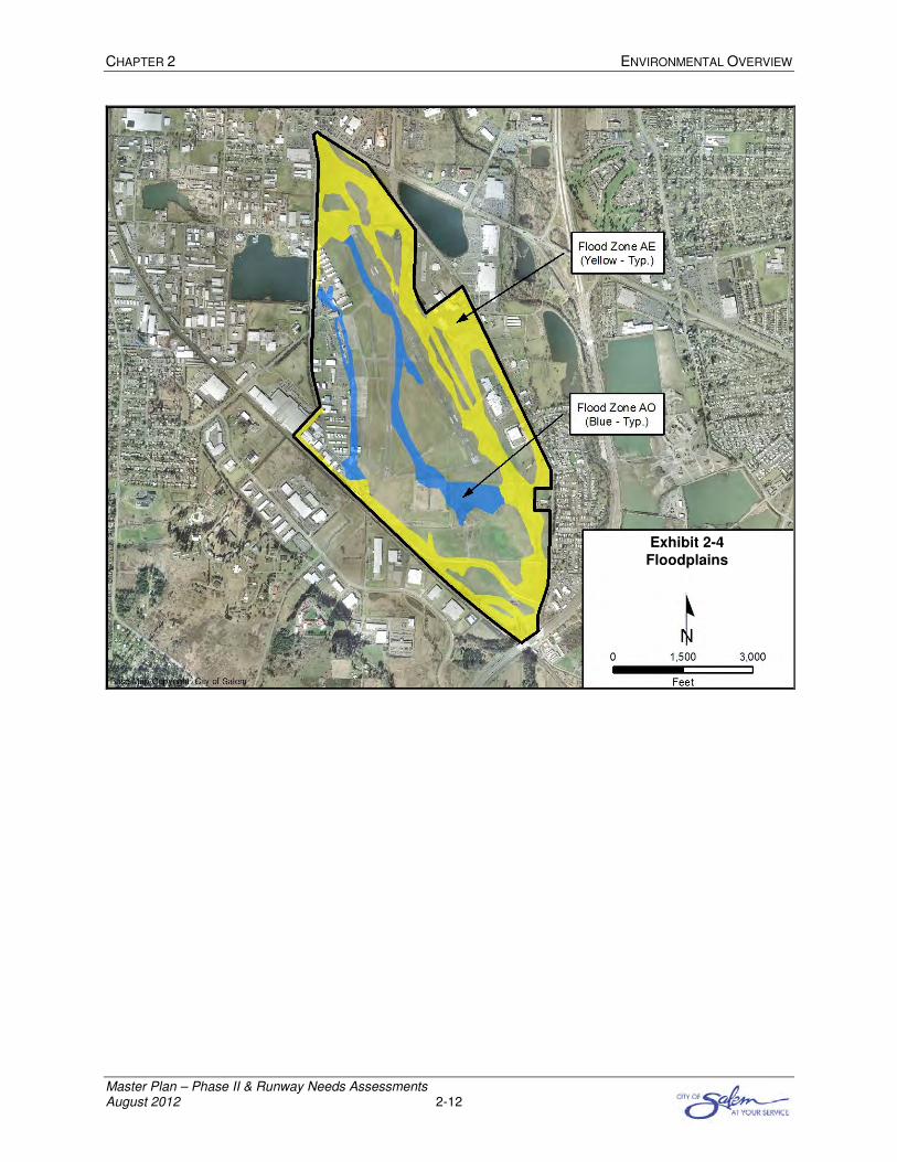
5. Floodplain Assessment
There are 306 acres classified by the Federal Emergency Management Agency (FEMA) as “high risk”
floodplains in Flood Zone AE and Flood Zone AO within airport property. FEMA defines Flood Zone AE
as “the base floodplain where base flood elevations are provided,” and Flood Zone AO as “river or stream
flood hazard areas, and areas with a 1 percent or greater change of shallow flooding each year, usually in
the form of sheet flow, with an average depth ranging from 1 to 3 feet. These areas have a 26 percent
chance of flooding over the life of a 30-year mortgage.” On airport property there are 241 acres classified
as Flood Zone AE, and 65 acres classified as Flood Zone AO.
Development at SLE is expected to include grading and cut and fill activities on existing floodplains.
Development that impairs floodplains ability to handle high water levels may require mitigation.
The NEPA process requires floodplain review and impact analysis for airport improvements, and a
detailed floodplain study is recommended during design of airfield improvements.
Floodplains are shown in Exhibit 2-4.
CHAPTER 2 ENVIRONMENTAL OVERVIEW
Master Plan – Phase II & Runway Needs Assessments August 2012 2-12
Exhibit 2-4
Floodplains

CHAPTER 2 ENVIRONMENTAL OVERVIEW
Master Plan – Phase II & Runway Needs Assessments August 2012 2-13
6. Cultural Resource Assessment
An archaeological survey to determine the likelihood for the presence of cultural resources at SLE was
completed in November 2010. The archaeological survey consisted of a review of historical records, and
an automobile and pedestrian survey of the airfield.
Review of records maintained by the Oregon State Historic Preservation Office indicate that cultural
resource surveys have been completed for projects around the Airport, but not on airport property. One
cultural resource site on airport property was reported in the 1970’s without exact location data. The
nearest known cultural resource site is located within 0.25 miles of SLE.
The archaeological survey recommended the following.
• An archaeological site has previously been recorded on SLE property, but the pedestrian survey
did not locate the site. An intensive pedestrian survey should be preformed.
• SLE meets the 50 years or older age requirement for the National Register of Historic Places.
Documentation and determination of eligibility should be completed.
The NEPA process requires cultural resource review and impact analysis for airport improvements.
The Archaeological Reconnaissance Summary is included in Appendix D.

CHAPTER 2 ENVIRONMENTAL OVERVIEW
Master Plan – Phase II & Runway Needs Assessments August 2012 2-14
7. Other Environmental Categories
NEPA considers environmental categories in addition to wetlands, biological resources, floodplains, and
cultural resources. The following section describes additional environmental categories that relate to
SLE.
7.1 Coastal Resources
Coastal resources are protected by the Coastal Barriers Resources Act of 1982, as amended (CBRA)
and the Coastal Zone Management Act of 1972, as amended (CZMA). The CBRA applies to coastal
barriers in the Atlantic and Gulf coasts, and in the Great Lakes. CBRA is not applicable to SLE. CZMA
applies to land within Oregon’s Coastal Zone, administered by the Department of Land Conservation and
Development. The coastal zone extends from the Pacific Coast to the crest of the Oregon Coastal
Mountain Range, located west of SLE. The CZMA is not applicable to SLE.
The NEPA process requires coastal resources review and impact analysis for airport improvements.
7.2 Compatible Land Use
Compatible land use protects the health, safety, and welfare of those living and working near SLE, while
protecting airspace for safe and efficient aircraft operations. Examples of land use considered not
compatible with airport operations include places of public assembly, schools, hospitals, residential
dwellings, and land uses that emit smoke, dust, glare, and attract wildlife. Strategies for achieving land
use compatibility are provided in the 2003 Oregon Department of Aviation Airport Land Use Compatibility
Guidebook, and the 2011 Washington State Department of Transportation Airports and Compatible Land
Use Guidebook, summarized in Chapter 6.
The NEPA process requires compatible land use review and impact analysis for airport improvements.
7.3 Construction Impacts
On-airport construction activities can impact surrounding communities through the generation of noise,
dust, debris, and emissions. FAA Order 1050.1E, Appendix A, Section 5.3 states that “construction
impacts alone are rarely significant pursuant to NEPA,” but construction impacts can cause a project to
exceed acceptable impact thresholds in other impact categories.
The NEPA process requires construction impact review and impact analysis for airport improvements.
7.4 Department of Transportation Act, Section 4(f)
Section 4(f) resources include publicly-owned parks; recreational areas; wildlife and waterfowl refuge of
national, state, or local significance; and land of a historic site of national, state, or local significance.
Projects that occur within the existing fence-line at SLE are not expected to impact Section 4(f) resources
because this property is inaccessible to the public without clearance.
The NEPA process requires Department of Transportation Act, Section 4(f) review and impact analysis for
airport improvements.

CHAPTER 2 ENVIRONMENTAL OVERVIEW
Master Plan – Phase II & Runway Needs Assessments August 2012 2-15
7.5 Farmland Conversion
The Farmland Protection Policy Act, part of the Agriculture and Food Act of 1981, as amended, protects
conversion of important farmlands to non-agricultural use. Important farmlands include pasturelands,
croplands, and forests (even if zoned for development) considered to be prime, unique, and statewide or
locally important lands, determined by soil type. U.S. National Resources Conservation Service (NRCS)
data indicates there are 71 acres on airport property classified as prime farmland, and 168 acres of soil
classified as farmland of state importance. NRCS notes that 459 acres would be considered prime
farmland if drained, and six acres would be considered prime farmland if drained and either protected
from flooding or not frequently flooded. SLE’s property was not used for agricultural purposes in 2011.
The NEPA process requires farmland conversion review and impact analysis for airport improvements.
Farmland classifications are shown in Exhibit 2-5.
Exhibit 2-5 Farmland Classifications

CHAPTER 2 ENVIRONMENTAL OVERVIEW
Master Plan – Phase II & Runway Needs Assessments August 2012 2-16
7.6 Light Emissions and Visual Impacts
Light emitting sources at SLE include airfield lighting, aircraft approach lighting, parking lot lighting, and
building lighting. Airfield improvement projects can alter the location and intensity of light emitting
sources, which may change the impact on properties around the Airport. Airport improvement projects
that impact light emitting sources at SLE should be analyzed to determine potential impact, and mitigation
techniques such as shielding or angular adjustments.
FAA Order 1050.1E, Appendix A comments that “visual, or aesthetic, impacts are inherently more difficult
to define because of the subjectivity involved. Aesthetic impacts deal more broadly with the extent that
the development contrasts with the existing environment and whether the jurisdictional agency considers
this contrast objectionable.”
The NEPA process requires light emissions and visual impacts review and impact analysis for airport
improvements.
7.7 Natural Resources and Energy Supply
FAA Order 1050.1E states that airport improvement projects “will be examined to identify any proposed
major changes in stationary facilities or the movement of aircraft and ground vehicles that would have a
measurable effect on local supplies of energy or natural resources.” FAA Order 1050.1E requires
coordination with environmental stakeholders and energy producers should potential impacts be
identified. FAA Order 1050.1E, Appendix A, Section 13 identifies two applicable polices regarding energy
supplies, natural resources, and sustainable design. Executive Order 13123, Greening the Government
through Efficient Energy Management, encourages the expansion of the use of renewable energy, and
requires federal agencies to reduce petroleum use, energy use, air emissions, and water consumption.
Energy supply considerations include aircraft fueling facilities and utility connections. Most fueling, except
small tank self fueling, is conducted by the FBO. SLE receives power from the Portland General Electric
utility company. Water and sanitary sewer services are provided by the City of Salem. Coordination with
utility providers may be necessary during airport improvement project development.
The NEPA process requires natural resources and energy supply review and impact analysis for airport
improvements.
7.8 Noise
Aircraft noise influences the Airport’s relationship with the surrounding community. A noise analysis that
compares aircraft noise contours from 2008 to forecasted aircraft noise contours from 2028 has been
performed as part of MPU-II. The noise analysis is presented in Chapter 6.
The NEPA process requires noise review and impact analysis for airport improvements.

CHAPTER 2 ENVIRONMENTAL OVERVIEW
Master Plan – Phase II & Runway Needs Assessments August 2012 2-17
7.9 Socioeconomic Impacts, Environmental Justice, Children’s Environmental Health
and Safety Risks
Council on Environmental Quality regulations in Title 40 of the Code of Federal Regulations (CFR),
Section 1508, requires environmental documents prepared for federally funded projects to address
potential social impacts. The evaluation of a proposed project on the human environment should address
the following items.
• Disproportionate impacts to low-income and minority populations,
• Potential relocation of homes or businesses,
• Division or disruption of an established community,
• Disruptions to orderly planned development,
• Notable project-related changes in employment, and
• Impacts on health and safety risks to children.
7.9.1 Socioeconomic Impacts
FAA Order 1050.1E states, “If acquisition of real property or displacement of persons is involved, 49 CFR
Part 24, Implementing the Uniform Relocation Assistance and Real Property Acquisition Policies Act of
1970, as amended, must be met for federal projects and projects involving federal funding. Otherwise,
the FAA, to the fullest extent possible, observes all local and State laws, regulations, and ordinances
concerning zoning, transportation, economic development, housing, etc. when planning, assessing, or
implementing the [airport improvement project].”
The expected social impacts to be considered at SLE are those associated with relocation or other
community disruption, transportation, planned development, and employment. The need for special
relocation advisory services to be provided, if any, for the elderly, handicapped, or illiterate regarding
interpretation of benefits or other assistance is expected to be assessed by environmental documents of
airport improvement projects.
The NEPA process requires socioeconomic impacts review and impact analysis for airport improvements.
7.9.2 Environmental Justice
FAA Order 1050.1E states, “Executive Order 12898, Federal Actions to Address Environmental Justice in
Minority Populations and Low-Income Populations, and Department Of Transportation Order 5610.2,
Environmental Justice, require FAA to provide for meaningful public involvement by minority and low-
income populations and analysis, including demographic analysis, that identifies and addresses potential
impacts on these populations that may be disproportionately high and adverse.”

CHAPTER 2 ENVIRONMENTAL OVERVIEW
Master Plan – Phase II & Runway Needs Assessments August 2012 2-18
If an impact would affect low income or minority populations at a disproportionately higher level than it
would other population segments, an environmental justice impact is likely. In such cases, the
environmental documents are expected to include the following.
• Demographic information about the affected populations,
• Information about the population(s) that have an established use for the significantly affected
resource, or to whom that resource is important (i.e., subsistence fishing),
• Provide results of analysis to determine if a low income or minority population using that resource
sustains more of the impact than any other population segments,
• Identify disproportionately affected low income and minority populations,
• Discuss alternatives that would reduce the effect on those populations, and
• Describe possible mitigation to reduce the effect on the disproportionately affected low income
and minority populations.
In cases where FAA finds a significant impact, but determines that mitigation would reduce that impact
below the applicable significance threshold, the environmental document should describe how mitigation
would reduce the impact to less than significant and verify that the project would not result in
disproportionately high and adverse affects on low income and minority populations. Demographic
information for the Salem Metropolitan Statistical Area (MSA), which consists of Marion and Polk
counties, is presented in Table 2-2.
The NEPA process requires environmental justice review and impact analysis for airport improvements.
Table 2-2: 2008 Salem MSA Demographics
Category Marion County Polk County Salem MSA
Population
Total Population 314,606 77,074 391,680
White (Non-Hispanic) 226,946 64,483 291,429
Black (Non-Hispanic) 3,890 638 4,528
Native American (Non-Hispanic) 4,225 1,501 5,725
Asian American and Pacific Islander (Non-Hispanic) 7,937 1,611 9,548
Hispanic or Latino 71,609 8,841 80,450
Poverty
Total Number of Households 115,669 29,283 144,952
Average Persons Per Household 2.7 2.6 2.7
Households with Income Below Poverty Threshold1 21,010 5,870 26,884
1: 2008 Poverty Threshold for a Family of 3: $17,600 of Household Income, U.S. Department of Health and Human Services
Source: Woods & Poole, 2010

CHAPTER 2 ENVIRONMENTAL OVERVIEW
Master Plan – Phase II & Runway Needs Assessments August 2012 2-19
7.9.3 Children’s Environmental Health and Safety Risks
FAA Order 1050.1E states “Pursuant to Executive Order 13045, Protection of Children from
Environmental Health Risks and Safety Risks, Federal agencies are directed, as appropriate and
consistent with the agency’s mission, to make it a high priority to identify and assess environmental health
risks and safety risks that may disproportionately affect children. Environmental health risks and safety
risks include risks to health or to safety that are attributable to products or substances that a child is likely
to come in contact with or ingest, such as air, food, drinking water, recreational waters, soil, or products
they might use or be exposed to.”
There are three elementary schools, one middle school, and one high school within two miles of the
Airport. Environmental documents for airport improvement projects should investigate whether a potential
project could present any of the above mentioned risks to children through the environmental impacts of
such a project.
The NEPA process requires children’s environmental health and safety risks review and impact analysis
for airport improvements.
7.10 Water Quality
Airport activities can affect water quality when storm water runoff carries contaminants from paved
surfaces into creeks and rivers. To address the issues of controlled drainage and clean water, this
section provides an overview of water resources near the Airport.
Water quality in Oregon is managed by the DEQ. The DEQ reports the condition of Oregon’s water
quality to the Environmental Protection Agency (EPA) every two years. Lakes, rivers, and streams are
classified as Category 1 through Category 5, defined as the following.
• Category 1: All standards are met. (Not used in the report)
• Category 2: Attaining—Some of the pollutant standards are met.
• Category 3: Insufficient data to determine whether a standard is met.
• Category 3B: Potential concern—Some data indicate nonattainment of a criterion, but data are
insufficient to assign to another category.
• Category 4: Water is water quality limited, but a total maximum daily load (TMDL) is not needed.
• Category 4A: TMDL approved—TMDLs needed to attain applicable water quality standards have
been approved.
• Category 4B: Other pollution control requirements are expected to address all pollutants and will
attain water quality standards.
• Category 4C: Impairment is not caused by a pollutant (e.g., flow or lack of flow is not considered
a pollutant).
• Category 5: Water is water quality limited, and a TMDL is needed, Section 303 (d) lists.

CHAPTER 2 ENVIRONMENTAL OVERVIEW
Master Plan – Phase II & Runway Needs Assessments August 2012 2-20
There are rivers and streams that fall into Categories 2, 3, and 5 near SLE. DEQ does not identify lakes
of concern near SLE.
The NEPA process requires water quality review and impact analysis for airport improvements.
Water Quality of rivers and streams near the Airport shown in Exhibit 2-6.
Exhibit 2-6 Water Quality

CHAPTER 2 ENVIRONMENTAL OVERVIEW
Master Plan – Phase II & Runway Needs Assessments August 2012 2-21
7.11 Wild and Scenic Rivers
Wild Rivers are free of obstructions such as canals and dams, and normally so remote as to only be
accessible by trail. Scenic Rivers are free of obstructions, have undeveloped shorelines, but may have
road access. Wild and Scenic Rivers are protected by the 1968 Wild and Scenic Rivers Act. Wild and
Scenic Rivers are managed by the Bureau of Land Management, the National Park Service, the U.S. Fish
and Wildlife Service, and the U.S. Forest Service. The nearest Wild and Scenic River to SLE is Elkhorn
Creek, located 30 miles east of the Airport.
The NEPA process requires wild and scenic rivers review and impact analysis for airport improvements.
Wild and Scenic Rivers are shown in Exhibit 2-7.
Exhibit 2-7 Wild and Scenic Rivers

CHAPTER 2 ENVIRONMENTAL OVERVIEW
Master Plan – Phase II & Runway Needs Assessments August 2012 2-22
8. Summary
The environmental overview has reviewed environmental categories that must be analyzed under the
requirements of NEPA. Analysis in accordance with NEPA requirements is expected to be completed as
airport improvement projects approach construction. The following is a summary potential areas of
concern identified in the environmental overview.
• Wetlands—Multiple wetlands expected on the southwestern airfield
• Air Quality—Maintenance area for ozone and carbon monoxide
• Threatened and Endangered Species—Nelson’s checkermallow habitat on the southern airfield;
Northern spotted owl, Streaked horn lark, White-topped aster, Willamette Valley larkspur,
Chinook salmon, Winter steelhead, and Oregon chub habitat in Marion County
• Floodplain—241 acres classified as Flood Zone AE, and 65 acres classified as Flood Zone AO
• Cultural Resources—SLE meets age requirement for National Register of Historic Places,
eligibility should be determined
Other environmental categories were reviewed. Preliminary analysis of these categories did not suggest
areas of particular concern; however, analysis in accordance with NEPA regulations is expected to be
required for airport improvement projects.