template shoreline countermeasures manualresponse.restoration.noaa.gov/sites/default/files/... ·...
TRANSCRIPT

TEM
SHORCOUNTER
MAN
TEMPERATE COAS
N A T I O N A L O C E A N I C & A T
HAZARDOURESPONSE &
DIV
D E C E M
PLATE� �
ELINE� MEASURES� UAL
� �
TAL ENVIRONMENTS������ �M O S P H E R I C A D M I N I S T R A T I O N �
S MATERIALS� ASSESSMENT�
ISION� �
B E R 1 9 9 2

1
2
3
4
5
6
Contents
Introduction........................................................................................................................ iv
1 Decision Process Organization.................................................................................. 1
Shoreline Evaluation Process...................................................................................
1 Shoreline Assessment Group.......................................................................
2 Shoreline Product Review Group ...............................................................
3 Technical Advisory Group............................................................................
Termination of Countermeasure Activities..........................................................
Summary of the Decision Process............................................................................
2 Shoreline Types and Sensitive Resources.............................................................. 9
1a Exposed Wave-Cut Cliffs................................................................................ 10
1b Seawalls and Piers............................................................................................ 11
2 Exposed Wave-Cut Platforms....................................................................... 11
3 Fine-Grained Sand Beaches........................................................................... 12
4 Coarse-Grained Sand Beaches ...................................................................... 13
5 Mixed Sand and Gravel (or Shell) Beaches................................................ 14
6 Gravel Beaches and Riprap Structures........................................................ 15
7 Exposed Tidal Flats.......................................................................................... 16
8 Sheltered Rocky Shores.................................................................................. 17
9 Sheltered Tidal Flats........................................................................................ 18
10a Fringing and Extensive Salt Marshes.......................................................... 19
10b Mangroves......................................................................................................... 20
Special Considerations................................................................................................ 22
3 Shoreline Mapping and Prioritization.................................................................... 25
Guidelines for Shoreline Surveys............................................................................ 25
Ground Surveys........................................................................................................... 26
Selecting and Naming Segments............................................................................. 27
i

1234567
Contents, cont.
The Shoreline Survey Evaluation Forms.............................................................. 27
Abbreviated Shoreline Surveys.................................................................... 28
Surface Oil Cover Summary .............................................................................30
Shoreline Oil Terminology/Codes...................................................................31
Shoreline Survey Evaluation Form (exhibit).................................................33
Shoreline Survey Evaluation Short Form (exhibit).....................................34
Sketch Map ............................................................................................................36
4 Matrices of Recommended Countermeasure Methods by Oil and
Shoreline Type............................................................................................................. 37
Very Light Oils.................................................................................................. 39
Light Oils............................................................................................................ 40
Medium Oils..................................................................................................... 41
Heavy Oils......................................................................................................... 42
5 Treatment Methods Not Requiring Regional Response Team
Consideration............................................................................................................... 43
No Action.......................................................................................................... 44
Manual Removal............................................................................................. 44
Passive Collection (Sorbents)........................................................................ 45
Debris Removal................................................................................................ 46
Trenching.......................................................................................................... 46
Sediment Removal......................................................................................... 47
Ambient-Water Flooding (Deluge).............................................................. 48
8a Ambient-Water/Low-Pressure Washing................................................... 49
8b Ambient-Water/High-Pressure Washing.................................................. 50
9 Warm-Water/Moderate-to-High-Pressure Washing.............................. 50
10 Hot-Water/High-Pressure Washing........................................................... 51
11 Slurry Sand Blasting........................................................................................ 52
i i

Contents, cont.
12 Vacuum............................................................................................................. 53
13 Sediment Reworking...................................................................................... 54
14 Sediment Removal, Cleansing, and Replacement................................... 55
15 Cutting Vegetation.......................................................................................... 56
6 Treatment Methods Requiring Regional Response Team Approval.............. 57
16a Chemical Oil Stabilization with Elastomizers........................................... 57
16b Chemical Protection of Beaches.................................................................... 58
16c Chemical Cleaning of Beaches...................................................................... 59
17 In-situ Burning................................................................................................. 60
18 Nutrient Enhancement.................................................................................. 61
19 Microbial Addition.......................................................................................... 62
Appendices
A Guidelines for Treatment Operations............................................................ A-1
B Best Management Practices............................................................................... B-1
C NOAA Scientific Support Coordinators........................................................ C-1
Glossary................................................................................................................................ -D-1
Bibliography........................................................................................................................ E-1
i i i

Introduction
Shoreline countermeasures following an oil spill are a critical element in determining the ultimate environmental impact and cost resulting from a spill. As with most aspects of spill response, careful planning can significantly increase the effectiveness of treatment operations. Local response organizations need to develop mechanisms for identifying shorelines requiring treatment, establishing treatment priorities, monitoring the effectiveness and impacts of treatment, and for identifying and resolving problems as the treatment progresses.
The National Oceanic and Atmospheric Administration (NOAA) developed this manual as a tool for shoreline countermeasure planning and response by Regional Response Teams, Area Planning Committees, and State response agencies. The manual is presented as a template that can be tailored for each region or area.
Each section of the manual should be adapted to the specific environments, priorities, and treatment methods appropriate to the planning area. These elements provide the information needed to select cleanup methods for specific combinations of shoreline and oil types. Adapting and completing the template creates a better manual that meets the specific needs of the area. At a minimum, the shoreline environments and special resources need to be revised to reflect those found in the area of concern. Local information on shoreline types (discussed in Chapter 2) can be obtained from Environmental Sensitivity Index (ESI) atlases prepared by NOAA for most of the U.S. shorelines, including the Great Lakes. These atlases describe the shoreline types in each area; these descriptions can be used to replace those included in this template, if appropriate. The section on Special Considerations only lists those resource issues that are potentially of concern. Each region or area should identify those issues of greatest concern and provide guidance on how to best minimize impacts from oil spills. More importantly, the pre-spill process of adapting this manual should allow response agencies the opportunity to discuss and resolve shoreline treatment issues prior to a spill emergency. This tool also outlines a process of documenting and recommending cleanup options for a section of a shoreline after it has been oiled.
iv

Temperate
1 Decision Process Organization
A Shoreline Evaluation Process
The shoreline evaluation process requires a commitment of trained personnel to assess,
evaluate, and communicate the impacts of oil on the shoreline, as well as to recommend
countermeasures to mitigate adverse impacts. At most spills, a repetitive, detailed, and
systematic survey of the extent and degree of shoreline contamination is needed for:
1 Assessment of the need for shoreline cleanup
2 Selection of the most appropriate cleanup method
3 Determination of priorities for shoreline cleanup
4 Documentation of the spatial oil distribution over time
5 Internally consistent historical record of shoreline oil distribution for use by
other scientific surveys of intertidal and subtidal impacts
The organizational structure described in the following pages details a three-phase model
for the On-Scene Coordinator (OSC) to use in establishing the shoreline evaluation process
during an incident. During a small spill event, one team of individuals may be able to
conduct all three phases of support.
On the other end of the spectrum, during a larger spill event, three or more separate teams
would be required to conduct all three phases of support to the OSC. The products of the
shoreline evaluation process for a larger spill would include the collection of the individual
shoreline sketches noting the extent of oiling, the development of a database either in text
matrix or graphics displaying the oil distribution on the shoreline, a record of the decision
process from the initial assessment of oiling, and the monitoring to final evaluation of the
countermeasures used.
1

1 Shoreline Assessment Group
Objectives
To determine location and extent of shoreline oiling, and effectiveness of implemented
countermeasures.
Members
Three or four trained personnel prepared to evaluate a section of shoreline, equipped with
proper protective gear and suitable transportation to and from the site. The assessment
group should have representatives of the OSC, State, responsible party, and trustees.
Trained volunteers may assist members of the group. Team members must have basic site
safety training and training sufficient to complete the Shoreline Survey Evaluation Form
(page 33). A person well-versed in oil spill control should be the team leader. The group
leader should seek consensus, however, all areas of controversy or differences of opinion
shall be documented and forwarded to the OSC. Specific recommendations for cleanup
may be included under this phase of the assessment. Chapter 3 outlines the shoreline field
evaluation process.
Products
During a small spill event, the products may be as simple as a field sketch illustrating the oil
distribution on the impacted shoreline and photographic documentation. During more
complex events, the completion of the Shoreline Survey Evaluation Form would be required
to document the many details of the oil’s distribution on complex shoreline features.
2 Temperate

2 Shoreline Product Review Group
Objectives
Assure product quality of the Shoreline Assessment Group. Assure quality of the spill
database.
During larger or complex spill events, the OSC may elect to establish a special quality
assurance/quality control (QA/QC) team. The responsibility of this group is to insure that
information from the Shoreline Assessment Group is accurate and consistently gathered.
They will assure items of significance that may have been overlooked by the Shoreline
Assessment Group are added to the assessment process from other data sources (i.e., in-
house reports, maps, databases) such as culturally or archaeologically significant areas.
Significantly, the time-sensitive elements of the response may also be added to
recommendations to the OSC by this team. For example, are there natural resources that are
particularly sensitive to oiling at the time, or season, the spill is occurring? Is there a
window of opportunity to conduct countermeasure operations to protect a turtle nesting
season (remove the oil before they arrive) or terminate countermeasure activities to protect
bird nesting areas (keep the responders away from nesting areas with live chicks)?
Members
The Shoreline Product Review Group should contain representatives from the OSC, State,
land managers, and database managers, as appropriate. The State representative shall
collect and forward special concerns submitted by local authorities. The NOAA Scientific
Support Coordinator (SSC) team can assist in the design of the database to compile
detailed data on oil distribution by shoreline segment.
Products
During more complex spill events, a database will be used to collect and summarize the
Shoreline Evaluation Survey forms prepared by the field teams. The use of maps and other
graphics to display the oil’s distribution on the shoreline is critical in assisting the decision
process. This display may be as simple as using colored markers on existing maps or
charts. There should not be a requirement for a computer-generated display of the oil’s
distribution on the shoreline when lower technology displays will provide the same
information to the Technical Advisory Group and the OSC. The NOAA SSC team can
assist in the design of a visual display for a particular spill event by drawing pictures
3 Temperate

representing oil distribution on representations of particular shorelines now available from
National Ocean Survey (NOS) charts.
For more detailed statistical documentation, the use of a database to collect and summarize
distances and extent of shoreline segments that are oiled may also be required. There
should not be a requirement for the computer system to be both a combination of a visual
and a data collection system when lower technology systems can provide the same
information to the Technical Advisory Group and the OSC.
Technical Advisory Group
Objectives
Review and evaluate Shoreline Survey Evaluation forms to provide timely advice to the OSC
for recommended treatment of oiled shorelines and priorities, including specific
countermeasures. In addition, this group will consider the effects of proposed
countermeasures. They may also suggest alternative or modified countermeasures and
technologies to the OSC for experimental trials during a spill of opportunity.
Members
NOAA SSC, State representative, trustee(s), U.S. Coast Guard, and responsible party. The
SSC will present group recommendations, including differing opinions, to the OSC.
Participants in this group shall have the authority to commit their agencies to recommended
actions. The level of staff participating on this team should have the authority to determine
the final recommendations.
Products
One key product of the Technical Advisory Group is feedback to the Shoreline Assessment
Group on treatment countermeasures that have been approved. The Shoreline Assessment
Group will then be able to assess the effectiveness of this treatment method on the affected
shoreline and make recommendations back through the Technical Advisory Group for any
adjustments necessary to improve the efficacy of the cleanup. The form of the feedback
may be as simple as a copy of the approved countermeasure or a work order. The copying
of the graphics/charts, in which the oil distribution is displayed, would be another desirable
form of feedback. Recommendations and authorized countermeasures should be copied to
each team member.
4 Temperate
3

B Termination of Countermeasure Activities
Objective
To reach agreement on the completion of each shoreline segment countermeasure activity.
Product
Completion of active shoreline countermeasures under the jurisdiction of the Federal
Government is a decision of the OSC. Support of the OSC requires recommendations on
shoreline countermeasures, and also recommendations on when to terminate response. The
process of evaluating the results of countermeasures and the recommendation to terminate
response activities requires a give and take of members with many different responsibilities
and roles. A goal of the Technical Advisory Group is to determine if the continued use of a
particular countermeasure will result in more damage to the environment than would occur
as a result of terminating any active response measures.
5 Temperate

Summary of the Decision Process
This section outlines the decision tree for evaluating activities. It is a cyclical process.
Shoreline Assessment Group evaluation of oil’s distribution: use forms, sketches, aerial survey.
Shoreline Product Review Group assure quality of field surveys, add infomation, preparation of graphic summary.
Technical Advisory Group evaluates countermeasure. Question: Will use of countermeasures damage more than help?
NO - YES - terminate process.
On-Scene Coordinator implements countermeasure.
continue process.
Summary products of the decision process, including the use of maps and other graphics to
display the oil’s distribution on the shoreline, is critical in assisting this cyclical decision
process.
• This display may be as simple as using colored markers on existing maps or
charts.
• For more detailed and statistical documentation, the use of a database to collect
and summarize distances of shoreline segments that are, for example, heavily or
lightly oiled, may also be required.
• The NOAA SSC team can present the visual and database information, including
differing opinions of members, to the OSC.
6 Temperate

• This report of the recommendations and countermeasures approved for use
should be copied to each team member and collected for inclusion in the final
OSC report as required.
7 Temperate

8 Temperate

2 Shoreline Types and Sensitive Resources
The type of shoreline, degree of exposure to waves and currents, and associated biological
sensitivity are the main criteria for selecting appropriate treatment techniques. Prediction of
the behavior and persistence of oil on intertidal habitats is based on an understanding of the
coastal environment, not just the substrate type and grain size. The vulnerability of a
particular intertidal habitat is an integration of the:
1) Shoreline type (substrate, grain size, tidal elevation, origin)
2) Exposure to wave and tidal energy
3) Biological productivity and sensitivity
4) Ease of cleanup
All of these factors are used to determine the relative sensitivity of shorelines. Key to the
sensitivity ranking is an understanding of the relationships between: physical processes,
substrate, shoreline type, product type, sediment transport, and product fate and effect.
Thus, the intensity of energy expended upon a shoreline by wave action, tidal currents, and
river currents directly affects the persistence of stranded oil. The need for shoreline cleanup
activities is determined, in part, by the lack or slowness of natural processes in removal of
oil stranded on the shoreline.
These concepts were used in the development of the Environmental Sensitivity Index (ESI),
which ranks shoreline environments as to their relative sensitivity to oil spills, potential
biological injury, and ease of cleanup. ESI maps have been prepared for most areas of the
coastline of the United States. Generally speaking, areas exposed to high levels of physical
energy, such as wave action and tidal currents, and low biological activity rank low on the
scale, while sheltered areas with associated high biological activity have the highest ranking.
The shoreline types used in this manual are the rankings, on a scale of 1 to 10, used on most
ESI maps (NOAA, 1992). Each atlas has a legend that defines the shoreline ranking scale,
describes the nature and distribution of each shoreline type in the area, predicts the
behavior of oil on that shoreline type, and makes general cleanup recommendations. The
9 Temperate

descriptions, predicted oil impact, and recommended response activity listed in the
following sections were updated from existing ESI maps, based on NOAA (1992).
The shoreline ranking system provides a useful first step in the design of contingency plans
because it identifies the priority areas that require maximum effort for protection and
cleanup. With this document, Strike teams and contractors can focus their activities on
environmental priorities, particularly during the first few hours and days of the spill. Based
on numerous oil spill studies of shoreline characteristics, treatment, and oil impact, the
matrices in Chapter 4 were formulated following the basic ESI shoreline types.
1a. Exposed Wave-Cut Cliffs
Description
• The intertidal zone is steep (greater than 30° slope), with very little width.
• Sediment accumulations are uncommon and usually ephemeral, since waves
remove the debris that has slumped from the eroding cliffs.
• They are often found interspersed with other shoreline types.
• There is strong vertical zonation of intertidal biological communities.
Predicted Oil Impact
• Oil is held offshore by waves reflecting off the steep cliff.
• Any oil that is deposited is rapidly removed from exposed faces.
• The most resistant oil would remain as a patchy band at or above the high-tide
line.
• Impacts to intertidal communities are expected to be of short duration.
• An exception would be where heavy concentrations of a light refined product
(e.g., No. 2 fuel oil) came ashore very quickly.
Recommended Response Activity
• Cleanup is usually not required.
• Access can be difficult and dangerous.
10 Temperate

1b. Seawalls And Piers
Description
• Seawalls and piers are particularly common in developed areas, providing
protection to residential and industrial developments.
• They are also common along inlets, urbanized areas, and developed beachfront
sites.
• They are composed of concrete and stone, wooden, or metal bulkheads and
wooden pilings.
• Organisms, such as barnacles, shellfish, and algae may be common on pilings.
• Biota on concrete structures along the upper intertidal or supratidal zones is
sparse.
Predicted Oil Impact
• Oil would percolate between the joints of the structures.
• Oil would coat the intertidal areas of solid structures.
• Biota would be damaged or killed under heavy accumulations.
Recommended Response Activity
• High-pressure spraying may be required in order to:
- remove oil;
- prepare substrate for recolonization of barnacle and oyster communities;
- minimize aesthetic damage;
- prevent the chronic leaching of oil from the structure.
2. EXPOSED WAVE-CUT PLATFORMS
Description
• The intertidal zone consists of a flat rock bench of highly variable width.
• The shoreline may be backed by a steep scarp or low bluff.
• There may be a narrow, perched beach of gravel- to boulder-sized sediments at
the base of the scarp.
• The platform surface is irregular and tidal pools are common.
• Small accumulations of gravel can be found in the tidal pools and crevices in the
platform.
• Pockets of sandy “tidal flats” can occur on the platform in less exposed settings.
11 Temperate

• These habitats can support large populations of encrusting animals and plants,
with rich tidal pool communities.
Predicted Oil Impact
• Oil will not adhere to the rock platform, but rather be transported across the
platform and accumulate along the high-tide line.
• Oil can penetrate and persist in the beach sediments, if present.
• Persistence of oiled sediments is usually short term, except in wave shadows or
larger sediment accumulations.
Recommended Response Activity
• Cleanup is usually not required.
• Where the high-tide area is accessible, it may be feasible to remove heavy oil
accumulations and oiled debris.
3. Fine-Grained Sand Beaches
Description
• These beaches are generally flat, wide, and hard-packed.
• They are commonly backed by dunes or seawalls along exposed, outer coasts.
• Along sheltered bays, they are narrower, often fronted by tidal flats.
• Upper beach fauna are scarce.
Predicted Oil Impact
• Light oil accumulations will be deposited as oily swashes or bands along the
upper intertidal zone.
• Heavy oil accumulations will cover the entire beach surface, although the oil will
be lifted off the lower beach with the rising tide.
• Maximum penetration of oil into fine-grained sand will be 10 centimeters (cm).
• Burial of oiled layers by clean sand within the first few weeks will be less than 30
cm along the upper beach face.
• Organisms living in the beach sands may be killed either by smothering or by
lethal oil concentrations in the interstitial water.
• Shorebirds may be killed if oiled, though they may shift to clean sites.
Recommended Response Activity
• These beaches are among the easiest beach types to clean.
12 Temperate

• Cleanup should concentrate on the removal of oil from the upper swash zone
after all oil has come ashore.
• Removal of sand from the beach should be minimal to avoid erosion problems;
special caution is necessary in areas backed by seawalls.
• Activity through both oiled and dune areas should be severely limited, to prevent
contamination of clean areas.
• Manual cleanup, rather than road graders and front-end loaders, is advised to
minimize the volume of sand removed from the shore and requiring disposal.
• All efforts should focus on preventing the mixture of oil being pushed deeper into
the sediments by vehicular and foot traffic.
4. Coarse-Grained Sand Beaches
Description
• These beaches are moderate-to-steep, of variable width, and have soft
sediments.
• They are commonly backed by dunes or seawalls along exposed, outer coasts.
• Generally species density and diversity is low.
Predicted Oil Impact
• Light oil will be deposited primarily as a band along the high-tide line.
• Under very heavy accumulations, oil may spread across the entire beach face,
though the oil will be lifted off the lower beach with the rising tide.
• Penetration of oil into coarse-grained sand can reach 25 cm.
• Burial of oiled layers by clean sand can be rapid, and up to 60 cm or more.
• Burial over one meter is possible if the oil comes ashore at the start of a
depositional period.
• Biological impacts include temporary declines in infaunal populations, which can
also affect feeding shorebirds.
Recommended Response Activity
• Remove oil primarily from the upper swash lines.
• Removal of sediment should be limited to avoid erosion problems.
• Mechanical reworking of the sediment into the surf zone may be used to release
the oil without removal.
13 Temperate
• Activity in the oiled sand should be limited to prevent mixing oil deeper into the
beach.
• Use of heavy equipment for oil/sand removal may result in the removal of
excessive amounts of sand; manual cleanup may be more effective.
5. Mixed Sand And Gravel (Or Shell) Beaches
Description
• Moderately sloping beach composed of a mixture of sand (greater than 20
percent) and gravel (greater than 25 percent).
• The high-tide berm area is usually composed of sand or fine gravel (pebbles to
cobbles), whereas the lower part of the beach is coarser, with cobbles to
boulders.
• Because of the mixed sediment sizes, there may be zones of sand, pebbles, or
cobbles.
• Because of sediment mobility and desiccation on exposed beaches, there are low
densities of attached animals and plants.
• The presence of attached algae, mussels, and barnacles indicates beaches that
are relatively sheltered, with the more stable substrate supporting a richer biota.
Predicted Oil Impact
• During small spills, oil will be deposited along and above the high-tide swash.
• Large spills will spread across the entire intertidal area.
• Oil penetration into the beach sediments may be up to 50 cm; however, the sand
fraction can be quite mobile, and oil behavior is much like on a sand beach if the
sand fraction exceeds about 40 percent.
• Burial of oil may be deep at and above the high-tide line, where oil tends to
persist, particularly where beaches are only intermittently exposed to waves.
• On sheltered beaches, extensive pavements of asphalted sediments can form if
there is no removal of heavy oil accumulations, because most of the oil remains
on the surface.
• Once formed, pavements are very stable and can persist for many years.
• Oil can be stranded in the coarse sediments on the lower part of the beach,
particularly if the oil is weathered or emulsified.
14 Temperate

Recommended Response Activity
• Remove heavy accumulations of pooled oil from the upper beach face.
• All oiled debris should be removed.
• Sediment removal should be limited as much as possible.
• Low-pressure flushing can be used to float oil away from the sediments for
recovery by skimmers or sorbents. High-pressure spraying should be avoided
because of potential for transporting the finer sediments (sand) to the lower
intertidal or subtidal zones.
• Mechanical reworking of oiled sediments from the high-tide zone to the upper
intertidal zone can be effective in areas regularly exposed to wave activity (as
evidenced by storm berms). However, oiled sediments should not be relocated
below the mid-tide zone.
• In-place tilling may be used to reach deeply buried oil layers in the mid-beach on
exposed beaches.
6. Gravel Beaches and Riprap Structures
Description
• Gravel beaches are composed of sediments ranging in size from pebbles to
boulders.
• They can be very steep, with multiple wave-built berms forming the upper beach.
• Attached animals and plants are usually restricted to the lowest parts of the
beach, where the sediments are less mobile.
• Riprap structures are composed of cobble to boulder-sized rocks.
• Riprap structures are placed for shoreline protection and inlet stabilization.
• Biota on the riprap may be plentiful and varied.
Predicted Oil Impact
• Deep penetration and rapid burial of stranded oil is likely on exposed beaches.
• On exposed beaches, oil can be pushed over the high-tide and storm berms,
pooling and persisting above the normal zone of wave wash.
• Long-term persistence will be controlled by the depth of penetration versus the
depth of routine reworking by storm waves.
• On relatively sheltered beaches, formation of asphalt pavements is likely where
accumulations are heavy.
• On riprap structures, deep penetration of oil between the boulders is likely.
15 Temperate

• If oil is left uncleaned, it may become asphaltized.
• Resident fauna and flora may be killed by the oil.
Recommended Response Activity
• Heavy accumulations of pooled oil should be quickly removed from the upper
beach.
• All oiled debris should be removed.
• Sediment removal should be limited as much as possible.
• Low- to high-pressure flushing can be used to float oil away from the sediments
for recovery by skimmers or sorbents.
• Mechanical reworking of oiled sediments from the high-tide zone to the upper
intertidal zone can be effective in areas regularly exposed to wave activity (as
evidenced by storm berms). However, oiled sediments should not be relocated
below the mid-tide zone.
• In-place tilling may be used to reach deeply buried oil layers in the mid-beach on
exposed beaches.
• It may be necessary to remove heavily oiled riprap and replace it.
7. Exposed Tidal Flats
Description
• They are composed primarily of sand and mud.
• The presence of sand indicates that tidal or wind-driven currents and waves are
strong enough to mobilize the sediments.
• They are always associated with another shoreline type on the landward side of
the flat.
• The sediments are water-saturated, with only the topographically higher ridges
drying out during low tide.
• Biological utilization can be very high, with large numbers of infauna and heavy
use by birds for roosting and foraging.
Predicted Oil Impact
• Oil does not usually adhere to the surface of exposed tidal flats, but rather
moves across the flat and accumulates at the high-tide line.
• Deposition of oil on the flat may occur on a falling tide if concentrations are
heavy.
16 Temperate

• Oil does not penetrate the water-saturated sediments.
• Biological damage may be severe, primarily to infauna, thereby reducing food
sources for birds and other predators.
Recommended Response Activity
• Currents and waves can be very effective in natural removal of the oil.
• Cleanup is very difficult (and possible only during low tides).
• The use of heavy machinery should be restricted to prevent mixing of oil into the
sediments.
• On sand flats, oil will be removed naturally from the flat and deposited on the
adjacent beaches where cleanup is more feasible.
8. Sheltered Rocky Shores
Description
• They consist of bedrock shores of variable slope (from vertical cliffs to wide,
rocky ledges) that are sheltered from exposure to most wave and tidal energy.
• The wider shores may have some surface sediments, but the bedrock is the
dominant substrate type
• Species density and diversity vary greatly, but barnacles, snails, mussels, clams,
periwinkles, amphipods, polychaetes, rockweed, and crabs are often very
abundant.
Predicted Oil Impact
• On rocky shores, oil will adhere readily to the rough rocky surface, particularly
along the high-tide line, forming a distinct oil band.
• Fractures in the bedrock will be sites of pooling and oil persistence.
• Even on wide ledges, the lower intertidal zone usually stays wet (particularly
when algae covered), preventing oil from adhering to the rock surface.
• Heavy and weathered oils can cover the upper zone with little impacts to the
rich biological communities of the lower zone.
• Where surface sediments are abundant, oil will penetrate into the crevices formed
by the surface rubble and pool at the contact of the sediments and the surface.
• Where the rubble is loosely packed, oil will penetrate deeply, causing long-term
contamination of the subsurface sediments.
17 Temperate

• Fresh oil and light refined products have high acute toxicities that can affect
attached organisms after even short exposures.
Recommended Response Activity
• Low- to high-pressure spraying at ambient water temperature is most effective
when the oil is fresh.
• Extreme care must be taken not to spray in the biologically rich lower intertidal
zone or when the tidal level reaches that zone.
• Cutting of oiled, attached algae is not recommended; tidal action will eventually
float this oil off, so sorbent booms should be deployed.
9. Sheltered Tidal Flats
Description
• They are composed primarily of silt and clay.
• They are present in calm-water habitats, sheltered from major wave activity, and
frequently fronted by marshes.
• Wave energy is very low, although there may be strong tidal currents active on
parts of the flat and in channels across the flat.
• The sediments are very soft and cannot support even light foot traffic.
• There are usually large populations of clams, worms, and snails.
• Bird life is seasonally abundant.
Predicted Oil Impact
• Oil does not usually adhere to the surface of sheltered tidal flats, but rather
moves across the flat and accumulates at the high-tide line.
• Deposition of oil on the flat may occur on a falling tide if concentrations are
heavy.
• Oil will not penetrate the water-saturated sediments at all.
• In areas of high suspended sediments, sorption of oil can result in contaminated
sediments that can be deposited on the flats.
• Biological damage may be severe.
Recommended Response Activity
• These are high-priority areas necessitating the use of spill protection devices to
limit oil spill impact; deflection or sorbent booms and open water skimmers
should be used.
18 Temperate

• Cleanup of the flat surface is very difficult because of the soft substrate and
many methods may be restricted.
• Manual operations and deployment of sorbents from shallow-draft boats may be
helpful.
10a. Fringing and Extensive Salt Marshes
Description
• Marshes are intertidal wetlands containing emergent, herbaceous vegetation.
• Width of the marsh can vary widely, from a narrow fringe to extensive.
• They are relatively sheltered from waves and strong tidal currents.
• Resident flora and fauna are abundant and consist of numerous species.
• Marshes provide a nursery ground for numerous fish species.
• Bird life is seasonally abundant.
Predicted Oil Impact
• Oil adheres readily to marsh vegetation.
• The band of coating will vary widely, depending upon the tidal stage at the time
oil slicks are in the vegetation. There may be multiple bands.
• Large slicks will persist through multiple tidal cycles and coat the entire stem
from the high-tide line to the base.
• If the vegetation is thick, heavy oil coating will be restricted to the outer fringe,
with penetration and lighter oiling to the limit of tidal influence.
• Medium to heavy oils do not readily adhere or penetrate the fine sediments, but
they can pool on the surface and in burrows.
• Light oils can penetrate the top few centimeters of sediment and deeply into
burrows and cracks (up to one meter).
Recommended Response Activity
• Under light oiling, the best practice is to let the area recover naturally.
• Heavy accumulations of pooled oil can be removed by vacuum, sorbents, or low-
pressure flushing. During flushing, care must be taken to prevent transporting oil
to sensitive areas down slope or along shore.
• Cleanup activities should be carefully supervised to avoid vegetation damage.
• Any cleanup activity must not mix the oil deeper into the sediments. Trampling
of the roots must be minimized.
19 Temperate

• Cutting of oiled vegetation should only be considered when other resources
present are at great risk from leaving the oiled vegetation in place.
10b. Mangroves
Description
• Mangrove forests are composed of salt-tolerant trees that form dense stands
with distinct zonation: red mangroves occur on the seaward exterior while black
and white mangroves occur on forest interiors.
• The outer, fringing forests can be exposed to relatively high wave activity and
strong currents; forests located in bays and estuaries are well-sheltered.
• Sediment types range from thin layers of sand and mud to muddy peat to loose
gravel on limestone beachrock.
• Heavy wrack deposits in the storm swash line are very common.
• The topographic profile is generally very flat, and seagrass beds are common in
shallow offshore areas.
• Attached to the prop roots are moderate densities of algae, snails, and crabs.
Predicted Oil Impact
• Fresh spills of light refined products have acute, toxic impacts to both trees and
intertidal biota. These products will penetrate deeply into the forests, stopping
only at the high-tide line, where sediment contamination may result.
• No. 2 fuel oil or fresh crude will have great persistence where it penetrates
burrows and prop root cavities. Heavier oils tend to coat the intertidal zone,
with heaviest concentrations at the high-tide line or storm wrack line.
• Heavy oils will coat the intertidal section of prop roots, resulting in defoliation
and eventual death of the tree if significant coverage occurs.
• In sheltered areas, oil may persist for many years.
Recommended Response Activity
• Under light accumulations of any type of oil, no cleanup is recommended.
• If sheens are present, use sorbent booms to pick up the oil as it is naturally
removed, being sure to change booms frequently.
• The only light refined product that usually requires cleanup is No. 2 fuel
oil/diesel because of the potential for long-term sediment contamination.
20 Temperate

• Heavy accumulations could be skimmed or flushed with low-pressure water
flooding, as long as there is NO disturbance or mixing of oil into the substrate. If
substrate mixing is likely or unavoidable, it is better to leave the oil to weather
naturally.
• Oily debris should be removed, taking care not to disturb the substrate.
• Live vegetation should never be cut or otherwise removed.
• Sorbents can be used to remove wide heavy oil coatings from prop roots in areas
of firm substrate and with close supervision.
• Under moderate to heavy accumulations of crude or heavy refined products, a
detailed, site-specific cleanup plan will be required. The cleanup plan should be
prepared by experienced personnel and include:
1) General map of entire impacted area and locations of specific areas to be
cleaned up.
2) Detailed maps of each specific area showing the oil locations and type of
cleanup to be performed at each location.
3) Definition of each type of cleanup allowed.
4) Specific restrictions to prevent further damage for each cleanup location.
21 Temperate

Special Considerations
The above shoreline types may also have associated sensitive biological resources and
human-use areas, which include:
Subtidal Habitats
• Submerged aquatic vegetation
• Kelp beds
• Coral reefs
• Worm beds
Birds
• Rookeries and nesting sites
• Waterfowl overwintering concentration areas
• High concentration migration stopovers
• High concentration resident bird colonies
Marine Mammals
• Migration corridors
• Population concentration areas
Terrestrial Mammals
• Concentration areas
Terrestrial Plants
• Threatened and endangered plants adjacent to the shoreline
Fish and Shellfish
• Anadromous fish spawning streams
• Sites important to beach- and kelp-spawning fish
• Estuarine areas that are important fish nursery areas
• Special concentration areas for estuarine and demersal fish
• Shellfish seed beds, leased beds, high concentration areas
• Crab, shrimp, and lobster nursery areas
Reptiles
• Marine turtle nesting beaches
• Alligator/crocodile concentration areas
22 Temperate

Recreation
• High-use recreational beaches
• Marinas and boat ramps
• High-use boating, fishing, and diving areas
Management Areas
• Nature preserves and reserves
• Privately developed lands/facilities (Nature Conservancy Areas)
• Research natural areas
• State marine parks/Federal marine sanctuaries
• Wildlife management areas and refuges
Resource Extraction
• Commercial fishing areas, including finfish, crabs, and mollusks
• Water intakes
• Aquaculture sites
• Intertidal and subtidal mining leases
• Subsistence harvest sites
• Log storage sites
Cultural Resources
• Archaeological and other historically significant sites
• Native American reservations
23 Temperate

24 Temperate

3 Shoreline Mapping and Prioritization
Guidelines for Shoreline Surveys
At most spills, a repetitive, detailed, and systematic survey of the extent and degree of
shoreline contamination is needed for:
1 Assessment of the need for shoreline cleanup
2 Selection of the most appropriate cleanup method
3 Determination of priorities for shoreline cleanup
4 Documentation of the spatial oil distribution over time
5 Internally consistent historical record of stranded oil distribution for use by other
scientific surveys of intertidal and subtidal impacts
Though general approvals for use of shoreline cleanup methods are to be developed during
planning stages, site-specific cleanup recommendations must be based on field data on the
shoreline types and type and degree of shoreline contamination. Thus, shoreline surveys
become a very important component of the decision-making process, and they must be
conducted in a systematic manner. Also, repeated surveys are needed to monitor the
effectiveness and effects of on-going treatment methods (any migration of beached oil, as
well as natural recovery), so that the need for additional treatment or constraints can be
evaluated.
Several methods of data collection can be used to obtain information on shoreline character
and degree of oil contamination. For example, aerial surveys provide reconnaissance-level
information that is necessary for broad scale evaluations, definition of the impacted area,
and general characterization of the oiling conditions. During aerial surveys, observers
should note presence of resources at risk that need immediate protection, recommendations
for boom deployment sites, access points, or restrictions, etc.
Ground surveys provide detailed information necessary for site-specific decisions on
shoreline treatment techniques. The methods and forms for ground surveys described here
have been modified from those developed by Exxon and their contractors during the 1989
25 Temperate

Exxon Valdez oil spill in Prince William Sound (Owens and Teal, 1990). These methods
have been revised for application to specific regions, such as the Oil Spill SCAT Manual for
the coastline of British Columbia (Environment Canada, 1992). Guidance on methods and
forms for use in ground surveys are described in the following section.
Ground Surveys
The primary purpose of ground surveys is to collect information on the extent of oiling on
various shoreline types and to feed this information into the decision-making process for
shoreline cleanup. Thus, it is imperative that survey teams use consistent methods and
terminology throughout the spill event. A series of forms have been developed as the basis
for data collection and reporting. Field teams should conduct a training program so all
members understand the objectives, methods, data forms, terms, etc., and to insure
standardized application. The teams need to visit at least one site as a group so that their
observations can be calibrated.
At a large spill, the scientific members of the Shoreline Assessment Team usually consist of
the following:
Oil Spill Scientist/Coastal Geologist (OG)—Should have at least B.Sc. degree in
geology or physical geography and oil-spill experience, plus familiarity with
shorelines of impacted area. Responsible for logistical/direction and detailed
documentation (i.e., completion of Shoreline Survey Evaluation Form).
Ecologist (ECO)—Should have degree in biology and oil-spill experience, plus
familiarity with the local affected habitats and organisms. Responsible for
characterization of the intertidal communities and assessing affects of oil or cleanup
efforts.
Archeologist (ARCH)—Usually an M.S.- or Ph.D.-level archeologist. Main
responsibilities are identifying and updating archaeological and historical sites, and
determining potential impacts of oiling or cleanup measures.
In addition to the core scientific group, the team also usually has representatives of: (a)
operations group of the party responsible for cleanup; (b) the State government; (c) the
Federal Government; and (d) the land owner or manager. At smaller spills or under
emergency conditions, team members may have to assume more than one role.
26 Temperate

Selecting and Naming Segments
The general approach is to divide the impacted area into segments, which are sections of the
oiled shoreline for which detailed observations are recorded. The size of segments depends
on the variabilities in degree of oiling and shoreline type. Boundaries of the segments should
be defined where the shoreline geomorphology or degree of oiling changes significantly.
However, it should be noted that new forms are completed for each segment, so the interval
should not be so small that the number of forms required becomes unmanageable for the size
of the spill. Segment lengths up to several kilometers would be acceptable for large spills,
where smaller spills may have lengths in the hundreds of meters.
Numbering of the segments in a logical order helps location recognition. Usually an alpha-
numeric code is employed, with two-letter abbreviations for the local area (e.g., CF for
segments located along the Cape Fear River and BH for those on Bald Head Island), and
numbers for each segment in the order it was surveyed. Thus, if Bald Head Island was
divided into four segments, they would be designated as BH-1 through BH-4. The
boundaries of the segments would be delineated on detailed maps.
The Shoreline Survey Evaluation Forms
For each segment, the Shoreline Survey Evaluation Form should be completed. Two versions
of a Shoreline Survey Evaluation Form have been included in this manual. This section
briefly outlines the methods to be used to complete the long form.
The Shoreline Terminology/Codes sheet lists the common terms and abbreviations to be
used to describe the oil, sediments, and other features on the forms and sketch maps. The
blocks on the Shoreline Survey Evaluation Form, where the codes are used, are indicated on
the sheet. One member of the team, usually the OG, should be responsible for completing
the forms, although all members collect the field data. The segment is walked and
observations on the oiling conditions are recorded. It is very important to make accurate
measurements or estimates of the dimensions of each type of oil. Areas containing surface
oil are shown on a field sketch of the shoreline segment. The oiled sites, which are
designated by letters, are described systematically by filling in Block 6 of the Shoreline
Survey Evaluation Form. A blank sketch form is attached, and an example is included for
illustration purposes.
Subsurface oil is investigated by digging trenches and recording measurements of the degree
and depths of subsurface oil. Each trench is numbered, and the location of each trench
should be shown on the sketch. A symbol is used to differentiate between oiled and clean
27 Temperate

trenches (filled-in versus open triangle). The sketches are a very important component of
the field survey data; they are better than photographs at depicting overall conditions.
Sketches help reviewers put the tabular data on oiled area and type in perspective, thereby
facilitating decision making. They provide documentation in a manner not achieved by
photographs, videotapes, or statistics, and they allow ready comparisons over time.
The objective of the surveys should always be kept in mind: to collect the information
needed by operations personnel and decision makers to formulate and approve shoreline
treatment plans. An operations manager should be able to use the data to develop a
detailed cleanup plan, including equipment and manpower needs, from these surveys.
Government agencies should be able to use the data, along with natural resource
information, to develop cleanup priorities, identify site-specific or temporal constraints, and
approve the proposed cleanup plan.
The Comment section and sketch map will be important references for documentation of
sensitive resources and impacts. The Comments section should highlight the information
the field team considers to be very important to the shoreline treatment decision making.
The Comments section is also where the field team makes treatment recommendations that
would best remove the oil without causing further environmental damage, or identify
specific constraints that should be incorporated into the cleanup plan.
Abbreviated Shoreline Surveys Comprehensive surveys, as outlined above, are not always appropriate for smaller spills, or
those that are relatively simple in oiling conditions. Yet, there is still the need for systematic
observations and documentation of shoreline oiling conditions and cleanup progress. An
abbreviated shoreline survey at smaller or less complicated spills would consist of:
• Trained team(s) with members from State and Federal response agencies, the cleanup contractor, and responsible party to document shoreline oiling conditions.
• Consistent terminology for description of oiling conditions and of shoreline features.
• Segmentation of the oiled areas into sections by shoreline type, degree of oiling, etc., and for which specific cleanup recommendations can be made.
• Field sketches to identify the area surveyed, record oil observations, identify sensitive areas to avoid, and utilize as the basis for a work plan by cleanup crews.
• Simplified forms for recording observations, making recommendations for cleanup, listing segment-specific restrictions, and generating summary statistics
28 Temperate

on shoreline oiling conditions. The forms would also document team composition, samples, photographs, etc., for each segment.
The Shoreline Survey Evaluation Short Form was developed to meet the documentation
requirements at smaller spills. The form contains space for recording measurements of the
length and degree of shoreline contamination, but allows for textual descriptions of the
oiling conditions. It is important that the standard terms be used in these descriptions and
that specific features be shown on the field sketch. The Short Form also includes space for
recording segment-specific considerations for cleanup operations. This section would
include information on the location of areas that should be avoided or that require special
care or restricted activities by cleanup crews. For example, the location of sensitive wildlife
such as eagle nests would be noted in this section. Sites to be avoided, such as archeological
sites or private property, would be delineated. Photographs and samples taken at the site
would be recorded in the section for Other Comments.
29 Temperate

Surface Oil Cover Summary As the shoreline surveys are being completed, a rating system must be used to describe and
summarize the surface oil conditions on the shoreline. These conditions are:
• Heavy • Moderate • Light • Very Light
These ratings are assigned based upon the Oil Category Width and the Surface Oil
Distribution, as defined on the sheet on Shoreline Oil Terminology/Codes. Following is an
Initial Surface Oil Cover Matrix for use during spills.
Surface Oil Cover Matrix
Width of Oiled Areas Wide Medium Narrow Very Narrow >6 m >3 - 6 m >0.5 - 3 m <0.5 m
O i Continuous Heavy Heavy Moderate Light l 91 - 100%
D i Broken Heavy Heavy Moderate Light s 51 - 90% t r i Patchy Moderate Moderate Light Very Light b 11 - 50% u t i Sporadic Light Light Very Light Very Light o 1 - 10% n
Trace Very Light Very Light Very Light Very Light <1%
30 Temperate

Shoreline Oil Terminology/Codes 11/5/92
Shoreline Slope (Enter in Block 3)
Low Less than 30 degrees Medium Between 31 and 60 degrees High Between 61 and 90 degrees Vertical Vertical or near vertical
Oil Category Width (Enter in Block 4) (To be determined for each segment, depending on width of the intertidal zone)
W WideM MediumN NarrowV Very Narrow
Oil Distribution
C ContinuousB BrokenP PatchyS SporadicT Trace
> 6 m wide > 3 m to < 6 m > 0.5 m to < 3 m < 0.5 m
(Enter in Block 5)
91 - 100% 51 - 90% 11 - 50% 1 - 10%
<1%
Surface Oiling Descriptors - Thickness (Enter in Block 5)
PO Pooled Oil (fresh oil or mousse > 1 cm thick)CV Cover (oil or mousse from >0.1 cm to <1 cm on any surface)CT Coat (visible oil <0.1 cm, which can be scrapped off with
fingernail) ST Stain (visible oil, which cannot be scrapped off with fingernail) FL Film (transparent or iridescent sheen or oily film)
Surface Oiling Descriptors - Type (Enter in Block 5)
FR Fresh Oil (unweathered, liquid oil)MS Mousse (emulsified oil occurring over broad areas)TB Tarballs (discrete accumulations of oil <10 cm in diameter)PT Patties (discrete accumulations of oil >10 cm in diameter)TC Tar (highly weathered oil, of tarry, nearly solid consistency)SR Surface Oil Residue (non-cohesive, heavily oiled surface sediments,
characterized as soft, incipient asphalt pavements) AP Asphalt Pavements (cohesive, heavily oiled surface sediments) NO No Oil
31 Temperate

DB Debris; logs, vegetation, rubbish, garbage, response items such as
booms, etc.
32 Temperate

Shoreline Oil Terminology/Codes 11/5/92
Subsurface Oiling Descriptors (Enter in Block 6)
SAP Subsurface asphalt pavement (cohesive) OP Oil-Filled Pores (pore spaces are completely filled with oil, to the
extent that the oil flows out of the sediments when disturbed). May also consist of weathered oil such as a buried lens of asphalt pavement
PP Partially Filled Pores (pore spaces partially filled with oil, but the oil does not flow out of the sediments when disturbed)
OR Oil Residue (sediments are visibly oiled with black/brown coat or cover on the clasts, but little or no accumulation of oil within the pore spaces)
OF Oil Film (sediments are lightly oiled with an oil film, or stain on the clasts)
TR Trace (discontinuous film or spots of oil, or an odor or tackiness) NO No Oil (no evidence of any type of oil)
Shoreline Zone (Enter in Blocks 5 and 6)
SU Supratidal (above normal spring high tide levels) UI Upper Intertidal MI Middle Intertidal LI Lower Intertidal
Sediment Types
R Bedrock outcrops
Gravel B Boulder (>256 mm in diameter) C Cobble (64-256 mm) P Pebble (4-64 mm) G Granule (2-4 mm)
S Sand (0.06-2 mm)M Mud (silt and clay, < 0.06 mm)AR Riprap (man-made permeable rubble)AW Seawalls (impermeable)AP Man-made pilings
Sheen Color
B BrownR Rainbow
(Enter in Blocks 5 and 6)
(Enter in Block 6)
33 Temperate

S SilverN None
34 Temperate

SHORELINE SURVEY EVALUATION FORM Page __ of __ 1 G Segment Name:
E Segment ID: N Surveyed From: Foot / Boat / Helicopter
Survey Date:
Survey (use military time)
Time: to Weather: Sun / Clouds / Fog / Rain / Snow
2 T Team No. E OG : A ECO : M ARCH :
Operations: State: for: Federal: for: Land Manager: for:
3 S Overall Classification for UITZ–select one H Bedrock: O Manmade: Permeable ___ Impermeable ___ Pebble-Cobble __ R Marsh/Wetlands E Secondary Shore Type:
Sediment Beach: Boulder-Cobble __ Sand __
Sand-Gravel __
Sediment Flat: Boulder-Cobble __ Sand _ Pebble-Cobble __ Sand-Gravel __
Cliff ___ Platform ___
Backshore Type:
4 L Geomorphology A Slope: Low ___% N Estimated Segment Length: D Access Restrictions:
Med. ___% High ___% Vert. ___% Wave Exposure: Low / Medium / High m Total Estimated Length Surveyed:
5 O Oil Category Width: I L Medium
Total Pavement: sq.m by cm Wide m Very Narrow
m No Oil Narrow m Unsurveyed
m Patties/Tarballs m Debris/Amount: Logs m
bags Oiled Debris? Yes/No Vegetation
Trash Other
S L U O LENGTH
R C F A C E
O I L
AREA ZONE
D I S T
SURFACE OIL SHORELINE SEDIMENT
TYPE WIDTH THICKNESS TYPE
m m SU UI MI LI PO CV CT ST FL FR MS TB PT TC SR AP NO
Distribution (DIST): C = 100-91%; B = 90-51%; P = 50-11%; S = 10-1%; T = <1% Photo Roll # _____ Frames _____ 7 S
U N B O. SU S U R F A C E
TRENCHES TRENCH
DEPTH
cm
OILED
ZONE
cm-cm
SUBSURFACE OIL CHARACTER
WATER TABLE
cm SHEEN COLOR
SURFACE-SUBSURFACE SEDIMENTS
CLEAN BELOW
Y/NUI MI LI OP PP OR OF TR NO
Sheen Color: B = Brown R = Rainbow S = Silver N = None
8 COMMENTS
6

SHORELINE SURVEY EVALUATION SHORT FORM Page __ of __
1 G Segment Name: E Segment ID: N Surveyed From: Foot / Boat / Helicopter
Survey Date:
Survey (use military time)
Time: to Weather: Sun / Clouds / Fog / Rain / Snow
2 T Team No. E Name: A Name: M Name:
for: Name: for: for: Name: for: for: Name: for:
3 L Shoreline Types:
A Sediment Types: N Access Restrictions: D
Length of Shoreline for Each Oil Category Oil Wide Medium Narrow Very Narrow No Total Estimated
Distribution (>6m) (3-6m) (0.5-3m) (<0.5m) Oil Segment Length 4 O Continuous (91-100%) m m m m
I Broken (51-90%) m m m m __ m m L Patchy (11-50%) m m m m
Sporadic (1-10%) m m m m
5 Description of oiling conditions (use standard terms/refer to sketch) SURFACE OIL:
SUBSURFACE OIL:
6 Segment-specific considerations for cleanup operations (sensitive wildlife areas to avoid, etc.)
7 Other Comments

SKETCH MAP 11/05/92
Segment Name____________________________ Segment No.___________ Date__________________ Names________________
Checklist __North Arrow__Scale__Oil Distribution__High-Tide Line__Low-Tide Line__Substrate Types__Trench Locations
Legend 1Δ
Trench Number. No Subsurface Oil
2▲ Trench Number. Subsurface Oil

Sketch Map
38 Temperate

4 Matrices of Recommended Countermeasure Methods by Oil and Shoreline Type
The matrices included in this chapter show which shoreline countermeasure techniques have
been considered for the ten shoreline types described in Chapter 2. Four matrices have been
constructed for the major categories of oil (very light, light, medium, heavy).
Countermeasure methods are described in Chapters 5 and 6. Countermeasures in Chapter 5
are traditional techniques that the OSC can use without any additional concurrence.
However, the cutting of vegetation countermeasure should be used only during specific
seasonal windows under specific conditions and with landowner approval.
Countermeasures in Chapter 6 are described under a separate section called “Treatment
Methods Requiring Regional Response Team Approval” and may be useful in certain
situations. The matrices are a particularly dynamic component of the manual and should
continue to be revised as the existing techniques are used and evaluated, and as both old
and new techniques are refined.
Each matrix has a written explanation of how it is to be used as a countermeasure
advisability matrix. The matrix is only a general guide for removing oil from shoreline
substrates. It must be used in conjunction with the entire “Shoreline Countermeasures
Manual” plus field observations and scientific advice. The countermeasures listed are not
necessarily the best under all circumstances, and any listed technique may need to be used
in conjunction with other techniques (including ones not listed herein). The Federal On-
Scene Coordinator (FOSC) or the State OSC operating with the FOSC's authorization has
the responsibility for and authority to determine which countermeasure(s) are appropriate
for the various situations encountered.
Selection of countermeasure techniques to be used in each spill is based upon the degree of
oil contamination, shoreline types, and the presence of sensitive resources. Extremely
sensitive areas are limited to manual cleanup methods. It is important to note that the
primary goal of countermeasure implementation is the removal of oil from the shoreline with
39 Temperate

no further injury or destruction to the environment. The three categories of guidance used in
the matrices are defined as follows:
R Recommended Method that best achieves the goal of minimizing
destruction or injury to the environment
C Conditional Viable and possibly useful but may result in limited
adverse effects to the environment
Shaded Do not use
40 Temperate
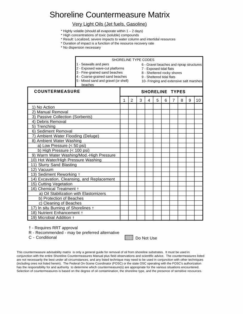
Shoreline Countermeasure MatrixVery Light Oils (Jet fuels, Gasoline)
* Highly volatile (should all evaporate within 1 – 2 days) * High concentrations of toxic (soluble) compounds * Result: Localized, severe impacts to water column and intertidal resources * Duration of impact is a function of the resource recovery rate * No dispersion necessary
1 - Seawalls and piers 2 - Exposed wave-cut platforms 3 - Fine-grained sand beaches 4 - Coarse-grained sand beaches 5 - Mixed sand and gravel (or shell)
beaches
6 - Gravel beaches and riprap structures 7 - Exposed tidal flats 8 - Sheltered rocky shores 9 - Sheltered tidal flats 10- Fringing and extensive salt marshes
SHORELINE TYPE CODES
COUNTERMEASURE SHORELINE TYPES
1) No Action 2) Manual Removal 3) Passive Collection (Sorbents) 4) Debris Removal 5) Trenching 6) Sediment Removal 7) Ambient Water Flooding (Deluge) 8) Ambient Water Washing
a) Low Pressure (< 50 psi) b) High Pressure (< 100 psi)
9) Warm Water Washing/Mod.-High Pressure 10) Hot Water/High Pressure Washing 11) Slurry Sand Blasting 12) Vacuum 13) Sediment Reworking † 14) Excavation, Cleansing, and Replacement 15) Cutting Vegetation 16) Chemical Treatment †
a) Oil Stabilization with Elastomizers b) Protection of Beaches c) Cleaning of Beaches
17) In situ Burning of Shorelines † 18) Nutrient Enhancement † 19) Microbial Addition †
† - Requires RRT approval
1 653 7 9 10
R - Recommended - may be preferred alternative C - Conditional Do Not Use
2 4 8
This countermeasure advisability matrix is only a general guide for removal of oil from shoreline substrates. It must be used in conjunction with the entire Shoreline Countermeasures Manual plus field observations and scientific advice. The countermeasures listed are not necessarily the best under all circumstances, and any listed technique may need to be used in conjunction with other techniques (including ones not listed herein). The Federal On-Scene Coordinator (FOSC) or the state OSC operating with the FOSC's authorization has the responsibility for and authority to determine which countermeasure(s) are appropriate for the various situations encountered. Selection of countermeasures is based on the degree of oil contamination, the shoreline type, and the presence of sensitive resources.

Shoreline Countermeasure Matrix Light Oils (Diesel, No. 2 Fuel Oils, Light Crudes)
* Moderately volatile; will leave residue (up to 1/3 of spilled amount) * Moderate concentrations of toxic (soluble) compounds * Will "oil" intertidal resources with long-term contamination potential * Has potential for subtidal impacts (dissolution, mixing, sorption onto suspended sediments) * No dispersion necessary * Cleanup can be very effective
1 - Seawalls and piers 2 - Exposed wave-cut platforms 3 - Fine-grained sand beaches 4- Coarse-grained sand beaches 5 - Mixed sand and gravel (or shell)
beaches
6 - Gravel beaches and riprap structures 7 - Exposed tidal flats 8 - Sheltered rocky shores 9 - Sheltered tidal flats 10- Fringing and extensive salt marshes
SHORELINE TYPE CODES
COUNTERMEASURE SHORELINE TYPES
1) No Action 2) Manual Removal 3) Passive Collection (Sorbents) 4) Debris Removal 5) Trenching 6) Sediment Removal 7) Ambient Water Flooding (Deluge) 8) Ambient Water Washing
a) Low Pressure (< 50 psi) b) High Pressure (< 100 psi)
9) Warm Water Washing/Mod.-High Pressure 10) Hot Water/High Pressure Washing 11) Slurry Sand Blasting 12) Vacuum 13) Sediment Reworking † 14) Excavation, Cleansing, and Replacement 15) Cutting Vegetation * 16) Chemical Treatment †
a) Oil Stabilization with Elastomizers b) Protection of Beaches c) Cleaning of Beaches
17) In situ Burning † 18) Nutrient Enhancement † 19) Microbial Addition †
† - Requires RRT approval
1 653 4 7 10
R - Recommended - may be preferred alternative C - Conditional Do Not Use
2 9 8
This countermeasure advisability matrix is only a general guide for removal of oil from shoreline substrates. It must be used in conjunction with the entire Shoreline Countermeasures Manual plus field observations and scientific advice. The countermeasures listed are not necessarily the best under all circumstances, and any listed technique may need to be used in conjunction with other techniques (including ones not listed herein). The Federal On-Scene Coordinator (FOSC) or the state OSC operating with the FOSC's authorization has the responsibility for and authority to determine which countermeasure(s) are appropriate for the various situations encountered. Selection of countermeasures is based on the degree of oil contamination, the shoreline type, and the presence of sensitive resources.

Shoreline Countermeasure Matrix Medium Oils (Most Crude Oils)
* About 1/3 will evaporate within 24 hours * Maximum water-soluble fraction is 10 – 100 ppm * Oil contamination of intertidal areas can be severe/long term * Impact to waterfowl and fur-bearing mammals can be severe * Chemical dispersion is an option within 1 – 2 days * Cleanup most effective if conducted quickly
1 - Seawalls and piers 2 - Exposed wave-cut platforms 3 - Fine-grained sand beaches 4 - Coarse-grained sand beaches 5 - Mixed sand and gravel (or shell)
beaches
6 - Gravel beaches and riprap structures 7 - Exposed tidal flats 8 - Sheltered rocky shores 9 - Sheltered tidal flats 10- Fringing and extensive salt marshes
SHORELINE TYPE CODES
COUNTERMEASURE SHORELINE TYPES
1) No Action 2) Manual Removal 3) Passive Collection (Sorbents) 4) Debris Removal 5) Trenching 6) Sediment Removal 7) Ambient Water Flooding (Deluge) 8) Ambient Water Washing
a) Low Pressure (< 50 psi) b) High Pressure (< 100 psi)
9) Warm Water Washing/Mod.-High Pressure 10) Hot Water/High Pressure Washing 11) Slurry Sand Blasting 12) Vacuum 13) Sediment Reworking † 14) Excavation, Cleansing, and Replacement 15) Cutting Vegetation * 16) Chemical Treatment †
a) Oil Stabilization with Elastomizers b) Protection of Beaches c) Cleaning of Beaches
17) In situ Burning † 18) Nutrient Enhancement † 19) Microbial Addition †
† - Requires RRT approval
1 653 7 10
R - Recommended - may be preferred alternative C - Conditional Do Not Use
2 4 9 8
This countermeasure advisability matrix is only a general guide for removal of oil from shoreline substrates. It must be used in conjunction with the entire Shoreline Countermeasures Manual plus field observations and scientific advice. The countermeasures listed are not necessarily the best under all circumstances, and any listed technique may need to be used in conjunction with other techniques (including ones not listed herein). The Federal On-Scene Coordinator (FOSC) or the state OSC operating with the FOSC's authorization has the responsibility for and authority to determine which countermeasure(s) are appropriate for the various situations encountered. Selection of countermeasures is based on the degree of oil contamination, the shoreline type, and the presence of sensitive resources.

Shoreline Countermeasure Matrix Heavy Oils (Heavy Crude Oils, No. 6 fuel, Bunker C) * Heavy oils with little or no evaporation or dissolution * Water-soluble fraction likely to be <10 ppm * Heavy contamination of intertidal areas likely * Severe impacts to waterfowl and fur-bearing mammals (coating and ingestion) * Long-term contamination of sediments possible * Weathers very slowly * Dispersion seldom effective * Shoreline cleanup difficult under all conditions
1 -Exposed wave-cut cliffs 2 - Exposed wave-cut platforms 3 - Fine-grained sand beaches 4 - Coarse-grained sand beaches 5 - Mixed sand and gravel (or shell)
beaches
6 - Gravel beaches and riprap structures 7 - Exposed tidal flats 8 - Sheltered rocky shores 9 - Sheltered tidal flats 10- Fringing and extensive salt marshes
SHORELINE TYPE CODES
COUNTERMEASURE SHORELINE TYPES
1) No Action 2) Manual Removal 3) Passive Collection (sorbents) 4) Debris Removal 5) Trenching 6) Sediment Removal 7) Cold Water Flooding (deluge) 8) Cold Water Washing
a) Low Pressure (< 50 psi) b) High Pressure (< 100 psi)
9) Warm Water Washing/Mod.-High Pressure 10) Hot Water/High Pressure Washing 11) Slurry Sand Blasting 12) Vacuum 13) Sediment Reworking † 14) Excavation, Cleansing, and Replacement 15) Cutting Vegetation * 16) Chemical Treatment †
a) b) c)
17) In situ Burning † 18) Nutrient Enhancement † 19) Microbial Addition †
*† - Requires RRT approval
1 653 4 7 10
R - Recommended - may be preferred alternative C - Conditional Do Not Use
Oil Stabilization with Elastomizers Protection of Beaches Cleaning of Beaches
2 9 8
This countermeasure advisability matrix is only a general guide for removal of oil from shoreline substrates. It must be used in conjunction with the entire Shoreline Countermeasures Manual plus field observations and scientific advice. The countermeasures listed are not necessarily the best under all circumstances, and any listed technique may need to be used in conjunction with other techniques (including ones not listed herein). The Federal On-Scene Coordinator (FOSC) or the state OSC operating with the FOSC's authorization has the responsibility for and authority to determine which countermeasure(s) are appropriate for the various situations encountered. Selection of countermeasures is based on the degree of oil contamination, the shoreline type, and the presence of sensitive resources.
1
2
3
4
5
6
7
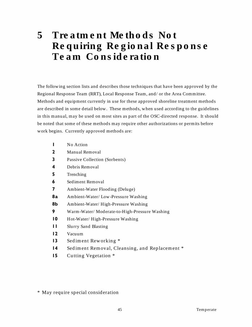
5 Treatment Methods Not Requiring Regional Response Team Consideration
The following section lists and describes those techniques that have been approved by the
Regional Response Team (RRT), Local Response Team, and/or the Area Committee.
Methods and equipment currently in use for these approved shoreline treatment methods
are described in some detail below. These methods, when used according to the guidelines
in this manual, may be used on most sites as part of the OSC-directed response. It should
be noted that some of these methods may require other authorizations or permits before
work begins. Currently approved methods are:
No Action
Manual Removal
Passive Collection (Sorbents)
Debris Removal
Trenching
Sediment Removal
Ambient-Water Flooding (Deluge)
8a Ambient-Water/Low-Pressure Washing
8b Ambient-Water/High-Pressure Washing
9 Warm-Water/Moderate-to-High-Pressure Washing
10 Hot-Water/High-Pressure Washing
11 Slurry Sand Blasting
12 Vacuum
13 Sediment Reworking *
14 Sediment Removal, Cleansing, and Replacement *
15 Cutting Vegetation *
* May require special consideration
45 Temperate

1. No Action Objective
No attempt is made to remove stranded oil, to minimize impacts to the environment
or because there is no proven effective method for cleanup.
Description
No action is taken. However, the OSC continues to monitor the incident.
Applicable Shoreline Types
Can be used on all shoreline types.
When To Use
If the shoreline is extremely remote or inaccessible, when natural removal rates are
very fast, or cleanup actions will do more harm than leaving the oil to be removed
naturally.
Biological Constraints
This method may be inappropriate for areas where high numbers of mobile animals
(birds, marine mammals, crabs, etc.) use the intertidal zone or adjacent nearshore
waters.
Environmental Effects
Intertidal — The same as the oil.
Subtidal — The same as the oil.
2. Manual Removal Objective
Removing stranded surface oil with hand tools and manual labor.
Description
Removing surface oil and oily debris by manual means (hands, rakes, shovels, etc.)
and placing in containers for removal from the shoreline. No mechanized equipment
is used.
Applicable Shoreline Types
Can be used on all shoreline types.
When To Use
Generally used on shorelines where the oil can be easily removed by non-mechanical
means. Most appropriate for light to moderate oiling conditions.
46 Temperate
Biological Constraints
Foot traffic over sensitive areas (shellfish beds, algal mats, bird nesting areas, dunes,
etc.) is to be restricted. May be periods when shoreline access is restricted (e.g., bird
nesting, mammal pupping).
Environmental Effects
Intertidal — Minimal if surface disturbance by cleanup activities and work force
movement is limited.
Subtidal — None.
3. Passive Collection (Sorbents) Objective
Removal of oil by adsorption onto oleophilic material placed in the intertidal zone.
Description
Sorbent material is placed on the surface of the shoreline substrate allowing it to
absorb oil as it is released by tidal or wave action. Oil removal is dependent on the
capacity of the particular sorbent, energy available for lifting oil off the shoreline,
and degree of weathering.
Applicable Shoreline Types
Can be used on any shoreline type, especially riprap and on intertidal vegetation.
When to Use
When the shoreline oil is mobile and transport of oil is expected on or off the site.
The oil must be of a viscosity and thickness to be released by the substrate and
absorbed by the sorbent. Often used as a secondary treatment method after gross
oil removal, and along sensitive shorelines where access is restricted.
Biological Constraints
None, although this method can be slow, thus allowing oil to remain in critical
habitats during sensitive periods of time.
Environmental Effects
Intertidal — None, except for the amount of oil remaining on the shoreline after the
sorbents are no longer effective.
Subtidal — None.
47 Temperate

4. Debris Removal Objective
Removal of contaminated debris and logs.
Description
Manual or mechanical removal of debris from the upper beach face and the zone
above high tide beyond the normal wash of waves. Can include cutting and removal
of oiled logs.
Applicable Shoreline Types
Can be used on any shoreline type where safe access is allowed.
When to Use
When driftwood and debris is heavily contaminated and either a potential source of
chronic oil release, an aesthetic problem, or a source of contamination for other
organisms on the shoreline.
Biological Constraints
Disturbance to adjacent upland areas should be minimized. Foot traffic over
sensitive intertidal areas (shellfish beds, algal mats, bird nesting areas, dunes, etc.) is
to be restricted. May be periods when shoreline access is restricted (e.g., bird
nesting, mammal pupping).
Environmental Effects
Intertidal — None.
Subtidal — None.
5. Trenching Objective
Remove subsurface oil from permeable substrates.
Description
Dig trenches to the depth of the oil and remove oil floating on the water table by
vacuum pump or super sucker. Water flooding or high-pressure spraying at ambient
temperatures can be used to flush oil to the trench.
Applicable Shoreline Types
Can be used on beaches ranging in grain size from fine sand to gravel.
When To Use
When large quantities of oil penetrate deeply into permeable sediments and cannot
be removed by surface flooding. The oil must be liquid enough to flow at ambient
temperatures.
48 Temperate

Biological Constraints
Trenches should not be dug in the lower intertidal when attached algae and
organisms are abundant.
Environmental Effects
Intertidal — On gravel beaches, there may be a period of beach instability as the
sediments are redistributed after the trenches are filled in.
Subtidal — None.
6. Sediment Removal Objective
Removal of surface oiled sediments.
Description
Oiled sediments are removed by either manual use of hand tools or mechanical use
of various kinds of motorized equipment. The oiled material must be transported
and disposed of off-site.
Applicable Shoreline Types
Can be used on any shoreline with surface sediments. On rocky coasts, only manual
removal is feasible. Equipment is to be used only on beaches, with special
supervision to minimize sediment removal.
When to Use
When only very limited amounts of oiled sediments have to be removed. Should not
be considered where beach erosion may result. Care should be taken to remove the
sediments only to the depth of oil penetration, which can be difficult with heavy
equipment.
Biological Constraints
Excavating equipment must not intrude upon sensitive habitats. Only the
upper INTERTIDAL and supratidal areas should be considered FOR SEDIMENT
REMOVAL TO MINIMIZE DISTURBANCE OF BIOLOGICAL COMMUNITIES IN
THE LOWER INTERTIDAL AND SUBTIDAL. There may be site-specific
constraints limiting placement of EQUIPMENT and temporary sediment storage
piles. Replaced material must be free of oil and toxic substances. The washing must
not change the grain size of the replaced material, either by removal of fines or
excessive breakage of friable sediment. SUCH OPERATIONS WOULD BE
GENERALLY RESTRICTED IN FISH-SPAWNING AREAS. ADJACENT AREAS
49 Temperate

POTENTIALLY IMPACTED BY RELEASED OIL SHEENS MUST BE PROTECTED
DURING OPERATIONS.
Environmental Effects
Intertidal — The equipment is heavy, and required support personnel is extensive.
May be detrimental if excessive sediments are removed without replacement. All
organisms resident in the beach will be affected, though the need for removal of the
oil may be determined to be the best overall alternative.
Subtidal — Release of oil and fine-grained oily sediments to the water during
sediment removal activities and tidal flushing of the excavated beach surface.
7. Ambient-Water Flooding (Deluge) Objective
To wash surface oil and oil from crevices and rock interstices to water's edge for
collection.
Description
A large diameter header pipe is placed parallel to the shoreline above the oiled area.
A flexible perforated header hose is used during deluge of intertidal shorelines to
better conform to their profiles. Ambient seawater is pumped through holes in the
header pipes and flows down the beach face to the water. On porous beaches,
water flows through the substrate pushing loose oil ahead of it (or floats oil to the
water's surface) then transports the oil down slope for pickup. Flow is maintained
as long as necessary to remove the majority of free oil. Oil is trapped by booms and
picked up with a skimmer or other suitable equipment.
Applicable Shoreline Types
Beaches with sediments coarser than sand, and gently sloping rocky shorelines.
Generally not applicable to mud, sand, vegetated, or steep rocky shorelines.
When to Use
On heavily oiled shorelines when the oil is still fluid and loosely adhering to the
substrate; and where oil has penetrated into cobble or boulder beaches. This method
is frequently used in combination with other washing techniques (low or high
pressure, ambient or warm water).
50 Temperate

Biological Constraints
Not appropriate at creek mouths. Where the lower intertidal contains rich biological
communities, flooding should be restricted to tidal stages when the rich zones are
under water, to prevent secondary oiling.
Environmental Effects
Intertidal — Habitat may be physically disturbed and smothered as sand and gravel
components are washed down slope. Organisms may be flushed into lower tidal
zones.
Subtidal — Oiled sediment may be transported to shallow subtidal areas,
contaminating them and burying benthic organisms.
8a. Ambient-Water/Low-Pressure Washing Objective
Remove liquid oil that has adhered to the substrate or man-made structures, pooled
on the surface, or become trapped in vegetation.
Description
Low-pressure washing (<50 psi) with ambient seawater sprayed with hoses is used
to flush oil to the water’s edge for pickup. Oil is trapped by booms and picked up
with skimmers or sorbents. Can be used with a deluge system on beaches to prevent
released oil from re-adhering to the substrate.
Applicable Shoreline Types
On heavily oiled gravel beaches, riprap, and seawalls where the oil is still fresh and
liquid. Also, in marshes and mangroves where free oil is trapped.
When to Use
Where adhered oil is still fresh and must be removed due to continued release of oil.
Biological Constraints
May need to restrict use of flushing to certain tidal elevations so that the oil/water
effluent does not drain across sensitive low tide habitats. In marshes, use only at
high tide and either from boats or the high-tide line to prevent foot traffic in
vegetation.
Environmental Effects
Intertidal — If containment methods are not sufficient, contamination may be
flushed into lower intertidal zone.
Subtidal — Oiled sediment may be transported to shallow subtidal areas,
contaminating them and burying benthic organisms.
51 Temperate

8b. Ambient-Water/High-Pressure Washing Objective
Remove oil that has adhered to hard substrates or man-made structures.
Description
Similar to low-pressure washing except that water pressure is up to 100 psi. High-
pressure spray will better remove oil that has adhered to rocks. Because water
volumes are typically low, may require placement of sorbents directly below
treatment areas.
Applicable Shoreline Types
Riprap and seawalls. Can be used to flush floating oil or loose oil out of tide pools
and between crevices on riprap.
When To Use
When low-pressure washing is not effective for removal of adhered oil, which must
be removed due to continued release of oil. When directed water jet can remove oil
from hard-to-reach sites. To remove oil from man-made structures for aesthetic
reasons.
Biological Constraints
May need to restrict use of flushing to certain tidal elevations so that the oil/water
effluent does not drain across sensitive low-tide habitats.
Environmental Effects
Intertidal — Removes many organisms on the surface. May drive oil deeper into the
substrate if water jet is improperly applied. If containment methods are not
sufficient, contamination may be flushed into lower intertidal zone.
Subtidal — Oiled sediment may be transported to shallow subtidal areas,
contaminating them and burying benthic organisms.
9. Warm-Water/Moderate-to-High-Pressure Washing Objective
Mobilize thick and weathered oil adhered to rock surfaces prior to flushing it to the
water’s edge for collection.
52 Temperate

Description
Heated seawater (ambient to 90°F) is applied at moderate to high pressure to
mobilize weathered oil that has adhered to rocks. The warm water may be sufficient
to flush the oil down the beach. If not, "deluge" flooding and additional low- or high-
pressure washing can be used to float the oil to the water’s edge for pickup. Oil is
trapped by booms and picked up with skimmers or sorbents.
Applicable Shoreline Types
Gravel beaches, riprap, and seawalls that are heavily oiled.
When To Use
When the oil has weathered to the point that low-pressure washing with ambient
water is not effective for removal of adhered oil, which must be removed due to
continued release of oil. To remove oil from man-made structures for aesthetic
reasons.
Biological Constraints
Must restrict use to certain tidal elevations so that the oil/water effluent does not
drain across sensitive low-tide habitats (damage can result from exposure to oil,
oiled sediments, and warm water). Should be restricted adjacent to stream mouths,
tide pool communities, and similar rich intertidal communities.
Environmental Effects
Intertidal — Can kill or remove most organisms. If containment methods are not
sufficient, contamination may be flushed into lower intertidal zones that would
otherwise not be oiled.
Subtidal — Oiled sediment may be transported to shallow subtidal areas,
contaminating them and burying benthic organisms.
10. Hot-Water/High-Pressure Washing Objective
Dislodge trapped and weathered oil from inaccessible locations and surfaces not
amenable to mechanical removal.
Description
Water heaters mounted offshore on barges or small land-based units heat water to
temperatures from 90°F up to 170°F, which is usually sprayed by hand with high-
pressure wands. Used without water flooding, this procedure requires immediate
use of vacuum (vacuum trucks or super suckers) to remove the oil/water runoff.
53 Temperate

With a deluge system, the oil is flushed to the water’s surface for collection with
skimmers or sorbents.
Applicable Shoreline Types
Gravel beaches, riprap, and seawalls that are heavily oiled.
When To Use
When the oil has weathered to the point that even warm water at high pressure is
not effective for removal of adhered oil, which must be removed due to continued
release of oil. To remove oil from man-made structures for aesthetic reasons.
Biological Constraints
Restrict use to certain tidal elevations so that the oil/water effluent does not drain
across sensitive low-tide habitats (damage can result from exposure to oil, oiled
sediments, and hot water). Should be restricted near stream mouths, tide pool
communities, etc. Released oil must be recovered to prevent further oiling of
adjacent environments.
Environmental Effects
Intertidal — All attached organisms in the direct spray zone will be removed or
killed, and significant mortality of the lower intertidal communities will result even
when used properly. Where the intertidal community is rich, the tradeoff between
damage to the intertidal community from the hot-water washing versus potential
damage from leaving the oil has to be weighed.
Subtidal — Oiled sediment may be transported to shallow subtidal areas,
contaminating them and burying benthic organisms.
11. Slurry Sand Blasting Objective
Remove heavy residual oil from solid substrates.
Description
Use of sandblasting equipment to remove oil from the substrate. May include
recovery of used (oiled) sand in some cases.
Applicable Shoreline Types
Seawalls and riprap. Equipment can be operated from boat or land.
When to Use
When heavy oil residue is remaining on the shoreline, which needs to be cleaned for
aesthetic reasons, and even hot-water wash is not effective.
Biological Constraints
54 Temperate

Not to be used in areas of oyster/clam beds, or areas with high biological abundance
on the shoreline directly below or adjacent to the structures.
Environmental Effects
Intertidal — Complete destruction of all organisms in the intertidal zone.
Subtidal — Possible smothering of subtidal organisms with sand. When the used
sand is not recovered, introduces oiled sediments into the subtidal habitat.
12. Vacuum Objective
Remove free oil pooled on the substrate or from the water’s surface in sheltered
areas.
Description
Use of a vacuum unit with a suction head to recover free oil. The equipment can
range from small portable units that fill individual 55-gallon drums to large
supersuckers that are truck-mounted and can lift large rocks. Can be used with
water spray systems to flush the oil towards the suction head.
Applicable Shoreline Types
Can be used on any shoreline type if accessible. May be mounted offshore on barges,
onshore on trucks, or as individual units on boats or ashore at low tide.
When to Use
When free, liquid oil is stranded on the shoreline (usually along the high-tide line) or
trapped in vegetation that is readily accessible.
Biological Constraints
Special restrictions should be identified for areas where foot traffic and equipment
operation should be limited, such as rich intertidal communities. Operations in
wetlands are to be very closely monitored, with a site-specific list of restrictions.
Environmental Effects
Intertidal — Minimal impacts if used properly and minimal substrate is removed.
Subtidal — None.
13. Sediment Reworking Objective
Rework oiled sediments to break up the oil deposits, increase its surface area, and
mix deep subsurface oil layers that will expose the oil to natural removal processes
and enhance the rate of oil degradation.
55 Temperate

Description
Beach sediments are rototilled or otherwise mechanically mixed with the use of
heavy equipment on gravel beaches. The oiled sediments in the upper beach area
may also be relocated lower on the beach to enhance natural cleanup during
reworking by wave activity (berm relocation).
Applicable Shoreline Types
Should be used only on beaches exposed to significant wave activity. Tilling-type
activities work best on beaches with a significant sand fraction; large equipment can
be used to relocate sediments up to boulder size.
When to Use
On beaches with significant amounts of subsurface oil, where sediment removal is
unfeasible (due to erosion concerns or disposal problems); also where surface oil
deposits have started to form pavements or crusts.
Biological Constraints
Could not be used on beaches near shellfish-harvest or fish-spawning areas, or near
bird nesting or concentration areas because of the potential for constant release of oil
and oiled sediments. Sediment reworking should be restricted to the upper part of
the beach, to prevent disturbance of the biological communities in the lower intertidal
area.
Environmental Effects
Intertidal — Due to the mixing of oil into sediments, this process could further
expose organisms living below the original layer of oil. Repeated mixing over time
could delay the reestablishment of organisms. Relocated sediments would bury and
kill organisms. There may be a period of beach instability as the relocated sediments
are redistributed.
Subtidal — There is a potential for release of contaminated sediments to the
nearshore subtidal habitats.
56 Temperate
14. Sediment Removal, Cleansing, and Replacement Objective
To remove and clean oiled sediments, then replace them on the beach.
Description
Oiled sediments are excavated using heavy equipment on the beach at low tide. The
sediments are loaded into a container for washing. Cleansing methods include hot
water wash or physical agitation with a cleansing solution. After the cleansing
process, the rinsed materials are returned to the original area. Cleaning equipment
must be placed close to beaches to reduce transportation problems.
Applicable Shoreline Types
Sand- to boulder-sized beaches, depending on the limitations of the cleanup
equipment. The beaches must be exposed to wave activity, so that the replaced
sediments can be reworked into a natural distribution.
When to Use
Applicable on beaches with large amounts of subsurface oil, where permanent
removal of sediment is undesired and other cleanup techniques are likely to be
ineffective.
Biological Constraints
Excavating equipment must not intrude upon sensitive habitats. Only the upper and
supratidal areas should be considered. Generally restricted in spawning areas.
There may be site-specific constraints limiting placement of temporary sediment
storage piles. Replaced material must be free of oil and toxic substances. The
washing must not change the grain size of the replaced material, either by removal of
fines or excessive breakage of friable sediments.
Environmental Effects
Intertidal — All resident organisms will be affected, though the need for removal of
the oil may be determined to be the best overall solution. Equipment can be heavy,
large, and noisy; disrupting wildlife. Transportation to site may entail aircraft, land
vehicles, or barges, contributing to environmental disruption. There may be a period
of beach instability as the replaced sediments are redistributed.
Subtidal — May release oil and fine-grained oily sediments into the water during
excavation. This is a concern due to tidal flushing of beach sediments and exposed
excavations.
57 Temperate

15. Cutting Vegetation Objective
Removal of oiled vegetation to prevent oiling of wildlife.
Description
Manual cutting of oiled vegetation using weed eater, and removal of cut vegetation
with rakes. The cut vegetation is bagged immediately for disposal.
Applicable Shoreline Types
Marshes composed of emergent, herbaceous vegetation.
When to Use
Use when the risk of oiled vegetation contaminating wildlife is greater than the value
of the vegetation that is to be cut, and there is no less destructive method to remove
or reduce the risk to acceptable levels.
Biological Constraints
Strict monitoring of the operations must be conducted to minimize the degree of root
destruction and mixing of oil deeper into the sediments. Access to bird nesting areas
should be restricted during nesting seasons.
Environmental Effects
Intertidal — Removal of the vegetation will result in loss of habitat for many
animals. Cut areas will have reduced plant growth for up to two years. Along
exposed section of shoreline, the vegetation may not regrow, resulting in erosion and
permanent loss of the habitat. Trampled areas (which are inevitable) will recover
much slower.
Subtidal — Long-term impacts would include increased sediment load in the
subtidal area as a result of increased erosion in the intertidal area.
58 Temperate
6 Treatment Methods Requiring Regional Response Team Approval
Research and development is ongoing for both new and improved oil spill treatment
methods. Various chemical and biological degradation techniques are currently being tested
for effectiveness and toxicity, and they may be approved for use in certain situations.
Methods considered to be of potential use in this area are described below.
16a Chemical Oil Stabilization with Elastomizers
16b Chemical Protection of Beaches
16c Chemical Cleaning of Beaches
17 In-situ Burning of Shorelines
18 Nutrient Enhancement
19 Microbial Addition
16a. Chemical Oil Stabilization with Elastomizers Objective
Solidify or gelatinize oil on the water’s surface or a beach to keep it from spreading
or escaping, and to speed recovery rate and efficiency.
Description
Chemical agent enhancing polymerization of the hydrocarbon molecules applied by
semi-liquid spray or as a dry chemical onto the oil in the proper dosage. Depending
on the nature and concentration of the polymerizing agent, the oil can be rendered
viscoelastic, but still fluid, gelatinous, or semisolid. The primary purpose is to
stabilize the oil, keeping it from spreading or escaping, causing oiling elsewhere. May
reduce the solubility of the light (and more toxic) fractions, by locking them into the
polymer. This reduces both air and water exposure. Depending on the beach type
and equipment used, recovery may be enhanced.
59 Temperate

Applicable Shoreline Types
Suitable on shorelines of low permeability where heavy oil has pooled on the surface,
except vegetated shorelines.
When to Use
When heavy concentrations of liquid oil are on the substrate and adjacent water
body, and physical removal can not be completed prior to the next tide so that the
oil is likely to move to a more sensitive shoreline type. Should be used in conjunction
with booming or other physical containment.
Biological Constraints
Not suitable for vegetated or riprap shore types. Should be avoided when birds or
other wildlife that may be more adversely impacted by the congealed oil can not be
kept away from the treated shoreline. The congealed oil may stick to vegetation and
wildlife, increasing physical damage to both. On riprap the congealed oil may
remain in crevices where it may hamper recovery and prolong the release of sheens.
Environmental Effects
May enhance the smothering effect of oil on intertidal organisms. Thus, the
treatment should be considered only for heavily oiled beaches where smothering
effects are already maximal. The congealed oil may stick to vegetation and wildlife
increasing physical damage, such as impaired flight in birds or impaired
thermoregulation in mammals and birds whose feathers or fur become oiled.
16b. Chemical Protection of Beaches Objective
Pretreat shoreline to prevent oil from adhering to the substrate.
Description
Certain types of water-based chemicals, some of which are similar in composition to
dispersants, are applied to beaches in advance of the oil.
Applicable Shoreline Types
Coarse- and fine-grained sand beaches, seawalls and piers (particularly piers or
waterfront facilities that are of historical significance), eroding bluffs, wave-cut
platforms, and riprap.
When to Use
When oil is projected to impact an applicable shoreline, particularly those that have
high recreational or aesthetic value.
60 Temperate

Biological Constraints
May not be suitable for nutrient-rich environments, particularly in confined waters.
The toxicity of shoreline treatment products is reportedly much less than that of oil,
but the toxicity of each product should be evaluated prior to consideration for use.
Environmental Effects
The long-term environmental effects of these procedures are unknown. A toxic effect
of the chemical can be anticipated. Additionally, the nutrient load to nearshore and
interstitial waters may lead to eutrophication. Whether the predicted reduced
residence time of the oil on the beach will increase the survival rate for sessile and
interstitial organisms is unknown.
16c. Chemical Cleaning of Beaches Objective
To increase the efficiency of oil removal from contaminated areas.
Description
Special formulations, which can be characterized as weak dispersants, are applied
to the substrate, as a presoak and/or flushing solution, to soften weathered or heavy
oils to aid in the efficiency of flushing treatment methods. The intent is to be able to
lower the temperature and pressure required to mobilize the oil from the substrate.
Applicable Shoreline Types
On any shoreline where deluge and water flushing procedures are applicable.
When to Use
When the oil has weathered to the point where it will not flow using warm to hot
water. This approach may be most applicable where flushing decreases in
effectiveness as the oil weathers.
Biological Constraints
Will require extensive biological testing for toxicity and water quality sampling prior
to receiving approval for use. The concern is that the treated oil will be dispersed in
the water column, and thus impact water column and subtidal organisms. Field
tests will be required to show that use of a beach cleaner does not reduce overall
recoverability of the oil. Use may be restricted where suspended sediment
concentrations are high, adjacent to wetlands and tidal flats, and near sensitive
subtidal resources.
Environmental Effects
61 Temperate

If more oil is dispersed into the water column, there could be more oil sorbed onto
suspended sediments and transferred to subtidal habitats, particularly along
sheltered shorelines. Intertidal habitats might survive better, if cooler water
temperatures are possible.
17. In Situ Burning of Shorelines Objective
Removal of oil from the shoreline by burning.
Description
Oil on the shoreline is burned, usually when it is on a combustible substrate such as
vegetation, logs, and other debris. Oil can be burned off of nonflammable substrates
with the aid of a burn promoter.
Applicable Shoreline Types
On any shoreline type except tidal flats.
When to Use
Early in the spill event, after ensuring that the product is ignitable.
Biological Constraints
Should only be considered for use in the upper intertidal or supratidal zones since
destruction of plants and animals from heat and burn promoters will be extensive.
This technique is subject to restrictions and permit requirements established by
federal, state and local laws. It should not be used to burn PCBs, wastes containing
more than 1,000 parts per million (ppm) of halogenated solvents, or other
substances regulated by the U. S. Environmental Protection Agency (EPA).
Environmental Effects
Little is known about the relative effects of burning oiled wetlands compared to
other techniques or natural recovery. Burning may cause significant air pollution,
which must be considered when weighing the potential benefits and risks of the
technique. The combustion products may travel great distances before deposition.
18. Nutrient Enhancement Objective
To speed the rates of natural microbial degradation of oil by addition of nutrients
(specifically nitrogen and phosphorus). Microbial biodegradation is the conversion
by microorganisms of dissolved and dispersed hydrocarbons into oxidized products
via various enzymatic reactions. Some hydrocarbons are converted to carbon
62 Temperate
dioxide and cell material, while others are partially oxidized and/or left unaltered
as a residue.
Description
Nutrients are applied to the shoreline in one of several methods: soluble inorganic
formulations that are dissolved in water and applied as a spray at low tide,
requiring frequent applications; slow-release formulations that are applied as a solid
to the intertidal zone and designed to slowly dissolve; and oleophilic formulations
that adhere to the oil itself, thus they are sprayed directly on the oiled areas.
Applicable Shoreline Types
Could be used on any shoreline type where safe access is allowed.
When to Use
On moderately to heavily oiled shorelines, after other techniques have been used to
remove as much oil as possible; on lightly oiled shorelines where other techniques are
not effective; and where nutrients are a limiting factor in natural degradation.
Potentially for the treatment of subsurface oil.
Biological Constraints
Not applicable in shallow water, poorly flushed, restricted embayments where
nutrient overloading may lead to eutrophication, or where toxicity of nutrients,
particularly ammonia, is of concern. There must be no risk of oxygen depletion. Use
is to be restricted adjacent to stream mouths, tide pools, etc. Contact toxicity of
oleophilic formulations may restrict areas of direct application. Bioassay test results
should be carefully evaluated, as other chemicals in the formulations could be toxic
to aquatic organisms.
Environmental Effects
Tests in Alaska showed that interstitial oxygen concentrations did not decrease to
such an extent that it limited the supply of oxygen available to the bacteria. The
fertilizer applications that increased nutrient concentrations and microbial activity
did not harm the nearshore environment. About 99 percent of butoxyethanol, a toxic
component of the Inipol formulation, (the fertilizer commonly used in Alaska)
degraded to nontoxic compounds within 24 hours after Inipol treatments of cobble
shorelines. Inipol was initially toxic to intertidal organisms directly contacted during
application. Researchers also found no evidence that the nutrients released from the
treated shorelines stimulated algal blooms.
19. Microbial Addition
63 Temperate

Objective
To speed the rates of natural microbial degradation of oil by addition of nutrients
and microbial products. Microbial biodegradation is the conversion by
microorganisms of dissolved and dispersed hydrocarbons into oxidized products
via various enzymatic reactions. Some hydrocarbons are converted to carbon
dioxide and cell material, while others are partially oxidized and/or left untouched
as a residue.
Description
Formulations containing hydrocarbon-degrading microbes and fertilizers are added
to the oiled area. The argument is made that indigenous organisms will be killed by
the oil, so new microbial species need to be added to begin the process of
biodegradation. To date, microbial addition has not been shown to work better than
fertilizer alone in field tests.
Applicable Shoreline Types
Could be used on any shoreline type where safe access is allowed.
Biological Constraints
Not applicable in shallow water, poorly flushed, restricted embayments where
nutrient overloading may lead to eutrophication, or where toxicity of nutrients,
particularly ammonia, is of concern. There must be no risk of oxygen depletion. Use
is to be restricted adjacent to stream mouths, tide pool communities, etc. Bioassay
test results should be carefully evaluated, as other chemicals in the formulation could
be toxic to aquatic organisms.
Environmental Effects
Yet to be evaluated for full-scale field applications.
64 Temperate

Appendix A
Guidelines For Treatment Operations
General Guidelines Ensure familiarity and compliance with approved treatment methods, approved shoreline
segment work plans, advisories, and special instructions. Restrict all access to wetlands and
tidal flats, except with special authorization.
Conditions to avoid
• Treatment techniques (such as high pressure and hot water) that dislodge intertidal
vegetation and invertebrates, e.g., mussels, barnacles, snails
• Clearing marshes and vegetated shorelines (the presence of algae does not
characterize a vegetated shoreline)
Actions to encourage
• Boom off mud/grass flat adjacent to treatment areas to prevent further
contamination.
• Boom off tidal creeks to prevent further contamination.
• Minimize impact to uncontaminated lower intertidal zones, including:
- land crews during tides that cover the lower intertidal zone
- avoid high-/low-pressure washing where possible
- work heavily oiled upper beach zone hen lower intertidal zones are covered by
high tides
- employ sorbents along riprap and below oiled upper beach to protect lower
intertidal zone from oiling
Ensure that all signs of human activity are removed when cleanup is completed. Ensure that all
trash and wastes are removed daily:
• Oil trapped in booms must be picked up before the next tide cycle
• All food and associated trash must be removed each day to minimize attracting
wildlife into contaminated areas
A-1

Guidelines Specific to Biological Resources Advisories and special instructions may address:
• bird concentration areas (nesting sites, colonies, rookeries, etc.)
• live/dead animal collection policy
• protection of cultural resources
• marine mammal haulouts
• collection of eagle feathers and marine mammal parts
• cutting bull kelp
• cutting oiled fucus
Appendix B includes existing “best management practices” for specific issues addressed during
previous spills, which can be used as the basis for developing regional guidelines.
A-2

Appendix B
Best Management Practices
Specialized Areas of Concern - National (The following notices are provided as guidelines.)
Marine Mammal Notice
Collection of Eagle Feathers and Marine Mammal Parts
Protection of Cultural Resources
Cutting of Oiled Bull Kelp
Cutting of Oiled Fucus (Popweed)
Instruction for the Disposition of Dead and Live Wildlife
B-1

Marine Mammal Notice(Developed by NOAA in 1989 during the Exxon Valdez oil spill.)
To reduce stress caused by unnecessary disturbance to marine mammal haulouts and
improve the changes for wildlife survival, an aircraft advisory is issued for coastal areas
affected by the spill. These advisories request that pilots stay at least one-half mile
offshore and 1000 feet above ground level from areas of wildlife concentrations and
critical habitats. These areas are shown on maps and distributed to pilots. The most
critical areas to avoid are: (list critical areas).
No person, except an authorized government official, will approach, molest, or take a
seal or sea lion, regardless of whether the animal is oiled, distressed, lethargic, or
abandoned. This reminder is necessitated by the widespread activities of oil spill
cleanup personnel in areas where seals and sea lions are giving birth to pups. Although
casual and distant human/marine mammal interactions may not always be avoidable,
they are, to varying degrees, harmful to the animal. The following explanation and
guidance with respect to seal pups is offered in the interest of avoiding law violations
and minimizing human-induced mortality among marine mammals.
Live seal pups are to be left undisturbed, whether or not they have oil on them. A pup not
accompanied by an adult and/or appearing emaciated may not be abandoned. Females
commonly leave their pups alone for extended periods during foraging trips. Newborn and
young pups appear emaciated before acquiring fat through nursing. It is not possible to
distinguish between a normal pup and one that is truly distressed. In the presence of
humans, female seals may only approach their pups at night to nurse them, making
determination of abandonment difficult to establish. True abandonment is unlikely, barring
death or serious injury to the mother.
Pup deaths will greatly increase if oiled animals are picked up and subjected to the stress of
handling, transport, and rehabilitation centers. Unlike sea otters and birds, external oiling
does not adversely affect a seal’s heat conservation ability or indicate a need for human
assistance. Persons finding seals, sea lions, whales, or porpoises that appear to be in
distress should contact NOAA Fisheries. Do not touch or closely approach these animals.
B-2

Collection of Eagle Feathers and Marine Mammal Parts In response to inquiries about collecting eagle feathers and marine mammal parts by
personnel involved in cleanup activities during a spill, the laws and regulations dealing
with the collection and possession of such materials are summarized below.
Collection of Eagle Feathers: The Eagle Act (Public Law 95-616, 92 Stat. 3114, 16 U.S.
Code 668) prohibits the collection and possession of any eagle parts, including feathers.
Collection of Marine Mammal Parts: The Marine Mammal Protection Act of 1972
(Public Law 92-522, 88 State. 1027, 95 Stat. 979, 16 USC 1372) generally prohibits the
collection and possession of any marine mammal parts. Under 50 CFR 18.26, the
collection of certain dead marine mammal parts is allowed, as follows:
a. Any bones, teeth or ivory of any (non-endangered) dead marine mammal
may be collected from a beach or from land within 1/4 of a mile of the ocean.
The term “ocean” includes bays and estuaries.
b. Marine mammal parts so collected may be retained if registered within 30
days with an agent of the National Marine Fisheries Service, or an agent of
the U.S. Fish and Wildlife Service.
c. Registration shall include (1) the name of the owner, (2) a description of the
article to be registered, and (3) the date and location of collection. Items so
collected and registered must be retained in the ownership of the collector.
The sale of such items is prohibited.
B-3

Protection of Cultural Resources Shoreline cleanup operations have the potential for damaging important archaeological
and cultural resources. Authorized shoreline cleanup procedures may uncover
undiscovered archaeological features or artifacts. To assist in their identification,
drawings of the types of artifacts that might be found in the intertidal zone and along
the shoreline by cleanup crews are included. Cleanup personnel should be aware of the
policy that anyone found vandalizing or appropriating cultural materials will be subject
to full prosecution under the Archaeological Resources Protection Act. If response
personnel find any cultural resources (fossils, archaeological or historical artifacts), the
following steps should be taken immediately:
1. Leave the cultural materials in place at the site of discovery and mark
with flagging tape.
2. Stop cleanup activities in the surrounding area.
3. Inform a designated state representative.
B-4

Cutting of Oiled Bull Kelp (Nereocystis luetkeana) as a Technique for Releasing and Recovering Trapped Oil (Based on research by NOAA conducted during the Tenyo Maru oil spill, off the coast of
Washington, 1991)
Although bull kelp is an annual, with much of a year's growth typically removed by
seasonal storms, Dr. Sandra Lindstrom, a phycologist with the University of British
Columbia, cautions that removal of the upper portion of the stipe removes the entire
active reproductive area of the plant, which is located in the fronds. Bull kelp
reproduces by the production of spore cases, which drop to the bottom and
subsequently grow into the following season's plants. If cutting is to take place, it
should be limited to the fronds, leaving a portion on the plant, which would permit it to
nominally survive. Cutting the stipe effectively kills the plant.
Cutting kelp beds abruptly changes the light regime on the seafloor below. This may
have implications in that growth of young kelp plants is light-mediated, and an increase
in light reaching the bottom may result in earlier growth than would otherwise occur.
Secondary ecological impacts of kelp removal should be carefully considered before
arriving at a decision about cutting the near-surface portions of plants. The canopy
provided by the kelp stipes and blades represents important habitat for fish species
such as greenlings and rockfishes (a study in California counted 23 species of fish in a
bull kelp bed) and substrate for organisms that are important prey items for fish.
Should cutting take place, cutting the upper portion of the plants is preferable to
removing the entire plant, and cutting only the blades and leaving the stipe intact is
preferable to removing the gas-filled bulb. Decisions will necessarily balance removal of
oil from the environment with direct impacts on the plants and alteration of significant
nearshore habitat.
Commercial harvesting equipment similar to that routinely employed in California
coastal waters is a possibility, but Nereocystis is substantially different in nature than
Macrocystis. If they worked, such harvesting barges would cut through the stipe and kill
the plant. Whether they are capable of cutting the stipe is not known. Support logistics
for kelp cutting could be expected to be substantial as well: the large biomass of kelp
B-5

would require either vessels with considerable hold capacity, or barges on which the
plants could be loaded.
B-6

Cutting of Oiled Fucus (Popweed) (Developed by NOAA in 1989 during the Exxon Valdez oil spill)
The cutting of heavily oiled fucus still attached to the substrate in the intertidal zone is
sometimes suggested during shoreline cleanup efforts. At issue is the benefit derived
from removing a source of contamination compared with the costs to intertidal systems
from fucus removal. Fucus defines the mid-intertidal zone and provides shelter and
attachment for other animals. The spores, primarily the very small plants, are a sources
of food for other animals. The plants are prone to breaking loose in exposed settings
and may end up on the beach or in the water. The average half-life of fucus plants is six
months, with the large, older overstory plants being up to five years old (in Prince
William Sound).
Fucus is a particularly hardy species with respect to oiling. Mortality may occur as a
result of the oil preventing photosynthesis from occurring, but it is extremely difficult to
determine if a plants is dead or alive by looking at it when oiled. Reproduction in fucus
is through the release of spores from buoyant reproductive receptacles that look like
small air sacs located on the tips of the plant. The presence of mucus coming out of
these receptacles when exposed during low tide indicates that the plant is fertile.
Recruitment comes primarily from spores released by plants located no more that three
to ten feet away and occurs quite readily as long as sufficient numbers of other fucus
plants are in the area. In the absence of other fucus plants, drift spores do come along,
but recruitment from this source is very haphazard and not at all guaranteed.
Cutting oiled fucus still attached to the rock is generally not recommended. Flushing
(ambient water) and other cleanup techniques should be tried first. If it is deemed
necessary to remove heavily oiled fucus to prevent redistribution to very sensitive
resources, a sufficient number of mature plants should be left in the area to facilitate
recruitment (in patches or fringe three to ten feet apart). If this is not done, recruitment
may not take place. It is not necessary to leave the holdfasts when cutting plants.
B-7

Instruction for the Disposition of Dead and Live Wildlife (Derived from the Wildlife Protection Guidelines, Alaska RRT, 1991)
Dead Animals
1 Collect all dead animals (except whale and other large forms), including
scavenged carcasses, to discourage further scavenging in oiled areas.
2 Wear gloves when handling dead animals.
3 Use a shovel or spade to uncover and remove carcasses partially covered by
sand, kelp, wood, or other debris.
4 Place carcasses in double plastic garbage bags. Place all animals from one
beach in one bag, if possible. Close securely with masking tape.
5 Complete an animal collection form or provide the following information:
- beach name or location where carcasses were recovered
- date
- name and address of collector
- species, age, and sex of collected animals .
If any of this information is not available or questionable, this fact should
be recorded so that additional examinations of the animals can be
conducted.
6 Place the form or list in a ziplock baggie and place the baggie outside the first
garbage bag but inside the second. Bring the dead animals to a designated
recovery site
Live Animals
Authorization for animal rescue must be given by the appropriate State or Federal
agency prior to the rescue and rehabilitation of oiled wildlife. Long-handled nets, rags,
or towels are recommended for capturing live, oiled birds. Wear gloves to keep from
getting oiled. Do not wash oiled birds. It is more important to keep them warm. Place
them in a covered cardboard box. It is okay to keep more than one bird and multiple
species in the same box. Do not attempt to give birds fluids; they should be taken to a
rehabilitation center as soon as possible. For live birds, the following information should
be reported:
- beach name or location where animal was recovered
- date and name and address of collector
- species, age, and sex of collected animals
B-8
- condition of the animal
Do not attempt capture of live sea otters without prior authorization from the
appropriate agency. Inexperienced people can cause otters additional injuries. In
addition, otters may bite and cause infections. A bite from an otter may result in
inflammation of the joints and inability to bend one’s fingers. Live, oiled otters are to be
reported to the designated agency contact for the spill.
B-9

Appendix C
NOAA Scientific Support Coordinators For more information about developing and applying shoreline countermeasures, contact
the appropriate NOAA Scientific Support Coordinator for your area.
District Address Phone 1 Stephen Lehmann NOAA SSC HAZMAT (w) 617-223-8016
First CG District (mer) (fax) 617-439-0468 408 Atlantic Ave Boston, MA 02110
1/5 NOAA SSC HAZMAT (w) 212-668-6428 Ed Levine Building 100, Box 2 (fax) 212-668-6370
Governors Island New York, NY 10004-5000
2/9 NOAA SSC HAZMAT (w) 216-522-7760 Bill Sites c/o USCG Marine Safety Division (fax)216-522-7759
AJC Federal Bldg. 1240 E. 9 St. Rm 2157 Cleveland, OH 44199
5 NOAA SSC HAZMAT (w) 804-898-2320 Gary Ott USCG RTC Yorktown (t-mer) (fax) 804-898-2296
Yorktown, VA 23690-5000
7 NOAA SSC HAZMAT (w) 305-530-7931 Brad Benggio Miami Federal Build Rm 1123 (fax)305-530-7932
51 S.W. First Ave, PO Box 83 Miami, FL 33130
8 NOAA SSC HAZMAT (w) 504-589-6271 Ilene Byron Cdr Eighth CG District (m-ssc) (fax)504-589-4999
Hale Boggs Federal Bldg 501 Magazine St., Rm. 1341 New Orleans, LA 70130-3396
11 NOAA SSC HAZMAT (w) 310-980-4107 Scott Stolz 501 West Ocean Blvd. Rm 5110 (fax) 310-980-4109
Long Beach, CA 90802
13/14 NOAA/HAZMAT (w) 206-526-6829 Sharon Christopherson 7600 Sand Point Way N.E. (fax) 206-526-6329
Seattle, WA 98115-0070
C-1

District Address Phone 17 NOAA SSC HAZMAT (w) 907-271-3593 John Whitney Peterson Towers Bldg (fax) 907-271-3139
510 L Street, Ste #100 Anchorage, AK 99501
C-2

Glossary
Aerobic
Able to live or grow only where free oxygen is present.
Anaerobic
Able to live and grow where there is no air or free oxygen.
Annual
A plant that lives only one year or season.
Aromatic
Organic compounds containing any of a series of benzene ring compounds. They are
unsaturated organic ring compounds with low boiling points and are generally toxic to
aquatic life.
Benthos
The plants and animals that live in and on the bottom of a water body.
Berm
A wedge-shaped sediment mass built up along the shoreline by wave action. Sand berms
typically have a relatively steep seaward face (beach face) and a gently sloping surface
(berm top). A sharp crest (berm crest) usually separates the two oppositely sloping planar
surfaces on top of the berm. Berms on sand beaches are eroded away during storms, thus a
berm may not be present if the beach is visited shortly after a storm. On gravel beaches,
however, steep and high storm berms are activated and refurbished during storms.
Biota
Animal and plant life characterizing a given region. Flora and fauna, collectively.
D-1

Booms
Both containment and absorbent booms are used for the collection, deflection, and
containment of spreading oil. Containment booms are somewhat rigid structures extending
both above and below the water acting as barriers to surface oil. Primary containment
booms are usually deployed close to oiled shorelines to trap oil being flushed from beaches
before it is collected. Secondary containment booms are deployed farther out to trap oil that
leaks past primary booms. Absorbent boom is used along the shore-water interface to
collect oil dislodged during treatment operations. It is important that absorbent boom be
changed once the sorbent capacity is reached. Great care should be taken to seal the shore
ends of booms so that no oil can get past. This is particularly difficult at rocky shorelines, or
areas strewn with boulders and cobbles. The use of absorbent pads or other materials, such
as “pom poms”, can be effective sealants.
Brackish
Intermediate in salinity (0.50 to 17.00 parts per thousand) between sea water and fresh
water.
Clam shell
A mechanical device mounted at the end of a crane that picks up soil or mud with a pincer-
like movement.
Coagulating agent
Chemical additives applied to oil to form a more cohesive mass.
Contact period
The time required to maximize the efficiency of the sorbent or chemical agent or the time
before plant or animal damage occurs.
Dispersant
Chemical agent used to disperse and suspend oil in water leading to enhanced
biodegradation.
Distillate
A refined hydrocarbon obtained by collection and condensation of a known vapor fraction
of the crude oil.
D-2

Drag line
A mechanical device that excavates or transports soil, using a container pulled over earth by
cables or chains.
Dredge
A device used to remove sediment from the bottom of a water body.
Emulsification
The process by which oil is mixed with water.
Endless rope
A continuous rope-like oil sorbent device that is pulled across the surface of the water to
pick up oil.
Erosion
The wearing away by action of water or wind of unprotected or exposed earth.
Estuary
Classic definition A drowned river valley that has a significant influx of fresh water
and is affected by the tides. Most of the coastal water bodies in the mid-Atlantic region are
estuaries (e.g., Chesapeake Bay, Delaware Bay).
Evaporation
The conversion of a fluid—including hydrocarbons—to a gaseous state.
Fast ice
Any sea ice that forms along and remains attached to the coast, or that forms between
grounded ice bergs, or is attached to the bottom in shallow waters. May form in situ from
seawater or by freezing of pack ice to the shore. It may extend a few meters to several
hundred kilometers from the shore.
Fertilizer
A substance or agent that helps promote plant or seed growth.
Flash point
The lowest temperature at which vapors from a volatile liquid (e.g., oil) will ignite.
D-3

Flushing
Use of a water stream to make oil flow to a desired location or recovery device.
Fouling
Accumulation of oil or other materials, such as debris, that makes a device inoperative.
Free oil
See mobile oil.
Gelling agent
See coagulating agents.
Habitat
The chemical, physical, and biological setting in which a plant or animal lives.
Herding agent
Chemical agent that confines or controls the spread of a floating oil film.
Intertidal
The part of the shoreline that lies between high-tide and low-tide water levels.
Lagoon
A shallow, linear, and usually oblong water body, located parallel with and connected to a
larger water body by one or more inlet channels.
Landfill
A dump that has progressive layers of waste matter and earth.
Marsh fringe
The edge of the marsh adjacent to the water.
Migration
Seasonal movement of a group of animals from one location to another.
D-4

Mobile oil
Oil that can refloat when water is applied (as in high tide).
Mobilization
Movement of oil caused by physical forces, such as gravity, tides, or wind. Mobility of oil is
limited by its viscosity.
Mousse
A type of oil/water emulsion.
Non-persistent
Decomposed rapidly by environmental action.
Oil/water separator
A device for separating oil from water.
Oleophilic
A material that has affinity for oil.
Paraffin
The waxy saturated component of crude oil, having relatively high boiling point and low
volatility. Any member of the methane series having the general formula CnH2n+2.
Penetration
Downward motion of oil into sediments from the surface driven by gravitational forces.
Perennial
Vegetation that continues to grow for several years.
Permeability
The degree to which fluids can flow through a substance. Measured in Darcys.
Permeability is not equal to porosity. High porosity of a material does not insure high
permeability. However, a substance cannot be permeable without having some degree of
porosity.
D-5

Physiography
General term for the shape of the earth’s surface.
Pooled oil
Oil thickness exceeds one centimeter. This need not be uniform.
Porosity
The volume of void spaces in a sediment mass, measured in percent.
Riprap
(a) A layer of large, durable fragments of broken rock, specially selected and graded, and
thrown together irregularly or fitted together. Its purpose is to prevent erosion by waves or
currents and thereby preserve the shape of a surface, slope, or underlying structure. It is
used for irrigation channels, river-improvement works, spillways at dams, and revetments
for shore protection. (b) The stone used for riprap.
Recontamination
Contamination by oil of an area that was previously cleaned.
Rhizome
A rootlike stem under or along the ground, ordinarily in a horizontal position, which
usually sends out roots from its lower surface and leafy shoots from its upper surface.
Salt pan
A pool above high tide, “drained” only by evaporation so that salt is accumulated and
concentrated.
Seine
A fish net that can be used to collect sorbent or debris.
Skimmer
A mechanical device that removes an oil film from the water surface.
Oil skimmers collect oil spilled on, or released to, the water's surface. They come in a wide
range of shapes and sizes. Skimmers generally have a higher recovery rate than sorbents,
providing enough oil is present to justify the costs for its use. Skimmers are usually
D-6

equipped with storage space for collected oil. Oil is herded to a collection point along a
containment boom located close to shore yet in water of sufficient depth for the skimmer to
function. Two types of skimmers currently in use are described below. Other types of
skimmers are being tested for possible use at a later date.
Band, or “Rope,” skimmers use an oleophilic material such as polypropylene. Oil is
collected by a floating, continuous rotating band or “rope” drawn through an oil slick
or along the water’s edge of a contaminated area. Adhered oil is wrung from the band
by a squeeze roller and collected in an oil sump. These bands are used in either static
(stationary) or dynamic (towed) modes. Bands can be torn by solids or skimmed
debris. Efficiency is high in calm waters, poor in choppy waters and waves.
Belt skimmers use an oleophilic belt mounted on the front of a small vessel. The
oleophilic belt pushes the floating oil below the waterline. Oil not adsorbed by the belt
is collected into a holding area located behind the belt. Oil carried up the belt is
recovered at the top of the system by a squeeze belt or scraper blade. It is then
pumped into a storage container. These skimmers can not operate in shallow waters
or tight areas.
Slurry
A suspension of particles in water.
Solubility
The amount or fraction of a substance (e.g., oil) that dissolves into the water column,
measured in ppm.
Solvent
A chemical agent that will dissolve oil.
Specific gravity
The measure of the density of a substance such as oil or sea water, usually determined at
20°C, compared to the density of pure water at 4°C. Thus, specific gravity varies slightly
with temperature.
D-7

Sorbent
All sorbent materials work on the same principles—oil adheres to the outside of the material
or sorbs into the material by capillary action. There are three basic types of sorbent
materials: mineral based, natural organic, and synthetic organic. Currently, only synthetic
organic sorbents are being used in the field in the form of booms, pads, and mops. Peat is
currently in the testing and demonstration phase.
Stain
Oil that is visibly present but cannot be scraped off with a fingernail.
Substrate
The substance, base, or nutrient on which, or the medium in which, an organism lives and
grows, or the surface to which a fixed organism is attached; e.g., soil, rocks, and water.
Substrate penetration
Vertical distance from surface to where oil has percolated into the substrate.
Subtidal
That part of the coastal zone that lies below the lowest low-tide level, so that it is always
underwater.
Sump
A pit or reservoir that serves as a drain from which oil can be collected.
Supratidal
Above the normal high-tide line.
Tank barge
A barge for transporting liquids.
Tarballs
Lumps of oil (<10 cm in diameter) weathered to a high density semisolid state.
Tidal variation or range
The vertical distance between high and low tides.
D-8

Toxicity
The inherent potential or capacity of a material (e.g., oil) to cause adverse effects in a living
organism (Rand and Petrocelli, 1985).
Viscosity
Flow resistance; referring to internal friction of a substance (e.g., oil) that is a function of the
oil type and temperature.
Vacuum systems
Used to recover oil collected behind containment booms along the beach face and in the
water during shoreline flushing operations. Where equipment access allows, vacuums can
be used to remove pools of oil directly from shorelines and surfaces of heavily oiled rocks.
Two vacuum systems currently in use are described below.
The first system is classified as a vacuum device, but requires a high-velocity air
stream, @ 150 mph, to draw oil, water, and debris into the unit's collection chamber.
Due to the 6- to 12-inch diameter of the inlet hose, it rarely becomes clogged by debris.
The inlet nozzle should always be placed slightly above (never below) the fluid’s
surface. The distance at which it is held above the fluid is critical to limit the amount
of water intake. This system is suitable for picking up weathered oil, tar balls, and
mousse from water or shorelines, and to vacuum oil from skimming vessels, boomed
areas, or debris-laden sites. The primary advantage is its ability to pick up oil of any
viscosity and, where necessary, lift fluid more than 30 feet. The system can pick up
and decant simultaneously. The main disadvantages are that it usually picks up a
high water/oil ratio, and can be difficult to repair in the field.
The second system, barge-mounted vacuum trucks, use high-suction pumps and a
cylindrical chamber capable of sustaining very low internal pressure, i.e., minus 12 psi.
Vacuum is created in the chamber, and a 3- to 4-inch diameter hose is usually placed
slightly below the surface of a floating oil slick, allowing a mixture of water and oil to
enter the collection chamber. The position of the open end of the vacuum hose is
critical. If it is placed too far down into the oil slick, recovered fluid will be mostly
water; if not deep enough, air will be sucked into the system, and much of the vacuum
will be lost. The primary advantages of the vacuum truck system are: it can recover
fluid of nearly any viscosity; it has a rapid pickup rate of thick oil layers; and it can
recover a wide variety of small debris. Primary disadvantages are its limited lift, no
D-9

more than 20 to 30 feet, and the length of time required to reestablish a vacuum if air
enters the hose. As with the other vacuum, this one also picks up a high water/oil
ratio.
Weathering
Natural influences such as temperature, wind, and bacteria that alter the physical and
chemical properties of oil.
Weir
A vertical barrier placed just below the surface of the water so that a floating oil slick can
flow over the top.
Wetlands (as defined by the Annotated Code of Maryland Title 9)
State wetlands: Lands below the mean high-tide line affected by the regular rise of tide.
Private wetlands: Lands bordering on state tidal wetlands, below the mean tide line subject
to the effects of the regular rise and fall of tide. Lands able to support growth of wetland
vegetation.
Lands transitional between terrestrial and aquatic systems where the water table is usually
at or near the surface, and is at least periodically saturated with or covered by water
(Cowardin et al., 1979).
Wrack
Accumulations of plant debris that is deposited at or above the high-tide line (e.g., Spartina
or kelp debris).
D-10

Bibliography
American Petroleum Institute. 1982. Oil Spill Response: Options For Minimizing Adverse
Ecological Impacts. Publication No. 4398. Washington, D.C.: American Petroleum Institute.
98 pp.
Bobra, M., P. Kawamura, M. Fingas, and D. Velicogna. 1987. Laboratory and mesoscale
testing of Elastol and Brand M demoussifer. Proceedings of the 10th Arctic and Marine Oil Spill
Program Technical Seminar, June 9-11, 1987. Edmonton, Alberta, Canada. pp. 223-241.
Breuel, A. 1981. Oil Spill Cleanup and Protection Techniques for Shorelines and Marshlands.
Park Ridge, New Jersey: Noyes Data Corp. 404 pp.
Cairns, J., Jr. and A.L. Buikema, Jr. (Eds.). 1984. Restoration of Habitats Impacted by Oil Spills.
Boston: Butterworth Publishers.
CONCAWE. 1987. A Field Guide To Coastal Oil Spill Control And Clean-up Techniques. The
Hague, The Netherlands: . 112 pp.
Cowardin, L. M., V. Carter, F. C. Golet, and E. T. LaRoe. 1979. Classification of wetlands and
deepwater habitats of the United States. Washington, D.C.: U.S. Fish and Wildlife Service. 103
pp.
Environment Canada. 1992. Oilspill SCAT Manual for the Coastlines of British Columbia.
Edmonton, Alberta: Technology Development Branch, Conservation and Protection. 245 pp.
DOI. 1991. Wildlife Protection Guideline for Alaska. Tab D to Annex X of the Alaska
Region Oil and Hazardous Substances Pollution Contingency Plan. Anchorage:
U.S. Department of the Interior. 229 pp.
ERCE and PENTEC. 1991. Evaluation of the condition of intertidal and shallow subtidal
biota in Prince William Sound following the Exxon Valdez oil spill and subsequent shoreline
treatment. Seattle, Wash. Report HMRAD 91-1. Seattle: Hazardous Materials Response and
Assessment Division, National Oceanic and Atmospheric Administration. Two Volumes.
E-1

Fiocco, R.J., G.P. Canevari, J.B. Wilkinson, J. Bock, M. Robbins, H.O. Jahns, and R.K.
Markarian. 1991. Development of Corexit 9580–A chemical beach cleaner. Proceedings of the
1991 International Oil Spill Conference, March 4-7, 1991, San Diego, California. API Publication
No. 4529, Washington, D.C.: American Petroleum Institute, pp. 395-400.
Hayes, M.O., E.R. Gundlach, and C.D. Getter. 1980. Sensitivity ranking of energy port
shorelines. Proceedings of the Specialty Conference on Ports ‘80, May 19-20, 1980, Norfolk,
Virginia, pp. 697-708.
Hayes, M.O., J. Michel, and B. Fichaut. 1991. Oiled gravel beaches: A special problem.
Proceedings of the Specialty Conference on Oil Spills, Management and Legislative Implications,
published by American Society of Civil Engineers pp. 444-457.
Interagency Shoreline Cleanup Committee. 1989. Field Shoreline Treatment Manual.
Valdez, Alaska: National Oceanic and Atmospheric Administration, Alaska Department of
Environmental Conservation, Alaska Department of Fish and Game, U.S. Fish and Wildlife
Service, U.S. Environmental Protection Agency, and Exxon.
Meyers & Associates and RPI, Inc. 1989. Oil Spill Response Guide. Park Ridge, New Jersey:
Noyes Data Corp. 314 pp.
National Research Council. 1989. Using Oil Spill Dispersants on the Sea. Washington, D.C.:
National Academy Press. 335 pp.
National Oceanic and Atmospheric Administration. 1992. Introduction to coastal habitats
and biological resources for oil spill response. Report HMRAD 92-4. Seattle: Hazardous
Materials Response and Assessment Division, NOAA. 384 pp.
Nauman, S.A. 1991. Shoreline Cleanup: Equipment and Operations. Proceedings of the 1991
International Oil Spill Conference, March 4-7, 1991, San Diego, California. Washington, D.C.:
American Petroleum Institute. pp. 1411-1417.
Owens, E.H. and A.R. Teal. 1990. Shoreline cleanup following the Exxon Valdez oil spill–
field data collection within the SCAT program. Proceedings of the 13th Arctic and Marine Oil
Spill Program Technical Seminar, June 6-8, 1990, Edmonton, Alberta, Canada, pp. 411-421.
E-2

Prince, R.C., J.R. Clark, and J.E. Linstrom. 1990. Bioremediation Monitoring Program.
Anchorage: Exxon, U.S. Environmental Protection Agency, Alaska Department of
Environmental Conservation. 85 pp. plus appendices.
Rand, G. M. and S. R. Petrocelli. 1985. Fundamentals of Aquatic Toxicology. Washington, D.
C.: Hemisphere Publishing Company. 666 pp.
Rooney-Char, A.H., R.W. Middleton, A.T. Fritz, and M.L. Vance. 1983a. ESI Atlas of
Maryland. Seattle: Hazardous Materials Response and Assessment Division, National
Oceanic and Atmospheric Administration. 119 maps.
Rooney-Char, A.H., A.T. Fritz, M.L. Vance, R.W. Middleton, and J. Baker. 1983b. ESI Atlas
of Virginia. Seattle: Hazardous Materials Response and Assessment Division, National
Oceanic and Atmospheric Administration. 113 maps.
Rooney-Char, A.H., M.L. Vance, A.T. Fritz, and R.W. Middleton. 1983c. ESI Atlas of North
Carolina. Seattle: Hazardous Materials Response and Assessment Division, National
Oceanic and Atmospheric Administration. 113 maps.
Sanders, N. and E. Gray. Alaska Oil Spill Bioremediation Project Workshop Summary.
Rockville, Maryland: Technical Resources, Inc. 8 pp.
Tetra Tech. 1982. Ecological Impacts of Oil Spill Cleanup: Review and Recommendations. Draft
report. Washington, D.C.: American Petroleum Institute.
U.S. Congress, Office of Technology Assessment. 1991. Bioremediation for Marine Oil
Spills - Background Paper. OTA-BP-0-70. Washington, D.C.: U.S. Government Printing
Office. 31 pp.
E-3