templeton reconnaissance report - massachusetts
TRANSCRIPT

UPPER QUABOAG WATERSHED AND NORTH QUABBIN REGION LANDSCAPE INVENTORY
MASSACHUSETTS HERITAGE LANDSCAPE INVENTORY PROGRAM
Massachusetts Department of Conservation and RecreationCentral Massachusetts Regional Planning Commission
North Quabbin Regional Landscape Partnership
TEMPLETON RECONNAISSANCE REPORT

PROJECT TEAM
Massachusetts Department of Conservation and RecreationJessica Rowcroft, Preservation PlannerBureau of Planning and Resource Protection
Central Massachusetts Regional Planning Commission Adam Burney, Associate Land Use Planner
North Quabbin Regional Landscape PartnershipJay Rasku, Partnership Coordinator
Project ConsultantsDodson Associates, Ltd. Peter Flinker, Principal Sarah la Cour, Project Manager Reid Bertone-Johnson , Associate Hillary King, Associate
Public Archeology Laboratory (PAL) Virginia AdamsHolly Herbster
Local Project CoordinatorChantell Wead, Planning Agent
Local Heritage Landscape ParticipantsHarry Aldrich, Narragansett Historical
SocietyJohn Brook, ResidentDoris Brooks, ResidentJo-Anne Burdin, Conservation Commission
(Con Comm), Open Space (OS) CommitteeDavid Dwelly, ResidentJustin Duplessis, Con Comm and OS
CommitteeJulie Farrell, Board of Selectmen and OS
CommitteeJoyce Grucan, Community Preservation
Committee (CPC)Peter Haley, Planning BoardJohn Henshaw, Board of Slectmen, OS
Committee, CPCRoger Henshaw, ResidentEloise Kenney, ResidentDaniel Kittredge, The Gardner NewsDavid Koonce, Resident Zach Koziol, CPC and Con CommDana May, ResidentMichael Morgan, ResidentKirk Moschetti, Planing BoardBob Olsen, ResidentDennis Rich, CPC, Planning BoardChristine StoneChris Symonds, CPCDave Symonds, Con CommKaren Tucker, OS CommitteeBob Whalen, Planning BoardGerald White, Planning BoardMaureen White, Resident
Spring 2008
Local Heritage Landscape Participants (continued)
Deval L. Patrick Governor
Timothy P. Murray Lt. Governor
Ian A. Bowles, Secretary, Executive Office of Energy & Environmental Affairs
Richard K. Sullivan, Jr., Commissioner Department of Conservation & Recreation
COMMONWEALTH OF MASSACHUSETTS • EXECUTIVE OFFICE OF ENERGY & ENVIRONMENTAL AFFAIRS
Department of Conservation and Recreation251 Causeway Street, Suite 600Boston MA 02114-2119617-626-1250 617-626-1351 Faxwww.mass.gov/dcr

CONTENTS
Introduction . . . . . . . . . . . . . . . . . . . . . . . . . . . . . . . . . . . . . . . . . . . . . . . . . . . . . . . . . . . . . . . . . 1
PART I: Heritage Landscape InventoryLocal History . . . . . . . . . . . . . . . . . . . . . . . . . . . . . . . . . . . . . . . . . . . . . . . . . . . . . . . . . . 3 Priority Heritage Landscapes . . . . . . . . . . . . . . . . . . . . . . . . . . . . . . . . . . . . . . . . . . . . 5
Templeton CenterBrooks VillageSouth TempletonOtter River CorridorTempleton Developmental Center (TDC)
Templeton Priority Heritage Landscape Map . . . . . . . . . . . . . . . . . . . . . . . . . . . . . . 28
PART II: Planning for Heritage LandscapesInventory and Documentation . . . . . . . . . . . . . . . . . . . . . . . . . . . . . . . . . . . . . . . . . . 29Planning and Zoning Tools and Techniques . . . . . . . . . . . . . . . . . . . . . . . . . . . . . . . 31Implementation Strategies . . . . . . . . . . . . . . . . . . . . . . . . . . . . . . . . . . . . . . . . . . . . . 38
Conclusion . . . . . . . . . . . . . . . . . . . . . . . . . . . . . . . . . . . . . . . . . . . . . . . . . . . . . . . . . . . . . . . . . 39
Appendix A: Heritage Landscapes Identified by Community . . . . . . . . . . . . . . . . . . . . . . . 41Appendix B: Preservation and Planning Tools . . . . . . . . . . . . . . . . . . . . . . . . . . . . . . . . . . . . 45Appendix C: Works Cited . . . . . . . . . . . . . . . . . . . . . . . . . . . . . . . . . . . . . . . . . . . . . . . . . . . . 61

Massachusetts Heritage Landscape Inventory Program �Templeton Reconnaissance Report
INTRODUCTION
Heritage landscapes are special places created by human interaction with the natural environment that help define the character of a community and reflect its past. They are dynamic and evolving, reflect the history of a community and provide a sense of place. They show the natural ecology that influenced land use patterns and often have scenic qualities. This wealth of landscapes is central to each community’s character, yet heritage landscapes are vulnerable and ever changing. For this reason it is important to take the first step toward their preservation by identifying those landscapes that are particularly valued by the community – a favorite local farm, a distinctive neighborhood or mill village, a unique natural feature or an important river corridor.
To this end, the Massachusetts Department of Conservation and Recreation (DCR) and its regional partners, the Central Massachusetts Regional Planning Commission (CMRPC) and the North Quabbin Regional Landscape Partnership (NQRLP), have collaborated to bring the Heritage Landscape Inventory program to fifteen communities in central Massachusetts. The goals of the program are to help communities identify a wide range of landscape resources, particularly those that are significant and unprotected, and to provide communities with strategies for preserving heritage landscapes.
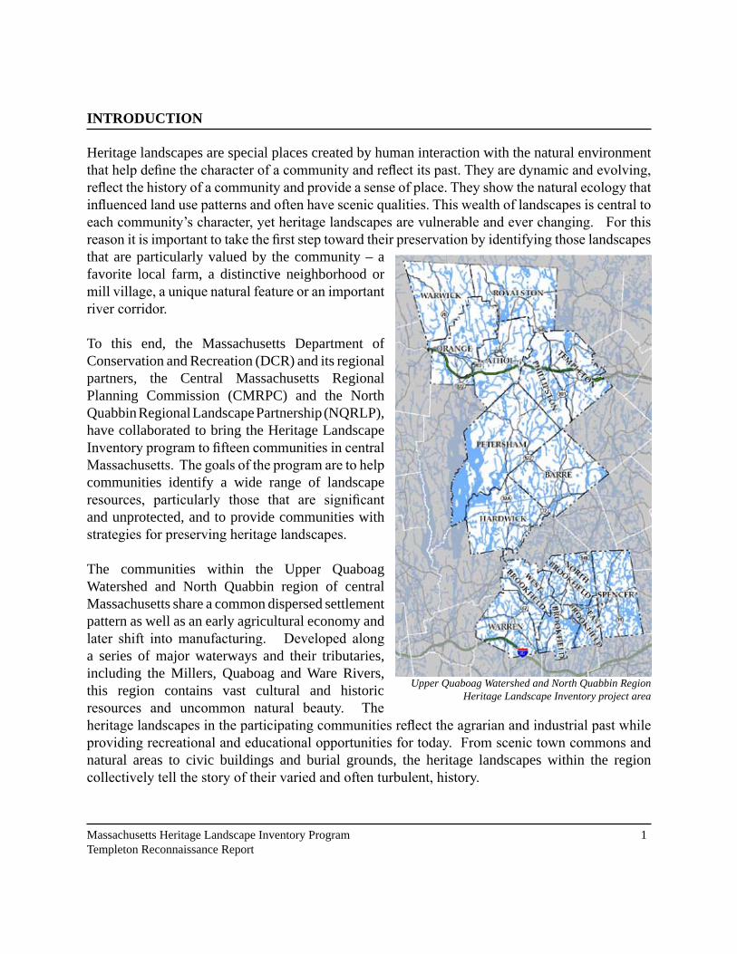
The communities within the Upper Quaboag Watershed and North Quabbin region of central Massachusetts share a common dispersed settlement pattern as well as an early agricultural economy and later shift into manufacturing. Developed along a series of major waterways and their tributaries, including the Millers, Quaboag and Ware Rivers, this region contains vast cultural and historic resources and uncommon natural beauty. The heritage landscapes in the participating communities reflect the agrarian and industrial past while providing recreational and educational opportunities for today. From scenic town commons and natural areas to civic buildings and burial grounds, the heritage landscapes within the region collectively tell the story of their varied and often turbulent, history.
Upper Quaboag Watershed and North Quabbin Region Heritage Landscape Inventory project area

� Massachusetts Heritage Landscape Inventory Program Templeton Reconnaissance Report
Methodology
The methodology for the Heritage Landscape Inventory program was developed in a pilot project conducted in southeast Massachusetts. It is outlined in the DCR publication Reading the Land, which has provided guidance for the program since its inception. In summary, each community organized a heritage landscape identification meeting during which residents and town officials identify and prioritize the landscapes that embody the community’s character and its history. This meeting is followed by a fieldwork session including the consulting team, accompanied by interested community members. The final product for each community is an individualized Heritage Landscape Reconnaissance Report. This report outlines the community’s landscape history, discusses broader land planning issues identified by the community, describes the priority heritage landscapes and issues associated with them and concludes with preservation recommendations.

Massachusetts Heritage Landscape Inventory Program �Templeton Reconnaissance Report
PART I: HERITAGE LANDSCAPE INVENTORY
LOCAL HISTORY
The history of Templeton is intimately tied to the character of the landscape. As described in an �879 History of Worcester County, Templeton is in the northern part of Worcester County, �6 miles from the City of Worcester, in the highlands between the Atlantic and the Connecticut Valley.
“The leading feature in its topography is the broad valley of the Burnshirt and Meetinghouse, or Trout Brook, extending in a northerly and southerly direction through the central part of the township… the Burnshirt flowing south to the Ware River near Coldbrook, Trout Brook flowing north to Otter River in the northerly part of the township. The land rises to the east of this valley, forming a broad and comparatively level plateau, sloping to the north, on which is situated Templeton centre. It rises quite abruptly to the west, extending into Phillipston in broken ridges, culminating in Prospect Hill at the extreme north-west, which affords a beautiful and extensive view of the surrounding country.” (Varanus P. Parkhurst, History of Worcester County, 1879. p. 392).
The glaciers that created this landscape left behind deep deposits of sand and gravel along the rivers, other areas of dense, poorly-drained till, and a limited amount of good farmland. Before European settlement, the area was probably not the site of a permanent Native American community, but used seasonally for hunting, fishing, and gathering by small groups. While not settled, the land was probably regularly managed; burned regularly to encourage forage for deer and other game animals, with cultivation of oaks and chestnuts to provide additional food for wildlife as well as human consumption.
Like other towns in the highlands of Worcester County, Templeton’s settlement by the English began in the aftermath of the King Phillip’s War of 1675. In 1685 a group of petitioners in Lynn, Reading, Beverly and Hingham
1894 USGS Map - http://docs.unh.edu/nhtopos/nhtopos.htm

� Massachusetts Heritage Landscape Inventory Program Templeton Reconnaissance Report
asked the Massachusetts Bay Colony for a grant of land, in lieu of cash payment for their services in helping to defeat the Narragansett tribe in Rhode Island. More than 45 years later, the 840 members of the “Narragansett Society” (or their heirs) finally received grants amounting to a township 6 miles by 6 miles square (about 23,000 acres) for each 120 men. As was customary, the proprietors of each township were supposed to settle sixty families and a “learned Orthodox minister” within seven years. For the proprietors, this was more of a real estate venture than anything else; they would provide the initial improvements, then most would sell their shares to others who would actually settle the town. Narragansett Society #6 met several times to get organized and raise the capital to survey the town and begin improvements. In 1734 they chose a committee to lay out roads, locate a site for the meetinghouse, and survey an initial subdivision of 123 forty-acre lots.
The site they chose, which became Templeton Common, was on the central plateau, a logical crossing point for north-south and east-west roads, and more or less convenient to outlying farms. Meeting in the town for the first time in �7��, the proprietors began plans for road clearing, and contracted for the construction of a saw mill. The mill, a critical support for settlement, was burned by a raiding parting shortly afterward when King George’s War (�7��-�7�8) broke out between England
and France. By 1751, however, peace prevailed and settlement began in earnest with construction of a meetinghouse and settlement of the first permanent families. Ten years later, enough people had arrived that a petition was made to change from a plantation to a town, and in �76� the community was incorporated as “Temple Town,” with about 300 residents.
Templeton continued to grow and prosper for the rest of the century, enduring the economic turmoil that followed the Revolutionary War, and continued to grow steadily thereafter. Jonathan Baldwin came from Spencer in the 1760s, and developed mills in the village that became Baldwinville. Grist mills and sawmills were also built in Otter River, in East Templeton, and in the south part of town along the Burnshirt River. Construction of the Fifth Massachusetts Turnpike, starting in 1799, turned Templeton Center into an important stage coach stop. During the heyday of water power in the first half of the 19th century, larger and more numerous mills were built, especially in Baldwinville and Otter River. Sawmilling declined as most of the land was cleared and settled,
View of the Common in the early 20th century. Taken from the First Church belfry (from Images of America: Templeton)

Massachusetts Heritage Landscape Inventory Program �Templeton Reconnaissance Report
but was replaced by the making of chairs and other furniture, carts, wagons, woolens and tanning. In Templeton Center, John Boynton began manufacturing tin ware in �8�� and selling it through traveling peddlers, which made him wealthy enough to later start the Worcester Polytechnic Institute. The arrival of the railroad in 1835 ensured that Templeton’s mills and farms would continue to have easy access to regional markets. Population grew steadily, from about 1500 in 1830 to almost 2800 in 1875 and over 4000 in 1910. The mills attracted workers from outside the town, and the villages saw an influx of immigrants. For a time, Templeton became a popular resort destination, and the landmark Templeton Inn was built in 1900 and expanded in 1910.
Like the rest of the region, in the 20th century Templeton’s industries began a slow decline, worsened by the Great Depression and capped off by flooding from the Hurricane of ’38. Many of the small mills went out of business, but chair making and other larger industries continued, and shipping and warehousing associated with the railroads was also important. The landscape of the northwest corner of town was changed with the founding of the Templeton Farm Colony, developed in the early 1900s, which later became the Templeton Developmental Center. The 1943 Birch Hill Dam flood control project on the Otter River, which together with several state forest tracts placed much of this area of town into permanent open space.
Today, Templeton is a museum of 18th, 19th and 20th century landscape history. While recent suburban development has changed the roadside view, especially in areas with easy access to Route �, vast areas behind the frontage lots remain undeveloped, and farm landscapes can still be enjoyed in the southwest, particularly along the Burnshirt River/Trout Brook Valley. Many of the mill buildings and associated residential and civic structures remain in Baldwinville, East Templeton and Otter River, though lack of viable uses threatens many of them with continued decline. Templeton Center remains as a classic village, and endures as the cherished heart of the community.


Massachusetts Heritage Landscape Inventory Program 7Templeton Reconnaissance Report
PRIORITY HERITAGE LANDSCAPES
Templeton is experiencing significant growth pressure and will need to determine how it will affect the rural character of the community and the heritage landscapes that the community finds valuable. In the public identification meeting, participants identified priority landscapes in town that define the heritage of the community. These heritage landscapes provide a cross section of the types of landscapes that contributed to the historical development of the town and together tell the story of Templeton’s past. The following text describes the unique value that each of these landscapes provides to the community and a set of recommendations for its preservation and protection.
Templeton Center
The location of Templeton Center was selected even before the town was settled, and the surrounding home lots were the first to be divided among the proprietors. Its location on the central plateau was a logical crossing point for north-south and east-west roads, and convenient to outlying farms. The first meetinghouse was built in 1755. However, it was not until 1786 that the proprietors, having distributed all the remaining land in the outlying areas of town, finalized the arrangements for the Templeton Common by deeding over a lot next to the meeting house for a “burying place,” and voted “that the common land by the meeting-house be granted and appropriated to the town of Templeton for a common for their use and benefit as such to them and their heirs forever.”
By this time, Templeton Center was a bustling cross roads, which was reinforced by the establishment of the fifth Massachusetts Turnpike through the center of town in 1799.
Out of the prosperity of the early �9th Century arose the First Parish Church (�8��), the Templeton Hotel (1820, no longer extant), the First Trinitarian Congregational Church (1832, no longer extant)
Town Common showing band stand, general store, erosion issues
Old photo of Common showing the General Store Building and former Landlord’s Inn (from Images of America: Templeton)

8 Massachusetts Heritage Landscape Inventory Program Templeton Reconnaissance Report
and the residence and store of Col. Artemus Lee (1829), along with numerous fine homes. Another period of general growth and prosperity followed the Civil War, and several buildings were added to the center, including the Boynton Library (1868).
The Common itself was for a long time primarily a functional space, used for annual musters and training for the local militia. The quartermaster would come out the day before, and “…with a cord and hoe marked out a little furrow on which the line was to be formed, beginning near the hotel at the south end and running along the east side of the common… as far as Dea. Hawkes house (Parkhurst, p. 407). As time went on, the common became more of a central park for the village, and was improved with tree plantings and monuments. Col. Lee, a prominent Templeton Resident and state politician during the �9th century, chose the Ash trees for the common, some of which still stand, based on soil tests showing that Ash trees would be best suited to the soil on the site.
By 1900, when the grand Templeton Inn was built, the common remained the center of town government and ceremonial heart of Templeton, but most business and industry was focused on the town’s other villages. Without pressure to grow and change, the center remained much as it
had been through most of the �9th Century, though probably much cleaner and well-kept. Guests of the Inn, which became a popular summer resort, came out to play shuffleboard on the common. The paved shuffleboard courts remain today. Like other towns in the region, the summer people eventually moved on, and the Fire Station replaced the Templeton Inn. However, most of the other structures have been preserved due in large part to the care and attention of the Narragansett Historical Society, the Grange, and other civic groups. The Templeton Common Historic District has been placed on the National Register of Historic Places.
Half a mile down the road from the common at Templeton Station, the former Conant Ball factory, now occupied by Glenwood Kitchens, tells an interesting story of Templeton’s industrial history. The first mill on the site was built by Bourn,
Historical Society on Boynton Road
Aerial view of Glenwood Kitchens. Photo from Microsoft VirtualEarth

Sources: Office of Geographic and Environmental Information (MassGIS), Commonwealth of Massachusetts Executive Office of Environmental Affairs. 1:5,000 Color Ortho Imagery, 1/2 meter resolution, taken in April 2005.
1. 2nd Framed house in town 2. Library 3. Old Trinitarian Church (empty lot) 4. Church Parsonage 5. Bourne House 6. Narragansett Historical Society 7. Brooks Tavern 8. Former Post Office 9. “Country Mischief”10. Cemetery11. First Church12. Country Store (1829)13. Shuffleboard Courts14. Fire Department15. Grange
1.2.
3.4.
5.6.
7.8.
9.
10.
11.
12. 13.
14.15.

10 Massachusetts Heritage Landscape Inventory Program Templeton Reconnaissance Report
Hadley and Company, after their original furniture factory on Bourn Hadley Pond burned in 1890. To encourage them to rebuild, the town gave them a plot of land conveniently located next to the rail road. Ironically, the new building was set afire by sparks from a passing locomotive, and burned to the ground in 1903. They rebuilt the furniture factory, which was sold to the Gardner-based Conant Ball Company in 1929. While the Ware River Railroad tracks that supported the industry in this location were removed in the 1960s, the building remains in use by Glenwood Kitchens. Aside from the main building, several unused structures are slowly falling into disrepair, and the landmark water tower, which has served as a local landmark, is no longer functional.
Opportunities:• Artemis Lee’s �8�9 country store still actively
used and well-maintained.• Active historical society maintains a museum
and recently took over maintenance and interpretation of the Grange.
• Templeton adopted Village District Zoning in 2006 to “enable the development and re-development of the Town’s four Village Districts in harmony with the existing historical, cultural and natural assets in each Village.”
• Town is working on sidewalk improvements.• Ware River Railroad bed, half a mile west of
the common, is maintained by the snowmobile club; potential for more extensive recreational use.
Issues:• Common landscape needs vegetative and infrastructure work, and road shoulders are
crumbling and eroded.• Drainage structures on streets surrounding the common may need to be redesigned and/or
rebuilt.• Ash trees generally reaching the end of their life expectancy, and even with maintenance
will continue to slowly decline.
Images of Glenwood Kitchens building

Massachusetts Heritage Landscape Inventory Program ��Templeton Reconnaissance Report
• Electrical and telephone wires need to be relocated.• Development is possible on a 4.5 acre parcel behind the historical society.• Older sections of Conant Ball Factory, as well as the landmark water tower, are in decline
and in need of stabilization.
Recommendations:1. The town should pursue a masterplan for renovation and maintenance of the common area,
including a plan for tree care and replacement. Community Preservation Act (CPA) could be utilized to fund this project.
2. The town and/or Historical Society should pursue acquisition of parcel behind the Historical Society. CPA funds may also be used here.
3. Glenwood Kitchens could explore leasing Conant Ball water tower for cell phone equipment.
4. Explore options for Conant Ball Factory, including possible nomination to National Register of Historic Places to facilitate tax credit opportunities for rehabilitation or zoning tools such as an Adaptive reuse Overlay District (see page �� for more about this zoning).
5. Form a Local Historic District Commission to explore the feasibility of establishing a Local Historic District (LHD) for Templeton Center (see page 36 for more about LHDs).
6. Passage of a Demolition Delay Bylaw would assist efforts to protect the historic resources in this area (see page �� for more about this bylaw).
Aerial view of Templeton Center. Photo from Microsoft VirtualEarth
�� Massachusetts Heritage Landscape Inventory Program Templeton Reconnaissance Report
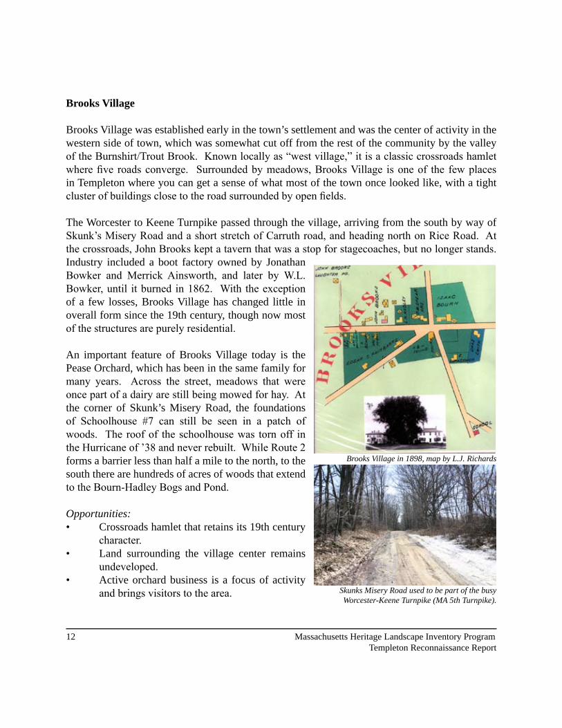
Brooks Village
Brooks Village was established early in the town’s settlement and was the center of activity in the western side of town, which was somewhat cut off from the rest of the community by the valley of the Burnshirt/Trout Brook. Known locally as “west village,” it is a classic crossroads hamlet where five roads converge. Surrounded by meadows, Brooks Village is one of the few places in Templeton where you can get a sense of what most of the town once looked like, with a tight cluster of buildings close to the road surrounded by open fields.
The Worcester to Keene Turnpike passed through the village, arriving from the south by way of Skunk’s Misery Road and a short stretch of Carruth road, and heading north on Rice Road. At the crossroads, John Brooks kept a tavern that was a stop for stagecoaches, but no longer stands. Industry included a boot factory owned by Jonathan Bowker and Merrick Ainsworth, and later by W.L. Bowker, until it burned in 1862. With the exception of a few losses, Brooks Village has changed little in overall form since the �9th century, though now most of the structures are purely residential.
An important feature of Brooks Village today is the Pease Orchard, which has been in the same family for many years. Across the street, meadows that were once part of a dairy are still being mowed for hay. At the corner of Skunk’s Misery Road, the foundations of Schoolhouse #7 can still be seen in a patch of woods. The roof of the schoolhouse was torn off in the Hurricane of ’38 and never rebuilt. While Route 2 forms a barrier less than half a mile to the north, to the south there are hundreds of acres of woods that extend to the Bourn-Hadley Bogs and Pond.
Opportunities:• Crossroads hamlet that retains its �9th century
character.• Land surrounding the village center remains
undeveloped.• Active orchard business is a focus of activity
and brings visitors to the area. Skunks Misery Road used to be part of the busy Worcester-Keene Turnpike (MA 5th Turnpike).
Brooks Village in 1898, map by L.J. Richards

Sources: Office of Geographic and Environmental Information (MassGIS), Commonwealth of Massachusetts Executive Office of Environmental Affairs. 1:5,000 Color Ortho Imagery, 1/2 meter resolution, taken in April 2005.
1.
1. Pease Orchard2. Brooks Tavern Site3. Boot Factory Site4. Schoolhouse #7 Site (foundation remains)
2.
3.
4.Old Worcester - Keene Turnpike
Old W
orcester - Keene Turnpike

�� Massachusetts Heritage Landscape Inventory Program Templeton Reconnaissance Report
Issues:• Meadows that were once part of the Pease
Orchard property were sold out of the family, and are vulnerable to change.
• Open fields surrounding the hamlet are not protected; uncertain if any are in chapter 61.
Recommendations:1. Create a masterplan for the village
that would look at issues of historic preservation, open space conservation, existing ownership and protection status of undeveloped parcels, and support for the orchard operation.
2. The town should adopt a Scenic Road Bylaw and designate Brooks Village’s roads as scenic, and/or adopt a Scenic Overlay District to preserve specific views in the area (see pages 36-7 for more about scenic protection).
3. Establish a maintenance and improvement plan for public roads converging on the village that would support preservation of walls, trees, and other scenic resources.
4. Talk to landowners about conservation options, including Agricultural Preservation Restrictions, temporary Chapter 6� designation, and Conservation Restrictions (see pages ��, ��, �� for more about these options).
5. Examine development options allowed by current zoning, and explore options to protect roadside views and other resources even as development continues in the area. Open Space and Flexible Development Zoning Bylaws could benefit Brooks Village (see pages 35 &36 for more about these bylaws).
6. Form a Local Historic District Commission to explore the feasibility of establishing a Local Historic District (LHD) for Brooks Village (see page �6 for more about LHDs).
Phillipston Road at Pease Orchard looking toward Brooks Village
Aerial view of Brooks Village. Photo from Microsoft VirtualEarth

Massachusetts Heritage Landscape Inventory Program ��Templeton Reconnaissance Report
South Templeton
The landscape of South Templeton retains many of its farms and much of its former rural character, despite a fair amount of recent frontage development, the landscape of South Templeton retains many of its farms and much of its former rural character. Large subdivisions like Cook Farm Estates, recently developed on the former Ryder Farm, have the potential to quickly alter this character. Roughly bounded by South Road, on the East, and Petersham Road on the west, the district incorporates Barre Road and several transverse connections, such as Cook Road. Cook Road is typical of several old gravel roads that connect across the interior areas: lined with stone walls, wetlands and scattered new houses, but still largely rural in character. Cook Road traverses a large area of forest that extends ¾ of a mile to Barre Road.
At the edge of South Templeton towards Templeton Center at the base of Dolbier Hill, is the Young Farm, which includes the oldest house in Templeton. Down South Road, the Laine Farm is still active. Perhaps the most active farm in the area is the Valley View Farm on Barre Road, whose owners are expanding into niche agricultural products like specialty beef and free-range chicken, and tapping into growing agri-tourism potential. They are clearing land and are in the process of building a new barn. The farm is in Chapter 61A, holding a ten-year agricultural covenant. A half-mile south on Barre Road, the Dwelly Farm has almost as much open land, but is not actively farmed.
Farm fields along Henshaw Road
Henshaw Farm (from Images of America: Templeton)
Aerial view of Henshaw Farm. Photo from Microsoft VirtualEarth

�6 Massachusetts Heritage Landscape Inventory Program Templeton Reconnaissance Report
Just off Barre Road, the Henshaw Farm offers a trip back in time, and has changed so little that it has been used for civil war reenactments. Built in 1810, the farm has been in the Henshaw family for over a century. At one time it was home to the largest herd of Brown Swiss Cattle in Massachusetts. While the cattle are gone, the fields are still being cut for hay. A few years ago, one end of the huge barn on the property collapsed, but the structure has been stabilized and will be repaired. Just down the road, the old Stone Bridge across the Burnshirt River lies at the center of what was once a busy collection of mills – now just ruins. The Historical Society has placed several markers at the site describing these features.
The Ware River Rail Trail runs through South Templeton, following the valley of the Burnshirt River and Trout Brook north to Baldwinville. The Rail Trail is owned by the Commonwealth of Massachusetts and extends south to Barre and north to Winchendon. The rails and ties have been removed, but the trail itself has not been paved. It is maintained by the snowmobile club.
The Stone Bridge at Stone Bridge Pond
Aerial view of Valley View Farm. Photo from Microsoft VirtualEarth

Sources: Office of Geographic and Environmental Information (MassGIS), Commonwealth of Massachusetts Executive Office of Environmental Affairs. 1:5,000 Color Ortho Imagery, �/� meter resolution, taken in April 2005.
Wa
re
R
i
ve
r R
ai l
T
r
ai
l
Views to Mt. Monadnock
1.
Philli
pston
WM
A
1. Old Mill Remnants2. Stone Bridge3. Dwelly Farm4. Laine Farm
Templeton State
Forest
2.3.
Ston
e Br
idge
Po
nd
Cook Pond
Bur
nshi
rt R
iver
Valley View Farm
Henshaw Farm
4.

�8 Massachusetts Heritage Landscape Inventory Program Templeton Reconnaissance Report
Opportunities:• Several farms are still active, including the Laine Farm and Valley View Farm.• Other properties are no longer actively farmed, but meadows are still being cut and buildings
maintained as owners are able.
Issues:• Development is replacing former farms with subdivisions.• Barns and other outbuildings no longer in active use are threatened by lack of
maintenance.• Rural character is being lost to frontage development, even though relatively small
percentage of the land is actually developed.
Recommendations:1. The town should take inventory of the remaining farms and talk to the owners about
conservation options, tax incentives such as Chapter 6�A and APR programs to support agriculture (see pages 32 &34 for more about these options).
2. The town should help support active agricultural operations by connecting these farms with local visitors bureaus to help promote agri-tourism opportunities.
3. Inventory large parcels of forest land in the interior and establish a list of priorities for town conservation action; talk to landowners about enrolment in Chapter 61 or 61B.
4. The Town should form an Open Space Committee and develop a strategy for acquisition of Chapter 6� parcels throughout town, should they change land use or ownership
5. The town should look into creative zoning tools, such as Agricultural Preservation Zoning, Open Space Zoning, or Flexible Development Zoning that can help protect scenic roadsides and rural character even as development continues (see pages ��, �� and �6 for more about these bylaws).

Massachusetts Heritage Landscape Inventory Program �9Templeton Reconnaissance Report
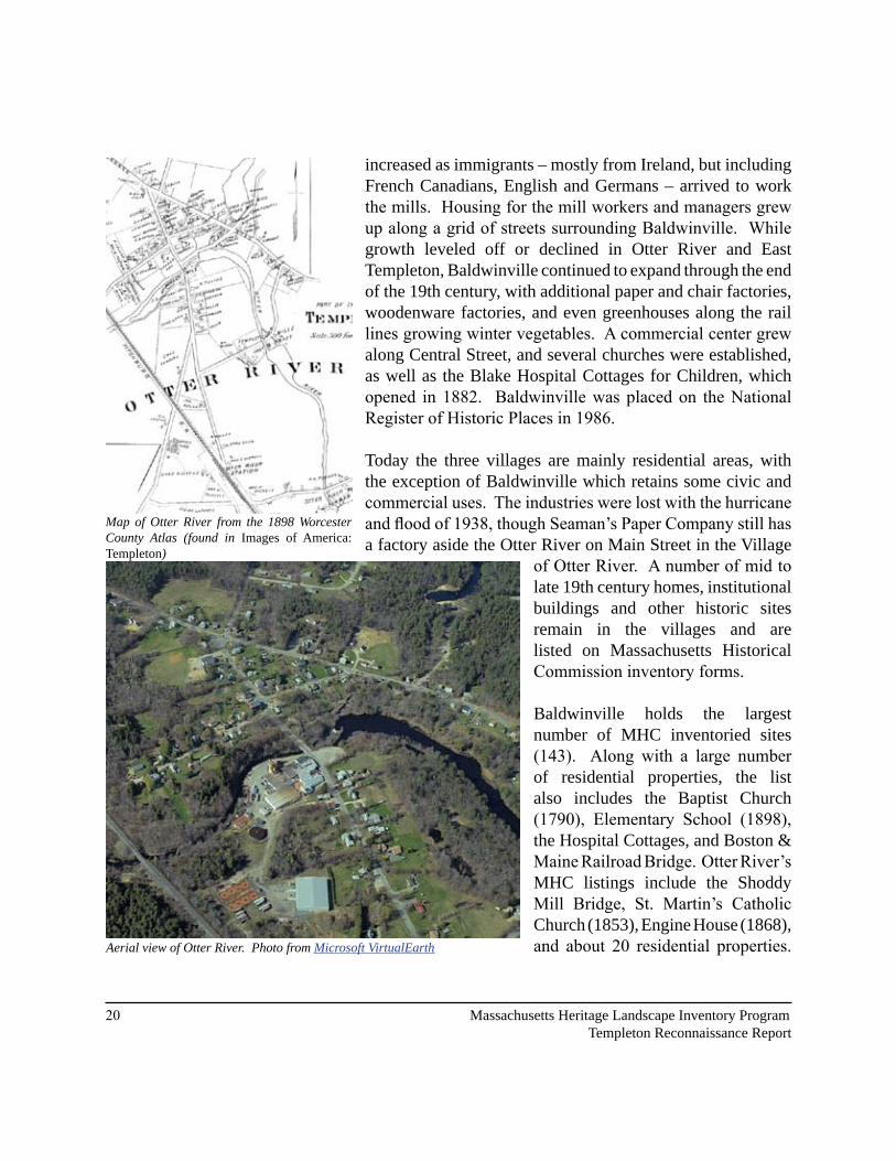
Otter River Corridor
Like many towns in Massachusetts, the original colonial settlement in Templeton formed around the town common on the central hilltop, while later growth followed the water power to the rivers on the edge of town. Three mill villages developed in the �9th century alongside the Otter River in Templeton - Baldwinville, Otter River and East Templeton. Jonathan Baldwin began developing saw and grist mills on the Otter River in Baldwinville in the 1860s. The village of Otter River, originally called Factory Village, had a woolen mill by 1823. At Fales Village, later East Templeton, another mill center developed, where they were manufacturing scythes around 1820.
The growth of the chair manufacturing industry was important along the whole Otter River corridor from Baldwinville to East Templeton. Starting around 1820 at the reservoir in East Templeton, the chair makers took advantage of available local labor, buying turning stock from local farmers who spent the winter splitting logs and shaving the pieces down to octagonal blanks ready for the lathe. As time went on, the same processes were consolidated in larger factories in Otter River and Baldwinville, where Thompson, Perley & Waite, Smith, Day & Co. and L. Breenwood & Co. all manufactured chairs. Related businesses produced lumber, pails and tubs, pine furniture, and children’s carts and wagons.
Transportation was an important factor in the expansion of Baldwinville, which by the 1870s had two intersecting railroads, which helped keep the factories in the village even after water power was no longer required to run them. Population
View looking South down Elm Street
Aerial view of Baldwinville. Photo from Microsoft VirtualEarth
Baldwinville from South Main Street (from Images of America: Templeton)
20 Massachusetts Heritage Landscape Inventory Program Templeton Reconnaissance Report
increased as immigrants – mostly from Ireland, but including French Canadians, English and Germans – arrived to work the mills. Housing for the mill workers and managers grew up along a grid of streets surrounding Baldwinville. While growth leveled off or declined in Otter River and East Templeton, Baldwinville continued to expand through the end of the �9th century, with additional paper and chair factories, woodenware factories, and even greenhouses along the rail lines growing winter vegetables. A commercial center grew along Central Street, and several churches were established, as well as the Blake Hospital Cottages for Children, which opened in 1882. Baldwinville was placed on the National Register of Historic Places in 1986.
Today the three villages are mainly residential areas, with the exception of Baldwinville which retains some civic and commercial uses. The industries were lost with the hurricane and flood of 1938, though Seaman’s Paper Company still has a factory aside the Otter River on Main Street in the Village
of Otter River. A number of mid to late �9th century homes, institutional buildings and other historic sites remain in the villages and are listed on Massachusetts Historical Commission inventory forms.
Baldwinville holds the largest number of MHC inventoried sites (143). Along with a large number of residential properties, the list also includes the Baptist Church (1790), Elementary School (1898), the Hospital Cottages, and Boston & Maine Railroad Bridge. Otter River’s MHC listings include the Shoddy Mill Bridge, St. Martin’s Catholic Church (�8��), Engine House (�868), and about 20 residential properties.
Map of Otter River from the 1898 Worcester County Atlas (found in Images of America: Templeton)
Aerial view of Otter River. Photo from Microsoft VirtualEarth

Sources: Office of Geographic and Environmental Information (MassGIS), Commonwealth of Massachusetts Executive Office of Environmental Affairs. 1:5,000 Color Ortho Imagery, 1/2 meter resolution, taken in April 2005.
Floodswood
Conservation Area
Depot Pond
Otter River Village
Baldwinville Village Historic
District
Bi
rc
h
Hi
ll
East Templeton
East Templeton
Ponds
Otter River State Forest
Greenlawn Cemetery
Seaman’s Paper Co.
Ot t e r R
i v e r
O t t e r R i v e r
Old Fitchburg Railroad Line
Old Ware River Branch Railroad Line

�� Massachusetts Heritage Landscape Inventory Program Templeton Reconnaissance Report
In East Templeton, �8 historic sites have been inventoried. Upon entering the center of this village, one can still observe the �8�� Methodist Church, �8�� East Templeton Schoolhouse, and 1860 General Store lined up along a narrow square.
Opportunities:• Loss of industry, while hard on the town, has been good for water quality in the Otter River
and its watershed, and much of the river corridor is undeveloped.• Seaman’s Paper in Otter River remains as an active industrial use; connected to several
other businesses.• Baldwinville is a good example of a small railroad town of the late �9th Century, with
relatively little 20th Century development.
Issues:• Extensive sand and gravel mining has unknown impact on water quality and wildlife
habitat.• Many historic structures have already been lost, and more are threatened by neglect or
inappropriate remodeling efforts.• Most new development is not designed to fit in with the historic architecture or site planning
patterns of the communities.
Paper Factory on Otter River at Depot Road
The Methodist church, schoolhouse and old store buildings still stand in East Templeton (from Images of America: Templeton)

Massachusetts Heritage Landscape Inventory Program ��Templeton Reconnaissance Report
1886 Aerial drawing of Baldwinville. Library of Congress, Geography and Map Division. Panoramic Map Archives:http://lcweb2.loc.gov/ammem/pmhtml/panhome.html
Recommendations:1. Pursue protection and management of a permanent greenway along the Otter River, in
partnership with Gardner. The towns could adopt a Corridor Protection Overlay District to help inform new development along the Otter River (see page �� for more about this type of zoning)
2. Identify at-risk historic structures and seek funding for stabilization and “moth-balling” until future redevelopment opportunities emerge.
3. Establish economic development initiative and work with landowners and businesses to take better advantage of the location. Transfer of Development Rights (TDR) and/or Smart Growth Zoning may benefit East Templeton and Baldwinville (for more about these tools see page 37). Downtown Revitalization Zoning may benefit the Village of Baldwinville (see page 35 for more about this type of zoning).
5. Form a Local Historic District Commission to explore the feasibility of establishing a Local Historic District (LHD) for Baldwinville, and work with landowners to take advantage of tax credit opportunities (see page 36 for more about LHDs).

�� Massachusetts Heritage Landscape Inventory Program Templeton Reconnaissance Report
Templeton Developmental Center
The Templeton Developmental Center is a state-operated facility for individuals with mental retardation, managed by the Department of Mental Retardation (DMR). Its campus, originally known as the Templeton Farm Colony, crosses the top of Norcross Hill, also known as Prospect Hill, and affords dramatic views of Mount Monadnock. Like many state hospitals, the Center was originally designed to be self-sufficient, and still includes a 72 head dairy herd, a separate herd of beef cattle, and hundreds of acres of hay fields. Stretching for several miles across the shoulder of Norcross Hill and north to Elliott Hill, Fernald School Road connects several outlying building clusters, including the Elliot Hill Colony and Brook House Colony, that are still used for housing. On Hansel Pond the remains of an ice house can still be seen.
An interesting (if no-doubt rose-colored) snapshot of life at the Farm Colony is found in the superintendent’s annual report of �9�7:
“The 300 boys at the Templeton Farm Colony have at least equaled the record of previous years in the way of health, content and happiness, and of useful and intrinsically valuable work accomplished. Our tillable land at the colony is now in a high state of cultivation as a result of the constant efforts of the boys. The application of the principles of scientific farming, of proper crop rotation and of skillful fertilization is now showing results in the amount and value of the food products produced on our farm and directly used on the tables of our patients and employees. The total value of the farm products during the past year was $67,286.34…
Aerial views of the TDC: Elliot Hill (top) and Norcross Hill Road (bottom). Photo from Microsoft VirtualEarth, http://maps.live.com

Massachusetts Heritage Landscape Inventory Program ��Templeton Reconnaissance Report
During the year the boys at the colony cleared 6 acres of rough land ready for plowing, built 606 square yards of cement sidewalk, 1,750 square feet of cement partitions, 618 square yards of basement floors, 2,200 square yards of new roads, and resurfaced 1,800 square yards of roads. This work was in addition to the work done by the boys in the construction of the new cement cow barn and hay shed, and the fireproof bungalow for 15 boys. These buildings are now practically ready for occupancy. The farmhouse at the Eliot Colony was a large, old, rambling, wooden structure. During the year we have replaced the wooden construction in the entire center section of this building with cement partitions and fireproof floors, so that the fire risk at this colony is now a negligible factor.
The program of progressively improving and developing the forest land has been continued, and this year 40 acres of our forest area have been entirely renovated and improved, and 20,000 young white pines have been planted. . .”
The Development Center is a fascinating cultural landscape, containing numerous historic structures, each of which has a story to tell about the history of the state hospitals generally, and the evolution of this one in particular. Like many, it was built on a hilltop, but in a uniquely rural way that feels much more like an extended farmstead or rural village than state hospitals elsewhere. Many of the older buildings, however, have outlived their usefulness, and while much of the surrounding land has been permanently protected, the TDC colonies do not fall under this protection. The Templeton Farm Colony District was placed on the National Register of Historic Places in 1994.
The Church Farmhouse (top) was one of the original homes in town. The Narragansett house (bottom) was built in
1920. Both are on Fernald School Road

Sources: Office of Geographic and Environmental Information (MassGIS), Commonwealth of Massachusetts Executive Office of Environmental Affairs. 1:5,000 Color Ortho Imagery, �/� meter resolution, taken in April 2005.
TDC Land
Elliot Hill Colony
Views to Elliot Hill/Mt. Monadnock
Narragansett Colony
1.
T D C L a n d
TDC Land Otter River State Forest
Templeton State Forest
Bi
rc
h
Hi
ll
(
Ar
my
C
or
ps
o
f
En
gi
ne
er
s
La
nd
)
2.
3.4.
5.6.
7.8.
1. Dairy Farm2. Horse Barn3. Old Ice Pond4. Dairy Farm5. 1920 House6. Hasting’s Church7. Church House8. Old Piggery

Massachusetts Heritage Landscape Inventory Program �7Templeton Reconnaissance Report
Opportunities:• A large area of protected land surrounds
the core Development Center facilities.• Active dairy and meat herds, pasture,
mowing and orchard preserve a typical hilltop farm landscape.
• Miles of well-maintained, low-traffic roads offer potential recreational opportunities.
Issues:• Many historic structures, including the
Church House, are not actively used nor well-maintained.
• While the future sale and private development seems unlikely, an uncertain future for the facilities makes it hard to plan for preservation of historic structures.
Recommendations:1. The town and DMR should collaborate
to pursue funding to stabilize historic structures to prevent further deterioration.
2. The town, Historical Society and/or DMR should prepare historic landscape inventory and preservation plan to evaluate structures and landscape elements and plan for their protection and interpretation. The town and state should establish good communications to forge a working relationship and explore potential partnership opportunities for the future protection of these resources.
View to Elliot Hill Colony and Mt. Monadnock seen from the Narragansett Colony on Fernald School Road
The Elliot Hill Colony from Royalston Road

Templeton Common
South Templeton
Otter River Corridor
Brooks Village
Templeton Development Center:Narragansett Colony
Templeton Common
Templeton Development Center:Elliot Hill Colony
£¤202UV2
Priority Heritage Landscapes
Permanently Protected Open Space
Te m p l e t o n , M a s s a c h u s e t t s
P r i o r i t y H e r i t a g e L a n d s c a p e s
Prepared for: Massachusetts Department of Conservation and Recreation, Heritage LandscapeInventory Project in the Upper Quaboag Watershed and North Quabbin Region
Prepared by: Dodson Associates, Ltd., Landscape Architects and PlannersAshfield, Massachusetts
25 June 2008 .0 1 2 3 40.5Miles
For Planning Purposes Only
"Office of Geographic and Environmental Information (MassGIS), Commonwealth of Massachusetts Executive Office of Environmental Affairs"MassGIS 2005 Orthophotos

Massachusetts Heritage Landscape Inventory Program �9Templeton Reconnaissance Report
As our communities undergo rapid land use change, heritage landscapes are particularly threatened because they are often taken for granted. There is a broad variety of resources that communities can call upon to protect these irreplaceable landscapes. What follows is a review of the tools that Templeton already has in place. While these measures provide a strong foundation for heritage landscape preservation, additional measures are described in the following text that will aid the development of a holistic preservation planning strategy. Appendix B includes extended descriptions of preservation measures. These tools should be considered in combination with those recommendations made in Part I for Templeton’s priority landscapes.
INVENTORY AND DOCUMENTATION
1. Massachusetts Historical Commission Records
We cannot advocate for something until we clearly identify it – in this case, the physical characteristics and historical development of the town’s historic and archeological resources. The necessary first step is to record information about the resources at the Massachusetts Historical Commission. The Massachusetts Historical Commission’s (MHC) Inventory of Historic and Archaeological Assets is a statewide list that identifies significant historic resources throughout the Commonwealth. In order to be included in the inventory, a property must be documented on an MHC inventory form, which is then entered into the MHC database. This searchable database, known as the Massachusetts Cultural Resource Information System (MACRIS), is now available online at http://www.sec.state.ma.us/mhc. Information on the specific locations of archaeological sites is not available to the general public in order to protect these sensitive and non-renewable cultural resources.
Current Listings: According to the MHC, Templeton’s inventory documents �68 properties from the mid 18th century through the 20th century ranging from individual homes, businesses and civic buildings to war monuments and agricultural land. Each of the heritage landscape areas identified by the community as priority resources contain properties listed with MACRIS: There are 60 listed sites in Templeton Center, two in Brooks Village, and the Wilder-Gilam House is listed on Henshaw Road in South Templeton. In addition, there are 168 properties listed between Otter River and Baldwinville, and the Church House, numerous barns and sheds are listed for the Temple Developmental Center district includes the Church House, numerous barns and sheds.
MACRIS also lists 27 recorded archaeological sites within the town. Four of these are prehistoric and 23 are historic.
PART II: PLANNING FOR HERITAGE LANDSCAPES

30 Massachusetts Heritage Landscape Inventory Program Templeton Reconnaissance Report
Recommendations: The inventory does not include documentation of certain landscape, transportation and engineering features, including the Stone Bridge, various mill ruins and former industrial sites, and sites associated with the railroads. The Templeton Historical Commission should consider completing MHC inventory forms for these resources.
2. National and State Register Listing
The National Register of Historic Places is the official federal list of districts, sites, buildings, structures and objects that have been determined significant in American history, architecture, archaeology, engineering and culture. Listing brings a number of benefits including recognition, consideration when federally-or state-funded projects may impact the resource, eligibility for tax credits, and qualification for certain grant programs. Resources on the National Register are automatically added to the State Register of Historic Places.
Current Listings: The “Templeton Center Historic District” (referred to in this report as the Templeton Common) is listed with the National Register of Historic Places. It was listed in November of �999 as the area around the common, including portions of Baldwinville, Petersham and Templeton Roads. The “Baldwinville Historic District,” listed in 1986, occupies the area around Elm and S. Main Sts. between Pleasant St. and Mt. View. The “Templeton Farm Colony” (TDC) was listed in 1994.
Recommended Listings: To further support the integrity of the National Register Historic Districts, Templeton Center and Baldwinville should be explored by a Local Historic District Commission and established as Local Historic Districts. The town should also seek national recognition for the Brook’s Village area and evaluate its potential as an LHD.
3. Heritage Landscape Inventory List from Local Identification Meeting
Each town involved in the Upper Quaboag Watershed and North Quabbin Region Heritage Landscape Inventory held a local identification meeting to solicit input from a range of community members to identify potential heritage landscapes throughout the town. The lists were prioritized by the community, with help from the consultants, to create a list of five to ten priority areas, which were described in Part I of this report. The complete list of the town’s 88 heritage landscapes is included as Appendix A of this report and provides a useful resource for future documentation activities and potential funding opportunities. Templeton’s meeting was held on March 13, 2008 with 25 community members present.

Massachusetts Heritage Landscape Inventory Program ��Templeton Reconnaissance Report
PLANNING AND ZONING TOOLS AND TECHNIQUES
1. Comprehensive, Open Space and other Planning Documents
It is important that Open Space Plans, Comprehensive or Master Plans, and other planning documents address heritage landscapes as vital features of the community, contributing not only to unique sense of place but also to environmental, recreational and economic health.
Current Plans: Templeton does not have a recent Comprehensive or Master Plan in place. An approved Open Space Plan is on file with the Massachusetts Division of Conservation Services, but is due to expire in 2009.
Recommended Plans: Comprehensive or Master Plans provide an important frame of reference for land use decisions, and incorporate all of a community’s issues including economic development, housing and transportation into an integrated plan. Heritage landscapes need to be seen through the lenses of community character, historic preservation, environmental health, and economic viability and growth. Their future and the values they contribute should be addressed within these multiple perspectives, not solely as historical assets of the community.
Like Comprehensive Plans, Open Space Plans look holistically at the community—its history, demographics, growth patterns, and current conditions—to make recommendations that protect open space and natural resources for ecological health and public benefits. In recent years, open space planning for natural resource systems has moved beyond conservation of specific habitat locations to identifying and protecting the functioning ecosystems that make that habitat viable.
Heritage landscapes can also be understood as functional systems, analogous to natural ecosystems, that need to be preserved intact if they are to be kept alive and functioning. This is easiest to see with working agricultural landscapes, where structures, fields, roads, fences, animals, plants and people are all part of a single system. It also is present in places that are no longer being actively farmed, but which are still organized according to the systems that once functioned there. It can also be argued that the historic and visual character of small towns is a kind of cultural ecosystem; by preserving at least the core of this system we can preserve its scenic value, as well as the story of that place, for future generations. Templeton should keep this in mind and utilize the information in this Reconnaissance Report when creating a Master Plan and/or updating their Open Space Plan. Together these three documents could provide clear guidance to the town for how to achieve its goals.

�� Massachusetts Heritage Landscape Inventory Program Templeton Reconnaissance Report
2. Zoning Bylaws, Regulations and Conservation Programs
A broad range of innovative preservation tools exist that can be adopted into town zoning bylaws and regulations. Others tools can protect heritage resources by encouraging private conservation and renovation of historic properties through grants, tax incentives and other means. By knowing what the options are, and where necessary changing zoning to allow their use, the best tool for a particular project will be available when it is needed.
Current Zoning Bylaws and Ordinances: Templeton has been active in updating and adding to its zoning bylaws: revising zoning districts, regulating stormwater connections, passing a right-to-farm bylaw, and enacting the Community Preservation Act in 2007. The town received a state grant in 2007 to explore additional bylaws for Low Impact Development, Inclusionary Zoning, Traditional Neighborhood Development, Transfer of Development Rights, Open Space Residential Design, and Wind Power. These and other possible tools for protecting Templeton’s heritage are described below.
Additional Planning and Zoning Tools for Templeton’s Landscapes:
Adaptive Reuse Overlay DistrictAn Adaptive Reuse Overlay District is superimposed on one or more established zoning districts in order to permit incentive-based reuses of existing built properties. These districts can be created to allow for the adaptive reuse of properties of a certain kind, or within a specified area within a community. As an overlay zone, all regulations pertaining to the underlying zone apply, except to the extent that the overlay zone modifies or provides for alternatives to the underlying requirements. Such a district could be established to encourage reuse of the Conant Ball Factory and old mill buildings in Baldwinville, Otter River and East Templeton.
Agricultural Preservation Restrictions (APR)The Agricultural Preservation Restriction (APR) Program is a voluntary program managed by the Massachusetts Department of Agricultural Resources. It is intended to provide a “non-development” alternative to farmers and other owners of “prime” and “state important” agricultural land. When faced with the inability to actively farm and rising tax assessments, this offers the farmer the opportunity to retain the property rather than sell it for development. The State purchased a permanent deed restriction on the property for the difference between fair market value and agricultural value. The deed restriction would preclude any use of the property that will negatively impact its agricultural viability. Assuming soils meet state standards, the APR program could be suitable for the Valley View Farm or Henshaw Farm.
Massachusetts Heritage Landscape Inventory Program ��Templeton Reconnaissance Report
Agricultural Preservation ZoningAn agricultural preservation overlay zone can be created that will promote and protect the practice of farming. This can help to preserve lands on which farming is most viable, lands that maintain an adequate agricultural base in town and areas that preserve the culture and landscape of farming. This can be accomplished in several ways including requiring all new large-scale residential development to be clustered on areas least suitable for agriculture and away from farms and views. An agricultural preservation bylaw can also use the site plan review process to require dedicated open space to remain as farmland and include that new development be located on least suitable soils for agriculture and be integrated into the existing landscape. As a supplement to the current right-to-farm bylaw, agricultural zoning could be applied as an overlay based on soils or active agricultural use – most likely in southern agricultural district centered on Barre Road.
Archaeological Resource ProtectionArchaeological sites are non-renewable cultural resources that can be permanently altered or destroyed through unauthorized digging, artifact collection, and development. Protection of archaeological sites can occur through a number of different strategies and mechanisms. An important first step is the development of a town-wide archaeological resource protection plan. Based on a professional reconnaissance survey of resources in the community, this plan would recommend steps for their preservation. Options for protection include acquisition, preservation restrictions, site plan review, an archaeological review bylaw and public education. Reasonable thresholds for local review of archaeological resources should be developed in consultation with the Massachusetts Historical Commission and interested groups such as the Massachusetts Commission on Indian Affairs. Conservation Restrictions (CR)A permanent deed restriction between a landowner and a holder - usually a public agency or a private land trust; whereby the grantor agrees to limit the use of his/her property for the purpose of protecting certain conservation values in exchange for tax benefits. EOEEA’s Division of Conservation Services provides assistance to landowners, municipalities, and land trusts regarding conservation restrictions and has produced The Massachusetts Conservation Restriction Handbook as a guide to drafting conservation restrictions. CRs could be a valuable tool in South Templeton, where the town’s goal is probably more to prevent development and encourage active farming and forestry than to own land.
Corridor Protection Overlay DistrictA Corridor Protection Overlay District is intended to promote appropriate development within a given corridor, serving to protect natural (and sometimes cultural) resources. As an overlay zone, all regulations pertaining to the underlying zone apply, except to the extent that the overlay

�� Massachusetts Heritage Landscape Inventory Program Templeton Reconnaissance Report
zone modifies or provides for alternatives to the underlying requirements. The Corridor Protection Overlay District can be used cooperatively by adjoining communities to help maintain continuous protection across town lines. This could be applied to the Otter River Corridor, in conjunction with plans for a greenway, and possibly to the Burnshirt/Trout Brook Valley.
Chapter 61 PolicyMassachusetts General Laws Chapter 61 was created in the 1970s when many farmers and forestland owners were forced to sell their land due to rising property values and taxes. The legislation became known as the Forestland Act but was quickly followed by Chapter 61A, the Farmland Assessment Act and 61B, the Open Space Act. This new legislation required towns to reduce assessments on farm, forest and open space lands as long as the owners made a commitment to keep their land in that use.
A major provision of this law allows the town the right of first refusal on these lands if the lands are to be sold for residential, commercial or industrial purposes. This provision provides the town with the opportunity to match a fair market value offer for the property. Templeton should review the Chapter 61 land in town and develop a policy for determining priorities for acquisition if land becomes available. Adoption of a Chapter 61 Policy would outline a response process for the town to follow when these lands come out of the program. This may include a requirement for the selectboard to collaborate with other town boards, conservation groups and other interested parties, and hold a public meeting. The Town should also maintain a good working relationship with the Mount Grace Land Conservation Trust as they may be able to offer some guidance with these preparations. For more information about the Chapter 61 Program and to see a sample Chapter 61 Policy, please see the Mount Grace Land Conservation Trust website (http://mountgrace.org/), to download their Chapter 61 Handbook.
Demolition Delay BylawDemolition delay bylaws provide a time period in which towns can consider alternatives to demolition of historic buildings and structures. The local historical commission should work with MHC staff to develop a bylaw that would best suit the town and should work with other town groups to publicize the advantages of a demolition delay bylaw to the community. Most demolition delay bylaws apply to structures that were built more than 50 years ago. The most common delay of demolition is six months; however many communities are finding that a one-year delay is more effective. A demolition delay bylaw requires a majority vote of Town Meeting. This could be helpful for some of the older mill buildings and other structures in areas zoned for commercial development, where there will be increased pressure to replace historic structures with modern buildings.

Massachusetts Heritage Landscape Inventory Program ��Templeton Reconnaissance Report
Design ReviewDesign Review is often a non-regulatory process that is undertaken by a town appointed Design Review Board, though usually in combination with other regulatory reviews. The board reviews the design of new construction and additions – typically those taking place in existing neighborhoods and commercial areas. Recommendations are made to the planning board to help preserve appropriate building patterns and architectural styles, with the goal of maintaining the overall character of a given area. Design Review Boards often limit their review to exterior architectural features, site design and signage. While usually applied to historic districts and downtowns, design review can be useful in helping to blend new development into rural districts. Design review would be particularly valuable in helping to blend new development into the historic fabric of Baldwinville, Otter River, East Templeton, Brooks Village and Templeton Center.
Downtown Revitalization ZoningDowntown Revitalization Zoning seeks to encourage businesses to locate in downtowns. Zoning of this nature is typically written to be attractive to businesses of a certain kind that would work well within the given infrastructure and transportation needs, but can also incorporate some of the same elements as Village Center Zoning (see below), such as encouraging mixed use development at a pedestrian-friendly scale, with minimal setbacks and off-site parking. This would be most helpful in Baldwinville.
Expedited Local Permitting - Chapter 43DExpedited Local Permitting (Chapter 43D) provides an efficient process for municipal permitting and grants for up to $100,000 for such things as professional staffing assistance, local government reorganization, and consulting services. Participating towns benefit from marketing of their site and online promotion of their pro-business regulatory climate. In order to pursue Expedited Local Permitting, a town must have commercial and/or industrial zoning in place for the site, and there must be space for a building of at least 50,000 square feet of floor area. Expedited permitting would be most useful in areas of Baldwinville and East Templeton.
Flexible Development ZoningFlexible Development Zoning allows for greater flexibility and creativity when subdividing land, to conform and work with the natural and cultural resources of a site and minimize alteration or damage to these resources, rather than follow standard requirements of subdivision regulations. While this does not prevent land from being subdivided, it does allow for the protection of some features, serves to preserve some undeveloped land, and promotes better overall site planning. Flexible development would be helpful in mitigating the effects of frontage development along many of the more rural roads, especially in South Templeton and the Brooks Village area.

�6 Massachusetts Heritage Landscape Inventory Program Templeton Reconnaissance Report
Local Historic Districts (LHD) Local Historic Districts are designated through the adoption of a local ordinance that recognizes special areas within a community where the distinctive characteristics of buildings and places are preserved and protected by the designation. These districts are the strongest form of protection for the preservation of historic resources. They are adopted by a 2/3 vote of Town Meeting and are administered by a district commission appointed by the Board of Selectmen. Since there is already strong support for maintaining the existing character of Templeton Center, that is the most likely candidate for a local historic district. Such a designation for the Templeton Farm Colony historic district would encourage the state to protect the historic structures and landscapes on the site.
Neighborhood Architectural Conservation Districts (NCD)Neighborhood Architectural Conservation Districts (sometimes known as Neighborhood Conservation Districts) are local initiatives that recognize special areas within a community where the distinctive characteristics of the neighborhood are important. They are less restrictive than Local Historic Districts in that they focus on a few key architectural elements and massing, scale, and setback in an effort to embrace overall neighborhood character. As in Local Historic Districts, changes are reviewed by a Neighborhood Architectural Conservation District Commission. This could be useful in Baldwinville and East Templeton, where growth and redevelopment are desirable, but not at the expense of the historic character of the neighborhoods.
Open Space ZoningOpen Space Zoning – also known as Open Space Residential Development – allows for flexibility in the design of a subdivision in return for preservation of open space. Typically the same number of homes that are allowed by current zoning for the parcel are built in the area of the site that is best suited for construction, while at least half the parcel is permanently protected. The most useful OSRD bylaws provide for a design process that first identifies the best land for conservation, then lays out roads and building lots in the remaining areas. With so much undeveloped backland in Templeton, and OSRD bylaw could help preserve hundreds of acres of land at no cost to the taxpayers, and would be especially valuable in South Templeton and Brooks Village.
Scenic Overlay District ZoningScenic Overlay District Zoning protects scenic vistas by providing for a no-disturb buffer on private lands, thereby helping to maintain specific viewpoints. This type of zoning is more far-reaching than a Scenic Roads Bylaw (see below) and may be applied to numbered routes. This could be applied to areas in South Templeton or undeveloped areas along the river and stream corridors.

Massachusetts Heritage Landscape Inventory Program �7Templeton Reconnaissance Report
Scenic Roads BylawLocal roads, owned and maintained by the Town, can be designated as Scenic Roads in order to preserve their rural and/or historic character. A scenic roads bylaw is an effective tool for the preservation of these significant heritage landscapes. Adopted as part of the local zoning bylaws, the scenic roads ordinance requires a public hearing by the planning board before any work is undertaken in a public right-of-way that would involve the cutting of trees or the destruction of stone walls. This bylaw only applies to trees and stone walls within the town-owned right-of-way and to local roads and not state routes.
Scenic Vista Protection BylawThis is a preservation planning tool that seeks to protect the scenic qualities of mountains, hills and rolling terrain by requiring additional design criteria for new construction in these visually sensitive areas. A scenic vista protection bylaw can be created as a scenic overlay district to protect a larger area or can address specific views such as those only visible from a certain area or above a certain elevation. A scenic protection bylaw is generally administered through site plan review and the development application process.
Shade Tree ActThe Shade Tree Act is a part of MGL Chapter 87, which defines all trees within the public way as public shade trees. The municipal Tree Warden is responsible for the care, maintenance and protection of all public shade trees (except those along state highways). Trimming or removal of any public shade trees greater than 1.5” in diameter requires a public hearing. Chapter 87 applies to all communities; however, some communities have adopted their own Shade Tree Act Bylaws that provide stricter regulations than those mandated in Chapter 87.
Smart Growth Zoning – Chapter 40R & 40SSmart Growth Zoning (Chapter 40R) provides financial rewards to communities that adopt special overlay zoning districts allowing as-of-right high density residential development in areas near transit stations, areas of concentrated development, or areas that are suitable for residential or mixed use development. Such zoning can help direct compact growth to areas that are already developed – such as historic village centers – thereby discouraging growth in less suitable areas. Chapter 40S provides State funding for any net-added school costs that come from children living in newly developed housing within a Smart Growth District. This could be a useful way to encourage redevelopment of selected areas of Baldwinville or East Templeton.
Transfer of Development Rights (TDR)TDR is a regulatory technique that allows a landowner to sell the development rights from a property, which are then purchased by a landowner or developer in a location where higher density

�8 Massachusetts Heritage Landscape Inventory Program Templeton Reconnaissance Report
may be more appropriate. In essence, development rights are “transferred” from one district (the “sending district”) to another (the “receiving district”). As a result, development densities are shifted within the community to achieve both open space preservation and economic goals without changing the total amount of potential development. While best used as an implementation strategy for a town master plan, it would make sense in general to transfer development from the more sensitive areas in the south and west sides of Templeton to receiving districts in Baldwinville and East Templeton.
Wetlands Protection Act and BylawsThe Wetlands Protection Act (MGL Chapter 131, Section 40) protects wetlands by requiring a careful review by local conservation commissions of proposed work that may alter wetlands. The law also protects floodplains, riverfront areas, land under water bodies, waterways, salt ponds, fish runs and the ocean. Communities may also adopt their own Wetlands Protection Bylaw, providing stricter regulations than those mandated in Chapter 131.
IMPLEMENTATION STRATEGIES
Outreach, Education and InterpretationIn order to create a community of advocates, we need to raise public awareness and broaden the base of support. This includes developing opportunities to learn about and celebrate the places and history of the town, as well as to care for them. Protecting community character, respecting history, and promoting smart growth are interrelated concerns that impact heritage landscapes and require collaboration across a broad spectrum of the community. This includes communication among town boards and departments, as well as public-private partnerships.
Technical AssistanceRegulations and creative solutions for heritage landscapes are constantly changing and emerging. Public and private agencies offer technical assistance with the many issues to be addressed, including DCR, MHC, and the Montachusett Regional Planning Commission.
Funding OpportunitiesFunding rarely comes from a single source, more often depending on collaborative underwriting by private, municipal, and regional sources. Each town also has a variety of funding sources that are locally-based and sometimes site-specific.
A list outlining options for the above strategies can be found in Appendix B.

Massachusetts Heritage Landscape Inventory Program �9Templeton Reconnaissance Report
CONCLUSION
This Heritage Landscape Reconnaissance Report for Templeton is an initial preservation-planning document that identifies priority heritage landscapes and discusses strategies for their long-term protection. It provides a starting point for thinking about strategies that combine traditional historic preservation tools with creative approaches to planning and zoning. Preserving Templeton’s history and rich sense of place cannot be done by any one person or committee. Increasingly, protecting what is special about the town will require a collaborative effort between boards, elected officials and private citizens, rooted in a shared process of understanding both the existing landscape and alternatives for the landscape of the future.
Heritage landscapes cannot be understood, celebrated and preserved as isolated elements; they are all connected to each other, to the past and future of the town, and to every citizen. They are living landscapes that are home to vibrant plant, animal and human communities, and which continue to evolve and change over time. For planning purposes, it is useful to think of these heritage landscapes as functioning systems, analogous to natural ecosystems, which need to be preserved intact if their essential functions are also to be preserved. By protecting town and village centers, scenic roads, important viewsheds, stream corridors and working landscapes as an intact system, social and economic change can continue without destroying Templeton’s unique sense of place.
This Report provides a starting point for preservation of heritage landscapes, but the areas identified, especially the priority landscapes, will need further research and documentation, including the preparation of additional MHC inventory forms and survey work. Just as important is outreach to town staff, elected officials, boards and committees, and the general public describing Templeton’s heritage landscapes and the reasons they should be protected. Distribution of this Reconnaissance Report to various municipal boards and commissions involved in making land use decisions is a good first step, and will lay the ground work for including the heritage landscape approach in the town’s ongoing planning efforts.
The project team suggests that the following recommendations be the top three priorities for the Town of Templeton as it works to protect the heritage landscape character of the community:
1. Pursue a masterplan for renovation and maintenance of the Templeton Common area, including a plan for tree care and replacement.
2. Pursue protection and management of a permanent greenway along the Otter River, integrated with pedestrian routes and public spaces in Baldwinville, Otter River, and East Templeton.
3. Form an Open Space Committee to work on an inventory and conservation strategies for remaining farms and other open space.


Massachusetts Heritage Landscape Inventory Program ��Templeton Reconnaissance Report
APPENDIX A: TEMPLETON HERITAGE LANDSCAPES
Landscape Name Landscape Notes
AgriculturalPease Orchard and Brooks Village also identified as civic and residential landscapes
TDC (Templeton Developmental Center) also recognized as an institutional landscape
South Templeton Agricultural Area includes Barre, South and Gray Roads, Ware River Rail Trail runs nearby
Karen Tucker/Norcross HillLaine Farm �/� of the farm is part of South Templeton Ag Area
Baldwinville Road Farms Paige, Maynard, Brown, Glover, Robins Farms - many have been subdivided
Yoke Farm On Old Winchendon RoadNygard Farm On French RoadJohnson/Larson Farm On River Road
Archaeological
Stone Bridge Pond to Phillipston Meadow
important industrial corridor, many mills here destroyed in �9�8 Hurricane, Bridge also a transportation landscape
Otter River Corridor Includes Baldwinville, Otter River and E. TempletonMine Hill "Copper Mines" - coprus for dyesEast Templeton DamBaldwinville FactoriesPrincess RockDay Mill within Army Corps boundaryHamlet MillLord and Stone FoundryOld School Foundation within Brooks VillageOtter River Brickyard in Otter RiverShoddy Mill in Otter River
Note: Highlighted landscapes have been designated "Priority Landscapes" by the town or directly correspond to a Priority Landscape

�� Massachusetts Heritage Landscape Inventory Program Templeton Reconnaissance Report
BurialTDC Burial Grounds on TDC landFirst Church Burial on Templeton CommonBaptist CommonPine Grove Cemetery active cemeteryGreenlawn Cemetery active cemetery in Baldwinville
CivicBaptist Common AreaOtter River Old industrial village along Otter RiverTempleton Village A National Register Historic DistrictBaldwinville Village A National Register Historic DistrictE. Templeton VillageBack Bay Area Old Polish Neighborhood
Industrial
Conant BallAKA Glenwood Kitchens, original building still fully intact, water tower is a local landmark, but falling into disrepair
Templeton Street Railway now Wilson Bus Lines, original building burned down, one wall remains
Seaman's Paper active factory in Otter RiverBrickyardBaldwinville ProductsTemple StuartBay State Wheel Co
Institutional
Hospital Cottages located in Baldwinville, AKA "Protestant Youth Center", also recognized as a burial landscape
Historical Society in Templeton VillageFirst Church in Templeton VillageMemorial Church in Templeton VillageBrooks Tavern in Templeton Village
Note: Highlighted landscapes have been designated "Priority Landscapes" by the town or directly correspond to a Priority Landscape

Massachusetts Heritage Landscape Inventory Program ��Templeton Reconnaissance Report
Grange in Templeton VillageWright's TavernSt. Martins first Catholic Church in area
Baptist Church oldest in town, has been moved twice - now in Baldwinville
Scout Hall formerly a schoolNatural
Bourne-Hadley Bogs AKA Skunks MiseryOtter River Greenway Along Hamlet Mill Road, includes old Hemlock groveEast Templeton PondsBell HillThree Pipes Trout Brook, Crow Hill, Crow BrookBurnshirt River, Stone Bridge Pond, Brown's PondBurns Pond On Otter River Road
Open Space/RecreationTempleton Common in Templeton VillageTemplewood Golf Course
Landlord's Inn Shufleboard Courts was also known as Templeton Inn; slabs still exist on Templeton Common
Gilman WaiteCrow Hill MotocrossOtter River Pool great recreational spot, built 1950, is in disrepairTempleton State ForestOtter River State ForestBaker's Grove BallfieldGarden behind Historic Society
Ridgely Country Club members only club, owns large tract of land, including a pond
Note: Highlighted landscapes have been designated "Priority Landscapes" by the town or directly correspond to a Priority Landscape

�� Massachusetts Heritage Landscape Inventory Program Templeton Reconnaissance Report
ResidentialArtemus Lee/General Store in Templeton VillageYoung House on South Road (in Agricultural Area), oldest in townHawke's House on Baldwinville Road, in Templeton VillageCutler Houses on Baptist CommonOctagonal House in East Templeton
Stone Houses Stone is the family (not building material), � homes in Otter River Village
Wellington Home on Wellington Road, second oldest in townWrights TavernHamlet Mill Road � remaining mill housesCircle Street Mill Housing in BaldwinvilleBack Bay Mill Housing, Polish NeighborhoodBaldwin House at end of Baldwinville Road
Country Mischeif Craft store in Templeton Village; brick dwelling built by Silas Stone
TransportationOld Worcester-Keene Turnpike AKA Skunks Misery roadBaldwinville Railroad Trestle in the village of Baldwinville Ware River Rail Trail runs from South end of town to Rte �ABoston & Maine Railroad currently runs through town dailyBus LinesHitching Posts on Templeton CommonHorse Trough on East Templeton Common
West Road Old stagecoach road. Condition is much the same as it used to be
Note: Highlighted landscapes have been designated "Priority Landscapes" by the town or directly correspond to a Priority Landscape

Massachusetts Heritage Landscape Inventory Program ��Templeton Reconnaissance Report
APPENDIX B: GUIDE TO PRESERVATION & PLANNING TOOLS FOR HERITAGE LANDSCAPES
Preservation planning is a four-step process: identification, evaluation, education and protection. Within the realm of protection, there is a vast array of tools that communities can call upon and that are most effective when used in combination with one another. Stewardship of these resources involves education and community support, planning with a clear set of goals, and regulatory mechanisms.
Three useful documents to consult when planning preservation strategies are:
♦ Department of Conservation and Recreation, Reading the Land♦ Massachusetts Historical Commission, Survey Manual♦ Massachusetts Historical Commission, Preservation through Bylaws and Ordinances
The following three sections detail the resources and strategies available for heritage landscape preservation - from documentation and evaluation, to public education, to regulating activities and finding the revenue necessary to fund the effort. These lists are meant to cover a variety of regional areas and opportunities, all may not apply to any given community.
INVENTORY AND DOCUMENTATION
Massachusetts Historical Commission Records
The vital first step in developing preservation strategies for heritage landscapes is to record information about the resources on MHC inventory forms. One cannot advocate for something unless one knows precisely what it is – the physical characteristics and the historical development.
Survey methodology has advanced since the early work of the 1980s. If a community had survey work done during that time period, it is time for an inventory update, looking at resources in a more comprehensive and connected way than may have been done at that time. Even if survey work is more recent, there may be a need to document more resources throughout the community.
Using the Massachusetts Historical Commission survey methodology:
♦ Compile a list of resources that are under-represented or not thoroughly researched, beginning with heritage landscapes.
♦ Document unprotected resources first, beginning with the most threatened resources.

�6 Massachusetts Heritage Landscape Inventory Program Templeton Reconnaissance Report
♦ Make sure to document secondary features on rural and residential properties, such as outbuildings, stone walls and landscape elements.
♦ Record a wide range of historic resources including landscape features and industrial resources.
♦ Conduct a community-wide archaeological reconnaissance survey to identify patterns of prehistoric and historic occupation and to identify known and probable locations of archaeological resources associated with these patterns. Known and potential precontact and historic archaeological sites should be professionally field-checked to evaluate cultural associations and integrity. A professional archaeologist is one who meets the professional qualifications (950 CMR 70.01) outlined in the State Archaeologist Permit Regulations (950 CMR 70.00).
National and State Register Listing
Survey work for the National Register of Historic Places, a program of the National Park Service includes evaluation of whether resources meet the qualifications for its listing. This will provide new information about the eligibility of properties. Using the information generated in the survey work and the accompanying National Register evaluations, expand your town’s National Register program.
♦ Develop a National Register listing plan, taking into consideration a property’s or area’s integrity and vulnerability. Properties in need of recognition in order to advance preservation strategies should be given priority. All sites listed on the National Register are automatically added to the State Register.
PLANNING AND ZONING TOOLS AND TECHNIQUES
Comprehensive, Open Space and other Planning Documents
Communities use a variety of planning exercises and documents to define their goals and vision of the future, address community-wide issues, and recommend measures to respond to them. There are state mandates for towns to prepare Comprehensive or Master Plans and Open Space and Recreation Plans.
♦ Comprehensive or Master Plans provide an important frame of reference for land use decisions, and incorporate all of a community’s issues including economic development, housing and transportation into an integrated plan. Heritage landscapes need to be seen

Massachusetts Heritage Landscape Inventory Program �7Templeton Reconnaissance Report
through the lenses of community character, historic preservation, environmental health, and economic viability and growth. Their future and the values they contribute should be addressed within these multiple perspectives, not solely as historical assets of the community.
♦ Like Comprehensive Plans, Open Space Plans look holistically at the community—its history, demographics and growth patterns, and current conditions—to make recommendations that protect open space and natural resources for ecological health and public benefits. The Heritage Landscape Inventory Program provides a framework for looking at these important resources, and this new understanding should be incorporated into Open Space Plans.
♦ Many communities have other plans that have been prepared as well.
Zoning Bylaws and Ordinances
A wide range of laws, bylaws and regulations is available to protect heritage landscapes. Following are brief descriptions of some of the most widely used and/or most effective of these tools, arranged alphabetically.
Adaptive Reuse Overlay DistrictAn Adaptive Reuse Overlay District is superimposed on one or more established zoning districts in order to permit incentive-based reuses of existing built properties. These districts can be created to allow for the adaptive reuse of properties of a certain kind, or within a specified area within a community. As an overlay zone, all regulations pertaining to the underlying zone apply, except to the extent that the overlay zone modifies or provides for alternatives to the underlying requirements.
Agricultural Preservation Restrictions (APR)The Agricultural Preservation Restriction (APR) Program is a voluntary program managed by the Massachusetts Department of Agricultural Resources. It is intended to provide a “non-development” alternative to farmers and other owners of “prime” and “state important” agricultural land. When faced with the inability to actively farm and rising tax assessments, this offers the farmer the opportunity to retain the property rather than sell it for development. The State purchased a permanent deed restriction on the property for the difference between fair market value and agricultural value. The deed restriction would preclude any use of the property that will negatively impact its agricultural viability.

�8 Massachusetts Heritage Landscape Inventory Program Templeton Reconnaissance Report
Agricultural Preservation ZoningAn agricultural preservation overlay zone can be created that will promote and protect the practice of farming. This can help to preserve lands on which farming is most viable, lands that maintain an adequate agricultural base in town and areas that preserve the culture and landscape of farming. This can be accomplished in several ways including requiring all new large-scale residential development to be clustered on areas least suitable for agriculture and away from farms and views. An agricultural preservation bylaw can also use the site plan review process to require dedicated open space to remain as farmland and include that new development be located on least suitable soils for agriculture and be integrated into the existing landscape.
Archaeological Resource ProtectionArchaeological sites are non-renewable cultural resources that can be permanently altered or destroyed through unauthorized digging, artifact collection, and development. Protection of archaeological sites can occur through a number of different strategies and mechanisms. An important first step is the development of a town-wide archaeological resource protection plan. Based on a professional reconnaissance survey of resources in the community, this plan would recommend steps for their preservation. Options for protection include acquisition, preservation restrictions, site plan review, an archaeological review bylaw and public education. Reasonable thresholds for local review of archaeological resources should be developed in consultation with the Massachusetts Historical Commission and interested groups such as Native Americans. Reasonable thresholds for local review of archaeological resources should be developed in consultation with the Massachusetts Historical Commission and interested groups such as the Massachusetts Commission on Indian Affairs. Community Preservation ActBy enabling legislation created in 2000, the Community Preservation Act (CPA) helps communities provide funds for the preservation of open space and historic resources and the creation of affordable housing and recreational facilities. The funds are raised through a property tax surcharge ranging from 0.5% to 3% and are administered by a local Community Preservation Committee. A minimum of 10% of the annual revenues must be used for each of the three core areas: acquisition and preservation of open space, acquisition and preservation of historic buildings and landscapes and creation and support of affordable housing. The remaining 70% can be used for any combination of the above uses and for recreational uses.
Conservation Restrictions (CR)A permanent deed restriction between a landowner and a holder - usually a public agency or a private land trust; whereby the grantor agrees to limit the use of his/her property for the

Massachusetts Heritage Landscape Inventory Program �9Templeton Reconnaissance Report
purpose of protecting certain conservation values in exchange for tax benefits. Executive Office of Energy and Environmental Affairs (EOEEA) Division of Conservation Services provides assistance to landowners, municipalities, and land trusts regarding conservation restrictions and has produced The Massachusetts Conservation Restriction Handbook as a guide to drafting conservation restrictions.
Corridor Protection Overlay DistrictA Corridor Protection Overlay District is intended to promote appropriate development within a given corridor, serving to protect natural (and sometimes cultural) resources. As an overlay zone, all regulations pertaining to the underlying zone apply, except to the extent that the overlay zone modifies or provides for alternatives to the underlying requirements. The Corridor Protection Overlay District can be used cooperatively by adjoining communities to help maintain continuous protection across town lines.
Chapter 61 PolicyMassachusetts General Laws Chapter 61 was created in the 1970s when many farmers and forestland owners were forced to sell their land due to rising property values and taxes. The legislation became known as the Forestland Act but was quickly followed by Chapter 61A, the Farmland Assessment Act and 61B, the Open Space Act. This new legislation required towns to reduce assessments on farm, forest and open space lands as long as the owners made a commitment to keep their land in that use.
A major provision of this law allows the town the right of first refusal on these lands if the lands are to be sold for residential, commercial or industrial purposes. This provision provides the town with the opportunity to match a fair market value offer for the property. Adoption of a Chapter 6� Policy would outline a response process for the town to follow when these lands come out of the program. This may include a requirement for the select board to collaborate with other town boards, conservation groups and other interested parties, and hold a public meeting. For more information about the Chapter 61 Program and to see a sample Chapter 61 Policy, please see the Mount Grace Land Conservation Trust website (http://mountgrace.org/), to download their Chapter 61 Handbook.
Demolition Delay BylawDemolition delay bylaws provide a time period in which towns can consider alternatives to demolition of historic buildings and structures. The local historical commission should work with MHC staff to develop a bylaw that would best suit the town and should work with other town groups to publicize the advantages of a demolition delay bylaw to the community. Most demolition delay bylaws apply to structures that were built more than 50 years ago. The most

50 Massachusetts Heritage Landscape Inventory Program Templeton Reconnaissance Report
common delay of demolition is six months; however many communities are finding that a one-year delay is more effective. A demolition delay bylaw requires a majority vote of Town Meeting.
Design ReviewDesign Review is a non-regulatory process that is undertaken by a town appointed Design Review Board. The board reviews the design of new construction and additions – typically those taking place in already built-up areas. Recommendations are made to the planning board to help preserve appropriate building patterns and architectural styles, with the goal of maintaining the overall character of a given area. Design Review Boards often limit their review to exterior architectural features, site design and signage.
Downtown Revitalization ZoningDowntown Revitalization Zoning seeks to encourage businesses to locate in downtowns. Zoning of this nature is typically written to be attractive to businesses of a certain kind that would work well within the given infrastructure and transportation needs, but can also incorporate some of the same elements as Village Center Zoning (see below), such as encouraging mixed use development at a pedestrian-friendly scale, with minimal setbacks and off site parking.
Expedited Local Permitting - Chapter 43DExpedited Local Permitting (Chapter 43D) provides an efficient process for municipal permitting and grants for up to $150,000 for such things as professional staffing assistance, local government reorganization, and consulting services. Participating towns benefit from marketing of their site and online promotion of their pro-business regulatory climate. In order to pursue Expedited Local Permitting, a town must have commercial and/or industrial zoning in place for the site, and there must be space for a building of at least 50,000 square feet of floor area.
Flexible Development ZoningFlexible Development Zoning allows for greater flexibility and creativity when subdividing land, to conform and work with the natural and cultural resources of a site and minimize alteration or damage to these resources, rather than follow standard requirements of subdivision regulations. While this does not prevent land from being subdivided, it does allow for the protection of some features, serves to preserve some undeveloped land, and promotes better overall site planning.

Massachusetts Heritage Landscape Inventory Program ��Templeton Reconnaissance Report
Local Historic Districts (LHD) Local Historic Districts are designated through the adoption of a local ordinance that recognizes special areas within a community where the distinctive characteristics of buildings and places are preserved and protected by the designation. These districts are the strongest form of protection for the preservation of historic resources. They are adopted by a 2/3 vote of Town Meeting and are administered by a district commission appointed by the Board of Selectmen. For more information review the Massachusetts Historic Commission's (MHC) guidebook, Establishing Local Historic Districts, available on the MHC website.
Neighborhood Architectural Conservation Districts (NCD)Neighborhood Architectural Conservation Districts (sometimes known as Neighborhood Conservation Districts) are local initiatives that recognize special areas within a community where the distinctive characteristics of the neighborhood are important. They are less restrictive than Local Historic Districts in that they focus on a few key architectural elements and massing, scale, and setback in an effort to embrace overall neighborhood character. As in Local Historic Districts, changes are reviewed by a Neighborhood Architectural Conservation District Commission.
Open Space ZoningOpen Space Zoning – also known as Cluster Development Bylaw, Open Space Communities Zoning, Open Space Development Overlay District, Open Space Preservation Subdivision, or Open Space Residential Development – allows greater density than would otherwise be permitted on a parcel, in an effort to preserve open space. Typically, construction is limited to half of the parcel, while the remaining land is permanently protected under a conservation restriction.
Preservation RestrictionsPreservation Restrictions protect historic and archaeological properties from changes that may be inappropriate. A Preservation Restriction (easement) on a property restricts present and future owners from altering a specified portion of that building, structure, or site. A restriction can run for a few years or in perpetuity and may be included as part of the property deed. Preservation restrictions can be donated or purchased by a government body or private preservation organization and are enforced by the holder of the restriction. Charitable donations of easements on historical buildings or archaeological sites may qualify for federal income tax deductions.

�� Massachusetts Heritage Landscape Inventory Program Templeton Reconnaissance Report
Rate of Development BylawA town may slow the rate of its growth within reasonable time limits to allow the community to engage in planning and preparation for growth. This measure must be used for the purpose of conducting studies and planning for rational development, and not for restraining the rate of growth for a period of unlimited duration.
Right to Farm BylawA Right to Farm Bylaw asserts the rights of farmers to pursue agricultural activities, provides community support for farming activities and requires dispute resolution so that abutters cannot make nuisance claims. Agricultural landscapes are widely considered to be significant heritage landscapes for which there is constant concern of potential development. This bylaw serves to help active farmers remain just that - active.
Scenic Overlay District ZoningScenic Overlay District Zoning protects scenic vistas by providing for a no-disturb buffer on private lands, thereby helping to maintain specific viewpoints. This type of zoning is more far-reaching than a Scenic Roads Bylaw (see below) and may be applied to numbered routes.
Scenic Roads BylawLocal roads, owned and maintained by the Town, can be designated as Scenic Roads in order to preserve their rural and/or historic character. A scenic roads bylaw is an effective tool for the preservation of these significant heritage landscapes. Adopted as part of the local zoning bylaws, the scenic roads ordinance requires a public hearing by the planning board before any work is undertaken in a public right-of-way that would involve the cutting of trees or the destruction of stone walls. This bylaw only applies to trees and stone walls within the town-owned right-of-way and to local roads and not state routes.
Scenic Vista Protection BylawThis is a preservation planning tool that seeks to protect the scenic qualities of mountains, hills and rolling terrain by requiring additional design criteria for new construction in these visually sensitive areas. A scenic vista protection bylaw can be created as a scenic overlay district to protect a larger area or can address specific views such as those only visible from a certain area or above a certain elevation. A scenic protection bylaw is generally administered through site plan review and the development application process.
Shade Tree ActThe Shade Tree Act is a part of MGL Chapter 87, which defines all trees within the public way as public shade trees. The municipal Tree Warden is responsible for the care, maintenance and

Massachusetts Heritage Landscape Inventory Program ��Templeton Reconnaissance Report
protection of all public shade trees (except those along state highways). Trimming or removal of any public shade trees greater than 1.5” in diameter requires a public hearing. Chapter 87 applies to all communities; however, some communities have adopted their own Shade Tree Act Bylaws that provide stricter regulations than those mandated in Chapter 87.
Site Plan ReviewSite Plan Review provides the planning board (and other boards and committees, depending how the bylaw is written) with an opportunity to consider a variety of community concerns – such as impacts to vehicular circulation, scenic vistas, topography and natural resources – during the permit process. Boards may comment on site plans and request changes to the design. Site Plan Review is typically limited to large scale projects and tied to the special permit process.
Smart Growth Zoning – Chapter 40R & 40SSmart Growth Zoning (Chapter 40R) provides financial rewards to communities that adopt special overlay zoning districts allowing as-of-right high density residential development in areas near transit stations, areas of concentrated development, or areas that are suitable for residential or mixed use development. Such zoning can help direct compact growth to areas that are already developed – such as historic village centers – thereby discouraging growth in less suitable areas. Chapter 40S provides State funding for any net-added school costs that come from children living in newly developed housing within a Smart Growth District.
Transfer of Development Rights (TDR)TDR is a regulatory technique that allows a landowner to separate building or development rights from the property and sell them, receiving compensation for preserving land and allowing for the development to occur in areas selected for higher density projects. In essence, development rights are “transferred” from one district (the “sending district”) to another (the “receiving district”). As a result, development densities are shifted within the community to achieve both open space preservation and economic goals without changing overall development potential.
Village Center ZoningThe goal of Village Center Zoning is to meet the needs of a small-scale, mixed-use, pedestrian-friendly area by encouraging compact development. New construction is required to be built at a scale that is compatible with the neighborhood and to have a reduced (or no) setback from the street. Parking may be directed to discourage large lots in front of buildings. Village Center Zoning shares many similarities with Traditional Neighborhood Development, and the terms are sometimes used interchangeably.

�� Massachusetts Heritage Landscape Inventory Program Templeton Reconnaissance Report
Wetlands Protection Act and BylawsThe Wetlands Protection Act (MGL Chapter 131, Section 40) protects wetlands by requiring a careful review by local conservation commissions of proposed work that may alter wetlands. The law also protects floodplains, riverfront areas, land under water bodies, waterways, salt ponds, fish runs and the ocean. Communities may also adopt their own Wetlands Protection Bylaw, providing stricter regulations than those mandated in Chapter 131.
IMPLEMENTATION STRATEGIES
Outreach, Education and Interpretation
The best stewards and advocates for heritage landscape protection are members of the community. There are many ways to communicate the importance of these special places to the public, and to connect their preservation with the shared values and goals that community members have already expressed in various planning documents and forums.
Think creatively about how to educate the community about the values and threats to heritage landscapes, and how each town resident benefits from these special places. Use a combination of strategies to get the word out about heritage landscapes and preservation of community character, including:
♦ Festivals and Tours – Tours are a great way to draw attention to the history around us, and to engage more people in caring for it. Consider hosting a Heritage Celebration Day including tours and family-friendly activities, or plan a celebration around a particular place or area on a meaningful date. Make sure events are well publicized.
♦ Signage and Banners – Signs are a very effective way to announce special historic sites and districts. Banners can also bring attention to the significance of an area and make a celebratory statement about its contribution to the town.
♦ Written Materials – Clear, concise and engaging written material with engaging illustrations is a reliable way to relay information about community character and heritage landscapes. Make use of fact sheets and flyers to get the word out on particular issues such as a town ordinance that protects heritage landscapes, a threat that needs to be addressed, or an upcoming event.
♦ School Curricula – Start teaching at a young age. Children are very receptive to engaging stories, and there are no better stories to excite childrens’ imaginations and build pride of place than stories of their town’s past and present. Teachers have an opportunity to connect history with environmental issues through classroom study, hands-on history
Massachusetts Heritage Landscape Inventory Program ��Templeton Reconnaissance Report
projects, and field exploration of a town’s heritage landscapes. Subsequently, students have an opportunity to teach their parents that preservation is everybody’s business.
♦ Lectures and Workshops – Use these forums to raise awareness, educate at a deeper level about the community’s history and its resources, and broaden the base of interest.
♦ Website – Keep Historical Commission and local historical organizations’ entries on the town’s website current, and include information about issues, proposals for preservation strategies, and upcoming events.
♦ Press Releases – Use all avenues including press releases to keep the public informed when a meeting or event is about to occur. Work with local reporters to develop special interest articles that highlight landscape resources.
Remember that bringing an issue or a heritage landscape to people’s attention once will have only short-term effect. Outreach, education and interpretation must be ongoing concerns that involve preservation and conservation interests, teachers and community organizations in repeated projects to attract and engage the general public.
Collaboration Opportunities
Because heritage landscapes encompass such a broad range of resources and issues—from preservation of town centers, scenic roads and river corridors to promotion of smart growth and economic development – stewardship of these resources involves many interests in a community. It is essential that there be good communication between the many departments and committees that address issues related to heritage landscapes. Collaboration between public and private partners is also an essential element in a successful preservation strategy.
♦ Broaden the base. Preservation, particularly preservation of landscapes, is not just for the Historical Commission. It is important that the cause not be marginalized by those who view preservation as opposed to progress, or to personal interests. A look at DCR’s Reading the Land shows the range of organizations and viewpoints that value heritage landscapes.
♦ Nurture public-private partnerships. Friends groups, neighborhood associations, and local land trusts all have important roles to play to spread the word, and to expand the capacity of the public sector to care for heritage landscapes.
♦ Take advantage of forums created to share issues and ideas. For instance, the Massachusetts Department of Agricultural Resources offers a “cluster” format for monthly discussion and information exchange meetings among area farmers.
♦ Share resources across communities. Towns that lack funding for a town planner position, for instance, have found that “sharing” a planner with another community can be quite effective.

�6 Massachusetts Heritage Landscape Inventory Program Templeton Reconnaissance Report
Technical Assistance
Beyond DCR, the Central Massachusetts Regional Planning Commission and the North Quabbin Regional Landscape Partnership, technical assistance is available from many governmental and non-profit sources, most often free of charge to municipalities and non-profit organizations.
♦ American Farmland Trust: Clearinghouse of information supporting farmland protection and stewardship.
♦ Regional planning agencies are charged with assisting communities with local planning efforts:
• Central Massachusetts Regional Planning Commission serves the Heritage Landscape Inventory Program towns of Barre, Brookfield, East Brookfield, Hardwick, North Brookfield, Spencer, Warren and West Brookfield.• Franklin Regional Council of Government serves the Heritage Landscape Inventory Program towns of Orange and Warwick.• The Montachusett Regional Planning Commission serves the Heritage Landscape Inventory Program towns of Athol, Petersham, Phillipston, Royalston, and Templeton.
♦ The North Quabbin Regional Landscape Partnership provides assistance and small grants to help protect ecologically, historically, economically, and culturally significant open space within the North Quabbin Region.
♦ The Mount Grace Land Conservation Trust is a regional non-profit organization that assists with conservation efforts of productive farm and forest land in parts of central and western Massachusetts.
♦ Citizen Planner Training Collaborative: Provides local planning and zoning officials with training opportunities and online information; they also hold an annual conference to support land use planning.
♦ Massachusetts Historical Commission: Provides technical assistance as well as grants to municipalities and non-profits for preservation planning and restoration projects.
♦ New England Small Farm Institute: A non-profit dedicated to providing technical assistance, information and training to farmers.
♦ The Trustees of Reservations: Offers conservation and landscape protection workshops, publications and connections through the Putnam Conservation Institute. The Trustees also manages a unique Conservation Buyer Program that links interested sellers with conservation-minded buyers and assists with establishing permanent property protection mechanisms.
♦ Massachusetts Department of Agricultural Resources is the state agency dedicated to supporting the agricultural activities in the state through special initiatives, programs and technical assistance.

Massachusetts Heritage Landscape Inventory Program �7Templeton Reconnaissance Report
♦ The Trust for Public Land is a national non-profit that assists municipalities with land conservation efforts.
♦ DCR’s Lakes and Ponds Program works with local groups and municipalities to protect, manage and restore these valuable aquatic resources. They provide technical assistance to communities and citizen groups, help to monitor water quality at various public beaches to ensure public safety, and provide educational materials to the public about a range of lake issues.
♦ Massachusetts Agricultural Commissions has recently launched a new website that includes helpful information both for communities with Agricultural Commissions and for those learning more about forming one.
♦ UMASS extension (NREC) – Natural Resources and Environmental Conservation) can provide assistance on issues related to land and water resource protection, smart growth/sustainability measures and forestry and farming management.
♦ The East Quabbin Land Trust provides assistance to protect ecological and historic landscapes through the conservation and stewardship of the farmlands, woodlands and waters of 8 Central Massachusetts towns
♦ Opacum Land Trust provides assistance to protect ecologically and culturally significant open space within 13 south-central Massachusetts towns.
Funding Opportunities
Funding for preservation projects is an important aspect of implementing strategies to protect heritage landscapes. There are local, state, regional, national and non-profit funding programs and resources that can assist communities in preservation and land conservation-related issues. The availability of such assistance varies from year to year and private property is not always eligible for funding. Examples include:
Local Funding Assistance
♦ Towns that have adopted the Community Preservation Act (CPA) find it to be an excellent funding source for many heritage landscape projects. While tricky to pass in lean economic times, the number and types of projects that are benefiting across the Commonwealth makes the CPA worthy of consideration. Such projects include MHC inventory, National Register nominations, cemetery preservation, open space acquisition and preservation and restoration of public buildings. The CPA (M.G.L. Chapter 44B) establishes a mechanism by which cities and towns can develop a fund dedicated to historic preservation, open space and affordable housing. Local funds are collected through a 0.5% to 3% surcharge on each annual real estate tax bill. At the state level, the

�8 Massachusetts Heritage Landscape Inventory Program Templeton Reconnaissance Report
Commonwealth has established a dedicated fund which is used to match the municipality’s collections under the CPA. The amount of the surcharge is determined by ballot vote at a local election.
Adoption of the Community Preservation Act, by a majority vote on a ballot question, fosters partnerships among historic preservationists, conservationists and affordable housing advocates. At least 10% of the funds must be used to preserve historic resources; at least 10% must be used to protect open space; and at least 10% must be used to advance affordable housing. The remaining 70% must be used for one of these three uses as well as recreational needs and can be distributed in varying proportions depending upon the projects that the city or town believes are appropriate and beneficial to the municipality. Additional information about the CPA can be found at www.communitypreservation.org.
♦ Municipalities can establish land acquisition funds, increasing their revenue from sources such as an annual fixed line item in the municipal budget; income from forestry, farming and leasing of town-owned land; gifts and bequests; grants and foundation funding; and passage of the CPA, detailed above.
State Funding Assistance
Funding for a variety of preservation projects, primarily for municipalities and non-profit, is available through the Massachusetts Historical Commission (MHC), the EOEEA Division of Conservation Services (DCS), the Department of Conservation and Recreation (DCR) and other state agencies. Further information on these programs is available on the agency websites.
♦ MHC Survey and Planning Grants support survey, National Register and a wide variety of preservation planning projects.
♦ The Massachusetts Preservation Projects Fund (MPPF), administered through the MHC, funds restoration and rehabilitation projects.
♦ Towns that have a local historic district bylaw may apply for Certified Local Government (CLG) status which is granted by the National Park Service (NPS) through the MHC. At least 10% of the MHC’s yearly federal funding allocation is distributed to CLG communities through Survey and Planning matching grants. To become a CLG, the town completes an application; after being accepted as a CLG, it files a report yearly on the status of applications, meetings, and decisions; in return the town may apply for the matching grant funding that the MHC awards competitively to CLGs annually. Presently 18 cities and towns in Massachusetts are CLGs. NOTE: CLG status is dependent in

Massachusetts Heritage Landscape Inventory Program �9Templeton Reconnaissance Report
part on a municipality having at least one Local Historical District as evidence of the community’s commitment to historic preservation.
Open Space Plans, with a requirement of updating the plan every five years, make a community eligible for Executive Office of Energy and Environmental Affairs (EOEEA) grants and technical assistance programs through the Department of Conservation Services.
♦ The Massachusetts LAND Program of DCS assists local conservation commissions in acquiring land for the purposes of natural and cultural resource protection and passive outdoor recreation.
♦ The Massachusetts PARC Program, another DCS initiative, is geared toward assisting towns and cities in acquiring and developing land for park and outdoor recreation purposes.
♦ DCS Conservation Partnership Grants assist non-profits in acquiring interests in land for conservation or recreation, and have also been used in the past to help protect active agricultural lands.
♦ The Federal Land and Water Conservation Fund, distributed through the DCS, can support heritage landscape protection by providing up to 50% of the total project cost for the acquisition or renovation of park, recreation or conservation areas. Municipalities, special districts and state agencies are eligible to apply.
The Department of Conservation and Recreation (DCR) administers a variety of grant programs that can help with heritage landscape preservation:
♦ Urban and Community Forestry grants fund projects which will result in sustained improvements in local capacity for excellent urban and community forestry management.
♦ The Recreational Trails Grant Program provides funding on a reimbursement basis for a variety of recreational trail protection, construction, and stewardship projects.
The Department of Agricultural Resources Farm Viability Enhancement Program works with farmers to develop sound business plans and funding assistance to implement them.
Regional and Non-Profit Funding Assistance
♦ The Trust for Public Land (TPL) is a national, nonprofit, land conservation organization that conserves land for people to enjoy as parks, community gardens, historic sites, rural lands and other natural places. TPL helps communities identify and prioritize

60 Massachusetts Heritage Landscape Inventory Program Templeton Reconnaissance Report
lands to be protected; secure financing for conservation; and structure, negotiate and complete land transactions. TPL’s New England Office recently launched the Worcester County Conservation Initiative, to accelerate the pace of land conservation in central Massachusetts by helping communities plan and finance conservation projects.
♦ The National Trust for Historic Preservation offers a variety of financial assistance programs. Based on the availability of funding, the National Trust awards more than $2 million in grants and loans each year for preservation projects nationwide.
♦ Regional planning organizations do not administer grants, but can work with communities to write grants or help them find funding:
• Central Massachusetts Regional Planning Commission serves the Heritage Landscape Inventory Program towns of Barre, Brookfield, East Brookfield, Hardwick, North Brookfield, Spencer, Warren and West Brookfield.• Franklin Regional Council of Government serves the Heritage Landscape Inventory Program towns of Orange and Warwick.• The Montachusett Regional Planning Commission serves the Heritage Landscape Inventory Program towns of Athol, Petersham, Phillipston, Royalston, and Templeton.
♦ The North Quabbin Regional Landscape Partnership offers a Small Grants Program to eligible organizations. More information can be found at: http://www.nqpartnership.org/sgp.htm. The Partnership also provides technical assistance.
Federal Funding Assistance
♦ The Farmland and Ranchland Protection Program of the U.S. Department of Agriculture has protected 85 farms to date in Massachusetts on 6,335 acres with matching funds. Eligible organizations are federally recognized Indian tribes, states, local government, and nongovernmental organizations. They are required to provide 50-50 matching funds for purchase of conservation easements in land with prime, productive soils that are subject to a pending offer, for the purpose of limiting conversion to non-agricultural uses of the land.
♦ The National Park Service’s Rivers & Trails Program provides technical assistance to community groups and government agencies so they can conserve rivers, preserve open space, and develop trails and greenways. The program does not offer grants, but can provide staff to help identify needs, assist partners in navigating the planning process, and help with organizational development and capacity building. The program can serve as a catalyst for successful trail development and conservation efforts.

Massachusetts Heritage Landscape Inventory Program 6�Templeton Reconnaissance Report
APPENDIX C: WORKS CITED
Aldrich, Harry Jr. and Brian P. Tanguay. Images of America: Templeton. Arcadia Publishing, Portsmouth, NH. 2005.
Department of Housing and Community Development Community Profiles. http://www.state.ma.us/dhcd
First Annual Report, Massachusetts Commission on Mental Diseases, for the year ending November 30, 1916. Wright & Potter Printing Co., State Printers, 32 Deane Street, Boston, Massachusetts, 1917.
Historic USGS Maps. University of New Hampshire Library Digital Collections Initiative.
http://docs.unh.edu/nhtopos/nhtopos.htm
Parkhurst Esq., Varanus P. “Templeton” History of Worcester County, Massachusetts. CF Jewett and Company, Boston. 1879.
Malloy, Tom, illustrated by Jim Murphy. Profiles of the Past; An illustrated history of Ashburnham, Gardner, Hubbardston, Templeton, Westminster and Winchendon, Massachusetts. Millers River Publishing Co. Athol, Massachusetts, 1984. Massachusetts Cultural Resource Information System (MACRIS). http://mhc-macris.net/
Massachusetts Historical Commission Reconnaissance Survey Town Report. http://www.sec.state.ma.us/mhc/mhchpp/TownSurveyRpts.htm, 1982-1984.