terminal 2 - portodoacu.com.br port information.pdfport of aÇu - terminal 2 3 ... bollard pull a...
TRANSCRIPT
TERMINAL 2 PORT INFORMATION
PORTO DO AÇU OPERAÇÕES S.A.
3rd EDITION
DECEMBER, 2017
PORT INFORMATION PORT OF AÇU - TERMINAL 2
3rd Edition – December, 2017 2 The latest version of this publication must be consulted at www.portodoacu.com.br
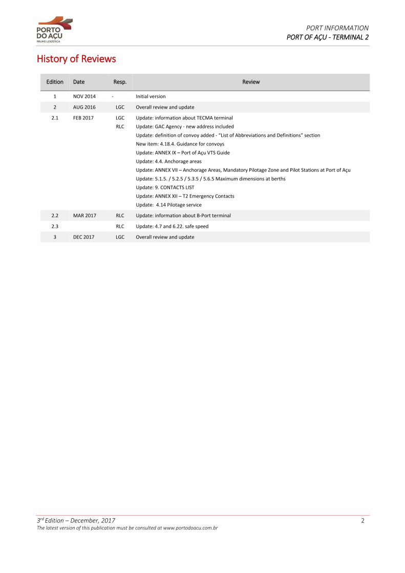
History of Reviews
Edition Date Resp. Review
1 NOV 2014 - Initial version
2 AUG 2016 LGC Overall review and update
2.1 FEB 2017 LGC
RLC
Update: information about TECMA terminal
Update: GAC Agency - new address included
Update: definition of convoy added - “List of Abbreviations and Definitions” section
New item: 4.18.4. Guidance for convoys
Update: ANNEX IX – Port of Açu VTS Guide
Update: 4.4. Anchorage areas
Update: ANNEX VII – Anchorage Areas, Mandatory Pilotage Zone and Pilot Stations at Port of Açu
Update: 5.1.5. / 5.2.5 / 5.3.5 / 5.6.5 Maximum dimensions at berths
Update: 9. CONTACTS LIST
Update: ANNEX XII – T2 Emergency Contacts
Update: 4.14 Pilotage service
2.2 MAR 2017 RLC Update: information about B-Port terminal
2.3 RLC Update: 4.7 and 6.22. safe speed
3 DEC 2017 LGC Overall review and update
PORT INFORMATION PORT OF AÇU - TERMINAL 2
3rd Edition – December, 2017 3 The latest version of this publication must be consulted at www.portodoacu.com.br
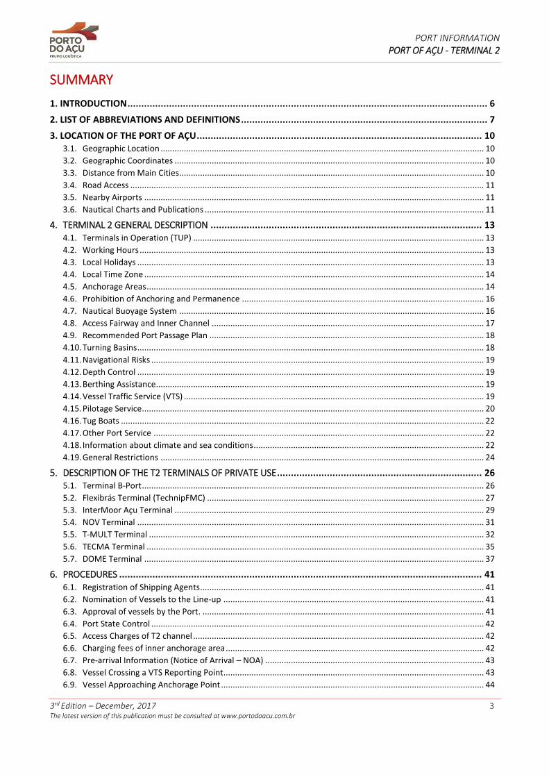
SUMMARY
1. INTRODUCTION .................................................................................................................................. 6
2. LIST OF ABBREVIATIONS AND DEFINITIONS ......................................................................................... 7
3. LOCATION OF THE PORT OF AÇU ....................................................................................................... 10 3.1. Geographic Location ........................................................................................................................................... 10 3.2. Geographic Coordinates ..................................................................................................................................... 10 3.3. Distance from Main Cities................................................................................................................................... 10 3.4. Road Access ........................................................................................................................................................ 11 3.5. Nearby Airports .................................................................................................................................................. 11 3.6. Nautical Charts and Publications ........................................................................................................................ 11
4. TERMINAL 2 GENERAL DESCRIPTION .................................................................................................. 13 4.1. Terminals in Operation (TUP) ............................................................................................................................. 13 4.2. Working Hours .................................................................................................................................................... 13 4.3. Local Holidays ..................................................................................................................................................... 13 4.4. Local Time Zone .................................................................................................................................................. 14 4.5. Anchorage Areas ................................................................................................................................................. 14 4.6. Prohibition of Anchoring and Permanence ........................................................................................................ 16 4.7. Nautical Buoyage System ................................................................................................................................... 16 4.8. Access Fairway and Inner Channel ..................................................................................................................... 17 4.9. Recommended Port Passage Plan ...................................................................................................................... 18 4.10. Turning Basins ..................................................................................................................................................... 18 4.11. Navigational Risks ............................................................................................................................................... 19 4.12. Depth Control ..................................................................................................................................................... 19 4.13. Berthing Assistance............................................................................................................................................. 19 4.14. Vessel Traffic Service (VTS) ................................................................................................................................. 19 4.15. Pilotage Service ................................................................................................................................................... 20 4.16. Tug Boats ............................................................................................................................................................ 22 4.17. Other Port Service .............................................................................................................................................. 22 4.18. Information about climate and sea conditions ................................................................................................... 22 4.19. General Restrictions ........................................................................................................................................... 24
5. DESCRIPTION OF THE T2 TERMINALS OF PRIVATE USE .......................................................................... 26 5.1. Terminal B-Port ................................................................................................................................................... 26 5.2. Flexibrás Terminal (TechnipFMC) ....................................................................................................................... 27 5.3. InterMoor Açu Terminal ..................................................................................................................................... 29 5.4. NOV Terminal ..................................................................................................................................................... 31 5.5. T-MULT Terminal ................................................................................................................................................ 32 5.6. TECMA Terminal ................................................................................................................................................. 35 5.7. DOME Terminal .................................................................................................................................................. 37
6. PROCEDURES ................................................................................................................................... 41 6.1. Registration of Shipping Agents .......................................................................................................................... 41 6.2. Nomination of Vessels to the Line-up ................................................................................................................ 41 6.3. Approval of vessels by the Port. ......................................................................................................................... 41 6.4. Port State Control ............................................................................................................................................... 42 6.5. Access Charges of T2 channel ............................................................................................................................. 42 6.6. Charging fees of inner anchorage area ............................................................................................................... 42 6.7. Pre-arrival Information (Notice of Arrival – NOA) .............................................................................................. 43 6.8. Vessel Crossing a VTS Reporting Point................................................................................................................ 43 6.9. Vessel Approaching Anchorage Point ................................................................................................................. 44
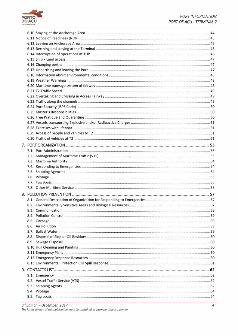
PORT INFORMATION PORT OF AÇU - TERMINAL 2
3rd Edition – December, 2017 4 The latest version of this publication must be consulted at www.portodoacu.com.br
6.10. Staying at the Anchorage Area ........................................................................................................................... 44 6.11. Notice of Readiness (NOR) .................................................................................................................................. 45 6.12. Leaving an Anchorage Area ................................................................................................................................ 45 6.13. Berthing and staying at the Terminal ................................................................................................................. 45 6.14. Interruption of operations at TUP ...................................................................................................................... 46 6.15. Ship x Land access ............................................................................................................................................... 47 6.16. Changing berths .................................................................................................................................................. 47 6.17. Unberthing and leaving the Port ........................................................................................................................ 47 6.18. Information about environmental conditions .................................................................................................... 48 6.19. Weather Warnings .............................................................................................................................................. 48 6.20. Maritime buoyage system of fairway ................................................................................................................. 48 6.21. T2 Traffic Speed .................................................................................................................................................. 49 6.22. Overtaking and Crossing in Access Fairway ........................................................................................................ 49 6.23. Traffic along the channels ................................................................................................................................... 49 6.24. Port Security (ISPS Code) .................................................................................................................................... 50 6.25. Master’s Responsibilities .................................................................................................................................... 50 6.26. Free Pratique and Quarantine ............................................................................................................................ 50 6.27. Vessels transporting Explosive and/or Radioactive Charges .............................................................................. 51 6.28. Exercises with lifeboat ........................................................................................................................................ 51 6.29. Access of people and vehicles to T2 ................................................................................................................... 51 6.30. Traffic of vehicles at T2 ....................................................................................................................................... 51
7. PORT ORGANIZATION ....................................................................................................................... 53 7.1. Port Administration ............................................................................................................................................ 53 7.2. Management of Maritime Traffic (VTS) .............................................................................................................. 53 7.3. Maritime Authority ............................................................................................................................................. 54 7.4. Responding to Emergencies ............................................................................................................................... 54 7.5. Shipping Agencies ............................................................................................................................................... 54 7.6. Pilotage ............................................................................................................................................................... 55 7.7. Tug Boats ............................................................................................................................................................ 55 7.8. Other Maritime Service ...................................................................................................................................... 55
8. POLLUTION PREVENTION .................................................................................................................. 57 8.1. General Description of Organization for Responding to Emergencies ............................................................... 57 8.2. Environmentally Sensitive Areas and Biological Resources ................................................................................ 57 8.3. Communication .................................................................................................................................................. 58 8.4. Pollution Control ................................................................................................................................................. 59 8.5. Garbage .............................................................................................................................................................. 59 8.6. Air Pollution ........................................................................................................................................................ 59 8.7. Ballast Water ...................................................................................................................................................... 59 8.8. Disposal of Slop or Oil Residues .......................................................................................................................... 60 8.9. Sewage Disposal ................................................................................................................................................. 60 8.10. Hull Cleaning and Painting .................................................................................................................................. 60 8.11. Emergency Plans ................................................................................................................................................. 60 8.12. Emergency Response Resources ........................................................................................................................ 60 8.13. Environmental Protection (Oil Spill Response) ................................................................................................... 61
9. CONTACTS LIST ................................................................................................................................. 62 9.1. Emergency .......................................................................................................................................................... 62 9.2. Vessel Traffic Service (VTS) ................................................................................................................................. 62 9.3. Shipping Agents .................................................................................................................................................. 62 9.4. Pilotage ............................................................................................................................................................... 64 9.5. Tug boats ............................................................................................................................................................ 64
PORT INFORMATION PORT OF AÇU - TERMINAL 2
3rd Edition – December, 2017 5 The latest version of this publication must be consulted at www.portodoacu.com.br
9.6. Fast Boats............................................................................................................................................................ 64 9.7. Terminals of T2 ................................................................................................................................................... 65 9.8. Local Authorities ................................................................................................................................................. 66 9.9. Other organizations and agencies ...................................................................................................................... 67 9.10. Nearby Hospitals ................................................................................................................................................. 67
ANNEX I – Terminal 2 Aerial Photographs ............................................................................................. 69
ANNEX II – Geographic Location of Port of Açu ..................................................................................... 71
ANNEX III – Route Map - Access to T2 ................................................................................................... 72
ANNEX IV- Nautical Charts of Interest ................................................................................................... 73
ANNEX V – Location of TUPs in operation at T2 ..................................................................................... 74
ANNEX VI – Aerial Photographs of TUPs at T2 ....................................................................................... 75
ANNEX VII – Anchorage Areas, Mandatory Pilotage Zone and Pilot Stations .......................................... 78
ANNEX VIII – Suggested Passage Plan – T2 ............................................................................................ 79
ANNEX IX – Port of Açu VTS Guide ........................................................................................................ 80
ANNEX X – Port of Açu VTS Reporting Points ......................................................................................... 85
ANNEX XI – T2 Overtaking and Crossing Area ........................................................................................ 86
ANNEX XII – T2 Emergency Contacts ..................................................................................................... 87
PORT INFORMATION PORT OF AÇU - TERMINAL 2
3rd Edition – December, 2017 6 The latest version of this publication must be consulted at www.portodoacu.com.br
1. INTRODUCTION
This document was developed by the Porto do Açu Operações S.A., which administrates the Terminal 2 in Port of Açu (as known as “Port of Açu T2 Administration” or “T2 Administration”), located in São João da Barra city, State of Rio de Janeiro. This document must be observed with the Port of Açu Terminal 2 Port Regulation, available at the Porto do Açu’s website (www.portodoacu.com.br) or upon request to the Port of Açu T2 Administration, local shipping agents or local terminal.
This document has relevant port information related to the Private Use Terminals (as known as TUPs) located in the T2, providing utilities to owners, shipping agents, masters, crew, pilots and those involved with the operation of the vessels in this terminal (as known as “interested parties”). This document, in digital format, is available to everyone at the Porto do Açu’s website (www.portodoacu.com.br).
The information contained in this document comes from reliable sources and match the reality from time of its writing. However, the T2 Administration does not get any responsibility for misinterpretation or unintentional omissions reported in this document, and clarifies that it is intended to supplement the Applicable Law (as the definition below) and not to substitute or modify it.
In case of any contradiction between the matter of this document and the Applicable Law, it will prevail what is written in this last one. Therefore, all interested parties are directly responsible for the full compliance of the Applicable Law, not being able of claim ignorance to exclude any responsibility.
The guidelines contained in this document may not be observed only during emergencies when that the non-adoption of the procedures here provided are recognized to be essential to avoid immediate danger or operational risks. The ship master will not be able to exclude his fully responsibility about the maneuvers that they perform under the allegation of compliance or orientation of information contained in this document.
This document is available in two downloadable versions (in Portuguese and English) at the Porto do Açu’s website (www.portodoacu.com.br). The T2 Administration reserves the right of changing any operational characteristics here presented without prior notice. Supposing the reader has a printed version, it is recommended to access the updated version available at the Porto of Açu’s website (www.portodoacu.com.br) to guarantee the acknowledge of the most updated version in force.
In case of any incorrect information found in this document, we kindly request the interested party to contact the T2 Administration by e-mail ([email protected]).
PORT INFORMATION PORT OF AÇU - TERMINAL 2
3rd Edition – December, 2017 7 The latest version of this publication must be consulted at www.portodoacu.com.br
2. LIST OF ABBREVIATIONS AND DEFINITIONS
Access Fairway Navigable channel that connects the open sea to the T2 inner channel.
Accident Non-planned event which causes death, health problem, injury, damage or other losses of any nature.
Aids to Navigation Set of all visual, sound and radioelectric resources, for maritime use with the purpose to allow the recognition of vessel position.
ANTAQ Brazilian National Agency of Waterway Transportation.
Applicable Law Any law, decree, regulation, resolution, instruction, orientation, international convention ratified by Brazil, as well as any official publication of national or international competent authorities, applicable to operations in T2 of the Port of Açu.
BA British Admiralty – Maritime Authority of United Kingdom
Bollard Pull A conventional measure of the pulling (or towing) power of a vessel.
BPAE Emergency Readiness and Response Base - located in Porto of Açu.
Bunkering Technical term used to the supply of fuel for use by ships.
COLREGS International Regulations for Preventing Collisions at Sea.
CONAMA Brazilian National Environment Council.
Course Direction followed by the vessel during navigation.
DHN Directorate of Hydrography and Navigation (Brazilian Navy).
DWT Deadweight tonnage (unit of measurement).
ETA Estimated Time of Arrival.
ETB Estimated Time of Berthing.
ETD Estimated Time of Departure.
High tide Maximum level reached by sea water in the end of flood tide.
Hs Significant Wave Height.
IALA International Association of Lighthouse Authorities.
IATA International Air Transport Association.
IMO International Maritime Organization.
IMO SRS items IMO Standard Ship Reporting System to provide information, widely used by VTS service.
Impracticability Situation which the weather and sea conditions, accidents or navigational facts or also technical failures create an unacceptable risk to safety of navigation, becoming advisable not to carry out maneuvers, traffic of vessels and/or the pilot’s embarkation/disembarkation.
Inner Channel Navigable channel artificially dredged on T2, several TUPs established around it.
ISGOTT International Safety Guide for Oil Tankers and Terminals.
ISO International Organization for Standardization.
ISPS Code International Ship and Port Facility Security Code.
PORT INFORMATION PORT OF AÇU - TERMINAL 2
3rd Edition – December, 2017 8 The latest version of this publication must be consulted at www.portodoacu.com.br
Km/h kilometers per hour (unit of measurement for speed).
LESTA Law 9.537/1997, that disposes about the waterway traffic safety in water under national jurisdiction.
Line-up List of sequence of inbound and outbound operations in the Access Fairway and Inner Channel of vessels arriving or leaving the T2 TUPs, according to its ETA, NOR, ETB and ETD.
Low tide The minimum level reached by sea water in the end of ebb tide.
m/s Meters per second (unit of measurement for speed).
Maritime Authority Brazilian Navy, the national authority responsible for the sea transportation, under the Law 97/99.
Meteoromarinha Weather forecast bulletin issued to the Brazilian maritime area.
mm/month Millimeter per month (unit of measurement for rain precipitation).
NM Nautical Miles (unit of measurement for nautical distance).
NOR Notice of Readiness – notice issued by the vessel to the destination TUP after the arrival at Port of Açu area, being in condition to operate in all respects
NORMAM Brazilian Maritime Authority Regulation.
NPCP-RJ Rules and Procedures of the Harbormaster of the State of Rio de Janeiro.
NR Reduction Level of Nautical Chart (DNH level zero).
PEI Individual Emergency Plan maintained by each TUP.
Pilotage zone Geographic area delimited by Maritime Authority where it’s carried out pilotage service.
PSC Port State Control – International regime to control ships with foreign flag carried out by the state where the port is located.
Reporting Point (VTS)
Points located in limit area of influence of Port of Açu VTS Center. The sailor should inform VTS Center when crossing these points, when arriving or leaving the area.
RLESTA The waterway Traffic Safety Law Regulation, under national jurisdiction established by decree 2.596/1998.
Slop Mixture of oil and water resultant of tanks washing and others oil residues on board.
Spring tide the large rise and fall of the tide at or soon after the new or the full moon.
T-MULT Multicargo Terminal, located at the Terminal 2.
T-OIL Oil terminal, located at the Terminal 1.
T-ORE Iron ore terminal, located at the Terminal 1.
T1 Offshore Terminal 1, in Port of Açu.
T2 Onshore Terminal 2, in Port of Açu.
T2 Administration Part of the company Porto do Açu Operações S.A.
TECMA Maritime fuel supply terminal.
Average level (tide) Horizontal plane defined by the average height of continuous high and low tides.
PORT INFORMATION PORT OF AÇU - TERMINAL 2
3rd Edition – December, 2017 9 The latest version of this publication must be consulted at www.portodoacu.com.br
TUP Abbreviation in Portuguese for “Private Use Terminal”. Port installation explored with permission, located outside the organized port area and used in movement and/or storage of goods, designated to or proceeding of maritime transportation.
Turning Basin Area in the water close to the port with appropriate dimension and depth to maneuver the vessels.
VHF Very High Frequency wave band used in radio communication.
VTS Vessel Traffic Service.
VTS CENTER Body responsible for the vessel traffic monitoring in the navigational area of Port
of Açu.
VTSO Vessel Traffic Service Operator – VTS Operator.
Waypoint Planned point to change the route of vessel.
ZP-15 Code for Pilotage Zone which covers the ports located in the State of Rio de Janeiro.
PORT INFORMATION PORT OF AÇU - TERMINAL 2
3rd Edition – December, 2017 10 The latest version of this publication must be consulted at www.portodoacu.com.br
3. LOCATION OF THE PORT OF AÇU
3.1. Geographic Location
The Port of Açu, managed by Porto do Açu Operações S.A., is a private port complex, established in São João da Barra city, located in the northern coast of the State of Rio de Janeiro in an area about 90.0Km², where there are several Private Use Terminals (as known as “TUPs”), operating according to Law 12.815/13. The complex is located at about 12.0 NM north of Cabo de São Tomé and 12.0 NM south of mouth of the river Paraíba do Sul.
Annex I presents aerial view photos of the T2 as a reference.
The Port of Açu is divided into two big Terminals, named Terminal 1 and Terminal 2:
• Terminal 1 (T1): Offshore terminal with an access of 3.0Km entrance bridge, 5 piers for moving iron ore and oil.
• Terminal 2 (T2): Onshore terminal with TUPs around the inner channel that are dedicated to any cargo handling, including terminals to support activities of oil and gas exploration.
Annex II presents images of the geographic location of Port of Açu.
3.2. Geographic Coordinates
The approximate geographic coordinates of the Port are:
• Latitude: 21°49,00’ S
• Longitude: 041°00,00’ W
3.3. Distance from Main Cities
The approximate distances of Port of Açu from the main cities nearby are:
• São João da Barra, RJ (downtown): 35.0 Km;
• Campos dos Goytacazes, RJ (downtown): 45.0 Km.
From Campos dos Goytacazes city, the distance to the main cities in the States of Rio de Janeiro (RJ) and Espírito Santo (ES) are:
• Macaé, RJ: 115.0 Km.
• Niterói, RJ: 260.0 Km.
• Rio de Janeiro, RJ: 280.0 Km.
• Vitória, ES: 245.0 Km.
PORT INFORMATION PORT OF AÇU - TERMINAL 2
3rd Edition – December, 2017 11 The latest version of this publication must be consulted at www.portodoacu.com.br
3.4. Road Access
The Federal Highway BR-101 is the main road access which connects the Rio de Janeiro city to the cities located in the north of the State. The highway is currently operated by two companies (below) in the route between Rio de Janeiro city and the border between the States of Rio de Janeiro and Espírito Santo:
• ECO Rodovias: route between Rio de Janeiro city and Niteroi city, both in State of Rio de Janeiro (operation of the “Rio-Niterói” Bridge). For more information, see <www.ecoponte.com.br>.
• Autopista Fluminense: route between Niteroi to the north of the State of Rio de Janeiro, to its border with the State of Espírito Santo. For more information, see <www.autopistafluminense.com.br>.
The main route between Campos dos Goytacazes city and São João da Barra city is the Federal Highway BR-356. By the point 164Km of the highway, there are many signs to provide directions to the drivers going to the Port through the State Road RJ-240, that connects the BR-356 to the Port of Açu.
Annex III presents an access route map to the Port of Açu (T2 Main Gate) from Campos dos Goytacazes city.
3.5. Nearby Airports
There is no commercial airport in activity in Sao Joao da Barra city; the closest airports located in Campos dos Goytacazes city and Macae city, both in the State of Rio de Janeiro (RJ):
• “Bartolomeo Lisandro” Airport – Campos dos Goytacazes, RJ (IATA code – CAW). It is located 54.0Km from the Port, operating national flights from/to Rio de Janeiro city, RJ. Address: Rodovia Brejo Grande Road, 02 - Bom Sucesso, Campos dos Goytacazes - RJ, CEP: 28093-000. Phone number: +55 22 2726-6400. For more information, see <www.infraero.gov.br>.
• “Benedito Lacerda” airport – Macaé, RJ (IATA code - MEA). It is located about 100.0Km from the Port, operating national flights from/to Rio de Janeiro city (RJ), Vitoria city (ES) and Campinas city, (SP). Address: Rodovia Hildebrando Alves Barbosa – Aeroporto, Macaé – RJ, CEP: 27963-840. Phone number: +55 22 2763-5700. For more information, see <www.infraero.gov.br>
The closest international airport from the Port is the “Antônio Carlos Jobim” International Airport (as known as “Galeão”), located in Rio de Janeiro city:
• International Airport “Antônio Carlos Jobim” (Rio Galeão) – Rio de Janeiro, RJ (IATA code - GIG). It is located about 320.0Km from the Port, operating national and international flights. Address: Av. Vinte de Janeiro - Ilha do Governador - Rio de Janeiro. Phone number: +55 21 3004-6050. For more information see <www.infraero.gov.br> or <www.riogaleao.com>.
3.6. Nautical Charts and Publications
Information about Port of Açu can be obtained by consulting the following publications:
Nautical Charts
The Nautical Charts which cover the Port area and, specifically, its Terminal 2 are:
• British Admiralty – BA 3972 chart “Rio Doce to Cabo de São Tome” (medium map scale - 1:300.000)
PORT INFORMATION PORT OF AÇU - TERMINAL 2
3rd Edition – December, 2017 12 The latest version of this publication must be consulted at www.portodoacu.com.br
• Brazilian Navy – DHN 1403 chart “Barra do Itapemirim ao Cabo de São Tomé” (medium map scale - 1:150.000)
• Brazilian Navy – DHN 1405 chart “Porto do Açu” (large map scale - 1:25,000)
• Brazilian Navy – DHN 1406 chart “Proximidades do Porto do Açu” (large map scale - 1:75,000)
The availability of Brazilian nautical charts on board the vessels operating at the Port is extremely important for the safety of navigation in the Port area. The nautical charts can be acquired upon request to the local shipping agents.
Annex IV presents the nautical charts of interest for navigation at Port of Açu. The Brazilian DHN chart files (RASTER charts and GeoTIFF images) can be obtained directly at the DHN website <www.mar.mil.br/dhn/chm/box-cartas-raster/raster_disponiveis.html> for the reference.
Other Nautical Publications
Other edited and maintained documents for official bodies which bring information about, or applicable to, the Port of Açu are:
• Brazilian Navy – List of lights
• Brazilian Navy – Sailing Directions - East coast
• Brazilian Navy – Tide Tables
• Brazilian Navy – Rules and Procedures of the Harbormaster of the State of Rio de Janeiro (NPCP-RJ).
• Brazilian Navy – Brazilian Maritime Authority Regulations (NORMAM); concerning overall procedures related to vessels in Brazilian waters).
The updating of all nautical publications, which includes the Brazilian nautical charts, must be systematically carried out by the vessel in operation at the Port of Açu, through the “Notice to Mariners” edited by Brazilian Navy.
PORT INFORMATION PORT OF AÇU - TERMINAL 2
3rd Edition – December, 2017 13 The latest version of this publication must be consulted at www.portodoacu.com.br
4. TERMINAL 2 GENERAL DESCRIPTION
The Terminal 2 is an onshore terminal installed around an inner channel artificially dredged.
The entrance of the inner channel is protected by two breakwaters, northern and southern breakwaters, designed in direction west ↔ east in relation to the coastline and in a shape of an “L”. The inner channel is 6.5Km long, at least 270m wide and 13.93m deep, along the East ↔ West part; 120m wide and 10m deep, along the North ↔ South part.
Surrounding the inner channel, several TUPs are being established dedicated to varied cargo handling, such as containers, general and project charges, liquid and solid bulks, support to the oil and gas industry and others, along nearly 13.0Km of extension for berthing area (when 100% of works are completed).
4.1. Terminals in Operation (TUP)
The following terminals (TUP) are currently in operation at the T2 (at the time of this edition):
• B-PORT Terminal: operated by Brazil Port Logística Offshore and Estaleiro Naval Ltda; supporting the oil and gas industries and repairing vessels as well.
• TECMA Terminal: operated by NFX Combustíveis Marítimos Ltda.; supplying maritime fuel (bunkering).
• Flexibrás Terminal (TechnipFMC): operated by Flexibrás Tubos Flexíveis (Technip) Ltda.; handling flexible pipes used by oil and gas industries.
• Intermoor Açu Terminal: property of Intermoor do Brasil Serviços Offshore de Instalação Ltda.; supporting operations of oil and gas industries.
• NOV Terminal: operated by National Oilwell Varco; handling flexible pipes used by oil and gas industries.
• Multicargo Terminal (T-MULT): operated by Porto do Açu Operações S.A.; handling and storage of general cargo, bulk, liquid, solid and containers.
• DOME Terminal: operated by the DOME Consortium Integrated Service; service to the oil and gas industries.
Annex V presents a sketch with the approximate location of each TUP along T2 inner channel.
Annex VI presents aerial view photos of the TUPs in operation.
4.2. Working Hours
The T2 working hours are 24 (twenty-four) hours a day, 7 (seven) days a week (24/7), during all year long including holidays. Each TUP is free to establish their own working hours; any person must contact the administration of the TUP for further details.
4.3. Local Holidays
Besides the Brazilian national holidays, the following dates are holiday in State of Rio de Janeiro and in São João da Barra city:
PORT INFORMATION PORT OF AÇU - TERMINAL 2
3rd Edition – December, 2017 14 The latest version of this publication must be consulted at www.portodoacu.com.br
• February 2nd – Nossa Senhora dos Navegantes (city holiday)
• April 23rd – São Jorge (state holiday)
• June 13th – Santo Antônio (city holiday)
• June 17th – Emancipação de São João da Barra (city holiday)
• June 24th – São João (city holiday)
• June 29th – São Pedro (city holiday)
• October 28th – Dia do Funcionário Público (state holiday)
• November 20th – Zumbi dos Palmares (state holiday)
• December 8th – Nossa Senhora da Conceição (state holiday)
4.4. Local Time Zone
The local time is 3 hours less in relation to the Greenwich Mean Time (GMT -3h), standard time followed by Brazil (BRT – Brasília Time Zone).
During daylight saving time, usually between October and February, it is adopted the Brasília Summer Time Zone (BRST), when the local time becomes 2 hours less in relation to the Greenwich Mean Time (GMT -2h).
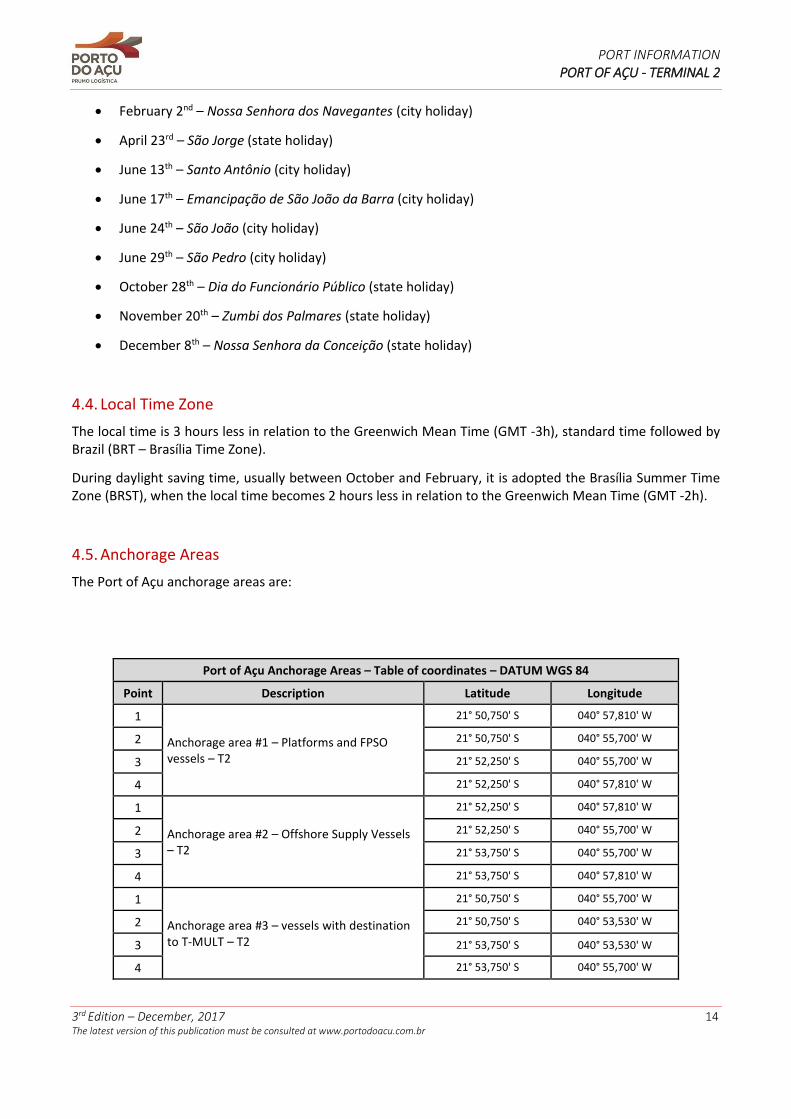
4.5. Anchorage Areas
The Port of Açu anchorage areas are:
Port of Açu Anchorage Areas – Table of coordinates – DATUM WGS 84
Point Description Latitude Longitude
1
Anchorage area #1 – Platforms and FPSO vessels – T2
21° 50,750' S 040° 57,810' W
2 21° 50,750' S 040° 55,700' W
3 21° 52,250' S 040° 55,700' W
4 21° 52,250' S 040° 57,810' W
1
Anchorage area #2 – Offshore Supply Vessels – T2
21° 52,250' S 040° 57,810' W
2 21° 52,250' S 040° 55,700' W
3 21° 53,750' S 040° 55,700' W
4 21° 53,750' S 040° 57,810' W
1
Anchorage area #3 – vessels with destination to T-MULT – T2
21° 50,750' S 040° 55,700' W
2 21° 50,750' S 040° 53,530' W
3 21° 53,750' S 040° 53,530' W
4 21° 53,750' S 040° 55,700' W
PORT INFORMATION PORT OF AÇU - TERMINAL 2
3rd Edition – December, 2017 15 The latest version of this publication must be consulted at www.portodoacu.com.br
Port of Açu Anchorage Areas – Table of coordinates – DATUM WGS 84
Point Description Latitude Longitude
1
Anchorage area #4 – vessels with destination to TECMA (usually tankers) – T2
21° 54,123' S 040° 55,700' W
2 21° 54,123' S 040° 53,530' W
3 21° 55,623' S 040° 53,530' W
4 21° 55,623' S 040° 55,700' W
1
Anchorage area #5 – LNG vessels – T2
21° 54,123' S 040° 49,619' W
2 21° 54,123' S 040° 47,488' W
3 21° 55,623' S 040° 47,488' W
4 21° 55,623' S 040° 49,619' W
1
Anchorage area #6 – Bulk carriers (up to CAPESIZE) in ballast with destination to T-ORE – T1
21° 43,506' S 040° 57,069' W
2 21° 44,070' S 040° 55,011' W
3 21° 46,943' S 040° 55,906' W
4 21° 46,371' S 040° 57,973' W
1
Anchorage area #7 – Tankers (up to SUEZMAX) with destination to T-OIL – T1
21° 44,634' S 040° 52,970' W
2 21° 45,199' S 040° 50,905' W
3 21° 48,075' S 040° 51,817' W
4 21° 47,506' S 040° 53,875' W
1
Anchorage area #8 – Vessels waiting for sanitary inspection (ANVISA) or in quarantine – T1 / T2
21° 45,032' S 040° 49,241' W
2 21° 45,437' S 040° 47,689' W
3 21° 47,373' S 040° 48,256' W
4 21° 46,974' S 040° 49,822' W
1
Anchorage area #9 – Emergency and/or repairs – T1 / T2
21° 47,234' S 040° 49,883' W
2 21° 47,640' S 040° 48,330' W
3 21° 49,574' S 040° 48,896' W
4 21° 49,165' S 040° 50,461' W
1
Anchorage area #10 – Tankers (up to VLCC) with destination to T-OIL – T1
21° 47,810' S 040° 46,530' W
2 21° 47,810' S 040° 44,219' W
3 21° 49,810' S 040° 44,219' W
4 21° 49,810' S 040° 46,530' W
1 Anchorage area #11 – T2 inner anchorage * Position related to the center of the anchorage area.
21° 52,960' S 041° 00,322' W
The Anchorage areas have a good quality seabed (sand, mud). However, it is advisable for the vessels to keep proper watch onboard over the anchor chain and anchorage position; considering the local predominant winds that blows from NE (northeast), when the sea current can develop high intensity with risk of anchor dragging.
Annex VII presents a sketch with the limits of the anchorage areas; nautical chart DHN 1406 “Proximidades do Porto do Açu” as a reference.
PORT INFORMATION PORT OF AÇU - TERMINAL 2
3rd Edition – December, 2017 16 The latest version of this publication must be consulted at www.portodoacu.com.br
4.6. Prohibition of Anchoring and Permanence
Vessels are forbidden to drop anchor outside the established anchorage areas without previous authorization from the VTS Center. Such restriction includes, but not restrict to the following situations:
• Anchoring along the access fairway, inner channel or at the T2 turning basins.
• Anchoring in the sheltered areas limited by the T2 northern or southern breakwaters.
• Anchoring near any pilot station, in accordance to the paragraph below.
The area inside a circle centered at the pilot boarding ground with a radius of 1 (one) nautical mile is considered as an operational proximity area of the T2 access fairway, being extremely forbidden to drop anchor or unjustified permanence of vessels.
To contribute to safety of navigation, all support vessels, tug boats, fast boats, fishing boats, barges and other similar vessels must observe the anchoring and permanence restrictions in the T2 access fairway and inner channels. Anchoring or permanence outside the designated and/or authorized areas are subject to penalties as per the Terminal 2 Port Regulation in force.
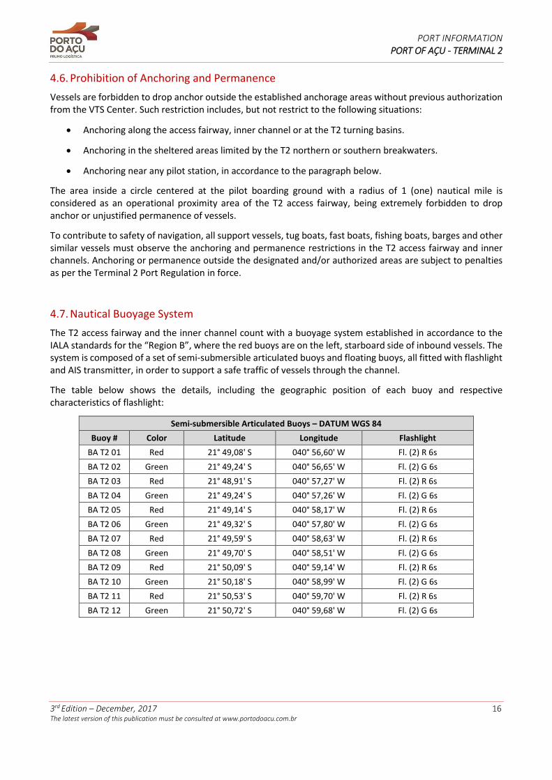
4.7. Nautical Buoyage System
The T2 access fairway and the inner channel count with a buoyage system established in accordance to the IALA standards for the “Region B”, where the red buoys are on the left, starboard side of inbound vessels. The system is composed of a set of semi-submersible articulated buoys and floating buoys, all fitted with flashlight and AIS transmitter, in order to support a safe traffic of vessels through the channel.
The table below shows the details, including the geographic position of each buoy and respective characteristics of flashlight:
Semi-submersible Articulated Buoys – DATUM WGS 84
Buoy # Color Latitude Longitude Flashlight
BA T2 01 Red 21° 49,08' S 040° 56,60' W Fl. (2) R 6s
BA T2 02 Green 21° 49,24' S 040° 56,65' W Fl. (2) G 6s
BA T2 03 Red 21° 48,91' S 040° 57,27' W Fl. (2) R 6s
BA T2 04 Green 21° 49,24' S 040° 57,26' W Fl. (2) G 6s
BA T2 05 Red 21° 49,14' S 040° 58,17' W Fl. (2) R 6s
BA T2 06 Green 21° 49,32' S 040° 57,80' W Fl. (2) G 6s
BA T2 07 Red 21° 49,59' S 040° 58,63' W Fl. (2) R 6s
BA T2 08 Green 21° 49,70' S 040° 58,51' W Fl. (2) G 6s
BA T2 09 Red 21° 50,09' S 040° 59,14' W Fl. (2) R 6s
BA T2 10 Green 21° 50,18' S 040° 58,99' W Fl. (2) G 6s
BA T2 11 Red 21° 50,53' S 040° 59,70' W Fl. (2) R 6s
BA T2 12 Green 21° 50,72' S 040° 59,68' W Fl. (2) G 6s
PORT INFORMATION PORT OF AÇU - TERMINAL 2
3rd Edition – December, 2017 17 The latest version of this publication must be consulted at www.portodoacu.com.br
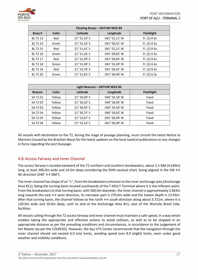
Floating Buoys – DATUM WGS 84
Buoy # Color Latitude Longitude Flashlight
BL T2 13 Red 21° 51,19' S 041° 01,11' W Fl. (2) R 6s
BL T2 14 Green 21° 51,10' S 041° 00,41' W Fl. (2) G 6s
BL T2 15 Red 21° 51,41' S 041° 01,21' W Fl. (2) R 6s
BL T2 16 Green 21° 51,26' S 041° 00,82' W Fl. (2) G 6s
BL T2 17 Red 21° 52,39' S 041° 00,66' W Fl. (2) R 6s
BL T2 18 Green 21° 51,49' S 041° 01,09' W Fl. (2) G 6s
BL T2 19 Red 21° 52,76' S 041° 00,42' W Fl. (2) R 6s
BL T2 20 Green 21° 51,65' S 041° 00,99' W Fl. (2) G 6s
Light Beacons – DATUM WGS 84
Beacon Color Latitude Longitude Flashlight
SA T2 01 Yellow 21° 50,09' S 040° 59,18' W Fixed
SA T2 02 Yellow 21° 50,20' S 040° 58,96' W Fixed
SA T2 03 Yellow 21° 49,95' S 040° 59,30' W Fixed
SA T2 04 Yellow 21° 50,75' S 040° 59,03' W Fixed
SA T2 05 Yellow 21° 53,07' S 041° 00,49' W Fixed
SA T2 06 Yellow 21° 53,14' S 041° 00,09' W Fixed
All vessels with destination to the T2, during the stage of passage planning, must consult the latest Notice to Mariners (issued by the Brazilian Navy) for the latest updates on the local nautical publications or any changes in force regarding the port buoyage.
4.8. Access Fairway and Inner Channel
The access fairway is located eastward of the T2 northern and southern breakwaters, about 2.5 NM (4.630m) long, at least 300.0m wide and 14.5m deep considering the DHN nautical chart, being aligned in the SW ↔ NE direction (240° ↔ 060°).
The inner channel has shape of an “L”, from the breakwaters entrance to the inner anchorage area (Anchorage Area #11), being the turning basin located southwards of the T-MULT Terminal where it is the inflexion point. From the breakwaters to that turning basin, with 500.0m diameter, the inner channel is approximately 2.663m long towards the east ↔ west direction, its narrower part is 270.0m wide and the lowest depth is 13.93m. After that turning basin, the channel follows to the north ↔ south direction along about 3.721m, where it is 120.0m wide and 10.0m deep, until its end at the Anchorage Area #11, east of the Wartsila Brasil Ltda. facilities.
All vessels sailing through the T2 access fairway and inner channel must maintain a safe speed, in a way which enables taking the appropriate and effective actions to avoid collision, as well as to be stopped in an appropriate distance as per the prevailing conditions and circumstances, in accordance to the judgement of her Master (as per the COLREGS). However, the Açu VTS Center recommends that the navigation through the inner channel should not exceed 6.0 (six) knots, avoiding speed over 8.0 (eight) knots, even under good weather and visibility conditions.
PORT INFORMATION PORT OF AÇU - TERMINAL 2
3rd Edition – December, 2017 18 The latest version of this publication must be consulted at www.portodoacu.com.br
It is forbidden the permanence and anchoring of vessels such as those involved in sports and recreation, fishing, researches, passengers’ transportation or any kind of vessel, regardless its type, that are not authorized to stay in the T2 by the T2 Administration.
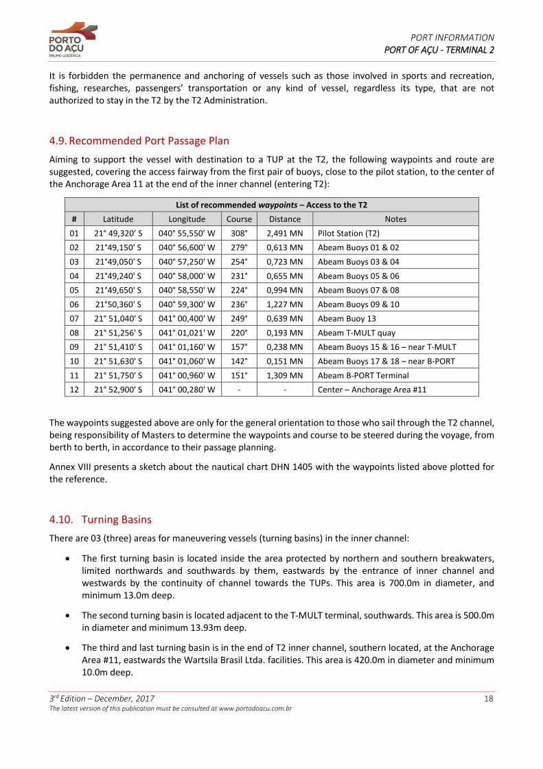
4.9. Recommended Port Passage Plan
Aiming to support the vessel with destination to a TUP at the T2, the following waypoints and route are suggested, covering the access fairway from the first pair of buoys, close to the pilot station, to the center of the Anchorage Area 11 at the end of the inner channel (entering T2):
List of recommended waypoints – Access to the T2
# Latitude Longitude Course Distance Notes
01 21° 49,320’ S 040° 55,550’ W 308° 2,491 MN Pilot Station (T2)
02 21°49,150' S 040° 56,600' W 279° 0,613 MN Abeam Buoys 01 & 02
03 21°49,050' S 040° 57,250' W 254° 0,723 MN Abeam Buoys 03 & 04
04 21°49,240' S 040° 58,000' W 231° 0,655 MN Abeam Buoys 05 & 06
05 21°49,650' S 040° 58,550' W 224° 0,994 MN Abeam Buoys 07 & 08
06 21°50,360' S 040° 59,300' W 236° 1,227 MN Abeam Buoys 09 & 10
07 21° 51,040' S 041° 00,400' W 249° 0,639 MN Abeam Buoy 13
08 21° 51,256' S 041° 01,021' W 220° 0,193 MN Abeam T-MULT quay
09 21° 51,410' S 041° 01,160' W 157° 0,238 MN Abeam Buoys 15 & 16 – near T-MULT
10 21° 51,630' S 041° 01,060' W 142° 0,151 MN Abeam Buoys 17 & 18 – near B-PORT
11 21° 51,750' S 041° 00,960' W 151° 1,309 MN Abeam B-PORT Terminal
12 21° 52,900' S 041° 00,280' W - - Center – Anchorage Area #11
The waypoints suggested above are only for the general orientation to those who sail through the T2 channel, being responsibility of Masters to determine the waypoints and course to be steered during the voyage, from berth to berth, in accordance to their passage planning.
Annex VIII presents a sketch about the nautical chart DHN 1405 with the waypoints listed above plotted for the reference.
4.10. Turning Basins
There are 03 (three) areas for maneuvering vessels (turning basins) in the inner channel:
• The first turning basin is located inside the area protected by northern and southern breakwaters, limited northwards and southwards by them, eastwards by the entrance of inner channel and westwards by the continuity of channel towards the TUPs. This area is 700.0m in diameter, and minimum 13.0m deep.
• The second turning basin is located adjacent to the T-MULT terminal, southwards. This area is 500.0m in diameter and minimum 13.93m deep.
• The third and last turning basin is in the end of T2 inner channel, southern located, at the Anchorage Area #11, eastwards the Wartsila Brasil Ltda. facilities. This area is 420.0m in diameter and minimum 10.0m deep.
PORT INFORMATION PORT OF AÇU - TERMINAL 2
3rd Edition – December, 2017 19 The latest version of this publication must be consulted at www.portodoacu.com.br
Annex IX shows the T2 turning basins as a reference.
4.11. Navigational Risks
Once the buoyage system for lateral limits of channel is respected, no navigational risks were evidenced along the access fairway and inner channel. However, special attention is recommended during the passage through northern and southern breakwaters, where the width is about 300.0m (from one breakwater to the other).
The main obstacle to navigation of those that sails to the T2 is the presence of fishing boats sailing or trawling nearby the port. It is also important to highlight that there are fishing boats in the port area which do not have VHF equipment available on board; when they have it may not be fully operational. For this reason, it is recommended the use of appropriate warning sound signals in order to avoid the risk of collision, where applicable, as per the COLREGS.
4.12. Depth Control
The T2 Administration is responsible for the depth control of the access fairway, inner channel and T2 turning basins, monitoring the sedimentation rate and also carrying out the required maintenance dredging campaigns as required to maintain the depth as approved by the Maritime Authority.
4.13. Berthing Assistance
Each TUP established in the T2 is responsible for determining, establishing and operating any equipment available at its respective berth to assist vessels during maneuvers of approach, such as docking radars to measure the distance, speed and approach angle of vessel to the berth. The operator of each TUP counts, also, with proper manpower to assist the shipboard staff during berthing.
For more information about the specific equipment and resources available in a TUP established in T2, any person is encouraged to contact directly the respective TUP representatives. Contact details are given in the Chapter 9.
4.14. Vessel Traffic Service (VTS)
The control of the maritime traffic at the Port of Açu is carried out by the Port of Açu VTS Center, the body responsible for inbound and outbound flow of vessels in T2. The VTS Center should be contacted by VHF channels 16 or 10 for information about maneuvers, time schedule, authorization of maneuvers and other requests.
The table below presents the limits of operational area of the Port of Açu VTS Center:
Coordinates of the VTS operating area – DATUM WGS 84
Point Description Latitude Longitude
1
Port of Açu VTS Center operational area
21° 41,92' S 041° 01,26' W
2 21° 46,32' S 040° 44,22' W
3 21° 55,62' S 040° 44,22' W
4 21° 55,62' S 040° 58,74' W
PORT INFORMATION PORT OF AÇU - TERMINAL 2
3rd Edition – December, 2017 20 The latest version of this publication must be consulted at www.portodoacu.com.br
The use of the anchorage areas by vessels, berthing operations, navigation through the access fairway or inner channel and unberthing operations will be authorized and coordinated by the VTS Center, according to the previous schedule of arrivals and departures of vessels as per the port line-up, further described in item 6.2.
Except in case of unplanned route deviation or reasons beyond control, any interested party must require prior authorization to access a TUP in T2. To do so, it must provide the nominating information in advance, as described in item 6.2 of this document. It is up to the T2 Administration to define the schedules and sequence of maneuvers, as per the rules established in T2 Port Regulation.
All vessels, when crossing a VTS reporting point, should contact the VTS Center in accordance to the procedures described in item 6.8 of this document. The following table lists the VTS reporting points for T2:
Point Reporting Point Latitude Longitude
A North 21° 43,87’ S 040° 53,73’ W
B East 21° 51,59’ S 040° 44,22’ W
C South 21° 55,62’ S 040° 51,55’ W
F T2 Pilot Station 21° 49,32’ S 040° 55,55’ W
More information about Port of Açu VTS Center available in Annexes IX and XI.
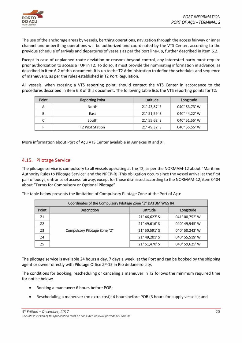
4.15. Pilotage Service
The pilotage service is compulsory to all vessels operating at the T2, as per the NORMAM-12 about “Maritime Authority Rules to Pilotage Service” and the NPCP-RJ. This obligation occurs since the vessel arrival at the first pair of buoys, entrance of access fairway, except for those dismissed according to the NORMAM-12, item 0404 about “Terms for Compulsory or Optional Pilotage”.
The table below presents the limitation of Compulsory Pilotage Zone at the Port of Açu:
Coordinates of the Compulsory Pilotage Zone “Z” DATUM WGS 84
Point Description Latitude Longitude
Z1
Compulsory Pilotage Zone “Z”
21° 46,627' S 041° 00,752' W
Z2 21° 49,616' S 040° 49,945' W
Z3 21° 50,591’ S 040° 50,242' W
Z4 21° 49,201' S 040° 55,519' W
Z5 21° 51,470' S 040° 59,625' W
The pilotage service is available 24 hours a day, 7 days a week, at the Port and can be booked by the shipping agent or owner directly with Pilotage Office ZP-15 in Rio de Janeiro city.
The conditions for booking, rescheduling or canceling a maneuver in T2 follows the minimum required time for notice below:
• Booking a maneuver: 6 hours before POB;
• Rescheduling a maneuver (no extra cost): 4 hours before POB (3 hours for supply vessels); and
PORT INFORMATION PORT OF AÇU - TERMINAL 2
3rd Edition – December, 2017 21 The latest version of this publication must be consulted at www.portodoacu.com.br
• Canceling a maneuver (no extra cost): 3,5 hours before POB (2,5 hours for supply vessels).
The pilotage service is directly arranged by the ship owner, its agent or other representative, at their own expense, except when there are specific contractual terms between the TUP of destination and the vessel owner or if representatives agree in a different way. The T2 Administration and the VTS Center do not book pilotage service for vessels operating at the T2.
The details to contact the Pilot Office ZP-15 (responsible for pilotage service in the Port) are available in the item 9.4 of this document. All further conditions that applies to the pilotage service at the T2 shall be consulted directly with this Office.
The pilot boarding ground for vessels with destination to the T2 is located in the position below:
Coordinates Table - Pilot Boarding Ground– DATUM WGS 84
Point Description Latitude Longitude
P2 Pilot Station - T2 21° 49,32’ S 040° 55,55’ W
The vessels with destination to T2 Terminal must have enough ballast and be properly equipped concerning to mooring equipment and related accessories, and afford clean, safe and effective pilot ladders, to embark and disembark, with cable and steps in perfect conditions, steady in the point close to the side and adequate length to reach pilot boat, being 1.0 (one) meter above the water line.
A responsible officer must remain on the top of the pilot ladder, equipped with a VHF communication device to contact directly the bridge. A lifebuoy with safety line (floating line) and self-ignition light must be available less than 12.0 (twelve) meters of this position.
During the pilot’s embarkation and disembarkation, the vessels must assume a position which provides shelter against winds, providing safe passage from the pilot boat to board and vice versa. The vessel must also reduce the speed to facilitate the embarkation and disembarkation.
In general, the vessels at Port of Açu must follow the IMO (International Maritime Organization) and the IMPA (International Maritime Pilots’ Organization) recommendations for pilots’ embarkation and disembarkation. More information about international requirements to this activity are available at IMPA website (www.impahq.org).
Each Master is the only responsible for the maneuvers of own vessel, being responsible for all information to be provided to the pilot about any peculiarities, specific conditions or existing difficulties, such as machinery or system failure, problems or equipment malfunctions with mooring lines and any other element which could endanger the ship navigation, maneuvering and mooring.
According to NPCP-RJ, it is the competency of the Harbormaster of the State of Rio de Janeiro to declare the impracticability of the port entrance. The VTS Center and the Pilots on duty at the Port of Açu cooperate with the Maritime Authority so the appropriate measures can be taken.
Annex VII presents a sketch with the limits of Port of Açu Pilotage Zone and also the T2 Pilot Station, DHN 1406 nautical chart “Proximidades do Porto do Açu” for reference only.
For more information, see the Pilotage website (www.praticagem-rj.com.br).

PORT INFORMATION PORT OF AÇU - TERMINAL 2
3rd Edition – December, 2017 22 The latest version of this publication must be consulted at www.portodoacu.com.br
4.16. Tug Boats
Tugs and towing service for berthing and unberthing operations and other maneuvers in T2 are provided by a specialized company and authorized by Porto do Açu Operações S.A. to operate at Port of Açu. The service is available 24 hours a day, 7 days a week, provided by a fixed fleet based at Açu.
The towing service is directly arranged by the ship owners, its agent or other representative, at their own expense, except when there are specific contractual terms between the destination TUP and the vessel owner or if representatives agree in a different way. The T2 Administration and the VTS Center does not book towing service for vessels operating at the T2.
The tug requirements for maneuvers at the T2 follows the terms of the “Port of Açu Statement on Operational Parameters” published by the T2 Administration and available at the Port of Açu website (www.portodoacu.com.br) in the "Port Operations" menu. This document follows the requirements established by the CPRJ for each maneuver in T2.
Additional tugs may be required by Ship Master through the agent, when it is considered necessary; once that the establishment of devices and the number of tugs for berthing or unberthing operations is Master’s exclusive responsibility. The availability and rules to this request must be consulted directly with the company that operates tug boats at Port of Açu.
To contact the company responsible for towing service, see item 9.5 of this document.
4.17. Other Port Service
Supporting Boats
Port of Açu does not have own fast boats to transport staff or material. However, this kind of service can be requested through the local shipping agent to companies that currently provide this service at the port.
The fast boat service to transport material and provisions, trash collection and lubricants supply, when berthed, will be allowed by terminal authorization. This service must be hired by agency, being an obligation of the Terminal and the Ship Officer on duty to evaluate the safety conditions of the operation.
The contacts list of the companies which have fast boats available at the port are published in item 9.6 of this document.
4.18. Information about climate and sea conditions
Climate
The climate in Port of Açu area is described as tropical, with rainfall between low and moderate, especially during Winter, between June and August. The local average temperature is about 27.0°C (80.6°F), oscillating between 23.0°C and 31.0°C (73.4°F and 87.8°F) during the year.
Predominant Winds
The predominant winds are at the northeast quadrant (045°) occurring about 25% of time from this direction. The average wind intensity is 12.1 knots (22.4 Km/h or between 3 and 4 in Beaufort scale), not considering the

PORT INFORMATION PORT OF AÇU - TERMINAL 2
3rd Edition – December, 2017 23 The latest version of this publication must be consulted at www.portodoacu.com.br
gusts, with wind speed lower than 15.0 knots (27.8 Km/h) and 20.0 knots (37.1 km/h) from 70% to 90%, respectively.
Waves & Swell
The significant wave height (Hs) in the Port of Açu is 1.25m (average), being the waves usually lower than 1.50m about 81% of the time. The predominant waves direction is east (090°), about 22% of the time.
Humidity and Precipitation
The relativity air humidity is usually high during the year, with monthly average between 75% and 85%. The precipitation annual average is 1,944.0 mm/year; during the rainy season (about 15 rainy days per month) the monthly average is 325.0 mm/month and, during the dry season between the months of July and November, the monthly average is 50.0 mm/month (about 5 rainy days per month).
Thunderstorms with lightning
Such storms are not common, but can occur with the passage of cold fronts.
Visibility
In general, the visibility is good, however, in the first morning hours it may be foggy during Autumn and Winter. During Summer, sometimes, drought mist may reduce the visibility.
Currents
The measurement of coastal currents at port area presents the following data:
• 1.0m deep: predominant direction SOUTH (180°), average speed 0.4 knots (0.21 m/s) and lower than 1.0 knot (0.51 m/s) about 93% of the time.
• 5.0m deep: predominant direction SOUTH (180°), average speed 0.35 knots (0.18 m/s) and lower than 1.0 knot about 98% of the time.
• 8.0m deep: predominant direction SOUTH (180°), average speed 0.3 knots (0.15 m/s) and lower than 1.0 knot about 99% of the time.
The tidal currents inside T2 channel, because of its design, present during flood tides an east-west course and, during ebb tides, the opposite (west-east). The tidal current speed is 0.22 knots (average), according to measures carried out near the Intermoor Terminal along the year of 2014.
PORT INFORMATION PORT OF AÇU - TERMINAL 2
3rd Edition – December, 2017 24 The latest version of this publication must be consulted at www.portodoacu.com.br
Tides
The tidal regime in the Port of Açu area is semidiurnal; two (02) high tides and two (02) low tides daily, both practically with the same amplitude, meaning that a high tide is practically as high as the next one and a low tide is almost as low as the next one.
In general, the variation of local tide height is:
• Tidal average height1: + 0.90m (+ 2.95ft)
• Maximum amplitude of spring tide: 1.80m (5.91ft)
• High tide of spring tide: + 1.70m (+ 5.58ft)
• Low tide of spring tide: - 0.20m (- 0.66ft)
Complete tide tables to Port of Açu can be found online at the Directorate of Hydrography and Navigation website (www.mar.mil.br/dhn/chm/box-previsao-mare/tabuas/).
Water Density
The water density in T2 is 1.025 grams/liter (salt water).
Measurements
Port of Açu VTS Center operates equipment to measure and monitor the weather and sea parameters, which includes, but not limited to, measurement of wind, waves and current.
The seafarer interested in more precise information, obtained in real time at Port of Açu, can contact VTS Center through VHF channels 16 or 10 24 hours a day, 7 days a week.
4.19. General Restrictions
Access Fairway and Inner Channels Maximum Depths
The T2 access fairway is dredged to 13.93m (47.6ft) from the first pair of buoys to the breakwaters and from them to the turning basin area adjacent to the T-MULT Terminal. Going south from this point, T2 navigable channel is dredged to 10.0m (32.8ft) deep until its end, where the inner Anchorage Area #11 is located.
Nowadays, the approved depths by Brazilian Maritime Authority to two parts of T2 are:
• External fairway part until the entrance (between breakwaters): 14.5m
• From the entrance to T-MULT: 13.9m
• From T-MULT to south, until Anchorage Area #11: 10.0m
1 Related to the DNH Nautical Chart 1405 “Porto do Açu”
PORT INFORMATION PORT OF AÇU - TERMINAL 2
3rd Edition – December, 2017 25 The latest version of this publication must be consulted at www.portodoacu.com.br
Depth and Maximum Vessel Dimensions at the Berths
Applicable restrictions to berths of each TUP are detailed in Chapter 5 of this document.
Guidance for Convoys
Convoys (tug plus barge) should shorten the tow line as far as possible before entering the T2 access fairway,
keeping a safe distance from the buoys or at a place where the buoys are at the windward side of the vessel.
To enter the channel, the convoy must navigate permanently at a safe speed, never exceeding six (6) knots to
the destination terminal, where it will complete tug to barge mooring and the berthing operation.
The passage of convoys should preferably take place in the wake of (after) other vessels that are not being
towed.
PORT INFORMATION PORT OF AÇU - TERMINAL 2
3rd Edition – December, 2017 26 The latest version of this publication must be consulted at www.portodoacu.com.br
5. DESCRIPTION OF THE T2 TERMINALS OF PRIVATE USE
In addition to the information written bellow, the updated maximum dimensions allowed at the berths, as well as tug boats and pilotage requirements, shall always be consulted at the “Port of Açu Statement on Operational Parameters” published by the T2 Administration available at the Port of Açu website (www.portodoacu.com.br) in the "Port Operations" menu.
For more information about each terminal in operation at T2, consult the local agent or the terminal representative. Contact details are given in Chapter 9.
5.1. Terminal B-Port
Edison Chouest Group's logistical support base for the offshore oil and gas industries.
Geographical Location
• Latitude: 21° 52,0 S
• Longitude: 041° 00,9 W
General Description
With a total area of 581,814m² and 1,030m of quay, including covered slips which allow 24 hours operating independent of weather conditions. B-PORT Terminal started its first operational phase in April, 2016 at the southern quay.
Authorizations
• ANTAQ: Subscription Contract – 02/2016-SEP/PR.
• ANTAQ: Operations Permission Term – TLO 03/2016.
• INEA: Operations License – IN033712.
Characteristics of Quay
Conventional berths and 10 covered slips (construction in progress).
• South quay operational length: 310.0m
• Current functional length: 310.0m
• Depth of berth: 8.08m
• Fenders: tubular types
• Bollards: 5 (five) “T” type SWL 100t and 17 (seventeen) cylindrical type SWL 30t
PORT INFORMATION PORT OF AÇU - TERMINAL 2
3rd Edition – December, 2017 27 The latest version of this publication must be consulted at www.portodoacu.com.br
Maximum dimensions at berths
Straight quay (south):
• LOA: 161.0m
• Beam: 23.43m
• Draft: 7.55m
Slips 1 to 4:
• LOA: 100.0m
• Beam: 20.0m
• Draft: 6.30m
Developed Operations
Handling equipment and supplies; storage yard and equipment commissioning/assembly (oversize and overweight); plants for providing drilling fluid, cement, diesel and water; temporary storage and management of waste; offices, restaurants, accommodation and road scales.
Equipment available at quay
At the quay, 200t “crawler” cranes and a 500t Derrick crane. At the covered slips, a double set of 50t overhead cranes and heavy lift 100t overhead cranes.
Service and materials supply
There is a specific Supply Management Service on the local site 24 hours a day/7 days a week. Safety and Health Achievement Recognition Program (SHARP); infrastructure of oil spills and pollution response, appropriate equipment and trained staff; first aids and medical infrastructure; and waste management.
Specific procedures
For any further information, consult directly the Terminal.
5.2. Flexibrás Terminal (TechnipFMC)
Dedicated to handle TechnipFMC’s flexible lines for oil and gas industries.
PORT INFORMATION PORT OF AÇU - TERMINAL 2
3rd Edition – December, 2017 28 The latest version of this publication must be consulted at www.portodoacu.com.br
Geographical location
The terminal can be visualized in Nautical Chart 1403 – Barra do Itapemirim to Cabo de São Tomé, with geographic coordinates determined by the points: 021°52’17,30”S / 041°00’65,30”W, 021°52’08,22”S / 041°00’47,05”W, 021°52’31,51”S / 041°57’26”W, 021°52’22,46”S / 041°00’39,08”W.
General Description
Flexibrás Terminal is installed in a 289.800 m² area (39.086m² of constructed areas).
Authorizations
• ANTAQ: Subscription Contract – 003/2013-SEP/PR
• ANTAQ: Operations Permission Term – TLO 15/2014
• INEA: Operations License – IN027862
Characteristics of quay
• Length: 500.0m
• Fenders: conical type with 3.6m high, 3.0m long and 25.0m spaced
• Bollards: 29 (twenty-nine) molten “T” type SWL 100t, spaced in 16.0m or 20.0m (depending on berth location).
Maximum dimensions at berths
• LOA: 183.0m.
• Beam: 30.0m
• Draft: 8.57m between bollards 1 and 16 / 8.36m along the rest of quay
• Minimum free board: 2.5m
Developed Operations
The Flexibrás terminal works basically in the following activities:
• The manufacturing of flexible tubes, loading and unloading bobbins which contain flexible tubes, umbilical oil tubes and accessories.
PORT INFORMATION PORT OF AÇU - TERMINAL 2
3rd Edition – December, 2017 29 The latest version of this publication must be consulted at www.portodoacu.com.br
Available equipment at quay
• TEREX/DEMAG PC9600 Crane with nominal capacity of 2,000tf
• Stacking machines – 5t, 7t and 16t
• Transportation of bobbins – 400t and 500t
Service and materials supply
The terminal doesn’t have structure for material supplies. However, it offers mooring service and oil booms operations.
Specific procedures
Specific procedures shall be requested to TechnipFMC.
5.3. InterMoor Açu Terminal
InterMoon Açu Maritime Support Base belongs to InterMoor do Brasil Serviços Offshore de Instalação.
Geographical location
• Latitude: 21° 52,09’ S
• Longitude: 041° 01,02’ W
General Description
The InterMoor do Brasil Serviços Offshore de Instalação Ltda. is installed in the west side of inner channel.
Intermoor Açu Maritime Support Base has a total area of 52,302m². Of this total, 45,000m² are destined to storage yard, pre-boarding yard and goods handling; it is expected 3,000m² of covered area to be built.
Authorizations
• ANTAQ: Subscription Contract – 009/2014-SEP/PR.
• ANTAQ: Operations Permission Term – TLO 07/2014
• INEA: Operations License – IN026544; Registrations AVB002428 and AVB002733
PORT INFORMATION PORT OF AÇU - TERMINAL 2
3rd Edition – December, 2017 30 The latest version of this publication must be consulted at www.portodoacu.com.br
Characteristics of quay
• Operational length: 90.0m
• Minimum Current Functional Length: 90.0m, the Intermoor Terminal accommodate bigger vessels (length up to 210m), as authorized by ANTAQ (Resolutions 4003 and 4004 on March 20th 2015), through the contract of berthing structure sharing with NOV.
• Berth minimum depth: 10.0m.
• Fenders: 5 (five) conical type 2.0m high, 1.6m long and 18.5m spaced
• Bollards: 5 (five) molten “T” type SWL 100t, 18.5m spaced
Maximum dimensions at quay
• LOA: 183.0m (using contiguous pier of NOV when LOA > 90.0m)
• Beam: 30.0m
• Draft: 8.90m
Developed operations
InterMoor carries out loading and unloading logistic supplies destined to operations of exploration and production of hydrocarbons in Brazilian jurisdiction waters, through platform supply vessels, also berthing platforms and drill-ships.
Below there are other operations done by the terminal:
• Berthing vessel for operations of:
o Loading and unloading equipment and materials;
o Crew change;
o Waste removal of any kind;
o Vessel repairing, including diving operations; and
o Environmental protection with oil boom operations.
Equipment available at quay
Several equipment for cargo handling, such as cranes (80t or 220t), stacking machine, air platforms, generator, etc. Other capacities on demand which can be mobilized by the Terminal upon request.

PORT INFORMATION PORT OF AÇU - TERMINAL 2
3rd Edition – December, 2017 31 The latest version of this publication must be consulted at www.portodoacu.com.br
Service and materials supply
The diverse materials supply and service, such as waste removal; transportation of people, materials, equipment; fresh water supply and others, can be provided by the terminal upon request.
Specific procedures
The Terminal follows the most restricted rules of safe work, demanding the use of PPE (personal protective equipment) in its operational areas, with implementation of all procedures and internal rules to ensure personal and patrimonial safety in its facilities, and environmental protection as well.
5.4. NOV Terminal
It’s a Terminal for handling flexible tubes of National Oilwell Varco company.
Geographical Location
• Latitude: 21° 52,04’ S
• Longitude: 041° 00,97’ W
General Description
The NOV Equipamentos e Serviços Ltda. (NOV) Terminal, one of the companies from National Oilwell Varco group, is dedicated to handling flexible tubes of NOV industry, structures and other components of oil and gas offshore exploration system. Additionally, under contract with companies involved in exploration and production of oil and gas in the sea, the terminal will be used for receiving inputs to be used in NOV productive process, structures, systems and special bobbins for maritime transportation of tubes between the continent and offshore platforms, in the name of its clients, as well as eventual cargo and people management to attend the mentioned activities in the sea.
The Terminal has a total area of 121,905m² (210.0m along the T2 inner channel). In its plant, storage areas and temporary products stocking are planned.
About storage facilities, there will be, from the quay, a large uncovered area (about 32,000m²) for storing, stacking, pre-stacking and handling, especially bobbins and hydrostatic test of the flexible cables; and also, a covered area (about 1,400m²) destined to warehouse and workshops. Inside the covered area of the factory, there will be two main warehouses, one for steel storage as inputs for tubes manufacturing and another for polymers storage, including a storeroom to keep other products.
Authorizations
• ANTAQ: Subscription Contract – 015/2014-SEP/PR
• ANTAQ: Operations Permission Term – TLO 17/2014
PORT INFORMATION PORT OF AÇU - TERMINAL 2
3rd Edition – December, 2017 32 The latest version of this publication must be consulted at www.portodoacu.com.br
• INEA: Operations License – IN026502
Characteristics of quay
• Operational length: 210.0m
• Current Functional Length: 210.0m
• Berth depth: 10.0m
• Fenders: conical type 3.6m high, 3.0m long and 25.0m spaced
• Bollards: 11 (eleven) molten “T” type SWL 100t, 19.27m spaced
Maximum dimensions at berths
• LOA: 183.0m
• Beam: 30.0m
• Draft: 8.90m
Developed Operations
Handling flexible pipes for the oil and gas industries.
Equipment available at quay
The NOV terminal has an attached crane with capacity of 410.0 metric tons and 30.0m range.
Service and materials supply
Not informed by the terminal.
Specific Procedures
Not informed by the terminal.
5.5. T-MULT Terminal
Multicargo Terminal operated by Porto do Açu Operações S.A.
PORT INFORMATION PORT OF AÇU - TERMINAL 2
3rd Edition – December, 2017 33 The latest version of this publication must be consulted at www.portodoacu.com.br
Geographical Location
• Latitude: 21° 52,69’ S
• Longitude: 041° 0,10’ W
General Description
The T-MULT has a specific area for handling dry bulk cargoes, containers and general cargoes.
It also has a retro area of 187,800m², access roads and traffic, parking lots for trucks and cars, administrative area, storing area for bulk and other cargoes.
Authorizations
• ANTAQ: Subscription contract – 008/2015-SEP/PR
• ANTAQ: Operations Permission Term – TLO 02/2016
• INEA: Operations License – IN034002
Characteristics of quay
• Nominal length: 500.0m
• Operational length: 350.0m (for the authorized maximum draft)
• Berth depth: 14.5m
• Fenders: conical type 3.6m high, 3.0m long and 25.0m spaced
• Bollards: Cast, “T” type SWL 150 t and 25.0m spaced (depending on the location at the quay)
• Floor resistance at the Berth: 10t/m².
Maximum dimensions at quay
• LOA: 250.0m
• Beam: 40.0m
• Draft: 12.5m (without tidal height)
• Draft: 13.1m (with tidal height)
Developed Operations
Handling of the following cargoes:
PORT INFORMATION PORT OF AÇU - TERMINAL 2
3rd Edition – December, 2017 34 The latest version of this publication must be consulted at www.portodoacu.com.br
• Dry Bulk
• General Cargo
• Containers
• Project Cargoes
T-MULT also attends to the oil and gas industries, offering the berthing service to offshore vessels, drillships and platforms.
Equipment available at quay
The terminal has the following equipment and a yard area for the handling of cargoes:
Equipment:
• Two Gottwald cranes with SWL of 100t
• Two ecological hoppers
• Two Spreaders for containers – 20’ and 40’
• Two Grab’s – 20m³
• Two Grab’s – 30m³
• Two Spreaders for articulated bucket
• Ten articulated buckets – 20 m³
• Two forklifts for yard storage – 10m high
• Two forklifts – 7t
• Ten flatbed trucks
• Five mechanical shovels with shells of 5 m³
• One excavator with a shell of 5 m³
• One munck truck
• Eighteen dump trucks
Storage area for solid bulk cargoes:
• Number of yards: 01
• Yard area: 25,500m²
• Number of piles: 04
• Dimensions of piles/stacks #1, #2 and #3: 50.0m x 120.0m.
PORT INFORMATION PORT OF AÇU - TERMINAL 2
3rd Edition – December, 2017 35 The latest version of this publication must be consulted at www.portodoacu.com.br
• Dimensions of pile/stack #4: 50.0m x 150.0m
• Stack Height (project): 10m
• Floor type: Asphalt
• Static capacity: 165,000t
Storage Area for General Cargo:
• Number of yards: 01
• Location: In front of the quay
• Dimensions: 27.0m x 395.0m
• Area: 10,200m²
• Floor type: gripped floor
• Floor resistance: 10t/m²
Service and materials supply
T-MULT allows fresh water supply by tank trucks that can be provided upon request.
Specific Procedures
The Terminal follows the most restricted rules of safe work, demanding the use of PPE (personal protective equipment) in its operational areas, with implementation of all procedures and internal rules to ensure personal and patrimonial secutrity in its facilities, and environmental protection as well.
For more information about specific procedures of Terminal or other subject, contact the T-MULT administration.
5.6. TECMA Terminal
The Maritime Fuels Terminal (TECMA) is operated by the NFX Combustíveis Marítimos Ltda. (NFX).
Geographical Location
• Latitude: 21° 51,0’ S
• Longitude: 041° 01,0’ W
General Description
PORT INFORMATION PORT OF AÇU - TERMINAL 2
3rd Edition – December, 2017 36 The latest version of this publication must be consulted at www.portodoacu.com.br
The terminal is dedicated to maritime fuel supply (bunkering).
TECMA is located on the left side (outbound direction) of inner channel and has two discontinuous berths.
Authorizations
• ANTAQ: Subscription Contract – 005/2015-SEP/PR
• INEA: Operations License – IN034899
• ANP: No Objection Document – 0370/2016/SCM
Characteristics of berths
• Operational length (mooring platform length)
▪ Berth #1: 75.0m
▪ Berth #2: 44.0m
• Distance between the far end of the mooring dolphins:
▪ Berth #1: 213.5m
▪ Berth #2: 126.5m
• Functional Length:
▪ Berth #1: 185.0m
▪ Berth #2: 110.0m
• Berth depth:
▪ Berth #1: 12.5m
▪ Berth #2: 10.3m
• Fenders: Conical type 3.6m high, 3.0m wide and 25.0m spaced
• Quick release mooring hooks: SWL 100t, 25.0m spaced
Maximum Dimensions at berths
• Total length (LOA):
▪ Berth #1: 185.0m
▪ Berth #2: 95.0m
• Beam:
▪ Berth #1: 32.0m
PORT INFORMATION PORT OF AÇU - TERMINAL 2
3rd Edition – December, 2017 37 The latest version of this publication must be consulted at www.portodoacu.com.br
▪ Berth #2: 20.0m
• Draft:
▪ Berth #1: 11.0m
▪ Berth #2: 7.9m
• Minimum freeboard:
▪ Mooring platform height: 5.0m (DHN)
Developed Operations
Maritime fuel products supply.
Equipment available at berths
In the first operational phase, TECMA will carry out all operations with equipment on board the vessels. Therefore, the equipment at the berth is restrict to fenders and quick release mooring hooks and equipment to emergencies response.
Service and materials supply
TECMA is ready to receive and authorize the necessary service to be performed at the vessels in both berths, as long as the service is hired by the vessels and agreed with TECMA.
Specific Procedures
To ensure that the fuel transfer is developed in a planned and controlled way, procedures of security management must be observed following guidelines from regulatory bodies, such as ISO 13739 (related to procedures for ship-to-ship bunkering) and ISGOTT (International Safety Guide for Oil Tankers & Terminals).
5.7. DOME Terminal
Terminal for service supply to the oil and gas industries under the responsibility of the Consórcio Dome Serviços Integrados, a joint venture between the companies Prumo Serviços de Navegação Ltda. and GranIHC S.A.
Geographical Location
• Latitude: 21° 51,0’ S
• Longitude: 041° 01,0’ W
PORT INFORMATION PORT OF AÇU - TERMINAL 2
3rd Edition – December, 2017 38 The latest version of this publication must be consulted at www.portodoacu.com.br
General Description
The DOME Terminal has a first-class infrastructure to meet the demands of oil and gas industries, providing naval repairs, construction and assembly; support to the subsea industry, decommissioning and waste treatment. The Terminal has an area of 47,000m², with access roads and traffic, parking lots for trucks and cars, pipe shop, administrative areas, sheds, ambulatory, cafeteria and locker rooms.
Authorizations
• ANTAQ: Resolution – 5449/2017.
Characteristics of quay
• Operational length: 400.0m
• Maximum depth: 9.0m
• Fenders: plate type, 5.5m high, 2.6 wide from 17.0m to 18.0m spaced (depending on location at quay), 180.0tf capacity; fixed on quay by conic rubber and 1,632mm distant from the quay to the front part of plates.
• Bollards: molten type, 27.0 to 29.5m spaced (depending on location at quay), 200tf capacity.
• Floor resistance: 150.0ton/m²
• Floor resistance at retro area: 50.0ton/m²
Maximum Dimensions at quay
• LOA: 120.0 m
• Beam: 28.0m
• Draft: 7.8m
Developed Operations
Dome understands that the oil and gas industries are looking for a one-stop-shop service provider that innovates to meet its demands, providing integrated, safe, efficient and fully reliable service.
• Logistic support:
▪ Port operations
▪ Handling and storage of cargo in the yard and qualified warehouses
▪ Inland transportation
▪ Access and use of the quay and central facilities
PORT INFORMATION PORT OF AÇU - TERMINAL 2
3rd Edition – December, 2017 39 The latest version of this publication must be consulted at www.portodoacu.com.br
• Naval repairs:
▪ Emergency and classification naval repairs
▪ Hibernation and vessel warm-up
▪ Equipment inspection and repairs
• Construction and assembling:
▪ Modules and skids
▪ Integration
• Subsea:
▪ Spoolbase
▪ Logistic support for composite mills.
▪ Handling and storage of flexibles
▪ Loading and unloading PLSVs
▪ Risers repair
▪ Assembling of PLETs, PLEMs and manifolds
• Decommissioning and waste treatment:
▪ Support to offshore decommissioning
▪ Collection, treatment and discard of residues and drilling mud
Equipment available at quay
The Terminal is ready to serve the oil and gas industries with integrated service and first-class infrastructure of the Dome Terminal, T-MULT, Molhe Sul and T-Ore (Ferroport).
• Quay:
• Lenght: 400.0m
• Depth: maximum 12.5m
• Floor resistance: 150t/m²
• Bollards: 200 Ton
• Fenders: 1200
PORT INFORMATION PORT OF AÇU - TERMINAL 2
3rd Edition – December, 2017 40 The latest version of this publication must be consulted at www.portodoacu.com.br
• Retro area:
• Area: 3.2Km²
• Yards area: 160,000m²
• Yard floor resistance: up to 50t/m²
• Facilities:
• Area: 17,000m²
• Warehouse area: 8,900m²
• Fabrication area: 3,000m²
• Offices for 250 people
• Dining hall for 750 people
• Locker rooms and ambulatory
Service and Materials supply
Not informed.
Specific Procedures
The Terminal follows the most restricted rules of safe work, demanding the use of PPE (personal protective equipment) in its operational areas, with implementation of all procedures and internal rules to ensure personal and patrimonial security in its facilities, and environmental protection as well.
For more information about specific procedures of Terminal or other subject, contact the DOME administration.
PORT INFORMATION PORT OF AÇU - TERMINAL 2
3rd Edition – December, 2017 41 The latest version of this publication must be consulted at www.portodoacu.com.br
6. PROCEDURES
During the stay of vessels at Port of Açu, several actions are carried out to allow a safe operation and to manage the risks in order to minimize them. In all stages described below, the measures were taken aiming to facilitate the operations and to plan them properly.
Among the planned actions it is included the appropriate information exchange and agreement between the involved parties of the safety standards to be performed.
Some of these actions are mentioned below in an illustrative way, without affecting any other actions that are also considered relevant to assure safe operational conditions; agreed between the parties, which carry out the operations.
It is important to highlight that the destination terminal of the vessel must be consulted regarding to the requirements and specific procedures maintained to operate at its berths.
6.1. Registration of Shipping Agents
The agents who would like to operate with vessels at Port of Açu should contact the Operations Management of Port of Açu through the e-mail [email protected] for further information.
The contacts list of shipping agencies already registered to operate in Port of Açu is mentioned at item 9.3 of this document.
6.2. Nomination of Vessels to the Line-up
The nomination of vessels with destination to TUPs are only made online through the Port of Açu Line-up System, by agents and/or the TUP previously registered for this purpose (instructions in the item 6.1). This system is available at Port of Açu website (www.portodoacu.com.br).
The Line-up System aims an integrated traffic management among T2 Administration, shipping agents and the TUPs, contributing to organize prospects and the maneuvers day-by-day and to manage information related to the traffic at T2.
6.3. Approval of vessels by the Port.
Port of Açu Operations Management after receiving the form, proceeds with its internal process of vessels’ approval (or vessels’ vetting), carried out to keep the safety of navigation and T2 operations, in order to identify and reject operations of sub-standard vessels at T2.
In case of any additional information considered necessary, or any questioning or objection noticed, the Operations Management will contact the ship owner or agent for any necessary measures to be taken.
It is important to highlight that, according to the Maritime Authority Rules in force, bulk carriers with more than eighteen (18) years must pass through inspection of condition carried out by a Classification Society duly authorized. In this way, bulk carriers fitted in this rule must send, attached with the vessel’s form, a digital copy of vessel’s approval at the inspection carried out in the last twelve (12) months. The failure in this service to this requirement leads to the non-confirmation of vessel’s inclusion in port queue.

PORT INFORMATION PORT OF AÇU - TERMINAL 2
3rd Edition – December, 2017 42 The latest version of this publication must be consulted at www.portodoacu.com.br
Tankers, used in transportation of oil and petroleum products, must send attached with vessel’s form, a digital copy of the last SIRE report carried out in the last 12 (twelve) months.
Vessels of any type or age, which present problems considered major, such as but not limited to structural problems, dentitions history at inspections of the Port State Control, accidents history at Port of Açu or whatever causes damage or accidents in the port area during the current stay, may have denied future calls for Port of Açu.
In this way, Porto do Açu Operações S.A. reserves its right to refuse the berthing or operation of any ship considered inappropriate that does not achieve the safety conditions for mooring or any circumstance that can be a risk to T2 or a TUP established in T2. That includes risks resulted of staff, equipment, environment, and noncompliance of recommendations from Maritime Authority, Classification Society, established market standards or any other.
6.4. Port State Control
The vessels with foreign flags at Port of Açu are submitted to the Port State Control (PSC), according to International Conventions endorsed by Brazil and with NORMAM-04 of Brazilian Maritime Authority.
The shipping agent will inform the Master in case of the vessel is chosen to be inspected by Maritime Authority during its stay at Port of Açu.
6.5. Access Charges of T2 channel
The access charges are done through a bank slip sent with a deadline of 15 (fifteen) consecutive days, start counting from the date of vessel access to T2 channel. Exceptionally, Port of Açu Operations S.A can request the payment through bank deposit in a specific bank account for this purpose.
For those cases that the inclusion of vessel in the port queue is conditioned to payment of debts with Port of Açu by agents or owners, in a way that their payment is informed as condition for acceptance of a call. Aiming to optimize the process it is recommended that the responsible for the payment sends to Port of Açu Operations Management the receipt, being accepted as a tariff discharge proof for confirming the vessel in port queue.
The port tariff’s table updated, containing all the applicable conditions, is available at the Porto do Açu’s website (www.portodoacu.com.br).
TUPs in operation at T2 have different tariffs agreed with the Port of Açu for operations of some types of vessels. For more information, consult directly the TUP of interest.
6.6. Charging fees of inner anchorage area
Port of Açu Operations Management, after receiving a request to anchor at the inner area, will answer to the applicant informing about the availability (or lack) of the area and the technical and commercial conditions.
The charge of inner anchorage area will be calculated according to the updated port tariffs chart, available at the Porto of Açu website (www.portodoacu.com.br), being done through a bank slip sent with a deadline of 15 (fifteen) consecutive days start counting from the date that the vessel leaves the anchorage area.
Exceptionally, Port of Açu Operations S.A can request the payment through bank deposit in a specific bank account for this purpose.
PORT INFORMATION PORT OF AÇU - TERMINAL 2
3rd Edition – December, 2017 43 The latest version of this publication must be consulted at www.portodoacu.com.br
6.7. Pre-arrival Information (Notice of Arrival – NOA)
The vessels with destination to T2 at Port of Açu must inform VTS Center, with at least six (6) hours in advance, via maritime agent, the following data (IMO SRS items):
• Name, prefix and flag (ALFA);
• Position (CHARLIE);
• Last port of call (GOLF);
• ETA to enter VTS area (HOTEL);
• Terminal of destination (INDIA);
• Present maximum draft (OSCAR);
• Cargo (PAPA);
• Defects, damage, deficiencies, limitations (QUEBEC);
• Type, dimensions and gross tonnage (UNIFORM); and
• Level of security ISPS (X-RAY).
The shipping agent must update the information whenever there is an alteration of more than 2 hours in ETA.
The existence of any type of damage or failures, which reduce or restrict the maneuvers, steer and navigation, is considered a factor to refuse the maneuver by the VTS Center and the pilot. Such conditions must be informed, so all necessary arrangements can be made in order to assure the safety of navigation at T2 and the maneuvers can be performed with no delays. In general, maneuvers of vessels with restrictions in their steering systems and navigation are not authorized by Port of Açu VTS Center; except in special circumstances.
Additional information regarding the information requirements between vessels that operate in Port of Açu and the VTS Center must be consulted in Annex IX.
6.8. Vessel Crossing a VTS Reporting Point
When crossing an area near a VTS reporting point at Port of Açu in accordance to established in Annex XI, arriving or departing the port, the vessel master must inform the VTS Center through VHF channel 10 the following data:
Vessel ARRIVING at the VTS area:
• Ship name (ALFA);
• Time of the event (BRAVO);
• Position (DELTA);
• Course (ECHO);
• Speed (FOXTROT);
• Present maximum draft (OSCAR); and
• Any other information considered relevant by the Master (X-RAY).
PORT INFORMATION PORT OF AÇU - TERMINAL 2
3rd Edition – December, 2017 44 The latest version of this publication must be consulted at www.portodoacu.com.br
Vessel PASSING THROUGH a reporting point:
• Ship name (ALFA);
• Position (DELTA);
• Pilot boarding ground (JULIET); and
• Speed (FOXTROT).
Vessel leaving the VTS area:
• Ship name (ALFA);
• Time of the event (BRAVO); and
• Position (DELTA).
6.9. Vessel Approaching Anchorage Point
The vessels which doesn’t have a designated pier for berthing must proceed to anchorage area, according to established in nautical chart or Notice to Mariners.
When anchoring, the vessel must inform Port of Açu VTS Center the following data (IMO SRS items):
• Ship name (ALFA);
• Time the maneuver ended (BRAVO); and
• Position (CHARLIE).
6.10. Staying at the Anchorage Area
During the stay of the vessel at the anchorage area, an adequate level of surveillance should be kept on board to ensure the safety of the vessel, of the others that may be on the same anchorage area or nearby, as well as traffic safety of vessels in passage through the Port of Açu area.
During the stay in the anchorage area, it is forbidden:
• Fishing, of any kind or nature;
• Diving activities and/or naval repairs, without the acknowledgment and authorization of the VTS Center;
• Keeping stairs lowered near the water level during night-time, being only lowered in case of need to people embark/disembark, according to the NPCP-RJ in force;
• Embarking/Disembarking people or handling material without acknowledgment and previous authorization of the VTS Center; and
• The approaching and permanence alongside of small boats not authorized by the VTS Center.
PORT INFORMATION PORT OF AÇU - TERMINAL 2
3rd Edition – December, 2017 45 The latest version of this publication must be consulted at www.portodoacu.com.br
Such measures aim strictly the security of vessels, which operate in the Port of Açu, as well as their crewmembers, contributing to the inhibition of any type of illegal activity involving smaller vessels and ships, which operate in port.
The bridge of vessels at the anchorage area must be manned by a qualified crew; keeping constant watch on the VHF channel 16.
For restrictions and environmental control measures applicable to vessels at anchorage areas in the Port of Açu, see Chapter 9.
6.11. Notice of Readiness (NOR)
Vessels designated to operate at the Port of Açu must issue a NOR for the destination TUP in T2, according to the following guidelines:
• Vessels with a designated berth, without prospect to anchor: when crossing the VTS Reporting Point, according to Annex X;
• Vessels proceeding to an anchorage area: any time after dropping the anchor.
6.12. Leaving an Anchorage Area
Any anchored vessel must inform, 30 minutes before the estimated time for heaving up anchor, through VHF channel 10, that it is in conditions to start the maneuver, informing the VTS Center about the following data:
• Ship name (ALFA);
• Scheduled time to start heaving up anchor (BRAVO);
• Destination (INDIA);
• Present maximum draft (OSCAR).
In case of any malfunction preventing the heaving up the anchor, the vessel Master shall communicate the fact to the VTS Center, also informing the estimated time for the repair. It is the responsibility of the shipping agent to schedule a new timetable for the maneuver in the Port line-up, according to item 6.2.
6.13. Berthing and staying at the Terminal
Any vessel involved in VTS service only can proceed to the Access Fairway of Port of Açu after receiving the berthing confirmation from the VTSO (traffic clearance) through VHF channels 10 or 16.
After ascertaining that tugs, which will assist the berthing maneuver when needed, are ready and near the local where they will be used by the pilot, the VTSO informs the vessel that it is authorized to access the channel. In case there are no available tugs for the maneuver, the VTSO informs the vessel that it should return to the anchorage area, until there are tugs available.
In addition to the reporting points, according to Annex XI, the items below must be informed (IMO SRS items):
• Ship name (ALFA);
• Time of berthing end (BRAVO); and
PORT INFORMATION PORT OF AÇU - TERMINAL 2
3rd Edition – December, 2017 46 The latest version of this publication must be consulted at www.portodoacu.com.br
• Position (DELTA).
For those vessels which pilotage service is mandatory, the pilot must embark at Pilot Station located in the beginning of T2 Access Fairway, near to the first pair of buoys.
During the entire period berthed, the vessel must keep watching the VHF channels 10 and 16 for communication with Port of Açu VTS Center. In this period, the vessel must be in total condition to navigate, without restrictions as its capacity of propulsion, govern and maneuverability, in such a way that it is possible to unberth immediately from the quay in case of emergency.
The berthed ship cannot move its propellers while staying berthed to the terminal. The ratchet can only be used after analysis and authorization of TUP operator; however, the propeller must be operated in a slow and controlled way, in order to assure total security. The ships will be held liable for any damages caused by this maneuver, as the terms indicated at the Port Regulation of T2 Terminals.
The mooring cables need constant attention, in order to keep the ship always berthed. All cables must be maintained under proper tension during operation, with winches (when available), break devices and monitored by the personnel onboard and the terminal.
It is recommended the use of mooring cables of the same type, gauge and material; avoiding the use of cables with different characteristics in mooring. The cables must be laid out symmetrically to the middle of ship, in accordance to the following guidelines:
• The breast lines guided to the most perpendicularly as possible of ship longitudinal axis;
• The spring lines guided to the most parallel as possible of ship longitudinal axis;
• The horizontal angle of forward lines and aft lines in relation to the direction of the beam perpendicularly to ship longitudinal axis, not exceeding 45°.
The emergency and firefighting equipment of the ship should be maintained ready for use, while the ship is berthed at the terminal. It must be maintained a ready-to-use-kit of pollution response (sawdust, rags, blades, buckets, squeegees, transfer pumps, etc.) in case of oil spill; and it should be taken supplementary precautions aiming to avoid water pollution by oil.
For more information about restrictions and environmental control measures applicable to vessels berthed in Port of Açu, see chapter 9.
The destination terminal of the vessel at T2 must be consulted about their specific procedures applicable to staying and operations at the quay.
6.14. Interruption of operations at TUP
In any emergency, the terminal can interrupt the operations in progress, so that all actions aim to solve the situation.
The interruption of operations at the terminal must happen in any situation that can offer danger to the ship, to people involved, to the cargo or to the terminal. The operations can be temporally suspended in case of adverse events such as storms, lightning and/or strong winds.
People responsible for operations in each TUP has authorization to order the interruption or suspension of operations in the terminal in case of noncompliance of any rules and regulations concerning to safety, universally accepted and adopted in maritime transportation. Similarly, the ship master has the right of
PORT INFORMATION PORT OF AÇU - TERMINAL 2
3rd Edition – December, 2017 47 The latest version of this publication must be consulted at www.portodoacu.com.br
interrupt the operation, if there are reasons to believe that land operations do not offer safety, as long as they notify in advance the TUP operators and the Port of Açu VTS Center (for acknowledgement).
6.15. Ship x Land access
For vessels berthed to the terminal, the access between ship and quay must be made through accommodation ladder or boarding ramp properly fixed and protected according to applicable international rules.
According to NPCP-RJ, during the stay of the berthed ships it is prohibited to keep ladders lowered by the seaside, as well as the pilot ladder must be heaved up, during all stay at the terminal. In this way, it is recommended that the accommodation ladder in the opposite board side, where the ship is berthed, be maintained ready and lifted besides the deck during all the time the vessel is still berthed at the terminal, aiming the safety of the ship and also the terminal. The ladder can be used only in emergency case.
The accommodation ladder lowered to the quay must be provided of guard net; it is the Master’s decision to keep it lowered or heaved up at night.
For anchored vessels, which need to transport people from the ship to the terminal, the lifeboat can be used for this purpose as long as previously authorized, specifically for this aim, by the local Officer of Maritime Authority local agent, according to NPCP-RJ.
The crewmembers who want to use the terminal facilities must attend to the procedures related to ISPS Code. The crew can only circulate in delimited area of TUP control, where there will be vehicles to be requested by the ship agent, or by the terminal, to lead them to exit through the T2 Main Gate at Port of Açu.
6.16. Changing berths
The vessel traffic at the same Terminal or between two different ones, with or without the assistance of the pilot, the VTS Center must be informed, through VHF channel 10, about the following info:
• Ship name (ALFA);
• Time of unberthing and berthing at the new berth (BRAVO);
• Position (DELTA);
• Pilot (JULIET); and
• Maximum present draft (OSCAR).
6.17. Unberthing and leaving the Port
The Master must inform the Port of Açu VTS Center 30 minutes before starting the unberthing operation. After ascertain that the tugs, which will assist the maneuver, are ready and near the local where they will be used by the pilot. The VTSO informs the vessel about their authorization of starting the unberthing operation.
After VTSO confirmation (traffic clearance), the following data must be informed (IMO SRS items):
• Ship name (ALFA);
• Pilot’s boarding time and unberthing maneuver time (BRAVO);
PORT INFORMATION PORT OF AÇU - TERMINAL 2
3rd Edition – December, 2017 48 The latest version of this publication must be consulted at www.portodoacu.com.br
• Destination and ETA (INDIA)
• Maximum present draft (OSCAR);
• Cargo on board: only for vessels that transport dangerous cargo (PAPA)
• Update of eventual defects, damages, deficiencies or limitations for navigation (QUEBEC).
The vessel leaving the Port with pilot aboard should disembark at the T2 Pilot Station, where the pilot boat will wait to return to the Port.
6.18. Information about environmental conditions
VTSO should inform the conditions of wind, current, sea and visibility whenever a vessel enters the VTS area and/or whenever requested by the seafarer. The information is disclosed by the VTS Center in the following format, according to IMO SRS, SIERRA item:
• Wind direction (use cardinal points), FORCE BEAUFORT ____.
• TIDAL STREAM / CURRENT IS (speed in knots) KNOTS, DIRECTION (use cardinal points) IN POSITION _________.
• THE SEA STATE IS (sea state at Beaufort scale).
• VISIBILITY IN POSITION ________ IS (visibility in meters).
In case of environmental adverse situations, VTSO discloses the following additional information for vessels:
• Impracticability, in case the environmental conditions impede the traffic of vessels;
• Any maneuver restrictions, due to extreme conditions of wind or current; and
• Special measures of traffic separation.
6.19. Weather Warnings
In accordance to procedures of Port of Açu VTS, the VTS Center informs to seafarers in the port area, upon request, the weather forecast issued in METEOROMARINHA bulletin for DELTA area.
The meteorological bulletin is available at the website (https://www.marinha.mil.br/chm/dados-do-smm-meteoromarinha/previsao-24-horas).
6.20. Maritime buoyage system of fairway
The Port of Açu VTS Center, in accordance to its internal working procedures, regularly checks the positioning of the buoys at the port. In case of any abnormality or change, it is disclosed through VHF following the established standards for information.
The seafarer who identifies any abnormality in the buoyage system of T2 must report the fact to VTS Center so that the properly measures can be taken. Temporary changes in the buoyage are duly published on Notice to Mariners, which must be consulted by officers onboard for voyage plan of the vessel.
PORT INFORMATION PORT OF AÇU - TERMINAL 2
3rd Edition – December, 2017 49 The latest version of this publication must be consulted at www.portodoacu.com.br
6.21. T2 Traffic Speed
As previously stated in item 4.7, all vessels navigating along T2 must keep permanently a safe speed, in a way that it enables the appropriate and effective action to avoid collision, as well as to be stopped in an appropriate distance at circumstances and prevailing conditions, in accordance to the judgement of officers and pilots involved in the maneuver. However, the Port of Açu VTS Center recommends that the speed above 8 knots should be avoided during navigation along the channel, even in good conditions of weather and visibility.
Regarding to small vessels, such as support and service boats, which reach high speeds, special attention must be paid during the navigation near a place where fuel supply or bunkering operations are underway because of the adverse effect of the small waves generated by its passage, splashing in the oil boom. In this situation, the fast boats shall navigate at the recommended speed, maximum of 6.0 (six) knots, avoiding speeds above 8.0 (eight) knots, keeping as far as possible away from the oil booms to cause less impact in the operation.
If the speed developed represents a risk to the terminals and to the other vessels nearby, the VTS Center will contact the vessel through VHF requesting adjustment for traffic safety.
6.22. Overtaking and Crossing in Access Fairway
The maneuvers of overtaking and crossing must be in conformity with the International Regulations for Preventing Collisions at Sea (COLREGS) and the Rules and Procedures of Harbormaster of the State of Rio de Janeiro (NPCP-RJ) valid for the Port of Açu.
The maneuvers of overtaking and crossing at the channels will be allowed for offshore supply vessels, being their execution conditioned to notification of VTS Center and the coordination between the vessels involved, respecting the recommendations of maximum speed informed.
The distance for overtaking and crossing established by Port of Açu VTS Center is detailed below and exhibited in Annex XI. It has been considered the stretch between the waypoint parallel the rock structures and the beginning of the T-MULT quay, a total extension about 1,3 NM.
Overtaking Points in T2 Canal
Description Latitude (S) Longitude (W)
Center of the channel, parallel rock structures 21° 50,672’ 040°59,768’
Center of the channel, abeam of T-MULT Terminal 21°51,295’ 041°01,059’
When one of the vessels involved in an overtaking maneuver requests communication support from Port of Açu VTS Center, the VTS Center will contact by VHF, according to working procedures of this VTS Center.
6.23. Traffic along the channels
Vessels navigating along the Port of Açu channels must keep as close as possible to the limit line of the fairway (safe distance), on starboard side.
As already exposed in item 4.7, the traffic and anchorage of vessels involved in sports and recreation, fishing, researches, passengers’ transportation or any other kind not authorized by the Port of Açu VTS Center are forbidden in the entire inner area of T2 Access Fairway.
PORT INFORMATION PORT OF AÇU - TERMINAL 2
3rd Edition – December, 2017 50 The latest version of this publication must be consulted at www.portodoacu.com.br
6.24. Port Security (ISPS Code)
The crewmembers that want to use the terminal facilities, when disembarking, must attend to the procedure of ISPS Code, circulate only in delimited area and duly provided with relevant identification documents.
Due to the Property Security rules and the distance from the Port of Açu to the closest city (São João da Barra), it is recommended that the local shipping agent should be contacted to proceed with documents and necessary permissions for circulation of crewmembers. An adequate transportation schedule is required in order to crewmembers enter and exit the Port with no complication. The terminal where the vessel is berthed must be notified about circulation of crewmembers.
It must be strictly observed the prohibition regarding to the staying of small vessels not authorized at the side or in proximities of vessels berthed or anchored. Only vessels authorized by the VTS Center can stay nearby, as long as they meet all applicable safety conditions.
Normally, TUPs in activity in T2 at Port of Açu operates in level 1 of security, in accordance to what is established in ISPS Code. Some additional and basic recommendations of safety during the staying in the Terminal are:
• The vessel must be well lighted, especially by the sea side.
• Keep in available local all telephones and communication channels of the vessel with TUP’s administration to be used in case of need.
• The cabin and other compartments must be locked whenever the occupants are absent.
• The side scuttles and access doors to inner areas of the vessel must be locked, assuring the control of entrance and exit by the person on duty.
• At anchorage, Pilot ladder and accommodation ladder must be maintained lifted. At the terminal, only leave the accommodation ladder lowered by the berth side.
For more information, the safety supervisor of the TUP must be contacted.
6.25. Master’s Responsibilities
It’s responsibility of the Master to ensure the vessel, their crew and cargo; to adopt the necessary precaution measures to complete safety of them and of the activities developed by the vessel that are undertaken by the crew and other personnel onboard, in the terms of Applicable Law.
6.26. Free Pratique and Quarantine
In attention to ANVISA’s rules, only vessels that are under satisfactory sanitary conditions can navigate at Port of Açu. Whenever a crew member aboard is ill, the vessel must hoist the quarantine flag “Q” from the International Code of Signals.
The berthing and the beginning of cargo and crew disembarkation will only be authorized after the emission of Free Pratique Certificate by ANVISA, issued in the vessel after sanitary inspection, or through radio (issued after a satisfactory evaluation of the information submitted in certificate request, without sanitary inspection onboard at the time of its issue).
In cases that ANVISA opts for leading a sanitary inspection, it usually starts when the vessel is totally berthed, all mooring cables provided with mousetraps, gangway or access ladders with guard net in all its extension; or

PORT INFORMATION PORT OF AÇU - TERMINAL 2
3rd Edition – December, 2017 51 The latest version of this publication must be consulted at www.portodoacu.com.br
when anchored or berthed to a buoy, whenever the climate conditions do not offer risks to physical integrity of the ANVISA agent.
In case there are ascertained risk factors to public health in a vessel already berthed, the ANVISA agent can demand its unberthing and its distance to a delimited area, aiming the operation of sanitary measures control.
More information can be obtained in T2 Port Regulation or with local agents.
6.27. Vessels transporting Explosive and/or Radioactive Charges
Ships that transport explosive and/or radioactive charges, foreseen in International Maritime Dangerous Goods Code (IMDG-CODE), must accomplish the following procedures to maneuver at Port of Açu, when loaded with dangerous goods.
• Inform Maritime Authority, Harbormaster and Pilotage 48 hours before entering/exiting the port about the load of dangerous cargo;
• They cannot cross other ships during the maneuver in the Access Fairway.
• They will sail through all channel, with at least one azimuth tug with cable passed in stern; and
• They can only maneuver during the daylight.
The ships transporting the following cargos are exempt of the procedures mentioned in this article:
• Explosive charge pertaining to sub-groups 1.4 and 1.6 of IMDG-CODE;
• Radioactive charges non-fossil, packed in type B (U), according to standard CNEN-NE-5.01; and
• Radioactive minerals that does not require special packaging.
6.28. Exercises with lifeboat
In accordance to NPCP-RJ, the lifeboat may be lowered for crew training, independent of license by local representative of Maritime Authority; the exercises must be registered appropriately in logbook.
The accomplishment of exercises with lifeboat at T2 is authorized, upon prior information and coordination of the vessel with Port of Açu VTS Center, which will issue the permission according to safety and to the traffic flow expected to the moment of request in order to carry out the exercise.
6.29. Access of people and vehicles to T2
The access request for people and vehicles to enter and exit the T2 must be requested directly to the destination TUP. The administration of the respective TUP will proceed with the necessary process of access permissions with the staff of T2 Main Gate.
6.30. Traffic of vehicles at T2
The security regulations established in common areas of T2 must be followed by all members independent of the scope of service to be carried out. Therefore, each TUP has its own rules, which should be respected.
In relation to the inner areas of T2, the following guidelines are highlighted:
PORT INFORMATION PORT OF AÇU - TERMINAL 2
3rd Edition – December, 2017 52 The latest version of this publication must be consulted at www.portodoacu.com.br
• Respect speed limits indicated by signs;
• Use a three-point seat belt to all occupants of the vehicle (mandatory);
• Do not park blocking the way which is used to fight fire or to respond to other emergencies;
• Keep the headlights on while driving, even during the day;
• Do not drive the vehicle while smoking or using the mobile phone;
• In places where parking is allowed, reverse parking only;
• It’s forbidden to transport passengers on the vehicle body;
• In case of fog and/or rain, low beam must be used and reduce the speed;
• Before accessing a roundabout, cloverleaf or crossway, respect the signs and make sure that the lane is free.
Educative blitzes are often carried out. The traffic offenders are stopped and the infraction is reported to the Administration of TUP that they work for.
PORT INFORMATION PORT OF AÇU - TERMINAL 2
3rd Edition – December, 2017 53 The latest version of this publication must be consulted at www.portodoacu.com.br
7. PORT ORGANIZATION
7.1. Port Administration
Port of Açu Operations S.A, as the responsible for the administration of Port of Açu, establish the utilization rules of the channel at Terminal 2, which includes the rules and general applicable procedures to the good operation of T2. For this reason, Port of Açu issued the Port Regulation of Terminals T2, that must be consulted.
For more information, consult the T2 Port Regulation at the Porto do Açu website (www.portodoacu.com.br).
7.2. Management of Maritime Traffic (VTS)
The management of maritime traffic at Port of Açu is carried out by the VTS Center, authorized by Brazilian Maritime Authority.
Port of Açu VTS Center was established aiming to provide to Port of Açu a structure for monitoring the maritime traffic and to observe and inform, in real time, the vessels inside the influence area of the port.
In this way, VTS Center contributes to the increase safety of navigation and of life at sea and also the prevention of water pollution. It impacts positively on the efficiency of inbound and outbound maneuvers at the port, contributes to the environmental preservation and operates to support the port safety measures implemented by the Port Administration.
Port of Açu VTS Center is certified to operate as Information Service (INS), being the Operators (VTSO) responsible for:
• Identifying and positioning all vessels which have AIS “A”; including all large vessels, with knowledge of its intention and destination;
• Identifying and positioning all vessels which have AIS “B”, including all medium-sized vessels, with knowledge of its intention and destination;
• Monitoring the movement of small vessels in order to verify possible traffic conflicts with bigger vessels;
• Disclosing temporary changes (e.g.: reporting points, communication channels and frequencies etc.) in promulgated procedures to VTS area;
• Monitoring the traffic development and emitting warnings to vessels in risk of collision, which diverted of their routes and may navigate where they are not supposed to or close to submarine obstacles;
• Providing information to seafarer, when requested or when VTSO deems necessary; regarding the position, identity, intentions and traffic restriction;
• Disclosing the Notice to Mariners for VTS area, situation of buoyage system, weather and sea conditions and any alteration in waterways which may affect the safe navigation; and
• Contributing, upon request of 1st Naval District Command / Harbormaster of Rio de Janeiro (CPRJ), for SAR operations inside VTS area, but without assuming coordination of efforts and without compromising VTS service.
PORT INFORMATION PORT OF AÇU - TERMINAL 2
3rd Edition – December, 2017 54 The latest version of this publication must be consulted at www.portodoacu.com.br
For supporting activities, the following resources are available in the VTS Center:
• RADAR Band-X (one);
• AIS Class “A” (two);
• VHF Transceiver (two);
• Closed Circuit TV - CCTV (composed by seven cameras);
• Weather and Sea Monitoring Station (one); and
• Digital electronic chart system SISTRAQ (two).
All internal work procedures of the VTS Center were established by Operations Management and properly submitted for approval of Brazilian Maritime Authority throughout its approval process.
Port of Açu VTS Center may be contacted through VHF channels 10 or 16. The Center is provided by VTSOs 24 hours a day, 7 days a week during the year. More information about the Port of Açu VTS Center is available in the Annex IX of this document.
7.3. Maritime Authority
The Maritime Authority whom the Terminal is subordinated is the Harbormaster of the State of Rio de Janeiro, represented in São João da Barra city by the Harbormaster Agency.
The Harbormaster of Rio de Janeiro is the responsible for verifying the compliance of the Applicable Law and also for determining the actions and finding the responsible, in case of any incident inside port limits.
7.4. Responding to Emergencies
Port of Açu has an Emergency Readiness and Response Base (BPAE), currently operated by OCEANPACT SERVIÇOS MARÍTIMOS; besides that, available proper resources for responding to emergencies related to environmental pollution.
7.5. Shipping Agencies
At the date of issue of this document, the companies below work with vessels with destination to Port of Açu:
• Brazcargo Group
• GAC
• LBH Brasil – Port of Açu
• Necotrans
• Pennant
• Rochamar
• Seaway
• Smart Offshore
• Terra Energy Agência Marítima
PORT INFORMATION PORT OF AÇU - TERMINAL 2
3rd Edition – December, 2017 55 The latest version of this publication must be consulted at www.portodoacu.com.br
• Vinymar
• Wilson & Sons
• WWR Ship Agency
For updated list of shipping agents, contact the Operations Management through e-mail <[email protected]> .
7.6. Pilotage
The pilotage service at Port of Açu is carried out by the Pilotage Office ZP-15 at all ports in the State of Rio de Janeiro: RIO DE JANEIRO, NITERÓI, SEPETIBA, ILHA GUAÍBA, ILHA GRANDE, ANGRA DOS REIS, FORNO and AÇU.
It’s important to highlight that, for every situation, the pilotage service is booked by the shipowner, agent or its representative, respecting the timetable established by the Office ZP-15. In case of emergency, the pilot can be called to the maneuver without prior notice established, upon consultation of the Office ZP-15 and availability of the pilot on duty.
The pilotage counts with a support base to pilots on duty, located at T2.
7.7. Tug Boats
Currently, the company Wilson Sons operates five (05) tugs which attend the terminals T1 and T2 at Port of Açu. The available tugs nowadays vary between 60 and 80 TTE.
Nowadays, the company does not keep a fix fleet at Port of Açu, reserving the right of replacing the vessels in use at the port according to the need, but always for another with similar size and characteristics.
7.8. Other Maritime Service
Maritime Fuel Supply
NFX Maritime Fuels Ltda. has environmental permission to perform the bunkering operations at Port of Açu. For more information, contact TECMA administration.
Water and Food Supply
The availability of fresh water and food supply must be consulted directly with the representative of the destination terminal of the vessel.
Garbage Disposal and Treatment
The service of disposal, destination and treatment of garbage (non-oily waste) collected aboard of vessels in TUPs at T2 is carried out by specialized companies and it already exists in port area.
PORT INFORMATION PORT OF AÇU - TERMINAL 2
3rd Edition – December, 2017 56 The latest version of this publication must be consulted at www.portodoacu.com.br
The availability of this service must be consulted directly with the representative of the destination terminal of the vessel. It’s important to highlight that the waste disposal is bounded to previous authorization of Brazilian National Health Surveillance Agency (ANVISA).
Fast Boats
Currently this service isn’t available at Port of Açu; however, it can be arranged by shipping agencies working at the port, upon consultation.
The service to loading materials and food, garbage disposal, lubricants supply, when berthed, will be allowed with permission of the terminal. This service will be hired by agency, being the TUP responsible to evaluate the security operational conditions.
Diving Operations
The diving activities at Port of Açu area must be carried out only after authorization issued by Maritime Authority and conducted according to instructions from Port of Açu VTS Center, in accordance with faced and expected conditions on desired period to carry out activities. The Master of support vessel used in the activity must ensure the compliance of the provided by RIPEAM concerning to lights and applicable marks to activity signalling in progress.
Others
Other maritime service relevant to operation of vessels at the port, such as naval repairs, among others, can be arranged by consulting and solicitation to vessel’s agent. The service execution is conditioned to the existence of licenses and specific Authorizations on the TUP and the service provider’s part, whenever appropriate.
PORT INFORMATION PORT OF AÇU - TERMINAL 2
3rd Edition – December, 2017 57 The latest version of this publication must be consulted at www.portodoacu.com.br
8. POLLUTION PREVENTION
8.1. General Description of Organization for Responding to Emergencies
TUPs in operation at T2 maintain, individually, an Individual Emergency Plan (PEI) in attendance to CONAMA Resolution 398/08, where it is defined the responsibility and attributions of organization for responding to emergencies and the procedures to control and management of oil spill at sea and also the available resources to response actions.
PEI of the TUPs applies to pollution incidents related to oil spilled by the terminal or by the ship which is originated from or destined to this terminal; berthed, during inbound/outbound operations or maneuvers at the turning basins.
For responding to emergencies at T2, the established TUPs maintain the Support Base BPAE, where the resources are kept for shared use. The base has vessels and equipment ready 24 hours a day for immediate response to incidents involving oil spill. In case of oil pollution emergency, the BPAE must be contacted according to item 10.1 in this document.
The Emergency Response Team of BPAE is formed by professionals of Oceanpact Serviços Marítimos S.A., that count on specialized personnel of the respective terminal where the vessel is operating. Annex XII presents names and telephone numbers to contact members of Emergency Response Team of each TUP operating at T2.
For more information about the specific requirements related to Environmental Protection at T2, consult T2 Port Regulation, available at the Porto of Açu website (www.portodoacu.com.br). Other specific requirements can be issued by the TUPs, the contact with their administration is recommended.
8.2. Environmentally Sensitive Areas and Biological Resources
In the Port of Açu area exist a rich concentration of marine species, especially sea turtles, which are endangered animals and protected by federal law. It’s requested that the vessels keep a special attention between September and March due to reproduction season of sea turtles at the port area, taking extra care to avoid the inadequate or accidental disposal of waste in the sea.
The oil spill risk area is composed by different types of coastal ecosystem, with the existence of mangroves (at the mouth of the river Paraíba do Sul), sheltered and exposed rock structures, sheltered tidal plains, beaches with fine/medium sand and exposed artificial flat structures.
The mangroves are located along the mouth of the river Paraíba do Sul, in the border between São João da Barra and São Francisco de Itabapoana cities. Classified with HIGH sensitivity, this environment presents LOW probability of oil spill, resulting in AVERAGE level of vulnerability.
The places composed of sheltered rock struture, classified with AVERAGE sensibility are in internal region of Port of Açu and also by the mouth of the river Paraíba do Sul. In some areas of Port of Açu, closest to the potential oil spill sources, it’s observed HIGH/AVERAGE probability of oil spill risk, being classified with HIGH/AVERAGE vulnerability. The region of mouth of the river Paraíba do Sul has its vulnerability classified as AVERAGE.
Just as the mangroves, the areas of sheltered tidal plains are located in the border between São João da Barra and São Francisco de Itabapoana cities, taking a small portion of the mouth of the river Paraíba do Sul. Classified with AVERAGE sensibility, these areas have LOW probability of oil spill risk, resulting in AVERAGE vulnerability.
PORT INFORMATION PORT OF AÇU - TERMINAL 2
3rd Edition – December, 2017 58 The latest version of this publication must be consulted at www.portodoacu.com.br
The exposed rock structures are at the Port of Açu channel and in the south part of the mouth of the river Paraíba do Sul, being classified with AVERAGE sensibility. The areas near the port are classified with AVERAGE probability, resulting in AVERAGE vulnerability. About the area of the mouth of the river Paraíba do Sul is classified with LOW probability and AVERAGE vulnerability.
The beaches with fine or medium sand are largely in coastal zone of studied areas, being classified with LOW sensibility. In the Summer, the parts located around Port of Açu are classified with AVERAGE vulnerability (in consequence of the AVERAGE probability), being the other areas classified with LOW vulnerability (due to LOW probability). In the Winter, the same classifications are obtained, with exception of coastal central part of São João da Barra city, which is classified with AVERAGE vulnerability (in consequence of the AVERAGE probability).
The exposed artificial flat structures are classified with LOW sensibility. Due to the AVERAGE probability of oil spill risk, they are classified with AVERAGE vulnerability.
In relation to biological resources, different groups are present in the area with probability of oil spill risk, including plankton representatives, benthos and nekton (cetacean and chelonian).
The plankton community is characterized by its locomotion inability, being its sensibility considered HIGH due to the impossibility to move away from the risk area. In the Summer, at Port of Açu area, the vulnerability of plankton community is considered HIGH, due to HIGH/AVERAGE probability of oil spill risk and AVERAGE in other parts of studied area (due to its LOW probability). In the Winter, it is obtained the same vulnerability classification, with exception of coastal central part of São João da Barra city, which is also classified with HIGH vulnerability in consequence of the AVERAGE probability.
The nekton community is composed with chelonian (present in coastal region, area of reproduction and feeding) and large cetaceans (present in ocean region, priority area for conservation, being classified with AVERAGE sensibility, because, although they have good locomotion capacity, enabling the distance of regions with oil spill risk, there is the intoxication possibility by feeding. In chelonian case, its vulnerability is classified as HIGH/AVERAGE in region near the Port of Açu (in consequence of HIGH/AVERAGE probability) and AVERAGE to the other parts (in consequence of LOW probability). About large cetaceans, its vulnerability is classified as AVERAGE, due to LOW probability of oil spill risk in oceanic region.
8.3. Communication
All communication among the ship, the terminal and VTS Center during emergencies must be through VHF radio, in a prior channel agreed between the ship and the TUP, starting the traffic in emergency by VHF channel 16. Emergencies details will be reported as soon as possible among all parties involved.
In case of oil spill, or of an event with potential chance to cause damage to marine environment, the TUP where the vessel is berthed will notify BPAE in Port of Açu, according to established in PEI of T2 terminals.
Port of Açu VTS Center will warn the other vessels which are in port area by VHF radio about any traffic restriction in consequence of an accident involving or not the vessel at T2.
The observer of any indication of oil spill at T2 must inform the destination terminal or the one where it is or was berthed, that will evaluate the situation and, if necessary, notify the BPAE and the VTS Center.
The Harbormaster will be informed in case of incident that affect the safety of navigation in Port of Açu. The State Civil Defense will be notified in case the incident threatens the integrity of people’s lives outside the facility. In both cases, the report will be made by the TUP where the incident took place and/or by VTS Center/Operations Management of Port of Açu.
PORT INFORMATION PORT OF AÇU - TERMINAL 2
3rd Edition – December, 2017 59 The latest version of this publication must be consulted at www.portodoacu.com.br
8.4. Pollution Control
Brazil is a signatory of MARPOL Convention about pollution prevention caused by ships. In the country, the law imposes the environmental protection, and special attention must be given to Laws 9.605/98 and 9.966/00 which can punish with heavy fines those who commit environmental crimes. All costs related to or generated in consequence of a pollutant incident caused by a vessel in the port area will be charged from its owner, charterer, operator, agent or legal representative.
The emission of any polluting type by vessels in the sea or in the air at the Port of Açu area is subjected to fine implementation and penalties imposed by Brazilian legislation.
Emergencies and firefighting equipment of ships must always be ready to use, while the ship is berthed at the terminal. It must be maintained an anti-pollution kit (sawdust, rags, spade, pail, rake, transfer pumps etc.) ready to immediate use in case of oil spill. Supplementary precautions should be taken to avoid oil pollution at the sea.
In case of any incident that was caused or there is potential chance to cause damage to the environment, the Port of Açu VTS Center must be informed immediately by the vessel, working on control measures as soon as possible.
8.5. Garbage
The vessels which operate at Port of Açu must collect and maintain the garbage generated aboard in proper recipients, maintaining properly closed until its disposal. It’s not allowed to hang garbage recipients at vessel freeboard or to accumulate it on main deck where they may fall into the sea.
The availability of trash disposal service in TUPs at T2 must be verified directly with the destination terminal. It’s important to highlight that the disposal of any type of garbage or residue at the sea or air inside the Port of Açu limits is forbidden, being the violator subjected to fines according to T2 Port Regulations.
8.6. Air Pollution
It’s prohibited the cleaning of soot blower or of boiler pipelines with “black smoke” emissions by a vessel inside Port of Açu area. It must be taken all precautions to avoid the “black smoke” containing soot and/or sparks escape by the chimney, being the violator subjected to fines according to T2 Port Regulations.
8.7. Ballast Water
Loading/discharging the ballast water is allowed inside T2 as long as it does not compromise the electrical facilities of TUPs.
The act of de-ballasting at the Port of Açu is allowed as long as the ship Master comply the requirements of ANVISA, being fully aware of compatible and satisfactory quality of water spilled in the sea. This water must be clean, free of oils and/or oil residues and also free of pathogenic organisms and germs which can change the microbiological balance of the region, causing damages to marine fauna and flora with negative impact on local community and marine influence area of the port.
VTS Center/Operations Management and the TUP can, any time, request to the ship the copy of “Ballast Water Report” in accordance to NORMAM-20, protecting their interests against possible questioning by the competent bodies.
PORT INFORMATION PORT OF AÇU - TERMINAL 2
3rd Edition – December, 2017 60 The latest version of this publication must be consulted at www.portodoacu.com.br
8.8. Disposal of Slop or Oil Residues
TUPs established at T2 do not offer appropriate facilities to dispose slop or oil residues, not being possible to carry out this operation.
8.9. Sewage Disposal
The disposal of sewage directly in the sea is prohibited by ANVISA. The treatment system must be maintained operational while the vessel stays at Port of Açu.
8.10. Hull Cleaning and Painting
The execution of diving operations to clean the hull, sea-chests or propeller, hull cleaning service (mechanical or blasting) at freeboard to remove residues or hull painting service are not allowed inside T2.
8.11. Emergency Plans
Each TUP established at T2 has its own PEI, according to mentioned at item 9.1, being this terminal plan used to respond to emergencies in its facilities.
According to PEI of the terminal, actions of responding and neutralizing the effects of an emergency will be centralized in a single coordination. The coordination of emergency response will be active full-time and with exclusive dedication by the TUP where the accident happens or which is responsible for the vessel that caused it; working together with the BPAE staff.
In each terminal, near the quay, it must be maintained an anti-pollution kit (sawdust, rags, spade, pail, rake, transfer pumps etc.) ready to immediate use in case of oil spill. Supplementary precautions should be taken to avoid oil pollution at the sea.
It’s important to highlight that the emergency responses will have priority over the other operational activities at T2. Any accident which presents potential chance to impact on the environment must be immediately reported to TUP and to Port of Açu VTS Center.
8.12. Emergency Response Resources
The equipment and materials to respond oil pollution incidents at T2 are stored in BPAE facilities, being maintained and operated by the base personnel. In case of need, there are resources available in other BPAE bases. The resources will be transported and operated by vehicles and vessels provided by the own company.
The main available resources for responding to emergencies at T2 are:
• 2 (two) vessels to install booms;
• Support vessel for responding to emergencies;
• VHF portable communication radio;
• Oil floating booms;
• Skimmer;
PORT INFORMATION PORT OF AÇU - TERMINAL 2
3rd Edition – December, 2017 61 The latest version of this publication must be consulted at www.portodoacu.com.br
• Floating tanks to collect oil;
• Absorbers blankets and barriers; and
• Big bags for solid residues.
It’s important to highlight that BPAE maintain specific procedures for resources and combat of hydrocarbon spillage in hydrous bodies at Port of Açu, attending TUPs in operation at T2 and also those established at T1.
8.13. Environmental Protection (Oil Spill Response)
In case of oil spill, the vessel will execute the “Emergency Plan for Oil Pollution” required according to the Applicable Law until the local authorities start execution of local plan to solve the caused damages to environment.
Depending on the emergency type and the seriousness, the BPAE will be notified, making available all staff and equipment. BPAE operation is made by competent personnel who periodically train to perform at T2, according to established in PEI of each terminal in operation.
The BPAE operational response procedures will be executed after definition of response strategy. The proper response action depends on potential limitations of the response options; the type of oil spill; operational, meteorological and environmental conditions at the location; the environmental sensibility which may be potentially threatened and the guidelines of local environmental agency.

PORT INFORMATION PORT OF AÇU - TERMINAL 2
3rd Edition – December, 2017 62 The latest version of this publication must be consulted at www.portodoacu.com.br
9. CONTACTS LIST
9.1. Emergency
Emergency Response Base – BPAE Base Contact: Mr. Raimundo Fonseca Phone number: + 55 21 3032-8502 Mobile: + 55 21 98556-7857 E-mail address: [email protected] Channel 16 VHF (during response to the emergency) Annex XII presents the full list with names and numbers for emergency at T2 – Port of Açu.
9.2. Vessel Traffic Service (VTS)
Port of Açu VTS Center Fazenda Saco Dantas, s/n - Distrito Industrial São João da Barra, RJ – Brasil. CEP: 28200-000 Phone number: + 55 22 2133-1100 – Extension line: 1223 E-mail: [email protected] VHF Channels 16 and 10.
Port of Açu Operations Management Fazenda Saco Dantas, s/n - Distrito Industrial São João da Barra, RJ – Brasil. CEP: 28200-000 Phone number: + 55 22 2133-1100 – Extension Line: 1244 E-mail address: [email protected]
9.3. Shipping Agents
Brazcargo Group Rua Capitão Domingos Correia da Rocha 80, Santa Luzia - Vitória, ES - Brasil Contact: Mr. Arly Santana Filho Phone number: + 55 27 3200-3064 Mobile: + 55 27 9242-1939 E-mail address: [email protected] Website: www.brazcargo.com.br
GAC Av. Dom Helder Câmara, 5200 – 4º Andar, salas 428 a 433 - Rio de Janeiro, RJ – Brasil. CEP: 20771-004 Contact: Mr. Carlos Madriz Mobile: + 55 21 99129-7105 E-mail addresses: [email protected] / [email protected] Website: www.gac.com LBH Brazil – Port of Açu Rua Senhor dos Passos 311, Sala 08 - São João da Barra, RJ – Brasil. CEP: 28200-000 Contact: Mr. Caio Porto Mobile: + 55 22 99713-8877 E-mail address: [email protected] Website: www.lbhbrasil.com.br
PORT INFORMATION PORT OF AÇU - TERMINAL 2
3rd Edition – December, 2017 63 The latest version of this publication must be consulted at www.portodoacu.com.br
Necotrans Av. Liberdade, s/nº - São João da Barra, RJ – Brasil. CEP: 28200-000 Contact: Mr. Peter Wheeler Phone number: + 55 22 2741-6365 Mobile: + 55 22 99881-9250 Fax number: + 55 22 2741-6365 E-mail address: [email protected] Website: www.necotrans.com Pennant Av. Jeronimo Monteiro, 1000 – sala 522, Centro - Vitória, ES – Brasil. CEP: 29010-935 Contact: Mr. Marco Aurélio Phone number: + 55 27 2124-7310 / 2124-7308 / 2124-7301 Mobile: + 55 27 98114-2894 E-mail address: [email protected] Website: www.pennant.com.br Rochamar Av. Rio Branco, 25 – 8º andar, Centro - Rio de Janeiro, RJ – Brasil. CEP: 20090-003 Contact: Mr. Fernando Leite Phone number: + 55 21 2203-0031 Mobile: + 55 21 99175 4442 E-mail address: [email protected] Website: www.rochamar.com Seaway Rua Alberto de Oliveira Santos, 42 – sala 1709 (Ed. Ames), Centro - Vitória, ES – Brasil. CEP: 29010-901 Contact: Mr. Felipe Pizzin Phone number: + 55 27 3323 0841 Fax number: + 55 27 3233 3207 Mobile: + 55 27 99932 6022 E-mail address: [email protected] Website: www.seawayvix.com.br Smart Offshore Rua Venezuela, 3 - Sala 1105/1106 (Ed. Navegação Aliança), Saúde – Rio de Janeiro, RJ – Brasil Contact: Mr. Jaques Monteiro Phone number: + 55 21 2263-5032 Fax number: + 55 21 2263-5067 Mobile: + 55 21 99927-5735 E-mail address: [email protected] Website: www.smartoffshore.com.br Terra Energy Rua São João, 230 – Centro – Macaé, RJ – Brasil. CEP: 27913-070 Contact: Mr. Marcos Ferreira Phone number: + 55 22 2772-6845 / + 55 22 99663-0061 E-mail address: [email protected]
PORT INFORMATION PORT OF AÇU - TERMINAL 2
3rd Edition – December, 2017 64 The latest version of this publication must be consulted at www.portodoacu.com.br
Vinymar Rua Roberto Lauro Marques, 38 – Alto da Glória – Macaé, RJ – Brasil. CEP: 27933-685 Contact: Sr. Marcos Felipe Phone number: + 55 21 2509-6820 Mobile: + 55 22 3717-0328 / 2142-4636 E-mail address: [email protected] Website: www.vinymar.com.br Wilson Sons Contact: Mr. Mário Moreno Phone number: + 55 21 99289-4789 E-mail address: [email protected] WWR Rua Felicíssimo Alves, 910 - Atafona – São João da Barra, RJ – Brasil. CEP: 28200-971 Contact: Mr. Gabriel Cordeiro Phone number: + 55 22 2741-2426 Mobile: + 55 22 97402-7397 / + 55 22 99700-7260 / + 55 22 99231-7909 E-mail address: [email protected]
9.4. Pilotage
Rio de Janeiro Pilots Atalaias do Estado do Rio de Janeiro (ZP-15) Rua da Assembleia, 10/2904, Centro, Rio de Janeiro, RJ – Brasil. CEP: 20011-901 Phone number: + 55 21 2516-1416 Fax number: + 55 21 3553-0525 E-mail address: [email protected]
9.5. Tug boats
Wilson Sons – Tug operations at Port of Açu Contact: Mr. Rodrigo Baiense Mobile: + 55 27 99902-2586 Nextel ID: 55*929*2526 E-mail address: [email protected]
9.6. Fast Boats
Camorim (Oceanboat) Contact: Mr. Lucas Marinho (Açu) Mobile: + 55 22 99786-1411 E-mail address: [email protected] Contact: Mr. Marcos Segond (Headquarters) Mobile: + 55 21 21 99408-8546 E-mail: [email protected] Zenith Marítima Contact: Mr. Fábio Barros Phone number: + 55 27 3029-5390
PORT INFORMATION PORT OF AÇU - TERMINAL 2
3rd Edition – December, 2017 65 The latest version of this publication must be consulted at www.portodoacu.com.br
Mobile: + 55 27 98122-5583 E-mail address: [email protected]
9.7. Terminals of T2
B-Port Logisitca Offshore Via 5 Projetada – Lote A12 parte – Distrito Industrial de São João da Barra, RJ – Brasil. CEP: 28200-000 Contact: Mr. Paulino Nobrega Phone number: + 55 22 99227-8588 E-mail address: [email protected]
TECMA (Terminal de Combustíveis Marítimos)
Via 5 Projetada – Lote A12 parte – Distrito Industrial de São João da Barra, RJ – Brasil. CEP: 28200-000 Contact: Mr. Luiz Bonifácio Mobile: + 55 21 99490-9519 / 21 99625-1017 E-mail address: [email protected]
Flexibrás Terminal (TechnipFMC)
Via 5 Projetada – Lote A12 parte – Distrito Industrial de São João da Barra, RJ – Brasil. CEP: 28200-000 Phone numbers: + 55 21 2139-1214 / + 55 21 2139-7012 Website: www.technip.com
InterMoor Açu Terminal Head Office:
Av. das Américas, 3500 – Bloco 2 – Barra da Tijuca, Rio de Janeiro, RJ – Brasil. CEP: 22640-102 Phone number: + 55 21 3282-5730
Port of Açu: Via 5 Projetada – Lote A12 parte – Distrito Industrial de São João da Barra, RJ – Brasil. CEP: 28200-000 Contact: Mr. Milton Pereira Phone number: + 55 21 3282-5730 / + 55 21 99484-0789 E-mail address: [email protected] Website: www.intermoor.com.br
NOV Terminal (NOV - National Oilwell Varco) Head Office:
Rua Lauro Muller, 116, sala 2508 - Botafogo, Rio de Janeiro, RJ – Brasil. CEP: 22290-160 Phone number: + 55 21 3575-0123
Port of Açu: Via 5 Projetada – Lote A12 parte – Distrito Industrial de São João da Barra, RJ – Brasil. CEP: 28200-000 Phone number: + 55 22 3575-0267 Website: www.nov.com
DOME Port of Açu:
Via 5 Projetada – Lote A12 parte – Distrito Industrial de São João da Barra, RJ – Brasil. CEP: 28200-000 Contact: Mr. Eduardo Fonseca Mobile: + 55 21 98100-0778 E-mail address: [email protected]
PORT INFORMATION PORT OF AÇU - TERMINAL 2
3rd Edition – December, 2017 66 The latest version of this publication must be consulted at www.portodoacu.com.br
T-MULT Port of Açu:
Via 5 Projetada – Lote A12 parte – Distrito Industrial de São João da Barra, RJ – Brasil. CEP: 28200-000 Contact: Mr. Marcelo Patrício Mobile: + 55 22 99215-4419 Phone number: + 55 22 2133-1100 – Extension Line: 1106 E-mail address: [email protected] Website: www.portodoacu.com.br
9.8. Local Authorities
Harbormaster Office – São João da Barra Agency (Brazilian Navy) Rua Joaquim Thomaz de Aquino Filho, 60 - Centro, São João da Barra, RJ – Brasil. CEP: 28200-000 Phone number: + 55 22 2741-4807 Fax number: + 55 22 2741-4807 E-mail address: [email protected] Harbormaster Office – Rio de Janeiro Headquarters (Brazilian Navy) Rua Alfred Agache, s/nº - Centro - Rio de Janeiro – RJ. CEP: 20021-000 Phone numbers: + 55 21 2104-5320 / + 55 21 2104-7197 / + 55 21 2104-5480 (crime reports) Fax number: + 55 21 2104-5319 E-mail address: [email protected] Complaints: [email protected] / + 55 21 2233-8412 / + 55 21 98218-6968 Fire Department – 5º GBM Campos dos Goytacazes Av. Rui Barbosa 1027 - Centro, Campos dos Goytacazes, RJ – Brazil. CEP: 28013-000 Phone numbers: + 55 22 2731-8675 / + 55 22 2724-3212 / + 55 22 2724-3237 – Emergency: 193 E-mail: [email protected]
Fire Department – DBM São João da Barra Av. Atlântica, S/Nº - Atafona, São João da Barra, RJ - Brasil Phone numbers: + 55 22 2741-0163 / + 55 22 3399-9781 – Emergency: 193 Internal Revenue Service – Campos dos Goytacazes Office Av. Ruy Barbosa No. 975 – Centro Campos dos Goytacazes, RJ – Brasil. CEP: 28010-005 Phone number: + 55 22 2101-8200 Federal Police Station Rua Barão de Miracema, 158 – Centro Campos dos Goytacazes, RJ – Brasil. CEP: 28035-300 Phone numbers: +55 22 2726-8730 / + 55 22 2726-8700 Police Station – 145ª DP Rodovia BR 356 – São João da Barra, RJ – Brasil Phone number: + 55 22 2741-4657 / + 55 22 2741-1373 Military Police – 8º BPM Rua Tenente Coronel Cardoso No. 200 – Centro Campos dos Goytacazes, RJ – Brasil. CEP: 28010-802
PORT INFORMATION PORT OF AÇU - TERMINAL 2
3rd Edition – December, 2017 67 The latest version of this publication must be consulted at www.portodoacu.com.br
Phone number: +55 22 2733-0162 – Emergency: 190 Civil Defense Office – Campos dos Goytacazes City Rua Francisco Faria Barbosa, 200 - Parque Vicente Goncalves Dias Campos dos Goytacazes, RJ – Brasil. CEP: 28080-265 Phone number: + 55 22 2735-0109 – Emergency: 199
9.9. Other organizations and agencies
ANVISA (Brazilian National Health Surveillance Agency)2 Av. Elias Agostinho, 665 – Bl. 313, sala 03 – Imbetiba Macaé, RJ – Brasil. CEP: 27913-350 Phone numbers: + 55 22 2772-7486 / + 55 22 2753-0476 E-mail address: pp.macaé[email protected]
INEA (Enviromental Institute State of Rio de Janeiro) Av. Venezuela, 110 - Praça Mauá - Rio de Janeiro, RJ – Brasil. CEP: 20081-312 Warning contacts in case of environmental accidents Phone numbers: + 55 21 2334-7910 / + 55 21 2334-7911 / + 55 21 98596-8770 (24 hours a day) Fax number: + 55 21 2334-7912
ANTAQ (Brazilian National Waterway Transportation Agency) – Headquarters Agência Nacional de Transportes Aquaviários - SEDE SEPN, Quadra 514, Conjunto "E" – Edifício ANTAQ - Brasília, DF – Brasil. CEP: 70760-545 Phone number: + 55 61 2029-6500
ANTAQ (Brazilian National Waterway Transportation Agency) – Rio de Janeiro Office Agência Nacional de Transportes Aquaviários – RJ Rua Rodrigo Silva, 26 - 11º andar – Centro - Rio de Janeiro, RJ – Brasil. CEP: 20011-040 Phone numbers: + 55 21 2101-2501 / + 55 21 2101-2502 E-mail address: [email protected]
9.10. Nearby Hospitals
The phone number for emergence rescues with ambulance is 192.
São João da Barra
Centro Municipal de Emergência Dr. Pedro Otavio Enes Barreto Avenida Rotary / BR-356 – Centro - São João da Barra, RJ – Brasil. CEP: 28200-000 Phone number: + 55 22 2741-4760 Santa Casa de Misericórdia de São Joao da Barra Rua João Francisco de Almeida, 260 – Centro - São João da Barra, RJ – Brasil. CEP: 28200-000 Phone number: + 55 22 2741-1272
2ANVISA service at Port of Açu is performed by staff from the Port of Macaé, RJ.
PORT INFORMATION PORT OF AÇU - TERMINAL 2
3rd Edition – December, 2017 68 The latest version of this publication must be consulted at www.portodoacu.com.br
Campos dos Goytacazes
Hospital dos Plantadores de Cana Av. José Alves de Azevedo, 337 – Parque Rosário - Campos dos Goytacazes, RJ – Brasil. CEP: 28015-000 Phone Number: + 55 22 2737-7400 Hospital Escola Álvaro Alvim Rua Barão da Lagoa Dourada, 409 – Centro - Campos dos Goytacazes, RJ – Brasil. CEP: 28035-211 Phone Number: + 55 22 2726-6700 Hospital Ferreira Machado Rua Rocha Leão, 02 – Caju - Campos dos Goytacazes, RJ – Brasil. CEP: 28050-120 Phone Number: + 55 22 2737-2500
Hospital Geral de Guarus - HGG Rua Sen. José Carlos Pereira Pinto, 400 – Centro - Campos dos Goytacazes, RJ – Brasil. CEP: 28080-790 Phone Numbers: + 55 22 2726-1100 / + 55 22 2726-1110 / + 55 22 2726-1000

PORT INFORMATION PORT OF AÇU - TERMINAL 2
3rd Edition – December, 2017 69 The latest version of this publication must be consulted at www.portodoacu.com.br
ANNEX I – Terminal 2 Aerial Photographs
Aerial view of northern and southern breakwaters and entrance to T2 inner channel. [July, 2016]
Aerial view of T2 inner channel and B-Port, Intermoor Açu, NOV and Flexibrás (Technip) terminals
(from left to right at the photograph) [August, 2016]
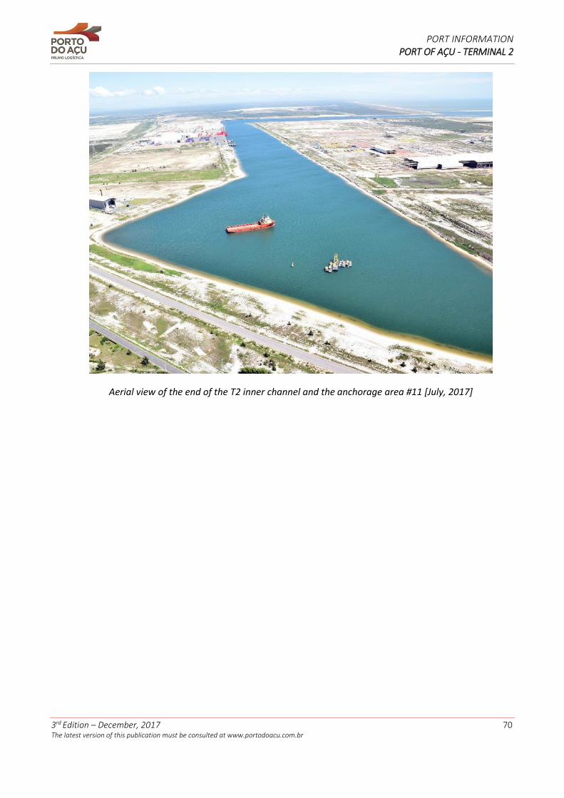
PORT INFORMATION PORT OF AÇU - TERMINAL 2
3rd Edition – December, 2017 70 The latest version of this publication must be consulted at www.portodoacu.com.br
Aerial view of the end of the T2 inner channel and the anchorage area #11 [July, 2017]

PORT INFORMATION PORT OF AÇU - TERMINAL 2
3rd Edition – December, 2017 71 The latest version of this publication must be consulted at www.portodoacu.com.br
ANNEX II – Geographic Location of Port of Açu
Map of Brazil with location of the State of Rio de Janeiro
Map showing the State of Rio de Janeiro and location of
São João da Barra city
Map showing São João da Barra city and
location of Port of Açu
Location of T2 at Port of Açu
A B
A
C
A
D
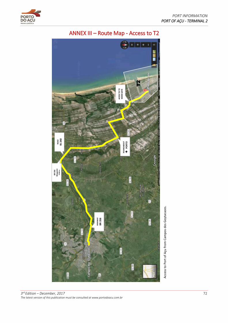
PORT INFORMATION PORT OF AÇU - TERMINAL 2
3rd Edition – December, 2017 72 The latest version of this publication must be consulted at www.portodoacu.com.br
ANNEX III – Route Map - Access to T2
Acc
ess
to P
ort
of
Açu
fro
m C
amp
os
do
s G
oyt
acaz
es.
AC
ESS
TO T
2
MA
IN G
AT
E
RO
AD
RJ
240
RO
UN
DA
BO
UT
PO
RTO
BR
356
W
ayp
oin
t 16
4Km
HIG
HW
AY
BR
356
T2
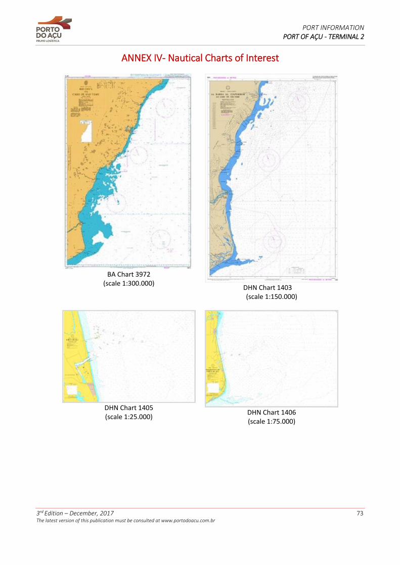
PORT INFORMATION PORT OF AÇU - TERMINAL 2
3rd Edition – December, 2017 73 The latest version of this publication must be consulted at www.portodoacu.com.br
ANNEX IV- Nautical Charts of Interest
BA Chart 3972
(scale 1:300.000)
DHN Chart 1403
(scale 1:150.000)
DHN Chart 1405 (scale 1:25.000)
DHN Chart 1406 (scale 1:75.000)
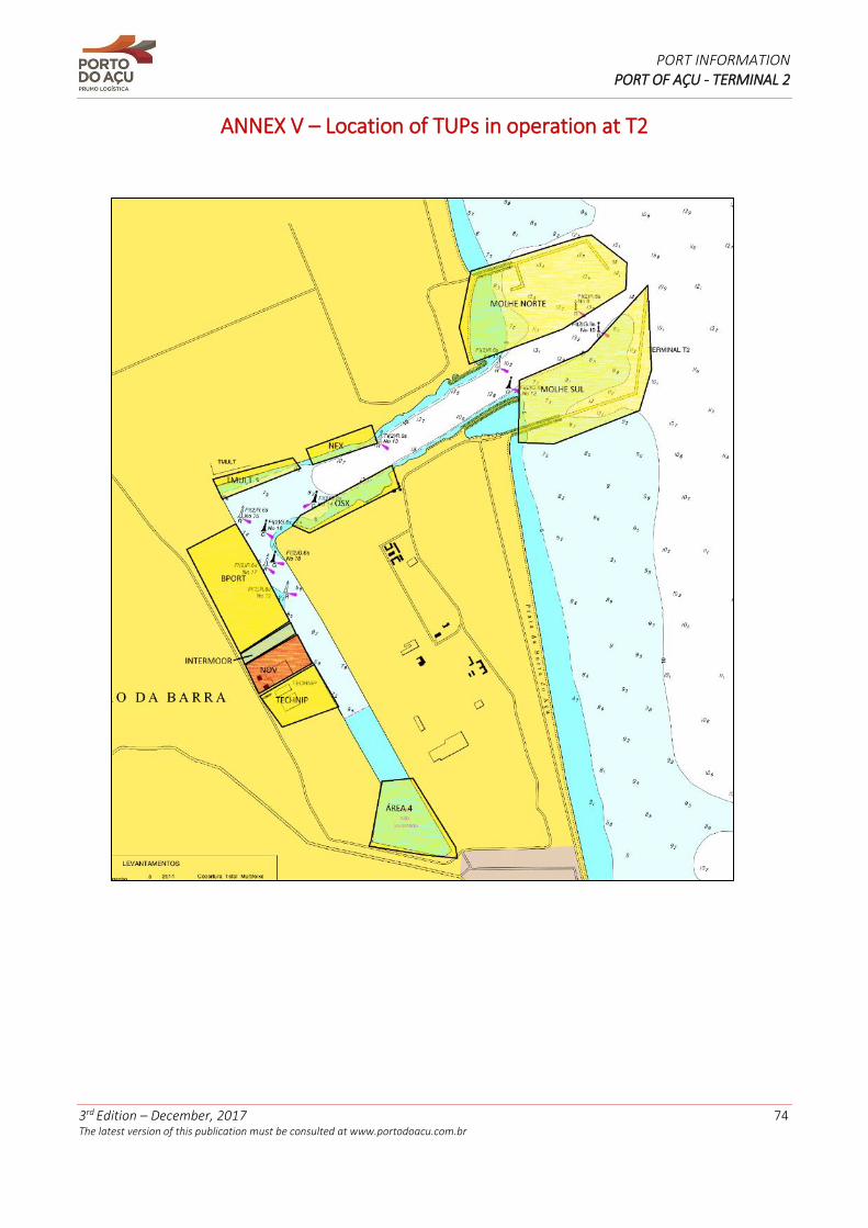
PORT INFORMATION PORT OF AÇU - TERMINAL 2
3rd Edition – December, 2017 74 The latest version of this publication must be consulted at www.portodoacu.com.br
ANNEX V – Location of TUPs in operation at T2
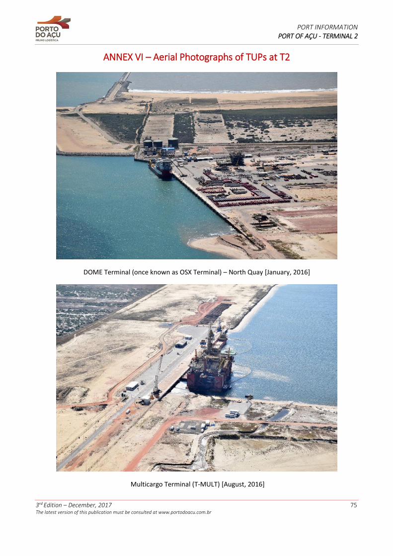
PORT INFORMATION PORT OF AÇU - TERMINAL 2
3rd Edition – December, 2017 75 The latest version of this publication must be consulted at www.portodoacu.com.br
ANNEX VI – Aerial Photographs of TUPs at T2
DOME Terminal (once known as OSX Terminal) – North Quay [January, 2016]
Multicargo Terminal (T-MULT) [August, 2016]

PORT INFORMATION PORT OF AÇU - TERMINAL 2
3rd Edition – December, 2017 76 The latest version of this publication must be consulted at www.portodoacu.com.br
TECMA Terminal [July, 2016]
B-Port Terminal [July, 2016]
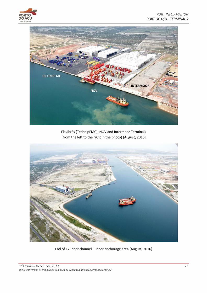
PORT INFORMATION PORT OF AÇU - TERMINAL 2
3rd Edition – December, 2017 77 The latest version of this publication must be consulted at www.portodoacu.com.br
Flexibrás (TechnipFMC), NOV and Intermoor Terminals
(from the left to the right in the photo) [August, 2016]
End of T2 inner channel – Inner anchorage area [August, 2016]
TECHNIPFMC
NOV
INTERMOOR
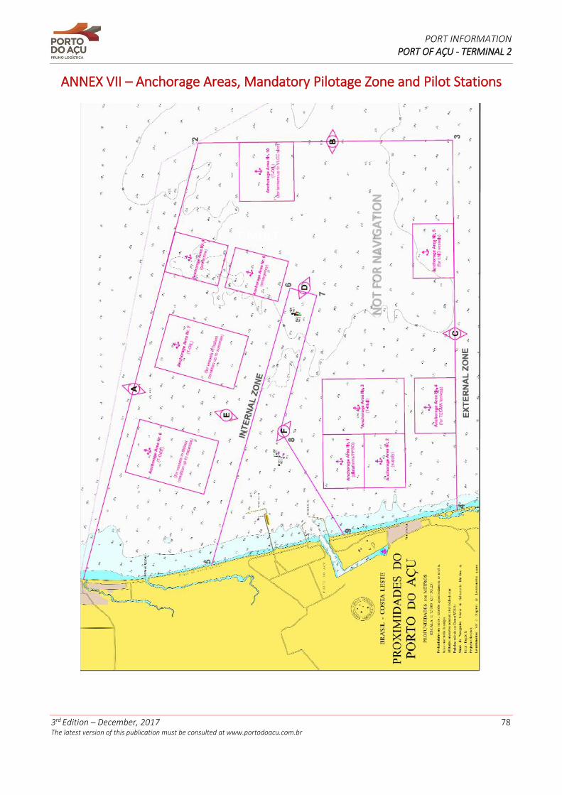
PORT INFORMATION PORT OF AÇU - TERMINAL 2
3rd Edition – December, 2017 78 The latest version of this publication must be consulted at www.portodoacu.com.br
ANNEX VII – Anchorage Areas, Mandatory Pilotage Zone and Pilot Stations
T-MULT
NO
T FO
R N
AV
IGA
TIO
N
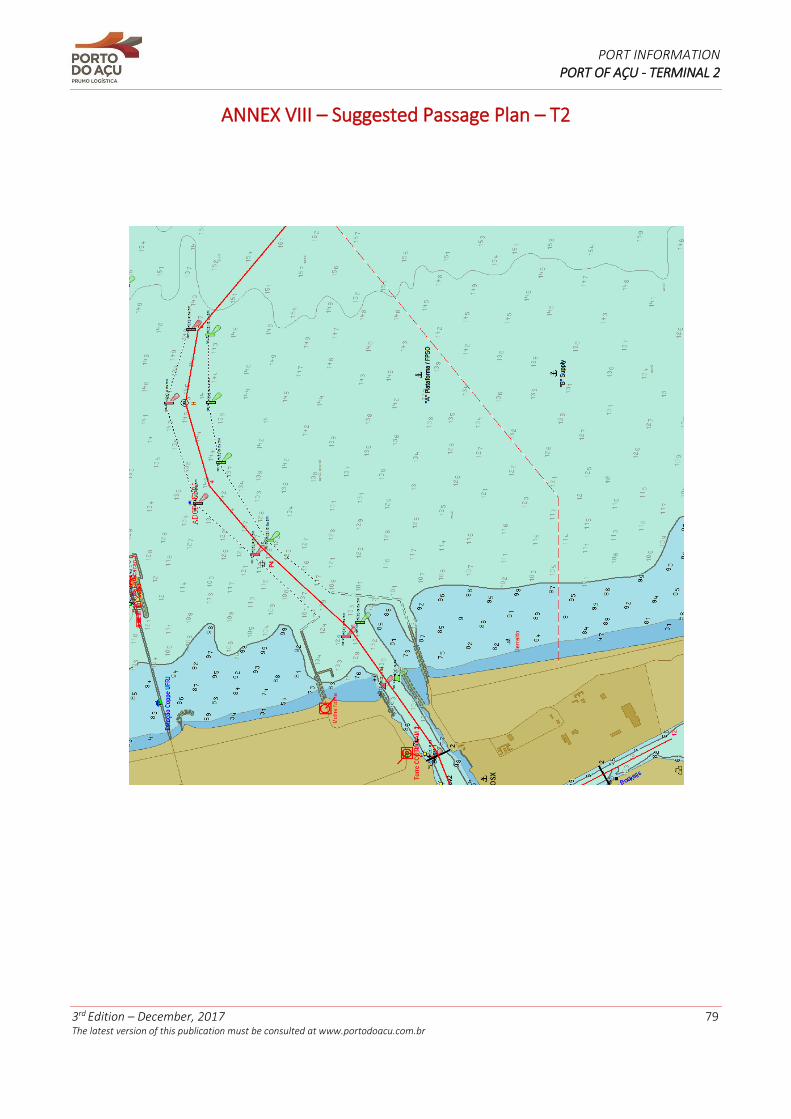
PORT INFORMATION PORT OF AÇU - TERMINAL 2
3rd Edition – December, 2017 79 The latest version of this publication must be consulted at www.portodoacu.com.br
ANNEX VIII – Suggested Passage Plan – T2
PORT INFORMATION PORT OF AÇU - TERMINAL 2
3rd Edition – December, 2017 80 The latest version of this publication must be consulted at www.portodoacu.com.br
ANNEX IX – Port of Açu VTS Guide
BRAZIL – PORT OF AÇU VHF Procedures 1. When arriving or leaving the VTS area; and when anchoring inside or outside of the port limits, all vessels must keep watching the VHF channel 16. VHF Communications: - Channel 16: Emergency calls. - Channel 10: Açu VTS Center operational channel. - Channels 12 and 13: Exclusively used for maneuvers with pilots. 2. Other channels: Other uses (as the radio regulations of ITU). Reports Near the VTS area, the AIS system must be operational and permanently sending information of vessel. Pre-arrival information (NOA – Notice of Arrival) When: 6 hours before arrival. To: Açu VTS Center. Informing: IMO SRS items Alfa, Charlie, Golf, Hotel (in outer area of VTS), India, Oscar, Papa (Tankers and vessels with dangerous cargo: use the IMDG code), Quebec, Uniform, X-Ray. Through: Shipping agents. Positioning information Arrival When: crossing the limits of the VTS area. To: Açu VTS Center. Informing: IMO SRS items Alpha, Bravo (passage time), Delta, Echo, Foxtrot, Oscar, X-Ray. Through: VHF Channel 10. Reporting points When: passing through the reporting points. 1. Terminal 1 (T1) – Pilot station. 2. Terminal 1 (T1) – Pilot station (alternative). 3. Terminal 2 (T2) – Pilot station. To: Açu VTS Center. Informing: IMO SRS items Alpha, Delta, Juliet (only for pilot station), Foxtrot. Through: VHF Channel 10. Arrival at Berth When: berthed; all lines fasten. To: Açu VTS Center. Informing: IMO SRS items Alpha, Bravo (arrival time), Delta. Through: VHF Channel 10. Changing Berths 1. Leaving the initial berth; all lines unfasten. 2. Arriving at the new berth; all lines fasten.
PORT INFORMATION PORT OF AÇU - TERMINAL 2
3rd Edition – December, 2017 81 The latest version of this publication must be consulted at www.portodoacu.com.br
To: Açu VTS Center. Transmitting: IMO SRS items Alpha, Bravo (arrival/departure time), Delta, Juliet, Oscar. Through: VHF Channel 10. Unberthing When: Unberthed; all lines unfasten. Para: Açu VTS Center. Informing: IMO SRS items Alpha, Bravo (departure time), India, Oscar, Papa (only when transporting dangerous goods), Quebec. Through: VHF Channel 10. Arrival at anchorage area When: After dropping the anchor. To: Açu VTS Center. Informing: IMO SRS items Alpha, Bravo (arrival time), Charlie. Through: VHF Channel 10. Leaving the anchorage area When: After heaving up the anchor. To: Açu VTS Center Informing: Items SRS IMO: Alpha, Bravo (departure time), India, Oscar. Through: VHF Channel 10. Departure When: crossing the limits of the VTS area. To: Açu VTS Center. Informing: IMO SRS items Alpha, Bravo, Delta. Through: VHF Channel 10. Deviation When: Any change of details informed at the notice of arrival. To: Açu VTS Center. Informing: Changed items at the route plan. Through: VHF Channel 10. Incidents When: All vessels must inform, immediately, an incident that affects the safety of navigation or the environmental protection. To: Açu VTS Center. Informing: Complete details of the event. If appropriate, the reports of Dangerous Goods, Harmful Substances or Water Pollution shall be included. Through: VHF Channel 10. Pilotage Service
1. The Pilotage Service inside the Port limits (inner zone) is in accordance to the provisions of the Standards of the Maritime Authority for the Pilotage Service (NORMAM-12/DPC) and, when applicable, the Rules and Procedures of the Harbormaster of the State of Rio de Janeiro (NPCP-RJ).
PORT INFORMATION PORT OF AÇU - TERMINAL 2
3rd Edition – December, 2017 82 The latest version of this publication must be consulted at www.portodoacu.com.br
2. All vessels with destination to the Port of Açu that are not dismissed of pilotage service as per the aforementioned rules, or Masters, by their own, who wish the assistance of the service of a pilot, shall embark the pilot at the designated boarding ground established by the Maritime Authority. When leaving the port, the pilot shall disembark when the vessel is on a safe route and the Master is duly informed. 3. Pilot Stations: Terminal 1 (T1) Latitude: 21° 50,14’ S Longitude 040° 49,95’ W Terminal 1 (T1) - alternative Latitude: 21° 47,23’ S Longitude 040° 54,95’ W Terminal 2 (T2) Latitude: 21° 49,32’ S Longitude 040° 55,55’ W Available Service Service availability: 24 hours a day, 7 days a week.
Traffic image generation: Automatic identification system (AIS), closed circuit TV (CCTV), radar, real-time
tracking, information about positioning by VHF radio, visual.
Type of VTS service: INS. Availability of allied service: full time. Service offered Information service (INS) Situational reports (SITREP) are transmitted in Portuguese and English, upon request. Orders to specific reports must be requested to the VTS Center by VHF channel 10. SITREP Time: Only when requested. SITREP content: 1. Relevant details to perform a safe passage through the VTS area. 2. General situation of the navigable channel and the traffic (weather, bathymetry, dredging and notice to mariners). 3. Shipping incidents assistance. 4. Detailed information related to berths and maximum drafts. 5. Fire department, Police or ambulance requests. Language: Portuguese or English, upon request.
PORT INFORMATION PORT OF AÇU - TERMINAL 2
3rd Edition – December, 2017 83 The latest version of this publication must be consulted at www.portodoacu.com.br
Anchorage areas
Anchorage area #1 – Platforms and FPSO vessels - T2:
1 - 21° 50,750' S 040° 57,810' W
2 - 21° 50,750' S 040° 55,700' W
3 - 21° 52,250' S 040° 55,700' W
4 - 21° 52,250' S 040° 57,810' W
Anchorage area #2 – Supply Vessels - T2:
1 - 21° 52,250' S 040° 57,810' W
2 - 21° 52,250' S 040° 55,700' W
3 - 21° 53,750' S 040° 55,700' W
4 - 21° 53,750' S 040° 57,810' W
Anchorage area #3 – Vessels with destination to “T-MULT” - T2:
1 - 21° 50,750' S 040° 55,700' W
2 - 21° 50,750' S 040° 53,530' W
3 - 21° 53,750' S 040° 53,530' W
4 - 21° 53,750' S 040° 55,700' W
Anchorage area #4 – Tankers with destination to “TECMA” - T2:
1 - 21° 54,123' S 040° 55,700' W
2 - 21° 54,123' S 040° 53,530' W
3 - 21° 55,623' S 040° 53,530' W
4 - 21° 55,623' S 040° 55,700' W
Anchorage area #5 – LNG vessels - T2:
1 - 21° 54,123' S 040° 49,619' W
2 - 21° 54,123' S 040° 47,488' W
3 - 21° 55,623' S 040° 47,488' W
4 - 21° 55,623' S 040° 49,619' W
Anchorage area #6 – Bulk carriers in ballast (up to “CAPESIZE”) - T-ORE - T1:
1 - 21° 43,506' S 040° 57,069' W
2 - 21° 44,070' S 040° 55,011' W
3 - 21° 46,943' S 040° 55,906' W
4 - 21° 46,371' S 040° 57,973' W

PORT INFORMATION PORT OF AÇU - TERMINAL 2
3rd Edition – December, 2017 84 The latest version of this publication must be consulted at www.portodoacu.com.br
Anchorage area #7 – Tankers (up to “SUEZMAX”) - T-OIL - T1:
1 - 21° 44,634' S 040° 52,970' W
2 - 21° 45,199' S 040° 50,905' W
3 - 21° 48,075' S 040° 51,817' W
4 - 21° 47,506' S 040° 53,875' W
Anchorage area #8 – Vessels in quarantine or waiting for the ANVISA authorization - T1/T2:
1 - 21° 45,032' S 040° 49,241' W
2 - 21° 45,437' S 040° 47,689' W
3 - 21° 47,373' S 040° 48,256' W
4 - 21° 46,974' S 040° 49,822' W
Anchorage area #9 – Emergencies and/or repairs - T1/T2:
1 - 21° 47,234' S 040° 49,883' W
2 - 21° 47,640' S 040° 48,330' W
3 - 21° 49,574' S 040° 48,896' W
4 - 21° 49,165' S 040° 50,461' W
Anchorage area #10 – Tankers (up to “VLCC”) - T-OIL - T1:
1 - 21° 47,810' S 040° 46,530' W
2 - 21° 47,810' S 040° 44,219' W
3 - 21° 49,810' S 040° 44,219' W
4 - 21° 49,810' S 040° 46,530' W
Anchorage area #11 – for vessels at terminal T2:
Center of the anchorage area
1 - 21° 52,960' S 041° 00,322' W
Responsible Authority Prumo Logística Global S.A. represented by the Açu VTS Center. VHF Channels 10 and 16. Phone Number: +55 22 2133 1100 – Extension Lines: 1223 or 1232 e-mail: [email protected] Address: Fazenda Saco Dantas, S/Nº - Porto do Açu - São João da Barra/RJ – Brasil. CEP 28200-000 For more information about regulations, see the Port Regulation and Maritime Authority Rules.
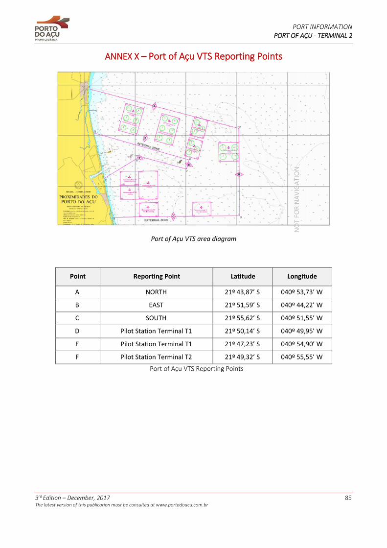
PORT INFORMATION PORT OF AÇU - TERMINAL 2
3rd Edition – December, 2017 85 The latest version of this publication must be consulted at www.portodoacu.com.br
ANNEX X – Port of Açu VTS Reporting Points
Port of Açu VTS area diagram
Point Reporting Point Latitude Longitude
A NORTH 21º 43,87’ S 040º 53,73’ W
B EAST 21º 51,59’ S 040º 44,22’ W
C SOUTH 21º 55,62’ S 040º 51,55’ W
D Pilot Station Terminal T1 21º 50,14’ S 040º 49,95’ W
E Pilot Station Terminal T1 21º 47,23’ S 040º 54,90’ W
F Pilot Station Terminal T2 21º 49,32’ S 040º 55,55’ W
Port of Açu VTS Reporting Points
NO
T FO
R N
AV
IGA
TIO
N
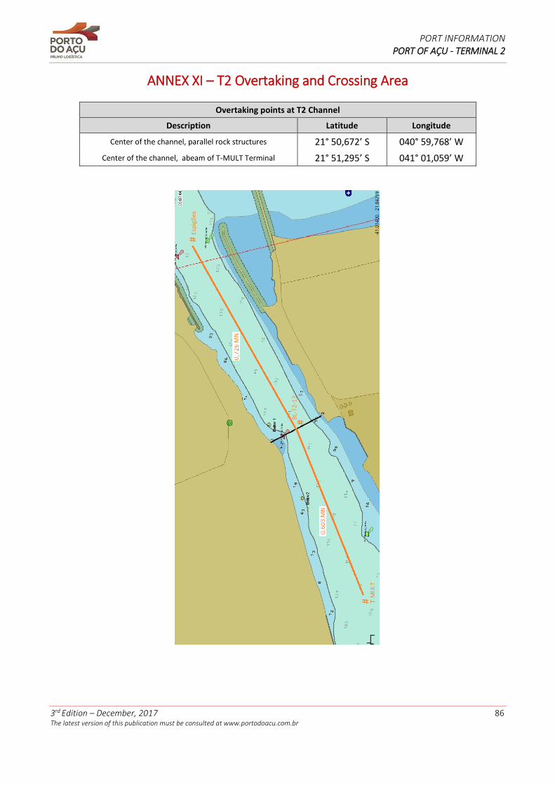
PORT INFORMATION PORT OF AÇU - TERMINAL 2
3rd Edition – December, 2017 86 The latest version of this publication must be consulted at www.portodoacu.com.br
ANNEX XI – T2 Overtaking and Crossing Area
Overtaking points at T2 Channel
Description Latitude Longitude
Center of the channel, parallel rock structures 21° 50,672’ S 040° 59,768’ W
Center of the channel, abeam of T-MULT Terminal 21° 51,295’ S 041° 01,059’ W
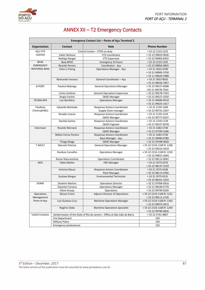
PORT INFORMATION PORT OF AÇU - TERMINAL 2
3rd Edition – December, 2017 87 The latest version of this publication must be consulted at www.portodoacu.com.br
ANNEX XII – T2 Emergency Contacts
Emergency Contact List – Porto of Açu Terminal 2
Organization Contact Role Phone Number
AÇU VTS CENTER
Control Center – VTSO on duty + 55 22 2133-1223
Valter Barbosa VTS Coordinator + 55 22 99819-9656
Rodrigo Rangel VTS Supervisor + 55 22 99965-8355
BPAE EMERGENCY
RESPONSE BASE
Base BPAE Emergency 24 hours + 55 22 2133-1235
Ricardo Pereira Coordinator - Açu + 55 22 99856-0825
Chen Li Cheng Operations Manager - Açu + 55 21 3032-6700 + 55 21 99995-3750 + 55 11 99620-2988
Raimundo Fonseca General Coordinator – Açu + 55 21 3032-8502 + 55 21 98556-7857
B-PORT Paulino Nobrega General Operations Manager + 55 22 99227-8588 +55 21 99578-7563
Carlos Antônio General Operations Supervisor + 55 21 99578-7563
Sergio Fantini QHSE Manager + 55 21 99527-3250
TECMA NFX Luiz Bonifácio Operations Manager + 55 21 99490-9519 + 55 21 99625-1017
Flexibrás (TechnipFMC)
Eduardo Machado Response Actions Coordinator Supply Chain manager
+ 55 21 2139-1269 + 55 22 99731-2267
Rinaldo Linares Response Actions Coordinator QHSE Manager
+ 55 21 2139-1319 + 55 22 99777-8107
Daniela Santos Response Actions Coordinator QHSE Engineer
+ 55 21 2139-1139 + 55 27 99227-8378
Intermoor Ricardo Werneck Response Actions Coordinator QHSE Manager
+ 55 21 3282-5730 + 55 21 97599-3186
Milton Ferraz Pereira Response Actions Coordinator Base Manager - Açu
+ 55 21 3282-5730 + 55 21 99484-0789
Thiago Braga QHSE Manager + 55 21 97598-4650
T-MULT Marcelo Patrício General Operations Manager + 55 22 2133-1100 R: 1106 + 55 22 99215-4419
Rovilson Carvalho Operations Manager + 55 22 2133-1100 R: 1233 + 55 22 99815-2694
Ronan Mascarenhas Operations Coordinator + 55 22 98112-0042
NOV Fábio Mattos HSE Manager + 55 21 3575-0276 + 55 22 98137-3159
Antonio Klauss Response Actions Coordinator Plant Manager
+ 55 21 3575-0106 + 55 22 98115-0766
Gustavo Borges Environmental Technician + 55 21 3575-0131 + 55 22 98161-3333
DOME Divalmir Martins Operations Director + 55 21 97994-0910
Eduardo Fonseca Operations Manager + 55 21 98100-0778
Flávio Araujo Operations + 55 22 99799-0249
Operations Management Porto of Açu
Alisson Freire Adjunct Director of Operations + 55 22 2133-1100 R: 1221 + 55 22 98111-2726
Luiz Gustavo Cruz Maritime Operations Manager + 55 22 2133-1100 R: 1243 + 55 22 99973-2672
Rogério Oeda Maritime Operations Specialist + 55 22 2133-1100 R: 1244 + 55 22 99780-6816
Useful Contacts Harbormaster of the State of Rio de Janeiro - Office at São João da Barra + 55 22 2741-4807
Fire Department 193
Military Police 190
Emergency (ambulance) 192

OPERATIONS MANAGEMENT
PORTO DO AÇU OPERAÇÕES S.A.