terms of reference and work plan - british columbia · complete the eia (section 2.5). the...
TRANSCRIPT

TERMS OF REFERENCE AND WORK PLAN
Grace-Mar Farms Ltd. Pollution Abatement Order File AMS#350101
June 2016

CONFIDENTIALITY AND © COPYRIGHT This document is for the sole use of the addressee and Associated Environmental Consultants Inc. The document contains proprietary and confidential information that shall not be reproduced in any manner or disclosed to or discussed with any other parties without the express written permission of Associated Environmental Consultants Inc. Information in this document is to be considered the intellectual property of Associated Environmental Consultants Inc. in accordance with Canadian copyright law. This report was prepared by Associated Environmental Consultants Inc. for the account of Grace-Mar Farms Ltd.. The material in it reflects Associated Environmental Consultants Inc.’s best judgement, in the light of the information available to it, at the time of preparation. Any use that a third party makes of this report, or any reliance on or decisions to be made based on it, are the responsibility of such third parties. Associated Environmental Consultants Inc. accepts no responsibility for damages, if any, suffered by any third party as a result of decisions made or actions based on this report.
REPORT
i
Table of Contents
SECTION PAGE NO.
Table of Contents i
List of Tables ii
List of Figures ii
1 Introduction 1
1.1 Qualified Professionals 1
1.2 Background to the Terms of Reference 2
2 Terms of Reference 2
2.1 Goals of the Monitoring Program and EIA 2
2.2 Regulatory Context 2
2.3 Spatial and Temporal Boundaries of the EIA 3
2.4 Receptor 4
2.5 Environmental Assessment Process 4
3 Work Plan 6
4 Schedule 12
Closure
References

Grace-Mar Farms Ltd.
ii p:\20168113\00_poll_abate\environmental_sciences\04.00_environmental_assessments\tor and work plan\tor and work plan_grace-mar farms_20160627.docx
List of Tables
PAGE NO.
Table 3-1 Proposed work plan 7
Table 4-1 Proposed project schedule 13
List of Figures
PAGE NO.
Figure 2-1 Limits of study area 5
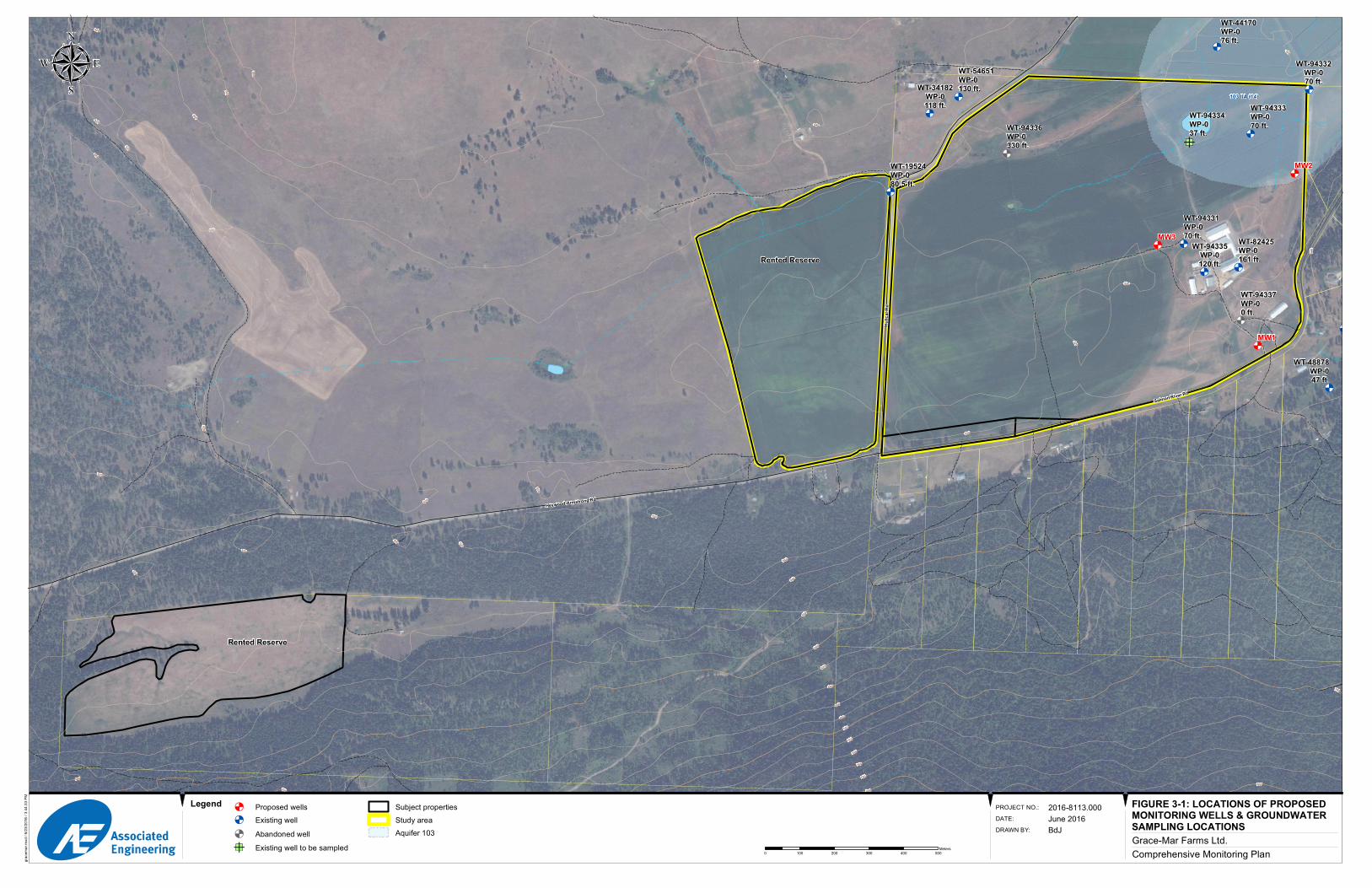
Figure 3-1 Proposed monitoring well locations 11
REPORT
1
1 Introduction
Associated Environmental Consultants Inc. (Associated), with Ruth McDougall, P.Ag. and Doug McFarlane,
CCA, were retained by Grace-Mar Farms Ltd. to complete the Terms of Reference (TOR) and work plan for
a comprehensive monitoring program and an Environmental Impact Assessment (EIA) for nitrates and other
nitrogen compounds in the soil and groundwater. The focus of the comprehensive monitoring program and
EIA is the Grace-Mar Farms Ltd. dairy operation located at 5904 Salmon River Road, Armstrong, BC. The
requirements for the monitoring program and EIA are specified in the Pollution Abatement Order issued by
the BC Ministry of Environment on May 12, 2016 (File AMS#350101).
1.1 QUALIFIED PROFESSIONALS
The following Qualified Professionals will complete the comprehensive monitoring program and the EIA.
They are listed here with their qualifications as reference. Resumes can be provided on request.
1. Marta Green, P.Geo. of Associated will be responsible for the groundwater component. Through
education and experience in consulting for the past 16 years, Marta’s skillset includes physical
hydrogeology (e.g., well testing – pumping tests and slug tests), water quality, contaminant
hydrogeology, and regional hydrogeological studies.
2. Hugh Hamilton, PhD., P.Ag. of Associated will provide guidance on monitoring design and EIA
methodology, and provide senior review of the reports. He has been practicing in environmental
and agricultural consulting in BC since 1990. His areas of practice include soil and water
conservation, water quality, land use, and environmental impact assessment.
3. Ruth McDougall, M.Sc., P.Ag. will contribute to the soil and nutrient management component of
the EIA. Ruth is an acknowledged expert in BC in the characterization and recycling of organic
residuals to agricultural land. She has expertise in soil fertility and nutrient cycling in agricultural
systems, having started in this line of work in 1990. Ruth has been involved in writing provincial
guidelines for residuals recycling, and has produced Land Application Plans for the application of
many residuals to agricultural land as well as Environmental Farm Plans for livestock operations.
4. Doug Macfarlane, CCA, will contribute to the soil and nutrient management component. He is a
Certified Crop Advisor registered with American Soil Society of Agronomy and has many years of
experience in BC.
5. Rod MacLean, P.Eng., with Associated will contribute to the civil and drainage management
component. Rod is a senior engineer responsible for civil, municipal, and agricultural design
services in the Okanagan, and has a long history of experience in addressing water supply
conservation issues. Rod has completed a variety of irrigation and drainage assessments for both
small farming operations and larger corporate facilities. He is currently the BC Director of the
Canadian National Committee for Irrigation and Drainage (CANCID) and supports research across
Canada.

Grace-Mar Farms Ltd.
2 p:\20168113\00_poll_abate\environmental_sciences\04.00_environmental_assessments\tor and work plan\tor and work plan_grace-mar farms_20160627.docx
1.2 BACKGROUND TO THE TERMS OF REFERENCE
Development of the TOR and work plan is intended to meet Requirement 1 of the Pollution Abatement
Order (the Order) issued on May 12, 2016 by the Ministry of Environment (MOE) to Grace-Mar Farms Ltd.
The Order applies to the following area (the Lands):
Lot 9, Plan KAP30452, District Lot 8 & 47, Section 26, Township 17, Range 10, Meridian W6,
Kamloops Div of Yale Land District, Except Plan KAP72622: Property Identification 003-934-616;
and
Lands used from time to time for agricultural operations that are part of or associated with the
agricultural operations of the above lands and are controlled by Grace-Mar Farms Ltd.
Requirement 2 in the Order is to implement the monitoring program and to complete the EIA. The
monitoring program and EIA will begin as soon as the TOR and work plan are approved by MOE.
The Order states that “the usefulness of the environment has been impaired due to the presence of nitrates
in the groundwater as the presence of nitrates is causing the groundwater in the unconfined aquifer that lies
in part underneath the Lands (commonly referred to Hullcar Aquifer 103) to be unfit for potable water for
specific persons in the population.” The Order stems from the Hullcar Aquifer Inter-Ministry Action Plan
developed in March 2016, where one of the goals of the Action Plan is to determine as accurately as
possible the sources of nitrate and potential for human health effects in the Hullcar Aquifer. The TOR and
work plan are intended to clearly identify the methods to meet this goal.
2 Terms of Reference
2.1 GOALS OF THE MONITORING PROGRAM AND EIA
The overall goal of the combined monitoring program and EIA is to determine whether the existing
agricultural operations on the Lands are having an adverse effect on Hullcar Aquifer 103 and connected
surface water by increasing the concentrations of nitrate-N and other nitrogen compounds to levels that are
a hazard to human health (Requirement 2 of the Order). The TOR:
Outlines the regulatory context for the monitoring program and EIA (Section 2.2)
Defines the spatial and temporal boundaries of the EIA (Section 2.3)
Defines the environmental receptor that is the focus of the assessment (Section 2.4); and
Defines the basic steps that will be completed to design and implement the monitoring program and
complete the EIA (Section 2.5).
The monitoring program and EIA are described in the work plan (Section 3).
2.2 REGULATORY CONTEXT
The Order is pursuant to section 83 of the Environmental Management Act (EMA) (SBC 2003 c. 53), and
manure management is subject to the Agricultural Waste Control Regulation (BC Reg. 131/92).
Terms of Reference and Work Plan Pollution Abatement Order File AMS#350101
3
Fundamentally, the EMA prohibits pollution, and the Order indicates that pollution in this case has been
caused by the introduction of agricultural waste to the environment. With respect to groundwater and
surface water, a key indication that pollution has occurred is an exceedance of water quality guidelines or
objectives; specifically, Health Canada’s Guidelines for Canadian Drinking Water Quality (Health Canada
2013) for the Hullcar Aquifer.
Health Canada’s Guidelines for Canadian Drinking Water Quality state that the maximum acceptable
concentration of nitrate-N in drinking water is 10 mg/L (Health Canada 2013). Elevated nitrate consumption
can lead to methaemoglobinemia, which is a blood disorder that affects the ability to transport and release
oxygen throughout the body (Health Canada 2013). Its effects are most pronounced in infants, and as a
result it is more commonly referred to as “blue-baby syndrome.” There are also concerns that nitrate may
impact thyroid gland function and be associated with cancer (Health Canada 2013). The maximum
acceptable concentration of 10 mg/L nitrate-N is designed to protect the health of the most sensitive users,
i.e., bottle-fed infants. However, Health Canada recommends that levels be kept as low as reasonably
practicable (Health Canada 2013). The BC Approved Water Quality Guidelines also state a maximum
acceptable concentration of nitrate-N in drinking water of 10 mg/L (MOE 2009).
Under the regulatory guidelines, the landowner is responsible for the nitrates contributed by its operation to
soil, groundwater, and surface water. It is therefore important to know the concentrations of nitrates in the
water as it enters the property (i.e., the levels of nitrates prior to the effect from the operations on the
Lands).
We therefore will consider an adverse impact to be present if the agricultural operations from the Lands are
causing groundwater to exceed the 10 mg/L guideline in wells installed in the Hullcar Aquifer 103. The EIA
will also consider the additive effect of farm operations on the Lands to the total nitrogen load in the aquifer,
which is likely contributed by activities on other properties located over the aquifer.
2.3 SPATIAL AND TEMPORAL BOUNDARIES OF THE EIA
Grace-Mar Farms Ltd. operates a dairy farm with 150 milking cows. The operation includes several
properties that Grace-Mar own or rent. Grace-Mar own one property (Main Farm), and rent two (Reserve
pivot, Hideaway) (Figure 2-1). The total size of the operation is 300 acres (121 Ha).
The spatial extent of the study area is the lands identified in the Order, which overlie, or partly overlie, the
Hullcar Aquifer 103 and are on the western side of Deep Creek. The spatial extent of the study is shown in
yellow on Figure 2-1, and are referred to here as the Lands. The vertical extent is from the land surface to
the bottom of the Hullcar Aquifer 103.
The Order is for pollution abatement (i.e., the ending, reduction, or lessening of something). Therefore, the
objective of the EIA in the Order is to assess current agricultural practices and their potential to adversely
affect groundwater. Grace-Mar Farms Ltd. has been following a nutrient management plan for the past
several years (since 2012). We will therefore examine records relevant to our assessment since that time.
Accordingly, we define the temporal extent of the EIA study to be from 2012 to present.
Grace-Mar Farms Ltd.
4 p:\20168113\00_poll_abate\environmental_sciences\04.00_environmental_assessments\tor and work plan\tor and work plan_grace-mar farms_20160627.docx
2.4 RECEPTOR
As stated in the Order, the specific substance causing pollution is agricultural waste, including manure
and/or manure-laden effluent, from which nitrate is leaching into groundwater. The Order describes the
presence of nitrates in the groundwater, which is causing the Hullcar Aquifer 103 to be unfit for potable
water. We therefore will assess the impacts from nitrogen (all species) on drinking water wells installed in
the Hullcar Aquifer 103. The drinking water wells in the Hullcar Aquifer 103, which is an unconfined aquifer,
will be the “receptor.”
2.5 ENVIRONMENTAL ASSESSMENT PROCESS
The environmental assessment process will include the following tasks:
Characterize the existing (baseline) environmental conditions on the Lands and underlying aquifer,
considering climate, soils, surficial geology, aquifer characteristics, and water quality. Baseline
characterization includes design and implementation of the monitoring program.
Describe farm operations on the Lands, particularly manure and nutrient management.
Assess the effects of farm operations on the environment, considering the magnitude, timing,
duration, and reversibility of any adverse effects.
Identify management practices or other mitigation measures to avoid or minimize the identified
adverse effects. The EIA will include the recommended preliminary mitigation strategy, with the
details to be developed later as part of the Action Plan.
Determine if there are any residual effects that cannot be reasonable mitigated.
Develop a monitoring program to assess the effectiveness of the mitigation measures.
The implementation of these tasks is described in the work plan (Section 3).


Grace-Mar Farms Ltd.
6 p:\20168113\00_poll_abate\environmental_sciences\04.00_environmental_assessments\tor and work plan\tor and work plan_grace-mar farms_20160627.docx
3 Work Plan
The work plan includes two phases:
Development and implementation of a comprehensive monitoring program; and
The EIA.
The comprehensive monitoring plan is designed to inform the EIA, and will form the basis for later
monitoring to evaluate the effectiveness of the Action Plan. The work plan for the comprehensive
monitoring program and EIA is described in Table 3-1.
The results of the EIA will provide the information necessary to develop the Action Plan, which is
Requirement 3 in the Order. The Action Plan will detail the mitigation measures that will be taken to abate
the environmental impacts identified in the EIA.
7
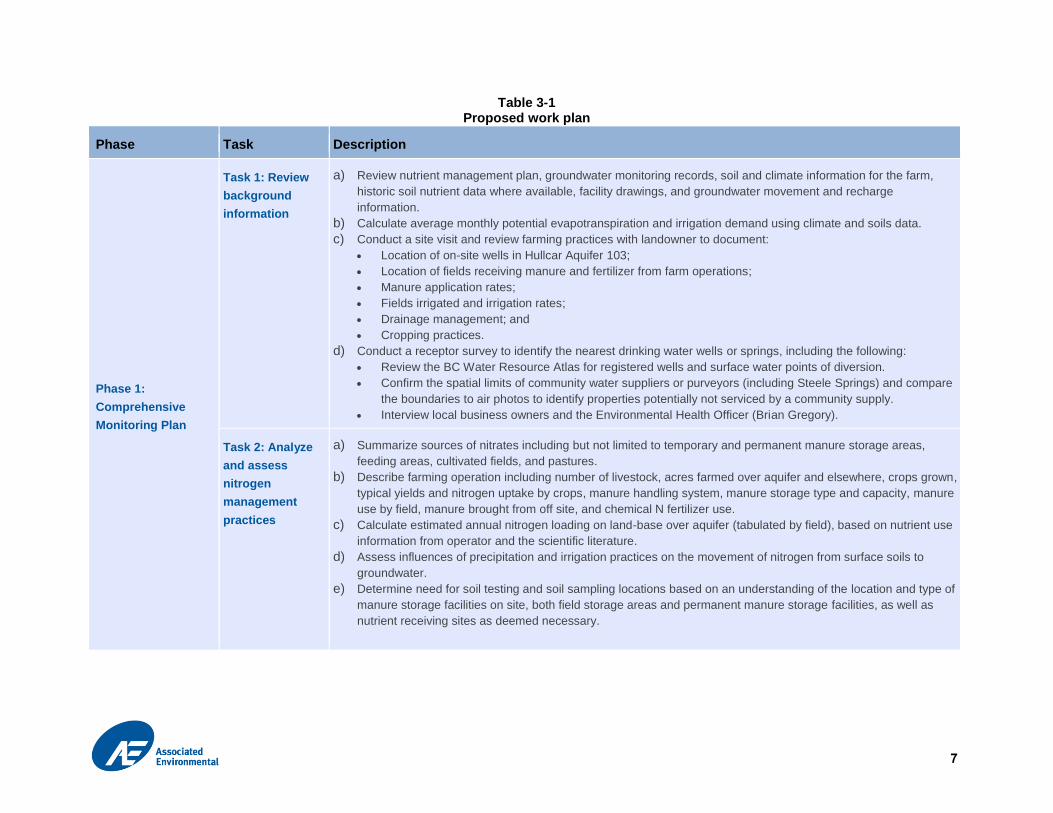
Table 3-1 Proposed work plan
Phase Task Description
Phase 1:
Comprehensive
Monitoring Plan
Task 1: Review
background
information
a) Review nutrient management plan, groundwater monitoring records, soil and climate information for the farm,
historic soil nutrient data where available, facility drawings, and groundwater movement and recharge
information.
b) Calculate average monthly potential evapotranspiration and irrigation demand using climate and soils data.
c) Conduct a site visit and review farming practices with landowner to document:
Location of on-site wells in Hullcar Aquifer 103;
Location of fields receiving manure and fertilizer from farm operations;
Manure application rates;
Fields irrigated and irrigation rates;
Drainage management; and
Cropping practices.
d) Conduct a receptor survey to identify the nearest drinking water wells or springs, including the following:
Review the BC Water Resource Atlas for registered wells and surface water points of diversion.
Confirm the spatial limits of community water suppliers or purveyors (including Steele Springs) and compare
the boundaries to air photos to identify properties potentially not serviced by a community supply.
Interview local business owners and the Environmental Health Officer (Brian Gregory).
Task 2: Analyze
and assess
nitrogen
management
practices
a) Summarize sources of nitrates including but not limited to temporary and permanent manure storage areas,
feeding areas, cultivated fields, and pastures.
b) Describe farming operation including number of livestock, acres farmed over aquifer and elsewhere, crops grown,
typical yields and nitrogen uptake by crops, manure handling system, manure storage type and capacity, manure
use by field, manure brought from off site, and chemical N fertilizer use.
c) Calculate estimated annual nitrogen loading on land-base over aquifer (tabulated by field), based on nutrient use
information from operator and the scientific literature.
d) Assess influences of precipitation and irrigation practices on the movement of nitrogen from surface soils to
groundwater.
e) Determine need for soil testing and soil sampling locations based on an understanding of the location and type of
manure storage facilities on site, both field storage areas and permanent manure storage facilities, as well as
nutrient receiving sites as deemed necessary.
8
Phase Task Description
Task 3: Drill and
install monitoring
wells
a) Determine locations of monitoring wells based on an understanding of the site and nutrient sources. Position
wells upgradient and downgradient of storage facilities. In addition, where there are no suitable existing wells,
locate at least one monitoring well on fields where nutrients have been applied to indicate background conditions.
Existing wells will only be considered suitable for use as monitoring wells if they have a well log showing a
description of the geology from ground surface to the bottom of Hullcar Aquifer 103 and the screens are installed
in Hullcar Aquifer 103.
b) Conduct an underground utility locate.
c) Conduct a drilling program:
Install up to 3 monitoring wells in Hullcar Aquifer 103 (Figure 3-1).
A hydrogeologist will log each borehole and design each monitoring well installation.
Advance the borehole using solid stem augers to collect continuous soil samples for logging to the top of the
uppermost silt/clay layer below the water table. If the borehole does not stay open, conduct continuous
sampling using hollow stem with split spoons. Collect representative soils samples from the aquifer for grain
size analysis.
Install wells into the uppermost water bearing sand unit, using hollow stem casing, 5 cm (2-inch) diameter
PVC screen, and an artificial filter pack inserted into the annulus to the required depths around the screened
sections; use 10/20 sand or similar.
Seal the sections with bentonite from 0.6 m above the screened section up to 0.6 m below ground surface, to
meet or exceed the BC Ground Water Protection Regulation.
Affix well plate identifiers to each new monitoring well and any existing wells that will be used as part of the
monitoring program (if not already present).
Install up to 2 m long screens at the bottom of the uppermost aquifer, which is estimated at about 20 m. This
is based on the understanding that there are many well logs available for the area; however, most provide
little detail on the lithology of the Hullcar Aquifer 103 in this area. The most detailed well log is from well tag
number 82425. It was drilled in 1981 by Thomas Well Drilling and describes the first water bearing unit from
64 to 65 ft. (19.5 to 19.8 m). If actual geological conditions are found to be different during the fieldwork, we
will complete screens no longer than 2 m at the bottom of the uppermost unconfined aquifer. Multi-level wells
will not be completed at this time, to avoid the potential for cross-contamination between screened sections.
d) Survey the top of casing and ground surface of each new monitoring well and existing well(s) that will be used as
part of the monitoring plan, with an accuracy of +/- 2 cm.

9
Phase Task Description
Task 4: Conduct
groundwater
sampling and
aquifer parameter
tests
a) Develop each well until purge water is clear using either a submersible pump or WaterraTM tubing with a foot
valve and surge block, depending on geologic conditions.
b) Measure groundwater level (if available) for each well after well completion and once the well has been left for
one day to stabilize.
c) Perform slug tests or short pumping tests (up to 4 hours) in one well to estimate hydraulic conductivity of the
aquifer. Measure the recovering water levels with an electronic water level meter inserted into the well for the
duration of the test.
d) Analyze grain size of two representative soil samples.
e) Sample groundwater in 3 new monitoring well samples and one existing well (total of 4 samples). Collect
groundwater samples using low flow sampling techniques and a submersible pump. Conduct purging until
consistent (stabilized) field-measured chemistry (e.g., electrical conductivity, pH, and temperature) is observed.
Collect samples as per the British Columbia Field Sampling Manual (MWLAP 2013).
f) Complete laboratory analysis of the water samples collected. Courier samples to an analytical laboratory for
analysis of ammonia, nitrate, nitrite, total Kjeldahl nitrogen (TKN), organic nitrogen, and total nitrogen.
Task 5: Analyse
hydrogeological
and groundwater
quality data
a) Estimate hydraulic conductivity two ways: 1) by the Hazen equation or similar using grain size results, and 2) by
processing the aquifer testing results using Aquatesolv or similar aquifer testing software.
b) Calculate groundwater flow direction, and estimate groundwater travel time.
c) Upload all water quality results directly from the laboratory to Wireless WaterTM Database Management Services,
and then tabulate and compare results with the Guidelines for Canadian Drinking Water Quality (Health Canada
2014).
Task 6: Conduct
soil sampling (if
necessary,
depending on
results of Task 2)
a) Conduct soil sampling when field conditions permit (may only be possible after crop harvest).
b) Soil sampling methodology to be determined based on Task 2 findings and type of sampling to be undertaken
(i.e. whole field sampling vs. sampling in vicinity of field or permanent manure storage sites). Soil sampling to be
undertaken using B.C. standard methods; at multiple sampling depths (likely at least 2) and locations.
c) Submit samples for laboratory analysis and assess results. Samples to be analyzed for nitrate, ammonium,
organic matter, and TKN1 at a minimum.
Phase 2:
Environmental
Impact Assessment
and Reporting
Task 7: Conduct
EIA
a) Refine the identification of receptors and the spatial extent of the study area or limits of monitoring.
b) Calculate descriptive statistics for the water quality and soil data collected at all monitoring locations.
c) Determine if current (since 2014) agricultural operations on the Lands cause nitrate-N concentrations in the
aquifer to exceed water quality guidelines in the vicinity of the nutrient applications.
d) Assess the difference in concentrations of nitrogen species between upgradient and downgradient locations.
1 Analyses for these variables also enable the calculation of total N and organic N.

10
Phase Task Description
Where there are sufficient data, determine if differences between monitoring locations or areas are statistically
significant.
e) Determine the potential for cumulative effects on nitrogen in groundwater from nearby properties in addition to
the Lands.
Task 8: Draft
comprehensive
monitoring and
EIA report
Compile the results of the comprehensive monitoring program and EIA into a draft technical report that will be
submitted to MOE for review. The monitoring program section will describe tasks completed, methods applied, and
results obtained, including the following results:
1. Farm nitrogen balance and nitrogen loading practices; and soil sampling program, if completed.
2. Drilling and aquifer testing, including well lithological logs and a site plan showing well locations and
groundwater flow direction.
3. Groundwater sampling
Based on the technical assessment, the report will determine the likelihood that current farm practices are causing
pollution, on their own or in combination with activities on other properties. The report will include the laboratory
reports from the sampling programs in an appendix, and will include photographs, maps, and charts.
Task 9: Finalize
comprehensive
monitoring and
EIA report
The report will be finalized after receiving comments from MOE on the draft report. The details of action items for
abatement/mitigation will not be included in the current scope. This will be a separate task identified as the Action
Plan in the Order, with a different schedule, and would be completed if an adverse effect on groundwater from the
current farm practices is identified by the EIA. However, the report will provide a preliminary identification of pollution
prevention strategies (actions) that would be put in place based on the EIA findings.

Grace-Mar Farms Ltd.
12 p:\20168113\00_poll_abate\environmental_sciences\04.00_environmental_assessments\tor and work plan\tor and work plan_grace-mar farms_20160627.docx
4 Schedule
This report is being submitted to meet Requirement 1 of the Order, which requires that it be submitted
within 45 days issuance of the Order. Based on discussions with the MOE, the June 30, 2016 submission is
acceptable (Oldfield, D., personal communication, 2016).
Requirement 2, the completion of the comprehensive monitoring program and EIA are requested to be by
August 1, 2016. This proposed schedule will be very difficult to meet because of the need to mobilize well
drillers after the approval of the plan by MOE, then to submit and analyse laboratory results. Associated
proposes to revise the schedule to submit the results of the monitoring plan and EIA on October 7, 2016
(assuming Task 6 is not required). The proposed schedule is provided in Table 4-1.
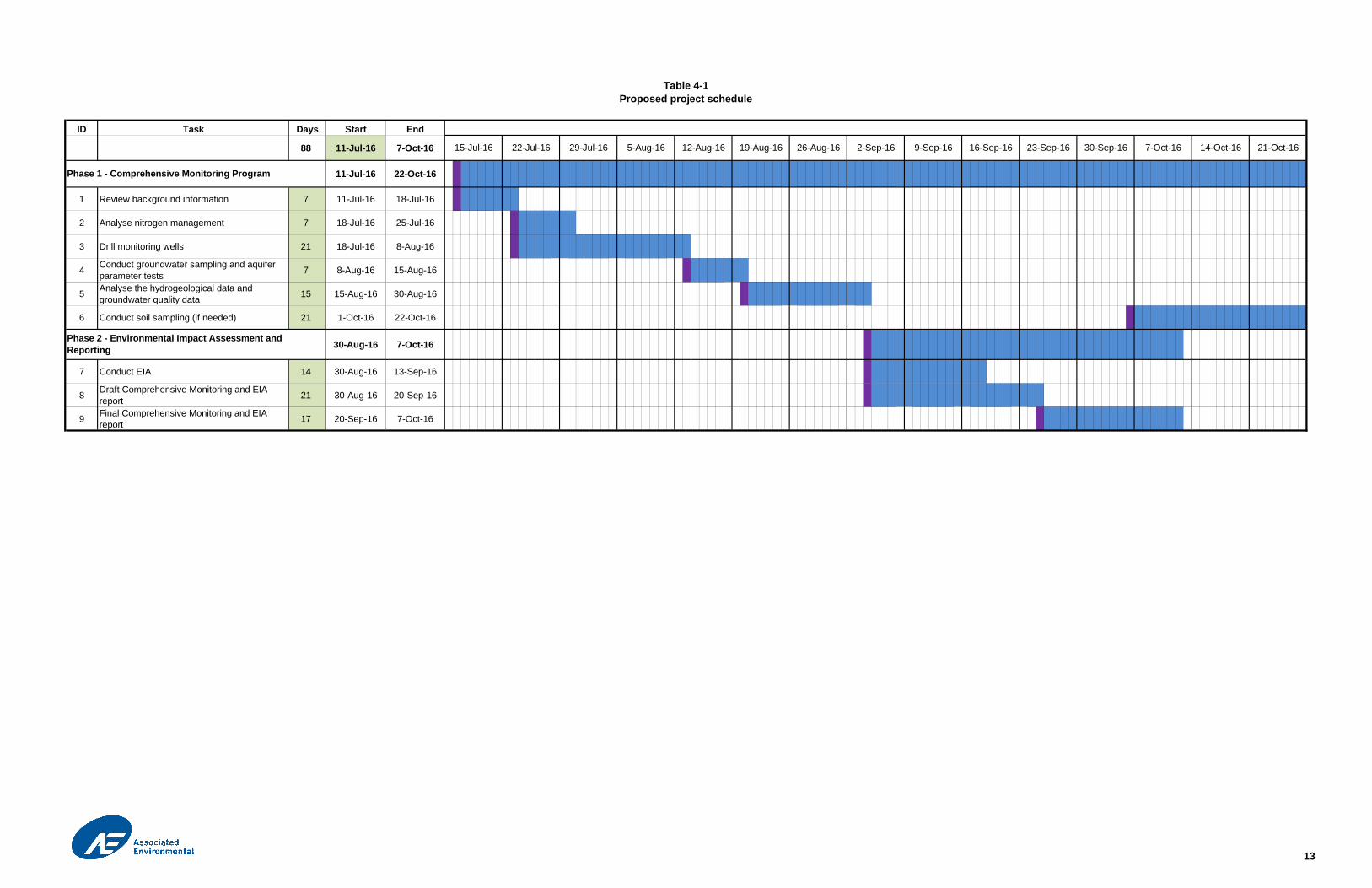
ID Task Days Start End
88 11-Jul-16 7-Oct-16
11-Jul-16 22-Oct-16
1 Review background information 7 11-Jul-16 18-Jul-16
2 Analyse nitrogen management 7 18-Jul-16 25-Jul-16
3 Drill monitoring wells 21 18-Jul-16 8-Aug-16
4 Conduct groundwater sampling and aquiferparameter tests 7 8-Aug-16 15-Aug-16
5 Analyse the hydrogeological data andgroundwater quality data 15 15-Aug-16 30-Aug-16
6 Conduct soil sampling (if needed) 21 1-Oct-16 22-Oct-16
30-Aug-16 7-Oct-16
7 Conduct EIA 14 30-Aug-16 13-Sep-16
8 Draft Comprehensive Monitoring and EIAreport 21 30-Aug-16 20-Sep-16
9 Final Comprehensive Monitoring and EIAreport 17 20-Sep-16 7-Oct-16
19-Aug-1615-Jul-16 22-Jul-16 29-Jul-16 5-Aug-16 12-Aug-16 26-Aug-16 2-Sep-16 9-Sep-16 16-Sep-16 23-Sep-16 30-Sep-16 7-Oct-16 14-Oct-16 21-Oct-16
Table 4-1Proposed project schedule
Phase 2 - Environmental Impact Assessment andReporting
Phase 1 - Comprehensive Monitoring Program
13

REPORT
References
BC Ministry of Environment (MOE). 2009. Approved Water Quality Guidelines for Nitrogen (Nitrate, Nitrite,
and Ammonia). Overview Report Update. September 2009. Water Stewardship Division, Ministry of
Environment. Available at: http://www2.gov.bc.ca/assets/gov/environment/air-land-
water/water/waterquality/waterqualityguidesobjs/approved-wat-qual-guides/nitrogen/nitrogen-
overview.pdf.
BC Ministry of Environment (MOE). 2016. Hullcar Aquifer Information. Okanagan Region EPD. Available at:
http://www.env.gov.bc.ca/epd/regions/okanagan/envman/hullcar-aquifer.html. Accessed June 2,
2016.
BC Ministry of Water, Land and Air Protection (MWLAP). 2013. British Columbia Field Sampling Manual for
Continuous Monitoring and the Collection of Air, Air-Emission, Water, Wastewater, Soil, Sediment,
and Biological Samples. 2013 Edition. Available at:
http://www2.gov.bc.ca/assets/gov/environment/research-monitoring-and-reporting/monitoring/emre
/field_sample_man2013.pdf
Environmental Management Act, SBC 2003, c. 53, and Agricultural Waste Control Regulation, BC Reg.
131/92.
Health Canada. 2013. Guidelines for Canadian Drinking Water Quailty Guideline Technical Document –
Nitrate and Nitrite. Prepared by the Federal-Provincial-Territorial Committee on Drinking Water of
the Federal-Provincial-Territorial Committee on Health and the Environment. Available at:
http://healthycanadians.gc.ca/publications/healthy-living-vie-saine/water-nitrate-nitrite-eau/index-
eng.php
Health Canada. 2014. Guidelines for Canadian Drinking Water Quality. Federal-Provincial-Territorial
Committee on Drinking Water of the Federal-Provincial-Territorial Committee on Health and the
Environment. Available at: http://www.hc-sc.gc.ca/ewh-semt/pubs/water-eau/sum_guide-
res_recom/index-eng.php
Oldfield, D. 2016. Personal communication (email conversation with Ruth McDougall). Environmental
Protectino Officer, Ministry of Environment.