terms of reference – cooks-devils creek integrated
TRANSCRIPT
TERMS OF REFERENCE – COOKS-DEVILS CREEK INTEGRATED WATERSHED MANAGEMENT PLAN

TABLE OF CONTENTS
1.0 INTRODUCTION Page 1
PURPOSE
DEFINITION OF A WATERSHED
PRINCIPLES OF INTEGRATED WATERSHED MANAGEMENT
PARTICIPANT ROLES AND RESPONSIBILITIES
GUIDING LEGISLATION AND POLICIES
LINKAGES BETWEEN WATER MANAGEMENT AND LAND USE PLANNING
2.0 WATERSHED INFORMATION Page 7
PLANNING AREA – Figure 1
WATERSHED OVERVIEW
LAND COVER – Figure 2
AGRICULTURAL CAPABILITY – Figure 3
WATERWAYS – Figure 4
GROUNDWATER
WATER QUALITY MANAGEMENT – Figure 5
WATERSHED ISSUES
3.0 SCHEDULE Page 16
4.0 BUDGET Page 17
WATERSHED PLANNING GRANT
SHARED IMPLEMENTATION STRATEGY
5.0 ENDORSEMENT Page 19
APPENDIX A


1
1.0 INTRODUCTION .
The intent of this document is to provide the scope, schedule and budget for the development of the Cooks-Devils Creek Integrated Watershed Management Plan. The document also provides important information about the watershed to consider during the planning process.
PURPOSE
The purpose of the Cooks-Devils Creek Integrated Watershed Management Plan is to positively influence land and water management with a focus on protecting water, aquatic ecosystems and drinking water sources in the Cooks Creek and Devils Creek watersheds. It is not intended to replace existing land and water management legislation or associated requirements currently in place.
The general process for this planning initiative is as follows:
• Compile existing information about the watershed • Identify partners and key stakeholders in watershed • Consult the public, municipalities, First Nations, and Planning Districts within the
study area • Review current management practices • Identify the key issues affecting water, aquatic ecosystems and drinking water
sources • Establish goals for the plan • Develop recommendations to address watershed issues and meet goals • Develop implementation plan including measures of success
KEY DEFINITIONS AND CONCEPTS
A watershed is topographically defined area of land where all the precipitation that falls within that area generally flows to a common downstream point, such as a lake or large river. Some precipitation that falls within a watershed will infiltrate soil and percolate into the ground to become groundwater. Groundwater is found in the tiny spaces between bits of sand and gravel or in fractures in the bedrock. In the Cooks-Devils Creek watershed almost all drinking water is sourced from the ground. A key concept important to consider as this plan is developed is the interconnectedness of a watershed. Actions taken in the upstream portion of a waterway can influence downstream conditions. Activities occurring on land can influence the quantity and quality of surface and groundwater. Integrated

Terms of Reference | Cooks-Devils Creek Integrated Watershed Management Plan 2
watershed planning takes into consideration these interrelationships to develop a plan which balances economic and ecological needs to ensure a sustainable future.
PRINCIPLES OF INTEGRATED WATERSHED MANAGEMENT
Interdependence Land and water are interdependent of each other and must be managed as such.
Accountability We are accountable for our actions and must therefore make decisions that account for the social, economic and environmental consequences of those decisions.
Transparency The planning process shall be transparent and all information made publicly accessible.
Respect All meetings and discussions must be fair and respectful and provide an environment for sharing ideas and solutions.
Recognition There must be recognition of existing rights, treaties, agreements and obligations.
Opportunity The planning process shall provide opportunities for meaningful participation.
Cooperation and Coordination
Cooperation and coordination are needed among all government and non-government interests.
Balance and Integration
Consideration of social, economic and environmental costs and benefits must be an integral part of all decision making.
Commitment Watershed management requires a long-term commitment, with ongoing adaptation based on information provided by regular monitoring and updates.
Support
Support for the planning process extends beyond meeting participation and is best demonstrated through plan implementation.
PARTICIPANT ROLES AND RESPONSIBILITIES
Water Planning Authority
Through a Memorandum of Understanding dated March 15, 2010 and authorized by the Minister of Water Stewardship, Manitoba designated the Cooks Creek Conservation District

3
as the Water Planning Authority for the Cooks-Devils Creek watershed. As Water Planning Authority, the Cooks Creek Conservation District is responsible for leading the development of an integrated watershed management plan for the Cooks-Devils Creek watershed that meets the requirements and intent of The Water Protection Act.
Project Management Team
The Project Management Team is a small group of key representatives appointed by the Water Planning Authority to complete the necessary work involved in the planning process and develop the integrated watershed management plan. They are the key decision makers and are formally tasked with upholding the responsibilities of the Water Planning Authority as described in The Water Protection Act. Their initial responsibilities include the development of the Terms of Reference and establishment of the Watershed Team. They are also responsible, to varying degrees, for requesting relevant technical information, coordinating all meetings and related advertisements, recording meeting minutes, participating at all Watershed Team meetings, writing the plan, and developing a public communications strategy to keep watershed residents up to date on plan progress and opportunities for input and participation. The project management team will ensure that all views in the watershed are considered and will strive to balance different needs.
Membership of the Project Management Team will include: • Cooks Creek Conservation District • Manitoba Conservation and Water Stewardship • R.M. of St. Clements • R.M. of Brokenhead • R.M. of East St. Paul • R.M. of Springfield • R.M. of Tache • Peguis First Nation
Watershed Team
The Watershed Team is a large group (~30 people) of people from government, First Nations, producer groups, environmental non-government organizations and other organizations that have either important management responsibilities in the watershed, or background knowledge and experience in the watershed. The main responsibilities of the team are to provide information about the watershed, present and discuss watershed issues, assess options, suggest recommendations to address issues, and share in plan implementation.

Terms of Reference | Cooks-Devils Creek Integrated Watershed Management Plan 4
Membership of the Watershed Team includes, but is not limited to: • Manitoba Conservation and Water Stewardship • Manitoba Infrastructure and Transportation • Manitoba Agriculture, Food and Rural Initiatives • Manitoba Municipal Government • First Nations • Municipalities • Federal Government • Planning Districts
Municipalities
As the integrated watershed management plan is prepared, the Water Planning Authority must consult with each municipality that is wholly or partly within the watershed. Part of this consultation will be enabled through representation on the Project Management Team. Although municipal representatives are often members on the Project Management Team, they are expected to make decisions for the betterment of the entire watershed rather than their municipality alone. Representatives on the project management team are expected to attend and participate in all public meetings to provide local background knowledge, input on watershed issues, recommendations to address issues, and comments on the draft plan.
Manitoba Conservation and Water Stewardship
Manitoba Conservation and Water Stewardship: • Is responsible for the administration of The Water Protection Act which authorizes
the designation of a Water Planning Authority and defines the content and requirements of an integrated watershed management plan
• Provides a Watershed Planner to the Project Management Team who plays an important coordination role throughout the planning process
• Contributes technical reports and input to the planning process • Participates on the Watershed Team
The Minister of Conservation and Water Stewardship gives final approval to the IWMP. Prior to approval, the Minister may refer the plan to the Manitoba Water Council for additional review, advice and comments.
First Nations
The Project Management Team must consult with each of the First Nations, as defined in The Indian Act (Canada), in the watershed. Two First Nations have land within the Cooks-Devils integrated watershed management plan study area: Peguis 1H, 1I, and 1G and the Na-Sha-

5
Ke-Penais Indian Reserve. First Nations in the area are involved in TLE negotiations that need to be considered during the planning process.
Non-Government Organizations
Non-government organizations are invited to participate on the Watershed Team and asked to contribute background information about the watershed, watershed issues, and recommendations to address the issues and share in plan implementation.
GUIDING LEGISLATION AND POLICIES
The Water Protection Act guides the development of integrated watershed management plans in Manitoba. The purpose of the Act is to provide for the protection and stewardship of Manitoba’s water and aquatic ecosystems, recognizing:
a) That Manitoba’s social and economic well-being is dependent upon the sustained existence of a sufficient supply of high quality water
b) The importance of comprehensive planning for watersheds, with respect to water, land and ecosystems, on a basis that acknowledges and considers their interdependence
c) That water resources and aquatic ecosystems require protection to ensure the high quality of drinking water sources
d) The importance of applying scientific information in decision-making processes about water, including the establishment of standards, objectives and guidelines
e) The need to protect riparian areas and wetlands f) The benefits of providing financial incentives for activities that protect or enhance
water, aquatic ecosystems or drinking water sources
Part 3 of The Water Protection Act relates specifically to watershed management plans. It describes the designation, roles, and responsibilities of a Water Planning Authority, required content of an integrated watershed management plan, required consultations, process for plan approval and amendments, establishment and purpose of the Water Stewardship Fund, and the establishment, role and responsibilities of the Manitoba Water Council. As well, it identifies the importance of developing plans that address land drainage and flood control, protect drinking water sources, and identify ways that the plan can be implemented, monitored and evaluated.
The following legislation is also relevant to water management and protection in Manitoba:
• The Water Rights Act • The Environment Act

Terms of Reference | Cooks-Devils Creek Integrated Watershed Management Plan 6
• The Drinking Water Safety Act • The Ground Water and Water Well Act • The Planning Act • The Health Act • The Water Resources Conservation Act
LINKAGES BETWEEN WATER MANAGEMENT AND LAND USE PLANNING
To ensure an integrated approach to planning, all efforts will be made to recognize the Provincial Land Use Policies and specify linkages between water management and municipal development plans. Policies relevant to land use planning will be included in development plans as they are updated in the region. This integrated watershed management plan will specify opportunities for linkages to all development plans, and outline information important to consider when undertaking land use planning in the future. The Project Management Team will work together with Peguis First Nation, the Red River Planning District, the Brokenhead River Planning Districts, and the Rural Municipalities of Springfield and Tache to ensure they have opportunities for meaningful participation throughout the IWMP planning process. Municipalities in the watershed without up-to-date development plans will be asked if any new development plans are being considered.

7
2.0 WATERSHED INFORMATION .
Figure 1 – Planning Area for the Cooks-Devils Creek Integrated Watershed Management Plan

Terms of Reference | Cooks-Devils Creek Integrated Watershed Management Plan 8
WATERSHED OVERVIEW
Due to their relatively small size and similar physical geographic features, the Cooks Creek and Devils Creek sub watersheds have been combined as one watershed management planning area. The watershed is characterized by the following information:
• Area of the Cooks-Devils Creek Watershed is 1,826 square km (705 square miles). • Population in the watershed, excluding Winnipeg’s population in the watershed, is
approximately 22,000 people. • The watershed includes Birds Hill Provincial Park. • Surface water flow is generally to the northwest. • Cooks Creek enters the Red River just north of Selkirk. • Devils Creek enters the Red River northwest of Libau. • On some land the growth and demand for rural residential properties has resulted in
a land use shift away from agricultural production. • Many of the communities serve as bedroom communities to Winnipeg. • There is a high density of riverfront property residences along the Red River. • Over 90% of the land in the watershed is privately owned.
DEVELOPMENT PLANS CONNECTIONS– Figure 2
LAND COVER – Figure 3
While the eastern and southern extremes of the watershed include forested uplands with limited agricultural activity, the majority of the watershed is relatively flat land extensively developed for agriculture.
AGRICULTURAL CAPABILITY – Figure 4
The Canada Land Inventory (CLI) system was used to classify land based on agricultural capability. The CLI is a comprehensive survey of land capability and use designed to provide a basis for making rational land-use planning decisions. Under the CLI, lands are classified according to physical capability for agricultural use. The system uses seven classes to rate agricultural capability, with Class 1 land having the highest capability to support agriculture, and Class 7 the lowest. Within Figure 3 there is a table that provides a description of each class. Subclass descriptors, such as stoniness, salinity or excess water, are also used to identify specific limiting factors within each class. The classes indicate the degree of limitation for mechanized agriculture imposed by the soil. The subclasses indicate the type of limitations that individually, or in combination with others, affect agricultural land use.
WATERWAYS – Figure 4

9
Figure 2 – Development Plans in the Cooks-Devils Creek Watershed

Terms of Reference | Cooks-Devils Creek Integrated Watershed Management Plan 10
Figure 3 – Land Cover in the Cooks-Devils Creek Watershed

11
Figure 4 – Agricultural Capability in the Cooks-Devils Creek Watershed

Terms of Reference | Cooks-Devils Creek Integrated Watershed Management Plan 12
Figure 5 – Waterways in the Cooks-Devils Creek Watershed
13
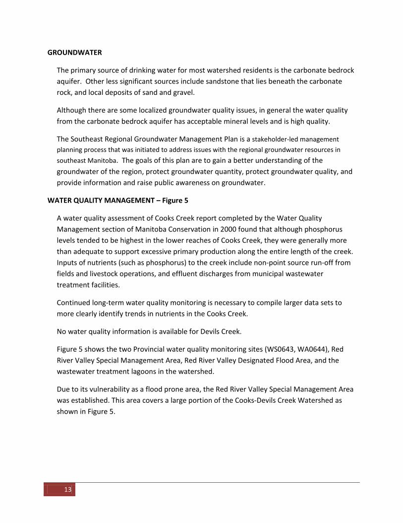
GROUNDWATER
The primary source of drinking water for most watershed residents is the carbonate bedrock aquifer. Other less significant sources include sandstone that lies beneath the carbonate rock, and local deposits of sand and gravel.
Although there are some localized groundwater quality issues, in general the water quality from the carbonate bedrock aquifer has acceptable mineral levels and is high quality.
The Southeast Regional Groundwater Management Plan is a stakeholder-led management planning process that was initiated to address issues with the regional groundwater resources in southeast Manitoba. The goals of this plan are to gain a better understanding of the groundwater of the region, protect groundwater quantity, protect groundwater quality, and provide information and raise public awareness on groundwater.
WATER QUALITY MANAGEMENT – Figure 5
A water quality assessment of Cooks Creek report completed by the Water Quality Management section of Manitoba Conservation in 2000 found that although phosphorus levels tended to be highest in the lower reaches of Cooks Creek, they were generally more than adequate to support excessive primary production along the entire length of the creek. Inputs of nutrients (such as phosphorus) to the creek include non-point source run-off from fields and livestock operations, and effluent discharges from municipal wastewater treatment facilities.
Continued long-term water quality monitoring is necessary to compile larger data sets to more clearly identify trends in nutrients in the Cooks Creek.
No water quality information is available for Devils Creek.
Figure 5 shows the two Provincial water quality monitoring sites (WS0643, WA0644), Red River Valley Special Management Area, Red River Valley Designated Flood Area, and the wastewater treatment lagoons in the watershed.
Due to its vulnerability as a flood prone area, the Red River Valley Special Management Area was established. This area covers a large portion of the Cooks-Devils Creek Watershed as shown in Figure 5.

Terms of Reference | Cooks-Devils Creek Integrated Watershed Management Plan 14
Figure 6 – Water Quality Management in the Cooks-Devils Creek Watershed

15
WATERSHED ISSUES
The following provides a general introduction to the most common watershed issues in the Cooks-Devils Creek Watershed. These issues are based on discussions with the Cooks Creek Conservation District, municipal councillors, watershed residents, and provincial government staff.
SURFACE WATER MANAGEMENT
• Agricultural land drainage o Application and definition of drainage standards for upgrading and
construction o Adequacy of current forage standard o Cost effectiveness of upgrading and construction o Drainage standards reflection of capability of land o Maintenance vs. construction vs. reconstruction of drains o Drainage for saline soil areas and marginal land o Erosion control and need for vegetated buffer strips along drains o Field and on-farm drainage o Impact of rural residential development on drainage o Construction and maintenance guidelines
• Infrastructure Maintenance o Cost effectiveness and sustainability of current maintenance program o Decision criteria for crossing repair, replacement or abandonment o Impacts of new subdivisions and rural residential development o Public safety o Road slips o Soil deposition – accumulation in drains o Vegetation management – cattails, willows
WATER QUALITY
• Surface water and groundwater pollution risks o Agricultural fertilizers and pesticides o Industrial and municipal wastewater – increasing urbanization o Manure management: spreading, feedlot runoff, cattle access to waterways o Aggregate and peat moss mining activities

Terms of Reference | Cooks-Devils Creek Integrated Watershed Management Plan 16
WATER HAZARDS
• Flooding o Spring runoff, rainstorms o Urban and rural o Land use planning and development in Red River Valley o Water storage and retention o Rural flood protection
• Erosion o Drains, road-slips, field gullies, riverbanks
• Groundwater o Soil salinity o Winter flow, icing of drains and culverts o Waterlogged soils o Water table
WATER DEMAND / SUPPLY
• Aquifer monitoring • Ensuring an adequate supply of high quality groundwater for growing domestic and
municipal demand • Identifying important groundwater recharge areas • Forecasted development scenario and associated water needs
WILDLIFE MANAGEMENT
• Loss / degradation of wetlands and native cover areas • Nuisance animals – beavers, deer • Conservation of natural areas
AQUATIC / FISH HABITAT MANAGEMENT
• Aquatic habitat degradation • Barriers to fish migration

17
3.0 SCHEDULE .
The schedule is organized into three stages: 1) Pre-Planning, 2) Plan Development, and 3) Plan Implementation. There are three check points throughout the planning process to ensure that the PMT membership and the organizations they represent are in agreement with all documents and decisions before proceeding to the next stage.
PHASE 1 – PRE-PLANNING
Activities:
• Designate a Water Planning Authority • Form a balanced Project Management Team • Develop a Terms of Reference • Complete source water assessments for all public drinking water systems
CHECK POINT 1: Receive endorsement from all councils within the watershed on the Terms of Reference.
PHASE 2 - PLAN DEVELOPMENT
Activities:
• Engage watershed residents to gain an understanding of watershed priorities • Collect and compile scientific, traditional and local knowledge • Hold at least one meeting with the Watershed Team
CHECK POINT 2: Receive endorsement from all councils on the watershed priorities that will form the framework of the plan.
• Develop a surface water management strategy • Draft the plan and edit as necessary • Review the draft plan with the Water Planning Authority, Watershed Team, Provincial
Branches and Departments, Rural Municipal and Band Councils and the watershed residents
• Compile a final draft plan CHECK POINT 3: Receive endorsement from all councils on the final draft plan prior to submitting the plan for approval.
• Submit the plan to Minister of Conservation and Water Stewardship • Once plan is approved, print a minimum of 500 copies • Promote the plan to watershed residents and stakeholders

Terms of Reference | Cooks-Devils Creek Integrated Watershed Management Plan 18
PHASE 3 - PLAN IMPLEMENTATION
Activities:
• Implement the IWMP • Monitor and evaluate the progress of implementation annually • Revisit and revise IWMP
4.0 BUDGET . Watershed Planning Grant
Manitoba provides a watershed planning grant of $25,000 to the Water Planning Authority to cover the expenses related to developing the plan. The Project Management Team has the authority for expenditure of the grant. The following table lists, in general, most of the necessary tasks and the approximate cost of each.
Tasks Amount
Engaging watershed residents $4,000
Project Management Team meetings $2,000
Two Watershed Team meetings $2,000
Mail-outs and advertising re: watershed info, issue summary, and Draft Plan $4,000
Graphic Design of Plan $2,000
Printing of Final Plan (Min. 500 copies) $9,000
Plan distribution and advertising to encourage implementation $2,000
TOTAL $25,000

19
Shared Implementation Strategy
The IWMP is to include an implementation strategy which will outline the organization(s) responsible for implementing each action in the plan. This shared implementation strategy will guide and assist stakeholders during plan implementation.
Plan implementation is voluntary; however, the plan will better achieve its goals if all stakeholders participate in implementation. The IWMP will be implemented voluntarily by a group of stakeholders, including the Cooks Creek Conservation District. The Cooks Creek Conservation District receives provincial, municipal and external funding in order to deliver projects throughout their watershed and is expected to organize their budget in accordance with the watershed goals and actions stated in the plan. Stakeholders outside the boundaries of the Cooks Creek Conservation District can explore alternative methods of funding implementation including funding projects from existing budgets, pursuing available grants, or creating/joining a conservation district.
