terms of reference for the master plan …pdf.usaid.gov/pdf_docs/pnadm875.pdf · terms of reference...
TRANSCRIPT

TERMS OF REFERENCE FOR THE MASTER PLAN DEVELOPMENT STRATEGY IN THE JORDAN VALLEY Final Report
July 17, 2007
This publication was produced for review by the United States Agency for International Development. It was prepared by <Dr. Brent Tegler>.

DISCLAIMER:
The author’s views expressed in this publication do not necessarily reflect the views of the United States Agency for International Development or the United States Government.
TERMS OF REFERENCE FOR MASTER PLAN DEVELOPMENT STRATEGY IN THE JORDAN VALLEY FINAL REPORT
SUSTAINABLE ACHIEVEMENT OF BUSINESS EXPANSION AND QUALITY (SABEQ)
CONTRACT NUMBER: 278-C-00-06-00332-00
BEARINGPOINT, INC.
USAID/JORDAN ECONOMIC OPPORTUNITIES OFFICE (EO)
JULY 17, 2007
AUTHOR: DR. BERNT TEGLER
DELIVERABLE NO: 2.5.1.1_REPORT PROVIDING A METHODOLOGY FOR A DEVELOPMENT PLAN FOR THE JORDAN VALLEY

SABEQ: Report Title i
CONTENTS
1 INTRODUCTION .................................................................................................... 2
2 BACKGROUND...................................................................................................... 3
2.1 Relevant Land Use Planning Studies Completed in the Jordan Valley .....................................5 2.2 Current status of land use planning in the Jordan Valley ..........................................................6
3 ISSUES TO BE ADDRESSED BY MASTER PLAN DEVELOPMENT STRATEGY............................................................................................................. 7
4 GENERAL OBJECTIVES OF THE MASTER PLAN DEVELOPMENT STRATEGY........................................................................................................... 10
5 SPECIFIC OBJECTIVES OF THE MASTER PLAN DEVELOPMENT STRATEGY........................................................................................................... 11
6 STUDY DELIVERABLES..................................................................................... 20
7 TEAM REQUIRED AND LEVEL OF EFFORT .................................................... 20
8 PROJECT PHASES AND TIMING ...................................................................... 21
APPENDIX 1: JV-PLUMP TABLE OF CONTENTS, VOLUMES 1 – 5. ........................ 22
APPENDIX 2: LAND USE MAPPING COMPLETED IN JV-PLUMP ............................. 35
APPENDIX 3: INVESTMENT PROJECTS ON THE EAST SHORE OF THE DEAD SEA............................................................................................................................... 36
APPENDIX 4: JV-PLUMP LAND USE RECOMMENDATIONS FOR DEAD SEA ....... 40
APPENDIX 5: JVA STRATEGIC PLAN 2003-2008 EXECUTIVE SUMMARY................ 1

Terms of Reference for Master Plan Development Strategy in the Jordan Valley..........................................page 2
1 INTRODUCTION
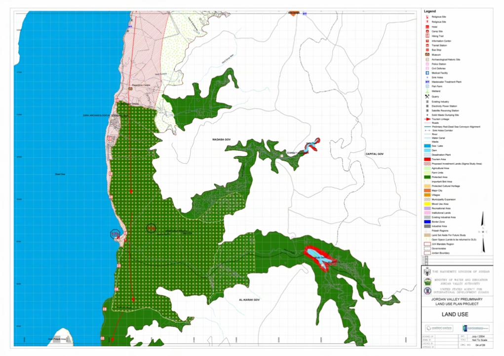
In 2004, the USAID funded program Achievement of Market-Friendly Initiatives and Results (AMIR) completed the Jordan Valley Preliminary Land Use Master Plan (JV-PLUMP) project. The project provided a comprehensive five-volume assessment of social, economic and environmental conditions in the Jordan Valley (JV) and produced maps of infrastructure, facilities, conservation areas, tourism zones, parcel ownership and land use (see Appendix 1 JV-PLUMP Table of Contents, Volumes 1-5). The JV-PLUMP was reviewed and approved by the cabinet of the Hashemite Kingdom of Jordan (HKJ).
While the JV-PLUMP provides an excellent assessment of existing and proposed land use within the JV in broad terms, the mapping does not provide detailed information defining activities within the various land use categories defined, due to the scale at which the study was undertaken. For example within an area of existing agricultural land use mapped as “Farm Units”, additional information on the type of agriculture present, such as the crops grown or the method of irrigation used, is not provided. Another example is within an area of proposed land use mapped as “Municipal Expansion”, where additional details on the location and type of roads, residential densities, commercial lands, etc. that may be included within an area of municipal expansion are not provided.
Within the JV there is a need to develop detailed land use plans (sometimes referred to as “secondary plans” or “local plans”) that are necessary to guide sustainable land use within areas designated for municipal, industrial and tourism growth, etc. Detailed land use plans will use the JV-PLUMP as a base and through a consideration of the demand for new land uses and consultation with stakeholders, further build on that base to provide opportunities for sustainable growth that considers issues of social responsibility, economic growth and ecological balance.
The JV-PLUMP provides guidance for new development in the JV within the following categories as shown on the Land Use maps (Appendix 2):
• “Tourism Area”, where there are areas of potential tourist interest and development;
• “Proposed Investment Lands (Sigma Study Area)”, an area of potential development located around the north end of the Dead Sea;
• “Agricultural Area”, areas that may not currently be used for agriculture but which have the potential for use as range lands, cropping, animal farms and fish farms;
• “Municipal Expansion”, located around existing urban areas that are undergoing growth;
• “Mixed Use Areas”, areas generally associated with existing villages that have the potential to accommodate a variety of residential, commercial and institutional land uses;
• “Recreational Areas”, intended for development of active recreation facilities such as a sports city;
• “Institutional Lands”, areas that may be suitable for the development of public facilities for infrastructure, educational training centers, vocational schools, cultural heritage centers, handicapped centers, conference facilities, cemeteries, etc.; and
• “Industrial Area”, associated with existing areas of industrial development or associated with villages in the JV where there is the potential for the development of

Terms of Reference for Master Plan Development Strategy in the Jordan Valley..........................................page 3
light industry compatible with the environment and where possible industry associated with agricultural production and processing.
The JV-PLUMP also provides guidance for the protection of existing land uses and for the protection of sites of cultural and/or environmental significance. Following the legend used in the Land Use maps, these areas include the following:
• “Farm Units”, areas of existing agriculture;
• “Protected Area”, includes areas protected under existing legislation and additional areas proposed for protection;
• “Important Bird Area”, are shown as an overlay on other land uses and are intended to show areas where current or proposed land uses may be modified to ensure they are conducted in a manner that is sensitive to birds, particularly migrating birds;
• “Protected Cultural Heritage”, valued cultural heritage sites that should be protected from other conflicting land uses;
• “Existing Industrial Area”, recognizing areas of current industrial land use;
• “Border Zone”, showing areas of infrastructure associated with HKJ’s border crossings; and
• “Potash Regions”, industrial land use areas located at the southern end of the Dead Sea.
2 BACKGROUND
The Jordan Valley is part of the Great Rift Valley, an extensive geological fault line that stretches 5,000 kilometers between Turkey and East Africa. The JV is one of the world’s most important anthropological areas due to the very early (9000 years BP) agrarian civilizations that utilized fertile soils irrigated by natural springs. The region is significant also for its complex religious history. The JV is a unique, important and scenic ecological corridor. Where the Dead Sea is located at approximately 400 m below sea level, there are contrasting fertile and desert, valley and mountain landscapes forming part of an intercontinental bird migration corridor. Within the HKJ the JV stretches from the Syrian border in the north to the Red Sea in the south, a distance of over 350 km. The western boundary of the JV within the HKJ is defined by the country’s border with Israel and the Palestinian Territories; the eastern boundary of the JV is defined by the 300 metre contour line above sea level (ASL) north of the Dead Sea and the 500 metre contour line ASL to the south.
The JV represents a significant region within the HKJ due to the fresh and saline water resources present and the socio-economic conditions that arise from these, including:
• Ecological and cultural sites of global importance;
• A large proportion (40%) of Jordan’s irrigated agricultural lands;
• The presence of health and nature based tourism opportunities;
• Resource-based industries (potash and other minerals); and
• The supply of fresh water to areas within and outside the JV.
Within the JV there are more than 55 villages with a total population of approximately 191,000 in 2004. This constitutes 3.5% of the HKJ’s total population. The JV has one of the country’s highest population growth rates (4.5%), with a predicted population of 238,000 in

Terms of Reference for Master Plan Development Strategy in the Jordan Valley..........................................page 4
2010 and 314,000 in 2020. A description of the three major regions of the JV, north, middle and south, are provided below.
The northern JV area is characterized by a generally larger, agriculturally based population producing fruits (oranges, lemons, limes, melons, bananas, etc.) and vegetables (tomatoes, cucumbers, leafy vegetables, etc.) for both domestic consumption and export. Agriculture in the northern JV is dependent on a sophisticated water capture and distribution system managed by the Jordan Valley Authority (JVA) which captures water from the Jordan and Yarmouk Rivers as well as from a number of dams which capture surface water runoff and springs that come from deeply incised Wadis (valleys) entering the JV from areas of higher elevation located to the east. The JVA distributes water from the 110 km long King Abdullah canal which stretches from the Yarmouk River in the north southward to a point approximately 10 km north of the Dead Sea. In this region, there is limited small scale industry, an interesting cultural heritage of Roman, Islamic, and other sites, a living heritage of basket and rug weavers, and a broad swath of environmentally sensitive land and Important Bird Areas (IBA) designated because of their importance for bird migration along the Jordan and Yarmouk Rivers.
The middle JV area is centered on the Dead Sea, a site known internationally for its location at over 400 metres below sea level (BSL). The area has only a small population of indigenous human settlements given the relatively infertile saline soils associated with the Dead Sea. The middle JV is characterized by universally important cultural heritage sites including the Baptismal site of Jesus, increasing health and spa tourism development, nature-based tourism associated Wadi Mujib Nature Reserve and internationally competitive potash, salt and mineral extraction related industries along the southern shore of the Dead Sea. Due to water capture and diversion within Jordan, Israel and Syria the Dead Sea no longer receives much of its original water inputs, resulting in a sea level decline of up to one metre each year and a sea surface area now less than half of its original extent; consequently there is a rapidly increasing area of exposed shoreline.
The southern JV area is characterized by a more arid environment, which is home to nomadic Bedouin who utilize environmentally sensitive rangelands. Wadi Araba, which forms a large part of the southern JV, has been identified for a special land use study in part to address, in part, the needs of local populations, but also in recognition of potential groundwater resources. There is also a proposed Red Sea to Dead Sea Canal soon to undergo an environmental impact and feasibility study. The canal is intended to restore and maintain the level of the declining Dead Sea, to generate electricity as water flows down into the Dead Sea and using the electricity generated, produce fresh water through desalinization.

Terms of Reference for Master Plan Development Strategy in the Jordan Valley..........................................page 5
2.1 RELEVANT LAND USE PLANNING STUDIES COMPLETED IN THE JORDAN VALLEY
1. Establishment of the Jordan Valley Authority (Law 18. “The Jordan Valley Development Law” No. 18 of 1977)
The JVA is part of the Ministry of Water and Irrigation (MoWI), a Ministry it shares with the Water Authority of Jordan (WAJ). The mandate of the JVA is to carryout integrated social and economic development of the JV. During the period 1972-1988, a land use planning exercise was conducted by the JVA whereby approximately 350,000 denims (35,000 hectares) of land were developed and provided with irrigation infrastructure. Six dams were constructed and physical infrastructure for public utilities, schools, health centers and hospitals were constructed. Currently, a project is underway to accurately survey and register with the Department of Lands and Survey all privately owned land within the JV; in June 2007 the project was approximately 50% completed and was to 100% complete by the end of 2007.
2. Jordan Rift Valley Tourism Development Project: Action Areas (OTH International 1979)
The Jordan Rift Valley Tourism Development project developed a Master Plan that identified three main “action areas”: (1) areas around Suweimah Village at the north end of the Dead Sea; (2) the Zara Archeological Site located mid-way along the east shore of the Dead Sea; and (3) the Al-Himmah hot spring located in the northern JV near the Yarmouk River. The Master Plan provided a development strategy based on the existing tourism facilities, the socio-economic context, and the potential markets for health (curative) tourism.
3. Tourism Development Project of the East Coast of the Dead Sea (Sigma Consulting Engineers 1994, 1996, 1997)
A tourism development program and plan for the east coast of the Dead Sea was prepared within a study area approximately 60 km long and 5 km wide (often referred to as the “Sigma Study”). The Development Master Plan produced in three volumes identified 23 potential zones for tourism development and provided detailed land use plans for two areas referred to as the Suweimeh Sector (which included the potential zones 3, 4, 5 and 6) and the Zara Sector (which included the potential zones 12, 13 and 14). The Sigma Plan accommodated projected tourism growth requiring up to 10,800 hotel rooms by the year 2010. The JVA has indicated all development lands identified in the Sigma study have been allocated as of 2007.
4. Preliminary Land Use Master Plan for the Jordan Valley (USAID AMIR Program 2004)
As discussed in the introduction the JV-PLUMP was a comprehensive regional scale initiative providing land use mapping for the JV. In 2007 the Ministry of Municipal Affairs (MoMA) completed similar land use mapping for the HKJ; within the JV the MoMA followed the mapping from the JV-PLUMP. Information provided in JV-PLUMP reports and maps should be used as the starting point for more detailed planning exercises in the JV.

Terms of Reference for Master Plan Development Strategy in the Jordan Valley..........................................page 6
2.2 CURRENT STATUS OF LAND USE PLANNING IN THE JORDAN VALLEY
Currently there are no detailed long-range (5-10 year) plans available to guide development growth in the Jordan Valley. Urban growth, which is occurring as a result of the high population growth rate (4.5%), is generally managed on a case-by-case basis as applications for new development are submitted to local Municipalities and the JVA. There are some examples where hard copy mapping maintained by the JVA has been amended to accommodate the expansion of existing villages (municipal areas) and where areas within villages have been specified for specific kinds of development such as “commercial development” along main roads. Mapping maintained by the JVA which has been amended to expand municipal lands, includes approval signatures based on HKJ Cabinet approval due to the fact that the responsibility for these areas is transferred from the JVA to the MoMA.
In addition to urban growth, there is considerable investment interest in tourism related development in the JV. The Sigma Study provides a detailed long range plan for tourism development in two areas (Suweimeh and Zara) on the east coast of the Dead Sea. The land parcels identified for development by the Sigma Study have been allocated to a variety of private and government investors. Based on information provided in June 2007 by the JVA Investment Unit, the status of investment projects on the east shore of the Dead Sea is as follows (for details see Appendix 3):
• Seven projects have been implemented covering an area of 2206 denims (220.6 ha) with a total investment of 115 MJD;
• Four projects are under construction covering an area of 219 denims (21.9 ha) with a total investment of 228 MJD; and
• Fifteen projects are to be implemented during 2007-2008 covering an area of 2731.8 denims (273.2 ha) with a total investment of 1816.2 MJD.
The “Proposed Investment Lands (Sigma Study Area)” as shown on the JV-PLUMP mapping encloses a large (over 30,000 ha) area along the northeastern shore of the Dead Sea. The JV-PLUMP study team recommended that this area be re-studied taking into consideration current issues identified during consultations held as part of the JV-PLUMP project. Further, the study team made recommendations for land uses within areas not currently developed. (see Dead Sea parcel by parcel recommendations provided in Appendix 4). While these recommendations do not include the results of a fully integrated and detailed planning study they can be used to provide direction for future planning studies, such as the detailed integrated planning study to be undertaken by this project.

Terms of Reference for Master Plan Development Strategy in the Jordan Valley..........................................page 7
3 ISSUES TO BE ADDRESSED BY MASTER PLAN DEVELOPMENT STRATEGY
Based on an examination of the current status of planning in the JV and discussions held with government officials and the private sector, three focus areas have been identified for this study. Justification for the need and a brief description of the intent and tasks for each of the three study focus areas is provided below.
Study Focus A: Conduct Detailed Planning Studies within Priority Areas of the JV
Detailed land use plans are needed immediately to facilitate and direct, in a sustainable manner, the demand for growth in the JV. Currently there is a demand for growth by private investors within the Proposed Investment Lands (Sigma Study Area) around the Dead Sea and within some urban areas (villages).
The government has indicated there are development proposals for areas around the Dead Sea that require immediate review. This study must therefore begin by undertaking a rapid evaluation of the existing proposals in order to determine if they are appropriate within the context of a larger vision being developed for the Dead Sea investment lands. The intent of the rapid evaluation is to provide assurance to investors there are opportunities for development, while ensuring development meets the vision, priorities and guidelines that are to be developed by a more detailed master land use plan.
Detailed land use plans developed by this study must be based on a vision that considers the following principles:
• creative and diverse;
• incorporates the best of international thinking while being uniquely Jordanian;
• works within the limits of the environment, particularly in regard to water;
• respects stakeholder opinions; and
• is responsive to the projected demand for growth (residential, tourism, commercial, industrial, etc.).
Key tasks to be completed in the development of detailed land use plans include at a minimum the following broad categories of tasks:
• Consultation with stakeholders for initial input and to report back to stakeholders on proposed land use plans (public, private, local communities, all levels of government);
• Assessment of growth demands (population growth, tourism, commercial, industrial, agriculture, etc.);
• Assembly and mapping of base line information (land use, topography, drainage, vegetation, infrastructure, protected areas, cultural sites, etc.);
• Completion of infrastructure planning required in support of development (water supply, wastewater management, storm water management, transportation, electricity, telecommunications, etc.);
• Development of detailed guidelines required to manage development (water use, landscaping, architecture, scenic viewpoints, etc.); and

Terms of Reference for Master Plan Development Strategy in the Jordan Valley..........................................page 8
• Preparation of detailed land use plans for the proposed investment lands as well as up to three selected growth areas in the JV.
Study Focus B: Improve the Capacity to Undertake and Implement Detailed Land Use Planning
Currently the JVA and/or Local Municipalities are not preparing detailed land use plans needed to accommodate and guide long-term growth and development in the JV. In addition, the JVA has indicated that implementation of the detailed Sigma land use plan for the Suweimeh and Zara areas of the Dead Sea (prepared by Sigma Consulting Engineers), requires the use of consultants to assist in the evaluation of development proposals. In some cases the land use recommendations of the Sigma Study have not been implemented in favor of the distribution of land parcels to private investors, who may not develop the lands according to the land use defined by the Sigma Study.
The JVA Strategic Plan 2003-2008 recognizes a changing role for the JVA and the challenges faced by growth and development (Appendix 5 JVA Strategic Plan 2003-2008 Executive Summary). While Goals 1 and 2 of the Strategic Plan recognized the importance of JVA’s ongoing role in water management, Goals 3 and 4 identified the need for JVA’s greater involvement in land development and an improved capacity of JVA to monitor and manage growth. The JVA Strategic Plan goals are as follows:
Goal One: Water Resource Development and Management
Meet the needs of current and future water users by managing, developing, protecting and sustaining both existing and new water resources, and to do this in a way which takes into account both economic and environmental considerations, and involves the private sector where appropriate.
Goal Two: Water Supply and Distribution
Ensure that JVA's existing water delivery and distribution infrastructure, systems and facilities are managed in an efficient, transparent and equitable manner, and involve the private sector where appropriate
Goal Three: Land Development and Management
Develop, manage, regulate and protect land and related resources in the Jordan Valley in order to maximize their economic usefulness while taking into account environmental considerations, and involve the private sector where appropriate.
Goal Four: Organizational Performance Improvement and Development
Develop and reorganize JVA to enable it to better achieve its new mission and improve its performance and effectiveness in providing quality service to its stakeholders.
Key tasks to be completed to improve the capacity to undertake and implement detailed land use planning include, at a minimum, the following tasks:
• Examination of the existing institutional framework and capacity for long range planning within the JVA, MoMA, Department of Lands and Survey (DLS), Ministry of Tourism and Antiquities (MoTA) and other government agencies relevant to land use planning in the JV;
Terms of Reference for Master Plan Development Strategy in the Jordan Valley..........................................page 9
• Identify counterparts within relevant government agencies to participate in the development of detailed land use plans prepared by this study;
• Identify training needs and opportunities for existing government staff and, where warranted, identify the requirements for additional government staff and skills areas that will in the long term allow government to undertake and implement detailed land use planning in the JV;
• After reviewing the existing institutional planning framework make recommendations that identify a lead government agency to conduct land use planning; the structure and organization of the lead agency; and the procedures for undertaking and implementing land use planning, including how the lead agency interacts with and involves other relevant government agencies.
Study Focus C: Advice the HKJ on financial mechanisms available for remuneration when government land is approved for private development.
The government of the HKJ has indicated it is seeking advice on the full range of financial mechanisms that may be used when government land is made available for development. While reasonable financial return to the government is an important consideration, it is also recognized that there are indirect social, economic and environmental benefits to the people of the HKJ that may be of equal or greater importance to consider. It is also recognized that overly regulated or cumbersome financial mechanisms may reduce or delay potential private development reducing potential social and financial benefits to the HKJ.
Key tasks to be completed to advise the HKJ on financial mechanisms include, at a minimum, the following tasks:
The intent of this study focus area is to provide a review and description of strategies and options available to the government in regard to financial and contractual agreements related to the transfer of government land for development. Development may include a wide range of possible activities such as hotels, residential development, a variety of commercial operations (stores, restaurants, recreation facilities, etc.), health facilities, research institutions, educational institutions, museums, etc. The study should consider how financial arrangements may vary according to different types of development. In considering financial arrangements the study should, among other things describe methods of land valuation, options for revenue sharing, and possible shareholder agreements.
Terms of Reference for Master Plan Development Strategy in the Jordan Valley....................................... page 10
4 GENERAL OBJECTIVES OF THE MASTER PLAN DEVELOPMENT STRATEGY
1. The principles of Sustainable Development should form the foundation for new development within the JV, these principles include: Social Progress – Ecological Balance – Economic Growth
2. The JV-PLUMP 2004 vision for a sustainable future and the understanding of current conditions and future needs should be incorporated in to detailed land use planning, notwithstanding, modification of the JV-PLUMP land use recommendations may be an outcome of more detailed study.
3. There is a need to develop an implementation strategy for the JV-PLUMP. This will require the identification of, and capacity building within, a lead agency and the development of detailed guidelines for sustainable land use.
4. There is considerable potential for tourism development within an area identified by the JV-PLUMP as the “Proposed Investment Lands (Sigma Study Area)”. These lands located along the northeastern coastline of the Dead Sea currently have a number of proposed investment projects that require evaluation.
5. In order to provide direction for long-term sustainable development within the Proposed Investment Lands there is a need undertake a detailed integrated land use planning study to prepare a Master Plan Development Strategy.
6. High population growth within the JV combined with the indirect effects of growth in the tourism sector necessitates comprehensive planning initiatives be undertaken within urban growth areas within the JV.
7. There is a need to improve the capacity of government to undertake and implement detailed land use planning in the JV.
8. The government of the HKJ should encourage and facilitate new development in the JV within the limits of the environment, while maximizing the benefits derived.

Terms of Reference for Master Plan Development Strategy in the Jordan Valley....................................... page 11
5 SPECIFIC OBJECTIVES OF THE MASTER PLAN DEVELOPMENT STRATEGY
For each of the three study focus areas defined above a more detailed outline of the tasks is provided below. The detailed outline is intended to more clearly define the activities to be carried out in this study, however this should not preclude consultants from identifying and undertaking additional tasks and activities relevant to the study, particularly where they have been identified through stakeholder consultations. The numbering of tasks does not reflect a sequence in which tasks are to be completed; while some tasks may logically come before others, it is envisioned many of the tasks will be carried out simultaneously.
Study Focus A: Conduct Detailed Planning Studies within Priority Areas of the JV
This study must recognize the Proposed Investment Lands (Sigma Study Area), the area surrounding the northeast coast of the Dead Sea, require the immediate preparation of a detailed land use plan. As such, this area will be the primary focus of the master plan development strategy during the initial phases of the study (first 3 to 6 months).
The study will also prepare detailed land use plans for up to three additional areas that are to be selected through consultation with stakeholders. It is anticipated the additional areas will be selected based on existing or known future population, tourism, commercial and/or industrial development growth pressures. The additional areas may be associated with areas mapped by the JV-PLUMP as agricultural area, protected area, protected cultural heritage, villages, municipality expansion, mixed use area, recreational area, institutional lands, industrial area (see Section 1. Introduction).
Task A1: Consultation with stakeholders for initial input and as a part of reporting back to stakeholders on proposed land use plans (public, private, local communities, all levels of government).
There is a considerable body of knowledge distributed among the general public, local communities, all government ministries within the JV and within Amman, and the private sector. The sustainability of land use plans will be greatly enhanced by obtaining, understanding and incorporating the knowledge of stakeholders.
Consultation with stakeholders should seek to obtain information on the following topics as well as other topics that may be identified during stakeholder consultations:
• the range of tourism opportunities in the JV desired by international and domestic tourists (e.g. cost, ecotourism, health tourism, length of stay, distance traveled for tourism, method of travel, preferred accommodation, etc.);
• the diversity of land use development that should occur in the JV and where such development should occur (e.g. tourism, residential, commercial, industrial, agricultural, environmental protection, cultural heritage protection, institutional, educational, etc.);
• the existing and potential future employment opportunities in tourism, commercial enterprises, industry, and agricultural production and processing, etc.;
• the formal, non-formal and mature-learner educational needs within the JV (e.g. schools to serve a growing population, technical training for participation in tourism, commercial and industrial related growth and development, re-training of mature-learners seeking employment in a changing workforce environment, etc.);

Terms of Reference for Master Plan Development Strategy in the Jordan Valley....................................... page 12
• up to three additional areas in the JV where detailed land use plans are to be developed by this study to address issues of development growth; and
• through public presentation of conceptual land use plans stakeholder feedback should be obtained and used to refine the detailed land use plans prepared for the Proposed Investment Land (Sigma Study Area) and for up to three additional areas in the JV feedback as discussed above.
Task A2: Assessment of the demand and opportunities for growth (e.g. tourism, population growth, commercial/industrial development, agriculture)
There is a need for market feasibility studies, economic analysis and forecasting, and demographic studies as well as environmental assessments to inform land use planning. An understanding of growth demand combined with stakeholder consultation is essential to ensure land use plans respond to a changing world in ways that inform and respond to the communities of people that live, work and recreate within the planning landscape.
• assemble and review existing information on projected tourism growth by contacting relevant government, non-government and tourism industry sources [e.g. JVA, MoTA, Ministry of Industry and Trade (MoIT), Jordan Tourism Board (JTB), Jordan Investment Board (JIB), Jordan Tourism Development Corporation (JTDC), Jordan Hotel Association (JHA), Jordan Inbound Tour Operators Association (JITOA), Jordan Restaurant Association (JRA), Jordan Society for Tour and Travel Agents (JSTTA), Jordan Tour Guides Association (JTGA), Aqaba Development Corporation (ADC), National Tourism Authority (NTA), National Tourism Council (NTC), Royal Jordanian Airlines (RJA), World Tourism Organization (WTO), and World Travel and Tourism Council (WTTC), etc.] and consider recommendations provided in Jordan’s National Tourism Strategy 2004-2010;
• assemble and review existing information on population growth and the growth of urban areas in the JV by contacting relevant government sources [e.g. JVA, MoMA, DLS, Department of Statistics (DoS), Local and Regional Councils in the JV, etc.];
• assemble and review existing information on the growth of agricultural production and secondary industries related to the processing, marketing and transportation of agricultural products domestically and internationally by contacting relevant government, aid-agencies, and private sector sources [e.g. JVA, MoA, MoMA, MoIT, German Aid Agency (GTZ), Japan Aid Agency (JICA), USAID, Agriculture Marketing Association (AMO), National Centre for Agricultural Research and Technology Transfer (NCARTT), General Union of Jordanian Farmers (GUJF), Jordan University Plant Production Division, etc.] and consider recommendations provided in The National Strategy for Agricultural Development 2002-2010;
• assemble and review information on other potential areas of economic growth and development in the JV by contacting relevant government and non-government sources [e.g. MoIT, MoPIC, Ministry of Information and Communication Technology (M0ICT), Ministry of Higher Education and Scientific Research (MoHESR), etc.] and consider recommendations provided in Jordan Vision 2020.
Task A3: Assembly and mapping of base line information (land use, topography, drainage, vegetation, infrastructure, protected areas, cultural sites, etc.)
Geographically accurate and up to date base line information accessible in a digital format is essential to a land use planning study. Various government departments have assembled or are in the process assembling digital data sets that will be available to this project. There is

Terms of Reference for Master Plan Development Strategy in the Jordan Valley....................................... page 13
also a need to collect and assemble additional relevant and current land use, environmental and cultural information for the land use planning exercises to be conducted in this study.
• contact relevant government agencies to establish data sharing agreements and to obtain necessary digital data [e.g. JVA, MoWI, MoMA, DLS, DoS, Ministry of Public Works and Housing (MoPWH), Ministry of the Environment (MoE), Royal Society for the Conservation of Nature (RSCN), etc.];
• obtain current, high resolution, geographically corrected satellite imagery for those areas of the JV where detailed land use plans are to be completed;
• ground truth existing data and satellite imagery to produce a digital data set of sufficient detail and quality to conduct detailed land use planning at a scale of 1:10,000. Report figures created to convey concept land use plan information may be created at smaller scales (e.g. 1:20,000 or 1:50,000);
• the data layers should include, but not be limited to, the following themes:
o existing land use as mapped on JV-PLUMP; o land ownership; o existing and proposed infrastructure related to transportation (e.g. main and
secondary roads, rail lines, public transportation routes, bridges, tunnels, etc.) o existing and proposed infrastructure related to other services (e.g. utility
corridors, electrical generation sites, communication towers, gas pipelines, buried cables, etc.)
o existing and proposed management of fresh water (e.g. dams, springs, wells, pumping stations, distribution lines, canals, water storage facilities, storm water management facilities, desalinization plants, etc.);
o existing and proposed wastewater management (e.g. wastewater pipelines, pumping stations, treatment plants, outlets, etc.);
o topography (e.g. contour lines, steep slopes, cliffs, sink holes, etc.); o known mineral resources; o drainage (e.g. springs, intermittent water courses, wetlands, ponds, lakes,
etc.) o vegetation (e.g. breakdown of existing natural communities such as forest,
steppe, desert, etc.); o areas of environmental concern (e.g. protected areas, important bird areas,
habitat of rare species, etc.) o areas of cultural significance (e.g. historic buildings/structures, religious sites,
significant viewscapes, known locations of archeological significance, historic routes, trails, rights-of-way, etc.)
Task A4: Completion of infrastructure planning required in support of development
Development planning may recommend improvements to the existing infrastructure noted in Task 3 necessary to service and support any proposed land use plan. Recommendations for infrastructure improvements shall be made based on the professional judgment of engineers in consultation with other members of the planning team and appropriate government ministries and departments.
The availability of fresh water for domestic use has been identified as a primary constraint for new development in the JV (and elsewhere in the HKJ). As such, this study must work closely with the WAJ and the JVA to determine the opportunities and constraints in regard to water supply and waste water treatment. Guidelines developed in Task 5 below must establish very progressive and aggressive controls on water use and re-use.

Terms of Reference for Master Plan Development Strategy in the Jordan Valley....................................... page 14
Infrastructure improvements may include, but not be limited to, the following:
• Water supply;
• Wastewater management;
• Storm water management;
• Public and private transportation;
• Electricity supply; and
• Telecommunications.
Task A5: Development of detailed guidelines required to manage development
The intention of land use planning is to guide sustainable development. This is accomplished in part by a land use plan that identifies land uses that are appropriate for the environment while meeting the present and future social and economic needs of the people that live, work and recreate within the communities of the land use plan. Sustainable development is also achieved through the preparation and application of guidelines that respond to known social, economic and environmental issues and concerns identified by stakeholders. Guidelines may include for example, set-backs from environmentally or culturally sensitive features identified on the land use plan, they may also provide architectural and landscape design criteria to which new development must conform, and they may specify water use and re-cycling systems that must be used.
This study will develop detailed guidelines intended complement detailed land use plans and that will, at a minimum, address the following:
• Efficient domestic fresh water use within residences, tourist hotels, restaurants, institutions for government, health, education and research, commercial and industrial places of work, etc. to provide guidelines that that require the use of water conserving fixtures such as low flow showers, low volume, dual flush, and dry toilets;
• Recycling of grey water, to include guidelines regarding dual water waste water systems to facilitate re-use, and re-use of grey water on-site, etc.
• Recreational use of fresh water will include guidelines that may restrict some uses including, indoor and/or outdoor swimming pools, hot tubs, water parks, etc.
• Industrial water use will include guidelines that may prohibit water demanding industries and/or require total water recovery and re-cycling on-site, etc.
• Landscaping associated with residences, tourist facilities, institutional, commercial and industrial sites, public open space, street plantings, etc. to include water conserving guidelines such as “hardscaping” or “xeriscaping” or as provided by the Centre for the Built Environment (www.csbe.org);
• Rainwater (storm water) management guidelines to capture and manage rainwater runoff from natural and hard surfaces (roads, buildings, parking areas, etc.) created by development in order to reduce the risk of erosion and to use rainwater efficiently;
• Building architecture guidelines related to energy conservation, in particular to reduce the demand for air conditioning;
• Building architecture guidelines related to architectural styles such as height, roof line, exterior finishes, etc.
Terms of Reference for Master Plan Development Strategy in the Jordan Valley....................................... page 15
• Environmental protection guidelines to protect, restore and link natural areas and to incorporate natural space into areas of development in manner that encourages public enjoyment while not compromising the ecological integrity of natural areas;
• Cultural, religious, historic, and archeological guidelines to protect valued features and to incorporate features in areas of development in a manner that respects and validates the feature while not compromising their protection;
• Green space guidelines, including requirements for public open space;
• Views cape guidelines to protect scenic viewpoints and views capes;
• Utility installation guidelines may specify installation of above and below ground utilities;
• Signage guidelines may specify the type, size, and location of public and private signage;
• Public trails, walkways, access guidelines to accommodate pedestrian friendly land uses and to limit motorized access where appropriate;
• Agricultural guidelines to protect areas of suitable soils and available water for agricultural use including croplands, rangelands and urban garden plots;
• Agricultural guidelines to encourage diverse, water conserving crops;
• Agricultural guidelines that may enhance and promote the local economy by encouraging local processing and marketing of agricultural products (value added);
• Transportation guidelines that avoid conflicts between major roads and highways and other land uses such as tourism, residential, and commercial areas in order to create streetscapes that are accessible and encourage public use thereby creating a sense of place;
• Transportation guidelines that facilitate and encourage public transit systems;
• Transportation guidelines that facilitate inter-regional movement of people, goods and services;
• Transportation guidelines to ensure road design meets safety standards, and accommodates traffic demand parking requirements, etc.
• Monitoring guidelines to permit evaluation of land use plan implementation.
Task A6: Preparation of detailed land use plans for the proposed investment lands and up to three selected growth areas in the JV
Detailed land use plans and supporting documentation including land use mapping, policies, and guidelines will be produced by the study. Concept land use plans will be produced to permit review, discussion and input by stakeholders prior to the preparation of the final land use plans. Documentation should include a description of the methods used to conduct the study, sources of data, field work conducted, the methods used to ensure stakeholder involvement and the input provided by stakeholders.
Each land use plan (one for the Proposed Investment Lands and up to three additional plans) will consist of a policy document that will guide future development. Evaluation of new investment proposals or other new development will be based on meeting the policies and guidelines outlined in the land use plan.
Terms of Reference for Master Plan Development Strategy in the Jordan Valley....................................... page 16
Each land use plan will contain the following information:
• The planning context outlining the legal (government) authority and history of land use in the plan area;
• The overall goals of the plan related to social responsibility, economic growth and ecological balance;
• Plan development objectives related to key areas such as water, natural environment, cultural heritage, agriculture, tourism, transportation, infrastructure, housing and employment, etc.;
• Plan implementation process including roles and responsibilities of the government and private sector as well as an outline of proposed phased development of infrastructure and land uses intended to meet the demand for growth;
• Land use schedules providing detailed land use mapping related to water, natural environment, cultural heritage, agriculture, tourism, transportation, infrastructure, housing and employment, etc., and
• Detailed planning guidelines relevant to the land use plan as discussed in Task 5.
Study Focus B: Improve the Capacity to Undertake and Implement Detailed Land Use Planning
Land use planning which facilitates and guides growth and development is the responsibility of the government and it is an ongoing process that relies on expertise from a variety of disciplines with continuous updating of relevant information. This study is intended to increase the capacity and organizational framework of government in order to improve future land use planning.
Task B1: Examination of the existing institutional framework and capacity to undertake long range planning in the JV
There is a need to better understand the current mechanism(s) of land use planning in the JV both in legal terms (i.e. authority and responsibility) and in terms of where relevant expertise needed for planning resides within government (e.g. agricultural specialists in MoA, transportation planning specialists in MoPWH, etc.). It is recommended that the following government ministries and departments be contacted better understand these latter two issues:
• JVA, in particular the Investment Unit, planning section, and mapping section to better understand current approaches to land use planning and to availability and format (digital?) of up to date land use information;
• WAJ and the MoWI to better understand the process of water allocation and waste water treatment for new development;
• MoMA and local Municipalities to better understand their role administering municipal areas in the JV and the availability and format of up to date land use information;
• MoTA to determine how best to utilize the tourism expertise within the ministry in land use planning exercises in the JV and to determine the availability, format and most recent data available in regard to tourism use and demand and in regard to antiquities; and

Terms of Reference for Master Plan Development Strategy in the Jordan Valley....................................... page 17
• MoIT to determine how best to utilize their expertise in addressing long range planning for industrial growth in the JV that may be related to mineral extraction at the Dead Sea or secondary agricultural processing and marketing;
• MoE to determine how best to utilize their expertise in land use planning that includes the protection of environmental lands and to determine the availability and format of up to date land use information on natural areas;
• MoA to determine their role in land use planning of agricultural lands and secondary processing industries in the JV;
• DLS to determine the status of the current cadastral project registering land in the JV and the availability, format and most recent data available;
• Housing and Urban Development Corporation to determine their role in urban land use planning and development; and
• Any other ministries or departments considered important to land use planning exercises in the JV.
Task B2: Identify counterparts within relevant government agencies to participate in the development of detailed land use plans prepared by this study
This study will work with counterparts from relevant government agencies in order to benefit from their knowledge of the existing planning framework and sources of information, and to engage them in an integrated long range land use planning exercise.
• This study may work within an existing government office in part or in whole and/or government staff may be assigned on a temporary basis to work with the consultant study team;
• Some selected counterparts may undertake a study tour (Europe, North America, etc.) of consultant planning offices and government planning offices to explore methods of long rangeland use planning used outside the HKJ.
Task B3: Identify training needs and opportunities for existing government staff
This study will provide direction in regard to staff requirements and skills in order for the government to undertake and implement detailed land use planning in the JV.
• Identify the type of college and university programs producing graduates relevant to planning the government should seek to attract;
• Identify mature student educational opportunities for existing government staff to upgrade their skills both within the HKJ and internationally;
• Identify skill areas that are currently needed within government to better undertake long range land use planning
Task B4: Review the existing institutional planning framework within government and make recommendations that identify possible improvements
Land use planning is complex, requiring a wide range of skills that generally do not all exist within a single government ministry or department. Nonetheless it is important that a single government agency take the lead in land use planning and that there process that engages other government ministries and departments and all stakeholders in a clearly articulated and transparent planning and regulatory process.

Terms of Reference for Master Plan Development Strategy in the Jordan Valley....................................... page 18
To accomplish this task this study will complete the following:
• Identify the most appropriate lead government agency to conduct land use planning;
• Determine the structure and organization of the lead agency and the manner in which it works with other government ministries and departments;
• Identify the process for undertaking land use planning, including, the timing and location(s) for land use planning studies, the information that must be assembled and used in a comprehensive land use planning exercise, the public consultation process, and the expected outputs; and
• Identify the methods by which the implementing agency leads and works with other relevant government agencies throughout the planning process.
Study Focus C: Advice the HKJ on financial mechanisms available for remuneration when government land is approved for private development.
Government facilitates development through sustainable land use planning that protects valued cultural and environmental features while making land available for people to live, work and recreate. In addition, government often provides the infrastructure needed to service new communities. When a land use plan is created and the infrastructure needs identified, land which is owned by the government may be made available to private investors to carry out development guided by the land use plan.
The first step in the process of attracting private investors is the preparation of conceptual land use plans that are innovative and sustainable. The steps of making the land use plan a reality may involve a variety of private, public or joint private-public ventures. Financial agreements between government and private investors may involve competitive bidding, shared financing, government financial incentives, leasing or sale of land, and shareholder agreements, etc.
This study will provide advice on the methods available to government to attract private investment in new development and on the range of financial mechanisms that may used to sell, lease and/or enter into agreements with private investors when government land is made available for development. Research of this study focus area should consider examples from within the HKJ (e.g. Aqaba) as well as international models in the Middle East (e.g. Mediterranean coast region in Egypt) and elsewhere.
Task C1: Review and describe strategies and options available to the government in regard to financial and contractual agreements related to the transfer of government land for development
The study should consider a wide range of possible financial arrangements between government and private investors, such as:
• land valuation for sale or lease;
• options for revenue sharing;
• shareholder agreements;
• etc.

Terms of Reference for Master Plan Development Strategy in the Jordan Valley....................................... page 19
The study should consider how financial arrangements may vary according to the type of development, such as:
• Hotels;
• Residential development;
• Commercial operations (stores, restaurants, recreation facilities, etc.);
• Health facilities;
• Research institutions;
• Educational institutions;
• Museums;
• Outdoor recreation facilities;
• etc.
Each of the possible financial mechanisms should be described in terms of the following:
• Merits and drawbacks;
• Examples within and outside the HKJ;
• Legal integrity;
• Method and ease of implementation;
• Benefits to investors;
• Benefits to government; and
• Social and economic benefits to the people of the HKJ.

Terms of Reference for Master Plan Development Strategy in the Jordan Valley....................................... page 20
6 STUDY DELIVERABLES
Deliverables from the three study focus areas include the following:
Study Focus A:
Detailed land use plans for the Proposed Investment Lands (Sigma Study Area) and up to three additional areas identified within the study. Land use plans will be prepared following the guidance provided in this TOR and will include land use mapping, policies, and guidelines. Documentation should also include a description of the methods used to conduct the study, sources of data, field work conducted, and stakeholder involvement, including the input provided by stakeholders.
Study Focus B:
A document prepared following the guidance provided in this TOR that will provide direction in regard to staff requirements and skills for government to undertake and implement detailed land use planning in the JV. Including the structure and organization of the lead agency, the manner in which it works with other government ministries and departments and the process for undertaking and implementing land use planning.
Study Focus C:
A document prepared following the guidance provided in this TOR outlining strategies and options available to the government in regard to financial and contractual agreements related to the transfer of government land for development
7 TEAM REQUIRED AND LEVEL OF EFFORT
The staff required conducting the study, their area of expertise, international or local consultants, and the level of effort over the projected 18-month study are shown in the table below.
Master Plan Development Strategy in the Jordan Valley – Study Team
Area of Expertise International/Local
Consultant Level of Effort
(months) Project Manager - Integrated Land Use Planner
International 18
Integrated Land Use Planner Local 18 Infrastructure Engineer Local 8 Tourism Development Specialist International 8
Development Economist International 8 Social Scientist Local 12 Financial Analyst (Real Estate/ Tourism) Local 12 Architect/Urban Designer Local 8 Transportation Engineer Local 8
Environmental Specialist International 8 Landscape Architect Local 8
Archeologist Local 8 Support Staff – Project Administration Local 18 Support Staff – GIS Analyst Local 18
Support Staff – Driver Local 18 Support Staff – Technician Local 18

Terms of Reference for Master Plan Development Strategy in the Jordan Valley....................................... page 21
8 PROJECT PHASES AND TIMING
The following chart presents the key project phases and their timing for completion within the study. It is critical to note that the first task identified for the project is to undertake a rapid evaluation of existing investment proposals directed at the Proposed Investment Lands (Sigma Study Area) in order to facilitate their approval (where appropriate) within the context of a larger vision being developed for the Dead Sea investment lands in the first three months of the project.
Master Plan Development Strategy in the Jordan Valley – Project Phases & Timing
Project Cycle (months) Project Focus Areas and Tasks
1 2 3 4 5 6 7 8 9 10 11 12 13 14 15 16 17 18
Focus Area A: Conduct Detailed Planning Studies
Evaluation of Existing Investment Proposals
Task A1: Consultation with stakeholders
Task A2: Assessment of the demand and opportunities for growth
Task A3: Assembly and mapping of base line information
Task A4: Completion of infrastructure planning
Task A5: Development of detailed guidelines
Task A6: Preparation of detailed land use plans
Focus Area B: Improve Capacity
Task B1: Examination of the existing institutional framework
Task B2: Identify counterparts
Task B3: Identify training needs and opportunities
Task B4: Review the existing institutional planning framework
Study Focus C: Advise the HKJ on financial mechanisms
Task C1: Review and describe strategies and options

Terms of Reference for Master Plan Development Strategy in the Jordan Valley....................................... page 22
APPENDIX 1: JV-PLUMP TABLE OF CONTENTS, VOLUMES 1 – 5.
Volume 1 of 5: Final Land Use Report
EXECUTIVE SUMMARY ................................................................................................................ 1
1 INTRODUCTION .............................................................ERROR! BOOKMARK NOT DEFINED.
1.1 ORGANIZATION OF THE LAND USE REPORT ..................ERROR! BOOKMARK NOT DEFINED.
2 PROJECT VISION, GOALS, AND OBJECTIVES: WATER CONSERVATION AND
ENVIRONMENTAL AND ECONOMIC SUSTAINABILITY...... ERROR! BOOKMARK NOT
DEFINED.
3 PLANNING METHODOLOGY ........................................ ERROR! BOOKMARK NOT DEFINED.
3.1 PARTICIPATORY PLANNING STRATEGY .........................ERROR! BOOKMARK NOT DEFINED.
3.2 TECHNICAL SCOPE OF WORK.......................................ERROR! BOOKMARK NOT DEFINED.
4 BASELINE ASSESSMENT OF EXISTING CONDITIONS ............ ERROR! BOOKMARK NOT
DEFINED.
4.1 PEOPLE AND COMMUNITIES – PARTICIPATION AND SOCIOECONOMIC CHARACTERISTICS
ERROR! BOOKMARK NOT DEFINED.
4.2 ENVIRONMENTAL RESOURCES .....................................ERROR! BOOKMARK NOT DEFINED.
4.3 CULTURAL RESOURCES ...............................................ERROR! BOOKMARK NOT DEFINED.
4.4 WATER RESOURCES....................................................ERROR! BOOKMARK NOT DEFINED.
4.5 AGRICULTURE..............................................................ERROR! BOOKMARK NOT DEFINED.
4.6 INDUSTRY ....................................................................ERROR! BOOKMARK NOT DEFINED.
4.7 TOURISM RESOURCES .................................................ERROR! BOOKMARK NOT DEFINED.
4.8 PUBLIC INFRASTRUCTURE............................................ERROR! BOOKMARK NOT DEFINED.
5 PROPOSED PELIMINARY LAND USE RECOMMENDATIONS.. ERROR! BOOKMARK NOT
DEFINED.
5.1 LEGEND .......................................................................ERROR! BOOKMARK NOT DEFINED.
5.2 FUNCTIONAL RELATIONSHIPS ANALYSIS.......................ERROR! BOOKMARK NOT DEFINED.
5.3 LAND USE SELECTION CRITERIA ..................................ERROR! BOOKMARK NOT DEFINED.
5.4 SUSTAINABLE ENVIRONMENT AND ECONOMY ...............ERROR! BOOKMARK NOT DEFINED.
6 FRAMEWORK FOR A FISH FARMING PILOT PROJECT........... ERROR! BOOKMARK NOT
DEFINED.
6.1 GLOBAL AQUACULTURE ...............................................ERROR! BOOKMARK NOT DEFINED.
6.2 JORDANIAN AQUACULTURE ..........................................ERROR! BOOKMARK NOT DEFINED.
6.3 KARAMAH FISH FARM RFP AND PILOT PROJECT ..........ERROR! BOOKMARK NOT DEFINED.
7 POLICY RECOMMENDATIONS..................................... ERROR! BOOKMARK NOT DEFINED.
7.1 CONSERVATION AND PROMOTION WITHIN THE GOVERNMENT ......ERROR! BOOKMARK NOT
DEFINED.
7.2 ARCHITECTURAL AND DESIGN GUIDELINES ..................ERROR! BOOKMARK NOT DEFINED.

Terms of Reference for Master Plan Development Strategy in the Jordan Valley....................................... page 23
8 PHASE III – JVA RECOMMENDED ACTION ITEMS..... ERROR! BOOKMARK NOT DEFINED.

Terms of Reference for Master Plan Development Strategy in the Jordan Valley....................................... page 24
Volume 2 of 5: Planning Process and Architectural Design Guidelines
1 PROJECT GOALS AND OBJECTIVES...................................................................... 1 1.1 Organization of the Land Use Report ...............................................................................................2
2 PLANNING PROCESS AND PARTICIPATORY ANALYSIS..................................... 3 2.1 Planning Strategy .............................................................................................................................3 2.2 Performace Indcaitors in Support of Proposed Land Uses ............................................................10 2.3 Participatory Analysis .....................................................................................................................18
3 ARCHITECTURAL DESIGN GUIDELINES............................................................... 34 3.1 Introduction .....................................................................................................................................34 3.2 Key Characteristics of Architectural Character...............................................................................35 3.3 Building Scale and Massing ...........................................................................................................36 3.4 Design Details.................................................................................................................................36 3.5 Secondary Structures .....................................................................................................................37 3.6 Exterior Colors ................................................................................................................................37 3.7 Exterior Materials............................................................................................................................37 3.8 Courtyards ......................................................................................................................................38 3.9 Roofs ..............................................................................................................................................38 3.10 Windows ...............................................................................................................................39 3.11 Doors ....................................................................................................................................40 3.12 Building Facades ..................................................................................................................41 3.13 Side and Rear perimeter Walls and Fences.........................................................................41 3.14 Retaining Walls .....................................................................................................................41 3.15 Building Setback ...................................................................................................................42 3.16 Service Areas........................................................................................................................43 3.17 Development Intensity ..........................................................................................................43 3.18 Cultural Heritage Protected Zones .......................................................................................45 3.19 Touristic Roads .....................................................................................................................46
4 REFERENCES ........................................................................................................... 47 4.1 References of Architectural Design Guidelines..............................................................................47

Terms of Reference for Master Plan Development Strategy in the Jordan Valley....................................... page 25
Volume 3 of 5: Social, Transportation, and Economic Assessment
1 PROJECT GOALS AND OBJECTIVES...................................................................... 1 1.1 Organization of the Land Use Report ...............................................................................................2
2 SOCIAL ASSESSMENT .............................................................................................. 3 2.1 Population.........................................................................................................................................3 2.2 Focus Groups ...................................................................................................................................5 2.3 Summary of Focus Group Discussions ............................................................................................8 2.4 Summary of Land Use Requirements ............................................................................................10 2.5 Analysis of Questionnaire...............................................................................................................10 2.6 Needed Projects .............................................................................................................................13 2.7 Training Needs ...............................................................................................................................13 2.8 Analysis of Focus Group Discussions in the South, Middle and North Ghor .................................13
3 TRANSPORTATION .................................................................................................. 15 3.1 Roads .............................................................................................................................................15 3.2 Public Transport..............................................................................................................................30
4 ECONOMIC CONDITIONS ........................................................................................ 34 4.1 Agricultural Sector ..........................................................................................................................34 4.2 Tourism Sector ...............................................................................................................................38 4.3 Water Competition between Agriculture and Tourism....................................................................41 4.4 Industrial Sector..............................................................................................................................42
5 FISH FARMING IN JORDAN..................................................................................... 46 5.1 The Jordan Valley “Taloubi” Fish Farm ..........................................................................................46 5.2 Small Farmers and Fish Farming ...................................................................................................47
6 REFERENCES ........................................................................................................... 48 6.1 References of Social Assessment..................................................................................................48 6.2 References of Transportation .........................................................................................................48 6.3 References of Economic Section and Fish Farming in Jordan ......................................................48

Terms of Reference for Master Plan Development Strategy in the Jordan Valley....................................... page 26
Volume 4 of 5: Environmental Assessment, Dead Sea Carrying Capacity and Archaeological Assessment
1 PROJECT GOALS AND OBJECTIVES...................................................................... 1 1.1 Organization of the Land Use Report ...............................................................................................2
2 ENVIRONMENTAL ASSESSMENT ............................................................................ 3 2.1 Introduction .......................................................................................................................................3 2.2 The Biological Environment..............................................................................................................4 2.3 Grazing in the Valley ......................................................................................................................31 2.4 Woodcutting in the Valley ...............................................................................................................32 2.5 Planned Conservation Projects ......................................................................................................33 2.6 Comments on the Fish Farming Pilot Project in the Valley ............................................................34 2.7 Environmental Threats ...................................................................................................................34 2.8 Recommendations..........................................................................................................................36 2.9 Laws ...............................................................................................................................................38 2.10 Policies..................................................................................................................................38
3 DEAD SEA CARRYING CAPACITY ......................................................................... 39 3.1 Introduction .....................................................................................................................................39 3.2 Estimation Methodology .................................................................................................................39 3.3 Results............................................................................................................................................45 3.4 Conclusion ......................................................................................................................................45
4 ARCHAEOLOGY........................................................................................................ 47 4.1 Salient Archaeological and Cultural Heritage Sites in the Valley ...................................................47 4.2 Threats and Challenges .................................................................................................................50 4.3 Recommended Conservation Measures ........................................................................................50
5 REFERENCES ........................................................................................................... 54 5.1 References of Environmental Assessment ....................................................................................54

Terms of Reference for Master Plan Development Strategy in the Jordan Valley....................................... page 27
Volume 5 of 5: Geologic Assessment, Water Resources and Agricultural Resources
1 PROJECT GOALS AND OBJECTIVES...................................................................... 1 1.1 Organization of the Land Use Report ...............................................................................................2
2 GEOLOGY OF THE JORDAN VALLEY AND GEOTECHNICAL CONSIDERATIONS ............................................................................................... 3
2.1 General Geology for the Study Area ................................................................................................3 2.2 Soils of the Jordan Valley .................................................................................................................9 2.3 Geotechnical Consideration .............................................................................................................9
3 WATER RESOURCES............................................................................................... 12 3.1 Water Resources Analysis .............................................................................................................12
4 AGRICULTURAL ASSESSMENT ............................................................................. 34 4.1 Introduction .....................................................................................................................................34 4.2 Jordan Water Resources................................................................................................................35 4.3 The Study Area...............................................................................................................................36 4.4 Justification For Land Use Planning...............................................................................................36 4.5 Methodology Of Land Use Planning...............................................................................................37 4.6 Land Use Plan ................................................................................................................................38 4.7 Soil and Groundwater Pollution ......................................................................................................78 4.8 Summary ........................................................................................................................................80
5 REFERENCES ........................................................................................................... 86 5.1 References of Geological Assessment ..........................................................................................86 5.2 References of Water Resources ....................................................................................................86 5.3 References of Agricultural Resources............................................................................................86

Terms of Reference for Master Plan Development Strategy in the Jordan Valley....................................... page 35
APPENDIX 2: LAND USE MAPPING COMPLETED IN JV-PLUMP


Terms of Reference for Master Plan Development Strategy in the Jordan Valley....................................... page 36
APPENDIX 3: INVESTMENT PROJECTS ON THE EAST SHORE OF THE DEAD SEA
PROJECTS HAVE BEEN IMPLEMENTED
# Company Parcel number\ block Area
(Dunum) Type of Project
Value of Investment
MJD
1
The National Company for Hotels and Tourism (MovinPick Hotel)
Parcel number58 \ block number 39 of Farrshet Aeen Gazal from Ma’in village
71
Five Star Hotel with a total capacity of 250 rooms 35
2
The National Company for Hotels and Tourism (Expansion of MovinPick Hotel)
Parcel number70\ block number 39 of Farshet Aeen Gazal from Ma’in village
18
Five Star Hotel with a total capacity of 100 rooms
10
3
Business Tourist Company (Marriot Dead Sea Hotel)
Parcel number57\ block number39 of Farshet Aeen Gazal from Ma’in village
62
Five Star Hotel with a total capacity of 250 rooms 38
4 Dead Sea Spa Hotel
Parcel number61\ block number39 of Farshet Aeen Gazal from Ma’in village
45 Five Star Hotel with a total capacity of 120 rooms
10
5
King Abdullah II Conference Center
Parcel number265\ block number3
Of North Sowiemah
68
Conference Center
20
6
Amman Tourist Beach
Municipality of Greater Amman
Part of Parcel number88\ block number39 of Farshet Aeen Gazal from Ma’in village
142
Parks, swimming pools and utilities
2
7 Soymah National Park Ministry of Tourism
Parcel number D1\ block number 17 of Malah Ghour Alramh
1800 Children play ground, restaurants and utilities
-
Totals 2206 720 rooms 115

Terms of Reference for Master Plan Development Strategy in the Jordan Valley....................................... page 37
TOURISM PROJECTS UNDER CONSTRUCTION
# Company Parcel number\ block Area
(Dunum) Type of Project
Value of Investment
MJD
1
The Saudi Jordanian Company (Kempinski Hotel)
Parcel number72\ block number39 of Farshet Aeen Gazal from Ma’in village
70
Five Star Hotel with a total capacity of 450rooms
80
2
Ayam Al-Shams International Company
Parcel number 276 of Sowiemah
Block number 3 37
Five Star Resort with a total capacity of 230 rooms
Water park
35
15
3
Social Securities Corporation
(Crowne Plaza)
Parcel number 64 block number39 of Farshet Aeen Gazal from Ma’in village
70
Five Stars Hotel with a total capacity of 420rooms
70
4
Social Securities Corporation
(Holiday Inn)
Parcel number 7 of Sowiemah coast 42
Five Stars Hotel with a total capacity of 102 rooms
28
Totals 219 1200 rooms 228

Terms of Reference for Master Plan Development Strategy in the Jordan Valley....................................... page 38
TOURISM PROJECTS THAT WILL BE IMPLEMENTED DURING 2007- 2008
# Company Parcel number\ block Area
(Dunum) Type of Project
Value of Investment
MJD
1 Crystal Company for Tourism Investments
Parcel number1+ number 2 in Al-zara zone \ Abu Al- assal block
142 Five Star Hotel with a tourist village 200
2
AlSanabel Company for Tourism Investments
Parcel number 14\block number 2 of sowiemah coast
44
Five Star Hotel with a total capacity of 200 rooms
20
3 Bella Company For Tourism Investments
Parcel number15A \block number 2 of sowiemah coast
21 Four Star Hotel with a total capacity of 40 rooms
10
4
Ethad Tourism company Integrated Joint Investment.\ Union Bank
Parcel number 21\ block number 3 of
Sowiemah Farm 42
Five Star hotel with a total capacity of 200 rooms 25
5
Role Resort Parcel number 249+252\ block number 3 of
Sowiemah Farm 121
Five Star Hotel with a total capacity of 300 rooms and 100 beach cabins
150
6 King Abdullah II Fund for Development
Parcel number 282
+287+290 1383
Hotels beach cabins, villas, malls and links 500
7
Sharam Company for Tourism Investments
Parcel number 63 of Sowiemah
55.3
Five Star Hotel
38
8
Alkear Jordanian Company for Investment Project
Parcel number 13 of Sowiemah block
64
Hotels, tourist village malls and cultural centers
13
9 Aljazeera Beach Company
Part of Parcel 13 of Sowiemah block
45.0 Three, four, five star Hotels
43
10
Altechniat company for construction and services
Parcel number 13 of
Sowiemah block 50
Hotel, Tourist village, malls and cultural centers
11
11
Saraya Dead Sea project
D2
1260
Hotel, tourist village, mall, links 660

Terms of Reference for Master Plan Development Strategy in the Jordan Valley....................................... page 39
TOURISM PROJECTS THAT WILL BE IMPLEMENTED DURING 2007- 2008
# Company Parcel number\ block Area
(Dunum) Type of Project
Value of Investment
MJD
12
Dubai capital project
Zone 15
450 Five Star Hotels and specialized Therapeutic Centre
145
13
Social Securities corporation
(A) temporarily is part of parcel number 8 \ block number 2 in the south coast of the Dead Sea
34.5
Restaurant, swimming pools services utilities, 45 Beach cabins
1200
14
Private Project Development Fund for Armed Forces
Mamlouka 12
?
Building restaurants, swimming pools services utilities ,therapeutic center and 45 beach cabins
15
Project development fund for Armed force
Mamlouka 87
20
Building Fve Star Hotels and its supporting facilities
Totals 2731.8 930 rooms
(under estimate) 1816.2

Terms of Reference for Master Plan Development Strategy in the Jordan Valley....................................... page 40
APPENDIX 4: JV-PLUMP LAND USE RECOMMENDATIONS FOR DEAD SEA
Map. No. 3 / INVESTMENT LANDS (Sigma Study Area)
Tourism Reserve
Undeveloped
Cultural/Religious
Protected Area
Tourism/visitor services
RSCN Jordan River Reserve
Maghtas IBA
Baptism Site
King Abdullah Bridge Important tourism link
Suweimah Municipality Sports or Recreation
Open Space to east
Regional “sports city”
Could be protected area For
youth camp
Need regional health facility
Focus Group and housing for
Dead Sea employees
Maps No. 3,4 and 5 / DEAD SEA PARCELS (see figure below)
Parcels 25 River Path Protected Land Link to Jordan River Trail
for hiking and biking
Parcel 26 Katar Land Protected Land Suweimah National Park
JVA gave Ministry of
Tourism and Archaeology
1,000 Dunums for park
Parcel 28 Undeveloped Protected Land Integrate into park
Parcel 29 Undeveloped Protected Land Suweimah National Park
Some residential Protected Land Integrate into park (Dead
Sea National Park and
Nature Guide Training
Institute with camping
facilities and Dead Sea
Low Altitude Winter
Training Center (for
Olympic atheletes)
Protect IBA
* It is important to design this area as an integrated nature reserve/training area, which
would have tremendous appeal to visitors.
* JVA , MOTA, and RSCN could jointly build, operate, and manage this area for significant
revenue generation and training
Parcel 31
* Although I realize they are revenue generators, with the water conservation thrust of this
master plan and the local disinterest in golf, I do not recommend a golf course, unless it
was the type that has been developed in the Dominican Republic, i.e., Punta Cana Resort
has golf course grass that is drought and salt tolerant, irrigated with gray water from
dishes/laundry, organically grown fruits and vegetables, bird tourism, zoning to maintain
small human footprint, 2000 acre ecological reserve that includes a 10 acre biodiversity lab
and field station, drawing researchers from all over the world.
Parcel 27 Undeveloped
Undeveloped (private)
Sports/Recreational
Mixed Use
Regional sports city
Commercial - Medical
regional facility
Parcel 30 Developed Tourism/Hotel Dead Sea Spa
Parcel 32 Undeveloped Municipal Expansion of Suweimah
will be critical to providing
housing for Dead Sea hotel
employees in the future
Floating Within Suweimah JV Bus Transit Station Locate along road
Parcel 30 Developed Tourism/Hotel Dead Sea Spa
Parcel 33 Jordan Intelligence Institutional or
Commercial
JVA Planned Resort for
employees, Could include
training facilities

Terms of Reference for Master Plan Development Strategy in the Jordan Valley....................................... page 41
Maps No. 3,4 and 5 / DEAD SEA PARCELS (see figure below)
Parcel 34 Social Security leased
(JVA tore down old rest house)
Commercial Restaurants area needed not
hotel to give a more public
edge to this end of the Dead
Sea and to support the
Convention Center
Parcel 35 JVA leased to Social Security Commercial Retail and office area
including art galleries,
sports rental shops (biking),
retail shops, etc.
Parcel 36 Wadi Protected Land Water run-off
Parcel 37 Undeveloped
(plan shows youth camp)
Mixed/Residential
(luxury apartments)
Managerial staff housing
Long term rental income
for JVA
Parcel 38 JVA Employee Housing Residential Whteher for JVA or other,
this is a good land use
Parcel 39 Military Land Protected Area Suweimah Public Beach
Parcel 40 Army checkpoint Protected Area Suweimah Public Beach
Parcel 41 Undeveloped (15 dunums) Institutional Mediterranean Culinary
Institute (training)
Parcel 42 JVA
* This could stay under JVA’s ownership through a lease; allows training for tourism and operational
support for catering of the Convention Center and planned KH ME Hydrology Center. Could work jointly
with farmers and Hydrology Center to create public awareness of foods/menus related to less water
intensive crops. Gives these parcels a semi-public edge to the sea.
* Recommend conservation of archaeological site across road from parcel 42
Parcels 43-
47
Undeveloped
(now public beach and camel
rides)d
Institutional King Abdullah Middle East
Hydrology Center (Owned
by His Majesty) Could be
operated by MWI, JVA,
WAJ, and provide state-of-
the-art training and research
facilities
* Water will be the primary issue in the decades ahead. The Dead Sea is very symbolic of our international
loss of water, and Jordan could become a leader in water conservation and management. Facilities would
include international standard water and energy conserving building design, research facilities,
laboratories, GIS/computer labs, office space, storage space, breakfast café, and training. The Centre can
use the convention centre for international meetings, and can house visitors in the surrounding hotels. The
Mediterranean Culinary Institute can cater meetings at both. This could be a good revenue generator for
JVA, and a teaching facility for MWI’s staff.
Parcel 48 Undeveloped Mixed Use
Parcel 49 Undeveloped Residential and
Commercial
Tourism Village (both
parcels)
* It will be imperative that there be a safe pedestrian crosswalk for this already planned project. Could
incorporate a Red Rocks Amphitheatre for musical performances, festivals, etc., through which JVA could
create significant revenue.
Parcel 50 Undeveloped
(leased to Bank currently)
Parcel 51 Consolidate with private owner
Mixed Use/Commercial Boat dock and souk
Create night-time
entertainment to avoid
problem at Petra
Facilitate non-motorized
water boating/sea taxi
system. All 3 could be
Significant revenue
Generators for JVA
Parcel 52 Undeveloped
(leased to Sunday Co.)
Tourism/Commercial Hotel
Parcel 53 Unknown
Parcel 54 Convention Center Institutional Conferences and meetings
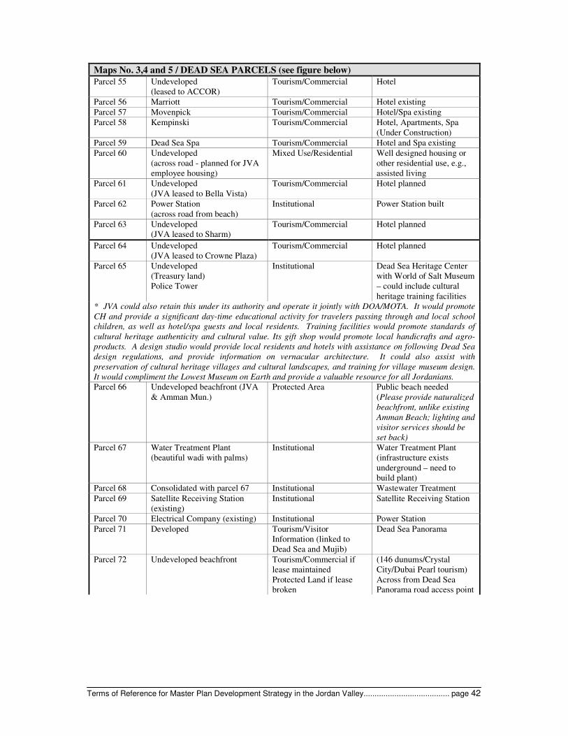
Terms of Reference for Master Plan Development Strategy in the Jordan Valley....................................... page 42
Maps No. 3,4 and 5 / DEAD SEA PARCELS (see figure below)
Parcel 55 Undeveloped
(leased to ACCOR)
Tourism/Commercial Hotel
Parcel 56 Marriott Tourism/Commercial Hotel existing
Parcel 57 Movenpick Tourism/Commercial Hotel/Spa existing
Parcel 58 Kempinski Tourism/Commercial Hotel, Apartments, Spa
(Under Construction)
Parcel 59 Dead Sea Spa Tourism/Commercial Hotel and Spa existing
Parcel 60 Undeveloped
(across road - planned for JVA
employee housing)
Mixed Use/Residential Well designed housing or
other residential use, e.g.,
assisted living
Parcel 61 Undeveloped
(JVA leased to Bella Vista)
Tourism/Commercial Hotel planned
Parcel 62 Power Station
(across road from beach)
Institutional Power Station built
Parcel 63 Undeveloped
(JVA leased to Sharm)
Tourism/Commercial Hotel planned
Parcel 64 Undeveloped
(JVA leased to Crowne Plaza)
Tourism/Commercial Hotel planned
Parcel 65 Undeveloped
(Treasury land)
Police Tower
Institutional Dead Sea Heritage Center
with World of Salt Museum
– could include cultural
heritage training facilities
* JVA could also retain this under its authority and operate it jointly with DOA/MOTA. It would promote
CH and provide a significant day-time educational activity for travelers passing through and local school
children, as well as hotel/spa guests and local residents. Training facilities would promote standards of
cultural heritage authenticity and cultural value. Its gift shop would promote local handicrafts and agro-
products. A design studio would provide local residents and hotels with assistance on following Dead Sea
design regulations, and provide information on vernacular architecture. It could also assist with
preservation of cultural heritage villages and cultural landscapes, and training for village museum design.
It would compliment the Lowest Museum on Earth and provide a valuable resource for all Jordanians.
Parcel 66 Undeveloped beachfront (JVA
& Amman Mun.)
Protected Area Public beach needed
(Please provide naturalized
beachfront, unlike existing
Amman Beach; lighting and
visitor services should be
set back)
Parcel 67 Water Treatment Plant
(beautiful wadi with palms)
Institutional Water Treatment Plant
(infrastructure exists
underground – need to
build plant)
Parcel 68 Consolidated with parcel 67 Institutional Wastewater Treatment
Parcel 69 Satellite Receiving Station
(existing)
Institutional Satellite Receiving Station
Parcel 70 Electrical Company (existing) Institutional Power Station
Parcel 71 Developed Tourism/Visitor
Information (linked to
Dead Sea and Mujib)
Dead Sea Panorama
Parcel 72 Undeveloped beachfront Tourism/Commercial if
lease maintained
Protected Land if lease
broken
(146 dunums/Crystal
City/Dubai Pearl tourism)
Across from Dead Sea
Panorama road access point

Terms of Reference for Master Plan Development Strategy in the Jordan Valley....................................... page 43
Maps No. 3,4 and 5 / DEAD SEA PARCELS (see figure below)
This appears to be the best land along the Dead Sea, which the developer recognized. However, my belief is that the best land should always be under the purview of the government of the country, and therefore I am recommending protected area with limited camping and facilities and relatively undeveloped shoreline. The Amman Beach is wedged into an infrastructure area, and it could be relocated here.
It would allow the Dead Sea a long public edge for local and international nature based tourism, allowing
people to experience the Dead Sea as it has been seen for thousands of years without hotels. It is a very
scenic area that could be tied into the Archaeological Park, and provide more long-term income to JVA and
the GOJ than a hotel lease or sale will.
No Parcel # Archaeology Protected Cultural
Heritage area
Zara sites
Zara is a well excavated site on the shoreline that links through Roman period to Callirhoe excavated but
abandoned site across road – both Roman medium significance sites. Both could be interpreted and become
significant cultural heritage sites on the tourism circuit. For revenue generation, could include a small gift
shop with archaeological reproduction jewellery, books, maps, t-shirts, etc., and a fruit juice kiosk and
shwarma stand – very little fast food available along the Dead Sea.
Parcel 73 Undeveloped beachfront Protected Area
(Parcel 72 and 73 would
be integrated)
Public beach
Parcel 74 Developed with restaurant
(lease should be discontinued
due to litter, example of
negative architectural style)
Tourism/Commercial Shoreline needs some non-
hotel refreshments area;
area has hot springs that
need preservation could
draw nature based tourism
Parcel 75 Agriculture and Res. Protected area
Parcel 76 (Princess Basma/Zara) Institutional
Recommend that this be a
combined
tourism/institutional area,
linked to Mujib and Zara
CH and featuring
agricultural pilot Xeric
nursery and interpretive
garden, perhaps with higher
up campsite; this could be a
good revenue generator for
JVA and land owners.
Note: This would also link
to the Dead Sea Trail
(walking/nature and
geology
Mujib Reserve and IBA Protected area Nature based tourism
Mujib Dam site Tourism overlay Fish farm potential and link
tourism to Mujib
Parcel 77 Developed
(owned by Intelligence
Department)
Institutional Police Station
Parcel 78 Developed Institutional JVA Directorate Offices
Parcel 79 Developed Institutional 2nd
Police Station built
Parcel 80 Developed Institutional Fire Station built
Parcel 81 Developed Institutional Power Station
Parcel 82
Parcel 83
Undeveloped Mixed/Residential Area very rocky
Limited high end housing.
Could do a small
commercial tourism
attraction like the Arabic
World of Tea and Coffee

Terms of Reference for Master Plan Development Strategy in the Jordan Valley....................................... page 44
Maps No. 3,4 and 5 / DEAD SEA PARCELS (see figure below)
Note: Rarely are the Arab world’s strong ties to tea and coffee used for tourism purposes, other than
drinking. There is ample opportunity to use these common products, tied to the JV’s agro potential as a
tourism asset. This idea is taken from an existing tourism attraction in Colorado called Celestial
Seasonings. This company simply packages tea, but they have used their imaginations to make it into a very
successful tourism attraction in Boulder. Included are guest tours through an art gallery of illustrations for
their tea boxes, a Tea Sampling Bar with 50 varieties, a Celestial Herb Garden tour, a Mint Room, gift
shop, café, and a factory tour to show how they produce the tea bags.
Parcel 84 Developed Institutional Telephone exchange
building
Parcel 85 Developed Institutional Power Station built
Parcel 86 Undeveloped Institutional Parking currently- Could be
a staging area for
hiking/climbing
Parcel 87 and
88
Undeveloped Mixed/Residential High end low density
retirement housing
Parcel 89 Undeveloped Institutional Military zone across from
power station
Wadi Ibn
Hammad
Agriculture Agriculture and protected Wadi Ibn Hammad IBA
Ibn Hammad Proposed Dam Tourism overlay
Protected Area
Fish farming/picnic and
parkland in protected area
with Dead Sea (geological)
trail running along edge of
site
Bird watching
Wadi Karak Proposed Dam Tourism overlay
Protected Area
Fish farm/picnic area
within IBA
Bird watching
Villages Expansion Along Dead Sea trail – can
provide- can provide
services
Residential to south and
east
Farm Units to West and
East
Undeveloped
Agriculture to west They are already growing
sunflowers, date palms,
bananas here; opportunity
for Xeric plants-pilot.
Salt Flats Open Space to west Housing exists pt of area
Mazraa and
Mazraa
Madineh
Industry/mechanics Industrial to south
Mixed Use along road
located in this area
buffering industrial
Arab Potash industries
Recommendation is to move garages away from road front and create a nicer commercial presence for
locals and tourists buffering the industrial development.
El Qasr Archaeological Site Protected Cultural
Heritage
Significant site – tie into
Cultural Heritage/ nature
based tourism Xeric
grasses, oats, alfalfa
Khirbet Esal Archaeological Site Protected Cultural
Heritage
Significant sites
Rujm
Numeira
Archaeological Site Protected Cultural
Heritage
Significant site
Expansion to southwest Focus Group
recommendation
Umm
Halasheem
Village
Tourism overlay Linkages to Lots Cave and
Lowest Point. Museum

Terms of Reference for Master Plan Development Strategy in the Jordan Valley....................................... page 45
Maps No. 3,4 and 5 / DEAD SEA PARCELS (see figure below)
Institutional South JVA offices
Safi Ramleh Village Expansion to northwest Focus Group recommended
cold storage; food
processing
Note: Wadi Hasa, the traditional border between Moab and Edom (on St. George’s map in Madaba), is just
south of Safi Ramleh. This could be exploited as a religious/CH site with a marker and interpretation and
be linked to nature based tourism, as quite picturesque.
Protected Area Wadi Al Hasa


SABEQ: Report Title Section Title (HEADER 1) 1
APPENDIX 5: JVA STRATEGIC PLAN 2003-2008 EXECUTIVE SUMMARY

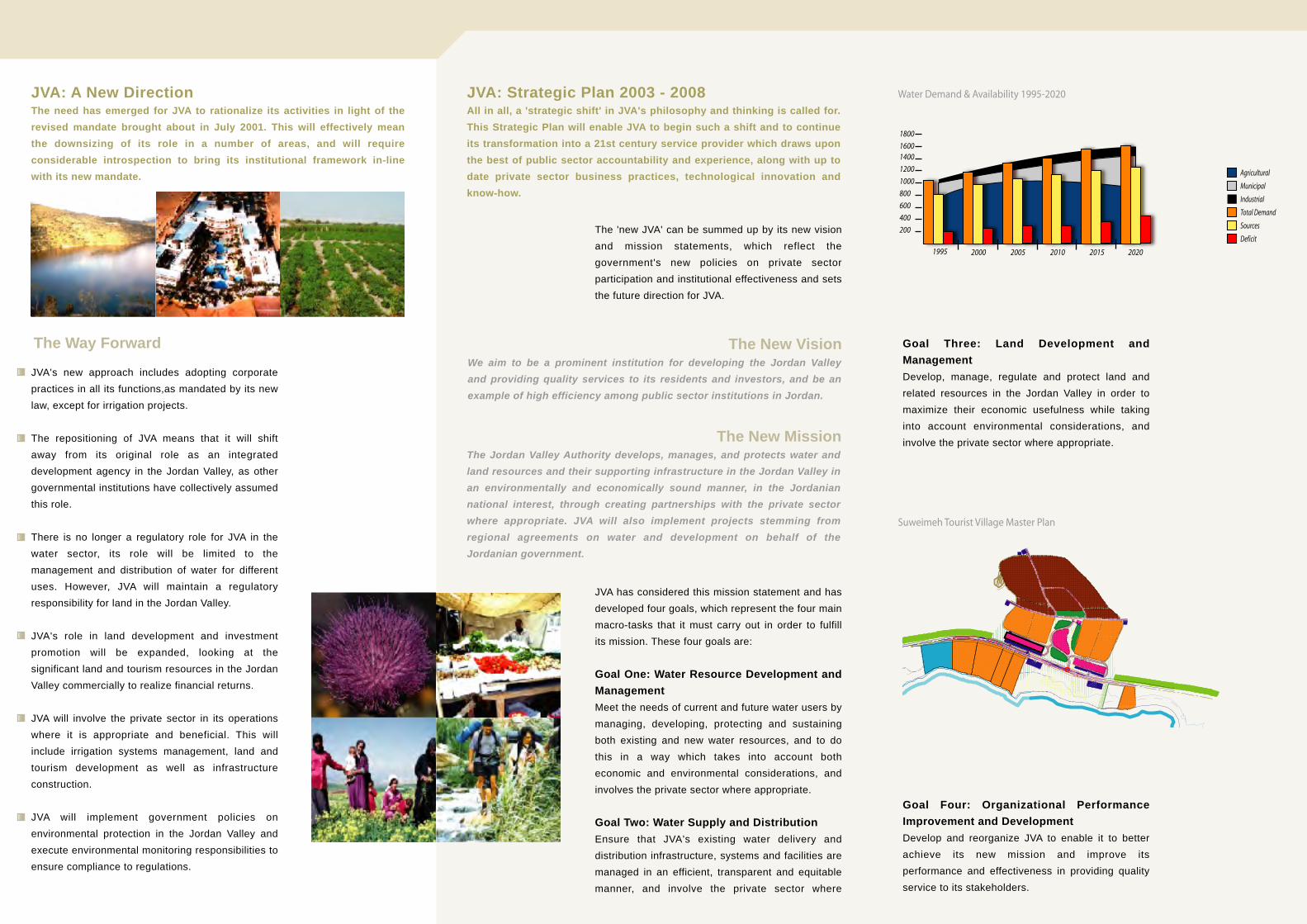
JVA's new approach includes adopting corporate practices in all its functions,as mandated by its new law, except for irrigation projects.
The repositioning of JVA means that it will shift away from its original role as an integrated development agency in the Jordan Valley, as other governmental institutions have collectively assumed this role.
There is no longer a regulatory role for JVA in the water sector, its role will be limited to the management and distribution of water for different uses. However, JVA will maintain a regulatory responsibility for land in the Jordan Valley.
JVA's role in land development and investment promotion will be expanded, looking at the significant land and tourism resources in the Jordan Valley commercially to realize financial returns.
JVA will involve the private sector in its operations where it is appropriate and beneficial. This will include irrigation systems management, land and tourism development as well as infrastructure construction.
JVA will implement government policies on environmental protection in the Jordan Valley and execute environmental monitoring responsibilities to ensure compliance to regulations.
The 'new JVA' can be summed up by its new vision and mission statements, which reflect the government's new policies on private sector participation and institutional effectiveness and sets the future direction for JVA.
JVA has considered this mission statement and has developed four goals, which represent the four main macro-tasks that it must carry out in order to fulfill its mission. These four goals are:
Goal One: Water Resource Development and ManagementMeet the needs of current and future water users by managing, developing, protecting and sustaining both existing and new water resources, and to do this in a way which takes into account both economic and environmental considerations, and involves the private sector where appropriate.
Goal Two: Water Supply and DistributionEnsure that JVA's existing water delivery and distribution infrastructure, systems and facilities are managed in an efficient, transparent and equitable manner, and involve the private sector where
Goal Four: Organizational Performance Improvement and DevelopmentDevelop and reorganize JVA to enable it to better achieve its new mission and improve its performance and effectiveness in providing quality service to its stakeholders.
Goal Three: Land Development and ManagementDevelop, manage, regulate and protect land and related resources in the Jordan Valley in order to maximize their economic usefulness while taking into account environmental considerations, and involve the private sector where appropriate.
The Way Forward The New Vision
The New Mission
1800
1995 2000 2005 2010 2015 2020
16001400
1200
1000
800
600
400
200
Water Demand & Availability 1995-2020
Suweimeh Tourist Village Master Plan
Agricultural
Total Demand
Municipal
Sources
Industrial
Deficit
JVA: A New DirectionThe need has emerged for JVA to rationalize its activities in light of the revised mandate brought about in July 2001. This will effectively mean the downsizing of its role in a number of areas, and will require considerable introspection to bring its institutional framework in-line with its new mandate.
JVA: Strategic Plan 2003 - 2008All in all, a 'strategic shift' in JVA's philosophy and thinking is called for. This Strategic Plan will enable JVA to begin such a shift and to continue its transformation into a 21st century service provider which draws upon the best of public sector accountability and experience, along with up to date private sector business practices, technological innovation and know-how.
The Jordan Valley Authority develops, manages, and protects water and land resources and their supporting infrastructure in the Jordan Valley in an environmentally and economically sound manner, in the Jordanian national interest, through creating partnerships with the private sector where appropriate. JVA will also implement projects stemming from regional agreements on water and development on behalf of the Jordanian government.
We aim to be a prominent institution for developing the Jordan Valley and providing quality services to its residents and investors, and be an example of high efficiency among public sector institutions in Jordan.

Sustainable Achievement of Business Expansion and Quality Salem Center, Sequleyah Street
Al Rabieh, Amman Phone: +962 6 550 3050
Fax: +962 6 550 3069 Web address: http://www.sabeq-jordan.org