terrestrial and marine ecology - brisbane airport corporation
TRANSCRIPT

B5VOLUME B: AIRPORT AND SURROUNDS
Terrestrial and Marine Ecology
NEW PARALLEL RUNWAY DRAFT EIS/MDP FOR PUBLIC COMMENT B5-178

CONTENTS
5.1 Introduction 185
5.2 Proposed Development 185
5.3 Methodology 186
5.3.1 Nomenclature and Terminology 186
5.3.2 Review of Existing Information 188
5.3.3 Field Investigations 188
5.4 Limitations and Assumptions 190
5.4.1 Baseline Condition Assessments190
5.4.2 Ecological Values and Impact Assessment 190
5.5 Baseline (Existing Condition) 191
5.5.1 General Context 191
5.5.2 Terrestrial and Aquatic Vegetation – Study Site and Project Area 195
5.5.3 Terrestrial and Aquatic Vegetation – Dredge Pipeline Corridor 207
5.5.4 Benthic Macroinvertebrates 207
5.5.5 Fish, Nektobenthic Invertebrates and Fisheries 211
5.5.6 Marine Megafauna 224
5.5.7 Terrestrial Vertebrate and Butterfly Fauna 225
5.6 Consultation 244
5.7 Policies and Guidelines 245
5.7.1 Australian Government Legislation 245
5.7.2 Queensland Government Legislation 246
5.8 Impact Assessment Approach 246
5.8.1 Impacts of Clearing on Vegetation Community Values 248
5.8.2 Loss of Estuarine Habitats and Fauna in Project Area 251
5.8.3 Loss of Terrestrial Fauna and Fauna Habitat in the Project Area 255
5.8.4 Direct Impacts Associated with Foreshore Stabilisation Works 259
5.8.5 Construction of Approach Lighting Structure 260
5.8.6 Construction and Operation of Luggage Point Pump-Out Facility and Dredge Pipeline 261
5.8.7 Construction and Operation of Tidal Discharge Channels 264
5.8.8 Potential Impacts to Ecosystem Functioning and Conservation Values 266
5.9 Cumulative and Interactive Effects 275
5.10 Assessment Summary Matrix 276
5.11 Approach to MitigatingResidual Impacts 280
FIGURES AND TABLES
Figures
Figure 5.3: Location of the Study Site and Project Area
Figure 5.5a: Key Localities within the Study Site, Project Area and Airport Surrounds
Figure 5.5b: Vegetation Communities of the Study Site and Project Area (Based on ERM (2002) and Ground Truthing by WBM in 2006).
Figure 5.5c: Remnant Regional Ecosystem (2003) Mapping (V.5.0 Queensland Herbarium)
Figure 5.5d: Present Distribution of Mangroves in the Project Area, Study Site and Surrounding Area
Figure 5.5e: Present Distribution of Saltmarsh Within the Project Area, Study Site and Surrounding Area
Figure 5.5f: South East Queensland Biodiversity Planning Assessment Mapping (EPA, V3.4)
Figure 5.5g: Area of the T5 Trawl Fishery (QDPI and F 2005)
Figure 5.8a: Rank Grassland and Interspersed Mangrove and Saltmarsh Vegetation Within the Luggage Point and Boggy Creek Pipeline Alignments. Proposed Pipeline Corridors are Shown with a 25 m Buffer.
Figure 5.8b: Ramsar Wetlands within Bramble Bay
VOLUME B: AIRPORT AND SURROUNDS
Terrestrial and Marine EcologyB5
NEW PARALLEL RUNWAY DRAFT EIS/MDPFOR PUBLIC COMMENTB5-179

Figure 5.11a: Biodiversity Management Strategy (BMS): Airport Biodiversity Zone (yellow cross hatch)
Figure 5.11b: Biodiversity Zone: Vegetation Communities Following Construction of the New Parallel Runway and Associated Infrastructure.
Tables
Table 5.3: Schedule of Additional Specific and Field Assessments - Shorebirds and Megabats
Table 5.5a: Vegetation Communities of the Study Site and Project Area Mapped During the Present Study
Table 5.5b: Threatened Flora Species Recorded within 10 km of Study Site (Online Search Tools for QLD EPA Wildlife and DEH EPBC Protected Matters)
Table 5.5c: Number of Taxa Recorded By FRC Environmental (2003) in Grab Samples in the Jacksons/Serpentine Creek System and Waterways in the Wider Study Site
Table 5.5d: Ten Most Abundant Fish Species Recorded in Serpentine Inlet
Table 5.5e: The Ten Most Abundant Fish Species Captured in Jacksons Channel and Kedron Brook Floodway During Four Sampling Efforts Between November 2002 and April 2003 (From FRC 2003).
Table 5.5f: Abundance of Species Captured by Cast Netting in the Upper and Lower Reaches of Jacksons Creek and Kedron Brook (Pooled Across Sampling Events) for Both Small Meshed and Large Meshed Cast Nets (WBM Present Study).
Table 5.5g: Rank Abundance of Fish Species Captured Between November and February (2002) at Four Locations in North-West Moreton Bay (Data Source: D. McPhee Unpublished Data)
Table 5.5h: Key Fisheries Species Present in the Project Area and Surrounding Study Site, and their Primary Habitats at Different Stages of their Life-Cycle (Data: Kailola et al 1993)
Table 5.5i: Area of Semi-Permanent Refugia (<MWS) and Total Area of Tidal Waters in Jacksons Creek and the Project Area
Table 5.5j: Summary of Key Habitats of the Study Site Used by Species of Conservation Significance
Table 5.5k: List of Species of Conservation Significance of Potential Occurrence within the Project Area and Summary of Likely Habitat Usage
Table 5.5l: Ecological Profiles for Wader Species of Conservation Significance of Potential Occurrence within the Project Area
Table 5.5m: List of Species of Conservation Significance of Potential Occurrence within the Proposed Luggage Point Pipeline Alignment and Summary of Likely Habitat Usage
Table 5.8a: Summary of Impact Category Ratings and Significance Criteria Used in this Assessment
Table 5.8b: Key to Defining Impact Magnitude
Table 5.8c: Key to Defining Impact Spatial Scale
Table 5.8d: Key to Impact Timeframe
Table 5.8e: Decision Matrix Used to Derive Impact Category Ratings
Table 5.8f: Vegetation Communities of the Study Site and Project Area
Table 5.8g: Vegetation Features of Conservation Significance – Known or Likely Occurrence in the Project Area and Study Site
Table 5.8h: Criteria Listed by the EPBC Act 1999 for a ‘Significant Impact’ and the ‘Likelihood’ of this Impact to Local and Regional (Moreton Bay) Populations of Dugongs.
Table 5.8i: Criteria Listed by the EPBC Act 1999 for a ‘Significant Impact’ and the ‘Likelihood’ of this Impact to Local and Regional (Moreton Bay) Populations of Marine Turtles.
NEW PARALLEL RUNWAY DRAFT EIS/MDP FOR PUBLIC COMMENT
B5
B5-180
VOLUME B: AIRPORT AND SURROUNDS
Terrestrial and Marine Ecology

VOLUME B: AIRPORT AND SURROUNDS
Terrestrial and Marine EcologyB5
Table 5.8j: Criteria Listed by the EPBC Act 1999 for a ‘Significant Impact’ and the ‘Likelihood’ of this Impact to Local and Regional (Moreton Bay) Populations of Shorebirds
Table 5.8k: Ramsar Criteria and Impact Assessment – Airport and Surrounds
Table 5.8l: Criteria Listed by the EPBC Act 1999 for a ‘Significant Impact’ to Ramsar Wetlands
Table 5.10: Ecology Assessment Summary Matrix
APPENDICES
Appendix A: Overview of Field Investigations and Surveys
Appendix B: Mangrove Transects at Serpentine Inlet
Appendix C: Macro-Invertebrate Field Investigations and Studies at Serpentine Inlet
Appendix D: Results of Fish and Nektobenthic Surveys at Serpentine Inlet
NEW PARALLEL RUNWAY DRAFT EIS/MDPFOR PUBLIC COMMENTB5-181

KEY FINDINGS
Background
• Brisbane Airport is one of the most intensively surveyed areas in the greater Brisbane area. This is particularly the case for land-based fauna, including shorebirds, and vegetation communities. Fish and other marine species and groupings in the vicinity of Brisbane Airport and its surrounding areas have also been studied and sampled in recent years. Investigations undertaken for the Draft Environmental Impact Statement and Major Development Plan (EIS/MDP) build upon these previous studies.
NPR project area – vegetation
• Much of the vegetation within the New Parallel Runway (NPR) Project Area has been either planted or has recolonised following the construction of Brisbane Airport. As a result, the vegetation on-airport lands is very simple, and includes five main vegetation communities: Casuarina plantation, mangroves, mown (managed) and rank (unmanaged) grasslands, and saltmarsh.
• Mangrove habitats within the NPR Project Area are not unique, but are representative of mangrove-lined creek habitats in the broader region.
• This proposed development will therefore not represent a loss of ecosystem function at this scale.
• With the exception of mangroves, weed infestation is an issue in all vegetation community types within the NPR Project Area.
• The major vegetation communities that were identified in the NPR site and the amount of these communities that would be removed by the NPR project proposal are as follows:
Casuarina plantation ~ 209 ha Mangroves ~ 94 ha Managed grassland ~ 31 ha Saltmarsh/saltpan ~ 18 ha Phragmites wetland ~ 3 ha
Dredge pipeline corridor – vegetation
• The Luggage Point pipeline corridor traverses mostly regularly mown and unmanaged grasslands, crossing Luggage Point Wastewater Treatment Plant lands, Jubilee Creek Drain (which is lined with mangroves), and two small areas of saltmarsh regrowth. These areas have limited biodiversity value from a flora perspective.
• No Endangered or Of Concern Regional Ecosystems or vegetation species of conservation concern have been identified on the NPR site or the dredge pipeline corridor.
Fish and marine invertebrates
• Although modified by past and in some cases ongoing disturbances, the NPR Project Area supports habitat types that contribute to fisheries production in the wider region.
• No fish of conservation significance were recorded or are likely to occur within the waterways of the NPR Project Area.
• The number of fish species and their abundances within the NPR Project Area are not unique, but representative of environments within the wider Moreton Bay region, particularly the western side of Moreton Bay.
• Infilling of waterways and mangrove/saltmarsh vegetation within the NPR Project Area would result in a reduction in the available spawning (reproduction), foraging and nursery habitat for some fish and crustacean species.
• Benthic fauna (small animals living in or on the seafloor) form important food resources for many fish and bird species and also perform important functions in their own right (i.e. biogenic working etc.).
• The benthic fauna communities within the NPR Project Area are not unique, meaning they are comprised of species that are typical of such environments.
NEW PARALLEL RUNWAY DRAFT EIS/MDP FOR PUBLIC COMMENT
VOLUME B: AIRPORT AND SURROUNDS
Terrestrial and Marine EcologyB5
B5-182NEW PARALLEL RUNWAY DRAFT EIS/MDP
FOR PUBLIC COMMENT
VOLUME B: AIRPORT AND SURROUNDS
Terrestrial and Marine EcologyB5
B5-182

VOLUME B: AIRPORT AND SURROUNDS
Terrestrial and Marine EcologyB5
• The proposal would result in the loss of benthic fauna inhabiting the waterways and amongst aquatic vegetation within the NPR Project Area. Impacts to population status of benthic fauna outside the NPR area are not expected.
• Numerous fish and crustaceans of importance to commercial and recreational fisheries inhabit the waterways within the NPR Project Area, including: sea mullet, yellowfin bream, tailor, and dusky flathead. Such species generally occur as juveniles.
• Given that mangrove and saltmarsh habitats support commercially important species, it is likely that the loss of habitat may result in a reduction in the relative abundances of some species at a site-specific scale (i.e. within Jacksons Creek).
• No commercial fishing is permitted by the Department of Primary Industries and Fisheries within Jacksons Creek, although there is some evidence that this area is targeted by recreational fishers. It is understood that adjacent areas, including Serpentine Inlet (within land owned by the Brisbane Airport Corporation (BAC)), are fished by commercial net fishers. Recreational angling is undertaken at the mouth of Jacksons Creek, Serpentine Inlet and Kedron Brook Floodway, which targets species such as yellow-finned bream with lines, banana prawns with cast nets and mud and blue swimmer crabs with pots.
• A program to relocate fish from the NPR site to adjacent waterways will be implemented prior to the commencement of the reclamation stage.
Turtles and Marine Mammals
• Dugongs and turtles are very unlikely to utilise the various waterways around Brisbane Airport due to a lack of suitable food (seagrass).
• Dolphin species visit the Kedron Brook Floodway but are unlikely to use the smaller intertidal creeks within the NPR Project Area.
• No impacts to turtles and marine mammals are therefore expected as a result of the proposal.
Land-Based Fauna
• Fauna assessments undertaken specifically for the Draft EIS/MDP and the findings of previous field surveys indicated that the NPR Project Area may potentially be used by a number of fauna species of conservation significance.
• A large proportion of these fauna are likely to use the habitats within the NPR Project Area on a seasonal basis (e.g. migratory waders, grey goshawk and dollar bird) rather than having resident populations.
• Casuarina plantation and grassland habitats are of relatively low conservation value to fauna, as they support a comparatively low biodiversity with few species of conservation significance utilising these communities on a regular basis.
• Low numbers of the grey-headed flying fox utilise the NPR Project Area, reflecting the lack of food resources in this area. It is more likely that the NPR Project Area is used by the species as a movement corridor, rather than as a key habitat.
• A survey of the site found that the NPR Project Area was mostly unsuitable as a sustained habitat for the Illidge’s ant blue butterfly, which is of conservation significance and know to occur in mangrove environments.
• Only a small number of shorebird species were found to use the NPR Project Area as a roosting habitat. Overall, the NPR Project Area is not considered to be an important habitat when compared with other available roosts in the local area (e.g. Fisherman Islands, Jubilee Creek).
• During the construction of the seawall and the approach lighting system, a range of mitigation strategies will be implemented to minimise impacts on migratory species including the timing of construction and an observation program.
• The grassland habitat traversed by the Luggage Point dredge pipeline corridor is of low ecological value and consequently is only likely to support a low biodiversity. Most species known or considered likely to utilise these habitats are those tolerant of high and frequent levels of disturbance (regular slashing, vehicle and human activity).
NEW PARALLEL RUNWAY DRAFT EIS/MDPFOR PUBLIC COMMENTB5-183

Mitigating Impacts
A number of environmental management measures are proposed to minimise and/or mitigate the potential negative effects of marine and terrestrial ecology on the Airport, including:
• Avoidance of nearly all the freshwater (Phragmites sp.) wetland habitat on the site through the design and layout of the Kedron Brook Floodway Drain so that the wetland area can continue to provide habitat for species of conservation significance;
• Retaining the remnant Jacksons Creek and associated mangroves outside the runway footprint to ensure it continues to provide fish habitat values in the long term;
• Sensitive design of the main drainage channels to minimise scour in the bed of the drain and to provide a benched level for mangrove colonisation;
• Creating about three hectares of mangrove habitat within the proposed construction of tidal discharge/stormwater channels at Kedron Brook Floodway and Serpentine Inlet;
• Selection of a dredge pump-out facility in an already modified environment, which avoids dredging and pump-out operations in the Moreton Bay Ramsar site;
• Water sensitive drainage design for the completed airfield utilising grassed swales and vegetation buffers; and
• Avoiding the construction of a hard seawall structure along the northern foreshore west of the NPR that will avoid construction impacts on birds.
An Environmental Management Framework will also be applied during construction and operational phases incorporating:
• Estuarine Fauna Management Plan.
• Mangrove Rehabilitation Plan.
• Animal Welfare and Fauna Movement Plan (including undertaking best practice actions to locate an alternative roosting site for the white-bellied sea-eagle nest that will be displaced by the NPR footprint).
• Vegetation Protection and Management Plan.
The plans will be augmented by monitoring and survey programs undertaken in consultation with relevant Government departments.
Biodiversity Management Strategy (BMS)
In addition to measures to be implemented specifically relating to environment protection in and around the NPR site, BAC has developed the Biodiversity Management Strategy (2006), which aims to protect significant vegetation communities and habitat across the Airport site. It maps an Airport Biodiversity Zone encompassing 285 hectares of on-airport land that is to be managed to conserve a wide range of identified environmental assets in the long term. This zone will be kept free of future development.
The biodiversity zone will:
• Protect the tall, unmanaged Phragmites wetland area adjoining Kedron Brook Floodway;
• Protect saltmarsh areas;
• Maintain the existing migratory wader bird feeding habitat;
• Maintain habitat for significant fauna species;
• Provide additional protection to the existing mangrove areas at Jacksons Creek, Serpentine Inlet and Pinkenba; and
• Retain Casuarina plantations occurring within the perimeter of the biodiversity zone, which provide habitat to a range of common wildlife.
In addition to the on-site mitigation measures proposed, BAC is also investigating contributing to an off-site mitigation project involving estuarine or marine habitat monitoring and/or rehabilitation in consultation with State agencies and community conservation groups. This project will be further defined as the EIS/MDP process progresses.
NEW PARALLEL RUNWAY DRAFT EIS/MDP FOR PUBLIC COMMENT
VOLUME B: AIRPORT AND SURROUNDS
Terrestrial and Marine EcologyB5
B5-184

5.1 Introduction
The existing environment of the coastal and shoreline region, creeks and terrestrial lands within and adjacent to the Airport is described in this Chapter.
This Chapter specifically examines the following attributes related to terrestrial and marine ecology:
• Patterns (in space and time) in the distribution, abundance, diversity and other community structure attributes of key functional ecological groups;
• Ecological and conservation values of each functional ecological group;
• Processes known or likely to control these patterns.
The key ecological functional groups considered in the Chapter are separated into:
• Terrestrial, aquatic and marine vegetation;
• Marine fauna (benthic macroinvertebrates, fish and nektonic invertebrates and marine megafauna such as marine mammals and reptiles); and
• Terrestrial fauna (vertebrate fauna and butterflies).
5.2 Proposed Development
Brisbane Airport is located adjacent to Moreton Bay on the north-western side of the Brisbane River, on part of what was the original Brisbane River delta. This delta has undergone significant changes since the 1830s, primarily though land reclamation.
The waterways and intertidal habitats supported on, and surrounding the airport, drain into Moreton Bay. Moreton Bay is gazetted as a State Marine Park and parts of the Bay are declared as an internationally listed Ramsar wetland. In addition, the coastal wetlands adjoining the airport to the north form part of the Brisbane City Council’s (BCC) North East Wetlands conservation area.
Brisbane Airport is located on the floodplain of the Boggy Creek and Kedron Brook catchments. The site is flat and low lying, with all of the surrounding waterways and most of the internal drains and waterways being tidally affected. Much of the land on the Airport site has been altered through grazing and other rural land uses predating the use of the site for an airport and through the major land reclamation and drainage works undertaken in the 1980s to establish the current infrastructure at Brisbane Airport.
Most of the vegetation on-site has either been planted or has recolonised the site after cessation of major construction works in the 1980s (Lambert and Rehbein 2004a). Vegetation communities currently supported on the site include plantations of she-oaks (Casuarina), unmanaged and managed (i.e. mown) grasslands, mangrove communities, wetland complexes and eucalypt woodland fragments.
The NPR and taxiway system is proposed to be located to the west of the existing main runway. Vegetation communities in this area are dominated by swamp oak plantations, though there are areas of mangrove communities and associated creek lines within the proposed footprint area of the runway and associated infrastructure. These communities represent habitats for a wide range of species, including species of high conservation value, and direct fisheries value.
The proposed development will also involve the construction and operation of two drainage channels (Kedron Brook Floodway Drain and Serpentine Inlet Drain). The Kedron Brook Floodway Drain, which will discharge into Kedron Brook Floodway, will drain catchment areas in the south of the Project Area. Serpentine Inlet Drainage Outfall, located at the mouth of the former Serpentine Creek (Serpentine Inlet), forms the main drainage for waters in the northern sub-catchment areas. Discharges from these drainages during the construction and operational phases of the project will influence water quality in the receiving waters (refer Chapter B8 for more information).
The proposed upgrade of the rock revetment protection fronting the runway facilities and the construction of the approach lighting structure will occur along the northern foreshore of the Airport land.
NEW PARALLEL RUNWAY DRAFT EIS/MDPFOR PUBLIC COMMENTB5-185
VOLUME B: AIRPORT AND SURROUNDS
Terrestrial and Marine EcologyB5

This area is an intertidal mud and sandflat habitat that is utilised by wader bird communities of high ecological value.
The dredge mooring facility will be situated at the edge of the Port of Brisbane Swing Basin at Luggage Point. The dredge pipeline alignment associated with the mooring facility extends from the foreshore across the Luggage Point Wastewater Treatment Plant reserve. The land within the reserve is generally flat, with vegetation comprised of open grassland dominated by exotic species. Minor non-remnant mangrove and saltmarsh communities are present at the foreshore of Luggage Point and along an artificial drain that feeds Jubilee Creek adjacent to the airport boundary.
5.3 Methodology
5.3.1 Nomenclature and Terminology
In this report, the Study Site refers to the lands that are controlled by the BAC and are located on the north-western side of the Brisbane River. Moreton Bay forms the northern boundary of the airport lands while, the Kedron Brook Floodway forms the western boundary. The southern and eastern boundaries are formed by industrial and residential developments of Eagle Farm, Pinkenba, Myrtletown and the Brisbane City Council Wastewater Treatment facility (Luggage Point).
The Project Area refers to the land subject to the development of the proposed NPR and associated infrastructure (i.e. taxiway and Northern Development Area). Both the Study Site (26.69 km2) and the Project Area (3.9 km2) are identified in Figure 5.3.
The term ‘surrounding area’ refers to the areas outside the BAC lease area which may be affected by the project including marine areas such as Bramble Bay.
Within this report, the conservation status of a species may be described as ‘Endangered’, ‘Vulnerable’, ‘Regionally Vulnerable’, ‘Rare’, ‘Culturally Significant’ or ‘Common’. These terms are used in accordance with the provisions of the Queensland Nature Conservation Act 1992
(NC Act) and its regulations and amendments, and/or the Environment Protection and Biodiversity Conservation Act 1999 (EPBC Act). For the purposes of this report, relevant NC Act regulations and amendments refer to the Nature Conservation (Wildlife) Regulation 1994 and includes amendments up to 2004 (SL No. 316). ‘Threatened’ is a common term used to collectively describe endangered and vulnerable species. The term Marine Plants refers to species listed in the Schedule of Marine Plants under the FHMOP 001 (Department of Primary Industries 2002).
The Brisbane City Council (BCC) has produced a list of flora species regarded as significant at a city-wide level in the Brisbane City Plan 2000 (City Plan) as at 18 November 2004. These species are referred to in this report as species of city-wide significance.
Vegetation type descriptions used (e.g. forest and grassland) are based on the structural types described by Specht (1970). Plant nomenclature follows Henderson (2002).
The definition of a ‘wetland’ follows the Strategy for the Conservation and Management of Queensland Wetlands (Queensland Government 1999), where wetlands are defined as “areas of permanent or periodic/intermittent inundation, whether natural or artificial, with water that is static or flowing, fresh, brackish or salt, including areas of marine water the depth of which at low tide does not exceed 6 m.”
‘Terrestrial Fauna’ refers to all vertebrate and butterfly fauna and the nomenclature used in this report follows Strahan (2000) for non-flying mammals, Churchill (1998) for bats, Christidis and Boles (1994) for birds and Cogger (2000) for reptiles and amphibians. Common names for frogs follow the nomenclature of Ingram et al (1993). Nomenclature for fish follows Froese and Pauly (2005).
The BCC has produced a list of fauna species regarded as significant at a city-wide level in the Brisbane City Plan 2000 (City Plan), i.e. taxa listed in Schedule Four (Significant Vertebrate Fauna Species), Natural Assets Planning Scheme Policy as at 18 November 2004. These species are referred to in this report as ‘species of city-wide significance’.
NEW PARALLEL RUNWAY DRAFT EIS/MDP FOR PUBLIC COMMENT B5-186

Figure 5.3: Location of the Study Site and Project Area.
NEW PARALLEL RUNWAY DRAFT EIS/MDP FOR PUBLIC COMMENTB5-187

With regards to migratory birds, the terms CAMBA and JAMBA refer to the following:
• JAMBA, the Agreement between the Government of Australia and the Government of Japan for the protection of migratory birds in danger of extinction and their environment 1974; and
• CAMBA, the Agreement between the Government of Australia and the Government of China for the protection of migratory birds in danger of extinction and their environment 1986.
With regards to wetlands of international importance, the term RAMSAR refers to the International Wetland Convention (1971). Parts of Moreton Bay have been declared as a wetland of international importance under this convention.
The terms shorebirds and waders are generic terms used in this study to describe both resident and migratory species from the following families:
• Scolopacidae – snipes, sandpipers, godwits, curlews and their allies;
• Burhinidae – stone-curlews;
• Haematopodidae – oystercatchers;
• Recurvirostridae – stilts and avocet;
• Charadriidae – plovers, dotterels and lapwings; and
• Glareolidae – pratincoles.
5.3.2 Review of Existing Information
Existing information regarding the flora and fauna of the Study Site and surrounding area was collated and reviewed. The following documents and database information were considered in the preparation of this report:
• Flora and Fauna databases of Environment Australia, the Queensland Museum, Birds Australia and Queensland Environment Protection Agency’s (QEPA) WildNet.
• Brisbane Airport Fauna Study: 2002–2004 (Lambert and Rehbein, 2004).
• Brisbane Airport Fauna Study: Aquatic Fauna (FRC Environmental 2003).
• Fauna lists derived from site surveys within the general area prepared by the author as part of other studies (e.g. Pell and Jones 1998, 1999, 2001 and 2002; ERM 2002; Lambert and Rehbein 2004a and b; Fein and Whyte 2004; Lambert and Rehbein 2005a,b and c).
• Vegetation cover, ecosystem and community mapping (e.g. BAC 2005; QEPA Regional Ecosystem mapping and Biodiversity Planning Assessment Mapping).
• 1944, 1951, 1997 and 2003 aerial photography in order to identify vegetation in the local area, comparing historical patterns observed with existing vegetation mapping.
• Brisbane Airport Vegetation and Condition Assessment (ERM, 2002).
• 2003 Remnant Regional Ecosystem Mapping (V5.0, Qld Herbarium); and
• SEQ Biodiversity Planning Assessment Mapping (V3.4, EPA).
5.3.3 Field Investigations
Targeted field surveys were conducted throughout the Study Site to address key information gaps identified in a scoping report prepared by WBM. Additional survey work related to vegetation assessment, the structure of aquatic habitats, fish and benthic macroinvertebrate communities, mangrove habitat condition (Serpentine Inlet) and terrestrial and intertidal fauna (including the Illidge’s ant blue butterfly). An overview of each survey including methodology employed can be found in Appendix A.
5.3.1.1 Terrestrial and Intertidal Fauna
Prior to undertaking fieldwork assessments, the following information sources were interrogated:
• Desktop review of existing information as described above, and including the Queensland Herbarium’s Remnant 2004 Regional Ecosystems mapping; and
• Air photo interpretation of vegetation cover patterns and vegetation types that may provide suitable habitat for the conservation significant species known or considered likely to occur within the Study Site and surrounding area.
NEW PARALLEL RUNWAY DRAFT EIS/MDP FOR PUBLIC COMMENT B5-188

The primary aims of the field work undertaken was to:
• Undertake a preliminary assessment of the type, condition and extent of fauna habitats;
• Assess their potential suitability as habitat to support rare and threatened species;
• Assess habitat significance in a local area context; and
• Gain a level of field data sufficient to draw conclusions about the general patterns of fauna use throughout the Study Site and surrounding area.
In addition to the major surveys undertaken and described in Appendix A, additional specific assessments were undertaken for shorebirds and megabats with a focus on the following issues:
• Investigation of shorebird roost and feeding habitat usage and flight paths to and from high tide roost sites (supplementing regular shorebird surveys (Lambert and Rehbein 2005); and
• Investigation of potential megabat (flying fox) camps and flight paths to and from these sites.
Table 5.3 details the field assessment activities that were undertaken for this project for the overall habitat assessment, wader bird assessments and the flying fox assessments.
Table 5.3: Schedule of Additional Specific Field Assessments – Shorebirds and Megabats.
Date Locations Habitat/s SurveyTidal
Cycle*
2-5/11/05 - Study Site- Project Area
Primary Habitat Types:- She-oak - plantations- Mangroves- Grasslands- Intertidal Areas
Site familiarisation and baseline habitat assessments including:- High Tide roost at mouth of Kedron Brook;- Moreton Bay frontage for roost and foraging habitat;- Observe waders arriving/foraging on northern
foreshore under runways 01R/19L and 14/32; and- Flying fox Camp Fly-outs – Aquarium Passage.
High and Low Ebb
30/11/2005 - Project Area- Foreshore- Intertidal flats
- High tide roost sites
- Intertidal Flats- Flying fox camp
in mangroves
- High Tide roost at mouth of Kedron Brook.- Moreton Bay frontage for roost and foraging habitat.- Area of dead mangroves.- Observe/video waders arriving/foraging on northern
foreshore under runways 01R/19L and 14/32.- Flying fox Camp Fly-outs – Aquarium Passage
High tide ebbing
01/12/2005 - Foreshore- Intertidal flats
- High tide roost sites
- Intertidal Flats- Flying fox camp
in mangroves
- High Tide roost at mouth of Kedron Brook.- Moreton Bay frontage for roost and foraging habitat.- Observe/video waders arriving/foraging on northern
foreshore under runways 01R/19L and 14/32.- Flying fox Camp Fly-outs – Aquarium Passage.
High tide ebbing
02/12/2005 - Foreshore- Intertidal flats- Study Site
- High tide roost sites
- Intertidal Flats- Flying fox camp
in mangroves
- High Tide roost at mouth of Kedron Brook.- Moreton Bay frontage for roost and foraging habitat.- Observe/video waders at roost/foraging around clay
pan under northern end of runway 01R/19L.- Flying fox Camp Fly-outs – Aquarium Passage.
High tide ebbing
21/12/2005 - Surrounding Area
- Project Area Waterways
- Project Area
- Mangrove along waterways
- Boat Survey of Kedron Brook, Serpentine Creek, Jacksons Creek/drain.
- High Tide roost at mouth of Kedron Brook.- Observe waders at roost/foraging in waterways.
Flood tide through high tide ebbing
* The tidal range for this time of year was very large, ranging from very low to very high tides (~0.3 m Low Tide to 2.37 m High Tides).
NEW PARALLEL RUNWAY DRAFT EIS/MDP FOR PUBLIC COMMENTB5-189

5.4 Limitations and Assumptions
5.4.1 Baseline Condition Assessments
The assessments made in this Chapter are predominantly based on a review of existing literature. The Study Site is one of the most intensively surveyed areas in the greater Brisbane area. This is particularly the case for terrestrial vertebrate fauna (including shorebirds), which has been the subject of numerous intensive field surveys undertaken on behalf of BAC in recent years. The vegetation communities are also well described.
The fish (post-larval stages), nektobenthic macroinvertebrates and benthic macroinvertebrate assemblages of the Study Site and surrounding areas are also reasonably well described. FRC Environmental (2003) undertook the most recent survey in the Study Site in 2002/2003. Within the Project Area, sampling of benthic macroinvertebrates was undertaken at one site on the eastern beach fronting airport lands, three sites in Jacksons/Serpentine Creek in the vicinity of the proposed NPR, and one site near the NPR footprint in Jacksons Channel. An additional seven sites were sampled elsewhere throughout the Study Site, but outside the Project Area. Sampling was done at two time periods (November/December 2002, March 2003). The FRC Environmental (2003) study describes variability in fish assemblages among sites (six sites within and adjacent to the Project Area) and times (November 2002, December 2002, March 2003, April 2003). In addition, and as described in Appendices A and B, supplementary marine vegetation and fauna surveys were undertaken as part of the current EIS/MDP at Serpentine Inlet (and Kedron Brook) to complement these past studies.
As described in section 5.5 of this Chapter, great variation was observed in estuarine fauna community structure between sampling episodes and among sites. This high degree of temporal variability in community structure is a typical feature of such communities (see for example papers by Stephenson and Stephenson et al (1978;1980a,b,c;1982); and reviews by Skilleter (1998) and Tibbetts and Connolly (1998).
Temporal variability is thought to be controlled by processes operating across a range of temporal scales (i.e. measured in hours to years), including hydrodynamic disturbances (wave action, freshwater flows etc) and biological processes and interactions (i.e. recruitment, predation etc). The FRC Environmental (2003) study, together with numerous recent historical and recent studies in the Study Site and surrounding area, provide a sound basis for describing the general characteristics of macroinvertebrate and fish communities in intertidal areas of the Study Site.
There are several functional groups that have not been surveyed within the Project Area, including plankton and benthic microflora, and interstitial invertebrates. It is acknowledged that these groups are important ecosystem components. However, in the absence of detailed comparable data from other areas (i.e. descriptions of community structure over a range of temporal and spatial scales), sampling of these groups within an impact assessment process has questionable value.
5.4.2 Ecological Values and Impact Assessment
The ecological values, or ecosystem services provided by the Project Area and Study Site are described in this Chapter on the basis of:
• Structural habitat characteristics, including habitat diversity, complexity and condition;
• A review of known functions or ecosystem services provided by similar habitat types in the broader region;
• Interpretation of survey data from the Study Site and surrounding area describing patterns in fauna movements (from an avifauna and bat perspective);
• Comparison of survey results from the Study Site with other areas in the surrounding area, and from regional data.
NEW PARALLEL RUNWAY DRAFT EIS/MDP FOR PUBLIC COMMENT B5-190

• Connectivity to other areas (from a terrestrial fauna perspective).
To date, no studies have directly examined the fisheries habitat values within different parts of Moreton Bay. In this impact assessment study, fisheries habitat values, and predictions of impacts, have been undertaken using a range of quantitative, semi-quantitative and qualitative indicators, including:
• Estuarine vegetation loss. Quantification of habitat area as a surrogate measure of fisheries habitat value underpins many fisheries habitat-planning decisions. It should be recognised however that the approach of equating habitat loss to fish loss might not always be appropriate, as there is not always a strong relationship between fish assemblages and habitat structure.
• Examination of habitat condition and structure. Areas of mangrove die back, which are typically hyper-saline and anoxic are unlikely to provide the same fisheries habitat values as ‘healthy’ mangals (mangrove forests). Poorly flushed mangals are also unlikely to provide as high quality habitat as well flushed mangals.
• Examination of fish assemblages. This study compares the fish fauna and habitats of the Study Site to other estuaries in the region, and provides comment on likely fisheries habitat values of the Study Site. This data provides the context of defining the types of species using the Study Site, their relative abundance, and their fisheries values.
• Fishing resource values. FRC Enviromental (2003) considered the fishing values of the Study Site and environs through: (i) consultation with peak fishing bodies; (ii) informal surveys of anglers; and(iii) comment on commercial fisheries statistics
for western Moreton Bay. Furthermore, additional assessments were undertaken in the assessment process to define fishing values of the Project Area and broader Study Site.
Within the impact assessment sections of this report, specific uncertainties with respect to data quality and degree of confidence in impact predictions are fully documented.
5.5 Baseline (Existing Condition)
5.5.1 General Context
5.5.1.1 Study Site, Project Area and AirportSurrounds
Key locations mentioned in the text below within the Study Site, Project Area and Airport Surrounds are shown in Figure 5.5a.
Terrestrial Lands Controlled by BAC
As discussed in the introduction, the Brisbane Airport terrestrial lands (comprising the Study Site) are located on the flat and low-lying coastal floodplain of a number of catchments, of which, Kedron Brook is the most significant (BAC 2005). The area was principally formed through the reclamation of tidal wetlands and draining (or channelisation) of freshwater wetlands. The geotechnical instability of underlying alluvial sediments meant that construction of the airport required marine and reworked dune sand (sourced from Middle Banks in Moreton Bay) to be used as fill and pre-load. Existing Airport terrestrial lands previously comprised a large portion of the Brisbane River delta, which had been gradually infilled with alluvial muds and sands derived from the River during the Holocene1, and subsequently colonised by tidal and freshwater wetland vegetation.
Much of the vegetation within the Study Site has been either planted or has recolonised after cessation of major construction works (Lambert and Rehbein 2004a).
Broad terrestrial vegetation communities within Brisbane Airport controlled lands currently include extensive Casuarina plantations, remnant Eucalypt vegetation, Phragmities wetlands, unmanaged open grasslands, managed grasslands and coastal dunes and foreshores.
Jacksons Channel
For the purposes of this Chapter, the waterway referred to in the following text as ‘Jacksons Channel’ is used to collectively describe Jacksons Creek and the remnant sections of Serpentine Creek, which
1 Contemporary geological period beginning about 10,000 years ago.
NEW PARALLEL RUNWAY DRAFT EIS/MDP FOR PUBLIC COMMENTB5-191
can be considered a singular connective waterway. Both creek systems were modified extensively during construction phases of the existing Brisbane Airport. Serpentine Creek was almost fully reclaimed, while Jacksons Creek was partially reclaimed and diverted where it had historically discharged into Moreton Bay. This diversion occurred as a direct result of the construction of Kedron Brook Floodway. Furthermore, Jacksons Channel was designed to create a tidal link between Moreton Bay, the remaining mangroves in the former Serpentine Creek and Landers Pocket Drain.
The tidal or estuarine reaches of the Jacksons Channel currently comprise various tidal wetland communities, including mangroves, saltmarsh and saltpan. Dieback of much of the larger remnant mangroves (most likely to be A. marina) apparently occurred throughout the Jacksons Channel estuary following the original reclamation and diversions in the Jacksons/Serpentine Creek systems (R. Dowling pers. comm.).
As a result of the reclamation and diversion works associated with the construction of the existing Brisbane Airport in the 1980s, the geomorphology and tidal hydrodynamics of the waterways and wetland areas were significantly modified. Consequently, creek banks are currently in a poor condition throughout Jacksons Channel and its tributary waterways, which is evidenced by undercut or eroded vegetation and erosion scarps. Water depths are generally shallow within this system, with areas as deep as -4 m Lowest Astronomical Tide (LAT). Numerous shoal or sand banks have also formed within this shallow waterway, typically being exposed at low tide.
The physical characteristics of sediments within Jacksons Channel and its associated waterways and wetland areas are influenced or derived in some part from marine and reworked dune sand from Middle Banks. The sand was used to reclaim areas of tidal and freshwater wetlands during the 1980s airport construction, and was the base material for many of the constructed drains and diversions in larger waterways. Following construction of the various diversions and channels within the Study Site, silts and muds of a marine origin have deposited over, and been incorporated into these sands, shifting particle
size distribution towards finer sediment fractions. In the most part, sediments are characterised by an unconsolidated and commonly fine grained substrate, interspersed by raised sand banks and shoals.
Serpentine Inlet
Serpentine Inlet comprises remnant and constructed elements of intertidal and subtidal wetland areas that historically formed the estuary mouth of Serpentine Creek. The area may be broken into three functional, interlinked elements:
Creek Environment
A shallow blind end creek exists in the southern corner of Serpentine Inlet, and is bounded by an area of tidal wetland vegetation, which is dominated by the grey mangrove, A. marina. This area contains a large proportion of the remnant mangrove vegetation from the former Serpentine Creek system. Historically, the creek and its estuarine vegetation were very similar to its present day structure, forming a small inlet on the southern side of the mouth of Serpentine Creek. Since the reclamation of Serpentine Creek, a significant sand bar (~1–2 m in height) has deposited at the mouth of the small creek, restricting tidal flow to a small channel. The formation of the sand bar has led to the deposition of sediments (mostly sands) behind the bar, creating a shallow intertidal backwater environment. With these exceptions, sediments within the inlet are comprised largely of fine silts and muds.
Basin Environment
This area is exposed to wind-generated waves predominately from a north-east and easterly direction, and is the receiving environment for tidal waters from the blind ended mangrove creek to the south. A mangrove lined stormwater drain also enters this embayment to the west, which discharges surface water runoff from northern portions of the Brisbane Airport runway. This water flows into a smaller intertidal basin, before discharging into the larger Serpentine Inlet embayment.
NEW PARALLEL RUNWAY DRAFT EIS/MDP FOR PUBLIC COMMENT B5-192

The embayment consists of a diversity of functional intertidal and subtidal habitats, including mangroves and saltmarsh areas; subtidal channel (former Serpentine Creek estuary channel ~2 m deep); intertidal unvegetated sand and mudflats; a depositional subtidal basin; and sandy beaches. The large depositional basin situated to the centre of the embayment is organic matter rich and comprised of fine silts and muds.
Foreshore Intertidal Sand Flats
Broad intertidal sand flats surround (north and south) the basin environment at Serpentine Inlet. Remnants of the deep water channel that once drained Serpentine Creek (prior to the existing Brisbane Airport reclamation) cut through these intertidal flats, draining tidal waters from the small mangrove lined creek. Sediments on the intertidal flats are predominately silty sands, however, the channel sediment is generally rich with organic material and silts.
Kedron Brook
The Kedron Brook Floodway enters Moreton Bay south of Nudgee Beach in Bramble Bay. It rises in the D’Aguilar Ranges east of Brisbane where there are two main tributaries, Kedron Brook and Cedar Creek. The uppermost sections of Kedron Brook are ephemeral gullies draining the southern slopes of the Samford State Forest section of Brisbane Forest Park. The lowermost sections of the waterway pass though a low-lying floodplain and tidal areas that have been re-engineered for flood mitigation and the development of the Brisbane Airport (to the west). Tidal or estuarine limits occur where Kedron Brook passes through the suburban Toombul.
Prior to the original airport development in the 1980s, the tidal areas of Kedron Brook comprised a complex of low-lying wetlands and mangrove flats. Following construction of the Floodway, mangroves seedlings were planted and naturally re-established along its margins within estuarine reaches. These now exist as a thin fringe roughly 1–3 m in height and comprised of grey (A. marina) and river (A. corniculatum) mangrove species.
The banks of Kedron Brook Floodway to the west of the current Brisbane Airport area are generally eroded. Vast changes to the geomorphology of the floodplain and wetland areas have resulted in changes to the hydrology of this waterway. This is evidenced along the Floodway margins by banks undercut by erosion, and erosion scarps where sections of the thin mangrove fringe have collapsed.
In 1997 the Kedron Brook Floodway was redredged to its original profile, in order to maintain its function in flood mitigation. Depths typically range between -1 and -3 m LAT within the Kedron Brook Floodway estuary. Estuarine Sediments in the floodway are typically unconsolidated and silty sands.
Luggage Point Pipeline Alignment
The proposed dredge pipeline alignment is located to the south-east of the Study Site, within the immediate vicinity (just to the north) of the Luggage Point Wastewater Treatment Plant and its discharge.
Terrestrial lands associated with the Luggage Point alignment is generally flat, with raised sections or regular undulations where ‘night soil’ (solid waste from the Luggage Point Wastewater Treatment Plant) was historically buried in the area. The principle terrestrial vegetation that exists along the corridor is of open grassland dominated by exotic species.
NEW PARALLEL RUNWAY DRAFT EIS/MDP FOR PUBLIC COMMENTB5-193

Fig
ure
5.5a
: K
ey L
ocal
ities
with
in th
e S
tudy
Site
, Pro
ject
Are
a an
d A
irpor
t Sur
roun
ds.
NEW PARALLEL RUNWAY DRAFT EIS/MDP FOR PUBLIC COMMENT B5-194

5.5.2 Terrestrial and Aquatic Vegetation – Study Site and Project Area
The following description of vegetation of the Study Site is based on the review of existing information, aerial photo interpretation, a reconnaissance survey conducted in August 2005 and field investigations conducted in January and February 2006 to ground truth available vegetation mapping and condition reporting (notably ERM, 2002 and QLD Herbarium Remnant Regional Ecosystem Mapping, 2003).
The vegetation communities of the Project Area are shown in Figure 5.5b. This figure is based on mapping by ERM (2002) and ground-truthing by WBM (present study).
The following vegetation communities have been identified within the Study Site:
Aquatic communities:
• Mangroves;
• Saltmarsh/saltpan; and
• Phragmites Wetlands.
Terrestrial communities:
• Casuarina plantation;
• Managed grasslands;
• Unmanaged grasslands;
• Eucalypt open forest; and
• Coastal vegetation (Dunes and Foreshore).
The total area of each of these communities in the Study Site and Project Area are indicated in Table 5.5a.
Table 5.5a: Vegetation Communities of the Study Site and Project Area Mapped During the Present Study.
Vegetation Community Area Within Study Site
(ha)
Area Within Project
Area (ha)
Aquatic Communities:
Mangroves 202 94
Saltmarsh/saltpan 130 18
Phragmites Wetland 76 3
Terrestrial Communities:
Casuarina plantation 719 209
Managed Grassland 588 31
Unmanaged Grassland 306 5
Eucalypt Open Forest 1 1
Coastal Vegetation 2 0
Figure 5.5c indicates certified Regional Ecosystem (RE) mapping produced by the Queensland Herbarium for the Study Site and Project Area. It is notable that within the Study Site, 888 ha of Casuarina plantation were mapped by the Queensland Herbarium (2003), however, only 70 percent of this mapped area is actually Casuarina plantation. The remaining ~30 percent comprises predominately mangrove vegetation, but includes also areas of saltmarsh and phragmities wetland. For this reason, 2003 Remnant Regional Ecosystem (RRE) data was not used for calculating areas of vegetation communities in the present study. This error is likely to be an artefact of the vegetation mapping technique used in this instance (broad scale mapping using low resolution Landsat satellite imagery).
Within the Study Site, areas of remnant mangroves and saltmarsh exist within Serpentine Inlet and along remaining portions of Serpentine Creek that now comprise the Jacksons Channel waterway. These remnant areas were too small and largely interspersed with regrowth vegetation to accurately map during the present study. All remaining vegetation of the Study Site (and Project Area) has either regenerated (mainly estuarine vegetation) or has been planted since development of the Airport (mainly terrestrial communities).
Apart from a minor copse (1 ha) of highly degraded eucalypt open forest, no Of-Concern or Endangered RE’s have been identified in the Study Site.
NEW PARALLEL RUNWAY DRAFT EIS/MDP FOR PUBLIC COMMENTB5-195

Figure 5.5b: Vegetation Communities of the Study Site and Project Area (Based on ERM (2002) and Ground Truthing by WBM in 2006). Note that the areas listed in hectares (top left corner) relates to vegetation types in the Project Area.
NEW PARALLEL RUNWAY DRAFT EIS/MDP FOR PUBLIC COMMENT B5-196

Figure 5.5c: Remnant Regional Ecosystem (2003) Mapping (V.5.0 Queensland Herbarium).
NEW PARALLEL RUNWAY DRAFT EIS/MDP FOR PUBLIC COMMENTB5-197

No threatened vegetation communities listed under the EPBC Act have been identified within the Study Site. No plant species listed as threatened under the Nature Conservation Act 1992 (NC Act) or Environment Protection and Biodiversity Conservation Act 1999 (EPBC Act), or locally significant species or communities listed under BCC Natural Assets Planning Scheme (NAPS) Policy have been identified within the Study Site.
5.5.2.1 Mangroves and Saltmarsh
Spatial Patterns
Mangroves and saltmarsh are tidally influenced wetland habitats that occur on estuarine sediments with a recent or existing permanent or intermittent connection to the sea.
Figure 5.5d outlines the current extent of mangroves within the Study Site. Approximately 202 ha of mangroves occur on the Study Site with approximately 94 ha occurring within the Project Area. Remnant mangroves occur both at Serpentine Inlet and in patches along Jacksons Channel in the vicinity of the remnant Serpentine Creek (although those were not mapped by the Queensland Herbarium). Mangroves in this area have largely established and regenerated since development of the Airport. Minor areas of mangrove replanting have also been trialed on Jacksons Creek (pers. comm. Ralph Dowling, December 2005).
Consistent with other estuaries on the South East Queensland coast, remnant and regenerating mangals in the Study Site were dominated by grey mangroves (Avicennia marina). Across the Study Site Avicennia marina had a canopy height ranging from 3–4 m to 9–12 m with a foliage projection cover of 70–100 percent (ERM, 2002). Other species included river mangroves (Aegiceras corniculatum) in habitats with lower salinities, and yellow mangroves(Ceriops tagal var. australis), which had a sparse distribution and occurred mainly as individuals along the Landers Pocket Drain and Jacksons Channel. Serpentine Inlet supports a mangrove community comprised primarily of Avicennia marina ranging from 8–12 m in height and 35–70 percent canopy cover to 12–14 m in height and 40–70 percent canopy cover (see Appendix B).
Sparse Aegiceras corniculatum, Ceriops tagal var. australis and Rhizophora stylosa (spotted mangroves) also occurred.
Most mangrove habitat within the Study Site was considered to be in good ecological condition. Only small areas of mangrove dieback have been recorded within and directly adjacent to the Study Site (Figure 5.5d).
Saltmarsh is an intertidal wetland type that relies on the periodic inundation of salt water and is generally found as a zone landward of mangrove stands. Figure 5.5e outlines the current extent of saltmarsh within the Study Site. Approximately 130 ha of saltmarsh exists within the Study Site and approximately 18 ha of this lies within the Project Area. Within the surrounding area, the largest extent of saltmarsh exists on lands to the south of the Study Site adjacent to Kedron Brook and surrounding Jubilee Creek. Saltmarsh plants of the Project Area occurred as disjunct copses of regenerating vegetation.
Consistent with other estuaries on the South East Queensland coast, remnant and regenerating saltmarsh in the Study Site was dominated by marine couch (Sporobolus virginicus) and other saltmarsh plants (Sesuvium portulacastrum, Halosarcia indica, Enchylaena tomentose, Suaeda australis). Sporobolus virginicus was also a dominant groundcover within the Casuarina plantations adjacent to the waterways. Occasional scattered mangroves consisting of mature and regenerating Avicennia marina trees occurred through the saltmarsh at some sites. The River Mangrove, Aegiceras corniculatum also occurred in saltmarsh areas, although their occurrence was less frequent. In brackish areas dense stands of common reed (Phragmites australis) also occurred as part of this community.
NEW PARALLEL RUNWAY DRAFT EIS/MDP FOR PUBLIC COMMENT B5-198

Figure 5.5d: Present Distribution of Mangroves in the Project Area, Study Site and Surrounding Area.
NEW PARALLEL RUNWAY DRAFT EIS/MDP FOR PUBLIC COMMENTB5-199
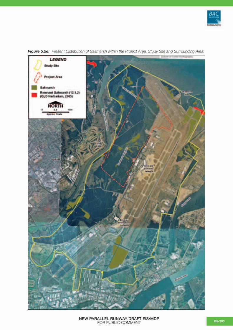
Figure 5.5e: Present Distribution of Saltmarsh within the Project Area, Study Site and Surrounding Area.
NEW PARALLEL RUNWAY DRAFT EIS/MDP FOR PUBLIC COMMENT B5-200

Values
The mangroves of the Study Site are listed under BCC’s NAPS Policy as Valuable Ecological Features (Schedule 1), as significant sites (Schedule 2) and as a significant vegetation community (Schedule 5). As part of the Airport Environment Strategy (2004), BAC have designated three areas of mangroves within the Study Site as environmentally signficant areas for conservation, however, all of these sites occur outside the NPR Project Area. Based on a vegetation and condition assessment of Brisbane Airport controlled lands by ERM (2002), mangrove communities were considered to have the highest conservation value of all vegetation communities.
5.5.2.2 Phragmites Wetland
Spatial and Temporal Patterns
This section describes the composition and extent of other wetlands across the Study Site with the exception of mangroves and saltmarsh, which are described above.
ERM (2002) mapped approximately 115 ha of discontinuous wetlands on the Study Site. These were described as shallow wetlands subject to seasonal rainfall/intermittent inundation dominated by a ground layer of Phragmites australis up to 2.5 m tall. These communities were distinguished from the managed grassland habitats due to seasonal rainfall/intermittent inundation conditions and the dominance of Phragmites, which is an aquatic perennial plant that is usually found in or near creeks or swamps but is also found in damp areas (Stephens and Dowling, 2002).
Based on field surveys conducted in February 2006, some of the wetlands previously described by ERM (2002) had reverted to grassland communities. These communities were generally dominated by introduced grasses known from a diversity of habitats, and which generally do not require permanent or periodic/intermittent inundation. Species that are generally associated with wetland conditions were noted in drainage lines and small depressions (notably Phragmites australis, Typha sp and Cyperus spp), but these formed a minor component (less than 10 percent) of the vegetation cover in these communities. The invasion of
exotic grasses is possibly a result of prevailing dry conditions in Brisbane in recent years.
Figure 5.5b indicates the current distribution of Phragmites wetland communities on the Study Site. Approximately 76 ha of this wetland habitat was recorded within the Study Site with approximately three ha of this occurring within the Project Area. These communities were highly variable across small spatial scales reflecting minor topographic (and flooding) variations. More than 40 percent of the vegetation cover was comprised of Phragmites australis, which occurred on damp soils subject to periodic inundation. Drainage lines subject to prolonged inundation supported Typha sp. with the more brackish drainage lines supporting a groundcover of Sporobolus virginicus. The gently undulating plains in close association with these wetlands supported unmanaged grassland dominated by Paspalum urvillei and Chloris gayana.
Values
Wetlands on the coastal floodplains of the South East Queensland bioregion have been extensively drained or have become silted and large areas were filled for urban and associated infrastructure development. These habitats are important for water birds and freshwater vertebrates and invertebrates. Wetland habitats also provide potential habitat for significant flora species such as Aponogeton queenslandicus. Artificial wetlands created on previously dry land specifically for purposes such as sewage treatment, stormwater management and farm production, may also provide these habitat features.
No threatened flora has been recorded within the Phragmites wetlands mapped on the Study Site, but they are considered to provide some fauna habitat features (see section 5.5.7).
5.5.2.3 Unmanaged Grasslands
Spatial and Temporal Patterns
As previously discussed, the floodplain has been extensively cleared throughout the Study Site and installation of creek diversions, bunding, reclamation and establishment of plantations has had an impact on the hydrology, topography and distribution of regenerating habitats. Self-seeded unmanaged
NEW PARALLEL RUNWAY DRAFT EIS/MDP FOR PUBLIC COMMENTB5-201

grasslands have colonized highly modified habitat on reclaimed land that occur in close association with the Phragmites wetlands of the Study Site, but are less prone to inundation and waterlogging.
Figure 5.5b indicates the current distribution of unmanaged grassland communities on the Study Site. Approximately 306 ha of grassland habitat was recorded within the Study Site with approximately five ha occurring within the Project Area. These communities were highly variable across small spatial scales reflecting minor topographic variations. The gently undulating plains supported self-seeded grassland dominated by Paspalum urvillei and Chloris gayana.
Whilst Paspalum urvillei is associated with damp conditions it does not require areas of permanent or periodic/intermittent inundation and the other species recorded are widespread in a variety of habitats. Species which are generally associated with wetland conditions were noted in drainage lines and small depressions (notably Phragmites australis, Typhasp and Cyperus spp), but these formed a minor component (less than 10 percent) of the vegetation cover. Sparse shrubs included Lantana camara, Cinnamomum camphora, Solanum mauritianum, Cestrum parqui, Leucaena leucocephala, Tecoma stans and Gomphocarpus physocarpus.
Values
The unmanaged grasslands provide limited biodiversity value from a flora perspective but provide fauna habitat features (see section 5.5.7).
5.5.2.4 Managed Grasslands
Spatial and Temporal Patterns
Managed grasslands occur in the Study Site as roadside vegetation and as mown open landscapes surrounding the aircraft facilities. A total of 30 species have been recorded within these communities in the Study Site and surrounding area including 17 exotic species (ERM, 2002).
Figure 5.5b indicates the current distribution of mown grassland communities on the Study Site. Approximately 588 ha of mown grassland occurs within the Study Site with approximately 31 ha of this occurring within the Project Area.
Values
The managed grasslands provide limited biodiversity value from a flora perspective but provide some fauna habitat features (section 5.5.7).
5.5.2.5 Casuarina Plantations
Spatial and Temporal Patterns
Prior to clearing and reclamation on the site, the margins of the marine clays of the Study Site would have supported large areas of Casuarina glauca open forest. However, no remnants or regrowth of these Casuarina glauca communities currently occur on the Study Site.
Figure 5.5b outlines the current extent of Casuarina plantation within the Study Site. Approximately 720 ha of Casuarina glauca monoculture exists within the Study Site, and 209 ha of this vegetation occurs within the Project Area. The vegetation community was planted following the construction of the Airport, primarily due to its landscape stability and for its potentially low fauna habitat value.
Casuarina glauca stands across the landward zone of the Study Site ranged from 10–12 m in canopy height. There was generally a dense shrub layer dominated by Lantana camara, Solanum mauritianum, Cestrum parqui and Schinus terebinthifolius. Dense infestations of the vines Araujia hortorum and Solanum seaforthianum were also widespread.
Casuarina glauca stands abutting Serpentine and Jacksons Channel were subject to periodic tidal inundation and generally ranged from 6–10 m in canopy height and supported a shrub layer dominated by Lantana camara, Solanum mauritianum, Cestrum parqui, Schinus terebinthifolius, Gomphocarpus physocarpus and Rivina humilis. Sporobolus virginicus dominated the groundlayer.
Stands which were subject to intermittent tidal inundation generally had a canopy height less than 5 m over a sparse shrublayer of Lantana camara. The groundlayer was dominated by salt-tolerant species such as Sporobolus virginicus, Sesuvium portulacastrum, Enchylaena tomentosa, Suaeda australis and Einadia hastata.
NEW PARALLEL RUNWAY DRAFT EIS/MDP FOR PUBLIC COMMENT B5-202

Values
All Casuarina glauca communities of the Study Site are monoculture plantations that were planted on highly modified terrain and soils, but primarily marine sand dredged from Middle Banks. These communities were planted in part for their low fauna (bird) habitat potential (see section 5.5.7). All Casuarina glauca communities of the Study Site occur on highly modified terrain and are not considered to be regrowth or representative of regrowth or remnant communities. All Casuarinaglauca stands on the Study Site have been mapped as plantation by the Queensland Herbarium.
5.5.2.6 Eucalypt Open Forest
Spatial and Temporal Patterns
Figure 5.5b shows that a minor, isolated copse of disturbed remnant eucalypt open forest occurs in the Project Area, which is approximately 1 ha in area and is dominated by Eucalyptus tereticornis. This isolated and disturbed remnant was too small to be mapped as remnant by the certified RE mapping produced by the Queensland Herbarium.
Values
Given its small area, this isolated remnant is prone to a high level of edge effects as evidenced by weed invasion and canopy dieback. This habitat provides limited biodiversity value from a flora perspective but provides some fauna habitat features (see section 5.5.7).
5.5.2.7 Coastal Dunes and Foreshores
Spatial and Temporal Patterns
The foreshore on the north and north-eastern boundary of the Study Site support narrow fringes of coastal dune and foreshore vegetation on undulating, well-drained dunes. Planted Casuarina equisetifolia occurred on the seaward edge with a canopy height ranging from 4–7 m and a foliage protection cover of 30 –70 percent (ERM, 2002).
The shrub layer was dominated by Lantana camara and the ground and vine layer was also dominated by exotics, notably: Panicum maximum, Stenotaphrum secundatum and Chloris gayana. The native species recorded were pigface (Carpobrotus glaucescens) and other common dune/foreshore species (Tetragonia tetragonioides, Crinum pedunculatum, Zoysia macrantha, Sesuvium portulacastrum and Sporobolus virginicus).
Values
Foreshore vegetation impacts on sand transport pathways and influences the rate of shoreline recession and dune rebuilding. Dune vegetation is adapted to salt laden winds of the coast, and maintains the foredunes by holding sands, trapping sand and aiding repair of dunes following storm damage. This vegetation traps and holds windblown sand and protects vegetation on the relatively more stable foredune. Sand trapped in the foredune acts as a reservoir of sand for the beach during periods of wave erosion and buffers the effects of storm erosion. The minor area of foreshore vegetation on the Study Site has limited biodiversity value but has some fauna habitat features (see section 5.5.7).
5.5.2.8 Threatened Flora – Study Site
A search of the Queensland EPA’s threatened flora records2 for the Study Site and DEH’s EPBC Protected Matters3 for the same area, indicate that eleven threatened flora species have the potential to occur within the Study Site (see Table 5.5b). All threatened species recorded within the vicinity of the Study Site are associated with terrestrial, riparian or wetland habitats. There are no threatened flora records from mangrove or saltmarsh habitats.
Given the disturbance history of the Study Site and the modified condition of the terrestrial and wetland habitats, it is considered highly unlikely that threatened plants would occur. No significant plant species have been identified on the Study Site.
2 QLD EPA Wildlife Online Extract for Rare and Threatened Tlora Records Within a 10 km Radius of –27.38745357 / 153.1187146 Since 1980, www.epa.qld.gov.au (accessed October, 2005).
3 DEH EPBC Protected Matters Search Tool. www.deh.gov.au (accessed October, 2005).
NEW PARALLEL RUNWAY DRAFT EIS/MDP FOR PUBLIC COMMENTB5-203

Table 5.5b: Threatened Flora Species Recorded within 10 km of Study Site (Online Search Tools for Queensland EPA Wildlife and DEH EPBC Protected Matters).
Species (Common Name)
Status under
NC Act
Status under
EPBC Act
Potential Habitat Potential to Occur on Study
Site
Data Source
Arthraxon hispidus hairy-joint grass
Vulnerable Vulnerable Within South East Queensland has been recorded adjacent to freshwater springs in coastal foreshore dunes, in shaded small gullies, on creek banks and on sandy alluvium in creek beds in open forests. May be found growing on the fringe of rainforest or in more open, wet eucalypt forest (QLD CRA/RFA Steering Committee, 1998).
Unlikely DEH
Austromyrtus gonocladaangle-stemmed myrtle
Endangered Endangered Sloping or flat alluvial terraces of permanent waterways, which experience some degree of tidal influence and are at an elevation of 5–50 m ASL. Usually found growing below the peak flood level. May be found growing in lowland riparian rainforest or in association with notophyll vine forest species (www.deh.gov.au).
No DEH
Bosistoa selwyniiheart-leaved bosistoa
Vulnerable Rainforest up to 300 m in altitude. Occurs on deep basaltic soils. May occur on alluvial flats including creek banks (www.threatenedspecies.environment.nsw.gov.au).
No DEH
Bosistoa transversathree-leaved bosistoa
Vulnerable Lowland subtropical rainforest up to 300 m in altitude.
No DEH
Corchorus cunninghamii native Jute
Endangered Endangered Ecotone between wet sclerophyll forest and dry to dry-subtropical rainforest on sheltered slopes and gullies, and grassy open forest on exposed slopes and ridges. (NSW Department of Environment and Conservation, 2004).
No DEH
Cryptostylis hunterianaleafless tongue-orchid
Vulnerable Does not appear to have well defined habitat preferences and is known from a range of communities, including swamp-heath and woodland (NSW Department of Environment and Conservation, 2004).
No DEH
Hydrocharis dubiafrogbit
Vulnerable Vulnerable Shallow ponds or slow moving streams and in roadside lagoons to 30 cm depth (Stephens and Dowling, 2002).
Unlikely DEH
Leucopogon sp. (Coolmunda D.Halford Q1635)
Endangered Endangered Shallow sandy soils near Inglewood in the Darling Downs district (Stanley and Ross, 1986).
No EPA
Macadamia integrifoliamacadamia nut, Queensland nut, smooth-shelled macadamia, bush nut
Vulnerable Vulnerable Dry and subtropical rainforest. (www.brisrain.webcentral.com.au)
No DEH
Phaius australislesser swamp-orchid
Endangered Endangered Wet heathland on sandy soils. No DEH
NEW PARALLEL RUNWAY DRAFT EIS/MDP FOR PUBLIC COMMENT B5-204

No regionally restricted flora or locally significant species under BCC’s NAPS have been identified on the Study Site, however, the yellow mangrove (Ceriops tagal var. australis) is an uncommon community within the Moreton Bay region. It has a sparse distribution on the Study Site occurring mainly as single dispersed individuals along Landers Pocket Drain, Serpentine Creek and Jacksons Channel waterway (ERM, 2002).
5.5.2.9 Biodiversity and ConservationSignificance – Study Site
Remnant Vegetation
Figure 5.5c indicates the extent of 2003 remnant vegetation mapped on the Study Site by the Queensland Herbarium.
Approximately 19 ha of mangroves within the Study Site at Serpentine Inlet have been classified as remnant RE12.1.3 vegetation as defined under the Vegetation Management Act 1999 (VM Act) by the Queensland Herbarium. As previously noted, however, this figure is not an accurate reflection on the likely extent of remnant mangrove vegetation on the Study Site.
Approximately four ha of saltmarsh near Serpentine Inlet within the Study Site has been classified as remnant vegetation (RE12.1.2) by the Queensland Herbarium. With the exception of this area, all saltmarsh of the Study Site and Project Area has regenerated since the original development of the airport. No other remnant saltmarsh has been identified on the Study Site. Saltmarsh is exempt from the purposes of the VM Act, but is regulated by the Fisheries Act 1994.
One hectare of isolated, disturbed remnant RE12.3.11 (Of Concern) has been retained within the Casuarina glauca plantation near the Kedron Brook Floodway. This remnant is too small to be mapped by the certified RE mapping produced by the Queensland Herbarium. Given its small area this isolated remnant is prone to a high level of edge effects as evidenced by weed invasion and canopy dieback. This habitat provides limited biodiversity value from a flora perspective.
No Endangered RE’s have been identified on the Study Site. Remnant Casuarina glauca open forest in the South East Queensland bioregion is classified as an Endangered community (RE12.1.1) under the VM Act. The Casuarina glauca communities of the Study Site are recognised as plantations that have been developed on highly modified terrain and soils. These communities are not considered to be regrowth or representative of RE12.1.1.
Environmentally Significant Areas
As part of the Airport Environment Strategy (2004), BAC designated three areas of mangroves within the Study Site as environmentally significant areas for conservation. The three environmentally significant areas on the airport are located: (1) in Jacksons Creek (west of the Project Area); (2) in the south-eastern corner of Serpentine Inlet; and (3) in the south-eastern part of the site abutting the Pinkenba community. All three areas of environmentally significant mangrove vegetation are located outside the proposed NPR Project Area and will be retained by BAC for conservation purposes (refer section 5.11).
EPBC Act 1999
No threatened vegetation communities listed under the EPBC Act have been identified within the Study Site.
South East Queensland BPA Mapping
Figure 5.5f shows the South East Queensland Biodiversity Planning Assessment (BPA) Mapping for the Study Site and surrounding area. The remnant mangroves and saltmarsh within and directly adjacent to the Study Site have biodiversity value that is of ‘State Significance’. No habitats of State or Regional biodiversity value have been mapped within the Project Area.
Brisbane City Council NAPS Policy
Under BCC’s NAPS Policy the habitats of the Study Site would be considered Valuable Ecological Features (Schedule 1) as they contain areas of ecosystem diversity. Under Schedule 2 of this policy the mangroves, saltmarsh and wetland habitat is listed as a significant site because of the presence of intertidal habitats and potential significance for migratory waders (see section 5.5.7). Both the mangrove communities and the wetlands are listed under the policy as having local/citywide significance.
NEW PARALLEL RUNWAY DRAFT EIS/MDP FOR PUBLIC COMMENTB5-205

Figure 5.5f: South East Queensland Biodiversity Planning Assessment Mapping (EPA, V3.4).
NEW PARALLEL RUNWAY DRAFT EIS/MDP FOR PUBLIC COMMENT B5-206

5.5.3 Terrestrial and Aquatic Vegetation – Dredge Pipeline Corridor
A habitat assessment was conducted in the area to be impacted by the proposed pipeline alignment to verify existing reporting and spatial data and to describe current habitat condition and composition. Data collected included location, environmental and overall vegetation structural information as well as a list of dominant species present.
As shown in drawings contained within Chapter A4, the Luggage Point pipeline alignment covers approximately 2.5 km from the foreshore of Brisbane River to the airport boundary. It extends across operational areas of the Luggage Point Wastewater Treatment Plant and managed grasslands and saltmarsh regrowth within the Study Site (refer to section 5.5.1 for a description of communities on the Study Site). The pipeline continues from this point across the managed grasslands of the airport site to the runway reclamation area (a total distance of between 4–6 km from the dredge mooring facility).
The dominant vegetation community traversed by this alignment is unmanaged grassland which has self-seeded reclaimed land adjacent to the Brisbane River and within the Treatment Plant site. Dominant species were Chloris gayana, Panicum maximum and Melinis repens. Other species included the grasses Paspalum spp., Melinis minutiflora, Sorghum halepense, Cynodon dactylon and Sporobolus spp. and sparse shrubs including Solanum mauritianum, Ricinus communis, Solanum torvum, Schinus terebinthifolius and Lantana camara. Isolated Casuarina glauca, Cupaniopsis anacardioides, Eucalyptus tereticornis and Hibiscus tiliaceus regenerating trees and planted Ficus sp. also occurred.
The pipeline will be required to cross the Jubilee Creek drainage channel which is lined with low Avicennia marina ranging from 0.5–2.0 m in height to 3–4 m in height. Suaeda australis, Halosarcia india, Sporobolus virginicus and Sesuvium portulacastrum form a sparse groundcover on the banks of this channel.
The grassland adjacent to the Brisbane River in close proximity to the proposed dredge mooring location is occasionally slashed and is regularly accessed by vehicles. The banks and foreshore of
the Brisbane River support a discontinuous fringe of regenerating grey mangroves (Avicennia marina)bounded by a narrow band of Sporobolus virginicusdominated saltmarsh. Depressions and drainage channels on the foreshore support minor copses of Phragmites australis, Avicennia seedlings, Cyperus polystachyos and Sporobolus virginicus. The unmanaged grasslands described above extend to the foreshore on heavily eroded banks.
No remnant vegetation as defined by the VM Actand no threatened flora species listed under the EPBC Act 1999 and Nature Conservation Act 1992 will be impacted by this alignment.
5.5.4 Benthic Macroinvertebrates
Most detailed work on subtidal soft sediment benthic macroinvertebrates in Moreton Bay was conducted in the 1970s and 80s (reviewed in Skilleter 1998). A number of these studies examined communities in Bramble Bay (adjacent to the current Project Area) and Serpentine Creek prior to the initial airport expansion works. These studies describe variations in community patterns in time and space, but do not empirically test processes controlling these patterns. These studies provide background information in the context of the EIS/MDP.
FRC Environmental (2003) surveyed the macrobenthic infaunal communities of the channels and creeks within BAC lands and along the adjacent foreshore. Sampling was undertaken on two transects along the north-eastern foreshore, three sites in Serpentine Creek in the vicinity of the proposed NPR, and one site in Jacksons Channel. Seven sites were sampled elsewhere through BAC lands, but outside the immediate influence of the NPR. Sampling was done at two time periods (November 2002, March 2003).
5.5.4.1 Patterns in Foreshore and SerpentineInlet Assemblages
A broad intertidal sand flat is situated adjacent to BAC lands. This area is part of a semi-contiguous intertidal flat system that extends along the length of Bramble Bay, extending from Juno Point at the mouth of the Brisbane River, northwards to Hays Inlet.
NEW PARALLEL RUNWAY DRAFT EIS/MDP FOR PUBLIC COMMENTB5-207

Several tidal creeks, including Jubilee Creek, Serpentine Inlet, Kedron Brook Floodway, Nudgee Creek and Cabbage Tree Creek punctuate these flats.
Within the area extending from Juno Point to Kedron Brook Floodway, the tidal flat has a gentle gradient with a substrate comprised of fine sands nearshore, but becoming progressively muddier with distance offshore (e.g. Stephenson et al 1976). The movement of water across the tidal flats has resulted in the creation of sand ripples in the intertidal and shallow subtidal zone. Furthermore biogenic disturbance of sediments by crabs (Mictyris, Helocius) and ghost-nippers (Trypea),as well as fish (e.g. ‘ray wallows’), have created a mosaic of micro-topographical complexes across the tidal flat. Micro-topographical features is thought to have a major influence on small-scale patchiness patterns in macrobenthic assemblages.
Recent studies and field investigations in connection with this EIS undertaken by WBM at Serpentine Inlet (2006) and previous surveys of benthic macroinvertebrates along the sandy intertidal sand flats and in offshore areas by FRC Environmental (2003) are discussed in Appendix C.
These studies have shown that:
• Rank abundance and total average abundances of different species showed marked variation over time;
• Differences in assemblages were detected among different tidal zones, although these patterns were not always consistent between transects or over time;
• There were differences in benthic communities between nearshore (<100 m) and offshore (>200 m offshore) environments, but no difference in assemblages between either of these locations and locations in mid-shore environments;
• Differences were detected in assemblages between sampling occasions, with differences over time typically being greater than differences between tidal zones; and
• Like assemblages on tidal flats, benthic assemblages within Serpentine Inlet were numerically dominated by small-bodied opportunistic species, with most of these taxa being deposit-feeders or predators.
5.5.4.2 Patterns in Study Site WaterwayAssemblages
Jacksons Channel, Serpentine Creek and Kedron Brook Floodway represent the main tidal creeks in the northern sections of the Study Site. These waterways have been extensively modified due to reclamation and flood mitigation activities in the 1980s associated with the original airport development. In summary, these works involved the in-filling of most of the Serpentine Creek system, and Kedron Brook was diverted into a floodway constructed south of Nudgee Beach. Waterways have been subject to ongoing physical disturbance, including further dredging works, and water quality degradation from catchment and urban influences.
FRC Environmental (2003) reported that the visually obvious epifauna communities of waterways within the Project Area (i.e. Serpentine/Jacksons Creek, Kedron Brook) were numerically dominated by semaphore and fiddler crabs (Heloecius cordiforimsand Uca spp), and prawns (Macrobrachium novaehollandiae and Metapenaeus bennettae) and mangrove snails, all of which are common inhabitants of tidal creek environments in the wider region.
Grab sampling in 2002 and 2003 by FRC Environmental (2003) recorded 26 morpho-species of macroinvertebrates in the Jacksons/Serpentine Creek (Project Area), and 19 morpho-species in the broader Study Site (Kedron Brook, Boggy Creek waterways). Table 5.5c shows that most taxa were typically recorded on only a single occasion, and that the number of taxa recorded exclusively in one year only was generally similar between years.
NEW PARALLEL RUNWAY DRAFT EIS/MDP FOR PUBLIC COMMENT B5-208

Table 5.5c: Number of Taxa Recorded by FRC Environmental (2003) in Grab Samples in the Jacksons/Serpentine Creek System and Waterways in the Wider Study Site.
No. of taxa:
Jacksons Channel
Wider Project Area
No. samples/occasion 20 20
Recorded in 2002 only 7 6
Recorded in 2003 only 9 8
Recorded in 2002 and 2003 10 5
TOTAL 26 19
When compared and analysed using data from more recent sampling in Serpentine Inlet as part of WBM (2006) (see also Appendix C), the studies have shown that:
• The composition of numerically dominant taxa (at the family level4) recorded in Serpentine Inlet in 2006 was generally similar to that recorded in waterways by FRC Environmental (2003). In this regard, 8 of the 13 numerically dominant families recorded at Serpentine Inlet in 2006 were also recorded in 2002/03 in the Project Area and wider Study Site;
• Taxa richness was consistently low across all sites, although there was great variation in abundances among sites. FRC Environmental (2003) found that poorly flushed areas had mollusc dominated communities, whereas crustaceans and polychaete worms generally dominated well-flushed areas;
• Multivariate analyses of available data from sampling studies show that community structure was not stable over time; and
• Changes in community structure were not uniform across sites, as indicated by differences in the direction and magnitude of change among sites between sampling episodes suggesting that the processes controlling the observed temporal changes in community structure were not operating over broad spatial scales.
5.5.4.3 Controls on Benthic InvertebrateCommunity Structure
On the basis of the results presented above, and past studies in the Moreton Bay region (reviewed by Skilleter 1998), it is apparent that benthic invertebrate community structure shows complex changes over a range of temporal scales in the region. A range of processes operating at different temporal and spatial scales are thought to control these temporal changes in community structure.
Macroinvertebrates communities tend to have a peak in abundances during spring (Stephenson et al 1978; WBM Oceanics Australia 2003), which is thought to reflect seasonal recruitment pulses in the Bay. Moreton Bay benthic communities have been noted by Stephenson et al (1978) to experience a ‘summer depletion’ in abundances, which they suggested (but not empirically tested) may reflect high levels of predation by fish at this time. Interestingly, species richness within the Study Site tended to decline between November 2002 and March 2003 sampling episodes, however this trend was not consistent across all sites.
It has also been argued that there have been major long term changes in the benthic fauna community structure of Bramble Bay over the last 30 years (Quinell 1997; FRC Environmental 2003). Quinell (1997) and FRC Environmental (2003) found that polychaete worms numerically dominated benthic communities, and that the mactrid bivalve Spisula (Notospisula sp). was not particularly abundant. By contrast, surveys by WBM Oceanics Australia in the present study recorded relatively high abundances of this species at Serpentine Inlet. Studies undertaken on macrobenthic invertebrate assemblages in intertidal and subtidal habitats of Nudgee Beach (Skilleter 1998) found that mactrid bivalve Spisula trigonella showed substantial variations over the survey period (August and October 1997). Skilliter (1998) found no evidence to suggest a long term change in benthos in the Nudgee Beach area, although consistent with past studies in the Bay, demonstrated substantial variations in community structure in scales measured in weeks.
4 Note differences in the naming of taxa preclude direct comparisons at the species/morpho-species level.
NEW PARALLEL RUNWAY DRAFT EIS/MDP FOR PUBLIC COMMENTB5-209

5.5.4.4 Values
Benthic macroinvertebrates represent a large proportion of the total estuarine biomass and productivity at local and regional scales, although no studies to date have quantified this in the Moreton Bay estuary. Invertebrates form important food resources for many bird species, several of which are of conservation importance at international scales. Lambert and Rehbein (2005) suggest that changes in the distribution of wader birds in the Study Site may in part be influenced by variability in benthic organisms (see section 5.5.7.5). Benthic macroinverebrate assemblages are also very important component of biodiversity in their own right. The following provides a summary of the values of benthic macroinvertebrates assemblages within and adjacent to the Study Site.
Mangrove and Saltmarsh Fauna
• In general, assemblages in the mangroves and tidal creeks of the Study Site had characteristically low taxa richness, which is a typical feature of such environs. Very few species inhabiting mangals are habitat specialists (i.e. few are restricted to mangrove habitats exclusively).
• Some crabs and teredinid molluscs (shipworms) probably play an essential role in the maintenance of the health of the mangrove plants. These species facilitate the breakdown of detritus by shredding and consuming leaves and ingesting wood, and aerate the soil through burrowing; (Robertson and Daniel 1989; Robertson 1991; Smith et al 1991). Furthermore, sediment excavated by burrowing softens the mangal microtopography thereby improving conditions for germination of mangrove seedlings.
• Some mangrove invertebrate fauna represent food resources for many bird species (i.e. large polychaete worms, crabs, prawns etc). However, as discussed in section 5.5.7, the mangals of the Study Site are not thought to represent important bird feeding areas, but have some values as roost sites for wader birds.
• In the study by Connolly and Guest (2004), stable isotopes (13C and 15N) were employed in determining the dominant sources of nutrition for fish that were collected over mudflats lacking conspicuous aquatic vegetation in Gladstone, Queensland. Most notably, organic matter from beds of seagrass (in particular Zostera sp.) were recognised as an important sources of nutrition for many fish species in adjacent unvegetated areas. This is consistent with findings of a similar study in Moreton Bay (Guest and Connelly 2004).
By comparison, organic matter from mangroves and saltmarsh areas were shown to contribute very little in terms of nutrition of fish species in adjacent unvegetated mudflats. This may suggest that mangrove stands export relatively little organic or vegetative matter into adjacent environments, which might reflect the importance of in situ nutrient cycling by macroinvertebrates within these communities.
• Mangrove-associated macroinvertebrates represent an important dietary component of most estuarine fish. Consequently, macroinvertebrates represent an important link for transferring energy and nutrients between trophic levels and driving benthic-pelagic coupling.
• The Study Site represents one of many sources of invertebrate propagules to the wider Moreton Bay region.
Mudflat and Sandflat Fauna
• Several species present in the Study Site are of direct commercial significance (see section 5.5.5.3).
• The benthic macroinverebrate populations within the Study Site have low to moderate species richness on a Moreton Bay scale.
NEW PARALLEL RUNWAY DRAFT EIS/MDP FOR PUBLIC COMMENT B5-210
• The numerically dominant macroinvertebrates species (including polychaete worms, bivalve molluscs and amphipod crustaceans) are largely responsible for intertidal bioturbation and biogenic working as a result of burrowing. Burrowing in the sediment surface delivers oxygen and nutrients to deeper anaerobic environments, and therefore reduces the redox layer.
• Macroinvertebrates control nutrient fluxes. Loss of nitrification and denitrification, and increased ammonium efflux from sediment can cause a shift from clear water to a turbid state. It is unknown to what extent (i) benthic communities have changed since European settlement and (ii) these modifications have affected nutrient fluxes and subsequent effects to estuary ecology.
• Soft sediment benthic macroinvertebrates provide an important food resource for fisheries, avifauna, and humans, therefore forming an integral part of the food web.
• Macrobenthic deposit feeders (e.g. polychaetes and amphipods) contribute significantly to biodeposition through regeneration of inorganic nutrients (Day et al 1989). They also promote decomposition of organic matter and recycle nutrients for photosynthesis (Gaston et al 1998).
5.5.5 Fish, Nektobenthic Invertebrates and Fisheries
Tidally inundated wetlands (e.g. mangroves, seagrass, saltmarsh, unvegetated mud/sand flats), and the various waterways (e.g. creeks, constructed channels) within the Study Site and adjacent environments are utilised by many fish species, some of which are of commercial and recreational fisheries value (Stephenson and Dredge 1976; FRC Environmental (2003); WBM Oceanics Australia present survey). The following sections discuss patterns, values and controls on fish assemblages at:(1) Serpentine Inlet; and(2) waterways within the Study Site and adjoining
Kedron Brook.
5.5.5.1 Spatial and Temporal Patterns -Serpentine Inlet
As part of the present Environmental Impact Study (EIS), WBM Oceanics Australia conducted a survey of the fish and nektobenthic invertebrate fauna of Serpentine Inlet during January and March 2006. The survey targeted fauna within creek, nearshore and offshore (intertidal sand flat) habitats, and used a combination of replicated fishing survey methods/apparatus, namely: gill netting/seining, cast netting and beam trawling.
A variety of fishing apparatus was used in order to capture the largest variety of fish species and size classes as possible.
This study is understood to represent the only quantitative assessment of these fauna within Serpentine Inlet since the reclamation of the Serpentine Creek system in the late 1970s.
A total of 38 fish species from 26 families were captured during this survey, all of which are considered typical of estuaries in South East Queensland and the Moreton Bay region (Johnson 1999). The ten most abundant captured fish for each fishing technique and location are shown in (Table 5.5d). A full list of the species and the number captured is included as Appendix D. No threatened species or marine species listed under the Commonwealth’s Environment Protection and Biodiversity Conservation Act 1999 or Nature Conservation (Wildlife) Regulations 1994, or Fisheries Act 1994 were recorded in this study or previous fish surveys in the Study Site.
NEW PARALLEL RUNWAY DRAFT EIS/MDP FOR PUBLIC COMMENTB5-211

Table 5.5d: Ten Most Abundant Fish Species Recorded in Serpentine Inlet. (WBM Present Study).
Gill Netting Cast Netting
Nearshore Offshore Creek Creek mouth Discharge area
Fantail mullet* Silverbiddy Common toadfish Yellow perchlet Silverbiddy
Southern herring Fantail mullet* Flattail mullet* Common toadfish Common toadfish
Estuary anchovy Southern herring Yellow perchlet Banded toadfish Fantail mullet*
Banded toadfish Black napped ponyfish
Banded toadfish Silverbiddy Diver whiting*
Silverbiddy Gold-lined whiting* Diver whiting* Fantail mullet* Banded toadfish
Tailor* Trevally* Fantail mullet* Flattail mullet* Yellow perchlet
Putty nosed perch* River garfish* Silverbiddy Diver whiting* Tailor*
Sea mullet* Yellow-tail pike* Yellow finned bream* Common dragonet Flattail mullet*
Snub nosed garfish* Putty nosed perch* Dusky flathead* Black napped ponyfish
Gold-lined whiting*
Common toadfish Double spotted queenfish*
Gold-lined whiting* Butter bream Bar-tailed flathead*
Note that (*) denotes species of direct fisheries value.
Quinn (1978) conducted a survey of the fish fauna of Serpentine Creek prior to its reclamation, and reported 45 species for the area (Quinn, 1978). Stephenson and Dredge (1976) also conducted a survey of Serpentine Creek using greater levels of spatial and temporal replication than Quinn (1978), but used the same sampling technique, and yielded 36 fish taxa. This could be considered to be a gross underestimate of total species richness within the area, reflecting the biased coverage of the survey’s fishing technique (beam trawling) (see Guest and Connolly, 2004). This technique would generally target bottom dwelling fish and nektobenthic invertebrates, with pelagic species poorly represented.
Fish communities can show significant variation over a range of temporal and spatial scales.In the near shore environments of Moreton Bay, several authors have reported higher species richness and abundances in summer (and in some cases spring) compared to winter (reviewed by Tibbetts and Connolly 1998). Quinn (1978) demonstrated that fish communities within the Serpentine Creek system displayed variation in species richness and abundances over small temporal scales, recording three times as many individuals and twice as many species captured at night compared with daytime catches.
5.5.5.2 Spatial and Temporal Patterns– Jacksons Channel and Kedron Brook
The FRC Environmental (2003) study represents the only post-airport construction quantitative assessment of fish assemblages within the Study Site and surrounds (i.e. Kedron Brook). The survey used four sampling techniques (Gill Nets, Dip Nets, Box Traps and Beam Trawls) at 13 sites and at multiple locations, which included: Kedron Brook Floodway, Jacksons Channel (including elements of the former Serpentine Creek), Boggy Creek and several constructed tidal drains within and surrounding the Study Site.
During the FRC study, 39 fish species were captured from 28 families, all of which were considered typical of estuaries in South East Queensland (Table 5.5e; FRC Environmental (2003)). Among the captured species were fish of commercial and recreational importance including: sea mullet, dusky flathead, threadfin, tailor, yellowfin bream, winter whiting and striped sea pike. Five fish species (longtoms, trevally, striped butterfish, sand whiting and tarwhine) commonly caught within waterways of Moreton Bay were not reported in this study (FRC Environmental (2003)). Some of these absences were attributed to there being differences in sampling effort and the seasonality in nearshore habitat usage (e.g. tarwhine and gobies) by some species (Environmental FRC (2003)).
NEW PARALLEL RUNWAY DRAFT EIS/MDP FOR PUBLIC COMMENT B5-212

The seasonal movements of some species (e.g. striped herring, December 2002) explained some differences in numerically dominant fish between survey periods in the FRC Environmental (2003) study. The schooling behaviour of herring would most likely have also contributed significantly to variation in catches of this species and other species such as mullets. Many species of goby, however, complete their life cycle within estuaries, and were thus numerically abundant during all sampling occurrences in the FRC Environmental (2003) study.
Table 5.5e: The Ten Most Abundant Fish Species Captured in Jacksons Channel and Kedron Brook Floodway During Four Sampling Efforts Between November 2002 and April 2003 (from FRC Environmental (2003).
Table 5.5f: Abundance of Species Captured by Cast Netting in the Upper and Lower Reaches of Jacksons Creek and Kedron Brook (Pooled Across Sampling Events) for Both Small Meshed and Large Meshed Cast Nets (WBM Present Study).
Species Jacksons Creek Kedron Brook
Upper reaches Lower reaches Upper reaches Lower reaches
Small Large Small Large Small Large Small Large
Yellow finned bream 2 19 1 9 1 11 - 6
Yellow perchlet 3 - 34 2 - - 1 -
Shovel nosed ray - 1 - - - - -
Snub-nosed garfish - - 2 - - - - -
Silver biddy 2 3 8 4 2 10 - 13
Southern herring 1 1 2 1 - - - -
River garfish - - - - - - - -
Spotted stargazer 1 - - - - - - -
Black naped ponyfish - - - - - 2 - -
Flat tail mullet - 1 - 2 - - - -
Banded toadfish - 2 4 - - - - -
Butter bream - - - - - - 1 -
Sea mullet 1 1 - - - 1 2
Fantail mullet 19 6 3 16 - 5 4 10
Banana prawn 4 8 2 3 5 7 - -
Tiger flathead 1 - - 1 - - - -
Putty nosed perch - - - - - - - 1
Species Common name Total abundance (n)
Herklotsichthys castelnaui Southern herring 548
Tetractenos hamiltoni Common toadfish 394
Marilyna pleurosticta Banded toadfish 335
Ambassis marianus Estuary perchlet 278
Acanthopagrus australis Yellow fin bream 270
Pseudogobius sp. Goby 136
Valamugil georgii Fantail mullet 123
Gobiopterus semivestita Transparent goby 116
Mugil cephalus Sea mullet 97
Pseudomugil signifer Blue eye 85
NEW PARALLEL RUNWAY DRAFT EIS/MDP FOR PUBLIC COMMENTB5-213

Species Jacksons Creek Kedron Brook
Upper reaches Lower reaches Upper reaches Lower reaches
Small Large Small Large Small Large Small Large
Tailor - - - 1 - - - -
Blue swimmer crab - - - - - 1 2 1
Goby species 2 - - - - - - -
Large toothed flounder - 2 - - - 1 - -
Tarwine - - - - - - - 2
Striped butterfish - - - 1 - - - 7
Golden lined whiting - - - 1 - 1 - -
Diver whiting 1 - - 3 1 1 1 1
Yellow tail pike - - - - 1 - - -
Stonefish - - - 1 - - - -
Common toadfish 50 83 8 34 2 8 1 4
Estuary anchovy - - - - - - 2 -
Torquigener pleurogramma - - - 1 - - - -
Davie and Hooper (1998) explored patterns in fish species richness within Moreton Bay, based on collections of fish held by the Queensland Museum. A distinct estuarine/marine dichotomy in species richness was detected. In general, highest numbers of species were recorded at the artificial reefs and reefs at Tangalooma, Cowan and Bulwer (western Moreton Island), and at Amity Point. The nearshore areas extending from Fisherman Islands to Deception Bay had moderate species richness compared to off-shore areas. These patterns are likely to reflect both differences in sampling effort in different parts of the bay, and changes in species composition and richness in response to differences in habitat structure, food availability etc.
Wallace (2002) also used cast netting as a rapid assessment tool to assess fish assemblages in adjacent areas with similar muddy habitats and found a suite of common species typical of these habitats. From these studies and from other literature sources (e.g. Quinn 1978; Tibbetts and Connolly, 1998; WBM present study (Table 5.5f) D. McPhee unpublished data (Table 5.5g),
the overall structure of the fish assemblages of such habitats can be described as follows:
• A suite of mullet species dominated by sea mullet and flat tail mullet which principally feed on detritus;
• Macrobenthic carnivores dominated by common and striped toadfish and the yellowfin bream;
• Planktivores including the southern herring, estuary perchlet and estuary anchovy;
• Microbenthic carnivores dominated by the silverbiddy;
• Grazers including various goby species and the striped butterfish;
• Lesser numbers of piscivores including the dusky flathead and large toothed flounder; and
• A suite of species (e.g. garfish species) that occur in lower abundance which are generally more abundant in other inshore habitats (e.g. seagrass).
NEW PARALLEL RUNWAY DRAFT EIS/MDP FOR PUBLIC COMMENT B5-214

Table 5.5g: Rank Abundance of Fish Species Captured Between November and February (2002) at Four Locations in North-West Moreton Bay (Data source: D. McPhee Unpublished Data).
Rank Nudgee Creek Cabbage Tree Creek Pine River Hay’s Inlet
Upper Lower Upper Lower Upper Lower Upper Lower
1 Common toadfish
Common toadfish
Common toadfish
Common toadfish
Common toadfish
Common toadfish
Common toadfish
Common toadfish
2 Flat tail mullet
Striped toadfish
Sea mullet Tiger mullet Puttynose perch
Tiger mullet Yellowfin bream
Silverbiddy
3 Sea mullet Yellowfin bream
Striped butterfish
Yellowfin bream
Yellowfin bream
Silverbiddy Striped toadfish
Yellow perchlet
4 Tiger mullet Sea mullet Tiger mullet Yellow perchlet
Flat tail mullet
Yellowfin bream
Tiger mullet Striped toadfish
5 Yellowfin bream
Yellowfin whiting
Striped toadfish
Silverbiddy Sea mullet Flat tail mullet
Flat tail mullet
Estuary anchovy
6 Striped toadfish
Diver whiting
Silverbiddy Yellowfin whiting
Silverbiddy Dusky flathead
Yellow perchlet
Tiger mullet
7 Southern herring
Silverbiddy Yellowfin bream
Tiger mullet Bony bream
Yellowfin whiting
Silverbiddy Yellowfin bream
8 Estuary anchovy
Tiger mullet Diver whiting
Sea mullet Sand whiting
Diver whiting
Sea mullet Yellowfin whiting
9 Dusky flathead
Yellow perchlet
Flat tail mullet
Large toothed flounder
Tiger mullet Large toothed flounder
Dusky flathead
Flat tail mullet
10 - Large toothed flounder
Yellow perchlet
Dusky flathead
Large toothed flounder
Sea mullet Diver whiting
Large toothed flounder
Several authors have also reported variation in fish assemblages over larger temporal scales for Moreton Bay, with general patterns showing that higher species richness and abundances occur in summer (and in some cases spring) compared to winter (reviewed by Tibbets and Connolly 1998). In general, major recruitment to Moreton Bay’s macrobenthic communities is thought to occur around August/September (Stephenson (1980a;b;c), while the depletion of these stocks was attributed to ‘increases’ in mobile predators and benthic disturbers (fish and prawns) in December. However, the exact cause of these patterns is not well understood and requires further investigation beyond the scope of this study.
5.5.5.3 Fish of Conservation Significance
The EPBC Act 1999 lists a number of additional species of conservation significance (primarily pipefish and seahorse species) that are known or likely to occur within the Moreton Bay region (refer to Chapter C5). Based on the surveys undertaken
and studies to date, these significant marine fauna are unlikely to occur within waterways of the Project Area or the Study Site as the areas do not provide important habitat for these species.
5.5.5.4 Fisheries Habitat Values
The definition of the ‘values’ of a particular habitat patch will vary depending on the spatial scale under consideration, and these values may vary over a variety of (nested) temporal scales. The assessment has considered two spatial scales; values at a whole of Moreton Bay scale, and values at finer (within-habitat) local spatial scales. The definition of ‘values’ is based on an assessment of structural habitat characteristics, as well as the findings of fish sampling described in sections 5.5.5.1 and 5.5.5.2.
Regional scales
In general terms, fisheries productivity of an estuary is thought to be a function of its geomorphic conditions, which is a function of the degree of infilling (e.g. Roy, et al 2001, Saintilan 2004).
NEW PARALLEL RUNWAY DRAFT EIS/MDP FOR PUBLIC COMMENTB5-215
From an estuary geomorphology perspective, Moreton Bay is classified as a wave-dominated estuary that is comprised of four types of depositional environment or estuary zones (Rochford 1951, Roy, et al 2001):
• Marine tidal delta, which extends along the eastern bay. The geomorphology of this zone is dominated by wave action and is well flushed by marine waters. Structural habitat complexity is lower than found in fluvial delta environments in western Moreton Bay, but nonetheless, this zone contains significant fish habitat resources in the form of seagrass beds (i.e. Amity Banks) and ‘unvegetated’ sandy banks;
• Central mud basin, which includes deeper areas between the marine tidal deltas of eastern Moreton Bay, and fluvial delta environments of western Moreton Bay;
• Fluvial delta. The western foreshore of Moreton Bay contains numerous fluvial deltas associated with the rivers and creek systems draining the Moreton Bay catchment. The Study Site is situated on the Brisbane River fluvial delta, whereas the geomorphology to the north west of the Study Site is dominated by the fluvial deltas of the Pine and Caboolture Rivers (Lang et al 1998). Fluvial delta zones typically contain the most complex physical settings and habitat types of the four estuary zones, including mud flats, mangroves, saltmarsh, seagrass, and creek channels;
• Riverine channel and alluvial plain. This zone is situated in areas where the alluvial plains are intersected by the river channel. This zone typically has limited structural habitat complexity, and has highly variable salinities that are a function of tidal flows and river discharges. The main channel of Kedron Brook Floodway, although an artificially created habitat, resembles a riverine channel in its geomorphology and water quality characteristics.
At broad spatial scales (regional), the fluvial delta environment in which Jacksons Channel and Serpentine Inlet are situated can be considered to represent a structurally complex environment compared to the other three estuary zones in the broader Moreton Bay region. These nearshore environments also have relatively high species
richness of macroinvertebrates and fish compared to other environments in the Bay (e.g. Davie and Hooper 1998, Stephenson, et al. 1970). By contrast, the section of Kedron Brook Floodway adjacent to the proposed southern discharge represents a relatively simplified habitat, which experiences freshwater pulses and scouring during flood events.
Habitat and waterway area has also been cited as a potential indicator of regional-scale fisheries productivity (e.g. Pease and Grinberg 1995, Roy et al 2001), although such relationships may not be as strong at finer spatial scales (see discussion below). For example, commercial fish catch data from NSW demonstrates that the largest estuaries produce the largest fish catches, including when results are normalised for fishing effort (Pease and Grinberg 1995, Roy et al 2001). Similarly, Staples et al. (1985) found that banana prawn landings were positively correlated with total mangrove area in tropical northern Australia. Such correlations are not a universal feature in all environments. For example, Loneragan, et al (2005) did not find a clear relationship between landings of a mangrove-associated prawn (Penaeus merguiensis) and mangrove loss in western Malaysia. Unfortunately, no similar studies have been undertaken in South East Queensland to test whether this trend is broadly applicable in this regional setting.
Western Moreton Bay contains a range of mangrove lined creeks and rivers of varying complexity and size, several of which are protected as Fish Habitat Areas (i.e. creeks discharging into Deception Bay/Kippa-Ring, Hays Inlet). From north to south, the major tidal creeks and rivers include Caboolture River, Burpengary Creek, Hays Inlet, Pine River, Cabbage Tree Creek, Nundah Creek, Nudgee Creek, Jubilee Creek, Brisbane River and Boggy Creek, Crab Creek, Tingalpa Creek, Eprapah Creek and Albert River. On the basis of estuarine habitat area in isolation, the Project Area and broader Study Site represents a small proportion (<1.5 percent) of the total available mangrove habitat resource at regional (Moreton Bay) scales.
From this it is also apparent that the coarse structural habitat characteristics of the Study Site are not unique, but rather are representative of the types of tidal creek habitats found in fluvial delta environments in the western Moreton Bay region.
NEW PARALLEL RUNWAY DRAFT EIS/MDP FOR PUBLIC COMMENT B5-216

The following describes fisheries habitat values at finer spatial scales, taking into account the structure and organisation of habitat patches that are known to be important in the context of driving fisheries productivity.
Local scales
The results presented in sections 5.5.5.1 and 5.5.5.2 indicate that Jacksons Channel, Kedron Brook and Serpentine Inlet are utilised by many fish species of commercial and recreational significance, including snub-nosed garfish, river garfish, flat tailed mullet, sea mullet, fantail mullet, sand flathead, dusky flathead, tailor, spotted mackerel, golden lined whiting, diver whiting, yellow finned bream and tarwhine. Similarly, numerous fish of importance to commercial and recreational fisheries are known to inhabit estuarine waters within the Study Site, including: sea mullet, yellowfin bream, tailor, and dusky flathead. Such species generally occur in the Study Site as juveniles. Five nektobenthic invertebrate species of recreational and commercial interest were also recorded within Serpentine Inlet, namely: banana prawn, tiger prawn, greasy back prawn, mud crab, and blue swimmer crab, of which, the banana prawn was numerically dominant. A similar suite of species was recorded in Study Site waterways. All of these species are widespread in western Moreton Bay and other areas within and outside of Moreton Bay.
Fish and nektobenthos use different habitat types during different stages of their life cycle (Table 5.5h). For example, juvenile mullet are commonly found in freshwater reaches of tidal creeks and around shoals, whereas adults are typically more common in riverine channel habitats. Other species only occupy estuaries during their juvenile phase, such as king prawns, snapper and tarwhine, whereas other species, such as Australian bass, migrate from their primary freshwater habitat into the estuary to spawn. Species such as school prawns, luderick, yellowfin bream, flathead and whiting spend most of their life-cycle in estuaries, only moving to nearshore areas to spawn (Kailola, et al 1993). These estuary residents are among the most important species from a commercial and/or recreational fisheries perspective.
Table 5.5h shows that the numerically dominant species recorded in the Study Site are not found exclusively in any one habitat type during any part of their life-cycle. Rather, these species have relatively flexible (plastic) habitat requirements, and are typically found in a variety of habitat types. Banana prawns were the only habitat specialists recorded in the Study Site, and are typically found in mangrove wetlands during their juvenile stages (Staples et al 1985).
While it is apparent that the habitat types supported in the Study Site are of importance to fisheries productivity, there are few empirical studies demonstrating that habitat resource availability limits (c.f. influences) estuarine fish and nektobenthic crustacean population abundances. Most studies tend to suggest that non-equilibria processes (e.g. predation, mortality) are probably more important in controlling local-scale fish abundances rather than density-dependent habitat or food limitation during the post-settlement phase. It is therefore not especially practical to consider that all patches of a particular habitat type have equal value as a fisheries resource (see for example Tibbetts and Connolly 1998), or indeed that the removal of an area of habitat will result in a commensurate reduction in fisheries productivity.
For marine species with complex life cycles defining the spatial characteristics (i.e. location, shape, surface area or volume) of functional nurseries is a complex task because the locations (and times) of suitable habitats are determined by a range of biological processes, many of which are stochastic in nature. Ultimately functional nursery habitats are those which produce reproductive adults that contribute progeny to the next generation.
NEW PARALLEL RUNWAY DRAFT EIS/MDP FOR PUBLIC COMMENTB5-217

Table 5.5h: Key Fisheries Species Present in the Project Area and Surrounding Study Site, and their Primary Habitats at Different Stages of their Life-Cycle. (Data: Kailola et al 1993)
Species Estuary Coastal/Oceanic
Mangroves* Seagrass Shoals*Deep
channel*Freshwater Inshore* Offshore
Reef/seawall
TELEOSTI
Anguillidae
Long-finned eel Juv., Ad. Ad. Ad. Ad. Juv., Ad. Ad. Spw.
Exocoetidae
River garfish Juv., Ad. Ad. Ad. Juv., Ad. Ad.
Snub-nosed garfish Juv., Ad. Ad. Ad. Juv., Ad. Ad.
Platycephalidae
Dusky flathead Juv. Spw., Juv., Ad.
Spw., Juv., Ad.,
Ad. Spw.
Bartail flathead Juv.
Sillaginidae
Sand whiting Juv. Juv. Juv., Ad.
Juv., Ad. Spw.
Gold lined whiting Juv., Ad Spw.
Diver whiting Juv., Ad Ad. Spw.
Carangidae
Trevally Spw. Ad.
Pomatomidae
Tailor Juv., Ad. Juv., Ad.
Juv., Ad. Spw., Juv., Ad.
Sparidae
Yellowfin bream Juv. Juv., Ad. Juv., Ad.
Ad. Spw.Ad.
Sciaenidae
Mulloway Ad. Juv., Ad Juv., Ad Juv., Ad. Ad., Spw.
Kyphosidae
Luderick Juv., Ad. Juv., Ad. Ad. Ad. Ad., Spw. Ad. Ad.
Mugilidae
Sea mullet Juv., Ad. Juv. Juv. Juv., Ad. Juv. Spw. Spw.
Flat-tail mullet Juv., Ad. Ad. Ad. Ad. Spw. Ad. Ad.
Tiger mullet Juv., Ad. Ad. Ad. Ad. Spw. Ad. Ad.
CRUSTACEA
Portunidae
Blue swimmer crab Ad. Ad. Juv., Ad. Ad., Spw.
Mud crab Juv., Ad. Juv. Spw.
Penaeidae
King prawn Juv. Juv. Juv. Ad., Spw.
Greasyback prawnJuv., Ad. Juv., Ad. Spw.
School prawnJuv., Ad. Juv., Ad. Spw.
Banana prawn Juv., Ad. Ad. Ad. Ad. Ad. Ad., Spw
Note: Juv. = Juvenile, Ad. = Adult, Spw. = Spawning; * denotes habitat type found in the Study Site.
NEW PARALLEL RUNWAY DRAFT EIS/MDP FOR PUBLIC COMMENT B5-218

Jacksons Channel
When considering the fisheries habitat value of an area, it is important to consider the spatial organisation of habitat patches and types (i.e. degree of fragmentation), together with other attributes such as structural complexity and size of habitat patches, and the degree of tidal inundation/flushing. On this basis, the following broad conclusions are applicable to habitat values of Jacksons Channel:
• Extensive areas of intertidal habitat are present in the Project Area, including well-flushed mangals, tidal channels with undercut banks (present along the main arm of Jacksons Channel), and mud flats in the lower reaches of Jacksons Channel and the remnant Serpentine Creek channel. These intertidal environments provide shelter and/or foraging areas for fish and nektobenthos during high tide.
• Subtidal habitats, which provide refugia during low tide, occur throughout the Project Area. This is a potentially important factor determining the ‘values’ of intertidal habitats. It is thought that the risk of predation is increased where fish need to move large distances between intertidal habitat patches (e.g. mangroves, saltmarsh, tidal flats) and permanent tidal pool habitats during low tide (Crowley and Tibbetts in Tibbetts and Connolly 1998)5. All mangroves and tidal flats in Jacksons Creek are aerially exposed during mean low water (MLW). The entire remnant channels of the Serpentine Creek system, also dries during mean low water, forcing fish to move some distance from their mangrove habitat to deeper water refugia. As shown inTable 5.5i, ~8 percent of Jacksons Creek, as well as most of Kedron Brook, retains water during mean low water, allowing fish to remain in close proximity to their mangrove habitat.
• Saltmarsh communities within the Study Site are inundated tidally during high water spring events, and are known from case-studies elsewhere to provide functional habitats and foraging areas for a range of fish (typically
small-bodied non-commercial species) and nektobenthic crustaceans (including penaeid prawns and non-commercial crab species) of indirect and direct fisheries value (e.g. Morton, et al 1987, Mousalli and Connolly 1998).
• Areas of mangrove die-back and degraded mangrove areas provide limited estuarine fauna habitat values, as they typically are poorly flushed and contain hyper-saline and typically anoxic waters.
• The Casuarina plantations within the Study Site are generally situated above Highest Astronomical Tides (HAT), and most are not tidally inundated. Furthermore, given the scarcity of freshwater wetland habitats in the Study Site (possible exceptions including the Phragmites wetland and Jurassic Lake), these plantations have limited values as an aquatic fauna movement corridor to adjacent wetland environments. These plantations do however represent an important buffer between developed areas and estuarine environments.
Serpentine Inlet
Serpentine Inlet has been highly modified by past reclamation/creek diversion works and is presently subject to pressures associated with poor ambient water quality (from catchment sources and from mixing with Bramble Bay waters – refer Chapter B8) and fishing effort. Despite this, Serpentine Inlet supports various estuarine habitats, some of which are of fisheries value. Although relatively limited in size, it contains a range of habitats of varying structural complexity (e.g. mangroves, shoals and subtidal creek environments). These habitats are contiguous with the broad inter tidal flats that extend along Bramble Bay, and with the large remnant mangal/saltpan system that extends from Jubilee Creek to Luggage Point. Furthermore, habitats in this area are directly tidally linked to habitats in the broader Moreton Bay.
5 The authors also note however that conditions (possibly stochastic) encountered during movements may increase feeding opportunities and reduce predation rate.
NEW PARALLEL RUNWAY DRAFT EIS/MDP FOR PUBLIC COMMENTB5-219

Table 5.5i: Area Of Semi-Permanent Refugia (<MWS) and Total Area of Tidal Waters in Jacksons Creek and the Project Area.
Location Tidally inundated area (based on extent of mangrove + saltmarsh + channel)
Semi-permanent refugia area <MLW (based on DEM)
Jacksons Channel (overall) 167.7 ha 13.8 ha (8.2%)
Project area 118.9 ha 6.9 ha (5.8%)
It is notable that there are no seagrass meadows situated at or directly adjacent to the Study Site, most likely a consequence of the turbid nature of waters in this area (e.g. Abal and Dennison 1996, Abal, et al 1998). The closest seagrass meadow to the Study Site is situated on the south-eastern side of the Brisbane River mouth at Fisherman Islands, approximately 5.5 km south-east of Serpentine Inlet.
Recent studies have examined the importance of mangroves, seagrasses and saltmarsh as autotrophic nutritional sources for fish in adjacent unvegetated environments (Melville and Connolly 2005, Connolly and Guest 2004, Melville and Connolly 2003). Despite being devoid of seagrass, Melville and Connolly (2003) demonstrated that organic matter, particularly from seagrasses, was important as the base of food webs for fish species of commercial significance on adjacent unvegetated mudflats in Moreton Bay. Benthic microalgae also contributed a relatively high proportion of the nutrition of the species examined.
Seagrass beds also represent an important (and in some case obligatory) habitat resource for many nektobenthic crustaceans and some fish of commercial significance (see for example Bell and Pollard 1989, Connolly, et al 1999, Edgar and Kirkman 1989, Bell, et al 1988, Haywood, et al 1995). Furthermore, there is an emerging view that fish and nektobenthic crustacean community structure in mangroves and unvegetated habitats is influenced by their proximity to seagrass beds (e.g. Jelbart 2004, Olds 2002).
Studies by Olds (2002) in Moreton Bay and Jelbart (2004) in central NSW both found that seagrass beds (particularly dense beds – Olds 2002) in close proximity to mangroves tend to contain more abundant nekton assemblages than seagrass remote from mangroves. Both studies also found that the suite of species inhabiting seagrass varied with distance from mangroves. Not surprisingly, no species that have an obligate association with seagrass were captured within the Study Site or Serpentine Inlet, and those species that are typically found in association with seagrass (e.g. garfish) were recorded in low abundances.
In conclusion, Jacksons Creek and Serpentine Inlet provide a range of structurally complex habitats for fish and nektobenthic crustaceans of commercial and non-commercial significance. The values of habitat patches as a resource will vary from place to place, and over time, depending on a range of factors. The gross-scale structural characteristics and spatial arrangement of habitat patches in Jacksons Creek are not unique, but representative of environmental conditions in the wider western Moreton Bay region. The species that utilise these environments are also common and widespread throughout the bay and wider region, and most have relatively flexible (plastic) habitat requirements. Together with adjacent environments contribute to the overall fisheries productivity of the Moreton Bay region.
NEW PARALLEL RUNWAY DRAFT EIS/MDP FOR PUBLIC COMMENT B5-220

5.5.5.5 Commercial and Recreational Usersand Issues
Moreton Bay supports a substantial commercial fishing industry consisting primarily of netting and otter trawling. The commercial trawl fishery in Moreton Bay is a multi-species fishery, which targets a variety of prawn species with incidental catches of squid, cuttlefish and blue swimmer crabs also taken as by-product. The main prawn species targeted are bay/greasyback (Metapeneaus bennettae), tiger (Peneaus semisulcatus and P. esculentus), endeavour (Metapenaeus endeavouri and M. ensis)and eastern king prawns (Peneaus plebejus). The extent to which mobile epibenthic fauna utilise waterways within the BAC controlled lands is not well understood.
Sand crabs, mud crabs and spanner crabs are also targeted by commercial operations in Moreton Bay using pots and dillies. Sand crabs form the largest crab fishery (WBM Oceanics Australia 2003).
Fenton and Marshall (2000) examined the demographics of commercial fishers in the Brisbane region and key information from that study is reproduced here. On the basis of their sampling, they estimated that there were 382 commercial fishing businesses within this region. This number has probably fallen due to a range of management initiatives that have reduced the overall number of participants in Queensland fisheries. Trawling, netting and crabbing were the most common fishing activities undertaken. Fishing businesses in the region on average employed 2.3 employees. The average number of years the business had been operating was 20.2 years, which was somewhat higher than the average for all Queensland fishing businesses (18.2 years). Within the Brisbane TRC it is estimated that the 382 fishing businesses had a gross value of production of approximately $33.2 Million, which is approximately 10.6 percent of the total value of production of the Queensland commercial fishing industry. Participants in commercial fishing in the region are predominantly male with an average age of 45. The number of hours worked per week is above the regional average at 65 hours per week.
Serpentine Inlet, Jacksons Creek and Kedron Brook
The waterways within and adjacent to the Study Site are accessed by commercial net fishers generally targeting mullet and a limited amount of commercial mud crabbing also occurs in the area. It is not possible though from commercial logbook data to identify exactly how many commercial fishers utilise the area. The area is also accessed by recreational fishers targeting species such as yellow-finned bream with lines, banana prawns with cast nets and mud and blue swimmer crabs with pots.
Commercial Fisheries Usage
No commercial fishing is permitted by the Department of Primary Industries and Fisheries within Jacksons Creek, although parts of Serpentine Inlet (which is part of BAC land) and Kedron Brook Floodway are known to be utilised by net fishers and to a lesser degree by crab fishers. Both commercial net and crab fishers have endorsements to operate along the Queensland East Coast. The compulsory logbook programme for commercial fishers records catch and effort information at a coarse spatial scale which precludes identifying the specific number of fishers that access the areas of interest and the catch from these areas.
Net fishing is the principal commercial fishing activity in Serpentine Inlet and the Kedron Brook area. Based on discussions with commercial fisher representatives, it is estimated that approximately 10 to 20 net fishers would use the area. Commercial net fishers that fish in the area are known to principally target sea mullet (Mugil cephalus),‘flicker’ mullet (Valamugil georgii), and tailor (Pomatomus saltatrix) while catching lesser quantities of yellowfin bream (Acanthopagrus australis), dusky flathead (Platycephalus fuscus),and ‘John Dory’ (Selenatoca multifasciatus). A limited amount of commercial crabbing for mud crabs (Scylla serrata) occurs in the area.
Offshore of the Serpentine Inlet, otter trawling occurs for banana prawns (Penaeus merguiensis),eastern king prawns (Penaeus plebejus) and greasyback prawns (Metapenaeus bennettae).
NEW PARALLEL RUNWAY DRAFT EIS/MDP FOR PUBLIC COMMENTB5-221

Recreational Fisheries Usage
No quantitative data exists that describes the fine scale spatial distribution of recreational fishing catch and effort in Moreton Bay. The following description of recreational fishing catch and effort is from the personal experience of the section author (Dr D. McPhee), observations undertaken during surveying for this study, and a review of recreational fishing websites and chatboards that document fishing reports in Moreton Bay.
Serpentine Inlet, the mouth of Jacksons Creek and the lower reaches of Kedron Brook are accessed by anglers principally targeting yellowfin bream, whiting (principally Sillago analis) and dusky flathead. Recreational fishers also use crab pots to target both mud crabs and blue swimmer crabs (Portunus pelagicus). The targeting of banana prawns occurs by recreational fishers using cast nets, particularly in the lower reaches of Kedron Brook.
Luggage Point and lower Brisbane River
Commercial Fisheries Usage
Pre-lodgement consultation with the Queensland Seafood Industry Association (QSIA) and the Moreton Bay Seafood Industry Association (MBSIA) identified concerns regarding loss of access at Luggage Point for beam trawlers during the NPR project construction phase (approximately 18 months) of the development as a result of the dredge tying up to a mooring during pump-out. This potential loss of access has been exacerbated by factors external to the airport development, namely, a reduction in the area of operation due to fisheries management planning (East Coast Trawl Fishery Management Plan 1999), developments in the Brisbane River in general, and recently a Maritime Safety requirement for all vessels to stay 50 m away from all port facilities.
Beam trawling in the Brisbane River is described in the Moreton Bay Environmental Management System prepared by the Moreton Bay Seafood Industry Association. There are currently 57 beam trawl vessels endorsed (T5) to fish in the rivers and inshore areas of Moreton Bay (including the Brisbane River, Pine River and Logan River). T5 endorsed vessels are also permitted to fish in the Noosa River, of which approximately 15 fish there
each year (Figure 5.5g). Juvenile greasyback prawns and banana prawns are dominant in the catch with the former being the most significant (Hyland, 1985). While beam trawl fishers licensed to fish in the Brisbane River can also legally fish in other rivers that drain into Moreton Bay (e.g. Logan and Pine Rivers) as well as the Noosa River, in practice anecdotal information suggests very limited movement of vessels between River systems.
A seasonal closure applies to the fishery in Boggy Creek from November 1 to April 30 each year and a weekend closure applies to all beam trawling. A limited amount of commercial mud crabbing also occurs in the downstream areas of the Brisbane River.
Available logbook data are not of a sufficiently detailed spatial scale to ascertain exactly where within the endorsed fishery area vessels fish. That is, from available data it is not possible to determine whether a vessel within Moreton Bay has worked in the Brisbane River or Pine River, or whereabouts in the Brisbane River a vessel has worked. The MBSIA advised that beam trawl operators tend to work in the shallow areas of the river and the shallow side of channel edges and not the deeper water in the main channel. These beam trawling operations typically occur at night. Advice from QSIA and MBSIA indicates that a significant number of operators currently use the area in the vicinity of the proposed dredge mooring location.
All four of the proposed berth options are situated within the area presently used by beam trawling operators. In addition, Koopa Channel and Juno Point berth options would affect key fisheries habitat as well as a net fishery based on tailor (Pomatomus saltatrix).
Recreational Fisheries Usage
Recreational fishing in the downstream parts of the Brisbane River occurs in many areas and typically targets yellowfin bream. The ‘Sunken Wall’ at Pinkenba and the Luggage Point area are popular locations for angling. The Brisbane River is one of the locations for Bream tournaments, a national series of sportfishing tournaments which target bream for catch and release on lures with cash prizes for the largest fish captures (www.bream.com.au). Recreational fishers also target banana prawns in parts of Brisbane River using cast nets.
NEW PARALLEL RUNWAY DRAFT EIS/MDP FOR PUBLIC COMMENT B5-222

Figure 5.5g: Area of the T5 Trawl Fishery (QDPI and F 2005).
NEW PARALLEL RUNWAY DRAFT EIS/MDP FOR PUBLIC COMMENTB5-223

5.5.6 Marine Megafauna
5.5.6.1 Spatial and Temporal Patterns
Moreton Bay is inhabited by various marine megafauna, including dugongs (Dugong dugon), six species of marine turtle, and two species of dolphin.
Three of the six turtle species known to inhabit Moreton Bay – the green (Chelonia mydas),loggerhead (Caretta caretta) and hawksbill (Eretmochelys imbricata) turtles, all have resident populations in Moreton Bay. The remaining three species, the leatherback (Dermochelys coriacea), olive ridley (Lepidochelys olivacea) and flatback (Natator depressus) turtles are seasonal visitors to the region. Although it is an important feeding area, Moreton Bay is not a turtle breeding ground, with most turtles in the Bay believed to have originated from rookeries on the central and north Queensland coast.
Green turtles in Moreton Bay are known to feed directly on seagrasses and algae (Brand-Gardner et al 1999), while loggerhead turtles are known to feed on bivalve molluscs from seagrasses and hard bottom areas (Limpus et al 1994). One of the largest semi-contiguous seagrass beds in the western Moreton Bay region is situated on the southern side of Fisherman Islands. Consequently, a large number of green turtles (Chelonia mydas) are known to frequently inhabit these parts of western Moreton Bay, principally due to the presence of this prime feeding habitat.
While their distribution is not physically limited to areas where, for example, seagrasses grow, marine turtles are not likely to utilise the various constructed and ‘natural’ waterways within wetlands surrounding the Brisbane Airport precinct. This is primarily due to a lack of suitable feeding habitat for these species. The diet of green turtles has, however, been recorded as containing the propagules of the mangrove species Avicennia marina (grey mangrove), but this feeding habit is apparently uncommon in Moreton Bay (C. Limpus, pers comm. 2005).
Dugongs are more infrequently sighted feeding in western Moreton Bay, which may be attributable to their timid or ‘boat-shy’ nature. Important feeding habitat for these animals is in eastern Moreton Bay, where human visitation is less frequent, more
favourable seagrasses grow and clear oceanic type waters prevail. As with marine turtles, dugongs are similarly unlikely to utilise the waterways within wetlands adjacent to the Brisbane Airport precinct due to lack of feeding habitat.
The Indopacific humpback (Sousa chinensis)and bottlenose dolphins (Tursiops truncates) are common visitors to western Moreton Bay. Unlike marine turtles, both these dolphin species are known visitors to the larger, well-flushed Kedron Brook Floodway, which can support favourable prey items such as mullet, clupeids and prawns (FRC Environmental (2003)). The use of any other waterways within the Brisbane Airport precinct is not known, but it is believed that they are generally restricted to larger waterways such as the Floodway.
5.5.6.2 Values
Marine turtles are protected under the Nature Conservation Act 1992, with the loggerhead and olive ridley listed as ‘Endangered’, and the green, hawksbill and flatback turtles listed as ‘vulnerable’ under this Act. All of these marine turtle species are protected under the EPBC Act 1999. The most likely turtle to inhabit nearshore areas close to the airport surrounds (Chelonia mydas: Green Turtle) is ‘listed vulnerable’, ‘listed migratory’ and ‘listed marine’ species under the EPBC Act 1999 (Commonwealth).
Dugong have a global IUCN listing of ‘vulnerable to extinction’ (IUCN 1996), they are ‘listed threatened’, ‘listed migratory’ and ‘listed marine’ species under the EPBC Act 1999 (Commonwealth) and the Queensland dugong population is considered as ‘vulnerable’ under the Nature Conservation Act 1992 (QLD).
All marine mammals are protected under the Nature Conservation Act 1992, with further protection afforded to both dolphins and whales under the Nature Conservation (Whales and Dolphins) Conservation Plan 1997.
NEW PARALLEL RUNWAY DRAFT EIS/MDP FOR PUBLIC COMMENT B5-224

5.5.7 Terrestrial Vertebrate and Butterfly Fauna
5.5.7.1 Fauna Habitat Values – Study Site
With respect to terrestrial vertebrate fauna, the spatial and temporal patterns and values of vegetation communities/habitats within the Study Site to fauna are summarised below.
Mangroves and Saltmarsh
The mangrove and saltmarsh communities support values for a wide variety of native taxa, though largely avifauna. These habitats support fauna assemblages of relatively high conservation value (Lambert and Rehbein 2004a). Biodiversity is relatively high in some of these areas, particularly where old mangroves with hollows persist (Lambert and Rehbein 2004a).
Bird communities within mangrove habitats are likely to be more diverse than those of other available habitats within the Study Site (cf. swamp oak plantations). Mangrove habitats are of particular importance for:
• Habitat specialists, e.g. mangrove gerygone (Gerygone levigaster) and mangrove honeyeater (Lichenostomus fasciogularis);
• Diurnal raptors, e.g. brahminy kite Haliastur indusand whistling kite Haliastur sphenurus; and
• A variety of migratory waders, particularly those which have feeding and/or roosting preferences for mangrove communities, e.g. whimbrel (Numenius phaeopus), grey-tailed tattler (Heteroscelus brevipes) and common sandpiper (Actitis hypoleucos).
Mangrove communities also provide habitat for several reptiles (skinks, tree-snakes and pythons), flying foxes and microbats (e.g. grey-headed flying fox (Pteropus poliocephalus) and large-footed myotis (Myotis adversus)).
Saltmarsh communities typically support a less diverse fauna assemblage than mangrove habitats (Davie 1998), though they are similarly dominated by avifauna. Saltmarsh areas support important values as high tide roost sites for a variety of shorebirds (Scolopacidae, Burhinidae, Haematopodidae, Recurvirostridae and Charadriidae), waterbirds (Ardeidae and Threskironithidae) and seabirds (Laridae).
Terrestrial, native mammals are rare or absent from the mangrove and associated saltmarsh communities, with introduced species such as the fox (Vulpes vulpes), pig (Sus scrofa) and black rat (Rattus rattus) being the most common mammals recorded within these areas (Lambert and Rehbein 2004a). Few herpetofauna are common within these habitats, with only cane toads (Bufo marinus) and striped rocketfrogs (Litoria nasuta) being recorded (with some breeding activity) in some saltmarsh areas and mangrove backwaters where tidal flushing is negligible (Lambert and Rehbein 2004a).
Fauna databases obtained as part of the Lambert and Rehbein report, show that it is apparent that a large number of the species listed in the database would use both mangrove and saltmarsh habitats. The review of this data also indicates that a number of species of conservation significance would inhabit mangrove and/or saltmarsh (see Table 5.5k).
Casuarina Plantations
The swamp oak plantations support a comparatively low biodiversity. These habitats contain fauna of a relatively low conservation value, with few species of conservation significance utilising these communities on a regular basis (ERM 2002; Lambert and Rehbein 2004a). The original operational management goal of establishing the swamp oak plantations (to discourage birds and other fauna that are detrimental to airport operation), is apparently being achieved (Lambert and Rehbein 2004a).
Bird communities within swamp oak plantations are characterised by small forest birds (Lambert and Rehbein 2004a). Birds such as red-backed fairy-wrens (Malurus melanocephalus), silvereyes (Zosterops lateralis), mangrove gerygones (Gerygone levigaster), grey fantails (Rhipidura fuliginosa), rufous whistlers (Pachycephala rufiventris) and olive-backed orioles (Oriolus sagittatus) were found to be common and breed within these plantations (Lambert and Rehbein 2004a). Birds larger than torresian crow Corvus orru were apparently rare (e.g. Australian White Ibis Threskiornis molucca, straw-necked ibis Threskiornis spinicollis, black bittern Ixobrychus flavicollis and Australian brush-turkey Alectura lathami) (Lambert and Rehbein 2004a).
NEW PARALLEL RUNWAY DRAFT EIS/MDP FOR PUBLIC COMMENTB5-225

Bird distribution within the swamp oak plantations of the Study Site does not appear to be homogenous (Lambert and Rehbein 2004a). Areas infested with introduced weeds such as lantana and green cestrum apparently supported higher bird abundance and diversity in comparison to non-infested areas of swamp oak plantations (Lambert and Rehbein 2004a). Birds such as white-browed scrubwrens (Sericornis frontalis) and speckled warblers (Chthonicola sagittata) were most common in areas of swamp oak plantation with thick undergrowth (Lambert and Rehbein 2004a).
Herpetofauna species richness recorded within swamp oak plantations was relatively poor with the most commonly encountered species being the skink (Calyptotis scutirostrum), red-bellied black snake (Pseudechis porphyriacus), black-bellied swamp snake (Hemiaspis signata), striped marshfrog (Limnodynastes peronii) and the introduced cane toad (Bufo marinus) (Lambert and Rehbein 2004a). Apart from the northern brown bandicoot Isoodon macrourus, native ground mammals are rare or absent, with introduced species dominating ground mammal fauna (i.e. foxes, house mice, feral pigs) (ERM 2002).
Managed Grasslands
Low open grasslands (mown and/or slashed) are structurally and floristically simple, and as a result, they do not support habitat for a diverse fauna assemblage. Low open grasslands (mown and/or slashed) are likely to harbour fauna assemblages of very low conservation value with survey data indicating a very low biodiversity, dominated by very common and/or introduced species (Lambert and Rehbein 2004a). Species that are relatively common and abundant within mown grass habitats include Australian white ibis (Threskiornis molucca), straw-necked ibis (Threskiornis spinicollis), the introduced common starling (Sturnus vulgaris) and Australian magpie (Gymnorhina tibicen) (Pell and Jones 2002; Rhodes and Jones 2004).
Unmanaged Open Grassland and Phragmities Wetland
The taller or unmanaged open grasslands are expected to support more species than that expected (or recorded) from the managed (mown) grassland
habitats. Fauna assemblages within unmanaged open grassland communities are numerically dominated by bird species (see Lambert and Rehbein 2004a; Rhodes and Jones 2004). Relatively common and abundant bird species include tawny grassbird (Megalurus timoriensis), golden-headed Cisticola (Cisticola exilis), chestnut-breasted mannikin (Lonchura castaneothorax) and brown quail (Coturnix ypsilophora) (Lambert and Rehbein 2004a).
Whilst taller grassland habitats support relatively low species richness, these habitats are known to support several species of conservation significance. These are, the Lewin’s rail (Rallus pectoralis), king quail (Coturnix chinensis) and grass owl (Tyto capensis).
Apart from the avifauna, other fauna regularly recorded include brown hare (Lepus capensis) and the skink Lampropholis delicata (ERM 2002). These species were also common to the taller grassland habitats. Other taxa considered relatively common within taller grassland include black rat (Rattus rattus), house mouse (Mus musculus), and in wetter environments, red-bellied black snakes, black-bellied swamp snakes, the skink (Ctenotus robustus),striped rocketfrog, striped marshfrog and cane toads (Lambert and Rehbein 2004a).
Coastal Dunes and Foreshores
These habitats support habitat values as feeding grounds and high tide roost sites for a wide variety of shorebirds (Scolopacidae, Burhinidae, Haematopodidae, Recurvirostridae and Charadriidae), waterbirds (Ardeidae and Threskironithidae) and seabirds (Laridae) (see Lambert and Rehbein 2004a; Lambert and Rehbein 2005c; Fein and Whyte 2004). A high proportion of the recorded bird assemblages include species that are scheduled as significant under the EPBC and bilateral international agreements, CAMBA and JAMBA.
Of particular importance is the beach extending south from the mouth of Kedron Brook Floodway which is utilised by large numbers (up to several thousand) of migratory waders (see Lambert and Rehbein 2004a and b; Lambert and Rehbein 2005a,b and c). This area supported the highest diversity and greatest abundance of waders of all the areas surveyed on the Study Site (Fein and Whyte 2004; Lambert and Rehbein 2005c).
NEW PARALLEL RUNWAY DRAFT EIS/MDP FOR PUBLIC COMMENT B5-226

These listed migratory species have also been regularly recorded feeding in areas of saltmarsh and mangrove along Serpentine Inlet (Lambert & Rehbein 2004a and 2005c). However, the current value of this area as a roost habitat is low, resulting from historical modifications to foreshore areas as part of the original Brisbane Airport development during the 1980s. This has resulted in little remaining viable roost habitat in the area (Fein & Whyte 2004). The endangered Little Tern (Sterna albifrons) has also been recorded feeding and roosting within the Study Site’s foreshore habitats (Lambert & Rehbein 2004a).
The sections of foreshore which are now rock revetted support comparatively lower habitat values. On all but the lowest tides, water laps the rock walls leaving little area for roosting birds, save grey-tailed tattlers which often roost on the rock wall faces (Fein and Whyte 2004).
Whilst highest species richness and abundance of migratory waders have been recorded in summer, foreshore habitats of the Study Site are utilised by migratory waders in the winter, albeit in significantly lower numbers (see Lambert and Rehbein 2004b and 2005c). This demonstrates that these habitats are of year-round importance.
The relationship of the Study Site’s habitat with others in the local area appears important (Fein and Whyte 2004). Lambert and Rehbein (2004a and b and 2005a and b) describe that at dusk and at high tide, the majority of the shorebird avifauna is likely to fly to other larger, nearby high tide roosts such as the reclamation paddocks at the Port of Brisbane, Fisherman Islands. Areas of saltmarsh and beachfront at Luggage Point, to the near east of the Study Site, were found to offer extensive shorebird feeding and roost habitat and are likely to be important within the central western part of Moreton Bay (which includes the Study Site) (Lambert and Rehbein 2005c). Due to the proximity of the Luggage Point habitats, it is considered likely that these, and those of the Study Site, may function as one habitat area for shorebirds (Lambert and Rehbein 2005c).
Remnant Eucalypt
This habitat type is represented by a remnant patch of forest red gum (Eucalyptus tereticornis),approximately one hectare in area. This small patch is located within swamp oak plantation near the Kedron Brook Floodway (central north-west sector of the Study Site).
Within this remnant, a white-bellied sea-eagle nest (Haliaeetus leucogaster) has been recorded. This nest has been used by the sea-eagles for many years, and the pair successfully fledged two young in each of the 2002 and 2003 breeding seasons (Lambert and Rehbein 2004a). Several of the trees within this patch support hollow limbs. These resources are rare on the Study Site and are critical resources for a variety of hollow-dependent fauna. Owlet nightjars (Aegotheles cristatus) and pale-headed rosella (Platycercus adscitus) have been recorded nesting and roosting in hollows in this habitat (Lambert and Rehbein 2004a).
5.5.7.2 Fauna Biodiversity Values – Study Site
The terrestrial fauna and fauna habitat values of the Study Site have been assessed through a series of systematic and comprehensive fauna surveys (see Pell and Jones 1998, 1999, 2001; Rhodes and Jones 2002; ERM 2002; Lambert and Rehbein 2004a and b; Fein and Whyte 2004; Lambert and Rehbein 2005a, b and c). The combined effort and coverage of these survey programs provides a very reliable basis with which to characterise the fauna assemblage of the Study Site. With the exception of the Port of Brisbane lands at Fisherman Islands, it is unlikely that any other land in the Brisbane area will have been subjected to the same level of investigations.
The following provides a summary of the fauna biodiversity characteristics, habitat values and threats to biodiversity values of the Study Site.
210 terrestrial vertebrate fauna species have been recorded on the Study Site. The vertebrate fauna assemblage of the Study Site is comprised of 24 mammal, 21 reptile, 8 frog and 157 bird species.
The recorded fauna assemblage includes 16 introduced species. These are: house mouse (Mus musculus), black rat (Rattus rattus), brown rat
NEW PARALLEL RUNWAY DRAFT EIS/MDP FOR PUBLIC COMMENTB5-227

(Rattus norvegicus), fox (Vulpes vulpes), feral cat (Felis catus), brown hare (Lepus capensis), pig (Sus scrofa), Asian house gecko (Hemidactylus frenatus),cane toad (Bufo marinus), rock dove (Columba livia),spotted turtle-dove (Streptopelia chinensis), nutmeg mannikin (Lonchura punctulata), house sparrow (Passer domesticus), common starling (Sturnus vulgaris); and common myna (Acridotheres tristis).
Mammals
• With the exception of bats, the mammalian fauna on-site is dominated by feral species. This is consistent with many parts of Australia where native mammals are the least likely group of vertebrates to survive urban encroachment or habitat modification (Lambert and Rehbein 2004a).
• Factors contributing to the depauperate small mammal fauna population are probably the history of land disturbance (including reclamation), the establishment of extensive swamp oak plantations (with low potential for foraging and no hollows); and the continued presence of introduced predators (Lambert and Rehbein 2004a).
• The arboreal mammal fauna is extremely depauperate, with only one species noted, the common brushtail possum (Trichosurus vulpecula). Even this species does not appear to be common on-site and is apparently confined to areas near eucalypts (Lambert and Rehbein 2004a).
• The lack of tree hollows may contribute to the scarcity of the common brushtail possum and the absence of other species of arboreal mammal such as gliders. Casuarinas, which do not produce nectar, would provide few feeding opportunities for possums and gliders to feed upon (Lambert and Rehbein 2004a).
• From review of the Lambert and Rehben studies, it is considered likely that more than 15 microchiropteran bat species utilise habitats and resources supported on the Study Site. This species diversity is considered to be relatively high in a regional context. The highest activity levels and species richness were recorded from the remnant eucalypt habitat and mangrove habitats (particularly at the more inland, southern
end of the Study Site where tidal flushing may be lower, favouring insect prey populations). Additionally, the structural features of the mangrove-swamp oak plantation ecotonal boundary may favour high levels of bat foraging by providing foraging flyways (Lambert and Rehbein 2004a);
• Megabats such as the grey-headed flying fox (Pteropus poliocephalus) were recorded infrequently and it is likely that the Study Site is used by these species as a transit corridor more than as key roosting and/or foraging habitat. This is largely due to the paucity of available food resources on-site (Lambert and Rehbein 2004a).
Herpetofauna
• Reptile biodiversity is comparable to that which characterises modified environments in coastal South East Queensland. Common reptile species dominate most areas (Lambert and Rehbein 2004a). The presence of the introduced cane toad may represent a threat to some snake species, especially the red-bellied black snake.
• In the context of the Brisbane area, the native frog fauna (seven species) is considered to be depauperate for an area of the size of the Study Site. The airport is of low conservation value for frogs. All species detected are considered to be common and widespread within South East Queensland. Two native species, the striped marshfrog and striped rocket frog, and the introduced cane toad are common within all non-littoral habitats.
• The apparent low number and diversity of frogs is probably due to several factors, i.e. a history of land disturbance (including use of marine sediments in reclamation works resulting in high salt concentrations in the soil), barriers to recolonisation (e.g. few opportunities for native frog recolonisation from nearby areas; marine barriers to the west, north and east; and an industrial/road barrier to the south) with highly saline environments (brackish to highly saline barriers).
NEW PARALLEL RUNWAY DRAFT EIS/MDP FOR PUBLIC COMMENT B5-228

Avifauna
Of the terrestrial habitat types, the mangrove community supports the greatest variety and abundance of birds. Avifauna of swamp oak plantations is dominated by small forest birds (with relatively few large birds) with greater species richness and abundance where lantana and green cestrum is common in the understorey and where mistletoes grow in the canopy (Lambert and Rehbein 2004a).
Low open grasslands (mown and/or slashed) have a very low conservation value with survey data indicating a very low biodiversity, dominated by very common and/or introduced species. Taller grassland habitats support relatively low species diversity, though these habitats are known to support several species of conservation significance (Lambert and Rehbein 2004a).
The only occurrence of a small remnant patch of Forest Red Gum near Kedron Brook Floodway supports habitat features which are rare on the Study Site (i.e. tree hollows, nectar resources) and because of this, support a suite of species which are not common in other parts of the Study Site (Lambert and Rehbein 2004a).
A significant proportion of the avifauna of the Study Site uses the foreshore and intertidal habitats. This includes shorebirds, waterbirds and seabirds. Large numbers of migratory waders utilise the beach along the northern boundary of the Study Site, particularly in summer when they have migrated from breeding grounds in the northern hemisphere. These habitats are likely to be important within the local area context and form part of the Boondall wetlands to Port of Brisbane wader bird complex (Lambert and Rehbein 2004a; Fein and Whyte 2004; Lambert and Rehbein 2005c).
The following provides a summary of the findings of shorebird (wader) counts undertaken during 2004 and 2005 on the Study Site (Lambert and Rehbein 2004b and 2005a). The objectives of that work (see Lambert and Rehbein 2005b) were to:
• Assess whether the Study Site is of particular significance for certain species by determining which species utilize the Study Site only for feeding or roosting; and which species utilise the Study Site for both purposes; and
• Determine the relative significance of the Study Site in the context of other key shorebird habitat areas in the central western part of Moreton Bay (which includes the Study Site). This was achieved by comparing count data from the Study Site with that recorded from other shorebird roost sites within a ten km radius of the Study Site (a distance thought to be the maximum distance a shorebird will travel between roost/feeding sites within the area of primary residency).
Lambert and Rehbein (2005b) summarise the findings of those surveys as follows:
Overview of Study Site Values
• The beachfront along the northern frontage of the Study Site provides a feeding area to shorebirds. This area supported the highest species richness and greatest abundances of waders of all the sites surveyed.
• Tidal wetland and saltmarsh to the north of runway 01/19 supports roost and minor feeding habitat, though the species diversity and abundance recorded from the salt flats was less than that recorded at the nearby beachfront.
• The areas of saltmarsh and beachfront at Luggage Point, to the near east of the Study Site, were found to offer extensive shorebird feeding and roost habitat and likely to be important within the central western part of Moreton Bay (which includes the Study Site). Due to the proximity of the Luggage Point habitats, it is considered likely that these, and those of the Study Site, may function as one habitat area for shorebirds.
Assessment of Shorebird Activity within the Study Site
• Shorebird species only recorded utilizing the Study Site as feeding habitat were: bar-tailed godwit, curlew sandpiper, grey plover, lesser sand plover, pied oystercatcher, red-capped plover, red-necked stint and ruddy turnstone.
• Shorebird species only recorded utilizing the Study Site as roosting habitat were: black-fronted dotterel, marsh sandpiper and red-kneed dotterel.
NEW PARALLEL RUNWAY DRAFT EIS/MDP FOR PUBLIC COMMENTB5-229
• Shorebird species recorded utilizing the Study Site as both feeding and roosting habitat were: common greenshank, eastern curlew, little egret, masked lapwing, pied stilt, sharp-tailed sandpiper and whimbrel.
Assessment of shorebird activity between the Study Site and other principle roosts in the sub-region
• Generally, the airport tended to provide feeding or roosting habitat to a small percentage of the total abundance of each wader species recorded roosting in the airport (i.e. Port lands to Tinchi Tamba Reserve). This indicates that principal feeding and roosting areas for each species are located at sites other than the Study Site.
• Overall, species that roosted and fed at the airport tended to occur in higher numbers on the beachfront feeding site (northern interface with Moreton Bay). This indicates that the beachfront feeding site may be the area of most habitat value to waders at the Study Site.
• Species recorded only on the airport beachfront feeding site over summer 2004/2005 were recorded roosting at the Port of Brisbane, indicating that no species flew long distances to feed at the Study Site.
• Although recorded in low numbers in the sub-region, the Marsh Sandpiper and Common Greenshank were recorded roosting at the airport in high proportions (relative to the other survey sites) during the survey period. The Marsh Sandpiper was not recorded roosting at the Port of Brisbane, indicating that the airport roost sites may be relatively important to this species.
Although the Study Site tended to only support relatively small percentages of the total abundances of each wader species recorded in the sub-region (i.e. Port lands to Tinchi Tamba Reserve), it was concluded that it is still likely to provide significant habitat to these species. This conclusion was drawn for the following reasons:
• Waders tend to circulate between a number of local sites and that because each of these sites are required by species at various times, they are all important.
• The Study Site provides both roosting and feeding habitat to waders, which is significant for the fact that waders are provided with feeding and roosting areas in close proximity, which is important for conserving energy and building strength for migration.
• The beachfront feeding site, lies in close proximity to the port lands, an area which also supports roost sites generally occupied by the greatest abundances of waders in the sub-region (i.e. Port lands to Tinchi Tamba Reserve).
• The Study Site lies in close proximity to the Luggage Point feeding and roost areas. If adverse conditions prevailed at one site, the closeness of the two areas would allow waders to fly the short distance between sites without expending a great deal of energy, which is crucial when waders are preparing for, or just after, migration.
• The Study Site forms a link in a vast movement ‘corridor’ (or flyway) that is used by wader species on their northern and southern migrations. Moreton Bay is especially significant as a staging ground to waders migrating both northward and southward.
• The Study Site offers relatively undisturbed habitat to waders. Loss of energy reserves as a result of disturbance can affect the ability of waders to migrate and to breed.
5.5.7.3 Fauna Habitat and Biodiversity Values– Project Area
As described previously, both the nature and condition of the habitats of the Project Area is a reflection of the surrounding area and that these habitats are representative of the suite of habitat types which occur throughout the Study Site. Almost all of the vegetation cover within the Project Area is the result of site rehabilitation (i.e. swamp oak plantation) or regeneration since the development of the present airport.
The Project Area is dominated by swamp oak monoculture and as previously identified, this habitat type does not support a diverse fauna assemblage and thus, of both low biodiversity and conservation value (see also Lambert and Rehbein 2004a). The mangrove community (including waterways within) supports higher habitat values in terms of both biodiversity and conservation value.
NEW PARALLEL RUNWAY DRAFT EIS/MDP FOR PUBLIC COMMENT B5-230

5.5.7.4 Fauna Biodiversity Values - DredgePipeline Corridor
Within the proposed Luggage Point alignment, fauna habitats are dominated by rank grassland communities and operational areas of the BCC Luggage Point Wastewater Treatment Facility. Habitats are characterised by regularly slashed, open grassland areas that are frequently disturbed (with numerous and regularly used vehicle tracks). Habitats supported are considered to be of low value to fauna.
A thin fringe of intertidal mudflat habitat is supported along the margins of the Brisbane River. As with the grassland communities, this area is also highly disturbed through human activity and consequently, this habitat, whilst providing marginal value (e.g. foraging habitat for whimbrel) is considered of low conservation value.
5.5.7.5 Vertebrate Fauna Species ofConservation Significance – Study Site
Forty-one species of conservation significance, as listed under the provisions of the NC Act, EPBC Actand/or Council’s Natural Assets Planning Scheme Policy, have been recorded on the Study Site. Table 5.5j lists the species of conservation significance which have been recorded on the Study Site.
The suite of species of conservation significance listed in Table 5.5j is characterised by migratory birds, several diurnal raptors (e.g. white-bellied sea-eagle) and grassland species (including Lewin’s rail, grass owl and swamp harrier). Even though grey-headed flying foxes were detected on the Study Site, they were recorded infrequently. It is likely that the Study Site is used by the species more as a transit corridor than as key habitat (Lambert and Rehbein 2004a). Table 5.5j summarises the primary habitats of the Study Site which are known or likely to be used by species of significance.
The review of database searches, local studies and those carried out by the study team within the local region collectively indicate that there are additional species of conservation concern that potentially could occur within the areas surveyed. These are:
• Yellow-bellied sheathtail-bat Saccolaimus flaviventris – listed by BCC as a species of city-wide significance. This species is the largest of Brisbane’s microchiropteran bat fauna. It is a highly mobile species which hunts high over vegetation to catch flying insects. Yellow-bellied sheathtail-bats require tree hollows as roost and breeding habitat. This highly mobile species would forage over any part of the Study Site and surrounding habitats.
• Fork-tailed swift Apus pacificus – listed under the migratory provisions of the EPBC Act and bilateral international agreements of JAMBA and CAMBA. This species is a summer migrant and aerial forager and could be expected to occur over most parts of the Study Site and surrounds in summer.
• Spotless crake Porzana tabuensis and Australian spotted crake Porzana fluminea – each is listed by BCC as a species of city-wide significance. Small areas of potentially suitable habitat occur within the north-western sector of the Study Site near the Kedron Brook Floodway. These areas are small and marginal although they may contribute to a suite of habitats within the wider area for this species. Overall, the Study Site does not support quality habitat for these species and they could only be considered as rare visitors to the Study Site under suitable seasonal (wet summer) conditions.
• Black-necked stork Ephippiorhynchus asiaticus– listed as Rare under the NC Act. This species prefers large terrestrial wetlands (though also using smaller waterbodies nearby) in which it forages in shallow water. This species may occur on an irregular basis throughout the various shallow wetland habitats observed within the Study Site (dependent on level of inundation and water quality).
• Painted snipe Rostratula benghalensis – listed as Rare under the NC Act. The occurrence of this species is considered to be erratic and unpredictable, seldom remaining long in any locality. It is known to occur in a variety of well vegetated shallow, permanent or seasonal wetland habitats which support areas of soft mud. Patches of potentially suitable habitat occur near the northern boundary and eastern sectors of the Study Site. This species could only be regarded as a potentially rare visitor to the Study Site, with occurrence linked to habitat suitability which is likely to vary considerably as a result of seasonal influences (optimum in wet conditions).
NEW PARALLEL RUNWAY DRAFT EIS/MDP FOR PUBLIC COMMENTB5-231

Sci
enti
fic
Nam
eC
om
mo
n N
ame
Co
nser
vati
on
Sta
tus*
Man
gro
ves
Sal
tmar
shS
wam
p O
ak
Pla
ntat
ion
Dry
Ran
k G
rass
land
Wet
G
rass
land
*Fo
resh
ore
sR
emna
nt
Euc
alyp
t p
atch
Pte
ropu
s po
lioce
phal
usG
rey-
head
ed fl
ying
-fox
Vu¸
¸
Nyc
toph
ilus
bifa
xEa
ster
n lo
ng-e
ared
bat
S¸
¸¸
Sco
tean
ax r
uepp
ellii
Gre
ater
bro
ad-n
osed
ba
tS
¸¸
¸¸
¸¸
Ard
ea a
lba
Gre
at e
gret
C, J
¸¸
¸¸
Ard
ea ib
isC
attle
egr
et
C, J
¸¸
¸¸
Ixob
rych
us fl
avic
ollis
Bla
ck b
itter
nS
¸¸
Ixob
rych
us m
inut
esLi
ttle
bitte
rnS
¸¸
Acc
ipite
r fa
scia
tus
Bro
wn
gosh
awk
S¸
¸¸
Acc
ipite
r no
vaeh
olla
ndia
eG
rey
gosh
awk
R, S
¸¸
¸
Pan
dion
hal
iaet
usO
spre
yS
¸¸
¸¸
Hal
iaee
tus
leuc
ogas
ter
Whi
te-b
ellie
d se
a-ea
gle
C, S
¸¸
¸¸
¸¸
Circ
us a
ppro
xim
ans
Sw
amp
harr
ier
S¸
¸
Cot
urni
x ch
inen
sis
Kin
g qu
ail
S¸
¸
Ral
lus
pect
oral
isLe
win
’s ra
ilR
, S¸
¸¸
¸
Gal
linag
o ha
rdw
icki
iLa
tham
’s s
nipe
C
, J, S
¸¸
¸
Lim
osa
lapp
onic
aB
ar-t
aile
d go
dwit
C, J
¸¸
¸
Num
eniu
s m
adag
asca
riens
isEa
ster
n cu
rlew
C, J
, R, S
¸¸
¸
Num
eniu
s ph
aeop
usW
him
brel
C, J
¸¸
¸
Trin
ga b
revi
pes
Gre
y-ta
iled
tattl
erC
, J¸
¸¸
Trin
ga n
ebul
aria
Com
mon
gre
ensh
ank
C, J
, S¸
¸¸
Trin
ga s
tagn
atilis
Mar
sh s
andp
iper
C, J
, S¸
¸¸
Act
itis
hypo
leuc
osC
omm
on s
andp
iper
C, J
, S¸
¸¸
Cal
idris
acu
min
ata
Sha
rp-t
aile
d sa
ndpi
per
C, J
¸¸
¸
Cal
idris
ferr
ugin
eaC
urle
w s
andp
iper
C, J
¸¸
¸
Cal
idris
alb
aS
ande
rling
C, J
¸¸
Tab
le 5
.5j:
Sum
mar
y of
Key
Hab
itats
of t
he S
tudy
Site
use
d by
Spe
cies
of C
onse
rvat
ion
Sig
nific
ance
.
NEW PARALLEL RUNWAY DRAFT EIS/MDP FOR PUBLIC COMMENT B5-232

Sci
enti
fic
Nam
eC
om
mo
n N
ame
Co
nser
vati
on
Sta
tus*
Man
gro
ves
Sal
tmar
shS
wam
p O
ak
Pla
ntat
ion
Dry
Ran
k G
rass
land
Wet
G
rass
land
^Fo
resh
ore
sR
emna
nt
Euc
alyp
t p
atch
Cal
idris
rufi
collis
Red
-nec
ked
stin
tC
, J¸
¸¸
Plu
vial
is fu
lva
Pac
ific
gold
en p
love
rC
, J¸
¸
Cha
radr
ius
mon
golu
sLe
sser
san
d pl
over
C, J
¸¸
Cha
radr
ius
lesc
hena
ultii
Gre
ater
san
d pl
over
C, J
, S¸
¸
Ste
rna
casp
iaC
aspi
an te
rnC
¸¸
Ste
rna
berg
iiC
rest
ed te
rnJ
¸¸
Ste
rna
albi
frons
Littl
e te
rnC
, J, E
, S¸
¸
Tyto
cap
ensi
sG
rass
ow
lS
¸¸
Hiru
ndap
us c
auda
cutu
sW
hite
-thr
oate
d ne
edle
tail
C, J
¸¸
¸¸
¸¸
¸
Cht
honi
cola
sag
ittat
aS
peck
led
war
bler
S¸
¸
Mer
ops
orna
tus
Rai
nbow
bee
-eat
erJ
¸¸
¸
Eury
stom
us o
rient
alis
Dol
lar b
irdC
, J¸
¸¸
Aca
nthi
za li
neat
aS
tria
ted
thor
nbill
S¸
¸
Rhi
pidu
ra r
ufifro
nsR
ufou
s fa
ntai
lS
¸¸
¸
Che
lodi
na lo
ngic
ollis
East
ern
long
-nec
ked
turt
leS
¸
Eger
nia
strio
lata
Tree
ski
nkS
¸¸
Num
ber
of
spec
ies
of
sig
nifi
canc
e fo
r ea
ch
hab
itat
typ
e27
2514
713
2415
*C
onse
rvat
ion
Sta
tus:
VU
= V
ulne
rabl
e un
der
EPB
C A
ct; V
= V
ulne
rabl
e un
der
NC
Act
; R =
Rar
e un
der
NC
Act
; CS
= C
ultu
rally
Sig
nific
ant u
nder
NC
Act
; C =
CA
MB
A T
reat
y lis
ting;
J
= J
AM
BA
Tre
aty
listin
g; S
= S
igni
fican
t und
er B
CC
’s N
atur
al A
sset
s P
lann
ing
Sch
eme
Pol
icy.
^
Wet
gra
ssla
nd h
abita
t inc
lude
s sm
all i
nund
ated
are
as w
hich
form
eith
er s
emi-p
erm
anen
t wet
land
s or
sea
sona
lly r
echa
rged
wet
land
are
as.
NEW PARALLEL RUNWAY DRAFT EIS/MDP FOR PUBLIC COMMENTB5-233

5.5.7.6 Vertebrate Fauna Species ofConservation Significance –Project Area
Overview
Both habitat assessments undertaken for this study and the findings of previous field surveys (e.g. Lambert and Rehbein 2004a) indicate that the habitats of the Project Area may potentially be used by 36 species of conservation significance which are known to occur within the extent of habitats on the Study Site. This assemblage is comprised of the following:
• One species listed Endangered under the provisions of the EPBC Act - little tern Sterna albifrons.
• Two species listed as Vulnerable under the provisions of the EPBC Act – grey-headed flying fox Pteropus poliocephalus and Illidge’s ant blue butterfly Acrodipsas illidgei, which is also listed as vulnerable under the NC Act.
• Three species listed as Rare under the provisions of the NC Act – grey goshawk Accipiternovaehollandiae, Lewin’s rail Rallus pectoralis and eastern curlew Numenius madagascariensis.
• Twenty One species listed under the migratory provisions of the EPBC Act – great egret Ardea alba, white-bellied sea-eagle Haliaeetus leucogaster,latham’s snipe Gallinago hardwickii, bar-tailed godwit Limosa lapponica, whimbrel Numenius phaeopus, grey-tailed tattler Tringa brevipes,common greenshank Tringa nebularia, marsh sandpiper Tringa stagnatilis, common sandpiper Actitis hypoleucos, sharp-tailed sandpiper Calidris acuminata, curlew sandpiper Calidris ferruginea,red-necked stint Calidris ruficollis, pacific golden plover Pluvialis fulva, lesser sand plover Charadrius mongolus, greater sand plover Charadrius leschenaultia, caspian tern Sterna caspia, crested tern Sterna bergii, white-throated needletail Hirundapus caudacutus, fork-tailed swift Apus pacificus, rainbow bee-eater Merops ornatus and dollar bird Eurystomus orientalis.
• Nine taxa listed as species of city-wide significance under the provisions of BCC’s NAPS – yellow-bellied sheathtail-bat Saccolaimus flaviventris,eastern long-eared bat Nyctophilus bifax, greater broad-nosed bat Scoteanax rueppellii, black bittern
Ixobrychus flavicollis, brown goshawk Accipiterfasciatus, speckled warbler Chthonicola sagittata,striated thornbill Acanthiza lineata, rufous fantail Rhipidura rufifrons and tree skink Egernia striolata.
Table 5.5k provides a summary of the potential habitat usage within the Project Area for each of the species of conservation significance which may potentially occur within habitats of the Project Area. This summary indicates that the mangrove communities provide potential feeding and/or roost habitat for a large proportion of those species of conservation significance which may potentially use habitats of the Project Area.
Of the species of conservation significance which may potentially occur within habitats of the Project Area, only a minority could be regarded as potentially resident within the Project Area (e.g. tree skink Egernia striolata). A large proportion of the species which may potentially occur within habitats of the Project Area, are likely to use such habitats on a seasonal basis (e.g. migratory waders, grey goshawk Accipiter novaehollandiae and dollar bird Eurystomus orientalis).
For a variety of species, the Project Area does not support suitable habitat (e.g. speckled warbler Chthonicola sagittata and striated thornbill Acanthiza lineata). For other taxa, habitat within the Project Area is of marginal value, either by way of its degraded condition, paucity of essential resources (e.g. hollow-bearing trees or exfoliating bark) or very small extent (e.g. Lewin’s rail Rallus pectoralis and eastern long-eared bat Nyctophilus bifax). For a variety of species, their association with the Project Area would be restricted to the use of air space above, and are likely to use air space over any part of the Project Area, Study Site and wider area (e.g. highly mobile, wide-ranging species such as the white-throated needletail Hirundapus caudacutus, fork-tailed swift Apus pacificusand yellow-bellied sheathtail-bat Saccolaimus flaviventris).
The following sections provide discussion on the use and potential values of the Project Area and those species of conservation significance which may potentially occur within its habitats.
NEW PARALLEL RUNWAY DRAFT EIS/MDP FOR PUBLIC COMMENT B5-234

Table 5.5k: List of Species of Conservation Significance of Potential Occurrence within the Project Area and Summary of Likely Habitat Usage.
Potential Habitat Usage within the Project Area
Scientific Name Common Name ConservationStatus*
Mangroves^ Saltmarsh^ Swamp Oak Plantation^
Tachyglossus aculeatus Short-beaked echidna CS F
Pteropus poliocephalus Grey-headed flying-fox VU F
Saccolaimus flaviventris Yellow-bellied sheathtail-bat
S F F F
Nyctophilus bifax Eastern long-eared bat S F F
Scoteanax rueppellii Greater broad-nosed bat S F F
Ardea alba Great egret C, J F R
Ixobrychus flavicollis Black bittern S F,R
Accipiter fasciatus Brown goshawk S F F
Accipiter novaehollandiae Grey goshawk R, S F F
Haliaeetus leucogaster White-bellied sea-eagle C, S F F
Rallus pectoralis Lewin’s rail R, S F
Gallinago hardwickii Latham’s snipe C, J, S (R)
Limosa lapponica Bar-tailed godwit C, J (R)
Numenius madagascariensis Eastern curlew C, J, R, S F (R)
Numenius phaeopus Whimbrel C, J F,(R) (R)
Tringa brevipes Grey-tailed tattler C, J (R)
Tringa nebularia Common greenshank C, J, S F (R)
Tringa stagnatilis Marsh sandpiper C, J, S (R)
Actitis hypoleucos Common sandpiper C, J, S F,(R)
Calidris acuminata Sharp-tailed sandpiper C, J F,(R) (R)
Calidris ferruginea Curlew sandpiper C, J F,(R) (R)
Calidris ruficollis Red-necked stint C, J F,(R) (R)
Pluvialis fulva Pacific golden plover C, J (R)
Charadrius mongolus Lesser sand plover C, J (R)
Charadrius leschenaultii Greater sand plover C, J, S (R)
Sterna caspia Caspian tern C (R)
Sterna bergii Crested tern J (R)
Sterna albifrons Little tern C, J, E, S (R)
Hirundapus caudacutus White-throated needletail C, J F F F
Apus pacificus Fork-tailed swift C, J F F F
Chthonicola sagittata Speckled warbler S F
Merops ornatus Rainbow bee-eater J F F
Eurystomus orientalis Dollar bird C, J F F
Acanthiza lineata Striated thornbill S F
Rhipidura rufifrons Rufous fantail S F F
Egernia striolata Tree skink S F
Acrodipsas illidgei Illidge’s ant blue butterfly VU, V F,(R) F,(R)
* Conservation Status: VU = Vulnerable under EPBC Act; V = Vulnerable under NC Act; R = Rare under NC Act; CS = Culturally Significant under NC Act; C = CAMBA Treaty listing; J = JAMBA Treaty listing; S = Significant under BCC’s Natural Assets Planning Scheme Policy. ^ Potential Habitat Usage: F = Feeding habitat; (R) = Roost habitat.
NEW PARALLEL RUNWAY DRAFT EIS/MDP FOR PUBLIC COMMENTB5-235

Grey-Headed Flying Fox
The grey-headed flying fox inhabits subtropical and temperate rainforests, tall sclerophyll forests and woodlands, heaths, swamps and also occurs within urban and agricultural areas where food trees have been cultivated (Churchill 1998; Duncan et al. 1999). This megabat favours fruits of rainforest trees, nectar and pollen of Myrtaceae, Proteacea and rainforest tree species, though it also feeds on fruit from introduced species (Eby 1995; Tidemann 2000). Roost sites (camps) are usually traditional, regularly used and occupied when suitable food resources are available in the surrounding area (Hall and Richards 2000). Grey-headed flying foxes are highly mobile and may travel considerable distances from their roost camps in search of food (e.g. 40 km/night and 4 to 32 km direct line distances from roosts to initial feeding trees; refer to Eby 1995 and Hall and Richards 2000).
Whilst grey-headed flying foxes were detected on the Study Site during extensive spotlighting surveys, they were recorded infrequently, and it is likely that the Study Site (and the Project Area within) is used by the species more as a transit corridor than as key habitat (Lambert and Rehbein 2004a). This is largely due to the paucity of available food resources within the Study Site (Lambert and Rehbein 2004a). Flowering eucalypts on the Study Site, though not present or near the Project Area would form the highest value foraging habitat in the vicinity of the Project Area. Mangroves within the Project Area would provide low value foraging habitat, though the swamp oak plantation would not provide any habitat value for grey-headed flying foxes.
No roost camps have been recorded on the Study Site or the Project Area (Lambert and Rehbein 2004a). The closest roost camps to the Project Area are located on the edge of Aquarium Passage, approximately nine km to the south/south-east and at Sandgate, approximately eight km to the north-west. Both sites are well within the recorded distances travelled each night by foraging animals.
Microchiropteran Bats
This group, as it relates to species of conservation significance, comprises the yellow-bellied sheathtail-bat Saccolaimus flaviventris, eastern long-eared bat Nyctophilus bifax and greater broad-nosed bat Scoteanax rueppellii.
The yellow-bellied sheathtail-bat is the largest of Brisbane’s microchiropteran bat fauna (Hall and Martin 1995). This microbat is known to occur in association with a wide variety of habitats, though it may favour cleared land and open forest (Hall and Martin 1995; Churchill 1998). Usually solitary, this highly mobile species is known to forage high above the forest canopy where it feeds on a variety of invertebrates, with beetles contributing up to 90 percent of its diet (Churchill 1998). Yellow-bellied sheathtail-bats require tree hollows for breeding and diurnal roosts (Richards 2000). This highly mobile species may forage over any part of the Project Area, Study Site and surrounds.
Eastern long-eared bats prefer wetter habitats including rainforest, monsoon forest and riverine forest, though they have also been recorded in dry sclerophyll open forest and woodland (Churchill 1998; Menkhorst and Knight 2001). Given its flight is faster and more direct than other Nyctophilus spp., it is assumed that eastern long-eared bats tend to favour foraging along forest edges rather than within forest habitat (Churchill 1998; Menkhorst and Knight 2001). Eastern long-eared bats are known to roost in a variety of situations, including tree hollows, under exfoliating bark, among epiphytes and in dense foliage (Churchill 1998; Parnaby 2000).
The greater broad-nosed bat’s flight is slow and direct with poor manoeuvrability and as a result, feeds on slow-flying invertebrate prey around the edges of woodland patches and within uncluttered, open understorey conditions within a variety of open forest and woodland habitats (Woodside and Long 1984; Churchill 1998). It is also known to forage low along waterway corridors and over treeless habitats including pastures (Hoye and Richards 2000). Greater broad-nosed bats have been recorded roosting in a variety of sites, including tree hollows, fissures in the trunk and boughs of stags, under exfoliating bark, as well as ceiling space within old buildings (Churchill 1998; Duncan et al 1999; Hoye and Richards 2000).
NEW PARALLEL RUNWAY DRAFT EIS/MDP FOR PUBLIC COMMENT B5-236
The findings of field surveys (both call-detection surveys and harp trapping) undertaken throughout the western side of the Study Site, indicate that both higher microbat activity levels and species richness were recorded from sites containing eucalypts and mangroves with Casuarinas, particularly within the southern (Gateway Motorway) end of the Study Site (Lambert and Rehbein 2004a). It is postulated that in these areas, tidal flushing may be lower, thus creating more favourable conditions for insect prey populations and the microbats which feed on them (Lambert and Rehbein 2004a).
It could be expected that the highly mobile yellow-bellied sheathtail-bat may forage over any part of the Project Area, Study Site and surrounds. Eastern long-eared bats and greater broad-nosed bats may forage throughout the Project Area, particularly along the edges of timbered habitats. In addition, greater broad-nosed bats may also forage along Serpentine/Jacksons Creeks. The rarity of hollow-bearing trees throughout the Project Area (and surrounds) suggests that the habitat value of the Project Area may be limited to providing foraging habitat for microbat species.
Diurnal Raptors
This group, as it relates to species of conservation significance, comprises the grey goshawk Accipiter novaehollandiae, brown goshawk Accipiter fasciatusand white-bellied sea-eagle Haliaeetus leucogaster.
The grey goshawk is a secretive and solitary predator of a variety of ground and arboreal mammals, bats, birds and reptiles (Marchant and Higgins 1993). These raptors hunt from a concealed perch within the tree canopy, thus they prefer forest which provides a dense shaded canopy (Debus 1998). Habitats include rainforests, gallery and wet sclerophyll forest, swamp forest and mangroves (Marchant and Higgins 1993). Czechura (2000) notes that the apparent seasonal presence of grey goshawks within the broader local area reflects a general pattern seen during the winter on the coastal lowlands.
Only one grey goshawk was recorded by Lambert and Rehbein (2004a), seen flying across open grassland from one section of Casuarina plantation to another. Swamp oak plantations were regarded
as of low conservation value to species (Lambert and Rehbein 2004a). The grey goshawk is likely to be an uncommon, though a regular, winter season visitor associated with forest cover across the extent of the Project Area, Study Site and wider area. The Boondall Wetlands Reserve is likely to support the highest value habitat for this species within the wider area. The Tinchi Tamba Wetlands Reserve/Boondall/Fitzgibbon area has been described as one of the more important areas for over-wintering goshawks in the eastern part of Brisbane (BCC 2004a).
Czechura (1995) describes habitat of the brown goshawk as open forest, woodland, farmland, parks and gardens. Brown goshawks feed mainly on small to medium-sized birds which they hunt in a wide range of habitats, though breeding sites are more regularly in forested areas, often close to permanent water (Marchant and Higgins 1993). Brown goshawks are considered to be largely sedentary (Marchant and Higgins 1993). Formerly widespread throughout Brisbane (including the inner City and suburbs), brown goshawks are now considered uncommon to moderately common (BCC 2004a). On the Study Site, brown goshawks have been recorded from the swamp oak plantations, though generally, this habitat was of low conservation value for this species (Lambert and Rehbein 2004a).
White-bellied sea-eagles are opportunistic predators of birds, reptiles, fish and mammals, preferring to hunt over large, open water bodies, though also over adjacent and nearby terrestrial habitats (Marchant and Higgins 1993). White-bellied sea-eagles are regarded as uncommon in Moreton Bay (Agnew and Stewart 1998). Within the Brisbane area, they are more regularly observed along the foreshores of Moreton Bay, along major waterways such as the Brisbane River and in association with major dams and reservoirs (BCC 2004b). The main breeding period for white-bellied sea-eagles within the Brisbane area is between May and October (BCC 2004b). An active nest of the white-bellied sea-eagle was located within a small patch of eucalypts surrounded by swamp oak plantation near ‘Skase’s Landing’ and Kedron Brook (Lambert and Rehbein 2004a). This nest site is located within the north-western sector of the Project Area. This, and the mangrove community, represent quality habitat for this species.
NEW PARALLEL RUNWAY DRAFT EIS/MDP FOR PUBLIC COMMENTB5-237

Waders
This group, as it relates to species of conservation significance, comprises the following: eastern curlew Numenius madagascariensis, Latham’s snipe Gallinago hardwickii, bar-tailed godwit Limosa lapponica, whimbrel Numenius phaeopus, grey-tailed tattler Tringa brevipes, common greenshank Tringa nebularia, marsh sandpiper Tringa stagnatilis,common sandpiper Actitis hypoleucos, sharp-tailed sandpiper Calidris acuminata, curlew sandpiper Calidris ferruginea, red-necked stint Calidris ruficollis, pacific golden Plover Pluvialis fulva, lesser sand plover Charadrius mongolus and greater sand plover Charadrius leschenaultia.
Mangroves are a dominant feature of the lower estuarine parts of the Project Area and associated with the remaining sections of Serpentine and Jacksons Creek, both of which are connected to Kedron Brook Floodway and Moreton Bay. Small patches of saltmarsh occur within the mangrove community. Both of these communities support feeding and roost habitat values for waders, waterbirds and seabirds. The swamp oak plantation supports little to no value for this group.
The value of the mangrove community varies between species within this group, being linked to the extent of usage and the way in which the habitat is used. For example, for both whimbrel and grey-tailed tattler, taller, large-limbed trees adjacent to the waters edge are likely to be favoured high tide roost sites, though muddy intertidal substrates within the mangrove forests would not constitute preferred feeding habitat. The muddy edges of the mangrove-lined waterways are likely to support preferred feeding habitat for common sandpipers which would also use mangroves as high-tide roosting sites. Several of the listed wader species may use areas of intertidal habitats within and along the edges of the mangrove forests as feeding habitat, though their usage of these areas is likely to be lower in comparison to their usage of larger area of open intertidal mud flats nearby and to the east of the Project Area and Study Site boundaries (e.g. common greenshank).
For the majority of the wader species listed, small patches of saltmarsh and salt pan may potentially support habitat values as high tide and Highest Astronomical Tide (HAT) roost sites. The latter describes a location where waders can roost even during the height of the HAT. These sites receive an increased number of roosting birds during spring tide events when birds congregate at these sites due to tidal flooding of their usual roosts. To date, none of the field evidence collected indicates that there is high or regular usage of these sites.
Previous field surveys and habitat assessments concluded that the area designated to accommodate the proposed parallel runway (i.e. the Project Area) was not found to support quality habitat for wader species (Lambert and Rehbein 2005c). The findings of additional work undertaken for the current report generally accord with the earlier conclusion. In summary, that assessment found:
• Little evidence to suggest that that any of the salt marsh and salt pan habitat was regularly used as high tide roosts sites – none of inspections (coinciding with high tide) recorded waders present, though several waterbirds (egrets) were usually there;
• A paucity of large mangrove trees which could/do support arboreal roost sites for species which favour such sites (e.g. grey-tailed tattler Tringa brevipes); and
• Low abundance of waders utilising intertidal areas within the mangrove community (e.g. between two to five waders detected per 0.5 hour survey transect on foot (total of 12 survey person hours) and between two to four waders per 0.5 hour survey transect along channels traversed by boat (total of four person hours)).
NEW PARALLEL RUNWAY DRAFT EIS/MDP FOR PUBLIC COMMENT B5-238

Table 5.5l: Ecological Profiles for Wader Species of Conservation Significance of Potential Occurrence within the Project Area.
Species Species Profile
Great egret Ardea alba
Breeding resident. Great egrets inhabit estuaries and littoral habitats, permanent terrestrial wetlands and nearby flooded grasslands (Marchant and Higgins 1990).
Latham’s snipe Gallinago hardwickii
Non-breeding summer migrant in a variety of freshwater and brackish wetlands. Feeds on soft wet ground or in shallow water for invertebrates, seeds and vegetation (Higgins and Davies 1996; Todd 2000). Usually found close to dense ground cover (Garnett and Crowley 2000).
Black-tailed godwit Limosa limosa
Non-breeding summer migrant. Mainly coastal, occurring on sheltered bays and estuaries and feeds in soft mud or shallow water on wide intertidal mudflats or sand flats (Higgins and Davies 1996). Also uses near coastal tidal and non-tidal wetlands (e.g. saltmarsh and salt flats) that are shallow and sparely vegetated (Higgins and Davies 1996).
Bar-tailed godwit Limosa lapponica
Non-breeding summer migrant. Exclusively coastal, inhabiting broad intertidal mud or sand flats (often with seagrass meadows) and feeding on soft wet mud and/or shallow waters (Higgins and Davies 1996). High tide roosts on sandy beaches, spits, muddy bars and islets in sheltered environments (Lane 1987; Higgins and Davies 1996).
Whimbrel Numenius phaeopus
Non-breeding summer migrant. Prefers mudflats within mangrove habitats, though also forage at low tide on open tidal mudflats, on sandy beaches, and along banks of tidal rivers and creeks (Lane 1987; Higgins and Davies 1996). Roost in mangrove trees, though also on muddy, sandy or rocky beaches (Higgins and Davies 1996).
Eastern curlew Numenuis madagascarienus
Non-breeding summer migrant. Intertidal mud or sand flats of sheltered coasts, estuaries and harbours (Higgins and Davies 1996). High tide roosts on sandy spits and beaches, though also amongst coastal vegetation such as saltmarsh and mangroves (Lane 1987).
Marsh sandpiper Tringa stagnatilis
Non-breeding summer migrant. Forages for aquatic invertebrates in shallow waters of fresh and brackish wetlands (Lane 1987). Often highly dispersive, with movements associated with seasonal changes in rainfall and availability of wetlands (Higgins and Davies 1996).
Common greenshank Tringa nebularia
Non-breeding summer migrant. Forages for aquatic invertebrates in shallow waters of fresh and brackish wetlands (Lane 1987).
Terek sandpiper Xenus cinereus
Non-breeding summer migrant. Exclusively coastal, feeding on soft muddy substrates, especially near mangroves within sheltered estuaries, harbours and coastal lagoons (Higgins and Davies 1996). High tide roosts on beaches, though often prefers mangroves when present (Lane 1987).
Common sandpiper Actitis hypoleucos
Non-breeding summer migrant. Wide range of coastal and inland habitats of varying salinities (Higgins & Davies 1996). Preferred coastal habitats include muddy intertidal zones of mangrove-lined estuaries, tidal rivers and creeks (Lane 1987). Also muddy margins or rocky shores of wetlands, though large coastal mudflats apparently not favoured (Higgins & Davies 1996). High tide roosts include rocks or roots/branches of mangroves (Lane 1987).
Grey-tailed tattlerHeteroscelus brevipes
Non-breeding summer migrant. Exclusively coastal, occurring mainly in areas which support extensive mangal communities and intertidal mudflats (Higgins and Davies 1996). May prefer intertidal mudflats which support sea grass meadows (Thompson 1992). Roosts on rocks and beaches, though prefers mangroves when present (Lane 1987).
Red-necked stint Calidris ruficollis
Non-breeding summer migrant. Occurs in a wide variety of coastal and inland wetland habitats from salt lakes, freshwater swamps, intertidal mudflats and sandy ocean beaches (Lane 1987; Higgins and Davies 1996). More abundant coastally where it mainly feeds wet or drying mud near waterline on intertidal mudflats and roosts on sandy beaches (e.g. spits) (Lane 1987).
Sharp-tailed sandpiper Calidris acuminata
Non-breeding summer migrant. Coastal and inland habitats, feeding for invertebrates in mud or shallow water along edges of shallow wetlands, lagoons, dams and sewage farms (Higgins and Davies 1996).
Curlew sandpiper Calidris ferruginea
Non-breeding summer migrant. Occurs on both coastal and inland wetland habitats, though not as widespread as red-necked stint and sharp-tailed sandpiper (Higgins & Davies 1996). Prefers bare, wet, muddy surfaces and adjoining shallow water margins of fresh, saline, or brackish open water bodies and wetlands (Lane 1987; Higgins & Davies 1996).
NEW PARALLEL RUNWAY DRAFT EIS/MDP FOR PUBLIC COMMENTB5-239

Species Species Profile
Pacific golden plover Pluvialis fulva
Non-breeding summer migrant. Mainly sandy or muddy beaches with large intertidal sandbanks or mudflats, though also saltmarsh, mangroves and estuarine mudflats (Lane 1987; Marchant and Higgins 1993).
Lesser sand plover Charadrius mongolus
Non-breeding summer migrant. Mainly sandy or muddy beaches with large intertidal sandbanks or mudflats (Marchant & Higgins 1993). Typically roost near feeding grounds on sand spits and banks, occasionally on rocky points and reefs (Marchant & Higgins 1993).
Greater sand plover Charadrius leschenaultii
Non-breeding summer migrant. Mainly sandy or muddy beaches with large intertidal sandbanks or mudflats (Marchant and Higgins 1993). Typically roost on sand spits and banks, often on rocky points (Marchant and Higgins 1993).
Waterbirds and Seabirds
This grouping, as it relates to species of conservation significance, comprises the following:
Waterbirds – great egret Ardea alba, Lewin’s rail Rallus pectoralis and black bittern Ixobrychus flavicollis.
Seabirds – little tern Sterna albifrons, caspian tern Sterna caspia and crested tern Sterna bergii.
Lewin’s rail inhabits densely vegetated wetlands, usually with some areas of surface water, where it forages in soft soils and mud or shallow water usually staying close to, or in, dense vegetation cover (Marchant and Higgins 1993). Roberts (1979) regarded this rail as rare in South East Queensland and associated with densely-vegetated coastal swamps and mangrove edges. Low (1995) lists the Lewin’s rail as rare and only in the outer suburbs of Brisbane (e.g. Lytton). Lambert and Rehbein (2004a) regarded the Lewin’s rail as common throughout most rank grassland areas on the Study Site and while no birds were detected in habitat other than rank grassland, they may only utilise swamp oak plantation and mangroves (where understorey feeding habitat is unsuitable) for movement between rank grassland habitats.
The black bittern is a solitary, secretive bird which inhabits dense vegetation of terrestrial wetlands, estuarine and littoral habitats, though also known from riparian woodland and rainforest in the northern part of its range (Marchant and Higgins 1990; Garnett and Crowley 2000). Black bitterns forage at night for invertebrate prey, small fish, amphibians, molluscs and crustaceans along the waters edge of vegetated wetlands (Serventy 1985). Movements of this species are poorly known but it is considered likely to be sedentary throughout the
majority of its range and recorded more frequently in coastal Queensland during summer than winter (Marchant and Higgins 1990). Roberts (1979) regarded the black bittern as uncommon in South East Queensland and associated with freshwater streams and rarely in mangroves. Low (1995) lists this bittern as rarely recorded in Brisbane with its distribution and movement patterns unknown (and has not been recorded from the Study Site).
Little terns inhabit sheltered coastal environments of estuaries, river mouths, inlets and harbours, particularly those which support sand spits and exposed sandbanks (Higgins and Davies 1996). Little terns primarily feed on fish taken from the water surface (Smith 1990). This seabird nests in colonies (often traditional nest sites) with preferred nesting habitat characterised by sandy substrate on flat or gently sloping topography, usually within 150 m of water, preferably between the high tide mark and littoral vegetation (Higgins and Davies 1996, Smith 1990). An abundance of shells, small pebbles and sparse clumping vegetation cover may be critical factors in breeding success (Smith 1990). No potentially suitable breeding habitat was observed within or near the Project Area. Little terns may occasionally surface feed within the lower section of the Jacksons Channel near its confluence with Kedron Brook and Moreton Bay. Its use of the small patches of salt pan/saltmarsh as high tide roost sites is unknown and these areas may not provide conditions considered favourable for little terns.
Caspian terns surface feed for small fish on open waters of marine and estuarine habitats, freshwater lakes, reservoirs and rivers (Higgins and Davies 1996). They tend to inhabit more sheltered environments including estuaries, bays and open wetlands such as inland lakes and rivers (Higgins and Davies 1996). Crested terns are exclusively
NEW PARALLEL RUNWAY DRAFT EIS/MDP FOR PUBLIC COMMENT B5-240

coastal, feeding on inshore waters of tropical/sub-tropical coast, embayments and estuaries (Higgins and Davies 1996). Both terns roost on the ground near the waters edge on intertidal sand spits, sand bars, sandy beaches and occasionally on water (Higgins and Davies 1996). Both species are known to forage along the wider sections of the Project Area’s waterways, particularly the lower section of Jacksons Channel near its confluence with Kedron Brook and Moreton Bay.
White-throated Needletail and Fork-tailed Swift
Both the white-throated needletail Hirundapus caudacutus and fork-tailed swift Apus pacificusare non-breeding summer migrants to Australia (Pizzey and Knight 2003). These species are aerial insectivores, spending the austral summer feeding and sleeping on the wing. Locally, they are regularly observed gliding ahead of weather changes, particularly warm rising air masses that commonly precede summer thunderstorms and low pressure systems (per obs. L. Agnew). These highly mobile species may occur in air space over any part of the Project Area, Study Site and surrounds. No management actions are considered feasible for these highly mobile and aerial species.
Rainbow Bee-eater and Dollar Bird
Rainbow bee-eaters occur in a variety of timbered habitats in which they forage aerially for mainly insects (Higgins 1999). They require open areas with friable, often sandy soils in which to excavate a nest chamber (Pizzey and Knight 2003). The migratory habitats of the rainbow bee-eater in Australia are complex, with populations in southern Australia migrating north for the austral winter (often beyond Australian shores), whilst northern Australian populations are considered resident year-round (Higgins 1999). Typically in South East Queensland, rainbow bee-eaters are more abundant in summer (pers. obs. L. Agnew). This species is regarded as common and widespread in Brisbane (Low 1995).
Rainbow bee-eaters have been observed throughout the Study Site (Lambert and Rehbein 2004a) and suitable feeding habitat is associated with all timbered habitats within the Project Area. Rainbow bee-eaters are likely to be more abundant throughout the summer season, though individuals may occur
on-site during other periods. No suitable breeding habitat was observed within the Project Area.
The dollarbird is migratory and arrives in Australia to breed in September–October (Higgins 1999). Dollarbirds are mainly associated with treed habitats, but regularly use adjacent open spaces for feeding using isolated trees and/or stags as roost sites (Higgins 1999). Dollarbirds feed aerially, taking invertebrates above the tree canopy, in clearings, or over water (Higgins 1999). This species is dependent on tree hollows as breeding sites (Pizzey and Knight 2003). Dollarbirds are regarded as a relatively common summer visitor to Brisbane (Low 1995).
Dollar birds are likely to be present within treed habitats of the Project Area and Study Site throughout summer. The rarity of suitable hollow-bearing trees throughout the Project Area suggests that it may be limited to providing foraging habitat only (i.e. in most lightly timbered habitats). The only potentially suitable area of breeding habitat is represented by a stand of tall eucalypts off-site on the edge of the Kedron Brook Floodway (Lambert and Rehbein 2004a) and is well removed from the Project Area.
Passerine Forest Birds
This group, as it relates to species of conservation significance, comprises the speckled warbler Chthonicola sagittata, striated thornbill Acanthiza lineata and rufous fantail Rhipidura rufifrons.
Speckled warblers inhabit a variety of sclerophyll woodlands and open forest habitats which support a grassy understorey, often on ridges or within gullies (Garnett and Crowley 2000; Higgins and Peter 2002). Speckled warblers are sedentary, occurring in small family groups (3–9 birds) with a home range of between 6–12 ha and forage on the ground and within the shrub/small tree layer for invertebrates and seeds (Ford et al 1986; Higgins and Peter 2002). Preferred foraging habitat characteristics appear to be a combination of open grassy patches, leaf litter, fallen timber and shrub cover within woodland communities (Higgins and Peter 2002). Speckled Warblers nest on the ground, amongst grass tussocks, dense litter and fallen branches (Beruldsen 2003). This species is regarded as uncommon in Brisbane (Low 1995).
NEW PARALLEL RUNWAY DRAFT EIS/MDP FOR PUBLIC COMMENTB5-241

Striated thornbills inhabit open and wet sclerophyll forests where they glean insects from the foliage of the canopy and understorey vegetation (Bell 1985; Higgins and Peter 2002). This small insectivore is considered to have a patchy distribution within the outer eastern and western parts of Brisbane (Low 1995). Within South East Queensland, it is considered to be uncommon east of the Great Dividing Range and perhaps only or mainly a winter visitor (Storr 1984).
The rufous fantail prefers forested habitats with relatively thicker understorey vegetation (Boles 1988; Cameron 1985) and is known to be partially migratory within the bioregion (Roberts 1979; Storr 1984). Rufous fantails are likely to occur as regular, seasonal visitors to habitats of the Project Area and Study Site during dispersal from upland habitats in autumn and winter.
Rufous fantails may occur in either mangroves or swamp oak plantation, provided that the canopy and understorey is suitably dense. Both striated thornbills and speckled warblers are more likely to occur within the swamp oak plantation. Within the swamp oak plantation, areas infested with Lantana (Lantana camara) are likely to be favoured (see also previous comment on observations by Lambert and Rehbein (2004a) that greater species richness and abundance of small passerine birds was recorded in parts of the swamp oak plantation where Lantana and green cestrum is common in the understorey).
All three species have been recorded from the swamp oak plantations throughout the Study Site, though generally, this habitat was regarded as having low conservation value for these species (Lambert and Rehbein 2004a).
Tree Skink
Tree skinks occur in a variety of dry sclerophyll forest, open forest, woodland (Cogger 2000; Wilson 2005). Within these habitats, it shelters within splits, crevices, hollow limbs and under loose bark of live/dead trees, stumps and fallen timber (Ehmann 1992; Wilson 2005). It is also known to inhabit exfoliating slabs on granite and other rock outcrops (Wilson 2005). Uncommon amongst Australian skinks is its strong attachment to a permanent retreat from which all activities are centred around for both
short and long term shelter (Greer 1989). The diet of the tree skink includes beetles, cockroaches, grasshoppers, ants, spiders, moths and even small skinks and geckos (Ehmann 1992).
Tree skinks appear to have a highly restricted distribution within Brisbane, with populations known from the Fitzgibbon bushlands, Tinchi Tamba and Boondall Wetland Reserves (Low 1995; pers obs. L. Agnew). Gynther and Caneris (1995) regarded the discovery of a population within a stand of Casuarina glauca trees which bordered saltmarsh flats at the Brisbane Entertainment Centre as quite remarkable as this habitat was quite unlike the dry eucalypt forest and woodland in which tree skinks typically occur elsewhere in the State.
Lambert and Rehbein (2004a) recorded only two tree skinks from one location on the Study Site – a stand of dead Casuarinas with peeling bark beside the remnant eucalypt woodland in the southern part of the Study Site. They regarded this small area as something of a refuge for tree skinks, with this reptile probably sparsely distributed throughout the Study Site (Lambert and Rehbein 2004a). Suitable shelter sites are rare within the Project Area and as a result, as such tree skinks are likely to be very uncommon within this part of the Study Site.
Butterflies
Illidge’s ant blue
The Illidge’s ant blue, Acrodipsas illidgei (Waterhouse and Lyell) is a small butterfly taxonomically related to a group of ten other species (one undescribed) placed in the genus Acrodipsas (Sands) and belonging to the family Lycaenidae (commonly known as blues).
Illidge’s ant blue butterfly appears to be restricted to very few localities with mature stands of coastal mangroves (predominately Avicennia marina). They occur from the Mary River Heads, South East Queensland to Brunswick Heads, northern New South Wales. The known habitats of Illidge’s ant blue are all mature trees, sometimes well spaced with a particular growth and architecture (phenology), and bearing senescing limbs and twigs. These characteristics enable some mangrove stands to be described as ‘potential habitats’ when the appropriate ants are present.
NEW PARALLEL RUNWAY DRAFT EIS/MDP FOR PUBLIC COMMENT B5-242

An assessment based on the absence of: (i) adults of Illidge’s ant blue; (ii) the abundance of the ant Crematogaster sp.; and (iii) a sufficient number of potential habitats indicated that the Project Area was mostly unsuitable as a sustained habitat for the Illidge’s ant blue. In the Study Site there were larger areas of potential habitat to the southwest, at the northeastern and southern mangroves near Kedron Brook. These areas are much more likely to be habitats for the Illidge’s ant blue, but perhaps they are not able to sustain the breeding of butterflies and are of more transient significance.
Overall the Study Site does not contain sufficient potential habitat to be likely to support Illidge’s ant blue whereas there is a possibility, though unlikely, that some areas of the Project Area could be adequate. No localities on the Study Site were rated as high and all were unlikely to support the butterfly. The impact by the proposed disturbance of the Study Site and Project Area on Illidge’s ant blue is assessed as unlikely to occur and therefore is considered to be low.
Other butterflies of conservation significance
Specifically, threatened wetland species or those of conservation significance that might occur in the Study Site or Project Area are Telicota eurychlora(Lower), with larvae that feed on a sedge Cladium procerum and the Australian fritillary, Argyreus hyperbius inconstans (Butler) with larvae that feed on the violet Viola betonicifolia. Neither of these species were seen during the surveys.
For other species of common butterflies at the Project Area and Study Site the greatest impact will be from felling casuarinas bearing mistletoes. However, the impact by disturbance of the Project Area on other butterflies of conservation significance is rated as low.
Water Mouse
The previous baseline survey (Lambert and Rehbein 2004) and those of the most recent work conducted for the present EIS, conclude that it is highly unlikely that the Water Mouse Xeromys myoides occurs within the Study Site or Project Area. It is noted that the Lambert and Rehbein (2004) fauna study included the water mouse as a target species and a specific trapping effort was applied during that study.
Within the Study Site, no animals have been
located nor has any evidence been detected (e.g. feeding midens or nesting mounds). This is despite an extensive survey program comprising trapping, ground searches and spotlight surveys. Furthermore, there are no records to suggest that the water mouse has ever occurred in the vicinity of the Kedron Brook Floodway. Fauna lists for nearby Boondall Wetlands make no mention of this species. Surveys were undertaken in 1998 throughout the Boondall Wetlands reserve specifically targeting the water mouse (L.R. Agnew, pers. comm. 2006). No animals were recorded during this survey, nor was any evidence of occurrence detected (e.g. feeding middens, tracks or nesting mounds).
Neither the Queensland Museum nor WildNet Queensland Environmental Protection Agency (QEPA) data searches provide records within close proximity to the present Brisbane Airport Study Site. Closest known water mouse populations are located on North Stradbroke Island (to the east), Pumicestone Passage (to the north) and in southern Moreton Bay.
5.5.7.7 Vertebrate Fauna Species ofConservation Significance –Dredge Pipeline Alignment
The rank grassland habitat characteristic of the proposed pipeline option from Luggage Point is of low ecological value and subsequently is only likely to support a low biodiversity. The majority of species known or considered likely to utilise these habitats are those tolerant of high and frequent levels of disturbance (e.g. regular slashing, vehicle and human activity, etc).
Field assessments and information review have identified six species of conservation significance that may potentially utilise this habitat, primarily the air space above (see Table 5.5m). All are relatively common species in the local area, aerial foragers of insects, with the exception of the brown goshawk, which typically hunts small passerine birds. On the Study Site, these species (except the brown goshawk) have been recorded in all primary habitat types. Brown goshawks were recorded from the swamp oak plantations.
All these species are highly mobile and may forage over any part of the Project Area, Study Site, pipeline options and surrounds.
NEW PARALLEL RUNWAY DRAFT EIS/MDP FOR PUBLIC COMMENTB5-243

Table 5.5m: List of Species of Conservation Significance of Potential Occurrence within the Proposed Luggage Point Pipeline Alignment and Summary of Likely Habitat Usage.
Scientific Name Common Name ConservationStatus*
Known/Likely^ Rank Grassland
Saccolaimus flaviventris Yellow-bellied sheathtail-bat S L F
Accipiter fasciatus Brown goshawk S L F
Hirundapus caudacutus White-throated needletail C, J L F
Apus pacificus Fork-tailed swift C, J L F
Merops ornatus Rainbow bee-eater J K F
Eurystomus orientalis Dollar bird C, J K F
* Conservation Status: C = CAMBA Treaty listing; J = JAMBA Treaty listing; S = Significant under BCC’s Natural Assets Planning Scheme Policy. Potential Habitat Usage: F = Feeding habitat; R = Roost habitat. ^ Known/Likely: K=Known; L=Likely
5.6 Consultation
Consultation occurred in the preparation of this Chapter with relevant Federal, State and local regulatory agencies as part of the Working Group process outlined in Chapter A1.
Dr Daryl McPhee, fisheries biologist and lecturer at the University of Queensland, held pre-lodgement discussions with members of the Queensland Seafood Industry Association, Moreton Bay Seafood Association and recreational fishers with respect to preferred fishing areas, times and catches in the vicinity of the Project Area and surrounds. These groups identified concerns regarding:
• Loss of access to fishing grounds:
• The loss of access by commercial beam trawlers at Luggage Point during construction phases (12 to 18 months) of the proposed development (refer to section 5.5.7.5);
• The loss of access by commercial net fishers at Serpentine Inlet. The current proposal does not seek to change access arrangements into this area for commercial or recreational fishers;
• Changes to the migration paths or ‘where fish run’ of species such as sea mullet and tailor, which may alter their catchability; and
• Modification and/or removal of key fisheries habitat (e.g. mangroves and saltmarsh).
Changes to the migration paths (‘where fish run’) of species such as sea mullet is a specific concern to the commercial net fishery. There are concerns from commercial fishers that large scale habitat modification leads to the behaviour of target species changing, particularly the migratory behaviour of species.
Modification or loss of fisheries habitat is of obvious concern to both commercial and recreational fishers. The issue is that the current proposal represents one of many developments (albeit a large one) that impacts fisheries habitats in Moreton Bay. Commercial operators in particular are concerned about cumulative impacts on fisheries habitat in Moreton Bay, which could result in flow on effects to commercial fisheries catches.
NEW PARALLEL RUNWAY DRAFT EIS/MDP FOR PUBLIC COMMENT B5-244

5.7 Policies and Guidlines
5.7.1 Australian Government Legislation
At an Australian Government level, the Airports Act 1996 and Airports (Environment Protection) Regulations 1997 apply to Brisbane Airport because it is an Australian Government regulated airport.6 The Airports Act and associated regulations apply only to activities, and to pollution generated, on the airport site. Regulations may deal with environmental standards for airport sites only. Queensland laws apply to activities off the Airport site.
Australia has a number of commitments under international conventions which apply generally to the construction and operation of the proposed project:
• Convention on Wetlands 1971 (Ramsar Convention) aims to stop the loss of wetlands and to conserve those that remain through wise use and management. Australia is required to maintain the ecological character of each of the Ramsar wetlands located on its territory. This includes the Moreton Bay Ramsar site;
• Japan-Australia Migratory Birds Agreement 1974 (JAMBA) and the China-Australia Migratory Birds Agreement 1986 (CAMBA). The two agreements list terrestrial, water and shorebird migratory, and require protection and conservation of migratory birds’ habitats; and
• Convention on the Conservation of Migratory Species of Wild Animals (Bonn Convention) for which Australia is a range state.
Under the Airports Act 1996, the Airports Regulations provides standards and imposes requirements in relation to impacts on biota or habitat.7 The Airports Regulations impose a general duty on operators, requiring the operator to take all reasonable and practicable measures to ensure that there are no adverse impacts on:
• The local biota and the ecosystems and habitats of native species;8
• Flora or fauna that is known to be endangered, or vulnerable, as a species; and
• An ecological community that is known to be an endangered ecological community.9
The above international commitments, and the general duty in the Airports Regulations, are covered in the implementation of the Environment Protection and Biodiversity Conservation Act 1999 (EPBC Act).Approval is required pursuant to the EPBC Act for activities having a significant impact on a matter of national environmental significance. The following matters of national environmental significance have been triggered for assessment in the present project:
• Listed migratory species;
• Listed threatened species and ecological communities; and
• Internationally significant (Ramsar) wetlands.
With regard to the Moreton Bay Ramsar Aggregation, management of impacts to the wetlands should include mechanisms that respond to risks associated with:
• Physical loss, modification or encroachment on the wetland;
• Loss of biodiversity;
• Pollution and nutrient input;
• Changes to water regimes;
• Utilisation of resources; and
• Introduction of invasive species.
Further, the proposed project should follow the Australia Ramsar management principles, as set out in the EPBC Regulations.
Management of wetlands is also considered at the Australian Government level in the Wetlands Policy of the Commonwealth of Australia 1997, which aims to conserve, repair and manage wetlands wisely, and through the listing of wetlands on the Directory of Nationally Important Wetlands in Australia (DEH). The Moreton Bay Aggregation is listed on the Directory.
6 s131A Airports Act 1996.7 s132(1)(b) Airports Act 1996.8 s4.04(1)(a)(i) Airports Regulations.9 s4.04(1)(b)(i)(ii) Airport Regulations.
NEW PARALLEL RUNWAY DRAFT EIS/MDP FOR PUBLIC COMMENTB5-245

5.7.2 Queensland Government Legislation
Regulations under the Airports Act deal principally with building controls and environmental pollution standards for the airport site. Queensland environmental legislation relating to nature conservation and biodiversity can apply both to activities on- and off-airport.
Key Queensland Government legislation and policies relevant to terrestrial and marine ecology issues for the Airport and Surrounds area includes the following:
• Coastal Protection and Management Act 1995and associated State Coastal Management Plan (2001) and South East Queensland Regional Coastal Management Plan (2006);
• Nature Conservation Act 1992, Regulations and Conservation Plans;
• Marine Parks Act 2004, Regulations and the Marine Park (Moreton Bay) Zoning Plan 1996;
• Fisheries Act 1994 and Regulations in relation to the regulation of marine plants.
Further information including regulatory requirements and assessment with regard to these statutes and plans is contained in Chapter B2 Land Use Planning and in Chapter B14 Environmental Management Framework.
5.8 Impact Assessment Approach
The primary impact processes associated with the proposed development are:
Construction phase:
• Vegetation clearing and waterway reclamation activities;
• Dredged material pump-out facility and sand pumping activities;
• Discharge of waters from the site into Kedron Brook and Serpentine Inlet;
• Noise and physical disturbance as a result of construction activities
• Construction of a lighting system; and
• Seawall upgrade and foreshore protection works.
Operation phase:
• Provision of habitat in discharge channels; and
• Stormwater run-off impacts.
These primary impacting processes will lead to individual and interactive cumulative impacts to ecological values at varying spatial and temporal scales. This section assesses the known or likely impacts of the proposed development (construction and operational phases) on flora and fauna habitats, species and communities, and their conservation values. The predicted level of impact associated with each of the key impacting processes is provided in the main text of this section, and is summarised in section 5.10.
Six impact categories have been derived in the assessment of impact significance (Table 5.8a). These categories broadly equate to those used in Arup’s Significance Criteria © scheme outlined in Chapter A1, and have been derived in part on the basis of general risk categories developed by the SCFA – FRDC Project Team (2001) for the Risk Assessment Process for Wild Capture Fisheries (Version 3.2).
The results of the impact assessment are discussed in relation to three factors:
• The spatial scale of impact;
• The temporal scale of impact; and
• The magnitude of impact.
These three factors are considered together to determine the level of impact as defined in Table 5.8a. These impacts are defined on the basis of three factors:
(i) magnitude of impacts (Table 5.8b);
(ii) the spatial scale of impact (Table 5.8c), and
(iii) duration of impacts (Table 5.8d).
These data are input into the matrix in Table 5.8e to define the Impact Category used in Table 5.8a.
NEW PARALLEL RUNWAY DRAFT EIS/MDP FOR PUBLIC COMMENT B5-246

Table 5.8a: Summary of Impact Category Ratings and Significance Criteria Used in This Assessment.
Impact Category
Significance Criteria
6 Major Adverse Moderate (or above) impact at National or State scale.
5High Adverse Minor impact at National or State scale .
Moderate (or above) impact at Regional scale.
4Moderate Adverse Major or high (medium to long term) impact at Site-specific scale.
High (short term) or Moderate impact at Local scale.Minor impact at Regional scale.
3Minor Adverse Moderate or high (short term) impact at Site-specific scale.
Minor impact at Local scale.
2Negligible Negligible impact at Local, Regional, State/National scale.
Minor impact or below at Site-specific scale.
1 Beneficial The effects of a project can also be beneficial from an ecological perspective.
Table 5.8b: Key to Defining Impact Magnitude.
Category Habitat Protected species Ecosystem functioning
Major >60% habitat removed Mortality likely local extinction. Total ecosystem collapse
High 30–60% removedMortality may affect recruitment and capacity to increase.
Measurable impact to functions, and some functions are missing/declining/increasing outside historical range and/or facilitate new species to appear
Moderate 5–30% removedMortality within some spp. Levels of impact at the maximum acceptable level.
Measurable changes to ecosystem components but no loss of functions (no loss of components).
Minor <5% removedAffected but no impact on local population status (e.g. stress or behavioural change to individuals).
Keystone species not affected, minor changes in relative abundance.
Negligible <1% removed No impact.Possible changes, but inside natural variation.
Beneficial Habitat creation Improvement in population status. N/A
Table 5.8c: Key to Defining Impact Spatial Scale.
Spatial Scales of Impact Definition
National Australia
State Queensland
RegionalMoreton Bay (Marine) – extending from Caloundra to Gold Coast BroadwaterBioregion (Terrestrial)
LocalBramble Bay, Brisbane River, Waterloo Bay (Marine)Brisbane River Catchment (Terrestrial)
Site-specificMeasured in metres to 100s metres:Within site boundary
NEW PARALLEL RUNWAY DRAFT EIS/MDP FOR PUBLIC COMMENTB5-247

Table 5.8d: Key to Impact Timeframe.
Temporal Scales of Impact Definition
Long term or irreversible Recovery measured in decades or irreversible
Medium term Recovery measured in years
Short term Rapid recovery measured in days to months
Table 5.8e: Decision Matrix Used to Derive Impact Category Ratings.
Duration Magnitude Site-specific Local Regional State/National
Medium to Long Major 4 5 6 6
Short Major 4 5 6 6
Medium to Long High 4 5 6 6
Short High 3 4 5 6
Medium to Long Moderate 3 4 5 6
Short Moderate 3 4 5 6
Medium to Long Minor 2 3 4 5
Short Minor 2 3 4 5
Medium to Long Negligible 2 2 2 2
Short Negligible 2 2 2 2
Medium to Long Beneficial 1 1 1 1
For each impacting activity, an assessment of impacts is provided, along with a summary on strategies that will be employed to mitigate impacts, and a discussion on residual impacts following the implementation of mitigation strategies. Along with an assessment of specific impacting processes, assessments of cumulative and interactive impacts to features of high ecological or conservation value are also provided in the following sections:
• Section 5.8.8.1 Key Ecosystem Functions;
• Section 5.8.8.2 Threatened Species;
• Section 5.8.8.3 Ramsar Listed Wetlands; and
• Section 5.8.8.4 Moreton Bay Marine Park.
The mitigation strategies outlined below incorporate two key elements:
(i) Replacement/substitution of impact risk through design processes; and
(ii) A summary of best practice mitigation strategies, with further detail provided within the Environmental Management Plans (EMPs).
In the case of the runway reclamation, despite implementation of best practice environmental measures there will be irreversible impacts at a local scale. These impacts are unavoidable with the preferred runway alignment. Consequently, BAC is committed to undertaking a range of additional compensatory measures, which are detailed in section 5.11 of this report.
5.8.1 Impacts of Clearing on Vegetation Community Values
5.8.1.1 Impacts
As discussed in Chapter A5, runway construction activities are proposed to be staged over an approximate seven year period. In broad terms, the first two years of construction presents the most noteworthy impacts on terrestrial and marine ecology as it will involve the following:
• Clearing of vegetation within the Project Area footprint;
• Reclamation of parts of Jacksons Channel and remnants of Serpentine Creek (total combined waterway length = 5.62 km);
NEW PARALLEL RUNWAY DRAFT EIS/MDP FOR PUBLIC COMMENT B5-248

• Preloading and filling of the runway footprint and associated infrastructure; and
• Excavation and construction of drainage channels: Kedron Brook Drain and Serpentine Inlet Drain.
As outlined in the baseline sections of this Chapter, with the exception of some areas of mangroves, all vegetation within the Project Area has either regenerated (saltmarsh, phragmites wetland, mangroves, unmanaged grassland, coastal vegetation) or has been planted since development of the airport (Casuarina plantation, managed grasslands along the Kedron Brook Floodway). Table 5.8f summarises the extent of vegetation communities on the Study Site relative to the Project Area that are to be directly impacted by the project. The dominant vegetation type to be impacted upon by the proposed upgrade is Casuarina plantation on reclaimed land. Approximately 47 percent of the Study Site’s mangals (mangrove forest) will also be removed for the project.
No remnant vegetation (as defined by the Vegetation Management Act 1999 (VM Act)) has been mapped on the Project Area by the Queensland Herbarium (2003 RRE mapping). However, 94 ha of mangroves comprised of mixed remnant and regrowth (i.e. has regenerated since the initial airport construction), were recorded in the Project Area during this study. In addition to this, one ha of isolated, disturbed remnant RE12.3.11 (Of Concern) has been retained
within the Casuarina glauca plantation near the Kedron Brook Floodway. This remnant is too small to be mapped by the certified RE mapping produced by the Queensland Herbarium and provides limited biodiversity value from a flora perspective.
No Endangered RE’s occur on the Project Area. Prior to clearing and reclamation, habitat on the fringes of the marine clays would have supported Casuarina glauca, Melaleuca quinquenervia (± mangroves) open-forest (Endangered RE12.1.1). No remnant or regenerating habitats of this community occur on the Project Area.
Table 5.8g shows that with the exception of mangrove and saltmarsh communities, which are regulated under the Fisheries Act 1994 and have State-wide relevance, the project will not impact on any other vegetation features of Regional, State or Federal significance. At a local level, no locally significant species or communities listed under BCC’s NAPS Policy occur within the Project Area. No regionally restricted flora or locally significant vegetation species under BCC’s NAPS have been identified in the Project Area, however, Ceriops tagal var. australis is an uncommon mangrove community within the Moreton Bay region. These mangals have a restricted distribution in the Project Area, mostly comprising small stands in pockets along portions of Jacksons Channel.
Table 5.8f: Vegetation Communities of the Study Site and Project Area.
Vegetation Community Area Within Study Site (ha)
Area within Project Area (ha) to be Directly
Impacted
Proportion of Community to be Directly Impacted
(%)
Aquatic Communities:
Mangroves 202 94 47
Saltmarsh/saltpan 130 18 14
Phragmites wetland 76 3 4
Terrestrial Communities:
Casuarina plantation 719 209 29
Managed grassland 588 31 5
Unmanaged grassland 306 5 2
Eucalypt open forest 1 1 100
Coastal vegetation 2 0 0
NEW PARALLEL RUNWAY DRAFT EIS/MDP FOR PUBLIC COMMENTB5-249
Table 5.8g: Vegetation Features of Conservation Significance – Known or Likely Occurrence in the Project Area and Study Site.
Level of Jurisdiction
Legislation/Policy/Scheme Threatened/significant Species, Communities, Habitats or Ecosystems
Federal Environment Protection and Biodiversity Conservation Act 1999
Not present
State Vegetation Management Act 1999 Not present
Nature Conservation Act 1992 Not present
Fisheries Act 1994 Marine plants (mangroves and saltmarsh) present
Queensland EPA BAMM Not present
Local Brisbane City Council’s (BCC) Natural Assets Planning Scheme (NAPS) Policy
• Ceriops tagal var. australis is an uncommon mangrove community within the Moreton Bay region.
• Habitats listed as Valuable Ecological Features (Schedule 1) as they contain areas of ecosystem diversity.
• Mangroves, saltmarsh and wetland habitat are listed as significant. Both the mangrove communities and the wetlands are listed under the policy as having local / citywide significance.
Under BCC’s NAPS Policy the habitats of the Study Site would be considered Valuable Ecological Features (Schedule 1) as they contain areas of ecosystem diversity. Under Schedule 2 of this policy the mangroves, saltmarsh and wetland habitat are listed as significant sites because of the presence of intertidal habitats and potential significance for migratory waders (see section 5.5.7). Both the mangrove communities and the wetlands are listed under the policy as having local/citywide significance.
5.8.1.2 Mitigation
Measures will be implemented to protect the local habitat values of remaining vegetation adjacent to and downstream of the Project Area. The proposal would create edge effects which generally include weed invasion and changes to species composition. With the exception of the mangroves, all vegetation communities of the Study Site were invaded by environmental weeds to a high degree. The Casuarina plantations in particular, were major sources of weed invasion. Weed control measures will need to be implemented both during and following construction to reduce spread of these species.
The following will be implemented for the protection of flora values (and are described in more detail in the vegetation management plan in the EMF –see Chapter B14):
• All native vegetation removed will be mulched and wherever possible reused (e.g. in revegetation areas);
• All areas of vegetation that are to be retained during construction will be clearly marked and clearly visible. Staff and contractors will be trained on the importance of protecting this vegetation and access to retained areas will be prohibited;
• Control measures to target the spread of weeds will be implemented during and following construction. Overall weed management for the site will be implemented according to the Airport Environment Strategy (AES 2004) and more specifically BAC’s Draft Weed Management Strategy;
• Storage of all materials and wastes (including general human waste) will be restricted to designated areas. These areas will be designed to ensure no off-site impacts can occur; and
• Disturbance areas not required during the operational phase will be revegetated with species compatible with the land use.
NEW PARALLEL RUNWAY DRAFT EIS/MDP FOR PUBLIC COMMENT B5-250

5.8.1.3 Residual
In general terms, mitigation strategies are unlikely to measurably alter the impacts described above and as such are aimed at protecting neighbouring vegetation communities outside the NPR footprint that are to be retained. From a vegetation perspective, the proposed works are predicted to have minor to high adverse impacts at a site-specific scale, and minor adverse impacts at local spatial scales (i.e. loss of mangroves – see section 5.8.2).
5.8.2 Loss of Estuarine Habitats and Fauna in Project Area
5.8.2.1 Impacts
Habitats within the Project Area have been modified by past reclamation activities, and are subject to ongoing pressures associated with water quality degradation across the wider western Moreton Bay region (see Chapter B8). Nonetheless, the Project Area represents a functional habitat for a range of estuarine fauna species, including commercially and recreational important fish and crustacean species (see section 5.5). The estuarine and coastal marine systems of the project area are open systems, and are comprised of inter-connected meta-communities in which propagules are exchanged among various components (e.g. different tidal creeks). This means that a reduction in the area of estuarine habitats would be expected to have flow-on effects to other system components.
When assessing the significance of this habitat loss to estuarine fauna and fisheries, the following questions have been considered:
1. What proportion of the total habitat will be disturbed/destroyed compared to the total habitat area at various spatial scales?
2. Does the habitat to be disturbed/destroyed provide critical or unique spawning habitats at regional, local or sub-local scales?
3. Does the habitat to be disturbed/destroyed provide critical or unique nursery habitats or foraging areas at regional, local or sub-local scales?
4. Does the habitat to be disturbed/destroyed contain unique or regionally important assemblages or species from a fisheries perspective?
Area of Habitat
The areas of mangrove and saltmarsh habitat to be lost as a result of the proposed development is 94 and 18 ha (respectively), which comprises a total area of estuarine wetland habitat of 112 ha. The areas of mangrove and saltmarsh within the Project Area can be compared in relative terms to RRE vegetation extents10, to ascertain a (conservative) picture of the significance of these areas at the bioregional, regional and local spatial scales (Table 5.8f):
• 0.19 percent and 0.06 percent of the South East Queensland mangrove and saltmarsh communities, respectively
• 0.75 percent and 0.76 percent of the Moreton Bay region (Gold Coast Shire to Caloundra Shire) mangrove and saltmarsh communities, respectively
• 3.3 percent and 2.7 percent of the local scale (north-western Moreton Bay) area of mangrove and saltmarsh, respectively.
No remnant areas of saltmarsh were recorded within the Project Area in the 2003 RRE mapping. The 18 ha of saltmarsh recorded within the Project Area in the present study represents areas that have re-established since the initial airport development.
Given that mangrove and saltmarsh habitats support commercially important species, it is likely that the loss of habitat will result in some negative impacts to fisheries productivity. However, it is not possible to make quantitative predictions of the effects of habitat loss on fisheries productivity. While habitat loss has often been cited as a key driver of reduced fish populations and fisheries productivity, few studies have demonstrated that habitat availability is the primary regulator of estuarine fish populations. As discussed in section 5.5.5, although some studies have demonstrated that commercial fish/crustacean landings can in part be predicted by total habitat area (at broad regional scales), the strength of this relationship may vary over time, and is likely to be highly dependent on the spatial scale under consideration.
10 Remnant Regional Ecosystem mapping represents the most recent quantification of mangrove and saltmarsh areas within South East Queensland. Even though this survey did not map areas of mangrove regrowth, the extent of estuarine vegetation derived by that study can be used as a surrogate (but highly conservative) measure for the areas of mangrove and saltmarsh at various spatial scales within South East Quuensland.
NEW PARALLEL RUNWAY DRAFT EIS/MDP FOR PUBLIC COMMENTB5-251

Loss of Spawning, Nursery or Foraging Habitats
Almost all commercially important fish and shellfish species spawn in nearshore coastal and offshore waters, with larvae eventually moving inshore to settle in mangrove lined estuaries, shoals and seagrass beds. Notable exceptions to this include Australian bass (which spawns in upper estuaries), greasy-back prawns and blue-swimmer crabs (which spawn in a range of estuarine habitat types). No commercially significant species in the Moreton Bay or South East Queensland region spawn exclusively in mangrove-lined creek environments.
Several estuarine fauna species that are not of direct commercial significance are known to breed in estuaries and mangrove lined creeks. This includes, for example, grapsid and ocypodid shore crabs, snapping shrimps, some gastropod mollusc species, as well as some small-bodied fish species (e.g. mud-skippers and some gobiids). These species represent food resources for commercially important fish species. However, as discussed in the baseline conditions section, there are few mangrove dwelling species that are restricted to this habitat type.
Infilling of waterways and estuarine wetlands within the Project Area will result in a reduction in the available spawning habitat for mangrove-associated (non-commercial) species. Most species in these environments are highly fecund (fertile), producing large numbers of (typically planktonic) eggs and/or larvae. The mortality rate of fish larvae is thought to very high (>99.9 percent; see for example Leis, 1991), and largely controlled by stochastic factors. For this reason, it is not possible to predict, even in quantitative terms, whether the reduction in spawning habitat will result in a reduction in post-settlement fish/invertebrate abundances.
As previously discussed, mangroves are widely acknowledged to represent ‘nursery’ habitats for many fish and nektobenthic crustacean species (e.g. banana prawns) of commercial significance, where sampling found that most individuals captured within the mangrove lined creeks were juveniles. These habitats also represent foraging areas for some adult fish species (e.g. bream, mullet) and nektobenthic crustaceans (most prawn
species). The proposed works will also result in a reduction in the availability of habitat for juvenile life-stages of fish, nektobenthic crustaceans and benthic macroinvertebrates, many of which are of commercial significance.
When considering question 3 (i.e. presence or otherwise of critical or unique nursery/foraging habitats), it can be concluded that the Project Area (i.e. NPR footprint):
• Provides habitat patches whose values as a habitat resource will vary from place to place, and over time, depending on a range of factors;
• Does not represent a particularly unique habitat from a structural habitat perspective, but is rather representative of mangrove-lined creek habitat types (distant from seagrass) in the broader Moreton Bay region. In this regard, the Project Area represents <4 percent of the total available habitat resource on a local scale, and <1 percent on a regional scale; and
• Does not possess a combination of habitat attributes that potentially enhance its nursery habitat values. As discussed in the baseline section, high value seagrass beds are not found in close proximity to the mangals of the Project Area. Furthermore, deep-waters (low-tide refugia) are poorly represented in the Project Area, potentially reducing nursery habitat values.
Measurable changes to estuarine fauna communities as a result of the reduction in ‘nursery’ and foraging habitats in the Project Area are therefore not expected at broad, regional spatial scales, although relative abundances are likely to be negatively altered at finer (sub-local) spatial scales.
Assemblage Structure and Composition as an Indicator of Potential Fisheries Values
As discussed in section 5.5.5, the Project Area as a whole contains fish and shellfish assemblages that are structurally similar to those found in other creeks in the western Moreton Bay region. Based on available data, it would appear that the Project Area does not contain assemblages with disproportionately higher relative abundances of commercially important species compared to other creeks in the region.
NEW PARALLEL RUNWAY DRAFT EIS/MDP FOR PUBLIC COMMENT B5-252

Keystone Species and Unique Ecosystem Functions
The Project Area contains several ‘keystone’ species, including mangroves and saltmarsh, as well as some marine invertebrates that maintain the ‘health’ of these mangroves. Impacts to population status of these species are not expected at spatial scales greater than the Project Area. The Project Area also contains ecosystem components (particularly mangroves) that represent a key source of autotrophic production (see Guest and Connelly 2005), and are therefore essential in the maintenance of estuarine ecosystem functioning. However, as mentioned above, mangroves are well represented in western Moreton Bay, and the proposed development will not represent a loss of ecosystem function or key ecosystem components at this spatial scale.
Loss, Disturbance and Displacement of Estuarine Fauna
As described in the baseline assessment, the development footprint (Project Area) contains a suite of estuarine fauna species with varying locomotory abilities. For discussion purposes, estuarine fauna can be broadly described as either:
Sedentary – fauna attached to the substrate, such as oysters and sea pens, and interstitial organisms;
Planktonic – fauna that are largely but not wholly passive, with movements largely controlled by water movements;
Semi-sedentary – fauna that are slow-moving and unlikely to evade disturbed habitats, such as small benthic macroinvertebrates;
Semi-mobile – fauna that are capable of short bursts of speed but are typically site attached, and would seek shelter in local burrows or bury in the substrate. This includes shore crabs and other nektobenthic macroinvertebrates;
Highly mobile – includes fauna that are capable of rapid movements and would typically move away from a source of disturbance. This includes most nektonic fish, marine mammals and turtles.
In the absence of appropriate mitigation strategies, all estuarine fauna, except perhaps highly mobile species (discussed further below), will be lost within the reclamation area. There may be further mortality of displaced juvenile fish that evade the works area. As discussed in section 5.5.5, juvenile fish move between mangroves and adjacent channel habitats depending on the state of the tide. In the Jacksons Channel system, the distance travelled between mangrove fringe and channel habitats is relatively small (typically measured in 10s of m). Juvenile fish that evade the works area will need to travel some distance (~1 km) to reach the nearest significant mangrove area, located near the mouth of Jacksons Creek, which increases the risk of their predation.
Strategies are provided in section 5.8.2.2 that will be adopted to address impacts to highly mobile and semi-mobile fauna.
Estuarine fauna groups within the Project Area provide a range of ecosystem services at a range of spatial scales. Given the small proportion of the total number of individuals (at a regional scale) to be lost as a result of the proposed development, it is considered highly unlikely that the population status of resident species will be measurably altered at these spatial scales.
Flow-on Effects Due to Changes in Hydraulics, Habitats and Freshwater Flows
As discussed in Chapter B4, tidal hydraulics within Jacksons Channel are currently in a non-equilibrium phase, primarily as a result of the airport reclamation works in the 1980s and construction of the Floodway. These non-equilibrium conditions have arisen as a result of the tidal prism being too large relative to the present channel depths within Jacksons Channel system.
Existing non-equilibrium hydraulic conditions have resulted in bank erosion throughout most of the creek, which has lead to the exposure of mangrove roots and pneumatophores. As discussed in Chapter B4, the proposed reclamation of parts of Jacksons Channel is predicted to restore the tidal prism to near equilibrium conditions. This is predicted to result in some minor accretion of fine (silty) sediments within the upper creek reaches, which could also result in a localised reduction in
NEW PARALLEL RUNWAY DRAFT EIS/MDP FOR PUBLIC COMMENTB5-253

water depths primarily within the subtidal or deeper water channel in these creek reaches (i.e. not mangrove or saltmarsh areas). There will not be a change in sediment grain size in this zone of accretion, as the bed and banks in this area presently also consist largely of fine silts and clays.
The predicted ecological responses of this change to tidal hydraulics and sediment dynamics include:
• The possible re-establishment of shoal habitats within Jacksons Channel. Mud bank habitats are ecologically important areas, providing habitats for both marine invertebrate and fish species (of direct and indirect commercial significance), and feeding areas for wader birds; and
• In time, the upper intertidal margin of shoals is likely to be colonised by mangroves. There are too few data to estimate of the area of shoals and mangroves that may establish, although it is not expected to be particularly extensive (<10 ha). Tidal currents will still maintain regular tidal flushing throughout the creek and within retained mangrove areas, hence no loss or degradation of habitats is expected as a result of this reinstatement of the tidal prism.
It is likely that there will be a reduction in freshwater inflow within remnant portions of Jacksons Creek as a result of the change to the hydrology of this waterway from the NPR development. More specifically, this change would be attributable to the interception of stormwater from the Brisbane Airport lands by the proposed Kedron Brook Floodway drainage channel, where they would normally flow into the Jacksons Channel system. While this would represent a reduction in freshwater inflow to remnant portions of Jacksons Creek, it would continue to receive pulses of freshwater during high rainfall or flooding in the Kedron Brook catchment (i.e. due to its permanent tidal connection with Kedron Brook Floodway). From an ecological perspective these changes are unlikely to be measurable and it is predicted that there will be no major changes to ecosystem functioning.
Conclusions
At a regional scale the proposed development will result in the loss of ~0.8 percent of the total available resource. This habitat is not unique, but representative of mangrove-lined creek habitats
in the broader region. There is little empirical evidence suggesting that fish populations are regulated by density-dependent processes (i.e. habitat availability), rather non-equilibrium (density-independent) processes are more likely to exert control over fish populations (e.g. disturbance, predation, larval mortality etc). Consequently, a directly proportional reduction in fisheries productivity is unlikely to occur.
Based on criteria outlined in Table 5.8b, this habitat loss is classified as negligible (<1 percent) at a regional scale. At a local scale, negative effects are considered to be minor (habitat loss <5 percent) to moderate (measurable changes to ecosystem components but no loss of functions/components).
5.8.2.2 Mitigation
Best management practices will be employed to minimise the potential impact to estuarine fauna and their habitats, which are detailed in Ecology sections of the Environmental Management Framework (refer Chapter B14). Furthermore, the two major discharge drains (Serpentine Inlet drain and Kedron Brook Floodway drain) have been designed to encourage mangrove development, partially off-setting habitat loss. The following is a summary of mitigation strategies that would be employed. Note also that further compensatory works will be undertaken over and above on-site best management practices, as outlined in section 5.11.
Discharge Channel Design and Mangrove Establishment
Kedron Brook and Serpentine Inlet drainage channels will be permanently connected with tidal waters and thus will represent estuarine habitats. An intertidal bench has been designed into these channels between RL 1.5 and 2.0 m (AHD), which will be unlined for the primary purpose of providing suitable conditions for the establishment of mangroves. The total area of intertidal flats available for mangrove colonisation in these channels will be ~3.0 ha.
Mangroves will gradually colonise these drains via natural recruitment processes, however, mangrove planting will also be undertaken to expedite the colonisation process. Full details on mangrove rehabilitation are detailed in the Mangrove Establishment Plan in the EMF (refer Chapter B14).
NEW PARALLEL RUNWAY DRAFT EIS/MDP FOR PUBLIC COMMENT B5-254

Fish and invertebrate species will colonise the drains shortly after construction. Initially, it would be expected that community structure would probably be relatively simple, probably dominated by a small number of species (e.g. toadfish, species of mullet, pacific blue-eyes, gobies and glassfish). In time, as ecosystem processes become more complex and mangroves begin to establish, habitat complexity and species richness would be expected to increase. These drains would be expected to provide suitable nursery habitat for some species of fisheries significance (e.g. bream, prawns, mud crabs). These drains however have a smaller area and would have a relatively simple habitat structure compared with existing habitats in the Project Area.
Mangrove Vegetation Management
Stem and leaf/organic matter from the smaller mangroves cleared within the Project Area will be mulched and/or utilised, where possible on-site. Mangrove seedlings (typically between 50 and 100 cm in height) and propagules may also be collected within the Project Area prior to reclamation, and utilised in revegetation works within the constructed drainage channels.
Estuarine Fauna Management
Best management practices will be employed to relocate fish and other estuarine fauna from the Project Area prior to clearing and reclamation activities. This will consistent of a staged process involving the following:
• Bund Construction – prior to the vegetation clearance and filling process, a bund will be constructed near the downstream boundary of the Project Area in Jacksons Channel to prevent tidal movement and to control run off. The bund will also prevent fish and other fauna from entering the waterways in the Project Area. Measures such as netting will be devised and employed to minimise the number of fish and other marine fauna in the waterways of the Project Area prior to the bund construction.
• Relocation of Fauna – following the bund construction but prior to the commencement of the site works, a fauna translocation program will also be conducted. This program would primarily target adult fish and some crustacean species (i.e. mud and sand crabs) within the section of bunded waterway using a combination of non-destructive fishing techniques.
5.8.2.3 Residual
The implementation of the estuarine fauna management strategy is expected to reduce the risk of fauna mortality associated with vegetation clearing and reclamation. The program will specifically target sub-adult and adult fish, and any large mobile invertebrates (prawns, crabs) within the Project Area. It would be almost impossible to remove semi-mobile and sedentary organisms; hence the program will be unable to mitigate impacts to these groups.
The creation of mangrove lined drains will partially mitigate impacts of habitat loss within the Project Area in the long term (i.e. once mangroves establish and provide complex structural habitats/organic matter). However, given the limited area of mangroves to be created, the impact status described in section 5.8.2.1 is unlikely to be measurably altered, i.e. at a local scale, negative effects are considered to be minor (habitat loss <5 percent; changes in relative abundance but no change to population status of keystone species). It is uncertain whether there will be measurable changes to ecosystem components at the local scale (i.e. moderate level impact).
5.8.3 Loss of Terrestrial Fauna and Fauna Habitat in the Project Area
5.8.3.1 Impacts
Habitat Loss
Table 5.8f identifies the type and extent of vegetation communities that make up the main fauna habitat types that are contained within the footprint of the proposed development. It is anticipated that the proposed development will require the removal of the entire extent of all of the Project Area’s fauna habitat types as described in Table 5.8f.
NEW PARALLEL RUNWAY DRAFT EIS/MDP FOR PUBLIC COMMENTB5-255
Approximately 361 ha of fauna habitat will be required for removal. Most of this clearing will comprise the Casuarina plantation (209 ha), mangrove (94 ha), managed grassland (31 ha) and saltmarsh (18 ha) habitat types. Both the nature and condition of these habitats is a reflection of the surrounding area and these habitats are representative of the suite of habitat types which occur throughout the Study Site and, with the exception of swamp oak plantation, throughout the surrounding local area.
As identified previously, the most widespread vegetation types within the Project Area (i.e. swamp oak plantation and grassland) are of relatively low conservation value as they support a comparatively low biodiversity with few species of conservation significance utilising these communities on a regular basis (ERM 2002; Lambert and Rehbein 2004a). Whilst the mangrove communities support the highest values to native fauna, these values vary throughout. Variations in habitat values for biodiversity and species of conservation significance are linked to the structural complexity of the habitat and the presence of older mangroves which support hollows.
Loss, Disturbance and Displacement of Terrestrial Fauna
The majority of the species recorded within the area proposed to be cleared are birds and mammals (e.g. northern brown bandicoot) and are highly mobile. Removal of habitat will result primarily in displacement of such species to similar habitats which adjoin the Project Area or occur within the local area. Large areas of suitable habitat exist (and are accessible) within the local area.
It is unlikely that any species will be threatened with local extinction as a result of the proposed removal of habitat on the Project Area. Individual animals which can not establish new territories in other habitats (either on-site or within the local area) are likely to migrate from the local area or perish as a result of failure to compete for resources with animals which are able to defend established territories within these areas. There is a potential for loss of less mobile fauna (e.g. skinks and frogs) during initial vegetation removal. Strategies such as phased clearing operations, pre-clearing surveys and capture/relocation programs will assist in mitigating impacts to less mobile taxa.
Fauna Movement
Within a local area context, the existing BAC infrastructure and associated site management regimes (e.g. maintenance of extensive areas of regularly mown grass) present a significant impediment to fauna movement between habitats adjacent and east to the Brisbane River, and those to the west (i.e. the Project Area and surrounds). For non-flying vertebrate taxa, the Kedron Brook Floodway presents a further significant movement impediment to the habitat complex centred on the Boondall Wetland Reserve. As such, the removal of habitat within the Project Area will not impact on current fauna movement opportunities for ground-dwelling vertebrate fauna either within the Study Site, or between adjacent habitats to the south and north of the Study Site.
For flying-fauna, impacts to local movements resulting from the removal of vegetated habitats within the Project Area are unlikely to be significant. For a variety of smaller passerine species (e.g. rufous whistler) which prefer some tree cover for movement, what little cover that remains along the foreshore frontage (northern side; widely spaced small Casuarina equisetifolia trees) of the Study Site will remain largely intact and the overall dispersal distance between treed habitats from the east and west of the northern end of the existing runway will not increase. This results in little or no change to the current local east-west movement opportunities for such species, which are relatively minor and constrained under the status quo.
The clearing of vegetation on the Project Area will significantly narrow the width of vegetation cover for dispersal between the southern and northern habitat areas (western side of BAC lands and including the Project Area). This will result in constraining movement opportunities for those bird species which prefer broader tree cover to a narrow, linear strip which parallels the southern side of the Kedron Brook Floodway. This may result in impacts to some bird species within the Study Site, though unlikely to be significant at the local area scale. Highly mobile species which do not require some tree cover for dispersal are unlikely to be affected by the loss of vegetation cover on the Project Area (e.g. flying foxes; large birds).
NEW PARALLEL RUNWAY DRAFT EIS/MDP FOR PUBLIC COMMENT B5-256

Vertebrate Biodiversity
Both the swamp oak plantation and grassland habitats are structurally and floristically simple and include a high proportion of exotic plant species. As a result, these habitats support a comparatively low biodiversity and are regarded as supporting relatively low conservation value (ERM 2002; Lambert and Rehbein 2004a). Whilst the swamp oak plantation does not occur in the local area outside of the Study Site (cf. grasslands which are common throughout the local area), its contribution to local area biodiversity values is relatively low. In terms of impacts to biodiversity, the removal of both swamp oak plantation and grassland habitats will have a minor adverse impact to biodiversity values at both a local and regional scale.
Of the fauna habitat types occurring within the Project Area, the mangrove communities support higher native fauna biodiversity values. Whilst the values of this habitat type are highest for avifauna, mangroves, in comparison with swamp oak plantations or grassland, are also likely to provide more favourable habitat, and thus higher habitat values for a variety of other vertebrate taxa (e.g. arboreal skinks and snakes and microbats). The extent of this habitat removal on the Project Area is likely to result in a minor impact within the local scale and negligible adverse impact within the context of the Moreton Bay Region.
Vertebrate Species of Conservation Significance
The findings of both habitat assessments undertaken for this study and the findings of previous field surveys (e.g. Lambert and Rehbein 2004a) indicate that the habitats of the Project Area may potentially be used by 36 species of conservation significance which are known to occur within the extent of habitats on the Study Site(which encompasses the Project Area). Table 5.5kprovides a summary of the potential habitat usage within the Project Area for each of the species of conservation significance which may potentially occur within habitats of the Project Area. It should be noted that for many of the species listed, the probability of occurrence within the Project Area is low, though they have been included in the analysis for completeness.
The table indicates that the mangrove communities provide potential feeding and/or roost habitat for a large proportion of the species of conservation significance which may potentially use habitats of the Project Area. The majority of these are migratory waders. Many of these migratory wader species would also potentially use both saltmarsh and mudflats which are exposed along the margins of margins of the Jacksons Channel system. As a result, migratory waders represent the group of species of conservation significance most vulnerable to the affects of the vegetation/habitat removal proposed within the Project Area.
The Project Area (and Study Site) forms parts of Moreton Bay. The international significance of shorebird habitat values of Moreton Bay were formally recognised when sections of Moreton Bay were designated as wetland of international importance on the Convention on Wetlands, also known as the Ramsar Convention (i.e. Convention on Wetlands of International Importance – Especially as Waterfowl Habitat (Ramsar 1971)). Moreton Bay has been assessed as the 10th most important shorebird site in Australia, and the 3rd most significant shorebird habitat area on the Queensland coast (Watkins 1993), supporting approximately 10 percent of the State’s population (Driscoll 1993et al). Whilst there are a number of threats to Moreton Bay’s wader populations, habitat loss is regarded as a significant management issue. There has been an ‘unquantified but considerable loss’ of suitable habitat in Moreton Bay in the last two decades, largely due to impacts associated with development of the coastal zone (QEPA 2005).
Given the value of the mangrove, salt marsh and mudflat habitats as wader habitat within the Project Area, the extent of such habitats within the local area (i.e. coastal central western Moreton Bay within 10 km of the Project Area), and their contribution to wader habitats within Moreton Bay, their removal is likely to result in a high adverse impact at the site-specific scale, minor impact within the local scale and negligible adverse impact within a regional context.
NEW PARALLEL RUNWAY DRAFT EIS/MDP FOR PUBLIC COMMENTB5-257

For the remainder of those species of conservation significance known or likely to use the mangrove, salt marsh and mudflat habitats, the extent of habitat removal is likely to result in a minor impact within the local scale and a negligible adverse impact within a regional context.
Threatened Butterfly Species
Illidge’s Ant Blue
As outlined in the baseline section, an assessment based on the absence of: (i) adults of Illidge’s ant blue Acrodipsas illidgei (ii) the abundance of the antCrematogaster sp.; and (iii) a sufficient number of potential habitats indicated that the Project Area was mostly unsuitable as a sustained habitat for the Illidge’s ant blue. The impact by the proposed disturbance of the Study Site and Project Area on Illidge’s ant blue is assessed as unlikely to occur and therefore is considered to be low.
Other butterflies
Habitat values for both Telicota eurychlora, with larvae that feed on a sedge Cladium procerum and the Australian fritillary, Argyreus hyperbius inconstans with larvae that feed on the violet Viola betonicifolia were assessed. Neither of these threatened wetland species was seen during the surveys. The impact by the proposed disturbance of the Study Site and Project Area on both species is assessed as unlikely to occur and therefore is considered to be low.
5.8.3.2 Mitigation
Vegetation Clearing
To mitigate impacts on fauna, any vegetation clearing operations will be guided by the following:
• Removal of vegetation will be limited to within the approved development precinct boundaries.
• That the approved boundaries be established on the ground by appropriate survey techniques and be clearly delineated and readily identifiable by field staff, especially operators of heavy machinery.
Animal Welfare and Fauna Movement
To minimise the adverse direct effects on a variety of terrestrial fauna (mammals, reptiles, frogs and birds) during vegetation clearance, an Animal Welfare and Fauna Movement Plan will be developed. The Plan will provide strategies and actions to avoid/minimise fauna mortality during vegetation clearance and disturbance to fauna within adjoining habitat areas during the construction phase. Strategies include (see detailed EMF in Chapter B14):
• Wildlife assessment/rescue services are to be engaged prior to vegetation clearing, to assess appropriate site clearing approaches to minimise deleterious impacts to fauna;
• Spotter/catcher services are to be employed until all clearing has ceased;
• Development and implementation of protocols for any displaced fauna to be relocated to more suitable similar habitat within the surrounding area; and
• Establishment of fauna exclusion fences to prevent fauna inadvertently re-entering the construction site.
Terrestrial Fauna Monitoring
BAC has previously committed resources to provide detailed information on the fauna habitats supported on the Study Site and the values that those habitats support. During both the construction and operational phases, a fauna monitoring program will be implemented to both assess project commitments to minimise development impacts to native fauna and those to maintain/enhance fauna habitat values of the Study Site which surrounds the Project Area.
5.8.3.3 Residual
With the implementation of the mitigation strategies outlined above, the proposed airport development will result in a relatively minor adverse impact within a regional and a state context.
NEW PARALLEL RUNWAY DRAFT EIS/MDP FOR PUBLIC COMMENT B5-258

5.8.4 Direct Impacts Associated with Foreshore Stabilisation Works
5.8.4.1 Impacts
Foreshore stabilisation works will involve reconstruction of an existing rock revetment structure along the northern beach of the airport site, east to Serpentine Inlet from the old Cribb Island jetty. The existing seawall in this area, which consists of a poorly defined rock and concrete structure, has been in place for many decades and requires works to improve its long term stability. These works are predicted to result in the following ecological impacts:
Altered Water Quality
The main near-shore construction related water quality impact is likely to be a localised increase in turbidity/suspended solids during the placement of rock and fill material. The foreshore intertidal sand flats adjacent to the proposed seawall experience a naturally variable light climate; periodic pulses of turbid water in intertidal areas are generated by onshore winds and waves that resuspend the seabed (i.e. during high stages of the tide), and following rainfall or flooding events in nearby catchments (i.e. Kedron Brook Floodway, Brisbane River). The turbidity plumes from the proposed construction of this seawall are expected to be highly localised and of limited duration, and within the range of natural variability.
Habitat Changes and Estuarine Fauna Recolonisation
Since the proposed seawall construction east of the jetty will effectively follow the line of the existing rock wall, the works would result a minimal change in available rock wall habitat within this area.
In time, a range of marine vegetation and epifauna will recolonise the reconstructed seawall. In the first weeks following construction, the community structure would be expected to be relatively simple, although in periods measured in months, these communities would become more abundant and structurally complex. At time scales measured in months to years, community structure should be relatively similar to those presently found on rocky shores and other hard substrate habitats at the comparable tidal heights in the study area.
Altered Hydraulics
As discussed in Chapter B4, the operation of proposed seawall is not predicted to result in detectable changes to hydraulic processes, including sand movement or wave/current patterns. No subsequent flow-on effects to marine biota are therefore expected, hence no specific mitigation strategies are proposed in this regard.
Loss, Disturbance and Displacement of Terrestrial Fauna
Construction of the seawall has the potential to disturb shorebirds known to use the area as a feeding ground, particularly where the construction involves the use of heavy equipment and frequent occupation of the site by workers (in and out of vehicles).
5.8.4.2 Mitigation
Operational strategies that will be employed to mitigate potential adverse impacts to avifauna, include:
• Design and implementation of construction schedules which allow for a staged development which minimises potential disturbance to migratory wader birds during periods when they are most vulnerable to disturbance, i.e. March/April and September/October.
• Note observations of shorebird response to construction and development, and if required, further mitigation strategies to minimise impacts.
5.8.4.3 Residual
Effective management of coastal remnant vegetation disturbance during construction of the western seawall alignment, would minimise clearing, and therefore also reduce impacts to these communities. Revegetation of the foreshore where clearing of remnant coastal vegetation (coastal she-oaks) is necessary as part of the seawall construction works, would restabilise these foreshores and replace any vegetation that is removed. The implementation of the mitigation strategies as outlined above will assist in reducing potential impacts of the proposed works to a relatively low level with respect to avifauna (including shorebirds).
NEW PARALLEL RUNWAY DRAFT EIS/MDP FOR PUBLIC COMMENTB5-259

5.8.5 Construction of Approach Lighting Structure
5.8.5.1 Impacts
Design details for the lighting structure are provided in Chapters A4 and A5. In summary, a piled structure for navigation lighting will be constructed, and will extend 660 m across broad intertidal flats along the alignment of the proposed new parallel runway. A 490 m long section will extend into the Ramsar wetland. The structure on which the lighting system would be installed has piled supports and, as discussed in Chapter B4, will not act as a barrier to either wave propagation or to the transport of sand along the coastal zone. Furthermore, the pile spacing would not be sufficiently close to cause any significant attenuation of wave energy. As such, there will be no impacts on coastal processes by this structure. From an ecological perspective, the most notable potential impacts of the lighting structure includes the following:
Turbid plumes generated by piling activities
The most notable water quality impact during the construction phase will be the localised disturbance of bed materials in the vicinity of each driven pile arising from the driving forces applied to the pile being transmitted to the surrounding sediments. The disturbance of bed sediments may result in a short term, highly localised (measured in metres) turbid plume during the driving process for each pile. Given the hard, sandy nature of sediments to be disturbed, the generated turbid plume is likely to be of limited duration (measured in minutes to hours) and size (scales measured in metres to possibly 10s of m). Turbid plumes will have negligible (and temporary) impacts to ecosystem functioning at a site-specific scale. No mitigation measures are proposed given the low potential for impacts.
Construction related noise impacts associated with piling activities
As discussed in section 5.5.7, the Study Site and adjacent tidal flats do not represent important areas for dugong or turtle populations, reducing the risk of interactions with these species. It would be expected that any marine mammals (i.e. most likely dolphins) or turtles within close proximity to
pile driving works would avoid or move from these nearshore areas during pile driving works. Negligible to minor short term impacts to these protected marine species are expected at a highly localised (site specific) spatial scale.
Disturbance and Loss of Benthic Habitats Under Piles
Pile driving will result in the loss or displacement of intertidal habitat within the footprint of the pile. It is estimated that the total area of seafloor to be lost as a result of pile driving associated with construction of the lighting structure, will be 24 m2, which represents a very small proportion of the total available area of this habitat type at even highly localised spatial scales. Negligible (permanent) impacts to habitat are expected at a site-specific scale.
Shading impacts
The lighting structure will be situated ~8 m above sea level. This height, together with the open nature of the overhead structure (i.e. allowance of gaps), will prevent the structure from fully shading the seabed throughout the day. However, shading will reduce photosynthetic active radiation levels under and adjacent to the structure, with the area to be affected dependent on the angle of the sun. It is possible that there will be a reduction in local benthic microalgae productivity within and adjacent to the lighting structure. This could lead to highly localised effects to benthic fauna productivity (i.e. reduced productivity under the shadow footprint). It is anticipated that this will have minimal impacts, considering the highly localised scale of impact (measured at m2). Negligible (permanent) impacts to habitat are expected at a site-specific scale.
Use of Lighting Structure by Terrestrial Fauna
The proposed structure is likely to have some positive, though limited benefit as it could be used as a roost (sunning and loafing sites) for a variety of waterbirds and seabirds (and occasionally raptors). It is unlikely to be of any value to shorebirds and migratory waders. Potential negative impacts of the construction and operation of the lighting structure to avifauna are primarily associated with degradation of inter-tidal shorebird feeding habitat conditions and disturbance to feeding birds.
NEW PARALLEL RUNWAY DRAFT EIS/MDP FOR PUBLIC COMMENT B5-260

Potential degradation of inter-tidal shorebird feeding habitat associated with the following potential impacts is likely to be minimal for the following reasons:
• Turbidity plumes resulting from pile driving are likely to be very localised (measured in metres) and of limited duration (measured in minutes to hours) due to the nature of sediments to be disturbed (see above sections);
• The structure has been designed so that it will not significantly interfere with local coastal processes, i.e. wave propagation or sand transportation (see above sections); and
• Given the design characteristics of the structure (e.g. height and open structure), the extent of seabed shading and the subsequent reduction in local benthic microalgae productivity will be minimal (see above sections).
Other potential impacts associated with the construction and operation of the lighting structure, for which there is a higher potential to negatively impact on avifauna which feed on the intertidal habitat include:
• Disturbance to feeding shorebirds resulting from construction noise (especially pile driving works), human and machinery activity. In response, shorebirds may only use part of the potential feeding grounds (distant to construction operations) or may temporarily abandon nearby feeding areas during construction activities; and
• Disturbance to feeding shorebirds resulting from leakage of beacon lights at night onto intertidal areas surrounding the structure (shorebirds will feed on exposed sand and mud flats during low tide at night).
5.8.5.2 Mitigation
The lighting structure has been designed to ensure minimal changes to habitats or biota. In this regard, the following mitigation measures for minimising disturbance to avifauna will be implemented:
• Design and implementation of construction schedules for the component of the structure to be built in the inter-tidal area particularly during periods when shorebirds are most vulnerable to disturbance, i.e. March/April and September/October;
• Note observations of shorebird response to construction and develop, if required, further mitigation strategies to minimise impacts.
5.8.5.3 Residual
With respect to shorebirds (including migratory waders), the implementation of the mitigation strategies as outlined above will assist in reducing potential impacts during construction phases of the proposed lighting structure to a relatively low level over a relatively short period. Taking into account the low potential for impact, the adoption of mitigation strategies outlined above, negligible to minor impacts are expected at a site-specific scale. It is anticipated that the creation of hard substrate habitat could result in negligible to minor beneficial impacts to birds at a site-specific scale. Operational lighting-related impacts to shorebirds (including migratory waders) are expected to have negligible impacts on communities at night.
5.8.6 Construction and Operation of Luggage Point Pump-Out Facility and Dredge Pipeline
Chapter A5 of this Draft EIS/MDP provides more detailed information with respect to the construction and proposed operation of the dredge pump-out facility. In summary, this will involve the following:
• The driving of piles at the edge of the turning basin, to establish the mooring dolphins;
• Installation of a flexible floating pipeline to the foreshore; and
• Installation of a surface pipeline (and access track) from the foreshore to the Airport site that will convey the dredged sand to the Project Area.
5.8.6.1 Impacts to Marine Fauna
Operation of dredge
Sand pumping from the mooring at the mouth of the Brisbane River will require large volumes of water to be taken from the water column by the dredger and these will be used to transport the sand in a slurry to several settlement ponds within the Project Area.
NEW PARALLEL RUNWAY DRAFT EIS/MDP FOR PUBLIC COMMENTB5-261

Luggage Point is not thought to represent an important area for marine mammal and turtle populations, thus reducing the risk of interactions (both noise related and physical) with these species. It would be expected that any marine mammals (i.e. most notably dolphins) or turtles within close proximity to the moored dredger would actively avoid or move from the area. As the dredger is stationary during pump operation, the risk of interactions to marine fauna is further reduced. Negligible level impacts to protected species are expected at site-specific scale. Mitigation strategies will be employed to further reduce this already low risk activity.
Construction of moorings and jetty
The proposed construction of temporary moorings and a jetty structure at Luggage Point will result in the temporary disturbance of subtidal benthic habitat within the footprint of the pile. It is estimated that the total area of seafloor to be disturbed as a result these works would be minimal in area, and would represent a very small proportion of the total available area of this habitat type at even highly localised spatial scales.
With respect to underwater noise propagation, potential impacts are likely to be comparable to those described in section 5.5.6. Negligible level impacts to protected species, habitats and ecosystem functioning are expected at the site-specific scale.
5.8.6.2 Impacts to VegetationCommunity Values
Impacts to vegetation along the pipeline corridor (and the associated maintenance track) will occur as a result of installation and maintenance of the surface pipeline, which will extend from the pump-out facility to the Project Area. At the completion of the pumping, the pipeline will be removed and disturbed areas will be allowed to regenerate.
With the exception of non-remnant mangrove and saltmarsh communities which have recolonised the Jubilee Creek drain and which are protected under the Fisheries Act 1994, the Luggage Point pipeline alignment will not impact on any other vegetation features of Regional, Queensland or Australian Government significance (refer Figure 5.8a).
Furthermore, no remnant vegetation (under the VM Act), or threatened flora species protected under the NC Act or EPBC Act will be impacted as a result of these pipeline corridors. Negligible level impacts to protected species, habitats and ecosystem functioning are expected at site-specific scale.
5.8.6.3 Impacts to Terrestrial Fauna
The most widespread vegetation type within the proposed Luggage Point alignment and adjacent areas is rank, open grassland. This habitat type is of relatively low conservation value as it supports fauna with a low resident biodiversity. There are few species of conservation significance that utilise these communities on a regular basis (ERM 2002; Lambert and Rehbein 2004a). The habitats associated with this alignment option are already highly disturbed and contained within the existing operational areas of the Luggage Point sewage treatment facility. As a result, the proposed construction maintenance of a pipeline alignment through this habitat type will not generate any significant impacts to local native fauna biodiversity.
Located adjacent and to the north-east of the pipeline alignment is an extensive clay pan.Shorebirds, including migratory waders, use the clay pan as high-tide roost habitat, though the more regularly used roost areas are located on the far eastern end of the clay pan (distant to the proposed alignment on the western side of the clay pan). It is unlikely that the installation and operation of this pipeline alignment option (approximately 12 to 18 months duration) would generate any significant impact to shorebirds (including migratory waders) which may roost on the eastern side of the clay pan. To further minimise risk of impacts to migratory wader birds mitigation measures are proposed to visually screen this area from the pipeline and associated access track.
NEW PARALLEL RUNWAY DRAFT EIS/MDP FOR PUBLIC COMMENT B5-262

5.8.6.4 Impacts to Commerical Fishingat Luggage Point
The Brisbane River area is utilised by commercial beam trawl fishers with a T5 endorsement and principally targets schooling prawns (greasyback and banana) which make up about 75 percent of the saleable catch. There are currently 57 vessels licensed to beam trawl in the Brisbane River. It has been recognised that trawling operations for schooling prawns occur within the vicinity of Luggage Point at the Brisbane River mouth.
In terms of assessing the economic impacts, insufficient information exists and the cumulative nature of the impact also makes it difficult to apportion the impact of loss of fishing access. However, three scenarios are possible as a result of preventing beam trawl access to the proposed dredge mooring area:
1. The first scenario is that prawns migrate through the area and are captured by the beam trawl fishery elsewhere in the River. This scenario results in little or no economic impact on the beam trawl fishery. A caveat to this is that suitable areas remaining open to the fishery are limited; however it still remains plausible.
2. The second scenario is that prawns migrate through the area and out of the Brisbane River and are captured by the otter trawl fishery in Moreton Bay itself. Hyland (1985) notes the overlap between the beam trawl and otter trawl fisheries in terms of targeting the same stock of greasyback prawns. This scenario results in a temporary reallocation of the fishery resource between the two fishing sectors, but not necessarily a loss in overall prawn production from the fishery as a whole. The general life history of the harvested prawn species in the Brisbane River is characterised by a seaward migration as the prawns grow and mature (Hyland, 1985).
3. The third scenario is that the prawn production in the area of the proposed mooring site is lost to the fishery during the construction phase and is not offset by catching the prawns elsewhere. Given the migratory nature of the prawn species this third scenario is unlikely.
Figure 5.8a: Rank Grassland and Interspersed Mangrove and Saltmarsh Vegetation within the Luggage Point and Boggy Creek Pipeline Alignments. Proposed Pipeline Corridors are Shown with a 25 m Buffer.
NEW PARALLEL RUNWAY DRAFT EIS/MDP FOR PUBLIC COMMENTB5-263

5.8.6.4 Mitigation
Impacts to Marine Fauna
During daylight hours, the contractor will report any sightings of mammals or turtles in the works area or adjacent environments during operations, with reports stored in a central database developed and maintained by the contractor. Furthermore, the contractor will report any harm to marine mammals or turtles (EPA Hotline 1300 130 372).
Terrestrial Fauna Management
Temporary fencing will be established and maintained to that section of the alignment which is exposed to the clay pan and roosting birds. This will provide a visual buffer between construction/maintenance activities within the alignment corridor and the clay pan to the east.
5.8.6.5 Residual Impacts
With respect to terrestrial fauna, and in particular shorebirds, the implementation of the mitigation strategies as outlined above will assist in reducing potential impacts of the proposed works to a negligible level over the relatively short reclamation period (i.e. 12 to 18 months). Taking into account the low potential for impacts, the adoption of mitigation strategies outlined above, negligible level impacts are expected at a site-specific scale.
With respect to impacts to commercial fishing at Luggage Point, further discussions with commercial fishing bodies would be undertaken prior to construction of the pump-out facility to determine if there are further practicable measures that could be implemented to reduce access limitations to the area.
5.8.7 Construction and Operation of Tidal Discharge Channels
5.8.7.1 Impacts
Construction related Impacts to Vegetation Community Values
Construction of the discharge channel at Serpentine Inlet will impact two main vegetation communities at this location, most notably, an area of managed and unmanaged grassland, and a thin fringe of mangroves.
The proposed Kedron Brook tidal discharge channel is much longer than Serpentine Inlet and will be
constructed through reclaimed terrestrial lands, comprising a surface area of over 16 ha. The largest vegetation community to be impacted by the construction footprint of the Kedron Brook channel will be Casuarina plantation, however, small copses of phragmities dominated wetland and a mangrove lined drain will also be directly impacted.
It would be expected that the operation of the drainage channels would represent a beneficial impact to vegetation community values. As discussed in section 5.8.2.2, drainage channels will eventually be colonised by mangroves, which have a higher conservation value than the vegetation that it is replacing. At the site-specific scale, the drainage channels will represent a negligible long term beneficial impact.
Construction-related Impacts to Terrestrial Fauna
The constructed channels at Kedron Brook will form a barrier for the movement of terrestrial fauna between areas of Phragmities wetland to the south-west and Casuarina plantations to the north-east. However, species most affected would be terrestrial mammals such as pigs, rats, mice and reptiles, none of which are of high conservation significance in the Study Site. Refer to section 5.8.8.
Tailwaters from the dredged material settlement ponds will be discharged into the drainage channels and into the adjacent estuarine environment of Kedron Brook and Serpentine Inlet (Bramble Bay). Tailwaters will be sourced from Luggage Point at the mouth of the Brisbane River, and will therefore be saline in nature. At Serpentine Inlet, the discharge channel mouth has been designed such that the tailwater will flow across an intertidal basin into the north-west of the Inlet, then into Bramble Bay (it was assumed in water quality modelling that flows to Serpentine Inlet will only occur when the tidal level is above mean sea level (MSL). By comparison, at Kedron Brook the tidal channel will discharge directly into the Floodway and subsequently into Moreton Bay.
The intertidal basin within Serpentine Inlet is the receiving environment for discharge waters off-site. In the absence of appropriate mitigation
NEW PARALLEL RUNWAY DRAFT EIS/MDP FOR PUBLIC COMMENT B5-264

strategies, there is a risk that flow related scouring and mobilisation of fine bed sediments could impact upon resident macrobenthic fauna and mangrove communities. This impact would likely operate at spatial scales measured in 10s of m. Mitigation strategies associated with the channel design will reduce the impact to very low levels.
In terms of total nitrogen, total phosphorous and total suspended solids, it is likely that the discharge of dredge tailwater during construction operations will have minimal impact on the receiving waters of Bramble Bay and given the negligible change in concentrations, are not anticipated to contribute to existing water quality issues in Bramble Bay such as algal blooms or seagrass loss (refer to Chapter B8).
A localised increase in suspended solids in the receiving marine environment will occur periodically due to the turbid nature of discharged dredge tailwaters. This impact would be relevant to both of the receiving environments (i.e. at Kedron Brook and Serpentine Inlet), possibly leading to localised smothering or shading of seabed environments and macrobenthic invertebrates at these locations. Water quality modelling undertaken for the current study indicate that levels of suspended solids within the close environs of discharge points may be slightly elevated when compared to expected background levels at the discharge point and thus, a localised worsening of water quality parameters may be expected.
The overall risk to local marine fauna assemblages from changes to water quality from nutrients and sediments in the tailwater is considered to be low on the basis that:
• Present-day biological communities occur and function in turbid and nutrient-enriched waters of Kedron Brook Floodway and Serpentine Inlet. Benthic fauna community structure in these areas is typical of slightly enriched, turbid waters (i.e. dominance of Prionspio spp, Owenia fusiformis and Capitellidae polychaetes). Given these existing conditions, it is unlikely that species that are highly sensitive to suspended sediments would occur in this area;
• The predicted increase in TN and TP concentrations near the discharge point may result in localised increases in algae biomass, which
conceivably may lead to increased abundances of the above-mentioned species at highly localised spatial scales (measured in 10s of m). However, given the high degree of mixing within these areas, eutrophic conditions (and associated with this the loss of benthic fauna) are not expected to occur. As a result of mixing and dilution, major changes to benthic fauna communities are not expected at distances measured in 100s of m from the discharge points.
• As discussed in Chapter B8, other contaminants (e.g. toluene, metals etc.) are unlikely to have concentrations that would significantly alter biological communities in the receiving environment.
• At both locations the fine sediment particles from the tailwater (per discharge cycle) will rapidly mix with ambient tidal water both in the drain and at the discharge point;
• At Serpentine Inlet, which is of greater ecological significance than Kedron Brook, discharge will not be continuous and will coincide with high tide levels to maximise mixing and dilution;
• While the current velocities out of the sediment ponds and drains have been reduced to avoid bed scour, fine particles already in suspension will disperse with tidal movement and are unlikely to result in any depositional/smothering effects at the discharge locations; and
• The duration of the operation of sediment ponds is temporary (12–18 months) and would not affect long term ecosystem health of either waterbody. It would be expected that any localised changes to benthic communities would be reversed at the cessation of discharges.
5.8.7.2 Mitigation
Bed Scouring and Habitat Alterations
Current velocities >0.4 m/second would result in the mobilisation of bed sediments. The drainage channels have been designed to ensure current speeds are <0.4 m/second within 10 m of the outlet of the drain.
For the shorter Serpentine Inlet drain, in order to achieve this desired current speed, the channel/discharge regime incorporates the following design features:
NEW PARALLEL RUNWAY DRAFT EIS/MDP FOR PUBLIC COMMENTB5-265

• The discharge channel has been designed to ensure that current velocities are significantly reduced from settlement ponds to discharge point at Serpentine Inlet;
• Installation of diffusers (e.g. rock checks and rock rubble) along the discharge channel to reduce current speed; and
• Discharges will occur at the higher stages of the tide, thereby diffusing current velocity at outflow.
With the above design features, there will be minimal physical alterations to soft sediment or mangrove habitats due to scouring or bed resuspension at either discharge locations, except at highly localised spatial scales (measured in metres, but less than 100s of m).
5.8.7.3 Residual
From a flow/scour perspective, the overall significance of impact is considered to be negligible (short to medium term) at the site-specific scale provided that mitigation strategies are implemented.
The discharge of dredge tailwaters at Kedron Brook Floodway and Serpentine Inlet during construction operations will also have minimal impact on the quality of receiving waters in Bramble Bay. Given the negligible change in concentrations of nutrients and suspended solids, this process is not anticipated to contribute to existing water quality issues in Bramble Bay, such as algal blooms or seagrass loss.
5.8.8 Potential Impacts to Ecosystem Functioning and Conservation Values
5.8.8.1 Key Ecosystem Functions
The key physical processes controlling ecosystem functioning in estuaries and coastal foreshores along Moreton Bay are pulsed freshwater flows, tidal currents and wind generated waves. Together these processes; control (i) water quality patterns and processes; and (ii) the geomorphological and hydraulic processes (i.e. physical disturbance); which in turn controls patterns in estuarine vegetation, invertebrates and vertebrate fauna.
The proposed works are unlikely to measurably alter patterns in freshwater flows or patterns in wind generated waves (see Chapter B4) at spatial scales measured in kilometres. However, it is likely that the proposed development will restore the post-development (i.e. pre-1980s) hydraulic regime in the remnant Jacksons Channel, which would represent a beneficial impact at a highly localised spatial scale. No changes to tidal hydraulics are expected outside the Study Site as a result of the airport development.
The physio-chemical properties of the water column (water quality) are unlikely to be measurably altered in the long term at local or larger spatial scales (see Chapter B8). The main water quality impact associated with the proposed works will be the discharge of water with slightly elevated turbidity from constructed channels at Serpentine Inlet and Kedron Brook Floodway. As discussed in Chapter B8, the turbid plume generated by these discharges will be highly localised, and this is not expected to result in changes to ecological functioning at all except to highly localised spatial scales.
The removal of fisheries habitat, and impacts to keystone species, will likely result in flow-on effects to fisheries productivity and ecosystem functioning at a site-specific spatial scale (i.e. within Jacksons Channel). Negative effects at local spatial scales are also possible, however it is unknown whether the impacts would be detectable/measurable. Impacts are not anticipated to be measurable at broader spatial scales (i.e. Moreton Bay).
NEW PARALLEL RUNWAY DRAFT EIS/MDP FOR PUBLIC COMMENT B5-266

5.8.8.2 Threatened Species
As discussed in the baseline sections, the Project Area contains almost completely artificial habitats on reclaimed lands that have varying levels of ecological significance to terrestrial and aquatic flora and fauna. The estuarine habitats and waterways within the Project Area are not thought to represent critical foraging or refuge habitats for migratory or transient threatened or protected marine fauna, including dugongs, dolphins and marine turtles). As such, these species are also unlikely to be impacted by the proposed NPR project (refer to Table 5.8h and Table 5.8i).
The grey-headed flying fox Pteropus poliocephalus is the only threatened species known (or likely) to occur in habitats of the Project Area. Neither the Project Area nor the surrounding BAC lands (Study Site) support favourable feeding habitat for grey-headed Flying foxes. Mangroves within the Project Area support low value foraging habitat, whilst the swamp oak plantation does not support any feeding habitat value for grey-headed flying foxes. Both vegetation types dominate the Project Area. No roost camps have been recorded on the Study Site or the Project Area. The closest roost camp to the Project Area is located on the edge of Aquarium Passage, approximately nine km to the south/south-east and at Sandgate, approximately eight km to the north-west. Current air-strike data on flying fox mortality does not suggest that the BAC operations pose a significant threat to local flying fox populations. Any potential increase in flying fox mortality which might arise from the expanded operations is considered unlikely to represent a significant threat to local flying fox populations. As such, the proposed NPR project is unlikely to present a significant impact to this species.
It is clear that, in reference to the matters set out in the Administrative Guidelines on Significance under the EPBC Act, the nature and condition of Project Area’s habitat and the nature of the proposed development, that significant impacts are highly unlikely. As identified by Environment Australia web page, “An activity that affects a single grey-headed flying fox or a small number of individual grey-headed flying foxes would not be expected to have a significant impact on the species and so would not require approval ” (Environment Australia 2002).
Field survey results indicate that the BAC lands (including the Project Area) tended to provide feeding or roosting habitat to a small percentage of the total abundance of each wader species recorded roosting in the Study Site (airport lands). This indicates that principal feeding and roosting areas for each wader species recorded on BAC lands (including the Project Area) are located at other sites within the sub-region. Whilst both mangrove and salt marsh habitats that occur within the Project Area do not support high quality wader feeding or roost habitat or significant numbers of migratory waders, their removal will have an adverse impact, within a local area context, on several migratory wader species which prefer these habitat types. Whilst intertidal feeding habitat located adjacent to the Project Area will not be removed by the proposed development of the NPR, there is a potential that construction works will generate disturbance to birds feeding on these flats. Successful implementation of mitigation strategy commitments during both construction and operational phases, in combination with those commitments to manage and enhance wader habitat values throughout the remainder of the Study Site will effectively reduce any potential longer term impact to regional wader populations to a negligible level. Table 5.8j provides responses to the criteria listed by the EPBC Act 1999 fora ‘significant impact’ and the ‘likelihood’ of this impact to local and regional (Moreton Bay) populations of shorebirds.
NEW PARALLEL RUNWAY DRAFT EIS/MDP FOR PUBLIC COMMENTB5-267

Table 5.8h: Criteria Listed by the EPBC Act 1999 for a ‘Significant Impact’ and the ‘Likelihood’ of this Impact to Local and Regional (Moreton Bay) Populations of Dugongs.
Criteria for a significant impact Likelihood
Lead to a long term decrease in the size of an important population of a species.
Based on the previously developed criteria, the proposed development will not lead to a decrease in the population due to (a) the low level of spatial overlap between dugong and the proposed development.
Reduce the area of occupancy. The spatial scale of the development relative to the Moreton Bay region is very low and it is in an area where dugong are not expected to occur (due to limited foraging or refuge habitat).
Fragment an existing important population into two or more populations.
The proposed development does not represent a physical barrier to the movement of dugong between different parts of the Moreton Bay region.
Adversely affect habitat critical to the survival of a species.
The proposed development will not impact any areas of seagrass habitat and will not result in flow on effects to seagrass habitats elsewhere in the Moreton Bay region.
Interfere substantially with the recovery of the species.
The proposed development will not affect dugong populations, hence the recovery of the species will not be affected.
Disrupt the breeding cycle of an important population.
The proposed development will have no effect on the breeding cycle of dugong.
Result in invasive species that are harmful to a vulnerable species becoming established in the vulnerable species’ habitat.
The proposed development will not introduce any invasive species either deliberately or incidentally.
Modify, destroy, remove or isolate, or decrease the availability or quality of habitat to the extent that the species is likely to decline.
The proposed development will have no impact on seagrass habitat.
Table 5.8i: Criteria Listed by the EPBC Act 1999 for a ‘Significant Impact’ and the ‘Likelihood’ of this Impact to Local and Regional (Moreton Bay) Populations of Marine Turtles.
Criteria for a significant impact Likelihood
Lead to a long term decrease in the size of an important population of a species.
The present EIS does not identify any negative impacts from derdge mooring facilities or seawall construction on marine turtles, as these developments occur away from key breeding areas. Due to the low probability of spatial overlap between marine turtles and the proposed development, impacts on marine turtle populations are unlikely.
Reduce the area of occupancy. The spatial scale of the development relative to the area of suitable habitat elsewhere in the Moreton Bay region is very low. The proposed development is not prime foraging or refugia habitat for marine turtles.
Fragment an existing important population into two or more populations.
The proposed development does not represent a physical barrier to the movement of marine turtles.
Adversely affect habitat critical to the survival of a species.
The proposed development will not have an impact on any areas of seagrass habitat and will not result in flow on effects to seagrass habitat elsewhere in the Moreton Bay region.
NEW PARALLEL RUNWAY DRAFT EIS/MDP FOR PUBLIC COMMENT B5-268

Criteria for a significant impact Likelihood
Interfere substantially with the recovery of the species.
The proposed development will not affect marine turtle populations, hence the recovery of the species will not be affected.
Disrupt the breeding cycle of an important population.
Coastal foreshores of Bramble or western Moreton Bay are not a recognised breeding area for marine turtles.
Result in invasive species that are harmful to species becoming established in the their habitat.
The proposed development will not introduce any invasive species either deliberately or incidentally.
Modify, destroy, remove or isolate, or decrease the availability or quality of habitat to the extent that the species is likely to decline.
The proposed development will have no impact to seagrass habitats.
Table 5.8j: Criteria Listed by the EPBC Act 1999 for a ‘Significant Impact’ and the ‘Likelihood’ of this Impact to Local and Regional (Moreton Bay) Populations of Shorebirds.
Criteria for a significant impact Likelihood
Lead to a long term decrease in the size of an important population of a species.
The Project Area does not support areas identified as critical habitat (per EPBC Act) or critical shorebird habitat (per QEPA’s Shorebird Management Strategy Moreton Bay) or an important population of a species (per EPBC Act). Whilst the Project Area contains wader habitat (mangrove and salt marsh), given its extent and quality, it only supports feeding/roosting habitat for a small percentage of the total abundance of each wader species recorded roosting in the local area (airport/river mouth region). Given this, and the implementation of impact mitigation strategies and management/ enhancement of other, more favourable wader habitats on the airport lands, the likelihood of a long term decrease in the size of the regional population for those migratory wader species is considered to be negligible.
Reduce the area of occupancy. The development proposal will result in a reduction in the area of occupancy for migratory waders though the removal of mangroves and salt marsh.
Fragment an existing important population into two or more populations.
The proposed development does not represent an impediment to movement between suitable feeding and roost habitats within the local area or have the potential to fragment local wader populations.
Adversely affect habitat critical to the survival of a species.
The Project Area does not support areas identified as critical habitat (per EPBC Act) or critical shorebird habitat (per QEPA’s Shorebird Management Strategy Moreton Bay). Whilst the Project Area contains wader habitat (mangrove and salt marsh), given its extent and quality, it only supports feeding/roosting habitat for a small percentage of the total abundance of each wader species recorded roosting in the local area (airport/river mouth region). The likelihood of a long term decrease in the size of the regional population for those migratory wader species is considered to be negligible, given the successful implementation of development-related impact mitigation strategies and management/enhancement of other wader habitats on the airport lands.
Interfere substantially with the recovery of the species.
The development as proposed will not interfere substantially with the recovery of any of the migratory wader species’ known or likely to occur within the Project Area or surrounds.
NEW PARALLEL RUNWAY DRAFT EIS/MDP FOR PUBLIC COMMENTB5-269

Criteria for a significant impact Likelihood
Disrupt the breeding cycle of an important population.
The Project Area does not support an important population of a species (per EPBC Act). The proposed development will not disrupt the breeding cycle of any of the migratory wader species known or likely to occur within the Project Area or surrounds.
Result in invasive species that are harmful to species becoming established in their habitat.
The proposed development will not introduce any invasive species either deliberately or incidentally. Feral animal control strategies have been previously implemented and will continue as on-going controls throughout the Study Site, including the Project Area.
Modify, destroy, remove or isolate, or decrease the availability or quality of habitat to the extent that the species is likely to decline.
Whilst the Project Area contains wader habitat (mangrove and salt marsh), given its extent and quality, it only supports feeding/roosting habitat for a small percentage of the total abundance of each wader species recorded roosting in the local area (airport/river mouth region). Given this, and the implementation of impact mitigation strategies and management/enhancement of other, more favourable wader habitats on the airport lands, the likelihood of a long term decrease in the size of the regional population for those migratory wader species is considered to be negligible.
5.8.8.3 Ramsar Listed Wetlands
The Moreton Bay Ramsar wetland aggregation (declared in 1993) is located within the larger Moreton Bay Marine Park and managed as part of the Marine Park by the Environmental Protection Agency (EPA). There are around 25 discrete wetland areas of national importance that comprise the Moreton Bay Ramsar aggregation (Figure 5.8b).
The Ramsar Convention has adopted the following broad definition(s) of a ‘wetland’:
“Areas of marsh, fen, peatland or water, whether natural or artificial, permanent or temporary, with water that is static or flowing, fresh, brackish or salt, including areas of marine water the depth of which at low tide does not exceed six metres”.
“[Wetlands] may incorporate adjacent riparian and coastal zones, islands or bodies of marine water deeper than six metres at low tide lying within the wetlands”.
Two Ramsar listed wetlands are recognised for Bramble Bay (Figure 5.8b), both of which cover a large proportion of the intertidal foreshore (including estuarine wetlands) of Bramble Bay between Hayes Inlet to the north, and Jubilee Creek to the south. It is notable that the proposed Project Area and Study Site does not include any area that has been listed as part of a Ramsar wetland (Moreton Bay aggregation).
The southern Bramble Bay Ramsar wetland site lies immediately adjacent to the Study Site and is of relevance to the present EIS. In total, this Ramsar wetland comprises an area of 18.89 km2, which is contained within a perimeter of around 34.97 km, around five km of which borders the north-eastern boundary of the Study Site.
In relation to the NPR project and as described in this chapter, the following impacts are likely to occur within or directly adjacent to the Ramsar wetland:
• Localised noise impacts associated with construction of seawall and approach lighting structure;
• Highly localised and short term turbidity impacts due to rock revetment of existing shoreline and construction of the approach lighting structure;
• Loss of habitat and biota within the runway footprint;
• Pulsed discharges of tailwater and stormwater from the new runway footprint at Serpentine Inlet, leading to localised increases in turbidity.
NEW PARALLEL RUNWAY DRAFT EIS/MDP FOR PUBLIC COMMENT B5-270

Figure 5.8b: Ramsar Wetlands within Bramble Bay.
NEW PARALLEL RUNWAY DRAFT EIS/MDP FOR PUBLIC COMMENTB5-271

The Moreton Bay Ramsar Wetlands were declared on the basis they meet eight selection criteria, which are shown in Table 5.8k. The table also presents information on the ecological character and values of relevance to each of the criterion, and an assessment of whether these values may be affected by the proposed expansion works at the Brisbane Airport Project Area.
The ‘ecological character’ of the Ramsar wetland is also dependent on the maintenance of a range of ecosystem processes operating in the wider western Moreton Bay region. As discussed, the key ecosystem functions within western Moreton Bay are unlikely to be measurably altered (at all but highly localised spatial scales) as a result of the proposed construction works. No detectable impacts to the ‘ecological character’ of the Ramsar wetland are likely to occur as a result of the predicted changes to the key ecosystem drivers operating in the wider region.
In summary, other ecological attributes cited in the declaration of the Moreton Bay Ramsar site are highly unlikely to be significantly affected by the proposed works. In this regard:
• No impacts to the status of local turtle, dugong populations, habitats or food resources in Moreton Bay or the Ramsar wetland are expected (see section 5.8.8.2);
• The likelihood of any long term population decrease for those migratory wader species within Moreton Bay or the Ramsar wetland, which are known or likely to occur within the Project Area(or surrounds), is considered to be negligible. Thus, no significant impacts to the status of those migratory wader species in Moreton Bay or the Ramsar wetland are expected;
• No impacts to the status of invertebrate and fish populations, habitats or food resources in Moreton Bay are expected, except at local spatial scales. Any changes are not expected to result in changes to ‘ecological character’ of the Ramsar wetland.
Table 5.8k: Ramsar Criteria and Impact Assessment – Airport and Surrounds.
Ramsar Criteria Ramsar Justification Impact Assessment
1b – It is a particularly good representative example of a natural or near-natural wetland, common to more than one biogeographical region.
Moreton Bay is one of the largest estuarine bays in Australia which are enclosed by a barrier island of vegetated sand dunes.
• Morphological character and processes, water quality character and ecological functions largely unaltered in short to long term.
1c – It is a particularly good representative example of a wetland which plays a substantial hydrological, biological or ecological role in the natural functioning of a major river basin or coastal system, especially where it is located in a trans-border position.
Moreton Bay plays a substantial role in the natural functioning of a major coastal system through its protection from oceanic swells providing habitat for wetland development, receiving and channelling the flow of all rivers and creeks east of the Great Dividing Range.
• Morphological character and processes, water quality character and ecological functions will be largely unaltered in short to long term.
2a – It supports an appreciable assemblage of rare, vulnerable or endangered species or subspecies of plant or animal, or an appreciable number of individuals of any one or more of these species.
Moreton Bay supports appreciable numbers of the vulnerable green and hawksbill turtles, the endangered loggerhead turtle and is ranked among the top ten dugong habitats in Queensland.
• Overall values of Moreton Bay as a turtle habitat or feeding area will not be affected. Proposed works will not affect key turtle or dugong habitats, nor will values of food resources within western Moreton Bay be altered in the long term.
• No measurable change to populations of these species is expected to occur.
NEW PARALLEL RUNWAY DRAFT EIS/MDP FOR PUBLIC COMMENT B5-272

Ramsar Criteria Ramsar Justification Impact Assessment
2b – It is of special value for maintaining the genetic and ecological diversity of a region because of the quality and peculiarities of its flora and fauna.
Moreton Bay supports over 355 species of marine invertebrates, at least 43 species of shorebirds, 55 species of algae associated with mangroves, seven species of mangrove and seven species of seagrass.
• No unique habitat or locally endemic species present in the Project Area.
• Therefore, the population status of resident plant, invertebrate and vertebrate species will not be measurably altered.
2c – It is of special value as the habitat of plants or animals at a critical stage of their biological cycle.
It is a significant feeding ground for green turtles and is a feeding and breeding ground for dugong. The Bay also has the most significant concentration of young and mature loggerhead turtles in Australia.
• Overall values of Moreton Bay as a turtle habitat or feeding area will not be affected. Proposed works will not affect key turtle or dugong habitats, nor will values of food resources at Middle Banks be altered in the long term.
• No measurable change to populations of these species is expected to occur.
3a – It regularly supports 20,000 waterfowl.
Moreton Bay supports more than 50,000 wintering and staging shorebirds during the non-breeding season.
• Despite the proximity of the Ramsar wetland area to the Project Area, no significant direct or indirect impacts to migratory waders (shorebirds) or their habitats are predicted to occur.
• Overall values of Moreton Bay as a shorebird roosting and feeding area will not be significantly affected. Proposed works will have minimal and short term impacts to a recognised shorebird habitat.
• Values of habitats around the Project Area (within BAC lands) will be managed to secure and enhance shorebird habitat values and their long term contribution to the overall values of the central-western section of Moreton Bay.
3b – It regularly supports substantial numbers of individuals from particular groups of waterfowl, indicative of wetland values, productivity or diversity.
At least 43 species of shorebirds use intertidal habitats in the Bay, including 30 migratory species listed by JAMBA and CAMBA.
See point 3a.
3c – Where data on populations are available, it regularly supports 1% of the individuals in a population of one species or subspecies of waterfowl.
The Bay is particularly significant for the population of wintering Eastern curlews (3,000 to 5,000) and the Grey-tailed tattler (more than 10,000), both substantially more than 1% of the known Flyway population.
• Whilst both species have been recorded in nearby intertidal habitats (though in low abundance and relatively uncommon), only Grey-tailed tattlers have been recorded on the Project Area (roosting in mangroves).
• The likelihood of any long term population decrease for these migratory wader species within Moreton Bay or the Ramsar wetland as a result of the proposed development is considered to be negligible.
• See also point 3a.
NEW PARALLEL RUNWAY DRAFT EIS/MDP FOR PUBLIC COMMENTB5-273

Table 5.8l shows the significant impact criteria used by DEH to determine potential impacts on Ramsar listed wetlands. On the basis of this assessment, significant impacts to Ramsar wetland values are not expected at broad regional to local spatial scales.
Table 5.8l: Criteria Listed by the EPBC Act 1999 for a ‘Significant Impact’ to Ramsar Wetlands.
Impact Significance Criteria Impact Assessment
Areas of wetland being destroyed or substantially modified.
• No wetland vegetation affected by the proposal is located within Ramsar site.
• The lighting structure will extend into the Ramsar site boundaries, but will not destroy or substantially modify the wetland or its values (see section 5.8.5).
A substantial and measurable change in the hydrological regime of the wetland.
• No changes to the hydrological regime of the Ramsar wetland will occur (see Chapter B4).
The habitat or lifecycle of native species, including invertebrate fauna and fish, dependent upon the wetland being seriously affected.
• At local spatial scales, there will be minor negative impacts to native species, although it is uncertain whether such effects will be measurable.
• No impacts to species will occur at regional, Moreton Bay wide spatial scales.
A substantial and measurable change in water quality of the wetland, which may adversely impact on biodiversity, ecological integrity, social amenity or human health.
• No long term changes to the water quality of the wetland will occur.• No substantial impacts to water quality are expected.
An invasive species that is harmful to the ecological character of the wetland being established in the wetland.
• The proposal will not enhance the risk of the establishment of an invasive species in the wetland.
5.8.8.4 Moreton Bay Marine Park
Moreton Bay Marine Park has five categories of zones plus six designated areas declared under the Marine Park Zoning Plan, which are designed to provide a balance between human needs and the need to conserve the Bay’s special values. Each zone has objectives defining activities that are allowed, those that require permits and those that are prohibited.
The Project Area does not include intertidal or subtidal areas that form part of Moreton Bay Marine Park, however, a Habitat zone declared under the marine park zoning plan abuts the foreshore along Bramble Bay. All filling and reclamation activities proposed in relation to the new parallel runway are on BAC land, outside of the marine park boundary.
According to the Zoning Plan, the purpose of habitat zones are to:
• Conserve significant habitats within the marine park and the cultural heritage and amenity values of the marine park;
• Maintain the productivity and diversity of ecological communities within the marine park; and
• Provide for reasonable public use and enjoyment of the zone consistent with the conservation of the marine park.
The Zoning Plan does not specifically identify particular ecological attributes, values or functional properties used to define the habitat zone fringing this portion of Moreton Bay. However, the habitat zone does occur in broadly the same area as the Ramsar wetland that occurs within this region.
As discussed previously in this Chapter, there are no significant habitats (seagrass, coral reefs, etc) identified in close proximity to the airport. The closest conservation zone under the Zoning Plan is approximately one km to the north of Kedron Brook Floodway (comprising the Boondall Wetlands foreshore).
NEW PARALLEL RUNWAY DRAFT EIS/MDP FOR PUBLIC COMMENT B5-274

The approach lighting structure will extend into the marine park habitat zone (thus requiring a marine park permission) while other aspects of the NPR development will occur adjacent to this zone (seawall) or involve the indirect discharges of waters into the zone (Serpentine Inlet Drainage Channel).
Potential impacts of these development activities have been discussed previously in this report. Based on this analysis and the proposed mitigation measures, the development activities associated with the NPR would be consistent with the management intent of the zone.
5.9 Cumulative andInteractive Effects
Cumulative and interactive effects described in the preceding sections have considered the interactive impacts associated with the works for this project. As discussed throughout this impact assessment report, fish and marine invertebrates, particularly those of commercial significance, use offshore and nearshore environments at different stages of their life-history. The findings of this impact assessment report take into consideration the impacts of other (nearshore) components of the study.
It is difficult, even in qualitative terms, to predict the potential cumulative effects associated with other, future projects in the surrounding area or in nearshore waters. In simple terms, any future projects involving the broad-scale loss of key habitats (that are also being affected by the proposed airport expansion) would be expected to result in further negative impacts to estuarine habitats, populations and communities and their values, and possibly ecosystem functions. This will need to be considered in the context of future impact assessment studies.
The Gateway Upgrade Project (GUP) and proposed Northern Access Road Project (NARP) on the airport site are perhaps the most significant projects proposed in the local area.
The GUP project will involve:
• The removal of small areas of mangrove and saltmarsh in Kedron Brook and Bulimba Creek.
• Disturbance of wader bird habitat, most notably Lewin’s rail. Lewin’s rail forages in a range of habitats near waters including the Kedron Brook floodplain.
The NARP project will involve:
• Re-alignment of the Landers Pocket Drain involving a small amount of mangroves to be removed along the existing drain.
• Clearing of Casuarina plantation on the Airport site south of the NPR Project Area to accommodate the road corridor.
The general findings of this impact assessment study take into account habitat loss associated with the GUP and NARP projects.
The proposed loss of estuarine habitat associated with the GUP and NARP is minor in the context of available habitat at local scales. The proponents for these projects are currently exploring the feasibility of rehabilitating mangroves on the southern part of the airport site (known as the Old Kedron Brook mangroves) as part of the final development design of the GUP.
Both the BAC NARP and NPR projects have been designed to avoid the Lewin’s rail habitat on the Airport site; hence the combined impact of the three projects are not expected to significantly alter the area of available habitat for this species.
NEW PARALLEL RUNWAY DRAFT EIS/MDP FOR PUBLIC COMMENTB5-275

5.10 Assessment Summary Matrix
The matrix presented in Table 5.10 considers each of the main impacting processes associated with the proposed works, together with an assessment of level of impacts. In summary, the most significant impacting processes are:
• The permanent loss of estuarine fauna habitat in the airport expansion footprint (Project Area). This was ranked as moderate adverse impact, due to:
– Moderate impacts to protected species (wader bird populations) at site-specific scale, but low level adverse impacts are expected at the local scale;
– Moderate impacts to estuarine ecosystems, which support commercial fisheries values, are expected a local scale (i.e. population status of keystone species not affected, but minor changes in relative abundance of some species keystone are expected);
– High adverse impacts are expected to habitats at the site-specific scale, whereas at local scales impacts are considered to be minor (<5 percent of regional total removed);
• The permanent loss of grassland and Casuarina plantation is expected to have minor adverse effects, as a consequence of local scale impacts to species of conservation significance;
• Discharge of dredge tailwaters from constructed channels at Kedron Brook Floodway and Serpentine Inlet.
NEW PARALLEL RUNWAY DRAFT EIS/MDP FOR PUBLIC COMMENT B5-276

Table 5.10: Ecology Assessment Summary Matrix.
EIS Area:Ecology
Feature/ Activity
Defined Values under
Planning Instruments
Description of Impact Additional Compensation
(Beyond Standard
Practice) – see section 5.11
Impact Mitigation Inherent
in Design/ Standard Practice
Amelioration
Significance Criteria
Estuarine vegetation and habitats in the Project Area
Local Significance
(BCC NAPS Policy; BCC Wetland Waterway Code)
Loss of Estuarine Vegetation and Habitats (94 ha mangrove; 18 ha saltmarsh)
Rehabilitation measures and weed control will be implemented to protect the local habitat values of remaining vegetation adjacent to and downstream of the Project Area.
Design of constructed drains to facilitate mangrove establishment.
Planting of mangroves along constructed drains.
Site-specific (BAC lands):Impact Category 4Ecosystem = ModerateProtected species = Moderate Habitat = HighLocal (western Moreton Bay):Impact Category 3Ecosystem = Minor/Moderate?Protected species (Waders) = Minor Habitat = MinorRegional (Moreton Bay):Impact Category 2Negligible (all)
-ve; P
Relocation of estuarine fauna.
On-site conservation of vegetation communities as part of Biodiversity Management Strategy.
Offsite habitat compensation activities.
Casuarina plantation in the Project Area
No Defined Value
Loss of Casuarina (209 ha)
Rehabilitation measures and weed control will be implemented to protect the local habitat values of remaining vegetation adjacent to the Project Area.
Site-specific (BAC lands): Impact Category 3Ecosystem = MinorProtected species = Minor Habitat = ModerateLocal (western Moreton Bay): Impact Category 3Ecosystem = MinorProtected species = MinorHabitat = Negligible
-ve; P
On-site conservation of vegetation communities as part of Biodiversity Management Strategy.
Pragmites Wetland in the Project Area
Local Significance
(BCC NAPS Policy; BCC Wetland Waterway Code)
Loss of Phragmites (3 ha)
Rehabilitation Measures and weed control will be implemented to protect the local habitat values of remaining vegetation adjacent to and downstream of the Project Area.
Site-specific (BAC Lands): Impact Category 2Ecosystem = MinorProtected species = MinorHabitat = MinorLocal (western Moreton Bay):Impact Category 2Ecosystem = NegligibleProtected species = Negligible Habitat = Negligible
-ve; P
On-site Conservation of vegetation communities as part of Biodiversity Management Strategy.
NEW PARALLEL RUNWAY DRAFT EIS/MDP FOR PUBLIC COMMENTB5-277

EIS Area:Ecology
Feature/ Activity
Defined Values under
Planning Instruments
Description of Impact Additional Compensation
(Beyond Standard
Practice) – see section 5.11
Impact Mitigation Inherent
in Design/ Standard Practice
Amelioration
Significance Criteria
Coastal foreshore of Moreton Bay along boundary of Brisbane Airport
State Significance
Marine Parks (Moreton Bay) Zoning Plan 1997
Re-construction of seawall/ operational impacts (exc. noise impacts)
Selection of suitable rock material with a low percentage of fine material.
Implementation of construction schedules which minimise disturbance to feeding shorebirds during peak visitation times.
Site-specific (BAC Lands):Impact Category 2Ecosystem = MinorProtected species = MinorHabitat = NegligibleLocal (western Moreton Bay):Impact Category 2Ecosystem = NegligibleProtected species = Negligible Habitat = Negligible
+ve/-ve; P
Nil
Nearshore areas of Moreton Bay
International Significance
Ramsar Listed Wetland
Marine Parks (Moreton Bay) Zoning Plan 1997.
Lighting structure construction/ operation impacts
Piles to be driven rather than excavated.
Implementation of construction schedules which minimise disturbance to feeding shorebirds during peak visitation times.
Site-specific (BAC Lands):Impact Category 1-2Ecosystem = NegligibleProtected species = NegligibleHabitat = Beneficial (Negligible)
+ve/-ve; T, ST
Nil
Lugggage Point Mooring Structure and placement of dredge pipeline
No Defined Values
Pump-out facility, sand pumping and pipeline construction/ operation activities
Selection of pipeline route that avoids areas of mangrove and saltmarsh (high conservation value)
Implementation of rehabilitation measures and weed control to protect the local habitat values of vegetation.
Site-specific (BAC Lands):Impact Category 2Ecosystem = NegligibleProtected species = Minor Habitat = Negligible
-ve; D; T; ST
Placement of temporary fencing which will minimise disturbance to feeding/resting shorebirds, particularly during peak visitation times.
NEW PARALLEL RUNWAY DRAFT EIS/MDP FOR PUBLIC COMMENT B5-278

EIS Area:Ecology
Feature/ Activity
Defined Values under
Planning Instruments
Description of Impact Additional Compensation
(Beyond Standard
Practice) – see section 5.11
Impact Mitigation Inherent
in Design/ Standard Practice
Amelioration
Significance Criteria
Tidal discharge channels (Kedron Brook Floodway drain and Serpentine Inlet Drain)
Local
(BCC NAPS Policy; BAC AES (2004) Biodiversity Management Strategy)
Water quality impacts from construction and operation of Tidal Discharge Channels (e.g. sedimentation, nutrients, bed scour)
Discharge channels designed to reduce current velocities (i.e. diffusers, rock checks).
Implementation of best practice measures to control sediment during reclamation phase (see Chapter B8).
Site-specific (BAC Lands):Impact Category 3Ecosystem = MinorProtected species = NegligibleHabitat = NegligibleLocal (western Moreton Bay):Impact Category 2Ecosystem = NegligibleProtected species = NegligibleHabitat = Negligible
-ve; D; P
Controlled tailwater discharge at mid-high tide conditions for Serpentine Inlet Drain to further reduce scour potential in the Inlet and to ensure maximum mixing with ambient waters.
Fauna management in the Project Area (construction site)
Local
(BCC NAPS Policy; BAC AES (2004) Biodiversity Management Strategy)
General Disturbance Impacts including noise
Vegetation clearing plan.
Fauna Movement and Animal Welfare Plan.
Terrestrial Fauna Monitoring.
Site-specific (BAC Lands):Impact Category 2Ecosystem = MinorProtected species = MinorHabitat = N/ALocal (western Moreton Bay):Impact Category 2Ecosystem = NegligibleProtected species = Negligible Habitat = N/A
-ve; D; T; MT
Nil.
Key:Significance Criteria: Major, High, Moderate, Minor Negligible+ve positive; -ve negativeC – cumulative; P – permanent; T – temporaryST – short term; MT – medium term; LT long term
NEW PARALLEL RUNWAY DRAFT EIS/MDP FOR PUBLIC COMMENTB5-279
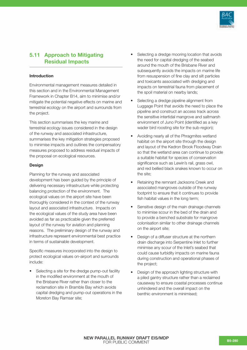
5.11 Approach to Mitigating Residual Impacts
Introduction
Environmental management measures detailed in this section and in the Environmental Management Framework in Chapter B14, aim to minimise and/or mitigate the potential negative effects on marine and terrestrial ecology on the airport and surrounds from the project.
This section summarises the key marine and terrestrial ecology issues considered in the design of the runway and associated infrastructure, summarises the key mitigation strategies proposed to minimise impacts and outlines the compensatory measures proposed to address residual impacts of the proposal on ecological resources.
Design
Planning for the runway and associated development has been guided by the principle of delivering necessary infrastructure while protecting balancing protection of the environment. The ecological values on the airport site have been thoroughly considered in the context of the runway layout and associated infrastructure. Impacts on the ecological values of the study area have been avoided as far as practicable given the preferred layout of the runway for aviation and planning reasons. The preliminary design of the runway and infrastructure represent environmental best practice in terms of sustainable development.
Specific measures incorporated into the design to protect ecological values on-airport and surrounds include:
• Selecting a site for the dredge pump-out facility in the modified environment at the mouth of the Brisbane River rather than closer to the reclamation site in Bramble Bay which avoids capital dredging and pump-out operations in the Moreton Bay Ramsar site;
• Selecting a dredge mooring location that avoids the need for capital dredging of the seabed around the mouth of the Brisbane River and subsequently avoids the impacts on marine life from resuspension of fine clay and silt particles and toxicants associated with dredging and impacts on terrestrial fauna from placement of the spoil material on nearby lands;
• Selecting a dredge pipeline alignment from Luggage Point that avoids the need to place the pipeline and construct an access track across the sensitive intertidal mangrove and saltmarsh environment of Juno Point (identified as a key wader bird roosting site for the sub-region);
• Avoiding nearly all of the Phragmites wetland habitat on the airport site through the design and layout of the Kedron Brook Floodway Drain so that the wetland area can continue to provide a suitable habitat for species of conservation significance such as Lewin’s rail, grass owl, and red bellied black snakes known to occur on the site;
• Retaining the remnant Jacksons Creek and associated mangroves outside of the runway footprint to ensure that it continues to provide fish habitat values in the long term;
• Sensitive design of the main drainage channels to minimise scour in the bed of the drain and to provide a benched substrate for mangrove colonisation similar to other drainage channels on the airport site;
• Design of a diffuser structure at the northern drain discharge into Serpentine Inlet to further minimise any scour of the Inlet’s seabed that could cause turbidity impacts on marine fauna during construction and operational phases of the project;
• Design of the approach lighting structure with a piled gantry structure rather than a reclaimed causeway to ensure coastal processes continue unhindered and the overall impact on the benthic environment is minimised;
NEW PARALLEL RUNWAY DRAFT EIS/MDP FOR PUBLIC COMMENT B5-280

• Avoiding the construction of a hard seawall structure along the northern foreshore west of the NPR that will avoid construction impacts on birds that use the area as a feeding habitat and occasional roost site;
• Water sensitive drainage design for the completed airfield utilising grassed swales and vegetation buffers underlain by sand for treatment and retention of stormwater that will minimise contaminant export and high velocity flows to local waterways.
Mitigation Measures
Mitigation measures and implementation strategies were developed to target the impacting processes, and incorporated into an overall Environmental Management Framework for the construction phases of the NPR development. Each of these implementation strategies are briefly summarised below:
• Estuarine Fauna Management – Development of an Estuarine Fauna Management Plan, and conduct of a program to relocate targeted species of estuarine fauna within waterways of the NPR footprint;
• Megafauna Management – Site-based management of direct impacts to megafauna, e.g. spotter will undertake regular inspections to survey marine megafauna in the works areas of the lighting structure and foreshore stabilisation works;
• Mangrove establishment in tidal drainage channels – Development and implementation of a Mangrove Establishment Plan in consultation with the Department of Primary Industries and Fisheries;
• Terrestrial Fauna Welfare – Development and implementation of an Animal Welfare and Fauna Movement Plan;
• Terrestrial Flora – Development of a Vegetation Protection and Management Plan to protect biodiversity zones outside the development footprint;
• Foreshore Stabilisation and Approach Lighting Structure Construction – Implementation of construction methods and schedules, which wherever possible minimises potential disturbance
to migratory wader birds and implement an observation program to assess potential shorebird response to construction and operations.
Compensatory Measures
As part of the detailed approvals stage of the project, regulatory permits, approvals and/or licenses will set out similar or additional requirements to the proposed mitigation measures outlined in the previous section.
Implementation of these safeguards, terms and conditions, and other environmental measures are instrumental in achieving compliance with relevant environmental legislation and a high level of environmental performance for the project during its planning, construction and operational phases.
However, it is not possible to avoid or mitigate all ecological impacts given the scale and nature of the project. In summary, the key residual impacts that have been identified in this report from the NPR development are as follows:
• Loss of habitat for fish and estuarine invertebrates at the site specific and local scales; and
• Loss of habitat for a small number of wader birds at the site specific and local scales.
The principal cause of these residual impacts is the reclamation and filling of the Project Area on the airport site which will permanently change the land use within the runway footprint. Given the irreversible nature of the impacts associated with this element of the project, a range of compensatory measures are being proposed to address this loss of habitat.
Rationale for Compensatory Measures
In approaching a compensatory habitat package for the project, the following strategic goals were set:
• Areas to be retained or rehabilitated should compensate the values of the habitat being lost to the greatest extent practicable (e.g. like for like);
• Areas investigated should be site specific, local or sub-regional to the location of the airport;
• Investment should lead to demonstrable, on-the-ground environmental outcomes;
NEW PARALLEL RUNWAY DRAFT EIS/MDP FOR PUBLIC COMMENTB5-281

• In the context of investing resources to retain or rehabilitate habitat areas, management arrangements should be in place to ensure the area can provide those values in the long term.
To this end, BAC looked at a range of on-site and off-site options in consultation with a mangrove mitigation working group made up of State and local agency representatives over the period from 2004–2006.
This process included engaging the Coastal CRC (Co-operative Research Centre) to provide expert advice about on-site mitigation efforts that could lead to improved conservation outcomes involving restoration or creation of new mangrove habitat.
A key conclusion out of the working group process was that the two large mangrove areas on the airport that had been designated as environmentally sensitive areas (at the lower end of Jacksons Creek, and in the Jubilee Creek/Serpentine Inlet area) were regarded as being fairly productive systems and modification to try and enhance these existing environments or create new wetland environments nearby through altering hydrology may lead to a risk of losing current productivity and values.
On-site Measures
As discussed above, mangrove areas on the airport site outside of the NPR development footprint are already afforded protection through Brisbane Airport strategic planning documents. The approved 2003 Brisbane Airport Master Plan and 2004 Brisbane Airport Environment Strategy designate three large mangrove areas on the Airport site (at Jacksons Creek, at Jubilee Creek/Serpentine Inlet and at an area adjoining Pinkenba) comprising an area over 50 ha as significant environmental areas.
The Master Plan provides that these areas are managed to retain their environmental values in a way that does not compromise airport safety, particularly from bird hazard. Provisions in the Airports Act provide for the conservation of environmentally significant areas through specific consideration in the assessment of major development plans and through the application of more rigorous standards for environmental management for matters such as water quality and contaminated land management.
To augment the Master Plan and Airport Environment Strategy and in response to the predicted impacts from the NPR Project, BAC has also prepared a site-based Biodiversity Management Strategy (BMS) 2006.
The BMS aims to protect significant vegetation communities and habitat on the airport site that will conserve and restore biodiversity more effectively than the re-creation of habitat through revegetation.
The BMS has been developed following the extensive survey of the flora and fauna on the site in 2003/2004 and provides a blueprint for the conservation and management of areas with conservation value into the future.
The BMS seeks to protect the conservation assets on-airport land and waters not planned for future use through the identification and mapping of an airport biodiversity zone (see Figure 5.11a). The biodiversity zone is to be managed to conserve these assets in the long term and will be kept free of future development.
As shown in Figure 5.11b the biodiversity zone encompasses a large area (285 ha) consisting of the following vegetation types:
• 40 ha of Phragmites wetland;
• 55 ha of mangrove wetland;
• 18 ha of saltmarsh/saltpan wetland;
• 115 ha of Casuarina plantation;
• 9 ha of unmanaged grassland;
• 4 ha of managed grassland; and
• Approximately 44 ha of aquatic habitat (mainly sub-tidal) in Jacksons Creek and Serpentine Inlet that is contained within the Airport Boundaries
Specifically the proposed biodiversity zone will:
• Protect the tall, unmanaged Phragmites wetland area adjoining Kedron Brook Floodway which provides habitat for the Lewin’s rail and other native fauna such as the eastern grass owl and red-bellied black snake;
NEW PARALLEL RUNWAY DRAFT EIS/MDP FOR PUBLIC COMMENT B5-282

• Protect saltmarsh areas on the airport site that are significant in the context of declining saltmarsh habitat across the Moreton Bay region;
• Maintain the existing migratory wader bird feeding habitat along the airport’s Bramble Bay foreshore and protect the roost site located on a saltpan area along the foreshore east of the existing 01/19 runway;
• Provide additional protection to the existing mangrove areas at Jacksons Creek, Serpentine Inlet and adjacent to Pinkenba declared as significant under the Airport Environment Strategy;
• Retain Casuarina plantations occurring within the perimeter of the biodiversity zone, which provide habitat to a suite of common wildlife.
The ecosystem services provided by the biodiversity zone may be enhanced further when combined with adjoining land held in freehold and managed by the BCC between the Airport Boundary and Kedron Brook Floodway. BAC and BCC are currently exploring co-management of this area as a semi-continuous ecological corridor for the local area.
Subsequent to the runway approval process, the biodiversity zone will be incorporated as conservation areas in the next and sequential Master Plan/Airport Environment Strategy process.
Setting aside land in the biodiversity zone under the BMS is seen as a significant contribution toward compensating impacts from the new runway project on the basis that:
• The areas within the biodiversity zone that are to be retained provide similar values (e.g. fisheries value and bird habitat values) to those being lost in the runway footprint as a result of the reclamation process;
• Retention of areas with established biodiversity and fisheries values on the site provides a tangible and measurable contribution to ecosystem services and avoids risks of rehabilitation or restoration projects not achieving equivalent habitat values over time;
• Setting aside large areas of land and water (285 ha) for conservation purposes is a significant undertaking in the context of the highly urbanised Brisbane Metropolitan area. Maintaining these areas in an undeveloped state contributes to retaining open space and biodiversity values that are being sought to be protected within the South East Queensland region in the longer term;
• BAC can maintain the conservation values of these areas in the long term through subsequent Master Plans and Airport Environment Strategies;
• BAC will continue to privately fund and undertake the required management and maintenance activities on the land to ensure the ecological values of the areas are retained and enhanced where appropriate (estimated to be about $3 Million over a twenty year period).
In addition to setting aside coastal land and waters in the biodiversity zone, the BMS also sets out a range of issue specific biodiversity action plans. Actions under these plans relevant to the airport development projects include:
• Funding further studies and developing management recommendations for long term management of the Lewin’s rail habitat;
• Undertaking best practice attempts to provide an alternative suitable roost site for the pair of white-bellied sea-eagles that nest in the small area of remnant eucalypt in the Project Area that will be displaced by the New Runway footprint. BAC has undertaken an assessment of nearby land that would be suitable for an alternative nest site in consultation with BCC staff. A group of eucalypts on BCC land south of Nudgee Beach (across Kedron Brook Floodway) has been identified as a suitable site. Timing and logistics for establishing the new, alternative nest location is described in the BMS and will be developed further as the project progresses.
NEW PARALLEL RUNWAY DRAFT EIS/MDP FOR PUBLIC COMMENTB5-283

• Exploring the feasibility of rehabilitating mangroves on the southern part of the site (known as the Old Kedron Brook mangroves) as part of the development of the GUP and BAC’s NARP.
Implementation of these action plans is ongoing. A specific management plan is being developed to establish an alternative suitable roost site for the white-bellied sea-eagle in consultation with relevant experts, the Queensland Parks and Wildlife Service and BCC as this activity would need to be undertaken prior to the commencement of any clearing works on the site.
Off-Site Measures
The retention of approximately 55 ha of mangrove, 18 ha of saltmarsh habitat and over 40 ha of sub-tidal marine habitat on the airport site as part of the biodiversity zone will contribute to maintaining fisheries values in the sub-region in the short and long term.
The additional three ha of new mangrove habitat that will be established over time in the main drainage channels will partially offset fisheries values lost as part of the reclamation and augments the broader ‘open’ tidal drainage system on the airport that provides fringe mangrove habitat to local species.
To achieve a net environmental gain and fully offset the loss of mangrove and saltmarsh areas associated with the filling of Jacksons Channel and the remnant sections of Serpentine Creek in the runway footprint, BAC is also investigating a estuarine habitat project involving rehabilitation, monitoring or related activity in an off-site location in the Moreton Bay region.
To this end, key Queensland Government regulatory agencies have supplied BAC with a short list of projects in the regional area related to the rehabilitation of mangrove environments that can be investigated further as part of the EIS process. However, investigation and selection of a suitable project is at an early stage, and further sites or projects will be explored by BAC.
As the residual ecological impacts in question primarily relate to marine plants and fisheries values, it is proposed that the final selection of an off-site compensatory habitat project will occur in consultation with the Queensland Department of Primary Industries and Fisheries. Further discussions with the Department of Environmental and Heritage, Queensland EPA and other regulatory agencies will occur prior to the finalisation of the EIS process.
Separate to this habitat project, BAC is also investigating a project to provide an environmental education facility for the local area related to wetland conservation and management. This will be further discussed and negotiated with the relevant parties as the project progresses.
Conclusion
The overall objective of the compensatory measures proposed is to provide a positive environmental outcome associated with the project through:
• The retention and management of similar habitats and other habitats with conservation value on the airport site (these areas will be set aside for conservation purposes in the biodiversity zone and not developed); and
• Contribution to a project involving estuarine habitat of a similar type and condition to the area to be lost that is situated off the airport site in the surrounding sub-region.
On balance, the on-site measures provided in the Biodiversity Management Strategy and the implementation of an appropriate off-site project, are seen to adequately address the ecological impacts associated with the proposal in a way that leads to positive environmental outcomes.
NEW PARALLEL RUNWAY DRAFT EIS/MDP FOR PUBLIC COMMENT B5-284

Fig
ure
5.11
a:
Bio
dive
rsity
Man
agem
ent S
trat
egy
(BM
S):
Airp
ort B
iodi
vers
ity Z
one
(Yel
low
Cro
ss H
atch
).
NEW PARALLEL RUNWAY DRAFT EIS/MDP FOR PUBLIC COMMENTB5-285

Fig
ure
5.11
b:
Bio
dive
rsity
Zon
e: V
eget
atio
n C
omm
uniti
es F
ollo
win
g C
onst
ruct
ion
of th
e N
PR
and
Ass
ocia
ted
Infra
stru
ctur
e.
NEW PARALLEL RUNWAY DRAFT EIS/MDP FOR PUBLIC COMMENT B5-286

This page has been left blank intentionally.
NEW PARALLEL RUNWAY DRAFT EIS/MDP FOR PUBLIC COMMENTB5-287