terrestrial ecosystem mapping for the...
TRANSCRIPT

TERRESTRIAL ECOSYSTEM MAPPING for the
CLAYOQUOT SOUND AREA
YEAR FOUR
for:
MINISTRY OF SUSTAINABLE RESOURCE MANAGEMENT
NANAIMO FOREST DISTRICT
by:
MADRONE CONSULTANTS LTD. 1877 HERD ROAD, DUNCAN, B.C. V9L 5W4
MARCH 2002

Clayoquot Sound Ecosystem Inventory: Acknowledgements Year Four
Madrone Consultants Ltd. ii
ACKNOWLEDGEMENTS Madrone Consultants Ltd. would like to acknowledge the contribution that the following people made to the completion of the year four Clayoquot Sound Ecosystem Inventory Study. Bioterrain typing in year 4 has been the sole responsibility of Marian Oden. Deepa Filatow of the Ministry of Sustainable Resource Management (MSRM) correlated this typing. Ecosystem mapping has been the work of Helen Reid and Harry Williams; Ted Lea (MSRM) provided external correlation of the ecosystem mapping. Shari Willmott coordinated the mapping and the report. Tina Younker, Shar Gundersen and Shari Willmott built the datasets. Kate Miller and Julie Williams were a great help providing the background knowledge for years one to three and the required steps to complete a Terrestrial Ecosystem Mapping (TEM) project. Gillian Radcliffe was responsible for the senior quality assurance and review of the project. Digital data capture was performed by Chartwell Consultants Limited – Cherie Stutz, Evelyn Parsons, and Tim Hawker. Dan Sirk (MSRM) provided GIS support and Derek Challenger (MSRM) was the contract administrator.
Clayoquot Sound Ecosystem Inventory: Table of Contents Year Four
Madrone Consultants Ltd. iii
TABLE OF CONTENTS ACKNOWLEDGEMENTS........................................................................................................ ii LIST OF TABLES................................................................................................................... iv LIST OF FIGURES ................................................................................................................. iv 1.0 INTRODUCTION............................................................................................................ 5
1.2 Year Four Study Area......................................................................................................... 7 2.0 METHODOLOGY........................................................................................................... 9
2.1 Data Sources ...................................................................................................................... 9 2.2 Fieldwork............................................................................................................................. 9 2.3 Ecosystem Classification.................................................................................................... 9 2.4 Digital Mapping and Database Production......................................................................... 9 2.5 Data Limitations and Map Reliability ................................................................................ 10
3.0 BIOPHYSICAL DESCRIPTION OF THE STUDY AREA............................................. 11
3.1 Terrain............................................................................................................................... 11 3.1.1 Clayoquot River ..................................................................................................... 11 3.1.2 Kennedy Lake........................................................................................................ 11 3.1.3 Vargas Island/Esowista Peninsula/Pacific Rim National Park ............................... 12
3.2 Biogeoclimatic zones........................................................................................................ 12 3.3 Ecosystems ...................................................................................................................... 13
3.3.1 Coastal Western Hemlock Zone, Very Wet Hypermaritime Subzone (CWHvh1) .. 13 3.3.2 Coastal Western Hemlock Zone, Very Wet Maritime Subzone, Submontane and Montane Variants (CWHvm1 and vm2)........................................................................... 14 3.3.3 Mountain Hemlock Zone, Moist Maritime Subzone, Windward Variant (MHmm1 and mmp1) ...................................................................................................................... 15
4.0 ECOSYSTEM DESCRIPTIONS................................................................................... 20
4.1 Vegetation Descriptions.................................................................................................... 23 4.2 Coastal Western Hemlock Zone, Very Wet Hypermaritime Subzone, Southern Variant (CWHvh1) ................................................................................................................................... 24
4.2.1 Forested Site Series .............................................................................................. 24 4.2.1.1 Western hemlock – Sitka spruce – Lanky moss.............................................. 24 4.2.1.2 Sitka spruce - Trisetum ................................................................................... 25
4.3 Coastal Western Hemlock Zone, Very Wet Maritime Subzone, Submontane and Montane Variants (CWHvm1 and vm2) ..................................................................................... 26
4.3.1 Forested Site Series .............................................................................................. 26 4.3.1.1 Amabilis fir – Sitka spruce – Devil’s club......................................................... 26
4.3.2 Sparsely Vegetated, Non-Vegetated, and Anthropogenic Units of the CWHvh1 .. 27 4.3.2.1 Golf Course ..................................................................................................... 27 4.3.2.2 Urban / Suburban............................................................................................ 27
4.4 Mountain Hemlock Zone, Moist Maritime Subzone, Windward Variant (MHmm1 and MHmmp1) ................................................................................................................................... 28
4.4.1 Forested Site Series .............................................................................................. 28 4.4.1.1 Mountain hemlock – Amabilis fir - Bramble..................................................... 28 4.4.1.2 Mountain hemlock – Yellow Cedar – Deer Cabbage ...................................... 29
4.4.2 Sparsely Vegetated, Non-Vegetated, and Anthropogenic Units............................ 30 4.4.2.1 Pond................................................................................................................ 30

Clayoquot Sound Ecosystem Inventory: Table of Contents Year Four
Madrone Consultants Ltd. iv
5.0 References.................................................................................................................. 31 6.0 Appendices................................................................................................................. 32
6.1 Appendix I: Site Modifiers for Atypical Conditions .......................................................... 32 6.2 Appendix II: Structural Stages and Codes ...................................................................... 34 6.3 Appendix III: Soil Classification ....................................................................................... 36
LIST OF TABLES Table 1. Landscape Units Mapped .......................................................................................... 7 Table 2. Ecosystems with the same map code but different places on the edatopic grid for
each BEC subzone.......................................................................................................... 10 Table 3: Ecosystems of the Kennedy/Beach Study Area...................................................... 17 Table 4. Clayoquot Sound: Coastal Western Hemlock Zone, Very Wet Hypermaritime
Subzone, Southern Variant (CWHvh1) Forested Site Series .......................................... 21 Table 5. Clayoquot Sound: Coastal Western Hemlock Zone, Very Wet Maritime Subzone,
Submontane and Montane Variants (CWH vm1 and vm2) Forested Site Series............ 21 Table 6. Clayoquot Sound – CWH Sparsely Vegetated, Non-Vegetated, and Anthropogenic
Units ................................................................................................................................ 21 Table 7. Clayoquot Sound: Mountain Hemlock Zone, Moist Maritime Subzone, Windward
Variant (MHmm1) and Parkland Variant (MHmmp1) Forested Site Series ..................... 22 Table 8. Clayoquot Sound - MH Sparsely Vegetated, Non-Vegetated, and Anthropogenic
Units 22 LIST OF FIGURES Figure 1: Clayoquot Study Areas. ............................................................................................ 6 Figure 2: Kennedy/Beach Study Area...................................................................................... 8

Clayoquot Sound Ecosystem Inventory: Introduction Year Four
Madrone Consultants Ltd. 5
1.0 INTRODUCTION The objective of this project is to classify, map at a scale of 1:20,000, and describe the natural ecosystems within the study area according to Resource Inventory Committee (RIC) Standards of 1998.
Project Scope and History This report is the year four partial completion of a Multi-year Inventory Study conducted by Madrone Consultants Limited (MCL) on behalf of the Ministry of Forests (MOF) and the Ministry of Sustainable Resource Management (MSRM). The project was initiated in 1995, and was funded by Forest Renewal B.C. as part of the Forest Renewal Plan (FRP) announced April 14, 1994, by the Government of British Columbia. It is part of an Integrated Terrain Stability, Terrestrial Ecosystem, Hydroriparian, and Landslide Inventory of Clayoquot Sound, British Columbia.
The project intention was to map the entire area of Clayoquot Sound over a four-year period. However, due to an interruption in funding, there was a hiatus in the project from 1999 to 2001. At the present time (2002), the ecosystem mapping for Clayoquot Sound has been largely completed for all potentially operational areas and many protected areas. However, two large protected watershed units, the Moyeha and the Megin, remain unmapped, and Meares Island is also unmapped. At this point no funding has been made available to complete these areas and thus meet the original intent of the project. Figure 1 illustrates the ecosystem mapping for Clayoquot Sound Study Area by project year; the information is also summarized in Table 1. The Year One (1996–1997) portion of the project comprised seven separate subsets of specific watershed units within Clayoquot Sound; a further five watershed units were completed in Year Two (1997–1998) and two more in Year Three (1998-1999). These areas are described in the Clayoquot Year Three Interim Report (Madrone 1999). The project resumed in Year Four (2001-2002), with the mapping of one large contiguous area made up of three watershed units; Clayoquot River, Kennedy Lake, and Beach watershed units. Collectively this area has been generally referred to as Kennedy/Beach, and is the focus of this report.

Clayoquot Sound Ecosystem Inventory: Introduction Year Four
Madrone Consultants Ltd. 6
Figure 1: Clayoquot Study Areas.
Clayoquot Sound Ecosystem Inventory: Introduction Year Four
Madrone Consultants Ltd. 7
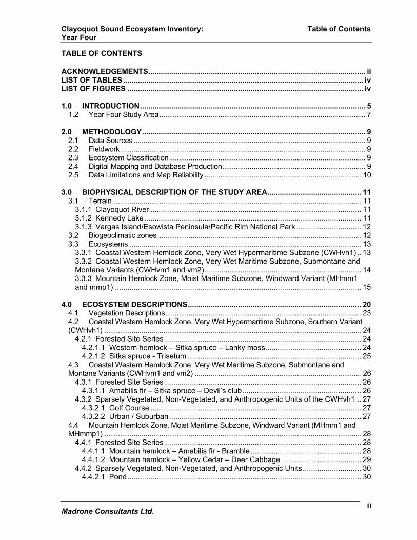
Table 1. Landscape Units Mapped
Year One (1996-97) 1.1.1.1.1.1.1 Size in Hectares
Bedwell 5,543 Catface/Cypre/Cotter 19,214
Fortune Channel 6,719 Hesquiat Peninsula 10,841
Sydney River 5,594 Tofino Creek 4,503
Tranquil Creek 5,871 total 58,285
Year Two (1997-98) Size in Hectares Atleo 10,634
Hesquiat 15,245 Marble 723
Pretty Girl 10,795 Ursus Creek 7,349
total 44,746 Year Three(1998-99) 1.1.1.1.1.1.2 Size in
Hectares Kennedy River 22,347 Muriel Ridge 3,627
total 25,974 Year Four(2001-02) 1.1.1.1.1.1.3 Size in
Hectares Kennedy/Beach 43,793
total 43,793 1.2 Year Four Study Area The year four study area is collectively referred to as Kennedy/Beach and is comprised of three watershed units: Clayoquot River, Kennedy Lake and the Beach, illustrated in figure 2. It extends from sea level to an elevation of approximately 1500m. Kennedy/Beach lies at the eastern end of the Clayoquot Sound study area, with Kennedy River to the east and Tofino Creek, Marble and Muriel Ridge to the west. The northern boundary edge matches to these years one, two and three study areas. The southern boundary follows the shoreline extending from the Tofino Peninsula, including Vargas Island, to Wya Point on Florencia Bay. The southeastern boundary follows the height of land using the 1:50,000 NTS definition as extracted from the provincial 1:50,000 watershed atlas from the coast up to the southern end of the year three Kennedy River study area. The total area is approximately 43,793 hectares.

Clayoquot Sound Ecosystem Inventory: Introduction Year Four
Madrone Consultants Ltd. 8
Figure 2: Kennedy/Beach Study Area.
Pacific Ocean
Vancouver Island
BritishColumbia
Kennedy/BeachStudy Area
Kennedy Lake
Tofino#
Pacific OceanHwy4
Hwy4

Clayoquot Sound Ecosystem Inventory: Methodology Year Four
Madrone Consultants Ltd. 9
2.0 METHODOLOGY 2.1 Data Sources Plot data and maps from earlier work conducted for International Forest Products Limited (Interfor) (Madrone Consultants Ltd. 1995, 1996), the Ministry of Forests (Lewis, 1992), and the Ministry of the Environment, Lands and Parks have been used in the production of the maps. Forest cover maps and TRIM sheets were used for tree cover and topographic information. Colour aerial photography at 1:17,500 (1996) was used for the Year Four areas. 2.2 Fieldwork
Field sampling was not carried out for Year Four. Previous extensive fieldwork in the Clayoquot Sound Study Area provided a solid knowledge base of the ecosystems encountered in the study area. References were made to field plot data and maps from adjacent historic projects during air photo interpretation, and photo-typing was edge matched where applicable. 2.3 Ecosystem Classification Classification and presentation of the mapping follow the methodology documented in Standard for Terrestrial Ecosystem Mapping in British Columbia, (1998). Each ecosystem unit (site series) is assigned a two-letter symbol, and identified using The Field Guide for Site Identification and Interpretation for the Vancouver Forest Region (Green and Klinka, 1994). Sparsely vegetated, non-vegetated, and anthropogenic units are also assigned two-letter symbols (RIC 1998). New ecosystem symbols have been assigned to any remaining ecosystems identified in the area. Aspect site modifiers have been applied to steep slopes (>35%), and soil depth modifiers and landform features have been applied to atypical sites using the current Site Series Master Coding List. Structural stages describe the current vegetation stage by a seven level system that has been modified from Hamilton (1988). Tables 4 to 8 list the ecosystems identified by subzone/variant, structural stages, and some environmental parameters associated with each ecosystem. 2.4 Digital Mapping and Database Production Parkland boundaries were identified on the air photos, and bioterrain polygons were delineated. These polygons were sometimes further subdivided for ecosystem labeling on the basis of aspect or structural stage variation. The air photos were then digitized. Biogeoclimatic boundaries for the Mountain Hemlock (MH) and Coastal Western Hemlock (CWH) zones were added to the resultant maps and these boundaries were also added to the air photos. The polygons cut by these boundaries were adjusted to avoid creating minute sliver polygons. The polygons were numbered at this time to facilitate data entry of bioterrain and ecosystem attributes for each polygon. Polygon attributes were entered into the provincial bioterrain and ecosystem database, which was downloaded from the TEM website. The data was then reviewed using the data capture (DC) Tool to ensure that the database was error-free. Once the database was clean, ecosystem labels were added to the maps and the final map legend was produced. Draft maps were plotted and reviewed for final edits before producing digital maps and attribute files for delivery.
Clayoquot Sound Ecosystem Inventory: Methodology Year Four
Madrone Consultants Ltd. 10
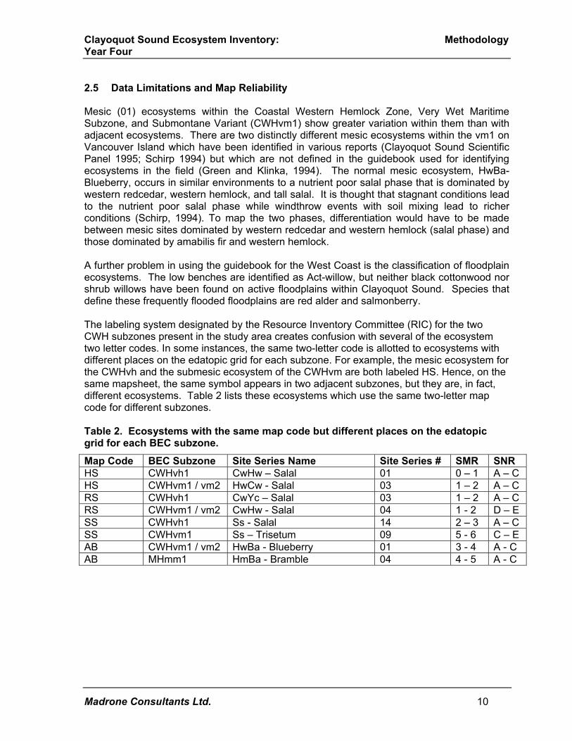
2.5 Data Limitations and Map Reliability Mesic (01) ecosystems within the Coastal Western Hemlock Zone, Very Wet Maritime Subzone, and Submontane Variant (CWHvm1) show greater variation within them than with adjacent ecosystems. There are two distinctly different mesic ecosystems within the vm1 on Vancouver Island which have been identified in various reports (Clayoquot Sound Scientific Panel 1995; Schirp 1994) but which are not defined in the guidebook used for identifying ecosystems in the field (Green and Klinka, 1994). The normal mesic ecosystem, HwBa-Blueberry, occurs in similar environments to a nutrient poor salal phase that is dominated by western redcedar, western hemlock, and tall salal. It is thought that stagnant conditions lead to the nutrient poor salal phase while windthrow events with soil mixing lead to richer conditions (Schirp, 1994). To map the two phases, differentiation would have to be made between mesic sites dominated by western redcedar and western hemlock (salal phase) and those dominated by amabilis fir and western hemlock. A further problem in using the guidebook for the West Coast is the classification of floodplain ecosystems. The low benches are identified as Act-willow, but neither black cottonwood nor shrub willows have been found on active floodplains within Clayoquot Sound. Species that define these frequently flooded floodplains are red alder and salmonberry. The labeling system designated by the Resource Inventory Committee (RIC) for the two CWH subzones present in the study area creates confusion with several of the ecosystem two letter codes. In some instances, the same two-letter code is allotted to ecosystems with different places on the edatopic grid for each subzone. For example, the mesic ecosystem for the CWHvh and the submesic ecosystem of the CWHvm are both labeled HS. Hence, on the same mapsheet, the same symbol appears in two adjacent subzones, but they are, in fact, different ecosystems. Table 2 lists these ecosystems which use the same two-letter map code for different subzones. Table 2. Ecosystems with the same map code but different places on the edatopic grid for each BEC subzone.
Map Code BEC Subzone Site Series Name Site Series # SMR SNR HS CWHvh1 CwHw – Salal 01 0 – 1 A – C HS CWHvm1 / vm2 HwCw - Salal 03 1 – 2 A – C RS CWHvh1 CwYc – Salal 03 1 – 2 A – C RS CWHvm1 / vm2 CwHw - Salal 04 1 - 2 D – E SS CWHvh1 Ss - Salal 14 2 – 3 A – C SS CWHvm1 Ss – Trisetum 09 5 - 6 C – E AB CWHvm1 / vm2 HwBa - Blueberry 01 3 - 4 A - C AB MHmm1 HmBa - Bramble 04 4 - 5 A - C
Clayoquot Sound Ecosystem Inventory: Biophysical Descriptions Year Four
Madrone Consultants Ltd. 11
3.0 BIOPHYSICAL DESCRIPTION OF THE STUDY AREA Clayoquot Sound stretches along the West Coast of Vancouver Island for approximately 95 km, from Nootka Sound in the north to the middle of Florencia Bay in the south. Elevation ranges from sea level to the alpine, but most of the area lies below 800 m. 3.1 Terrain
3.1.1 Clayoquot River The Clayoquot River watershed group is characterized by a large, U-shaped glacial valley, which contains the Clayoquot River as well as several large tributaries. The tributary valleys are typically narrow and V-shaped. Several hanging valleys exist towards the headwaters of the river, with several hundred meters of elevation separating the main river valley from the hanging valleys. The terrain in this region of Clayoquot Sound is strongly bedrock controlled, and as a result, many of the slopes reflect the nature of the underlying bedrock, and bedrock outcrops are abundant. Surficial materials mapped in the study area include till, colluvium, fluvial and glaciofluvial deposits, and organics. Rockfall, rock slides, gullying, debris slides, debris torrents, and snow avalanches are all geomorphic processes common in the headwaters of the Clayoquot River, resulting in an abundance of colluvium. Till deposits are essentially absent in this portion of the study area. The valley bottom along the headwaters of the river is wide and gentle to moderately sloping, and there are several small lakes. A few of the lakes occupy large bedrock depressions carved by ice, while others were created by the encroachment of colluvial fans on the valley floor, eventually impounding the Clayoquot River. The mid and lower valley of the Clayoquot River are characterized by steep sidewalls, extensive bedrock outcrops, and active geomorphic processes. Rockfall, rockslides, gullying, debris slides, and debris torrents are common to the area. Till deposits are common on the lower slopes as a blanket, and taper to a veneer on mid and upper slopes while colluvium deposits vary in depth, and are deep at the base of large bedrock bluffs. Glaciofluvial deposits have been mapped as a set of terraces on either side of the mouth of a tributary valley. There was no field verification of the material, but it is likely well-drained coarse gravels. Extensive fluvial deposits are present on the wide floodplain. Organics have been mapped in a few isolated places within a hanging valley. This material however is not common in the area. The tributary valleys generally have a steep gradient as well as steep sidewalls. Soils are shallow and bedrock exposures are common. Colluvial deposits dominate the surficial materials, with till deposits restricted to the lower slopes along the lower reaches of the valleys.
3.1.2 Kennedy Lake Steep slopes characterize the majority of the Kennedy Lake study area, with gentle slopes dominating the southwestern portion. Throughout much of the area, the steep terrain is associated with the many bedrock outcrops and bluffs. However, the mid and lower reaches
Clayoquot Sound Ecosystem Inventory: Biophysical Descriptions Year Four
Madrone Consultants Ltd. 12
of several of the creeks and rivers, including the Sand River, are incised in deep till and colluvial deposits. These oversteepened slopes are inherently unstable. Surficial materials mapped in this area include till, colluvium, glaciomarine sediments, fluvial deposits, and organics. Rockfall, rockslides, gullying, debris slides, and debris torrents are common geomorphic processes in the area. Although these are natural processes, this area has been heavily logged, and the majority of the debris slides and debris torrents are logging related. These events transfer large volumes of material from the upper slopes to the lower slopes and valley bottoms, creating a complex of colluvial cones and fans. These processes are common in the Sand River watershed and upslope of Highway 4 on the southeast side of Kennedy Lake. The peninsula that divides the upper portion of the lake includes a broad ridgeline and broad hanging valleys. Small lakes dot the ridgeline. Surficial materials mapped in this area include a till mantle of varying depth and colluvium. The gentle slopes on the Kennedy Flats (southwestern portion of the study area) are the result of a raised sea level during glacial times, and are blanketed with deep glaciomarine/marine deposits. Scattered, steep-sided bedrock knobs with till deposits and colluvium protrude above these gentle slopes. Organic soils have been extensively mapped in the area, reflecting the poor to imperfect drainage conditions of the area. Fluvial deposits have been mapped along the larger streams and Kennedy River, adjacent to the outflow of Kennedy Lake.
3.1.3 Vargas Island/Esowista Peninsula/Pacific Rim National Park Predominantly gentle slopes characterize the Esowista Peninsula and Vargas Island study area. Surficial materials are dominated by marine and glaciomarine sediments, with till deposits present on the scattered bedrock outcrops. A massive deposit of glaciofluvial sediments is located on the southeastern portion of the study area. Gentle to flat slopes characterize this area. The till deposits are draped as a mantle of varying depth over the bedrock, reflecting the irregular nature of the bedrock. Marine sediments include the many sandy beaches in the area, as well as the extensive muddy tidal flats on the north side of the peninsula. Marine and glaciomarine sediments have also been mapped along the southern portion of this study area adjacent to the Kennedy Flats described above. Organic soils are common and have been mapped in association with the finer marine materials. 3.2 Biogeoclimatic zones There are two biogeoclimatic zones within the Kennedy/Beach study area, the Coastal Western Hemlock (CWH) Zone and the Mountain Hemlock (MH) Zone. The CWH is represented by the Southern Very Wet Hypermaritime, Submontane Very Wet Hypermaritime and Montane Very Wet Hypermaritime Variants (vh1, vm1 and vm2 respectively) and occurs between sea level and 800 m. The Windward Moist Maritime Variant (mm1), which occurs above 800 m and the Parkland Subzone (mmp1) which generally occurs above 1200 m to

Clayoquot Sound Ecosystem Inventory: Biophysical Descriptions Year Four
Madrone Consultants Ltd. 13
1300 m represent the MH Zone. The MH zone is continuous along the ridgetops, except in some areas, where elevations drop below 800 m. 3.3 Ecosystems A complete list of ecosystems that have been mapped in the area appears in Table 3. Logging is extensive throughout the southern portion of the study area, including Kennedy Flats, the beach area, Tofino, Grice Bay, the northern side of Kennedy Lake and the eastern side of Clayoquot Arm.
3.3.1 Coastal Western Hemlock Zone, Very Wet Hypermaritime Subzone (CWHvh1) Floodplain ecosystems occur throughout the CWHvh1 subzone. Several patches of old growth high bench sites (SL) stands are scattered along river tributaries in the Tofino-Beach area. The majority of the high bench floodplains, once conifer stands, are now herbaceous, shrubby, or very young forests due to logging. Several low bench floodplains (AL), dominated by alder, are found adjacent to gravel bars (GB). The rich, moist ecosystem (SD) occurs where moisture is abundant and drainage is not impeded. These ecosystems are most common adjacent to creeks and on fluvial fans. They occur frequently throughout the vh1. Most units are logged. Scattered coastal-forested units (SK, SS, SW) are often stunted by high coastal winds. As a result structural stages vary from 4-6. Where logging has occurred these forests are generally structural stages 3 or 4. The dune grass ecosystem (DS) is scattered along the coastline adjacent to sandy beaches. The grass dominated estuary ecosystem (GS) is mapped in several areas within the vh1. This ecosystem is extensive along the north side of Esowista Peninsula and is found adjacent to the mudflats (MU) in Grice Bay. Both sandy and rocky beaches (BE) are mapped along the intertidal zone on the south side of the study area. Poorly drained bog forests (YG) are quite common in the vh1 where the terrain is hummocky. Several bog woodland forests (LS) are scattered throughout the vh1 where water movement is impeded and organic deposits have accumulated. Wetter, but richer forests (RC) occur where water movement is less impeded. These units are quite common within this study area. Most sites are logged. Several herbaceous wetland types occur within the vh1. A richer wetland (SB) is mapped adjacent to Ilthpaya Lake as well as the treeless bogs (SM) associated with bog forests (YG), The richer mesic ecosystem (SF) occurs on lower colluvial slopes and on level areas adjacent to the wetter (SD) sites and on fluvial fans. The most common ecosystem occurring within the vh1 is the mesic forest unit (HS). These sites occur on shallow to deep soils, on hummocky terrain, and on steep sites. Poorer submesic forests (RS) are common in the vh1 and generally occur on shallow soils above or adjacent to mesic (HS) forests. The very dry pine ecosystem (LR) often occurs in complexes with submesic ecosystems and rock outcrops (RO). Several alder and

Clayoquot Sound Ecosystem Inventory: Biophysical Descriptions Year Four
Madrone Consultants Ltd. 14
salmonberry dominated slope failures are scattered throughout the area. Many of these slope failures have occurred during years of heavy rain in Clayoquot Sound. The town of Tofino and outlying urbanized areas are mapped as (UR). One golf course (GC) is located in the Grice Bay area.
3.3.2 Coastal Western Hemlock Zone, Very Wet Maritime Subzone, Submontane and Montane Variants (CWHvm1 and vm2)
In the CWHvm, floodplain ecosystems occur primarily along Clayoquot River. Other sites are found along the mouth of Kennedy River and scattered on larger creeks throughout the watershed. The majority of these ecosystems are high bench sites (SS), and most of those found along Clayoquot River are old growth stands. Most sites are logged along the tributaries draining into Kennedy Lake, as well as on the Kennedy flats. Frequently flooded shrubby ecosystems (CW) are rare within the study area and are generally found adjacent to gravel bars (GB) on the main river and some tributaries. Moist, nutrient rich forests (AS) are common near the Clayoquot River and other tributaries throughout the study area where soils are deep and moisture is abundant. Many of these ecosystems have been logged and are herbaceous or shrubby. Moist, nutrient poor ecosystems (HD) occur on steep north and northwest-facing seepage slopes. These forests are scattered throughout the watershed but are most common in the vm2. Bog forests (YG) are common throughout the vm where slopes are gentle to flat or hummocky. These ecosystems generally occur in complexes with the mesic (AB) or drier (HS) ecosystems. Several bog woodland forests (LS) are located within the vm, one of which is mapped in a complex with a treeless bog (SM). The wet but richer skunk cabbage forests (RC) are also mapped within the study area. These forests are infrequent, and most are logged. A shrubby wetland (WS), rare in Clayoquot, was mapped adjacent to Norgar Lake, where seepage is abundant. Rich mesic forests (AF) are present throughout the study area. They are usually found on colluvial and fluvial fans, on lower slopes of valleys, where soils are deep. Mesic forests (AB) are the most typical ecosystem within the vm. They occur on all aspects and elevations. Soils are generally deep, but many of these forests are also located on shallow soils, especially at higher elevations. Subxeric forests (HS) are usually found on the upper slopes and in areas where the terrain is hummocky and soils are thin. They are often found in complexes with mesic forests (AB), wet forests (YG) and xeric pine forests (LC). Rock outcrops (RO) are common, usually complexed with dry forests (LC). Shrub dominated avalanche track ecosystems (SA) are found at the heads of valleys in the CWHvm, while herbaceous sites (IF), rarely mapped in Clayoquot Sound, are mapped at toe

Clayoquot Sound Ecosystem Inventory: Biophysical Descriptions Year Four
Madrone Consultants Ltd. 15
of several avalanche tracks in the Clayoquot River watershed. Steep talus slopes are scattered near the headwaters of tributaries going into the river. Several recent slides or slope failures (ES) have occurred in the vm. Older slope failures, vegetated by red alder (AW), are scattered but infrequent. According to the field guide for this area (Green and Klinka, 1994), the CwSs-Goldthread ecosystem (YG) is rare in the vm1. However, in the Clayoquot Sound area, this ecosystem is quite common, found from sea level up to the higher elevations of vm2 on poorly drained gentle slopes.
3.3.3 Mountain Hemlock Zone, Moist Maritime Subzone, Windward Variant (MHmm1 and mmp1)
One ecosystem that normally occurs in the MH zone was mapped within the CWH. The moist ecosystem (MT) was observed during fieldwork for year three in the CWHvm1 and vm2 on north facing slopes in the upper reaches of the Clayoquot River valley. The high percentage of copper bush and mountain hemlock on these sites is similar to those sites found in the MH zone. This site was also mapped in the adjacent Kennedy River valley where field-sampling crews noted a high cover of mountain hemlock. Scattered mountain hemlock was also present on zonal sites as low as 500 m. Copper bush also was noted to have an unusually high percent cover in the CWH, particularly on poorer sites where it is often dense. The MH zone in the Clayoquot River watershed is found on most upper slopes. Many of these slopes are extremely steep and rocky. The wet, rich forests (MT) are scattered through the MH. These ecosystems occur close together and cannot be separated by air photo interpretation. The subhygric unit, MT, occurs on steep seepage slopes, while the hygric unit, (MD) occurs on lower receiving slopes just below MT. Both units occur on deep soils. Wetlands are rare in the MH zone. Several pockets of fen units (SC) are mapped. These wetlands are generally associated with ponds (PD). Mesic forests (MB) are the most common ecosystem found in this zone and occur on all aspects and slopes. Soils are generally deep, but these units are also often found on shallow and very shallow soil. Rich mesic forests (MO) are scattered throughout, where soils are deep. They are often on colluvial fans and lower slopes near the headwaters of tributaries. Several sites are located on slopes adjacent to small lakes. Subxeric parkland (MM) and rock (RO) occur near and along ridgetops where soils are very shallow. Terrain is often hummocky. Krummholz vegetation (MK) occurs above 1200 m in the MHmmp1 where severe climatic conditions maintain the conifer vegetation in a shrubby form. Mountain heather meadows (MH) occur at these high elevations and are usually in complexes with rock outcrops (RO). Limestone bedrock occurs on Steamboat Mountain and adjacent ridges of Clayoquot

Clayoquot Sound Ecosystem Inventory: Biophysical Descriptions Year Four
Madrone Consultants Ltd. 16
Plateau. The ridgetops are sparsely vegetated with scattered herbs and pockets of heath (MH) and Krummholz (MK). Hedysarum occidentals, a blue-listed species, has been collected from the limestone rock outcrops and talus slopes (TA) in this area, during the Kennedy River mapping fieldwork in year three. Avalanche track vegetation occurs near the headwaters of creeks. Most avalanche tracks consist of shrubby vegetation (SA).

Clayoquot Sound Ecosystem Inventory: Biophysical Descriptions Year Four
Madrone Consultants Ltd. 17
Table 3: Ecosystems of the Kennedy/Beach Study Area Coastal Western Hemlock Zone, Very Wet Hypermaritime Subzone (CWHvh1) Ecosystem Unit BEC Site Series Structural
Stages Forested Site Series AL Red Alder – Lily-of-the-Valley
10 Dr-Lily-of-the-Valley
3
HM Western Hemlock – Sitka Spruce – Lanky Moss
04 HwSs – Lanky Moss 6
HS Western Redcedar – Western Hemlock - Salal 01 CwHw - Salal
2, 3, 4, 5, 6, 7
LR Lodgepole Pine – Yellow Cedar - Racomitrium
02 PlCy - Racomitrium
3, 3b, 4, 5, 6, 7
LS Lodgepole Pine – Yellow Cedar - Sphagnum 12 PlCy - Sphagnum
2, 3b, 4, 5, 6, 7
RC Western Redcedar- Sitka Spruce – Skunk Cabbage
13 CwSs – Skunk Cabbage 3, 4, 5, 6, 7
RF Western Redcedar – Sitka Spruce – Sword Fern
05 CwSs – Sword Fern 3, 5, 7
RS Western Redcedar – Yellow Cedar - Salal
03 CwCy - Salal 3, 4, 5, 6, 7
SD Western Redcedar – Sitka Spruce – Devil’s Club
07 CwSs – Devil’s Club
2b, 3, 4, 5, 6, 7
SF Western Redcedar - Sitka Spruce - Foamflower
06 CwSs - Foamflower
3, 4, 5, 6, 7
SK Sitka Spruce – Kindbergia 15 Ss - Kindbergia 1, 3b, 4, 5, 6, 7
SL Sitka Spruce – Lily-of-the-Valley
08 Ss – Lily-of-the-Valley 3, 4, 5, 6, 7
SS Sitka Spruce - Salal 14 Ss – Salal 3, 4, 5, 7 ST Sitka Spruce - Trisetum 09 Ss – Trisetum 2 SW Sitka Spruce – Sword Fern 17 Ss – Sword Fern 2, 4, 5, 7 YG Western Redcedar Yellow Cedar - Goldthread 11 CwYc - Goldthread
3, 3b, 4, 5, 6, 7
Deciduous, Shrub and Herb Dominated Ecosystems AW Red Alder - Fern - 3 DS Dunegrass - Silverweed - 2b GS Tufted Hairgrass - Silverweed Estuarine Marsh
- 2b
SB Sedge – Buckbean Marsh - 2b, 5, 7 SM Sweet Gale – Sphagnum - 2a, 3a, 3b, Sparsely Vegetated, Non-Vegetated and Anthropogenic Units BE Beach - 1 ES Exposed Soil - 1 GB Gravel Bar - 1 GC Golf Course - 2 LA Lake - - MU Mudflat Sediment - - OW Shallow Water - -

Clayoquot Sound Ecosystem Inventory: Biophysical Descriptions Year Four
Madrone Consultants Ltd. 18
Table 3 continued: Coastal Western Hemlock Zone, Very Wet Hypermaritime Subzone, (CWHvh1) continued: Ecosystem Unit BEC Site Series Structural
Stages Sparsely Vegetated, Non-Vegetated and Anthropogenic Units PD Pond - - RO Rock Outcrop - 1 UR Urban/suburban - - Coastal Western Hemlock Zone, Very Wet Maritime Subzone, Submontane and Montane Variants (CWHvm1 and vm2) Ecosystem Unit BEC Site Series Structural
Stages Forested Site Series AB Western Hemlock- Amabilis Fir - Blueberry
01 HwBa - Blueberry
1, 3, 4, 5, 6, 7
AD Amabilis Fir – Sitka Spruce – Devil’s Club
08 BaSs – Devil’s Club 3, 4, 5, 6, 7
AF Amabilis Fir - Western Redcedar - Foamflower
05 BaCw - Foamflower
3, 4, 5, 7
AS Amabilis Fir - Western Redcedar - Salmonberry
07 BaCw - Salmonberry
1, 3, 4, 5, 7
CW Black Cottonwood – Willow
vm1 11 Act - Willow
3, 4, 7
HD Western Hemlock - Amabilis Fir - Deer Fern
06 HwBa -Deer Fern
3, 4, 5, 7
HS Western Hemlock -Western Redcedar - Salal
03 HwCw - Salal 3, 4, 5, 6, 7
LC Western Hemlock -Lodgepole Pine - Cladina
02 HwPl - Cladina
2b, 3, 4, 5, 6, 7
LS Lodgepole Pine - Sphagnum
vm1 13, vm2 10, PL - Sphagnum
3b, 5, 6, 7
MT Amabilis Fir - Mountain Hemlock - Twisted Stalk
MHmm1 05 BaHm - Twistedstalk
7
RC Western Redcedar- Sitka Spruce – Skunk Cabbage
vm1 14, vm2 11 CwSs – Skunk Cabbage
3, 7
RS Western Redcedar - Swordfern
04 CwHw - Swordfern
3, 4, 6, 7
SS Sitka Spruce - Salmonberry
vm1 09 Ss - Salmonberry
3, 4, 5, 7
YG Western Redcedar Yellow Cedar - Goldthread
vm1 12 , vm2 09, CwYc - Goldthread 3, 3b, 6, 7
Deciduous, Shrub and Herb Dominated Ecosystems AW Red Alder - Fern - 3, 4, 5 IF Indian Hellebore – Fern - 2a SA Salmonberry - Sitka Alder - 2, 3, 4, 7 SM Sweet Gale – Sphagnum - 2b

Clayoquot Sound Ecosystem Inventory: Biophysical Descriptions Year Four
Madrone Consultants Ltd. 19
Table 3 continued: Coastal Western Hemlock Zone, Very Wet Maritime Subzone, Submontane and Montane Variants (CWHvm1 and vm2) continued: Ecosystem Unit BEC Site Series Structural
Stages Sparsely Vegetated, Non-Vegetated and Anthropogenic Units BE Beach - 1 CL Cliff - 1 ES Exposed Soil - 1 GB Gravel Bar - 1 LA Lake - - OW Shallow Water - - RI River - - RO Rock Outcrop - 1 RP Road Surface - - TA Talus - 1 Mountain Hemlock Zone, Moist Maritime Subzone, Windward Variant (MHmm1 and MHmmp)) 3.3.3.1.1.1 Ecosystem Unit
BEC site series
Structural Stages
Forested Site Series AB Mountain Hemlock – Amabilis Fir - Bramble 04 HmBa - Bramble 3b, 7 MB Mountain Hemlock -Amabilis Fir - Blueberry
01 HmBa – Blueberry
3, 3a, 3b, 4, 5, 6, 7
MD Mountain Hemlock – Yellow Cedar - Blueberry 06 HmCy - Blueberry 7 MM Mountain Hemlock- Amabilis Fir - Mountain Heather
02 HmBa -Mountain Heather
3, 3a, 3b, 6, 7
MO Mountain Hemlock- Amabilis Fir - Oakfern
03 HmBa – Oakfern
7
MT Amabilis Fir -Mountain Hemlock - Twisted Stalk
05 BaHm - Twistedstalk
4, 5, 7
Deciduous, Shrub and Herb Dominated Ecosystems MH Mountain Heather Heath 00 2b, 2d MK Mountain Hemlock Krummholz
00 3, 3a, 3b, 4
SA Salmonberry - Sitka alder 00 3. 3b, 4 SC Sphagnum - Cotton -grass 00 2b Sparsely Vegetated, Non-Vegetated and Anthropogenic Units CL Cliff - 1 LA Lake - - OW Shallow Open Water - - PD Pond - - RO Rock Outcrop - 1 TA Talus - 1

Clayoquot Sound Ecosystem Inventory: Ecosystem Descriptions Year Four
Madrone Consultants Ltd. 20
4.0 ECOSYSTEM DESCRIPTIONS The following section provides more detailed descriptions of ecosystems that were not previously mapped in years one, two or three. For discussion of previously mapped ecosystem units, refer to Terrestrial Ecosystem Mapping of the Clayoquot Sound Area, Interim Document, Year Three (1998-1999), Madrone Consultants Ltd. Tables 4 to 8 list the ecosystems by biogeoclimatic zone, subzone, and variant. Structural stages and site modifiers mapped, as well as site attributes typical for the ecosystem, are listed. Details of site modifiers, structural stages, and soil classifications are shown in Appendices I, II, and III. Following the tables, the vegetation of each ecosystem is then described in detail. Ecosystem descriptions appear in the following order: Coastal Western Hemlock Zone, Very Wet Hypermaritime Subzone, Southern Variant (CWHvh1) Table 4: Forested Site Series Coastal Western Hemlock Zone, Very Wet Hypermaritime Subzone, Submontane (CWHvm1) and Montane (CWHvm2) Variants Table 5: Forested Site Series Coastal Western Hemlock Zone (CWH) Table 6: Sparsely Vegetated, Non-Vegetated, and Anthropogenic Units Mountain Hemlock Zone, Moist Maritime Subzone, Windward Variant (MHmm1) and Parkland Subzone (MHmmp1) Table 7: Forested Site Series Table 8: Sparsely Vegetated, Non-Vegetated, and Anthropogenic Units

Clayoquot Sound Ecosystem Inventory: Ecosystem Descriptions Year Four
Madrone Consultants Ltd. 21
Table 4. Clayoquot Sound: Coastal Western Hemlock Zone, Very Wet Hypermaritime Subzone, Southern Variant (CWHvh1) Forested Site Series
Ecosystem Unit
BEC Site Series
Site Modifiers
Used
Structural Stages Present
Slope Position/Gradient
Terrain Examples of Soil Type
Moisture/ Nutrient Status
HM 04 w 6 -upper slopes -steep gradient
-colluvial veneers over bedrock
FO., O.SB. 3, A-C
ST 09 none 2 -mid-bench floodplain -flat
-active fluvial plain O. HR., CU. HR., O. HFP.
5-6, D-E
Table 5. Clayoquot Sound: Coastal Western Hemlock Zone, Very Wet Maritime Subzone, Submontane and Montane
Variants (CWH vm1 and vm2) Forested Site Series Ecosystem
Unit BEC Site
Series
Site Modifiers
Used
Structural Stages Present
Slope Position/Gradient
Terrain Examples of Soil Type
Moisture/ Nutrient Status
AD 08 g, k, s, w 3, 4, 5, 6, 7 -mid, lower slopes -cool aspect -in gullies
-morainal, colluvial, and fluvial deposits in gullies.
O.HFP.,O.FHP., GL.DYB.
5-6, D-E
Table 6. Clayoquot Sound – CWH Sparsely Vegetated, Non-Vegetated, and Anthropogenic Units
Ecosystem Unit Site Modifiers Used
Structural Stages Present
GC Golf Course
n/a 2
UR Urban / Suburban
n/a n/a

Clayoquot Sound Ecosystem Inventory: Ecosystem Descriptions Year Four
Madrone Consultants Ltd. 22
Table 7. Clayoquot Sound: Mountain Hemlock Zone, Moist Maritime Subzone, Windward Variant (MHmm1) and
Parkland Variant (MHmmp1) Forested Site Series
Ecosystem Unit
BEC Site Series
Site Modifiers
Used
Structural Stages Present
Slope Position/Gradient
Terrain
Examples of Soil Type
Moisture/ Nutrient Status
AB 04 k, q, s, v, w, z
3b, 7 -mid slopes, -gentle to moderate gradient
-morainal blankets and veneers
HU. FO., O. HR. 5, A-C
MD 06 k, s 7 -lower slopes -receiving positions
-morainal blankets, mantles
No data 6, A-C
Table 8. Clayoquot Sound - MH Sparsely Vegetated, Non-Vegetated, and Anthropogenic Units
Ecosystem Unit Site Modifiers Used
Structural Stage Present
PD Pond
n/a n/a

Clayoquot Sound Ecosystem Inventory: Ecosystem Descriptions Year Four
Madrone Consultants Ltd. 23
4.1 Vegetation Descriptions The following descriptions are for new units used in the Year Four mapping. Three of the units are anthropogenic or non-vegetated units particular to the Tofino area. The other five are recognized site series described for their specific subzone. The descriptions are developed from ground and visual plots done in previous years fieldwork and an adjacent watershed in 2002 (Escalante Landscape Unit). Structural stage 3 is used for ecosystems that have been disturbed by logging, avalanches, or fire and will ultimately return to a forested state. Structural stages 3a and 3b are used for permanent shrub ecosystems caused by excessive moisture or harsh climatic conditions.

Clayoquot Sound Ecosystem Inventory: Ecosystem Descriptions Year Four
Madrone Consultants Ltd. 24
4.2 Coastal Western Hemlock Zone, Very Wet Hypermaritime Subzone, Southern Variant (CWHvh1)
4.2.1 Forested Site Series 4.2.1.1 Western hemlock – Sitka spruce – Lanky moss Site Series: 04 Hw-Ss-Lanky moss Ecosystem: HM Structural Stages: 6 General Distribution: uncommon Description: This unit typically occurs on steep slopes with shallow and very shallow colluvial soils. These are low productivity forests of western hemlock and Sitka spruce growing on shallow soils on steep slopes. The unit often receives surface seepage from the ridgetops. Because the soil is often very shallow, the forest is often clumped in appearance and has a fairly open canopy. Assumed Modifiers: d, m

Clayoquot Sound Ecosystem Inventory: Ecosystem Descriptions Year Four
Madrone Consultants Ltd. 25
4.2.1.2 Sitka spruce - Trisetum Site Series: 09 Ss - Trisetum Ecosystem: ST Structural Stages: 2 General Distribution: These medium fluvial bench floodplain forests are rare and limited in area on active floodplains in the mapping area. Description: The unit was mapped in the herb stage (structural stage 2) because of disturbance. Due to the rich nutrient regime, they will quickly regenerate to shrubs and then to deciduous trees (red alder). This floodplain unit experiences periodic flooding and a prolonged elevated water table, which inhibits conifer growth. The canopy is typically dominated by red alder, with scattered western hemlock, western redcedar. The shrub layer is dense, mostly composed of salmonberry, with scattered stink currant and red elderberry. The herb layer is usually well developed, with false lily-of-the-valley and Cooley’s hedge-nettle being most common. Herbs with limited cover include sword fern, false bugbane, sweet-scented bedstraw, small-flowered woodrush, maidenhair fern, and pathfinder. The moss layer is composed of Oregon beaked moss, and Climacium dendroides. Assumed Modifiers: a, d, j, m

Clayoquot Sound Ecosystem Inventory: Ecosystem Descriptions Year Four
Madrone Consultants Ltd. 26
4.3 Coastal Western Hemlock Zone, Very Wet Maritime Subzone, Submontane and Montane Variants (CWHvm1 and vm2)
4.3.1 Forested Site Series 4.3.1.1 Amabilis fir – Sitka spruce – Devil’s club Site Series: 08 Ba-Ss-Devil’s club Ecosystem: AD Structural Stages: 3,4,5,6,7 General Distribution: Common but very small in total area. Description: North-facing cool and shady gullies, but with a rich nutrient regime due to seepage and well-aerated soils. Associated with productive forests. Devil’s club is common under a canopy of amabilis fir, western hemlock and Sitka spruce. Other common shrubs include Alaskan blueberry, salmonberry, and red huckleberry. Ferns are common in this unit including deer fern, spiny wood fern, oak fern, and lady fern. Assumed Modifiers: d, j, m

Clayoquot Sound Ecosystem Inventory: Ecosystem Descriptions Year Four
Madrone Consultants Ltd. 27
4.3.2 Sparsely Vegetated, Non-Vegetated, and Anthropogenic Units of the CWHvh1 4.3.2.1 Golf Course Ecosystem: GC, Golf Course Structural Stages: 2 General Distribution: Only one golf course was mapped adjacent to Tofino Airport. Description: Open area with maintained fairways and scattered clumps of trees. Typical Situation: N/A Assumed Modifiers: N/A 4.3.2.2 Urban / Suburban Ecosystem: UR, Urban/Suburban Structural Stages: N/A General Distribution: The village of Tofino was mapped as this unit. Description: An area in which residences and other developments form an almost continuous covering of the landscape such as towns and villages. Typical Situation: N/A Assumed Modifiers: N/A

Clayoquot Sound Ecosystem Inventory: Ecosystem Descriptions Year Four
Madrone Consultants Ltd. 28
4.4 Mountain Hemlock Zone, Moist Maritime Subzone, Windward Variant (MHmm1 and MHmmp1)
4.4.1 Forested Site Series 4.4.1.1 Mountain hemlock – Amabilis fir - Bramble Site Series: 04 Mountain hemlock – Amabilis fir – Bramble Ecosystem: AB Structural Stages: 3b, 7 General Distribution: uncommon Description: Mid to lower slopes, receiving some seepage. Typically occurs on morainal blankets. The forest canopy is closed and dominated by mountain hemlock, amabilis fir, with scattered yellow cedar. The shrub layer is well developed and dominated by ericaceous species. Herbs are sparse and dominated by five-leaved bramble. Mosses are common and dominated by lanky moss and pipecleaner moss. Assumed Modifiers: d, m
Clayoquot Sound Ecosystem Inventory: Ecosystem Descriptions Year Four
Madrone Consultants Ltd. 29
4.4.1.2 Mountain hemlock – Yellow Cedar – Deer Cabbage Site Series: 06 Mountain hemlock – Yellow Cedar – Deer Cabbage Ecosystem: MD Structural Stages: 7 General Distribution: Uncommon due to the steep terrain. Description: These ecosystems occur on moist sites in the MH forested subzone. Mountain hemlock and yellow cedar dominate the open tree canopy. Amabilis fir may be scattered. Copperbush, Alaskan and oval-leaved blueberries, and black huckleberry are common in the low shrub layer. Deer cabbage and pink and white mountain heather dominate the herb layer but deer fern, bunchberry, running clubmoss, Alaska mountain-heather may all be present. Lanky moss, pipecleaner moss and common green sphagnum carpet the ground. Assumed Modifiers: d, j, m
Clayoquot Sound Ecosystem Inventory: Ecosystem Descriptions Year Four
Madrone Consultants Ltd. 30
4.4.2 Sparsely Vegetated, Non-Vegetated, and Anthropogenic Units 4.4.2.1 Pond
Ecosystem: PD, Pond Structural Stages: N/A General Distribution: Ponds are scattered throughout Clayoquot Sound. The greatest concentration is in the Easter Lakes area of the Pretty Girl study area. Descriptions: A small body of water greater than 2 m deep but less than 50 ha in size. Typical Situation: N/A Assumed Modifiers: N/A

Clayoquot Sound Ecosystem Inventory: References Year Four
Madrone Consultants Ltd. 31
5.0 References Green, R. N. and K. Klinka. 1994. A Field Guide to Site Identification and Interpretation for
the Vancouver Forest Region. Land Management Handbook 28. Ministry of Forests, Research Program, Victoria, B.C.
Lewis, T. 1992. Tofino Creek Ecosystem Units. Map at 1:15,000. Ministry of Forests,
Research Program, Ministry of Forest, Victoria, B.C. Madrone Consultants Ltd. 1995. Ecosystem Mapping in TFL 54, Clayoquot Sound. Report
for International Forest Products Ltd., West Coast Operations. Madrone Consultants, Ltd., Duncan, B.C
Madrone Consultants Ltd. 1996. Ecosystem Mapping in TFL 54, Clayoquot Sound. Report
for International Forest Products Ltd., West Coast Operations. Madrone Consultants, Ltd., Duncan, B.C
Madrone Consultants Ltd. 1999. Terrestrial Ecosystem Mapping for the Clayoquot Sound
Study Area. Interim Document Year Three. Madrone Consultants Ltd., Duncan B.C. Madrone Consultants Ltd. 2002. Terrestrial Ecosystem Mapping for the Escalante
Landscape Unit. Report for Ministry of Forests, Nanaimo, BC. Madrone Consultants Ltd., Duncan BC. In process.
Resources Inventory Committee. 1998. Standard for Terrestrial Ecosystems Mapping in
British Columbia. Ecosystems Working Group. Resources Inventory Committee. Victoria, B.C.
Scientific Panel for Sustainable Forest Practices in Clayoquot Sound. 1995. Report 5:
Sustainable Ecosystem Management in Clayoquot Sound, Planning and Practice.

Clayoquot Sound Ecosystem Inventory: Appendices Year Four
Madrone Consultants Ltd. 32
6.0 Appendices 6.1 Appendix I: Site Modifiers for Atypical Conditions (as per “Table 3.2” from the Standard for Terrestrial Ecosystem Mapping in British Columbia, Resources Inventory Committee, 1998.)
Code
Criteria
Topography a active floodplain1 – the site series occurs on an active fluvial floodplain (level or very gently sloping
surface bordering a river that has been formed by river erosion and deposition), where evidence of active sedimentation and deposition is present.
g gullying1 occurring – the site series occurs within a gully, indicating a certain amount of variation from the typical, or the site series has gullying throughout the area being delineated.
h hummocky1 terrain (optional modifier) – the site series occurs on hummocky terrain, suggesting a certain amount of variability. Commonly, hummocky conditions are indicated by the terrain surface expression but occasionally they occur in a situation not described by terrain features.
j gently slope – the site series occurs on gently sloping topography (less than 25% in the interior, less than 35% in the CWH, CDF, and MH zones).
k cool aspect – the site series occurs on cool, northerly or easterly aspects (285° – 135°), on moderately steep slopes (25%–100% slope in the interior and 35%–100% slope in the CWH, CDF, and MH zones).
n fan1 – the site series occurs on a fluvial fan (most common), or on a colluvial fan or cone.
q very steep cool aspect – the site series occurs on very steep slops (greater than 100% slope) with cool, northerly or easterly aspects (285°–135°).
r ridge1 (optional modifier) – the site series occurs throughout an area of ridged terrain, or it occurs on a ridge crest.
t terrace1 – the site series occurs on a fluvial or glaciofluvial terrace, lacustrine terrace, or rock cut terrace.
w warm aspect – the site series occurs on warm, southerly or westerly aspects (135°–285°), on moderately steep slopes (25%–100% slope in the interior and 35%–100% slope in the CWH, CDF, and MH zones).
z very steep warm aspect – the site series occurs on very steep slopes (greater than 100%) on warm, southerly or westerly aspects (135°–285°).

Clayoquot Sound Ecosystem Inventory: Appendices Year Four
Madrone Consultants Ltd. 33
Code
Criteria
Moisture x drier than typical (optional modifier) – describes part of the range of conditions for circummesic
ecosystems with a wide range of soil moisture regimes or significantly different site conditions. For example, SBSmc2/01 (Sxw–Huckleberry) has three site phases described, and the submesic phase can be labeled with the “drier than average” modifier (e.g., SBx). This code should be applied only after consultation with the Regional Ecologist.
y moister than typical (optional modifier) – describes part of the range of conditions for circummesic ecosystems with a wide range of soil moisture regimes or significantly different site conditions. For example, SBSmk1/06 (Sb–Huckleberry–Spirea) is “typically” described as submesic to mesic. When this site series is found on subhygric or hygric sites, the “y” modifier is used (e.g., Bhy). This code should be applied only after consultation with the Regional Ecologist.
Soil c coarse-textured soils2 – the site series occurs on soils with a coarse texture, including sand loamy
sand; and also sandy loam, loam, and sandy clay loam with greater than 70% coarse fragment volume.
d deep soil – the site series occurs on soils greater than 100 cm to bedrock.
f fine-textured soils2 – the site series occurs on soils with a fine texture including silt and silt loam with less than 20% coarse fragment volume; and clay, silty clay, silty clay loam, clay loam, sandy clay and heavy clay with less than 35% coarse fragment volume.
m medium-textured soils – the site series occurs on soils with a medium texture, including sandy loam, loam and sandy clay loam with less than 70% coarse fragment volume; silt loam and silt with more than 20% coarse fragment volume; and clay, silty clay, silty clay loam, clay loam, sandy clay and heavy clay with more than 35% coarse fragment volume.
p peaty material – the site series occurs on deep organics or a peaty surface (15–60 cm)3 over mineral materials (e.g., on organic materials of sedge, sphagnum, or decomposed wood).
s shallow soils – the site series occurs where soils are considered to be shallow to bedrock (20–100 cm).
v very shallow soils – the site series occurs where soils are considered to be very shallow to bedrock (less than 20 cm).
1 Howes and Kenk, 1997 2 Soil textures have been grouped specifically for the purposes of ecosystem mapping. 3 Canada Soils Survey Committee, 1987

Clayoquot Sound Ecosystem Inventory: Appendices Year Four
Madrone Consultants Ltd. 34
6.2 Appendix II: Structural Stages and Codes (as per “Table 3.3” from the Standard for Terrestrial Ecosystem Mapping in British Columbia, Resources Inventory Committee, 1998.)
Structural Stage
Description
Post-disturbance stages or environmentally induced structural development
1 Sparse/bryoid2 Initial stages of primary and secondary succession; bryophytes and lichens often dominant, can be up to 100%; time since disturbance less than 20 years for normal forest succession, may be prolonged (50–100+ years) where there is little or no soil development (bedrock, boulder fields); total shrub and herb cover less than 20%; total tree layer cover less than 10%.
Substages
1a Sparse2 Less than 10% vegetation cover;
1b Bryoid2 Bryophyte- and lichen-dominated communities (greater than ½ of total vegetation cover).
Stand initiation stages or environmentally induced structural development
2 Herb2 Early successional stage or herbaceous communities maintained by environmental conditions or disturbance (e.g., snow fields, avalanche tracks, wetlands, grasslands, flooding, intensive grazing, intense fire damage); dominated by herbs (forbs, graminoids, ferns); some invading or residual shrubs and tress may be present; tree layer cover less than 10%, shrubby layer cover less than or equal to 20% or less than 1/3 of total cover; time since disturbance less than 20 years for normal forest succession; may herbaceous communities are perpetually maintained in this stage.
Substages
2a Forb- dominanted2
Herbaceous communities dominated (greater than ½ o the total herb cover) by non-graminoid herbs, including ferns.
2b Graminoid- dominated2
Herbaceous communities dominated (greater than ½ of the total herb cover) by grasses, sedges, reeds, and rushes.
2c Aquatic2 Herbaceous communities dominated (greater than ½ of the total herb cover) by floating or submerged aquatic plants; does not include sedges growing in marshes with standing water (which are classed as 2b).
2d Dwarf shrub2 Communities dominated (greater than ½ of the total herb cover) by dwarf woody species such as Phyllodoce empetriformis, Cassiope mertensiana, Cassiope tetragona, Arctostaphylos arctica, Salix reticulata, and Rhododendron lapponicum. (See list of dwarf shrubs assigned to the herb layer in the Field Manual for Describing Terrestrial Ecosystems).
3 Shrub/Herb3
Early successional stage or shrub communities maintained by environmental conditions or disturbance (e.g., snow fields, avalanche tracks, wetlands, grasslands, flooding, intensive grazing, intense fir damage); dominated by shrubby vegetation; seedlings and advance regeneration may be abundant; tree layer cover less than 10%; shrub layer cover greater than 20% or greater than or equal to 1/3 of total cover.

Clayoquot Sound Ecosystem Inventory: Appendices Year Four
Madrone Consultants Ltd. 35
Structural Stage
Description
Substages
3a Low shrub3 Communities dominated by shrub layer vegetation less than 2 m tall; may be perpetuated indefinitely to environmental conditions or repeated disturbance; seedlings and advance regeneration may be abundant; time since disturbance less than 20 years for normal forest succession.
3b Tall shrub3 Communities dominated by shrub layer vegetation that are 2–10 m tall; may be perpetuated indefinitely by environmental conditions or repeated disturbance; seedlings and advance regeneration may be abundant; time since disturbance less than 40 years for normal forest succession.
Stem exclusion stages 4 Pole/Sapling4 Trees greater than 10m tall, typically dense stocked, have overtopped shrub and
herb layers; younger stands are vigorous (usually greater than 10–15 years old); older stagnated stands (up to 100 years old) are also included; self-thinning and vertical structure not yet evident in the canopy – this often occurs by age 30 in vigorous broadleaf stands, which are generally younger than coniferous stand at the same structural stage; time since disturbance ins usually less than 40 years for normal forest succession; u to 100+ years for dense (5,00015,000+ stems per hectare) stagnant stands.
5 Young Forest4 Self-thinning has become evident and the forest canopy has begun differentiation into distinct layers (dominant, main canopy, and overtopped); vigorous growth and a more open stand than in the pole/sapling sate; time since disturbance is generally 40–80 years but may begin as early as age 30, depending on tree species and ecological conditions.
Understory reinitiation stage 6 Mature Forest4 Trees established after the last disturbance have matured; a second cycle of shade
tolerant trees may have become established; understories become well developed as the canopy opens up; time since disturbance is generally 80–140 years for biogeoclimatic group A5 and 80–250 years for group B6.
Old-growth stage 7 Old Forest4 Old, structurally complex stands composed mainly of shade-tolerant and
regenerating tree species, although older seral and long-lived trees from a disturbance such as fire may still dominate the upper canopy; snags and coarse woody debris in all stages of decomposition typical, as are patchy understories; understories may include tree species uncommon in the canopy, due to inherent limitations of these species under the given conditions; time since disturbance generally greater than 140 years for biogeoclimatic group A5 and greater than 250 years for group
B6. 1 In the assessment of structural state, structural features and age criteria should be considered together. Broadleaf stands
will generally be younger than coniferous stands belonging to the same structural stage. 2 Substages 1a, 1b, and 2a-d should be used if photo interpretations is possible, otherwise, stage 1 and 2 should be used. 3 Substages 3a and 3b may, for example, include very old krummholz less than 2m tall and very old, low productivity stands
(e.g., gob woodlands) less than 10 m tall, respectively. Stage 3, without additional substages, should be used for regenerating forest communities that are herb or shrub dominated, including shrub layers consisting of only 10%-20% tree species, and undergoing normal succession toward climax forest (e.g., recent cut-over areas or burned areas).
4 Structural stages 4–7 will typically be estimated from a combination of attributes based on forest inventory maps and aerial photography. In addition to structural stage designation, actual age for forested units can be estimated and included as an attribute in the database, if required.
5 Biogeoclimatic Group A includes BWBSdk, BWBSmw, BWBSwk, BWBSvk, ESSFdc, ESSFdk, ESSFdv, ESSFxc, ICHdk, ICHdw, ICHmk1, ICHmk2, ICHmw3, MS (all subzones), SBPS (all subzones), SBSdh, SBSdk, SBSdw, SBSmc, SBSmh, SBSmk, SBSmm, SBSmw, SBSwk1 (on plateau), and SBSwk3.
6 Biogeoclimatic Group B includes all other biogeoclimatic units

Clayoquot Sound Ecosystem Inventory: Appendices Year Four
Madrone Consultants Ltd. 36
6.3 Appendix III: Soil Classification
Soil Classification Brunisolic Order DYB Dystric Brunisol E.DYB Eluviated Dystric Brunisol GL.DYB Gleyed Dystric Brunisol GL.SB Gleyed Sombric Brunisol O.DYB Orthic Dystric Brunisol O.SB Orthic Sombric Brunisol SB Sombric Brunisol Gleysolic Order FE.G Fera Gleysol G Gleysol O.G Orthic Gleysol Organic Order FI.M Fibric Mesisol FO Folisol H. Humisol HE.FO Hemic Folisol HI.FO Histic Folisol HU.FO Humic Folisol HU.M Humic Mesisol LI.FO Lignic Folisol M Mesisol TY.H Typic Humisol TY.M Typic Mesisol Podzolic Order FHP Ferro-Humic Podzol FR.HFP Fragic Humo-Ferric Podzol GL.FHP Gleyed Ferro-Humic Podzol GL.HFP Gleyed Humo-Ferric Podzol GLSM.FHP Gleyed Sombric Ferro-Humic Podzol HFP Humo-Ferric Podzol O.FHP Ortho Ferro-Humic Podzol O.HFP Ortho Humo-Ferric Podzol SM.HFP Sombric Humo-Ferric Podzol Regosolic Order CU.HR Cumulic Humic Regosol CU.R Cumulic Regosol GL.HR Gleyed Humic Regosol O.HR Orthic Humic Regosol O.R Orthic Regosol R Regosol