th century b.c.e. abstract -7 - university of georgia · pdf filecollectively described as...
TRANSCRIPT

PUBLIC AND PRIVATE: PHOENICIAN AND GREEK SETTLEMENT MODELS IN THE
8TH CENTURY B.C.E.
by
JOHN THOMAS LANIER, JR.
(Under the Direction of Naomi Norman)
ABSTRACT
During 8th-7th centuries B.C.E. the Phoenicians and Greeks embarked upon a period of
expansion in the western Mediterranean. While traditionally this movement has been
collectively described as “colonization,” the reality of the methods and motives of this western
diaspora varied widely. This study uses archaeological evidence from Phoenician and Greek
“colonies” of the 8th-7th century B.C.E. to establish two distinct models of settlement in the
western Mediterranean. The first two chapters discuss the “Kition” and “Andalusian” settlement
models; the third chapter then contextualizes Carthage, a unique settlement among the early
Phoenician colonies, within the framework of these models.
INDEX WORDS: Colonization, Phoenicians, Greeks, Early Iron Age, Western
Mediterranean History, Carthage

PUBLIC AND PRIVATE: PHOENICIAN AND GREEK SETTLEMENT MODELS IN THE
8TH CENTURY B.C.E.
by
JOHN THOMAS LANIER, JR.
B.A., University of Georgia, 2005
A Thesis Submitted to the Graduate Faculty of The University of Georgia in Partial Fulfillment
of the Requirements for the Degree
MASTER OF ARTS
ATHENS, GEORGIA
2007

© 2007
John Thomas Lanier, Jr.
All Rights Reserved

PUBLIC AND PRIVATE: PHOENICIAN AND GREEK SETTLEMENT MODELS IN THE
8TH CENTURY B.C.E.
by
JOHN THOMAS LANIER, JR.
Major Professor: Naomi Norman
Committee: Keith Dix Erv Garrison
Electronic Version Approved: Maureen Grasso Dean of the Graduate School The University of Georgia August 2007

DEDICATION
PATRI MATRIQUE MEO
iv

TABLE OF CONTENTS
Page
LIST OF TABLES........................................................................................................................ vii
LIST OF FIGURES ..................................................................................................................... viii
CHAPTER
INTRODUCTION.................................................................................................................1
“Phoenician”..............................................................................................................2
The Early 1st Millennium B.C.E................................................................................3
The Move West .........................................................................................................6
A Note on Chronologies............................................................................................6
1 THE PHOENICIANS IN THE WEST ........................................................................10
Introduction .............................................................................................................10
Geography and Available Resources ......................................................................16
The Nature of Settlement ........................................................................................20
Motya: A Case Study ..............................................................................................25
The Purposes of Settlement .....................................................................................29
2 THE GREEKS IN THE WEST ...................................................................................35
Introduction .............................................................................................................35
The Sites ..................................................................................................................37
Who? .......................................................................................................................41
Where?.....................................................................................................................51
v

Greek and Phoenician Models.................................................................................57
3 A MODEL FOR CARTHAGE....................................................................................63
Introduction .............................................................................................................63
Carthage and the Kition Model ...............................................................................67
Carthage and the Andalusian Model .......................................................................74
What was Carthage?................................................................................................83
CONCLUSION ...................................................................................................................86
Identifying the Models ............................................................................................86
Industry at Carthage ................................................................................................88
What Role for the Andalusian Model?....................................................................91
Further Research......................................................................................................95
REFERENCES ............................................................................................................................112
vi

LIST OF TABLES
Page
Table 1: Foundation Dates of Sites Mentioned in the Text ...........................................................15
Table 2: The Geographic Profiles of Sites Mentioned in the Text ................................................20
Table 3: Settlement Size and Urban Characteristics......................................................................29
vii

LIST OF FIGURES
Page
Figure 1.1: The major cities of Phoenicia......................................................................................97
Figure 1.2: Phoenician settlements in the Mediterranean..............................................................98
Figure 1.3: A reconstruction of ancient Gadir ...............................................................................98
Figure 1.4: Gadir, Tartessos, and the Phoenician settlements along the Andalusian coast ...........99
Figure 1.5: Motya in its modern topographical setting................................................................100
Figure 1.6: A reconstruction of the topography of ancient Gadir................................................101
Figure 1.7: The metal deposits of the Tartessian region..............................................................102
Figure 1.8: The metal deposits of Sardinia ..................................................................................103
Figure 1.9: The plans of the tripartite buildings ..........................................................................104
Figure 2.1: Ancient Campania .....................................................................................................105
Figure 2.2: Pithekoussai...............................................................................................................106
Figure 2.3: Ancient Sicily ............................................................................................................107
Figure 2.4: The distribution of Phoenician and N. Syrian objects...............................................108
Figure 2.5: Phoenician town planning .........................................................................................108
Figure 3.1: The Bir Massouda archaeological site at Carthage ...................................................109
Figure 3.2: The revised map of archaic Carthage ........................................................................110
Figure 3.3: Earlier estimates of the size of Archaic Carthage .....................................................111
viii

INTRODUCTION Since the middle of the 20th century, archaeological field work has transformed our
understanding of the Phoenicians in the first half of the 1st millennium B.C.E., making it possible
to discuss their activities in the greater Mediterranean world. Excavations in the Phoenicians’
Levantine homeland as well as important advances in archaeological knowledge at sites in North
Africa, Sicily, Iberia, and Sardinia are creating a better understanding of their cultural practices,
their impact on the early economy of the Mediterranean, and the reasons behind their western
diaspora beginning in the 9th century B.C.E.1 Recent studies on the Phoenicians in the west have
generally focused on two topics: the spectacular discovery of numerous 8th-7th century
Phoenician settlements in the southern coastal region of the Iberian peninsula2 and the
Phoenicians’ pursuit of metal resources in the west during this same time period, specifically in
the regions of Tartessos (Spain), Sardinia, and northern Etruria. This study focuses on the
specifics of the western colonial ventures as a whole and attempts to identify certain models for
8th century Phoenician settlement which explain the apparent variety of their urban environments
and suggest something about the intended functions of these settlements. Specifically, I attempt
to make a distinction between those settlement foundations which appear to be state-driven
operations and those which appear to be the result of private enterprise. In the first chapter I
demonstrate that these two models are evident in the Phoenician sphere; in the second chapter I
expand the discussion to look at the 8th century Greek foundations in the west within the
framework of these same models. I then provide an in-depth examination of Carthage, perhaps
the most important overseas Phoenician foundation in the west in the early Iron Age. In the third
1 Archaeological evidence of a resident Phoenician element at Kition (Cyprus) dates to the mid-9th c. B.C.E. For the problems related to the chronology of Phoenician expansion in the west, see below. 2 For the most recent treatment of Phoenician Spain, see Bierling and Gitin (2002) and C. Sagona’s review of the same (2004).
1
chapter I situate Carthage within the framework of the settlement models discussed in Chapters 1
and 2. Here, in order to set the westward movements of the 8th-7th century B.C.E. in the proper
context, I outline briefly the development of the Phoenicians in the centuries leading up to the
western diaspora in order to set the westward movements of the 8th-7th century B.C.E.. in the
proper context.
“Phoenician”
The term “Phoenician” is somewhat deceptive in more than one aspect. First, the word
itself is not eastern but Greek in origin, stemming from the Greek foi=nic, “purple” or “crimson,”
and first appearing in Greek literature in the time of Homer and Hesiod (roughly 8th-7th century
B.C.E.). The root from which foi=nic is derived has at present not been identified, but it is
neither Phoenician nor Semitic.3 Scholars debate whether the term refers to a Greek idea of an
easterner’s reddish skin tone or instead refers to the Phoenicians’ production of purple dye from
the murex.4 At any rate, the exact origins of the word were questioned already in antiquity just
as they are today.5 No one knows what exactly the Phoenicians called themselves, or whether
they referred to themselves as a collective group or people at all. Modern scholars further
complicate the nomenclature. Terms such as “Phoenician,” “Punic,” and “Carthaginian” have all
been used in the past to describe the Levantine peoples in the west in different (and often
conflicting) time periods. In the interest of clarity, in this study I follow current scholarly
consensus and use “Phoenician” to designate the western Phoenicians of the 8th-6th centuries
B.C.E., then “Punic” to designate those same peoples who, from the 6th century onwards, seemed
3 Aubet 2001, 6. Another theory links the word to Mycenaean po-ni-ki-jo or po-ni-ki. The word is found on Linear B tablets and refers to an eastern herb (Aubet 2001, 9). 4 Markoe 2000, 10. 5 Aubet 2001, 7.
2
to have lost their ties to the Levant and instead fallen under the political and cultural sway of
Carthage, a city which was itself an early Phoenician foundation.
This brings us to the second aspect of the word “Phoenician”: the question of collective
cultural identity. Geographically, we can talk of the Phoenician homeland as a restricted coastal
territory stretching from the southern limits of Syria to the Palestinian frontier, an area the
modern reader will identify with an enlarged version of the country of Lebanon (fig. 1.1). We
can in no way speak of such a unified political entity in the early first millennium B.C.E. Any
written records the Phoenicians might have produced concerning their origins or beliefs are now
lost, save for scattered inscriptions which allow us to reconstruct in part the ruling dynasties of
their major cities. Each of these cities—Tyre, Sidon, Byblos, and Arwad, among others—was
independent of the others, fiercely competitive, yet somehow connected to one another by ties of
Semitic ethnicity, material culture, artistic aesthetic, ritual observance, and, above all, an
important seafaring tradition. In essence, the deceptive simplicity of our modern term
“Phoenician” is a lexical shortcut used by both ancients and moderns to refer to a
geographically-bounded group of people linked primarily by their common ethnicity and by their
seafaring and mercantile proclivities.
The Early 1st Millennium B.C.E.
The commercial prominence enjoyed by the Phoenician cities in the early first
millennium B.C.E. had its precedents in the previous centuries. The emergence of the
Phoenicians as an economic power in the 11th century B.C.E. was, in part, prompted by the
departure of their powerful neighbors to the north and south. In the north, the Levantine coastal
port of Ugarit had been the dominant inland and maritime commercial power in the Late Bronze
3

Age, but entered a period of sharp decline in the 12th century. At that time, the Egyptian
kingdom experienced a similar decline.6 The result was an opportunity for the Phoenician cities
to embark upon a marked commercial expansion in the eastern Mediterranean.
In the 11th century, Phoenician material culture also became increasingly defined.
Bichrome pottery became widespread and cities like Tyre and Sarepta were redesigned and
rebuilt with the “pier-and-rubble” technique (later to become a standard Phoenician construction
method).7 This move towards a stronger cultural unity came at the very time when the
Phoenician cities were most at odds with each other. In particular, the competition between
Sidon and Tyre was acute. The former enjoyed the benefits of a rich agricultural hinterland and
access to inland trade routes which propelled her to primacy in the late 12th and 11th centuries
B.C.E. Tyre, as an island city, was habitually plagued by unreliable access to inland markets and
agricultural products.8 The city’s location in the southern region of Phoenicia naturally
promoted strong economic ties with Egypt; with the decline of the Egyptian economy in the 12th
century, Tyre may have experienced a similar crisis.9
Tyre’s unreliable mainland resources and Sidon’s military primacy compelled the former
more and more to turn to maritime activities.10 It is in the 11th-10th c. B.C.E. that evidence of
Phoenician commercial activity in the Mediterranean first appears in the archaeological record.
Phoenician pottery imports on the island of Cyprus and Cypriot imports in the Levant in the
latter half of the 11th century bear witness to an active exchange between those two economic
6 Markoe 2000, 25-26. 7 Markoe 2000, 29-30. 8 Markoe 2000, 31. 9 Markoe 2000, 32. 10 Markoe (2000, 31; 16, fig.1) references a Late Bronze Age cuneiform clay tablet bearing the letter of Abi-Milki, king of Tyre, to the Egyptian pharaoh Akhenaten. The king relates how Tyre is blockaded by a Sidonian land force on the mainland and cannot secure supplies such as fresh water and wood. Abi-Milki asks for Egyptian reinforcements to lift the blockade, but none were apparently forthcoming and the city was eventually evacuated by ship. See Moran 1992, 146-55.
4

centers; likewise, the presence of Greek Protogeometric pottery at Tyre and Levantine imports at
Euboean Lefkandi indicates some sort of trade relationship between the Aegean and the East in
the 10th c. B.C.E., possibly with Cyprus acting as a middleman.11 The discovery of 10th c.
Phoenician pottery at Kommos (Crete) might support the hypothesis that, even at this early date,
Phoenician vessels were using Crete as a stop-over on the way to destinations even further
west.12 Much of this overseas activity can be attributed to the city of Tyre.13 Biblical accounts
of this period indicate that King Hiram I of Tyre (971-939 B.C.E.) undertook a succession of
maritime ventures with King Solomon of Israel (961-922 B.C.E.) wherein ships of “Tarshish”
sailed to “Ophir” in search of gold (1 Kings, 9:26-28; 10:22ff; 2 Chronicles, 8:18). The actual
destination of these voyages is much debated by modern scholars,14 but the implication of this
and other ventures is clear: by the 10th century B.C.E. Tyre was sufficiently proficient in
maritime navigation to undertake long-distance voyages directly without the support of
intermediaries and as a result to gain access to metal-producing areas which had been dominated
by other commercial powers in the past.15 The result of these ventures was an economic base
which allowed the Tyrians to compete effectively with the land-based Sidon and eventually to
establish themselves as the most influential city in Phoenicia. Henceforth began a “golden age”
for the Levant which was culturally “Phoenician” but politically “Tyrian.”16 It is to this context
that western Phoenician expansion belongs.
11 Markoe 2000, 32. 12 Markoe 2000, 32-3. For Kommos, see Shaw 1989. 13 Markoe 2000, 33. 14 Aubet (2001, 45) notes that the Old Testament invariably refers to the destination as being in the east. Both Aubet and Markoe (2000, 33) support the identification of the departure port as Ezion-Geber (near modern Elat) on the Red Sea and the destination “Ophir” as somewhere along the north-eastern coast of Africa, either in the Sudan or along the Eretrian-Somalian coast. 15 Aubet 2001, 45. Markoe (2000, 33-4) notes that ancient Punt, if it is the same area referred to as “Ophir” in the biblical texts, was the primary source of gold for the Egyptians beginning in the 18th Dynasty. 16 Katzenstein 1997, 130-35.
5

The Move West
By the 9th century B.C.E, Tyrian maritime enterprise had shifted focus from the lucrative,
yet isolated voyages of Hiram I into a full fledged commitment to overseas settlement.
Phoenician demand for raw materials, metal resources in particular, fell first on the nearby island
of Cyprus. Scattered archaeological finds suggest a Phoenicio-Cypriot connection as early as the
11th century, while epigraphic evidence points to some sort of Phoenician presence in eastern
Cyprus under King Hiram I in the 10th century.17 Such contacts no doubt familiarized the
Phoenicians with the copper wealth of the island itself, although the exact nature of these
contacts in the 11th-10th centuries remains obscure. By the mid 9th century, nevertheless, Tyrian
demand for Cypriot copper resulted in the foundation on the island of the first Phoenician
overseas settlement, Kition (Kt(y)), at modern day Larnaka.18 In addition to being the first
Phoenician “colony,” Kition established a paradigm which would be repeated in later centuries in
the western Mediterranean: it was large from the outset, it retained the cultural and ritual
practices of Phoenicia, and its primary function was the managed acquisition of metal resources.
As this study focuses primarily on the western Mediterranean, I do not discuss Kition at length. I
do, however, present Kition as an earlier eastern archetype for the Kition model of expansion
discussed in chapter one, and therefore adopt the name of this important settlement as a
convenient moniker for the model it seems to have initiated in the west.
A Note on Chronologies
As this study concerns western settlements for which secure chronologies are lacking,
something must be said about past and present dating techniques. In the past, our main guide for
17 Markoe 2000, 170; Aubet 2001, 51. 18 Markoe 2000, 170.
6

the dating of western settlements has been a mix of literary and archaeological evidence. For
Greek settlements in Sicily, Thucydides has traditionally provided a source for foundation dates
which is—if not wholly reliable, being written more than 200 years after the fact—at the very
least useful as a general guide. In-depth analyses of Greek pottery found both in the west and in
the Aegean have provided typological criteria for the refining of these “literary” dates, with the
result that reliable relative chronologies have been established for most of the extant Greek
material in the west. Often these relative dates depend upon the presence of key imported
ceramic items with distinctive stylistic features, such as the ubiquitous skyphos decorated with
pendent semicircles; in this way, archaeology has been used to “verify” the dates Thucydides
provides for the Greek apoikiai in Sicily.19
Establishing a relative chronology for the Phoenician settlements in the west has—until
recently—been a much more difficult task. As the Phoenician homeland is less well known
archaeologically than the Greek mainland centers and western apoikia, reliable and well-
researched pottery typologies for typical Phoenician vessels are fewer and less comprehensive.
Contrary to matters on the Greek side, it is the eastern ceramic evidence from the western
“colonies” which has enhanced our understanding of the Levantine metropoleis. Yet despite the
drawbacks of dating by means of Phoenician pottery, work carried out over the last three decades
of the 20th century has made it possible to establish a general chronology based on Phoenician
ceramic finds.20 Of particular importance is a pottery seriation that uses the width of the rim for
dating the typical Phoenician red slip plate. This seriation, which establishes a relative date for
a stratigraphic context, enabled Schubart to demonstrate that the foundation of Phoenician Morro
19 See Tsetskhladze 2006, Tables 1 & 2. For pendent semicircle skyphoi, see Kearsley 1989. 20 See Bikai 1978; Maass-Lindemann 1985, 1990; Schubart 1977.
7
de Mezquitilla occurred sometime before the second third of the 8th century B.C.E.21 While it
still relies upon the correlation of key red slip specimens with imported Greek ceramics, this
method allows for a general relative chronology in the west which reconciles Greek and
Phoenician sites while at the same time allowing for a relative dating of western Phoenician sites
where contemporary Greek ceramic finds are scarce.
An emerging trend now threatens to undermine the relative chronology established for
the west by combining ceramic typologies and seriations with literary evidence. This method
relies instead on radiocarbon dating of samples to construct a fixed, absolute chronology; thus
analyses of samples from the Iberian peninsula and Carthage suggest that the traditional relative
chronology is some 50-100 years late, and that the Phoenician arrival in the far west should be
pushed back into the 9th century.22 The push for radiocarbon dating and an absolute
Mediterranean Iron Age chronology has not been unanimously accepted, however, mainly due to
the particular preferences of individual scholars23 and the complications inherent in the data
itself. For example, there are at present two chronologies at work in Iron Age Italian
archaeology: while southern Italy looks to the traditional, Mediterranean relative chronology,
northern Italian archaeology looks to the absolute dating of Central Europe, which is largely
based upon radiometric and dendrochronlogical dates.24 Likewise, in the Levant two
chronologies have been proposed recently, one which would lower the Early Iron Age II period
in Palestine to the 9th century, while the other would raise it.25 Due to the fact that a sound
consensus on the issue has not yet been reached, for this study I have chosen to remain with the
21 Schubart 2002, 14-15. 22 Tsetskhladze 2006, xxxv; for Spain, see Aubet 2001, Table 3; for Carthage, see Nijboer 2005, 259-61; Ridgway 1998. 23 E.g., see Ridgway 2004, 21-22. 24 Tsetskhladze 2006, xxxv; Ridgway 2004, 20; Nijboer 2005, 268. 25 See Tsetskhladze 2006, xxxvi, n.52 for relevant bibliography.
8

traditional relative chronology in the west, a system which is still generally preferred in most
comprehensive sources.26
26 E.g., Aubet (2001, 372-81) acknowledges the issue of radiometric dating and dedicates an Appendix to the subject, but continues to discuss the Phoenicians in the western Mediterranean in terms of traditional chronologies which locate the Phoenician diaspora to the middle of the 8th century B.C.E.
9

CHAPTER 1
THE PHOENICIANS IN THE WEST
Introduction
Around the middle of the 8th century B.C.E., the Phoenicians founded certain settlements
which seem to have been the product of an organized, westward-oriented operation under Tyrian
dynastic direction. These foundations involved large numbers of participants and vessels and
were directed in accordance with a specific economic agenda. This “colonial” description
accounts for a number of Phoenician foundations in the west and has long been accepted as the
raison d’être for all Phoenician overseas settlements. This model, however, does not fully
account for the identity and purposes of a number of other settlement present in the 8th century
western Mediterranean. In order to effectively describe the various western sites, I focus on
three aspects:
1. geography / available resources
2. settlement size / ritual areas
3. settlement goal / purpose
It is the goal of this chapter to establish the model of state-driven Phoenician enterprise based on
these aspects and to differentiate such sites from other western settlements which do not fit
satisfactorily within the model. By comparing the variations of the above elements it is possible
to discern two distinct models of Phoenician settlement in the western Mediterranean. The first
suggests a formal, state-driven foundation and will hereafter be referred to as the “Kition model.”
10

The second, which involves the unofficial activities of private enterprise, will be termed the
“Andalusian model.”
The Phoenician Settlements in the West
A brief survey of the relevant Phoenician sites in the western Mediterranean will be
useful. The Phoenician western diaspora affected three main Mediterranean regions in the 8th
century BCE: the Iberian peninsula, the islands of Sicily and Sardinia, and North Africa (fig.
1.2). Within these general geographic settings were located the Phoenician settlements which,
either at their onset or later in the first millennium B.C.E., were major and influential centers.
The furthest west of these centers was Gadir, modern Cádiz, on an ancient island just off the
southwestern Spanish coast and west of the Straits of Gibraltar. Closely associated with Gadir
was the site of Castillo de Doña Blanca, located on the Iberian mainland opposite the island
settlement (fig. 1.3). On the southeastern coast of the Iberian peninsula in what is now the
Spanish province of Andalusia, the Phoenicians established numerous small settlements. I
examine some of these sites more closely later; collectively, I refer to them as the Andalusian
sites (fig. 1.4). Moving east across the Mediterranean from Andalusia, one arrives at Sardinia, an
island which hosted several large Phoenician settlements in the 8th-7th centuries B.C.E., only one
of which, Sulcis, I address in this study. Further east, Sicily was likewise home to several
Phoenician settlements, the most famous and well-known of which is Motya, located on an off-
shore island off the western coast of the modern Marsala region. Moving southwest across the
sea from Motya brings one to the North African coast of what is now Tunisia, where the
Phoenicians established a succession of settlements, first at Utica and later at Carthage. Gadir
11

(in conjunction with Castillo de Doña Blanca), various Andalusian sites, Sardinian Sulcis, and
Motya all figure in this study. I treat Carthage separately in chapter three.
Nearly all of the places attested by ancient sources as the “first” Phoenician
establishments in the west are not well known archaeologically. The Roman author Velleius
Paterculus named the site furthest away from the Levant as the first Phoenician colony, assigning
to Gadir a foundation date of 1104/3 B.C.E. (Hist. Rom. 1.2.1-3).1 Such an early date is
altogether unsupported by archaeological evidence—the first finds from this site date to the 6th
century B.C.E., save for some scattered and problematic finds.2 Archaeology at the site of Gadir
suffers both from modern occupation and a drastically-altered geographic profile. Only recently
has the likely site of the Phoenician settlement area been identified.3
The lack of evidence from ancient Gadir can be supplemented by finds from nearby
Castillo de Doña Blanca, where Phoenician material dating to the 8th century has been
discovered.4 Ruiz Mata, the excavator of Doña Blanca, has asserted that the site was settled
under the political and commercial auspices of nearby Gadir; the site most likely functioned in
concert with Gadir and the temple of Melqart (see below) to form one plurality called “Gadir.”5
For this reason I consider the Doña Blanca evidence as synonymous with that which is missing
from the ancient island site now covered by modern Cádiz. Because the evidence at the site of
1 Niemeyer 2000, 97; 2006, 151. 2 Ruiz Mata (2002a, 157-8) discusses a bronze figurine known as the “Priest of Cádiz” citing discrepancies in its dating between Blázquez, who assigns it to the second half of the 2nd millennium, and Harden, who dates it to the 5th c. B.C.E. For Greek ceramic finds at Cádiz, see Domínguez and Sánchez (2001, 17-18). The earliest find is an early-middle Proto-Attic oenochoe dating to ca. 675 B.C.E., the provenance of which is uncertain but is said by Domīnguez and Sánchez (2001, 17) probably to have come from a necropolis in Cádiz itself or from the surrounding area. 3 Ruiz Mata 2002a, 164-5; see “Geography” below. 4 Ruiz Mata 2002a, 181. 5 Ruiz Mata 2002a, 171; 190.
12

Doña Blanca is better documented, we are able to assert confidently that Gadir was a functioning
Phoenician settlement by the middle of the 8th century, if not earlier.6
Moving to the east from Gadir and through the Straits of Gibraltar, a seafarer in the 8th
century B.C.E. would come next to a series of small Phoenician settlements dotting the coastline
from the river Guadiaro (Malaga) in the west to Villaricos (Almería) in the east. The Phoenician
character of this region (modern Andalusia) was altogether unknown until 1962, when workmen
building a fishermen’s complex uncovered the first Phoenician necropolis (“Laurita”) on the
Andalusian coast near the modern town of Almuñécar-Sexi.7 Since then numerous Phoenician
sites of 8th-7th c. date have been discovered and excavated in the region. Ancient sources
believed the area’s eastern population to be Carthaginian in origin (i.e. post-6th c. B.C.E.),
although Strabo at least evidences some knowledge of the area’s older, Phoenician pedigree. He
mentions Malaka (Malaga), “Phoenician in character” (Foinikikh_ tw|~ sxh&mati), the city of the
Exitani (ancient Sexi, modern Almuñécar), famous for its salted fish (h9 tw~n 0Ecitanw~n po/lij,
e0c h{j kai\ ta_ tari/xh e0pwnu/mwj le/getai), and Abdera (Adra), “a Phoenician founding
(Foini/kwn kti/sma)(3.4.2-3). While the presence of the modern city currently prevents
excavation at Malaga, Almuñécar-Sexi and Adra have been located and archaeologically
confirmed as Phoenician settlements. To these may be added Cerro del Villar on the river
Guadalhorce, Toscanos on the river Vélez, Morro de Mezquitilla on the river Algarrobo, and
Chorreras (ca. 800m to the east of Morro de Mezquitilla), among numerous others, all of which
date from the mid-8th to the mid-7th c. B.C.E.
Another important area of Phoenician settlement in the western Mediterranean is the
island of Sardinia. On the southwestern coast of the island the Phoenicians founded several
6 Ruiz Mata 2002a, 190. 7 Ruiz Mata 2002a, 49.
13

colonies beginning in the middle of the 8th c. B.C.E. From west to east were founded Tharros,
Sulcis, Bithia, and Nora. Citing the famous stele found at Nora, some argue for a Phoenician
presence on the island as early as the 9th c. B.C.E. Otherwise, archaeological evidence at Nora is
all of 7th c. date.8 Archaeological finds at Bithia, Tharros, and Sulcis point to the foundations of
these colonies in the mid- to late-8th c. B.C.E. I focus on Sulcis, where the evidence is most
abundant and a distinctive Phoenician territorial strategy seems to have been practiced.9 The
settlement of Sulcis is situated on what was, in antiquity, an offshore island. In 1986 evidence
for the Phoenician settlement was found beneath the modern town of Sant’Antioco. Due in no
small part to the Euboean/Pithekoussan pottery found here, the settlement has been dated to the
mid-8th c. B.C.E., if not earlier.10
East of Sardinia, the Phoenicians were actively sailing along the Tyrrhenian coast and
around the shores of Sicily in the 8th century B.C.E. In contrast to the Andalusian coast, very
few settlements with a distinctly Phoenician character have been discovered in these regions.
Pithekoussai, the much-discussed nexus of early Greek western activity in the Bay of Naples,
was probably home to a resident eastern population, but at present still seems to have been a
predominantly Greek venture.11 Aside from this seemingly-small eastern enclave, archaeology
has uncovered no other Phoenician settlements on the Italian peninsula, despite mounting
evidence of wide-scale Phoenician interaction with Campania and northern Etruria.12 On Sicily,
the only archaeologically-known Phoenician site is Motya, on a small offshore island (modern
8 Aubet 2001, 242. The Nora stele is dated epigraphically to the 9th c. B.C.E., but Aubet (2001, 209) notes that the actual chronology attributed to the stele is 830-730 B.C.E. Either extreme of the chronology can and is used to support theories of Phoenician “pre-colonial” contact with the west. See Amadasi and Guzzo 1986; Röllig 1983. 9 See below. 10 Aubet 2001, 237-8. The modern isthmus connecting the site to the mainland is the result of the river Palmas’ silting. 11 See the next chapter for a full discussion of Pithekoussai with bibliography. 12 So see Coldstream 1994a; Markoe 1992a, 1992b.
14

San Panteleo northwest of modern Marsala; fig. 1.5).13 The earliest occupation material from the
site dates to the 8th century B.C.E., at a time roughly contemporaneous to the foundation of many
of the Andalusian sites as well as the first Greek settlements on the eastern end of Sicily.14 The
site was purchased and extensively excavated by the Englishman Joseph Whitaker between
1906-13, then explored further by British and Italian teams beginning in 1961.15
Site Foundation Date by Ancient Tradition
Earliest Archaeological Evidence
Gadir 1104/3 B.C.E. (Velleius Paterculus Hist. Rom. 1.2.1-3)
ca. 675 B.C.E. (Domínguez & Sánchez 2001, 17)
Castillo de Doña Blanca 760-700 B.C.E. (Ruiz Mata 2002a, 181).
Utica 1101 B.C.E. (Pliny the Elder NH 16.216)
Toscanos 740/30 B.C.E. (Niemeyer 2002, 43)
Morro de Mezquitilla ca. 750 B.C.E. (Schubart 2002, 15)
Almuñécar-Sexi End of 8th century B.C.E. (Pellicer Catalán 2002, 57)
Sulcis ca. 750 B.C.E. (Aubet 2001, 238)
Motya 8th century B.C.E. (Isserlin 1982, 116)
Table 1 - Foundation Dates of Sites Mentioned in the Text
13 See below for the possibility of other Phoenician settlements on Sicily. 14 Isserlin 1982, 114. 15 Isserlin and du Plat Taylor 1974; for Whitaker’s notes, see Whitaker 1921.
15

Geography and Available Resources
Phoenician Geographic Profiles
The element of geography is important to this study not only as a tool for comparison
between sites, but also as a means for identifying Phoenician sites on the island of Sicily. As
discussed earlier, the site of Motya is the only Phoenician settlement on the island which has
been explored archaeologically. The geographic profile of the site not only provides a paradigm
for the preferred Phoenician settlement environment in general, but also furnishes the
opportunity to introduce a much-discussed passage of Thucydides (6.2.6):
w|!koun de\ kai\ Foi/nikev peri\ pa~san me\n th\n Sikeli/an a!krav te e0pi\ th~| qala&ssh|
a)polabo/ntev kai\ ta\ e0pikei/mena nhsi/dia e0mpori/av e3neka th~v pro\v tou\v
Sikelou/v: e0peidh\ de\ oi9 3Ellhnev polloi\ kata\ qa&lassan e0pese/pleon,
e0klipo/ntej ta\ plei/w Motu/hn kai\ Solo/enta kai\ Pa&normon e0ggu\v tw~n
0Elu/mwn cunoikh&santev e0ne/monto, cummaxi/a| te pi/sunoi th|= tw~n 0Elu&mwn, kai\
o3ti e0nteu=qen e0la&xiston plou~n Karxhdw_n Sikeli/av a0pe/xei.
The Phoenicians also, around the whole of Sicily, were settling both promontories
upon the sea, which they fortified, and off-shore islands for the sake of trade with the
Sicels. But when many Greeks sailed in [to Sicily] by sea, the majority [of the
Phoenicians] leaving behind their previous settlements and banding together
inhabited Motya and Solunto and Panormos near to the Elymi, both trusting in the
alliance with the Elymi and because from there was the shortest voyage between
Sicily and Carthage.16
The movements of peoples and the possible consequences of such displacements will be
discussed further below, but here simply I want to emphasize the reported political situation on
16 All translations in this and further chapters are my own, unless otherwise stated.
16

Sicily upon the arrival of the Greeks in the final third of the 8th c. B.C.E.17 and the rather specific
geographic detail Thucydides includes about Phoenician settlements there. He clearly indicates
that prior to the arrival of the Greek settlement foundations in the west, there were many
Phoenician settlements around Sicily. Although there is little archaeological corroboration of
this situation in the 8th century, Markoe identifies the island of Ortygia, opposite Syracuse, as the
possible location of a “pre-colonial” Phoenician site, along with others.18 Certainly, Motya’s
position on an off-shore island coincides with Thucydides’ description.19
Thucydides is the first of many who have noted that the Phoenicians seemed to prefer
specific geographic profiles when founding new settlements in the west. In many ways the physical
features of the western sites mimic those in Phoenicia proper. Of primary concern was a suitable
harbor or sheltered shoreline for the beaching of ships. Sea-faring vessels—both those stationed at
any given settlement and those simply passing through—were the primary means of transport and
communication for the settlements along the central and western coasts of the Mediterranean. Their
protection from inclement weather in a protected harbor, inlet, or river estuary was essential.
Second, Phoenician settlers seem to have preferred sites that were naturally separated from the
mainland. Narrow peninsulae,20 off-shore islands,21 or sites nestled between the shore and coastal
mountain ranges22 were generally preferred to those which offered easy, uncontrolled access to
inland regions. Third, the Phoenicians tended to prefer sites which were unoccupied.
17 Naxos was founded in 734 B.C.E., followed soon after by Syracuse (733 B.C.E.); Markoe 2000, 175-176. 18 Markoe (2000, 175-6) points to the deep bay at Syracuse as the ideal harbor on the eastern coast. Recent studies have suggested that Ortygia was joined to the mainland to form a peninsula in antiquity, thus forming a double harbor reminiscent of Tyre. Niemeyer (1990, 488-9) notes that red slip pottery from Ortygia, excavated by P. Orsi in the early 20th century, is still (as of 1990) not available for research. A proper study of this pottery, particularly considering the recent advances in red slip typology and independent dating, could well change the profile of 8th century Sicily. 19 Niemeyer 1990, 476-7. 20 Amuñécar-Sexi, Tharros, or Sidon, for example. 21 Motya, Cerro del Villar, or Tyre, for example. 22 As are all of the Phoenician sites in southeastern Iberia, a situation which closely resembles that of Phoenicia.
17

This geographic profile generally applies to all the western Phoenician sites. Although the
exact location of the early Phoenician settlement at Gadir is not currently known, Pliny mentions two
islands called Erytheia and Kotinoussa (Nat. Hist. 4.22). Recent identification of the ancient channel
of the Guadalete river has led to new theories the area’s ancient geography along with the
identification of a possible location of the Phoenician settlement at the Torre de Tavira, the tallest hill
on what must have been Erytheia Island in antiquity (fig. 1.3; fig. 1.6).23 Motya and Sulcis also
occupied small islands a short distance from the mainland, Thucydides’ ta\ e0pikei/mena nhsi/dia.
Likewise, the settlements so far discovered in Andalusia all are sited on coastal promontories (a!krav
e0pi\ th~| qala&ssh|), including Toscanos, Morro de Mezquitilla, Chorreras, Cerro del Villar, and others.
Thus it is clear that the Phoenicians preferred sites on promontories or off-shore islands where the
settlement could utilize natural features as harbors and at the same time remain isolated from a
potentially hostile mainland.24 The commonalities between the geographies of the western
Phoenician sites on the local level are therefore useful for understanding general Phoenician
preferences, but will not serve to differentiate the settlement models. To detect geographic
distinctions between the various sites, one must look further afield, to the regional setting.
Regional Geography
The available resources in the immediate area of the different settlements varied
considerably. The involvement of the Phoenicians in metal extraction and metals trade is attested in
the biblical sources by the voyage of Hiram and Solomon to Ophir and has long been acknowledged 23 Ruiz Mata 2002a, 164; Aubet 2001, 265ff; for the ancient channel, see Perdigones and Muñoz 1986, 45ff; for the Torre de Tavira, see Escacena 1986, 39ff. The ancient channel (Bahia-Caleta) was first detected by a mining engineer in 1926. Recent geological and archaeological work has confirmed that the channel was the ancient course of the Guaddalete river, ca. 150m wide. In the 8th century, this channel was still deep water and split the Cádiz island into the smaller Erytheia island, upon which was sited the Phoenician settlement (Torre de Tavira), and the larger and elongated Kotinoussa island, upon which were located the Phoenicio-Punic necropolis and, at the southern tip, the temple of Melqart. 24 Incidentally, the Phoenician settlements in the west are without exception located on the coastal fringes of large, organized indigenous societies such as the Tartessians in Iberia or the Iron Age Campanian and Etruscan cultures in Italy.
18

by scholars.25 Both Gadir and Sulcis were located immediately adjacent to rich metal sources, those
of the Iberian Tartessos and Sardinian interior, respectively (fig. 1.4; fig.1.7; fig. 1.8). Many of the
western Phoenician sites, however, do not seem to be associated directly with the acquisition of the
metal wealth of the west. While the sites on the Andalusian coast occupy territory with scattered
opportunities for the mining of copper, iron, and silver, these sources could not compare in quality or
quantity to the metals found further to the north in the Tartessian sphere of the Guadalquivir river
valley.26 Overland routes from the Andalusian sites to the Tartessian sphere were no doubt hindered
by the Penibetic Mountains and would at any rate have seemed prohibitively expensive compared to
the efficient waterborne system in place at nearby Gadir. Likewise, at Motya the closest identifiable
resources are salt, fish, clay, and possibly murex, not mines.27 Thus it is clear that the Phoenician
presence in the west can only partially be explained by the pursuit of metals, since only some of the
known sites seem to have been founded in areas which afforded access to metal resources.
25 For a comprehensive study, see Giardino 1995. 26 So Delgado and Ferrer (2006, 10) cite copper, iron, and silver mines in the immediate vicinity of Villar, but point out the poor quality and production quantity of these sources; cf. Aubet and Carulla 1986 See also Aubet (2002a, 85) for bibliography of recent geomorphological studies which reached the same conclusion. See also Aubet 2002a, 80. 27 Delgado and Ferrer 2006, 11.
19

Site Geographic Profile
Resources – Local
Resources – Regional
Gadir Offshore Island Murex? Metals: Tartessos/Rio Tinto
Castillo de Doña Blanca Peninsula none Metals: Tartessos/Rio Tinto
Utica Peninsula / River Mouth Arable land none
Toscanos Peninsula / River Mouth Timber, Murex, Fishing,
Agriculture/Grazing (Aubet 2001, 315)
Very limited copper, lead and iron at 15km distance
(Aubet 2001, 315)
Morro de Mezquitilla Peninsula / River Mouth Murex, Agriculture none
Almuñécar-Sexi Peninsula / River Mouth Murex, Fishing28 none
Sulcis Offshore Island Arable land Metals: Iglesiente region and the Campidano plain
Motya Offshore Island Murex none
Table 2 – The Geographic Profiles of Sites Mentioned in the Text The Nature of Settlement
Settlement Size
The difference in size between the Kition model and the Andalusian model is also a
factor. The apparent plurality of Gadir has already been mentioned; the combination of
population in the settlement proper, the mainland site at Doña Blanca, and the temple of Melqart
complex must have been considerable, considering the colony existed at the very boundary of the
known world, some 4,000 km (or three months voyage) from Phoenicia.29 Considerable also
was the commitment of manpower and material to this colonial venture, so far from home. The
28 See Mela (2:94) and Strabo (3.4.2) for the famous salted fish at these sites in the Punic period (5th-1st centuries). 29 Aubet 2002a, 86.
20

Doña Blanca settlement on the Iberian mainland covered an area of ca. 5 hectares (ca. 13 acres)
from its earliest Phoenician occupation and included a sizeable defensive wall.30 Estimates of
what we shall call the “administrative center”—that is, the colony proper of Gadir on the ancient
island of Erytheia—suffer from a lack of archaeological evidence, as we have seen, but the
ancient Phoenician city center likely corresponded roughly to the old city center of Cádiz and
occupied the same general space, an area which covers ca. 10 hectares (ca. 26 acres).31 The
combined figure of 15 hectares in the 8th century B.C.E. could have housed an urban population
of some 3000 people.32 This population figure corresponds to the earliest phase of settlement
that archaeology can affirm at Doña Blanca, dating roughly to the mid-8th c. B.C.E.33 The
construction of the fortification wall at Doña Blanca would have demanded a considerable
reserve of manpower on its own, not counting that which might have been laboring on a similar
wall on Erytheia or on the construction of the temple complex. In short, even though an exact
figure can never be known, it is clear that a significant number of Phoenicians was needed to
make Gadir a reality. Many vessels, perhaps making multiple trips across the whole of the
Mediterranean, would be required. Only an initiative under direct Tyrian control could hope to
muster the required resources.
No population at any one coastal Andalusian site compares to that which must have been
necessary at Gadir. The settlements in this area, although numerous, were decidedly smaller
than their western neighbor in the Bay of Cádiz.34 At their greatest extent the settlements of
Abdera and Morro de Mezquitilla each covered ca. 2 hectares, while Toscanos and Chorreras
covered ca. 3 hectares. Cerro del Villar, one of the larger Andalusian settlements, matched
30 Ruiz Mata 2002a, 190. 31 Aubet 2001, 266. 32 Niemeyer (2002, 40) assumes a population of 200 people per hectare via Kolb (1984, 15). 33 Ruiz Mata 2002a, 196. 34 Aubet 2002a, 81.
21

Castillo de Doña Blanca’s figure of 5 hectares, but had no corresponding temple complexes or
off-shore administrative centers.35 Thus the Andalusian sites represent a significantly smaller
contingent of settlers, a smaller commitment of initial resources, but at the same time a
considerable amount of people spread over numerous small-scale sites. A similar situation might
have been the case on Sicily in the pre-Greek period described by Thucydides. Extensive field
and survey work on the Andalusian coast since the discovery of the Laurita necropolis at
Almuñécar-Sexi in the 1960s has revealed an important 8th-century Phoenician area that was,
until that time, wholly unknown. It remains to be determined if a similar situation might have
existed around the coasts of Sicily, as the Athenian historian asserts. The Andalusian sites
experienced substantial growth in the 7th century B.C.E., as is evident at Toscanos. Here, the
original settlement area on Cortijo de los Toscanos during the 8th century was expanded in the 7th
to incorporate the industrial area of Cerro del Peñón and Cerro del Alarcón.36 Motya, too,
experienced explosive growth in the 7th century which eclipsed the small size of the 8th century
settlement. Although the island is some 40 hectares in extent, it is probable that the first
generation of Phoenician colonists occupied only a small fraction of this area.37
Ritual Areas
The western Phoenician settlements in the 8th century were not only differentiated by
their size, but by their urban character as well. One of the distinctive elements of the Kition
settlement model is the presence of a centralized ritual area. I have already mentioned the
35 Aubet 1995, 51. 36 Niemeyer 1995, 71; 2002, 40. 37 Isserlin 1982, 114; Isserlin and du Plat Taylor (1974, 83) note that the whole of the isle was not inhabited at the time of its founding in the 8th century. The material from the south gate, Phase IA, began 700-650 B.C.E.
22

temple of Melqart at Gadir. Josephus (quoting Menander of Ephesus)38 relates that the worship
of Melqart gained prominence in Phoenicia around the 10th century B.C.E. when King Hiram I of
Tyre enlarged his sanctuary and began to celebrate festivities in his honor (Jos. A.J. 8:146-7).
Melqart was a deity who “expressed a sort of mythicized hypostasis of the ideal of the
Phoenician sovereign.”39 The name of this deity (Milk-qart, “King of the City”) suggests his
close association with the city’s ruling dynasty; he was also associated with civic and maritime
matters. He was the archetypal founder of Tyre and, by extension, the protector of all her
colonial endeavors in the west.40 Given these attributes, it is no surprise that a temple in his
honor would be erected at Gadir at an early date. As divine representative of the city of Tyre, the
temple no doubt served the dual function of reinforcing the colony’s connection to the distant
Phoenicia and acting as a guarantor of commercial contracts.41
At Sulcis there is as yet little evidence of a monumental temple. There was, however, a
communal ritual area associated with infant burial which, like the temple of Melqart, suggests
the presence of an organized political and social structure in the late 8th c. B.C.E.42 This ritual
area, the tophet, is fraught with problems of modern interpretation which need not be discussed
here. In archaeological terms, the tophet can be defined as a demarcated area of ritual burial,
necessarily distinct from other Phoenician necropoleis in that it contains only the burials of infants.
This area is physically consolidated and, like the necropolis, generally sited on the fringes of the
settlement. Biblical references place the first tophet in the valley of Ben Hinnom, near Jerusalem,
where infants were offered as sacrifice to Ba’al (II Kings 23:10; Jeremiah 7:30-31). Texts from
Ugarit mention the mlk sacrifice of an infant in a time of crisis and also refer to the myth of Ba’al that
38 Menander lived and wrote in the 4th century B.C.E. 39 Ribichini 1988, 110. 40 Markoe 2000, 118. 41 Aubet 2001, 277. 42 Brown 1991, 66.
23
associates fertility with fiery sacrifice. Archaeological evidence from Phoenicia confirms neither the
physical presence of the tophet nor the mlk ritual associated with it; the extant evidence for this
institution in the east is wholly literary. 43 Nevertheless, the institution of child sacrifice along with a
specific set of physical parameters (burial of cremains in an urn in an area reserved exclusively for
such burials, stelae markers of a particular type, etc) was in some way transmitted to the west. It
remains to be seen how the tophet and the sacrifices observed there relate to the Phoenician
homeland. In the west, the tophet ritual was likely associated with aristocratic families and its
presence in a settlement may be indicative of a stratified society.44 Such a society would be expected
at a colony under the auspices of state authority, where participation from varying social levels might
be present, spanning a range from common laborer to monarchial agent. At the very least, the early
tophet at Sulcis suggests a large and socially-organized resident population.
Unlike Gadir and Sulcis, no evidence of a communal ritual area is present at the Andalusian
sites in the 8th-7th c. B.C.E. There exist in Andalusia more than ten systematically-excavated
Phoenician settlements, not one of which has produced even secondary evidence (i.e., votives,
architectural remains, or tophet stelae) of a temple complex or tophet. The fact that tophets have
been located in Sardinia not only at Sulcis, but also at the nearby Phoenician centers of Tharros,
Bithia, and Nora indicates that this ritual area is rather easily identified archaeologically by the
distinctive burial type and, later, by the stelae associated with the burials. It should be emphasized
that the lack of evidence for the tophet in southern Spain is not from any want of archaeological field
work in the area. While Niemeyer concedes the absence of distinctly Phoenician chora at the sites in
southern Spain, he does point out that the areas surrounding many of the Andalusian sites were
extensively surveyed during the 1970s and 1980s.45 Corresponding necropoleis have been
43 Clifford 1990, 58; Aubet 2001, 246; for a possible tophet at Tyre, see Seedeen 1991. The cinerary urns find parallels in the west, but it is unclear whether the burials at Tyre all contained infants. 44 Brown 1991, 171. 45 Niemeyer 1990, 485.
24

discovered for most of the Phoenician sites (i.e. the Peñon and Cerro del Mar necropoleis at
Toscanos, Trayamar at Morro de Mezquitilla, and Laurita at Almuñécar-Sexi), a sure indication that
the sites in question are generally well known topographically, if not extensively excavated; one gets
the impression that if tophets ever existed in Andalusia, they are very well hidden. The lack of any
evidence of tophet ritual at the Andalusian sites argues strongly that these sites represent a different
settlement model from those which were the result of state-driven initiative, since the latter feature
ritual areas—either a temple or tophet—from their earliest periods. In this context it will be useful to
examine in more detail Sicilian Motya, a site which began in the 8th century sharing much in
common with the Andalusian sites, but came during the 7th century increasingly to resemble the
larger, state-organized sites like Gadir and Sulcis.
Motya: A Case Study
First, Motya does not seem to have been sited near any significant natural resources. As at
the Andalusian sites, small quantities of iron slag—evidence of metal working—were discovered at
Motya, but the western end of Sicily is not particularly known for its rich mining opportunities in
antiquity.46 Unlike Gadir or Sulcis, Motya shares with the Andalusian sites a geomorphological
profile undistinguished for proximity to the classic object of the Phoenicians’ western ventures.
Second is its small size in the 8th century. Unlike Gadir/Castillo de Doña Blanca, which must have
required a significant investment of initial personnel, there is no evidence to suggest that 8th-century
B.C.E. Motya was any larger than the modest Andalusian sites. Burials for the first two centuries of
occupation were located on the north side of the island, an indication that the whole of the ca. 40
hectare expanse was not occupied.47 With current evidence and the presence of modern buildings on
46 Isserlin 1982, 126. For iron slag at Toscanos, see Niemeyer 1990, 483; for Morro de Mezquitilla, see Schubart 2002, 7; for Almuñécar-Sexi, see Pellicer-Catalán 2002, 75. 47 Isserlin 1982, 117. Some burials here were dated by Tusa (1972, 53ff) to the 730s B.C.E.
25

the most likely sites, it is difficult to determine where exactly the earliest occupation was sited on the
isle; indications of pan-island occupation, however, do not appear until the 6th century B.C.E.48
Motya shares a third connection to the Andalusian sites in a distinct building type. The
Andalusian example of this building type is found at Toscanos, the early Phoenician site on the Vélez
river. Here, the inhabitants of the late 8th c. B.C.E. constructed a large structure dubbed “Building C”
by the excavators. It was divided into three parallel wings and probably had at least two storeys.49
The form of this structure finds a strong parallel in the southern gate area at Motya (fig. 1.9-A). At
the area of the south gate of the later fortification walls, originally explored by Whitaker, excavators
of the British team uncovered a structure very similar to Building C at Toscanos (fig. 1.9-B). This
structure is dated to 700-675 BCE on the basis of Corinthian kotylai fragments, making it exactly
contemporary to the construction of the structure at Toscanos.50 The excavators at Motya, finding no
evidence of roofing for this building among the debris, assumed that the large central area was a
courtyard flanked by two symmetrical rooms to east and west.51 Both Niemeyer and Isserlin assign
an industrial/commercial use to the structures and envision the three long rooms/courtyards as
comprising a storehouse. Such a hypothesis finds strong support in the discovery at Toscanos of
amphora sherds within the tripartite area and in the absence of other kinds of pottery within the
confines of the structure. Niemeyer also points to similarities between Building C and warehouse
buildings at Hazor in the Levant.52 The presence of this extra-ordinary building type at both
Toscanos and Motya suggests that these settlements functioned in a similar fashion at the end of the
8th century B.C.E. The commonalities between Motya and the Andalusian sites, however, began to
disappear rapidly as the 7th century progressed.
48 Isserlin 1982, 117. 49 Niemeyer 1990, 480. 50 Isserlin and du Plat Taylor 1974, 53. 51 There is no evidence either to support or deny this hypothesis at Toscanos. 52 Niemeyer 1990, 480; see also Niemeyer, Jahrbuch des Römisch-Germanischen Zentralmuseums 31 (1984) 46ff.
26
Given the similarities between early Motya and sites like Toscanos, it is reasonable to
imagine the two areas being settled by largely similar groups—that is, not by large, organized parties
under the direction of the Tyrian monarchy as at Gadir or the Sardinian sites, but instead by smaller
groups under the auspices of private enterprise.53 That the early Phoenician settlers of Sicily54
possessed an attitude towards centralized ritual areas which was similar to that of the Andalusian
settlers is corroborated by the fact that there is no evidence for tophet ritual on Motya until the 7th
century.55 Other tophets in the west which date to the 8th century B.C.E. or earlier, including
Carthage (Tanit I, 800-700 B.C.E.),56 Sulcis (late 8th century),57 and Tharros (late 8th century).58
Indeed, Motya seems to have undergone a functional change beginning in the 7th century which is
evident not only in the creation of a tophet precinct, but also in the development of other markers of
urbanization.59 A defensive rock-cut ditch ca. 2m deep and 2.5m wide was created in this century;
perhaps more importantly, the first work on the so-called Cappiddazzu sanctuary began in the 7th
century, a structure which, while more modest, can be compared to those of Melqart at Gadir and
Ashtarte at Kition.60 By the end of the 6th century, there is evidence of a gridded street plan and
of occupation at many different points, suggesting that the original limited settlement had
expanded to more or less cover the ca. 40 hectare extent of the island. The Cappiddazzu
sanctuary was embellished with fine ashlars, the tophet was enlarged, a temple was erected
outside the north gate, a causeway connecting the island to the mainland was constructed, and
the cothon channel was installed in this century.61 All these urban developments speak of a
53 These private groups are addressed in chapter 2 of this study. 54 This activity would be dated to the mid- to late 8th century B.C.E., if contemporary with the majority of other Phoenician activity in the west. 55 Isserlin 1982, 115; Brown 1991, 64. 56 Brown 1991, 43. 57 Brown 1991, 66; One cinerary urn from Sulcis has been identified as originating from Pithekoussai. 58 Brown 1991, 68. 59 Isserlin (1982, 115) envisions Motya changing from a “trading post” into a “true town” in the 7th century. 60 Isserlin 1982, 117. 61 Isserlin 1982, 117.
27

greatly enlarged population and of the markedly increased importance of Motya in the 7th-6th
centuries B.C.E. over places like Toscanos which, despite some degree of growth in the 7th
century, remained small, relatively unimportant settlements.
The question, then, becomes a functional one. If the earliest site was of a model identical
to that at work on the Andalusian coast, why did Motya in the 7th century develop into something
more akin to the Kition model, while the Andalusian sites remained largely unchanged? Key to
this issue is the development of the tophet at Motya in the 7th century but not in the 8th, upon the
foundation of the site. The similarities between early Motya and the Andalusian sites suggest
that Motya was, in the mid-8th century, just one of many similar settlements sited all around the
coasts of Sicily. If we accept Thucydides’ account, the arrival of the Greeks in eastern Sicily
created tension which ultimately resulted in the abandonment of these settlements and resulted in
an influx of Phoenician refugees into certain western strongholds. Thus Motya, Panormos, and
Solunto might have been refounded as displaced Phoenicians from other parts of the island began to
arrive en masse. If we follow Thucydides and postulate an influx of displaced Phoenician population
to Motya towards the end of the 8th century, we begin to see the fundamental changes in urban and
societal makeup that the settlement might have undergone when the need to organize the settlement
on a higher level became apparent.
28

Site Size 8th Century Urban Characteristics 8th Century Ritual Areas
Gadir ca. 10 ha (Aubet 2001, 266) ? Temple complex
Castillo de Doña Blanca 5 ha (Ruiz Mata 2002a, 190)
Rubble Wall and Moat (Ruiz Mata 2002a, 176) none
Toscanos 2.5 ha (initially) (Aubet 2001, 312)
Tripartite building (Niemeyer 1990, 480) none
Morro de Mezquitilla 2 ha (Aubet 2001, 312) none
Sulcis ? ? tophet
Motya ? Tripartite building
(Isserlin and du Plat Taylor 1974, 53)
none62
Table 3 - Settlement Size and Urban Characteristics
The Purposes of Settlement
Any study which purports to identify different models of settlement must attempt to
account for the purposes of those models. In the case of the Kition model among the western
Phoenician settlements, the purpose was largely surmised even in antiquity: the pursuit of metals.
Several ancient sources identify southwestern Spain as an area particularly rich in metals;
although none of these sources is Phoenician and many no doubt inadvertently insert
anachronistic notions into their accounts, they do establish the overwhelming reputation of Iberia
in antiquity as a metal-rich region. Diodorus (5.35.4-5) describes how the Phoenicians “heard of”
silver in Iberia and subsequently set up exploitative trade agreements with the natives, who were
ignorant of the metal’s value. Strabo (3.2.11) also relates the wealth of the region in silver and
mentions a “Silver Mountain,” so-called on account of the silver mines in it (to\ o1roj…o3
kalou=sin )Argurou=n dia_ ta_ a)rgurei=a ta_ e0n au0tw|). Both sources clearly connect the region
with metals, particularly silver.
62 The tophet at Motya dates to the 7th century.
29

There could be little other practical reason for Tyre to commit such resources to the
establishment and sustenance of Gadir, so far away from Phoenicia and so dangerous to reach.63
Archaeological discoveries support the hypothesis that the Tyrian rulers founded and maintained
Gadir specifically to be the arbiter of a metal trade with the indigenous populations of the
Guadalquivir (Tartessos) and Rio Tinto regions. Intensive archaeological research in these
regions since the 1970s has done much to elucidate the general arrangements between the
Phoenicians and the indigenous inhabitants of these regions. As already mentioned, a significant
Phoenician presence at Castillo de Doña Blanca provided access to the Guadalquivir river valley
and from there into the metal-rich spurs of the Sierra Morena and beyond into the Rio Tinto
region. Finds of 8th c. B.C.E. Phoenician transport amphorae in the Tartessian centers here
would seem to support the ancient sources’ claim that the Phoenicians early on began to trade oil
and trinkets for precious metals.64 Also important are the discoveries of numerous orientalizing
native objects or Phoenician import items in the graves of Tartessian elites. Such finds point to a
specific strategy that involved interaction between Phoenician merchants from Gadir and
indigenous “big men” who controlled the extraction, smelting, and transport of Tartessian metal
resources to the coast.65 From there, the metals likely were shipped from centers like Tartessian
Huelva or Phoenician Doña Blanca to Gadir and thence back to the Phoenician homeland in the
east.66
63 Aubet 2002a, 80. 64 Aubet 2001, 287. 65 Aubet 2001, 137. The Phoenicians employed an identical strategy in Cyprus and southern Etruria. The process involved exploiting the lack of organized trade among the indigenous populations by introducing prestige goods (like high-quality silver vessels of Phoenician manufacture) aimed at local elites. This served not only to create a demand for such objects, but also to initiate a relationship of gift exchange and/or reciprocity with those who maintained control over regions with bountiful metal resources. 66 Aubet 2001, 288-91.
30

Thus the system in place at Gadir seemed to have been one of “boundary” or “home
base” reciprocity.67 It is unclear how the seemingly-“Tartessian” centers (like Huelva)
functioned in comparison to Phoenician Gadir/Doña Blanca. What is certain is that this
reciprocity between the Phoenicians and the indigenous Iberian leaders initiated an orientalizing
period among the Late Bronze Age/Early Iron Age “Tartessian” society.68 This system contrasts
with that in place at Sulcis, where due to indigenous reluctance or some other factor, the
Phoenicians instituted a program of direct land control. Sulcis, sited on the island of
Sant’Antioco and overlooking two natural harbors, no doubt served as a conduit port for
Sardinian copper, iron, and silver-bearing lead ores in much the same way as Gadir. Although
evidence for the 8th c. B.C.E. activity of the Phoenicians of Sulcis is sparse, the establishment in
the 7th century of fortified outposts in the inland regions of southwestern Sardinia points to a
concerted and organized effort on the part of Tyre to control and monitor access to the metal-rich
areas of the Iglesiente region and the Campidano plain.69 The best-known of the inland forts is
Monte Sirai, where a cremation necropolis of 7th-6th date attests to a sizeable resident Phoenician
population. Interestingly, no tophet existed at Monte Sirai until the 4th century. Aubet suggests
that the community only became an independent civic entity at that time and in the previous
centuries had been dependent upon the main center at Sulcis for central civic and religious
functions.70 Perhaps more relevant here is the fact that such a policy of direct territorial control
necessarily entailed the investment of significant numbers of Tyrian colonists. The construction,
maintenance, and garrison of numerous outpost centers like Monte Sirai demanded a level of
organization and manpower only available to settlements of the Kition model.
67 Renfrew and Bahn 2000, 368. 68 Cunliffe 1995, 16. 69 Markoe 2000, 179; Massoli-Novelli 1986. 70 Aubet 2001, 240-1.
31

The clear goal of metal acquisition associated with Gadir and Sulcis does not aptly apply
to the Andalusian or Sicilian sites. As already mentioned, no metal resources were present in the
Andalusian region or in Sicily that could compare to what Gadir was accessing in the
Guadalquivir valley or Rio Tinto.71 If one were to compare these settlements to a Greek colony
like Megara Hyblaia, one might theorize that they were intended to tap the agricultural resources
of the Andalusian coastal plains or the fertile Sicilian interior. Yet there is as yet little evidence
of western Phoenician agricultural activity in the west or, alternatively, of Phoenician trade
mechanisms for the acquisition of agricultural resources.72 The general character of both the
Kition and the Andalusian models of Phoenician expansion in the west is plainly commercial in
nature and not agricultural. This then leaves the question of what exactly was the function of
Thucydides’ Sicilian outposts and the less ephemeral examples on the Andalusian coast.
Because the archaeological evidence is much better for the Andalusian sites, I will focus the
discussion on this region.
Many scholars have recently considered the settlements in light of Polanyi’s “port of
trade.”73 Aubet notes that the international make-up of the settlement demanded by this model
does not seem to fit the southern Iberian sites, where archaeological evidence strongly points to a
fully-Phoenician population.74 Niemeyer instead suggests that the Andalusian settlements
represent a Phoenician attempt to protect trade relationships (i.e., the invaluable monopoly on
Tartessian metals) from the encroaching Greeks while at the same time fulfilling a need for
71 Aubet 2001, 315. 72 Aubet (2001, 316) notes that millstones and remains of wheat and barley argue for Phoenician agricultural activity at Cerro del Villar, at the mouth of the fertile Guadalhorce river. Niemeyer (1990, 486), however, indicates that no Phoenician chora has been discovered in southern Spain despite intensive field work. He goes on to assert that the transmission of Phoenician technology such as the potters’ wheel to the hinterland indigenous sites does not imply a “semitization” of the hinterland, political or otherwise. In reality it need imply little more than unavoidable, unorganized contact between Phoenician settler and indigenous neighbor. 73 E.g., Aubet 2001, 99-104; Niemeyer 1990, 485; see Polanyi 1963, 30ff. 74 Aubet 1995, 51.
32

“factories” or “commercial agencies.”75 Another theory asserts that the settlements had a mixed
function that was adapted to local conditions, but generally aimed at commercial agriculture.76
Yet one aspect not generally mentioned in relation to these settlements is the central drive behind
Phoenician expansion in the west: profit. While all the theories offered for the Andalusian sites’
purpose are viable, they generally do not provide a convincing motive for the Phoenician
occupation of a place which lies three months journey from home and which did not possess the
potential for profit offered by Tartessos or Sardinia. The enormous revenue generated by
Gadir’s metal trade justified the enormous burden the colony no doubt placed on Tyrian coffers;
what, then, could entice a Tyrian ruler to order the founding of Morro de Mezquitilla and then
found a practically identical settlement a short 800 m to the east at Chorreras? The close
proximity of the settlements, their urban character, and their small size all point to a source of
colonists different from that responsible for the foundations of places like Gadir and Sulcis.
What remains then is to attempt to identify the source of the Phoenician colonization model
present in Andalusia and pre-Greek Sicily.
A Mobile Population?
Two settlement models thus emerge for the western Phoenicians in the 8th century B.C.E.
The Kition model involved “colonists,” dispatched under the direction of Tyre to a
predetermined location with specific instructions to establish an urban center and procure
resources (usually metals) for transport back to Phoenicia. These settlements were physically
large from the onset and featured urban characteristics like fortification walls, evidence of a
significant population even in the earliest period. In addition, these sites very quickly developed
75 Niemeyer 1995, 83. 76 Aubet 2001, 316.
33

ritual areas, either temples to Phoenician deities on a Tyrian model (Gadir), or tophet precincts
(Sulcis). The Andalusian model, however, shares little with the state-driven foundations, save
that the sites under this model were founded in roughly the same time period by the same ethnic
group. This model involved Phoenician entrepreneurs of unknown origin, loosely affiliated with
the Phoenician centers by ties of common culture, language, and ethnicity. The next chapter
further addresses the Andalusian settlement model and contextualizes the 8th century Greek
activity in the western Mediterranean within the Kition and Andalusian models.
34

CHAPTER 2
THE GREEKS IN THE WEST
Introduction
The last chapter explored two settlement models for the Phoenician centers in the west in
the 8th century B.C.E. and identified some as the result of state initiative, in that they have
organization, man power, and a clear goal from the very beginning, they cover a large area, and
possess cult centers that associate them with the home city (or cities) in Phoenicia. These centers
contrast with the settlements along the coast of southern Iberia, where small size and the lack of
both central ritual centers and a clear economic goal suggest that they are fundamentally
different from the settlements of the Kition model. In the early to mid-8th c. B.C.E., Boardman’s
“first really busy period of traffic,”1 there are no organized political entities in Greece
comparable to the city-states of contemporary Phoenicia.2 Therefore it is not useful to speak of
“state-driven initiative” on the Greek side, an idea often mistakenly implied by the term
“colony.” The word colonia is irretrievably associated with organized states and with the
political and cultural control implied by its Roman pedigree.3 In the 8th century such an
association is seldom appropriate even for the Phoenician centers that were the products of state-
drive enterprise, save perhaps for Sulcis and her program of territorial control.4 To say that
Corinth or Megara founded a “colony” in the west is to assign anachronistic political
organizations to places which later became thriving poleis but which, in the early 8th century
1 Boardman 1990, 179. 2 Whitley 2001, 165-74; for the possible origins of Greek cities in the East, see De Geus 2001. 3 Osborne 1998, 251-2; Greco 2006, 169-70. 4 See Aubet 2001, 238-41.
35

B.C.E., were just beginning to awaken from the “Dark Age” and to explore the ideas crucial to
later polis formation.5
Yet the fact that it is not appropriate to speak of Greek “state-driven” colonial
foundations in the 8th century B.C.E. does not preclude the types of private overseas ventures in
the Greek sphere which are no doubt represented by the Andalusian sites in the Phoenician
sphere. Indeed, Greek activity in the western Mediterranean in this time period does not depend
upon the initiative of political states, but instead that of local Greek aristocracies and merchant
classes at centers like Eretria on Euboea and Megara or Corinth on the Greek mainland. In this
chapter I argue that these western ventures in the 8th century B.C.E. were the result of these
enterprising groups.
Robin Osborne has recently argued that a distinction must be made between apoikia and
colonia. He notes that the form of Greek colonization employed in the Classical period differed
from that of that of the 8th century, in that the Classical Greek colonies were polis-organized,
located at previously chosen sites, and had military and/or agrarian goals.6 This model of
expansion has much in common with the Kition model of Phoenician westward expansion
explored in the previous chapter, save that Phoenicians came into the west with different goals in
mind and preceded the later Greek “state-driven” settlements by some four centuries.7 Osborne
asserts that Greek settlement in the western Mediterranean in the 8th century B.C.E. was largely
in the hands of a “mobile population,” made up of individuals or small groups out for their own
gain who from time to time came to believe that permanent settlement would be profitable and
5 For a general treatment of current consensus on the term “colonization” see Tsetskhladze (2006, xxv-xxviii ). 6 Osborne 1998, 255. 7 Osborne (1998, 252-5). The Phoenician state-driven foundations in the west were clearly intended to provide Phoenicia with access to the metal-rich areas in southern Iberia and Sardinia, as discussed in the previous chapter. Osborne outlines three examples of later (5th and 4th century B.C.E.) Athenian colonial ventures, all of which seem to have been the result of military and/or agrarian concerns.
36

sustainable.8 This chapter contextualizes the Greek westward expansion of the 8th century
against the backdrop of Osborne’s “mobile population.” I first examine a selection of 8th century
western Greek sites under the headings “Who?” and “Where?” Then I compare those sites to the
Kition and Andalusian settlement models explored in the previous chapter in order to
demonstrate how the western Greek settlements in the 8th century reflect the activity of a “mobile
population” which is very similar to that responsible for the foundation of the Phoenician sites in
Andalusia.
The Sites
Pithekoussai
The earliest known of the western Greek ventures was Pithekoussai, situated on the island
of Ischia at the western end of the Bay of Naples (fig 2.1). Much of the ancient settlement lies
beneath what is now the comune of Laco Ameno at the northwest tip of the island. The location
of the site has been known since the end of the 18th century, when a local priest (Francesco De
Siano, 1801) and a Swiss expert on Ischia’s therapeutic waters (Chevalley de Rivaz, 1835) each
noted potsherds and tiles on the Monte di Vico promontory and in the adjacent Valle di San
Montano. Not until 1952, however, did Giorgio Buchner begin systematic excavation at the
site.9 The first area excavated was the necropolis at the Valle di San Montano, where alluvial
material preserved ancient burials from the 8th century B.C.E. through 3rd century CE.10 Two
series of excavations in an area covering 10% of the cemetery’s known extent have yielded ca.
8 Osborne 1998, 268. 9 Ridgway 1992, 37-39. 10 Ridgway 1992, 46.
37

1300 graves, 493 of which date to the periods LGI (750-725 B.C.E.) and LGII (725-700
B.C.E.).11
In addition to the necropolis site, Buchner excavated several non-funerary contexts at the
site. One of these relates to the ancient acropolis at Monte di Vico, a rough plateau of ca. 600
hectares which looks to the sea on the west, north, and east sides and towards the Valle di San
Montano on the south (fig 2.2). The construction of the modern Villa Gosetti on the eastern
slope of the hill in 1965 brought to light a vast quantity of ceramic and other material
representing at least 15 centuries of habitation, from the handmade coarse pottery of the native
Apennine Culture of the Italian Middle Bronze Age (ca. 1600-1400 B.C.E.) to the late
Campanian black glaze ware of the 2nd-1st centuries B.C.E.12 This material, known collectively
as the acropolis dump (or “scarico Gosetti”), was found in an erosion gully created by centuries
of rainwater runoff from the plateau above; there is no evidence to determine whether the
stratigraphically-jumbled material was put there by nature or by man. The formation and status
of the assemblage remains a mystery, and so the excavated finds can only be described
typologically.13 In addition to the acropolis dump, the excavators on Ischia located several
distinct areas of occupation. One of these sites was located in a natural hollow known as
Mazzola on the Mezzavia hill which looks towards Monte di Vico to the north. Excavations here
between 1969 and 1971 revealed a metal-working complex dating (by ceramics) from the mid-8th
to early 7th centuries B.C.E. and thus contemporary with the Valle di San Montano necropolis
and the acropolis dump. The site, consisting of four structures built in local Zaro trachite, was
11 Ridgway 1992, 46. 12 Ridgway 1992, 84-5. 13 Ridgway 1992, 84-5.
38
almost completely deserted during the first quarter of the 7th century and remained largely
undisturbed until modern terracing inflicted some superficial damage.14
Cumae
The settlement at Ischia was joined by another Greek foundation, Cumae, across the Bay
of Naples on the Italian mainland, slightly northeast of Pithekoussai and north of the cape of
Misenum (fig. 2.1). The evidence, as at Pithekoussai, is mainly funerary and includes burials
both on the acropolis (clearly visible from northeastern Ischia) and in the immediate vicinity.
Much of the material was haphazardly excavated during the 19th century, with the result that the
chronology of the site during the 8th century is largely uncertain.15 In addition, the richer graves
are probably over-represented in the surviving sample, as the poorer burials and enchytrismoi
(amphorae burials) were not valued by the 19th century excavators and tomb-robbers.16 The
earliest material is from the early 8th century B.C.E. and comes from the acropolis, where 36
graves of indigenous character have been excavated; the presence of MGII Euboean skyphoi in
some of the burials may indicate contact with “Euboean prospectors,” but there is nothing to
suggest permanent Greek presence on the mainland at this time.17 At some point between ca.
760-735 B.C.E., these indigenous inhabitants departed (or were pushed out); there is then a
chronological gap in the archaeological evidence between the latest indigenous material and the
earliest Greek material.18 While a majority of the Greek material recovered from burials dates to
ca. 730 B.C.E. (LGII = EPC), recent excavations along a section of Archaic wall in the northern
14 Ridgway 1992, 91-2. 15 Coldstream 1977, 230. 16 Frederiksen 1984, 62. 17 Coldstream 1977, 230. 18 Coldstream 1977, 230; Frederiksen 1984, 62
39

section of the site have uncovered sherds datable to the third quarter of the 8th century B.C.E.
(LGI). These fragments constitute the earliest Greek material at the site.19
Megara Hyblaia
The remaining 8th century Greek settlements in the west are found on the eastern coast of
Sicily. Thucydides (6.3-5) provides information on these settlements and establishes foundation
dates which archaeological finds can more or less affirm.20 I focus on Megara Hyblaia here
because the evidence affords a chance to examine material from a residential instead of burial
context, a context not currently available at Pithekoussai or Cumae.21 The site is located just
south of the river Cantera on the eastern coast of Sicily, some 20 km northwest of Syracuse and
the same distance southwest of Leontini (fig. 2.3).22 The first true excavations began under the
direction of Orsi in 1888 and were continued in 1917, when a few classical monuments and a
neolithic village were excavated. Work did not resume until 1949, when the French School at
Rome undertook a long-running project on the site under Vallet and Villard. Early efforts
focused on determining the extent and nature of the settlement, but the constant expansion of
nearby industrial complexes increasingly transformed the excavations into rescue operations.23
By the end of the 1950s the French again turned their attention to the settlement area proper,
19 d’Agostino 1999, 209-10. The sherds were stratigraphically disturbed already in antiquity, when the archaic residents of Cumae excavated a ditch while reinforcing the town wall. The operation apparently turned up previously-deposited pottery, including these few LGI sherds and much 6th century material. The LGI finds include (earlier to later): the fragment of the rim of a skyphos normally dated to MG II which has a direct parallel from the Ischia acropolis dump (see Ridgway 1992, 86, fig. 21), both of which are older than the oldest San Montano material (namely, the Aetos 666 type kotylai); sherds with chevron rows belonging to a kotylai of the Aetos 666 type; a Thapsos cup with panel decoration, dating to the period 740-720 B.C.E. 20 His list includes Naxos (734), Syracuse (733), Leontini (729), and Megara Hyblaia (728); see Tsetskhladze 2006, xxxii, Table 1 & 2. 21 Tsetskhladze 2006, xxxii, Table 2; Coldstream 1977, 235. The early necropolis at Megara Hyblaia has not yet been located; see De Angelis (2003, 50), who relates that only five burials from the 8th century settlement have been discovered, all in the southern necropolis area. De Angelis warns against drawing conclusions based on such scanty evidence, though others have tried (e.g., Shepherd 1995, 60; Asheri 1980, 112; Greco 1994, 17). 22 De Angelis 2003, xvii-xviii. 23 Later necropoleis were mainly affected.
40

where they uncovered more than ten 8th-century B.C.E. houses in an excavated area of ca. 2.25
hectares.24 The archaeological evidence, including a large quantity of LG pottery, supports
Thucydides’ dating of the site to around 728 B.C.E. (6.4.1).25
Who?
Two ancient authors mention the early history of Pithekoussai, both dating to the time of
Augustus and likely drawing on an earlier 4th century source.26 Strabo (5.4.9) relates that the
settlement was inhabited by Eretrians and Chalcidians from the island of Euboea who were later
driven away by internal dissent and natural disasters. Livy (8.22.5-6) mentions only that the later
residents of Cumae had first occupied the islands of Aenaria and Pithekoussai before later
“daring to move their homes to the mainland” (in continentem ausi sedes transferre). Neither
source is likely to be relating the whole story—while 8th-century Chalcis is little known
archaeologically, what is known of contemporary Eretria suggests that there was not a sufficient
population to provide for the large size of Pithekoussai, which had already reached ca.1 km in
extent by 750 B.C.E. and likely hosted a population of some 5,000-10,000 people.27 A lively
debate over the specific identity of the earliest inhabitants of the site has raged since the
publication in 1992 of The First Western Greeks, Ridgway’s synthesis of the archaeological
finds at Pithekoussai which proposed that the Euboeans were the principal “colonizers” of the
site. Morris and Papadopoulos, by contrast, hold that the Euboeans engaged in very little activity
outside the Aegean, east or west, in any period, and that the bulk of Greek material in the west
24 De Angelis 2003, 17-20. 25 Tsetskhladze 2006, xxxii, Table 1 & 2; Coldstream 1977, 235. 26 Osborne 1996, 116. 27 Osborne 1996, 116. For the size of Pithekoussai in 750 B.C.E., see Ridgway (1994, 39; 2000b, 180).
41

and elsewhere was the product of Phoenician maritime traffic.28 As is often the case, an
explanation which embraces both positions without resorting to the extremes of either is likely
the most plausible.
Although Boardman warns against the emerging tendency of “divorcing pottery from the
people who made, used and carried it,”29 it would be a stretch, for example, to suggest that the
presence of Protogeometric sherds at Lixus, in modern-day Morocco, attests to a contemporary
Greek presence there. There must be some balance between pottery possessed by those “who
made, used and carried it” and pottery that made up a “luxury goods” component of cargoes
headed into the western Mediterranean within the bellies of vessels sailed by Phoenicians (and
others). One useful distinction can be made between closed pottery shapes (aryballoi, alabastra,
amphorae, pithoi, et cetera) and open shapes (bowls, skyphoi, oinochoae, et cetera). The former
were primarily used for the transport of products from one place to another, be it perfumed oil
(aryballoi), wine (amphorae), or some other storable commodity. The discovery of these shapes
in an overseas settlement does not necessarily imply that the place of manufacture had any role
in the foundation or population of that settlement. Thus numerous Attic SOS amphorae30 have
been found in western archaeological contexts, but more likely owe their presence to the
activities of Athenian export customers, rather than direct Athenian western activity, since
Athenian participation in 8th century western ventures is not otherwise apparent, especially in the
wholly-Phoenician Iberian peninsula. On the other hand, open shapes such as the skyphos
(drinking cup) are generally held to be export items in themselves, or else the personal property
of the seafarers whose main business was the transport of closed shape pottery and other organic
28 For Ridgway’s most recent discussion of the arguments and his responses, see Ridgway (2000b, 183-85; 2004, 22-28); for the opposition, see S.P. Morris (1998, 362) and Papadopoulos (1997, 194; 1999, 388). 29 Boardman 2001, 34. 30 See A. W. Johnston and R. E. Jones, “The SOS Amphora” BSA 73 (1978), 103-41.
42

cargoes which leave no archaeological trace. I follow De Angelis in suggesting that a middle
ground be sought between a theory of ancient trade that rests wholly on the transport of life
essentials31 and one that envisions open shape pottery as the main cargo in any Archaic
merchant’s hull. Keeping in mind the problems involved in ceramic interpretation, I now turn to
the possible origins of the seafarers who seem to have visited or inhabited Pithekoussai, Cumae,
and Megara Hyblaia in the 8th century B.C.E. and the identifying markers they left behind in the
archaeological record.
Pithekoussai
Archaeological finds support the literary sources’ claim that Euboeans were one of the
first Greek groups to establish a permanent presence in the west, even if the specific primacy of
Euboean expansion has come into question. Admittedly, the occurrence of Euboean ceramics in
the period 750-700 B.C.E. at Pithekoussai is rare; the sum of Euboean pottery from the 493
graves sampled by Ridgway is made up of a few aryballoi, some imitations of EPC bird kotylai,
and a few kraters (roughly 11% of the total ceramics from LGI ).32 In the acropolis dump, only
3% of the sample studied by Ridgway is true Euboean.33 The rather small percentage of
Euboean imports at Pithekoussai stands in stark contrast to locally-made pottery, which
comprises roughly 70% of the total ceramics uncovered from the 8th century graves. 34 Ridgway
and his colleagues, however, used a Mössbauer analysis of the sherds to suggest that these local
wares were produced by Euboean “colonists.”35 If true, this would substantially strengthen the
31 De Angelis (2003, 92) lists essentials as metals, foodstuffs (cereals and fish), salt, hides, textiles, millstones, and timber. 32 Ridgway 1992, 75, Table 4. 33 Ridgway 1992, 89; for the Euboean element in the Acropolis material, see Coldstream 1995. 34 Ridgway 1992, 64; 72, fig. 18. 35 Ridgway 2004, 25-26. He also notes that local pottery outnumbers Euboean by 81% to 3% in the acropolis dump assemblage sample (of ca. 10,000 pieces), and that a substantial proportion of this local pottery imitates Euboean
43

Euboean identity of the endeavor. The fact that a large percentage of the imported fineware at
Pithekoussai is of Corinthian manufacture, however, challenges this picture of Euboean
“colonization.”36 Coldstream suggests that the Euboeans “may well have been forestalled by the
Corinthians as the first post-Mycenaean Greek prospectors in Italy” while limiting them to the
southern region of the peninsula, especially at the Messapian site beneath modern Otranto, where
the entire range of 8th century Corinthian fine ware has been found.37 The strong presence of
imported Corinthian pottery at Pithekoussai from its earliest visible stage and the rather scanty
Euboean representation at the same time might suggest something rather more heretical about the
specific identities of the Greeks than Coldstream’s cautious aside.38 For our purposes, however,
it is enough to note that even though the Euboean identity of Pithekoussai is still generally
accepted, we can safely suggest that it was Euboeans and Corinthians (and no doubt others) who
were plying the waters of southern Italy and the Tyrrhenian in the early to mid-8th century B.C.E.
and settling at a few places along its coasts.
Since the presence of a permanent Euboean settlement on Ischia in the 8th century is not
fully supported by ceramic evidence, a brief examination of the evidence for burial ritual will be
useful. I focus on the cremation graves at the San Montano necropolis, encompassing 18% of
the population.39 Two categories of cremation burials (usually of adults) are present, one with
grave goods present and the other without. The first type, which involved the deposition of shapes. The Mössbauer analysis of the sherds showed that imported Euboean, local Euboeanizing, local Corinthianizing, and other local wares at Ischia share a firing temperature that is 50º Celsius higher than that estimated for the samples of clearly-imported Corinthian wares. Ridgway uses this data to suggest that the firing technique is distinctly Euboean and not Corinthian, and thus that the local imitation ceramics should be attributed to Euboean “colonists” on Ischia. See A. Deriu, G. Buchner and D. Ridgway, “Provenance and firing techniques of Geometric pottery from Pithekoussai: a Mössbauer investigation”, AION 8 (1986), 113. 36 Ridgway 1992, 75, Table 4. 37 Coldstream 1994a, 48. 38 Ridgway 1992, Figure 18. 70% of all the ceramics found in the Valle di San Montano between 1952-61 are locally manufactured on Ischia. The other 29% (27 of 93 total ceramic items) is comprised of imported pottery: 12.9% Corinthian (12 of 93 objects), 7.5% Levantine (7 of 93), 3.2% Euboean (3 of 93), and 5.4% Argive Monochrome (5 of 93). 39 Ridgway 1992, 48. The other 82% of the burials were inhumations or enchytrismoi.
44

thoroughly-beaten pyre remains and grave goods in a lens-shaped depression subsequently
covered by a tumulus, comprises 15% of the total LGI-II burials and has no specific parallel
from the Greek homeland.40 The closest parallel, in fact, comes from the description of
Patroclus’ funeral in the Iliad: “First with gleaming wine they put out the pyre that was burning,
as much as was still aflame, and the ashes dropped deep from it. Then they gathered up the
white bones of their gentle companion, weeping, and put them in a golden jar with a double fold
of fat, and laid it away in his shelter, and covered it with a thin veil; then laid out the tomb and
cast down the holding walls around the funeral pyre, then heaped the loose earth over them and
piled the tomb, and turned to go away” (Il. 23.250-257).41
The second type, utilized for 3% of the excavated burials at Pithekoussai, did not include
grave goods.42 The complete absence of pottery from graves is attested both at Eretria in Euboea
and at nearby Cumae, in each case in a context which suggests the person buried was an
aristocrat.43 Buchner suggested that such cremation graves in the San Montano necropolis
should be associated with three large deposits of burnt sherds found near the graves. He
compares these secondary deposits to the Opferrinnen of the South Cemetery in the Athenian
Kerameikos, due mainly to the fact that the burnt sherds in the deposits at Pithekoussai are
generally high quality items (like the so-called “Pithekoussai Shipwreck” krater44) which are not
40 Ridgway 1992, 49. The deposit of sherds and bone was encircled by a ring of stones between 1.5m and 4m in diameter, then covered with a 1 – 1.5m high tumulus of local Zaro trachite blocks. d’Agostino (1999, 219) observes that there is no close parallel in contemporary Euboea 41 Translation by Lattimore (1951). 42 Ridgway 1992, 50. Ridgway includes in this category burials which are accompanied by a single lightly- or wholly-unburnt oenochoe. The wine jug likely had some function in the funeral ritual itself, such as the ritual extinguishing of the smoldering pyre remains (49). 43 Ridgway 1992, 50. 44 Ridgway 1992, 57-60; fig. 10.
45

found elsewhere in Pithekoussan burials.45 If the cremation burials without grave goods are to
be associated with these mass ceramic deposits, they may indicate a high status group at
Pithekoussai and may support the hypothesis of a movement of ideas from Attica to Euboea and
thence to the west.46 While admittedly only a very small fraction of the total necropolis has been
excavated,47 neither extant cremation burial type is particularly indicative of specific Euboean
presence at early Pithekoussai. While cremation burial in a tumulus in association with a
separate offering trench does occur in Eretria, it also occurs at Athens in the Kerameikos. More
telling is the fact that the first type of cremation burial is nowhere attested, except at
Pithekoussai. We cannot look to Corinth for the source of the burial form, as the Corinthians in
the 8th century B.C.E. never cremated their dead, and, beginning in the middle of the century,
reduced their utilization of grave goods so drastically that the graves become chronologically
undistinguishable for the next two centuries.48 Thus the funerary evidence from the site, while
Greek in some forms and containing Greek materials, does not securely identify the earliest
colonists as Euboeans.
Cumae
At Cumae, the surviving burials of the late 8th century are typically inhumation or, to a
lesser extent, secondary cremation without the presence of a burial container (around 78% of the
73 published tombs/pyres). What is of interest here is the differential burial practice (around
15%), which involved cremation: the cremains of the deceased were gathered in a cloth and
45 Ridgway (1992a, 51) via Buchner (1982, 285). Buchner wrote that “the remains of the secondary pyres were not deposed with those of the principal one. They were left to accumulate on the ustrinum until they finally became too inconvenient, when they were collected and dumped in a still unoccupied part of the necropolis.” 46 Ridgway 1992, 50ff; for an objection to this interpretation, see d’Agostino (1994-5, 85). 47 Ridgway 1992, 46. The excavated area is roughly 10% of the estimated total extent. 48 Osborne 1996, 83. The people of Boeotia, Lefkandi, and 8th century Eretria regularly cremated, but Argos shared with Corinth a preference for inhumation.
46

deposited in a bronze cremation urn, then enclosed by a stone box and accompanied by high
status grave goods such as weapons or metal vessels.49 This type of burial occurs only at Cumae
in the west—no comparable examples have been found in the San Montano necropolis or in 8th
century Sicily. Crielaard has argued that these graves belonged to a distinctive elite element at
Cumae and compare in form and contents with contemporary elite burials at Eretria, one of the
Euboean centers traditionally considered to be the founders of Pithekoussai and then Cumae.50
A typical representative of the burial type at Cumae is Frondo Artiaco 104, a tomb dated to ca.
710 B.C.E. which contained not only a large collection of weapons and metal vessels, but also
horse bits and the possible remains of a wheeled vehicle.51 This type of burial finds direct
parallels in a small necropolis near the West Gate of Eretria, dating to the period 720-680 B.C.E.,
where the cremains of men or women were similarly gathered in cloth, interred in bronze urns,
and then placed in boxes made of irregular stone slabs and accompanied by high status grave
goods.52 This parallel suggests to some that the princely burial at Cumae is that of an Euboean
aristocratic colonist;53 Strøm, however, sees the Italic elements in the grave as evidence that it is
the burial of an Etruscan prince instead.54 Coldstream, embracing both views, suggests that the
tomb is the product of a mixed Euboean-Italic marriage of the previous generation, a burial of
“the son of the aristocracy at present missing from the Pithekoussan cemetery who, lured by the
prospect of a more spacious estate in the mainland, had moved to [Cumae] and there
49 Crielaard 1992, 238. 50 Crielaard 1992, 238. 51 Crielaard 1992, 238. The tomb was found intact, carefully excavated, and quickly published by Pellegrini in 1903; Coldstream (1994a, 54-5) includes a survey of the 51 metal finds from this tomb. 52 Crielaard 1992, 237; Coldstream 1994a, 55; for the Eretria necropolis, see Bérard 1970. 53 e.g., Buchner (1979) and Crielaard (1992a). 54 see Strøm (1990, 90ff) for this argument. The finds of Italic nature in the tomb include a sword in a silver-plated scabbard of Italic “carp’s tongue” type, a set of oversized electrum fibulae with Villanovan parallels, and an Etruscan Orientalizing silver bolt fibula with miniature granulated sculpture (Coldstream 1994a, 55).
47
consolidated his power and prosperity.”55 He argues further that the form of the burial was set
by Greek (read: Eretrian) precepts, but that the lavish display was influenced by similar, earlier
“tombe principesche” burials at Tarquinii and Veii.56 The fact that this burial type has parallels
at Eretria, but no known parallels at Pithekoussai, suggests that it resulted from some sort of
direct contact from Euboea rather than any secondary interaction with Ischia. Further, the bronze
urn cremation graves at Cumae (of which Fronda Artiaco 104 is just one example) date to the
period 720-680 B.C.E., roughly contemporary with the appearance of Greek ceramics at the
site.57 These burials would then point to an elite element at Cumae during the first generation of
settlers, likely originating from Eretria itself.58
Although the burial evidence points more clearly to Euboean involvement in Cumae, the
ceramic evidence is just as varied in its origins as at Pithekoussai. Again, Corinthian pottery
dominates and outnumbers all others (including Euboean). The true Euboean examples consist
of a few unguent vessels, to which might be added a large number of Corinthianzing aryballoi
which seem to have been manufactured at Pithekoussai.59 Thus the pottery at Cumae does not
well support the notion of Euboean colonists there (at least if one assumes that that Euboean
colonists carried with them—and eventually buried—Euboean, and not Corinthian, pottery).
All of this together presents a rather confused state of affairs in the Bay of Naples in the
mid to late 8th century B.C.E Whoever is living on the island of Ischia around 750 B.C.E., some
of them practiced cremation burial associated with large deposits of ceramic material which finds
55 Coldstream 1994a, 55. 56 Coldstream 1994a, 55; see Strøm 1971, 148. 57 Frederiksen 1984, 62; Coldstream 1977, 230-1; this excludes d’Agostino’s LGI fragments which were deposited during the construction of the Archaic fortifications. 58 Crielaard (1992a, 238), but see also Demand (2004, 261), who mentions very similar burial practices in Iron Age Cyprus, where cremains were interred in bronze cauldrons after being wrapped in special cloth, frequently accompanied by rich grave goods (including “sacrificed” chariots). Demand notes parallels in Greece without mentioning Eretria: the “hero” of Lefkandi, buried in an antique Cypriot cauldron; and tombs from the North Cemetery at Knossos. 59 Coldstream 1977, 231; Osborne 1998, 259.
48
its closest parallels in the Kerameikos Opferrinnen of Athens, while others used tumulus
cremation burials which find no exact parallel in mainland Greece, but instead seem to hearken
to Homeric examples.60 At Cumae, meanwhile, perhaps contemporary with the earliest burials
at San Montano there is evidence which may indicate tumulus burial similar to that at
Pithekoussai. In addition, there are cremation burials in bronze urns that closely parallel Eretrian
examples, some of which may show signs of being influenced by Italic burial practices further
north.61 The resulting picture is not one of state-driven “colonization” by one or more Euboean
centers, but rather a chaotic mixture of people, some of whom may be Euboean and some of
whom may be visiting or living on the Campanian mainland at a time when others are living and
dying on Ischia.
Megara Hyblaia
Thucydides relates the torturous account of Megara Hyblaia’s foundation, wherein Lamis
(the Megarian oikist) first established his settlers on Sicily at a place called Trotilus,62 only to
abandon it and join the Chalcidian (Euboean) venture at nearby Leontini. In time,63 the
Megarians were driven away by the Chalcidians and settled on the Thapsos peninsula, only to be
moved again by the native Sicel ruler Hyblon and established finally at a place which came to be
known Megara Hyblaia in the ruler’s honor (Thuc. 6.5.1-2). Very little is known
archaeologically about the early history of Megara Hyblaia, but Thucydides’ tale may reflect
some kernel of truth, as Bernabò Brea and Graham have attempted to demonstrate.64 What is of
60 Coldstream 1994a, 55; Ridgway 1992, 50. 61 The so-called “tombe principesche” in Etruria, Latium, and Campania, some of which (like the Warrior Tombs of Tarquinii and Veii) are earlier than the Frondo Artiaco grave. See Strøm 1971, 148. 62 De Angelis (2003, 13) identifies the site as Brucoli. 63 Polyainos (5.5.1) says that it was six months, after which the Megarians (per Chalcidian request) drove out the resident Sicels and were then expelled themselves; De Angelis 2003, 13. 64 De Angelis 2003, 13; see Bernabò Brea 1968, Graham 1988.
49

interest here is the reported identity of the colonists as “Megarians,” just as the acclaimed
founders of Pithekoussai and Cumae were “Euboeans.” We saw at Ischia that there was not a
great quantity of the expected Euboean pottery; what of Megara Hyblaia?
Of the 676 imported pottery items from the period 750-700 B.C.E. at the site, 655 are of
Corinthian manufacture (97%), including 17 aryballoi, 349 cups, 10 hydria, 83 kraters, 67
oenochoes, 4 plates, 7 pyxides, and 108 skyphoi.65 The other 3% is comprised of a small number
of Argive, Euboean, Cycladic, Rhodian, and Attic imports, along with local imitations of both
Corinthian and Euboean types.66 As at Pithekoussai, imported Corinthian pottery dominates
despite the traditional identity of the colonists, and is joined by a mix of imports from other
wide-ranging sources.67 Osborne stresses this mix and notes that such a variety of ceramic
imports is found nowhere in contemporary contexts on the Greek mainland such as in Geometric
graves in the Argolid or Attica, or in settlement remains from 8th century Eretria.68 What is clear
from the ceramic material at Pithekoussai, Cumae, and Megara Hyblaia, both funerary and
settlement, is that these 8th century western foundations share a certain variety of contacts which
were not inherited from Greek mainland centers, and that neither pottery imports nor evidence of
funerary practice supports the notion that these settlements were “colonies” of Greek “mother
cities.”69 Such a variety of contacts suggests that many seafaring groups from multiple origins
were plying the waters around eastern Sicily and the Tyrrhenian coast in the mid to late 8th
65 De Angelis 2003, 92, Figure 32. 66 De Angelis 2003, 89; Osborne 1998, 259. 67 The Megarian style of ceramics in this period is unknown. It is possible that the Thapsos class, a distinct group stylistically which is traditionally grouped with Corinthian Late Geometric, could be the product of Megara and not Corinth. Cook (1997, 25) suggests as such, but more work is required to support such a claim. The Thapsos class accounts for the majority of Corinthian LG cups and kantharoi; if a large percentage of the 349 cups at Megara Hyblaia were of the Thapsos class, it might suggest that Megarians were at least present—if not the primary movers—at a settlement held by history to be theirs. 68 Osborne 1998, 259. Archaeological data from 8th century Megara, however, is scanty. 69 Osborne 1998, 260.
50

century, none of which was on a specific “missions” to colonize.70 The question then becomes
one of function: if not sent by “mother cities,” why was this mobile population in the west at all?
The next section looks more closely at the specific locations of the 8th century “private
settlements”—both Greek and Phoenician—in both a local and regional context.
Where?
The Central Mediterranean
The last chapter highlighted how the Phoenician centers on the Andalusian coast differed
fundamentally from Gadir and the Sardinian settlements, in that they seemed to be the product of
private enterprise—that is, the product of individuals or groups originating in Phoenicia who
were sailing widely and frequently across the Mediterranean in search of profit and who “from
time to time came to believe that more or less permanent settlement on foreign shores was both
in their immediate best interests and was sustainable.”71 The Andalusian sites are likely the
archaeological manifestation of these enterprising Phoenicians, the western counterparts to
Greeks along the Tyrrhenian coast. The Andalusian sites no doubt represent the activities of a
Phoenician “mobile population,” yet easterners were also present at Ischia in the middle of the
8th century.
The term “easterner” is intentionally vague in this context. The term “Phoenician” has
traditionally been synonymous with all orientalia from the early Iron Age, yet the Phoenicians
were not alone among the eastern peoples moving about and trading within the Mediterranean in
the 8th century B.C.E72 The city-states of Phoenicia proper—Tyre, Sidon, Byblos, and others—
70 Snodgrass 1994b, 2. 71 Osborne 1998, 268. 72 Boardman (1994b, 95) quips that “the purple men are at the moment the most favoured Levantines, for various reasons, not all of them academic.”
51

were joined in the production and movement of eastern goods by Cyprus and centers in the area
normally called North Syria. There had been a Phoenician presence on Cyprus since the
foundation of their settlement at Kition in the 9th century, but the activities undertaken by these
Cypriot Phoenicians are materially distinct from those of the residents of their more eastern
“mother cities” and should not, as is often the case, be lumped together with the activities of the
“Phoenicians” proper.73 Also frequently included in the catch-all term “Phoenician” are neo-
Hittite centers like Que and Unqi, located within the culturally-distinct North Syrian region,
which by the 8th century had become outlying provinces of Assyria.74 The finds of orientalia at
Pithekoussai provide a basis for the discussion of these groups.
There are three types of orientalia in the published graves of San Montano: Lyre Player
seals, scarabs, and ceramics. The well-known Lyre Player (LP) seals were manufactured not in
Phoenicia, but North Syria.75 There are 36 examples at Pithekoussai, concentrated in 28 burials
dating mainly to LGI and early LGII (ca. 750-715 B.C.E.).76 The scarabs can be divided into
two categories. The first are of steatite and are all Egyptian in origin and find close parallels on
Cyprus and Rhodes; the 24 Pithekoussan examples are found in LGI or LGII graves, and are
associated with LP seals in 8 of those graves. The second category, consisting of 23 faience
scarabs, fall into three types. The first is comprised of faience scarabs that are egyptianizing, not
true Egyptian, which may have been manufactured on Rhodes and were “probably” intended for
Greek markets.77 Parallels for this type appear well into the 7th century at many Greek sites and
at Carthage, but are unknown in Phoenicia proper, Egypt, or Cyprus. The second type consists
73 Boardman 1994b, 95. An imprecise terminology concerning the eastern peoples continues to plague modern scholarship. See also Boardman’s discussion of Cyprus (1999a, 44). 74 Boardman 1994b, 95. 75 For a study of the distinction between Phoenician and N. Syrian styles, see Pisano 1999. 76 Boardman 1994b, 96. 77 Boardman (1994b, 96) via Hölb (1979, 212-4).
52

of scarabs in late Egyptian style which are better known from the Phoenician settlements of the
far west (in the 7th century); they occur also in Cyprus and Rhodes, either of which could be the
source of manufacture. The third type is not easily classified but might be Egyptian in origin.78
When the LP seals and scarabs are considered as a group, they offer a picture of material
assemblage which does not seem particularly “Phoenician” and is not present in a similar form in
the western Phoenician settlements, private or otherwise.79 In fact, the most typical scarab type
regularly associated with Phoenicians is fashioned in hardstone, often with egyptianizing devices
and sometimes inscribed. This type is nowhere found at Pithekoussai.80 We shall return to the
apparent differences in orientalia distribution between the western Phoenician settlements and
Ischia below. For now, let it suffice to say that there were easterners in or around Pithekoussai in
the late 8th century, just not perhaps precisely the ones we have come to expect, given the
tendency to attribute all eastern trinkets to the holds of Phoenician ships.
The evidence for eastern ceramic imports further supports a diversified sourcing of
orientalia on Ischia. The Kreis-und-Wellenband (KW or “spaghetti”) aryballoi are prominent in
the LGII period of Pithekoussai (79 pots in 20 LGII graves).81 Coldstream has shown that these
vessels are almost certainly of Rhodian manufacture, likely in conjunction with resident
Phoenician perfumers.82 As such, the numerous KW aryballoi found in Pithekoussan graves
attest to direct contact with Rhodes specifically, rather than any locale further east. In addition to
the KW aryballoi were found 8 plain flasks, one with an appliqué head on its neck that has
parallels in North Syria.83 Also apparently from North Syria is a much-discussed Greek
78 Boardman 1994b, 96. 79 See Docter & Niemeyer (1994, 110-12). 80 Boardman 1994b, 96-7. 81 Boardman 1994b, 97. See Ridgway (1992a, 61, fig. 13.5; 79, pl.5 bottom center) for images. 82 Coldstream 1969. 83 Boardman 1994b, 97. For the North Syrian “face aryballos,” see Ridgway (1992a, 60, fig. 12).
53

amphora (Pithekoussai 575-I, reused for an enchytrismos burial) with three inscriptions, two of
which are Aramaic and indicate (apparently) the capacity of the container as “200 [units of
liquid], double [the standard quantity].”84 As with the seals and scarabs, the evidence points to
North Syria and Cyprus/Rhodes as sources for the majority of the eastern imports, rather than
Phoenicia itself.
We cannot, however, completely exclude Phoenicians from the Tyrrhenian coast or
indeed from Pithekoussai, although at Pithekoussai, at least, the quantity of evidence lies with
North Syrian and not true Phoenician items. The acropolis dump at Ischia yielded a small
percentage of Phoenician Red Slip fineware, a type frequently found wherever the Phoenicians
settle, but infrequently in mainland Greece itself.85 Also from the acropolis dump is a sherd
from a local imitation of a Protocorinthian kantharos with two Phoenician letters inscribed.
Since the pot was made locally, it seems certain that someone with a knowledge of Phoenician
script was present on Ischia in order to scratch the letters.86 Also from San Montano is a Red
Slip aryballos and five amphorae of a Levantine type, all of which seem to have originated in
Carthage.87
The presence of all this orientalia at Pithekoussai poses problems for the interpretation of
the site in the LGI-LGII period. Neither at Cumae, Megara Hyblaia, nor any other 8th-century
western Greek site has a similar array of eastern items been discovered. Concerning the five
Phoenician amphorae, one should remember that statistically, this quantity of securely-
84 Ridgway 1992, 111-13. There is some confusion over the third inscription, which entails a triangular glyph attached to a sub-divided rectangle below (see Ridgway 1992, 112, fig. 29). Ridgway interprets the scratching as a crude attempt at the sign of Tanit, familiar (in particular) to later Punic tophet contexts. He imagines the sign was scratched upon the amphora at the time of the enchtrismos burial. I tend to agree with Boardman (1994b, 98), who argues that the crossbar at the top of the triangle is missing, a rather essential component to the Tanit symbol. 85 Docter and Niemeyer 1994, 111. 86 Ridgway 1992, 117. It is at least possible, however, that the letters were copied by someone without specific knowledge of Phoenician script. 87 Boardman 1994b, 97. For the Red Slip aryballos, see Ridgway (1992a, 79, pl. 5 right). For a Carthaginian provenance of the items, see Docter and Niemeyer (1994, 110-111).
54
Phoenician pottery equals that of securely-Euboean pottery in the sections of the San Montano
necropolis excavated thus far. Niemeyer has called the eastern presence on Ischia an enoikismos,
or resident enclave, of merchants and/or metallurgists.88 Such an explanation seem plausible,
when one remembers that the Phoenicians were already established in the central Mediterranean
at Motya and Carthage by (at least) the mid-8th century B.C.E.; their presence in the central
Mediterranean in the correct time period is attested, even if their specific motivation for dwelling
on Ischia (instead of one of the Phoenician settlements) remains unknown. Ridgway relies on
the dating of Cumae to 725 B.C.E. to suggest that Pithekoussai, a singularity among the Greek
western settlements in ca. 750 B.C.E., acted as “a natural magnet for other foreigners, especially
those who had already been active in Western waters for some time.”89 On the other hand, these
theories do not account for the lack of any eastern presence at nearby Cumae or at Megara
Hyblaia, especially if we accept that their foundations followed Pithekoussai by only a quarter
century. These questions cannot be answered here; it is sufficient to note that easterners as well
as Greeks were active in some capacity in the central Mediterranean in the LGI-LGII period.
The Western Mediterranean
The apparently multinational status of the central Mediterranean in the 8th century
contrasts sharply with the situation in the far west. Very little evidence of Greek presence has
been unearthed in the far west in the Geometric and early Archaic period, where the settlements
(both private and state-driven) are—for now—overwhelmingly Phoenician in character.90 Not
88 Niemeyer 2006, 151. 89 Ridgway 1992, 119. 90 Very few Greek sherds of 8th or early 7th century B.C.E. date appear in Iberia, all of which are usually attributed to Phoenician carriers (so see Domínguez and Sánchez 2001, 459). The 8th and early 7th century material listed in Domínguez and Sánchez (2001) includes: at Huelva, a rim fragment of an EPC kotyle, 720-690 (9); a fragment of an Attic MG II Pyxis, 800-760 B.C.E. (10); two fragments of Euboean “bird” skyphoi, ca. 750-700 B.C.E. (10); at Cádiz, an early-mid Proto-Attic oenochoe, ca. 675 B.C.E. (17); at Castillo de Doña Blanca, a fragment of an
55

until the beginning of the 6th century B.C.E. do older centers like Huelva91 begin to yield
evidence of a substantial Greek presence, in addition to new, specifically Greek centers like
Ampurias in northeastern Iberia.92 Boardman emphasizes that Greek skyphoi (and other ceramic
shapes related to wine consumption) were found in 8th century Phoenician settlements in the west
and argues that Phoenicians had no use for Greek-style drinking implements, preferring more
open shapes; thus, the presence of these pots in Spain might indicate resident Greeks.93 This
conclusion, however, is nowhere supported by the architectural or burial evidence at the sites,
which is overwhelmingly Phoenician in character. In addition, the Greek finds in relation to the
Phoenician finds are generally small.
The non-Phoenician easterners (North Syrians or Cypriots) are likewise absent from the
far west, as Boardman’s distribution map makes clear (fig. 2.4). Niemeyer argues for a certain
rivalry between the Greeks and the Phoenicians already in the 8th century upon the traditional
founding of the earliest Sicilian colonies (Naxos and Syracuse, 734 B.C.E. and 733 B.C.E.
respectively).94 For him, the Andalusian sites represent an attempt by the Phoenician monarchs
to consolidate old trade routes to the Atlantic in the face of Greek expansion.95 Within the frame
of the Kition and Andalusian settlement models, such an explanation does not satisfy,
unattributed LG Euboean skyphos (18); an Attic “SOS” amphora, 750-700 B.C.E. (18); a Corinthian TypeA amphora in stratigraphic levels dated to 750-700 B.C.E. (18); at Cerro del Villar (Guadalahorce), a sherd from an Attic “SOS” amphora of late 8th – early 7th century date (23); at Toscanos, several fragments of Proto-Corinthian skyphoi, dating to the late 8th – early 7th century (30); sherds of Attic “SOS” amophorae of 7th century date; at Almuñécar-Sexi, two complete Proto-Corinthian kotylai of late 8th – early 7th century B.C.E. date, one of which might be an imitation from Pithekoussai (34). 91 Domínguez and Sánchez (2001, 5-6) note the emergence in recent years of several hundred published Archaic Greek sherds from Huelva (with much more awaiting publication), all concentrated in a restricted area (see Ortega 1999, 271, Fig. 1C). The vast majority of the “Archaic” Greek pottery listed in their book is 6th century B.C.E. or later in date, suggesting that the unpublished material at Huelva is from a similar time period and not 8th century material. For Phoenician material at Huelva, see most recently Gonzalez de Canales et al. 2006. 92 Domínguez and Sánchez 2001, 459. 93 Boardman 2001, 39. 94 See Crielaard 1992, 235; for Naxos and Syracuse, see Thucycides 6.3-5, Coldstream (1977, 233-34), Tsetskhladze 2006, xxxii, Table 1. 95 Niemeyer 2006, 157.
56
considering how the Andalusian sites differ from places like Gadir in size, geography, and urban
character. The distinction, however, between central and western spheres of influence is clear—
for whatever reason, the Greeks either had no interest in or knowledge of the far west, while their
own “territory” in the central Mediterranean remained an environment appropriate to both
Greeks and easterners. Certainly it is difficult to imagine Niemeyer’s Phoenician-Greek rivalry
at LG Pithekoussai; at the same time, the Phoenicians’ abandonment of settlements around Sicily
upon the advent of the Greeks there (around the third quarter of the 8th century, by Thucydides’
dating) does suggest direct territorial rivalry. It seems clear, then, that a simple distinction
between competition and collaboration did not exist;96 instead, the precise relationships between
the various contingents in the central and western Mediterranean were mitigated by regional
conditions, Phoenician state interests, and—above all—profitability.
Greek and Phoenician Models
Settlement Geography
In the previous chapter I used the geographic profiles of the Phoenician sites to make two
separate observations: first, that the Phoenicians seemed to prefer a specific local geographic
profile when founding sites, generally choosing isolated peninsulae or off-shore islands in close
proximity to good harborage; second, that the regional geography of the Kition and Andalusian
settlement models differed greatly, in that the Kition model settlements were sited near sources
of metal while the Andalusian-type settlements were not. A similar treatment of the geography
of the 8th century Greek settlements discussed here provides one means of comparing them to
Phoenician models established in the previous chapter.
96 Ridgway 1994, 26.
57

First is local geography. Many have noted that the geographic profile of Pithekoussai has
much in common with the typical Phoenician example.97 Like Motya, the settlement lies on an
offshore island, which provides reasonable protection from the mainland. It was blessed with
two adequate harbors: the narrow inlet to the northwest known as the Baia di San Montano, and a
broad, beach-lined bay to the east which serves as the bustling sea-front of modern Lacco
Ameno.98 Off shore island locations were, however, uncommon for Greek foundations in the 8th
century B.C.E. Cumae was situated upon a stretch of Tyrrhenian coast which is today straight
and generally uniform. Once thought to have been a settlement without harbor or other sea
access, recent studies have postulated that the Lago di Fusaro (a lagoon-like lake south of the
Cumaean acropolis) was open to the sea in the 8th century, and has since been isolated by
sandbars and/or volcanic activity.99 At any rate, the settlement enjoyed no natural defenses from
the Campanian interior. While Syracuse seems to have occupied the island Ortygia in the
earliest period,100 none of the other Sicilian foundations follow this pattern. Megara Hyblaia, for
example, is situated upon a seaside limestone plateau and enjoys no natural defenses from the
interior whatsoever, such as an acropolis or other naturally fortified area. The eastern end of the
site meets the sea in cliffs at roughly 12m height, but the site is accessible from the seaward side
a few hundred meters to the north, where the River Cantera flows into the Ionian Sea. While not
an ideal harbor, the confluence of the Cantera with the sea may have provided a beaching area
and shelter from storms, similar to the situation frequently found at the Andalusian sites, as at the
Vélez river at Toscanos or the Algarrobo at Morro de Mezquitilla.101 In general, then, the Greek
sites do not show the same aversion to contact with interior regions as do the Phoenician sites,
97 E.g., Ridgway 1992, 111. 98 Ridgway 1992, 41. 99 Coldstream 1994a, 54; Frederiksen 1984, 70; Coldstream 1977, 230. 100 De Angelis 2003, 13; for the foundation of Syracuse, see Thucydides (6.3.2) and Strabo (6.2.4). 101 De Angelis 2003, 14.
58

save for Ischia or early Syracuse, but do, as would be expected, tend to be located near the sea
and near serviceable harbors or sheltering river estuaries.
Likewise, on a regional level, the geographic profiles of the Greek settlements do not
seem to compare with the Kition model, since none of them is located near areas rich in metals.
Megara Hyblaia had virtually no access to what little Sicily had to offer in the way of metal
resources; if the site was chosen to exploit nearby resources, it must have been the ample
agricultural lands which drew the first colonists.102 The settlement’s agricultural territory in the
later archaic period stretched to ca. 400 km², all of it well-watered and suitable both for crops
and for grazing.103 At Cumae, also, the primary resource seems to have been agricultural and not
metallurgical. Likewise, on Ischia there are none of the metals typically sought by Phoenicians:
silver, gold, iron, copper, and tin are all wholly absent from the island.104 Nevertheless, scholars
have often argued that Pithekoussai was connected in some way to the metal-rich region of
northern Etruria.105 Scientific analysis has shown that a scrap of iron retrieved from the
Pithekoussan Acropolis Dump106 originated in the Colline metallifere or the island of Elba, but
this find (as is true with most of the Acropolis Dump material) cannot be accurately dated and
may belong to a 6th century context.107 While Greek involvement in and direct trade with
northern Etruria has often been proposed, there is in fact no direct evidence of Greek contact
with the Colline metallifere until after 600 B.C.E.108 In contrast to this, Phoenician and
phoenicianizing luxuries109 are present in northern Etruria from the 8th century onward, a sure
102 De Angelis 2003, 95. 103 De Angelis 2003, 95. 104 Ridgway 1992, 99. 105 See Coldstream 1994a, 49; Ridgway 1992, 100. For mineral exploitation in the Colline metallifere, see Warden 1984. 106 Presumably connected with the tuyères (bellows pipes) and crucibles also found there. 107 Ridgway 1992, 93. 108 Coldstream 1994a, 50. 109 I.e., silver vessels, faience objects, or painted ostrich egg shells.
59

sign of some kind of Phoenician-Etruscan relationship despite the apparent lack of any
Phoenician base of operations in the area.110 While a small amount of Euboean Middle and Late
Geometric pottery has been found in the coastal zones of Campania, Latium, and the southern
reaches of Etruria, none is found north of Vulci, casting doubt on whether the Greeks had direct
contact with the more northern metal-rich areas at all.111
Thus unless better evidence about the Greeks in northern Etruria emerges, we can say
that proximity to metal-rich areas was not one of the determining factors for the foundation of
the 8th-century Greek settlements. In this regard, the Greek settlements follow the same pattern
as the Andalusian settlement model established for the Phoenician sites in Andalusia—that is,
their locations on a regional geographic basis seem to be rather arbitrary and are not consistent
with the pursuit of any one unifying goal, as is obvious in the siting of the Phoenician state-
driven settlements Gadir and Sulcis.
Settlement Size and Urban Character
In the previous chapter I used settlement size as an additional means to distinguish the
state-drive from Andalusian settlement models. I argued that the type of site suggested by Gadir,
coupled with Doña Blanca and the nearby Melkart temple complex, would have required an
enormous commitment of organized manpower, the scale of which could only be provided by a
large metropolitan center like Tyre. In contrast to the large operation at Gadir were the
Andalusian sites, all of which were a modest ca. 3-5 hectares in size.112 Such a distinction does
not exist among the Greek sites, however. Sufficient settlement evidence exists at Megara
110 Coldstream 1994a, 50; for a complete coverage of Phoenician objects in northern Etruria, see Markoe (1992a; 1992b). 111 Crielaard 1992, 243; for the Euboean pottery, see Coldstream (1982b). 112 Aubet 1995, 51.
60

Hyblaia to suggest that the 8th century occupation covered the entire extent of the space later
enclosed by the 6th century B.C.E. fortifications, an area of ca. 61 hectares.113 For this
reconstruction De Angelis provides four arguments: 1) the 8th century houses were widely
distributed over the 2.25 ha. area excavated of the “agora sample,” and then infilled in later
decades; 2) the area of the south plateau shows a similar occupation pattern in the same time
period; 3) recent exploration of the L’Arenella depression (between the northern and southern
areas of the site) has revealed 8th century material; 4) French sondages in the northwestern area
of the site uncovered a large quantity of 8th-century pottery, albeit without any clear settlement
remains.114 Although all evidence points to a rather sparse occupation of the territory compared
to the tightly-packed settlement pattern evident at contemporary Phoenician sites (fig. 2.5), the
pattern clearly suggests a conscious effort to occupy a large territory.115 Any estimates of the 8th
century population at Megara Hyblaia must remain largely speculative,116 but the 8th century
population at Pithekoussai has been estimated at 5,000-10,000 people, occupying a settlement
area that was “one kilometer from end to end by ca. 750.”117 If there were no Greek cities on the
order of Tyre to furnish such populations as are evident at Megara Hyblaia or Pithekoussai, then
an alternate source must be sought.
Osborne has argued that the large settlement area (and corresponding population) at
Pithekoussai would have required the influx of a large number of incidental seafarers who were
already sailing widely in the west before being turned towards one particular destination.118 This
“mobile population” would, in theory, be attracted to places where there was potential for profit
113 De Angelis 2003, 33. 114 De Angelis 2003, 33. 115 Niemeyer 1995, 73, fig. 3. 116 De Angelis (2003, 41-5) uses an estimate of 2 people per house to provide a figure of 22 people (+/- 6) for the total visible population of Megara Hyblaia in the period 725-700 B.C.E. 117 Ridgway 1994, 39; 1992a, 101-3. 118 Osborne 1998, 258.
61

or perhaps a “new start.” Such an explanation aptly applies to the Andalusian sites as well, even
if the specific activities of these populations remain unclear. Certainly, the Andalusian sites and
the Greek settlements of the 8th century represent activity which cannot be said to be state-driven
“colonization,” but instead the manifestations of economic initiative which was not targeted at
any one particular resource; instead, these sites enjoyed wide-ranging contacts which connected
them to places all over the Mediterranean, east and west. The next chapter examines the
Phoenician settlement at Carthage, a site which seems to belong to none of the models proposed
thus far, but instead incorporates elements from each to form a unique type of settlement within
the 8th century Mediterranean.
62

CHAPTER 3
A MODEL FOR CARTHAGE
Introduction
The previous chapters examined the Phoenician and Greek settlements of the 8th century
in the central and western Mediterranean, yet one settlement in particular was conspicuous by its
absence from the discussion: Carthage, the Phoenician “colony” par excellence. Although it
shared the date of its foundation with numerous other Phoenician and Greek settlements, it
would by the 6th century B.C.E. rise to become one of the greatest cities in the Mediterranean
both in military and in economic power. This chapter examines the earliest period of the city and
contextualizes it within the framework of the western settlements reviewed in the previous two
chapters. In doing so, I first examine the ways in which early Carthage is similar to the state-
driven settlements discussed in chapter one. I then explore the differences between the city and
this model. These comparisons will demonstrate that early Carthage does not easily fall into the
models established in the previous chapters, but instead incorporates elements from both the
Kition and Andalusian models. The result is a unique settlement form in the 8th century
Mediterranean.
Early Investigations at Carthage
Digging at the city called Carthage (Phoenician Qart-hadasht, “new city”) has a rather
lengthy history. In the centuries following the abandonment of the city in 698 C.E., the ruins
were used as a quarry for the building not only of the nearby Muslim city of Tunis, but also for
Kairouan.1 Across the Mediterranean, materials removed from Carthage augmented building
1 Lancel 1995, 40.
63

projects in places like Genoa and Pisa.2 Thus when Chateaubriand arrived in Tunis in 1807 and
made the trek to Carthage, he found very little above ground level except the ruins of the great
La Malga cisterns and the Byrsa hill, upon which he noted “tiny pieces of marble.”3 The first
serious scientific attention given to Carthage came in 1833, when the Dutch consul-general in
Tunis, C. T. Falbe, published his Recherches sur l’emplacement de Carthage, a comprehensive
map of the then-known features in the area. This document led to the establishment in 1837 of
the Society for the Exploration of Carthage, among whose members was Falbe. The Society
also, however, created a framework for the sale of excavated Carthaginian antiquities to
museums and private collectors “in order to finance research.”4 Thus Nathan Davis investigated
the entire littoral region of the ancient city, shipped several fine Roman mosaics from his digs
back to the British Museum, and in 1861 published his Carthage and Her Remains. His work
was followed by Charles-Ernest Beulé in 1859, who began work on the Byrsa in pursuit of the
early citadel which was known to have been seized by the Romans in 146 B.C.E. Unaware the
of the Romans’ extensive transformation of the Byrsa hill following the re-establishment of
Carthage, Beulé mistook the Roman retaining walls on the hill for the Punic enclosing wall, at
the bottom of which he found genuine Punic items. These were not “the interior of Byrsa’s
walls,” as he imagined, but the remains of the Punic houses destroyed by Scipio’s army and
subsequently buried to form the flat plateau of the Roman “Byrsa.”5
Following the Bardo Treaty of 1881, which rendered Tunisia a French protectorate, the
new authorities established the Tunisian Department of Antiquities at Carthage (eventually under
the direction of P. Gauckler). By the beginning of the 20th century, a combination of the efforts
2 Lancel 1995, 439. 3 Lancel 1995, 439, via Chateaubriand, Itinéraire de Paris à Jérusalem, Pléade edition, p. 1202. 4 Lancel 1995, 441. 5 Lancel 1995, 444.
64

of Gauckler and the “Decauville” excavations of the White Father A.-L. Delattre had uncovered
around 100 Carthaginian tombs, a spectacle which often became a fashionable gathering for the
local high society. The 20th century saw the discovery and excavation of other Carthaginian
necropoleis as well as the tophet (by Icard, Poinssot, Lantier, Kelsey, and finally Cintas, among
others),6 but by 1983 the location of the earliest settlement was still wholly unknown, as no
traces prior to the 400s B.C.E. had been identified.7 Since that time, a flurry of new excavation
at Carthage has eliminated that uncertainty.
Recent Archaeology of Archaic Carthage
The accelerated urbanization of Carthage in the second half of the 20th century
increasingly threatened the ancient remains. For this reason, in 1972 the United Nations
Educational, Scientific, and Cultural Organization (UNESCO) in cooperation with the Institut
national d’archéologie et d’art de Tunisie (INAA) established the International Campaign to
Save Carthage. Archaeological teams from Tunisia, Poland, Bulgaria, Great Britain, Italy,
France, German, Sweden, Denmark, Canada, and the United States all participated in
excavations at various regions of the ancient city, the results of which were collected, stored, and
(in some instances) published by the INAA under the aegis of the newly-established Centre
d’études et de documentation archéologie de la conservation du site de Carthage (CEDAC
Carthage).
In addition to work on the Save Carthage campaign, other excavations have illuminated
early Carthage. The Bir Massouda site is central to the archaeological work to uncover archaic
Carthage (fig. 3.1). The 1.4 hectare site is a large, barren plot of land in the middle of modern
6 For Stager’s recent excavations at the Carthage tophet, see Stager 1982. 7 Aubet 2001, 218; Stager 1982, 155-6.
65

Carthage which has, since 1986, been the object of a massive rescue excavation involving
numerous institutions and departments. Previous sondages by the Deutsches Archäologisches
Institut (Rome)8 led to the excavation, in 1986, of the northwest sector of the Bir Massouda site
under H.G. Niemeyer of the Universität Hamburg, yielding habitation data in a more-or-less
unbroken sequence from 760 B.C.E. to ca. 700 C.E.9 South of this area (in the central area of
the Bir Massouda site), a team from the Cambridge Open University is excavating a Byzantine
baptistery and basilica, a large structure which at present prevents investigation of earlier
remains beneath. Finds of archaic remains resume, however, as one moves south of the
Cambridge site. Here, a 1988 excavation by the Tunisian Institut National du Patrimoine (INP)
under the direction of F. Chelbi uncovered Roman, Punic, and archaic (i.e., Phoenician)
material.10 The site, dubbed “Bir Massouda site 2” to distinguish it from the Cambridge area to
the north, was then enlarged by a team from the University of Amsterdam in 2001-211 and again
by Ghent University in 2002-3.12 These campaigns uncovered material from an extensive
archaic ironworking sector, as well as a previously unknown necropolis dating to the end of the
8th century. The research here and at other sites in the Bir Massouda area is transforming our
knowledge of Carthage in all periods; for the purposes of this study, however, the archaic
remains are most important, as they serve to fill in some of the blanks for a Phoenician
settlement about which very little was known as recently as 20 years ago.
8 The so-called Ben-Ayed property. See figure 3.1. 9 Docter 2004, 115. See Niemeyer et al. 1993; 1995; 1996. 10 Docter 2004, 115. 11 See Docter 2004. 12 See Docter et al. 2003; 2006.
66

Carthage and the Kition Model
Settlement Size
One of the criteria I used in the first chapter to distinguish between the Kition and
Andalusian models was the size of the different settlements. I argued that the Andalusian sites
generally covered a very limited area and by extension hosted small populations. At their
greatest extents the settlements of Abdera and Morro de Mezquitilla each covered ca. 2 hectares,
while Toscanos and Chorreras each covered ca. 3 hectares.13 These smaller settlements
contrasted with the larger state-driven examples such as Gadir, a site which may have amounted
to a combined figure of ca. 15 hectares.14 In this regard Carthage is similar to the Kition
settlement model, in that the city already occupied a large expanse in the 8th century B.C.E. A
brief examination of the factors which determine the known boundaries of earliest Carthage will
be useful in this context, as our knowledge of the subject has changed in recent years due to new
excavations.
Estimates of the size of earliest Carthage vary widely and often reach as high as 60
hectares.15 Most of these figures are no doubt based upon the site maps drawn up by the German
team in the late 1980s, when sondages uncovered archaic strata along a ca. 800 m stretch of the
lower Byrsa hill from east to southwest.16 Hence Lancel and Niemeyer, in their maps of
“Archaic Carthage,” include the area from the Juno and Dermech hills south to the beginnings of
the later Punic ports at Salammbô (fig. 3.2). However, recent work in the Bir Massouda area by
the Ghent University team and the INP suggests that the large area of archaic settlement
13 Aubet 2001, 312. 14 That is, including the urban center on the island of Erytheia, estimated at ca. 10-15 hectares, in conjunction with the corresponding temple complex(es)and the 5 ha. mainland enclave at Castillo de Doña Blanca. 15 Niemeyer (2000, 104) provides a figure of 25 ha, but notes that other estimates are as high as between 45 and 60 ha. Markoe (2000, 77) gives an estimate of 24 ha. 16 See Rakob 1987, 349; 1989, 165; these sondages frequently did not produce enough data to classify the given area as wholly residential or “industrial.”
67

represented on Lancel’s map be reduced by almost 50%. Docter had already begun to form this
hypothesis in 2001, after campaigns carried out by the University of Amsterdam team uncovered
evidence of extensive metallurgical facilities17 in trenches 7 and 8 (see fig.3.1, bottom). Docter
suggested that such industrial facilities should be located extra muros in a typical Phoenician
settlement;18 the presence of a city wall was confirmed during the 2002-3 seasons in trench 8 and
dated to the mid 7th century B.C.E., suggesting that the settlement prior to this construction
followed the same boundary.19 Further support for a settlement boundary in this area comes
from the identification, also in 2002, of an 8th century B.C.E. necropolis in trenches 7 and 1 (see
fig.3.1), the first 8th century necropolis discovered in Carthage to date.20 As Phoenician
necropoleis are invariably located at the very fringes of a settlement’s occupied area,21 this
provides very strong evidence for the revision of the archaic settlement area at Carthage as
reflected on Docter’s map (fig. 3.3; cf fig. 3.2). Thus the estimate of 50-60 hectares is too large;
17 Specifically, iron-working materials, as confirmed by a thick layer of iron hammer-scales found in situ in trench 7 and two iron working hearths in trench 8 during the 2002 Ghent campaign. 18 For instance, the metallurgical area at Toscanos was located (in the 7th century) on the Cerro del Peñon, east of the main settlement area and outside the defensive ditch (see Niemeyer 1990, 483). Compare also the Phoenician settlement on the eastern coast of Iberia at La Fonteta (for which see González Prats et al., “La Fonteta: A Phoenician City in the Far West,” in Bierling 2002). 19 Docter et al. 2003, 46; 2006, 39-41. The 3.5m wide structure consisted of two parallel walls with transverse reinforcements. Contemporary eastern parallels for this “casemate wall” configuration exist at Beer-Sheeba (Schoor 1986, 24-5, figs. 3 & 7), Hazor (King and Stager 2001, 190, fig. 92), and Beyrouth (Badre 2000, 948 with plan). 20 Docter et al. 2003, 46-7; 2006, 44. Lancel (1995, 27), without knowing of this newly-discovered necropolis, suggested that the earliest burials likely lie “nearest to the settlements to which they [are] related,” a hypothesis which the Ghent excavations bears out. The presence of a necropolis was already suspected in 1998 ,when archaic material was uncovered in trench 8 which was typically funerary in nature (e.g, mushroom mouth jugs, for which see Lancel 1995, 56; oenochoae; “table amphorae”/cremation urns; and painted ostrich egg shells; see Docter et al. 2006, 44). Nine pozzi (burial pits) were subsequently discovered in the bedrock of trenches 7 and 1, a burial form with contemporary comparanda at Tyre (see Aubet et. al 2000). Docter (et al. 2006, 44) surmises that the contents of the 8th century pozzi graves had already been cleaned out in antiquity to make room for the subsequent metalworking quarter of the mid 7th century. Besides the scattered finds of many sherds 8th century sherds (including Andalusian transport amphorae, Levantine red slip, Corinthian fine war, and Attic SOS amphorae; see Docter et al. 2003, 47), the discover among the debris of unburnt human bone fragments clinched the identification of the area as an early necropolis which was simply “in the way” by the 7th century B.C.E. 21 E.g., the Trayamar necropolis, which lies on the opposite side of the Algarrobo from Morro de Mezquitilla (see Schubart 2002, fig. 10); the Punte de Noy, Cerro de S. Cristobal, and Velilla necropoleis, to the west and east of Almuñécar-Sexi (see Niemeyer 1990, fig. 7); the necropoleis flanking Sulcis to the west and north (see Aubet 2001, fig. 56).
68

a revised figure of ca. 25 hectares for the late 8th - early 7th century B.C.E. residential habitation
is probably more reasonable in light of this recent evidence.
A settlement of such magnitude is still exceptional among the western Phoenician sites of
the 8th century B.C.E. and finds a close parallel not in Phoenician models, but in the apparently
large-scale settlement at Pithekoussai. As discussed in the previous chapter, the LGI-LGII (750-
700 B.C.E.) Greek residential area at Pithekoussai has not been definitively located, but probably
occupied the Monte di Vico acropolis.22 The population occupied by this settlement, no matter
the location, must have been quite large, considering the fact that the San Montano necropolis
occupies a space of ca 50,000 m2 below the acropolis. Nevertheless, Ridgway estimates the size
of Pithekoussai’s population in the LGI-II period at ca 10,000 people.23 For Osborne, only a
“mobile population” could provide the necessary pool of “individuals and small groups out for
their own gain [who] from time to time came to believe that more or less permanent settlement
on foreign shores was both in their immediate best interests and was sustainable.”24 On the
Greek side of the western expansion paradigm, such a conclusion is preferable to the traditional
litany of westward expansion which stresses colonial relations with “mother cities,” since the
mainland Greek cities possessed neither the population nor the political organization to field a
settlement as large as Pithekoussai in the 8th century B.C.E. Phoenician Tyre, however, was in
the 8th century much better suited for the founding of large, state-driven settlements in the west,
as is witnessed by Gadir and the Sardinian settlements. It remains to be determined whether the
source of the apparently sizeable population at Carthage in the 8th century was an “official”
contingent sent from Tyre, or the spontaneous agglomeration of elements in a mobile Phoenician
22 Ridgway 1992, 83. 23 Ridgway 1994, 39; 2000b, 180; Osborne 1996, 116. Ridgway (1992a, 46) acknowledges that only about 10% of the San Montano necropolis has been excavated – the remaining 90% could, theoretically, hold only later grave material. 24 Osborne 1998, 268.
69

population who, like the Greek “mobile population” at Pithekoussai, came to believe that
settlement at Carthage was preferable to the continuation of a mobile, seaborne lifestyle.
Ritual Areas: The Tophet
One of the factors which separates the Kition model from the Andalusian model is the
presence of a ritual area. In the first chapter I established that the Andalusian sites have not
produced any evidence of a communal ritual—either in the form of a tophet precinct or a temple
complex—while the state-driven sites featured such ritual areas from their earliest inception. In
this regard Carthage is similar to the Kition settlement model, as there is evidence to suggest that
the city not only hosted an early temple complex like that of Melqart at Gadir, but also quickly
developed a tophet precinct. Since each of these institutions affects the interpretation of
Carthage within the western Phoenician diaspora, I treat each separately.
The tophet at Carthage was located south of the archaic settlement, to the west of the
marshy lagoons which today mark the location of the famous 2nd century Punic harbors. Current
evidence (primarily based on urn typology) suggests that the early inhabitants of Carthage began
the practice of infant interment within the tophet as early as the 8th century B.C.E., roughly
contemporaneous with the tophets discovered in the Sardinian settlements of Sulcis, Tharros, and
Bithia.25 We know very little about the nature of the tophet ritual in the early period. Those
buried in the precinct were newborn babies or infants, possibly of either sex; the dedicants placed
the wholly- or partially-burnt bones of the deceased in a small amphora/urn, which was then
placed in a small pit and covered with earth and sometimes with a stone cairn. The earliest
burials of this type featured no markers—the cippi and inscribed limestone stelae often
25 Aubet 2001, 235-43.
70

associated with the tophet did not come into use until the Punic period.26 The specific
implications of the tophet ritual and the various arguments for and against child sacrifice among
the Phoenicians are not relevant to this study; here I wish only to emphasize that there is inherent
in the structure of the tophet institution a level of communal initiative and shared ritual. First,
the precinct is carefully defined by walls or other barriers, suggesting that the site was chosen in
advance and did not grow spontaneously upon the whim of successive dedicants. Second, like
the necropoleis, all of the known tophet precincts in the west are located at a distance from the
main settlement, suggesting that the tophet was in some way considered to be an extra-mural
area. This in turn entails some level of urban planning prior to the establishment of the precinct,
the type of organization one would expect in a state-driven settlement which (presumably) would
have been dispatched according to a pre-conceived plan.
The Cult of Melqart
Evidence for early worship of Melqart at Carthage is poor, yet nevertheless important.
The traditional foundation myth as reported by Justinus (18.4.3-9) relates that Elissa, the founder
of Carthage, was the wife of the Tyrian High Priest of Melqart, a position second in power only
to the Tyrian monarch. The importance of the god in early Carthage is supported by the frequent
occurrence of such names as Abdmelqart (“Servant of Melqart”) or Bodmelqart, “In the hand of
Melqart” (Latinized as Bomilcar); there are 25 such names attested at Carthage in over 1500
recorded instances.27 Archaeological evidence of the god’s cult at Carthage is almost non-
existent, however. It is possible that the temple, if it existed in the early period of Carthage, was
situated atop the Byrsa hill, where the later Temple of Eschmoun was located. The Byrsa was
26 Brown 1991, 73. 27 Markoe 2000, 130.
71

largely destroyed and then leveled by the Romans following Scipio’s conquest in 146 B.C.E.,
essentially erasing the Punic topography. Despite the lack of evidence, however, the possible
presence of Melqart’s cult in the early settlement would greatly affect the functional
interpretation of the early site. For this reason, a further discussion of the divine attributes of
Melqart is warranted.
Melqart has no known antecedents in the Canaanite pantheon of the 2nd millennium
B.C.E. Rather, his identity formed around the 10th century during the reign of the Tyrian king
Hiram I. He was a fertility deity, a guardian of sailors and overseas ventures, and the patron of
the Tyrian city and monarchy. 28 It is tempting to associate Melqart in the guise of an
agricultural/fertility deity to the rich farmlands of northern Africa, made particularly famous by
the Roman inheritors of Carthage. Yet causal connections between Melqart as an
agricultural/fertility deity and early Carthage cannot be securely made for the 8th century
settlement, as there is little evidence of agricultural activity at Carthage at this time. For this
reason we cannot assume that Melqart’s association with fertility was in some way connected to
the renowned agricultural fertility of the north African hinterland. His aspect as a protector of
sailors, however, is obviously relevant to the Phoenician diaspora to the west and to a seaborne
mobile population in particular. Brody presents several convincing arguments for Melqart’s
identification as a tutelary deity of Phoenician sailors. First, Melqart is commonly equated with
the Greek Herakles, who is often associated with headlands, promontories, islands, and ports.29
Besides the famous “Pillars of Herakles” at Gibraltar, there are numerous other examples which
likely trace their Herakleian toponym to an original identification with Melqart, including “the
28 Aubet 2001, 152; Brody 1998, 33ff. 29 Brody 1998, 33.
72

port of Herakles” in southern Sardinia and “the isle of Herakles” in the northwest of Sardinia.30
Second, the god is commonly associated with ships and with voyages. Arrian (Alex. 2.24.6),
while relating Alexander’s siege of Tyre, describes a Tyrian ship sacred to Herakles-Melqart.
Also noteworthy is the story of the foundation of Gadir as related by Strabo (3.5.5), in which
unfavorable sacrifices to Herakles-Melqart twice prevented the expedition from continuing. The
third attempt succeeded and resulted not only in the founding of the settlement, but the
establishment of the temple of Herakles (Melqart). These and numerous other connections
between Melqart and maritime matters suggest a connection between the god and seafaring, or
more generally, commerce.31 Brody asserts that the Phoenician Melqart should be associated
with an older Phoenician deity, Rašp, who is equivalent to Iršappa (a Hurrian deity of commerce)
and Mesopotamian Nergal (“the lord of commerce and the marketplace”).32 If such a connection
is indeed the case, then the formation of Melqart’s identity in the 10th century likely coincided
with Tyre’s increasing maritime power and the beginnings of her overseas ventures.33
Also important is the aspect of Melqart as patron of the city of Tyre. His name, melek-
qart, means “king of the city” in Phoenician, and the cultivation of the Melqart cult in the
western Phoenician settlements served as a means to bind the far-distant cities to Phoenicia and,
in particular, with Tyre.34 Literary sources indicate that the most important temple to Melqart
after that at Tyre was the temple at Gadir.35 Aubet argues that this temple served “to ensure the
tutelage of the temple of Tyre and the monarchy over the commercial enterprise, thus converting
the colony into an extension of Tyre ... and to guarantee the right of asylum and hospitality, 30 Brody 1998, 33; for the “Pillars,” see Strabo 3.5.5; for the Sardinian sites, see Ptolemy 3.3.2; Pliny the Elder 3.84; for further examples, see the list compiled by Gsell (1920, 307, n.2). See also Semple 1927. 31 Brody 1998, 35. 32 Brody 1998, 35. 33 C.f. the joint ventures of Hiram I of Tyre and Solomon of Israel, for which see 1 Kings, 9:26-28; 10:22ff; 2 Chronicles, 8:18 34 Aubet 2001, 152. 35 Diod. 5.20.1-4; Arrian Alex. 2.16.4; Silius italicus 3.29; Porfirius 1.25; Strabo 3.5.7-8.
73

which, in distant lands, was equivalent to endorsing contracts and commercial exchanges.”36
Having the Melqart cult as a proxy of the Tyrian monarchy in the distant settlement no doubt
provided inhabitants with a mediator of conflicts and a “conduit for financial exchange.”37 It
also may have provided the means by which the profits and/or resources acquired in the state-
driven settlements could be returned to Phoenicia. Numerous ancient authors recount the
Carthaginian practice of sending a certain “tithe” or “first fruits” of the city’s treasury back to the
temple of Melqart at Tyre once per year which continued down to the Hellenistic period.38
Evidence for the practice is late, but the connection between Carthage and Melqart at Tyre
suggests it began in the 8th or 7th century B.C.E., before Carthage underwent the change in the 6th
century from Phoenician “colony” to Punic hegemon. If so, the presence of the temple of
Melqart in the western Kition model settlements may well have provided the religious-turned-
political machinery by which the material wealth of the western ventures was returned to
Phoenicia.
Carthage and the Andalusian Model
I have already argued that early Carthage resembled the Kition settlement model. In this
section I examine the aspects of the city which do not easily fit within this model, but instead
find their closest parallels in the settlements that seem to be the result of Phoenician and/or
Greek private enterprise.
36 Aubet 2001, 277. 37 Markoe 2000, 89. 38 Aubet 2001, 157; Markoe 2000, 89; Lancel 1995, 36-7. See Diodorus 20.14.2; Polybius 31.12; Arrian Alex. 2.24.5; Quintus Curtius 4.2.10.
74

The Foundation Myth
Carthage is unique among the western Phoenician colonies in possessing a foundation
myth preserved in ancient literary sources. There are two separate traditions among the available
sources, called by Lancel the “early” and the “late” tradition.39 The early tradition traces the
foundation of the city to the sack of Troy and is related variously by Philistos of Syracuse,
Eusebius, Apollodorus, Eudoxus of Cnidus, and, finally, Appian.40 This tradition may have
started with the Athenian tragedians, who were already referencing Carthage in relation to the
Trojan War in the 5th century B.C.E.41 It is the late tradition, however, upon which I focus here.
The various sources in this tradition are “impressive for their number, agreement, and
coherence,” in that all of them more or less arrive at a foundation date of 814 B.C.E.42 It is
likely that the tradition is based on real historical documents—the chronicles of the city of Tyre,
which included lists of monarchs, their length of reign, and notations of important events within
each reign.43 These chronicles are now lost, but it is known that Greek historiographers made
use of them in antiquity. This was likely the case with the historian Menander of Ephesus,
writing in the 2nd century B.C.E. Although Menander’s work is now lost, his notes were
collected in the 1st century C.E. by Flavius Josephus, who records the foundation of Carthage in
the seventh year of the reign of King Pygmalion of Tyre, corresponding to the year 814 B.C.E. in
the Tyrian annals (Josephus C.Ap. 1:125).44 This date is apparently confirmed independently by
the Sicilian Greek Timaeus of Taormina, writing roughly a century before Menander. We know
that Timaeus had contact with the Punic peoples of the island at that time, and so it is possible
39 Lancel 1995, 20. 40 Lancel 1995, 21. 41 E.g., The Trojans of Euripides; Lancel 1995, 21. 42 Lancel 1995, 21. 43 Lancel 1995, 22. 44 Lancel 1995, 23.
75
that he enjoyed access to all the knowledge the Carthaginians retained about their own distant
past.45 He relates that the city was founded 38 years before the first Olympiad—that is, 814/13
(Dionysius of Halicarnassus, Ant. Rom. 1.74.1). This data is repeated by Cicero (de re publica
2.23.42), Velleius Paterculus, and Jerome.
Thus a foundation date around the late 9th century B.C.E. seems well supported by
literary sources. We have seen that this date is slightly early for the preponderance of
Phoenician archaeological evidence in the west, but is not wholly unreasonable, as most of the
western Phoenician material dates to the middle of the 8th century B.C.E. or later. Aside from a
consistent date, the late tradition generally agrees upon the legendary sequence of events which
led to the foundation of Carthage. The tale centers on several main themes:
(1) Elishat (transcribed as “Elissa” in Greek) was the Tyrian widow of Acherbas/Zakarbaal, the
high priest of Melqart. Her husband was murdered by Pygmalion, the king of Tyre, because
he was jealous of Acherbas’ powerful position (or desired his riches) (Justinus 18:4.1-12).46
(2) Elissa (Roman Dido or Deido, “the wandering one”)47 fled Tyre with the intention of
founding a new city, and was accompanied by loyal friends of her late husband (Justinus
18.4.13-15).
(3) She stopped first in Cyprus, where the high priest of Ashtarte joined the expedition, along
with 80 maidens (Justinus 18:5.1-5).
(4) The expedition went directly to the site of future Carthage, arriving in the 7th year of the reign
of Pygmalion, 38 years before the first Olympiad (814/13 B.C.E. Timaeus, as recorded in
Dionysius of Halicarnassus, Ant. Rom. 1.74.1).
45 Lancel 1995, 22. 46 Lancel 1995, 23. 47 Aubet 2001, 216.
76

(5) The colonists were received by the indigenous Libyans, whose king, Hiarbas, permitted them
to keep as much land as they could cover with an ox hide (h9 bu/rsa). The clever Elissa then
cut the hide into long strips and thereby encircled a hill which was afterwards known as the
Byrsa.
(6) Hiarbas demanded to marry Elissa, who refused and chose instead to immolate herself in
order to escape (Justinus 18.6.1-9).48
First, it is important to note that the myth implicitly connects the foundation of Carthage with the
city of Tyre. It is nowhere suggested, however, that the purpose of the foundation is anything
other than an attempt by Elissa and her company to flee the overbearing Pygmalion. Compare
this to Strabo’s story of the founding of Gadir, in which an oracle delivered specifically to the
Tyrians brought about the foundation of the distant settlement under Tyrian direction and
(eventually) under the favorable auspices of Melqart, the patron deity of Tyre. The foundation
myth of Carthage contains no such oracles and, although Elissa brings with her the sacra
Herculis (Justinus 18.4.15),49 there is no particular connection between Melqart and a recta
condita in North Africa. Thus the Elissa myth does not point to the paradigm of a state-driven
colonization effort focused on the acquisition of distant resources.
Second, the idea that the loyal followers of Elissa’s husband accompanied her implies a
rift from Tyre. In this story, Elissa is not going to establish a new revenue source for the Tyrian
monarchy—it is Pygmalion’s greed which initiates the journey. Acherbas’ loyal followers imply
some sort of Tyrian aristocracy in direct opposition to the king, wanderers who are exiled from
their own economic base. In fact, the category of displaced persons no doubt provided a
48 This outline adapted from that of Aubet (2001, 215-16). 49 Iunguntur et senatorum in eam noctem mpraeparata agmina; atque ita sacris Herculis, cuius sacerdos Acerbas fuerat, repetitis, exilio sedes quaerunt.
77

significant component of a “real” mobile population in the 8th century Mediterranean. The motif
of the displaced group relocating to find a new life across the sea is attested in Hesiod and
Homer.50 Hesiod relates how his father left behind terrible poverty (kakh_n peni/hn; WD 630-40)
in Aeolian Cyme to settle in Boeotian Ascra. In this case, it is economic distress (bi/ou
kexrhme/noj e0sqlou~; WD 639-40) which initiates the journey rather than a troublesome king, and
the destination is hardly a “New City.” The presence of this theme in Hesiod’s work does set a
poetic paradigm for similar real-world movements, perhaps to places further afield. Homer
provides an even more resonant example. When the Scherians entertain Odysseus, he learns how
they were forced to leave their previous home “in spacious Hypereia” (e0n eu0ruxorw| 9Uperei/h|)
because it proved too near that of the Cyclops, “overweening in pride, who continually plundered
them and were greater in strength” (a)gxou~ Kuklw&pwn a)ndrw~n u9perhnoreo/ntwn, oi3 sfeaj
sine/skonto, bi/hfi de\ fe/rteroi h]san; Od. 6.4-6). While the journey of Hesiod’s “father”
provides an example of individual mobility, the Odyssey passage and the tale of Elissa’s
departure from Tyre suggest the developed version of an archetypal story, wherein displaced
groups make a journey and eventually found replacements for lost homes, a0poiki/a in the truest
sense.
Regional Geography
The qualifying factor in delineating the Kition model settlements of the first chapter was
their proximity to exploitable resources, particularly metals. It was access to the metal wealth of
southern Iberia and Sardinia which made the enormous expense of organized “colonization” in
the 8th century a worthwhile investment.51 The regional geography of Carthage does not well fit
50 These poets are usually dated to the middle of the 7th century. 51 Frankenstein 1979.
78

this aspect of the model. North Africa has few metal resources; indeed in antiquity it was
primarily known for its abundant and rich arable land.52 As such, it would be reasonable to
assert that the Phoenicians’ primary aim when founding Carthage was access to the rich north
African interior, yet all our evidence for Carthaginian exploitation of a chora belongs to much
later periods in the city’s history. Field survey has documented “Phoenician” archaeological
traces in the hinterland of Carthage as early the 7th century (still a century short of an 8th century
foundation), yet it is difficult to determine whether these scattered finds are true “Phoenician” or
“Phoenicianized” Numidian.53
We have already seen that the foundation tradition assigns a rather subservient position to
the first “colonists” of Carthage upon their arrival to the Byrsa hill. It is only Elissa’s ox hide
trick which secures the wanderers any land at all. Within this story there is perhaps some
memory of the actual events. Such a position is typical among the western Phoenician
settlements, all of which seem to have existed at the acquiescence of larger political entities (e.g.,
Gadir and the large and apparently well-organized Tartessian culture of southern Iberia).54 The
foundation myth, coupled with the lack of archaeological evidence pointing to early Carthaginian
agricultural exploitation of a chora, makes it clear that 8th century Carthage was, like the
Andalusian sites and Pithekoussai, oriented towards maritime traffic rather than the exploitation
of metal or agricultural resources. The early city’s dependence on and participation in a
maritime trade network is visible in the archaeological evidence at Carthage, which demonstrates
a wide-ranging network of overseas contacts. These contacts are the focus of the next section.
52 Niemeyer 2000, 104-5. 53 Niemeyer 2000, 105. 54 With the exception of Sulcis, a settlement which launched a campaign of territorial domination centered on fortified outposts. See Aubet 2001, 237ff.
79

Mediterranean Contacts
One of the factors Osborne uses to delineate his “mobile population” is a wide range of
maritime contacts, as seen in the mixed nature of the archaeological record at places like
Pithekoussai.55 In the last chapter I used the mixed nature of the ceramic finds in the 8th century
western Greek settlements to suggest that these places may have been settled initially by a Greek
population which originated in several different mainland centers, and not from any one “mother
city.” It is likely that these various groups brought with them specific yet widely varying access
to commercial routes all over the Mediterranean. While the evidence from Pithekoussai is
primarily from a necropolis and the evidence from Carthage is primarily from a settlement
context, it is possible to demonstrate that both settlements enjoyed a rather varied range of
maritime contacts in the 8th century.
I address Pithekoussai first. Here, as discussed in the previous chapter, the LGI-LGII
ceramic material consists of imported wares not only from Euboea, but also from Corinth, Argos,
Egypt,56 “Phoenician” Rhodes,57 the Levant,58 and southern Iberia.59 The presence of such
wide-ranging imports in the 8th century suggests that Ischia received visitors—or perhaps
settlers—from these places, at least sporadically, if not on a regular basis. The export market at
Pithekoussai may have been similarly active. A link between Pithekoussai and Sulcis is
suggested by the presence, in the Sulcis tophet, of a LGII Pithekoussan pyxis, as well as other
(yet unpublished) items.60 A fragment of a LGI Pithekoussan kotyle at Toscanos likewise
55 Osborne 1998, 259. 56 Egyptian and Egyptianizing scarabs, dating LGI-LGII exclusively; Boardman 1994b, 96. 57 E.g., KW aryballoi, mainly from LGII San Montano; Docter and Niemeyer 1994, 112. 58 E.g., Levantine transport amphorae, “oil bottles,” and Lyre-player seals; Docter and Niemeyer 1994, 112. 59 E.g., transport amphorae from Gadir and/or Andalusia (Docter et al. 2003, 53); a mushroom mouth jug with complete red slip, a technique typical of southern Iberia (Docter and Niemeyer 1994, 113). 60 Docter and Niemeyer 1994, 109.
80

suggests a connection with Andalusia.61 A similar kotyle fragment was even found in Utica.62
While this small number of exports63 from Pithekoussai cannot alone prove regular links
between Ischia and other western Mediterranean settlements, the exports do suggest that these
places were not quiet, isolated enclaves; while we cannot firmly assert how the Pithekoussan
vessel made its way into the Sulcis tophet, the evidence of such journeys suggests that the
western Mediterranean in the 8th century—or at least its shipping lanes—was a much busier
place than the rather scanty archaeological evidence would suggest.
In addition, it is becoming more clear that not only Pithekoussai, but also Carthage was at
the center of this “first really busy period of traffic.”64 Ceramics of Pithekoussan manufacture65
are plentiful in 8th century Carthage; here I simply mention two prominent examples from the
Hamburg excavations in order to demonstrate the connection. First are fragments from all-black
Pithekoussan kotylai.66 Second is a large oenochoe which has an exact parallel from the San
Montano necropolis. The two jugs may even share the same (Pithekoussan) potter/painter.67
Also plentiful are exports from Carthage to Pithekoussai. From the San Montano necropolis on
Ischia comes a transport amphora from Carthage (LGII) as well as a bichrome mushroom mouth
oenochoe.68 From the acropolis dump, also, are numerous fragments of red slip plates and
carinated bowls.69 Ridgway and Buchner believed these to be Levantine imports, but Docter’s
61 Docter and Niemeyer 1994, 109. 62 Docter and Niemeyer 1994, 109. 63 For a full treatment, see Docter and Niemeyer 1994; Ridgway 1998. 64 Boardman 1990, 179. 65 Generally via thin-section or Mössbauer analysis. 66 Docter and Niemeyer 1994, 105. 67 Docter and Niemeyer 1994, 106. 68 Docter and Niemeyer 1994, 110-11. 69 See Peserico 1999.
81

recent thin-section analysis of a sample of the red slip sherds has demonstrated that Carthage is
the more likely source.70
Finds such as these not only demonstrate a link between Carthage and Pithekoussai, but
also connect Carthage to other central and western Mediterranean settlements of Greek,
Phoenician, and indigenous character. They suggest that both cities were participants in a
maritime network which was active already in the middle of the 8th century and necessarily
centered upon the central and western Mediterranean: such a mix of material is nowhere found in
the mainland Greek cities, for example.71 The finds also indicate that early Carthage was, like
Pithekoussai and the Andalusian sites, oriented towards maritime commerce and not towards
agriculture, as is often suggested.72 A recent study by Docter on the finds of transport amphorae
at both Toscanos and Carthage demonstrated that in early Carthage (ca. 760-575 B.C.E.), only
40% of the total excavated amphorae fragments were of local manufacture.73 This means that
over 50% of the amphorae represented in the archaic settlements at Carthage were manufactured
elsewhere, then imported into Carthage along with whatever they originally contained.
Moreover, Docter’s results showed that 34% of those imported amphorae originated from a
source less than 700 km distant. One prominent source of these amphorae was, surprisingly,
central Italy, from which Carthage imported large numbers of a particular class of amphora,
nicknamed “Zita.”74 There are 1322 catalogued fragments at Carthage of the Zita class amphora,
belonging to a maximum of 816 separate vessels.75 While more evidence is needed, these finds
70 It is probably very likely that a great majority of the red slip in the west comes from Carthage and not Phoenicia. It would be useful to have a thin-section or Mossbauer analysis of more western red slip samples, particularly from places like Castillo de Doña Blanca, Andalusia, and Motya. 71 Osborne 1998, 259. 72 So see Aubet 2001, 228-29. 73 Docter 1999, 102, table 5. 74 A shorthand form of zentralitalische Amphoren. Thin-section analysis confirms that the provenance of this class is central Italy, likely the colline metallifere. 75 Docter and Niemeyer 1994, 108.
82

suggest that Carthage was, in the 8th and early 7th centuries B.C.E., at least partially dependant on
other western Mediterranean areas for the import of “soft” commodities like grain, oil, wine, or
salted fish. At the same time, Docter’s results suggest that many of the imports at early Carthage
were not originating in the Levant, as would be expected in a settlement supported and directed
from Tyre.
What was Carthage?
In this chapter I have shown that the evidence for early Carthage falls into two distinct
profiles. One of these argues for the identification of the city with the Kition model reviewed in
the first chapter, while the other suggests that Carthage was founded independently of state
direction by a contingent of expatriate Tyrian nobility and subsequently augmented by a
Phoenician mercantile mobile population. Several points support the identification of Carthage
with the Kition model. Like the state-driven settlements at Gadir or Sulcis, Carthage boasted a
large population by the beginning of the 7th century B.C.E. The settlements identified in the first
chapter as the result of private enterprise were, without exception, very limited in their size. I
suggested that Motya began as such a settlement in the 8th century, but quickly increased in size
during the 7th century as Greek pressures in eastern Sicily forced central Mediterranean
Phoenician populations to consolidate in key centers. Key to the argument of the evolution of
Motya was the development of the tophet precinct, which did not occur until the 7th century.
This delayed development contrasts with the Carthage tophet, already in operation by the middle
of the 8th century. The presence of the tophet, contemporary with the earliest settlement remains
discovered thus far at Carthage, suggests that the city was founded not by a disparate collection
83

of mobile groups, but by a previously-organized and socially stratified party.76 Furthermore, the
early tophet indicates that Carthage does not belong to the Andalusian model, as the Andalusian
sites never developed a communal ritual precinct of any sort. In addition to the tophet, the early
city may have hosted a temple of Melqart, a deity connected with the city of Tyre and her
monarch. Later literary sources attest annual ritual-economic ties between Carthage and Tyre,
suggesting that the cult of Melqart played a role in channeling overseas revenue back to
Phoenicia.
In contrast to this “Kition” profile for Carthage, other evidence points to a city which was
independent of Tyre from the beginning and oriented towards maritime trade, for which role
Carthage was optimally sited. The foundation myth of the city is central to this argument, as the
story of Elissa stresses an unambiguous break from the Tyrian king and thus contradicts the idea
of a state-driven “colonial” foundation. Likewise, the regional geography of northern Africa
does not readily provide a resource “target” typical of Phoenician overseas aspirations. While I
demonstrated in the first chapter that all of the settlements conforming to the Kition model were
intended to exploit nearby metal resources, the region surrounding Carthage was wholly devoid
of significant metal deposits. If the city was founded under Tyrian direction, it is unclear what
purpose the settlement would have served, particularly when the Phoenician settlement at nearby
Utica presumably could have performed the same function. The presence in Carthage of the
numerous central Italian Zita amphora sherds suggests the city’s early involvement in the colline
metallifere, but the exact dimensions of this relationship, if indeed it existed, remain obscure,
especially in relation to Cypro-Phoenician involvement in the same area. In addition to the Zita
amphora, other archaeological evidence pertaining to Carthaginian imports and exports in the 8th
and 7th centuries B.C.E. suggests that much of the city’s maritime traffic was directed not 76 Niemeyer 1990, 486.
84

towards the east, but rather to other western Phoenician and Greek settlements. Finds ranging
from Andalusia, Sardinia, Greek Pithekoussai, and northern Etruria suggest that early Carthage
enjoyed a great variety of western overseas contacts, a feature consistent with an identification of
the city as a gathering point for a Phoenician version of Osborne’s “mobile population,” made up
of displaced persons or groups, profiteering merchants, and even enterprising expatriate
craftsmen.77
These two conflicting profiles suggest that early Carthage was a unique settlement type in
the western Mediterranean. The foundation myth, although available to us only in a very late
source, suggests some level of participation in the foundation of the city by Tyre; it is unclear,
however, whether we should trust in the now-lost Tyrian chronicles and thus believe the story of
Elissa’s break from King Pygmalion’s sovereignty, or instead assume a Tyrian participation at
early Carthage which is in some way equivalent to that at Gadir or Sulcis. The numerous later
literary references to the Carthaginian practice of sending a “tithe” back to Tyre suggests at the
very least a connection between the two cities in the later Punic period, even if such a connection
cannot be demonstrated for the early period. It is entirely possible that one or both of these
literary traditions were manufactured by a Punic aristocracy which variously wished to
emphasize or discard their city’s ancient connection to the Phoenician homeland. In any case,
the great size of the settlement and the very early tophet evidence suggests a communal
organization from the very beginning. Whatever the original purpose of the settlement, it seems
clear that this original population was augmented by a contingent of Phoenician seafarers whose
knowledge of maritime contacts integrated Carthage into the “busy” world of the 8th century
west.
77 See Giardino 1995.
85

CONCLUSION
Identifying the Models
As this study has focused on the development of specific models of 8th century western
expansion in the Mediterranean, it will be useful to establish the means by which these models
can be applied to new data from sites “on the ground”. In the last chapter I applied to Carthage
the criteria established for the Kition and Andalusian models and concluded that the settlement
fit neither, but seemed to incorporate elements from both. Such an exercise should be applicable
to any Phoenician settlement in the west, both undiscovered and largely unexplored. In this way
it will be possible to further refine expansion models in the west based upon future work at
places like Utica (in northern Tunisia) or Lixus (on the northwestern coast of Africa), largely
unknown archaeologically at present. In addition, the possibility of future discoveries in
locations such as Andalusia, along the Sicilian coast, or in western Italia1 will provide the
opportunity to apply the Kition and Andalusian models to a wider sample of settlements.
The dating of the settlement provides an obvious starting point. While the debate over
absolute and relative Mediterranean chronologies make it difficult to determine a beginning for
Phoenician presence in the west, the 6th century B.C.E. marks a definite end both to Phoenician
western expansion and to the expansion models established here. The beginning of the 6th
century witnessed the great expansion of Carthaginian cultural and political hegemony in the
west which progressively shifted the still-extant “Phoenician” settlements to a new “Punic”
horizon.2 In general, we can say that western Phoenician settlements dating between the mid 9th
1 For possible Phoenician involvement on the Tyrrhenian coast, see below, “Industry at Carthage.” 2 Aubet 2001, 226-7.
86
and mid 7th century B.C.E. are candidates for the Kition or Andalusian models.3 Having
established that the site falls within the required date range, the next indicator of settlement type
is the extent of the occupied area. In the first chapter I established that the settlements of the
Andalusian model were in every case smaller than 5-10 hectares in total extent; larger sites
would require a larger initial pool of “settlers” that would no doubt suggest a state-driven
initiative. Also essential is the presence or absence of a demarcated ritual area. The sites of the
Andalusian model exhibit no such ritual area, neither in the form of an eastern temple complex
or a tophet precinct. The presence of such an area in a site should immediately suggest the
Kition model.
A third indicator hinges upon the available resources in the immediate area of the
settlement. I have argued that Tyre founded Kition model settlements in the west with the sole
purpose of acquiring metal resources. If the site is large and features ritual areas from the very
inception of the settlement, the parameters of the Kition model dictate that some sort of target
resource must be located nearby to justify the expense of the foundation. The obvious exception
to this condition is Carthage, which was not apparently located near to metal resources. I have
argued that the foundation of Carthage might have been the result of certain political
circumstances at Tyre, resulting in the wholesale transport of a large, socially-stratified group to
the west. The confirmation of other large urban Phoenician centers in the west which offer no
apparent association with the extraction of metal resources could perhaps broaden our
understanding of Phoenician intentions in the west, particularly with regards to agriculture.
There is at present very little evidence that the Phoenicians went west in search of arable land,
although such a hypothesis has long been suggested for the Greek foundations of the late 8th and
3 Further radiocarbon work on the Phoenician material in Iberia may push the earliest presence of Phoenicians there to the 9th century. See Aubet 2001, 372, Appendix III.
87

7th centuries B.C.E. The discovery of further evidence to this effect (perhaps at the largely-
unknown Utica) could lead to a significant revision of the models established here. Until that
time, however, the evidence at Gadir and in Sardinia points to a determined pursuit of metals
which demands that other settlements of the Kition model find a similar raison d’être.
Industry at Carthage
A final category of archaic evidence from Carthage, of industrial nature, remains to be
discussed. This evidence is in many ways the most problematic, in that its interpretation greatly
affects our understanding of the role of Carthage in the 8th century B.C.E. west. Of particular
importance is the discovery of numerous metallurgical sites around the city. Rakob’s 1987-8
excavations on the archaic seafront, between Roman cardines XIII and XIV, uncovered a
sequence of 11 floor levels, the earliest of which (8th c. B.C.E.) contained iron slag and bellows
pipes.4 The University of Amsterdam and Ghent teams uncovered similar evidence of industrial
activity on a rather large scale in the southern area of the Bir Massouda site, including a thick
layer in situ of hammered scales and two ironworking hearths.5 Such evidence makes it clear
that the 8th century inhabitants were processing and working metals, particularly iron, at
Carthage. This type of activity is not uncommon in the west, and is frequently found both in
Phoenician and in Greek contexts. For example, at Toscanos, Niemeyer excavated slag, semi-
smelted residue, and bellows pipes;6 Schubart uncovered similar material in an 8th century
context at nearby Morro de Mezquitilla, including ovens, bellows pipes, iron slag, and clay
vessels with slag adhering inside.7 The acropolis dump and the Mezzavia Hill at Pithekoussai
4 Lancel 1995, 43. 5 Docter et al. 2003, 44-5. 6 The context of the finds, on the Cerro del Peñon hill, seem to be 7th century in date; Niemeyer 1990, 483 7 Schubart 2002, 7.
88

also yielded slag and bellows pipes.8 The presence of such metallurgical installations at
Carthage brings up the questions of the origin of the metal as well as the distribution of the
finished product. I present two hypotheses here, each of which affects the interpretation of 8th
century B.C.E. Carthage in different ways.
The first possibility for the origin of the metallurgical raw material at Carthage is Gadir
and the Tartessian region, the source par excellence for metals in the 8th century. We have seen
in the first chapter that the primary reason for the existence of Gadir seems to have been the
acquisition of metals on a monumental scale. I have argued that Gadir, as a state-driven
foundation, served the interests of the Phoenician homeland, Tyre in particular. As such, the
flow of Gaditian metals into Carthage would necessarily entail Carthaginian participation in a
transport network which ultimately ended at Tyre or served Tyrian interests in some way. What
function Carthage may have served in such a network is unclear. It is commonly assumed that
raw materials from western Phoenician state-driven settlements were returned to the Phoenician
metropoleis, where skilled craftsmen produced the signature Phoenician jewelry and metalwork.
It is possible that Carthage served as a cut-off point for these shipments, a place where
Phoenician craftsmen could intercept metal shipments and transform them into finished products
for redistribution in the west or shipment to the east. Alternately, Carthage could represent an
attempt by private Phoenician interests to preempt or subvert the returning shipments by offering
competitive prices or re-supply.9 In this way, Carthage could well fit either the Andalusian or
Kition settlement model, receiving metal supplies from a Gaditian source in either case.
8 Ridgway 1992, 91-96. 9 Morro de Mezquitilla, one of the Andalusian sites of the mid 8th century B.C.E., yielded evidence of forges used not for primary smelting, which would produce evidence of much higher temperatures, but instead for the finishing stage of metalwork production. Such evidence may suggest the economic draw of the Andalusian coast for “private” Phoenician settlers, who could remain close to the source of the metals. See Schubart 2002, 7.
89

A second possible source for the metal industry of 8th century Carthage is the colline
metallifere area of northern Etruria. The presence of low-quality “Zita” amphorae10 in Carthage
would, at the very least, support some sort of commercial relationship between central Italy and
Carthage at the end of the 8th century, if not earlier. Indeed, Phoenician involvement in northern
Etruria is attested in the 8th and early 7th century by numerous Phoenician imports in four
categories: (1) high-quality Phoenician silver and bronze vessels, including silver and bronze
jugs and repoussé gilt-silver bowls;11 (2) painted ostrich egg shells, which exhibit a marked north
Etrurian distribution, particularly at Vetulonia;12 (3) 8th-7th century B.C.E. Phoenician pottery at
Populonia and Marsiliana, including tripod plates, sack-shaped olpai, and bilychnus lamps, the
origins of which may be eastern but may just as well be from a western Phoenician settlement
such as Carthage;13 (4) “true” Egyptian faience imports which, unlike Egyptianizing examples,
are always found in a northern distribution.14 Such an array of evidence indicates some sort of
Phoenician involvement in the colline metallifere region, prompting Markoe to compare this
evidence to that of Sardinia and the Tartessos region and to suggest that Phoenicians were, as
seems to be their standard practice, in pursuit of the metal resources of northern Etruria.15 In the
Tartessian and Sardinian regions, the Tyrian monarch established proximal settlements (Gadir
and Sulcis, respectively) which could manage and monitor the supply and extraction of
resources. There is no evidence at present to suggest a permanent Phoenician settlement on the
Tyrrhenian coast, however, calling into question the exact mechanism of eastern involvement.
Markoe assigns a Cypro-Phoenician identity to the easterners operating along the Tyrrhenian 10 See above, Chapter 3, “Mediterranean Contacts.” 11 Markoe 1992a, 63-65. See also Markoe 1985. 12 Markoe 1992b, 18; for a distribution map of the ostrich egg shells, see Rathje 1979, 177. 13 See Markoe (1992a, 76, n.81) for an excerpt of his personal correspondence with Bikai on the subject of the ceramics’ provenance. Such vessels, along with red slip plates and “mushroom mouth” jugs, are typical in 8th century Phoenician settlement layers. 14 Markoe 1992b, 20. 15 Markoe 1992a, 71.
90

coast in the 8th and early 7th century B.C.E., based primarily on stylistic grounds, yet a north
African association with the colline metallifere is supported by the presence of the “Zita”
amphorae in Carthage. Furthermore, the possibility exists that many of the Phoenician ceramic
finds in central Italy originated in Carthage. To this may be added analyses which indicate Elba
as the provenance for iron slag from the acropolis dump on Ischia.16 Greek involvement in
northern Etruria—Euboean, Corinthian, or otherwise—is nowhere apparent, suggesting that any
metals originating from that area must have been brought to Ischia by Phoenician, not Greek,
ships.17
As with a Gaditian hypothesis, identifying the colline metallifere as the source for
Carthaginian metal needs does not solve the question of the nature of the early city. The distance
between the two areas does not well support the identification of Carthage as an administrative
center focused on the central Italian metals trade in a relationship parallel to that between Gadir
and the Tartessian region. As such, it is unclear how the city could have functioned under the
Kition model established here. Alternatively, if it was a “private” Carthaginian element at work
in central Italy, it remains to be determined what role (if any) the Cypro-Phoenicians played in
that enterprise.
What Role for the Andalusian Model?
Throughout this study, I have repeatedly noted that settlements of the Kition model were
established and administered with a clear goal in mind: the acquisition of metals. In many ways
16 Ridgway 1992, 91; the island of Elba lies off the coast of the colline metallifere, situated roughly between the Cecina river in the north and the Ombrone river to the south. See Markoe 1992a, 72-3. 17 A notion which is supported by Markoe (1992a, 1992b) but not favored by Buchner (1979), who argued for Euboean dominance of trade between the eastern Mediterranean and central Italy in the 8th century B.C.E. He envisioned the early orientalizing metalwork found in Etruria (especially gold sheet) to be the product of Euboean “colonists” at Pithekoussai. The Phoenician character of the finds in northern Etruria is now generally accepted.
91

this model is the less problematic of the two, in that the settlements of this type evince no
discrepancies in purpose or archaeological evidence. Although the land-control program
undertaken by Sulcis in the early 7th century came to differ from the gift-exchange system
developed between Gadir and the Tartessos, in both cases the purpose was the acquisition of raw
materials. Such a unifying purpose, however, can nowhere be applied to those settlements
identified under the Andalusian model. I have referred to these sites as the result of “private”
enterprise in order to distinguish them from those which seem to have experienced direct Tyrian
control. The lack of communal ritual areas indicate that the settlements were not apoikia in the
traditional Greek sense; whatever their function, they were not intended to operate as miniature
proxies of their metropoleis. Instead, it seems that the Phoenician inhabitants relied upon other,
larger Phoenician enclaves in the west for their religious (and perhaps other?) needs. What
remains to be determined is what exactly the settlers pursued in the founding of these enclaves.
Theories to explain the purposes of these settlements are as numerous as the places themselves; a
“Part II” to the research presented here might involve a deeper exploration of the particulars of
the Andalusian model and of Osborne’s “mobile population” in general. In the following
discussion, I briefly explore a number of the theories which scholars have offered to explain the
function of these “private” settlements.
1. Territorial control. Both Aubet18 and Niemeyer19 have suggested that the 8th-7th
century B.C.E. settlements along the Andalusian coast should be viewed as a Phoenician attempt
to effect a territorial conquest of the area, similar to the strategy undertaken by Sulcis in the 7th
century to dominate the metal-rich interior of southwestern Sardinia by means of fortified
outposts. The theory finds support in the fact that the Phoenician foundations along the Costa
18 Aubet 2001, 312; 2002b, 101. 19 Niemeyer 2006, 157.
92

del Sol are located very close to one another: a mere 4 km from Cerro del Villar to Malaka, 7 km
from Toscanos to Morro de Mezquitilla, and only 800 m from Morro de Mezquitilla to
Chorreras.20 Such a dense occupation of the coast could certainly suggest a determined effort to
keep somebody out—one is reminded of evenly spaced Roman watchtowers along the Danube
limes in a later epoch. The theory is also supported by the presence at many of the settlements of
a fortification system of some sort by the middle of the 7th century.21 Both scholars have further
suggested that the primary aim of such a defensive strategy was the protection of routes leading
inland through the Penibetic range to the metal rich Iberian interior around modern Cordoba.22
Such ideas fall short, however, when one considers the reality of the 8th century west. First,
unless we imagine that there existed within the Phoenician merchant fleet certain elements which
vied against one another, there were very few “enemies” in the area who needed to be “kept out”
of Iberia. Evidence that the Greeks had penetrated further west than the Tyrrhenian coast by the
end of the 8th century is non-existent. While Greek apoikia like Ampurias eventually appeared
in the 6th century, Iberia was strictly Phoenicio-Punic until that time. Second, very few of the
rivers by which the Phoenicians founded their Andalusian settlements provided any real access
to the Iberian interior. Only the Guadalhorce (Cerro del Villar), Vélez (Toscanos), and Motril
river valleys afforded alternative routes inland, footpaths which would in any case have been
vastly inferior both in speed and efficiency to the excellent seaborne link established at Gadir.
These considerations render it unlikely that the Andalusian sites represented Tyrian territorial
aspirations.
20 Aubet 2001, 312. 21 E.g., at Toscanos (Niemeyer 1995) and La Fonteta (González-Prats 2002); cf also the fortifications at Castillo de Doña Blanca (Ruiz Mata 2002a, 2002b). 22 See Aubet 2002a, 84.
93

2. Trading centers or “factories.” The most common explanation for the Andalusian sites
involves their identity as centers for economic and/or industrial activity. Aubet, having in mind
the theory of territorial control, asserts:
The present state of research suggests that, between 750 and 650 B.C.,
Phoenician commercial and colonial strategy consisted of a progressive
occupation of the coastal territories of the southern Peninsula. As this
commercial enterprise turned into a lucrative activity, the old ports of call
consolidated, some of them turning into authentic port cities and repositories for
merchandise, and, little by little, the shore between Gadir and Villaricos became
an authentically Phoenician coast.23
Although we may leave aside the argument for the initial influx of Phoenician settlers to the area,
this statement nevertheless emphasizes a key issue in the discussion of Phoenician activity in the
far west: profitability. The intrinsic value of western activity at such a distance from home
necessarily determined the scale of Phoenician involvement in Iberia, both in the state-driven and
private merchants’ sphere. Aubet is likely correct when she surmises that it was when the initial
trips “turned into a lucrative activity” that the sites of the Andalusian model began to increase in
population and the frequency of such settlements along the coast increased. It is at present
difficult to determine whether Gadir drew private interests west, or vice versa,24 but it seems
likely that the two were connected in a way which we do not currently understand. It is clear that
the Andalusian sites afforded economic prosperity of some sort—the inhabitants of these
settlements were moderately wealthy, to judge by their burials.25 We can safely assume also
that, based on the apparent scale of the metal shipping operations at Gadir, a great number of
23 Aubet 2001, 312; but see also Aubet 2002b, 84. 24 The earliest Andalusian settlement, Morro de Mezquitilla, dates to the middle of the 8th century B.C.E. (Schubart 2002), while the only 8th century evidence at Gadir comes from the satellite site at Castillo de Doña Blanca (Ruiz Mata 2002a, 2002b). Further radiocarbon research on Phoenician Iberia will no doubt clarify the chronology of Phoenician involvement. See Aubet 2001, 372, Appendix III. 25 Aubet 1995, 50; 2002a, 87.
94

Phoenician (specifically, Tyrian) vessels were regularly passing along the east-west route from
Gadir to Andalusia to Sardinia and thence back east.26 It follows logically that the Andalusian
sites offered “services” to these passing ships such as safe anchorage, resupply, refitting, or even
temporary lodging. One is reminded of the hotels and refueling stations that cluster around the
off-ramps of modern highways. Such a theory would account for the great number of
Andalusian settlements, all of which may have competed for the chance to offer these services.
It would also explain Thucydides’ Phoenician population around the shores of Sicily which was
already in the 8th century being out-maneuvered by the Greeks and perhaps by Carthage as well
(6.2.6). Alternately, the sites could represent the attempts by “private” parties to preempt or
siphon off a portion of the flow of metals returning east, thus accounting for the widespread
presence of secondary smelting evidence in Andalusia.
Further Research
Ultimately, more work is needed in order to understand the complete picture of
interaction between the Kition model, the Andalusian model, and the wider 8th century
Mediterranean world. While in the past four decades Phoenician Andalusia has been widely (if
not thoroughly) excavated and the results carefully studied, the settlements of the Kition model
remain largely unknown. On-going rescue excavations and chance discoveries in the Cádiz city
center will, in the future, provide more 8th-7th century data; such discoveries will not only further
illuminate Gadir’s relationship with the Tartessos, but perhaps also suggest what type of role the
Andalusian settlements played in trans-Mediterranean commerce. In the central Mediterranean,
ongoing research continues to enhance our understanding of the Phoenician diaspora. More
work at Motya is needed, particularly on the earliest settlement there. A better knowledge of this 26 Aubet 2001, 186-87.
95

site’s metamorphosis from small “factory” to large urban center is key to understanding why
some western settlements succeeded to become Punic towns while others faded away before the
end of the 7th century B.C.E. Elsewhere on Sicily, there is a need for more survey work to
confirm or refute the possibility of Andalusian-type settlements; meanwhile, the long-awaited
study of Phoenician red slip material from excavations on Ortygia island could confirm the early
presence of Phoenicians there and alter our understanding of eastern Sicily in the “pre-colonial”
period of the 9th and early 8th century B.C.E.
96

Figure 1.1 – The major cities of Phoenicia (after Aubet 2001, fig. 3).
97

Figure 1.2 – Phoenician settlements in the Mediterranean (after Aubet 2001, fig. 34).
Figure 1.3 – A reconstruction of ancient Gadir. The 8th century settlement was likely located at
Erytheia (1). Note the satellite settlement of Castillo de Doña Blanca at top right
(after Ruiz Mata 2002a, fig. 2).
98

Figure 1.4 – Gadir, the Tartessos (shaded area north of Cádiz), and the Phoenician settlements
along the Andalusian coast, showing Phoenician settlements (●), indigenous centers (○), and
metallurgical sites ( ) (after Ruiz Mata 2002a, fig.1).
99

Figure 1.5 – Motya in its modern topographical setting
(after Isserlin and du Plat Taylor 1974, fig. 5).
100
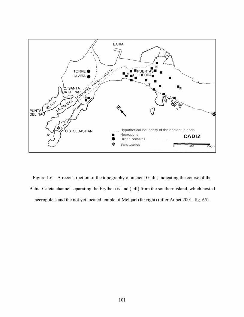
Figure 1.6 – A reconstruction of the topography of ancient Gadir, indicating the course of the
Bahia-Caleta channel separating the Erytheia island (left) from the southern island, which hosted
necropoleis and the not yet located temple of Melqart (far right) (after Aubet 2001, fig. 65).
101

Figure 1.7 – The metal deposits of the Tartessian region
(After Aubet 2001, fig. 68).
102

Figure 1.8 – The metal deposits of Sardinia
(after Gale and Stos-Gale 1988, fig. 4).
103

Figure 1.9 – Plans of the tripartite buildings at (A): the south gate at Motya, Phase IA; (B):
Cortijo de los Toscanos, with building A and House K to the East
(after Niemeyer 2002, fig. 6).
104

Figure 2.1 - Ancient Campania, showing the locations of Pithekoussai on the island of Ischia and
Cumae on the Campanian mainland (after Frederiksen 1984, Map II).
105

Figure 2.2 - Pithekoussai, showing the areas of excavation in the Valle di San Montano
necropolis, the Acropolis Dump, and the Mezzavia Hill (after Ridgway 1992, fig. 5).
106

Figure 2.3 - Ancient Sicily, showing the locations of Megara Hyblaia and the other Greek
settlements (eastern coast) as well as Phoenician Motya (western coast)
(after Holloway 1991, Map II).
107

Figure 2.4 – The distribution of Phoenician and N. Syrian objects in the 8th-7th century B.C.E.
(after Boardman 2001, fig. 3).
Figure 2.5 – Phoenician town planning. Settlement plans of a) Chorreras; b) Toscanos; c)
Carthage, Hamburg excavation, phase IVb (6th c. B.C.E.); d & e) Morro de Mezquitilla, phases 1
& 2 (after Niemeyer 1995, fig. 3).
108

Figure 3.1 – The Bir Massouda archaeological site at Carthage
(after Docter et al. 2006, fig. 1).
109

Figure 3.2 – The revised map of Archaic Carthage
(after Docter 2004, fig. 5).
110

Figure 3.3 – Earlier estimates of the size of Archaic Carthage
(after Lancel 1995, fig. 22).
111

REFERENCES
Amadasi, M.G. and P.G. Guzzo. 1986. “Di Nora, di Eracle gaditano e della più antica navigazione fenicia.” Aula Orientalis 4, 58-71. Asheri, D. 1980. “La colonizzazione greca.” In La Sicilia antica, edited by E. Gabba and G. Vallet, i/1.89-142. Naples. Aubet, M.E. 1995. “From Trading Post to Town in the Phoenician-Punic World.” In Social Complexity and the Development of Towns in Iberia, edited by V. B. Cunliffe and S. Keay. Proceedings of the British Academy 86 (1995), 47-66. __________. 2001. The Phoenicians and the West: Politics, Colonies, and Trade. Translated by M. Turton. Cambridge: Cambridge University Press. __________. 2002a. “Notes on the Economy of the Phoenician Settlements in Southern Spain.” In The Phoenicians in Spain, edited and translated by M. R. Bierling, 79-96. Winona Lake, IN: Eisenbrauns. ___________, 2002b. “Phoenician Trade in the West: Balance and Perspectives.” In The Phoenicians in Spain, edited and translated by M. R. Bierling, 97-112. Winona Lake, IN: Eisenbrauns. Aubet, M.E. and N. Carulla. 1986. “El asentamiento fenicio del Cerro del Villar (Málaga): Arqueología y paleogeografía del Guadalhorce y de su hinterland.” Anuario Arqueológico de Andalucía 2, 425-30. Aubet, M.E., F.J. Nuñez, and L. Trellisó. 2000. “The Phoenician Cemetery of Tyre al-Bass.” BAAL 3 (1998-1999), 267-294. Badre, L. 2000. “Les premières découvertes phéniciennes à Beyrouth.” In Actas del IV Congreso Internacional de Estudios Fenicios y Púnicos, Cádiz, 2 al 6 de Octubre de 1995, edited by M.E. Aubet and M. Barthélemy, 941-961. Cádiz. Bérard, C. 1970. Eretria III. Fouilles et recherches. L’Hérôon à la porte de l’ouest. Bernabò Brea, L. 1968. “Il crepuscolo del re Hyblon: considerazioni sulla cronologia delle fondazioni di Leontini, Megara e Siracusa e sulla topografia della Megaride di Sicilia.” PdP 23, 161-86. Bierling, M. and S. Gitin, eds. The Phoenicians in Spain. An Archaeological Review of the Eigth-Sixth Centuries B.C.E. Translated by M. Bierling. Winona Lake, IN: Eisenbrauns.
112

Bikai, P.M. 1978. “The Late Phoenician Pottery Complex and Chronology.” BASOR 229, 47-55. Boardman, J. 1990. “Al Mina and history.” OJA 9, 169-90. __________. 1994b. “Orientalia and Orientals on Ischia.” In Apoikia. Scritti in onore di Giorgio Buchner( = Annali di Archeologia e Storia Antica (Instituo Universitario Orientale, Napoli) n.s. 1 (1994), edited by D’Agostino and Ridgway, 95-100. Napoli. __________. 1999a. “Greek Colonization: the eastern contribution.” In La Colonisation grecque en Méditerranée occidentale: Actes de la rencontre scientifique en hommage à Georges Vallet organisée par le Centre Jean-Bérard, l'école française de Rome, l'istituto universitari o orientale et l'università degli studi di Napoli II, Rome-Naples, 15-18 novembre 1995. (Collection de l'école française de Rome 251.), 39-50. __________. 2001. “Aspects of ‘Colonization’.” Bulletin of the American Schools of Oriental Research, No.322 (May 2001), 33-42. Brody, A. 1998. Each Man Cried Out to His God. The Specialized Religion of Canaanite and Phoenician Seafarers. Harvard Semitic Museum Publications 58. Atlanta: Scholars Press. Brown, S. 1991. Late Carthaginian Child Sacrifice. JSOT/ASOR Monograph Series 3. Sheffield: JSOT Press. Buchner, G. 1979. “Early Orientalizing: Aspects of the Euboean Connection.” In Italy Before the Romans, edited by D. Ridgway and F.R. Ridgway, 129-44. London; New York: Academic Press. _________. 1982. “Articolazione sociale, differenze di rituale e composizionale dei corredi nella necropoli di Pithecusa.” In La mort, les morts dans les sociétés anciennes, ed. by G. Gnoli and J.-P. Vernant, 275-87. Cambridge. Clifford, R. 1990. “Phoenician Religion.” Bulletin of the American Schools of Oriental Research, No. 279 (August), 55-64. Coldstream, J.N. 1969. “The Phoenicians of Ialysos.” BICS 16, 1-8. _____________. 1977. Geometric Greece. London. _____________. 1982b. “Some Problems of Eighth-Century Pottery in the West, seen from the Greek angle.” In La céramique grecque ou de tradition grecque au VIIIe
siècle en Italie centrale et méridionale (Cahiers du Centre Jean Bérard 3), 21-37. Naples. _____________. 1994a. “Prospectors and Pioneers: Pithekoussai, Kyme, and Central Italy.” In The Archaeology of Greek Colonisation, edited by G.Tsetskhladze and F. De Angelis, 47-60. Oxford: Oxford University Committee for Archaeology.
113

____________. 1995. “Euboean Geometric Imports from the Acropolis of Pithekoussai.” ABSA 90, 251-67. Cook, R.M. 1997. Greek Painted Pottery. Third Edition. New York: Routledge. Crielaard, J. 1992. “How the West was won: Euboeans vs. Phoenicians.” In Hamburger Beiträge Zur Archäologie 19/20: 1992/93. Die Akten des Internationalen Kolloquiums “Interactions in the Iron Age: Phoenicians, Greeks and the Indigenous Peoples of the Western Mediterranean” in Amsterdam am 26. und 27. März 1992, 235-260. Mainz (1996): Verlag Phillip von Zabern. Cunliffe, B. 1995. “Diversity in the Landscape: The Geographical Background to Urbanism in Iberia.” In Social Complexity and the Development of Towns in Iberia, edited by V. B. Cunliffe and S. Keay. Proceedings of the British Academy 86 (1995), 5-28. d’Agostino, B. 1994-5. “La ‘Stipe dei Cavalli’ di Pitecusa.” Atti Mem. Soc. M. Grecia, 3a serie (3), 9-108. ___________. 1999. “Euboean colonisation in the Gulf of Naples.” In Ancient Greeks East and West, ed. by G.R. Tsetskhladze, 207-27. De Angelis, F. 2003. Megara Hyblaia and Selinous: The Development of Two Greek City-States in Archaic Sicily. Oxford: Oxford University School of Archaeology. De Geus, C.H.J. 2001. “Oriental Origins of the Greek City.” In The Greek City from Antiquity to the Present, ed. by K. Demoen, 41-8. Louvain/Paris/Sterling, VA. Delgado, A. and M. Ferrer. 2006. “Cultural Contacts in Colonial Settings: the Construction of New Identities in Colonial Phoenician Areas of the Western Mediterranean.” Paper read at the conference “Cultures of Contact: Archaeology, Ethics, and Globalization,” hosted by the Stanford Archaeology Center, 17-19 February, Stanford. Demand, N.H. 2004. “Iron Age Cyprus: Recent Finds and Interpretative Strategies.” In Commerce and Monetary Systems in the Ancient World: Means of Transmission and Cultural Interaction Proceedings of the Fifth Annual Symposium of the Assyrian and Babylonian Intellectual Heritage Project Held in Innsbruck, Austria, October 3rd-8th 2002, edited by r. Rollinger and C. Ulf, 257-265. Franz Steiner Verlag. Docter, R.F. 1999. “Transport Amphorae from Carthage and Toscanos: an economic-historical approach to Phoenician expansion.” In La cerámica fenicia en Occidente: centros de producción y áreas de comercio. Actas del I Seminario Internacional sobre Temas Fenicios, 89-109. Instituto de Cultura Juan Gil-Albert. Alicante. _________. 2004. “The Topography of Archaic Carthage. Preliminary results of recent excavations and some prospects.” TALANTA 24-25, 113-133.
114

Docter, R. F. and H. Niemeyer. 1994. “Pithekoussai: the Carthaginian connection. On the archaeological evidence of Euboeo-Phoenician partnership in the 8th and 7th centuries B.C” In Apoikia. Scritti in onore di Giorgio Buchner = Annali di Archeologia e Storia Antica (Instituo Universitario Orientale, Napoli) n.s. 1 (1994), edited by D’Agostino and Ridgway, 101-15. Napoli. Docter, R.F., F. Chelbi, B.M. Telmini, et al. 2003. “Carthage Bir Massouda. Preliminary report on the first bilateral excavations of Ghent University and the Institut National du Patrimoine (2002-2003).” Babesch: Bulletin Antieke Beschaving 78, 43-70. Docter, R.F., F. Chelbi, B.M. Telmini, et al. 2006. “Carthage Bir Massouda. Second preliminary report on the bilateral excavations of Ghent University and the Institut National du Patrimoine (2003-2004).” Babesch: Bulletin Antieke Beschaving 81, 37-89. Domínguez, A. and C. Sánchez. 2001. Greek Pottery from the Iberian Peninsula. Edited by G. Tsetskhladze. Boston: Brill. Escacena, J.L. 1986. “Gadir.” In Los fenicios en la Península Ibérica. Sabadell: AUSA. Frankenstein, S. 1979. “The Phoenicians in the Far West: A Function of Neo-Assyrian Imperialism.” In Power and Propaganda. A Symposium in Ancient Empires, Mesopotamia 7, edited by M.G. Larsen, 263-294. Frederiksen, M. 1984. Campania. Edited by N. Purcell. Rome: British School at Rome. Gale, N. H. and Z.A. Stos-Gale. 1988. “Recent Evidence for a Possible Bronze Age Metal Trade between Sardinia and the Aegean.” In Problems in Greek Prehistory. Papers presented at the Centenary Conference of the British School of Archaeology At Athens, Manchester, April 1986, edited by E.B. French and K.A. Wardle, 349-384. Bristol: Bristol Classical Press. Giardino, C. 1995. Il Mediterraneo Occidentale fra XIV ed VIII secolo a.C.: cerchie minerarie e metallurgiche. Oxford. Gonzalez de Canales, F., L. Serrano, and J. Llompart. 2006. “The Pre-colonial Phoenician Emporium of Huelva, Tartessos (south-west Spain).” Babesch: Bulletin Antieke Beschaving 81, 13-29. Graham, A.J. 1988. “Megara Hyblaea and the Sicels.” In Local Ethno-Political Entities of the Black Sea Area in the 7th-4th Centuries BC: materials of the 4th All-Union symposium dedicated to the problems of the ancient history of the Black Sea littoral Tsqaltubo-Vani – 1985, edited by O. Lordkipanidze, 304-321. Tbilisi. Greco, E. 1994. “Pithekoussai: empòrion o apoikia?” In Apoikia. Scritti in onore di Giorgio Buchner( = Annali di Archeologia e Storia Antica (Instituo Universitario Orientale, Napoli) n.s. 1 (1994), edited by D’Agostino and Ridgway, 11-18. Napoli.
115

_________. 2006. “Greek colonisation in Southern Italy: A Methodological Essay.” In Greek Colonisation. An Account of Greek Colonies and Other Settlements Overseas, Volume 1, ed. by G. Tsetskhladze, 169-200. Leiden/Boston: Brill. Gsell, S. 1920. Histoire ancienne de l’Afrique du nord. Vol. IV, La civilization carthaginoise. Paris: Librairie Hachette. Hölb, G. 1979. Beziehungen der ägyptischen Kultur zu Altitalien. Leiden. Isserlin, B. 1982. “Motya: urban features.” In Phönizier im Westen, edited by H. Niemeyer, 113-132. Mainz: Verlag Philipp Von Zabern. Isserlin, B., du Plat Taylor, J. 1974. Motya: A Phoenician and Carthaginian City in Sicily. A Report of the excavations undertaken during the years 1961-65 on behalf of the University of Leeds, The Institute of Archaeology of London University and Fairleigh Dickinson University, New Jersey. Volume I. Leiden: E. J. Brill. Johnston, A. and R. Jones, 1978. “The ‘SOS’ Amphora.” ABSA 73, 103-141. Katzenstein, H. J. 1997. The History of Tyre: From the Beginning of the Second Millennium B.C.E. Jerusalem : Ben-Gurion University of the Negev Press. Kearsley, R. 1989. The pendent semicircle skyphos. London: BICS, Suppl. 44. King, Ph.J., and L.E. Stager. 2001. Life in Biblical Israel. Louisville/London. Kolb. F. 1984. Die Stadt im Altertum. Munich: Beck. Lancel, S. 1995. Carthage: a history. Translated by Antonia Nevill. Cambridge: Blackwell. López Castro, J.L. 2006. “Colonials, merchants and alabaster vases: the western Phoenician aristocracy.” Antiquity 80: 74-88. Maass-Lindemann, G. 1985. “Vasos fenicios de los siglos VII-VI en España.” Aula Orientalis 3, 227-239. Maass-Lindemann, G. 1990. “Orientalische Importe vom Morro de Mezquitilla.” Madrider Mitteilungen 31, 169-177. Markoe, G. 1985. “Phoenician bronze and silver bowls from Cyprus and the Mediterranean.” University of California Classical Studies 26. Berkeley. ________. 1992a. “In Pursuit of Metal: Phoenicians and Greeks in Italy.” In Greece between East and West: 10th-8th Centuries BC, edited by G. Kopcke and I. Tokumaru, 61-84. Mainz, Rhine: Verlag Philipp von Zabern.
116

________. 1992b. “In pursuit of silver: Phoenicians in Central Italy.” In Hamburger Beiträge Zur Archäologie 19/20: 1992/93. Die Akten des Internationalen Kolloquiums “Interactions in the Iron Age: Phoenicians, Greeks and the Indigenous Peoples of the Western Mediterranean” in Amsterdam am 26. und 27. März 1992, 11-31.. Mainz (1996): Verlag Phillip von Zabern. ________. 2000. Phoenicians. Berkeley: University of California Press. Massoli-Novelli, R. 1986. “The Geology, Environment, and Natural Resources of Sardinia.” In Studies in Sardinian Archaeology. Volume II: Sardinia in the Mediterranean, edited by M. Balmuth, 3-8. Ann Arbor: The University of Michigan Press. Moran, W.L., ed. 1992. The Amarna Letters. Baltimore. Morris, S.P. 1998. “Bearing Greek gifts: Euboean pottery on Sardinia.” In Sardinia and Aegean chronology: towards the resolution of relative and absolute dating in the Mediterranean. Proceedings of the International Colloquium . . . at Tufts University, ed. M.S. Balmuth and R.H. Tykot, 361-2. Oxford: Oxbow. Niemeyer, H. 1990. “The Phoenician in the Mediterranean: A Non-Greek Model for Expansion and Settlement in Antiquity.” In Greek Colonists and Native Populations, edited by Jean-Paul Descoeudres, 469-502. Oxford: Oxford University Press, Clarendon Press. ___________. 1995. “Phoenician Toscanos as a Settlement Model? Its Urbanistic Characer in the Context of Phoenician Expansion and Iberian Acculturation.” In Social Complexity and the Development of Towns in Iberia, edited by V. B. Cunliffe and S. Keay. Proceedings of the British Academy 86 (1995) 67-88. ___________. 2000. “The Early Phoenician City-States on the Mediterranean: Archaeological Elements for their Description.” In A Comparative Study of Thirty City-State Cultures, edited by M. Hansen, 89-116. Cophenhagen. ___________. 2002. “The Phoenician Settlement at Toscanos: Urbanization and Function.” In The Phoenicians in Spain, edited and translated by M. R. Bierling, 31-48. Winona Lake, IN: Eisenbrauns. ___________. 2006. “The Phoenicians in the Mediterranean. Between Expansion and Colonisation: A Non-Greek Model of Overseas Settlement and Presence.” In Greek Colonisation. An Account of Greek Colonies and Other Settlements Overseas, Volume 1, ed. by G. Tsetskhladze, 143-168. Leiden/Boston: Brill. Niemeyer, H., R.F. Docter et al. 1993. “Die Grabung unter dem Decumanus Maximus von Karthago. Vorbericht über die Kampagnen 1986-91.” (With appendix by F.O. Hvidberg-Hansen). Mitteilungen des Deutschen Archäologischen institutes, Römische Abt. 100, 201-44.
117

Niemeyer, H., R.F. Docter, and A. Rindelaub. 1995. “Die Grabung unter dem Decumanus Maximus von Karthago. Zweiter Vorbericht.” Mitteilungen des Deutschen Archäologischen institutes, Römische Abt. 102, 475-502. Niemeyer, H., A. Rindelaub, and K. Schmidt. 1996. Karthago. Die alte Handelsmetropole am Mittelmeer. Eine archäologische Grabung. Hamburg. Nijboer, A.J. 2005. “The Iron Age in the Mediterranean: A Chronological Mess or ‘Trade before the Flag,’ Part II.” Ancient West and East 4.2, 255-77. Ortega, J. 1999. “Poblamiento y población en la Onuba prerromana: algunas consideraciones.” Complutum 2-3, 185-194. Osborne, R. 1996. Greece in the Making,1200 - 479 B.C. London: Routledge. ________. 1998. “Early Greek colonization? The nature of Greek settlement in the West.” In Archaic Greece: New Approaches and New Evidence, edited by N. Fisher and H. van Wees, 251-270. London: Duckworth & Co. Papadopoulos, J.K. 1997. “Phantom Euboians.” Journal of Mediterranean Archaeology 10, 191-219. Pellicer Catalán, M. 2002. “Phoenician and Punic Sexi.” In The Phoenicians in Spain, edited and translated by M. R. Bierling, 49-77. Winona Lake, IN: Eisenbrauns. Perdigones, L. and A. Muñoz. 1986. “Excavaciones de urgencia en un solar de la calle Regimiento de Infantería esquina Abreu (Cádiz).” Annuario Arqueológico de Andalucía 198-III, 45-46. Peserico, A. “Pottery Production and Circulation in the Phoenician and Punic Mediterranean.” In Phoenicians and Carthaginians in the Western Mediterranean (Studia Punica 12), edited by G. Pisano, 125-135. Pisano, G. 1999. “Remarks on Trade in Luxury Goods in the Western Mediterranean.” In Phoenicians and Carthaginians in the Western Mediterranean (Studia Punica 12), edited by G. Pisano, 15-30. Roma: Università degli Studi di Roma. Polanyi, K. 1963. “Ports of Trade in Early Societies.” Journal of Economic History 23, 30-45. Rakob, F. 1987. “Zur Siedlungstopographie des punischen Karthago.” Römische Mitteilungen 94, 333-49. _______. 1989. “Karthago. Die frühe Siedlung.” Römische Mitteilungen 96, 155-208.
118

Rathje, A. 1979. “Oriental Imports in Eturia in the Eight and Seventh Centuries B.C.: Their Origins and Implications.” In Italy Before the Romans, edited by D. Ridgway and F.R. Ridgway, 145-83. London; New York: Academic Press. Renfrew, C. and P. Bahn. 2000. Archaeology. Theories, Methods, and Practice. New York: Thames & Hudson. Ribichini, S. 1988. “Beliefs and Religious Life.” In The Phoenicians, edited by S. Moscati, 104-125. Milan: Bompiani. Ridgway, D. 1992. The First Western Greeks. Cambridge: Cambridge University Press. _________. 1994. “Phoenicians and Greeks in the West: a view from Pithekoussai.” In The Archaeology of Greek Colonisation, edited by G.Tsetskhladze and F. De Angelis, 35-46. Oxford: Oxford University Committee for Archaeology. _________. 1998. “The Carthaginian connection: a view from San Montano.” In Archäologische Studien in Kontaktzonen der antiken Welt, ed. by R. Rolle, K. Schmidt, R.F. Docter, 301-308. Göttingen: Vandenhoek & Ruprecht. _________. 2000b. “The first Western Greeks revisited.” In Ancient Italy in its Mediterranean setting: Studies in honour of Ellen Macnamara, edited by D. Ridgway, F.R. Serra Ridgway, M. Pearce, E. Herring, R.D. Whitehouse, and J.B. Wilkins, 179-91. London: Accordia Research Institute. _________. 2004. “Euboeans and others along the Tyrrhenian Seaboard in the 8th century B.C.” In Greek Identity in the Western Mediterranean: Papers in honor of Brian Shefton .Mnemosyne Suppl. 246, edited by K. Lomas, 15-33. Leiden: Brill. Ridgway, D. and F. R. Ridgway, eds. 1979. Italy before the Romans: the Iron Age, orientalizing and Etruscan periods. London/New York/San Francisco. Röllig, W. “Paläographische Beobachtungen zum ersten Auftreten der Phönizier in Sardinien.” Antidoron (Festschrift J. Thimme), 125-30. Karlsruhe. Ruiz Mata, D. 2002a. “The Ancient Phoenicians of the 8th and 7th Centuries B.C. in the Bay of Cádiz: State of the Research.” In The Phoenicians in Spain, edited and translated by M. R. Bierling, 155-198. Winona Lake, IN: Eisenbrauns. Sagona, C. 2004. “The Phoenicians in Spain from a Central Mediterranean Perspective: A Review Essay.” Ancient Near Eastern Studies XLI (2004). Sagona, A.G. 1982. “Levantine Storage Jars of the 13th to 4th Century B.C.” Opuscula. Atheniensia 14, 73-110.
119

Schoor, A. 1986. Berseba – de opgraving van een bijbelse stad. Kampen. Schubart, H. 1976. “Westphönizische Teller?” Rivista di studi Fenici 4, 179-196. _________. 2002. “The Phoenician Settlement of the 8th Century B.C. in Morro de Mezquitilla (Algarrobo, Málaga).” In The Phoenicians in Spain, edited and translated by M. R. Bierling, 3-30. Winona Lake, IN: Eisenbrauns. Seeden, H. 1991. “A Tophet at Tyre?” Berytus 39, 39-82. Semple, E.C. “The Templed Promontories of the Ancient Mediterranean.” The Geographical Review 17/3 (1927), 353-86. Shaw, J.W. 1989. “Phoenicians in Southern Crete.” AJA 93, 165-183. Shepherd, G.B. 1995. “The Pride of Most Colonials: burial and religion in the Sicilian colonies.” Acta Hyperborea 6: 51-82. Snodgras, A. M. 1994b. “The Nature and Standing of the Early Western Colonies.” In The Archaeology of Greek Colonisation, edited by G.Tsetskhladze and F. De Angelis, 1-10. Oxford: Oxford University Committee for Archaeology. Stager, L. 1982. “Carthage: a view from the Tophet.” In Phönizier im Westen, edited by H. Niemeyer, 155-166. Mainz: Verlag Philipp Von Zabern. Strøm, I. 1971. Problems concerning the origin and development of the Etruscan Orientalizing style. Odense. ______. 1990. “Relations between Etruria and Campania around 700 B.C.” In Greek Colonists and Native Populations, edited by Jean-Paul Descoeudres, 87-97. Oxford: Oxford University Press, Clarendon Press. Tsetskhladze, G.R. 2006. “Introduction: Revisiting Ancient Greek Colonisation.” In Greek Colonisation. An Account of Greek Colonies and Other Settlements Overseas, Volume 1, ed. by G. Tsetskhladze, xxiii-lxxxiii. Leiden/Boston: Brill. Tusa, 1972. Mozia VII. Rome. Warden, P.G. 1984. “The Colline Metallifere: Prolegomena to the Study of Mineral Exploitation in Central Italy.” In Crossroads of the Mediterranean, edited by T. Hackens, N. D. Holloway, and R. R. Holloway, 349-364. Louvain-la-Neuve (Belgium): Art and Archaeology Publications, College Erasme, and Providence; RI: Brown University Center for Old World Archaeology and Art. Whitaker, J.I.S. 1921. Motya. A Phoenician Colony in Sicilia. London: Bell.
120

Whitley, J. 2001. The Archaeology of Ancient Greece. Cambridge: Cambridge University Press.
121