th rzn trp - university of...
TRANSCRIPT

THE ARIZONA STRIP
Report of Reconnoissance of the CountryNorth of the Grand Canyon
ByPROF. A. M. McOMIE
Arizona Agricultural Experiment Station
C. C. JACOBSDistrict Engineer U. S. Geological Survey
DR. O. C. BARTLETTAssistant State Entomologist
Published byBoard of Control, by authority of Chapter XXVIII, Title 1
Revised Statutes of Arizona 1913, Civil Code
THE ARIZONA STRIP
Report of Reconnoissance of the CountryNorth of the Grand Canyon
By
PROF. A. M. McOMIEArizona Agricultural Experiment Station
C. C. JACOBSDistrict Engineer U. S. Geological Survey
DR. 0. C. BARTLETTAssistant State Entomologist
Published byBoard of Control, by authority of Chapter XXVIII, Title 1
Revised Statutes of Arizona 1913, Civil Code

(7 .6, /2--
PREFACE
Th6 Arizona Strip is that portion of Arizona which lies between the
Colorado River and the Southern boundary of the State of Utah. Concerning
this isolated but productive area, very meager information has been avail-
able heretofore. With a view, accordingly, of bringing the facts regarding
this comparatively unknown region and its highly enterprising and indus-
trious inhabitants within the realm of current knowledge, Honorable Geo.
W. P. Hunt, Governor of Arizona, early in the summer of 1914, authorized
and directed the organization of a reconnoissance party consisting of Prof.
A. M. McOmie, of the Arizona Agricultural Experiment Station, Mr. C. C.
Jacob, District Engineer of the U. S. Geological Survey, and Dr. O. C. Bart-
lett, Assistant State Entomologist of Arizona. The report on the population
and natural resources of the Arizona Strip, as presented in this booklet, is
the result of the reconnoissance so ordered, and on March 1st, 1915, was
transmitted in typewritten form to both houses of the Second State Legis-
lature of Arizona. The Governor's letter of transmittal addressed to the
Legislature, reads as follows:
March 1st, 1915.To the Senate and House of Representatives,
Second State Legislature of Arizona.Gentlemen:
I have the honor to transmit to you herewith copies of reports rendered
by Mr. C. C. Jacob, District Engineer, United States Geological Survey; Dr.O. C. Bartlett, Assistant State Entomologist, and Prof. A. M. McOmie, re-
spectively, relating to that region of Arizona which lies between the GrandCanyon of the Colorado .River and the southern boundary of the State of
Utah.
With reference to the foregoing, I may inform you that the attachedreports were rendered at my suggestion, and in the belief that the Arizonapublic would be interested in obtaining accurate information regarding thatportion of the State which is so isolated geographically that it has neverbeen the subject, heretofore, of any reliable, official account.
I feel quite sure, moreover, that a very considerable number of thepeople of Arizona would find great interest in reading the reports trans-mitted herewith, and, therefore, I earnestly recommend to you that legisla-tive authority for the printing of these interesting, official descriptions ofthe "Arizona Strip" be extended during the present session.
Very respectfully,GEO. W. P. HUNT,
Governor of Arizona.
After giving consideration to the Governor's recommendations, as setforth in the foregoing letter, the State Senate adopted a resolution author-izing the Board of Control to have the reconnoissance report printed, andthus made available for distribution. The Board accordingly presents tothe people of Arizona the interesting and authentic report comprised bythis pamphlet, a copy of which will be sent,on request to any citizen untilthe supply is exhausted.
CHAS R OSBURN,Secretary, State Board of Control.
Phoenix, June 30, 1915. 183149

THE ARIZONA STRIP
Report of Reconnoissance from Flagstaff, Arizona, to Hurricane,
Utah, across Kaibab and Kanab Plateaus, Arizona
The purpose of this reconnoissance was to examine that part ofArizona between the Colorado River and the Utah line, with par-ticular reference to- the agricultural possibilities and water resourcesof the so-called Arizona strip. The reconnoissance was macle underthe authority of the Director of the Arizona Agricultural Experi-ment Station and the District Engineer of the Santa Fe District,United States Geological Survey.
On July 10, 1914, our party consisting of A. M. McOmie, Agri-culturist, Arizona Agricultural Experiment Station, Dr. Bartlett.Assistant State Entomologist, and C. C. Jacobs, Assistant Engineer,United States Geological Survey, and driver, left Flagstaff in aFord automobile, intending to reach Fredonia, Arizona, by thismeans of transportation, at which point arrangements had beenmade for a wagon and horses to continue the reconnoissance. Theroad followed is the main highway to Tuba City, of the NavajoIndian Reservation, which skirts around the base of the San Fran-cisco mountains, across the lava flows and down over a rolling grasscovered country which slopes uniformly to the northeast towardsthe Little Colorado basin. The Little Colorado River was crossedat the new suspension bridge. The stream was at flood stage, carry-ing about 5,000 sec. ft. of muddy water. This locality was exam-ined for a gaging station site but conditions were found to be veryunfavorable on account of the shifting character of the stream bed.The stream is well confined here by vertical cliffs about 75 feet highof soft sand-stone of the "Moencopie" formation. The geology ofthis locality has been covered by Mr. N. D. Darton, and others ofthe Geological Survey and need not be referred to in detail. Themany brilliant colored clays and sandstones absolutely devoid ofvegetation that characterize this area, constitute the so-called
4
THE ARIZONA STRIP
"Painted Desert." The Moencopie wash, which drains a consider-able area east of Tuba City, but is normally dry, was found to becarrying a flood of approximately 2,000 sec. ft. and was impassable.Flood waters from the Moencopie wash are used by the NavajoIndians to irrigate their farms near Tuba City. Crops of corn andvegetables and some fruit trees were observed along this wash.Tuba City lies on top of the mesa from which several small springsissued from the sandstone. The quality of this water, which isdoubtless of local origin, was not determined, but alkali signs wereobserved at several points along the road from the wash up to thetop of the mesa. In general, the water seeping from these red sand-stone strata is soft and otherwise of excellent quality.
The road from Tuba City to Lee's Ferry follows up a shallowdraw for about thirty miles at the base of the red sandstone escarp-ment, forming the Echo Cliffs. The Buckskin Mountains strike theEcho Cliffs nearly at right angles and are composed of gray lime-stone strata, possibly belonging to the Aubrey group (Dutton) ofthe carboniferous system. These mountains are doubtless a localuplift and the strata dip to the north. The Buckskin Mountainsare covered by a growth of cedars, but there is no evidence ofsprings or running water, at least in the vicinity traversed by theroad, although several "tanks" and local seeps were noted. Aftercrossing these mountains, the road still follows the Echo Cliffs, butthe slope of country is here to the north and aside from the cross-ing of numerous intersecting side washes, a highway of nearly uni-form grade could be easily constructed down across the slope tothe Colorado River. Paria River, which joins the Colorado at Lee'sFerry, is in a deep canyon cut through the red sandstone of theVermilion cliffs. There is only a very limited area of irrigableland near the mouth of this stream—possibly 100 acres—the com-pany which owns the land at the Ferry has approximately 30 acresunder cultivation, irrigated from Paria River. No storage possi-bilities were noted on this stream, though a limited power develop-ment is possible, providing there were a market for the energy.There had been a heavy flood in this stream previous to our arrival,which had nearly subsided to the normal stage. The stream was car-rying approximately 15 'sec. ft. of muddy water. The low stage flowis probably much smaller than this.
The Paria Plateau northwest of the Vermillion Cliffs is rough
THE ARIZONA STRIP 5
and of no value except for grazing for sheep and goats. There is
no water on this plateau, which in itself Prohibits any development.
The old Utah road passes around the southern side of the Ver-
million Cliffs, intersecting numerous side washes running south fromthe Cliffs to the Grand Canyon, the formation consisting of brown
shale and red sandstone with bright colored clays exposed in thewashes. There were several water seeps, doubtless of local origin,
in the little canyons south of Lee's Ferry: A small spring at Jacob's
Pools has been developed by a cattle company and the water piped
down into the House Rock Valley for stock purposes. This water
is free from mineral salts and otherwise of excellent quality. It
seeps out from the red sandstone of the Vermillion Cliffs. Thesered sandstones of this area doubtless belong to the Shinarump group
(carboniferous or lower triassic).
House Rock Valley is a series of white rolling plains and sand
hills extending, from the Grand Canyon to the Utah line. It ob-
viously follows an extensive fault line, since the Kaibab plateau,consisting of a block of carboniferous limestone, confines it on thewest and the Paria plateau of red sandstone on the east. Thuswe found on the east side of the valley a series of red sand knollsand ridges and on the west, level rolling plains built up on thewaste from the limestone plateau, mixing with sand carried overby the wind. The central part of the valley is the result of a blend-ing of the two distinct types of rock waste. On account of the ob-viously shattered condition of the formations underlying the valley,together with the general porosity of this strata, chances for devel-oping ground water are not very good, but dry farming can becarried on by utilizing the small springs or seeps from the uppersandstone strata for domestic and stock purposes. By this meansthis valley could possibly sustain a nuniber of profitable ranches.There are no running streams in this valley, although the centralwash evidently carries considerable flood water at times. Thegreater part of the rainfall, however, enters the loose soil coverand either sinks through the porous strata or is evaporated fromthe surface. The Kaibab plateau, varying in altitude from 7,000to 9,000 feet, is covered by a heavy growth of timber, predominantlythe different varieties of pine, with cedar and oak on the foot hills.There are no running streams on this plateau, but it is reportedthat there is water in most of the canyons near its southern end.

THE ARIZONA STRIP
At various points the rain water collects in shallow sinks from smalllakes that usually contain water. The Kaibab ,plateau breaks offto the northwest in a series of rolling foot hills covered with cedarand lower down with sage brush. The rolling valley, through whichruns Kanab Creek, is covered by a heavy growth of sage brush,shad scale, and other semi-desert plants and the soil appears to bevery fertile. There are several dry farms in this valley near Fre-donia, where, in spite of the crude and unscientific methods used,field crops of corn, barley, sweet clover and other forage plants aregrown. Kanab Creek is little more than a dry wash, though mostof the year it carries a stream of two or three sec. ft. at Fredonia,which is all diverted for irrigation in the immediate vicinity. Itis evident, however, that a number of floods come down each yearwhich, if they could 'be stored, would irrigate several times the areanow being cultivated. It is reported that there is at least one ex-cellent reservoir site on this stream about 25 miles north of theUtah line. No feasible power possibilities were noted on this streamand no additional irrigational possibilities aside from that just men-tioned. The stream is not of sufficient importance to justify theheavy expense of maintaining a gaging station on it and no favor-able and accessible site for such a station was found. There are noother running streams of importance in the Strip. Several reservoirsites were examined where considerable flood water drained fromthe rolling plateau by large central washes could be stored eachyear, but in general they are too extensive and too shallow to war-.rant development.
There is a small stream, which is almost wholly in Utah butenters Arizona for a short distance, called Short Creek, where indi-
cations are good for shallow wells and limited pumping. Also, thecreek water, amounting to one or two sec. ft., would permit exten-
sive dry farming development of the adjacent lands. There are anumber of homesteaders now located near the mouth of this creek.Short Creek is a permanent stream up in the Canyon and sinks intothe sand before it enters the valley. There is a shallow reservoirabout three miles below its mouth which receives the flood waterand which might be greatly improved by dykes and a dam at itsoutlet. There are several small springs seeping out from the sand-stone strata of the Vermilion Cliffs. Pipe Springs has a constant

THE ARIZONA STRIP
flow of about forty gallons per minute and is the largest of thesesprings. This water is soft and otherwise of the highest quality.
CONCLUSION.
The surface water resources of this area are of very little im-portance for power or irrigation purposes and can be developedfor very little more than municipal, domestic and stock uses. How-ever, from a dry farming standpoint, the area studied is very prom-ising and undoubtedly holds great possibilities. The most efficientmeans of settling these lands would seem to be the careful and com-plete development of all seeps and springs and piping them to cen-tral localities where small towns could be built and the adjacentlands farmed by dry farming methods for a radius of five or sixmiles. The entire area could thus be made to support easily from5,000 to 10,000 people. There is no rainfall data for this erea exceptthe data obtained from one isolated station near the Utah line, whichcan hardly be taken as representative for the whole area. Thealtitude is about 5,000 feet and the vegetation and other featuresindicate a mean annual precipitation of at least fourteen inches.This is known to be ample for dry farming, especially since its dis-tribution is very favorable and a crop each year would be practi-cally assured.
Respectfully submitted,
C. C. JACOB,
District Engineer,U. S. Geological Survey.
Phoenix, Arizona, Sept. 12, 1914.

8
THE ARIZONA STRIP
CONSIDERING PART OF THE COUNTRY IN ARIZONA NORTH
OF THE GRAND CANYON OF THE COLORADO RIVER.
The writer wishes that those interested in this account giveappropriate weight to the fact that only twelve days were spent ina very large territory. Insufficient time and insufficient funds weregranted this work, making it impossible to thoroughly investigatea territory heretofore considered inaccessible. With these facts inview, the writer will present an accouut of a trip covering groundtraveled over in the so-called Arizona Strip. Recourse to the gov-ernment maps will make this narrative much clearer.
During the month of July the writer, with two other men, A.M. McOmie, Assistant Agriculturist of Arizona, C. C. Jacob of theIL S. Geological Survey, spent twelve days making a trip from Flag-staff to Lee's Ferry and thence through part of the country in Ari-zona north of the Grand Canyon of the Colorado River into theVirgin River country of lower Utah. The expedition was plannedand organized by A. M. McOmie, dry farm expert for. Arizona. Ofseveral objects in view, some may be enumerated.
(1) Agricultural land, amount, value, condition, etc.(2) Mineral, timber, water, climate, etc.(3) To carry Farmers' Institute work to this distant part of
the state.(4) The important reason for the Assistant Entomologist's
making the trip was to find how much danger there was of intro-ducing the Utah alfalfa weevil into the state of Arizona by carry-ing it across the Arizona Strip, principally through Lee's Ferry asa point of entry.
The trip from Flagstaff to House Rock Valley was made in aFord automobile. Some difficulty was experienced but none thatcould not be overcome. The rest of the trip was made either onfoot, horseback or by wagon. With but little exception exceptionthere is no land of agricultural interest between Flagstaff andHouse Rock Valley. The country is too broken, or if not, there isno water available for irrigation. Except in the forest, there seemsto be not enough rainfall for dry farming From Flagstaff north
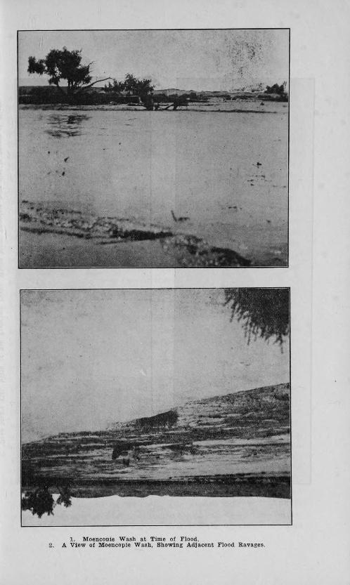
1. Moencopie Wash at Time of Flood.2. A View of Moencopie Wash, Showing Adjacent Flood Ravages.

THE ARIZONA STRIP 11
to the edge of the forest the land is excellent for dry farming andwe know from records at Flagstaff that there is enough rainfall.From the edge of the forest the road rapidly descends throughDead Man's Flat to the Little Colorado River. Dead Man's Flat isgood land. Rainfall a question. Crossing the Little Colorado bythe government bridge, the road continues over the famous PaintedDesert to Tuba City. Here the Indians have a large tract along theMoencopie Wash under cultivation. Some irrigation water is takenfrom the wash at high water. Corn, vegetables, beans and quitelarge fruit orchards are being grown.. The interesting agriculturalmethods used by the Indian in desert regions can be studied at TubaCity. - The road from Tuba City to Lee's Ferry follows close to theEcho Cliffs. Between the so-called Cedar Ridge and Navajo Springson the Indian Reservation there is a strip of agricultural land, other-wise the country is too broken to be of agricultural value. At thepoint called the Cedar Ridge there is a gracle.very near straight up.Our Ford made it with difficulty. Through this section there is noavailable water except at two or three springs along the cliffs. Avery little improvement would make the road from Flagstaff toLee's 'Ferry nicely Passable for automobiles.
At Lee's Ferry there are about thirty acres under cultivation,water being taken from the Paria River. There are grown six tonsof alfalfa to the acre, five cuttings per year: Of greater interest tothe writer Was a thrifty orchard of apple, peach, plum, pear andsome small fruits.
From Lee's Ferry the road runs southwest along the foot of theVermillion Cliffs nearly parallel with the river, in and out of deepcanyons, over broken mesa country of no agricultural value, toHouse Rock Valley. This valley extends about 35 miles north andsouth between the Buckskin Mountains on the west and the Ver-million Cliffs on the east into Utah. It is on an average about sixmiles wide. It has excellent winter range of white sage, blackgramma grass and blue stem grass. At least three springs have beendeveloped by the Grand Canyon Cattle Company and piped intothe valley where the water is fenced in. The land is of good agri-cultural value, being decomposed limestone on the west side anddecomposed sandstone on the east. The washes indicate that theremight be a danger of a layer of the so-called caliche—a lime forma-tion which if too near the surface destroys the agricultural value

12 THE ARIZONA STRIP
of the land. It is the opinion of the writer that much of this landcan be successfully cultivated. Use of a land auger would quicklyprove or disapprove the above statement. The amount of rainfallis a question but the character of the flora indicates enough for dryfarming.
At House Rock the road leaves the valley and climbs the Kai-bab Plateau, running about twenty miles to Jacob's Lake. Herethe Grand Canyon Cattle Company has summer headquarters. Thereis also a ranger station connected with Fredonia by telephone.
f Jacob's Lake is a shallow basin of perhaps two acres in extentwhere seepage water gathers. The water is good for stock purposesonly. It is estimated that there are several billion feet of the finesttimber in Arizona on the Kaibab Plateau. The plateau is also a finesummer range. Present indications are that there are valuable•
copper deposits near Jacob's Lake. One prospect was beingworked. A small sawmill near Jacob's Lake supplies timber toFredonia and Kanab. Trees growing on the plateau are mostly Ari-zona White and Yellow pine, some Douglas fir. A few Quaking aspwere seen. There is an excellent summer range of the grammagrasses. The elevation is about 9,000 feet and heavy snow in win-ter causes cattle to seek range at lower levels.
Leaving Jacob's Lake westward, the road descends very fastand enters the white Sage Flat country, where there are a numberof acres of valuable dry farming land. The flora here indicates thecharacter of the soil. White sage grows on good land. Proof ofthe value of this land is to be seen at the' ranch of Frank S. andRex R. Brown. These men are dry farming here and are success-fully growing potatoes, corn, beans, grain, etc. Turkey red- wheatplanted September, 1913, harvested July 3, yielded twenty bushelsto the acre, rye 25 bushels, corn, 50 bushels of shelled corn to theacre. They get water for ordinary purposes and stock in a peculiarmanner. Their houses have corrugated roofs drained to a cementtank in which rain-water is stored. They get enough water to sup-ply two houses, water six horses and two cows in this manner. Thisindicates the rainfall. Information from the Browns indicated otherland of like value northward and close to the plateau.
From here the road runs northwest to Fredonia, a small Mor-mon settlement on Kanab Creek and about seven miles from the townof Kanab, which is located just over the state line in Utah. The

THE ARIZONA STRIP 13
land about these towns is very rich, loam in character and althoughthere is irrigation water, the people are taking up dry farm landand succeeding in growing larger and better crops than with thewater. About Fredonia there is some indication of alkali on thesurface. It may be gypsum deposit. The people there have about1000 acres irrigated. Amount of water for irrigation about one acrefoot. There are about 200 acres in alfalfa and the rest in grain,corn, rye, wheat, oats, etc. Rye seems to be the favorite grain crop.There are a few small orchards, but the codling moth or wormyapple pest. is very bad. The town is a relief after the desert, forit has fine large shade trees of poplar, honey locust, catalpa, elmand balm of Gilead. Fruit grown is apple. pear, peach, plum, apri-cot, grape, etc. The rancher makes three cuttings of alfalfa. Thepopulation of the town is about 150. Littlefield has about 100, Lee'sFerry 10, Short Creek 50 and Moccasin 10. It was estimated thatthere were about 16,000 head of cattle grazing along Kanab Creek.
It is significant that at Kanab the ranchers are now taking updry farm land in preference to that under irrigation. They usethe town water supply for culinary purposes, etc., living in the townand going out to farm. This is possible under the Utah homestead law,for in that state a farmer may homestead without living on the saidland. This makes the farming of a great deal more land possible.The present Arizona homestead law makes this impossible. Leav-ing Fredonia, the road turned southwestward into a cedar ridgeterritory. Here there is a very fine grazing tract covered with afine growth of the best native grasses and some cedar. A large flockof about 5,000 Persian-Rambouilette sheep owned by Wooly andMcCormick of Kanab was seen. These sheep appear superior tothe Tunis. Meat from a young wether killed while the party wasat the sheep camp was sampled and found of excellent quality. ThePersian sheep is characterized by a large fat tail.
From this region the party turned northward, crossing thelower part of Antelope Valley to Pipe Springs where there is alarge natural spring of excellent quality. It is fenced by a cattlecompany. Traveling westward the road went through Pipe SpringsValley and on through the Short Creek country to the HurricaneLedges. Here, as far as the eye can reach, there stretches a won-derful tract of excellent agricultural land, the best north of theCanyon. It has a gentle slope, deep. decomposed sandstone soil
14 THE ARIZONA STRIP
and evidently enough rainfall, as indicated by a gauge at Kanabwhich for three years registered an average of 15 inches annually.These valleys running from Pipe Springs by the Short Creek countryto Hurricane Ledge and thence southward through Antelope Valleymust contain close to three-fourths of a million of acres of fine agri-cultural land. There are several springs which, if accessible, townscould be built around and the land farmed from these as centers.At Short Creek about 50 families are operating farms. There are afew squatters in Pipe Springs Valley. The character of the cropsis indicated by excellent corn, vegetables, etc., which were grow-ing at Short Creek.
Following the Hurricane Ledge formation into the town of Hur-ricane, Utah, we attended a good-roads meeting, to which Arizonaofficials had been invited but none had taken the trouble to attend.Object of road meeting to complete a good automobile road toGrand Canyon from Salt Lake City. A short distance taken care ofby the State of Arizona assured the whole road to a point oppositeEl Tovar, for other parts in Arizona had been completed by U. S.Indian and Forest Service.
(1) AGRICULTURAL LAND, AMOUNT, VALUE,
CONDITION, ETC. •
There is no land of agricultural value east of the House RockValley in the Arizona Strip except the few acres at Lee's Ferry.House Rock Valley contains about two hundred and ten squaremiles of land, part decomposed limestone and part decomposedsandstone. These kinds of soil are recognized as the finest of agri-cultural soils. This land can easily be put under cultivation.
Land on the Kaibab Plateau is of limestone origin, but for farm-ing the elevation is too much and the soil is shallow. There is afine summer range for cattle and sheep.
Along the western edge of the plateau lies a few hundred acresof extremely good dry farming land. Part of it lies in the WhiteSage Flats. Here, as has already been described, the Brown broth-ers are doing successful dry farming.
At Fredonia there are one thousand acres under irrigation andseveral hundred being farmed as indicated above. There are aboutthe town a great many acres of good dry farm land.

THE ARIZONA STRIP 15
The country through the Pipe Springs Valley on over the ShortCreek section and thence southward through the great AntelopeValley is an extensive stretch of very valuable agricultural land.The soil is decomposed sandstone from the Vermillion Cliffs and verydeep. In some places the washes showed forty feet of exposed soil.There must be well over one-half million acres of fine dry farmlands in this section. Crops seen growing at Short Creek prove itsvalue.
South of the lower Antelope Valley lies a great tract of finegrazing land. Cattle and sheep seen upon it were in prime condi-tion. Eelevation ranges from four thousand to five thousand fivehundred feet. The enterprising cattlemen in this country west ofthe Kaibab Plateau have established a fine method of improvingthe stock on the range of the Strip. They have agreed among them-selves to round up all the mavericks on the range and sell them atpublic auction. The money thus acquired is used to buy the bestbulls that can be obtained. These bulls are turned loose on therange. Thus every one gets the benefit of better blood. The resultis easily seen, for the increased quality of the stock is very evident.
We were told that there was a very large tract of land of thesame character as that in Pipe Springs Valley west of the Hurri-cane Ledge, down toward the Virgin River country. This land wedid not see.
The land spoken of east of the Hurricane Ledges could be putunder cultivation easily and at small cost.
In all, there must be north of the Canyon in Arizona good agri-cultural land to the extent of well over the three-quarter millionmark, perhaps approaching one million acres.
(2) MINERAL, TIMBER, WATER, CLIMATE, ETC.
There are several copper prospects being worked. They werereported of good value. Other mineral prospects were told of.
The only timber the writer saw was that on the Kaibab Plateau.Its value and character have already been indicated. It was under-stood that the U. S. Forestry Service was offering several millionfeet of this fine timber for sale. Timber of fine quality was reportedon the Dixie Reserve and the Unkaret Mountains.
The water proposition was to be covered by C. C. Ja6ob. It

16 THE ARIZONA STRIP
is enough to say that the great source of water supply is from living/ springs of excellent quality, coming mostly from the Vermilion
Cliffs. These springs are now mostly controlled by fences. Therewere two or three dam sites for empounding irrigation water beingtalked of in the section.
(3) FARMERS' INSTITUTE WORK.
The first farmers' institute ever held north of the Grand Can-yon in Arizona was held at Fredonia, July 16, 1914, at 7:30 in theevening. There were present sixty-five interested farmers. Thespeakers were Dr. O. C. Bartlett, Assistant State Entomologist;topic, Fruit Growing and Insect Pests. Prof. A. M. McOmie—DryFarming. C. C. Jacob—Water Resources. It was very noticeablethat the people in this region appreciated very much the effort toget in touch with them. They wanted to become more intimatelyin touch with our state and county government. They are finepeople, industrious farmers and stock breeders and not outlaws, asis indicated by prevalent stories abroad in this state.
(4) DANGER FROM THE ALFALFA WEEVIL.
As to the insect question, at the same elevations approximatelythe same climatic conditions exist north of the Colorado River assouth of it. This is strongly intimated by the kinds of insects foundin the Arizona Strip. Some classes of insects are fair indicators ofthe range of climate. It was noticeable that the same kinds of insectpests were found on the Arizona Strip that are found in other partsof the state at the same elevations—grasshoppers, locusts includinga species much resembling the famous Rocky Mountain locust, plantlice, corn earworm, codling moth, et cetera.
The worst pest called to the writer's attention was a large plantbug which attacked the grain in the milk stage and sucked the grainheads dry. This the farmers called the "chinch-bug," a local nameused because of the character of the damage done. It is not thechinch bug, but one of the large plant bugs which have done serious

THE ARIZONA STRIP 17
damage to grain in other parts of our state as in the Sulphur SpringsValley.
The Utah alfalfa weevil question should be one of great interestto the people and officials of this great alfalfa producing state.Alfalfa is our staple crop and always will be. Its protection froman invasion of the above scourge is a quesion of immense importanceto the continued prosperity of our state. As an expert on insectquestions, the writer considers there is extreme danger that thealfalfa weevil will make its way into Arizona across the ArizonaStrip, and considers Lee's Ferry the most dangerous point whereit might gain access. With all the precaution now .taken to preventits spread to Lower Utah, it is steadily making its way south. Itbecomes the writer's duty to say that it would seem immediate stepsshould be taken to safeguard the above point. In talking with J.Edward Taylor, the Secretary of the Utah Horticultural Commis-sion, at the Hurricane road-meeting, the writer gained the idea thatthe Utah official considered it impossible to prevent the invasion ofthe alfalfa weevil into Southern Utah because of the prevalence ofimmigrant movement. He considered this and other sources of likecharacter the chief means by which the weevil becomes disseminated.There is too much movement of this character through Lee's Ferryinto lower Arizona to be safe. It must be only a question of timebefore the alfalfa weevil gets to Salt River Valley. Every stepshould be taken to prevent its coming. It is the usual thing that astate acts too late. This state should be beforehand. A study ofthe condiions in Utah and modern methods used there to controlthe pest is recommended. A short time used by an expert wouldglean valuable information that has cost Utah thousands of dollars.
In conclusion it is easy to say there is a wonderful country inthis part of our great state yet undeveloped. The expenditure of asmall amount of money towards good roads, certain modificationsof the present unfavorable laws in this state governing the home-steading of dry farm lands, the establishment of a rational waterpolicy would do much toward opening to the public a fine region.The natural scenery is very attractive. Every step is very interest-ing to the traveler. The far-famed Painted Desert with its myster-ious coloring, the historic Lee's Ferry with the picturesque ColoradoCanyon, the Vermilion Cliffs talked of by the poet, the KaibabForest with its great trees and wild animals, and the immense

18 THE ARIZONA STRIP
stretches of grazing land demand the attention of the most indif-ferent, while to one fond of nature it opens a prospect which can-not be duplicated anywhere in the world.
Respectfully submitted,
O. C. BARTLETT,Assistant State Entomologist.
Farmers of Fredonia, Arizona.
H. E. Judd, D. V. Lawson, B. K. Judd, Thos. Jensen, A. E.Lewis, J. R. Button, Thos. P. Jensen, L. Pratt, Sr., S. R. Dunham,Lorin Pratt, Jr., Orin Judd, Hyrum Judd, W. J. Brooksby, H. P.Cram, E. S. Brown, Rebecca Church, Nancy Judd, A. W. Brown, J. O.Lamb, W. M. Judd, J. H. Hortt, Lee Brown, A. W. Judd, Reese B.Griffith, Thos. Dobson, Jas. T. Owens, Walter Haycock, Ralph But-ton, R. A. Jackson, Earl Jackson, Nathanea Young, W. M. Brooks-by, Jos. Brooksby, Alfred Brooksby, Ira Judd.
Farmers at Short Creek. Postoffice Moccasin.
W. S. Rust, O. F. Colvin, Iasic Caning, Frank, Johnson, PriceJohnson, Lorin Covington, Henry Covington, Mrs. May Covington,J. H. Gallighan, J. W. Lavritzen, Knute Palmer, John Dennett, .DaveDennett, Dan Dennett, Mr. Cougill, Mr. Straton, Mr. Wormly, Mr.Marshall, Freborn Gifford, Oscar Stephens, Artimus Denull.
Farmers at Moccasin.
Jonathan Heaton, Chas. C. Heaton, Fred C. Heaton, ChristopherHeaton, Edward Heaton, J. W. Maxwell, Supt. Schools, JohnCaswell.

5-6-7. Illustrations of Indian Farming near Tuba City, on Moencopie Wash.

8. Suspension Bridge Constructed by U. S. Indian Service across Little Colorado Riverat Tuba City—This Structure is 800 ft. Long and Cost 880.000.
THE ARIZONA STRIP 21
RECONNOISSANCE OF THE COUNTRY NORTH OF THE
GRAND CANYON, ARIZONA, KNOWN AS
THE "ARIZONA STRIP."
By Prof. A. M. McOraie.
The purpose of the reconnoissance of the "Arizona Strip" was
to get at first hand information concerning the possibilities of this
section of the state. Up to this time, no officials of any institutions
or departments of the state had made even a cursory survey of that
country. There is meager literature on certain aspects of the sec-
tion, such as forester reports, reconnoissance maps, etc., but thesepresent only partially the real worth of this area to Arizona. Vaguerumors as to its character and possibilities and people have beenabroad over the state for many years. Some of these depicted amarvelously rich country ; others a barren waste, and many de-scribed the inhabitants as being outlaws of the most desperate char-acter. Furthermore, the writer in compiling data on dry farmingin Arizona, felt that this country might possess some possibilitiesfor this class of farming which would be overlooked if a trip werenot made into it.
Accordingly, the writer organized a party consisting of C. C.Jacob, District Engineer for Arizona of the United States GeologicalSurvey, and Dr. O. C. Bartlett, Assistant State Entomologist of theArizona Commission of Agriculture and Horticulture.
On the 10th day of July, we left Flagstaff in a Ford automobileand traveled in a northeasterly direction over the main thorough-.fare to Tuba City, crossing the Little Colorado on the newly builtsuspension bridge. Thence, we took a northwesterly course, follow-ing a tributary of the Moencopie Wash, along the escarpment of afault called Echo Cliffs, to Lee's Ferry on the Big Colorado River.The first day's travel was somewhat impaired by having encoun-tered, by trying to make a short cut, Moencopie Wash in flood; andalthough Lee's Ferry was our objective point for the night, we werecompelled to stop on account of darkness and a second swollen wash,about twenty-five miles out from the Ferry, on the Navajo Indian

22 THE ARIZONA STRIP
Reservation. The road up to this point was passable, and with smallexpense could be made very pleasant going. A few bridges wouldbe necessary, and at a point near Cottonwood Tank, going overCedar Ridge, the grade would have to be very much reduced. Herewe had to unload our luggage, and 'after a dozen attempts, werefinally successful in getting on top. The grade at present must betwenty-five per cent.
The second day, we started early after a refreshing sleep on thegrass-covered desert, and encountered serious difficulty in goingdown the dug-way into Lee's Ferry. Heavy storms had washed theroad considerably, requiring much work to make it passable. Themost serious setback was a large boulder, weighing a couple of tons,that had been dropped in the middle of the ten foot dug-way. Itwas necessary to blast this in order to get past.
This portion of the road is very picturesque, being cut in a red-dish sandstone shale elevated above the river some fifteen hundi4 edfeet in many places, and 'below the top of the mesa some two thou-sand feet, with nearly perpendicular walls either up or down. Thesecond night was spent at the ranch situated at Lee's Ferry.
Lee's Ferry crosses the river just above the junction of theColorado proper, and a tributary, the Paria. The ranch is locatedbelow the junction of these two streams. A very excellent andmost picturesque crossing suitable for auto travel, could be madeout of the present site.
The third day we followed on a badly broken mesa, graduallyflattening and widening from Lee's Ferry as we proceeded west-ward. This is formed from the disintegrated and erratically trans-ported sandstone of the Vermillion Cliffs, which are the escarpmentof a fault on the north side of the Grand Canyon. The PariaPlateau extends north and westward from Lee's Ferry, and accord-ing to information gathered from cattlemen, it is of little valueexcept for grazing, and the scarcity of water even prevents exten-sive flocks subsisting there. This mesa road is very heavy in places,being inremittently covered with drifting sand, and having a fairlyconstant grade of considerable pitch. Naturally this wore severelyon the machine, which was shown about twenty-eight miles out whenthe Wyott bearing gave way and compelled us to walk five milesto an old deserted stock ranch at Jacob's Pool. Here we found ex-,cellent water that had been piped down four miles from Jacob's

THE ARIZONA STRIP 23
Pool to a winter headquarters ranch of the Grand Canyon Cattle
Company. After a night at this place, we walked some fifteen miles
to House Rock, where the fourth night was spent.The next day, up until two o'clock, was occupied by walking
from House Rock to Jacob 's Lake, some sixteen miles, across thelower or northern end of the Kaibab plateau and forest. From herehorses were provided by Mr. Mansfield of the Grand Canyon CattleCompany, on which we were carried to Fredonia.
Here we left the chauffeur, and arranged with Mr. Dunham ofFredonia to transport us over the Kanab Plateau, through AntelopeValley, over the Uinkaret Plateau to Mount Trumbull, over Hurri-cane Ledge to St. George, Utah. The trip as planned, was completedin the twelve days following.
SCENERY.
From the time we left the San Francisco peaks until we arrivedat St. George, the trip was enlivened by endless scenic beauty. Theweather was cool, and refreshing showers fell around us every day.A more wonderful road could not be planned than the course overwhich we traveled, fitted for auto travel in a north and south high-way. The calm rolling desert, the rugged, awe-inspiring canyons,the wonderful forests, and with all the vastness of the country, addsvariety that makes the entire trip a pleasure. Such a road couldbe built from all Arizona points to Salt Lake City, and the Yellow-stone Park, with comparatively slight cost.
CLIMATE.
The country east from Hurricane Ledge to Lee's Ferry variesin elevation for the most part from forty-five hundred feet in the lowvalleys to nine thousand feet in the Buckskin Mountains The high-est temperature for June at Moccasin was 97 degrees ; for July, 97degrees, and for August, 102 degrees, with a mean for the month ofJune of 66.4 degrees, and a minimum of 39 degrees. The maximumfor January was 56 degrees, the minimum 6 above zero, and themean 35.4 degrees. This would indicate that the climate so far astemperature is concerned, is excellent. Moccasin is 4,500 feet ele-vation, and would not represent the conditions in the Kaibab For-
24 THE ARIZONA STRIP
est farther east, nor along the Virgin in the extreme west, but itis characteristic of the main agricultural areas of the Strip. Theprecipitation for 1913 is 12.12 inches. Up to August 1, 1914, 11.31.At Short Creek, some thirty miles west from Moccasin, the 1913records show 14.27 inches. It may be safely concluded, therefore,that the average annual precipitation over the agricultural areaswould range from 12 to 15 inches.
On the high plateaus and in the mountains, the snowfall isheavy, which compels the stock to seek lower levels during the win-ter months. There is not a great difference, from available infor-mation, between the climate on the north and the south side of theGrand Canyon in Arizona at the same elevation.
GEOLOGY.
The geology of the locality between Flagstaff and the Colo-rado River has been covered by Mr. N. D. Darton, as well as othersof the Geological Survey. The multi-colored clays and sandstonesover a portion of the road between the Little Colorado and TubaCity, are devoid of vegetation and constitute the widely famed"Painted Desert." A similar formation, but smaller in extent, wasobserved on the Virgin River near Hurricane, Utah. The VermillionCliffs are composed of red sandstone, which doubtless belong to theShinarump group (carboniferous or lower Triassic). These strikenearly at right angles the limestones of the Aubrey group, compos-ing the Buckskin Mountains. These gray limestones of the Buck-skin are of the carboniferous system, and form a sharp contrast tothe Vermilion sandstones, which are characteristics of this section.Many washes running south from the Vermilion Cliffs to the GrandCanyon expose brown shale, red sandstone, and brightly coloredclays. The escarpment of a fault extending from Lee's Ferry to St.George, forms the Vermilion Cliffs, which extend westward in amore or less receding, broken line from the Grand Canyon. TheUinkaret Mountains on the west are also carboniferous limestone,being like the Kaibab plateau, an intrusion of local origin.
SOILS, FLORA, ETC.
It was observed that the soils formed from the red sandstoneswere of greater depth and uniformity than those formed from the

THE ARIZONA STRIP 25
limestone. East of the Buckskin Mountains, House Rock Valley
possesses distinct limestone soils on the west and sandstone soils on
its east slopes, with a mixture in the middle. This valley extends.
in a northerly direction between the Vermilion Cliffs and the Buck-
skins. It supports a fine growth of grass composed of the various
gramas, and giletta seem to be the predominating species. Ther&was also a slight growth of yellow sage on the knolls in the valley
proper. Slight indications of alkali were observed at House Rock
in a depression, but the valley, on the whole, is strikingly free fram
these salts. The depth of the soil will not recommend it highly foragricultural purposes. It is partly underlain with caliche about-
four feet below the surface. The surface soil is very fine sandyloam, easy of cultivation. There is a distinct slope from either side-to the center. The valley is about twelve miles long by five miles-wide, and is at present used almost exclusively as a winter range-by the Grand Canyon Cattle Company, who have piped water fromthe Vermilion Cliffs to House Rock, a distance of some four miles..The water is of excellent quality, and is developed from seeps whichtoccur at various intervals along the Vermilion Cliffs. This is theonly agricultural valley of any promise east of the Kaiba,b Plateau..
Rising abruptly on the west of House Rock Valley, is the Kaibab ,
Reserve. This plateau is fringed with cedar, juniper and pinyon
trees of fair size, and also supports a good growth of gramas. Thesoil is generally very shallow, being underlain with gray limestone.As higher elevations are reached, the soil improves in character anddepth, and the timber changes to yellow and white pine, with alittle Douglas fir. We also observed some quaking asp, wild cur-rants, sarvis berries, etc. The chief grasses are the gramas and somepine grass.
At Jacob's Lake, there is a forest ranger's station and sum-mer headquarters of the Grand Canyon Cattle Company, and a fewmiles distant a sawmill. There is also some copper mining here ofa superficial character. Considerable money, however, has beenspent in following the indications in this section. Jacob's Lake hasan area of about one acre, and is formed by a natural depressioninto which water is diverted from two directions. This water isgood for stock, but not for human consumption.
Coming west, the Kaibab Plateau is broken up, with numerousvery picturesque canyons, which finally open into the drainage of
26 THE ARIZONA 'STRIP
Kanab Creek. About midway between Jacob's Lake and Fredonia,we found white sage flat, a very small section of a few thousandacres of extremely desirable land. Here the Brown boys of Fredoniaare successfully growing grain, corn, pumpkins, potatoes, beans, etc.This is their third trial, and they report good crops each year. Oneof the most interesting features here was the way in which they sup-plied themselves with water. They had a large shed with a roof32x60 feet, covered with corrugated roofing. A pipe catches all thewater that falls on this shed, and conducts it into a cement cistern17x8 1/9x9 feet. They state one inch of rain will put one foot ofwater into the tank. In this way they accumulate sufficient waterto supply six horses, one cow and two families.
Mr. Frank S. Brown claims to be the original dry farmer ofthe Strip. He and his brother have 320 acres each, with some hun-dred acres under cultivation. Their records show Turkey red wheatplanted September, 1913, and harvested July 3, 1914, with an esti-mated yield of twenty bushels per acre. The yield of shelled cornin 1913 averaged 321/2 bushels, and six hundred pounds of pinkbeans. Mr. Brown began farming here February 19, 1911.
Proceeding in a northwesterly direction, we passed over a moreor less broken country well covered with white sage and sage brush.Occasionally small patches of cedar would show, but here the char-acter of the vegetation is not like any other section of Arizona, butresembles more distinctly, sections of the Great Basin area. Thesoil is of limestone origin, and occurs only in small patches suitablefor dry farming, due altogether to the gravel and generally brokenup condition of the soil mass.
Around Fredonia, which is located on Kanab Creek, we founda thousand acres of irrigated land. The soil here is of sandstoneorigin, but would be classed as a heavy loam type. Indications ofalkali occur in some of the depressions and low lying flats in thisvicinity. It is covered with a thick growth of shad scale and rabbitbrush, with a few grease woods in the depressions. There are onethousand acres of irrigated land, served with about one second footof water. Two hundred acres are in alfalfa and the rest in corn,rye, wheat and potatoes. The water supply is intermittent, andhere they have been practicing supplemental irrigation for thirty-five years. They report never having had crop failures. The townSite covers one hundred acres, each lot having shade and fruit trees.
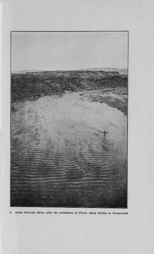
9. Little Colorado River after the subsidence of Flood—Sand Riffles in Foreground.

10. Cowboys Assisting Reconnoissance Party over Difficult Strip of Highway.
THE ARIZONA STRIP 29
Of the former we observed poplar, black locust, honey locust, two
species of ash, and elm. Of the latter, we observed pears, apples,peaches, plums, apricots, grapes, etc. They harvest three cuttingsof alfalfa, about one and one-half tons per cutting. Mr. Jenson, in1900, reports having grown 25 tons of alfalfa on three acres. Theland having been measured, and the hay weighed and sold. Both
white and yellow flowered sweet clover were observed growing withgreat vigor. The chief corn is white flint, which yields from 25bushels upward.
They commenced dry farming around Fredonia four years ago,and there are now over five hundred acres of corn, rye and wheat.in this section. Rye is the most popular crop, yielding from 15 to-20 bushels per acre. The country around. Fredonia is occasionallyflooded by the turbulent waters of Kanab Creek, one of the most im-portant occurring in 1911. The substance of a narrative relatingthereto, by Mr. A. W. Brown, is given below.
On August 31, 1911, a great flood occurred, which covered 100acres from zero to six inches deep in five hours, depositing silt fromzero to four inches in depth over the area. It carried great quan-tities of mud, which was forced mostly in front of the main watersheet, and formed great clayballs, one of which measured 28 feetlong by 16 feet wide, and stuck out of the moving sheet of rand 8feet. This was brought from 30 to 40 miles distant. Some lie nowsouthwest of Fredonia and although breaking down rapidly, theyare in a comparatively high state of preservation. These balls areof red, blue and yellow clay, usually round or oblong in shape andhave no coarse material whatever in them. The manner in whichthey are formed, and the persistency exhibited in withstandingweathering is very striking and interesting. So far as known, nosuch phenomena have been observed elsewhere.
While at Fredonia, a visit was made to Kana,b. Here we founda live agricultural community. Kanab is six miles from Fredonia,due north, being three miles north of the Utah line. Twenty-fivethousand acres of land have been sold by the State of Utah since1912, and have been cultivated by dry farming, chiefly into wheat,the average yield ranging from 15 to 25 bushels. The Utah Agri-cultural College has located an Experiment Station one and one-halfmiles north of the Arizona line, consisting of forty acres. This waslocated June 20, 1913, and had not grown any crops, but was being
183149
30 THE ARIZONA STRIP
broken and prepared for planting this fall. The man in charge atpresent is I. H. Chamberlain, Kanab, Utah. Growing season hereis from April 25 to October 10. Farmers grow Turkey red wheat,barley, rye, corn, potatoes, alfalfa, etc. : Milo was tried this year,and the field of Mr. Wooley examined was about three feet high.Last year it did not mature. It is stated there are still 25,000 acresthat have been set aside as available under the Smoot Act in andaround Kanab. The contrast between 'Arizona and Utah farmingat this place was especially noticeable, as nothing but the boundaryline separates the two sections. Yet the Utah side is flourishing withyellow fields and thrifty homes, while the Arizona side is still insage brush. The soils in this vicinity are all made from the Ver-milion Cliff sandstone.
East of Fredonia is Telegraph Valley, where are several thou-sand acres of excellent land which skirt the northern slopes of theKaibab forest and reserve. These are covered with sage brush andwhite sage. The soil is of carboniferous limestone origin.
On the 19th of July, we left Fredonia for the western trip viaSt. George. Directly west of Fredonia is the Moccasin Indian Res-ervation, the soil over which is very desirable, having been derivedfrom the red sandstone of the Vermilion Cliffs, and being for themost part deep and uniform in texture. The entire reservation iswell grassed with grama and giletta, and carries a heavy growth ofshad scale with some rabbit brush.
The Reservation is 18 miles long, and 12 miles wide, and sup-ports eighty Indians. Allotments have not been made to these asyet. Fourteen miles out is Bullrush Wash, made by President Tafta public watering place. The soil in this vicinity is underlain nearthe surface with a shale which makes it undesirable for farming.Going southwest, toward Mount Trumbull on the Sunshine road, thecountry is somewhat broken, and nearly all underlain near the sur-face with the red sandstone shale. Occasionally, small valleys vary-ing in size from one-half to one mile wide, and one to four mileslong, occur with sufficient soil depth to warrant farming:.
All of the section is excellent grazing land, being heavily grassedwith giletta, six weeks, grama, as well as some buffalo grass. Ashigher elevations are reached going toward Mount Trumbull, therise being very gradual, other species come in, such as white grease-woods, occasionally white cedar, yellow sage, etc. The soil condi-
THE ARIZONA STRIP 31
tions are not suitable for farming, but the range conditions improveas the elevation 18 increased. Twenty-six miles out, we stopped forthe night at the Wooley-McCormich sheep camp.
We were near Mount Trumbull, and found the soil of limestoneorigin, but badly broken up and unfit for agricultural purposes.Range conditions, however, were exceedingly favorable. They wererunning some 5,000 head of grade Persian-Rambouilette sheep inone band. The elevation here is about 5,500 feet. The thrifty con-dition of the sheep would indicate that they were well adapted totheir environment.
We continued in a southeast direction toward Mount Trumbull,and passed over a country which is much broken by intruding ridgesfrom the Uinkaret Mountains, one of the most conspicuous of whichis known as Cedar Ridge. We found gramas and giletta grass •kneehigh, with an abundance of sage browse. The cattle were all veryfat. It is evident the precipitation is greater here, as all vegetationlooked more luxuriant. West and north of the Cedar Ridge is aconspicuous range of hills, with a receding limestone plateau ex-tending and sloping mainly to the north, which finally . opens intoa very superior valley with soil exposed in washes six to ten feetdeep, and of uniform texture. This soil is probably of carboniferouslimestone origin, and is very fertile. A hole dug on the west slopesrevealed a slight sub-surface crust at about 12 inches. It was notimpervious to water nor plant roots. This is only one of many sim,ilar small valleys in this section.
Water here for culinary and stock purposes would have to beimpounded in tanks and cisterns. The multitudinous small canyonsand draws, however, .furnish excellent facilities for such storage.
Pipe Springs Valley represents the best type of soil and generalconditions for dry farming that we found anywhere on the strip(Soil sample sent in for complete analysis).
This .valley extends in a general north and south direction, andhas a uniform slope from each side towards the center, where wateris carried in considerable amount into Kanab Creek drainage. Thesoil exposed in many places is as much as forty feet, and is of thesame character to this depth. It is the decomposed red sandstoneof the Vermilion Cliffs, and supports a luxuriant growth of gramagrass and browse of white sage on the more elevated slopes, andgreasewood in the lowest flats. With little or no interruption, Pipe

32 THE ARIZONA STRIP
Springs Valley opens into the Short Creek country, which extendssouthwestward and joins Antelope Valley. The soils over these lasttwo are identical with that of Pipe Springs, and support the saineclass of flora.
Hurricane Valley also offers an excellent opportunity for dryfarming as far as the soil is concerned, it being of a heavy sandyloam type, easy to work and to conserve moisture. West fromHurricane, the counry drops into the Virgin River watershed, andbecomes precarious for dry farming, although excellent range isfurnished over most of this district.
The soils of the Strip in general examined seem to have beenderived either from the Vermilion Cliff sandstone, or from the graycarboniferous limestones. Wherever the mechanical composition isfavorable, it supports a thrifty growth of grass and browse; and nodoubt would support a profitable growth of agricultural crops.There is no strong evidence of the soil shifting to any serious de-gree. Certain small patches, however, showed sand dunes. Of thearea in the Pipe Springs, Antelope, Short Creek and Hurricane Val-leys, there are fully one million acres with excellent soil for agri-cultural purposes.
WATER.
The occurrance of living water over the area is confined to aseries of seeps or springs, which show themselves at Jacob's Pool,
Two Mile Spring, Pipe Springs, Short Creek, Antelope Springs, Bull-
rush Wash, Kane Beds, and one or two in Hurricane Valley. Thereare a few seeps on the Kaibab Forest, but the indications for water
there are generally rather adverse. This is shown by the waterthat forms Bright Angel Creek as it comes out some two thousand
feet below the rim, which would indicate that the main subterraneanwater supply is carried to that depth before finding an imperviousstratum. Two or three of the stockmen with large holdings in this
section have attempted at various times to corral various springsfor their own operations. The country not having been surveyed,
however, has with two or three exceptions left them public. Presi-
dent Taft also made public watering holes of Bullrush, Antelope,
Kane Beds and other springs in the Hurricane Valley, which has
prevented for all time the monopoly of any one individual over these

THE ARIZONA STRIP 33
waters. Sufficient water could be developed at the different pointsindicated along the Vermilion Cliffs, such as Pipe Springs, ShortCreek, Two Mile Spring, etc., to supply cities of five to ten thousandinhabitants at each place. These would be the nucleus for agricul-tural development for a radius of some ten miles from each town.The quality of the living water coming from the Vermilion Cliffsis very good, while that at Bullrush is brackish, and suitable onlyfor stock.
Storage possibilities occur in a small way from various canyonsand draws, coming from the Buckskins on the east, and Uinkaret onthe west. These are very small, however, and would be developedby individual or a small group of individual farmers. The storagepossibilities on Kanab Creek, into which the waters of Duck Lake,Utah, could be diverted, are sufficient to irrigate some twelve orfifteen thousand acres of land in Arizona. The dam site is in Utah,and most of the water rises in Utah. If suitable arrangements couldbe made between the two states, the area of irrigated land aroundKanab could be brought up. to 2,500 acres, and that around Fre-donia to 10,000 acres. Short Creek also offers possibilities in theway of a submerged dam and a storage darn for an acreage of per-haps 5,000. Numerous smaller projects were examined, but are oflittle or no significance.
The subterranean water, as it occurs around Kanab and Fre-donia, is slightly brackish and not used extensively by the peoplein these towns. It is suitable for stock water, and occurs as nearas 20 feet from the surface. There are a few or no wells outside ofthe Fredonia section from which data could be gathered.
There is a great possibility for an economic use of flood waterin this district, which; judging from the numerous washes and draws,is considerable. We were stopped by a heavy storm between PipeSprings and Short Creek, which had swollen a wash that we esti-mated discharged 1,000 acre feet of water in about one hour. Theflood waters are all heavily laden with .sediment.
TIMBER.
The timber over the Strip is found in the Kaibab National For-est, the Dixie Reserve, and the Uinkaret Mountains. That of thefirst mentioned area is the best forest in the state. The government

34 THE ARIZONA STRIP
fOresters have put up for sale, three billion feet from this reserve,with a hope of fostering a railroad through this section. The tim-ber is generally yellow and white pine, with some Douglas fir on theKaibab Reserve. There is also a small amount of timber not includedin the reserves between the Arizona-Nevada line. There is a saw-mill operated here by John Pulsiafer of St. George. The timber isscattering and not very large. One sawmill is at present operatingnear Jacob's Lake on the Kaibab Reserve. There is also one oper-ating in the Dixie Forest.
MINERAL.
The chief mineral observed is copper. There is a mine .at, Ryancalled Coconino, on which $500,000 has been expended in 'develop-ment work. They .put up a small smelter and lesher at this place.The mine at Jacob's Lake is called the Potaska, at which they havealso a small lesher. Here the indications are good, but the amountof work done is not ,extensive as yet. Around Moccasin, Mr. Jon-athan Heaton reports immense deposits of low grade copper. Sam-ples showed amounts from one and one-half to three per cent.
POWER.
One of the best opportunities for development of power is onBright Angel Creek. Although more or less isolated, the creek flowssome 12 or 15 second feet of water, and has a drop of 2,000 feet, ina distance of about three miles. There would also be about 1,000
horsepower developed along with the irrigation project mentionedabove, on Kanab Creek.
INHABITANTS, INDUSTRIES, ETC.
We found some eighty Indians located at Moccasin, who occupythemselves with farming in a small way and raising stock. Theyhave an Indian school at this point, at present in charge of J. W.Maxwell. They belong to the Piute tribe.
The white people of the Strip are found at Fredonia, Littlefield,Lee's Ferry, Short Creek, Moccasin, and on the various cattleranches. The population of Fredonia is estimated at 150, Littlefield100, Lee's Ferry 10. Short Creek 50, Moccasin 10, cattle ranches 25.
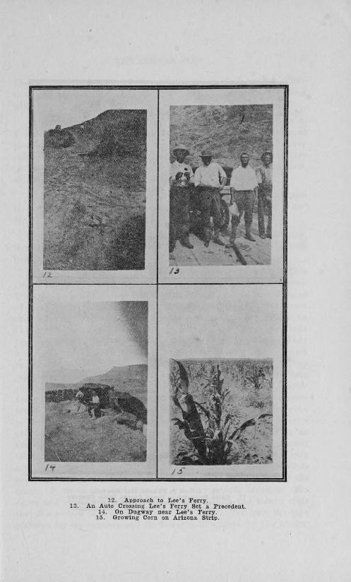
12. Approach to Lee's Ferry.13. An Auto Crossing Lee's Ferry Set a Precedent
14. On Dugway near Lee's Ferry.15. Growing Corn on Arizona Strip.

16. Arrival at Dainsite near Fredonia17. Cabin Belonging to Grand Canyon Cattle Company.
18. Looking over Buffalo in Pasture at Kanab.19. Potatoes Grown by Dry Farm near Fredonia.

THE ARIZONA STRIP 37
The principal occupation of the white people is stock raising. Prac-
tically all possess cattle and sheep and some supplement live stockwith farming.
The general standard of the people in Fredonia was shown ina Farmers' Institute which we held on July 16. There were 65present, and they were apparently very much alive to their agri-cultural and social problems. The program consisted of a lectureon dry farming by A. M. McOmie, Insect Pests by O. C. Bartlett,and Water Resources by C. C. Jacob.
Some of the best cattle breeders of this section are JonathanHeaton of the Grand Canyon Cattle Company, Alex Finley, andMr. D. Wooley of Kanab, Utah, and "Buffalo" Jones.
"Buffalo" Jones, or Colonel Jones, associated with Mr. Wooley,have at present four buffalo bulls and 48 hybrids. The hybridshave the following breeding:
One bull, one-sixteenth buffalo. Two cows, one-fourth buffalo(these looked like cows, except a little heavier in the shoulders).The rest are less than half cow, but all looked like buffalo ; 23 headof these are on the range around Jacob's Pool, and the rest wereshipped to Las Vegas, New Mexico, last spring. The Grand CanyonCattle Company get seven grade calves this year. They have onlytwo pure bred bulls. Mr. Owens is also interested in buffalo. Theyare chiefly valuable for their pelt, which is reputed to bring as muchas two and three hundred dollars from a full grown animal. Theysay the meat is very similar to first class beef, but no better. Theseanimais cross with difficulty on the common cow, the great troublebeing that the shoulders of the calf are so heavy that many cowsare killed in giving birth to the calf. It is also necessary in orderto get a buffalo male to serve a cow, to bring the buffalo from acalf in constant contact with domesticated cows. The buffalo onthe range do not mix much with the other cattle, and seem to selecttheir own range very distinctly. One breeder states that he tooka young buffalo calf from its mother from the range, and the wholeherd, consisting of ten head, immediately left that Portion of therange. It seems also that they are not very prolific breeders. Mr.Jones and others making a study of their habits and wants, statethat this section of the country where the buffalo can have the highplateaus for the summer and the lower mild valleys for the winter,

38 THE ARIZONA STRIP
thrive better than in any other portion of the United States, espe-cially better than those being, tried on open range in Wyoming.
Other live stock of interest are the Persian sheep, owned by theWooley-McCormick Persian Sheep Company of Kanab. They are adesert sheep, kept on this range the entire year, and are charac-terized by fat tails or rumps, which in many cases weight from 30to 40 pounds. This is very much reduced, however, by first onecross on the Rambouilette, or other similar breeds of sheep. Thetail coming out from the fat rump, is small and short, and curls uplike that of a goat. The wool is long and of fairly good quality(samples taken). We sampled the meat also of a young wether, andfound it to be of first grade quality.
As near as I could ascertain, the Strip supports 50,000 head ofcattle and 200,000 head of sheep most of the year. These flocks areowned by Utah growers as far north as ParoWan. The old systemof providing water tanks by building small dams across washes, andof running the cattle on the high plateaus in the summer and thelower valleys in the winter, prevails in this section. The cattle con-sist of grade Shorthorns and Herefords. The sheep are principallygrade . Rambouilette.
We found a thriving school at Fredonia. There is also one atLittlefield. They have no school at Lee's Ferry, Moccasin nor ShortCreek, although in the last named place, they stated, they wouldhave one this year. The people of Short Creek are mostly squatterslocated along the line, and share the accommodations furnished thepeople directly across the line in Utah, at Short Creek and Bigplains.
AGRICULTURAL DEVELOPMENT.
Agricultural development at present consists of about 30 acresof irrigated land at Lee's Ferry, cropped to fruit and alfalfa. Onethousand acres of irrigated land at Fredonia, and about 600 acresat Littlefield. The dry farming development consists of 500 acresat Fredonia, 200 acres at White Sage Flat, and about 2,000 acres atShort Creek, With five or six squatters in Hurricane Valley. Thecountry generally is suited to the production of grains, corn, sor-ghum, potatoes, alfalfa, and all classes of deciduous fruits. Theprices of some of the more staple products at Fredonia are asfollows:

THE ARIZONA STRIP 39
Alfalfa—$25 per ton.Corn-3 cents per pound.Rye-3 cents per poi bd.Wheat-3 cents per pound.Potatoes-2 cents per pound.
The agricultural possibilties here are very promising for com-bined stock raising and farming operations. There are at least amillion acres of excellent dry farming lands with many more acresof excellent adjacent grazing lands. The irrigated area may beincreased several times by the construction of storage dams ; bythe state taking some of the land, and by putting the rest under thenon-residence clause of the Smoot Act, the people may settle aroundthe living water mentioned above in communities, and build perma-nent homes. The water conditions, however, will make it impera-tive for some such arrangement as indicated, if the country is fullydeveloped. The future prospects for the Strip under these condi-tions are very bright, and the resources are ample to support a pop-ulation of 20,000 people, which is ample to form a thriving county.
The construction of a good road from the Arizona line throughthe heart of the Strip to the head of Bright Angel Canyon, oppositeEl Tovar, would be a great step towards bringing this section be-fore the public. The canyon from the north side is quite as attrac-tive as it is from the south side, and thousands of tourists would beinduced to make this trip from the north, who are now compelledto forego it on account of its inaccessibility.
It was the fortune of our party to attend a good roads meetingat Hurricane, Utah, in which such a road was discussed. The Utahpeople now have a good automobile road from Salt Lake City toHurricane, and propose to build it from Hurricane to the Arizonaline. The Salt Lake Chamber of Commerce is spending its energiesto inducing tourists to see the Grand Canyon from that side, andthe officials of Arizona should not be found wanting in keeping uptheir end of the road development work.
(Signed) A. M. McOMIE.