the 100-ka and rapid sea level changes recorded by ... · grading unit as sequence boundaries...
TRANSCRIPT

The 100-ka and rapid sea level changes recorded byprograding shelf sand bodies in the Gulf of Lions (westernMediterranean Sea)
M. A. Bassetti and S. BerneInstitut de Modelisation et d’Analyse en Geo-Environnement et Sante, Universite de Perpignan, 52 avenue Paul Alduy,F-66860 Perpignan, France
Geosciences Marines, Institut Francais de Recherche pour l’Exploitation de la Mer, BP70, F-29280 Plouzane, France([email protected])
G. JouetGeosciences Marines, Institut Francais de Recherche pour l’Exploitation de la Mer, BP70, F-29280 Plouzane, France
M. TavianiIstituto di Scienze Marine, CNR, via Gobetti 101, I-40129 Bologna, Italy
B. DennielouGeosciences Marines, Institut Francais de Recherche pour l’Exploitation de la Mer, BP70, F-29280 Plouzane, France
J.-A. FloresFacultad de Ciencias, Universidad de Salamanca, Plaza Merced s/n, E-37008 Salamanca, Spain
A. GaillotAltran Quest, Technopole Brest Iroise, CS 23866, F-29238 Brest, CEDEX 3, France
R. GelfortInstitut fur Geowissenschaftliche Gemeinschaftsaufgaben, Stilleweg 2, D-30655 Hannover, Germany
S. LafuerzaGRC Geociencies Marines, Departament d’Estratigrafia i Paleontologia i Geociencies Marines, Universitat deBarcelona, Martı i Franques s/n, E-08028 Barcelona, Spain
N. SultanGeosciences Marines, Institut Francais de Recherche pour l’Exploitation de la Mer, BP70, F-29280 Plouzane, France
[1] Thick forced regressive units on the wide continental shelf of the Gulf of Lions (westernMediterranean) recorded the composite effect of sea level changes during the Quaternary. They aremostly composed of coastal siliciclastic and bioclastic wedges showing clinoform geometry. Thesedeposits have been intensively explored through high-resolution seismic investigations, but only recently itwas possible to ground truth seismic interpretations, based on a long (100 m) borehole that crossed thesuccession and recovered a large part of the mainly sandy deposits (�84% recovery). A multiproxyanalysis of the sedimentary succession shows that (1) the stratal architecture of the shelf margin is definedby major bounding surfaces that are polygenic erosion surfaces associated with coarse-grained materialincorporating abundant and diverse shells, including cold-water fauna (presently absent from the
G3G3GeochemistryGeophysics
Geosystems
Published by AGU and the Geochemical Society
AN ELECTRONIC JOURNAL OF THE EARTH SCIENCES
GeochemistryGeophysics
Geosystems
Article
Volume 9, Number 11
13 November 2008
Q11R05, doi:10.1029/2007GC001854
ISSN: 1525-2027
Copyright 2008 by the American Geophysical Union 1 of 27
Mediterranean Sea). Between each surface, coarsening upward units with steep (up to 5�) foresets are madeof massive (more than 20 m thick) sands with possible swaley and hummocky cross-stratification, passingseaward to sands with muddy intervals and, further offshore, alternating highly boiturbated sands and silts.Each prograding wedge corresponds to a forced-regressive shoreface (or delta front/prodelta), depositedduring the overall sea level falls occurring at (relatively slow) interglacial/glacial transition and thereforerepresents the record of 100 ka cyclicity. Higher-frequency Milankovitch cyclicities are also probablyrepresented by distinct shoreface/delta front wedges; (2) detailed examination of the architecture andchronostratigraphy of the most recent sequence shows that minor bounding surfaces, corresponding toabrupt shallowing of sedimentary facies, separate downward stepping parasequences within the last 100 kasequence. These events are in phase with millennial-scale glacial climatic and sea level variability, thedownward shift surfaces corresponding to the falls during the coldest stadials. These deposits provide acomprehensive and well-constrained Pleistocene analog to the numerous shoreface deposits attributed tofalling-stage systems tracts recognized in ancient stratigraphic records, studied at the outcrop scale.
Components: 12,008 words, 13 figures.
Keywords: shoreface; quaternary; Mediterranean; paleoclimate.
Index Terms: 1861 Hydrology: Sedimentation (4863); 1641 Global Change: Sea level change (1222, 1225, 4556).
Received 12 October 2007; Revised 29 August 2008; Accepted 10 September 2008; Published 13 November 2008.
Bassetti, M. A., S. Berne, G. Jouet, M. Taviani, B. Dennielou, J.-A. Flores, A. Gaillot, R. Gelfort, S. Lafuerza, and N. Sultan
(2008), The 100-ka and rapid sea level changes recorded by prograding shelf sand bodies in the Gulf of Lions (western
Mediterranean Sea), Geochem. Geophys. Geosyst., 9, Q11R05, doi:10.1029/2007GC001854.
————————————
Theme: Interactions Between High-Frequency Climate Changes and Deltaic Margin ArchitectureGuest Editors: S. Berne, J. Syvitski, and F. Trincardi
1. Introduction
[2] Prograding beach-shoreface deposits are acommon component of the stratigraphic record[Walker and Plint, 1992]. They correspond toone of the key ‘‘facies models’’ utilized by sed-imentologists studying the stratigraphic record,and the analysis of their evolution through timeis at the origin of most sequence-stratigraphicparadigms [Posamentier et al., 1992]. Beach-shoreface deposits are very sensitive to base-levelchanges, thus they have been also utilized, undercertain conditions, as ‘‘dipsticks’’ for sea levelchanges [Rabineau et al., 2006]. In addition, be-cause of their high content of well-sorted sand, theyalso represent potential reservoirs for hydrocarbons.However, the shallow marine processes that arerecorded in detail within shoreface-foreshore-shelfparasequences are barely known. This is mostly dueto the lack of lithological data on Quaternary shore-face deposits, which are mainly known throughhigh-resolution seismic investigations or from in-terpretation of outcrops examples of ancient shore-face deposits. The term ‘‘shoreface’’ is used here inthe sense of van Wagoner et al. [1990], i.e., sedi-
ments deposited between the foreshore and thestorm wave base. In a wave-dominated deltaicsetting, it corresponds to the delta front and prodeltadomains, and it is generally difficult, in the strati-graphic record, to make the distinction betweenboth settings, especially when longshore drift modi-fies the geometry of sand bodies [Bhattacharya andGiosan, 2003].
[3] The Gulf of Lions, in the NW MediterraneanSea has been the subject of intense high-resolutionseismic investigations during the last 10 years[Berne et al., 2004]. Because of high sedimentsupply and rapid subsidence it offers an exception-al record of shelf/slope sequences linked to gla-cioeustatic sea level changes during the last 500 ka.However, attempts to core the sand bodies depositsthat constitute one of the key component of theshelf/slope succession was largely unsuccessful,due to the presence of coarse shell lags makingpiston and vibra-coring operations very difficult.The maximum recovery using these conventionaltechniques were cores about 2.5 m long [Aloısi,1986; Bassetti et al., 2006; Berne et al., 1998]. Forsimilar reasons, Ocean Drilling Program (ODP) leg
GeochemistryGeophysicsGeosystems G3G3
bassetti et al.: rapid cyclicity in shoreface deposits (gulf of lions) 10.1029/2007GC001854
2 of 27

174A on the New Jersey continental shelf encoun-tered great difficulties recovering, with ‘‘advancedpiston coring,’’ the sandy successions that consti-tute most of Quaternary deposits on this margin[Austin et al., 1998]. Similarly, attempts to core asand ridge in the North Sea experienced majordifficulties, with an overall recovery less than 16%[Davis and Balson, 1992]. The most comprehen-sive investigation of sandy clinoforms was con-ducted by a consortium of oil companies, whichsuccessfully drilled shelf-edge deltas of the Missis-sippi margin [Winn et al., 1995]. However, theborehole described by these authors is locatedbeyond the shelf edge, and the authors do notprovide description of sedimentary facies withinthe clinoform units.
[4] In June–July 2004, a drilling operation wasfunded by the European Community in order toinvestigate the Adriatic and the Gulf of Lionsdeltaic margins (Profiles Across MediterraneanSedimentary Systems (PROMESS 1)). Two siteswere drilled in the Gulf of Lions: PRGL1-4 (300 mlong), located at the interfluves of Bourcart andHerault canyons at a water depth of 298 m, andPRGL2-2 (100 m long, 103 m water depth),
through the seaward termination of a preservedlast glacial shoreline (Figure 1). In particular,PRGL2-2 drilled through sedimentary discontinu-ities related to submarine and/or subaerial erosionthat can be tied to correlative conformities towardthe slope. The borehole provided valuable infor-mation on seismic and sedimentary facies, as wellas physical and geotechnical properties.
[5] Interpretations of the prograding sedimentwedges that were drilled during the cruise at sitePRGL2-2 are here provided, since the drillingoperations were successfully terminated with thesatisfactory core recovery of 84%, despite thepresence of thick sandy intervals. The correspon-dence between sedimentary and seismic facies ishere demonstrated, thanks to the newly acquiredsedimentological data that permit detailed charac-terization the seismic response to lithologicalchanges. For intervals with no recovery, lithologieswere predicted fromCone Penetration Test [Lafuerzaet al., 2008].
[6] The major objectives of our study are todescribe the sedimentary facies of clinothem unitsand interpret their depositional environment and to
Figure 1. General bathymetry of the Gulf of Lions. The gray pattern corresponds to the sand distribution oncontinental shelf. The dotted line marks the seaward termination of glacial sandy shorefaces.
GeochemistryGeophysicsGeosystems G3G3
bassetti et al.: rapid cyclicity in shoreface deposits (gulf of lions) 10.1029/2007GC001854bassetti et al.: rapid cyclicity in shoreface deposits (gulf of lions) 10.1029/2007GC001854
3 of 27
understand how the different facies and sequencesrecord the changing sea level and how importantsurfaces can be recognized from subsurface andsedimentological data.
2. Regional Setting
[7] The Gulf of Lions is a passive, prograding, andsubsiding margin, located in the northwestern sec-tor of the Mediterranean Sea bounded, to the westand east, by Pyrenean and Alpine orogenic belts,respectively (see the synthesis by Berne and Gorini[2005]). It comprises a wide (about 70 km) shelfand a continental slope that is incised by numerouscanyons descending to the abyssal area of theAlgero-Balearic Basin. Because of high sedimentsupply (mainly from the Alps through the RhoneRiver) and very limited tectonic activity, the Gulfof Lions is a favorable environment for studyingthe deposition and preservation of sequences con-trolled by glacioeustasy.
[8] During the last �500 ka, sea level oscillatedbetween its present position and about 120 mbelow the present sea level. Because the shelf edgeis located between 105 and 165 m water depth, alarge portion of the continental shelf was exposedduring glacial periods. As a result, the stratigraphicrecord displays major erosional surfaces resultingfrom subaerial and shallow marine erosion duringsea level falls, lowstands, and sea level rises.
[9] The cyclically stacked Plio-Quaternary sequen-ces have been object of seismic investigationsover the last 30 years by several authors whoproposed a number of conceptual and/or numericalstratigraphic models [Aloısi, 1986; Berne et al.,1998; 2004; Lofi et al., 2003; Monaco, 1971;Rabineau et al., 2005; Tesson et al., 1990;2000]. A review of these investigations is givenby Rabineau et al. [2005]. Most of the middle andouter continental shelf consists of progradingwedges that display internal reflections showingalternating low angle (<1�) and high angle (>4�)clinoforms. On the basis of shallow cores andstratigraphic modeling, this elementary ‘‘motif’’was interpreted as the result of alternating deposi-tion of high energy (sandy upper shorefaces/deltafronts) and low energy (muddy lower shorefaces or‘‘offshore’’ deposits) during late Quaternary sealevel changes. The large (>100 km) lateral extentof these sand bodies suggest a global (sea level)control on their deposition. However, the nature ofthe prograding shorefaces remained controversial;some authors interpreted them as the product of
deposition during the falling stage of sea level[Aloısi, 1986; Berne et al., 1998; Rabineau et al.,2005], whereas others proposed that they couldcorrespond to transgressive parasequences (in thesense of van Wagoner et al. [1990]) formed duringthe early stages of sea level rises [Tesson et al.,2000]. Also, the formation timing of these depositsremained elusive, with some authors interpretingthe major bounding surfaces separating each pro-grading unit as sequence boundaries linked to the100 ka glacial/interglacial cycles [Aloısi, 1986;Lobo et al., 2005; Rabineau, 2001], whereas othersascribed them to higher-order (20 ka) cyclicities[Tesson et al., 1993, 2000].
3. Methods
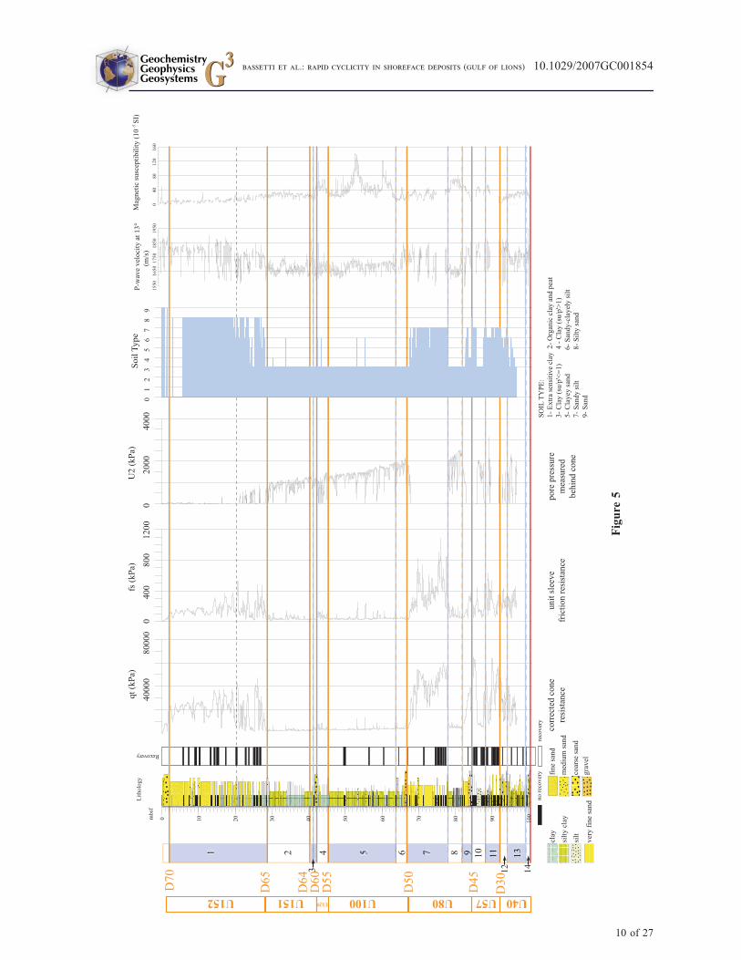
[10] The data were collected on board SRV Bavenitof the Russian company Amige, operated byFugro. In order to evaluate sediment types to becored, and for geotechnical characterization, wefirst performed a continuous cone penetration testunified (CPTU) at site PRGL2-1, distant a few mfrom the PRGL2-2 site where continuous coringwas carried out. The test was made with a staticpenetrometer measuring (1) cone resistance (kPa);(2) sleeve friction (kPa); and (3) pore pressureacting on the cone (kPa). The CPTU equipmentand the procedures adopted during the cruiseoperations are in accordance with the InternationalReference Test Procedure published by the Societyof Soil Mechanisms and Geotechnical Engineering(ISSMGE) [1999]. Estimation of sediment typesbased on geotechnical properties was done usingthe method of soil classification established afterRamsey [2002].
[11] An important application of CPTU measure-ments is the prediction of the stratigraphy andlithology of buried sediments. Thanks to the com-bination of three CPTU measurements (cone resis-tance, lateral friction, pore pressure [Ramsey,2002]) it is possible to define the soil type basedon a soil classification chart (see details in the workof Lafuerza et al. [2008]). It relies on a large CPTUdatabase adapted and improved by different authorsto diagrams of soil classification [Ramsey, 2002;Robertson, 1990].
[12] All geotechnical data were combined for soilcharacterization, considering that the pore pressure(u2) is mainly related to the permeability of sedi-ments, whereas the resistance to cone penetration(qt) and the lateral friction ( fs) can be directlycorrelated to a particular lithology.
GeochemistryGeophysicsGeosystems G3G3
bassetti et al.: rapid cyclicity in shoreface deposits (gulf of lions) 10.1029/2007GC001854
4 of 27
[13] Core sections, from 0.80 to 1.5 m in length,were recovered using a suite of FUGRO corers,including a piston corer, a ‘‘WIP’’ corer, and aFUGRO corer. Overall, about 50% of the drilledsection consisted of sand, making core recoverydifficult. However, within very sandy intervals, thestrategy consisted to core down to the maximum ofpenetration, then, when core recovery was less than50 cm, to drill only 50 cm in order to minimize thegaps. This time-consuming operation allowedoverall recovery of 84%.
[14] Physical properties of collected cores weremeasured on board using a GEOTEK MultiSensorCore Logger (MSCL), by means of (1) gamma raydensity; (2) P wave velocity; and (3) magneticsusceptibility. Magnetic susceptibility was mea-sured a second time in the laboratory on split cores.To link lithological, seismic, and geotechnical data,a time-depth conversion was constructed using Pwave velocities from MSCL. From this calculation,all logs were converted into a timescale (ms; twoway travel time (TWTT)). In addition, velocities offine-grained intervals were measured using a pairof transducers oriented along the core axis. Thevery good match between major lithologicalchanges and boundaries of seismic units demon-strates the validity of the method.
[15] All cores were visually described, and X-rayimages were realized for the most significantsections. The X-ray radiography was particularlyuseful for enhancing subtle sedimentary structuresnot easily identified on freshly cut core surfaces.
[16] Measurements of carbonate content (Bernardcalcimeter, precision ± 2%) and grain size analyseswith a laser microgranulometer (Coulter counterLS130; size range 0.4 mm to 1 mm) were made onthe total sediment fraction on samples collectedevery 20 cm (with the exception of gravel beds).
[17] In order to establish a biostratigraphic control,the cores were analyzed onboard for calcareousnannoplankton (E. Colmenero and J. Gravalosa,personal communication, 2004), additional samplesbeing analyzed after core splitting in the laboratory.
[18] The chronostratigraphy of the youngest se-quence is based on AMS 14C dating of biogeniccarbonates (mainly Foraminifera). In addition,attempts were made on a few samples to date totalorganic carbon or wood fragments. Approximately10 mg of biogenic carbonate was handpicked underthe binocular microscope and AMS 14C dates wereobtained by the Poznan Radiocarbon Laboratory ofthe Adam Mickiewicz University (Poland). All
ages reported here are given in calibrated ages.For ages between 0 and 21,880 14C BP calendar(i.e., calibrated) ages were calculated using correc-tion tables [Stuiver and Reimer, 1993] and by meanof Calib 5.0.2 sofware (http://calib.qub.ac.uk/calib/).For the marine material, the Marine04 calibrationcurve [Hughen et al., 2004; Reimer et al., 2004]was used with no deviation from the mean globalreservoir correction (�400 y). For continentalmaterial the Intcal04 calibration curve [Reimer etal., 2004] was used. For ages beyond 21,880 14CBP, the Glacial Polynomial [Bard et al., 1998] wasused. Calendar ages are given with 1 sigma stan-dard error.
[19] Beyond the radiocarbon dating resolution,chronostratigraphy was obtained by estimationsof the abundance of biostratigraphically significantcoccolith taxa, following the criteria of Raffi andFlores [1995].
[20] In addition to core data, spectral gamma raymeasurements were performed in situ by means ofwireline logging. Total gamma counts and potas-sium (40K), thorium (232Th), and uranium (238U)fractions were recorded. Because open hole log-ging was deemed to be too risky in such uncon-solidated marine sediments, logging took placewithin the drill string and bottom hole assembly(BHA). While this ensured a safe operation, gam-ma counts were severely diminished by the sur-rounding steel. From the BHA design, steelthicknesses were established and data correctedfor using the ENCOR algorithm as developed byHendriks [2003]. Spectral gamma ray results showedno major features but total gamma ray counts wereutilized as clean sand versus clay indicator.
4. Results
4.1. Seismic Sequences and Surfaces
[21] The overall seismic stratigraphic organizationof the shelf/upper slope is summarized in Figure 2.In the Gulf of Lions margin, prograding wedges,attributed to forced-regressive systems tracts [Huntand Tucker, 1992] thicken seaward. These wedgesare bounded by erosion surfaces that becomecorrelative conformities on the upper continentalslope, where they have been precisely dated. Theyform a hierarchy of bounding surfaces in the senseof Brookfield [1977].
[22] Major seismic surfaces are traceable through-out the Gulf of Lions and they correspond to 100 kaglacioeustatic cycles [Rabineau et al., 2005]. They
GeochemistryGeophysicsGeosystems G3G3
bassetti et al.: rapid cyclicity in shoreface deposits (gulf of lions) 10.1029/2007GC001854
5 of 27
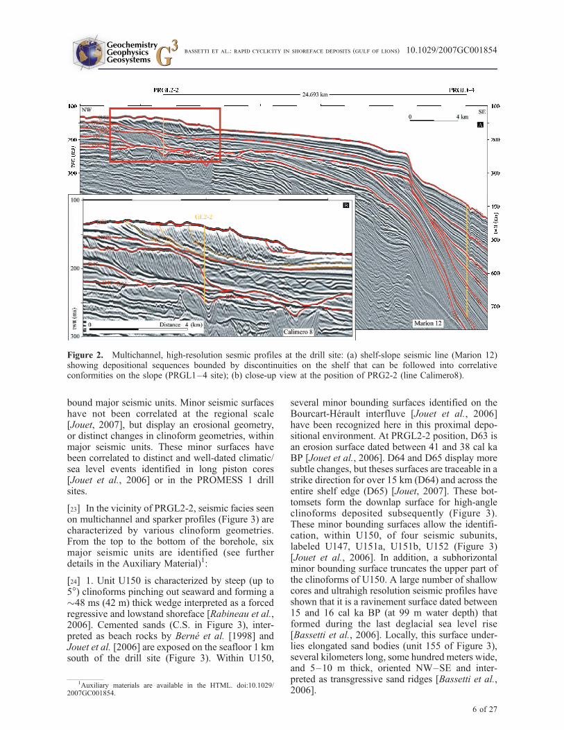
bound major seismic units. Minor seismic surfaceshave not been correlated at the regional scale[Jouet, 2007], but display an erosional geometry,or distinct changes in clinoform geometries, withinmajor seismic units. These minor surfaces havebeen correlated to distinct and well-dated climatic/sea level events identified in long piston cores[Jouet et al., 2006] or in the PROMESS 1 drillsites.
[23] In the vicinity of PRGL2-2, seismic facies seenon multichannel and sparker profiles (Figure 3) arecharacterized by various clinoform geometries.From the top to the bottom of the borehole, sixmajor seismic units are identified (see furtherdetails in the Auxiliary Material)1:
[24] 1. Unit U150 is characterized by steep (up to5�) clinoforms pinching out seaward and forming a�48 ms (42 m) thick wedge interpreted as a forcedregressive and lowstand shoreface [Rabineau et al.,2006]. Cemented sands (C.S. in Figure 3), inter-preted as beach rocks by Berne et al. [1998] andJouet et al. [2006] are exposed on the seafloor 1 kmsouth of the drill site (Figure 3). Within U150,
several minor bounding surfaces identified on theBourcart-Herault interfluve [Jouet et al., 2006]have been recognized here in this proximal depo-sitional environment. At PRGL2-2 position, D63 isan erosion surface dated between 41 and 38 cal kaBP [Jouet et al., 2006]. D64 and D65 display moresubtle changes, but theses surfaces are traceable in astrike direction for over 15 km (D64) and across theentire shelf edge (D65) [Jouet, 2007]. These bot-tomsets form the downlap surface for high-angleclinoforms deposited subsequently (Figure 3).These minor bounding surfaces allow the identifi-cation, within U150, of four seismic subunits,labeled U147, U151a, U151b, U152 (Figure 3)[Jouet et al., 2006]. In addition, a subhorizontalminor bounding surface truncates the upper part ofthe clinoforms of U150. A large number of shallowcores and ultrahigh resolution seismic profiles haveshown that it is a ravinement surface dated between15 and 16 cal ka BP (at 99 m water depth) thatformed during the last deglacial sea level rise[Bassetti et al., 2006]. Locally, this surface under-lies elongated sand bodies (unit 155 of Figure 3),several kilometers long, some hundred meters wide,and 5–10 m thick, oriented NW–SE and inter-preted as transgressive sand ridges [Bassetti et al.,2006].
Figure 2. Multichannel, high-resolution sesmic profiles at the drill site: (a) shelf-slope seismic line (Marion 12)showing depositional sequences bounded by discontinuities on the shelf that can be followed into correlativeconformities on the slope (PRGL1–4 site); (b) close-up view at the position of PRG2-2 (line Calimero8).
1Auxiliary materials are available in the HTML. doi:10.1029/2007GC001854.
GeochemistryGeophysicsGeosystems G3G3
bassetti et al.: rapid cyclicity in shoreface deposits (gulf of lions) 10.1029/2007GC001854
6 of 27
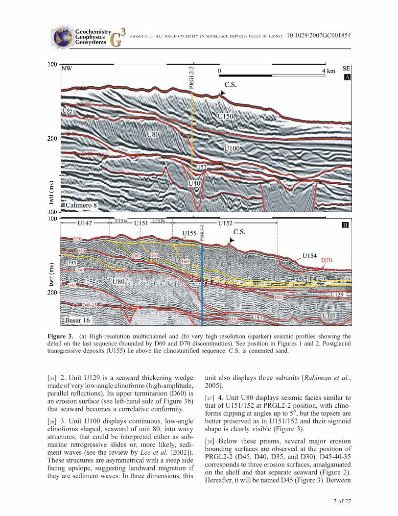
[25] 2. Unit U129 is a seaward thickening wedgemade of very low-angle clinoforms (high-amplitude,parallel reflections). Its upper termination (D60) isan erosion surface (see left-hand side of Figure 3b)that seaward becomes a correlative conformity.
[26] 3. Unit U100 displays continuous, low-angleclinoforms shaped, seaward of unit 80, into wavystructures, that could be interpreted either as sub-marine retrogressive slides or, more likely, sedi-ment waves (see the review by Lee et al. [2002]).These structures are asymmetrical with a steep sidefacing upslope, suggesting landward migration ifthey are sediment waves. In three dimensions, this
unit also displays three subunits [Rabineau et al.,2005].
[27] 4. Unit U80 displays seismic facies similar tothat of U151/152 at PRGL2-2 position, with clino-forms dipping at angles up to 5�, but the topsets arebetter preserved as in U151/152 and their sigmoidshape is clearly visible (Figure 3).
[28] Below these prisms, several major erosionbounding surfaces are observed at the position ofPRGL2-2 (D45, D40, D35, and D30). D45-40-35corresponds to three erosion surfaces, amalgamatedon the shelf and that separate seaward (Figure 2).Hereafter, it will be named D45 (Figure 3). Between
Figure 3. (a) High-resolution multichannel and (b) very high-resolution (sparker) seismic profiles showing thedetail on the last sequence (bounded by D60 and D70 discontinuities). See position in Figures 1 and 2. Postglacialtransgressive deposits (U155) lie above the clinostratified sequence. C.S. is cemented sand.
GeochemistryGeophysicsGeosystems G3G3
bassetti et al.: rapid cyclicity in shoreface deposits (gulf of lions) 10.1029/2007GC001854
7 of 27

these erosion surfaces, Unit U57 is a <5 m-thickseismic unit, difficult to correlate laterally. Thebottom of the borehole reached seismic Unit U40that corresponds to the infill of an axial incision (inthe sense of Baztan et al. [2005]) cutting across amajor buried canyon connected to the presentBourcart Canyon (Figure 1).
4.2. Lithology, Bio-, and SedimentaryFacies of Seismic Units
[29] PRGL2-2 offers a unique opportunity to verifythe actual nature of sandy clinoforms that havebeen imaged all around the world but almost neversampled with satisfying recovery.
[30] At the core scale, 14 sedimentary units wereidentified on the basis of their sedimentary facies(Table S1, Auxiliary Material). They are boundedby five coarse-grained intervals, the positions ofwhich perfectly correspond to the five majorbounding surfaces (D70, D60, D50, D45, D30)previously described on seismic profiles (Figure 4).The detailed lithological description of the bore-hole is included in the Auxiliary Material, as wellas the geotechnical properties (Figure 5) that wereutilized to interpolate with good confidence thelithological information for nonrecovered intervals.
[31] 1. U152 is an overall coarsening upwardsequence as defined on the basis of lithology, grainsize, and gamma ray (sedimentary unit 1; Figures 4and 6). This unit is topped by a coarse to mediumsand interval, 1.90 m thick, with shell debris (D70).It displays laminated or cross-bedded well-sortedand homogeneous fine- to medium-grained sand,with scattered rounded pebbles. Thin (1–2 cm)mud interbeds occur within the lower part of thisinterval (Figure 7, sections 8A, 10A, 14A; Figure 9,image 1). Swaley cross-stratification [Leckie andWalker, 1982] or hummocky cross-stratification[Harms et al., 1975] can be inferred at levels(Figure 7, section 14A) but these large-scale sed-imentary structures are not easy to recognize atcore scale.
[32] 2. U151 (sedimentary unit 2) is also a coars-ening upward sequence consisting of mud-sandalternations with millimeter-thick sandy beds, lam-inated and intensely burrowed, separated by 1 to10 cm-thick muddy beds (Figure 9, images 2, 3,and 4). The bottom of unit 2 is marked by a verydistinct transition toward massive silty clay withsparse bioturbation, and a carbonate content >25%(Figure 6). In detail, this unit can be divided into
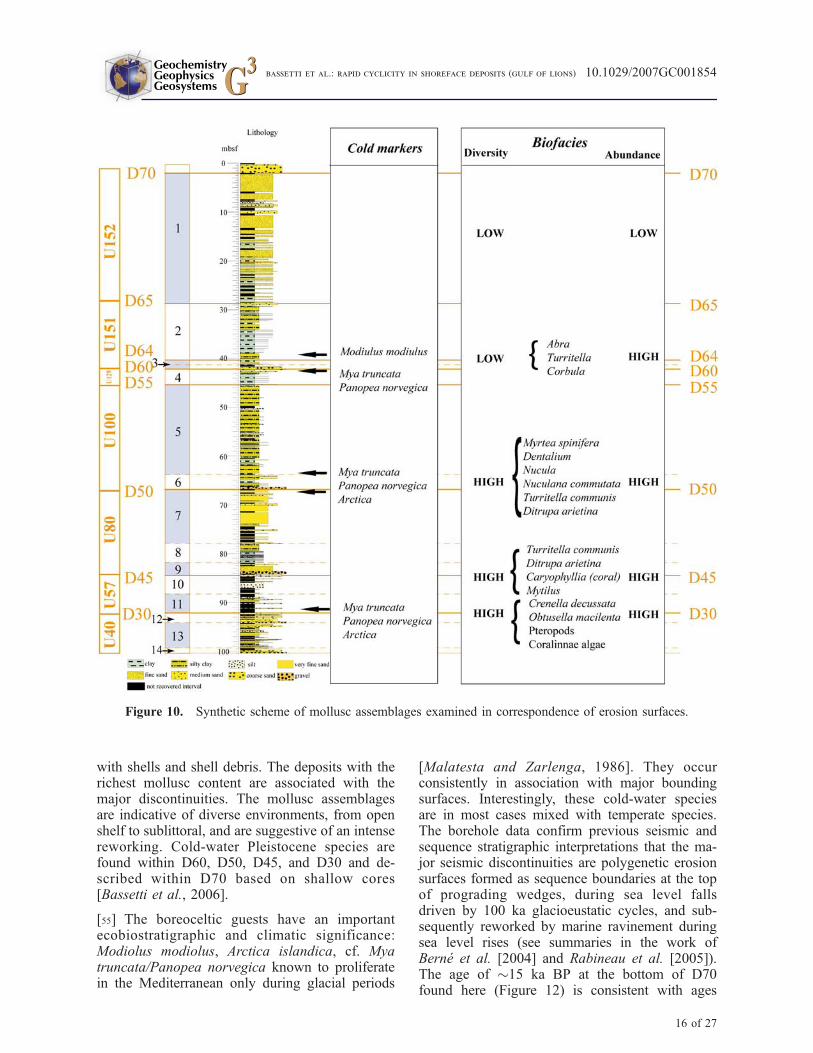
four coarsening-upward subunits, each displaying acoarsening upward pattern (Figure 11a).
[33] Seismic units U151 and U152 are character-ized by a very poor faunal content. Rare wornfragments of bivalves are found together with partlyreworked benthic foraminifera (mainly Ammoniasp. and Elphidium sp., Figure 10).
[34] 3. Surface D60 corresponds to 80 cm of verycoarse-grained material, mainly composed of shellfragments (sedimentary unit 3). In detail, twocoarse-grained intervals with an erosional base canbe distinguished, separated by less than 10 cm ofmarine clay (Figure 11b). This interval is rich inmolluscs but with low-diversity faunal assemblagedominated by Abra sp., Corbula sp., and Turritellacommunis (Figure 10).
[35] 4. U129 (sedimentary unit 4) is made ofalternating beds of fine sand and bioturbated clayor silty clay, with rare laminations (Figure 7,section 47).
[36] 5. D55 is a 10 cm-thick with pebbles up to2 cm in diameter.
[37] 6. U100 (sedimentary unit 5) displays highlybioturbated silty clay (Figure 9, image 6) and rare silt/fine sand beds (Figure 6 and Figure 7, section 61).
[38] 7. D50 is made of two coarse-grained inter-vals, about 50 cm-thick each, extremely rich inbiogenic material (Figure 9, image 7), separated bya bioturbated fine-grained interval, with parallellaminations preserved in the sandy beds (sedimentaryunit 6). Relatively high-diversity high-abundancemolluscs assemblages are identified here (Figure 10)with species pertaining to bivalves (Myrtea spinifera,Nucula sp., Nuculana commutate), scaphopods(Dentalium), and the typical prodeltaic associationTurritella communis- Ditrupa arietina (serpulidspolychaetes).
[39] 8. U80 is a coarsening-upward sequence con-sisting (from top to bottom) in well-sorted fine tovery fine sand (see grain size and gamma ray inFigure 6) with planar- and cross-bedding (sedimen-tary unit 7) passing to mud-sand alternations withintense bioturbation and occasional horizontal lam-inations (sedimentary unit 8; Figure 8, sections 88,90, 91).
[40] 9. D45 is a 25 cm-thick interval of medium sandwith abundant shell debris (sedimentary unit 9;Figure 9, section 9). Here, molluscs as D. arietinaand T. communis are associated with the solitary
GeochemistryGeophysicsGeosystems G3G3
bassetti et al.: rapid cyclicity in shoreface deposits (gulf of lions) 10.1029/2007GC001854
8 of 27
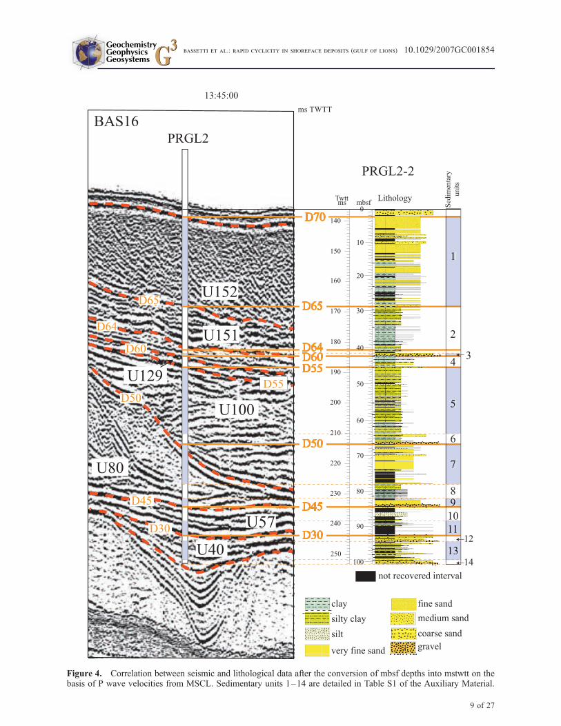
Figure 4. Correlation between seismic and lithological data after the conversion of mbsf depths into mstwtt on thebasis of P wave velocities from MSCL. Sedimentary units 1–14 are detailed in Table S1 of the Auxiliary Material.
GeochemistryGeophysicsGeosystems G3G3
bassetti et al.: rapid cyclicity in shoreface deposits (gulf of lions) 10.1029/2007GC001854
9 of 27
Figure
5
GeochemistryGeophysicsGeosystems G3G3
bassetti et al.: rapid cyclicity in shoreface deposits (gulf of lions) 10.1029/2007GC001854
10 of 27
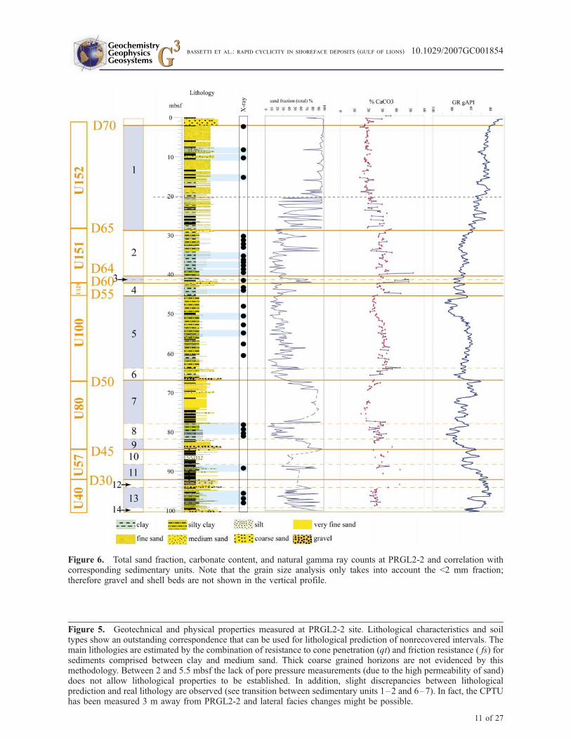
Figure 5. Geotechnical and physical properties measured at PRGL2-2 site. Lithological characteristics and soiltypes show an outstanding correspondence that can be used for lithological prediction of nonrecovered intervals. Themain lithologies are estimated by the combination of resistance to cone penetration (qt) and friction resistance ( fs) forsediments comprised between clay and medium sand. Thick coarse grained horizons are not evidenced by thismethodology. Between 2 and 5.5 mbsf the lack of pore pressure measurements (due to the high permeability of sand)does not allow lithological properties to be established. In addition, slight discrepancies between lithologicalprediction and real lithology are observed (see transition between sedimentary units 1–2 and 6–7). In fact, the CPTUhas been measured 3 m away from PRGL2-2 and lateral facies changes might be possible.
Figure 6. Total sand fraction, carbonate content, and natural gamma ray counts at PRGL2-2 and correlation withcorresponding sedimentary units. Note that the grain size analysis only takes into account the <2 mm fraction;therefore gravel and shell beds are not shown in the vertical profile.
11 of 27
GeochemistryGeophysicsGeosystems G3G3
bassetti et al.: rapid cyclicity in shoreface deposits (gulf of lions) 10.1029/2007GC001854
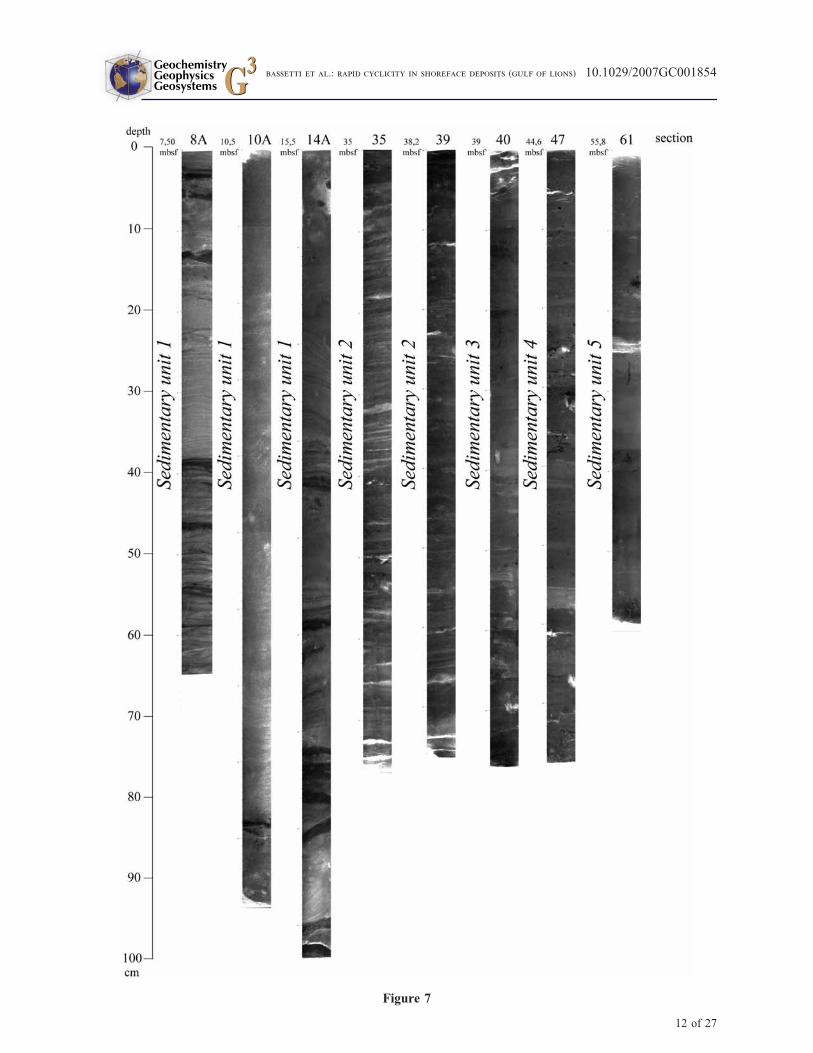
Figure 7
GeochemistryGeophysicsGeosystems G3G3
bassetti et al.: rapid cyclicity in shoreface deposits (gulf of lions) 10.1029/2007GC001854
12 of 27
coral Caryophyllia and a number of bivalves e.g.,Veneridae species, Dosinia lupinus, Saccella com-mutata, Parvicardium sp, Mytilus sp., etc.
[41] 10. U57 and U40 includes clayey silts (sedi-mentary units 10 and 13) and sandy/gravely depos-its (sedimentary units 11 and 12).
[42] 11. U40 consists of clayey silts with a verycoarse interval (large rounded clasts and shellfragments) at the bottom of the borehole (sedi-mentary unit 14; Figure 11c, Figure 9, image 10)in a muddy sand matrix (Figure 8, section 114;Figure 9, image 10). Penetrometer cone resistance(qt, Figure 5) is widely used in this part of theborehole for lithological prediction because ofpoor recovery. It allowed us to distinguish slightlithological differences (medium to coarse sand).
[43] A high degree of reworking concerns thebioclasts (worn and chalky fragments), despitetheir abundance and diversity (Figure 10).
4.3. Chronostratigraphic andBiostratigraphic Constraints
4.3.1. 14C Dates
[44] Radiocarbon dating has been carried out forthe first 42 m of the borehole that fall within theradiocarbon dating resolution (Table S2, AuxiliaryMaterial).
[45] We obtained good results for the top of theborehole (U155) and for the fine-grained intervalof seismic U151 (Figure 12), whereas significantage inversions affect the sandy interval of U152(Figure 12). Within the 14C ages that are clearlydistorted because of the occurrence of reworkedmaterial, it is worth noting that the measured agesshow an overall trend from older (about 36 cal kaBP) to younger (26 cal ka BP) moving from the topto the bottom of the interval. Thus, rather thandiscarding them, we can use these data for discus-sing the nature of erosion during falling sea levelsand eventually, the origin of sediments depositsduring forced regression (see section 5).
4.3.2. Calcareous Nannoplancton
[46] Coccolithophore assemblages observed in thestudied samples of PRGL2-2 are dominated by
Noelaerhabdaceae. Reworked nannofossils are acommon feature of all studied samples and areeven present in the samples that are almost barrenof calcareous nannoplancton. The age of basalsediments remains undetermined because of poorpreservation of nannoplancton in sedimentaryunits 7 to 14. However, significant events areidentified in the upper layers that allow a correla-tion with the oxygen isotope stack of Lisiecki andRaymo [2005] (Figure 12).
[47] First occurrence of Emiliania huxleyi is iden-tified at 60.56 mbsf. The age of this event wasestablished by Thierstein et al. [1977] at 268 ka(top of MIS-8). It has to be taken into account thatthis first occurrence horizon (lower limit of thepresent-day Nannofossil Zone NN21 of Martini[1971]) could have been influenced by the lowcoccolithophore abundances in the samples.
[48] Another significant event is the age of the topof the hole. The coccolithophore assemblage com-positions and the high abundances present in theuppermost interval indicate that this horizon isyounger than the last glacial period (scarcity ofE. huxleyi >4 mm).
[49] Finally, there are other events. Despite the lowabundance of calcareous nannoplancton in mostsamples, the following horizons can be approxi-mated (Figure 12):
[50] 1. Reversal in Gephyrocapsa caribbeanica/Gephyrocapsa oceanica - small Gephyrocapsa:G. caribbeanica and G. oceanica decrease theirabundances and small Gephyrocapsa becomes thedominant group at about 62.93 mbsf. This eventhas been dated by Villanueva et al. [2002] andFlores et al. [2003] between 260 and 245 ka (top ofMIS8).
[51] 2. Reversal in small Gephyrocapsa-Gephyro-capsa muellerae: This last species increases inabundance around 43.73 mbsf. This probablyapproximates the event occurring during the mid-dle of MIS6 (between 160 and 170 ka, as identifiedby Villanueva et al. [2002].
[52] 3. Acme of Emiliania huxleyi/Reversal inGephyrocapsa muellerae - Emiliania huxleyi: The
Figure 7. X-ray images (see position in depth in Figures 4 and 6) evidencing sedimentary facies and structures:horizontal lamination and swaley cross-bedding (8A), bioturbated sand (10A), hummocks and associated parallellamination (14A), bioturbated storms beds in mud (35, 39), bioturbated clays with rare laminated silty beds (40,47 and 61).
13 of 27
GeochemistryGeophysicsGeosystems G3G3
bassetti et al.: rapid cyclicity in shoreface deposits (gulf of lions) 10.1029/2007GC001854

Figure 8
GeochemistryGeophysicsGeosystems G3G3
bassetti et al.: rapid cyclicity in shoreface deposits (gulf of lions) 10.1029/2007GC001854
14 of 27

latter increases its abundance at about 41.34 mbsf,approximating the position of MIS4.
5. Discussion
[53] Integration of geophysical multiproxy bore-hole data allows us to propose a synthetic inter-pretation of Quaternary depositional units and
surfaces in the Gulf of Lions (Table S1, AuxiliaryMaterial).
5.1. Nature and Origin of Major ErosionSurfaces
[54] A striking feature along PRGL2-2 is theperfect match between major seismic reflections(including the seafloor) and very coarse intervals
Figure 8. X-ray images (see position in depth in Figures 4 and 6) evidencing sedimentary facies and structures:intensively bioturbated clays with laminated sand beds (81), heterolithic facies (90 and 91 comparable to 35 and 39 inFigure 7), muddy shelly lag deposits with associated silty-sand bioturbated layers (103), alternating sand and mudcouplets, slightly bioturbated (111), bioclastic material lag (worm tubes can be distinguished) with bioturbated claypassing upward to horizontally laminated silty clay (113), sand/clay alternations with sparse biogenic material (114).
Figure 9. Photos from selected cores. Image 1 shows section 8B/37-57 cm (8.50–8.70 mbsf): mud intervals inmassive sands; image 2 shows section 32/2–22 cm (32.61–32.80 mbsf): silty clay with fine sand beds, large burrow;image 3 shows section 34/23–43 cm (34.43–34.63 mbsf): Lenticular/wavy fine sand/silt beds and clay. Erosionalbasal contacts; image 4 shows section 36/25–45 cm (36.05–36.25 mbsf): lenticular (rippled?) fine sand beds andclay/silty clay. Some scours at the bottom of sand beds; image 5 shows section 40/30–50 cm (39.30–39.50 mbsf):Intensely bioturbated silty clay with organic matter spots; image 6 shows section 69/1–21 cm (62.21–62.40 mbsf):very bioturbated clay/silty clay; image 7 shows section 74/20–40 cm (66.40–66.60 mbsf): muddy bioclastic gravel;image 8 shows section 91/30–50 cm(80.94–81.10 mbsf): graded silty sand beds in silty clay; image 9 shows section95/0–20 cm (83.60–83.80 mbsf): very coarse-coarse muddy sand with very abundant shells and shell fragments,including complete bivalves; image 10 shows section 116/64–84 cm (99.57–100.13 mbsf): Sandy gravel with largerounded clasts (up to 3 cm).
15 of 27
GeochemistryGeophysicsGeosystems G3G3
bassetti et al.: rapid cyclicity in shoreface deposits (gulf of lions) 10.1029/2007GC001854
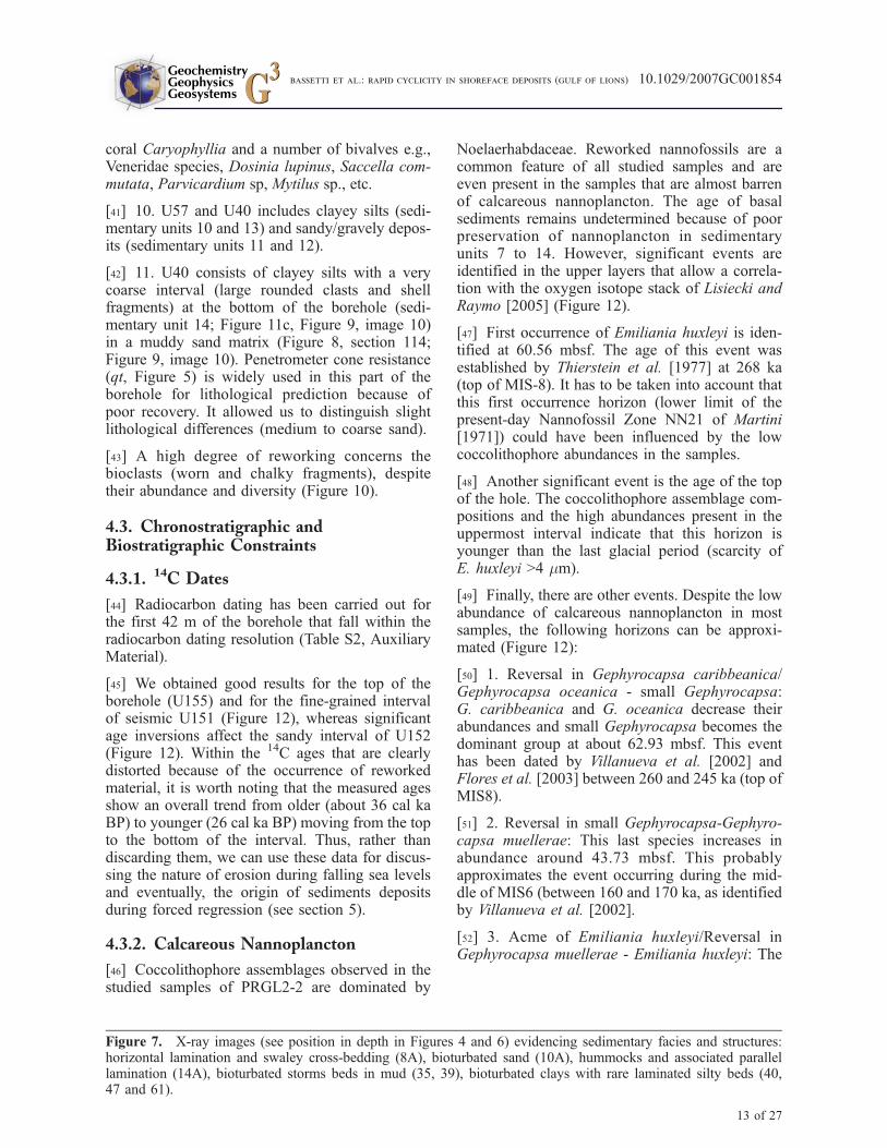
with shells and shell debris. The deposits with therichest mollusc content are associated with themajor discontinuities. The mollusc assemblagesare indicative of diverse environments, from openshelf to sublittoral, and are suggestive of an intensereworking. Cold-water Pleistocene species arefound within D60, D50, D45, and D30 and de-scribed within D70 based on shallow cores[Bassetti et al., 2006].
[55] The boreoceltic guests have an importantecobiostratigraphic and climatic significance:Modiolus modiolus, Arctica islandica, cf. Myatruncata/Panopea norvegica known to proliferatein the Mediterranean only during glacial periods
[Malatesta and Zarlenga, 1986]. They occurconsistently in association with major boundingsurfaces. Interestingly, these cold-water speciesare in most cases mixed with temperate species.The borehole data confirm previous seismic andsequence stratigraphic interpretations that the ma-jor seismic discontinuities are polygenetic erosionsurfaces formed as sequence boundaries at the topof prograding wedges, during sea level fallsdriven by 100 ka glacioeustatic cycles, and sub-sequently reworked by marine ravinement duringsea level rises (see summaries in the work ofBerne et al. [2004] and Rabineau et al. [2005]).The age of �15 ka BP at the bottom of D70found here (Figure 12) is consistent with ages
Figure 10. Synthetic scheme of mollusc assemblages examined in correspondence of erosion surfaces.
GeochemistryGeophysicsGeosystems G3G3
bassetti et al.: rapid cyclicity in shoreface deposits (gulf of lions) 10.1029/2007GC001854
16 of 27
Figure 11
GeochemistryGeophysicsGeosystems G3G3
bassetti et al.: rapid cyclicity in shoreface deposits (gulf of lions) 10.1029/2007GC001854
17 of 27
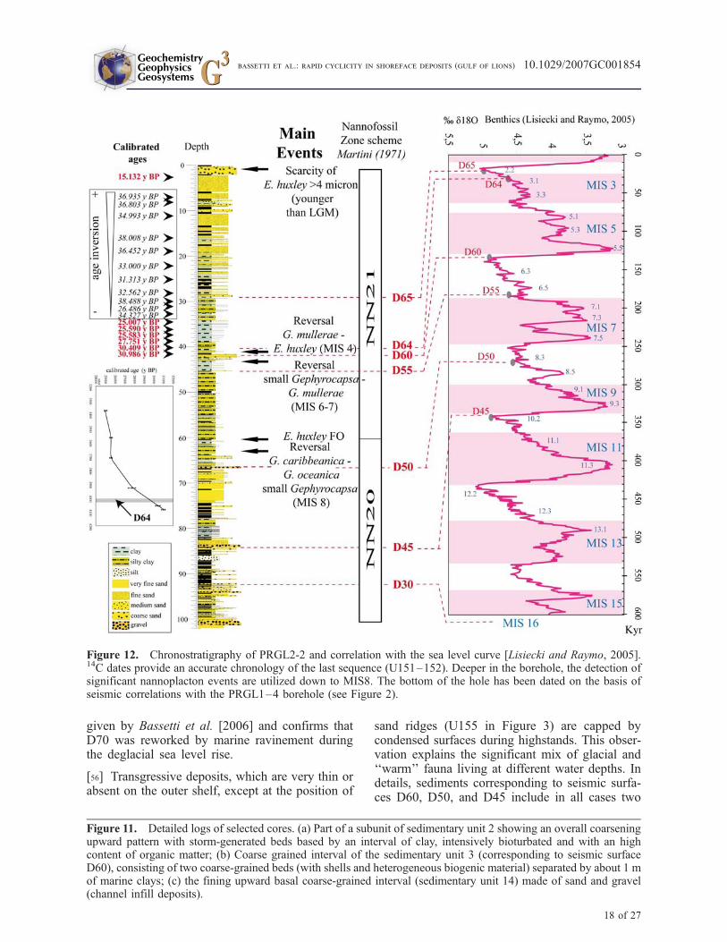
given by Bassetti et al. [2006] and confirms thatD70 was reworked by marine ravinement duringthe deglacial sea level rise.
[56] Transgressive deposits, which are very thin orabsent on the outer shelf, except at the position of
sand ridges (U155 in Figure 3) are capped bycondensed surfaces during highstands. This obser-vation explains the significant mix of glacial and‘‘warm’’ fauna living at different water depths. Indetails, sediments corresponding to seismic surfa-ces D60, D50, and D45 include in all cases two
Figure 11. Detailed logs of selected cores. (a) Part of a subunit of sedimentary unit 2 showing an overall coarseningupward pattern with storm-generated beds based by an interval of clay, intensively bioturbated and with an highcontent of organic matter; (b) Coarse grained interval of the sedimentary unit 3 (corresponding to seismic surfaceD60), consisting of two coarse-grained beds (with shells and heterogeneous biogenic material) separated by about 1 mof marine clays; (c) the fining upward basal coarse-grained interval (sedimentary unit 14) made of sand and gravel(channel infill deposits).
Figure 12. Chronostratigraphy of PRGL2-2 and correlation with the sea level curve [Lisiecki and Raymo, 2005].14C dates provide an accurate chronology of the last sequence (U151–152). Deeper in the borehole, the detection ofsignificant nannoplacton events are utilized down to MIS8. The bottom of the hole has been dated on the basis ofseismic correlations with the PRGL1–4 borehole (see Figure 2).
18 of 27
GeochemistryGeophysicsGeosystems G3G3
bassetti et al.: rapid cyclicity in shoreface deposits (gulf of lions) 10.1029/2007GC001854
coarse-grained intervals, separated by 10 cm to 1 mof very fine sand or silty clay material. These fine-grained intervals might correspond to transgressivedeposits separating a ravinement surface (at thebase) and a condensed interval (maximum floodingsurface, at the top), as described for D70 byBassetti et al. [2006]. The reduced thickness(<1 m) of these transgressive deposits hamperstheir detection on seismic profiles.
[57] The lowermost bounding surface (D30) fallsin a distinctive lithologic interval, with a coarse-grained basal unit (sedimentary unit 14) includingmaterial such as rounded pebbles implying thevicinity of a river. On seismic profiles, thesedeposits correspond to the infill of an axial incisionwithin the Bourcart canyon. This supports the ideaof a genetic link between axial incisions thatdowncut canyon heads and rivers during low-stands, as proposed by Baztan et al. [2005].
5.2. General Stratigraphic Organization
[58] Biostratigraphy allows us to propose a generalchronostratigraphic and sequence stratigraphic in-terpretation of the study area. Major seismic unitswith steep clinoforms correspond to sandy shore-faces or delta fronts/prodeltas formed during majorsea level falls and ensuing lowstands of each 100 kaglacial cycles. The age of seismic unit U100(MIS6–7) is consistent with a MIS8 origin forseismic U80, immediately beneath. The perfectpreservation of U80 (including preservation of thetopsets of the clinoforms) can be explained bysubstantial accommodation space formed by ero-sion during the two previous low stands of the sea(MIS10 and MIS12), that were much more pro-nounced than MIS8. Within MIS6, three majorsubunits with thick (>20 m) and steep (>3�) clino-forms, labeled U95, U110, and U130, have beenpreviously identified and mapped in three dimen-sions [Rabineau et al., 2005, Figures 7 and 8].Among these units, only U95 extends to the vicinityof the borehole (Figure 3), the others being situatedin a more offshore and further east [Rabineau et al.,2005]. In the absence of precise chronostratigraphicconstraints, the origin of these multiple sand bodieswithin one single 100-ka falling stage systems tractcould be attributed to purely autocyclic processes,such as switching of deltaic lobes in a supplydominated environment, with stable sea level being.However, considering that there is at least a differ-ence of 30 m in the depths of the topsets of clino-forms of units U95 and U130 [Rabineau et al.,2005], it is more reasonable to invoke an allocyclic
(sea level fall) origin. In this view, the lowstandscorresponding to MIS6.6, MIS6.4, and MIS6.2could be good candidates for the formation ofU95, U110, and U130, respectively.
5.3. Nature and Significance of LargeClinoforms of U151/U152
[59] The full recovery of sediments from seismicunit U151/U152, as well as the availability ofprecise time constraints (from absolute 14C dates)for this interval allows discussion of the origin oflarge-scale clinoforms. These features have beenoften described from seismic data on many conti-nental shelves but rarely sampled. Comparisonwith similar features from ancient stratigraphicrecord adds another interest to our results.
5.3.1. Synthesis of Sedimentological andBiostratigraphic Information on U151/U152
[60] The sedimentary facies association withinU151/U152 represents a typical coarsening upwardtrend commonly described on wave-dominatedshelves [Walker and Plint, 1992], with the verticalsuperposition of three main facies (from top tobottom):
[61] 1. The first is planar to very low-angle strat-ified sand and possibly swaley cross-stratification(Figure 7, sedimentary unit 1, section 8A), indic-ative of efficient wave reworking. This deposit liesabove an intensely bioturbated unit (Figure 7,sedimentary unit 1, section 10A).
[62] 2. The second is cross-stratified, well-sortedfine sands with parallel to low-angle converginglaminations suggesting a possible hummockycross-stratification (Figure 7, sedimentary unit 1,section 14A). The HCS unit represents depositionabove storm but probably not far from wave base[Dumas and Arnott, 2006].
[63] 3. The third is bioturbated mud with inter-bedded thin sand beds (Figure 7, sedimentaryunit 2, sections 35 and 39). Storm-generated eventbeds, intensively bioturbated with sharp erosionalbase, corresponding to moderate-energy storm-dominated shelf zone with fair weather muddrapes [Aigner and Reineck, 1982].
[64] The mutual stratigraphic position of thesefacies strongly supports the interpretation of U151/U152 as a regressive complex including foreshoreand shoreface (and/or delta front/prodelta) domains.Sedimentary unit 1 is characterized by a high-energy(coastal) setting marked essentially by (1) massive,
GeochemistryGeophysicsGeosystems G3G3
bassetti et al.: rapid cyclicity in shoreface deposits (gulf of lions) 10.1029/2007GC001854
19 of 27
well-sorted fine to medium sand with low carbonatecontent; (2) horizontal lamination and possibleswaley cross-stratification, indicative of winnowingby wave action; (3) possible hummocky cross-stratification indicative of a storm-dominated lowershoreface environment.
[65] Storm beds are preferably recorded in the‘‘offshore’’ facies (bottomsets, sedimentary unit 2)as testified by highly heterolithic deposits, mainlyconsisting of fine-grained beds alternating withrepeated, distally deposited, storm beds. Bioturba-tion of the finer section (silty clay) indicatesprolonged intervals of calm conditions betweenthe deposition of tempestites. It has been arguedthat the so-called ‘‘offshore muds’’ do not reallyexist and are in fact part of the lower shorefacedomain because mud is trapped along shore byshelf circulation [Dalrymple and Cummings,2005]. This is exactly what is observed in the Gulfof Lions, where mud is confined on the inner shelf[Berne et al., 2007]. We therefore consider sedi-mentary unit 2 as part of the lower shoreface/prodelta domains.
5.3.2. Integration of Sedimentological andSeismic Data
[66] The upper 20 m massive sands of sedimentaryunit 1 correspond to the steep (up to 5�) foresets ofseismic unit U152. They pass progressively tosands with thin muddy interbeds between 20 and30 mbsf where clinoforms are dipping more gently.The abrupt deepening of sedimentary facies below30 mbsf corresponds to seismic surface D65. Thealternating bioturbated sands and muds observedbelow this surface (sedimentary unit 2) correspondto the bottomsets of clinoforms of unit U151.Despite the dominant sandy lithology of clino-forms, the impedance contrast that is at the originof reflectors on seismic profiles (foresets of U152)is likely due to the presence of centimeter-thickclayey layers or packets of such layers.
[67] Sedimentary structures and paleoenvironmen-tal indications given by fauna and microfaunaconfirm earlier interpretations, based on seismicstratal architectures (Aloısi [1986] and subsequentworkers): U151 andU152 represent wave-dominatedshorefaces deposited during an overall sea level fallat the end of the last glacial cycle.
[68] The shoreface deposits observed here differfrom typical shoreface modern deposits (high-stand), which commonly show much gentler angleof clinoforms (0.3� on average [Walker and Plint,
1992], about 0.5� on the modern Sete shoreface[Barusseau et al., 1994]). On the other hand,examples of clinoforms with steep dip angles arereported in the stratigraphic record in forced re-gressive shelf margins [Hanken et al., 1996; Hartand Long, 1996; Massari et al., 1999; Surlyk andNoe-Nygaard, 2005]. Quaternary margins world-wide also document examples of sandy (or sup-posedly sandy) shelf or shelf-edge shoreface ordeltaic clinoforms with angles of dip similar to thatof the Gulf of Lions’ shorefaces [Anderson et al.,2004; Chiocci and Orlando, 1996; Hernandez-Molina et al., 1994; Hiscott, 2001; Suter andBerryhill, 1985; Sydow et al., 1992; Trincardiand Field, 1991; Trincardi and Correggiari,2000; Winn et al., 1998]. Possibly, the differencein slope angles between present-day shorefaces andPleistocene/Ancient indicates that the latest recordprogradation with more abundant sand supply,whereas modern examples correspond to equilibri-um profiles of sand-starved shorelines-shelf sys-tem. An alternative (or additional) explanation isthat these shorefaces could in fact correspond to the‘‘asymmetric wave-dominated deltas’’ that formupdrift of deltaic systems subject to longshore drift[Bhattacharya and Giosan, 2003]. Such an asym-metry has been described on the modern Po delta[Correggiari et al., 2005]. The steep dip angle ofthe clinoforms measured on seismic profiles isconsistent with slope measured on the moderndelta front of the active Roustan distributary chan-nel of the Rhone, i.e., about 4� [Maillet et al.,2006]. Another alternative explanation has beenproposed by F. Trincardi (personal communication,2006), these sand bodies being interpreted as theproduct of along-shore sediment advection todeeper areas of increased accommodation, as docu-mented for the muddy regressive deposits on theAdriatic [Cattaneo et al., 2007].
[69] The thickness of the Gulf of Lions’ shorefacedeposits is also quite different from values reportedfrom modern examples. It reaches up to 30 m forU152 (including 20 m of massive sands), and even40 m for U80 (where sand thickness is estimated tobe more than 30 m). These values have to becompared to the thickness of Holocene shorefaces,which are in the range of 10–20 m [Hampson andStorms, 2003]. On the other hand, they are com-parable to the thickness of some ancient shorefacedeposits such as the Kenilworth Member of theBook Cliffs [Pattison and Walker, 1995]. Anexplanation for this difference is that modernshorefaces prograde over inner shelves where ac-commodation is limited because of the low gradi-
GeochemistryGeophysicsGeosystems G3G3
bassetti et al.: rapid cyclicity in shoreface deposits (gulf of lions) 10.1029/2007GC001854
20 of 27

ent, whereas the shorefaces studied here developedat the shelf edge. In addition, the steep clinoformsof U151/152 and U80 developed immediately sea-ward of a step in the underlying surface (Figure 2).Probably this step provided additional accommo-dation for shoreface deposition, as proposed byTrincardi and Field [1991] for Tyrrhenian Seashorefaces, or as observed at the outcrop scale byMassari et al. [1999].
[70] In addition to this morphological control,Hampson and Storms [2003] proposed that themain processes (or recurrence of processes) con-trolling the architecture of modern and ancientshorefaces are substantially different: modern shor-efaces represent a much shorter time span andtherefore are mainly controlled by wave climateand/or sediment supply; in contrast, shorefacesfrom the geological record a shoreline trajectory[Helland-Hansen and Martinsen, 1996] duringchanging rate of relative sea level rise. This couldaccount both for the greater thickness of ancientshorefaces and for differences in clinoform dipangles. The available chronostratigraphic frame-work allows us to sustain this hypothesis.
5.4. Regressive Downward SteppingParasequences Linked to Pulsed Sea LevelFalls
[71] U151 and U152 were deposited during theoverall sea level fall that took place between thehighest sea level of Marine Isotope Stage (MIS) 3(around 50 ka BP) and the lowest sea level ofMIS2 (Last Glacial Maximum), around 22 cal kaBP. Even if the position of global sea level duringMIS3 is still debated (ranging from �35 m to�95 m, see compilation of sea level curves in thework of Jouet et al. [2006], the MIS3-MIS2interval record a period of overall cooling trendaccompanied by lowering of sea level, punctuatedby rapid climate changes generally referred to asDansgaard Oeschger (D/O) cycles [Bond et al.,1993; Dansgaard et al., 1993], with HeinrichEvents (HE) [Heinrich, 1988] occurring at theend of some of the coldest stadials.
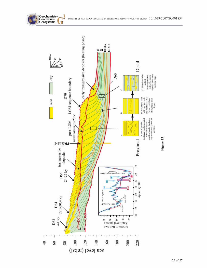
[72] In the lithological succession within U152/U151, we observed coarsening upward units indic-ative of a general regressive pattern that appearseparated by flooding surfaces mantled by fine-grained sediment. In particular, such flooding sur-faces are observed at about 29 and 40 mbsf whichcorrespond to seismic reflections D64 and D65 andare indicated by sedimentary facies suggesting arelatively abrupt deepening as marked in Figure 13.
[73] The chronostratigraphic constraints obtainedfrom shallow cores (�20 m long) retrieved land-ward and seaward of PRGL2-2 [Jouet et al., 2006],as well as the 14C dates obtained within U151/152at PRGL2-2 imply that (1) D65 formed between24.13 and 22.7 cal ka BP (from Jouet et al. [2006])a time frame consistent with an age <25 cal ka BPfound at 33.75 mbsf on PRGL2-2, about 4 mbelow the position of D65 (considering an averagesedimentation rate of 1 m/ka); and (2) D64 formedbetween 30.4 and 27.75 cal ka BP (if we assign adepth of about 40 mbsf for D64 at the position ofthis borehole).
[74] Finally, the ages of both surfaces fall withinthe time intervals assigned to HE 2 and HE 3 (�24and 30 ka cal BP, respectively [Hemming, 2004]).They also correspond to the end of marked periodsof sea level falls (in the order of 10 m) observed inthe Red Sea [Arz et al., 2007; Siddall et al., 2003].
[75] On seismic profiles, a very pronounced down-ward shift surface corresponds to seismic surfaceD63, that marks a very distinct erosional boundarybetween bottomsets of U147 and steep (probablysandy) clinoforms of U151 (Figure 13). At theresolution of seismic data, this surface is mergedwith the main sequence boundary (D60); however,we notice a distinctive fine-grained interval sepa-rating two very coarse intervals interpreted asravinement surfaces. This interval has not beendated on PRGL2-2. However, it was dated previ-ously in a piston core at �41 cal ka BP [Jouet etal., 2006], whereas an age of �38 cal ka BP isfound at the deep borehole PRGL1–4. The rele-vance of the erosion linked to D63, as it is seen onseismic profiles, can be explained by a muchhigher magnitude of sea level drop between 43and 40 ka cal BP (about 30 m according to Arz etal. [2007]). According to these authors, the mag-nitude of the ensuing sea level rise was in thesame order (Figure 13), within only �2 ka (about1.5 cm/a), i.e., a rate in the same range as that ofmeltwater pulses during the last deglacial. Thestratigraphic expression of this rapid transgressiveinterval could be the thin silt and clay layersituated at 41.51–41.56 mbsf between twocoarse-grained intervals (Figure 11b), immediatelyabove D60.
[76] Finally, within the prograding shorefacedeposits recording the overall sea level fall be-tween MIS3 and MIS2 display a sedimentary motiflinked to higher-order incremental sea level fallsand subsequent rises (Figure 13) that erode the
GeochemistryGeophysicsGeosystems G3G3
bassetti et al.: rapid cyclicity in shoreface deposits (gulf of lions) 10.1029/2007GC001854
21 of 27
Figure
13
GeochemistryGeophysicsGeosystems G3G3
bassetti et al.: rapid cyclicity in shoreface deposits (gulf of lions) 10.1029/2007GC001854
22 of 27
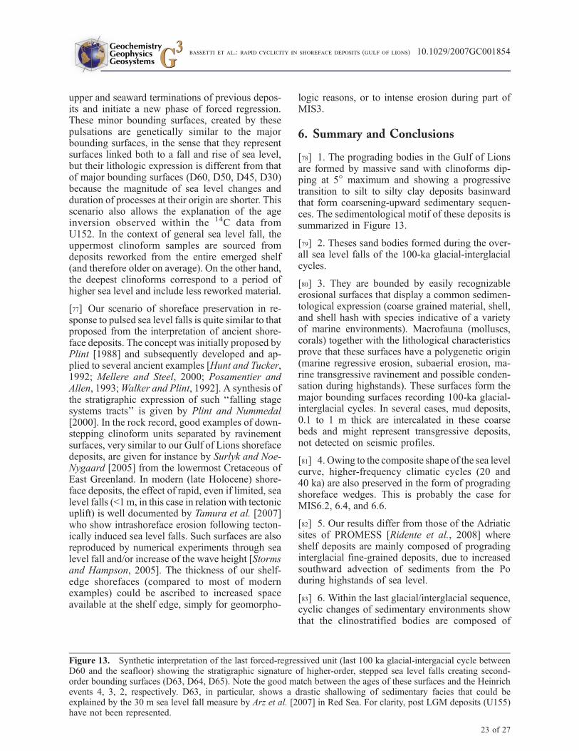
upper and seaward terminations of previous depos-its and initiate a new phase of forced regression.These minor bounding surfaces, created by thesepulsations are genetically similar to the majorbounding surfaces, in the sense that they representsurfaces linked both to a fall and rise of sea level,but their lithologic expression is different from thatof major bounding surfaces (D60, D50, D45, D30)because the magnitude of sea level changes andduration of processes at their origin are shorter. Thisscenario also allows the explanation of the ageinversion observed within the 14C data fromU152. In the context of general sea level fall, theuppermost clinoform samples are sourced fromdeposits reworked from the entire emerged shelf(and therefore older on average). On the other hand,the deepest clinoforms correspond to a period ofhigher sea level and include less reworked material.
[77] Our scenario of shoreface preservation in re-sponse to pulsed sea level falls is quite similar to thatproposed from the interpretation of ancient shore-face deposits. The concept was initially proposed byPlint [1988] and subsequently developed and ap-plied to several ancient examples [Hunt and Tucker,1992; Mellere and Steel, 2000; Posamentier andAllen, 1993;Walker and Plint, 1992]. A synthesis ofthe stratigraphic expression of such ‘‘falling stagesystems tracts’’ is given by Plint and Nummedal[2000]. In the rock record, good examples of down-stepping clinoform units separated by ravinementsurfaces, very similar to our Gulf of Lions shorefacedeposits, are given for instance by Surlyk and Noe-Nygaard [2005] from the lowermost Cretaceous ofEast Greenland. In modern (late Holocene) shore-face deposits, the effect of rapid, even if limited, sealevel falls (<1m, in this case in relation with tectonicuplift) is well documented by Tamura et al. [2007]who show intrashoreface erosion following tecton-ically induced sea level falls. Such surfaces are alsoreproduced by numerical experiments through sealevel fall and/or increase of the wave height [Stormsand Hampson, 2005]. The thickness of our shelf-edge shorefaces (compared to most of modernexamples) could be ascribed to increased spaceavailable at the shelf edge, simply for geomorpho-
logic reasons, or to intense erosion during part ofMIS3.
6. Summary and Conclusions
[78] 1. The prograding bodies in the Gulf of Lionsare formed by massive sand with clinoforms dip-ping at 5� maximum and showing a progressivetransition to silt to silty clay deposits basinwardthat form coarsening-upward sedimentary sequen-ces. The sedimentological motif of these deposits issummarized in Figure 13.
[79] 2. Theses sand bodies formed during the over-all sea level falls of the 100-ka glacial-interglacialcycles.
[80] 3. They are bounded by easily recognizableerosional surfaces that display a common sedimen-tological expression (coarse grained material, shell,and shell hash with species indicative of a varietyof marine environments). Macrofauna (molluscs,corals) together with the lithological characteristicsprove that these surfaces have a polygenetic origin(marine regressive erosion, subaerial erosion, ma-rine transgressive ravinement and possible conden-sation during highstands). These surfaces form themajor bounding surfaces recording 100-ka glacial-interglacial cycles. In several cases, mud deposits,0.1 to 1 m thick are intercalated in these coarsebeds and might represent transgressive deposits,not detected on seismic profiles.
[81] 4. Owing to the composite shape of the sea levelcurve, higher-frequency climatic cycles (20 and40 ka) are also preserved in the form of progradingshoreface wedges. This is probably the case forMIS6.2, 6.4, and 6.6.
[82] 5. Our results differ from those of the Adriaticsites of PROMESS [Ridente et al., 2008] whereshelf deposits are mainly composed of progradinginterglacial fine-grained deposits, due to increasedsouthward advection of sediments from the Poduring highstands of sea level.
[83] 6. Within the last glacial/interglacial sequence,cyclic changes of sedimentary environments showthat the clinostratified bodies are composed of
Figure 13. Synthetic interpretation of the last forced-regressived unit (last 100 ka glacial-intergacial cycle betweenD60 and the seafloor) showing the stratigraphic signature of higher-order, stepped sea level falls creating second-order bounding surfaces (D63, D64, D65). Note the good match between the ages of these surfaces and the Heinrichevents 4, 3, 2, respectively. D63, in particular, shows a drastic shallowing of sedimentary facies that could beexplained by the 30 m sea level fall measure by Arz et al. [2007] in Red Sea. For clarity, post LGM deposits (U155)have not been represented.
23 of 27
GeochemistryGeophysicsGeosystems G3G3
bassetti et al.: rapid cyclicity in shoreface deposits (gulf of lions) 10.1029/2007GC001854
several higher-order (para)sequences, bounded byflooding surfaces. Radiocarbon dates indicates thatthese minor bounding surfaces record rapid sealevel changes during the overall MIS3-MIS2 sealevel fall, in phase with the high-resolution isotopicrecords of the Red Sea [Arz et al., 2007; Siddall etal., 2003].
[84] 7. Each parasequence (about 40 m thick,including about 20 m of massive sand) formedwithin about 5–10 ka, and progradation during thisinterval was in the range of 1–2 km. The sea leveldrops that triggered progradation were of the orderof 10–30 m.
[85] 8. The detection of river-derived material atthe bottom of the borehole (unit 14), testifies thedirect influence of fluvial discharge events at theshelf edge. This is the first evidence in this area ofa connection between a lowstand river drainageand a canyon.
Acknowledgments
[86] The drilling operation was conductedwithin the European
project PROMESS 1 (contract EVR1-CT-2002-40024). Data
were processed and interpreted with the support of the French
Agence Nationale de la Recherche (ANR, contract NT05-3-
42040). Initial support for seismic data acquisitionwas provided
by Ifremer, the French ‘‘Margins’’ program, and the EC-funded
Eurostrataform project (contract EVK3-2001-00200). Engi-
neers of FUGRO-BV and the captain and crew of the Amige
drilling vessel Bavenit are warmly thanked for their dedication
during the cruise. The European Promess shipboard party
(http://www.pangaea.de/Projects/PROMESS1) and colleagues
at Ifremer (A.S. Alix, F. Duval, G. P. Fernagu, G. Floch,
N. Frumholtz, B. Marsset, L. Morvan, D. Pierre, M. Rovere,
E. Thereau, Y. Thomas) are also thanked for various contribu-
tions during all phases of data acquisition and processing.
A. Ceregato (University of Bologna) is thanked for revising
the mollusc taxonomy. The authors of this paper are indebted to
G-cubed Editors L.D. Labeyrie and V. Salters, Associate Editor
F. Trincardi, as well as to G. Plint and an anonymous reviewer,
for their thorough review of the manuscript. This is IGM
contribution 1596. The first author benefited from fellowships
from Eurostrataform and ANR at IFREMER (Centre de Brest).
References
Aigner, T., and H.-E. Reineck (1982), Proximality trends inmodern storm sands from the Helgoland Bight (North Sea)and their implication for basin analysis, Senckenb. Marit.,14, 183–215.
Aloısi, J. C. (1986), Sur un modele de sedimentation deltaıque:Contribution a la connaissance des marges passives, doctoralthesis, 162 pp., Univ. of Perpignan, Perpignan, France.
Anderson, J. B., A. Rodriguez, K. C. Abdulah, R. H. Fillon,L. A. Banfield, H. A. McKeown, and J. S. Wellner (2004),Late Quaternary Stratigraphic evolution of the northern Gulf
of Mexico margin: A synthesis, in Late Quaternary Strati-graphic Evolution of the Northern Gulf of Mexico Margin,edited by J. B. Anderson and R. H. Fillon, pp. 1–23, Soc. forSediment. Geol., Tulsa, Okla.
Arz, H. W., F. Lamy, A. Ganopolski, N. Nowaczyk, andJ. Patzold (2007), Dominant Northern Hemisphere climatecontrol over millennial-scale glacial sea-level variability,Quat. Sci. Rev., 26(3–4), 312–321, doi:10.1016/j.quascirev.2006.07.016.
Austin, J. A., et al. (1998), Proceedings of the Ocean DrillingProgram, Initial Report 174A, Ocean Drill. Program, CollegeStation, Tex.
Bard, E., M. Arnold, B. Hamelin, N. Tisnerat-Laborde, andG. Cabioch (1998), Radiocarbon calibration by means ofmass spectrometric 230Th/234U and 14C ages of corals.An updated data base including samples from Barbados,Mururoa and Tahiti, Radiocarbon, 40(3), 1085–1092.
Barusseau, J. P., M. Radulescu, C. Descamps, C. Akouango,and A. Gerbe (1994), Morphosedimentary multiyear changeson a barred coast (Gulf of Lions, Mediterranean Sea,France), Mar. Geol., 122, 47–62, doi:10.1016/0025-3227(94)90204-6.
Bassetti, M. A., G. Jouet, F. Dufois, S. Berne, M. Rabineau,and M. Taviani (2006), Sand bodies at the shelf edge in theGulf of Lions (western Mediterranean): Deglacial historyand modern processes, Mar. Geol., 234, 93 – 109,doi:10.1016/j.margeo.2006.09.010.
Baztan, J., S. Berne, J. L. Olivet, M. Rabineau, D. Aslanian,M. Gaudin, J. P. Rehault, and M. Canals (2005), Axial inci-sion: The key to understand submarine canyon evolution (inthe western Gulf of Lion), Mar. Pet. Geol., 22(6–7), 805–826, doi:10.1016/j.marpetgeo.2005.03.011.
Berne, S., and C. Gorini (2005), The Gulf of Lions: An over-view of recent studies within the French ‘Margins’ pro-gramme, Mar. Pet. Geol., 22(6–7), 691–693, doi:10.1016/j.marpetgeo.2005.04.004.
Berne, S., G. Lericolais, T. Marsset, J. F. Bourillet, andM. de Batist (1998), Erosional shelf sand ridges and low-stand shorefaces: Examples from tide and wave dominatedenvironments of France, J. Sediment. Res., 68(4), 540–555.
Berne, S., M. Rabineau, J. A. Flores, and F. J. Sierro (2004),The impact of Quaternary global changes on strata forma-tion. Exploration of the shelf edge in the northwest Mediter-ranean Sea, Oceanography, 17(4), 92–103.
Berne, S., G. Jouet, M. A. Bassetti, B. Dennielou, andM. Taviani (2007), Late Glacial to Preboreal sea-level riserecorded by the Rhone deltaic system (NW Mediterranean),Mar. Geol., 245(1–4), 65–88, doi:10.1016/j.margeo.2007.07.006.
Bhattacharya, J. P., and L. Giosan (2003), Wave-influenced del-tas: Geomorphological implications for facies reconstruction,Sedimentology, 50(1), 187–210, doi:10.1046/j.1365-3091.2003.00545.x.
Bond, G. C.,W. Broecker, S. Johnsen, J.McManus, L. Labeyrie,J. Jouzel, and G. Bonani (1993), Correlations between climaterecords from North Atlantic sediments and Greenland ice,Nature, 365(6442), 143–147, doi:10.1038/365143a0.
Brookfield, M. E. (1977), The origin of bounding surfaces inancient eolian sandstones, Sedimentology, 24, 303–332,doi:10.1111/j.1365-3091.1977.tb00126.x.
Cattaneo, A., F. Trincardi, A. Asioli, and A. Correggiari (2007),The Western Adriatic shelf clinoform: Energy-limitedbottomset, Cont. Shelf Res., 27(3–4), 506–525, doi:10.1016/j.csr.2006.11.013.
GeochemistryGeophysicsGeosystems G3G3
bassetti et al.: rapid cyclicity in shoreface deposits (gulf of lions) 10.1029/2007GC001854
24 of 27
Chiocci, F. L., and L. Orlando (1996), Lowstand terraces onTyrrhenian Sea steep copntinental slopes, Mar. Geol., 134,127–143, doi:10.1016/0025-3227(96)00023-0.
Correggiari, A., A. Cattaneo, and F. Trincardi (2005), Themodern Po Delta system: Lobe switching and asymmetricprodelta growth, Mar. Geol. , 222 – 223 , 49 – 74,doi:10.1016/j.margeo.2005.06.039.
Dalrymple, R. W., and D. I. Cummings (2005), The offshoretransport of mud: Why it doesn’t happen and the strati-graphic implications, paper presented at Annual Meeting,Geol. Soc. of Am., Boulder, Colo.
Dansgaard, W., S. J. Johnsen, H. B. Clausen, N. S. Dahl-Jensen,C. U. Hammer, C. S. Hvidberg, J. P. Steffensen, A. E.Sveinbjornsdottir, J. Jouzel, and G. C. Bond (1993), Evidencefor general instability of past climate from a 250-kyr ice-corerecord, Nature, 364, 218–220, doi:10.1038/364218a0.
Davis, R. A., and P. B. Balson (1992), Stratigraphy of a NorthSea tidal sand ridge, J. Sediment. Petrol., 62(1), 116–121.
Dumas, S., and R. W. C. Arnott (2006), Origin of hummockyand swaley cross-stratification. The controlling influence ofunidirectional current strength and aggradation rate, Geol-ogy, 34(12), 1073–1076, doi:10.1130/G22930A.1.
Flores, J.-A., M. Marino, F. J. Sierro, D. A. Hodell, and C. D.Charles (2003), Calcareous plankton dissolution pattern andcoccolithophore assemblages during the last 600 kyr at ODPSite 1089 (Cape Basin, South Atlantic): Paleoceanographicimplications, Palaeogeogr. Palaeoclimatol. Palaeoecol.,196(3–4), 409–426, doi:10.1016/S0031-0182(03)00467-X.
Hampson, G. J., and J. E. A. Storms (2003), Geomorphologi-cal and sequence stratigraphic variability in wave-dominated,shoreface-shelf parasequences, Sedimentology, 50, 667–701,doi:10.1046/j.1365-3091.2003.00570.x.
Hanken, N.-M., R. G. Bromley, and J. Miller (1996), Plio-Pleis-tocene sedimentation in coastal grabens, north-east Rhodes,Greece, Geol. J., 31(4), 393–418, doi:10.1002/(SICI)1099-1034(199612)31:4<393::AID-GJ712>3.0.CO;2-H.
Harms, J. C., J. B. Southard, D. R. Spearing, and R. G. Walker(1975), Depositional Environments as Interpreted From Pri-mary Sedimentary Structures and Stratification Sequences,161 pp., Soc. of Econ. Paleontol. and Mineral., Dallas, Tex.
Hart, B. S., and B. F. Long (1996), Forced regressions andlowstand deltas: Holocene Canadian examples, J. Sediment.Res., 66(4), 820–829.
Heinrich, H. (1988), Origin and consequences of cyclic icerafting in the northeast Atlantic Ocean during the past130,000 years, Quat. Res., 29(2), 142–152.
Helland-Hansen, W., and O. J. Martinsen (1996), Shorelinetrajectories and sequences: Description of variable deposi-tional-dip scenarios, J. Sediment. Res., 66(4), 670–688.
Hemming, S. R. (2004), Heinrich events: Massive late Pleis-tocene detritus layers of the North Atlantic and their globalclimate imprint, Rev. Geophys., 42, RG1005, doi:10.1029/2003RG000128.
Hendriks, P. H. G. M. (2003), In-Depth Gamma Ray Studies:BoreholeMeasurements, Rijksuniversiteit Groningen, Holland.
Hernandez-Molina, F. J., L. Somoza, J. Rey, and L. Pomar(1994), Late Pleistocene-Holocene sediments on the Spanishcontinental shelves: Model for very high resolution sequencestratigraphy, Mar. Geol., 120, 129–174, doi:10.1016/0025-3227(94)90057-4.
Hiscott, R. N. (2001), Depositional sequences controlled byhigh rates of sediment supply, sea-level variations, andgrowth faulting: The Quaternary Baram Delta of northwes-tern Borneo, Mar. Geol., 175(1–4), 67–102, doi:10.1016/S0025-3227(01)00118-9.
Hughen, K. A., et al. (2004), Marine04 Marine radiocarbonage calibration, 26 � 0 ka BP, Radiocarbon, 46, 1059–1086.
Hunt, D., and M. E. Tucker (1992), Stranded parasequencesand the forced regressive wedge systems tract: Depositionduring base-level fall, Sediment. Geol., 81, 1 – 9,doi:10.1016/0037-0738(92)90052-S.
Jouet, G. (2007), Enregistrements stratigraphiques des cyclesclimatiques et glacio-eustatiques du Quaternaire terminal.Modelisation de la marge continentale du Golfe du Lion,443 pp., Univ. de Bretagne Occidenatle, Brest, France.
Jouet, G., S. Berne, M. Rabineau, M. A. Bassetti, P. Bernier,and B. Dennielou (2006), Shoreface migrations at the shelfedge and sea-level changes around the Last Glacial Maxi-mum (Gulf of Lions, NW Mediterranean Sea), Mar. Geol.,234(1–4), 21–42, doi:10.1016/j.margeo.2006.09.012.
Lafuerza, S., J. Frigola, G. Jouet, M. A. Bassetti, N. Sultan,and S. Berne (2008), Subsea-floor stratigraphic profiling andsoil classification from piezocone tests: A case study in theGulf of Lion (NW Mediterranean Sea), Geochem. Geophys.Geosyst., doi:10.1029/2007GC001845, in press.
Leckie, D. A., and R. G. Walker (1982), Storm- and tide-dominated shorelines in Cretaceous Moosebar-Lower gatesinterval-outcrop equivalents of deep basin gas trap in wes-tern Canada, Am. Assoc. Pet. Geol. Bull., 66, 138–157.
Lee, H. J., J. P. M. Syvitski, G. Parker, D. Orange, J. Locat,E.W.H. Hutton, and J. Imran (2002), Distinguishing sedimentwaves from slope failure deposits: Field examples, includingthe ’Humboldt slide’, and modelling results, Mar. Geol.,192(1–3), 79–104, doi:10.1016/S0025-3227(02)00550-9.
Lisiecki, L. E., andM. E. Raymo (2005), A Pliocene-Pleistocenestack of 57 globally distributed benthic d18O records, Paleo-ceanography, 20, PA1003, doi:10.1029/2004PA001071.
Lobo, F. J., J. M. Dias, F. J. Hernandez-Molina, R. Gonzalez,L. M. Fernandez-Salas, and V. Diaz Del Rio (2005), LateQuaternary shelf-margin wedges and upper slope prograda-tion in the Gulf of Cadiz margin (SW Iberian Peninsula),Geol. Soc. London Spec. Publ., 244, 7–25, doi:10.1144/GSL.SP.2005.244.01.02.
Lofi, J., et al. (2003), Plio-Quaternary prograding clinoformwedges of the western Gulf of Lion continental margin(NW Mediterranean) after the Messinian Salinity Crisis,Mar. Geol., 198(3 –4), 289–317, doi:10.1016/S0025-3227(03)00120-8.
Maillet, G. M., C. Vella, S. Berne, P. L. Friend, C. L. Amos,T. J. Fleury, and A. Normand (2006), Morphological changesand sedimentary processes induced by the December 2003flood event at the present mouth of the Grand Rhone River(southern France), Mar. Geol., 234(1 – 4), 159–177,doi:10.1016/j.margeo.2006.09.025.
Malatesta, A., and F. Zarlenga (1986), Northern guests in thePleistocene Mediterranean Sea, Geol. Romana, 25, 91–154.
Martini, E. (1971), Standard Tertiary and Quaternary calcar-eous nannoplankton zonation, paper presented at 2nd Plank-tonic Conference 1970, Edizioni Tecnoscienza, Rome.
Massari, F., M. Sgavetti, D. Rio, A. D’Alessandro, andG. Prosser (1999), Composite sedimentary record of fallingstages of Pleistocene glacio-eustatic cycles in a shelf setting(Crotone basin, south Italy), Sediment. Geol., 127(1–2), 85–110, doi:10.1016/S0037-0738(99)00025-1.
Mellere, D., and R. J. Steel (2000), Style contrast betweenforced regressive and lowstand/transgressive wedges in theCampanian of south-central Wyoming (Hatfield Member ofthe Haystack Mountains Formation), in Sedimentary Re-sponses to Forced Regressions, edited by D. Hunt andR. Gawthorpe, Geol. Soc. London Spec. Publ., 172, 141–162.
GeochemistryGeophysicsGeosystems G3G3
bassetti et al.: rapid cyclicity in shoreface deposits (gulf of lions) 10.1029/2007GC001854
25 of 27
Monaco, A. (1971), Contribution a l’etude geologique et sedi-mentologique du plateau continental du Roussillon, doctoralthesis, 295 pp, Univ. of Perpignan, Perpignan, France.
Pattison, S. A. J., and R. G. Walker (1995), Sequence strati-graphic significance of sharp-based lowstand shoreface de-posits, Kenilworth Member, Book Cliffs, Utah, J. Sediment.Petrol., 79(3), 444–462.
Plint, A. G. (1988), Sharp-based shoreface sequences and ‘‘off-shore bars’’ in the Cardium Formation of Alberta: Theirrelationship to relative changes in sea level, in Sea-LevelChanges: An Integrated Approach, Spec. Publ., vol. 42,edited by C. K. Wilgus et al., pp. 357–370, Soc. forSediment. Geol., Tulsa, Okla.
Plint, A. G., and D. Nummedal (2000), The falling stage sys-tems tract: Recognition and importance in sequence strati-graphy, in Sedimentary Responses to Forced Regressions,edited by D. Hunt and R. L. Gawthorpe, pp. 1–17, Geol.Soc., London.
Posamentier, H. W., and G. P. Allen (1993), Variability of thesequence stratigraphic model: Effects of local basin factors,Sediment. Geol., 86, 91 – 109, doi:10.1016/0037-0738(93)90135-R.
Posamentier, H. W., G. P. Allen, D. P. James, and M. Tesson(1992), Forced regressions in a sequence stratigraphic frame-work: Concepts, examples and exploration significance, Am.Assoc. Pet. Geol. Bull., 76, 1687–1709.
Rabineau, M. (2001), Un modele geometrique et stratigraphi-que des sequences de depot quaternaires sur la marge duGolfe du Lion: Enregistrement des cycles climatiques de100,000 ans, Ph.D. thesis, 480 pp, Univ. of Rennes 1, Rennes,France.
Rabineau, M., S. Berne, D. Aslanian, J.-L. Olivet, P. Joseph,F. Guillocheau, J.-F. Bourillet, E. Ledrezen, and D. Granjeon(2005), Sedimentary sequences in the Gulf of Lion: A recordof 100,000 years climatic cycles, Mar. Pet. Geol., 22(6–7),775–804, doi:10.1016/j.marpetgeo.2005.03.010.
Rabineau,M., S. Berne, J.-L. Olivet, D.Aslanian, F. Guillocheau,and P. Joseph (2006), Paleo sea levels reconsidered fromdirect observation of paleoshoreline position during GlacialMaxima (for the last 500,000 yr), Earth Planet. Sci. Lett.,252(1–2), 119–137, doi:10.1016/j.epsl.2006.09.033.
Raffi, I., and J. A. Flores (1995), Pleistocene through Miocenecalcareous nannofossils from eastern equatorial PacificOcean (Leg 138), Proc. Ocean Drill. Program Sci. Results,138, 233–286.
Ramsey, N. (2002), A calibrated model for the interpretation ofcone penetration tests (CPTs) in North Sea quaternary soils,in Offshore Site Investigation and Geotechnics: Diversityand Sustainability, edited by M. Cook et al., pp. 341–356,Soc. for Underwater Technol., London.
Reimer, P. J., et al. (2004), IntCal04 Terrestrial radiocarbon agecalibration, Radiocarbon, 46, 1029–1058.
Ridente, D., F. Trincardi, A. Piva, A. Asioli, and A. Cattaneo(2008), Sedimentary response to climate and sea levelchanges during the past (400 kyr from borehole PRAD1-2(Adriatic margin), Geochem. Geophys. Geosyst., 9, Q09R04,doi:10.1029/2007GC001783.
Robertson, P. K. (1990), Soil classification using the conepenetration test, Can. Geotech. J., 27(1), 151–158,doi:10.1139/t90-014.
Siddall, M., E. J. Rohling, A. Almogi-Labin, C. Hemleben,D. Meischner, I. Schmelzer, and D. A. Smeed (2003), Sea-level fluctuations during the last glacial cycle, Nature, 423,853–858, doi:10.1038/nature01690.
Storms, J. E. A., and G. J. Hampson (2005), Mechanisms forforming discontinuity surfaces within shoreface-shelf para-sequences: Sea level, sediment supply, or wave regime?,J. Sediment. Res., 75(1), 67–81.
Stuiver, M., and P. J. Reimer (1993), Extended 14C databaseand revised CALIB radiocarbon calibration program, Radio-carbon, 35, 215–230.
Surlyk, F., and N. Noe-Nygaard (2005), A forced-regressiveshelf-margin wedge formed by transition-slope progradation:Lowermost Cretaceous Rauk Plateau Member, JamesonLand, East Greenland, Bull. Geol. Soc. Den., 52, 227–243.
Suter, J. R., and H. L. J. Berryhill (1985), Late Quaternaryshelf-margin deltas, Northwest Gulf of Mexico, Bull. Am.Assoc. Petrol. Geol., 69(1), 77–91.
Sydow, J., H. H. Roberts, A. H. Bouma, and R. Winn (1992),Constructional subcomponents of a shelf-edge delta, North-east Gulf of Mexico, paper presented at the 42nd AnnualConvention, Gulf Coast Assoc. of Geol. Soc., Jackson, Miss.
Tamura, T., F. Nanayama, Y. Saito, F. Murakami, R. E. I.Nakashima, and K. Watanabe (2007), Intra-shoreface erosionin response to rapid sea-level fall: Depositional record of atectonically uplifted strand plain, Pacific coast of Japan, Se-dimentology, 54(5), 1149–1162, doi:10.1111/j.1365-3091.2007.00876.x.
Tesson, M., B. Gensous, G. P. Allen, and C. Ravenne (1990),Late Quaternary lowstand wedges on the Rhone ContinentalShelf, France, Mar. Geol., 91, 325–332, doi:10.1016/0025-3227(90)90053-M.
Tesson, M., et al. (1993), Late Pleistocene shelf-perched low-stand wedges on the Rhone continental shelf, in SequenceStratigraphy and Facies Associations, IAS Spec. Publ.,vol. 18, edited by H. W. Posamentier et al., pp. 183–196,Blackwell Sci., Oxford, U. K.
Tesson, M., H. W. Posamentier, and B. Gensous (2000), Strati-graphic organization of Late Pleistocene deposits of the wes-tern part of the Rhone shelf (Languedoc shelf) from highresolution seismic and core data, AAPG Bull., 84(1), 119–150.
Thierstein, H. R., K. R. Geitznauer, B. Molfino, and N. J.Shackleton (1977), Global synchroneity of late Quaternarycoccolith datum levels: Validation by oxygen isotopes, Geol-ogy, 5, 400–404, doi:10.1130/0091-7613(1977)5<400:GSOLQC>2.0.CO;2.
Trincardi, F., and A. Correggiari (2000), Quaternary forcedregression deposits in the Adriatic Basin and the record ofcomposite sea-level cycles, in Sedimentary Responses toForced Regressions, edited by D. Hunt and R. L. Gawthorpe,pp. 245–269, Geol. Soc., London.
Trincardi, F., and M. Field (1991), Geometry, lateral variabilityand preservation of downlapped regressive shelf deposits:Eastern Tyrrhenian margin, Italy, J. Sediment. Petrol., 61,775–790.
van Wagoner, J. C., R. M. Mitchum, K. M. Campion, and V. D.Rahmanian (1990), Siliciclastic Sequence Stratigraphy inWell Logs, Cores and Outcrops, Methods in Explor. Ser.,vol. 7, 55 pp., Am. Assoc. of Petrol. Geol., Tulsa, Okla.
Villanueva, J., J. A. Flores, and J. O. Grimalt (2002), A detailedcomparison of the Uk’37 and coccolith records over the past290 kyears: Implications to the alkenone paleotemperaturemethod, Org. Geochem., 33(8), 897–905, doi:10.1016/S0146-6380(02)00067-0.
Walker, R. G., and A. G. Plint (1992), Wave- and storm-dominated shallow marine systems, in Facies Models -
GeochemistryGeophysicsGeosystems G3G3
bassetti et al.: rapid cyclicity in shoreface deposits (gulf of lions) 10.1029/2007GC001854
26 of 27

Response to Sea Level Changes, edited by R. G. Walker andN. P. James, pp. 219–238, Geol. Assoc. of Can., St John’s,Newfoundland, Canada.
Winn, R. D., H. H. Roberts, B. Kohl, R. H. Fillon, A. Bouma,and R. E. Constans (1995), Latest Quaternary deposition onthe outer shelf, northern Gulf of Mexico: Facies and se-quence stratigraphy from Main Pass Block 303 shallow core,
Geol. Soc. Am. Bull., 107(7), 851–866, doi:10.1130/0016-7606(1995)107<0851:LQDOTO>2.3.CO;2.
Winn, R. D., H. H. Roberts, B. Kohl, R. H. Fillo, J. A. Crux,A. H. Bouma, and H. W. Spero (1998), Upper Quaternarystrata of the upper continental slope, northeast Gulf ofMexico: Sequence stratigraphic model for a terrigeneousshelf edge, J. Sediment. Res., 68(4), 579–595.
GeochemistryGeophysicsGeosystems G3G3
bassetti et al.: rapid cyclicity in shoreface deposits (gulf of lions) 10.1029/2007GC001854
27 of 27