the 1985 nevado del ruiz volcano catastrophe: anatomy and
TRANSCRIPT
Journal of Volcanology and Geothermal Research, 44 (1990) 3 4 9 - 386
Elsevier Science Publishers B.V., Amsterdam 349
Erratum
The 1985 Nevado del Ruiz volcano catastrophe: anatomy and retrospection
BARRY VOIGHT
College of Earth and Mineral Sciences, Penn State University, University Park, PA 16802, U.S.A.
(Received December 1, 1989)
Abstract
Voight, B., 1990. The 1985 Nevado del Ruiz volcano catastrophe: ana tomy and retrospection. J. Volcanol. Geotherm. Res., 44:
349 - 386.
This paper seeks to analyze in an objective way the circumstances and events that contributed to the 1985 Nevado del Ruiz catastrophe, in order to provide useful guidelines for future emergencies. The paper is organized into two principal parts. In the
first part, an Anatomy of the catastrophe is developed as a step-by-step chronicle of events and actions taken by individuals and
organizations during the period November 1984 through November 1985. This chronicle provides the essential background for
the crucial events of November 13. This year-long period is broken down further to emphasize important chapters: the gradual
awareness of the awakening of the volcano; a long period of institutional skepticism reflecting an absence of credibility; the closure
of the credibility gap with the September 11 phreatic eruption, followed by an intensive effort to gird for the worst; and a detailed account of the day of reckoning. The second part of the paper, Retrospection, examines the numerous complicated factors that
influenced the catastrophic outcome, and at tempts to cull a few "lessons from Armero" in order to avoid similar occurrences in the future.
In a nutshell, the government on the whole acted responsibly but was not willing to bear the economic or political costs of early
evacuation or a false alarm. Science accurately foresaw the hazards but was insufficiently precise to render reliable warning of
the crucial event at the last possible minute. Catastrophe was therefore a calculated risk, and this combinat ion - the limitations
of prediction/detection, the refusal to bear a false alarm and the lack of will to act on the uncertain information available - pro-
vided its immediate and most obvious causes. But because the crucial event occurred just two days before the Armero emergency-
management plan was to be critically examined and improved, the numerous circumstances which delayed progress of emergency
management over the previous year also may be said to have contributed to the outcome. Thus the catastrophe was not caused
by technological ineffectiveness or defectiveness, nor by an overwhelming eruption, or by an improbable run of bad luck, but
rather by cumulative human error - by misjudgment , indecision and bureaucratic shortsightedness. Armero could have produced no victims, and therein dwells its immense tragedy.
" W e are all of us fellow passengers on the same planet and we are all of us equally responsible for the happiness and well-being of the world in which we happen to live . . " (Van Loon's Geography).
Introduction
This report begins with Joaquin Acosta's ac- count of tragedy on the Lagunillas; presented in 1846 in the Comptes Rendus of the Academy
Corrected version of article published in volume 42, pp. 151 - 188.
0377-0273/90/$03.50 © 1990 Elsevier Science Publishers B.V.
of Sciences, Paris, it captures the Colombian naturalist's observations of a flow of mud that swept over the site of Armero in 1845:
" A g rea t s u b t e r r a n e a n no i se was h e a r d in t he vicini-
ty o f t he M a g d a l e n a , f r o m A m b a l e m a to t he vi l lage o f

350 B. VOIGHT
Mendez . . . This sudden noise was followed, within a considerably smaller area, by trembling of the ground. Then, descending along the Lagunillas from its sources in the Nevado del Ruiz, came an immense flood of thick mud which rapidly filled the bed of the river, covered or swept away the trees and houses, burying men and animals. The entire population perished in the upper part and narrower parts of the Lagunillas valley. In the lower part, several people were saved by fleeing sideways to the heights; less hap- pily, others were stranded on the summits of small hills from which it was impossible to save them before they d i e d . . . On arriving at the plain with great impetus, the current of mud divided into two branches. The much larger one followed the course of the Lagunillas toward the Magdalena; the other, after topping the high divide, traversed the Santo Domingo va l l ey . . . and hurled itself into the Rio Sabandija, which was thus plugged by an immense dam. The danger seemed imminent for a flood of downstream lands. Happily, plentiful rain during the night produced enough water to begin clearing a passage across this mass of broken trees, sands, stones, and stinking mud, mixed with enormous blocks of ice which descended from the mountains in such abundance that after several days they had not melted ent i re ly . . . The terrain covered by debris and mud is more than four leagues square; it presents the appearance of a desert or playa, on the surface of which loom up like many islands heaps of broken trees that resisted the impetus of the torrent. The depth of the mud layer varies greatly, and is much greater toward the upper part of the deposit where it often reaches 5 to 6 m. A realistic calculation indicates more than 300 million tons of muddy material from the flanks of Volc~in R u i z . . . " *
O f this event, A c o s t a r emarked in an 1850
letter to the French geologist Elie de B e a u m o n t tha t all o f the p rope r ty which families had ac-
cumula t ed in years o f e f for t , the fruit o f labor
o f several genera t ions , was lost in a m u d f l o w
which des t royed houses , harvests , f locks, and
rendered the land bar ren for a great m a n y years: " I t is as tonishing that none o f the in-
habi tan ts o f these villages, built on the solidified m u d o f old mass movemen t s , has
even suspected the origin o f this vast terrain,
which occupies an area at least equal to tha t o f the province o f the Rh6ne , a l though ancient
* See Fig. 4 for locations referred to in text.
t rad i t ions test ify to the f requent m u d f l o w s in
these r e g i o n s . . . "
Such ancient t radi t ions encompass the last
m a j o r e rup t ion at Ruiz, k n o w n t h r o u g h the words o f P e d r o Sim6n, a Spanish priest who
came to the New K i n g d o m o f G r a n a d a in 1604
(Sim6n, 1625; cf. Espinosa , 1986; Velgtsquez et
al., 1986):
"It happened then, that on that day, month and year [12 March 1595] . . . there came from this volcano such a loud, hoarse, and extraordinary thunderclap, and after it three others not so strong, which were heard within a radius of more than forty leagues . . . the Spaniards saw that the volcano hurled out a large amount of pumice, as big as ostrich eggs and from these down to the size of dove's eggs, sparkling red like iron from the forge, which resembled erratic stars. Some fell on them and on their horses, which dis- quieted them no little. And on the side of this moun- tain which faced the east . . . the waters of the Rio Guali, which wets the foundations of Mariquita, it and its companion which flows in the south, called the Rio Lagunillas, both originating in the snow which melts from this mountain, ran so full of ash that it looked more like a thick soup of cinders than like water. Both overflowed their channels leaving the land over which they flowed so devastated that for many years after- ward it produced nothing but small weeds . . ."
A r m e r o , which did no t exist when S im6n and
A c o s t a m a d e their journeys , was built on the
site o f these ancient mudf lows . There fo re no precedent was established when on the evening
o f N o v e m b e r 13, 1985, N e v a d o del Ruiz ignited
to genera te the wors t volcanic m u d f l o w disas-
ter in historic t ime and the second wors t volca-
nic disaster o f this century . Its death toll ranks fou r th in his tory, behind only T a m b o r a in 1815
(92,000) and K r a k a t o a in 1883 (36,000), bo th in
Indones ia , and M o u n t Pel6e, Mar t in ique , in 1902 (28,000) ( U N D R O , 1986).
Shor t ly af ter 21:00 local t ime, a relatively small m a g m a t i c e rup t ion at the summi t crater
o f Volcgm Ruiz p r o d u c e d a series o f pyroclas t ic
f lows and surges that tu rbulent ly scoured and mel ted par t o f the s u m m i t ' s snow and ice cap, and sent tor rents o f mel twater , slush, ice and pyroclas t ic debris in a plexus o f sheet and chan-
neled cascades over the vo lcano f lanks (Katsui
T H E N E V A D O DEL RUIZ V O L C A N O C A T A S T R O P H E : A N A T O M Y A N D R E T R O S P E C T I O N 351
et al., 1986). In lower channels the flows coalesced and entrained debris, vegetation and ponded water to form lahars, the Javanese word used internationally to mean a mud or debris flow of volcanic origin.
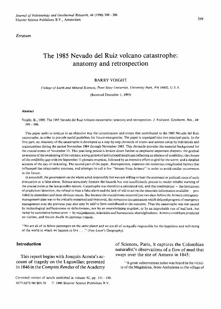
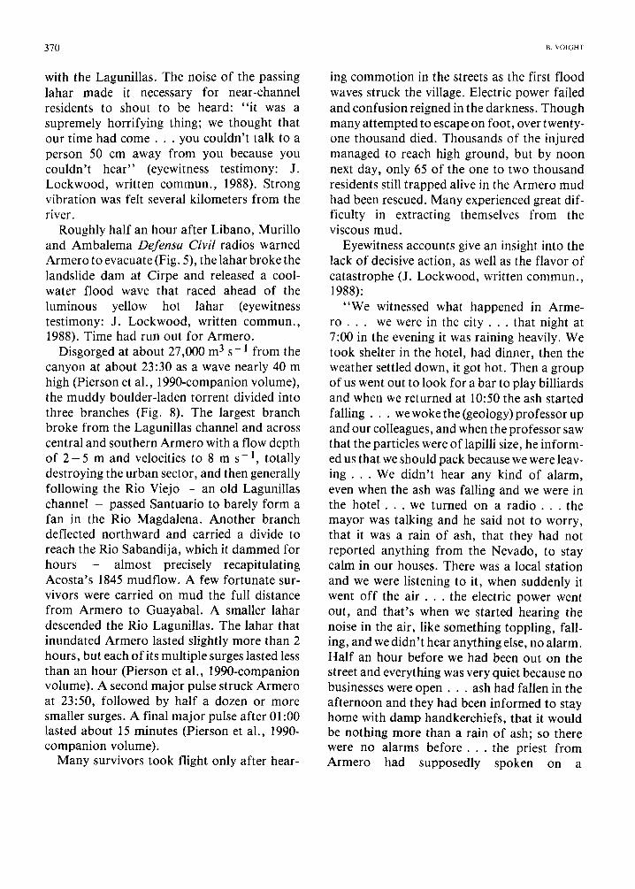
On the volcano's fertile western slope, over- bank flooding by lahars caused 1,100 fatalities at Chinchimi, Caldas Province, and destroyed more than 200 houses and three bridges (E. Parra P., written commun. , 1989). Lahars feeding the Rio Guali flowed northward and then east, destroying homes near Mariquita. Shortly before midnight, in Tolima Province, successive lahar waves obliterated Armero (population 29,000), the prime regional agricultural center. About 5 vertical kilometers below the summit of Ruiz, Armero became a crypt sealed in lahar mud (Fig. 1). Over 20,000 were entombed and 5,000 more were injured.
In the vicinity of the volcano, all roads, bridges, telephone lines, power grids and aqueducts were damaged or destroyed. Sixty percent of the region's livestock, thirty percent
of its grain sorghum and rice crops, and half a million bags of coffee were lost. Lahars buried 3,400 hectares of the agricultural land, damag- ed or eradicated 50 schools and 2 hospitals, destroyed 5,092 homes, 58 industrial plants and 343 commercial establishments, and damaged the National Coffee Research Center in ChinchinS.. About 7,700 were rendered homeless. Total damage exceeded a billion dollars (U.S. AID, written commun. , 1986). Thus " the majestic and silent Nevado del Ruiz, transformed now to an active volcano, could not resist singing a hymn of destruction; and where there was life and hope of production, there is today an ocean of mud as mute witness to the released fury of nature" (Epoca, Dec. 1985).
Yet the eruption was not a surprise, and neither were its effects. Persistent anomalous fumarolic, phreatic and seismic activity had served as precursors for about a year. Colom- bian workers in hazard assessment and management were assisted by international ex-
Fig. 1. The town of Armero following the November 13 eruption of Nevado del Ruiz (photo Steve Raymer, courtesy of National Geographic).
352 ~. VOIGHT
pertise. Despite this, the emergency manage- ment system failed to avert disaster.
Anatomy of the catastrophe
" T h e n a r r a t o r . . , would have little claim to com- petence for a task like this, had not chance put him in the way of gathering much information, and had he not been, by the force of things, closely involved • . . This is his justification for playing the part of a h i s t o r i a n . . . The present narrator has three kinds of data: first, what he saw himself; secondly, the ac- counts of other eye witnesses; and lastly, documents that subsequently came into his hands• He proposes to draw on these records whenever this seems desirable, and to employ them as he thinks best•" (Albert Camus, The Plague)
The awakening
" Y o u must picture the consternation of our little town, hitherto so tranquil, and now, out of the blue, shaken to its core, like a quite healthy man who all of a sudden feels his temperature shoot up and the blood seething like wildfire in his v e i n s . . . " (Camus)
The Ruiz chronicle begins in November 1984, when after a century of peaceful dormancy, earthquakes were felt at the Refugio lodge near the summit of the mountain and climbers repor- ted unusually strong activity in fumaroles with- in the summit crater. Three significant earth- quakes were felt within 20 - 30 km of the volca- no on December 22, one of magnitude 3 - 4, and over a two-day period, episodes of tremor las- ting 5 - 30 minutes were interpreted from re- cords at Chinchin~i (Tomblin, 1985a). At Refu- gio on December 22, 65 shocks were felt about every 15 minutes between 17:00 and 22:00 (Hall, 1990-this volume). Snow on Ruiz was covered with a fine ash and sulfur veneer.
Felt earthquakes and strong fumarolic activi- ty continued into 1985, and on January 6 geologists from the Central Hidro-Electrica de Caldas (CHEC) visited the summit crater Arenas and observed that a new, smaller crater had formed within it. Further investigation led them to conclude that authorities should "implement
a geophysical and geochemical program for monitoring a probable eruption" (CHEC un- publ. doc., February 4, 1985; Hall, 1990-this volume).
In response, a civic committee was formed in Manizales, a city of 350,000 near Volcfin Ruiz. With the support of CHEC, regional corpora- tions and local government, its task was "to form and support a scientific commission to monitor the volcanic and seismic hazard" (Hall, 1990-this volume). Colombia's Geology and Mines Bureau (INGEOMINAS) was then con- tacted, and on several occasions in the period February 18-27 geological teams from CHEC and the University of Caldas, or from JN- GEOMINAS, visited Ruiz to investigate its activi- ty. The first articles on the awakening Ruiz ap- peared in the Manizales newspaper La Patria on February 21 and 22, and a feature section on March 3 included the full report of the scientific commission of the civic committee and photo- graphs of the crater. At Chinchin~i, the only seismograph that had been operating in the region broke down on February 23.
John Tomblin, a seismologist from the United Nations Office of the Disaster Relief Organisation (UNDRO) at Geneva, was in Col- ombia in March on another mission. Accom- panied by two Swiss seismologists, he in- vestigated Volc~in Ruiz on March 9 at the re- quest of Colombia's civil defense agency (Defensa Civil) and INGEOMINAS and witnessed a 100- 150-m vapor column above the summit crater. He concluded that "the abnormal ac- tivity at Volc~in Ruiz corresponds to typical precursory events for an eruption of magni- tude". He recommended the immediate instal- lation of a portable seismograph on Ruiz and noted that INGEOMINAS had the obligation to conduct monitoring, using international exper- tise where necessary, and to prepare a hazard map in anticipation of different types of erup- tion. The Colombian civil defense was alerted to its obligation to develop a plan for alarm and evacuation of the populace in high-risk sectors, as outlined in an up-to-date UNDRO-UNESCO

T H E N E V A D O DEI RUIZ V O L C A N O C A T A S T R O P H E : A N A T O M Y A N D R E T R O S P E C T I O N 353
Handbook (1986), on Volcanic Emergency Management.
On the surface, INGEOMINAS appeared to be in a reasonable position to prepare a hazard map. Only three years before, they had published a 48-page report on the glacial and volcanic geology of the Ruiz - Tolima volcanic complex (Herd, 1982). Based on a 1974 Ph.D. disserta- tion at the University of Washington, this study identified post-glacial lahars and pyroclastic flows high on the flanks of Ruiz, and establish- ed a dated chronology through tephra correla- tions and radiocarbon dating. The lahars of the volcanic complex were noted to be "more com- monly associated with snow-capped volca- noes" , with heat generated by explosive erup- tions cited as the cause of rapid melting of ice. INGEOMINAS had also provided support for more recent investigations along similar lines by scientists from Grenoble, France (Thouret et al., 1985). Although volcanic hazards were not specifically mentioned, these reports con- tained detailed soil and tephra columns and geological maps that included historic lahars of 1595 and 1845, thus providing the basic build- ing blocks for hazard evaluation. However, these publications were founded on foreign ex- pertise, and INGEOMINAS lacked in-house ex- perience in volcanology.
On March 20, a local conference on volcanic risk was held at the National University in Manizales. The participants - many of whom would later form the nucleus of the Volcanic Risk Committee - concluded that the possibi- lity of an eruption could not be dismissed, risk studies were the responsibility of the state, communities had the right to be informed and protected, and an emergency evacuation plan was needed (Calvache et al., 1985). INGEOMI- NAS Report 1937 on the late February field ex- amination of Ruiz concluded otherwise: " the volcanic activity can be considered 'normal ' for active volcanoes and does not represent im- minent danger ." Nevertheless, they advocated establishment of a monitoring program.
An absence of credibility
"Please answer me quite frankly. Are you absolute- ly convinced it's p lague?"
"You ' r e stating the problem wrongly. It 's not a question of the term I use; it 's a question of t ime." (Camus)
On March 29 in Geneva, Tomblin expressed his concern in a telephone communique to Dr. Michio Hashizume, UNESCO Natural Hazards Unit, Paris (Epoca, Dec. 1985): "nothing is be- ing done about this new activity. It appears that the University in Bogota does not have volcanic expertise, and neither does the institute for geology and mines (INGEOMINAS). That institute probably carries the responsibility in a volcano crisis si tuation." Hashizume subsequently re- quested Gudmundur Sigvaldason in Iceland, representing the World Organization of Volca- no Observatories (wovo), to nominate a team of experts in case assistance was requested by the Colombian government. On April 9, wovo telegrammed candidates from Costa Rica, Ecuador and Mexico. The Costa Ricans res- ponded the next day with an offer of three por- table seismographs, an electronic tiltmeter and dry-tilt equipment. In a follow-up letter to UNESCO on April 15 Sigvaldason expressed his preference that a four-man team be involved, including experts from each country. On April 18, Hashizume sent invitations to these indivi- duals with the proviso that the Colombian go- vernment formally request their services. Mean- while, at Volc~n Ruiz, there were 17 felt seismic events in March, 18 more in April. Sounds in- terpreted as rock and ice falls were reported from high in the Rio Azufrado.
On May 4 - 7, Minard Hall, Escuela Polit6c- nica Nacional, Ecuador, visited Manizales on behalf of wovo and UNDRO tO evaluate the ac- tivity of the volcano and determine what measures had been initiated to monitor it and evaluate risk. He reported that " the crater's ac- tivity remains stable but in an abnormal state," with sulfur salts condensing on summit
354 ~. VOIGHT
snowfields. He was concerned that "no monitoring activities are being carried out. Portable seismographs, if they exist, are still in Bogotfi," and he suggested that local govern- ments might buy then from foreign sources. "At least four would be needed" (Hall, 1985, Spanish version). Hall saw "no attempt to in- itiate a volcanic-risk evaluation despite the fact that good quality maps exist" and stressed the importance of making a very preliminary risk map so that Defensa Civil would be better prepared, especially for damage reaching the foot of the Cordillera "where larger towns might be threatened by flowage deposits." He referred to the Cotopaxi, Ecuador, volcanic hazard map as an example of what should be done (Miller et al., 1978), and concluded that the geothermal department of CHEC was "best prepared and more interested" in carrying out hazard mapping and evaluation. INGEOMINAS administrators in Medellin were aware of the hazards but "other priorities and the lack of funds precluded future work there" (Hall, 1990-this volume).
The civil defense of Caldas Province had meanwhile prepared a disaster plan which ap- peared to Hall to be "excellent and completely adequate. However, once the preliminary hazard map is prepared, it will be necessary to review the plan and to adjust it in accordance with the map. It is recommended that the plan be approved" (Hall, 1985, Spanish version). He made no mention of a similar plan for the neighboring Tolima Province in which Armero lies, although he spoke briefly by phone to the national director of Defensa Civil. "All groups were interested" in the possibility of col- laborating with a volcanology team sent from abroad.
On May 30, IN6EOMXNAS made a request to the U.S. Geological Survey for technical exper- tise and for geophones and cable needed to operate in-country seismographs on loan from Interconexi6n E16ctrica S.A. (ISA). The parts were provided at UNDRO expense and shipped by diplomatic pouch on June 26. Informed by
Robert Tilling of USGS that the INGEOMINAS re- quest was under consideration (unpublished correspondence), on June 13, Hashizume look- ed forward to enrichment of a UNESCO effort by a cooperating USGS team. But USGS branch- level officials ultimately declined to send a technical expert, claiming prior commitments and studies associated with recent eruptions in Hawaii and Mount St. Helens. On July 2, the USGS Deputy Chief for Latin America observed in a note to UNDRO, "The opportunity is clear, and it is unfortunate that we can spare no one from the Hawaii or Cascades Observatories. . . If the volcano is to blow, let us hope that both we and the Colombians were prepared."
By early July, responding to the perceived vacuum in hazard evaluation, a Volcanic Risk Committee (Comit6 de Estudios Vulcan61ogi- cos Communidad Caldense) had crystallized from the earlier civic committee in Caldas Pro- vince with the support of the regional govern- ment, CHEC, the National University in Mani- zales, the University of Caldas, the coffee and financial corporations, and concerned citizens (Medina J., 1986, and oral communications). This organization was confirmed by govern- ment decree in August. The Comit6 initiated programs for investigation, local risk planning and public education. On July 7 they acknow- ledged INGEOMINAS for obtaining seismographs from ISA, and expressed the futile hope " that in the next few days INGEOMINAS will turn over these instruments to our project" (Hall, 1990- this volume). The Mayor of Manizales and Governor of Caldas submitted an official re- quest for technical assistance and equipment to the Swiss Disaster Relief Corps, and an UNDRO telex on July 10 to the Swiss Seismological Ser- vice supported the Colombian need for assis- tance in seismic operations and interpretation.
On behalf of the Swiss Disaster Relief Corps and Swiss Seismological Service, Bruno Mar- tinelli arrived in Manizales on August 8 to assist Colombian scientists with seismic monitoring. His equipment included a portable three- component short-period event recorder, an
T H E N E V A D O DEL RUIZ V O L C A N O C A T A S T R O P H E : A N A T O M Y A N D R E T R O S P E C T I O N 355
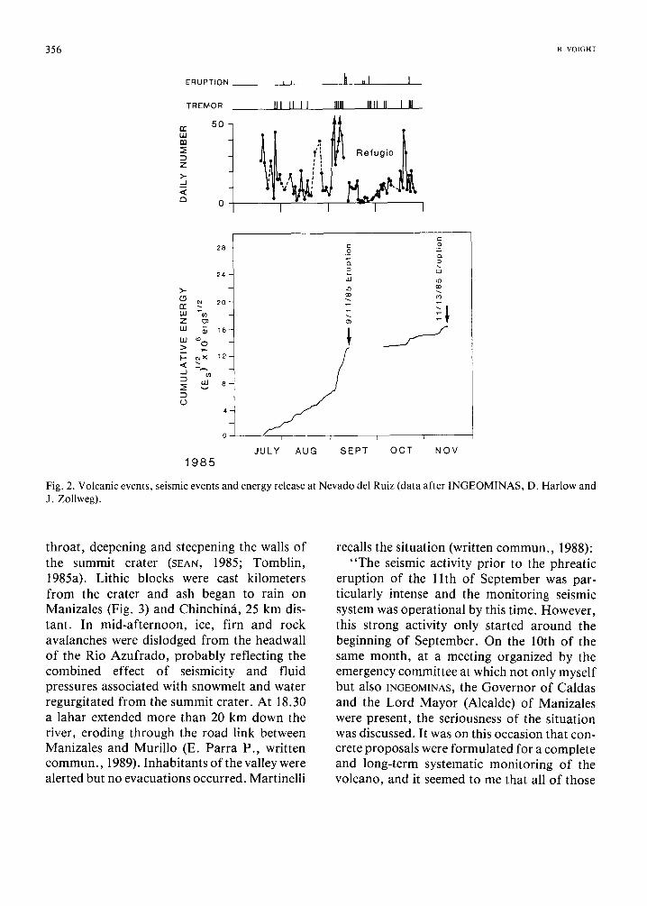
MEQ-800 drum recorder used as a one- component continuous monitor to supplement the event recorder and the INGEOM1NAS net- work, a one-component system with tape recorder mostly used to collect data on a glacier, and Mark geophones (B. Martinelli, written commun. , 1988). Martinelli was ably supported and assisted by CHEC personnel and by authorities of the Caldas region. He recalls the following (written communication):
" O n my arrival, four portable seismographs operated by personnel coordinated by IN- 6EOM~NAS were in operation since July 20th in the region around the Nevado. However, they did provide only little information of relevance due to their non-optional locations." (They were relocated in September.) " I t was only at the end of August, and due mostly to the con- tribution of Juan Duarte (Instituto de Los Andes) that the seismic system could be con- sidered to be suitable for monitoring the volcano at a l l . . . Cooperat ion between myself and the persons responsible for the seismic net- work was always characterized by cordiality and reciprocal consideration. In particular the cooperation with Juan Duarte was very inten- sive and profi table ."
The Comit6 and INGEOMINAS were now operating seismographs independently but the data were not amalgamated for rapid process- ing and complete interpretation. The IN- GEOMINAS data were processed in Bogota. Although background levels were unknown, seismic records indicated about 5 - 2 0 coun- table earthquakes daily, with as many as 4 0 - 5 0 during swarms and occasional t remor (Cu611ar and Solano, 1985; Fig. 2). Maximum magnitude was about 3.5 (D. Harlow, oral commun. , 1988).
On June 26, the same day that the geophones were shipped by USGS, the Colombian delegate to UNESCO wrote to the Minister of Colombian Foreign Affairs, called attention to the Tomblin and Hall UNDRO reports and noted the following: "UNESCO has contacted several in- ternational organizations and is able to offer
Colombia: (1) a team of volcanologists f rom different
countries; (2) equipment and instruments for measure-
ment; (3) training for Colombians in their country
or at volcanologic centers of other countries; (4) exchange of information and experience
concerning similar phenomena. Everything could be provided in a short t i m e . . . To ac- complish this project, it is necessary that the Colombian government file a formal petition to UNESCO as soon as possible." Despite this urgency, the letter was apparently sidetracked. Nearly two months later it resurfaced, attached to an August 21 note f rom an employee of the Ministry of Education to the Governor of Caldas Province: " I n this c o m m u n i c a t i o n . . . the delegate to UNESCO requested that you should petition UNESCO in order to stop the reactivation of the volcano (sic) (El Tiempo Oct. 25, 1985; Epoca, Dec. 1985)." Within a few days, the letter was in the hands of the Volcanic Risk Comit6; but by then the volcano was forging a schedule of its own design.
The credibility gap closes
"(This) marked one might say, the end of the first period, that of bewildering portents, and the beginn- ing of another, relatively more trying, in which the perplexity of the early days gradually gave way to panic . . , our townsfolk realized that they had never dreamed it possible that our little town should be chosen out for the scene of such grotesque happenings
• . . in this respect they were wrong, and these views obviously called for revision... And it was then that fear, and with fear serious reflection, began." (Camus)
E1 Ruiz commanded attention at 13.30 on September 11, when a strong phreatic eruption occurred at the summit crater, lasting for perhaps 7 hours. It had been preceded by 15- minute episodes of t remor every 80 minutes or so since September 6 (Fig. 2; Harlow et al., 1986). Violent steam explosions ripped pre- existing ash and blocks f rom the volcano
356 B. VOIGHT
E R U P T I O N
T R E M O R
5O r r w r.r,
Z >.- .._.1 <
o
I I
III 11 II
;i i t
t
I
II . I I
IIIII IIIII II I III
t Refugio | ~
- - ]
28
2 4
>,-
rr ~ 2o w *~ Z LIJ ~ 16 I i i t8
),.-. ~ × 1 2 -
4
1985
T=.
w
J U L Y A U G S E P T
1
I I
O C T N O V
Fig. 2. Volcanic events, seismic events and energy release at Nevado del Ruiz (data after INGEOMINAS, D. Harlow and J. Zollweg).
throat, deepening and steepening the walls of the summit crater (SEAN, 1985; Tomblin, 1985a). Lithic blocks were cast kilometers from the crater and ash began to rain on Manizales (Fig. 3) and Chinchin~i, 25 km dis- tant. In mid-afternoon, ice, firn and rock avalanches were dislodged from the headwall of the Rio Azufrado, probably reflecting the combined effect of seismicity and fluid pressures associated with snowmelt and water regurgitated from the summit crater. At 18.30 a lahar extended more than 20 km down the river, eroding through the road link between Manizales and Murillo (E. Parra P., written commun. , 1989). Inhabitants of the valley were alerted but no evacuations occurred. Martinelli
recalls the situation (written commun. , 1988): "The seismic activity prior to the phreatic
eruption of the 1 l th of September was par- ticularly intense and the monitoring seismic system was operational by this time. However, this strong activity only started around the beginning of September. On the 10th of the same month, at a meeting organized by the emergency committee at which not only myself but also INGEOMINAS, the Governor of Caldas and the Lord Mayor (Alcalde) of Manizales were present, the seriousness of the situation was discussed. It was on this occasion that con- crete proposals were formulated for a complete and long-term systematic monitoring of the volcano, and it seemed to me that all of those
THE NEVADO DEL RUIZ VOLCANO CATASTROPHE: ANATOMY AND RETROSPECTION 357
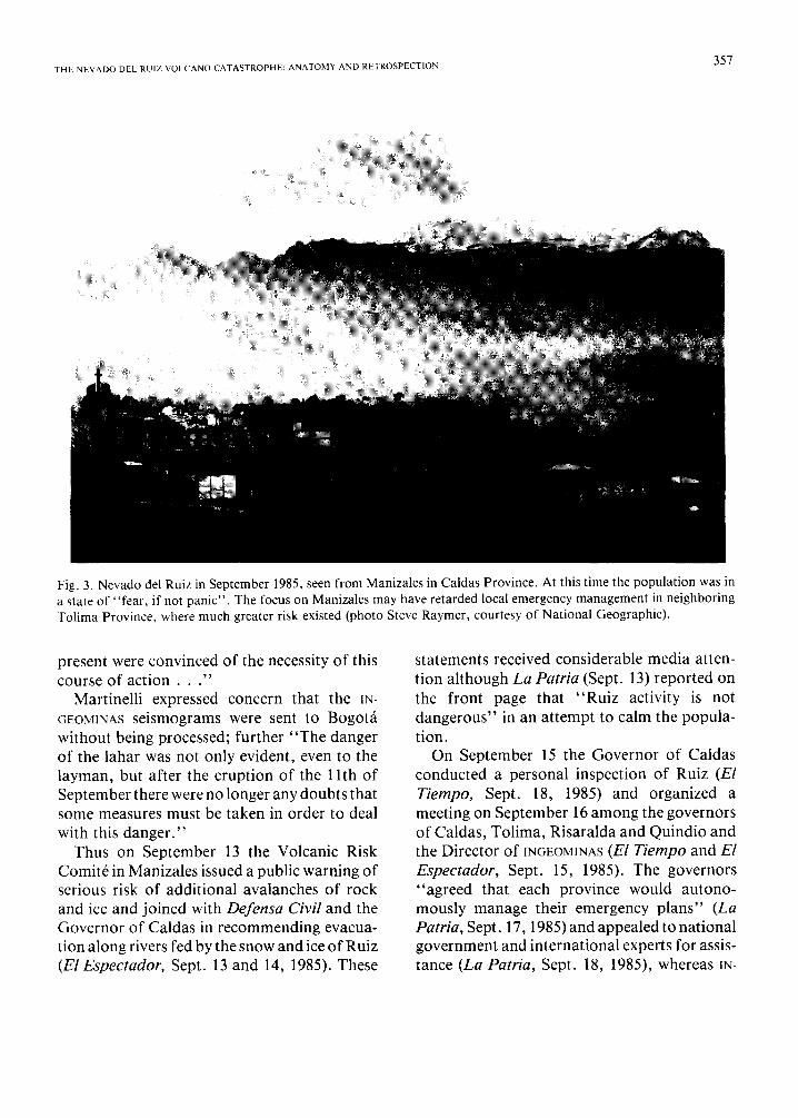
Fig. 3. Nevado del Ruiz in September 1985, seen from Manizales in Caldas Province. At this time the population was in a state of "fear, if not panic". The focus on Manizales may have retarded local emergency management in neighboring Tolima Province, where much greater risk existed (photo Steve Raymer, courtesy of National Geographic).
present were convinced of the necessity of this course of a c t i o n . . . "
Martinelli expressed concern that the ~N- GEOMINAS seismograms were sent to Bogotfi without being processed; further "The danger of the lahar was not only evident, even to the layman, but after the eruption of the 1 lth of September there were no longer any doubts that some measures must be taken in order to deal with this danger."
Thus on September 13 the Volcanic Risk Comit6 in Manizales issued a public warning of serious risk of additional avalanches of rock and ice and joined with Defensa Civil and the Governor of Caldas in recommending evacua- tion along rivers fed by the snow and ice of Ruiz (El Espectador, Sept. 13 and 14, 1985). These
statements received considerable media atten- tion although La Patria (Sept. 13) reported on the front page that "Ruiz activity is not dangerous" in an attempt to calm the popula- tion.
On September 15 the Governor of Caldas conducted a personal inspection of Ruiz (El Tiempo, Sept. 18, 1985) and organized a meeting on September 16 among the governors of Caldas, Tolima, Risaralda and Quindio and the Director of INGEOMINAS (El Tiempo and El Espectador, Sept. 15, 1985). The governors "agreed that each province would autono- mously manage their emergency plans" (La Patria, Sept. 17, 1985) and appealed to national government and international experts for assis- tance (La Patria, Sept. 18, 1985), whereas IN-

358 ~ VOIGHT
GEOMINAS emphasized the high priority of mo- nitoring (Parra and Cepeda, 1990-this vol- ume). An aviation advisory suggested that pi- lots should not fly within 50 miles of Ruiz (El Tiempo, Sept. 17, 1985). On September 18 the Bogot~ newspaper El Tiempo published a color photograph of Ruiz on the cover page, and gave extensive coverage to the developing crisis.
On September 17 t h e ' m a y o r of Armero reported to authorities that his town was threatened by a landslide-dammed lake at Cirpe, 12 km upstream on the Rio Lagunillas and containing an estimated half million cubic meters of water, and that flood hazards existed also on other rivers such as Rio Guali and Rio Recio, due to geothermally enhanced ice melting on Ruiz. Regarding the Lagunillas dam, "an increase in the volume will bring the total destruction of Armero. The town has already had two previous floods with serious consequences for the populat ion" (La Patria, Sept. 21, 1985). (Floods occurred in 1935 and 1950 from torrential rains.)
The mayor identified specific barrios border- ing the river within Armero to be at risk to " t ragedy" and named an 8-man emergency committee of civic leaders to request immediate action from the President of the Republic. The committee, which included the local chiefs of Defensa Civiland Red Cross, stated the follow- ing (La Patria, Sept. 21, 1985; cf. El Tiempo, Sept. 18, 1985): "We are concerned about the situation created by Volc~m Nevado del Ruiz. This is unpredictable, but we can see that critical danger threatens the population. For this reason we request that the Rio Lagunillas dam be dealt with, because it represents a time bomb. The problem of Nevado del Ruiz is well known to the government and to public opi- nion, as scientists have issued warnings about it. For this reason we urge the government to take the appropriate measures to prevent inun- dation by the river, as occurred on previous oc- casions with consequences disastrous to the population. Today the possibility of a catastrophe is greater because of 'superpopula-
tion' of the city." The director of Red Cross for Tolima Province supported this view: " A r m e r o . . . might disappear if a lahar was generated on the Lagunillas . . ." (El Tiempo, Sept. 18, 1985). INGEOMINAS concluded that the dam, which was not related to volcanic activity, did not appear to be in danger of failure "under normal river conditions"; at the same time, a drainage plan was recommended but construc- tion was never started (E. Parra P., written commun. , 1989). The actual reservoir volume at Cirpe was perhaps 250,000 m 3 (R. Janda, oral commun. , 1988).
Meanwhile on September 16, Defensa Civil, INGEOMINAS, Ministry of Mines, CHEC, Caldas government officials and coffee-industry re- presentatives met in Bogot~i to consider emergency plans for Ruiz: "a 25 percent chance of an eruption was estimated," and Defensa Civil "declared a state of alert" (El Tiempo, Sept. 18, 1985).
The September eruption had clearly slamm- ed shut the credibility gap. On September 17, a meeting of emergency and civil-defense direc- tors convened at the request of the government to form a national-level emergency committee to coordinate and plan a response to any fur- ther activity on Ruiz (El Tiempo, Sept. 18, 1985; Hall, 1990-this volume; Herd and Com- it6, 1986). Defensa Civil developed a manage- ment plan and attempted to identify what re- mained to be done, including procedures to carry out evacuation. Red Cross assumed responsibilities for emergency communica- tions and disaster response. INGEOMINAS was assigned national responsibility for monitoring and hazard assessment, generally following UNDRO's time-worn suggestions of March 9. These agencies met with the Colombian Con- gress to obtain funding for the work required. An interparliamentary committee involving the four provinces influenced by Ruiz was formed to oversee state aid for scientific work (El Espectador, Sept. 19, 1985).
A preliminary draft of a volcanic hazard map was scheduled for October 7 and visual obser-
THE NEVADO DEI RUIZ VOLCANO CATASTROPHE: ANATOMY AND RETROSPECTION 359
vation and monitoring of Ruiz was to be ex- panded. After September 20, six INGEOMINAS geologists and four University of Caldas in- structors and some students joined forces at a retreat at Termales del Ruiz, on the flank of the volcano not far from Manizales, to collaborate on the construction of the hazard map (Parra and Cepeda, 1990-this volume). On September 23, before returning to Switzerland, Martinelli (written commun. , 1988) had a chance in Bogot~i to view a first draft of this hazard map: "Dario Moschera illustrated to me the criteria . . . the danger of lahars, especially along the Rio Azufrado and Lagunillas, was the guiding theme of this work ." The Instituto Geogr~ifico Agustin Codazzi was asked to establish a geodetic polygon and provide aerial photographs and maps. A chief of seismology was drawn from the National University of Bogota by INGEOMINAS, and regional emergen- cy committees were established to coordinate local response planning. The existing Volcanic Risk Comit6 (involving CHEC and regional universities) in Manizales was assigned respon- sibility for scientific studies at Ruiz, with input from 1NGEOMINAS. Nevertheless, on September 24 the Congressional representative for Caldas " lamented that requests for help sent to 1N- GEOMINAS, to Ministry of Foreign Relations (and o t h e r s ) . . , had not been s u c c e s s f u l . . . The national government was acting with great uncertainty" (La Patria, Nov. 17, 1985; Hall, 1990-this volume). In response, the Director of Defensa Civil emphasized the regional meet- ings that had been held in July, and the Minister of Mines and Energy said that scientific and mitigation studies would be completed "before the end of October" (La Patria, Sept. 26, 1985; El Espectador, Sept. 27, 1985; Hall, 1990-this volume).
Formal petitions for assistance had been sent to ~JNDRO, UNESCO, USGS and others. In Mani- zales, " the eruption of the 1 l th September con- vinced the monitoring committee of the necessity of immediately having a volcano- logist on the spot who possibly had prior know-
ledge of the Ruiz. The choice did not prove dif- ficult seeing that Franco Barberi had occasion to work for several months on the Ruiz in 1983 as a consultant to a geothermic c o m p a n y . . , a member of the monitoring committee made phone contact with Franco Barberi in Pisa on September 13th. I also took the opportunity to inform him of the seismic recordings made, and it wasn't difficult to convince him of the neces- sity of his presence in Manizales" (B. Martinel- li, written commun. , 1988, cf. ¢HEC, 1983). The Italian team arrived in October.
Meanwhile, the credibility gap had closed sufficiently for the usGs to release Darrell Herd, the administrator in Reston who had studied Ruiz for his Ph.D. dissertation. Sup- ported by the U.S. AID Office for Foreign Disaster Assistance (OFDA), Herd spent the week of September 2 0 - 2 7 assisting Colom- bian scientists in Manizales to evaluate past eruptions as a basis for future prediction and to plan investigation programs. On September 23 he gave a public lecture to help dispel what was then perceived to be " the unnecessarily great anxiety of the population of Manizales," since UNI~RO had been informed that the population was in a state of "fear, if not panic" as a result of the September 11 eruption (Tomblin, 1985a). El Espectador, Sept. 28, 1985 thus reported that "an eruption would only affect an area within approximately 10 km of the sum- mi t . "
Manizales was indeed the hub of activity near Ruiz, being the one large city close to the volcano. However, Manizales was removed and in a different province from most of the main rivers at risk, which flow eastward toward the Magdalena. In retrospect, this focus on Manizales may have retarded local emergency management in neighboring Tolima Province, where even greater risk existed. This view is sus- tained by Martinelli (written communication): "During the whole period of my stay there were no mutual contacts or cooperation between the region Caldas, where I was, and Tolima. Only on September 13th, i.e. after the eruption of
360 B vo1~nz
September l lth, was a meeting held at the Defensa Civil in Bogot~i, organized by General De La Cruz, with representatives of the authorities of Caldas and Tolima, of the Red Cross, and the Defensa Civil. As far as I could see, even after this meeting cooperation be- tween the two regions was insufficient."
A geochemist from New Zealand acquired fumarole-gas samples between September 22 and 30 (partial analysis revealed significant SO2) and John Tomblin of UNDRO took over the advisory role from Herd and Martinelli from September 25 to October 2. He met with national leaders of civil defense and ~N- GEOM1NAS, participated each evening in scien- tific and administrative meetings, and reviewed the work of some local management and vulnerability-assessment groups. Several hours each afternoon were spent working on the hazard maps.
Tomblin (1985a, unpublished correspon- dence) learned that the seismology network needed prompt attention. He attempted to ac- quire radio-linked seismographs to use in short- term prediction, since the seismograph net in operation relied for recording on rotating drums of smoked paper which had to be retriev- ed every day in the field. Requests were made by phone and telex to the Volcano Observatory in Martinique, the University of Paris, the vsGs, the Swiss Federal Seismology Institute, the Swiss Disaster Relief Corps and the Swiss Ambassador in Bogotfi. The problem had not been resolved by the time of his departure.
Equally important, the Risk Comit6 and IN- GEOMINAS were still not fully sharing seismic data. The Comit6 (through Martinelli and CHEC) had several stations, but an insufficient number for hypocenter location study. IN- GEOMINAS had four stations (they added another on October 23), but data had to be mailed to the National University of Bogotfi for interpretation; not only was short-term predic- tion infeasible, but no seismic data or inter- pretations were actually issued by INGEOMINAS until October 7, despite operation of the system
since July 20. Martinelli (written commun., 1988) reported "cordiality" between seismic specialists from the two groups, but "during the whole time of my visit I noted a pronounced rivalry between the emergency committee and INGEOM1NAS. I was never able to figure out the reason for this conflict nor to clarify what responsibilities each institution actually had. In any case, this rivalry had a strong influence on the whole phase of emergency preparation." Tomblin therefore urged closer cooperation between the two groups in Manizales to permit all local earthquake data after September 26 to be interpreted rapidly and as fully as possible, and through UNESCO, coordinated the return of Minard Hall from Ecuador to guide the cooperative effort. He also arranged a mission by Rudolfo Van der Laat from Costa Rica to carry out ground-deformation measurements.
In a mission report dated October 9, Tom- blin (1985a) noted that eruptions producing ash-falls and mudflows were more likely than other types of eruption and observed that "sce- narios which should be envisioned for the pur- pose of hazard zoning and emergency planning (include) rapid melting of the glacier;" further, "the area devastated in 1845 has a present-day population of the order of 20,000." He also commented that the reactions of scientists and public safety authorities were greatly stimu- lated by the September 11 eruption, so that "'within the very near future, the necessary measures will have been taken to protect the population". Martinelli expressed a similar opinion; though well aware of several obstruc- tions to preparedness, on leaving Manizales on September 24 he "was convinced that every- thing would be done to limit the possible dam- age to a minimum."
Girding for the possibility o f battle
"People in town are getting nervous, that's a fact • . . And of course all sorts of wild rumors are going around. The Prefect said to me, 'Take prompt action if you like, but don't attract attention.' He personally is convinced that it's a false alarm." (Camus)
THE N E V A D O DEL RUIZ V O L C A N O C A T A S T R O P H E : A N A T O M Y A N D R E T R O S P E C T I O N 361
There was general satisfaction that the need for uniting all available national resources to meet the volcanic threat was finally recognized. Political fences had been mended and pre- disaster planning was at last progressing at a reasonable pace and in the right direction. Minard Hall, who returned to Manizales Oc- tober 2 - 14, set up a hypocenter-location pro- gram and assisted in the coordination of seismic data and the completion of the volcanic hazard map.
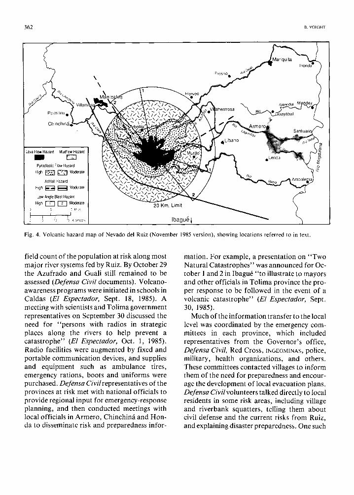
There were still some countercurrents. The Director of the Geophysical Institute of the Andes reported in Magazin 8 Dias (Sept. 1985) that " T o d a y . . . nothing is happening on the volcano that threatens the i n h a b i t a n t s . . . If it is necessary to declare an emergency, the In- stitute will do it. To do so before would only alarm the populace without reason" (Hall, 1990-this volume). Likewise in Manizales, in response to conflicting opinions, the Chamber of Commerce feared that irresponsible repor- ting "will cause economic losses" and the Arch- bishop criticized the media for the spread of "volcanic ter ror ism" (La Patria, Oct. 4 and 5, 1985). On October 7 La Patria noted in a cover story that publication of a volcanic-risk map would cause real estate "devalua t ion" (cf. La Patria, Sept. 18, 1985). Nevertheless, the preliminary version of the hazard map (scale 1:50,000) was presented in a press conference on October 7 at tended by the Minister of Mines, the Governor of Caldas (not Tolima?) and directors of INGEOMINAS, Defensa Civil and other dignitaries (Fig.4; cf. Parra and Cepeda, 1990-this volume, fig. 2). "The map showed that extensive a r e a s . . , are threatened (and) will help various civil defense organiza- tions design plans for e v a c u a t i o n . . , some cities such as Armero would have 2 hours to e v a c u a t e . . . " (La Patria, Oct. 8, 1985). But only ten copies of the map and accompanying explanation were prepared and distributed (Hall, 1990-this volume), although INGEOMI- hAS staff also met with officials of Armero, Mariquita and other towns in Caldas and Toli-
ma and informed them of the potential hazards (F. Zambrano O., cited in Herd and Comit6, 1986). The accompanying INGEOMINAS report (Cepeda et al., 1985a) referred to lahars as follows:
"The presence of old mudflow deposits in some river valleys indicates several possibilities for such events during a large eruption. The probability for this type of event is high for the rivers indicated on the hazard map, and they could occur during any eruption - therefore the probability is 100%. The magnitude is closely related to the size of the eruption and the availability of water . . , for the areas of high hazard the flow could be 25 m deep, and at curves and narrows it could reach 50 m."
The report was accurately referred to in media articles. A generalized version of the map was published in color on the front page of the Bogot~i paper El Espectador (though with some errors in map symbols), and articles men- tioned " a 100°70 probability of m u d f l o w s . . . with great danger for Armero, Mariquita, Honda, Ambalema and the lower part of the Rio Chinchin~i" (EI Espectador, Oct. 8, 1985) and "lahars and floods are i n e v i t a b l e . . . Armero would be evacuated in two hours without danger" (El Tiempo, Oct. 8, 1985).
The map was criticized by some government officials in Bogot~i for "being too a larming" (Cepeda et al., 1986). The mayor of Armero stated in a magazine interview that many peo- ple in Armero now did not know "whether to stay or leave" and lamented that the local emergency committee "did not have the necessary information or financial resources to do anything in the event of a c a t a s t r o p h e . . . For this reason, the people have lost confidence in the veracity of the information and have commended their fate to G o d " (Consigna, Nov. 15, 1985; Hall, 1990-this volume).
Meanwhile, Defensa Civil was hard at work (numerous Defensa Civil documents; P. Bolton and D. Mileti, written commun. , 1988): in September they assembled risk information by overflights of territory in the hazard zones, and in late September and October compiled a
362 B. VOIGHT
\ \
Fresno o
Vlariquita
Palestina e
Chinchin~., f
SaOanOlja M
Lava Flow Hazard Mudflow Hazard
Pyroclastic Flow Hazard High ~ ~ Moderate
Ashfall Hazard High I ~ ~ Moderate
Low Angle Blast Hazard High r-T-'] ~ Moderate
t I I 3 5 'o '5 K omete-~
20 Km. Limit
Ibagu~l
4Libano
eLerida
. Rio
Fig. 4. Volcanic hazard map of Nevado del Ruiz (November 1985 version), showing locations referred to in text.
field count of the population at risk along most major river systems fed by Ruiz. By October 29 the Azufrado and Guali still remained to be assessed (Defensa Civil documents). Volcano- awareness programs were initiated in schools in Caldas (El Espectador, Sept. 18, 1985). A meeting with scientists and Tolima government representatives on September 30 discussed the need for "persons with radios in strategic places along the rivers to help prevent a catastrophe" (El Espectador, Oct. 1, 1985). Radio facilities were augmented by fixed and portable communicat ion devices, and supplies and equipment such as ambulance tires, emergency rations, boots and uniforms were purchased. Defensa Civil representatives of the provinces at risk met with national officials to provide regional input for emergency-response planning, and then conducted meetings with local officials in Armero, Chinchin~i and Hon- da to disseminate risk and preparedness infor-
mation. For example, a presentation on "Two Natural Catastrophes" was announced for Oc- tober 1 and 2 in Ibagu6 " to illustrate to mayors and other officials in Tolima province the pro- per response to be followed in the event of a volcanic catastrophe" (El Espectador, Sept. 30, 1985).
Much of the information transfer to the local level was coordinated by the emergency com- mittees in each province, which included representatives from the Governor 's office, Defensa Civil, Red Cross, mGEOMINAS, police, military, health organizations, and others. These committees contacted villages to inform them of the need for preparedness and encour- age the development of local evacuation plans. Defensa Civil volunteers talked directly to local residents in some risk areas, including village and riverbank squatters, telling them about civil defense and the current risks from Ruiz, and explaining disaster preparedness. One such
THE NEVADO DEL RUIZ VOLCANO CATASTROPHE: ANATOMY AND RETROSPECTION 363
announcement read as follows:
"The Regional Emergency Committee of Caldas notifies you that in view of the danger that exists due to melting of snow, which causes mudflows or a rise in river levels, the margins of the rivers Molinas, Nereidas, Rioclaro and Chinchin/t MUST BE EVACUATED and such an EVACUATION must be accomplished to a minimum height of 50 meters above the river IMMEDIATELY."
The notifier's name, the notified, the address and date were also indicated (Defensa Civil documents).
Some documents suggest an intentional ef- fort to build public confidence in order to minimize the chances of public panic if a disaster occurred. P. Bolton and D. Mileti (written commun. , 1988) subsequently found no evidence that fear was a byproduct of the ef- fort to inform those at risk. In September, some members of the Bogota legislature had
criticized both INGEOMINAS and Defensa Civil for causing unnecessary fear by their hazard evaluation and planning efforts (La Patria, Nov. 17, 1985). But in retrospect, perhaps more fear would have been desirable at some loca- tions to encourage an appropriate public reac- tion.
On October 10, in a continuation of Tom- blin's quest for equipment, Hall sent the fol- lowing telex to Robert Tilling, usGs, "Seismic delay processing 24 hours makes telemetering desirable." On the 16th, Hall advised UNDRO by phone that the hazard map had been issued to government authorities, and that although seismicity remained abnormal, serious moni- toring problems had been encountered (Hall, 1990-this volume).
Also on the 16th, an advisory team represen- ting the National Volcanological Group of Ita- ly arrived in Manizales to advise on eruption hazards. They reported significant deficiencies in the monitoring program, particularly with regard to hypocentral location capability, telemetry, and semiautomatic data processing (Barberi et al., 1985): " to this point in the mis- sion (20 October) we have only the analysis of
seismic data on 26 September." They also em- phasized the need for a communication system which could provide immediate alert at the in- ception of an eruption: "we should consider that the communication system may be damag- ed in the initial moments of erupt ion." Moreover, " taking in consideration that lahars are the most dangerous volcanic phenomena and that there is a great possibility for them to occur in any type of e r u p t i o n . . , it is advisable to give high priority to a communication system that will allow an alert to be rapidly sent to peo- ple living in areas exposed to the risk of lahars. It is necessary to identify a place of refuge in each of these towns, and to inform the com- munity so that the people will know where to go in case of an alert." On October 22 the report was delivered to local government and emergency managers, and left with the Italian Ambassador for official transmission to the government in Bogotfi. By October 31 a com- plete gas analysis on a Ruiz sample was per- formed in Italy and the results, which verified a magmatic origin for the gas, were telexed to Colombian authorities (Barberi et al., 1986, 1990-this volume).
Between October 21 and November 3, with support from UNESCO, Van der Laat (1985) conducted ground deformation monitoring, though it may be recalled that the Costa Ricans had been available since April. Although four dry-tilt stations were established about the northwest side of the volcano and two electronic tiltmeters were installed, a retrospective look at the data "yielded erratic trends not easily reconciled with even a small intrusion" (Banks et al., 1990-companion volume); further, " the electronic-tiltmeter data are not useable because the tiltmeters were removed nine days prior to the eruption before settling-in drift had s topped." The "reliable" dry-tilt data showed no pre-eruption tilt, perhaps because the source magma was already emplaced or was too deep to detect (Banks et al., 1986, 1990-companion volume). Nevertheless, a consistent tilt pattern implying deflation emerged from background
364 B. VOIGHT
at one station (SEAN, 1985), and although in hindsight considered untrustworthy (Banks et al., 1990-companion volume), " a few days of tilt observations might have provided uncheck- ed misleading in format ion" (Barberi et al., 1986).
On October 29, the Tolima Emergency Com- mittee met for the third time at the Red Cross office in Ibagu6. The INGEOMINAS represen- tative reported that he and other committee members had visited 12 municipalities in north- ern Tolima to provide instructions on volcanic risk and advice on precautions for the benefit o f 4,380 residents. Emergency communicat ion systems were then reviewed by Red Cross and the hazard map was presented by INGEOMINAS, along with hazard probabilities. The local emergency plans of Herveo and Libano were praised, with the suggestion that these could be useful models for other municipalities. The meeting log shows that the Governor ' s representative applauded this work and sug- gested that a meeting be held in Libano to establish standards and to improve the local plans in all municipalities at risk. A meeting of mayors was therefore scheduled at Libano for November 15, to be preceded by an organiza- tional meeting on November 13 in Ibagu6. On October 30 a telegram from the Governor ' s re- presentative and a work order signed by the Governor went to the mayors in each Tolima municipality within potential reach of Ruiz, in- forming them that their emergency plans were to be critically reviewed at the Libano meeting.
Meanwhile, in response to Hall 's October 10 telex (but over four months since a plea for technical assistance had been made by ~N- GEOMINAS), the USGS had proposed to OFDA the installation of an array of six telemetered seismographs at Ruiz. OFDA declined support , and weeks were then lost in interagency negotiations whether the proposed cost should be of the order of $40,00 or $10,000. With the lower figure finally agreed upon, USGS seismo- logists Dave Har low and Randy White were ready to depart on November 7 with a single
telemetered seismograph (D. Harlow, oral commun. , 1988). But in a sense symptomatic of the entire tragedy, the Colombian government produced other matters o f concern. Already engulfed in an economic crisis, President Betancur came under political attack for his November 6 decision to send troops against guerrillas who had captured the Palace of Justice in Bogotfi. The bloody assault left 100 dead, including 11 supreme court justices (Time, Nov. 25, 1985). Reacting quickly, the State Department and OVDA concluded not to send U.S. government employees into a poten- tial hornet 's nest; White and Harlow were ad- vised to unpack their bags.
On November 6, most 1NGEOMINAS geolog- ists working on Ruiz left Manizales in order to complete reports at their home offices in other provinces (Hall, 1990-this volume). Because of the Palace of Justice crisis, public presentation of the revised hazard map (scale 1:100,000) and report was postponed from November 12 to 15 (Fig. 4; cf. Parra and Cepeda, 1990-this volume). The November report provided fur- ther details on the lahar hazard (Cepeda et al., 1985b):
"Occurrences of this type of event in these rivers is extremely high (100070) during eruptive phases of any type, varying only in magnitude... In the case of an eruptive event of great proportions (similar to 1845 or larger in magnitude), the hazard zone has been evaluated assuming a mud thickness of 50 m over nor- mal river level . . . the maximum assumed thickness has been calculated on the basis of the measurement of deposits of mudflows observed in the rivers Guali (at Santa Ines) and Azufrado-Lagunillas (near Liban). When the river leaves the canyon, reaching the Rio Magdalena flood plain, spreading occurs, causing a thinning and an increase in the area affected. As an ex- ample of this, we have the mudflow of 1845, which near Armero had a thickness of 8 m, with the area of influence extending to the Rio Sabandija and Rio Magdalena... In the Rio Chinchinfi are several rnudflow deposits, and in lower reaches of the con- fluence of the Rio Claro and Molinas. On this basis, the hazard zones were delimited with great detail for the towns of Armero, Honda and Mariquita." (though not for Chinchin~i).
TH E N E V A D O DEL RUIZ v o [ ( , \NO C A T A S T R O P H E : A N A T O M Y A N D R E T R O S P E C T I O N 365
The detailed map for Armero implied that most of the population would have to travel a distance of over a kilometer in order to reach the edge of the zone of inundation. The Italian team had written of the need to identify a place of safe refuge in each town; but the Armero map implied that no such simply reached place existed there and any evacuation therefore would be a major enterprise.
On November 10, three days of continuous 2 - 3 - H z tremor began at E1 Ruiz. At 78 decibels it was clear but less pronounced than during the September eruption. Nevertheless, during a regular meeting of the Comit6 in Manizales on the 12th, several participants voiced concern about monitoring and public education programs (Comit6 Acta No. 24; Hall, 1990-this volume). No analysis of seis- micity had been issued since October 10, and ISA now wanted their seismographs returned. Neither ~SA nor 1NGEOMINAS could maintain the system, and operations were being supported by the Comit6 and CHEC. INGEOMINAS was asked to leave them at Ruiz at least until February. On November 11 INGEOM1NAS again had claimed that Armero could be evacuated in 2 hours without danger - ironically, this statement was published November 14 in El Tiempo.
Day of reckoning
" A picture rose before him of the red glow of the pyres mirrored in a wine-dark, slumbrous sea, battling torches whirling sparks across the darkness, and thick fetid smoke rising toward the watchful sky. Yes, it was not beyond the bounds of possibility . . . " (Camus)
Nevado del Ruiz erupted with little short- term warning on November 13, following almost a year of precursory activity. The rise in rate of seismic energy released in October and early November was only slightly larger than background level, in contrast to the sharp premonitory increase of energy preceding the September 11 eruption. Gas samples were col- lected from summit crater fumaroles on November 12th but visual observations yielded
no signs of impending eruption. The events of November 13 began in
midafternoon at 15:06 with a phreatic eruption and its associated seismic signal, lasting about a quarter of an hour (Harlow et al., 1986). Fine lithic ash was deposited within a distance of about 50 km east of the volcano and muddy rain oxidized metal roofs. Punctuated with small explosions, tremor then characterized the seismic record until 21:08.
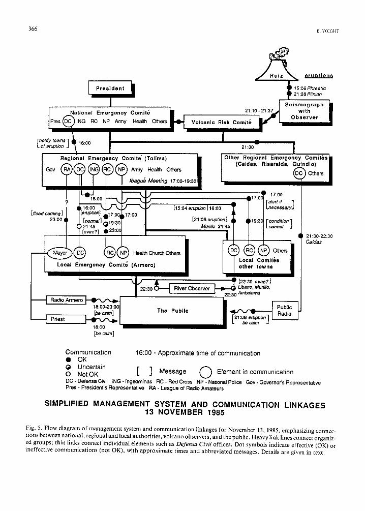
The regional Red Cross and Defensa Civil of- fices were soon informed that Ruiz was erup- ting. Cr. Rafael Perdomo S., Tolima regional civil-defense coordinator, reported this infor- mation to national headquarters and was in- structed to warn local Defensa Civil stations (Fig. 5). Soon afterward, between 17:00 and 19:30, he joined the Regional Emergency Com- mittee for Tolima at their previously scheduled meeting at the Red Cross office in the provin- cial capital of Ibagu& The key regional decision makers were thus already assembled when Red Cross and Defensa Civil officials reported that volcanic ash was falling in northern Tolima, along with heavy rain. Minutes of the meeting indicate that the police representative was "im- mediately asked to communicate with central headquarters in order that telex alerts to prepare for mudflows and floods might be sent to all police stations near the rivers Guali, Azufrado, Lagunillas and Recio." This was ac- complished via a hand radio in the presence of the committee and a similar advisory was radioed by Red Cross to their municipal sta- tions. In both instances, instructions were made to "sound the alarm - i f necessary - in the lower reaches of the rivers and at the local Red Cross headquarters."
The meeting was then officially called to order, and began with a reading of minutes of the previous meeting (Defensa Civil docu- ments). Recognizing the possibility of a developing emergency, discussion first focused on a suitable location for an operations center. The police headquarters suited this purpose because it provided facilities for communica-
366 n, VOIGHT
National Emergency Comite RING RC NP Army Health Others
21:10 - 21:37
Volcanic Risk Comit~
eruptions
15:06 Phreatic 21:08 Plinian
Seismograph with
Observer
n°tify t°wns ] ~ 16:00 of eruption J
Regional Emergency
?
[flood coming] i 23:00
Local Emergency
Radio Armero 18:00-23:00 [be calm]
Priest 18:oo [be ~lm]
Comite" (Tolima) I
~ An'ny Health O~'~ers
Ibagu~ Meeting 17:00-19:30
N[~) Health Church Others
Comite (Armero)
21:30 | |
Other Regional Emergency Comit(~s~B (Caldas, Rlsaralda, Quindio)
I ~ ) Others
[15:04 en4~tion] 16:00
[21:06 eruption] Murillo 21:45
a
A17.0~ r 17:00 T - I r it 7 l / ° eesary" ~ l g:3C~ [ condition ] I ILnormal J
,®®o, Local Comit$s other towns
River Observer
The Public
, ~ [22:30 evac;] ~ l_ibano, Murillo,
22:30 AmbaJema
/ I Pub,c i'21:08 eruption] J Radio L be calm J
21:30-22:30 Caldas
Communication 16:00 - Approximate time of communication • OK (~ Uncertain O O NotOK [ ] Message Element in communication DC - Defensa Civil ING - Ingeominas RC - Red Cross NP - Nadonal Police Gov - Governor's Representative Pres - President's Representative RA - League of Radio Amateurs
SIMPLIFIED M A N A G E M E N T SYSTEM AND C O M M U N I C A T I O N L I N K A G E S 13 NOVEMBER 1985
Fig. 5. Flow diagram of management system and communication linkages for November 13, 1985, emphasizing connec- tions between national, regional and local authorities, volcano observers, and the public. Heavy link lines connect organiz- ed groups; thin links connect individual elements such as Defensa Civil offices. Dot symbols indicate effective (OK) or ineffective communications (not OK), with approximate times and abbreviated messages. Details are given in text.

THE NEVADO DEL RUIZ VOLCANO CATASTROPHE: ANATOMY AND RETROSPECTION 367
tion with remote sites. Following a detailed discussion, an agenda was then developed for the forthcoming Libano meeting on November 15. As this meeting was to be inaugurated by the Governor, preparations needed to be thorough: it was to include summaries by IN- GEOMINAS on the hazard map and Defensa Civil on contingency plans, a videotape on natural disaster mitigation, a presentation by each mayor on local emergency plans, a sum- mation of the well-regarded Libano plan and a forum for the critical review and adjustment of the local emergency plans. Following this discussion of the agenda, a census of Los Nevados National Park (that includes Ruiz) was presented, restructuring of Emergency Committee sub-groups was debated and Cr. Perdomo made a presentation "praised for its clarity" of the Defensa Civil contingency plan to be presented at Libano. These details are in- cluded to demonstrate that the Committee was not obsessed with the day's events, and indeed at 19:30, in response to an information request by Red Cross radio, conditions were reported to have returned to normal (no ashfall) in northern Tolima. The meeting concluded with a reminder of the important Libano meeting.
By about 17:00 the minutes of the Ibagu6 meeting and interview comments suggest that Red Cross, the police, and Defensa Civil offices in Armero had all been independently alerted to the concern of the Emergency Committee (Fig. 5). Local officials were therefore almost cer- tainly aware of the alert, but no formal deci- sion to evacuate had been made. Before 19:30 the abnormal conditions had apparently end- ed, thus reducing concerns, and in Armero residents heard repeated reassuring messages from Radio Armero and the village priest.
At 21:08 a strong eruption-produced seismic signal occurred within Ruiz and seismographs were saturated for about an hour. A sequence of at least four andesitic to dacitic (58-65°7o SIO2) pumiceous pyroclastic flows (one weld- ed) and two surges were erupted and emplaced in rapid succession (Calvache, 1986, 1990-
companion volume; Janda et al., 1986, 1990- this volume; Thouret et al., 1987), as was later interpreted from the 10-m-thick deposits on the summit ice cap and the thinner deposits exten- ding several kilometers from the crater (over 5 km down the Rio Azufrado); flow contacts show several meters of scouring relief. Magma eruption temperatures exceeded 900°C (Katsui et al., 1986; W. Melson, oral commun. , 1986). The total dense-rock equivalent volume of eruption products was 1.9 x 10⁷ m 3 (Calvache, 1990-companion volume).
The flows and surges melted much of the snowpack and carved a radial pattern of chutes and channels in the 21-km 2 summit firn and ice cap and outlet glaciers (Fig. 6; cf. Thouret, 1990-companion volume). Some meltwater sank into crevasses already choked with pyroclastic debris, and large slabs of ice, firn and rock were pried loose from canyon walls and avalanched into the headwaters of the Rio Azufrado and the Lagunillas (Pierson et al., 1990-companion volume). Torrents of melt- water cascaded from the ice cap into the river channels flanking the cone. By entraining hot pyroclastic deposits, glacial drift, alluvium and colluvium, lahars were mobilized in the chan- nels of the major rivers. Campesinas of the up- per valleys of the Lagunillas, Molinas, and Guali reported hearing lahars as early as 21:15 (Pierson et al., 1990-companion volume); in- itial peak flows were into recession before the climax of the subplinian eruption column at 21:30 (Fig. 7).
Bernardo Salazar and Rafael Gonzales, CHEC/Risk Comit6 staff, tending a seismo- graph 9 km from the crater at El Arbolito had heard several strong explosions - one of which "lighted the raincloud over Ruiz like a lamp" (SEAN, 1985), and Salazar radioed the Risk Comit6 in Manizales (Fig. 5). Notified by the Comit6, the Governor of Caldas then called several commercial radio stations at various times between 21:30 and 22:30 to issue, in his own voice, a "red alert" for Caldas communi- ties living along rivers from Ruiz (unpublished
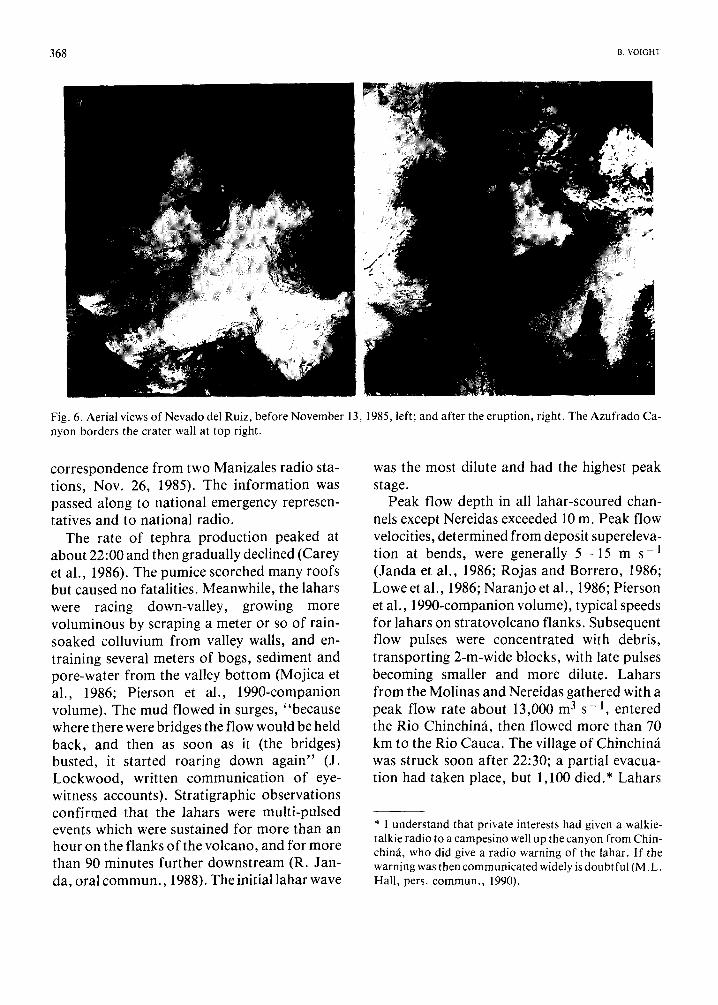
368 ~. VOJGHT
Fig. 6. Aerial views of Nevado del Ruiz, before November 13, 1985, left; and after the eruption, right. The Azufrado Ca- nyon borders the crater wall at top right.
correspondence from two Manizales radio sta- tions, Nov. 26, 1985). The information was passed along to national emergency represen- tatives and to national radio.
The rate of tephra production peaked at about 22:00 and then gradually declined (Carey et al., 1986). The pumice scorched many roofs but caused no fatalities. Meanwhile, the lahars were racing down-valley, growing more voluminous by scraping a meter or so of rain- soaked colluvium from valley walls, and en- training several meters of bogs, sediment and pore-water from the valley bo t tom (Mojica et al., 1986; Pierson et al., 1990-companion volume). The mud flowed in surges, "because where there were bridges the flow would be held back, and then as soon as it (the bridges) busted, it started roaring down again" (J. Lockwood, written communicat ion of eye- witness accounts). Stratigraphic observations confirmed that the lahars were multi-pulsed events which were sustained for more than an hour on the flanks of the volcano, and for more than 90 minutes further downstream (R. Jan- da, oral commun. , 1988). The initial lahar wave
was the most dilute and had the highest peak stage.
Peak flow depth in all lahar-scoured chan- nels except Nereidas exceeded 10 m. Peak flow velocities, determined from deposit supereleva-
-1 tion at bends, were generally 5 - 1 5 m s (Janda et al., 1986; Rojas and Borrero, 1986; Lowe et al., 1986; Naranjo et al., 1986; Pierson et al., 1990-companion volume), typical speeds for lahars on stratovolcano flanks. Subsequent flow pulses were concentrated with debris, transporting 2-m-wide blocks, with late pulses becoming smaller and more dilute. Lahars f rom the Molinas and Nereidas gathered with a peak flow rate about 13,000 m 3 s -1 , entered the Rio Chinchin~i, then flowed more than 70 km to the Rio Cauca. The village of Chinchin~i was struck soon after 22:30; a partial evacua- tion had taken place, but 1,100 died.* Lahars
* I understand that private interests had given a walkie- talkie radio to a campesino well up the canyon from Chin- chin~, who did give a radio warning of the lahar. If the warning was then communicated widely is doubtful (M. L. Hall, pers. commun., 1990).

THE NEVADO DEL RUIZ VO[ CANO CATASTROPHE: ANATOMY AND RETROSPECTION 369
o+•,,•Oo+ i~Man,zales
Arbo
Fresno e
Herveo
Mariquita
SaDandqa
Honda II
oLerida
E• Pyroc!ast~c Deposit
Actual Mud Flow
C ~ '[E; '[5 KiIome, e,s Ibagu6~ \
Fig. 7. Products of November 13 eruption. Contours show thickness of tephra deposit (airfall) [Comit6 data]. Compare with hazard map.
of the Guali flowed 90 km with a peak rate about 20,000 m 3 s -1, thinning somewhat beyond Mariquita before terminating in the Rio Magdalena (R. Janda, oral commun. , 1988).
A small quantity of muddy flow from the Lagunillas would ultimately reach the Magdalena, but upstream matters were more complicated. The Rio Lagunillas, about 50 km long from its headwaters on the Nevado to its debouchment on the Armero plain, is fed by the Rio Azufrado. Above the confluence, peak flow on the Lagunillas was about 700 m 3 s - 1 On the 49-km-long Azufrado, however, peak flow cross-sectional area typically ranged from 2200 to 2600 m 2 (Mojica et al., 1986). With an average flow rate of roughly 10 m s - 1 (72 km in 2 hours), discharge averaged about 25,000 - 30,000 m 3 s - l ; an astonishing peak value of 48,000 m 3 s t occurred about 10 km down- stream from the source (Pierson et al., 1990-
companion volume). For comparison, this is roughly equivalent to the wave produced by the evulsion of practically the entire reservoir over the world's largest arch dam in the gigantic Vai6nt, Italy, landslide catastrophe of 1963. The Armero story is essentially the Azufrado story, with the headwaters of the Lagunillas playing a subdued role. One eyewitness got it exactly right (J. Lockwood, written commun. , 1988): " the Lagunillas was flowing rather diminished. It was the Azufrado that brought everything down and finished the little town downstream."
At 21:45 to 22:00, officials in Ibagu6, aware of the paroxysmal eruption, attempted to order the evacuation of Armero (Fig. 5). Engulfed in a torrential, ashy rainstorm, Armero ex- perienced power and communicat ion dif- ficulties. By then the Azufrado lahar, 30 - 40 m high, had rounded the Villahermosa bend and was but half an hour or so from its confluence
370 ~. VOICHT
with the Lagunillas. The noise of the passing lahar made it necessary for near-channel residents to shout to be heard: "it was a supremely horrifying thing; we thought that our time had c o m e . . , you couldn't talk to a person 50 cm away from you because you couldn't hear" (eyewitness testimony: J. Lockwood, written commun., 1988). Strong vibration was felt several kilometers from the river.
Roughly half an hour after Libano, Murillo and Ambalema Defensa Civil radios warned Armero to evacuate (Fig. 5), the lahar broke the landslide dam at Cirpe and released a cool- water flood wave that raced ahead of the luminous yellow hot lahar (eyewitness testimony: J. Lockwood, written commun., 1988). Time had run out for Armero.
Disgorged at about 27,000 m 3 s - 1 from the canyon at about 23:30 as a wave nearly 40 m high (Pierson et al., 1990-companion volume), the muddy boulder-laden torrent divided into three branches (Fig. 8). The largest branch broke from the Lagunillas channel and across central and southern Armero with a flow depth of 2 - 5 m and velocities to 8 m s - l , totally destroying the urban sector, and then generally following the Rio Viejo - an old Lagunillas channel - passed Santuario to barely form a fan in the Rio Magdalena. Another branch deflected northward and carried a divide to reach the Rio Sabandija, which it dammed for hours - almost precisely recapitulating Acosta's 1845 mudflow. A few fortunate sur- vivors were carried on mud the full distance from Armero to Guayabal. A smaller lahar descended the Rio Lagunillas. The lahar that inundated Armero lasted slightly more than 2 hours, but each of its multiple surges lasted less than an hour (Pierson et al., 1990-companion volume). A second major pulse struck Armero at 23:50, followed by half a dozen or more smaller surges. A final major pulse after 01:00 lasted about 15 minutes (Pierson et al., 1990- companion volume).
Many survivors took flight only after hear-
ing commotion in the streets as the first flood waves struck the village. Electric power failed and confusion reigned in the darkness. Though many attempted to escape on foot, over twenty- one thousand died. Thousands of the injured managed to reach high ground, but by noon next day, only 65 of the one to two thousand residents still trapped alive in the Armero mud had been rescued. Many experienced great dif- ficulty in extracting themselves from the viscous mud.
Eyewitness accounts give an insight into the lack of decisive action, as well as the flavor of catastrophe (J. Lockwood, written commun., 1988):
"We witnessed what happened in Arme- r o . . . we were in the c i t y . . . t h a t n i g h t at 7:00 in the evening it was raining heavily. We took shelter in the hotel, had dinner, then the weather settled down, it got hot. Then a group of us went out to look for a bar to play billiards and when we returned at 10:50 the ash started f a l l i n g . . , we woke the (geology) professor up and our colleagues, and when the professor saw that the particles were of lapilli size, he inform- ed us that we should pack because we were leav- i n g . . . We didn't hear any kind of alarm, even when the ash was falling and we were in the h o t e l . . , we turned on a r a d i o . . , the mayor was talking and he said not to worry, that it was a rain of ash, that they had not reported anything from the Nevado, to stay calm in our houses. There was a local station and we were listening to it, when suddenly it went off the a i r . . , the electric power went out, and that's when we started hearing the noise in the air, like something toppling, fall- ing, and we didn't hear anything else, no alarm. Half an hour before we had been out on the street and everything was very quiet because no businesses were o p e n . . , ash had fallen in the afternoon and they had been informed to stay home with damp handkerchiefs, that it would be nothing more than a rain of ash; so there were no alarms b e f o r e . . , the priest from Armero had supposedly spoken on a

THE NEVADO DEL RUIZ VOI.CANO CATASTROPHE: ANATOMY AND RETROSPECTION 371
loudspeaker around 6:00 and had said the same thing, that there was no need to leave Armero, because the population was alarmed on ac- count of the story about the d a m . . , when we went out the cars were swaying and running people d o w n . . , there was total darkness, the only light provided by c a r s . . , we were runn- ing and about to reach the corner when a river of water came down the s t r e e t s . . , we turned around screaming, toward the hotel, because already the waters were dragging beds along, overturning cars, sweeping people a w a y . . . (we) went back into the hotel, a three-story building with a terrace, built of cement and very s t u r d y . . , suddenly I felt blows, and looking towards the rear of the hotel I saw (something) like foam, coming down in the darkness . . . it was (a wall of) mud approach- ing the hotel, and sure enough it crashed against the rear of the hotel and started crush- ing w a l l s . . , and then the ceiling slab fractu- red, a n d . . , the entire building was destroyed and broken into pieces. Since the building was made of cement, I thought that it would resist, but it (the bouldery mud) was coming in such an overwhelming way, like a wall of tractors, raz- ing the city, razing e v e r y t h i n g . . . (then) the
university bus that was in a parking lot next to the hotel was higher than us (on a wave of mud), on fire, and it exploded, so I covered my face thinking, this is where I die a horrible d e a t h . . , there was a little girl who I thought was decapitated, but what happened was that her head was buried in the m u d . . . A lady told me, ' look that girl moved a leg.' Then I moved toward her and my legs sank into the mud, which was hot but not burning, and I started to get the little girl out, but when I saw her hair was caught, that seemed to me the most unfair thing in the w o r l d . . . "
"All night long ash was falling. At 4:30 or 5:00, more or less, the noise increased again, then we thought that another mudflow was coming, and sure enough, towards the side you could see something shining that was mov- i n g . . . "
" . . . And it started to be light, and that 's when we lost control because we saw that horri- ble sea of mud, which was so gigan- t i c . . , there were people buried, calling out, calling for help, and if one tried to go to them, one would sink into the m u d . . , so now you must start counting time as before Armero and after A r m e r o . . . it's like living and being
Fig. 8. Mudflow deposits of November 13, 1985 near Armero, compared with reconstructed mudflows of 1845 and 1595 (after Mojica et al., 1986).
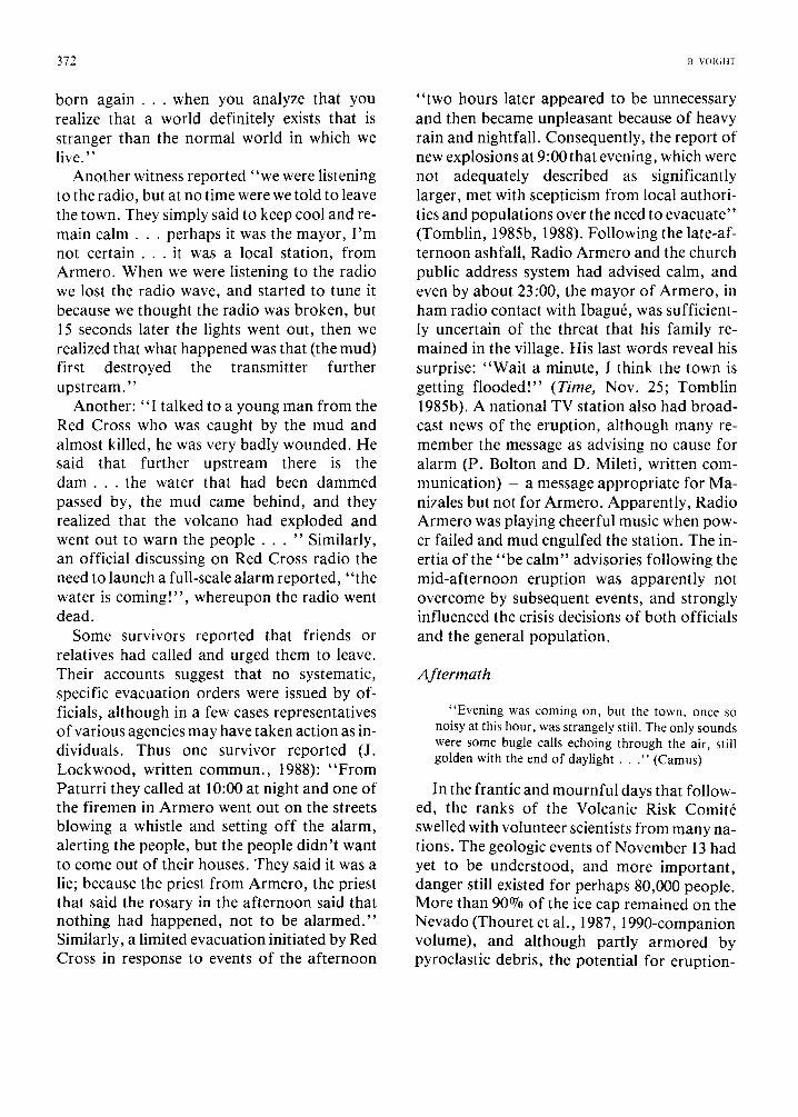
372 B. vomnT
born a g a i n . . , when you analyze that you realize that a world definitely exists that is stranger than the normal world in which we live."
Another witness reported "we were listening to the radio, but at no time were we told to leave the town. They simply said to keep cool and re- main c a l m . . , perhaps it was the mayor, I 'm not c e r t a i n . . , it was a local station, from Armero. When we were listening to the radio we lost the radio wave, and started to tune it because we thought the radio was broken, but 15 seconds later the lights went out, then we realized that what happened was that (the mud) first destroyed the transmitter further upstream."
Another: "I talked to a young man from the Red Cross who was caught by the mud and almost killed, he was very badly wounded. He said that further upstream there is the d a m . . , the water that had been dammed passed by, the mud came behind, and they realized that the volcano had exploded and went out to warn the p e o p l e . . . " Similarly, an official discussing on Red Cross radio the need to launch a full-scale alarm reported, "the water is coming!", whereupon the radio went dead.
Some survivors reported that friends or relatives had called and urged them to leave. Their accounts suggest that no systematic, specific evacuation orders were issued by of- ficials, although in a few cases representatives of various agencies may have taken action as in- dividuals. Thus one survivor reported (J. Lockwood, written commun., 1988): "From Paturri they called at 10:00 at night and one of the firemen in Armero went out on the streets blowing a whistle and setting off the alarm, alerting the people, but the people didn't want to come out of their houses. They said it was a lie; because the priest from Armero, the priest that said the rosary in the afternoon said that nothing had happened, not to be alarmed." Similarly, a limited evacuation initiated by Red Cross in response to events of the afternoon
"two hours later appeared to be unnecessary and then became unpleasant because of heavy rain and nightfall. Consequently, the report of new explosions at 9:00 that evening, which were not adequately described as significantly larger, met with scepticism from local authori- ties and populations over the need to evacuate" (Tomblin, 1985b, 1988). Following the late-af- ternoon ashfall, Radio Armero and the church public address system had advised calm, and even by about 23:00, the mayor of Armero, in ham radio contact with Ibagu6, was sufficient- ly uncertain of the threat that his family re- mained in the village. His last words reveal his surprise: "Wait a minute, 1 think the town is getting flooded!" (Time, Nov. 25; Tomblin 1985b). A national TV station also had broad- cast news of the eruption, although many re- member the message as advising no cause for alarm (P. Bolton and D. Mileti, written com- munication) - a message appropriate for Ma- nizales but not for Armero. Apparently, Radio Armero was playing cheerful music when pow- er failed and mud engulfed the station. The in- ertia of the "be calm" advisories following the mid-afternoon eruption was apparently not overcome by subsequent events, and strongly influenced the crisis decisions of both officials and the general population.
Aftermath
"Evening was coming on, but the town, once so noisy at this hour, was strangely still. The only sounds were some bugle calls echoing through the air, still golden with the end of daylight . . . " (Camus)
In the frantic and mournful days that follow- ed, the ranks of the Volcanic Risk Comit6 swelled with volunteer scientists from many na- tions. The geologic events of November 13 had yet to be understood, and more important, danger still existed for perhaps 80,000 people. More than 90°7o of the ice cap remained on the Nevado (Thouret et al., 1987, 1990-companion volume), and although partly armored by pyroclastic debris, the potential for eruption-
T H F N E V A D O DE[. RUIZ VOI C A N O C A T A S T R O P H E : A N A T O M Y A N D R E T R O S P E C T I O N 373
generated mudflows remained high. To aid the Comit6, the usGs immediately dispatched (with OFDA support) about ten veteran volcanologists and mudflow specialists armed with sophisticated instrumentation. A six- station telemetered seismic network and a tiltmeter array were operational by the end of November (Zollweg et al., 1986; Banks et al., 1986, 1990-this volume). Because Ruiz was often obscured by clouds, the telemetered seismographs provided a first line of defense for recognizing the onset of new eruptive activi- ty (Decker, 1986).
In addition, the U.S. Department of Defense sent two C-130 aircraft and 12 helicopters from the U.S. Army Southern Command to assist in medical evacuation, rescue and hazard mis- sions; four Sikorsky Blackhawks remained un- til mid-December to fly support missions for volcano monitoring. For these services, O~DA was billed by the Department of Defense for the phenomenal amount of $2,124,000: DOD there- by claimed 78% of the total assistance provided by the U.S. government. Yet the need was real, since Ruiz reached above the elevation capability of other helicopters in service in Col- ombia. Underscoring this fact, a Colombian helicopter vanished without a trace over Ruiz later that month, and several crashes have oc- curred.
Recognizing the need for a second line of defense to ensure that no lethal mudflow could occur without a public alert, Risk Comit6 chief Pablo Medina and R.J. Janda in December and January tried to gain USGS/OFDA approval for a critically-located 7-station lahar-warning net- work with GOES satellite telemetry, technology that had been demonstrated at Mount St. Helens. However, USGS included overhead and placed a cost of $290,000 on the project, and the proposal was rejected by OFDA on the grounds of cost and technical complexity. OF- DA, in fact, was anxious to disengage from operations at Ruiz. It remained for the Japa- nese Ministry of Construction, in February, to provide two ground-telemetered, multiple-ca-
ble lahar detectors. Detector location was bas- ed on accessibility and line power, with receiv- ers at ovc, Manizales (Rio Molinos) and the police station at Villahermosa (Rio Guali) con- taining an audio alarm and paper printout in- dicating which cables have broken and at what time. In October 1988 two additional stations were installed on the Rio Azufrado and the Rio Recio. The station locations do not allow ap- preciable lead time for some villages, and the need remains for near-source monitors on all major rivers fed by Ruiz.
On the evening of January 3, vigorous seismicity began at 23:20, saturating seismo- graphs within an hour (SEAN, 1985). LOW- frequency tremor began to dominate the seismic records at 01:28 (January 4), accom- panied by B-type earthquakes and explosion events. Initially, the summit was not visible, but ashfall was noted at 03:00. Evacuation of about 15,000 residents from valleys of major rivers began at 06:00. It took more than 3 hours to make the necessary decisions and pass the alert to the public, 4:32 hours if reckoned from the onset of low-frequency tremor, 6:40 hours from the onset of strong seismicity - times far in excess of that required for a lahar to reach endangered communities. Fortunately, tephra production was minor and no hazardous lahars were generated by this event; unfortunately, the circumstance was regarded as a false alarm and thereby influenced future hazard decisions (Fig. 9).
Since November 13, worrisome signs of in- stability in the thin septum separating the crater from the Azufrado headwall had raised the possibility of a catastrophic rock fall and lateral blast. EDM-monitoring, however, proved the wall to be stable and not an immediate threat to the population below (Voight, 1986; Voight et al., 1986, 1987).
By February 1986, the Risk Comit6 had evolved into a well-equipped Observatorio Vulcanol6gico de Colombia (ovc) under IN- GEOMINAS, with constructively phased-out sup- port by vsGs and OFDA.

374 B. VOIGHT
- t President i1_ COE = National Emergency ' r comite
I ovc = volcano Observatory I ovc HMonitoring (Vo,canicRiskComit, Network before Feb 1986)
~ River DC = Defensa Civil Observers
no Post 13 November 1985 Linkages
, (series system)
~,'~-~ Defensa Civil / ' . . . . . Suggestedlmproved . . . . . . . . . . . . . . . . . . . . Linkages ', (paraTlel system)
overnors ' - ' Radio, tV (Provinces) I -1
' f [ Public Radio, TV Receivers /
, 1 Police i i-'-i
--t Siren Manager Public
[ i Loudspeaker
i ..~. Repeated , / ~ .
Messages j.
i Emergency Radio Receivers - Radio ~, ' , I.-
EVACUATION DECISION AND COMMUNICATION CHAIN POST 13 NOVEMBER 1985
Fig. 9. Evacuation decision and communication chain in January 1986. Decision-making was not efficient for the minor eruption of January 3 -4 , 1986; fortunately, no mudflows reached populated areas.
R e t r o s p e c t i o n
"In this respect our townsfolk were like everybody else, wrapped up in themselves.., they disbelieved in catastrophes. A catastrophe isn't a thing made to man's measure; therefore we tell ourselves that it is a mere bogy of the mind, a bad dream that will pass away. But it doesn't always pass away and, from one bad dream to another, it is men who pass away • . . because they haven't taken their precautions." (Camus)
Before a t t empt ing to consider the fac tors that specifically con t r ibu ted to ca ta s t rophe at Ruiz, let us take a step back to look over some p rob lems o f vo lcan ic -haza rd m a n a g e m e n t . One p red icamen t i l lustrated by Decker and
Decker (1981) mimics on a larger scale the
J a n u a r y 1986 event at Ruiz:
"In 1976, a small eruption of La Soufri6re on Guadaloupe led to a massive and expensive evacuation of 74,000 residents because of the threat that the erup- tion might climax in catastrophic nu6es ardentes similar to those of the Mont Pel6e eruption on the neighboring island of Martinique in 1902. Fortunate- ly, no major eruption took place; but unfortunately, volcanologists were blamed for their 'cry wolf' forecast."
Volcanic emergency m a n a g e m e n t is faced with a se ldom-win si tuat ion. W h a t does one cry ou t when there may be a wolf? (Decker and Decker , 1981). The vo lcano log i s t ' s p rob lem is
to record accura te ly the probabi l is t ic chance o f
THE NEVADO DEL RUIZ VOLCANO CATASTROPHE: ANATOMY AND RETROSPECTION 375
error in event forecasting and hazard delinea- tion, and yet maintain the specificity and credibility necessary to encourage appropriate government and management action, and public acceptance and response to the message.
At the same time, predictive capability and risk assessment are only the first stage in the complicated process of volcanic-hazard man- agement. To illustrate, three models are shown, all relatively simple but each successively more involved. In the most elementary model, vol- canic-risk assessments are directed toward gov- ernment authorities, who then have the option to develop policy and to create a management structure capable of responding to the perceiv- ed hazard (Fig. 10a). Unfortunately, the win- dow of meaningful communicat ion opens in- frequently between the scientists, who prog- nosticate doom on a crude probabilistic basis, and the pragmatic decision makers. In the opi- nion of one experienced observer of the political scene (Hess, 1987):
"Scientists are generally viewed with less regard than any other group on the Hill. From my observa- tions, they are perceived as people who don't unders- tand the system, who have little ability to talk with peo- ple outside their profession, and who think that being correct is always enough . . . (Scientists) must learn that budgets, limited time frames, regulatory impacts, and public accountability are all factors that must be considered by Congress. Scientific facts are not the on- ly criteria in public decision making."
A result is that government may choose not to employ emergency management .
Yet an adequate emergency plan and critical risk levels must be established before an ade- quate response can be expected to result f rom geophysical warnings. Further, if the public is to respond appropriately, they need to be con- vinced that the threat is real, they may need to believe that they personally are at risk, and they need to know precisely what to do and where to go (Perry et al., 1981). Some of these elements were apparently missing at Mount St. Helens, when the public ignored restricted zones and exerted pressure to have restrictions removed,
and when political interests influenced restricted-zone boundaries (Saarinen and Sell, 1985).
An event which possesses the form, if not the substance, of danger may therefore be a prere- quisite for attracting the proper attention of government officials, of the population-at- large and even of hazard assessment organiza- tions. Anxiety in sufficient quantity and pro- perly distributed is a proven catalyst to action. Thus the prime precursor event triggers action, not only among risk evaluators but also among stakeholders, as seen in the second model. Stakeholders are those who are exposed to direct or indirect losses or mitigation costs f rom a hazardous event - the property owners, the non-risktaking cost bearers, financial institu- tions, local, state and federal policy makers, and the planners and insurers (Petak and Atkisson, 1982). Stakeholders wield political clout. Just as a lightning discharge in the uprushing ash column creates an elec- tromagnetic surge, so the prime precursor event closes, if only momentari ly, the credibili- ty gap separating stakeholders f rom risk evaluators (Fig. 10b). With the gap closed, risk communicat ion occurs and stakeholders are activated. Pried by the stakeholders, a window to influence policy opens momentar i ly for the risk evaluators, and a management structure is spawned to deal with future events.
With the onset of a damaging and perhaps lethal event, existing management structure is tested, as seen in the third model (Fig. 10c). The schedule of decision making may be influenced by risk communicat ion, but that mechanism is part of the management plan. Management is "successful" if the consequences of the event are minimal, although the vicissitudes of for- tune may ultimately decide the outcome.
Viewed in this light, the efforts at Ruiz in ear- ly 1985 may be represented by the simplest model. Risk evaluations by UNDRO specialists found an audience - of sorts. But apart f rom the preliminary disaster plan unveiled by Defensa Civil in May, progress was sluggish
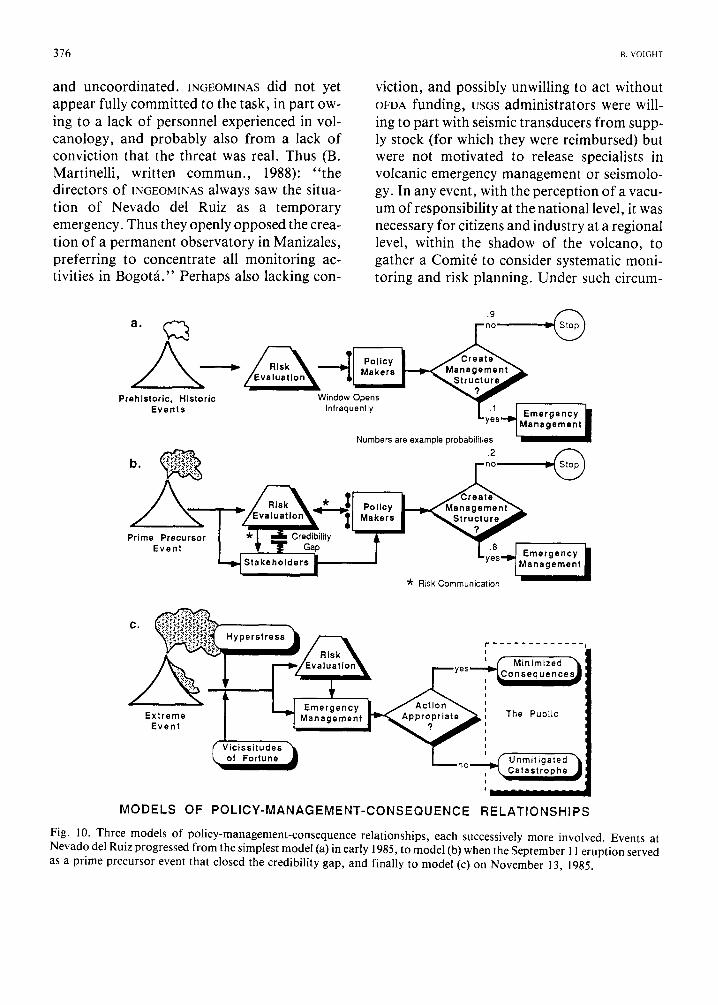
376 B. VOIGHT
and uncoordinated. INGEOMINAS did not yet appear fully committed to the task, in part ow- ing to a lack of personnel experienced in vol- canology, and probably also from a lack of conviction that the threat was real. Thus (B. Martinelli, written commun. , 1988): " the directors of INGEOMINAS always saw the situa- tion of Nevado del Ruiz as a temporary emergency. Thus they openly opposed the crea- tion of a permanent observatory in Manizales, preferring to concentrate all monitoring ac- tivities in Bogot&" Perhaps also lacking con-
viction, and possibly unwilling to act without OFDA funding, usGs administrators were will- ing to part with seismic transducers from supp- ly stock (for which they were reimbursed) but were not motivated to release specialists in volcanic emergency management or seismolo- gy. In any event, with the perception of a vacu- um of responsibility at the national level, it was necessary for citizens and industry at a regional level, within the shadow of the volcano, to gather a Comit6 to consider systematic moni- toring and risk planning. Under such circum-
a .
Prehistoric, Historic Events
;7:m :n Numbers are example probabilities
"~ ~ I S K ' , . , o m m u n l c a ' [ i o n
C. Hyperstress
Emergency Extreme Management
Event ; ~ 1 ~
Q Vicissitudes of Fortune ~ ,
M O D E L S OF P O L I C Y - M A N A G E M E N T - C O N S E Q U E N C E
t " . . . . . . . . . . . . .
The Public
.• Unmitigated )l Catastrophe •
a ImmlmmmlmmmmmNm
R E L A T I O N S H I P S
Fig. 10. Three models of policy-management-consequence relationships, each successively more involved. Events at Nevado del Ruiz progressed from the simplest model (a) in early 1985, to model (b) when the September 11 eruption served as a prime precursor event that closed the credibility gap, and finally to model (c) on November 13, 1985.
THE NEVADO DEI RUIZ VOLCANO CATASTROPHE: ANATOMY AND RETROSPECTION 377
stances a rivalry between the Comit6 and IN- GEOMINAS seems understandable.
The volcanic hazard map requested by Tomblin in March and urged by Hall in early May still had not been prepared by September, and consequently management plans then in existence lacked the necessary focus toward areas targeted for high risk. The relative effi- ciency of UNESCO's early response had been checkmated, lacking a formal petition from the Bogota government.
With the September 11 eruption of Ruiz as the prime precursor event, Colombia moved in- to the realm of the second model. The gap of credibility closed, opening the doors to cen- tralized power in Bogot& A National Emergen- cy Committee emerged to coordinate activities, ~NGEOMINAS became energized to take seriously and to complete the hazard map, and various regional committees accelerated their efforts. Responses to Colombian requests for assis- tance were facilitated by enhanced credibility and the technical support essential to hazard management was provided by a flow of interna- tional expertise.
By October, the management structure ap- peared to be relatively effective but when put to the test a month later - as in the third model - the system failed.
Of the numerous factors that played a role in the catastrophe, the following may be under- scored:
(1) Power failures and communications breakdowns are common as a direct or indirect result of volcanic eruptions; indeed they were anticipated. Communicat ions problems repor- ted at Ruiz included the failure of repeated late- hour attempts to convey an evacuation message directly from Ibagu6 Defensa Civil to Armero Defensa Civil and the failure of an upstream observer on the Lagunillas to directly contact Defensa Civilin Armero by transmitting radio.
However, review of technological com- munications for November 13 reveals that the system contained many redundant elements and on the whole worked successfully (Fig. 5).
By 17:00 representatives of Defensa Civil, Red Cross and National Police, all fixtures in Armero emergency management, had been in- dependently alerted and were told to sound the alarm if necessary. Information about the "end of abnormal conditions" at 19:30 was also received, although it certainly produced a signal contradictory to the succeeding alert. Messages concerning the evening magmatic eruption arrived by various sources, including commercial radio beginning 21:30 to 22:30, which remained available for messages from regional or national authorities, and Defensa Civil radio from at least three localities after 22:30. River observers' information probably influenced evacuation suggestions to Armero from Libano, Murillo and Ambalema (El Tiempo, Dec. 4, 1985); thus the basic message ofDefensa Civilhad gotten through, at least in- directly, by about 22:30. Red Cross radio from Armero to Ibagu6 was also connected, pro- bably before 23:00. Though the timing of many of the messages was probably too late to avert casualties, numerous lives could have been sav- ed had prompt action been taken.
It appears that the catastrophe cannot be primarily attributed to technical breakdowns in communications, which had succeeded in pro- viding sufficient if imperfect information. The primary pro01em was one of intent and value; that is, the lack of will to act decisively.
(2) Response to an evacuation alarm issued immediately after the onset of the afternoon phreatic eruption would have enabled no lives to be lost, although by itself this event produc- ed no long-reaching lahars, and thus could have provoked a charge of "false alarm". An alarm at the onset of the magmatic eruption would also have provided enough time for a well- prepared Armero population to escape with lit- tle loss - the two hours of lead time that had been forecast by INGEOMINAS proved correct - provided that the given alarm and public response were swift, and the possibility of a false alarm was accepted. Nevertheless, at Chinchin~i where the Governor of Caldas gave

378 B. VOIGHT
the alarm as early as 21:30, casualties were high and perhaps inevitable due to the realities of in- efficient response and the much shorter lead time for Chinchin~i.
(3) The scientists, emergency managers and particularly the local officials therefore had their backs to the wall. The risks were known early and well enough, but provincial and na- tional government made the conscious decision not to evacuate the villages unless and until the precise moment that danger could be guaran- teed. To evacuate before the event, especially for an indefinite period, would have caused enormous problems and political risks for a financially strapped government in providing the funding, facilities and resources needed to support a transported community. Security against looting in evacuated areas, and even the possibility of insurgents taking advantage of crisis conditions, could not be overlooked. And on the whole, the population would have resented leaving their homes and having their livelihood and comfort disrupted; lacking a paroxysmal event, criticism surely would have been severe. Therefore, fearing both the economic and political cost, no official was willing to take the responsibility for the order unless the damaging event - for Armero a long-reaching lahar, not merely an eruption - could be predicted with almost absolute cer- tainty. For science - whether the scientists ac- tually recognized it or not - it became more a matter of detection than of prediction.
Thus, the authorities on the whole acted not unreasonably but were unwilling to bear the economic or political costs of early evacuation or a false alarm. Science accurately foresaw the hazards but was insufficiently precise to render reliable warning of a devastating event at the last possible minute. Therefore, catastrophe had to be accepted as a calculated risk, and this combination - the limitations of predic- t ion/detection, the refusal to accept a false alarm and the lack of will to act on the uncer- tain information available - provided the im- mediate and most obvious cause of catastrophe.
(4) The local authorities were poorly pre- pared, funded and equipped to respond to an emergency. In some respects, deficiencies at this level could be attributed to the delays in- herent in the entire chain of information flow. The last links of the chain were at the village level. With earlier essential links of the process much delayed, time for critical review at the village level was minimized. Although the am- ple attention given to the evacuation possibility in mid-September could have encouraged ade- quate preparations and development of sound decision criteria, progress in Armero may have been contradicted by government attempts to allay local fears of the Cirpe landslide dam. Also, detailed hazard mapping implied the lack of any safe, easily reached refuge - thus any decision to evacuate implied a major logistical undertaking. In mid-October the mayor la- mented the state of frustration and confusion after the hazard map had been released - and noted a loss of "confidence in the veracity of informat ion"; clearly he needed help. One may surmise that some progress had been made in preparation for the November 15 Libano meeting, but it was too late.
(5) Preliminary evacuation plans for Armero were drawn up by the local emergency commit- tee, but apparently not many individuals had yet seen them. "What - to-do" information had not yet been meaningfully communicated to the population and the people were thus not adequately prepared to act either individually or with official instructions.
(6) The response of civil defense was initially hampered by the lack of specific hazard infor- mation and maps, although Defensa Civil had a rather complete regional plan for volcanic- risk management on paper by early May. Although progress was also restrained by the lack of cooperation between provinces facing similar hazard, these plans were re-evaluated and modified after September 11 and the pro- cess of adjustment accelerated after October 7. Nevertheless, it is one thing to have a plan on paper, and another matter to implement it.
T H E N E V A D O DEL RUIZ V O L C A N O C A T A S T R O P H E : A N A T O M Y A N D R E T R O S P E C T I O N 379
Although the need was clearly recognized, local plans had not yet been critically reviewed nor proof-tested by warning and evacuation drills to identify and correct weak links in the system.
(7) Preparation of hazard maps was not time- ly. Under ideal emergency-management cir- cumstances the month-long lead time might have been adequate; but at Ruiz the delay in producing the hazards maps impeded the mitigation effort, particularly for sites such as Armero and Chinchin~t where detailed local maps were essential for the completion and refinement of local management plans and for educating local decision makers and the population on the specific nature of the lahar threat. In addition, other agencies' concern over the map as an obvious missing link diverted attention from additional points of weakness in the mitigation chain. When releas- ed in October, the preliminary map and ex- planation were poorly distributed and the revis- ed map was not released until November 14, the day after the catastrophe.
(8) Key individuals with specialized know- ledge can bring a hazard-assessment group rapidly up-to-speed regarding key outcrops, observations and local conditions, and can significantly reduce the time required for preliminary hazard evaluation and effective monitoring. It is vital that such individuals - whether or not skilled in volcanic emergency management - enter the hazard-evaluation picture as early as possible; but non- Colombians most experienced in Ruiz geology were not available until, in one case, after September 20, for the second individual Oc- tober 16 and for a third only after November 13. In part this may reflect bureaucratic slug- gishness or the reluctance of administrators in such agencies as usGs and OFDA to release per- sonnel or provide pre-disaster support for foreign assignments. In any case, this factor contributed to the delays in production of the Ruiz hazard maps and in effective monitoring.
(9) Proclamation of the "end of abnormal condit ions" after 19:30 caused confusion and
skepticism, inasmuch as it conflicted with alerts concerning the evening magmatic erup- tion. This factor - which might be classified as "bad luck" - possibly impeded more decisive action by authorities in Armero and created conflicting media advisories that retarded public response to sporadic evacuation sugges- tions. Similarly, darkness and storm made con- ditions more difficult.
(10) What of the role of technology in the catastrophe? Would telemetered seismographs and real-time analysis have prevented disaster? The seismic records indicate that the 15:06 phreatic eruption of November 13 was preced- ed by an energy release only slightly larger than background level, in contrast to the clear premonitory increase prior to September l l . Following the November phreatic eruption, both earthquake activity and harmonic tremor amplitudes increased abruptly, and tremor fre- quency decreased, suggesting to some experts that a very short-term warning "might have been possible" for the 21:08 eruption; further, "cumulative tremor energies may have been a better short-term predictor (i.e. a few days) than earthquakes for the November 13 erup- tion, since an episode of low-level tremor began on November 10 and continued until the erup- tion onset" (J. Zollweg and D. Harlow, written commun. , 1986; cf. Gil et al., 1987; Muf~oz et al., 1987). But Zollweg (written commun. , 1988) has since concluded after comprehensive examination of the records that neither cumulative earthquake energies, tremor energies, nor low-frequency earthquake or tremor patterns would have been recognized as short-term precursors prior to November 13: "The depressing conclusion is that all short- term precursors of seismic nature were am- b i g u o u s . . . Your conclusion is correct regar- ding the lack of seismic contribution to the c a t a s t r o p h e . . , in this case there was to be vir- tually no recognisable short-term warning."
However, to partially offset the lack of telemetry, a seismometer 9 km from the crater was manned and had direct communication

380 B. VOIGHT
with Manizales (as recommended by the Italian team), and indeed the eruptive event was detected and reported with time sufficient to save most lives if appropriate action had followed. The deficiencies of the seismograph network, however real, did not contribute to the November catastrophe.
And what of the lahar detectors? These were not an off-the-shelf item, and - perhaps sur- prisingly - their utility was not widely recognized until Armero was destroyed. Even then they were rejected by OFDA. While the re- quired lead time for assembly, installation and resolution of problems in the development and maintenance of communicat ion linkages would have provided a hurdle to the effective use of detectors before November 13, since then it has been abundant ly clear that detectors are essential for ensuring that no damaging lahar can occur without an adequate public alert. The cost seems small when viewed as in- surance. The detector system installed by the Japanese currently plays an important role, al though near-source monitors are still lacking to provide sufficient lead time for all com- munities at risk.
Lessons f rom A rmero
"Apparently it came to this: we might try to explain the phenomenon . . . but, above all, should try to learn what it had to teach us . . ." (Camus)
When Andr6 Coyne 's magnificent but ill- fated dam in southern France failed in 1954 and the resulting f lood erased much of the town of Frejus, the limit o f the state-of-the-art design of arch dams was reached. An important lesson that emerged from this disaster was that drainage is necessary to reduce hydrostatic pressure downstream of thin arch dams: the state-of-the-art o f dam engineering was thereby advanced. Are there similar lessons to be gained from Armero? Or are there no new lessons to advance volcanic emergency management - merely an underscoring or reinforcement of lessons already compensated
by past catastrophes? Hindsight, while of no value to the former
residents of Armero, can be of benefit if it helps to avoid similar occurrences in the future. In this respect, Volc~in Ruiz offers a better type ex- ample of current hazard management than Mount St. Helens, for lessons derived from Ruiz are more easily exported to other dangerous volcanic regions, the majori ty of which are located in developing countries.
In the 20th century at Armero, twenty thou- sand - about 70% of the populat ion - died in a virtual repetition of an event which killed about one thousand - roughly 70% of the populat ion - in the 19th century. In com- parison, at Mayon volcano in the Philippines, where 1,200 died by surge and mudf low in the 1800s, the current populat ion in the zone of high risk approaches 800,000. Populat ion growth demands that people continue to live in areas of high hazard, many of which are places of considerable agricultural and economic value, and as a result, natural catastrophes of the future can be expected to be of staggering proport ions. It is therefore imperative that the developed countries pool financial and techno- logical resources to establish programs that em- phasize pre-disaster preparedness in order to cope with such expected extreme-magnitude crises.
(1) At Ruiz, it was not so much the impreci- sion of science, or inept last-minute decision- making, or breakdowns of a few communica- tion systems at the vital moment - the failure was to wait until the last possible minute. One cannot expect emergency management to operate efficiently at that time scale; but this is often what human nature seems to demand. It seems less a matter of excessive confidence or false sense of security than the lack of will to act in the face of uncertainty and the unwillingness to accept the costs implied by the finite pro- bability of a false alarm. Given that natural human tendency, the developed nations must, on the one hand, continue to improve event prediction, event detection and communica-
THE N E V A D O DEL RUIZ V O L C A N O C A T A S T R O P H E : A N A T O M Y A N D R E T R O S P E C T I O N 381
tions technology for early warning, and urge drills with the population at risk; but at the same time, they must also seek to improve education in facing uncertainty and false alarms, and seek to achieve improved under- standing of policy science, so that rationally conceived public policies are brought to bear on these difficult problems in order that the expec- tations of crisis management might be reduced to a reasonable level.
(2) In moments of crisis, complex decision- making processes that rely on a chain of com- mand, hours of committee discussion and the assumption of unstressed communication link- ages, are neither efficient nor effective. The decision-making process can be much simpli- fied by advance consideration of decision criteria. In countries with a highly centralized government, there is a tendency for officials to fear taking the initiative without higher authorization; consequently, a village leader may wait too long to initiate the emergency ac- tion required to stave-off disaster. A docu- mented proviso authorizing provincial and local action in time of known volcanic crisis might be a feasible mechanism to surmount this difficulty.
(3) The communication chain is no stronger that its weakest link: in emergency planning of this sort, it is often the final links that are the weakest but the most important, yet problems in local emergency response are reported in disaster case histories time after time. Manage- ment 's efforts tend to concentrate on the earlier links in the planning process, with less vigor and critical review applied as succeeding links and more local problems are encountered. In the future, specific attention should be given to local problems at an appropriate early stage. Parallel rather than series communication linkages may offer time-saving advantages (Fig. 9).
The final link, that of providing timely, sim- ple and effective information to the public can be aided by news media, but they have neither the exclusive nor the prime responsibility. Civil
authorities must decide upon and implement direct and convincing measures to prepare and alert the population. This information must convey respect for emergency measures and a specific sense of what-to-do for individuals who may lack the capacity to read and write. When given, the warning must convince the public to act. For example, evacuation research shows that sirens, even when preceded by public education, are insufficient to persuade people to leave their homes; sirens must be backed-up by repeated verbal (possibly tape- recorded) warnings from a respected public of- ficial (Perry et al., 1981; Mileti et al., 1986).
(4) Radio-communication problems are endemic in the steep canyons and dissected ter- rains of volcanic country, and these are exacer- bated by the meteorological conditions which accompany eruptions. Communicat ions tech- nology for crisis response needs thorough evaluation. Satellite telemetry, microwave telephone systems, standby power sources, and redundancy all have a place in volcano emergency management.
Yet electrical systems are susceptible to lightning damage, and require trained tech- nicians and the availability of electronic parts to keep them functional. Consequently, crude traditional communications systems in current use should not be totally abandoned and replaced by their high-technology counter- parts; they should be employed as a redundant system. With an appropriate population distribution, for example, a linkage of in- dividuals drumming on hollow logs, passing the message from one community to the next - "head for high ground N O W " - may be more effective in an electrical ashstorm at dead of night than a plan assuming an orderly response to a radioed alert.
(5) Hazard maps play a crucial role, yet one might question whether the precise map boun- dary, or the precise contour defined in these maps, should make much difference to preliminary planning. In the future, when a volcanic-hazard specialist is called to a crisis
382 B. VO[GHT
situation in a country lacking such expertise, part of his mission should be devoted to the rapid production of a preliminary hazard map, however crude, from the materials available to him. Whereas he may advise the host country's geological bureau of its obligation to conduct investigations needed to improve and field-test the map, the first priority is to produce a timely document-in-hand that will allow mitigation planning to proceed without further delay. Clearly, individuals known to possess special knowledge of the volcano should be sought out immediately and included in early efforts to evaluate hazard and produce maps.
But at the same time, the utility of hazard maps should not be overemphasized. The pro- duction and media publication of a hazard map is not synonymous with risk communication. Indeed, the map itself, such a familiar tool to a scientist, planner or engineer, may be virtually incomprehensible to individuals unfamiliar with the abstraction of reality on a sheet of paper. Conventional education is no guarantee of the ability to comprehend a map, a problem that becomes more acute as one moves down the communication chain, since the literacy of individuals at risk cannot be assumed.
(6) The response at Ruiz underscores the need for risk assessment, baseline monitoring data, reliable prediction and detection technologies, and the development and proof testing of alarm systems and evacuation plans in advance of volcanic crisis. Inasmuch as the majority of the world's high-risk volcanoes are in developing nations, scientific and economic support must be derived largely from devel- oped nations and international organizations. Most existing programs for so-called rapid crisis assistance are ad hoc in nature; they are inefficient and not truly rapid. A modest step in the right direction is the Volcanic Early-War- ning Disaster Assistance Program (VDAP), re- cently developed by USGS and OFDA to fOCUS on South and Central America (Banks, 1986). It includes such desirable features as develop- ment of scientific-political liaisons to avoid ad-
ministrative hurdles and to facilitate rapid en- try in time of crisis, an experienced technical core team capable of rapid response and a state- of-the-art equipment cache. However at the time of writing, the VOAP cache still lacked an off-the-shelf lahar-monitoring capability. Oth- er problems have surfaced because of bureau- cratic inertia. Support agencies still do not in- evitably appreciate the necessity for baseline observational studies; these may be castigated as "research" and too often are not considered as justified under pre-crisis conditions. Thus current efforts are helpful, but they are inade- quate to address the problem on a global scale (Tilling, 1989). There is an urgent need to devel- op, strengthen and expand such long-term pro- grams until developing nations acquire self suf- ficiency in volcanology.
(7) Finally, it is significant that such a small eruption at Ruiz was able to cause such a tremendous loss of life. Less than 5 × 10⁶ m 3 of magma ejected as pyroclastic flows was able to generate about 6 × 10⁷ m 3 of lahar deposits from 1 to 2 × 10⁷ m 3 melt water (Calvache, 1990-companion volume; Pierson et al., 1990- companion volume). It had been known that such events could occur from eruptions on snow-covered volcanoes; at Mount St. Helens in 1982, for example, a blast of hot pumice and gas caused a lahar with peak discharge about 14,000 m 3 s -1 (Waitt et al., 1983), and in South America a spectacular and well- publicized lahar was produced by eruption- triggered snowmelt at Cotopaxi volcano, Ecuador, in 1877 (Wolf, 1878). Nevertheless, Ruiz provides a particularly poignant reminder of the special sensitivity of the snow-capped volcanoes to even minor volcanic events.
Epilogue
"Summoned to give evidence.., he has exercised the restraint that behooves a conscientious witness. All the same, following the dictates of his heart, he has deliberately taken the victim's side . . ." (Camus)
At Ruiz, most of the elements considered

THE NEVADO DEL RUIZ VOLCANO CATASTROPHE: ANATOMY AND RETROSPECTION 383
highly desirable for successful volcanic emer- gency management were in place. The surficial stratigraphy surrounding the cone had been in- vestigated to USGS "Cascade Range" stan- dards, a geochronology had been established and post-glacial pyroclastic flows and lahars had been mapped. Accurate and perspicacious reports of key historical events were on record. Advice was available through able and ex- perienced foreign specialists in volcanic emer- gency management, and monitoring equip- ment was provided. Many Colombians worked admirably and knowledgeably, and the conse- quences of a potential eruption were adequate- ly foreseen by risk evaluators. A hazard map was produced over a month before the crucial event, and the problem had registered signifi- cant concern among national, provincial and local governments, despite inevitable credibili- ty issues that arose from time to time. The magmatic eruption turned out to be small, and its effects were not unprecedented - in fact the historical data provided extremely close analogies. Unlike Coyne's dam in southern France, no startling issues arose to shift the course of events. A n d yet in the end, time prov- ed to be a luxury squandered.
The catastrophe was not produced by tech- nological ineffectiveness or defectiveness, nor by an overwhelming eruption o f unprecedented character, nor by an improbable run of bad luck. Armero was caused, purely and simply, by cumulative human error - by misjudg- ment, indecision and bureaucratic short- sightedness. In the end, the authorities were un- willing to bear the economic or political costs of early evacuation or a false alarm, and they delayed action to the last possible minute. Catastrophe was the calculated risk, and nature cast the die. And so the lessons from Armero are not new lessons; they are old lessons forged in human behavior that once again require the force of catastrophe to drive them home. Armero could have produced no victims, and therein dwells its immense tragedy.
"And it was in the midst of shouts rolling against the terrace wall in massive waves that waxed in volume and duration, while cataracts of colored fire fell thicker through the d a r k n e s s . . , that [it was] resolved to compile this ch ron ic le . . . [to] bear witness in favor of these plague-stricken people, so that some memorial of the injustice and outrage done them might endure; and to state quite simply what we learn in a time of catastrophe: that there are more things to admire in men than to despise." (Camus)
Acknowledgements
In Colombia I worked as a member of the Comit6 de Estudios Volcanol6gicos, Manizales, with support of OFDA and coor- dination by tJSGS. Although drawing heavily on the work of the Comit6, I accept full blame for the interpretations and opinions expressed here. If there is value to this report it is due to the generosity of the numerous individuals who provided critical but unpublished documenta- tion, newspaper articles and personal insights, and who were also willing to correct erroneous or misleading statements in earlier drafts. I therefore particularly thank the following for contributions of information, manuscript review, or photographs: P. Bolton, M.L. Calvache, H. Cepeda, R. Decker, T. Ertekin, J.C. Griffiths, M. Hall, D. Harlow, R.J. Jan- da, B. Martinelli, H.J. Meyer, D. Mileti. F. Parra, T. Pierson, B.A. Shattuck, J.C. Thou- ret, J. Tomblin, E.G. Williams, S. Williams, K. Young, and J. Zollweg. I also owe a great deal to Jefe P. Medina J., and the entire Comit6 staff; OVTR Andinistas M.L. Calvache and O. Ospina H.; F. Zambrano O. and A. Nunez, IN- GEOMINAS; N. Banks and the USGS crew; acting U.S. Ambassador J.P. Osterling; and A. Swan and staff, OFDA. Translations were provided by J. Lockwood, C. Faria, A. Lacazette, R. Holcomb, and particularly C. Moy. Finally, but hardly least, I wish to express my gratitude to Judith Kiusalaas for her enthusiastic, skillful and unflagging efforts to disguise my deficien- cies in logical thought and muddled attempts to

384 B, VOIGHT
properly render the English language. Some material in this paper was presented at the 1986 Lahar and Landslide Workshop in the Philip- pines, and Institutes for Disaster Prevention in Tsukuba and Shinjo, Japan. A preliminary version was delivered to the 1988 Ruiz Volcano Workshop in Manizales, and a non-referenced version was published by Penn State University (Voight, 1988).
References
Acosta, J., 1846. Relation de l'6ruption boueuse sortie du volcan de Ruiz et de la catastrophe de Lagunilla dans la R6publique de Nouvelle Grenade. C. R. Acad. Sci., 22: 709- 710.
Acosta, J., 1850. Sur les montagnes de Ruiz et de Tolima (Nouvelle Granada) et les 6ruptions boueuses de la Magdalena. (Lettres a M. Elie de Beaumont). Bull. Soc. Geol. Fr., ser. II, 9: 489-496.
Banks, N., 1986. Hazard mitigation and rapid response to crises with Mobile Volcanic Observatories (abstr.). EOS. Trans. Am. Geophys. Union, 67 (16): 398.
Banks, N.G., Van der Laat, R., Carvajal, C. and Serrano, T., 1986. Deformation monitoring at Nevado del Ruiz, Colombia (abstr.). EOS, Trans. Am. Geophys. Union, 67 (16): 403.
Banks, N.G., Carvajal, C., Mora, and Tryggvason, E., 1990. Deformation monitoring at Nevado del Ruiz, Colombia: October 1985-March 1988. In: S.N. Williams (Editor), Nevado del Ruiz Volcano, Colom- bia, I. J. Volcanol. Geotherm. Res., 41: 269-296.
Barberi, F., Martini, M. and Rosi, M., 1985. Informe de la misi6n tecnica para la evaluacion del riesgo volcanico del Nevado del Ruiz-Cordillera Central- Colombia. Manizales 22 Octubre 1985. Ministero degli Affari Esteri-Italia-Dipartimento Cooperazione per lo Sviluppo, 18 pp.
Barberi, F., Martini M. and Rosi, M., 1986. The Italian Mission to Nevado del Ruiz, Colombia (October 1985): results, recommendations and some reflec- tions. Per. Mineral., 5 5 : 1 - 4 .
Barberi, F., Martini, M. and Rosi, M., 1990. Nevado del Ruiz volcano (Colombia): pre-eruption observations and the November 13, 1985 catastrophic event. In: S.N. Williams (Editor), Nevado del Ruiz Volcano, Colombia, I1. J. Volcanol. Geotherm. Res., 42: 1 -12 .
Calvache V., M.L., 1986. The eruption of the Nevado del Ruiz volcano, Colombia (abst.). EOS. Trans. Am. Geophys. Union, 67 (16): 405.
Calvache V., M.L., 1990. Pyroclastic deposits of the
November 13, 1985 eruption of Nevado del Ruiz volcano, Colombia. In: S.N. Williams (Editor), Nevado del Ruiz Volcano, Colombia, I. J. Volcanol. Geotherm. Res., 41: 67-78 .
Calvache V., M.L., Duque, G., Garcia, N., Salazar, J.E. and Salazar, B., 1985. Memorias del Seminario Sobre Riesgo Volc~inico del Ruiz. Nat. Univ., Manizales. Rev. Vias y Transport., 12 (53) 114 pp.
Carey, S., Sigurdsson, H., Fritz, W. and Naranjo, J.L., 1986. The November 13, 1985 eruption of Nevado del Ruiz: Tephra fall deposit and column height modelling (abstr.). EOS, Trans. Am. Geophys. Union, 67 (16): 403.
Cepeda, H., Michael, J., Murcia, A., Parra, E., Salinas, R. and Vergara, H., 1985a. Mapa Preliminar de Riesgos Volc~inicos Potenciales del Volcfin Nevado del Ruiz. Esc. 1:50.000. Memoria Explicativa, IN- GEOMINAS, Medellin, Oct. 7, 1985, 22 pp.
Cepeda, H., Michael, J., Murcia, A., Parra, E., Salinas, R. and Vergara, H., 1985b. Mapa de Riesgos Volcanicos Potenciales del Nevado del Ruiz. Esc. 1:100.000. Memoria Explicativa, INGEOMINAS, Medellin, Nov. 12, 1985, 28 pp.
Cepeda, H., Michael, J., Murcia, A., Parra, E., Salinas, R. and Vergara, H., 1986. Volcano risk potential maps of Nevado del Ruiz, Volcano, Colombia (abstr.). EOS, Trans. Am. Geophys. Union, 67 (16): 407.
CHEC, 1983. Investigaci6n Geoth6rmica, Macizo Volcfinico del Ruiz, Fase II Etapa A, Vol. I. Informe final, Bogot~i 119 pp.
Cu611ar, J. and Solano, A., 1985. Informe Preliminar de las actividades desarrolladas. INGEOMINAS, Bogot~t, October 1985, 19 pp.
Decker, R.W., 1986. Ruiz Volcano, Colombia: Trip Report, February-March 1986. U.S. Geological Survey, Menlo Park, 45 pp. (unpublished).
Decker, R.W. and Decker, B., 1981. Volcanoes. Freeman, San Francisco, CA, 244 pp.
Espinosa, A., 1986. Notas sobre la Actividad Hist6rica del Volczin Nevado del Ruiz. INGEOMINAS, Cali, 17 PP.
Gil C., F., Meyer, H.-J., Chouet, B. and Harlow, D., 1987. Observations of long-period events and tremors at Nevado del Ruiz Volcano 1985 - 1986. Hawaii Sym- posium on How Volcanoes Work. Abstr. Vol., Hawaiian Volcano Observatory, Hilo, Hawaii, Jan. 19-25, p. 90.
Hall, M.L., 1985 (mission report). Activities and conclu- sions of visit by Dr. M. Hall to Volc~in Nevado del Ruiz, Colombia. Instituto Geofisico, Escuela Polit6c- nica Nacional, Quito, 4 pp. (English and Spanish ver- sions with subtle differences).
Hall, M.L., 1990. Chronology of the principal scientific and governmental actions leading up to the November 13, 1985 eruption of Nevado del Ruiz, Colombia. In:
THE NEVADO DEL RUIZ VOLCANO CATASTROPHE: ANATOMY AND RETROSPECTION 3 8 5
S.N. Williams (Editor), Nevado del Ruiz Volcano, Colombia, lI. J. Volcanol. Geotherm. Res., 42: 101-115.
Harlow, D.H., Munoz, C. and Cuellar, J., 1986. Seismic activity preceding the 13 November 1985 eruption of Ruiz volcano, Colombia (abstr.). EOS, Trans. Am. Geophys. Union, 67 (16): 403.
Herd, G., 1982. Glacial and volcanic geology of the Ruiz- Tolima complex, Cordillera Central, Colombia. Publicaciones Geologicas Especiales del IN- GEOMINAS No. 8, Bogota, 48 pp.
Herd, G. and Comit6 de Estudios Vulcanol6gicos, 1986. The 1985 Ruiz volcano disaster. EOS, Trans. Am. Geophys. Union, 67 (19): 457- 460.
Hermelin, M., Vel~squez, A. and Bustamente, M., 1986. Aspectos historicos de eruptiones en el Volcan Nevado del Ruiz. Bol. Vias, 13 (56), 37 pp.
Hess, J., 1987. Report from Washington. GSA News and Information, Geol. Soc. Am., Boulder, November, p. 248.
Janda, R.J., Banks, N.G., Pierson, T.C., Calvache V., M.L. and Thouret, J.-C., 1986. Interaction between ice and pyroclastic sediments erupted during the 13 November 1985 eruption of Nevado del Ruiz, Colom- bia (abstr.). EOS, Trans. Am. Geophys. Union, 67 (16): 406.
Katsui, Y., Takahashi, T., Egashira, S., Kawachi, S. and Watanabe, H., 1986. The 1985 eruption of Nevado del Ruiz volcano, Colombia, and associated mudflow disaster. Report of Natural Disaster Scientific Research, no. B-60-7 (Japan Ministry of Education), pp. 61 - 91.
Lowe, D.R., Williams, S.N., Leigh, H., Connor, C.B., Gemmell, J.B. and Stoiber, R.E., 1986. Lahars in- itiated by the 13 November 1985 eruption of Nevado del Ruiz, Colombia. Nature, 324:51 -53.
Medina J., P., 1986. The organization of the group to monitor volcano Nevado del Ruiz in Colombia (abstr.). EOS, Trans. Am. Geophys. Union, 67 (16): 403.
Mileti, D.S., Bolton, P.A., Fernandez, G. and Updike, R.G., 1986. Recommendations for improving the ex- isting warning system for an impending eruption of the Nevado del Ruiz volcano, Colombia, S.A.: an Ad- vance Report. Committee on Nat. Disasters, Nat. Acad. Press, Washington D.C., 10 pp.
Miller, C.D., Mullineaux, D.R. and Hall, M.L., 1978. Reconnaissance Map of Potential Volcanic Hazards from Cotopaxi Volcano, Ecuador. Scale 1:100,000. U.S. Geol. Surv., Misc. Invest., Map 1-1072.
Mojica, J., Colmenares, F., Villarroel, C., Macia, C. and Moreno, M., 1986. Caracteristicas del flujo de lodo ocurrido el 13 de Noviembre de 1985 en el valle de Armero (Tolima, Colombia): Historia y comentarios de los flujos de 1595 y 1845. Geol. Colomb., 14:
107- 140. Mufioz, F. and Meyer, H.-J., 1987. Seismic activity
preceding the 13 November 1985 eruption at Nevado del Ruiz. Hawaii Symposium on How Volcanoes Work. Abstr. Vol., Hawaiian Volcano Observatory, Hilo, Hawaii, Jan. 19-25.
Mufioz, F., Meyer, H.-J., and Harlow, D., 1987. Seismic activity preceding the 13 November 1985 eruption of Ruiz volcano, Colombia. Hawaii Symposium on How Volcanoes Work. Abstr. Vol., Hawaiian Volcano Observatory, Hilo, Hawaii, Jan. 19-25, p. 185.
Naranjo, J.L., Sigurdsson, H., Carey, S.N. and Fritz, W., 1986. Eruption of Nevado del Ruiz volcano, Col- ombia, on 13 November 1985: Tephra fall and lahars. Science, 233:961 -963.
Parra, E. and Cepeda, H., 1990. Volcanic hazard maps of the Nevado del Ruiz volcano, Colombia. ln: S.N. Williams (Editor), Nevado del Ruiz Volcano, Colom- bia, II. J. Volcanol. Geotherm. Res., 42:117 - 127.
Perry, R.W., Lindell, M.K. and Green, M.R., 1981. Evacuation Planning in Emergency Management. Lexington Books, Lexington, MA.
Petak, W.J. and Atkisson, A.A., 1982. Natural Hazard Risk Assessment and Public Policy. Springer-Verlag, New York, NY.
Pierson, T.C., Janda, R.J., Thouret, J.-C. and Borrero, C.A., 1990. Perturbation and melting of snow and ice by the 13 November 1985 eruption of Nevado del Ruiz, Colombia, and consequent mobilization, flow and deposition of lahars. In: S.N. Williams (Editor), Nevado del Ruiz Volcano, Colombia, I. J. Volcanol. Geotherm. Res., 41: 17-68.
Rojas, R. and Borrero, C.A., 1986. Velocidad, descarga maxima y volumen del lahar del Rio Chinchina, 13 Noviembre 1985. In: Proc. Simposio Internacional sobre Neotectonica y Riesgos Volcanicos, Bogota, Colombia, Diciembre 1- 7, 1986.
Saarinen, T.F. and Sell, J.L., 1985. Warning and Response to the Mount St. Helen's Eruption. State Univ. New York Press, Albany, NY, 240 pp.
SEAN, 1985, Ruiz volcano, Colombia: Smithsonian In- stitution, SEAN Bull., 10 (11), p. 2 - 5 .
Sim6n, P., 1625. Noticias Historiales de las Conquistas de Tierra Firme en las Indias Occidentales. Casa Editorial de Medardo Rios, Bogota, 376 pp. (1892).
Thouret, J.-C., 1990. Effects of the November 13, 1985 eruption on the snowpack and ice cap of Nevado del Ruiz volcano, Colombia. In: S,N. Williams (Editor), Nevado del Ruiz Volcano, Colombia, I. J. Volcanol. Geotherm. Res., 41: 177-201.
Thouret, J.C. and Calvache V., M.L., 1986. The conse- quences of the 13 November 1985 eruption on the Nevado del Ruiz ice cap (abstr.). EOS, Trans. Am. Geophys. Union, 67 (16): 404.
Thouret, J.C., Murcia, L.A., Salinas, R., Perignon, N.V.
386 B. VOIGHT
and Cantagrel, J.M., 1985. Cronoestratigrafia me- diante dataciones K-AR y C-14 de los volcanes Com- puestos del Complejo Ruiz-Tolima y aspectos volcanoestructurales del Nevado del Ruiz (Cordillera Central, Colombia). Mem. VI Congr. Latinoamericano de Geol., Bogota, Tom. 1, pp. 385 - 454.
Thouret, J.C., Janda, R.J., Pierson, T.C., Calvache V., M.L. and Cendrero, A. , 1987. L'eruption du 13 Novembre 1985 au Nevado del Ruiz (Cordillere Cen- trale, Colombie); interactions entre le dynamisme eruptif, la fusion glaciaire et la genese d'ecoulements volcano-glaciaires. C.R. Acad. Sci. ser. II, 305: 505 - 509.
Tilling, R.I., 1989. Volcanic hazards and their mitigation: progress and problems. Rev. Geophys., 27 (2): 237 - 269.
Tomblin, J., 1985a. Report of a mission from 25 Sept - 2 Oct. 1985. UNDRO, Geneva, 9 October, 5 pp. and 6 Annexes.
Tomblin, J., 1985b. Ruiz - A sleeping giant awakes. UN- DRO News, Office of the United Nations Disaster Relief Coordinator, Geneva, Nov./Dec., 1985, 7 pp.
Tomblin, J., 1988. UNDRO's role in responding to volcanic emergencies. UNDRO News, Office of the United Nations Disaster Relief Coordinator, Geneva, March/April 1988, p. 7 - 10.
UNDRO, 1986. Volcanic Emergency Management. United Nations, New York, NY, 86 pp.
Van der Laat, R., 1985. Informe de la mision tecnica para la implementacion de estudios de deformacion del Volcan Nevado del Ruiz, Colombia. Unpub. Informe del Observatorio Vulcanol6gico y Seismologico de
Costa Rica, Univ. Nacional, Heredia, Costa Rica, 23 pp. and 15 p. Anexo.
Vel~tsquez, A., Hermelin, M. and Bustamente, M., 1986. Actividad del Volcan Nevado del Ruiz en epocas historicas. Bol. Vias, 13 (59), 20 pp.
Voight, B., 1986. Gravitational failure hazards, Nevado del Ruiz, Colombia - Mission from 30 January to 16 February 1986. Comit6 de Estudios Vulcanol6gicos, Manizales, 20 pp.
Voight, B., 1988. Countdown to catastrophe. Earth Miner. Sci., 57(2): 17-30 .
Voight, B., Calvache V., M.L. and Ospina H., O., 1986. Is the Arenas crater at Nevado del Ruiz endangered by gravitational slope collapse? (abstr.). EOS, Trans. Am. Geophys. Union, 67(16): 406.
Voight, B., Calvache V., M.L. and Ospina Herrera, O., 1987. High-altitude monitoring of rock mass stability near the summit of Volcano Nevado del Ruiz, Colom- bia. Proc. 6th Cong. Int. Soc. for Rock Mechanics, p. 275.
Waitt, R.B., Jr., Pierson, T.C., McLeod, N.S., Janda, R.J., Voight, B. and Holcomb, R.T., 1983. Eruption- triggered avalanche, flood, and lava at Mount St. Helens - effects of winter snowpack. Science, 221(4618): 1394- 1396.
Wolf, T., 1878. Der Cotopaxi und seine letzte Eruption am 26 Juni 1877. Neues Jahrb. Mineral. Geol. Paleon- tol., pp. 113-167.
Zollweg, J.E., Harlow, D.H., White, R.A., Norris, R.D. and Guendel, F., 1986. Post-eruption seismicity at Nevado del Ruiz, Colombia: Implications of the reser- voir system and continued activity (abstr.). EOS, Trans. Am. Geophys. Union, 67(16): 406.