the 2007 8 volcanic eruption on jebel at tair island (red
TRANSCRIPT

RESEARCH ARTICLE
The 2007–8 volcanic eruption on Jebel at Tair island (Red Sea)observed by satellite radar and optical images
Wenbin Xu & Sigurjón Jónsson
Received: 30 May 2013 /Accepted: 5 January 2014# Springer-Verlag Berlin Heidelberg 2014
Abstract We use high-resolution optical images andInterferometric Synthetic Aperture Radar (InSAR) data tostudy the September 2007–January 2008 Jebel at Tair erup-tion. Comparison of pre- and post-eruption optical imagesreveals several fresh ground fissures, a new scoria cone nearthe summit, and that 5.9±0.1 km2 of new lava covered abouthalf of the island. Decorrelation in the InSAR images indicatesthat lava flowed both to the western and to the northeasternpart of the island after the start of the eruption, while laterlavas were mainly deposited near the summit and onto thenorth flank of the volcano. From the InSAR data, we alsoestimate that the average thickness of the lava flows is 3.8 m,resulting in a bulk volume of around 2.2×10⁷ m3. We observeno volcano-wide pre- or post-eruption uplift, which suggeststhat the magma source may be deep. The co-eruption interfer-ograms, on the other hand, reveal local and rather complexdeformation. We use these observations to constrain a tensiledislocationmodel that represents the dike intrusion that fed theeruption. The model results show that the orientation of thedike is perpendicular to the Red Sea rift, implying that thelocal stresses within the volcanic edifice are decoupled from theregional stress field.
Keywords Red sea . InSAR . High-resolution opticalsatellite imagery . Volcanology
Introduction
The Red Sea is a divergent plate boundary between theAfrican and the Arabian plates with an opening rate thatincreases from 7 mm/year in the north to 16 mm/year in thesouth (ArRajehi et al. 2010). In the southern Red Sea, the riftboundary splits into two branches (Fig. 1a), with one branchfollowing the Red Sea with decaying opening rate to thesoutheast and the other branch lying along the Danakil de-pression and meeting up with the East African rift and theAden ridge (McClusky et al. 2010). The Jebel at Tair island isan oval-shaped stratovolcano, located in the south-central RedSea between Yemen and Eritrea. This small island is only∼4 km long, covering an area of about 11.4 km2, and itshighest peak is 258 m above sea level (Fig. 1b). The surfaceof Jebel at Tair is covered by tholeiitic basaltic lava flows andis cut by numerous open radial fissures (Gass et al. 1973). Themost recent volcanic eruptions on the island (before 2007)were in 1833, 1863, and in 1883, and possibly during theeighteenth century (Smithsonian Institution 2007). The islandhas been uninhabited, apart from a small Yemeni militaryoutpost.
In the afternoon of 30 September 2007, an energetic fissureeruption started on Tair island, depositing lavas to the NE andWof the summit and destroying the military outpost, resultingin several casualties (Smithsonian Institution 2007). Visualinspection made by Yemeni scientists from a helicopter on 1October 2007 showed lava fountaining from a short fissureextending from the summit area and down to the northeasternflank of the volcano (Jamal Sholan, personal communication,2012). Steam plumes were seen rising from fissures on thewest flank but no lava fountaining in the west was observed,though fresh lava flows were seen in this area extending downto the shore. A new summit scoria cone had formed above thenortheastern fissure on 21 October 2007, when a field trip wascarried out to the island, and at that time lava mainly came
Editorial responsibility: M.R. Patrick
Electronic supplementary material The online version of this article(doi:10.1007/s00445-014-0795-9) contains supplementary material,which is available to authorized users.
W. Xu (*) : S. JónssonKing Abdullah University of Science and Technology (KAUST),Thuwal, Saudi Arabiae-mail: [email protected]
Bull Volcanol (2014) 76:795DOI 10.1007/s00445-014-0795-9

from that scoria cone (Jamal Sholan, personal communication,2012). No further direct field observations were made of thevolcanic eruption by Yemeni scientists and it has not beenclear how long the eruption lasted. However, a series ofSEVERI (Spinning Enhanced Visible and InfraRed Imager)images show that a thermal anomaly observed from the onsetof the eruption disappears around 15 January 2008 (±1 day)(Talfan Barnie, personal communication, 2012), which
indicates that the total duration of 2007–2008 Jebel at Tairvolcanic eruption was 107 days.
Clarisse et al. (2008) analyzed volcanic SO2 with anInfrared Atmospheric Sounding Interferometer (IASI) andtracked the plume of the Jebel at Tair eruption for the first12 days. Shibata and Kouketsu (2008) studied the volcanicclouds from the Tair eruption using both a ground-based Lidarin Nagoya, Japan and a space-borne aerosol Lidar onboard theCALIPSO satellite and found the clouds to be nondepolarizedand not composed of ice particles and that they weretransported from the troposphere to the stratosphere.Temperature profiles also indicate that the eruption cloudpenetrated the tropopause and reached 16 km altitude(Eckhardt et al. 2008).
The Jebel at Tair volcanic eruption occurred in a remoteand mostly uninhabited area where no seismometers or con-ventional geodetic instruments have been installed to monitorvolcanic and earthquake activity. Earthquakes located by re-gional networks provide limited information, although theyshow increased seismicity near the island as early as 21September 2007 (International Seismological Centre, ISC).At least four ML>4 earthquakes occurred in the afternoon of30 September, which probably coincided with the dike prop-agating to the surface. Given the lack of local instrumentrecordings and direct observations of the Tair eruption, re-motely sensed data from satellites provide key information tounderstand and explain the course of events during the erup-tion and in the subsequent months.
In this study, we use high-resolution optical images andInterferometric Synthetic Aperture Radar (InSAR) data fromsatellites to study the 2007–2008 eruption. Commerciallyavailable optical satellite images have resolution as good as50 cm and can provide important details about the surfacechange occurring in volcanic eruptions and other naturaldisasters. InSAR has proven to be a powerful tool for mappingcrustal deformation with a centimeter to millimeter accuracyand at a high spatial resolution (Massonnet and Feigl 1998).We start by describing the high-resolution optical images andthen the available InSAR data and the data processing. Wedocument how the lava progressed during the eruption basedon radar coherence time series maps, and generate pre- andpost-eruption digital elevation models (DEMs) to estimate thesubaerial volume of the lava flows. We also use the InSARdata to model the dike that fed the eruption, applying con-straints from the optical images.
High-resolution satellite optical images
High-resolution satellite optical images acquired before andafter the eruption provide detailed information about the sur-face changes on the island caused by the eruption. They helpto understand the eruption activity, to find where ground
Fig. 1 a Topography and bathymetry of southcentral Red Sea (http://topex.ucsd.edu/WWW_html/srtm30_plus.html), where the Jebel at Tairvolcano is located. Red symbols show locations of volcanoes (Siebertet al. 2010), yellow linesmark plate boundaries in the region (Bird 2003),black arrows show GPS velocities with 95 % confidence ellipses in aEurasia-fixed reference frame (ArRajehi et al. 2010). bTanDEM-X DEMshaded relief topography of Jebel at Tair island with 50 m elevationcontour lines. The coverage of the new lavas is shown in red andseveral new ground fissures are in gray
795, Page 2 of 14 Bull Volcanol (2014) 76:795

fissures opened, where new lava was deposited, and how thecoastline changed.
We ordered three high-resolution cloud-free satellite im-ages, one from before and two from after the eruption(Table 1). The first image was acquired by the Quickbirdsatellite about 3 months before the onset of the eruption on 6July 2007 and it has 60 cm pixel resolution (Fig. 2a). The post-eruption images were acquired by the WorldView-1 satelliteon 22 December 2008 (not shown) and the WorldView-2satellite on 22 October 2011 (Fig. 2b) and these images have50 cm pixel resolution. The co-eruptive changes can be clearlyseen in both post-eruption images, but the 2011 image is ofbetter quality and we therefore focus our co-eruption surface-change analysis on that image.
The pre-eruption Quickbird image shows that the islandwas covered by multiple old lava flows before the 2007eruption began (Fig. 2a). Several radially distributed openfissures can be distinguished in the lava flows and two summitcones are visible (Fig. 3a).These cones can also be identifiedin the Tandem-X DEM (Fig. 1b). Older erosional sea cliffs are
exposed on the southeastern shore of the island (Fig. 2), andthese cliffs probably existed all around island, but were latermostly covered by lava flows (Gass et al. 1973). In addition tothese natural features, several car tracks and buildings can beseen on the island in the pre-eruption image.
The post-eruption WorldView-2 image shows, when com-pared to the pre-eruption image, that about half of the island iscovered by new lava flows, which appear black and gray–yellowish in color (Fig. 2b). The lava seems to have flowedmainly to the NE, N, and W from the summit of the volcanoand all the way to the Red Sea coastline. Many of the build-ings and most of the car tracks were buried by the lava flows.
The perimeter of the new lava flow is ∼26.5 km and thearea is 5.9 km2, as mapped from this high-resolution opticalsatellite image. We were able to detect the flow edges with aprecision of about 5 m (10× the spatial resolution of theWorldView-2 image), so we estimate the uncertainty of flowarea determination to be ±0.1 km2. The lava flowed to the seaboth in the west and in the northeast, causing changes to theshoreline (Fig. 2b), enlarging the area of the island by
Table 1 Information about the SAR datasets and the high-resolution optical images
Satellite Orbit Track Frame Acq. date (month/date/year) Perp. baseline (m)
ALOS 4,606 596 290 12/05/2006 142.2
7,290 596 290 06/07/2007 −597.67,961 596 290 07/23/2007 −225.18,632 596 290 09/07/2007 0
9,303 596 290 10/23/2007 50
9,974 596 290 12/08/2007 82.2
10,645 596 290 01/23/2008 215
11,316 596 290 03/09/2008 462.1
12,658 596 290 06/09/2008 947.4
14,000 596 290 09/09/2008 −1,751.215,342 596 290 12/10/2008 −1,212.418,026 596 290 06/12/2009 −1,032.218,697 596 290 07/28/2009 −1,11919,368 596 290 09/12/2009 −814.820,039 596 290 10/28/2009 −540.320,710 596 290 12/13/2009 −475.922,723 596 290 04/30/2010 56.5
ENVISAT 19,871 278 5425 12/18/2005 0
29,390 278 5582 10/14/2007 −45ERS-2 52,236 278 6576 04/17/2005 0
70,773 278 6579 11/02/2008 105
Tandem-X 130 – – 11/15/2011 −201.2130 – – 12/26/2012 283.8
Quickbird – – – 07/06/2007 –
WorldView-1 – – – 12/22/2008 –
WorldView-2 – – – 10/22/2011 –
Note that TanDEM-X data, co-eruption interferograms, and optical images shown in italics are discussed in the text
Bull Volcanol (2014) 76:795 Page 3 of 14, 795

0.13 km2. The new scoria cone seen in the field on 21 Octoberis clearly visible in the image near the summit and it has a basediameter of ∼0.25 km.We are not sure when it started to form,but an Envisat SAR amplitude image shows that it was alreadythere on 14 October 2007. In addition, a Terra ASTER image
from 8October exhibits a strong point-like thermal anomaly atthis location, indicating that the eruption had already focusedon a single summit vent by that day (Smithsonian Institution2007).
Several new eruptive fissures are seen in the post-eruptionimage (Fig. 3b). They were only active during the initial phaseof the eruption, producing the lava that extends down to theshore in the west, north, and the northeast. One of the fissureslies right beneath the new scoria cone and extends ∼0.25 km tothe southwest of the cone with a N59°E orientation. It alsoextended several hundred meters down the flank to the north-east, as was seen during the visual inspectionmade from air on1 October (Jamal Sholan, personal communication, 2012), butmost of it was subsequently covered by lava flows from thenew cone (Fig. 3b). Several small ground fissures can also beseen ∼0.6–1.6 kmwest-southwest of the scoria cone (Fig. 2b).They are slightly offset to the north and have a somewhatdifferent strike of ∼N60°E–N90°E, when compared with thesummit fissure. The total length of these fissures on the westflank is ∼1.1 km. These eruptive fissures suggest that theeruption was fed by dikes with similar orientations at shallowdepths.
Evolution of the lava flow
Mapping the extent and evolution of lava flows is critical tovolcano monitoring and valuable for understanding lava flowdynamics. This type of mapping has in the past been primarilybased on field observations, e.g., from handheld GPS mea-surements or on airborne surveys (Poland 2007), but in recentyears decorrelation in InSAR images has increasingly beenused for this task (e.g., Dietterich et al. 2012). Here, wegenerate multiple interferograms from 17 SAR images ac-quired between 5 December 2006 and 30 April 2010 by theALOS satellite (L band, 23.6 cm wavelength) and use theinterferometric coherence to map the evolution of the lavaduring the 2007–2008 Tair eruption (Table 1). Radar coher-ence in an interferogram is a manifestation of the similarity ofthe surface-scattering properties between the two radar acqui-sitions that were used to form that interferogram. In areas ofno change between InSAR images, the coherence of thegenerated interferograms is generally high, even for multiyearinterferograms. However, when new lava is deposited, thesurface scattering properties change completely, resulting intotal decorrelation of the interferometric signal in the areacovered by the new lava. Based on the decorrelated area inthe InSAR data, we map the extent of new lava with timeduring the eruption (Dietterich et al. 2012). However, rapidlava cooling, resulting in thermal contraction and physicalcompaction, can also cause interferometric decorrelation,which can be difficult to discriminate from decorrelationcaused by new lava emplacement in the coherence maps.
Fig. 2 High-resolution optical satellite images of Jebel at Tair volcanofrom before and after the 2007–2008 eruption. aThe pre-eruption imagewas taken on 6 July 2007 (60 cm spatial resolution), showing that thesmall island was covered by old lava flows and radially distributedground fissures. Red rectangle marks the area covered in Fig. 3. b Thepost-eruption image is from 22 October 2011 (50 cm resolution) and itshows the new lava flows (pink), a new scoria cone (red), several newground fissures (light blue), possible buried new fissure (dashed lightblue), and changes to the coastline (yellow) in the north
795, Page 4 of 14 Bull Volcanol (2014) 76:795

In the radar data processing, we followed a standard two-pass approach, with effects of the topography removed byusing the SRTM DEM (Farr et al. 2007). The raw radar datawere processed to SAR images and interferograms using theGAMMA software (Werner et al. 2000). We spatially aver-aged (multilooked) the interferograms using a 1×3 pixelwindow to reduce noise, then filtered them with an adaptivefiltering algorithm (Goldstein and Werner 1998), andunwrapped the interferograms using a statistical minimumcost-flow unwrapping algorithm (Chen and Zebker 2001).The unwrapped interferograms together with their corre-sponding decorrelation maps were then finally projected togeographic coordinates.
The coherence maps (Fig. 4) show the evolution of the lavaflows during the eruption and confirm that the eruptive activ-ity was most vigorous during the first phase. The time resolu-tion of this method is limited due to the long repeat time of theALOS satellite (46 days), which provides only three possiblewindows to study the evolution of the lava during the erup-tion. Decorrelation in an interferogram that spans the first23 days of the eruption shows that lavas were deposited tothe west, north, and northeast, reaching the Red Sea (Fig. 4a).In fact, most of this lava was likely produced in the first 2 daysas by 1 October the lava had already reached the shoreline,according to the aerial inspection mentioned above. The esti-mated subaerial area of the lava deposited in the first 23 days
Fig. 3 The details in the summit area (see coverage in Fig. 2a) before andafter the eruption. a The pre-eruption image shows several old fissuresand two old cones, while the post-eruption b image shows clearly the new
scoria cone and lava flows, as well as several new fissures, one locatedbeneath the scoria cone and extending into the saddle between the two oldcones
Bull Volcanol (2014) 76:795 Page 5 of 14, 795

is about 4.9 km2 (see Table 2), which is a majority of theeventual 5.9±0.1 km2 total subaerial area of the 2007–2008lava. The lavas produced during the two subsequent timeperiods primarily flowed to the north of the summit, partly
covering the earlier lava from the first period as well ascovering new ground. The area of the lava produced duringthe second phase of the eruption (23–69 days after the start ofthe eruption) is smaller than during the first phase or about1.7 km2, and it did not reach the Red Sea (Fig. 4b). During thethird period (69–115 days after the start), lava continued toflow to the north, reaching the coast again, with a subaerialflow area of about 1.4 km2 (Fig. 4c).
A time series of satellite thermal images from MODIS andSEVIRI instruments suggests that the eruption ended on 15January 2008 (±1 day), as discussed above (Talfan Barnie,personal communication, 2012). However, satellite data usedin the Hawai’i Institute of Geophysics and Planetology(HIGP) Thermal Alerts System show intermittent thermalanomalies after 15 January, i.e., until mid-May 2008(Smithsonian Institution 2008). The ALOS data do not pro-vide precise information about when the eruption ended, dueto the long 46-day repeat time. Post-eruption decorrelationmaps, formed using ALOS data from 23 January to 9 June2008, show reduced coherence of a ∼0.8 km2 area near thesummit. This reduction of coherence is probably due to rapidlava flow cooling and physical compaction, rather than newlava, as the coherence is not completely lost. We thereforethink that the eruption did not continue until May 2008, butended on 15 January 2008 (±1 day) and that the intermittentthermal anomalies after 15 January may have been due to low-level residual activity around hot open, degassing vent(s).
Lava flow volume
We also used multiple ALOS interferograms and TanDEM-Xdata (Krieger et al. 2007) to derive pre- and post-eruptionDEMs, respectively, to estimate the total volume of the2007–2008 Jebel at Tair lava flows (Table 1). The pre-eruption and post-eruption DEMs were generated from inter-ferograms with different perpendicular baselines ranging from142 to 740 m, corresponding to heights of ambiguity between18 and 452m. The height of ambiguity is defined as the heightdifference that generates a full interferometric phase cycle
Fig. 4 Evolution of the lava flow during the Jebel at Tair eruption. Theareas covered by new lava during the first 23 days, between days 23 and69 after the start of the eruption, and between days 69 and 115 are shownin blue, light blue, and yellow, respectively
Table 2 Information on the evolution of lava flow after the onset of the2007–2008 Jebel at Tair volcanic eruption
Days Dates Area (km2) Reached the sea
0–23 30 Sep 2007–23 Oct 2007 4.9 Yes
23–69 23 Oct 2007–8 Dec 2007 1.7 No
69–115 8 Dec 2007–23 Jan 2008 1.4 Yes
0–115 30 Sep 2007–23 Jan 2008 5.9 Yes
Note that summing up the area values from the individual time periodsexceeds the total area, as the subsequent lavas partly cover the earlierlavas
795, Page 6 of 14 Bull Volcanol (2014) 76:795

(i.e., 2π) after interferogram flattening and is inversely pro-portional to the perpendicular baseline (Massonnet and Feigl1998). The interferogram with a longer baseline has a smallerheight of ambiguity and is therefore more sensitive to topog-raphy. In order to improve the accuracy of the final DEMs, wefirst derived height values from N interferograms and thencalculated a weighted average based on the interferogramcoherence and perpendicular baseline (Eq. 1), as proposedby Lu et al. (2003):
h ¼XN
ihiCiB
2iXN
iCiB
2i
ð1Þ
where hi is the height value derived from interferogram i, Ci isthe coherence and Bi is the perpendicular baseline of thatinterferogram.When the pre-eruption DEM is subtracted fromthe SRTM DEM, the resulting residual DEM shows randomnoise, a phase ramp, and detailed terrain structure. We firstlow-pass filtered the residual DEM to reduce the noise level,then fit a polynomial function to remove the phase rampwhich mainly includes atmospheric effects and orbit errors,leaving only the detailed terrain information, which we addedto SRTMDEM to form the final pre-eruption DEM (Rowlandet al. 2003; Wadge et al. 2006).
The difference between the pre- and post-eruption DEMsreveals the topographic height change caused by the eruption,
which is primarily due to the deposition of lavas and theformation of the new summit scoria cone. A histogram ofthe refined height differences in areas with no new lava flowshas a symmetrical distribution that peaks at zero and standarddeviation of 1.9 m (Fig. 5), which indicates that the DEMs arewell aligned. For the standard deviation calculation, we ex-cluded the area near the southern cliff where radar geometricaldistortions are severe. An alternative way to estimate lavathickness is simultaneously inverting the interferometric phasefor topographic change and displacement (Ebmeier et al.2012).
Examining the derived height change map (Fig. 5), we findsignificant positive elevation changes in and close to the newscoria cone with a maximum value of ∼60 m and a notablepositive height difference of about 20–40 m on the northernflank. We estimate the average subaerial thickness of the2007–2008 volcanic products to be about 3.8 m (Table 3).Visual inspections made in the field indicate that the averagelava thickness near the coast is similar or about 3 m (JamalSholan, personal communication, 2012).We estimate the bulkflow volume to be 2.2±1.1×10⁷ m3 by integrating the heightchanges within the area of the new lava. This estimatedvolume only includes the amount of lava that appears abovesea level. The majority of 2007–2008 flows are ‘a’ā (JamalSholan, personal communication, 2012), and therefore thedense-rock equivalent (DRE) volume is smaller, here estimated∼1.7±0.8×10⁷ m3, assuming 25 % vesicularity.
Fig. 5 Elevation change betweenthe pre-eruption DEM, generatedfrom ALOS interferograms, andthe TanDEM-X post-eruptionDEM. The inset shows ahistogram of the DEMdifferences(standard deviation, 1.9 m) forareas not covered by the newlava flow
Bull Volcanol (2014) 76:795 Page 7 of 14, 795

Observed deformation with InSAR
Interferograms that span the start of the eruption show asignificant amount of ground deformation that likely occurredduring the propagation of the magmatic dike to the surface. Incontrast, we found no clear volcano-wide deformation in thepre-eruption interferograms we generated (ERS/Envisat dataNovember 2003–December 2005, and ALOS data December2006–September 2007) or in post-eruption interferograms(ERS/Envisat data July 2008–November 2009 and ALOSdata January 2008–April 2010), which may indicate that thesource of the magma is deep. Three interferograms providethe most valuable information: an ALOS interferogram span-ning the first 23 days of the eruption (7 September–23October2007), anEnvisat interferogram covering the time from2 yearsbefore until 2 weeks after the start of the eruption (18December 2005–14October 2007), and an ERS interferogramthat spans the entire eruption (Fig. 6a–c, Table 1). Both theEnvisat and ERS data are C band (5.6 cm wavelength), havemean incidence angles of 23°, and were acquired from de-scending orbits (westward looking). They therefore showmore or less the same line-of-sight (LOS) deformation andare more sensitive to vertical ground deformation than tohorizontal displacements. The coverage of the Envisat datais better, owing to the larger extent of the new lava in the ERSinterferogram. The L-band (23.6 cm wavelength) ALOS data,on the other hand, have a mean incidence angle of 38° andwere acquired from ascending orbits (eastward looking). Theytherefore provide another perspective of the surface deforma-tion and are sensitive to both horizontal and vertical deforma-tion of the land surface.
All three interferograms exhibit multiple fringes of defor-mation on the northwestern and southeastern part of the island(Fig. 6a–c), but decorrelated areas correspond to the coverageof new lava flows. The ALOS interferogram has about onefringe (11.8 cm) in the northern part of the island and alsosouth of the summit, as well as several fringes along someedges of the new lava flow (Fig. 6a). The fringe patterns in theEnvisat and ERS interferograms (Fig. 6b–c) are quite compli-cated but consistent, suggesting that the deformation occurredduring the onset of the eruption. The similarity of these twodatasets also shows that atmospheric effects and orbital errorsare negligible. The broad fringes in the southwest and south-east indicate that the co-eruption ground deformation
probably extended significantly beyond the coast of the island.We unwrapped the ALOS and Envisat interferograms toquantify the magnitude of the LOS displacements in thesedatasets (Fig. 6d–e). Themagnitude of the LOS displacementsin the ALOS data is about 15 cm northwest of the summit andmore than −35 cm along the edges of lava flows (Fig. 6d). Theunwrapped Envisat interferogram (Fig. 6e) shows about30 cm LOS displacement near the coast in the northeast,which is not seen in the ALOS data. Generally, the magnitudeof displacement on the northern part of the island is smallerthan that of the southern part.
In addition to the InSAR data, we calculated pixel offsets inthe azimuth direction by cross-correlating 64×64 pixel sub-images within the two ALOS amplitude images. This azimuthoffset (AZO) measurement is only sensitive to horizontaldisplacements along the satellite azimuth direction, which isapproximately perpendicular to the eruptive fissures. TheAZO results show clear surface displacements with a peak-to-peak amplitude of ∼1.2 m across the summit of the island(Fig. 6f). At the north of the summit, the ground moved to thenorth and the southern part of the island moved to the south,indicating that the intruding dike pushed the summit flanks ofthe mountain in opposite directions away from the dike.
Deformation modeling
The orientation of the eruptive fissures on Jebel at Tair showsthat a southwest–northeast trending dike fed the eruption. Tomodel the dike intrusion, we use rectangular dislocations in ahomogeneous, isotropic, elastic half-space without consider-ing the topography (Okada 1985) and compare the resultingmodel displacements with the main characteristics of theobserved surface deformation associated with the eruption.Both the ALOS and the Envisat interferograms (Fig. 6d–e),as well as the AZO results (Fig. 6f), were used to constrain thesource model parameters of the dike intrusion.
Estimating the size, location, dip, strike, and opening ofmultiple dike dislocations without any constraints can be bothcomputationally challenging and unstable, e.g., leading todissimilar solutions in independent model optimizations. Wetherefore used information from the post-eruption opticalsatellite image and from field observations to fix severalparameters of the dike model. We first let the model dike
Table 3 Information on the Jebelat Tair lava flow volume, deter-mined from pre- and post-erup-tion DEM height differences
Parameter Value Method
Subaerial area 5.9±0.1 km2 Optical image and InSAR decorrelation
Average subaerial thickness 3.8±1.9 m DEM difference
Max. subaerial thickness ∼60 m DEM difference
Subaerial DRE volume ∼1.7±0.8×10⁷ m3 DEM difference, assuming 25 % vesicularity
Dike DRE volume ∼5.0×10⁶ m3 Dike model
795, Page 8 of 14 Bull Volcanol (2014) 76:795

coincide with the mapped ground fissures by fixing its loca-tion, length, and strike. We extended the length of this summitdike by 0.3 km to the northeast in accord with the fieldobservations (“Introduction” and “High-resolution satelliteoptical images” sections). The InSAR observations show thatthe deformation extends to the east and southwest of thesummit fissure and we therefore added flank dike extensionsto the summit dike (Fig. 7), whose parameters we allowed tovary in the parameter estimation. The data were uniformlysubsampled (Pritchard et al. 2002) and we masked out
the large local signals in the ALOS interferogram(Fig. 6a), because they are not directly related to thediking process but likely to loading of lava. We used aMonte Carlo-type simulated annealing algorithm (Cervelliet al. 2001) to find the optimal dike geometry and theuniform opening. In addition, we allowed for constantdataset shifts (ambiguities) in the modeling, as the entireisland was deforming and therefore no obvious zero dis-placement reference point exists. With this modeling setup,the number of degrees of freedom is 21.
Fig. 6 a Filtered L-bandco-eruption ALOS interferogramacquired from an ascending orbitwith each color cyclecorresponding to 11.8 cm of line-of-sight (LOS) displacementaway from (blue–green–yellow–red) or toward (red–yellow–green–blue) the satellite. Arrowsindicate the horizontal projectionof the radar look direction (LOS)and the radar azimuth direction(AZO). New ground fissures areshown as black bold lines. b, cFiltered co-eruption Envisat andERS interferograms from adescending orbit, with each colorcycle corresponding to 2.8 cm (Cband) displacement in LOS. dande The ALOS and Envisatinterferograms, rewrapped (afterunwrapping) at 5 cm per fringe.fAzimuth offsets of ALOS radaramplitude images (AZO). g–iThemodel predictions that correspondto d–f. Blue lines the surfaceprojections of the three modeldikes, with thicker linesmarkingdike upper edges (parameterslisted in Table 4). j–lResidualsbetween the observations and themodel predictions, m–o the data(black) and model prediction (red)along profile A–A′ for the ALOS,Envisat and AZO data sets,respectively
Bull Volcanol (2014) 76:795 Page 9 of 14, 795

The predicted surface deformation of this combination ofthree dislocations representing one long dike can explain themost prominent deformation signals well, i.e., the northwest–southeast extension seen in the AZO data (Fig. 6i) and thecomplex deformation pattern seen in the Envisat data(Fig. 6h). This is confirmed by the low residual EnvisatRMS value of ∼2.2 cm and the rather flat AZO residual(RMS value of 6.2 cm, Fig. 6k–l). The RMS value to theALOS data is 3 cm, leaving some unmodeled deformation inthe southeastern part of the island (Fig. 6m–o). The modelparameter estimation yielded a near vertical and 2 m thicksummit dike with a length of 1.5 km (Table 4). The attachedflank dike extensions to the northeast and southwest bring thetotal length of the shallow dikes to 5.9 km. The extensionshave slightly different orientations and are thinner than thesummit dike and their bottoms are deeper than the centralsummit dike (Table 4). The northeastern flank dike extensionwas made to dip to the southeast (Table 4) to fit the strongdeformation seen in the Envisat interferogram on the easternpart of the island. The bulk volume of the multidike dikemodel is ∼5.0×10⁶ m3 or around 30 % of the derived lavavolume. We also explored a four-dike model that includes adeeper dike that is parallel to the Red Sea rift, but this model
does not significantly improve the fit to the data (seeElectronic supplementary material for details).
The entire eruptive fissure was active for only the firstseveral hours of the eruption, as by 1 October lava flowedonly from a short summit fissure (Jamal Sholan, personalcommunication, 2012). Assuming that the length of eruptivefissure steadily decreased from 1.5 km on 30 September(3 pm) to 0.3 km on 1 October (10 am), we estimate theeffusion rate using:
Emean ¼w3l
dp
dz−gρ
� �
12ηð2Þ
where dpdz is the lithostatic pressure gradient, w and l the ave-
rage thickness and length of the eruptive dike, g the gravita-tional acceleration, and ρ and η are the density and viscosityof the magma, respectively (Rowland et al. 2003). If we usew=1.1 m, ρ=2,600 kg/m3 and η=300 Pa s, and take the valueof dp
dz to be 27 kPa/m, then the calculated effusion rate Emean
decreased from ∼843 m3/s at the onset of the eruption to∼168.6 m3/s on 1 October. Integrating the lava effusion rateEmean for the time span mentioned above we find lava volumeof ∼3.5×10⁷ m3, which is larger than the estimated total lavavolume (“Lava flow volume” section). This discrepancy sug-gests that an amount of lava may have entered the sea, someparameters in Eq. 2 are different (e.g., the pressure gradient),or this simple approach over-estimates the volume due tosome incorrect assumptions.
Post-emplacement lava flow deformation
Lava flows continue to deform after they have been emplaced(e.g., Stevens et al. 2001; Lu et al. 2005), but the deformationmechanism is not well understood. Phase decorrelation onyoung ‘a’ā lava flows results from movement of surfaceblocks (scatterers), rapid compaction of the lava flows andsurface clast repacking (Ebmeier et al. 2010), often preventinginterferometric analysis of the lava flow movement during thefirst weeks after emplacement. In order to minimize this type
Table 4 Information about the dike-model parameters from modeling the data for the co-eruption time period
Length (km) Width (km) Depth (km) Dip (°SE) Strike (°NE) Latitude (°N) Longitude (°E) Opening (m)
Dike I 2.28 1.99 0.1 83 73 15.535 41.819 0.6
Dike II 1.5 0.17 0 67 66 15.542 41.833 2.0
Dike III 1.89 2.98 0 62 57 15.553 41.847 0.6
Note that the depth is the top depth of dikes
Fig. 7 Three-dimensional representation of the model dikes based on theresults of this study
795, Page 10 of 14 Bull Volcanol (2014) 76:795

of decorrelation, we use ten consecutive ALOS interferogramsto study the post-emplacement lava flow deformation after 23January 2008 using a chain stacking approach (Biggs et al.2007; Xu et al. 2012). In this method, all the interferogramsare added up to retrieve the accumulated deformation, whicheliminates atmospheric effects and orbital errors in the middleof the chain of images, leaving only the error contributionsfrom the first and last image.
The main post-emplacement lava flow subsidence is foundnorth of the summit cone (Fig. 8a) with maximum LOSdisplacement of∼−1.1 m, corresponding to amean subsidencerate of up to −0.5 m/year. Three “branches” of subsidenceextend down the north flank and correlate well with areas ofgreatest lava flow thickness (Figs. 5 and 8a). Significant
subsidence is also seen near the coast with maximum subsi-dence of about −0.5 m.
The post-emplacement lava flow deformation rate decaysexponentially with time. We selected time series at four siteslocated near the summit and on the north flank (Fig. 8a) toestimate the exponential decay time constant of the lava flowdeformation. We then fit the following decay function to thetime series for each site:
F t; τð Þ ¼ A� 1− exp −t−t0τ
� �� �ð4Þ
in which t0 is the first post-eruption observation (i.e., 23January 2008), A is the displacement magnitude, and τ is the
Fig. 8 a The post-emplacementdisplacements of the lava flows inthe LOS direction after 23January 2008 (reference imagedate). The cold colors representthe ground moving away from thesatellite. b the surfacedisplacement time series (dots) forsites A–D (locations shown in awith their corresponding standardderivation (bars) and best-fittingexponential decay curve). c–dSurface displacement time seriesresults along profiles a–a′ and b–b′
Bull Volcanol (2014) 76:795 Page 11 of 14, 795
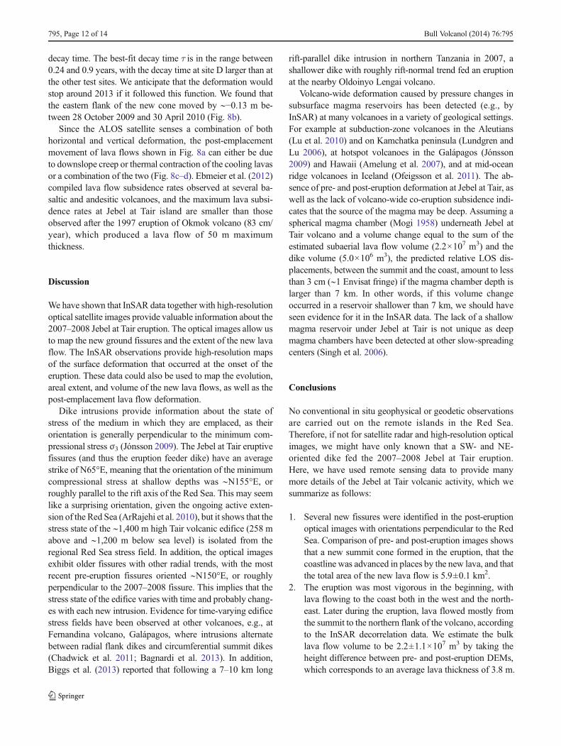
decay time. The best-fit decay time τ is in the range between0.24 and 0.9 years, with the decay time at site D larger than atthe other test sites. We anticipate that the deformation wouldstop around 2013 if it followed this function. We found thatthe eastern flank of the new cone moved by ∼−0.13 m be-tween 28 October 2009 and 30 April 2010 (Fig. 8b).
Since the ALOS satellite senses a combination of bothhorizontal and vertical deformation, the post-emplacementmovement of lava flows shown in Fig. 8a can either be dueto downslope creep or thermal contraction of the cooling lavasor a combination of the two (Fig. 8c–d). Ebmeier et al. (2012)compiled lava flow subsidence rates observed at several ba-saltic and andesitic volcanoes, and the maximum lava subsi-dence rates at Jebel at Tair island are smaller than thoseobserved after the 1997 eruption of Okmok volcano (83 cm/year), which produced a lava flow of 50 m maximumthickness.
Discussion
We have shown that InSAR data together with high-resolutionoptical satellite images provide valuable information about the2007–2008 Jebel at Tair eruption. The optical images allow usto map the new ground fissures and the extent of the new lavaflow. The InSAR observations provide high-resolution mapsof the surface deformation that occurred at the onset of theeruption. These data could also be used to map the evolution,areal extent, and volume of the new lava flows, as well as thepost-emplacement lava flow deformation.
Dike intrusions provide information about the state ofstress of the medium in which they are emplaced, as theirorientation is generally perpendicular to the minimum com-pressional stress σ3 (Jónsson 2009). The Jebel at Tair eruptivefissures (and thus the eruption feeder dike) have an averagestrike of N65°E, meaning that the orientation of the minimumcompressional stress at shallow depths was ∼N155°E, orroughly parallel to the rift axis of the Red Sea. This may seemlike a surprising orientation, given the ongoing active exten-sion of the Red Sea (ArRajehi et al. 2010), but it shows that thestress state of the ∼1,400 m high Tair volcanic edifice (258 mabove and ∼1,200 m below sea level) is isolated from theregional Red Sea stress field. In addition, the optical imagesexhibit older fissures with other radial trends, with the mostrecent pre-eruption fissures oriented ∼N150°E, or roughlyperpendicular to the 2007–2008 fissure. This implies that thestress state of the edifice varies with time and probably chang-es with each new intrusion. Evidence for time-varying edificestress fields have been observed at other volcanoes, e.g., atFernandina volcano, Galápagos, where intrusions alternatebetween radial flank dikes and circumferential summit dikes(Chadwick et al. 2011; Bagnardi et al. 2013). In addition,Biggs et al. (2013) reported that following a 7–10 km long
rift-parallel dike intrusion in northern Tanzania in 2007, ashallower dike with roughly rift-normal trend fed an eruptionat the nearby Oldoinyo Lengai volcano.
Volcano-wide deformation caused by pressure changes insubsurface magma reservoirs has been detected (e.g., byInSAR) at many volcanoes in a variety of geological settings.For example at subduction-zone volcanoes in the Aleutians(Lu et al. 2010) and on Kamchatka peninsula (Lundgren andLu 2006), at hotspot volcanoes in the Galápagos (Jónsson2009) and Hawaii (Amelung et al. 2007), and at mid-oceanridge volcanoes in Iceland (Ofeigsson et al. 2011). The ab-sence of pre- and post-eruption deformation at Jebel at Tair, aswell as the lack of volcano-wide co-eruption subsidence indi-cates that the source of the magma may be deep. Assuming aspherical magma chamber (Mogi 1958) underneath Jebel atTair volcano and a volume change equal to the sum of theestimated subaerial lava flow volume (2.2×10⁷ m3) and thedike volume (5.0×10⁶ m3), the predicted relative LOS dis-placements, between the summit and the coast, amount to lessthan 3 cm (∼1 Envisat fringe) if the magma chamber depth islarger than 7 km. In other words, if this volume changeoccurred in a reservoir shallower than 7 km, we should haveseen evidence for it in the InSAR data. The lack of a shallowmagma reservoir under Jebel at Tair is not unique as deepmagma chambers have been detected at other slow-spreadingcenters (Singh et al. 2006).
Conclusions
No conventional in situ geophysical or geodetic observationsare carried out on the remote islands in the Red Sea.Therefore, if not for satellite radar and high-resolution opticalimages, we might have only known that a SW- and NE-oriented dike fed the 2007–2008 Jebel at Tair eruption.Here, we have used remote sensing data to provide manymore details of the Jebel at Tair volcanic activity, which wesummarize as follows:
1. Several new fissures were identified in the post-eruptionoptical images with orientations perpendicular to the RedSea. Comparison of pre- and post-eruption images showsthat a new summit cone formed in the eruption, that thecoastline was advanced in places by the new lava, and thatthe total area of the new lava flow is 5.9±0.1 km2.
2. The eruption was most vigorous in the beginning, withlava flowing to the coast both in the west and the north-east. Later during the eruption, lava flowed mostly fromthe summit to the northern flank of the volcano, accordingto the InSAR decorrelation data. We estimate the bulklava flow volume to be 2.2±1.1×10⁷ m3 by taking theheight difference between pre- and post-eruption DEMs,which corresponds to an average lava thickness of 3.8 m.
795, Page 12 of 14 Bull Volcanol (2014) 76:795

3. The co-eruption deformation data show ∼1.2 m of exten-sion across the southwest–northeast striking dike that fedthe eruption, which we model with a set of dislocations inan elastic half space. Themodeling results suggest that thestress field within the volcano edifice is decoupled fromthe regional Red Sea extensional stress field. We interpretthat the volcano edifice stress field probably changes witheach new intrusion, as old fissures on the island exhibitmany different radial orientations.
4. The magma source of the 2007–2008 Tair eruption islikely deep (>7 km), as no uplift is found in pre- or post-eruption interferograms and no significant edifice-widesubsidence is seen in the co-eruption data.
Acknowledgments We thank Jamal Sholan (Seismological & Volca-nological Observatory of Yemen) for providing information about theJebel at Tair eruption. We also thank Talfan Barnie (University of Cam-bridge), Eleonora Rivalta (GFZ Potsdam), Guangcai Feng (KAUST),TengWang (KAUST), and Chong Chen (KAUST) for useful discussions,as well as Ahmet Akoglu (KAUST) for help with the GMT software(Wessel and Smith 1998), which was used to prepare Fig. 1a. Commentsmade by the editor, Matthew R. Patrick, as well as by Juliet Biggs,William W. Chadwick, and one anonymous reviewer helped to improvethe manuscript. The European Space Agency (ESA) and the JapaneseAerospace Exploration Agency (JAXA) provided the SAR images usedin this study through ESA category-1 project #6703. The TanDEM-Ximages were provided by the German Aerospace Center (DLR) throughproject XTI_GEOL3441.
References
Amelung F, Yun SH, Walter TR, Segall P, Kim SW (2007) Stress controlof deep rift intrusion at Mauna Loa volcano, Hawaii. Science 316:1026–1030. doi:10.1126/science.1140035
ArRajehi A, McClusky S, Reilinger R, DaoudM, Alchalbi A, Ergintav S,Gomez F, Sholan J, Bou-Rabee F, Ogubazghi G, Haileab B, FissehaS, Asfaw L, Mahmoud S, Rayan A, Bendik R, Kogan L (2010)Geodetic constraints on present-day motion of the Arabian Plate:implications for Red Sea and Gulf of Aden rifting. Tectonics 29,TC3011. doi:10.1029/2009TC002482
Bagnardi M, Amelung F, Poland MP (2013) A new model for the growthof basaltic shields based on deformation of Fernandina volcano,Galápagos. Earth Planet Sci Lett 377–378:358–366. doi:10.1016/j.epsl.2013.07.016
Biggs J, Wright T, Lu Z, Parsons B (2007) Multi-interferogram methodfor measuring interseismic deformation: Denali Fault, Alaska.Geophys J Int 170:1165–1179. doi:10.1111/j.1365-246X.2007.03415.x
Biggs J, Chivers M, Hutchison MC (2013) Surface deformation andstress interactions during the 2007–2010 sequence of earthquake,dyke intrusion and eruption in Northern Tanzania. Geophys J Int195:16–26. doi:10.1093/gji/ggt226
Bird P (2003) An updated digital model of plate boundaries. GeochemGeophys Geosyst 4:1027. doi:10.1029/2001GC000252
Cervelli P, Murray MH, Segall P, Aoki Y, Kato T (2001) Estimatingsource parameters from deformation data, with an application to theMarch 1997 earthquake swarm off the Izu Peninsula, Japan. JGeophys Res 106:11217–11237. doi:10.1029/2000JB900399
Chadwick WW, Jónsson S, Geist DJ, Poland M, Johnson DJ, Batt S,Harpp KS, Ruiz A (2011) The May 2005 eruption of Fernandina
volcano, Galapagos: GPS and InSAR observations of a circumfer-ential dike intrusion. Bull Volcanol 73:679–697
Chen CW, Zebker HA (2001) Two-dimensional phase unwrapping withuse of statistical models for cost functions in nonlinear optimization.J Opt Soc Am A Opt Image Sci Vis 18:338–351
Clarisse L, Coheur PF, Prata AJ, Hurtmans D, Razavi A, PhulpinT, Hadji-Lazaro J, Clerbaux C (2008) Tracking and quanti-fying volcanic SO2 with IASI, the September 2007 eruptionat Jebel at Tair. Atmos Chem Phys 8:7723–7734. doi:10.5194/acp-8-7723-2008
Dietterich HR, Poland MP, Schmidt DA, Cashman KV, Sherrod DR,Espinosa AT (2012) Tracking lava flow emplacement on the east riftzone of Kīlauea, Hawai’i, with synthetic aperture radar coherence.Geochem Geophys Geosyst 13, Q05001. doi:10.1029/2011GC004016
Ebmeier SK, Biggs J, Mather TA, Wadge G, Amelung F (2010) Steadydownslopemovement on the western flank of Arenal volcano, CostaRica. Geochem Geophys Geosyst 11:12. doi:10.1029/2010GC003263
Ebmeier SK, Biggs J, Mather TA, Elliott JR, Wadge G, Amelung F(2012)Measuring large topographic change with InSAR: lava thick-nesses, extrusion rate and subsidence rate at Santiaguito volcano,Guatemala. Earth Planet Sci Lett 335–336:216–225. doi:10.1016/j.epsl.2012.04.027
Eckhardt S, Prata A, Seibert P, Stebel K, Stohl A (2008) Estimation of thevertical profile of sulfur dioxide injection into the atmosphere by avolcanic eruption using satellite column measurements and inversetransport modeling. Atmos Chem Phys 8:3761–3805. doi:10.5194/acp-8-3881-2008
Farr TG, Rosen PA, Caro E, Crippen R, Duren R, Hensley S, Kobrick M,Paller M, Rodriguez E, Roth L, Seal D, Shaffer S, Shimada J,Umland J, Werner M, Oskin M, Burbank D, Alsdorf D (2007) TheShuttle Radar TopographyMission. Rev Geophys 45, RG2004. doi:10.1029/2005RG000183
Gass IANG, Mallick DIJ, Cox KG (1973) Volcanic islands of the RedSea. J Geol Soc 129:275–309. doi:10.1144/gsjgs.129.3.0275
Goldstein RM, Werner CL (1998) Radar interferogram filtering forgeophysical applications. Geophys Res Lett 25:4035–4038. doi:10.1029/1998GL900033
International Seismological Centre (2010) Online bulletin. http://www.isc.ac.uk, Internatl. Seis. Cent., Thatcham, UK
Jónsson S (2009) Stress interaction between magma accumulation andtrapdoor faulting on Sierra Negra volcano, Galápagos.Tectonophysics 471:36–44. doi:10.1016/j.tecto.2008.08.005
Krieger G, Moreira A, Fiedler H, Hajnsek I, Werner M, Younis M, ZinkM (2007) TanDEM-X: a satellite formation for high-resolution SARinterferometry. IEEE Trans Remote Sens Geosci 45:3317–3341.doi:10.1109/TGRS.2007.900693
Lu Z, Fielding E, Patrick MR, Trautwein CM (2003) Estimatinglava volume by precision combination of multiple baselinespaceborne and airborne interferometric synthetic apertureradar: the 1997 eruption of Okmok volcano, Alaska. IEEETrans Remote Sens Geosci 41:1428–1436. doi:10.1109/TGRS.2003.811553
Lu Z, Masterlark T, Dzurisin D (2005) Interferometric synthetic apertureradar study of Okmok volcano, Alaska, 1992–2003: magma supplydynamics and postemplacement lava flow deformation. J GeophysRes: Solid Earth 110:B2. doi:10.1029/2004JB003148
Lu Z, Dzurisin D, Biggs J, Wicks C, McNutt S (2010) Ground surfacedeformation patterns, magma supply, and magma storage at Okmokvolcano, Alaska, from InSAR analysis: 1. Intereruption deforma-tion, 1997–2008. J Geophys Res 115:B00B02. doi:10.1029/2009JB006969
Lundgren P, Lu Z (2006) Inflation model of Uzon caldera, Kamchatka,constrained by satellite radar interferometry observations. GeophysRes Lett 33, L06301. doi:10.1029/2005GL025181
Bull Volcanol (2014) 76:795 Page 13 of 14, 795

Massonnet D, Feigl KL (1998) Radar interferometry and its application tochanges in the Earth’s surface. Rev Geophys 36:441–500. doi:10.1029/97RG03139
McClusky S, Reilinger R, Ogubazghi G, Amleson A, Healeb B, VernantP, Sholan J, Fisseha S, Asfaw L, Bendick R, Kogan L (2010)Kinematics of the southern Red Sea-Afar Triple Junction and im-plications for plate dynamics. Geophys Res Lett 37, L05301. doi:10.1029/2009GL041127
Mogi K (1958) Relations of the eruptions of various volcanoes and thedeformations of the ground surfaces around them. Bull Earthq ResInst Tokyo Univ 36:99–134
Ofeigsson BG, Hooper A, Sigmundsson F, Sturkell E, Grapenthin R(2011) Deep magma storage at Hekla volcano, Iceland, revealedby InSAR time series analysis. J Geophys Res 116, B05401. doi:10.1029/2010JB007576
Okada Y (1985) Surface deformation due to shear and tensile faults in ahalf-space. Bull Seismol Soc Am 75:1135–1154
Poland MP (2007) ASAR images a diverse set of deformation patterns atKilauea volcano, Hawai’i. Proceedings of the ENVISATSymposium Monteux, Switzerland, 23–27 April 2007, ESA SP-636, 6 pp
Pritchard ME, Simons M, Rosen PA, Hensley S, Webb FH (2002) Co-seismic slip from the 1995 July 30 Mw=8.1 Antofagasta, Chile,earthquake as constrained by InSAR and GPS observations.Geophys J Int 150:362–376. doi:10.1046/j.1365-246X.2002.01661.x
Rowland SK, Harris AJL, Wooster MJ, Amelung F, Garbeil H,Wilson L,Mouginis-Mark PJ (2003) Volumetric characteristics of lava flowsfrom interferometric radar and multispectral satellite data: the 1995Fernandina and 1998 Cerro Azul eruptions in the westernGalapagos. Bull Volcanol 65:311–330. doi:10.1007/s00445-002-0262-x
Shibata T, Kouketsu T (2008) Volcanic clouds from the 2007 eruption ofJebel at Tair (Yemen) detected by ground based and space borneLidar. SOLA 4:93–96. doi:10.2151/sola.2008-024
Siebert L, Simkin T, Kimberly P (2010) Volcanoes of the world, 3rd edn.Univ of California Press, Berkeley
Singh SC, Crawford WC, Carton H, Seher T, Combier V, Cannat M,Pablo Canales J, Dusunur D, Escartin J, Miguel Miranda J (2006)Discovery of a magma chamber and faults beneath a Mid-AtlanticRidge hydrothermal field. Nature 442:1029–1032. doi:10.1038/nature05105
Smithsonian Institution (2007) Jebel at Tair. Bulletin of the GlobalVolcanism Network 32(10)
Smithsonian Institution (2008) Jebel at Tair. Bulletin of the GlobalVolcanism Network 33(4)
Stevens NF, Wadge G, Williams CA, Morley JG, Muller JP, Murray JB,Upton M (2001) Surface movements of emplaced lava flows mea-sured by synthetic aperture radar interferometry. J Geophys Res106(B6):11293–11313. doi:10.1029/2000JB900425
Wadge G, Oramas Dorta D, Cole PD (2006) The magma budget ofVolcan Arenal, Costa Rica from 1980 to 2004. J VolcanolGeotherm Res 157:60–74. doi:10.1016/j.jvolgeores.2006.03.037
Werner C, Wegmüller U, Strozzi T, Wiesmann A (2000) GammaSAR and interferometric processing software. In: Proceedingsof the ERS-ENVISAT Symposium, Gothenburg, Sweden, pp.16–20
Wessel P, SmithWHF (1998) New, improved version of generic mappingtools released. Eos Trans AGU 79:579. doi:10.1029/98EO00426
Xu W, Li Z, Ding X, Wang C, Feng G (2012) Application of smallbaseline subsets D-InSAR technology to estimate the time seriesland deformation and aquifer storage coefficients of Los Angelesarea. Chin J Geophys 55:452–461. doi:10.6038/j.issn.0001-5733.2012.02.009 (in Chinese)
795, Page 14 of 14 Bull Volcanol (2014) 76:795