the 2014 university of northern colorado front … · the 2014 university of northern colorado...
TRANSCRIPT

The 2014 University of Northern Colorado Front Range Doppler on Wheels (FR-DOW) Educational Project: Final Report
Assistant Professor Wendilyn J. Flynn Department of Earth and Atmospheric Sciences
University of Northern Colorado Greeley, CO
!1. Summary The University of Northern Colorado (UNC), with support from the Center for Severe Weather Research (CSWR), completed training, outreach, and four field deployments using the Doppler on Wheels (DOW 7) in late October through November 2014. The primary goals of the Front Range Doppler on Wheels (FR-DOW) project and outreach activities were to provide upper-level undergraduate students in meteorology a hands-on experience in data collection and analysis with a state-of-the-art mobile radar system, to allow non-meteorology majors enrolled in introductory meteorology courses a glimpse into the world of current meteorological research through NSF-supported instrumentation, and to collect high-quality datasets for use in undergraduate meteorology courses and capstone research projects. CSWR staff and the DOW were able to remain in Boulder over the course of the deployment period instead of being continually on-site in Greeley, and no overnight deployments occurred. Deployments were carried out on an ad-hoc basis with 24 hours notice, which was advantageous for the CSWR staff and worked well for students (who felt it gave this project a “storm chasing” feel) and faculty at UNC. As is the case with any field study, activities were dictated by observable weather phenomena and constrained by participant availability. The major weather features over Colorado in late October were anomalously warm temperatures and clear skies, as the western United States was predominantly under a high-amplitude ridge. Daily high temperatures in the low 80s (ºF) were exceeded or tied at Denver International Airport (DIA) on October 24 and 25. The first deployment occurred two days after DOW training, on the evening of Sunday, October 26, as light rain showers developed near the Colorado/Wyoming border. Subsequent deployments in November were aligned with passage of cold fronts and precipitation mainly in the form of snow in the northeastern Colorado region. A broad upper level trough in mid-November brought extremely cold temperatures with record lows at DIA on November 12 (-13ºF) and 13 (-14ºF), and a record low maximum temperature of 6ºF on November 12, which coincided with our scheduled educational outreach event day. The outdoor educational outreach event was moved to two days later, when the high was forecast to be in the low 30s. Six students enrolled in the Radar and Satellite Meteorology course (MET 465, taught by Dr. Flynn), two additional senior undergraduate meteorology students, and one graduate meteorology student were directly involved in FR-DOW, bringing the total number of student participants to nine. Each student in the Radar and Satellite Meteorology course was on shift for at least two deployments, and several students were able to deploy three times. Students in Radar and Satellite Meteorology were required to complete exercises and exam questions related to DOW operation, and a significant fraction of their grade was dependent upon completion of a course project using data from one of the DOW deployments.

At the conclusion of the semester, all student participants were asked to complete a voluntary survey. Segments of the survey consisted of direct questions to be answered according to a numerical scale, and other segments were more probing and open-ended in order to give students a chance to provide anecdotal evidence of their experiences to determine how the overall project personally impacted them. The numerical results of the survey and a selection of student responses are found at the end of this report, and a blank form of the complete survey is attached. 2. FR-DOW Training and Deployments a) Training on DOW operation and SOLOii software UNC is located a mere hour’s drive from Boulder, so a visit to the CSWR facilities for training and a tour of CSWR facilities was arranged for UNC participants prior to deployments (on October 24). Students received an introduction to the fundamentals of radar by Karen Kosiba, training by Traeger Meyer in DOW operation, and training in SOLOii by Rachel Humphrey. Students, in groups of 3-4 at a time, learned the basics of DOW operation, including turning on/off equipment, how to change between pre-defined radar scanning modes, and how to view various parameters on the display screens. Training activities took ~3 1/2 hours to complete. Students enjoyed the tour, learning about the DOW, pods, and the phased-array DOW on site, and were happy to see that many of the topics covered in class (as one student remarked, even the same figures!) appeared in the presentation of background material.
Figure 1: Left: UNC meteorology students, Dr. Lerach, and Dr. Flynn in training sessions with Rachel Humphrey and Traeger Meyer. Right: Radar and Satellite Meteorology students with Dr. Flynn and Dr. Lerach outside the CSWR Hangar in front of DOW 7 (right). (Photo credit: W. Flynn.)
b) Deployment Logistics A 5-10 minute segment of class time in Radar and Satellite Meteorology was devoted to current weather and the forecast during FR-DOW, in order to keep students aware of possibilities for upcoming deployments. Actionable deployments were determined on relatively short notice (24-hours or more), and for every requested deployment, CSWR staff always made themselves available. Due to the ad-hoc nature of these deployments, it was necessary for students to be “electronically vigilant.” Most of the communication between participants was

facilitated by their personal cell phones. Students were alerted to deployments via email and text message, and were requested to indicate availability via an online polling tool (www.doodle.com). Transportation of participants to and from the deployment location (using their own vehicles) was managed between students, and car pooling was encouraged. Optional weather briefings, conducted by Dr. Flynn, were held the night before morning deployments for two of the deployments. c) Deployments Four deployments occurred over the course of late October through November, the majority of which took place north or northeast of UNC. Table 1 below provides a summary of deployments, and locations of deployments can be seen in Figure 2. Figure 2 was “live” during the deployments and was available to students (but not publicly available) as locations were being updated. A minimum of two students was on each shift, and each shift was a maximum of three hours long. CSWR technician Traeger Meyer assisted us in all deployments and students were very appreciative of his help with operating and troubleshooting the DOW, help determining appropriate scan strategies on-the-fly, and his overall enthusiasm. FR-DOW Deployment #1 Date: Sunday, October 26, 2014 Location: Central Pawnee National Grasslands (PNG) Main Weather Feature: Rainshowers with embedded lightning near CO/WY border Students on-shift: 5pm-8pm: Coltin Grasmick, Philip Foy, Josh Clark 8pm-11pm: Kate Cotsakis, Rebecca Hykin, Daniel Bazemore CSWR Support Staff: Traeger Meyer FR-DOW Deployment #2 Date: Monday, November 3, 2014 Location: Northern CO, near Carr, off I-25 Main Weather Feature: Wet rain/snow mix early, changing to snow Students on-shift: 5am-8am: Alex Tekler, Coltin Grasmick, Josh Clark 8am-11am: Michael Willette, Benjamin Abel CSWR Support Staff: Traeger Meyer FR-DOW Deployment #3: Date: Monday, November 10, 2014 Location #1: Southern PNG Between Briggsdale and Greeley Location #2: Between Greeley and Ft. Morgan, south of Highway 34 Main Weather Feature: Snow bands, geese Students on-shift: 11am-2pm: Rebecca Hykin, Phillip Foy 2pm-5pm: Kate Cotsakis, Michael Willette CSWR Support Staff: Traeger Meyer FR-DOW Deployment #4: Date: Saturday, November 15, 2014 Location: Western PNG, West of Nunn, between I-25 and Highway 85 Main Weather Feature: Mesoscale cold front passage, shallow snow, snow bands Students on-shift: 6-9am: Josh Clark, Coltin Grasmick 9am-12pm: Kate Cotsakis, Michael Willette CSWR Support Staff: Traeger Meyer
Table 1. Summary of FR-DOW deployments, weather features, and participants.

Figure 2: Google map of deployment locations (actual deployment locations are marked in dark red, potential but unused locations in yellow, and major obstructions in blue). Link to google map: https://www.google.com/maps/d/edit?mid=zDDYtWukpGr8.k4mlHt0SrL5U FR-DOW Deployment #1: The first opportunity to capture a precipitation event for FR-DOW occurred Sunday evening, October 26, as RAP and HRRR models indicated slight chances for rain showers in far northern Colorado, southeast of Cheyenne. The deployment location was set in Pawnee National Grasslands upon the recommendation of CSWR staff from past deployments in this expansive region with few obstructions. Students and Dr. Flynn arrived to the site at 5pm, but decided to move to a new location a few miles to the northeast to be closer to where precipitation was developing. Data collection started at 6pm as rain showers developed approximately 50-60 km north of the DOW site. Light showers and outflow from storms to the north passed over as students collected data through 9pm. Reflectivities as high as 35 dBZ were observed, and negative ZDR values higher in the storm led students to conclude frozen precipitation (graupel or hail) was forming in the stronger updrafts aloft and melting as it was descending, though no definite bright band was detected. Showers were observed to have attendant, infrequent lightning, which supports the students’ idea that mixed-phase or glaciated hydrometeors were present. There were a few equipment malfunctions during this deployment, resulting in a lack of RHI scans. Photos from FR-DOW Deployment #1 are seen in Figure 1.

!!!!
!Figure 3. Photos from Deployment #1 in Pawnee National Grasslands. Upper left: Josh Clark, Phillip Foy, and Coltin Grasmick operate the DOW 7. Upper right: Sunset view looking toward the Front Range. Lower left: Virga and rain showers to the north. Lower right: Meteorology students unload a pod. (Photo credit: W. Flynn.) FR-DOW Deployment #2: Monday, November 3 was the second FR-DOW deployment and was the earliest deployment undertaken. Students and Dr. Flynn drove through rain changing to large, wet aggregates, arriving to the deployment site between I-25 and the town of Carr in northern Colorado at 4:45 am in order to document the development of precipitation along a cold front plunging southward from Wyoming, and to observe cold pool depth with the possibility of bright banding. Despite the early start, students were excited to be present for this event (see photo, Figure 4). By the time the DOW site had been finalized (location shifted about 0.5 mi due to saturated soils) and data collection had begun, the precipitation had fully transitioned to large aggregates at the surface in strong northerly winds. A sharp transition in wind direction was observed at ~1.5 km, where winds changed from being northerly closer to the surface to more westerly above that level. ZDR values were relatively consistent, but lower RhoHV values (~0.85-0.90) close to the radar indicated melting at the surface (which was physically verified by present students). Technical difficulties in this deployment included making sure the radar dish was occasionally brushed free of snow, and RHI data was once again not available. A sample student project using data from this project by Mr. Coltin Grasmick has been included as a separate attachment, and a snapshot from early in the deployment appears in Figure 4.

Figure 4. Coltin Grasmick (left), and Alex Tekler (right), adjusting scan strategies while a heavy rain/snow mix in strong winds falls outside. (Photo credit: University of Northern Colorado, University Relations.)
Figure 5. 0.5 degree reflectivity (left) and velocity (right) during snow showers observed after passage of a strong cold front in FR-DOW Deployment #2, rotated and corrected for ground clutter. Northerly winds exist near the surface, and winds shift to become more northwesterly aloft as snow bands pass over the DOW site. FR-DOW Deployment #3: A strong cold front was forecast to approach from the north/northeast around noon on Monday, November 10, with snow possible along the front and after frontal passage. The initial deployment site was located just north of Greeley, on the southern edge of the Pawnee National Grasslands just southwest of the town of Briggsdale, which would situate us well to observe the

approach of the front across the prairie. Unfortunately, frontal passage occurred much earlier than was forecast due to the very shallow, dense cold air mass approximately 1 km thick, estimated from soundings at KDNR, KLBF, and KDDC - models understandably did not resolve this feature well. Due to scheduling conflicts, no students were available early in the day, so the deployment began at 11am after the front had passed through. Snow bands developed over the DOW site with maximum reflectivities in most intense snow ~10-15 dBZ at 1 degree elevation and ZDR values hovering around 0 to slightly positive (Figure 7). Precipitation moved to the south/southeast after about 1pm, so students consulted with Dr. Flynn via text messages and phone calls with regard to a new DOW location. A site southeast of Greeley was decided upon in order to continue collecting data on snow bands in this area. Snow bands quickly moved southward of the maximum unambiguous range at the new location, but students were able to track migrating geese as well as observe wind turbines to the southeast through the remainder of the deployment. This deployment also had technical difficulties, as the duty cycle was running abnormally high during the last hour or so of deployment and data from this time period was unusable. No data from RHI scans were available. Photos from Deployment #3 can be seen in Figure 6.
Figure 6. Photos from Deployment #3 in southern Pawnee National Grasslands. Left: Meteorology student Phillip Foy and CSWR technician Traeger Meyer deploy a pod. Upper right: Traeger and Phillip troubleshoot DOW operations. Lower right: Trager troubleshoots DOW operations with students Phillip Foy and Rebecca Hykin. (Photo credit: University of Northern Colorado, University Relations.)

Figure 7. 1.0 degree elevation scans of horizontal reflectivity (left) and ZDR (right) from Deployment #3 (unrotated, not corrected for ground clutter). FR-DOW Deployment #4: The last deployment took place on Saturday, November 15, as a weak cold front was expected to pass through the Pawnee National Grasslands from the northeast. The front was difficult to forecast as it was a much weaker gradient of temperature and moisture than the previous front, but it was forecast based on a relatively strong gradient of equivalent potential temperature. Weak upper-level support and high relative humidity at low levels helped set the stage for light snow through the morning hours. Students and Dr. Flynn arrived on site just before 6am, and data collection continued through noon. It was still snowing at that point, but due to student schedules we ended the deploymnent. We did not receive the data from CSWR in time for students to use this data for a course project, but plan to use this dataset as an example of a mesoscale cold front for future classes.
Figure 8. Photos from Deployment #4 in western Pawnee National Grasslands (Photo credit: Left, W. Flynn; Right, C. Grasmick.)

3. Educational Outreach Our intended outreach day was Wednesday, November 12, and tours of the DOW by CSWR staff had already been scheduled in a high-traffic parking lot outside the UNC University Center. Due to extremely low forecast high temperatures for this day, the original date was cancelled but rescheduled for Friday, November 14 where highs were in the low 30s. The date of Karen Kosiba’s talk was not changed. Even though road conditions were poor, Karen Kosiba traveled to Greeley on November 12 to give the presentation, “Fine-scale Observations and Studies of Tornadoes, Landfalling Hurricanes, and Other Weather Phenomena Using the Doppler on Wheels Mobile Radars.” This presentation was advertised on signs around campus, and announced in all meteorology courses as well as the entire Earth and Atmospheric Sciences department. 27 people were in attendance, which consisted of most of our current meteorology majors and a couple of students from introductory meteorology courses. On Friday, November 14, the rescheduled DOW Tours were held from noon to 3:30pm. Students in Dr. Flynn’s General Meteorology and Physical Meteorology I courses (MET 205 and MET 315) committed to tour times in groups of 3-5 students in 10-minute time blocks to ensure everyone would be able to see the DOW. Students from Dr. Lerach’s “Our Violent Atmosphere” course (MET 110) were also specifically invited. Students in Radar and Satellite Meteorology volunteered to stand outside the DOW and entice passers-by to stay for tours. Approximately 60 students and walk-up visitors were given tours by CSWR staff Rachel Humphrey and Paul Robinson. One local high school student interested in meteorology also came for the tour. Several non-meteorology majors cited the chance to tour the DOW as a highlight of the General Meteorology course (MET 205) in course evaluation forms at the end of the semester. University media and local media outlets were informed of our educational activities, as well as outreach activities. The public was invited to attend the DOW tours and Karen Kosiba’s presentation through these media outlets. University of Northern Colorado Public Relations videographers and photographers were very interested in FR-DOW and accompanied us on two deployments, providing professional photographs and videos documenting the experience (available upon request). Media reports were published in the following outlets:
November 3, 2014: UNC News http://www.unco.edu/news/releases.aspx?id=7321 November 14, 2014: Dr. Flynn was interviewed about the FR-DOW project and tours of Doppler on Wheels on campus for student-run TV news program, “Bear News.” December 4, 2014: The Greeley Tribune http://www.greeleytribune.com/news/14080023-113/students-unc-weather-flynn
In another form of outreach, social media outlets are being used to inform the public of our activities and act as an outlet for students to express their enthusiasm for the project. The UNC Meteorology Facebook page was used to post pictures immediately after deployments by Dr. Flynn, and students posted “selfies” of themselves operating the DOW and photos from the DOW deployments on their own. A WordPress blog currently being assembled by Dr. Flynn

will showcase anecdotes chronicling the adventure of deployments, as well as perceptions of the project from participating students and many pictures and video taken by participants (https://frdow.wordpress.com/), accessible through the UNC meteorology website. The blog was not maintained in real-time for safety of the students involved.
Figure 9. Outreach Activity Photos. Upper left: Rachel Humphrey leading DOW tours for MET 205 students. Upper right: MET 205 students in the DOW learn about DOW operation from Paul Robinson. Lower left: Meteorology students at Karen Kosiba’s presentation. Lower right: Karen Kosiba presenting on recent research projects utilizing the DOW. (Photo credit: W. Flynn.) 4. Lessons Learned and Future Direction
• The NCAR software package SOLOiii was used by students to analyze data from the DOW deployments. While the training we received on SOLOii at CSWR was very valuable, some of the functionality we expected to be present in SOLOiii on the Ubuntu machines in our meteorology lab was not, and not all students were able to rotate or edit the data. For future data analysis, we plan on using SOLOii rather than SOLOiii, or try other software packages such as JAZZ.
• The time of year of our DOW deployments and outdoor educational outreach activities was
not ideal for participation. Timing of deployments often interfered with regular course

instruction during the semester. Two of the deployments occurred on a Monday, which meant that some students had to miss a class or two in order to participate in deployment. In the case of FR-DOW Deployment #3, no students were available for an early timeslot of 8-11am and passage of an intense cold front was missed. Having a larger pool of student participants to draw from would allow more options in deployment timing. Spring season temperatures would be more amenable to outdoor outreach activities, and with springtime convection, students will be more satisfied with sampling “more interesting weather.”
• Timing of instruction in the Radar & Satellite Meteorology course aligned well with the
timing of deployments. We had completed radar fundamentals, radar displays, and an introduction to polarimetric variables by the time we arrived at CSWR for training on the DOW and SOLOii training.
• Text messages and emails were the most effective and efficient methods of communication,
and will be used in future short-term deployments. • Technical difficulties with the DOW lead to student disappointment, but also was an eye-
opener to the reality of operations during a field campaign. Even though we were unable to obtain RHI scans and equipment overheated occasionally, there was still enough PPI data for students to analyze and quality control for their course projects.
• In future DOW educational projects, students will be required to forecast for deployments
on a regular basis and run pre-deployment weather briefings. For FR-DOW, it was efficient for the instructor to coordinate deployments, which included forecasting, determining deployment events, alerting CSWR, and scheduling student participants, but not all students were well informed of the weather events while they were collecting data. Greater student participation in preparation stages will give them a chance to improve their forecasting skills, foster teamwork, and motivate them to see how their forecasted weather event evolves.
• Students were expected to take notes while on deployment, but not all students did so. This
was reflected in the quality of their course projects, and one student remarked in retrospect that he wished he had taken more observations while in the DOW. Future DOW projects will employ a structured system requiring students to take more detailed notes on atmospheric conditions and radar settings while on deployment.
5. Conclusions and Results of Student Survey: FR-DOW marked the first educational request of the DOW granted to UNC, and we plan to use this experience as a base for creating new opportunities for undergraduates at UNC in future educational requests. Overall, this was an overwhelmingly positive experience for the students, as evidenced in the survey responses, and the project as a whole was a great success. All of the goals of FR-DOW were achieved, and this was a transformative experience for many undergraduate meteorology students in actively applying knowledge gained in the classroom to real-time weather events with novel instrumentation. Culmination of FR-DOW for Radar and Satellite Meteorology students was to use higher-order thinking skills to analyze and evaluate dual-polarization radar data they personally obtained, combined with the synoptic and mesoscale contexts of their observed weather event, to produce a ~10 page paper with self-

generated, professional quality figures. Datasets gathered from these four deployments will be used for upper-level undergraduate meteorology courses in the future (Mesoscale Meteorology and Radar and Satellite Meteorology) as well as potential foci for undergraduates pursuing a senior research project. Here are a few selected student responses to more open-ended questions in the survey. Student observations and perceptions of DOW deployments:
“[FR-DOW] sounded like the adventure I had always dreamed of; chasing wild storms across the countryside and intercepting intense weather of all kinds while collecting information that would save lives and property. Okay, the snowstorms we intercepted weren’t too dangerous but they still fit the bill. I was also excited because I had been learning about radar for a few months in Satellite and Radar and it would be really neat to be able to apply what we just learned while using the DOW to collect data.”
“…thought it would be high tempo all the time, but it wasn’t. However, the time flew by on deployments, and every minute was worth it.” “Sitting in class for four years takes some energy out of you, but projects like this bring it back.”
FR-DOW increased camaraderie amongst students:
“It was also nice to get a chance to hang out with classmates out of the typical classroom setting and get to know them better, I think it really brought all of us closer together.”
Field experiences helped solidify knowledge gained in class as they applied it in real-time situations:
“Learning something in class can easily be forgotten, but an experience like this is not. A project like FR-DOW makes a class like MET 465 way more valuable.” “…gave me confidence as a meteorology student in that what I was learning was very applicable and necessary to know in circumstances such as doing research. I learned skills that I will draw upon every time I look at a radar loop, nothing teaches like experience.”
UNC is very grateful to CSWR staff for being flexible, accommodating, and so forthcoming with help for training and troubleshooting in deployments and beyond, and also to NSF for funding DOW educational requests to make these transformative experiences for undergraduates possible.

Results of FR-DOW Numerical Survey: How would you rate your overall experience with the DOW?
Poor 1 2 3 4 5 Excellent Average: 4.25
Classroom Preparation and Training Do you feel course material, homeworks, and assignments prepared you well for training at the Center for Severe Weather Research?
Not 1 2 3 4 5 Very Helpful Helpful
Average: 4.75
Do you feel course material, homeworks, and assignments prepared you well for operating the DOW?
Not 1 2 3 4 5 Very Helpful Helpful
Average: 4.0
How would you rate your own involvement and participation in data collection during deployments?
Not 1 2 3 4 5 Very Involved Involved
Average: 4.75
Do you believe your experience with the DOW strengthened your knowledge in radar meteorology?
No 1 2 3 4 5 Greatly Impact Strengthened
Average: 4.5
Center for Severe Weather Research Facilities, Outreach, and Staff
How would you rate the quality of instruction on SOLO software by Rachel Humphrey at the CSWR Hangar?
Poor 1 2 3 4 5 Excellent
Average: 5.0
How would you rate the quality of the DOW tour from Traeger Meyer on our visit to the CSWR Hangar?
Poor 1 2 3 4 5 Excellent
Average: 5.0
How would you rate the quality of the talk by Dr. Karen Kosiba?
Poor 1 2 3 4 5 Excellent Average: 4.5
How would you rate the helpfulness of Traeger Meyer during deployments?
Poor 1 2 3 4 5 Excellent Average: 5.0
Deployment Logistics Were you satisfied with the number of deployments (4) during our time with the DOW?
Not 1 2 3 4 5 Very Satisfied Satisfied
Average: 5.0
Course Project Do you feel that your course project analyzing data from the DOW strengthened your understanding of radar meteorology?
No 1 2 3 4 5 Greatly Impact Strengthened
Average: 4.5

MET$465$ $ Grasmick$1$
$
Analysis(of(FR-DOW(data:(Deployment(#2(
Coltin$Grasmick$
$
On$Monday$November$3rd,$2014,$the$Doppler$on$Wheels$(DOW)$was$deployed$in$Northern$Colorado$
to$intercept$a$frontal$boundary$moving$into$the$region$from$the$north.$$The$location$was$just$off$of$IN25$
near$the$town$of$Carr$at$40°54'23.71"N,$104°54'56.88"W,$just$south$of$the$CO/WY$border.$$Upon$
arriving$at$the$site$at$12:00$UTC$(5:00$am$LT)$heavy$wet$snow$was$falling.$$The$trip$to$the$site$included$
periods$of$rain$and$rain/snow$mix;$lightning$was$also$noted$to$the$southwest$suggesting$moderate$
convection$south$of$the$incoming$front.$$Josh$Clark,$Alex$Tekler,$and$I$were$present$for$three$hours$until$
Michael$Willette$and$Ben$Abel$arrived$for$the$second$shift$that$went$till$18:00$UTC$(11:00$am$LT).$
$
I. Synoptic$Scenario$
$
The$synoptic$conditions$during$the$event$involved$a$troughNridge$pattern$over$the$contiguous$United$
States$that$is$evident$in$the$200$mb$heights$in$Figure(1.$$The$trough$axis$at$12$UTC$is$positively$tilted$and$
extends$from$the$south$Pacific$through$southern$California,$Utah,$Wyoming,$and$eastern$Montana.$$
Increased$lift$and$vorticity$is$expected$in$front$of$this$axis$over$Colorado.$$The$ridge$axis$in$the$Midwest$
extends$from$the$lower$Mississippi$valley$through$Illinois,$Wisconsin,$and$into$Canada.$$Also$in$Figure(1,$
a$subtropical$jet$is$positioned$over$Mexico$and$the$southern$United$States.$$The$500$mb$analysis$in$
Figure(2$depicts$the$same$troughNridge$locations$along$with$a$small$short$wave$entering$northern$
Colorado.$$Along$with$the$troughNridge$pattern$in$the$700$mb$analysis$is$the$appearance$of$two$midN
latitude$antiNcyclones,$one$northeast$of$Maine$and$the$other$in$Saskatchewan,$Canada$(Figure(3).$$There$
is$also$a$low$developing$lee$of$the$Rocky$Mountains$at$the$CO/WY/NE$border.$$Moisture,$identified$by$
dew$point$contours,$is$being$drawn$from$the$Pacific$Ocean$over$Mexico$and$through$New$Mexico,$Texas,$
Oklahoma,$Kansas,$and$Nebraska.$$The$developing$low$is$drawing$from$this$line$of$moisture$and$pulling$
some$into$the$vicinity$of$the$CO/WY$border.$
$
II. Mesoscale$Scenario$
$
Although$the$jet$stream$analysis$was$made$from$the$200$mb$map$in$which$it$was$most$apparent,$the$
300$mb$map$shows$the$enhanced$velocities$of$a$jet$streak$extending$from$southern$Arizona$to$eastern$
Colorado.$$This$puts$northern$Colorado$into$the$left$exit$region$area$of$divergence$as$seen$in$Figure(4.$$
MET$465$ $ Grasmick$2$
$
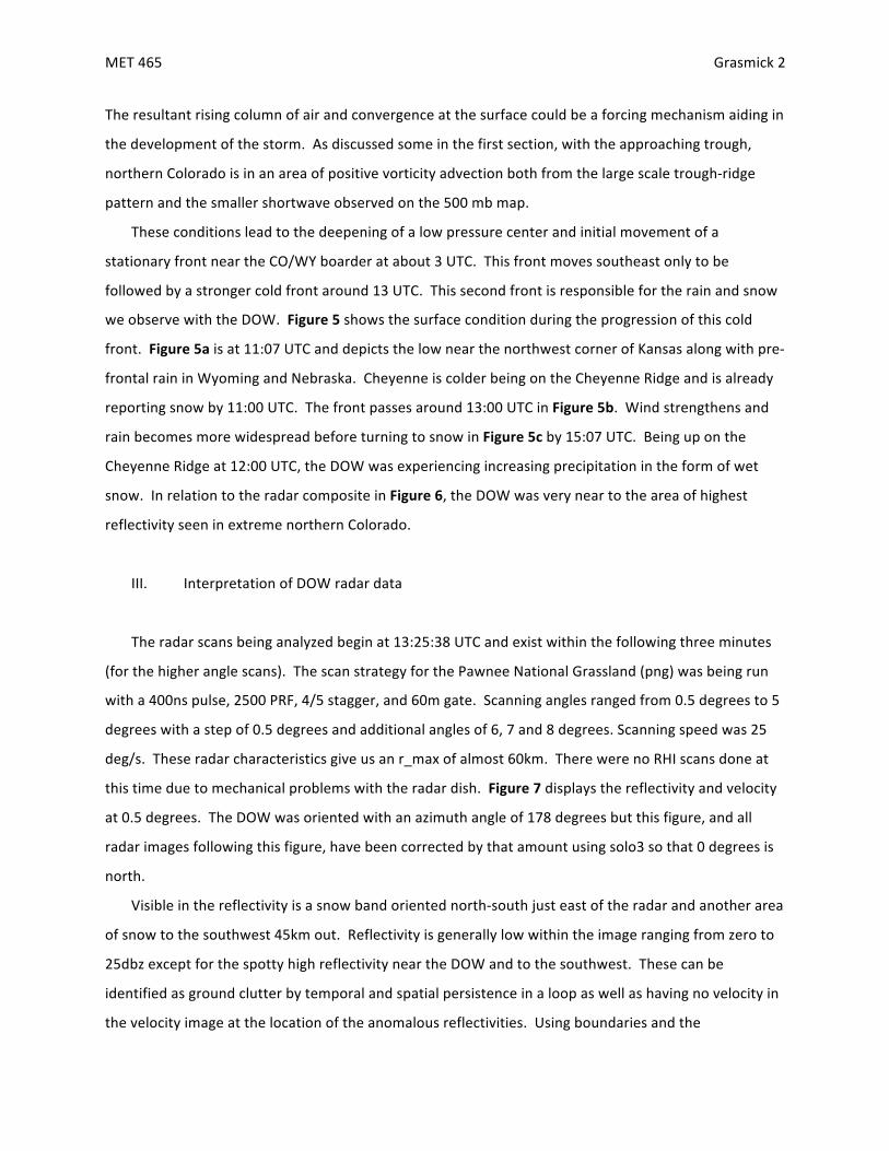
The$resultant$rising$column$of$air$and$convergence$at$the$surface$could$be$a$forcing$mechanism$aiding$in$
the$development$of$the$storm.$$As$discussed$some$in$the$first$section,$with$the$approaching$trough,$
northern$Colorado$is$in$an$area$of$positive$vorticity$advection$both$from$the$large$scale$troughNridge$
pattern$and$the$smaller$shortwave$observed$on$the$500$mb$map.$
These$conditions$lead$to$the$deepening$of$a$low$pressure$center$and$initial$movement$of$a$
stationary$front$near$the$CO/WY$boarder$at$about$3$UTC.$$This$front$moves$southeast$only$to$be$
followed$by$a$stronger$cold$front$around$13$UTC.$$This$second$front$is$responsible$for$the$rain$and$snow$
we$observe$with$the$DOW.$$Figure(5(shows$the$surface$condition$during$the$progression$of$this$cold$
front.$$Figure(5a$is$at$11:07$UTC$and$depicts$the$low$near$the$northwest$corner$of$Kansas$along$with$preN
frontal$rain$in$Wyoming$and$Nebraska.$$Cheyenne$is$colder$being$on$the$Cheyenne$Ridge$and$is$already$
reporting$snow$by$11:00$UTC.$$The$front$passes$around$13:00$UTC$in$Figure(5b.$$Wind$strengthens$and$
rain$becomes$more$widespread$before$turning$to$snow$in$Figure(5c$by$15:07$UTC.$$Being$up$on$the$
Cheyenne$Ridge$at$12:00$UTC,$the$DOW$was$experiencing$increasing$precipitation$in$the$form$of$wet$
snow.$$In$relation$to$the$radar$composite$in$Figure(6,$the$DOW$was$very$near$to$the$area$of$highest$
reflectivity$seen$in$extreme$northern$Colorado.$
$
III. Interpretation$of$DOW$radar$data$
$
The$radar$scans$being$analyzed$begin$at$13:25:38$UTC$and$exist$within$the$following$three$minutes$
(for$the$higher$angle$scans).$$The$scan$strategy$for$the$Pawnee$National$Grassland$(png)$was$being$run$
with$a$400ns$pulse,$2500$PRF,$4/5$stagger,$and$60m$gate.$$Scanning$angles$ranged$from$0.5$degrees$to$5$
degrees$with$a$step$of$0.5$degrees$and$additional$angles$of$6,$7$and$8$degrees.$Scanning$speed$was$25$
deg/s.$$These$radar$characteristics$give$us$an$r_max$of$almost$60km.$$There$were$no$RHI$scans$done$at$
this$time$due$to$mechanical$problems$with$the$radar$dish.$$Figure(7(displays$the$reflectivity$and$velocity$
at$0.5$degrees.$$The$DOW$was$oriented$with$an$azimuth$angle$of$178$degrees$but$this$figure,$and$all$
radar$images$following$this$figure,$have$been$corrected$by$that$amount$using$solo3$so$that$0$degrees$is$
north.$
Visible$in$the$reflectivity$is$a$snow$band$oriented$northNsouth$just$east$of$the$radar$and$another$area$
of$snow$to$the$southwest$45km$out.$$Reflectivity$is$generally$low$within$the$image$ranging$from$zero$to$
25dbz$except$for$the$spotty$high$reflectivity$near$the$DOW$and$to$the$southwest.$$These$can$be$
identified$as$ground$clutter$by$temporal$and$spatial$persistence$in$a$loop$as$well$as$having$no$velocity$in$
the$velocity$image$at$the$location$of$the$anomalous$reflectivities.$$Using$boundaries$and$the$

MET$465$ $ Grasmick$3$
$
“unconditionalNdelete”$command$in$solo3,$most$of$the$detached$ground$clutter$was$removed.$$To$
remove$ground$clutter$within$the$snow$band,$the$“threshold”$command$was$utilized$to$delete$velocities$
greater$than$25dbz.$This$editing$resulted$in$the$cleaner$looking$Figure(8.$$The$highest$reflectivities$are$
now$in$the$center$of$the$snow$band$and$have$a$somewhat$parallel,$linear$orientations$that$spiral$in$
toward$the$DOW.$$Another$visible$feature$in$the$reflectivity$is$beam$blockage$that$extends$from$the$
DOW$to$the$northeast.$$This$could$be$a$result$of$the$ground$clutter$near$the$radar$in$that$direction.$$
Figure(9(shows$0.5$degree$composite$radar$data$from$this$time$retrieved$from$UCAR’s$archives.$$
Comparing$the$largest$reflectivities$in$northern$Colorado$with$the$reflectivities$from$the$DOW,$Figure(8(
shows$the$similar$northNsouth$oriented$band.(The$velocities$show$flow$from$the$north$at$the$surface$of$
about$10$m/s$due$to$the$passing$of$the$cold$font$with$the$highest$velocities$at$the$highest$elevations$
furthest$from$the$radar$but$more$from$the$northwest$of$about$15$m/s.$
Figure(10$displays$the$reflectivity$and$velocity$from$the$elevation$scan$of$2.0$degrees.$$These$images$
look$a$little$smoother$and$nicer$do$to$less$quality$control$being$required.$$Highest$reflectivities$are$still$
nearest$to$the$DOW$though$an$area$of$slightly$higher$values$exists$down$the$middle$of$the$snow$band$as$
well.$$Velocities$at$this$elevation$look$similar$though$as$the$radar$beam$propagates$out$and$up,$direction$
changes$to$the$northwest$and$then$westNnorthwest$a$little$quicker.$
The$last$elevation$angle$I’ll$reference,$6.0$degrees,$is$in$Figure(11.$These$images$look$considerably$
different$as$the$radar$beam$is$now$intercepting$the$cloud$base$within$the$r_max$which$forms$a$circle$
around$the$DOW$where$this$interception$occurs.$$The$highest$reflectivities$are$still$east$of$the$DOW$
where$the$heaviest$snow$is$falling.$$In$the$velocity$image,$the$radar$beam$is$intercepting$faster$wind$
speeds$after$the$direction$quickly$changes$from$the$west.$$The$fastest$wind$speeds,$about$20$m/s,$are$
from$the$westNnorthwest$at$about$25$m/s.$$Because$velocities$then$drop$off$as$the$radar$beam$
continues,$there$is$a$layer$of$faster$wind$surrounded$above$and$below$by$slower$wind.$$After$doing$the$
trig,$estimating$the$straightNline$distance$to$be$15km,$this$layer$is$about$1.5km$above$the$surface.$$$
I$compared$this$to$the$November$4th$0z$sounding$to$try$and$confirm$the$analysis.$$Though$the$12z$
sounding$is$much$closer$to$the$actual$analysis,$it$is$in$Denver$and$does$not$yet$show$the$cold$front$
passage.$$Estimating$that$1.5km$would$be$slightly$above$700mb,$there$is$a$slight$increase$in$winds$at$this$
level$on$the$sounding$in$Figure(12(to$near$20$m/s$before$decreasing.$This$matches$my$velocity$images$
very$well.$$Also$notable$in$the$sounding$is$that$the$air$is$near$saturated$at$the$cloud$level$seen$in$the$6$
degree$sweep$and$the$highest$wind$speeds$are$about$75m/s$at$300mb,$where$a$jet$streak$was$noted$in$
section$2.$

MET$465$ $ Grasmick$4$
$
Next$is$an$analysis$of$a$few$polarimetric$variables$in$comparison$with$the$0.5$degree$elevation$angle$
scan.$$To$view$polarimetric$variable$with$solo3,$it$was$necessary$to$carefully$configure$the$color$scale$to$
the$values$specific$to$each$variable.$$First,$to$view$Differential$Reflectivity$(ZDR,$Figure(13)$I$centered$the$
scale$on$0.4$with$an$increment$of$0.25.$$This$made$the$minimum$value$shown$be$N1.73$and$the$
maximum$2.52.$$This$captures$most$the$data$points$except$for$ground$clutter$which$goes$off$the$lower$
end$of$the$scale$and$appears$grey.$$Most$the$targets$in$the$ZDR$panel$are$above$0.4$in$the$0.65$to$1.65$
range$with$a$yellow$tint.$This$is$consistent$with$values$of$the$observed$wet$snow$which$tends$to$range$
from$0N3.$$Green$and$purple$targets$have$negative$ZDR$values$which,$in$theory,$would$have$larger$
vertical$areas$than$horizontal$and$usually$corresponds$to$hail$or$graupel.$$Because$neither$of$these$were$
observed$and$these$values$tend$to$be$near$the$radar,$it’s$possible$that$sideNlobes$of$the$radar$beam$are$
intercepting$ground$clutter.$$Grasses$and$plants$in$the$area$would$have$a$much$larger$vertical$extent$
than$horizontal.$$Supportive$of$this$theory$is$that$the$ZDR$values$in$the$2$degree$elevation$angle$were$
almost$entirely$in$the$yellow$tinted$range$except$for$very$near$the$radar,$close$to$the$ground.$$There$is$
still$a$chance$that$the$beam$just$propagates$through$a$melting$later$quicker$at$this$higher$angle$but$if$
there$was$a$change$in$phase$due$to$melting$I$would$expect$higher$ZDR$values$instead$of$lower$ones.$
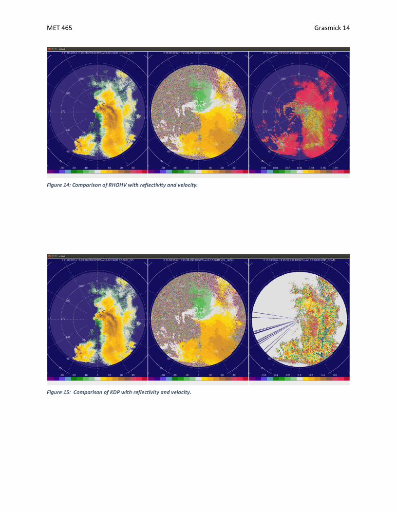
To$view$RHOHV$I$centered$the$scale$at$0.9$and$use$an$interval$of$0.015.$$For$the$17$colors,$this$
makes$the$range$from$0.78$to$1.02.$$For$the$RHOHV$at$0.5$degree$elevation$angle$seen$in$Figure(14,$
most$of$the$targets$are$in$the$range$from$yellow$to$red,$about$0.93$to$1.005.$$These$higher$values$of$
RHOHV$suggest$that$there$is$little$diversity$between$targets.$$These$areas$contain$completely$frozen$
snow.$$There$are$a$few$areas$where$green$stands$out$and$values$range$from$0.85$to$0.9.$$These$areas$
have$a$larger$diversity$in$hydrometeors$which$is$likely$due$to$melting.$$From$personal$observation$we$
know$that$there$was$some$very$wet$snow$at$times.$$Some$RHOHV$values$very$near$to$the$radar$are$
purple$to$gray$representing$values$below$0.85$and$are$results$of$ground$clutter.$$Areas$of$low$ZDR$values$
I$attributed$to$ground$clutter$in$the$previous$paragraph$have$RHOHV$values$that$are$characteristic$to$
hydrometeors.$$Either$the$contributing$regions$to$these$values$have$both$a$mix$of$ground$clutter$and$
hydrometeors$or$there$is$some$change$in$the$precipitation$causing$those$lower$ZDR$values.$
The$last$polarimetric$variable$I$analyze$is$KDP$which$is$based$on$a$propagation$effect$rather$than$a$
backscattering$effect$such$as$ZDR$and$RHOHV.$$Because$it$relates$to$difference$in$phase$shifts$for$
horizontal$and$vertical$waves,$I$viewed$this$variable$by$centering$the$scale$on$zero$and$changing$colors$
by$intervals$of$0.1$making$a$scale$from$N0.8$to$0.8$(Figure((15).$$Most$values$are$positive,$between$0$and$
0.8,$and$are$colored$yellow$or$red.$$These$values$are$characteristic$of$snow.$$The$highest$values$in$red$
(and$a$few$gray$that$are$off$the$scale)$are$characteristic$to$wet/melting$snow$and$are$most$numerous$in$

MET$465$ $ Grasmick$5$
$
the$area$of$highest$reflectivity$near$the$DOW.$$Interestingly,$there$is$an$almost$linear$area$of$negative$
values$on$the$display$which$are$green$and$purple.$$These$values,$from$0$to$N0.8$are$usually$seen$with$
large/wet$hail$but$occur$when$the$hydrometeor$is$taller$than$it$is$wide$(vertically$dominated).$$
Comparing$this$area$to$reflectivity,$these$low$values$are$stretched$out$along$the$east$side$of$the$snow$
band$that$is$moving$away$from$the$radar$site.$$It$may$be$possible$that$a$boundary$at$the$front$of$this$
snow$band$is$effecting$the$snow$by$tilting$it$to$make$it$seem$more$vertical$or$causing$another$area$of$
very$wet$snow.$
$
IV. Summary$
$
On$Monday$November$3rd,$2014,$synoptic$and$mesoscale$features$prompted$a$snow$event$in$
northern$Colorado$and$Wyoming.$$An$upper$level$trough$and$a$mid$to$lower$level$short$wave$moving$
into$the$area$increased$vorticity$and$lift$in$the$region.$$Enhancing$this$effect$was$a$jet$streak$at$300mb$to$
the$south$and$west$of$the$region.$$Moisture$moving$northeastward$over$the$United$States$from$the$
lower$Pacific$was$drawn$into$the$region$by$a$developing$low$in$extreme$northeast$Colorado.$$Lastly,$a$
cold$front$at$the$surface$was$a$forcing$mechanism$contributing$to$the$formation$of$precipitation.$$This$
front$crossed$into$Colorado$a$little$before$13:00$UTC$as$confirmed$by$the$RAP$model$output$in$Figure(16.$$
The$figure$shows$the$RAP$model$run$at$13:00$UTC$and$displays$the$cold$front$already$moving$through$
Colorado$and$the$low$cloud$cover$forming$behind$it.$$Precipitation$from$this$event$was$captured$on$
radar$by$the$Doppler$On$Wheels$from$12:00$to$18:00$UTC.$$At$the$site$near$Carr,$Colorado,$bands$of$
heavy,$wet$snow$were$observed$and$seen$on$radar.$$At$13:25$UTC$a$snow$band$east$of$the$DOW$
extending$northNsouth$contained$reflectivities$up$to$25$dbz.$$Velocities$from$the$north$at$the$surface$
become$westerly$as$move$up$in$elevation.$$With$use$of$polarimetric$variables,$areas$with$the$highest$
reflectivities$were$decided$to$large$clumps$of$wet$snow$while$areas$with$lower$reflectivities$were$of$
more$dry$snow.$
$
$ $

MET$465$ $ Grasmick$6$
$
References(
University$Corporation$for$Atmospheric$Research,$2014:$Image$Archive.$
[http://locust.mmm.ucar.edu/imagearchive/index.html]$
$
University$of$Wyoming$Department$of$Atmospheric$Sciences,$2014:$Upper$Air$Data.$
[http://weather.uwyo.edu/upperair/uamap.html]$
$
National$Weather$Service$Weather$Prediction$Center,$2014:$Surface$Analysis$Archive.$
[http://www.wpc.ncep.noaa.gov/archives/web_pages/sfc/sfc_archive.php]$
$
NOAA$National$Operational$Model$Archive$&$Distribution$System,$2014:$RAP$Model.$
[http://nomads.ncdc.noaa.gov/data/]$
$
$
$ $

MET$465$ $ Grasmick$7$
$
Figure'1:'Jet'stream'at'200mb,'12z.'(University'of'Wyoming'Department'of'Atmospheric'Sciences)'
$
$ $
Figure'2:'Short'wave'and'500mb'hights,'12z.'(National'Weather'Service'Weather'Prediction'Center)'

MET$465$ $ Grasmick$8$
$
Figure'3:'700mb'dew'points.'(National'Weather'Service'Weather'Prediction'Center)'
Figure'4:'Jet'Streak'at'300mb.'(University'of'Wyoming'Department'of'Atmospheric'Sciences)'
$ $

MET$465$ $ Grasmick$9$
$
$ $
A$ B$
C$
Figure'5:'Surface'Observations.'A)'11:07'UTC'B)'13:07'UTC'C)'15:07'UTC.'(University'Corporation'for'Atmospheric'Research)'

MET$465$ $ Grasmick$10$
$
Figure'6:'Composite'radar'at'beginning'of'deployment'(11:55'UTC).'(University'Corporation'for'Atmospheric'Research)'
Figure'7:'0.5'degree'reflectivity'and'velocity'with'ground'clutter'
$ $

MET$465$ $ Grasmick$11$
$
Figure'8:'0.5'degree'reflectivity'and'velocity'without'ground'clutter'
Figure'9:'Composite'reflectivity'at'same'time'as'analysed'radar,'13:25'UTC.'(University'Corporation'for'Atmospheric'Research)'
$ $

MET$465$ $ Grasmick$12$
$
Figure'10:'2.0'degree'reflectivity'and'velocity.'
Figure'11:'6.0'degree'reflectivity'and'velocity'
$ $

MET$465$ $ Grasmick$13$
$
Figure'12:'Denver'sounding'at'00z'Nov.'4th.''Increased'wind'near'700mb.'(University'of'Wyoming'Department'of'Atmospheric'Sciences)'
Figure'13:''Comparison'of'ZDR'with'reflectivity'and'velocity.'
$ $
MET$465$ $ Grasmick$14$
$
Figure'14:'Comparison'of'RHOHV'with'reflectivity'and'velocity.'
Figure'15:''Comparison'of'KDP'with'reflectivity'and'velocity.'
$ $

MET$465$ $ Grasmick$15$
$
(Figure'16:'IDV'displaying'RAP'model'at'13:00'UTC.'Temperature'is'shaded'and'cloud'cover'is'contoured.'(NOAA'National'Operational'Model'Archive'&'Distribution'System)'