the 24 august 2016 amatrice earthquake coseismic effects · pdf fileemergeo working group the...
TRANSCRIPT
EMERGEO Working Group
The 24 August 2016 Amatrice Earthquake
Coseismic Effects
Version 04.09.2016
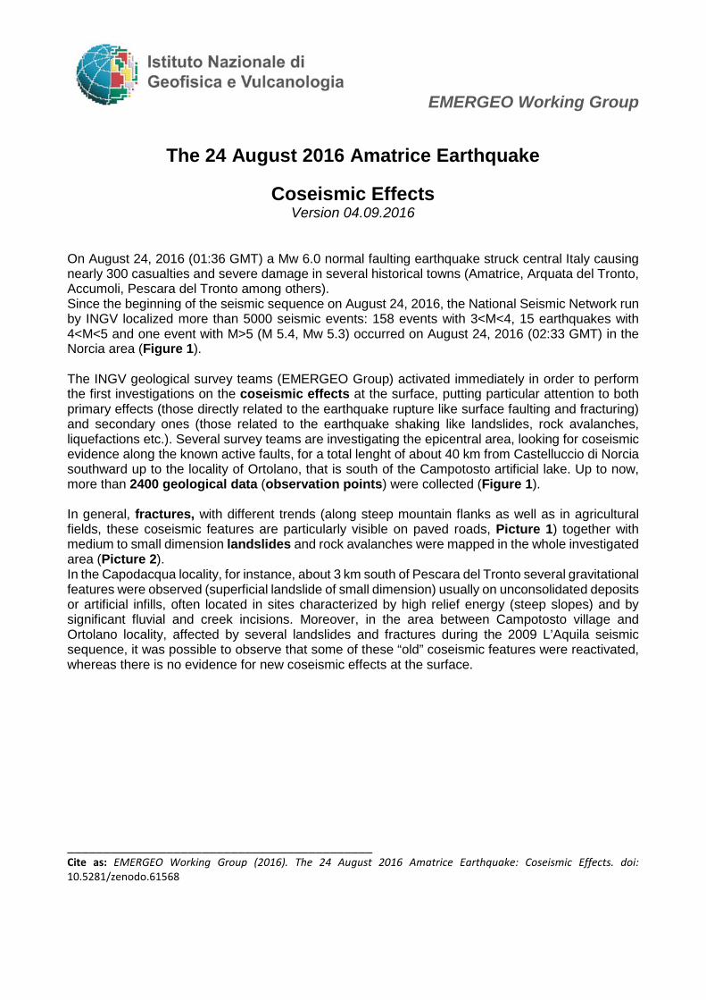
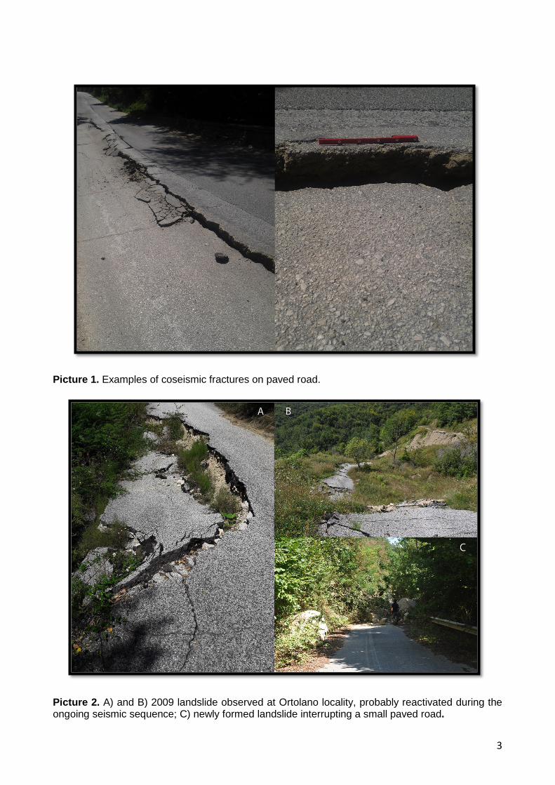
On August 24, 2016 (01:36 GMT) a Mw 6.0 normal faulting earthquake struck central Italy causing nearly 300 casualties and severe damage in several historical towns (Amatrice, Arquata del Tronto, Accumoli, Pescara del Tronto among others). Since the beginning of the seismic sequence on August 24, 2016, the National Seismic Network run by INGV localized more than 5000 seismic events: 158 events with 3<M<4, 15 earthquakes with 4<M<5 and one event with M>5 (M 5.4, Mw 5.3) occurred on August 24, 2016 (02:33 GMT) in the Norcia area (Figure 1). The INGV geological survey teams (EMERGEO Group) activated immediately in order to perform the first investigations on the coseismic effects at the surface, putting particular attention to both primary effects (those directly related to the earthquake rupture like surface faulting and fracturing) and secondary ones (those related to the earthquake shaking like landslides, rock avalanches, liquefactions etc.). Several survey teams are investigating the epicentral area, looking for coseismic evidence along the known active faults, for a total lenght of about 40 km from Castelluccio di Norcia southward up to the locality of Ortolano, that is south of the Campotosto artificial lake. Up to now, more than 2400 geological data (observation points) were collected (Figure 1). In general, fractures, with different trends (along steep mountain flanks as well as in agricultural fields, these coseismic features are particularly visible on paved roads, Picture 1) together with medium to small dimension landslides and rock avalanches were mapped in the whole investigated area (Picture 2). In the Capodacqua locality, for instance, about 3 km south of Pescara del Tronto several gravitational features were observed (superficial landslide of small dimension) usually on unconsolidated deposits or artificial infills, often located in sites characterized by high relief energy (steep slopes) and by significant fluvial and creek incisions. Moreover, in the area between Campotosto village and Ortolano locality, affected by several landslides and fractures during the 2009 L’Aquila seismic sequence, it was possible to observe that some of these “old” coseismic features were reactivated, whereas there is no evidence for new coseismic effects at the surface. ___________________________________________ Cite as: EMERGEO Working Group (2016). The 24 August 2016 Amatrice Earthquake: Coseismic Effects. doi: 10.5281/zenodo.61568

2
Figure 1. Map with distribution of observation points; faults are modified from 1:100.000 scale Geological Map of Italy (Sheet F132 Norcia and F139 L'Aquila - ISPRA) and Centamore et al. (1992); mainshocks and first 8 days of aftershocks from AMA_LOC Working Group – DOI: 10.5281/zenodo.61404, Istituto Nazionale di Geofisica e Vulcanologia, Cattaneo Marco, Chiaraluce Lauro, De Gori Pasquale, Di Stefano Raffaele, Latorre Diana, Marzorati Simone, Michele Maddalena, Monachesi Giancarlo, Valoroso Luisa. .
3
Picture 1. Examples of coseismic fractures on paved road.
Picture 2. A) and B) 2009 landslide observed at Ortolano locality, probably reactivated during the ongoing seismic sequence; C) newly formed landslide interrupting a small paved road.

4
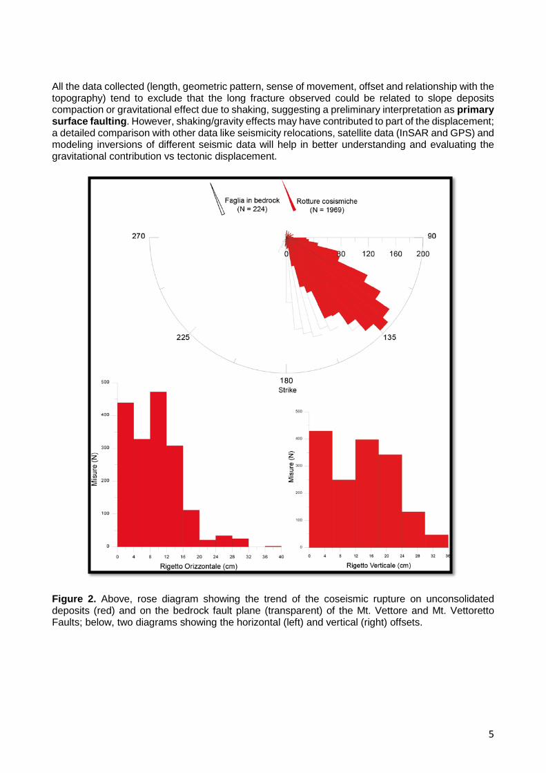
As for the active faults surveyed up to now, along the trace of the Mt. Gorzano Fault, on the eastern side of the Amatrice basin, some discontinuous coseismic fractures, few meters long, were observed in its northern portion. These were characterized by the absence of any specific geometric pattern; whereas, in the central-southern portion of this fault, it was not possible to observe any coseimic effect, nor clear fracturing at the surface. The observed small ground instability features occurring on unconsolidated deposits appear to be old. Most of the recent landslides are vegetated (not coseismic) and only rarely it is possible to discriminate an actual reactivation. The fault section close to the Amatrice village has not been surveyed yet, because of the well-known road interruptions and related difficulties in reaching most of the sites of this municipality. More interesting from the geologic and seismologic point of view are the data collected along the Mt. Vettore and Mt. Vettoretto Faults, on the northeastern side of the Castelluccio basin (Figure 1). Moving along the trace of the Mt. Vettore and the Mt. Vettoretto Faults a newly formed coseismic rupture on unconsolidated deposits (more than 1900 measurements), characterized by up to 5-6 m long fractures/free-faces, organized in regular geometric systems (mostly right en-echelon arrangement, with an average trend of 125-145°, Figure 2), aligned and continuous for a total length of 5.2 km was mapped (Picture 3).
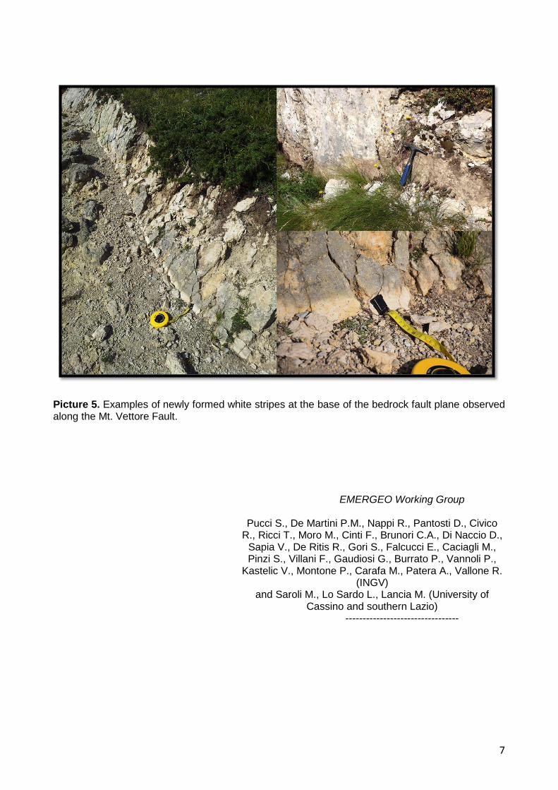
Picture 3. Examples of the coseimic ruptures observed along the Mt. Vettore Fault. The survey allowed us to estimate the deformation zone width to be about 3-5 m and the average trend to be 160° (Figure 2). The single ground ruptures show a clear vertical offset up to a maximum of about 30 cm, southwest side down, and in several sectors a horizontal component (opening) up to a maximum of about 30 cm (Picture 4). This newly formed fracture was observed both on slope deposits close to the bedrock fault plane and on the bedrock fault planes (more than 200 measurements) where it shows free faces up to 15 to 25 cm high, with an average trend of 145°-165°(Figure 2, 2b and Picture 5).
5
All the data collected (length, geometric pattern, sense of movement, offset and relationship with the topography) tend to exclude that the long fracture observed could be related to slope deposits compaction or gravitational effect due to shaking, suggesting a preliminary interpretation as primary surface faulting. However, shaking/gravity effects may have contributed to part of the displacement; a detailed comparison with other data like seismicity relocations, satellite data (InSAR and GPS) and modeling inversions of different seismic data will help in better understanding and evaluating the gravitational contribution vs tectonic displacement.
Figure 2. Above, rose diagram showing the trend of the coseismic rupture on unconsolidated deposits (red) and on the bedrock fault plane (transparent) of the Mt. Vettore and Mt. Vettoretto Faults; below, two diagrams showing the horizontal (left) and vertical (right) offsets.

6
Figure 2b. Maps showing the horizontal (left) and vertical (right) offsets along Mt. Vettore and Mt. Vettoretto faults strike.
Picture 4. Details of newly formed ruptures on unconsolidated deposits observed along the Mt. Vettore Fault.
7
Picture 5. Examples of newly formed white stripes at the base of the bedrock fault plane observed along the Mt. Vettore Fault.
EMERGEO Working Group
Pucci S., De Martini P.M., Nappi R., Pantosti D., Civico
R., Ricci T., Moro M., Cinti F., Brunori C.A., Di Naccio D., Sapia V., De Ritis R., Gori S., Falcucci E., Caciagli M., Pinzi S., Villani F., Gaudiosi G., Burrato P., Vannoli P.,
Kastelic V., Montone P., Carafa M., Patera A., Vallone R. (INGV)
and Saroli M., Lo Sardo L., Lancia M. (University of Cassino and southern Lazio)
---------------------------------