the amendments included in ppc15a-h as notified are ... made as part of the ppc15a-h decision are...
TRANSCRIPT

Note:
The amendments included in PPC15A-H as notified are shown as coloured underlined for additions and coloured strikethrough for removals. Further amendments made as part of the PPC15A-H decision are shown as shaded underline for additions and shaded strikethrough for removals.

Palmerston North City Council District Plan January 2009
20-1 DM 768102
Section 20: Transportation
Table of Contents
20.1 Introduction .................................................................................................................. 20-#
20.2 Resource Management Issues ................................................................................... 20-#
20.3 Roads, Parking and Access ........................................................................................ 20-#
20.3.1 Introduction ......................................................................................................... 20-#
20.3.2 Objectives and Policies ...................................................................................... 20-# Objective 1 ............................................................................................................ 20-# Policies ................................................................................................................. 20-# Objective 2 ............................................................................................................ 20-# Policies ................................................................................................................. 20-# Objective 3 ............................................................................................................ 20-# Policies ................................................................................................................. 20-# Objective 4 ............................................................................................................ 20-# Policy .................................................................................................................... 20-#
20.3.3 Methods ............................................................................................................... 20-#
20.3.4 Environmental Results Anticipated ................................................................... 20-#
20.3.5 The Treatment Of Roads .................................................................................... 20-# 20.3.5.1 The Roading Hierarchy ..................................................................... 20-# R 20.3.5.2 Roading Designations ....................................................................... 20-#
20.3.6 Parking ................................................................................................................. 20-#
20.3.6 Introduction ......................................................................................................... 20-#
20.3.7 Rules: Parking .................................................................................................. 20-## R 20.3.7.1 Parking Spaces for People with Disabilities .................................... 20-## R 20.3.7.2 Parking Provision Standards for All Zones Except the Inner and
Outer Business Zones ..................................................................... 20-## R 20.3.7.3 Parking Provision Standards for the Outer Business Zone ............. 20-## R 20.3.7.4 Parking Provision Standards for the Inner Business Zone .............. 20-## R 20.3.7.5 Car Park Landscape Design ........................................................... 20-## R 20.3.7.6 Formation of Parking Spaces .......................................................... 20-##
20.3.8 Rules: Loading Space Standards ................................................................... 20-## R 20.3.8.1 Loading Space Standards ............................................................... 20-##
20.3.9 Rules: Access Standards ................................................................................ 20-## R 20.3.9.1 Access Standards ........................................................................... 20-##
20.3.10 Rules: Restricted Discretionary Activities ..................................................... 20-## R 20.3.10.1 Restricted Discretionary Activities – Access ................................... 20-## R 20.3.10.2 Restricted Discretionary Activities – Drive Through Facilities ......... 20-##
20.4 The Airport .............................................................................................. 20-##
20.4.1 Introduction ....................................................................................................... 20-##
20.4.2 Objectives and Policies .................................................................................... 20-## Objective 1 .......................................................................................................... 20-## Policies ............................................................................................................... 20-## Objective 2 .......................................................................................................... 20-## Policies ............................................................................................................... 20-##
20.4.3 Methods ............................................................................................................. 20-##
20.4.4 Environmental Results Anticipated ................................................................. 20-##
20.4.5 Rules: Permitted Activities .............................................................................. 20-## R 20.4.5.1 Permitted Activities .......................................................................... 20-##
20.4.6 Rules: Discretionary Activities (Restricted) .................................................. 20-## R 20.4.6.1 Discretionary Activities (Restricted) – Separation Distance for
Rail Lines ........................................................................................ 20-## R 20.4.6.2 Discretionary Activities (Restricted) – Any activity not complying
with Rule 20.4.5.1(g) (i) to (v) .......................................................... 20-##
20.4.7 Rules: Discretionary Activities (Unrestricted) ............................................... 20-## R20.4.7.1 Discretionary Activities (Unrestricted) ............................................. 20-##
20.4.8 Rules: Non-Complying Activities .................................................................... 20-## R20.4.8.1 All activities in the Inner and Outer Control Zone that do not
comply with Rule 10.7.1.1 (h) shall be a non-complying activity ..... 20-## R20.4.8.2 Rail Lines and associated activities not complying with Rule

Palmerston North City Council District Plan January 2009
20-2
20.4.6.1 ........................................................................................... 20-##
20.4.9 Rules: Prohibited Activities ............................................................................ 20-## R 20.4.9.1 Prohibited Activities in the Air Noise Zone identified on Map
10.7.6.3 ........................................................................................... 20-##
20.4.10 Rules: Sound Emissions in the Airport Zone ................................................ 20-## R20.4.10.1 Sound Emissions in the Airport Zone.............................................. 20-## R20.4.10.2 Airport Noise Management Plan ..................................................... 20-##
20.4.11 Airport Protection Surfaces ............................................................................. 20-## R20.4.11.1 Airport Protection Surface ............................................................... 20-##
APPENDIX 20A.1: Road Hierarchy (Rural) ..................................................................................... 20-##
APPENDIX 20A.2: Road Hierarchy (Urban) .................................................................................... 20-##
APPENDIX 20A.3: Road Hierarchy (Ashhurst) .............................................................................. 20-##
APPENDIX 20A.4: Road Hierarchy (Palmerston North Central Area) .......................................... 20-##
APPENDIX 20A.5: Restricted Access Roads ................................................................................. 20-##
APPENDIX 20A.6: Roads for Future Reclassification .................................................................. 20-##
APPENDIX 20A.7: Limited Access Roads ..................................................................................... 20-##
APPENDIX 20B: Construction Criteria for new road and Street Description .......................... 20-##

Palmerston North City Council District Plan March 2003
20-3
20. TRANSPORTATION
20.1 Introduction An essential part of the functioning of any City, be it the urban or rural area, is the transportation system. The most obvious element of that system is the roading system, which is used daily to move goods and people around the City and which also provides a valuable parking resource in most areas. Other parts of the land transport system within the City include the North Island Main Trunk Railway (NIMTR) and the Palmerston North-Gisborne Line which carries both passengers and freight, and the Palmerston North Airport at Milson. The rail network way system is largely beyond the concerns of the Plan ascomprising-the railway lines and adjoining land required for their operation, are covered by a series of designations. Moreover, their Rail operations and existence gives rise to a few effects, the most obvious of which are, noise and vibration, but these effects areis usually of only limited duration or impact. In instances where rail activities occur beyond the boundary of the designation or are not in accordance with the designated purpose, the District Plan rules and resource consents will ensure that potential effects on amenity are avoided, remedied or mitigated.Thus, this part of the Plan is concerned with the functioning of the roading system and the Airport. Both Development will also be managed to avoid incompatible subdivision and development and reverse sensitivity effects for existing rail activities in the City. Tthe roading network and the Airport are centralis an important elements to the City’s position as a distribution centre for the lower North Island. The City’s geographical position and excellent transport networks have, over the last decade, assisted in developing a number of large warehousing and distribution ventures such as the Woolworths Distribution Centre and Toyota’s National Service Centre. Thus, the transport infrastructure as a physical resource, contributes to and is an integral part of the use and development of all other resources within the City. The City’s roading system is the most dominant feature of the City’s land transport infrastructure. Roads provide for the safe and efficient movement of people and goods and cannot be treated in planning terms in isolation from the communities which they serve. The State Highway networks within the City represent a significant investment which provides the primary link with the national highway network. Thus the District Plan has a role to play in ensuring that roads can effectively perform a range of functions such as the movement of goods and people, property access and the provision of parking and manoeuvring space. Equally the Plan also has a role to play in assessing the effects which other activities might have on the use and operation of the roading resource, and in avoiding, mitigating or remedying those effects. Public transport, walking and cycling both provide environmentally appropriate forms of transport, and clearly in terms of the sustainable management of the urban form, they need to be encouraged. The Palmerston North Airport represents a significant regional resource, being the major airport (with the exception of Wellington) in the lower North Island. The Airport has been gradually developed and will continue to develop to provide a range of air services to the Region. While the most obvious service is the movement of air passengers, a substantial element of the Airport’s operation involves the movement of freight and the teaching activities of the Massey University Aviation School. The air transport and teaching activities based at the Airport also attract a range of associated servicing activities such as freight forwarding agents who provide services based on air transport activities. These activities have developed markedly in the last five years, reflecting the City’s distribution centre function and the changes to transport regulations. Overall, the maintenance of a safe, effective and efficient transport system is an integral part of ensuring that the City operates in a sustainable manner. As with roads, the District Plan has an important role in ensuring that the Airport’s resources can be effectively and efficiently used while ensuring that any adverse effects of the Airport’s operations are avoided, remedied or mitigated. The particular safety concerns associated with the operation of aircraft mean that there are a number of issues

Palmerston North City Council District Plan March 2003
20-4
which are unique to the airport. An example is the need to ensure that there is no interference with navigational equipment.
20.2 Resource Management Issues The following resource management issues were identified in regard to Transportation: 1. The sustainable management of the land transport system and existing transport
infrastructure in the City; 2. The effects of activities on the operation of the roading network; 3. The impact of roads on the environment; 4. The importance of alternative modes of transport, including public transport,
walking, and cycling as environmentally appropriate modes of transport; 5. The need to ensure the efficient operation of the airport and the protection of its
potential capacity to meet the reasonably foreseeable needs of future generations while avoiding, remedying or mitigating any adverse effects of the airport on adjoining residential areas.
65. The need to indicate where extensions to the transport network will occur. 76. The need to provide adequate access and parking for all activities. 87. The effects of land use and development and on regional strategic roads and the
arterial road network, particularly uncontrolled vehicle access crossing points and intersections on traffic safety and the efficient functioning of major and minor arterial roads.
Explanation
The issues identified above reflect the diverse nature of transportation, largely reflecting the role of transport in allowing or assisting in the operation of other activities. However, while a safe and efficiently operating transport network can do much to assist in ensuring that activities within the City operate in a sustainable manner, transport modes, in this case roads and railway and the airport, do have effects on other activities and on the environment. A number of the issues also deal with the flow on effects of the relationship between roads and activities. Parking and access are the two most important issues in this respect as they are effects which result from the primary function of roads, in moving people and goods. The Regional Land Transport Strategy sets out the strategic direction, planning and development priorities for transport in the Manawatu-Wanganui Region for the next 30 years. Council is required to implement the directives encapsulated in the Regional Land Transport Strategy and update their plans and strategies, accordingly. This Strategy identifies a Regional Strategic Road Network and an outline work programme to advance intra and inter-regional accessibility and links to national roading corridors, consistent with the Council’s long term growth plans and regional economic development goals. Relevantly, the Kairanga Bunnythorpe Road and Ashhurst Bunnythorpe Road have been identified as new inter-regional routes and Railway Road has been classified as a major arterial route. The City Roading Hierarchy is updated to align with the Regional Land Transport Strategy (2010-2040). Access controls apply to arterial and collector roads to minimise reverse sensitivity effects and protect the efficient operation of the City’s arterial road network. In terms of the Airport, the issues reflect the needs of the Airport in terms of its continued use and development and the effects of the Airport and its operations on adjoining activities, particularly with regard to noise.
Palmerston North City Council District Plan March 2003
20-5
20.3 Roads, Parking and Access
20.3.1 Introduction This part of the Transportation Section focuses on the issue of roads and associated activities such as parking and access, and their effects on the environment.
20.3.2 Objectives and Policies Within the broad framework of the City View objectives the following specific objectives and policies were identified with regard to roads and associated activities.
Objective 1
To maintain and enhance the safe and efficient functioning of the roading
network.
Policies
1.1 To establish and maintain a roading hierarchy. 1.2 To identify the location and route of Mmajor Aarterial and Mminor Aarterial roads in
all areas of development. 1.3 To ensure all roads have function and design characteristics consistent with the
roading hierarchy. 1.4 To have regard to the particular safety needs of cyclists and pedestrians.
Explanation
It is important that where a roading network has been established, or is to be established, that the roads can efficiently, effectively and safely perform their functions. A road hierarchy assists in achieving this objective by ensuring that a road is of adequate width and design to meet the needs of the vehicles and people that will use it. Equally it is important at an early stage, that major elements of the roading system’s location are established in developing areas, to ensure the safe and efficient functioning of the roading system.
Objective 2
To protect the roading network, as identified in the roading hierarchy
(Appendix 20A), from the potential adverse effects of all land use activities.
Policies
2.1 To ensure safe and efficient vehicle access is provided to and from activities. 2.2 To ensure safe and efficient loading facilities are provided to service activities. 2.3 To ensure safe and efficient parking and manoeuvring space is provided for all
activities. 2.4 To manage and control vehicle access crossing points onto Major Arterial and
Minor Arterial roads.

Palmerston North City Council District Plan March 2003
20-6
Explanation
The primary rRoad networks can only operate safely and efficiently and achieve their primary purpose of moving goods and vehicles if, as far as possible, they are protected from the effects of other activities. This can largely be achieved by addressing specific issues such as parking, access and loading requirements as activities are established or when there are changes to, or an intensification of, an existing land use activity.
Objective 3
To avoid, remedy or mitigate the effects of roads and vehicles on the amenity
values of the City.
Policies
3.1 To restrict the through movement of traffic where the movement has adverse visual, noise and safety effects on adjoining areas.
3.2 To avoid, remedy or mitigate the impact of roads and parking areas on visual
amenity values of the community by the provision of landscaping. 3.3 To mitigate the effects of long term parking associated with activities in the Central
Business District on the amenity values of residential streets.
Explanation
Roads can have adverse effects on the environment because of the traffic which uses them. Traffic can cause adverse effects such as increases in noise to adjoining areas and decreases in safety to users of the adjoining activities. In some cases these effects need to be mitigated by restricting the through movement of traffic.
Roads, and particularly parking areas, can have a negative impact on the amenity and ambience of parts of the community. Large areas of parking are generally very visually obtrusive and can present a very sterile appearance. With proper landscape treatment, these adverse environmental effects can be overcome.
Objective 4
To maintain and enhance the use of public transport, walking and cycling as
alternative modes to the private motor vehicle.
Policy 4.1 To support and encourage the use of public transport, walking and cycling as an
integral part of the transportation system with special provisions made for them as appropriate.
Explanation
Public transport, walking and cycling are important modes of transport alongside private motor vehicles. Their use must be considered as an integral part of the entire transport system and, in many circumstances, special provisions such as bus stops, footpaths and cycleways need to be provided.
20.3.3 Methods
District Plan Rules
Designations (any requiring authority as defined in the Resource Management Act 1991)
The City Council’s role as road owner under the Local Government Act 1974
The National Land Transport Programme 2012-2015
The Regional Land Transport Plan
Other Plans, particularly the City Council’s Annual Plan, Strategic Long Term Plan,

Palmerston North City Council District Plan March 2003
20-7
District Land Transport Programme, and Integrated Parking Strategy
Operational Activities of the City Council
Educational initiatives and operational activities of the Manawatu-Wanganui Regional Council regarding public transport matters
Responsibilities of New Zealand Transport Agency regarding State Highways
Liaison between the Manawatu-Wanganui Regional Council and Palmerston North City Council to discuss transportation issues, for example, the Regional Transport Committee
Education (for example, encouraging people to make provision for cycle parking). The provision and operation of public transport which potentially uses fuels more efficiently and avoids single person journeys, is an important element of the sustainable management of any urban area. However, public transport is not an issue that a District Plan can easily deal with as this is primarily the responsibility of the Manawatu-Wanganui Regional Council. It is also an issue which can be dealt with more effectively through methods which lie outside the District Plan, such as the Annual Plan. The safe accommodation of cyclists is another issue which is largely more effectively dealt with by methods outside the District Plan. Education is an important tool to actively promote certain outcomes. Matters that may need to be promoted include the encouragement of making provision for cycle parks within the City.
With regard to roads, much of the achievement of the objectives and policies above will come through the activities of Council as the owner and effective operator of all roads, except the State Highways. This includes the right and responsibilities provided by Part XXI of the Local Government Act, and the impact of programmes established under the Annual Plan, including on-going operational and maintenance programmes. Programmes to establish cycle networks and cycleways, usually separate from roads, are examples of planning activities supported by funding through Annual Plan programmes,
which will assist in achieving the objectives and policies of this Plan. In terms of the District Plan, rules have a role in controlling some effects relating to roads which are not designated. The provisions of the District Plan do not apply to any land that is subject to a designation unless the land is used for a purpose other than the designated purpose. Theransit New Zealand Transport Agency has a role with regard to planning, investing and operating of the national state highway network and associated infrastructure and those parts of the roading network which have national significance, through their financing of roading improvements, reported in the National Land Transport Programme. Additionally, the Manawatu-Wanganui Regional Council has a primary role with regard to public transport both in its provision and delivery of services, and in terms of educating the public on public transport as a transportation alternative. The Regional Land Transport Plan sets out the vision, objectives and outcomes for the Region’s Land Transport Network over the next 10 years. Council is required to give effect to this statutory document in formulating its District Plan, resource consent processes and road infrastructure plans. The effects of long term parking, associated with activities in the Central Business District (CBD), on the amenity values of residential streets is recognised as a particular inter-zone resource management issue which is addressed through a combination of methods. This includes the parking rules of the District Plan applying to the activities in the Inner Business Zone, other regulatory measures such as time control of street parking in residential areas and operational works such as the marking of parking bays to ensure safe and convenient access to residences. Such measures are included in the Integrated Parking Strategy 2010 that provides for the implementation and monitoring of a Parking Management Plan for the CBD.

Palmerston North City Council District Plan March 2003
20-8
20.3.4 Environmental Results Anticipated
It is anticipated that the objectives, policies and methods of this Section will achieve the following results:
A roading network that provides for the movement of goods and people in a safe and efficient manner.
Identification of major new roads in the future roading network.
A reduction in the adverse effects of activities on the safe and efficient functioning of the roading network.
Avoiding, remedying or mitigating the adverse effects of the operation of the roading network on the environment and on the community’s amenity values.
An effective transport system that provides for the integration of public transport, walking and cycling alongside the private motor vehicle use.
20.3.5 The Treatment of Roads
20.3.5.1 The Roading Hierarchy
The roading hierarchy is a way of ordering different types of roads with like characteristics into an organised structure that enables the development of rules. The Roading Hierarchy is a means of developing rules that are appropriate to the effects likely to be created on particular types of roads. (The relevant policies dealing with the roading hierarchy are contained in Section 20.3.2, in particular Policies 1.1 to 1.3). The management of roads, streets and the land use activities that obtain access from them are linked. There needs to be integrated management and control to ensure that the function of the road or street is not unduly compromised, that the adverse effects of the activities within roads and streets do not have a detrimental effect on the environment or the amenity of land use activities, and vice versa. The use of the roading hierarchy is one method that can assist in integrating road management and land use activities.
The roading hierarchy is a tool that assists in:
Determining the status of activities i.e. the status of the road that access is obtained from determines the activity status in the District Plan,
Informing the development of asset management plans that identify upgrades and road maintenance that are funded through the Long Term Plan.
The roading hierarchy does not define road design and construction assumptions. The roading hierarchy also does not give weightings to the road user groups within the hierarchy, such as heavy vehicles, through traffic, parking, pedestrians and cyclists.
The following hierarchy shall apply in the City of Palmerston North. A list of the roads contained in each category of the hierarchy, described below, is included in Appendix 20A - also refer to Figures 20A.1 to 20A.74. The roading hierarchy which applies to the rural areas of Palmerston North, including the Primary and the Secondary Roads, is illustrated in Figure 20A.1.
Primary Roads
(i) Major Arterial Roads
Major Arterial Roads are of strategic importance to the Region. They provide interconnections between areas within the City and distribute traffic from major intercity links. Access is generally at grade but may be limited. Urban traffic volumes are typically greater than 20,000 vehicles per day and rural 5,000 vehicles per day with a significant number of heavy vehicles. Typical urban operating speeds are 50 to 70 km/h and rural

Palmerston North City Council District Plan March 2003
20-9
80 to 100 km/h. Major Arterial Roads include State Highways 3, 54, and 56 and 57 and Railway Road and Tremaine Avenue.
(ii) Minor Arterial Roads
Minor Arterial Roads provide access between Collector and Major Arterial Roads. These roads have a dominant through vehicular movement and carry the major public transport routes. Access to property may be restricted and rear servicing facilities may be required. Urban traffic volumes are typically 8,000 vehicles per day to 20,000 vehicles per day and rural from 1,000 to 5,000 vehicles per day with a higher proportion of heavy vehicles. Typical urban operating speeds are 40 to 60 km/h and rural 80 to 100 km/h. Botanical Road and Te Awe Awe Street are examples of Minor Arterial Roads.
(iii) Collector Roads
Collector Roads provide circulation in local areas and links to arterial roads, while balancing these needs with pedestrian and local amenity values. These roads provide access for all modes of transport including public transport. Typical traffic flows are between 3,000 and 10,000 vehicles per day. Examples of Collector Roads are Highbury Avenue and Brooklyn Heights Drive.
Secondary Roads
(iv) Local Roads
Local Roads provide access and connectivity within a local area. Low vehicle speeds, pedestrian and local amenity values predominate. Such roads typically carry up to 3,000 vehicles per day and their two lanes provide for on-street parking, property access and pedestrian needs. Buick Crescent and Milverton Avenue are examples of Local Roads.
Other Roads
(v) Pedestrian Streets
Pedestrian Streets are located in the centre of the City. They provide a safe and convenient network of links to carry pedestrians into the activities offered in the Central Area.
The Square, Broadway Avenue, Main Street, Coleman Place, Cuba Street, King Street, Fitzherbert Avenue, Church Street, Ashley Street and George Street are all Pedestrian Streets. Figure 20A.4 shows all Pedestrian Streets in Palmerston North. Explanation
Within the roading network there are a variety of types of roads which serve differing functions while retaining the overall purpose of moving people and goods around the City. Thus, while one road may provide a route across or through the City, another may only provide access to a number of residential or industrial sites. It is these differing functions of roads which are the basis of the roading hierarchy. The roading hierarchy defines the role and function of each road, and this in turn provides a basis on which to assist in the assessment of the effects of the road itself and the effects that activities located adjacent to that road might have. Thus the roading hierarchy provides a tool for determining appropriate traffic management measures, which are instituted outside this Plan, and provides a basis for the rules and standards which are instituted through this Plan.
The roading hierarchy detailed above was developed by assessing a range of matters, such as:
existing traffic service functions;
existing land uses;
existing characteristics, eg road standard, width and capacity;
current traffic volumes;
future land use strategies;

Palmerston North City Council District Plan March 2003
20-10
anticipated traffic increases.
From that assessment an appropriate hierarchy was determined.
R 20.3.5.2 Roading Designations
No developments involving permanent structures or building shall be
permitted on any land designated for proposed road widening or the
establishment of roads.
Explanation
Within the City there are two roading designations shown on the Planning Maps. The first, along the southern side of Ferguson Street, is to provide for road widening to relieve traffic congestion while the other, in Kelvin Grove, is intended to establish the alignment of the collector roads linking Roberts and James Lines. Further information is contained in Section 24, Designations, and on the Planning Maps.
20.3.6 Parking
20.3.6 Introduction
Regardless of the type or nature of the activity, every activity generates a certain amount of traffic. When that traffic arrives at the activity’s site, some provision must be made for it to park. While roads can and do provide some parking, this type of space is not always available, nor is it always in the best interests of the safe and efficient operation of a road, for such parking to occur. In the residential area, for instance, the number of crossing places reduces the potential for roadside parking while in the rural area, the unformed nature of road edges and the type of road means that there is little space for safe roadside parking. By contrast, in the Inner Business Zone, the emphasis on retailing and other business activities means that there is a substantial parking resource available in the form of developed on-street car parking and larger car parks. Rules for car parking ensure that Palmerston North has a sustainable road transport system, including parking spaces. The provision of those parking spaces is a shared responsibility of the Council and developers. The District Plan promotes the greatest concentration and intensity of development in the Inner Business Zone. A key component of achieving this development pattern is the maximum parking standard for the Inner Business Zone. The intention is to reduce the provision of on-site parking, especially those spaces used for all day staff parking, and enable a greater proportion of land to be developed. This approach increases the reliance on public parking and prioritises short stay parking within the Inner Business Zone. Development that proposes on-site parking over the specified maximum needs to demonstrate that additional parking is necessary for the effective operation of the activity. In this circumstance, the continued pedestrian priority provided for in the city centre is the first concern followed by ensuring the safe and efficient operation of the road network. The Plan also recognises that for large integrated retail developments the provision of on-site parking is critical to the efficient and effective operation of the retail format. For this reason, a minimum parking standard provides for the parking needs of these activities. “Pedestrian Streets”, as defined in the roading hierarchy (Appendix 20A), are located in the Inner Business Zone and are designed to provide a pleasant, safe, and convenient network of links throughout the city centre to carry pedestrians to activities. In order to enhance the character of the central area and the level of amenity for pedestrians, the retail frontage on pedestrian streets needs to remain unbroken. Vehicle accesses to car parks across pedestrian streets are generally not acceptable. However, a vehicle access across a Pedestrian Street may be acceptable where a large integrated retail development seeks to form an access point as part of a mid-block pedestrian link. In this situation, it is critical that pedestrian amenity at the street edge is maintained. Outside the Inner Business Zone, for the safe and efficient operation of the roading

Palmerston North City Council District Plan March 2003
20-11
network, the responsibility for the provision of all customer and worker-related car parking lies with individual developers. Parking provision standards for zones, except the Inner Business Zone, reflect these requirements. In the first instance, parking will need to be provided by developers. A development can provide less than the minimum number of car parks if it can demonstrate; the total parking demand generated by the activity is less than the number of spaces required; the hours of operation relative to other uses on a site or on adjoining sites provides opportunities for shared parking; or off-site parking is available in the locality and is readily accessible.
20.3.7 Rules : Parking
NOTES TO PLAN USERS: In respect of Rules 20.3.7.2, 20.3.7.3 and 20.3.7.4. 1. A building containing distinct areas of activity can be considered to be a
combination of these distinct activities, each requiring a specific number of parking spaces.
2. Where an assessment of the number of parking spaces required in respect of an activity results in a fractional space being involved, any fraction under one-half of a space must be disregarded and fractions of one-half of a space or more must be counted as one parking space.
3. gfa means gross floor area. 4. Car parks must be used for the activity specified with unrestricted access for those
using the activity and are not to be used, leased or occupied for any other activity. The Rule does not apply to any car parks provided in excess of the car parks required under the Rule.
5. The short term parking facility for Early Childhood Facilities is to be designed in accordance with Rule 20.3.7.6 – Formation of Parking Spaces.
6. See the definition of foodcourts for the purposes of calculating their GFA. 7. For the purposes of calculating the GFA of Storage, Warehousing or Distribution
activities, the standard shall be applied to all areas of the building including administration areas, cafeteria and waiting areas etc.
8. For Places of Worship the largest congregation area is the largest hall, chapel, congregation/worship area within the complex.
R 20.3.7.1 Parking Spaces for People with Disabilities
Where on-site parking is provided, or is to be provided for all buildings and
activities except dwellings, parking spaces for the disabled will be provided as
follows:
(a) Number (i) One where 10 or less spaces are provided. (ii) Two where between 10 and 50 spaces are provided.
plus (iii) One for every additional 50 spaces (or part thereof) where more than 50 spaces
are provided.
(b) Location Accessible car parking spaces shall connect to an accessible route and the closest building entrance or lift.
(c) Identification Accessible parking spaces shall have clear ground marking in accordance with the international symbol of access.

Palmerston North City Council District Plan March 2003
20-12
Explanation
Those in the community who are disabled have particular difficulties related to general mobility and to being able to gain access to buildings. The rule above ensures that there are sufficient spaces provided in appropriate locations, to be reserved for their particular requirements.
R 20.3.7.2 Parking Provision Standards for All Zones Except the
Inner and Outer Business Zones, Industrial Zone, Institutional Zone,
North East Industrial Zone and Airport Zone
(a) Where a building is constructed, reconstructed, altered or added to, or
an activity is established on a site or in a building or other structure,
parking provision must be made on-site in accordance with the following
standards:
Activity No of Parking Spaces Required
Dwellings 2 per dwelling
Multi-Unit Residential Developments 1 visitor space for every 5 dwelling units plus either 1 space per dwelling unit that contains 1 – 2 bedrooms including studio apartments or 2 spaces per dwelling unit containing 3 or more bedrooms.
Retail Activities, Commercial Service Activities, Building Suppliers, Farming & Agricultural Supplier, Office Product Supplier
5 per 100 m2 gfa for the first 10,000m
2
plus 4 per 100m2 gfa for additional
areas over 10,000m2
Offices 1 per 30m2 gfa
Theatres 20 per 100 m2 gfa
Places of Worship 1 per 3.0 persons that the largest congregation area is designed to accommodate.
Restaurants 1 per every 3 seats the facility is designed to accommodate.
Prepared Food & Beverage Outlets 1 per every 3 seats the facility is designed to accommodate.
Licensed Premises, excluding restaurants
18 per 100 m2 of gfa for the first 500m
2
plus 10 per every 100m2 gfa thereafter.
Accommodation Motels and the accommodation part of Motel Conference Centres and Hotels
1.2 per room or unit
Hospitals, Community Homes 0.5 per bed
Residential Centres 1 per unit plus 1 visitor park for every 5 units
Health Centres and Health Facilities 3 per consultant’s room (including rooms suitable for consulting)
Community and Leisure Facilities, and Tourist Facilities
1 park for every 10 seats the building is designed to accommodate. Where a building is not intended for seating, 5 parks per 100 m
2 gfa shall be
provided. Plus 0.1 parks per 100 m
2 of
recreational open space or playing fields.
Education Facilities: Early Childhood Facilities
1 per every 2 full time equivalent staff members at the facility at any time plus a

Palmerston North City Council District Plan March 2003
20-13
Activity No of Parking Spaces Required
Primary and Intermediate Schools Secondary Schools
Tertiary and Training Facilities
short term parking facility designed to cater for a minimum of 1 per every 7 pupils the facility is designed to accommodate.
1.4 per classroom 2 per classroom
0.7 per staff member, plus 0.3 per full-time student (excluding extramural students)
Manufacturing / Industrial 1.5 per 100 m2 of gfa
Buildings or land used for Storage, Warehousing or Distribution
1 per 100 m2 for the first 3,000m
2 gfa
plus 0.5 for every 100m2 gfa thereafter
Supermarkets 5 per 100m2 gfa of all areas except for
storage areas for which 1 space per 100m
2 gfa must be provided
Service Stations 3 per repair bay, plus 2 per 100 m2 of
remaining gfa
Yard Based Suppliers, Garden & Patio Suppliers, Automotive & Marine Suppliers
5 per 100m2 gfa plus 1 space per 100m
2
of outdoor areas devoted to the display of goods and commodities.
Home Occupations 1 per employee not resident on the site
Funeral Parlours Chapel area: 20 parks per 100 m2
plus 3.5 parks per 100 m2 of remaining
gfa
Animal Boarding Establishments 1.5 parks per 100 m2 gfa
Race Training and Agistment Establishments
1 park per 3 staff members resident on the property or 1 park per every 2 non-resident staff plus 2 visitor parks, whichever is the greater
Roadside Stalls 5 per 100 m2 gfa
R 20.3.7.3 Parking Provision Standards for the Outer Business
Zone, Industrial Zone, Institutional Zone, North East Industrial Zone
and Airport Zone
(a) Where a building is constructed, reconstructed, altered or added to, or
an activity is established on a site or in a building or other structure,
parking provision must be made on-site in accordance with the
following standards:
Activity No of Parking Spaces Required
Dwellings 1.4 per dwelling
Multi-Unit Residential Developments 0.7 visitor space for every 5 dwelling units plus either 0.7 space per dwelling unit that contains 1 – 2 bedrooms including studio apartments or 1.4 spaces per dwelling unit containing 3 or more bedrooms.
Retail Activities, Commercial Service Activities, Office Product Supplier
3.5 per 100 m2 gfa for the first 10,000m
2
plus 2.5 per 100m2 gfa for additional
areas over 10,000m2
Building Suppliers, Farming & Agricultural Supplier
2 per 100 m2 gfa for the first 10,000m
2
plus 1.4 per 100 m2 gfa for additional
areas over 10,000m2
Offices 1 per 43m2 gfa

Palmerston North City Council District Plan March 2003
20-14
Activity No of Parking Spaces Required
Theatres 14 per 100 m2 gfa
Places of Worship 1 per 4.3 persons that the largest congregation area is designed to accommodate.
Restaurants 1 per every 4.3 seats the facility is designed to accommodate.
Prepared Food & Beverage Outlets 1 per every 4.3 seats the facility is designed to accommodate.
Licensed Premises, excluding restaurants
12 per 100 m2 of gfa for the first 500m
2
plus 7 per every 100m2 gfa thereafter.
Accommodation Motels and the accommodation part of Motel Conference Centres and Hotels
0.9 per room or unit
Hospitals, Community Homes 0.5 per bed
Residential Centres 0.75 per unit plus 0.75 visitor park for every 5 units
Health Centres and Health Facilities 2.1 per consultant’s room (including rooms suitable for consulting)
Community and Leisure Facilities, and Tourist Facilities
1 park for every 14 seats the building is designed to accommodate. Where a building is not intended for seating, 3.5 parks per 100 m
2 gfa shall
be provided. Plus 0.1 parks per 100 m
2 of
recreational open space or playing fields.
Education Facilities: Early Childhood Facilities Primary and Intermediate Schools Secondary Schools
Tertiary and Training Facilities
1 per every 3 full time equivalent staff members at the facility at any time plus a short term parking facility designed to cater for a minimum of 1 per every 9 pupils the facility is designed to accommodate.
1.4 per classroom 2 per classroom
0.5 per staff member, plus 0.2 per full-time student (excluding extramural students)
Manufacturing / Industrial 1.1 per 100 m2 of gfa
Buildings or land used for Storage, Warehousing or Distribution
0.7 per 100 m2 for the first 3,000m
2 gfa
plus 0.5 for every 100m2 gfa thereafter
Supermarkets 5 per 100m2 gfa of all areas except for
storage areas for which 1 space per 100m
2 gfa must be provided
Service Stations 2.1 per repair bay or service bay, plus 1.4 per 100 m
2 of remaining gfa
Yard Based Suppliers, Garden & Patio Suppliers, Automotive & Marine Suppliers
3.5 per 100m2 gfa plus 0.7 space per
100m2 of outdoor areas devoted to the
display of goods and commodities.
Home Occupations 0.7 per employee not resident on the site
Funeral Parlours Chapel area: 14 parks per 100 m2
plus 2.5 parks per 100 m2 of remaining
gfa
Animal Boarding Establishments 1.1 parks per 100 m2 gfa
Race Training and Agistment Establishments
1 park per 4.3 staff members resident on the property or 0.7 park per every 2 non-resident staff plus 2 visitor parks, whichever is the greater
Roadside Stalls 3.5 per 100 m2 gfa

Palmerston North City Council District Plan March 2003
20-15
(b) For the construction, alteration of, or addition to a building 50m
2 or 20% of
the existing gross floor area, whichever is the lesser, within the Local
Business Zone no parking requirements shall apply.
(c) For any other activity in the Local Business Zone that is 300m2 or less, and
involves no form of construction, no parking requirements shall apply.
R 20.3.7.4 Parking Provision Standards for the Inner Business Zone
(a) Where a building is constructed, reconstructed, altered or added to, or
any activity is established on a site or in a building or other structure
adjacent to a Pedestrian Street then, on-site parking is not required. If
parking is provided, it must not exceed a maximum of 1 space per 100m2
of gross floor area.
(b) Where a building or structure of up to 400m2 of gross floor area is
constructed and it is not adjacent to a Pedestrian Street then on-site
parking is not required. If parking is provided, it must not exceed 1
space per 100m2 of gross floor area.
(c) Where a building or structure of over 400m
2 in gross floor area is
constructed and it is not adjacent to a Pedestrian Street, then parking
provision must be made on-site in accordance with the following
standards:
(i) A minimum of 1 space per 100m
2 of gross floor area; and
(ii) A maximum of 3.5 spaces per 100m2 of gross floor area.
(d) Where there are any external additions or alterations to existing
buildings, structures and activities not adjacent to a Pedestrian Street
and they do not exceed an additional 400m2 of gross floor area then,
additional on-site parking is not required. If additional parking is
provided, it must not exceed 1 space per 100m2 of gross floor area.
(e) Where there are any external additions or alterations to existing
buildings, structures and activities not adjacent to a Pedestrian Street
that are more than 400m2 of gross floor area, additional parking
provision must be made on-site in accordance with the following
standards:
(i) A minimum of 1 space per 100m
2 of gross floor area; and
(ii) A maximum of 3.5 spaces per 100m2 of gross floor area.
(f) Where the activity is a Comprehensive Integrated Retail Development
over 10,000m2 of gross floor area, rules (a) to (e) do not apply and
minimum parking provision must be provided of 3.5 spaces per 100m2 of
gross floor area for the first 10,000m2 of gross floor area, plus 2.5 per
100m2 gross floor area for additional areas over 10,000m
2.

Palmerston North City Council District Plan March 2003
20-16
R 20.3.7.5 Car Park Landscape Design
Any car parking area shall include the following landscape features:
(a) Any part of a car parking area (excluding access points), fronting to a
road shall feature one specimen tree capable of growing to 5 m within 10
years along every 10 m of car parking frontage.
(d) Trees planted to meet the requirements of (i) above shall be so planted as
to separate car parking area activities from pedestrian activities on the
street.
(c) Any tree planted on a frontage shall be planted in an area with a
minimum width of 2 m and with a total area per tree of not less than 4 m2.
(d) Within the Inner and Outer Business Zones, North East Industrial Zone,
Airport Zone and Institutional Zone an average of 1 specimen tree per 10
parks must be provided for internal car park areas. This ratio of trees to
parks is as follows:
Number of Car Parks Specimen Trees
0-9 0
10-19 2
12-29 3
30-39 4
40-49 5
Continued at the same ratio Continued at the same ratio
(e) Within the Inner and Outer Business Zones, North East Industrial Zone,
Airport Zone and the Institutional Zone any trees located within a car
park must have a protection area containing low planting with a
minimum dimension or diameter of 1.5 metres. The specimen trees, on-
going growing conditions and low planting must be maintained to a high
standard at all times.
Explanation Car parks can be expansive and quite barren. Parking areas can dominate an urban environment when the scale of the area is accentuated by an expanse of unbroken seal. The amenity of parking areas is significantly improved when planting is incorporated into the layout, particularly with the inclusion of specimen trees. It is important to ensure the planting will be well maintained and a high quality landscaping result will be achieved. Critical to achieving this is the on-going protection and maintenance of low planting and trees within car park areas. Protection can be provided by diamond shaped kerb planters around trees or equivalent methods. Young trees and planting will need to be protected from wind and moving vehicles.
R 20.3.7.6 Formation of Parking Spaces
Where a building is constructed, reconstructed, altered or added to or any activity
is established on a site or in a building or other structure, any car parking spaces
except those within a building shall be formed in accordance with the following
standards:
(a) Vehicle circulation routes within a car parking area must have:

Palmerston North City Council District Plan March 2003
20-17
(i) a width no less than 3.5 m for one way circulation routes and 6.5 m for two way circulation routes. Where these routes are also to accommodate pedestrians, these widths shall be increased by 800 mm except where a separate footpath is provided.
(ii) turning circles must comply with Figure 20.1.
(b) Any queuing space shall be sufficient to permit a free flow of traffic from the
road into the car parking area.
(c) All car parking spaces shall comply with the dimensions and construction
requirements detailed in Figure 20.2.
(d) All car parking areas are to be formed in a permanent, dust-free (not metal)
surface with kerbing, drainage and marking out of each parking space.
(e) An additional one metre clearance is to be added at the end of blind aisles which are
15 metres or more in length, to provide suitable manoeuvring to allow vehicles to
exit the aisle without reversing. The additional one metre clearance can be added
onto the end car park space and blind aisle (as shown in Figure A below), or
alternatively, to the blind aisle only (as shown in Figure B below).
FIGURE A: One Metre Clearance to
Carpark Space and Blind Aisle
FIGURE B: One Metre
Clearance to Blind Aisle Only
Width of car parking space as required in Figure 20.2
( 16 metres)
Blind Aisle Blind Aisle
( 16 metres)
1.0m1.0m
(f) Any carparking space with a side directly next to a wall, support column or other
obstacle shall provide an additional 300 mm width.
(g) The gradient of off-street parking surfaces for activities, with the exception
of dwellings, shall be no more than:
Type of car park Maximum slope of
car park
Mobility car parks 1:40
Car parks parallel to the angle of
parking
1:20
Car parks measured at 90 degrees to
the angle of parking
1:16
NOTE TO PLAN USERS: Where parking is provided on sloping land, information will need to be provided to the Council to show that the above standards are met.

Palmerston North City Council District Plan March 2003
20-18
Explanation
If people are to be encouraged to use car parking areas and to avoid the effects of uncontrolled on-road parking, then the parking areas must be useable. The standards above ensure that whenever car parks are established they are able to be easily accessed and are of sufficient size for their intended purpose. Thus it is not only the size of the car park which must be controlled, but also the manoeuvring areas and accessways associated with the spaces. These standards are intended to ensure that car parking areas are useable by all of the community including the disabled and those who are not regular users. This latter concern reflects the fact that people who regularly use a car parking area become used to its characteristics and are much more adept at manoeuvring a vehicle into a smaller space, hence the reduced width requirement for such parking spaces.
20.3.8 Rules : Loading Space Standards
R 20.3.8.1 Loading Space Standards
(a) Any business, institutional or industrial activity must provide a loading
space constructed to the following standards.
Activity Minimum
Width of
Space
Minimum
Length of
Space
Minimum
Height of
Space
Transport Depots or Land and Buildings used for storage
4.0 m 9.0 m 4.5 m
Retailing, Manufacturing Warehouses, Licensed Premises, Offices with ground floor area greater than 1500 m
2
4.0 m 7.5 m 4.5 m
Offices with gross floor area not greater than 1500 m
2
4.0 m 6.0 m 4.5 m
Any activity visited by articulated vehicles
4.0 m 20.0 m 4.5 m
Buildings serviced by courier vans only
3.0 m 6.0 m 3.2 m
(b) No loading arrangement shall be permitted where vehicles project onto
the road reserve while loading or are required to reverse onto or off a
major arterial or minor arterial road.
(c) For the construction, alteration of, or addition to a building 50m2 or 20%
of the existing gross floor area, whichever is the lesser, within the Local
Business Zone no loading requirements shall apply.
(d) For any other activity in the Local Business Zone that is 300m2 or less,
and involves no form of construction, no loading requirements shall
apply.
Explanation
The loading and unloading of goods is an integral part of most business and commercial activities. However, such loading activities can involve a variety of sizes of trucks and it is important that such vehicles have a loading space to use which avoids adverse effects on the safe and efficient use of the adjoining road.

Palmerston North City Council District Plan March 2003
20-19
Figure 20.1
Vehicle Dimensions and Single-Lane Turning Circles Source: Building Industry Authority (July 1992), Acceptable Solutions D1/AS1 – Access Routes

Palmerston North City Council District Plan July 2005
20-20
Figure 20.2
Car Park Dimensions
Parking Bays at 30
Parking Bays at 45
Parking Bays at 60
Parking Bays at 90
30
C*
BB
A
C*
45
B
A
C*
60
B
A
90C*A (=B)
Parallel Parking Bays
L3 L1 L2
300 mm min.kerb
wall, parapet, etc.> 150 mm high
RHS kerb of one-way road orcentre line of two-way road
User
Class
A B C1 C2 C3 Aisle
Width
1 2.1 4.2 4.4 4.1 4.5 3.1
2 2.3 4.6 4.4 4.1 4.7 3.0
3 2.5 5.0 4.4 4.1 4.9 2.9
4 3.6 6.4 4.4 4.1 5.5 2.9
User
Class
A B C1 C2 C3 Aisle
Width
1 2.4 3.4 5.2 4.8 5.5 3.9
2 2.5 3.5 5.2 4.8 5.6 3.7
3 2.6 3.7 5.2 4.8 5.7 3.5
4 3.6 5.1 5.2 4.8 6.1 3.3
User
Class
A B C1 C2 C3 Aisle
Width
1 2.4 2.8 5.7 5.1 5.9 4.9
2 2.5 2.9 5.7 5.1 6.0 4.6
3 2.6 3.0 5.7 5.1 6.0 4.3
4 3.6 4.2 5.7 5.1 6.3 4.0
User
Class
A B C1 C2 C3 Aisle
Width
1 2.4 2.4 5.4 4.8 5.4 6.2
2 2.5 2.5 5.4 4.8 5.4 5.8
3 2.6 2.6 5.4 4.8 5.4 5.4
4 3.6 3.6 5.4 4.8 5.4 5.0
User
Class
A B L1 L2 L3 Aisle
Width
1, 2, 3 2.1 2.1
4 3.6 3.6
All 6.3 6.6 5.4 3.0
All 6.1 6.4 5.4 3.3
All 5.9 6.2 5.4 3.6
With the exception of 90 car parks, aisle width dimensions are for manoeuvring into and out of car parks with one-way aisles.
For parking bays at 90 with two-way aisles, the aisle width should be the greater of 5.5 metres for circulation or the manoeuvring aisle widths stated in the above table.
For parallel parking bays with two-way aisles, aisle widths should be at least 3 metres wider than for one-way aisles.

Palmerston North City Council District Plan July 2005
20-21
NOTES: User Class is defined as:
1 - for all day parking, such as tenant, employee and commuter parking; 2 - for medium-term parking, such as long-term town centre parking, motels,
airport visitors, sports and entertainment centres; 3 - for short-term and goods or children loading parking, such as short-term
town centre parking, shopping parking, hospitals and medical centres. 4 - Accessible parking for people with disabilities.
Dimension C is selected as follows: C1 - where parking is to a wall or high kerb not allowing any overhang; C2 - where parking is to a low kerb which allows 600 mm overhang; C3 - where parking is controlled by wheelstops installed at right angles to the
direction of parking, or where the ends of parking spaces form a sawtooth pattern;
Dimension L is selected as follows: L1 - space length for consecutive parallel parking spaces; L2 - space length for obstructed end spaces; L3 - space length for unobstructed end spaces;
Aisle width dimensions are for one-way aisles. For parking bays at 90° with two-way aisles, aisle width should not be less than 5.5 metres. For parallel parking bays with two-way aisles, aisle widths should be at least 3 metres wider than for one-way aisles.
These standards are adapted from AS 2890.1 - 1993 with a more appropriate width for accessible car parks for people with disabilities. They have been established to be consistent with requirements for car parks within buildings.
20.3.9 Rules : Access Standards
R 20.3.9.1 Access Standards
(a) Position and Construction
All vehicle crossings and intersections shall be positioned and constructed in accordance with the instructions and specifications of, and to the satisfaction of, the road controlling authority. Theransit New Zealand Transport Agency is the road controlling authority for State Highway 3, and State Highway 54 (Kairanga- Bunnythorpe Road, between Milson Line and Rangitikei Line),56 and 57 within the Palmerston North City boundaries, and retains control of the location, design and construction standards of crossing places and road intersections with those state highways. Theransit New Zealand Transport Agency will not allow the construction of any vehicle crossing or intersection if its location and use would be unsafe for vehicles using the highway. No crossing place or intersection onto a state highway will be permitted unless: (i) The location and number of crossing places and intersections are determined so
as to both minimise the number, promote safe access to the state highway, and avoid or minimise adverse effects on the safe and efficient operation of the state highway;
(ii) The property does not have reasonably practicable alternative legal access to
some other road. The Palmerston North City Council is the road controlling authority for all other roads in the Palmerston North City area, which are not state highways. Palmerston North City Council retains control of the location, design and construction standards of crossing
places and road intersections (where these are not to state highways).

Palmerston North City Council District Plan January 2007
20-22
NOTE TO PLAN USERS: Notwithstanding this rule, as Road Controlling Authority, the Council , requires the permission of the Roading Manager, Palmerston North City Council, for any work to construct a vehicle crossing or intersection on all roads other than state highways; and Transit New Zealand Transport Agency permission is required for any work to construct a vehicle crossing or intersection with a state highway. An Application Form for a Vehicle Crossing can be obtained from Council Building Services. Where there is more than one Road Controlling Authority, permissions will be required from the respective Road Controlling Authorities.
(b) Access on Major Arterial, Minor Arterial and Collector Roads
Any access to a site or an activity on a Major Arterial Road, Minor Arterial Road or Collector Road (as defined in Appendix 20A or any roads or proposed roads meeting the criteria as set out in Appendix 20B) must be provided in accordance with the following standards: (i) Vehicles cannot reverse onto or off that road from any access to a loading or
parking area, except where access is to a residential dwelling and the posted speed limit is less than 100 km/h;
(ii) Site access shall be formed to a maximum of 6 metres in width. This rule does not apply to Collector Roads in the Residential and Industrial Zones;
(iii) The minimum sight distances at intersections and accesses shall be as recorded in Table 20.3 (illustrated and measured in accordance with Figure 20.6);
(iv) The minimum spacing between successive site accesses and intersections and the minimum distance between any access crossing and any intersection shall be as recorded in Table 20.3 and measured in accordance with Figure 20.4.
Table 20.3: Minimum Distances for Major Arterial, Minor Arterial and Collector
Roads.
Posted Speed (km/h) on Major Arterial, Minor Arterial, Collector Roads.
Minimum distance (m) from access to intersection on:
Minimum distance (m) Between successive
Minimum sight distance (m) at:
Major Arterial, Minor
Arterial, Collector Roads
(a)
Other Roads
(b)
Access Crossings
(c)
Intersections (d)
Access Crossings
Intersections
100 200 50 200 800 295 500
80 120 50 100 800 205 305
70 100 40 40 400 170 220
60 50 30 20 200 140 160
50 20 20 15 150 105 125
NOTES TO PLAN USERS: 1. Where the posted speed limit differs on the two roads, the standards for the higher
speed limit shall apply. 2. Any part of a road which forms part of the State Highway network is also subject to
the requirements of that road controlling authority, New Zealand Transport Agency. 3. Provided that, for the proposes of any development of land on Cashmere Drive
which is a vacant section at 1 July 2012, Cashmere Drive will be regarded as a local road and the provisions of Rule 20.3.9.1(d) will apply to any such development.
Palmerston North City Council District Plan January 2007
20-23
4. A Vehicle Crossing Application is required for every crossing to authorise a vehicle crossing place/access to the road network. A vehicle crossing application is approved by Council’s Roading Manager, as Road Controlling Authority. A Vehicle Crossing Application Form can be obtained from Council’s Building Services.
Figure 20.4:
Minimum Distances for Permitted Access for
Accessways and Intersections
(a)
Other Roads
Other Roads
Other Roads
(b)
(c)
(d) (d)
Major Arterial, Minor Arterial or Collector
Roads
Access
(a)
Where a boundary is
tapered, measurements
are taken from a point
at the intersection
between the two
boundary lines.
Access Access
(a) Distance from access to intersection on Major Arterial, Minor Arterial or Collector Roads
(b) Distance from access to intersection on all other roads (c) Distance between successive access crossings (d) Distance between successive intersections
(c) Access Standards in the Rural Zone
Any access to a site or an activity not covered by rules (b) above, and which is located in the Rural Zone, shall be provided in accordance with the following standards: (i) Vehicles cannot reverse onto or off that road from any access to a loading or
parking area; (ii) Site access shall be formed to a maximum of 6 metres in width; (iii) No vehicle crossing shall be located within a minimum distance of 10 metres from
an intersection, measured in accordance with Figure 20.4;
(iv) The minimum sight distances at intersections and accesses shall be as recorded in Table 20.5, measured in accordance with Figure 20.6;
(v) Vehicle crossing movements must not exceed 100 Car-equivalent Vehicle
Movements per day and the Car-equivalent Vehicle Movements shall be calculated
Where a boundary is tapered, measurements are taken from a point at the intersection between the two boundary lines.

Palmerston North City Council District Plan January 2007
20-24
in accordance with the calculation of Car-equivalent Vehicle Movements, below.
Calculation of Car-equivalent Vehicle Movements
a) Car-equivalent Vehicle Movements
i) One car to and from the site = 2 Car-equivalent Vehicle Movements ii) One truck to and from the site = 6 Car-equivalent Vehicle Movements iii) One truck and trailer to and from the site = 10 Car-equivalent Vehicle
Movements iv) One dwelling is deemed to generate 8 Car-equivalent Vehicle
Movements.
b) The number of Car-equivalent Vehicle Movements will be deemed to be less than 30 if they exceed 30 on no more than two days per week, provided that they do not exceed 60 on any given day.
c) The number of Car-equivalent Vehicle Movements will be deemed to be
less than 100 if they exceed 100 on no more than two days per week, provided that they do not exceed 200 on any given day.
Explanation
The traffic generated by some activities in the Rural Zone have the potential to impact on the traffic efficiency and safety of the adjoining Major and Minor Arterial roads, for example activities like Massey University farm-based teaching and research facilities. This control ensures that the adverse effects of vehicle movements associated with existing or new land uses are avoided, remedied or mitigated, where they exceed a defined volume, and reflective of the modal characteristics of the vehicular traffic.
Table 20.5 Minimum Sight Distances for Permitted Access in the Rural
Zone
Posted Speed (km/h)
Minimum Sight Distance at:
(metres)
Access Crossings Intersections
100 250 500
80 170 240
70 115 175
60 85 135
50 65 105
(d) Access Standards in Zones other than the Rural Zone
Any access to a site or an activity not covered by rules (b) and (c) above, and which is located in any zone other than the Rural Zone, shall be provided in accordance with the following standards: (i) There shall be no vehicle access across a Pedestrian Street (as identified in
Appendix 20A); (ii) Where the site or activity is located in a Residential Zone and used for residential
purposes:
(a) One standard crossing of 3 metres shall be provided except where a dwelling has a double garage facing a front boundary and is setback less than seven metres from the front boundary in which case the crossing width can be up to five metres wide or the width of the double doors, whichever is the lesser;
(b) No vehicle crossing shall be located within 8 metres of an intersection,
Palmerston North City Council District Plan January 2007
20-25
measured in accordance with Figure 20.4; (c) The width of shared access shall be as follows:
Number of dwellings Minimum width of access
2-3 3.5 metres
4-6 5.0 metres
(d) The minimum distance between access crossings and an intersection with a
Major Arterial, Minor Arterial or Collector Road shall be as recorded in the third column of Table 20.3 (entitled “Other Roads (b)”), measured in accordance with Figure 20.4.
(iii) Where the site or activity is located in an Industrial Zone:
(a) Where a site has frontage to one road, one two-way crossing, of not more than 8 metres in width shall be provided;
(b) Where a site has frontage to more than one road, one crossing of not more
than 8 metres in width may be provided to each road. The minimum is one two-way crossing of not more than 8 metres in width to one road;
(c) Where a site has a frontage length of more than 30 metres to a road, it may
have two crossings of not more than 8 metres wide each to that road. As a minimum, one two-way crossing of not more than 8 metres in width shall be
provided to the road;
(d) No vehicle crossing shall be located within 20 metres of an intersection, measured in accordance with Figure 20.4;
(e) The minimum distance between access crossings and an intersection with a Major Arterial, Minor Arterial or Collector Road shall be as recorded in the third column of Table 20.3 (entitled “Other Roads (b)”), measured in accordance with Figure 20.4.”
NOTE TO PLAN USERS: Access from Richardsons Line or Setters Line (North) to the North East Industrial Zone is to be assessed as a non-complying activity under Rule 12A.10.2.
(iv) Where the site or activity is located in a Fringe Business Zone:
(a) Where a site or Multiple Retail Development has frontage to one road, one two-way crossing, of not more than 6 metres in width shall be provided;
(b) Where a site or Multiple Retail Development has frontage to more than one road, one crossing of not more than 6 metres in width may be provided to each road. The minimum is one two-way crossing of not more than 6 metres in width shall be provided to the road;
(c) Where a site has a frontage length of more than 30 metres to a road, it may have two crossings of not more than 6 metres in width each to that road. As a minimum, one two-way crossing of not more than 6 metres in width shall be provided to the road;
(d) No vehicle crossing shall be located within 20 metres of an intersection, measured in accordance with Figure 20.4;
(e) The minimum distance between access crossings and an intersection with a Major Arterial, Minor Arterial, or Collector Road shall be as recorded in the third column of Table 20.3 (entitled “Other Roads (b)”) measured in accordance with Figure 20.4.
(e) Vehicle Crossings in Proximity to a Rail Level Crossing

Palmerston North City Council District Plan January 2007
20-26
All new vehicle crossings shall be set back a minimum of 30m from a rail level crossing.

Palmerston North City Council District Plan January 2007
20-27
(v) Where the site or activity is not covered by standards (i), (ii), (iii) or (iv) above:
(a) Where a site has frontage to one road, one two-way crossing, of not more than 6 metres in width shall be provided;
(b) Where a site has frontage to more than one road, one crossing, of not more than 6 metres in width may be provided to each road (access from a dedicated service lane shall be deemed to form one standard crossing). The minimum is one two-way crossing of not more than 6 metres in width to one road;
(c) Where a site has a frontage length of more than 30 metres to a road, it may have two crossings of not more than 6 metres in width each to that road. As a minimum, one two-way crossing of not more than 6 metres in width shall be provided to the road;
(d) No vehicle crossing shall be located within 8 metres of an intersection, measured in accordance with Figure 20.4;
(e) The minimum distance between access crossings and an intersection with a Major Arterial, Minor Arterial or Collector Road shall be as recorded in the third column of Table 20.3 (entitled “Other Roads (b)”), measured in accordance with Figure 20.4.
NOTE FOR PLAN USERS: For the purposes of interpreting this Rule, vehicle crossing widths are measured at the property boundary.
20.3.10 Rules : Restricted Discretionary Activities (Restricted)
R 20.3.10.1 Restricted Discretionary Activities (Restricted) —
Access
Any activities which do not comply with the performance conditions standards
in relation to access, except activities assessed as part of Rule 12A.10.2 are
Restricted Discretionary Activities (Restricted) with regard to:
the safe and efficient operation of the roading network
that vehicle access crossing points provide for the safe and efficient
management of traffic to and from the site
In determining whether to grant consent and what conditions to impose, if any, the Council will, in addition to the Transportation Section objectives and policies and standards of Rule 20.3.10.1, assess any application in terms of the following further policies assessment criteriaand shall require the applicant to consult with Transit the New Zealand Transport Agency if affecting a state highway:
Assessment Criteria (a) To avoid, remedy or mitigate any adverse effects on the roading network of vehicle
movements at any access or intersection. (b) To take into account the availability of alternative legal access to any other road. (c) To avoid, remedy or mitigate the adverse effects on the roading network of parking
and the extent that off-street parking can be provided. (d) The extent to which an Access Management Structure Plan remedies or mitigates
adverse effects of any new accessway and vehicle crossing point, on traffic safety and the efficient functioning of the arterial road network.

Palmerston North City Council District Plan January 2007
20-28
Explanation
The access rules for the roading network are designed to ensure the safe and efficient operation of the roading network. The Council recognises, though, that there may be instances where the form of the development may require consideration of a variation from the standards, provided the possible adverse effects on the roading network are properly addressed. Access to a site or activity on a Major Arterial and Minor Arterial roads requires specific consideration to protect the efficient operation of strategic roads and minimise traffic safety risks. The approval of the Council’s Roading Manager is required to authorise the location, design and construction standard for vehicle access crossing points onto a major and minor arterial roads,.
Non-notification Such applications (Rule 20.3.10.1) need not be publicly notified.
R 20.3.10.2 Restricted Discretionary Activities (Restricted) – Drive
Through Facilities
Any activities which include a Drive Through Facility are a Restricted
Discretionary Activity (Restricted) with regard to:
The safe and efficient operation of the roading network
That access points provide for the safe and efficient control of traffic to
and from the site
In determining whether to grant consent and what conditions to impose, if any, the Council will, in addition to the Transportation Section’s objectives and policies, assess any application in terms of the following further policies:
(a) To avoid, remedy or mitigate any adverse effects on the roading network of vehicle movements associated with the Drive-Through Facility on road users.
(b) Any queuing space must be sufficient to permit a free flow of traffic from the road into the parking area.
(c) That the activity is designed in such a manner that vehicles can manoeuvre in a safe and efficient manner on-site.
(d) The Drive-Through Facility is designed in a manner that allows for the safe and efficient on-site movement of pedestrians.
Explanation Drive Through Facilities, if designed properly, will not affect the safe and efficient operation of the roading network. However, if designed in a manner that does not adequately provide sufficient queuing space or in an efficient form they can potentially result in adverse effects on the safe and efficient operation of the roading network. Appropriate design features for a drive through facility include:
Maximising length of drive through queuing between ordering facility and access point;
The length of the queuing area should accommodate the peak demand;
One-way flow with separate entry/exit points that are located as practicably as far as possible from intersections;
Minimise turning conflicts both on-site and off-site;
Minimise conflict between pedestrians and vehicles to ensure their safe movement.
Non-notification Such applications (Rule 20.3.10.2) need not be publicly notified.

Palmerston North City Council District Plan January 2007
20-29

Palmerston North City Council District Plan June 2004
20-30
Figure 20.6:
Sight Distance Measurement Diagram
(a)
(a)
C L
C L
C L
C L
C L
(c)
(b)
Centreline of Access or Side
Road
Edge of traffic lane Edge of
traffic lane
Legal Road Boundary
(a) Sight Distance as stated in Tables 20.3 and 20.5
(b) Edge of road traffic lane (c) For Accesses: 3.5 metres from edge of
road traffic lane For Intersections: 5.5 metres from edge of
road traffic lane Note: Sight distances shall be measured to and from a height of 1.15 metres above the existing road surface and the proposed surface level of the side road or access
Road
Road
Lane
Lane

Palmerston North City Council District Plan June 2004
20-31
20.4 The Airport
20.4.1 Introduction
This part of the Transportation Section focuses on the issues associated with the Airport and the provision of air services within the City.
20.4.2 Objectives and Policies
Within the broad framework of the City View Objectives in Section 2, the following specific objectives and policies were identified with regard to the Airport and air services:
Objective 1
To promote the continued operation of the Palmerston North Airport and to
plan for its future development.
Policies
1.1 To create a zone to encompass the Airport’s existing activities; 1.2 To provide for the future growth and development of the airport and other
complementary activities within the Airport Zone.
Objective 2
To avoid, remedy or mitigate the existing and potential adverse effects of the
Airport’s operation.
Policies
2.1 To encourage the development of appropriate controls of residential interfaces to avoid, remedy or mitigate any adverse environmental effects.
2.2 To identify and limit the use of any land outside the Airport Zone which is severely
affected by airport noise.
Explanation
The Airport, as was earlier mentioned, is an essential element of the City’s transport infrastructure and is essential to the continued operation of the City as a distribution centre. It also represents an increasingly important mode of transport for the community.
However, the Airport and its associated activities has the opportunity to create significant effects on adjacent residents, particularly those in residential areas. In some cases these effects, particularly noise, are sufficient to make it inappropriate to allow the land to be used for residential purposes.
20.4.3 Methods
Zoning
Rules
Noise Management Plans
Operational Requirements of Other Organisations
Designations
The District Plan through zoning, rules and designation can contribute to establishing the Airport and associated activities and to put in place standards to control adverse

Palmerston North City Council District Plan April 2004
20-32
environmental effects. In respect of any land severely affected by airport noise, one of the options available is for the Requiring Authority to designate land for airport purposes (and subsequently purchase it) or to simply purchase land without designation. Palmerston North Airport Limited was granted requiring authority status in July 1995 however, to date the Company has not exercised its designating powers. However because of the safety issues involved, the activities of agencies such as the Ministry of Civil Aviation also have a bearing on the operations of the Airport while Noise Management Plans developed and instituted by the Airport Company or airport operators may also serve to achieve the objective of mitigating the effects of noise. These various methods have been adopted as the most appropriate methods as they represent the most effective and efficient means of achieving the objective and policies for the Airport. The District Plan with its rules represents an easily accessible and relatively costless source of information and direction and is an effective tool due to its legal enforceability.
20.4.4 Environmental Results Anticipated
It is anticipated that the objectives, policies and methods of this section will achieve the following results:
Provision for the safe and efficient use of the City’s airport resource.
Avoiding, remedying or mitigating of the adverse effects of the airport’s operation on other activities.
Exclusion from further development of any land severely affected by noise generated by airport operations.
20.4.5 Rules : Permitted Activities
R 20.4.5.1 Permitted Activities
The following activities are Permitted Activities in the Airport Zone provided
they comply with the specified Performance Conditions:
(a) Airport operations including freight and passenger facilities.
(b) Airport navigational, control and safety equipment.
(c) Aviation, educational and training and recreational facilities and
activities.
(d) Maintenance and servicing of aircraft.
(e) Retailing.
(f) Warehousing, storage and distribution of goods.
(g) Fuel installations and fuel servicing facilities.
(h) Restaurants, takeaway bars and licensed premises.
(i) Catering and preparation of food.
(j) Car parking and storage.
(k) Farming.
(l) Training Facilities.

Palmerston North City Council District Plan April 2004
20-33
(m) Buildings for any Permitted Activity.
(n) Minor and Extended Temporary Military Training Activities
(o) Roads and Railway lines
Performance Conditions
(a) Size Limitation
No building intended for retail or restaurant activities shall exceed 250 m2 in gross floor
area.
(b) Separation Distances
(i) No building or activity shall come within 6 m of any boundary with a residentially or recreationally zoned site.
This performance condition does not apply to Lot 3 DP 30759 (being the former Pinedale Reserve) and Lot 2 DP 306023 (being 111 Railway Road).
(ii) No rail line or associated activity shall come within 80 metres of any boundary with a residentially zoned site.
(c) Signs
Compliance with Rule 6.1.5.1.
(d) Hazardous Substances
Compliance with the provisions of Section 14 - Hazardous Substances of this District Plan.
(e) Air Noise Control
Compliance with Rule 10.7.1.1(h).
NOTE TO PLAN USERS: Proposals that do not: 1 Provide the required degree of noise reduction stated in the definitions of
Schedules P, Q and R; or 2 Obtain certification from an acoustical consultant to provide alternative means of
construction to achieve the degree of noise reduction set out in the definitions of Schedules P, Q and R;
are provided for as a Non-Complying Activity under R 20.4.7
(f) Vehicle Parking, Loading and Site Access
Compliance with Rules 20.3.7.1 Parking Spaces for People with Disabilities 20.3.7.2 Parking Provision Standards for All Zones Except the Inner and Outer
Business Zone 20.3.7.5 Car Park Landscape Design 20.3.7.6 Formation of Parking Spaces 20.3.8.1 Loading Space Standards 20.3.9.1 Access Standards

Palmerston North City Council District Plan April 2004
20-34
Explanation
The Airport Zone covers only the land owned by the Palmerston North Airport Company. While activities on that land predominantly involve airport activities in terms of the landing, taking off and servicing of aeroplanes, there are also a large number of associated activities. These include the Massey University School of Aviation and the Manawatu Districts Aero Club in terms of pilot training and recreational flying and a range of aviation-related servicing industries and freight forwarders. In addition there are a range of activities which serve the travelling public such as the restaurant.
The diverse nature of these activities does lead to the potential to cause disturbance to adjoining residential areas. Consequently, the performance standards are intended to ensure activities are sited well clear of residential boundaries, thereby reducing spillover effects. By requiring any building or activity to stay well clear of any residential boundary ensures that neither will be located close to the residential area. Within the Zone itself there are however no controls, as is the case in the Industrial Zone. This ensures that there is considerable flexibility within the Zone to accommodate a range of compatible activities
(g) Lot 3 DP 30759 and Lot 2 DP 306023 in the Airport Zone The following additional performance conditions apply to Lot 3 DP 30759 (being the former Pinedale Reserve) and Lot 2 DP 306023 (being 111 Railway Road) in the Airport Zone and replace Rule 20.4.5.1(b)(i), Separation Distance. Permitted Activities under Rule 20.4.5.1 and Performance Conditions (a), (b)(ii) and (c) to (f) under Rule 20.4.5.1continue to apply.
(i) Lighting Compliance with Rule 11.11.5.1(d)
(ii) Outdoor Storage (a) Any outdoor storage area, excluding outdoor motor vehicle sales yards, situated on
a site which adjoins or directly faces across a road, right-of-way, access strip or service lane, any part of a residentially zoned site or public area and which is visible from that residentially zoned site or public area, shall be screened from view by either a fence or wall of not less than 1.8 metres in height or dense planting of vegetation capable of growing to 1.8 metres in height.
(b) The outdoor storage of free-standing products, goods or materials, excluding motor vehicles within motor vehicle sales yards, shall comply with Rule 20.4.11.1 and 11.11.6.1(b).
(c) Nothing in (a) shall limit the provision of a gate or entry point to the site.
(iii) Height of any building on a site which fronts to or adjoins a residentially
zoned site. Compliance with Rule 11.11.6.1(b)
(iv) Landscape Amenity
Compliance with Rule 11.9.1.2(i) (Except this performance condition shall
not apply to that part of Lot 3 DP 30759 (being the former Pinedale
Reserve) adjacent to the 10 metre wide landscape easement).
(v) Servicing and Loading Hours Compliance with Rule 11.9.1.1(g)

Palmerston North City Council District Plan April 2004
20-35
20.4.6 Rules: Discretionary Activities (Restricted)
R 20.4.6.1 Activities which do not comply with the Separation
Distance Performance Conditions for Rail Lines and associated
activities of Rule 20.4.5.1(b)(ii)
Activities which do not comply with the Separation Distance Performance
Conditions for Rail Lines and associated activities of R 20.4.5.1(b)(ii) are:
Discretionary Activities (Restricted) with regard to:
Visual amenity effects on surrounding residential properties
Pedestrian Safety in Lot 3 DP 30759 (being the former Pinedale Reserve)
only
Vibration
Performance Conditions
Rail activities under Rule 20.4.6.1 shall comply with the following performance
conditions:
The nature if the rail activities shall be limited to rail sidings not main trunk rail activities and shall include: (a) Rail activities that only directly service the Airport and Industrial Activities; (b) A train speed limited to a maximum of 30 kilometres per hour; (c) Train movement numbers not exceeding 20 movements in any 24 hour period; (d) Rail activities carried out shall comply with the following controls within the
boundary of any residentially zoned site:
(i) 60 dBA Leq (1 hour) when measured at 1 metre from the outside wall of any dwelling located not less than 85 metres from the North Island Main Trunk railway line.
(ii) 80 dBA Lmax between the hours of 10 pm and 7 am the following day when measured at 1 metre from the outside wall of any dwelling located not less than 85 metres from the North Island Main Trunk railway line.
(iii) Measurements shall be in accordance with NZS6801:1991 and assessment in accordance with NZS6802:1991.
Explanation
This control ensures the rail noise is limited to a low level of noise effect, lower than the major tracks such as the North Island Main Trunk Line. The Lmax limit is applied at night time as a sleep protection measure.
NOTE TO PLAN USERS: North Island Main Trunk Line means the line shown on Designation 4 of the Palmerston City District Plan.
Assessment Policies for Rail Activity
In determining whether to grant consent (and the conditions if any that should be imposed) Council reserves its discretion to an assessment of the extent to which the

Palmerston North City Council District Plan April 2004
20-36
application meets the objectives and policies of the Airport Zone and the following assessment policies:
a) To promote rail activity that does not cause vibration which unreasonably affects
surrounding residential properties.
b) To promote rail activity that incorporates well designed landscape treatments including the treatment of the interface with surrounding residential properties that effectively mitigates the adverse effects of the activity and structures.
c) To ensure pedestrian access across the rail line is provided that is safe and provides good access from the surrounding residential area to key transportation infrastructure on the other side of the railway line utilised by the community in Lot 3 DP 30759 (being the former Pinedale Reserve) only.
Non-Notification (i) Such applications (Rule 20.4.6.1) shall not be publicly notified.
(ii) Notice of applications for Discretionary Activities (Restricted) (Rule 20.4.6.1) shall
not be served on persons, who in the Council’s opinion may be adversely affected by the activity.
R 20.4.6.2 Any activity on Lot 3 DP 30759 (being the former Pinedale
Reserve) and Lot 2 DP 306023 (being 111 Railway Road) in the Airport
Zone which does not comply with Rule 20.4.5.1(g)(i) to (v) are:
Discretionary Activities (Restricted) with regard to:
Effects on adjoining residential areas
Design and appearance
Visual amenity effects on adjoining or adjacent residential neighbours
In determining whether to grant consent (and conditions if any that should be imposed) Council reserves its discretion to an assessment of the extent to which the application meets the objectives and policies of the Airport Zone and the following assessment policies:
Lighting
(i) The extent to which the effects of lighting on amenity of affected residential
properties are remedied or mitigated.
Screening and Outdoor Storage
(i) The extent to which the existence of any topographic or other physical feature
makes compliance impracticable. (ii) The extent to which any adverse effects on the visual amenity or general amenity
values of any adjoining residential zoned sites are effectively avoided, remedied or mitigated.
Building Height
(i) The extent to which the existence of any topographic or other physical feature
makes compliance impracticable or inappropriate. (ii) The extent to which the design and appearance of any building or structure is in
character with and complementary to the character of the area and the ambience and amenity values of any adjoining residentially zoned site.

Palmerston North City Council District Plan April 2004
20-37
(iii) The extent to which adverse effects on residentially zoned properties from the
loss of sunlight, daylight or privacy, or through overshadowing are avoided, remedied or mitigated.
Landscape Amenity
(i) The extent to which the existence of any topographic or other physical feature
makes compliance impracticable or inappropriate. (ii) The extent to which any adverse visual effects on adjoining residential properties
which may arise from the lack of provision of landscaping is avoided, remedied or mitigated.
(iii) The extent to which any deficiency in landscape provision is effectively remedied or mitigated through alternative provision of on-site amenity and landscaping.
Servicing and Loading Hours
(i) The extent to which the adverse effects of noise and general disturbance created
by the activity on any adjoining or adjacent residentially zoned land are effectively avoided, remedied or mitigated.
(ii) The extent to which the limiting of operating hours is required to ensure any disturbance to residentially zoned properties is avoided, remedied or mitigated.
20.4.7 Rules: Discretionary Activities (Unrestricted) 20.4. Activities (Unrestricted)
R 20.4.7.1 Discretionary Activities (Unrestricted) -
(i) Accommodation Motels and Residential Centres (excluding those
prohibited by R 20.4.9.1).
(ii) Any activity which does not meet the performance conditions (a) to (d)
and (f) shall be a Discretionary Activity (Unrestricted).
In determining whether to grant consent and what conditions to impose, if any, Council will in addition to the City View objectives in Section 2 and the objectives and policies of this Zone, assess any application in terms of the following: (i) The objectives and policies of the Plan relating to noise sensitive activities in the
vicinity of Palmerston North Airport. These are consistent across a number of zones. Please refer to Section 9.3.
(ii) Alterations and additions to existing buildings accommodating these noise sensitive
(iii) activities shall only be permitted if fitted with appropriate acoustic insulation to achieve a satisfactory internal noise environment
20.4.8 Rules: Non-complying Activities
R 20.4.8.1 All activities in the Inner and Outer Control Zone that do
not comply with Rule 10.7.1.1(h) shall be a non-complying activity.
In considering whether to grant the application and what conditions, if any, to
impose, Council shall take into account the objectives and policies of the
Airport Zone, Objectives 5 and 6 within the Rural Zone, and the following
further policies:
(a) To take into account any circumstances that would make compliance
with the noise reduction standards in R10.7.1.1(h) inappropriate or

Palmerston North City Council District Plan April 2004
20-38
unreasonable; and
(b) To demonstrate that the level of noise reduction by the proposed
development can be less than the level required by R10.7.1.1(h) without
compromising the overall health and amenity of the occupants within the
respective building.
NOTE TO PLAN USERS: refer to section 5.4 (j) – Special Requirements Relating to Applications for Building Construction Where Noise Attenuation Standards Apply for additional information to be provided when lodging an application for a resource consent in respect of noise attenuation.
R 20.4.8.2 Rail Lines and associated activities that do not comply
with Rule 20.4.6.1 shall be a non-complying activity..
In determining whether to grant consent and what conditions if any, to impose, the Council will, in addition to City View Objectives in section 2 and the objectives and policies of the Airport Zone in section 20, assess any application in terms of the following further policies:
(a) To demonstrate that the adverse effects of noise and general disturbance created by rail activity on surrounding residential properties is effectively remedied or mitigated.
(b) To demonstrate that any rail activity is able to adequately avoid, remedy or mitigate any adverse vibration effects on surrounding residential properties.
(c) To demonstrate that adverse visual effects on surrounding residential properties by rail activities are effectively avoided, remedied or mitigated.
(d) To demonstrate that pedestrian access across the rail line located on Lot 3 DP 30759 (being the former Pinedale Reserve) is provided that is safe and provides good access from the surrounding residential area to key transportation infrastructure on the other side of the railway line utilised by the community.
20.4.9 Rules: Prohibited Activities
R 20.4.9.1 Prohibited Activities in the Air Noise Zone identified on
Map 10.7.6.3.
The following activities are prohibited activities in the Air Noise Zone
identified on Map 10.7.6.3:
(i) New accommodation motels and new residential centres.
These activities are expressly prohibited and no resource consent shall be
granted.
Explanation The above mentioned activities have been identified as being highly sensitive to the effects of excessive noise exposure associated with aircraft operations.
The impact of aircraft noise has been assessed by New Zealand Standard 6805:1992 – Airport Noise Management and Land Use Planning, which recommends as one of the criteria for land use planning within any defined air noise boundary that noise sensitive activities, such as motels, be prohibited. The purpose of this rule is to give effect to this recommended standard.

Palmerston North City Council District Plan April 2004
20-39
20.4.10 Rules : Sound Emissions in the Airport Zone
R 20.4.10.1 Sound Emissions in the Airport Zone
(i) The Palmerston North Airport Company shall ensure that noise
emissions from aircraft operations shall not exceed 65LDN at the air
noise boundary as shown on Map 10.7.6.3 when measured and assessed
using the methods described in NZS6805:1992 Airport Noise
Management and Land Use Planning.
The following is an exception to the rule:
(a) The operation of unscheduled flights required to meet the needs of a
national or civil defence emergency declared under the Civil Defence Act
1983.
Refer to Section 4 – ‘Definitions’ for a definition of aircraft operations.
Explanation
Council considers that it is important to ensure that the effects associated with aircraft operational noise are managed, as far as practicable, at the source of these emissions. This rule places a requirement on aircraft operations associated with the Palmerston North Airport to comply with the limit specified at the air noise boundary. In addition to this requirement, mitigation measures relating to aircraft operational noise are also contained in the Residential, Rural, Industrial, and Recreation Sections of this Plan.
(ii) Sound emissions from sources other than aircraft operations and
aircraft engine testing shall not exceed the following limits when
measured at or within the boundary of any land used for residential
purposes in a rural or residentially zoned area, other than within the Air
Noise Zone boundary:
7:00 am to 10:00 pm 55 dBA L10
10:00 pm to 7:00 am 45 dBA L10 and 75 dBA Lmax
Explanation
Given the level of activity within the Airport Zone associated, for example, with the servicing of aircraft, there is significant potential for adverse noise effects to be created. The above rule is based on the guidelines contained in New Zealand Standard 6802:1991 - Assessment of Environmental Noise, and has been included here to protect those residential properties located in close proximity to the airport from noise which is generated by other activities aside from aircraft operations.
(iii) Movements of military jet training aircraft shall be limited to the hours of
8:00 am to 9:00 pm (New Zealand Standard Time) or 10.00 pm (New
Zealand Daylight Time), whichever is the later.
Explanation
This rule has been included in the District Plan with the co-operation of the New Zealand Defence Force. The rule complements other methods to mitigate the adverse effects of noise from jet training aircraft, which may use the Airport. Those other measures include operational controls by the Royal New Zealand Air Force over their own activities in the form of standing orders to pilots, and arrangements with the Airport Company for use of the Airport.
Palmerston North City Council District Plan April 2004
20-40
(iv) Engine Testing
(a) All aircraft engine testing within the Airport Zone shall comply with the following conditions:
1) Daytime: (a) Between the hours of 7.00am and 10.00pm, noise emissions from aircraft
engine testing shall not exceed 55dBA Leq 15 hours, provided, however, that noise emissions from essential unscheduled engine testing of jet aircraft shall not be included in the calculation of Leq 15 hours.
(b) If there is an adequate and available noise mitigation facility testing shall
take place within that facility. 2) Night-time:
(a) Between the hours of 10.00pm and 7.00am the following day, the total noise
exposure from all aircraft engine testing shall not exceed the following limits:
Table (a) Total Leq 1 hour L max
1. All nights (except on three nights within any three successive calendar months)
55 dBA 70 dBA
2. On each of the three nights within any three successive calendar months that the above exception applies
60 dBA 70 dBA
(b) The total duration of aircraft engine testing taking place between the hours of 10.00pm and 7.00am in any one night shall not exceed one hour.
(c) The total exposure of aircraft engine testing taking place between the hours
of 10.00pm and 7.00am, in any one night, shall not exceed the Total Leq 1 hour limits specified in the table above.
(d) All night-time aircraft engine testing shall take place within a certified noise
mitigation facility. A certified noise mitigation facility shall be one that is designed, located, constructed, operated and maintained so as to meet the limits in the table in (a) above, and is certified as such in respect of each type of aircraft engine proposed to be tested. All certification shall be undertaken by an acoustical consultant [see definition section] who shall provide a certification report to the Palmerston North City Council prior to the construction of the noise mitigation facility, which shall state that the proposed facility will provide for engines to be tested in compliance with limits in the table in (a) above. Within three months of the commencement of testing of any type of aircraft engine and every two years thereafter a compliance report prepared by an acoustical consultant shall be provided to the Palmerston North City Council that demonstrates compliance with the noise limits in the table in (a) above. After the first three month period, if and so long as a compliance report is not in force for the facility for any engine type, the facility shall not be certified in respect of that engine type for the purposes of this rule.
(Note not forming part of this rule: the duty to adopt the best practicable option to control noise under section 16 of the Resource Management Act 1991 will apply).
(e) All engine tests at 60% power setting or more shall be notified to Palmerston
North Airport Limited within twenty-four hours of the event, who shall keep a register of such events.
(f) Notwithstanding the above conditions for the night-time testing of aircraft
engines–

Palmerston North City Council District Plan April 2004
20-41
(i) The total noise exposure from all essential unscheduled engine
testing occurring between the hours of 10:00pm and 7:00am (refer to definitions) need not comply with the limits and requirements in (a) to (e) above, but shall not exceed the following limits:
Table (b)
Total Leq 1 hour Lmax
1. All nights (except on one night in any successive period of three calendar months)
65 dBA 80 dBA
2. On the night that the above exception applies.
70 dBA 80 dBA
(ii) The total duration of essential unscheduled testing taking place
between the hours of 10.00pm and 7.00am in any one night shall not exceed one hour.
(iii) The total exposure of essential unscheduled engine testing taking
place between the hours of 10.00pm and 7.00am, in any one night, shall not exceed the Total Leq 1 hour limits specified in Table (b) above.
(iv) Essential unscheduled engine testing at 40% or more power setting
not undertaken within a certified noise mitigation facility, and not complying with the limits and requirements in (a) to (e) above, shall take place on no more than five nights (10pm to 7am the following day) in any successive period of three calendar months.
(v) All essential unscheduled engine testing at 40% or more power level
shall be notified to Palmerston North Airport Limited and to the Palmerston North City Council prior to the testing taking place. The notification shall include the fault to be rectified, likely time duration and power level of the engine test and likely location or choice of location of the test.
(vi) If there is an adequate and available noise mitigation facility that can
accommodate the aircraft engine testing being undertaken, the testing shall take place within that facility.
(vii) Where there is no adequate or available noise mitigation facility and
the essential unscheduled engine testing exceeds 40% power level, such testing shall not occur within 400 metres of any part of a residential zone outside the Air Noise Zone and any rural zoned dwelling existing at 31 March 1998 outside the Air Noise Zone.
(g) Notwithstanding clauses (a)(2)(b) and (a)(2)(f)(ii) of this rule, the total duration
of all aircraft engine testing taking place between the hours of 10:00pm and 7:00am in any one night shall not exceed one hour.
provided that
If engine testing noise emissions occurring between the hours of
10.00pm and 7.00am the following day comply with the noise limits
set out in R20.4.9.1(ii) then no limits on frequency or duration of
testing apply.
(b) Engine testing noise shall be measured and assessed at or within the boundary of any site zoned residential, or at or within the notional boundary of any rural dwelling existing at 31 March 1998, other than within the Air Noise Zone boundary. Noise levels shall be measured in accordance with NZS6801:1991 Measurement of Sound. Notional boundary defined as “A line 20 metres from the facade of any rural dwelling or the legal boundary where this is closer to the dwelling”.

Palmerston North City Council District Plan April 2004
20-42
Explanation This rule recognises that there is an operational necessity for testing aircraft engines as a core function of the Airport, while limiting the potential for adverse effects on the amenity of surrounding residences, particularly at night. The rule sets a number of conditions for aircraft engine testing to occur, recognising the special attributes and characteristics of noise emissions from this source. The Rule is complemented by other non-regulatory initiatives such as a noise management plan which should not be inconsistent with the provisions of this rule.
R 20.4.10.2 Airport Noise Management Plan
(i) The Palmerston North Airport Company (or equivalent controlling body)
shall prepare a Noise Management Plan (“the NMP”) relating to the
operation of Palmerston North Airport in consultation with the
Palmerston North City Council and Manawatu District Council.
(ii) The NMP shall include the following: (a) The mechanisms for giving effect to R 20.4.10.1(i). (b) Procedures for the establishment and maintenance of a monitoring programme to
demonstrate compliance with R 20.4.10.1(i). The monitoring programme shall be carried out by a suitably qualified and experienced person and all measurements shall be in accordance with NZS 6805:1992 Airport Noise Management and Land Use Planning.
(c) Procedures for reporting the results of monitoring to the respective Councils.
(d) Procedures for carrying out such mitigation measures as are necessary to ensure
compliance if monitoring indicates that the noise controls are being exceeded.
(e) Identification and establishment of procedures and systems to:
(i) Facilitate communication between the residents around the Palmerston
North Airport, airport users, Palmerston North Airport Company, and Palmerston North City Council.
(ii) Identify key people for communications purposes and methods of contact. (iii) Provide a dispute management system to receive, record, deal with and
monitor complaints.
(iii) The NMP shall be submitted for approval by the Palmerston North City
Council within 6 months of the Plan becoming operative. All aspects of
the NMP require approval by the Council, which shall not be
unreasonably withheld. Nothing in this rule or any other rule shall
detract from Sections 16 or 17 of the Resource Management Act 1991
(and subsequent amendments) or the Council’s powers to seek any
enforcement order pursuant to the Act, including an order requiring the
imposition of a curfew, or single event noise controls.
(iv) The NMP shall be reviewed by the Palmerston North City Council and
Palmerston North Airport Limited, with input from the community and
Manawatu District Council in 2002 and then at three yearly intervals.

Palmerston North City Council District Plan April 2004
20-43
20.4.11 Rules : Airport Protection Surfaces
R 20.4.11.1 Airport Protection Surface (a) No structure, building, tree or other object shall impinge within the take-
off climb surfaces or the approach surfaces for the main sealed runway
(known as 07/25), transitional side surfaces or the horizontal and conical
surfaces above the airport (refer Figure 20.7).
(b) For the purposes of interpreting (a) above, the following specifications
apply: (i) Runway Strip The runway strip contains the sealed runway which is symmetrically within it. The runway strip is 300 metres wide and extends 60 metres beyond each end of the sealed runway. (ii) Take-off Climb and Approach Surfaces for Main Runway Take-off climb and approach surfaces extend from each end of the main runway. Each take-off climb and approach surface is symmetrically disposed about the extended centre line of the main runway and extends for a horizontal distance of 12.5 kilometres (or for a slightly shorter distance where the Tararua Ranges rise higher than 30 metres below the approach surface near its south-eastern extremity, south of the Manawatu River).
The datum elevations for the origins of the take-off climb and approach surfaces at the west end of the runway is 35.5 metres above mean sea level (AMSL), and at the east end of the runway is 45.5 metres AMSL. The origins of the approach surfaces coincide with the ends of the runway strip. The surface elevation increases at a gradient of 2.0 percent (1 in 50) for the full length of the surface. The sides of the approach surfaces extend outwards from the corners of the runway strip, each side diverging at the rate of 15 percent (1 in 6.6). The origins of the take-off climb surfaces are 62 metres to the west of the runway strip and 127 metres to the east of the runway strip. The width of the surface at the origin is the width of the runway strip. The take-off climb surfaces increase in elevation at a gradient of 1.6 percent (1 in 62.5). The sides of the take-off climb surfaces extend outwards from the origins, each side diverging at the rate of 12.5 percent (1 in 8) until a width of 1.8 kilometres is achieved. The sides then extend parallel to the extended runway centre line for the remaining length of the surface. (iii) Transitional Side Surfaces Transitional side surfaces extend upwards and outwards from the sides of the main runway strip and from the sides of the approach surfaces at a gradient of 1 in 7 (14.29 percent) extending until it reaches the inner horizontal surface at 90 metres AMSL (refer figure 20.8). (iv) Horizontal and Conical Surfaces The inner horizontal surface is contained in a horizontal plane above the runway strip and has its outer limits at a locus of 4,000 metres measured from the periphery of the runway strip. The inner horizontal surface is at 90 metres AMSL. The conical surface slopes upwards and outwards from the periphery of the inner horizontal surface. It extends at a gradient of 1 in 20 (5.0 percent) to reach a maximum elevation of 195 metres AMSL (refer figure 20.8).

Palmerston North City Council District Plan April 2004
20-44

Palmerston North City Council District Plan April 2004
20-45
APPENDIX 20A: Roading Hierarchy
1. PRIMARY ROADS
1.1 Major Arterial Roads (refer to the figures attached)
Road Range
State Highway 3
Rangitikei Street from the City Boundary to the intersection with Grey Street and Walding Street
Grey Street from the intersection with Rangitikei Street and Walding Street to the intersection with Princess Street
Princess Street from the intersection with Grey Street to the intersection with Main Street
Main Street from the intersection with Princess Street to the intersection with Napier Road and Upper Main Street
Napier Road from the intersection with Main Street and Upper Main Street to the City Boundary
State Highway 56
Pioneer Highway from the Longburn Rail Overbridge intersection with Shirriffs Road to the intersection with Maxwells Line
State Highway 57
Fitzherbert East Road from the intersection with State Highway 3 to the Pahiatua Aokautere Road and Aokautere Drive intersection
Aokautere Drive from the intersection with Pahiatua Aokautere Road and Fitzherbert East Road to the intersection with Summerhill Drive and Turitea Road
Turitea Road from the intersection with Summerhill Drive and Aokautere Drive to the intersection with Old West Road
Old West Road from the intersection with Turitea Road to the intersection with Tennent Drive
Tennent Drive from the intersection with Old West Road to the City Boundary
The Ring Road
Pitt Street from the intersection with Ferguson Street to the intersection with Cuba Street and Bourke Street
Bourke Street from the intersection with Cuba Street and Pitt Street to the intersection with Walding Street
Walding Street from the intersection with Bourke Street to the intersection with Rangitikei Street and Grey Street
Pioneer Highway from the joining location with Main Street to the intersection with Maxwells Line
Main Street from the joining location with Pioneer Highway to the intersection with Pitt Street
Ferguson Street from the intersection with Pitt Street to the intersection with Princess Street
Princess Street from the intersection with Ferguson Street to

Palmerston North City Council District Plan April 2004
20-46
the intersection with Main Street.
State Highway 54
Kairanga Bunnythorpe Road between the intersection with Milson Line and the intersection with Rangitikei Line
Other Major Arterial Roads
Fitzherbert Avenue from the intersection with Ferguson Street to the joining location with Tennent Drive
Kelvin Grove Road from the joining location with McLeavey Drive to the joining location with Tremaine Avenue
No. 1 Line from the joining location with Tremaine Avenue to the intersection with Longburn Rongotea Reserve Road
Main Street from the joining location with Pioneer Highway to the intersection with Pitt Street
McLeavey Drive in its entirety
Pahiatua Aokautere from the intersection with Aokautere Drive and
Road (Pahiatua Track) Fitzherbert East Road to the City Boundary
Pioneer Highway from the joining location with Main Street to the intersection with Maxwells Line
Railway Road from the intersection with Tremaine Avenue and Vogel Street to the City Boundary
Roberts Line from the intersection with Napier Road to the joining location with McLeavey Drive
Summerhill Drive in its entirety
Tennent Drive from the joining location with Fitzherbert Avenue to the intersection with Old West Road
Tremaine Avenue in its entirety
Ashhurst Bunnythorpe Road from the intersection with Mulgrave Street to Stoney Creek Road
Kairanga Bunnythorpe Road from Longburn Rongotea Road to Campbell Road
Longburn Rongotea Road from the intersection with State Highway 56 to Kairanga Bunnythorpe Road

Palmerston North City Council District Plan April 2004
20-47
1.2 Minor Arterial (refer to the figures attached)
Road Range
Airport Drive in its entirety
Albert Street from the intersection with Main Street to the intersection with Te Awe Awe Street and Pahiatua Street
Amberley Avenue in its entirety
Ashhurst Bunnythorpe from the intersection with Mulgrave Street to the City
Road Boundary
Botanical Road in its entirety
Cambridge Avenue in its entirety
(Ashhurst)
College Street from the intersection with Maxwells Line to the intersection with Botanical Road
Featherston Street in its entirety
Hillary Crescent in its entirety
(Ashhurst)
John F Kennedy Drive in its entirety
Keith Street from the intersection with Napier Road to the intersection with Mihaere Drive
Kelvin Grove Road from the intersection with McLeavey Drive to the intersection with James Line Stoney Creek Road
Maxwells Line from the intersection with Pioneer Highway to the intersection with College Street
Mihaere Drive in its entirety
Milson Line * from the intersection with Tremaine Avenue and Ruahine Street to the City Boundary
Mulgrave Street from the intersection with Salisbury Street to the
(Ashhurst) intersection with Ashhurst Bunnythorpe Road
Pacific Drive in its entirety
Park Road from the joining location with Botanical Road to the intersection with Fitzherbert Avenue
Ruahine Street from the intersection with Tremaine Avenue to the intersection with Main Street (State Highway 3)
Salisbury Street in its entirety
(Ashhurst)
Saddle Road (Ashhurst) from the joining location with Salisbury Street to the City Boundary
Stoney Creek Road from the intersection with Napier Road (SH3) to the City Boundary
Te Awe Awe Street in its entirety
Upper Main Street in its entirety
Vogel Street in its entirety
Campbell Road from the intersection with Stoney Creek Road to the City Boundary

Palmerston North City Council District Plan April 2004
20-48
1.3 Collector Roads (refer to the figures attached)
Road Range
Albert Street from the intersection with Te Awe Awe Street and Pahiatua Street to the intersection with Manawatu Street and from the intersection with Main Street to the intersection with Featherston Street
Benmore Avenue in its entirety
Bennett Street from the intersection with Rangitikei Line (State Highway 3) to the intersection with Benmore Avenue
Bourke Street from the intersection with Featherston Street to the intersection with Walding Street
Brentwood Avenue in its entirety
Brooklyn Heights Drive in its entirety
Camp Road in its entirety
Cashmere Drive in its entirety – for the purposes of any site which was vacant at 1 July 2012 Cashmere Drive is to be regarded as a local road under Rule 20.3.9.1.
Clarke Avenue in its entirety
College Street from the intersection with Botanical Road to the intersection with Albert Street
Cook Street in its entirety
Cuba Street from the intersection with Pascal Street to the intersection with Pitt Street and Bourke Street
Fairs Road in its entirety
Ferguson Street from the joining location with Rugby Street to the intersection with Pitt Street, and from the intersection with Princess Street to the intersection with Ruahine Street.
Fernlea Avenue in its entirety
Gillespies Line from the intersection with Tremaine Avenue, Botanical Road and Admiral Place to the intersection with Benmore Avenue
Grey Street from the intersection with Princess Street to the intersection with Ruahine Street
Haydon Street in its entirety
Highbury Avenue in its entirety
James Line in its entirety
Johnstone Drive in its entirety
Kaimanawa Street in its entirety
Keith Street from the intersection with Mihaere Drive to the joining location with Rata Street
Kelvin Grove Road from the intersection with Stoney Creek RoadJames Line to the intersection with Hennaghans Ashhurst Bunnythorpe Road
Koromiko Avenue in its entirety
McGregor Street in its entirety
Manawatu Street in its entirety

Palmerston North City Council District Plan April 2004
20-49
Maxwells Line from the intersection with College Street to the eastern end
Monrad Street in its entirety
Oxford Street (Ashhurst) in its entirety
Pahiatua Street in its entirety
Park Road from the intersection with Fitzherbert Avenue to the intersection with Victoria Avenue
Parnell Heights Drive in its entirety
Pascal Street in its entirety
Pembroke Street in its entirety
Pitama Road in its entirety
Rangiora Avenue from the intersection with Koromiko Avenue to the intersection with Vogel Street
Rata Street from the joining location with Keith Street to the intersection with Shelley Street
Roberts Line from the intersection with Kelvin Grove Road to the Kairanga Bunnythorpe Roadintersection with Richardsons Line
Rosalie Terrace in its entirety
Roy Street in its entirety
Ruahine Street from the intersection with Main Street to the intersection with Pahiatua Street
Ruapehu Drive in its entirety
Rugby Street from the intersection with Maxwells Line to the joining location with Ferguson Street
Schnell Drive * from the joining location with Brooklyn Heights Drive to the intersection with Fernlea Avenue
Shelley Street in its entirety
Slacks Road in its entirety
Victoria Avenue in its entirety
Ward Street in its entirety
Wood Street in its entirety
York Street (Ashhurst) in its entirety
1.4 Local Roads (refer to the figures attached)
All other roads not identified as Major Arterial Roads, Minor Arterial Roads, Collector Roads or Pedestrian Streets.
1.5 Pedestrian Streets (refer to Figure 20A.4)
Road Range
Ashley Street from the corner with Church Street to the rear boundary of 12-16 Ashley Street, being Lot 2 DP 89317
Broadway Avenue from the intersection with The Square to the intersection with Princess Street
Church Street from the intersection with Princess Street to the intersection with Linton Street (south side) and Pitt Street (north side)

Palmerston North City Council District Plan April 2004
20-50
Coleman Place in its entirety
Cuba Street from the intersection with Rangitikei Street to the intersection with Andrew Young Street (south side) and Campbell Street (north side)
Fitzherbert Avenue from the intersection with The Square to the intersection with Ferguson Street
George Street in its entirety
King Street in its entirety
Main Street from the intersection with Princess Street to the intersection with Andrew Young Street (north side) and Pitt Street (south side)
Rangitikei Street from the intersection with The Square to the intersection with Queen Street (eastern side) and 57 Rangitikei Street (western side)
The Square in its entirety
1.6 Restricted Access Roads (refer to Figure 20A.5)
Road Range
Camp Road in its entirety
Forest Hill Road from the boundary of Lot 1 DP 85551 to its eastern end
Greens Road in its entirety
Kahuterawa Road from the boundary of Pt Sec 281A Town of Fitzherbert to its eastern end
North Range Road in its entirety
Pahiatua Aokautere from Harrison Hill Road intersection to the City
Road (Pahiatua Track) Boundary
Riverside Drive in its entirety
Scotts Road from the boundary of Lot 4 DP 31668 to its eastern end
Setters Line (South) from the intersection with Railway Road to its boundary with the Airport Zone
Shirriffs Road in its entirety – Shirriffs Road will cease to be a restricted access road on 1 July 2016 unless, before then, the Council has notified a further plan change to maintain this classification.
South Range Road in its entirety
Staces Road in its entirety – Staces Road will cease to be a restricted access road on 1 July 2016 unless, before then, the Council has notified a further plan change to maintain this classification.
Te Matai Road from the intersection with Napier Road to the intersection with Riverside Drive
Turitea Road from Ngahere Park Road intersection to its eastern end

Palmerston North City Council District Plan April 2004
20-51
NOTES TO PLAN USERS:
1. The figures which follow on the next few pages highlight those areas where the different roading hierarchies apply.
2. Where a property is on a corner site that has two different classifications, each classification shall only apply to that particular frontage only.
3. Roads with an * in 1.2, or 1.3 above indicate those roads that may be reclassified in the future following strategic roading improvements (refer to the following table in section 1.7).
4. Roads which have been formally declared as Limited Access Roads by the New Zealand Transport Agency and the Palmerston North City Council, as at [insert operative date of the plan change] are listed in Appendix 20A.7.
5. The Palmerston North Roading Hierarchy identified in Appendix 20A, can be defined, using the New Zealand Transport Agency’s One Network Road Classification, as follows:
Current Roading Hierarchy One Network Classification
1. Primary Roads
State Highway 57: equivalent to National Road
State Highway 3: equivalent to Regional Road
State Highway 56: equivalent to Regional Road
State Highway 54: equivalent to Arterial Road
1.1 Major Arterial Roads: equivalent to Arterial Road
1.2 Minor Arterial Roads: equivalent to Arterial Road
1.3 Collector Roads: equivalent to Primary Collector
1.4 Local Roads: equivalent to Access Road
Should the Council seek to amend the Roading Hierarchy in the future to align it to the New Zealand Transport Agency’s One Network Road Classifications, a plan change to the District Plan is required.
1.7 Future Reclassification Roads
There are a number of roads within the Palmerston North City that are likely to be reclassified in the future following strategic roading improvements as identified in the Regional Land Transport Strategy and local strategic plans. Should Council seek to amend the Roading Hierarchy to reflect these changes, a plan change to the District Plan is required.
Roads for future reclassification following Strategic Roading
Improvements
Road Extent Future change
anticipated
Te Matai Road
from the southern intersection with Napier Road to the intersection with Riverside Drive
Raise to Major Arterial
Riverside Drive in its entirety Raise to Major Arterial
Staces Road in its entirety Raise to Major Arterial

Palmerston North City Council District Plan April 2004
20-52
Milson Line from the intersection with John F Kennedy Drive to the intersection with Flygers Line
Lower to Collector
Schnell Drive+ in its entirety Raise to Collector
+ Part of Schnell Drive is currently a private road and this section of it would have to be made public road under the relevant statutory procedure before this classification could be proposed.
The Regional Land Transport Strategy also includes a future link via a new bridge between Pioneer Highway and State Highway 57 as a future Major Arterial Route. The location of this future route is not yet determined. As such, there are no specific roads that can be identified at this stage.

Palmerston North City Council District Plan April 2004
20-53

Palmerston North City Council District Plan April 2004
20-54

Palmerston North City Council District Plan April 2004
20-55

Palmerston North City Council District Plan April 2004
20-56

Palmerston North City Council District Plan April 2004
20-57

Palmerston North City Council District Plan April 2004
20-58

Palmerston North City Council District Plan April 2004
20-59

Palmerston North City Council District Plan April 2004
20-60
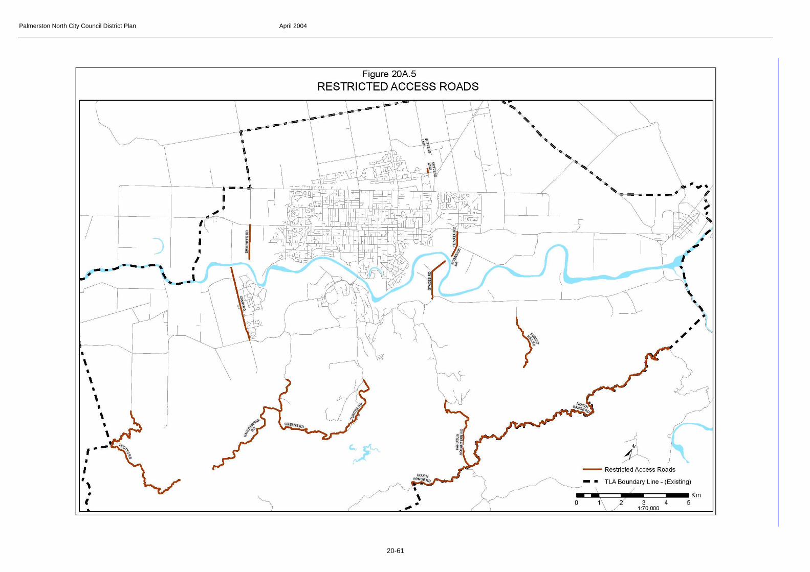
Palmerston North City Council District Plan April 2004
20-61

Palmerston North City Council District Plan April 2004
20-62

Palmerston North City Council District Plan April 2004
20-63
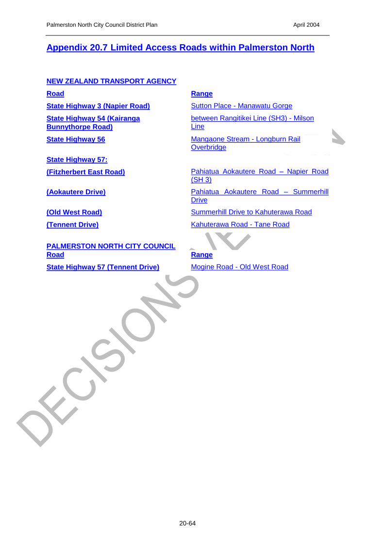
Palmerston North City Council District Plan April 2004
20-64
Appendix 20.7 Limited Access Roads within Palmerston North
NEW ZEALAND TRANSPORT AGENCY
Road Range
State Highway 3 (Napier Road) Sutton Place - Manawatu Gorge
State Highway 54 (Kairanga
Bunnythorpe Road)
between Rangitikei Line (SH3) - Milson Line
State Highway 56 Mangaone Stream - Longburn Rail Overbridge
State Highway 57:
(Fitzherbert East Road)
Pahiatua Aokautere Road – Napier Road (SH 3)
(Aokautere Drive) Pahiatua Aokautere Road – Summerhill Drive
(Old West Road) Summerhill Drive to Kahuterawa Road
(Tennent Drive) Kahuterawa Road - Tane Road
PALMERSTON NORTH CITY COUNCIL Road Range
State Highway 57 (Tennent Drive) Mogine Road - Old West Road

Palmerston North City Council District Plan April 2004
20-65
Appendix 20B – construction criteria for new roads and street description
TYPE CRITERIA MIN
RESERVE
WIDTH*
MIN
CARRIAGEWAY
WIDTH*
MIN
BERM
WIDTH
TYPICAL
DESCRIPTIO
N
Urban and or Rural
>300 EDUC
22m 13m 2 x 4.5 m
Major Arterial or Minor Arterial
Urban
150 – 300 EDUC
20m 11 m 2 x 4.5 m
Major Arterial or Minor Arterial
Rural 18 m 9 m (2 x 3.5 m lanes) (2 x 1.0m shoulders)
2 x 4.5 m
Major Arterial or Minor Arterial
Urban
EDUC of 60 – 150
18 m 9 m 2 x 4.5 m
Minor Arterial or Collector
Rural 16 m 7 m (2 x 3 m lanes) (2 x 0.5m shoulders)
2 x 4.5 m
Minor Arterial or Collector
Urban EDUC of 12 - 60
17 m 8 m 2 x 4.5 m
Local
Urban EDUC of 0 - 12
16 m 7 m 2 x 4.5 m
Local
Rural, Rural Residential, Parklands
EDUC of 0 - 60
14 m 6.2 m (2 x 3 m lanes) (2 x 0.1m shoulders
2 x 3.9 m
Local
Industrial EPE of > 150
22 m 13 m 2 x 4.5 m
Local
Industrial EPE of 0 – 150
17 m 11.5 m 1 x 4.5m and 1 x 1.0 m
Local
*Roads having either a longitudinal gradient steeper than 1:10 or having a
horizontal alignment with any curve less than 100metres radius will be
subject to specific design and will require approval of the Roading Manager
EDUC Estimated Dwelling Units in the Catchment
EPE Estimated Personnel Employed