the appalachian trail in assachusetts · to fulfill the requirements of the “memorandum of...
TRANSCRIPT

LOCAL MANAGEMENT PLAN FOR
THE APPALACHIAN
TRAIL
IN MASSACHUSETTS
PREPARED BY: MEMBERS OF THE MASSACHUSETTS APPALACHIAN
TRAIL MANAGEMENT COMMITTEE OF THE APPALACHIAN MOUNTAIN CLUB BERKSHIRE
CHAPTER and the
MASSACHUSETTS DEPARTMENT OF CONSERVATION AND RECREATION
and the APPALACHIAN TRAIL CONSERVANCY
March 2006

Massachusetts Appalachian Trail Management Plan (March 2006)Introduction—Page 1 of 1
The Appalachian Trail is a way, continuous from Katahdin in Maine to SpringerMountain in Georgia, for travel on foot through the wild, scenic, wooded, pastoral,
and culturally significant lands of the Appalachian Mountains.
PURPOSE OF THE MASSACHUSETTS APPALACHIAN TRAIL MANAGEMENT PLAN
1. To serve, guide and aid the Appalachian Trail (AT) Management Partners:Massachusetts Department of Conservation and Recreation (DCR), National ParkService (NPS), Appalachian Trail Conservancy (ATC), and the AppalachianMountain Club (AMC) Berkshire Chapter by providing a comprehensive andworkable local framework for the management and protection of the AppalachianTrail and its Corridor Lands.
2. To guarantee the role of the Trail volunteer in the management process.
3. To provide continuity and coordination for the present and future management ofthe Trail between the above referenced partners and other agencies andorganizations.
4. To increase public understanding and input into the management of the Trail.
5. To comply with state and federal mandates that specify how the Trail be protectedand managed.
6. To fulfill the requirements of the “Memorandum of Understanding for theAppalachian Trail in Massachusetts”. This document identifies which agency ororganization is responsible for each management component of the AppalachianTrail.
7. To fulfill the local management planning component of the Comprehensive Planfor the Protection, Management, Development and Use of the AppalachianNational Scenic Trail, prepared by the National Park Service AT Project Office.
8. To document the policies and principles of the Committee and to providecontinuity over the years.

Acknowledgements
This document is the result of countless hours of thinking, typing and research byvolunteers serving on the Massachusetts AT Management Committee, both past andpresent.
This update of the Local Management Plan for the Appalachian National ScenicTrail in Massachusetts was reviewed in detail and prepared with the assistance ofCommittee volunteers Jim Pelletier, Steve Smith, and Debra Weisenstein.
A great debt is also due our management partners acting through the persons ofDon Owen and Bob Gray at the National Park Service Appalachian Trail Park Office, JTHorn and Val Stori at the Appalachian Trail Conservancy’s New England RegionalOffice, Ted Weber at the Appalachian Mountain Club, and Becky Barnes at theMassachusetts Department of Conservation and Recreation.
I came to this document as a relative newcomer to the AT Committee. As theprimary editor of this update, I had no previous history with it, and found the document tobe a curious combination of accurate descriptions of the current state of AT managementand desired outcomes of management initiatives that have not yet come to pass.
In discussing this dichotomy with my colleagues on the AT Committee and othermanagement partners, I found some peace with the two seemingly opposing viewpoints.In fact, this combination of successful, hard headed and practical management in someareas and wished for, but not yet implemented outcomes in others truly reflects the natureof AT management. Its outwardly cumbersome, multi-headed and diverse structuremanages to place effective operation of this country’s premiere outdoor recreationalexperience firmly in the hands of citizen volunteers.
With humble thanks to who have gone before and those who will continue,
Cosmo CatalanoAT Management Committee ChairMarch 2006

Massachusetts Appalachian Trail Management Plan (March 2006) Table of Contents—Page 1 of 2
Table of ContentsChapter 1. Introduction and Background
1A. Overview of the Trail1B. The History of Land Protection for the Appalachian Trail in Massachusetts1C. History of the Construction and Maintenance of the Appalachian Trail in Massachusetts
Chapter 2. The Trail Community
2A. Roles and Responsibilities of Trail Management Partners2B. Club Roles
a. AMC (Appalachian Mountain Club)b. Berkshire Chapter of the AMC
2C. DCR (Mass Dept. of Conservation and Recreation, Division of State Parks andRecreation)
2D. ATC (Appalachian Trail Conservancy)2E. NPS, ATPO (National Park Service, Appalachian Trail Park Office)2F. Relationship with Landowners and Communities
Chapter 3. Trail Design Construction and Maintenance
3A. Trail Design3B. Relocation within AT Corridor3C. Maintenance and Construction3D. Overnight Use Facilities, Table 3-1, Overnight Sites3E. Blazes and Signs3F. Parking and Trailhead Facilities, Table 3-23G. Drinking Water Supplies and Water Quality3H. The Side Trail System3I. Bridges and Stream Crossings3J. Backcountry Sanitation3K. Managing the Trail for a Primitive Experience3L Trail Crew Safety and Training3M Chain Saw and Crosscut Saw Use and Certification
Chapter 4. Visitor Management
4A. Search and Rescue4B. Fire Prevention and Suppression4C. Law Enforcement4D. Public Information and Education Programs4E. Fishing/Hunting4F. Liability4G. Group Use4H. Kiosks and Signboards4I. Leave No Trace Education

Massachusetts Appalachian Trail Management Plan (March 2006) Table of Contents—Page 2 of 2
4J. Advertising on Trail Lands4K. Policy on Minimum Impact Backcountry Use4L Non-Hiking Recreational Use of Trail Corridor Lands
Chapter 5. Resource Management
5A. Open Areas and Vistas5B. Timber Management5C. Vegetation, Insect and Disease Control5D. Rare, Threatened or Endangered Species, Natural Heritage Management5E. Wildlife5F. Historic and Cultural Features5G. Agricultural Use5H. Mining and Excavation5I. Summit Development5J. Watershed Lands5K. National Environmental Protection Act (NEPA) Compliance5L. Environmental Monitoring
Chapter 6 Conflicting and Competing Uses
6A. Corridor Boundaries6B. Monitoring the Trail Corridor6C. Special Use Permits6D. Incidentally Acquired Structures6E. Special Events and Large Groups6F. Military Maneuvers6G. Hang Gliding6H. Litter and Vandalism6I. Road Closures and Access Control6J. Off-Road Vehicles6K. Road Crossings and Highway Development6L. Horses and Pack Animals6M. Utilities and Communications Facilities6N. Development on Adjacent Lands and Viewsheds
Chapter 7. Special Management Areas
7A. Upper Goose Pond7B. Sages Ravine7C. Tyringham Cobble
8A. AT Committee Long Range Planning
Appendices

Massachusetts Appalachian Trail Management Plan (March 2006), Chapter 1, Page 1 of 4
CHAPTER 1
INTRODUCTION AND BACKGROUND
1A. OVERVIEW OF THE TRAIL
The Appalachian Trail (AT) in Massachusetts lies in the far western end of the state. Itruns north and south for a distance of about 88 miles, parallel to and about ten miles east of theNew York State border. The location of the Trail is a reflection of the geological forces thatcreated the north-south pattern of mountains and valleys in the Appalachians of which theBerkshires are a small part. In general, the Trail follows the ridgeline wherever possible as ittraverses an upland plateau approximately 2000 ft. in elevation, but descends at several points tocross valleys cut through the plateau by the Hoosic and Housatonic Rivers. The Trail runs mainlythrough wooded country, composed of abandoned farmland or woodlots from which the originaltimber has been harvested. However, a few isolated stands of older forests still remain.
The AT enters the state at the Massachusetts/Vermont border in the north. This is also thesouthern terminus of Vermont's Long Trail. From the state line, at an elevation of about 2300 ft.,the Trail runs south through Clarksburg State Forest and after four miles descends to and crossesthe Hoosic River and Route 2. This crossing of the Hoosic (el 640 ft.) is the lowest point on theTrail in Massachusetts. The Trail then continues south and in about five miles reaches thesummit of Mount Greylock, within the Mount Greylock State Reservation. At 3491 feet, this isthe highest point in the Commonwealth.
Descending Mount Greylock to the south, the trail crosses active farmlands, Route 8 andthe Hoosic River again in Cheshire. From Cheshire, the Trail climbs past a scenic quartziteoutcropping, named the Cheshire Cobbles, to an upland plateau of about 2000 ft. and continuessouth about four miles to Gore Pond. Approximately five miles south of Gore Pond, the Traildrops down into the town of Dalton, travels along High Street, crosses Route 9 and theHousatonic River (el 1000 ft.) and rises again to the upland plateau. The Trail continues at anelevation of about 2000 ft. through lands comprising part of the Pittsfield watershed and intoOctober Mountain State Forest, where it skirts past Finerty Pond.
The Trail then crosses Route 20 and the Massachusetts Turnpike and heads generallysouthwest past Upper Goose Pond then descends to the Tyringham Valley (el 1000 ft.). InTyringham, the Trail runs southwest, crosses Hop Brook, the Trustees of Reservations'Tyringham Cobble, and several agricultural fields, then rises again to about 2000 ft. as ittraverses Beartown State Forest.
The Trail proceeds south, descending to cross the Route 23 valley and the inflow of LakeBuel, then climbs again, past Ice Gulch, to reach a ridge on East Mountain State Forest about 800feet above the valley floor. Seven miles later the Trail descends to the Housatonic Valley,crosses the Housatonic River (el 660 ft.), Route 7 and proceeds west through forest, open fieldsand farmlands for two miles, passing the Shay’s Rebellion Monument. The Trail re-enters thewoods on the west side of South Egremont Road, crosses Route 41 and continues to the west sideof the Housatonic Valley near Jug End.
Massachusetts Appalachian Trail Management Plan (March 2006), Chapter 1, Page 2 of 4
The Trail then rapidly gains 1000 feet in elevation and runs south along the eastern crestof the Taconic Range through Mount Everett State Reservation, traversing Mount Bushnell,Mount Everett and Mount Race. Nine miles south of Jug End, the Trail drops into Sages Ravineand cuts west through the ravine for one half mile. The Trail then turns south into the state ofConnecticut.
While most of the Trail in Massachusetts follows the wooded upland plateau ridges, partsof the section between Jug End and the Massachusetts/Connecticut line, follows open, rockyledges that offer frequent panoramic views. This is one of the most spectacular sections of theAppalachian Trail in Massachusetts.
Although the political border between Massachusetts and Connecticut is slightly south ofSage's Ravine, the Trail Committees of both states have agreed to make the stream crossing inthe Ravine the "management boundary" between the two club's jurisdictions.
Also of note, much of the AT in Massachusetts is located on State property. Roughly 49miles of Trail lie within various state forests, thereby making the Massachusetts Department ofConservation and Recreation an integral management partner. The role of the MassachusettsDepartment of Conservation and Recreation (DCR) and agency partners from the AppalachianMountain Club (AMC), Appalachian Trail Conservancy (ATC) and the National Park Service(NPS) are described in Chapter 2 of this document.
1B. THE HISTORY OF LAND PROTECTION FOR THE APPALACHIAN TRAIL IN MASSACHUSETTS
In 1933, complete as a continuous way in Massachusetts, the trail passed through StateForests and the privately owned land that lay in between. Verbal agreements with privatelandowners were the basis for the Trail crossing on private tracts.
However, between the late 1930s and the late 1960s increasing development on privateland caused the Trail in Massachusetts to be placed in jeopardy. When landowners who hadinitially agreed to allow the Trail on their property sold their land, the new landowners frequentlyrefused to allow the Trail to remain. Requests to relocate the Trail and instances of developmenton or near the Trail route increased. This often resulted in relocating the Trail onto existingroads. By 1968, 21.8 miles (of a then 85.0 mile total) were relocated onto roads.
Congress recognized the need to protect the AT and other trails of national significance inthe United States and in 1968 passed the National Trails System Act. The AT and the PacificCrest Trail were designated as the first National Scenic Trails. The Act authorized federalacquisition of lands for protection of the AT and encouraged states to take the initiative withtheir own acquisition programs.
Massachusetts was the first state to follow federal action by enacting legislation of itsown. This was accomplished in 1969 with the passage of Chapter 627, "An Act to Protect theAppalachian Trail". The legislation directed DCR, the Department of Conservation andRecreation, (then the Department of Natural Resources when the law was enacted, and later theDepartment of Environmental Management) to acquire lands in fee simple, easements,conservation restrictions, or gifts.

Massachusetts Appalachian Trail Management Plan (March 2006), Chapter 1, Page 3 of 4
The DCR was given the responsibility of implementing the State’s land acquisitionprogram to protect the Appalachian Trail. During the next 7 years, DCR acquired 20 parcels andtwo watershed easements. Nationally however, not all states were as agreeable to land protectionefforts as Massachusetts, and in 1976, Congress amended the National Trails System Act byauthorizing the National Park Service (NPS) to become actively involved in protecting andacquiring lands for the AT.
The National Park Service began working cooperatively with DCR on protection of theAT in Massachusetts. In 1977, the Park Service funded a land survey of the Trail, except forthose portions that were then located on state forest lands. The survey established the Trail"center line" and the land ownership patterns for 40 miles of the Trail.
From this plan, it was agreed as to which portions of a protected land corridor for the ATwould be purchased by the State, and which would be purchased by the National Park Service.
Significant progress has been made in State and Park Service efforts to acquire land forthe protective trail corridor. By 1998, DCR and the National Park Service had worked togetherto protect 49 miles of trail in addition to the 31 miles of trail already protected within State parksand forests. The DCR committed $878,000 in State funds for the protection of the Trail. Thisfunding was matched by federal money from the Land and Water Conservation Fund. The ParkService, through April, 1998, expended approximately $12 million for trail protection in theCommonwealth. Protection of the trail is ongoing, with the most recent DCR purchase of landadjacent to the trail in Monterey.
At this time (2006) all but a few hundred feet of Trail lie on land protected by the NPS,DCR or by Right of Way on watershed properties of North Adams and Pittsfield.
Protection of the AT goes beyond the footpath and has resulted in tangible benefits forresidents of the Commonwealth. Some of our most scenic areas in Berkshire County have beenpreserved. For example, most of the parcels surrounding Upper Goose Pond in Lee andTyringham were purchased in the mid1980’s to ensure that this beautiful area will remain in itsnatural state. Other unique areas that have been protected include: Sages Ravine, Mount Race,Jug End, Ice Gulch, Gore Pond, Warner Hill, the Cheshire Cobbles and Sherman Brook.
1C. THE HISTORY OF THE CONSTRUCTION AND MAINTENANCE OF THE APPALACHIAN TRAIL INMASSACHUSETTS
Benton H. MacKaye of Shirley Massachusetts first conceived the idea of the AT in 1921.In 1922 Walter Pritchard Eaton of Sheffield heard of MacKaye's scheme for a long-distance,north-south trail and did some investigation and planning of his own. However, by 1926 bothmen had little to show for their effort. In 1926 the Berkshire Hills Conservancy launched acounty-wide promotional campaign for the trail in Massachusetts, with Walter P. Eaton ofSheffield, Archie K. Sloper of Lanesboro and Franklin L. Couch of Dalton taking responsibilityfor the northern, central and southern sections of the proposed trail. By 1931, with Couch as theleader, most of the trail through Massachusetts had been built through private and state-ownedlands. The volunteers who cut most of the trail were: in the north, members of the Williams
Massachusetts Appalachian Trail Management Plan (March 2006), Chapter 1, Page 4 of 4
Outing Club and Williamstown school principal, John B. Clark; south of Mt. Greylock, ArchieSloper and the Boy Scouts; and in the south, S. Waldo Bailey, a naturalist from Pittsfield, and theBerkshire Chapter of the Appalachian Mountain Club (AMC). After the trail was cut, thefollow-up maintenance was accomplished by many diverse clubs, groups and individuals. TheBerkshire Chapter of the Appalachian Mountain Club first became involved with the Trail in1931. They improved the Trail between 1932 and 1935, but due to lack of communication anddisagreements with the Berkshire Hills contingent, little was accomplished after the initialconstruction.
From 1937 to 1940, the Mt. Greylock Ski Club provided maintenance from Upper GoosePond north to the Vermont state line. In 1938 Max Sauter, an engineer from General Electric inPittsfield, emerged as a one-man trail crew and devoted four decades to maintaining andimproving the Trail. The Metawampe (Massachusetts State College, Faculty Club - now knownas University of Massachusetts at Amherst) was another group that came to the rescue in 1937.This group maintained the central section of the Trail between Tyringham and Washington. TheBerkshire Chapter AMC continued to maintain the southern portion of the trail to theConnecticut state line. (NOTE: The preceding paragraphs are a synopsis of an article entitled"Trail Builders" by Guy and Laura Waterman and published in the Berkshire Week August 1,1986. The material was researched for the Waterman's book, Forest and Crag, A History ofHiking, Trailblazing and Adventure in the Northeast Mountains, published by AMC in 1989.)
Following the amendment of the National Trails System Act in 1978 when federal fundsbecame available for land acquisition, a need developed for better communications betweenvolunteer trail maintaining groups, the DCR Division of State Parks and Recreation, the NationalPark Service, and the Appalachian Trail Conservancy. The need for greater accountability by themaintaining groups for management and maintenance of the Trail was also apparent. The ATCrecommended the consolidation of the three maintaining groups, and in the spring of 1979, theBerkshire Chapter AMC with the concurrence of the other maintaining groups agreed toestablish an Appalachian Trail Management Committee that would have the responsibility formanagement and maintenance of the entire AT in Massachusetts. The agreement was made withthe understanding that the Metawampes and the Mt. Greylock Ski Club could continue to workon their sections as before.
A "MEMORANDUM OF UNDERSTANDING" was signed by ATC. and the ATCommittee of the Berkshire Chapter (A.M.C.) in 1998, that gave the AT Committee of theBerkshire Chapter, official responsibility for volunteer management and maintenance of theAppalachian Trail and Trail corridor lands, in Massachusetts.
In 2003, the Commonwealth of Massachusetts and it’s state agencies, the National ParkService, the Appalachian Trail Conservancy and the Berkshire Chapter of the AppalachianMountain Club entered into a similar agreement outlining the cooperative roles andresponsibilities in the management, maintenance and operation of the Appalachian Trail inMassachusetts. Copies of both MOU are in Appendix A3.

Massachusetts Appalachian Trail Management Plan (March 2006), Chapter 2, Page 1 of 4
CHAPTER 2--THE TRAIL COMMUNITY
2A. ROLES AND RESPONSIBILITIES OF TRAIL MANAGEMENT PARTNERS
Management Principles:
1. Communication is essential between the Appalachian Trail Conservancy (ATC), AppalachianMountain Club (AMC), trail abutters, municipal government, state agencies, federal agencies,and other public groups.
1. The Trail is managed on the local level by the Berkshire Chapter of the Appalachian MountainClub’s AT Management Committee and the Commonwealth of Massachusetts Department ofConservation and Recreation’s Division of State Parks and Recreation. Volunteers will assumeas much responsibility for on-the-ground management of the Trail as they realistically can takeon, in consultation with their management partners (AMC, DCR, ATC and NPS).
The organizations involved in the cooperative management of the Massachusetts AT are describedbelow. Their roles and responsibilities are detailed in the Memorandum of Understanding found in thisdocument as Appendix A3.
2B. CLUB ROLESa. Appalachian Mountain Club (AMC): The AMC is a non-profit volunteer organization
that, for over 100 years, has been committed to providing the public with outdoor recreationopportunities in the Northeast. The AMC--one of the largest active volunteer conservationand recreation organizations in North America--promotes the protection, enjoyment and wiseuse of the mountains, forests, open space and rivers of the Northeast. Trails program staffand hundreds of volunteers are responsible for the construction, maintenance andmanagement of approximately 1400 miles of hiking trails and related backcountry facilitiesthroughout the region. The AMC has 12 regional chapters. The specific chapter concernedwith the AT in Massachusetts is the Berkshire Chapter. The Appalachian Mountain Clubsupports the work of the AT Management Committee, of the Berkshire Chapter
b. The Berkshire Chapter of the Appalachian Mountain Club: The Berkshire Chapter ofthe AMC has been maintaining a section of the AT since the 1930's. In order to increase theeffectiveness of the volunteer maintenance of the Trail, and in recognition of the increasedmanagement responsibilities of the volunteers (resulting from the NPS land protectionprogram), the Berkshire Chapter agreed to coordinate the volunteer management of the entireAT in Massachusetts in April 1979. At that time--with the assistance of the then DEMDivision of Forests and Parks, the Appalachian Mountain Club and the Appalachian TrailConservancy--the Berkshire Chapter took the lead in management of the Trail in the State.
To assist in this effort the Berkshire Chapter’s “AT Management Committee” was created.The AT Management Committee of the Berkshire Chapter has been assigned by the Chapterthe responsibility for all matters pertaining to the AT, including the following activities:
• Management and operation of the Trail in Massachusetts• Trail construction, relocations and maintenance of the footpath and related
facilities

Massachusetts Appalachian Trail Management Plan (March 2006), Chapter 2, Page 2 of 4
• Locating, constructing and maintaining parking and backcountry overnightfacilities including shelters, tentsites and privies
• Maintaining trail signage.• Providing information and education about the AT to trail visitors and the
general public.• Updating the Massachusetts AT Local Management Plan• Corridor Monitoring• AT Volunteer recruitment, training and recognition
The AT Committee has the option to participate in other programmatic areas related toAppalachian Trail management such as:
• Natural heritage monitoring• Environmental monitoring• Corridor boundary maintenance (painting)• Open areas management• Ridgerunning and usage monitoring
Management decisions that affect state owned lands are made cooperatively with the DCRDivision of State Parks and Recreation.
The current composition of the AT Committee of the Berkshire Chapter consists of thefollowing (up to 20) volunteer representatives:
• Committee Chair nominated by the Berkshire Chapter AT Committee and electedby the Berkshire Chapter at its Annual Meeting in November.
• AT Maintenance Coordinators (three)• AT Corridor Monitoring Coordinators (up to three)• Additional voting members (not to exceed 13) may be appointed by the Chairman
and approved by the Committee. These members will include the followingpositions: shelter coordinator, work party/volunteer coordinator, secretary,treasurer, and others as necessary for the effective management of the Trail.
• In addition, one staff representative each from the DCR Division of State Parksand Recreation, the Appalachian Mountain Club and the Appalachian TrailConservancy sit as ex-officio members of the Committee.
The AT Committee meets five times per year, on the first Monday of September, November,January, March, and May. Additional meetings are scheduled on an as needed basis foreffective management of the Trail.
2C. THE DEPARTMENT OF CONSERVATION AND RECREATION DIVISION OF STATE PARKS ANDRECREATION:
The DCR Division of State Parks and Recreation works with the AT ManagementCommittee concerning the location and management of the Trail, and in the development ofthis AT Management Plan. In addition, it assists trail volunteer efforts by supplying expertadvice, materials, tools and transportation. In addition staff support is provided in the formof the Regional Trail Coordinator, and also the DCR AT Ridgerunner Program as sufficientresources allow.

Massachusetts Appalachian Trail Management Plan (March 2006), Chapter 2, Page 3 of 4
The DCR Division of State Parks and Recreation recognizes the importance of the ATCorridor protection program to the state, and has taken a leadership role among other stateagencies in support of the Trail. Approximately 49 of the 88 miles of AT are on state-ownedproperty. Management authority for the AT on state lands ultimately rests with the DCRDivision of State Parks and Recreation, following the principles described in the MOU(Appendix A-3).
2D. THE APPALACHIAN TRAIL CONSERVANCY:The Conservancy is a federation of 30 hiking, outdoor and trail maintaining clubs thatmanage designated sections of the AT. Since 1925, the ATC's sole focus has been theconstruction, maintenance and protection of the Appalachian Trail. Since 1984, it hasexpanded to include the protection and stewardship of Trail Corridor lands. Managementresponsibility for National Park Service lands has been delegated to the ATC by the NPS.The ATC assigns maintenance and management responsibilities for sections of the Trail tothe member clubs, such as the AMC’s Berkshire Chapter.
The Conservancy's primary role is coordination of management along the entire AT. In thiscapacity, it provides technical assistance, in the form of skills workshops and training,funding via grants and cyclical maintenance funds and staff support to the Berkshire Chapterand other volunteer clubs trailwide.
The ATC also acts as a liaison between federal and state agencies, AT clubs, localgovernments and other organizations. The ATC assumes the primary responsibility formaintaining boundary lines of NPS Trail Corridor lands, monitoring natural heritage sites,and environmental monitoring,
2E. THE NATIONAL PARK SERVICE, APPALACHIAN TRAIL PARK OFFICEThe National Trails System Act (PL 90-543) designated the AT as the nation's first NationalScenic Trail, and delegated authority to administer the AT to the Secretary of the Interior.The Secretary in turn has designated responsibility for management of the trail to theNational Park Service (NPS). Within the NPS, the Appalachian Trail Park Office (ATPO) isthe administrative arm responsible for NPS management of the trail. In this ManagementPlan, references to the NPS typically mean the ATPO.
In addition to its primary role in the acquisition of lands for the Appalachian Trail, the ParkService works closely with the ATC to build effective management of the Trail. In theComprehensive Plan for the Appalachian Trail, the Park Service emphasizes the importanceof volunteer management of the Trail through the ATC and the AT clubs in conjunction withstate and federal land managing agencies. The Comprehensive Plan defines a cooperativemanagement system for Trail lands.
The NPS retains law enforcement jurisdiction on National Park Service lands. The NPS isresponsible for boundary surveys and environmental compliance associated with all projectson NPS lands. Local law enforcement agencies will normally act as first responders foremergency safety and law enforcement incidents and assume overall management of thoseincidents.

Massachusetts Appalachian Trail Management Plan (March 2006), Chapter 2, Page 4 of 4
2F. RELATIONSHIP WITH LANDOWNERS AND COMMUNITIES
Background
Relations between landowners and the Appalachian Trail volunteers have generally beenpositive. Historically, it was only through the generosity of private and municipallandowners that the AT passed through their property.
In the process of discussing permanent protection of the AT, landowners identified a numberof concerns about management of the Trail. These concerns are taken seriously by the Trailmanagers and include the following: trespass, vandalism, careless use of fire, littering anddisrespect by Trail users of landowners. Each of these concerns is addressed in later chaptersof this plan.
The protected Trail corridor makes us neighbors to a variety of landowners. As the years goby, development of adjacent areas will increase the numbers of landowners bordering theTrail corridor. The AT Committee will work diligently to maintain and foster cooperationand communication with all trail neighbors.
Management Principles
Landowners, both private and municipal, are considered neighbors. The AT Committee and theDCR will work for the continuation of the cooperative relationships that have been establishedover the years with landowners.
Action Plan1. Landowners, or communities with problems related to the AT are encouraged to contact the
DCR Division of State Parks and Recreation and the AT Committee. Problem resolution willbe a combined effort of the DCR Division of State Parks and Recreation and the ATCommittee. For problems on NPS lands, the AT Committee and NPS and ATC will work toresolve any problems.
2. The AT Committee will organize a land management program that uses volunteers tomonitor the conditions of the Trail corridor lands for both state and federal properties (seeCorridor Monitoring, Chapter 6B). AT Committee Corridor Monitors and Coordinators willbe the lead contacts for neighbors abutting NPS-owned lands.
3. The AT Committee will periodically contact, by letter, the governing officials of the townsthrough which the AT passes, in order to maintain good communications.

Massachusetts Appalachian Trail Management Plan (March 2006)--Chapter 3, Page 1 of 14
CHAPTER 3--TRAIL DESIGN, CONSTRUCTION AND MAINTENANCE
3A. TRAIL DESIGN
Design Principle
The Trail should be a narrow, rustic footpath that considers hikers' safety while still providing anopportunity for challenge and solitude. The Trail should be located, built and maintained tominimize resource degradation. Unnecessary construction should be avoided.
Action Plan
1. The Trail shall be designed, located, constructed and maintained in accordance with generalstandards set by the ATC Stewardship Manual, “Appalachian Trail Design, Construction andMaintenance” by Birchard and Proudman, with consideration for local and state practices.
2. The Trail shall be located in a manner that minimizes conflicts with adjacent landowners.
3. The Trail design and location should minimize the impact of hikers and should seek toprevent the degradation of the areas through which the Trail passes. Special attention will bepaid to the location and design of the Trail on steep slopes, riparian zones, shorelines, sub-alpine and bog areas, areas with significant natural or cultural resources and other fragileenvironments.
4. The Trail design will provide a reasonably safe, but not necessarily easy hiking experience;i.e. a steep trail will not be relocated to easier terrain unless resource damage is present.
5. Trail location and design should seek to minimize future management problems.
6. All Trail locations on state lands will be decided upon jointly by the DCR Division of StateParks and Recreation and the AT Management Committee.
3B. RELOCATION WITHIN THE AT CORRIDOR
Management Principles
1. Trail relocations should be used to minimize and eliminate road walks, as solutions for hikersafety, to reduce resource degradation, to minimize future management problems, to bypassflooded area and to improve the hiking experience.
2. Trail relocations should not diminish, nor detract from, the primitive quality of the Trail.Relocations should be equal to, or better than--in terms of treadway and visitor experience--theexisting location. Relocations should not be justified on a basis of abandoning the existingproblem and creating a similar one in a different location. Care should be taken to remediate andclose the former footpath where relocation is necessary due to resource degradation and toprevent continued use.

Massachusetts Appalachian Trail Management Plan (March 2006)--Chapter 3, Page 2 of 14
Action Plan
1. All Trail relocations on state owned land will be decided upon jointly by the DCR Division ofState Parks and Recreation and the AT Committee.
2. Confirm that a relocation is needed for permanent improvement in the footpath, to improve hikersafety, protect the natural resource or provide a permanent solution to an ongoing maintenance ormanagement problem.
3. Verify that sufficient land or interest in land has been acquired for public access and verifyboundaries on public land involved in the relocation via survey maps and field visits.
4. The proposed relocation will be scouted and flagged by an experienced trail volunteer and AMCand/or DCR staff. ATC will be notified and asked to comment on any significant trailrelocations.
5. State and federal regulations (including the National Environmental Policy Act) will be metwhen applicable. This shall include all relocations on NPS lands, including relocations throughany areas having sensitive habitats such as wetlands, areas containing inventoried Rare,Threatened or Endangered Species, or when significant ground disturbance is contemplated.Sites of cultural or historical interest shall also be considered when planning relocations.
6. Determine if the local maintainer is experienced enough and willing to undertake the neededconstruction, or if AT Committee help is needed. Coordinate work on major relocations that willinvolve resources from outside the Committee.
7. Consider the following related Trail issues: location of overnight facilities, parking, trailheads,water sources and side trails.
8. DCR Division of State Parks and Recreation and/or the AT Committee will notify local firedepartments and police of any major trail relocation. (See Chapter 4).
9. The Committee will identify and prioritize planned relocations as part of the Trail Assessment orfive-year plan.
10. The Committee will map major relocations or advise ATC of a relocation requiring mapping.
3C. MAINTENANCE AND CONSTRUCTION
Management Principles
1. The AT Committee is the principal agent in maintaining and managing the Trail inMassachusetts and can elicit assistance from agency partners and management partners asneeded.
2. Maintenance responsibility is delegated by the AMC Berkshire Chapter to the AT Committee.

Massachusetts Appalachian Trail Management Plan (March 2006)--Chapter 3, Page 3 of 14
3. Maintenance and construction will be performed in accordance with the standards set forth in theATC stewardship manual, “Appalachian Trail Design, Construction and Maintenance”. Localmodifications in these standards must be approved by the AT Committee and the DCR Divisionof State Parks and Recreation.
4. Care shall be taken to identify NPS-inventoried Rare, Threatened or Endangered plant andanimal species near the treadway. Maintainers and construction project leaders will follow ATCrecommendations to protect any such species at or near the work area.
Action Plan
1. Inspection of the condition of the Trail is the responsibility of the AT Committee, and will beperformed at regular intervals.
2. The AT Committee organizes the selection and training of volunteer maintainers for each sectionof trail. Maintainers are responsible for maintaining clear blazes, removing litter, keeping thepathway clear, housekeeping of overnight sites, clearing drainage structures of debris and minortrail hardening.
3. Maintainers are further responsible for identifying and reporting to their Coordinator anyproblems or recommendations that are beyond their abilities to carry out. MaintainerCoordinators and the AT Committee will use this information to establish a schedule of workparties each season to complete major footpath projects. (See Chapter 8, AT Committee ActionPlans.)
3D. OVERNIGHT USE FACILITIES
Management Principles
1. Shelters and designated campsites shall be located at approximately one-day hiking intervals andsituated for minimum environmental impact, as well as to discourage abuse, vandalism andlittering.
2. Camping is allowed only in designated shelters and camping areas.
3. Siting for overnight facilities will be decided upon by the AT Committee, and managementpartners.
4. All overnight sites will be located and constructed in accordance with the guidelines outlined inthe ATC “Checklist for the Location, Design and Construction of Shelters and Campsites”,“Backcountry Facilities: Design and Maintenance”, by Leonard, Spencer and Plumley, and otherauthoritative resources. All backcountry overnight facilities will be in compliance withappropriate local, state and federal regulations.

Massachusetts Appalachian Trail Management Plan (March 2006)--Chapter 3, Page 4 of 14
5. Fires will be permitted only at designated areas (fire rings); only fallen wood will be permittedfor fires. Backpacking stoves are preferred. Fires are not permitted at the following locations:Laurel Ridge Campsite. When necessary, due to drought, disease, resource damage or otherenvironmental or public safety factors, fires may be prohibited at any or all overnight sites andon Trail Corridor lands by the AT Committee with approval of DCR and/or NPS.
6. The length of stay at an overnight location is limited to two consecutive nights.
7. All shelters and designated campsites will have privies. See 3(J) Sanitation
8. Shelters should be located as far as practical from points of vehicular access, the Trail footpath,and at least 200 feet from streams, ponds, lakes and corridor boundaries.
9. Shelters will be constructed using wood as the predominant building material. Efforts will bemade to blend the structure into the surrounding environment.
10. Shelters should be sited so as to minimize resource damage by concentrating environmental andsocial impacts of overnight visitors
11. Registers will be maintained at all shelters and designated campsites. Appropriate signage willdirect visitors to water sources and privies.
12. Initial proposals for new shelters or campsites must be addressed to the AT Committee.Proposals for new facilities on National Park Service lands must be reviewed by the NPS ATPark Office and ATC for need and compliance with the National Environmental Protection Act.Proposals for shelters or campsites on state land will be similarly reviewed by the DCR Divisionof State Parks and Recreation.
13. All designated overnight use areas will be shown on maps in Appendix A-1.
Action Plan
1. The AT Committee will assign a coordinator to be responsible for overall maintenance ofshelters and designated camping areas. The Coordinator will seek volunteer shelter adopters toassist in the upkeep and maintenance of overnight facilities.
2. Facilities will be inspected semi-annually by trail maintainers or shelter adopters.
3. Trail maintainers or shelter adopters will visually inspect trees at overnight use areas and arrangefor removal of any visibly diseased, dead or dying trees (hazard trees) within 75 feet ofdesignated overnight sites. The AT Committee and the DCR Division of State Parks andRecreation will assist in the removal of hazard trees upon request.
Massachusetts Appalachian Trail Management Plan (March 2006)--Chapter 3, Page 5 of 14
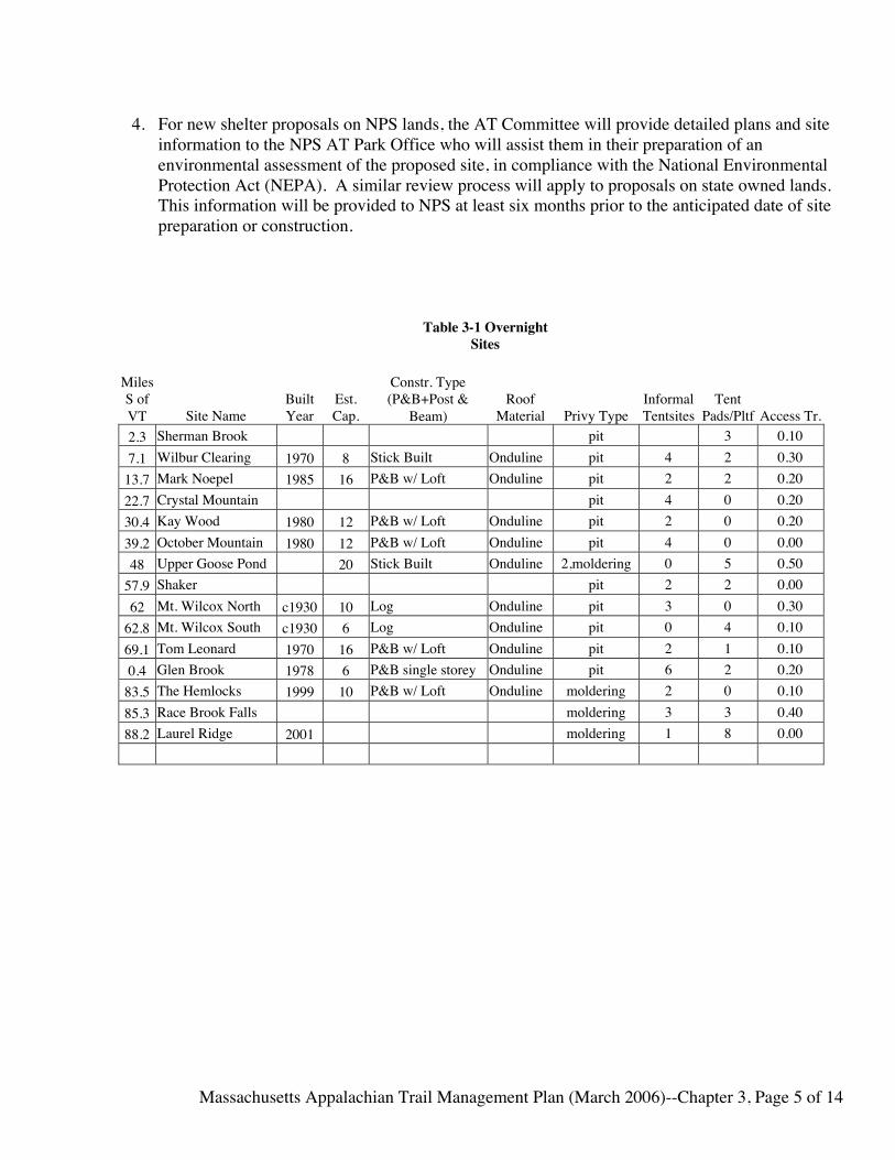
4. For new shelter proposals on NPS lands, the AT Committee will provide detailed plans and siteinformation to the NPS AT Park Office who will assist them in their preparation of anenvironmental assessment of the proposed site, in compliance with the National EnvironmentalProtection Act (NEPA). A similar review process will apply to proposals on state owned lands.This information will be provided to NPS at least six months prior to the anticipated date of sitepreparation or construction.
Table 3-1 OvernightSites
MilesS ofVT Site Name
BuiltYear
Est.Cap.
Constr. Type(P&B+Post &
Beam)Roof
Material Privy TypeInformalTentsites
TentPads/Pltf Access Tr.
2.3 Sherman Brook pit 3 0.107.1 Wilbur Clearing 1970 8 Stick Built Onduline pit 4 2 0.30
13.7 Mark Noepel 1985 16 P&B w/ Loft Onduline pit 2 2 0.2022.7 Crystal Mountain pit 4 0 0.2030.4 Kay Wood 1980 12 P&B w/ Loft Onduline pit 2 0 0.2039.2 October Mountain 1980 12 P&B w/ Loft Onduline pit 4 0 0.0048 Upper Goose Pond 20 Stick Built Onduline 2,moldering 0 5 0.50
57.9 Shaker pit 2 2 0.0062 Mt. Wilcox North c1930 10 Log Onduline pit 3 0 0.30
62.8 Mt. Wilcox South c1930 6 Log Onduline pit 0 4 0.1069.1 Tom Leonard 1970 16 P&B w/ Loft Onduline pit 2 1 0.100.4 Glen Brook 1978 6 P&B single storey Onduline pit 6 2 0.20
83.5 The Hemlocks 1999 10 P&B w/ Loft Onduline moldering 2 0 0.1085.3 Race Brook Falls moldering 3 3 0.4088.2 Laurel Ridge 2001 moldering 1 8 0.00

Massachusetts Appalachian Trail Management Plan (March 2006)--Chapter 3, Page 6 of 14
3E. BLAZES AND SIGNS
Management Principles
1. Blazes and signs will be kept to a minimum, consistent with prudent land management and hikersafety, to retain the primitive character of the Trail. Signs and blazes are meant to direct hikersonto the footpath, protect the natural resources of the Trail environs, educate hikers aboutappropriate backcountry use, inform hikers about site-specific regulations, direct hikers toshelters, campsites and side trails, and provide emergency information.
Action Plan
1. The AT Management Committee, and it’s trail adopters in cooperation with DCR will beresponsible for the ongoing upkeep and maintenance of signs along the AT.
2. The Trail will be blazed according to ATC standards with a vertical 2" X 6" crisply painted whiteblaze. Cairns or posts will be used in treeless areas in addition to blazing.
3. Side foot-trails for access to the AT, alternate routes that may be used during bad weather, andtrails to off-trail overnight sites will be identified by 2” x 6” vertical blue blazes.
4. Offset double blazes will be used to signify direction changes.
5. Regulatory signs will be developed cooperatively with the land-managing agency partners (DCRand NPS), and will be posted and maintained by the AT Committee.
6. Access information signs shall be located where parking is provided.
7. Signage will be kept to a minimum.
8. Signs will be provided at shelters, designated campsites, trail junctions, trailhead kiosks and fordirection to other areas that are not directly visible from the footpath.
9. Permanent AT signs will be brown-stained with white routed letters. Signs for temporary usesuch as relocations, logging operations, and wildlife activity may be of a variety of materials, andwill be removed promptly when no longer needed.
10. The content and format for state highway crossing signs will be coordinated with theMassachusetts Highway Department.
11. Leave No Trace© or similar signs will be installed at parking areas and shelters.
12. Official NPS Appalachian National Scenic Trail signs (“pregnant triangles”) will be posted ontown roads at trail crossings.
13. All other signs not approved or maintained by the AT Committee shall be removed promptly.

Massachusetts Appalachian Trail Management Plan (March 2006)--Chapter 3, Page 7 of 14
3F. PARKING AND TRAILHEAD FACILITIES
Management Principle
Adequate parking is a necessity for use of the AT. Designated parking areas can control how muchuse the trail receives, and provides the first chance to educate trail visitors via kiosk signage.Parking areas should provide a safe location to leave a vehicle and should be monitored for litter andvandalism regularly.
Action Plan
1. Use of approved private and municipal parking areas will be encouraged before consideration isgiven to construction of new areas.
2. Parking will be provided at designated trailheads and access trails. Responsibility forconstruction will be determined jointly on a case by case basis by the AT Committee and theDCR Division of State Parks and Recreation.
3. Planning for parking facilities should include appropriate federal, state and local agencies.Before any new parking areas are developed, careful study should be made of the actual spaceneeded, safety requirements, town, state, and trail neighbor concerns and impacts on the trail andnearby overnight facilities. State and federal environmental policies and regulations shall befollowed.
4. The size of parking areas will be kept to the minimum necessary for adequate parking inaccordance with the character of the Trail.
5. A list of parking areas and trailheads is provided in Table 3-2, below.
6. Parking areas will be identified by appropriate signs.
7. The AT Committee will work with local agencies to provide law enforcement and litter removalat trailhead parking.
8. Parking area locations shall be forwarded to entities publishing trail guides.
9. Where practical, sign boards (kiosks) shall be erected in or near parking areas to provide trailvisitors with information on appropriate use, facts about the nearby section of trail, andemergency contact information. A standard set of signs for trailhead parking kiosks will bedeveloped.
10. Parking areas should be visible from the main road so as to discourage vandalism.
11. Along busy roads, highway safety engineers should be contacted for designing and approvingproposed parking.

Massachusetts Appalachian Trail Management Plan (March 2006)--Chapter 3, Page 8 of 14
12. On NPS lands, the Appalachian Trail Park Office will be contacted to conduct an environmentalassessment prior to construction of new parking areas. A similar process will be initiated forprojects on state-owned lands
Table 3-2 Parking Areas
Location, DistFr. AT, TrailEast/West
Dist, VTLine Description
Est.Cap. Day/Overnnight
Ownership Notes
Mass Avenue 3.8 Side of Street 2 Day Public Rt 2,100YdsEast 4.1
GreylockComm. Club 8
Overnight/LongTerm Private Obtain Permission
Pattison Rd 5 Gravel Lot 5 Day Public Notch Rd.,300yds W 7.2 Gravel Lot 10 Day
DCR, Mt.Greylock
Mt. GreylockSummit 10.4 Paved 75 Day/Overnight
DCR, Mt.Greylock $2 Fee
Notch Rd. 50yds E 10.9 Gravel 6 Day
DCR, Mt.Greylock
Rockwell Rd,20yds E 11.1 Gravel 4 Day
DCR, Mt.Greylock
Rt. 8, Cheshire 18.1 Grass 2 Day NPS RailRoad St.,Cheshire 18.6 Paved 50 Day
DCR, RailTrail
Gulf Rd.,Dalton 26.4 Gravel, Kiosk 5 Day/Overnight Public Not Rec. for Overnight UseGrange HallRd, Dalton 30.1
WideShoulder 2 Day Public
Blotz Rd. 33.8 Gravel 3 Day/Overnight Public Not Rec. for Overnight UsePittsfield Rd.(WashingtonMtn Rd) 37 Gravel 6 Day/Overnight Public Not Rec. for Overnight UseWest BranchRd. 38.5 Dirt. Shoulder 2 Day
DCR, OctMtn SF
County Rd. 41 Dirt 2 DayDCR, OctMtn SF
Rt 20, 200ydsW 46.4 Gravel 6 Day/Overnight
MassHighway
Goose PondRd. 50yds East 48.8 Gravel 4 Day/Overnight
NPSProperty
TyringhamMain Rd.,50yd W 55 Grass 2 Day Public

Massachusetts Appalachian Trail Management Plan (March 2006)--Chapter 3, Page 9 of 14
TyringhamCobble,Jerusalem Rd.,200yds West 56.1 Gravel 8 Day
Trustees ofReservations
Beartown MtnRd. 20yd W 61.4 Dirt. Shoulder 3 Day/Overnight
DCR,BeartownSF Not Rec. for Overnight Use
Benedict Pond,0.5m W 65.1 Gravel 50 Day/Overnight
DCR,BeartownSF $2 Fee
Mass Rt 23 67.1 Dirt, Kiosk 6 Day/Overnight
DCR,BeartownSF
Lake Buel Rd. 68 Gravel, Kiosk 5 Day/OvernightNPSProperty
Homes Rd. 72.6 Dirt. Shoulder 2 Day Public SouthEgremeont Rd 77.3 Gravel, Kiosk 4 Day/Overnight
NPSProperty
Jug End Rd.(Curtiss Rd.) 80 Dirt. Shoulder 2 Day Mt EverettAccess Rd. 83.9 Gravel 6 Day/Overnight
DCR, MtEverett Access Rd. currently closed
Rt 41, RaceBrook FallsTr., 1.0m East 85.3 Paved, Kiosk 6 Day/Overnight
DCR, JugEnd
Rt 41,Undermountain Tr. 1.5m East 91.8
Gravel,Connecticut 8 Day/Overnight
CT TrailsCommittee

Massachusetts Appalachian Trail Management Plan (March 2006)--Chapter 3, Page 10 of 14
3G DRINKING WATER SUPPLIES AND WATER QUALITY
Management Principle
The AT Committee will make an effort to protect the quality of water along the Trail and onCorridor lands, but will not guarantee the potable quality of any backcountry water supplies alongthe footpath. Providing for safe drinking water is the responsibility of the individual hiker. The ATCommittee recommends appropriate treatment of drinking water from all backcountry sources.
Action Plan
1. Signs at publicized water sources shall read "water" only, not "drinking water" or other similartext.
2. Brochures and informational signs will indicate that purity of water is not guaranteed, and that allwater from natural sources along the Trail should be boiled, filtered, or chemically treated beforeuse.
3. Water sources that are identified will normally be maintained by the AT Committee in anundeveloped condition. Some may be improved minimally by construction of a catch basin orspring box to improve the collection of water. Any major improvements will comply with thepolicies of the appropriate land managing agency.
4. Campsites, shelters and privies shall be located at least 200’ from water sources.
3H. THE SIDE TRAIL SYSTEM See Appendix A-5(a)
Management Principles
Hiking side trails provide important access to the AT and alternative hiking areas. Hiking trails onpublic lands that intersect the AT shall be blazed with blue markers or paint blazes. Side trails alsoinclude specific alternate “bad weather” routes that may be more easily traveled in some weatherconditions than the official white blazed footpath.
Action Plan
1. The AT Committee and the DCR Division of State Parks and Recreation will maintain a list ofhiking side trails to the AT to be appended in this Management Plan. See Appendix 5(a).
2. The AT Committee and the DCR Division of State Parks and Recreation will review the status ofeach side trail as to its physical condition and public access. Where the physical condition meritsimprovement, the AT Committee may take appropriate action, with landowner's permission.Volunteers or DCR Division of State Parks and Recreation adopt-a-trail workers may beassigned to maintain these side trails.

Massachusetts Appalachian Trail Management Plan (March 2006)--Chapter 3, Page 11 of 14
3. Proposals for new side trails will be reviewed by the AT Committee, DCR/NPS and evaluatedusing the same standard as Chapter 3, sections A and B.
4. Unauthorized side trails on State or NPS lands will be closed.
5. Proposals to close existing side trails will be reviewed by the AT Committee and the appropriateagency partners.
6. All side trails (including multi use trails that cross the AT) will be inventoried.
7. The Committee will work to close or relocate existing side trails that negatively impact thehiking experience or natural resources within the trail corridor.
3I. BRIDGES AND STREAM CROSSINGS
Management Principles
1. A simple, well-designed ford or a few step stones suffice for most stream crossings during all ormost of the year, except after heavy rains or spring runoff. Others cannot be safely crossedwithout bridging. Bridges are, however, expensive and need frequent maintenance. Bridgesmay be installed to improve hiker safety, enhance the hiking experience, or protectenvironmentally fragile or sensitive areas from impacts from hikers.
2. It should be recognized that not all stream crossings require bridges. Hikers should exerciseappropriate care and judgment and are responsible for their own safety. Un-bridged crossingsmay not be passable at all water levels.
3. New bridges must meet ATPO and ATC standards of design, construction and inspection.
4. Prior to the construction of new bridges on NPS lands, compliance with the NationalEnvironmental Protection Act (NEPA) is required.
Action Plan
1. Due to the high cost of installation and maintenance, and the emphasis in maintaining natural,primitive surroundings, bridges will be kept to a minimum. When possible, considering thenature of the stream crossing, stream flow characteristics and use of the Trail section, naturalfords are the preferred type of crossing.
2. When bridges are needed, they will be of the minimum standard necessary and as aesthetic andunobtrusive as possible while being safe and durable under normal conditions.
3. On National Park Service (NPS) lands, bridges 35' or longer shall be reviewed and approved andinspected by a qualified civil engineer, at the time of installation or replacement. OnMassachusetts State lands, all bridges 20' or longer shall be approved by the Department ofConservation and Recreation (DCR) Division of Parks and Recreation at the time of installationor replacement. (The Appalachian Trail Conservancy (ATC) is able to provide maintaining

Massachusetts Appalachian Trail Management Plan (March 2006)--Chapter 3, Page 12 of 14
clubs with approved Bridge Designs as well as technical information) Bridges will be inspectedannually by the maintainer, with repairs or replacement made as necessary.
3J. BACKCOUNTRY SANITATION
Management Principles
Facilities for the safe disposal of human waste will be provided at every overnight facility, andmaintained in working order.
They will be maintained by volunteers from the AT Committee or DCR staff as necessary.
Where possible, privies will be of the “mouldering” or “composting” variety described in the ATC“Back Country Sanitation Manual”.
Action Plan1. Privies will be inspected regularly for soundness and their future capacity estimated.
2. Privies will be moved and/or maintained as necessary to prevent overfilling.
3K. MANAGING THE TRAIL FOR A PRIMITIVE EXPERIENCE (See ATC Policy Appendix 7(d))
Management Principles
The Massachusetts AT Committee should take into account the effects of Trail management andmaintenance programs and policies on the primitive and natural qualities of the Appalachian Trailand the primitive recreational experience the Trail is intended to provide. Although these guidelinesare intended to apply primarily to the effects of actions or programs on predominantly natural, wild,and remote environments along the Trail, they may apply to certain pastoral, cultural, and rurallandscapes as well. Even in sections of the Trail that do not pass through remote or primitivelandscapes, care should be taken not to inadvertently overdevelop or improve the Trail tread orfacilities in these environments.
Trail improvements, including shelters, privies, bridges, and other facilities, should be constructedonly when appropriate to protect the resource or provide a minimum level of public safety. Designand construction of these facilities should reflect an awareness of, and harmony with the Trail'sprimitive qualities. Materials and design features should emphasize simplicity and not detract fromthe predominant sense of a natural, primitive environment.
The Trail treadway, when constructed, reconstructed, or relocated, should wear lightly on the landand be built primarily to provide greater protection for the Trail footpath or Trail resource values.Trail-management publications should include appropriate references to the potential effects ofTrail-management activities on the primitive qualities of the Trail.

Massachusetts Appalachian Trail Management Plan (March 2006)--Chapter 3, Page 13 of 14
In developing programs to maintain open areas, improve water sources, provide sanitation, removestructures, and construct bridges, signs, trailheads, and other facilities, Trail managers shouldconsider whether a proposed action or program will have an adverse effect on the primitive qualitiesof the Trail, and, if such effects are identified, whether the action or program is appropriate.
Action Plan
1. The AT Committee will take appropriate measures to protect the primitive quality of the Trail.
2. Trail improvements, both treadway and structural, will be constructed only when appropriate,and will be done in a simple and unobtrusive way. Criteria for improvements will be based onnatural resource management decisions and public safety.
3. Shelters and privies will be simple by design and will be built to best protect the resource.
4. Care will be taken to maintain a certain level of solitude and challenge for the hiker.
5. The Committee will evaluate all AT projects considering these questions:• Is this project necessary?• Does it protect the AT Corridor?• Is it in harmony with the natural environment?• Can it be accomplished in a less obtrusive manner?• Is this a long-term solution to the initial problem?• Is the resource being damaged under the current condition?• Will the primitive backcountry be degraded?
3L. TRAIL CREW SAFETY AND SKILLS TRAINING
Management Principles
AT Committee field project leaders will make the safety of themselves, crew members and thehiking public their first priority.
Action Plan
1. All field work projects will have a leader
2. Field project leaders will have the necessary training and experience to lead a group on routinetrail projects. The AT Committee will provide for training or outside leaders for projectsrequiring skills not held by the Committee. For example: high line rock transport, chain saw use.
3. The AT Committee in conjunction with agency partners will provide opportunities for field worktraining sessions or workshops conducted by qualified persons on a regular basis.
4. Persons performing field work will follow all applicable State and Federal safety regulations.Chain saw work will be performed by, or under the direct field supervision of, a sawyer holdingcurrent ATC certification of Class B or higher (See Section M below).

Massachusetts Appalachian Trail Management Plan (March 2006)--Chapter 3, Page 14 of 14
5. All project leaders must meet Leadership Guidelines as adopted by the AT Committee (SeeAppendix 8(a)).
6. Injuries from field work must be reported to ATC/NPS within 24 hours using forms provided byATPO.
7. Injury claim forms will be distributed to all maintainers, corridor monitors and work projectleaders.
3M. CHAINSAW AND CROSSCUT SAW USE AND CERTIFICATION (SEE APPENDIX 7G)
Management Principles
1. Appalachian Trail workers have primary responsibility for their own personal safety and forcompliance with the requirements for chain-saw and crosscut-saw operators. This includes validFirst Aid/CPR certification and USFS/OSHA approved personal protective gear.
2. Appropriate training and safety equipment will be provided for volunteers engaging in trailmaintenance or other work projects requiring the use of chain saws or cross cut saws.
Action Plan1. The AT Committee requires all persons performing field work with chainsaws and crosscut saws
on AT lands or related projects to hold a Class B or better ATC certification, or be under thesupervision of a B-certified or higher, qualified instructor. NOTE: for volunteers to be coveredby VIP, they must have this certification for working anywhere on the AT regardless of landownership.
2. With the assistance of the ATC, the AT Committee will seek to provide opportunities, and whenpossible, funding for volunteers to attend certification classes in the region.
3. The AT Committee will not require volunteer trail maintainers to hold sawyer certification toperform their routine duties. The Committee will support and make available a sufficientnumber of Class B (or higher) certified volunteer sawyers to address trail maintenance tasks thatrequire chain saw or cross cut saw use.
4. DCR, to the extent of its available resources, will make available State-trained sawyers for largeor complex tree felling and/or removal problems as requested by the AT Committee.

Massachusetts Appalachian Trail Local Management Plan (March 2006)--Chapter 4, Page 1 of 10
CHAPTER 4—VISITOR MANAGEMENT
Overview
1. Use of the trail and trail facilities will be managed with the primary objective of preserving theprimitive nature of the trail experience and the sense of solitary communion with nature. Wherethese principals have been eroded, actions will be taken to restore them.
2. Use of the trail and trail facilities will also be managed with the objective of preserving the trail’snatural and cultural resources.
3. Areas with heavy use or significant group use will be closely monitored, and measures will betaken to minimize--or where necessary to reduce—impacts from high use to acceptable levels.
4. Data will be gathered on trail and trail facility use from Registers, data collected by RidgeRunners and other available sources. Periodically, the data will be analyzed and presented to theCommittee.
4A. SEARCH AND RESCUE
Management Principles
1. In Massachusetts, Search and Rescue is the mandated responsibility of the Massachusetts StatePolice. The DCR Division of State Parks and Recreation and the National Park Service are to benotified as soon as possible by the State Police regarding any search and rescue operations on ATLands.
2. Limited manpower for Search and Rescue is available from the DCR Division of State Parks andRecreation, local emergency response aid and other sources known to the Berkshire CountyCommunications Center.
3. Although having no legal authority or responsibility for Search and Rescue, AT Committeevolunteers with specific information about sections of the AT and AT Lands may be available toassist in search and rescue efforts.
Action Plan
1. Topographic maps with Trail locations and emergency access routes can be provided to theMassachusetts State Police and the Division of Law Enforcement by the AT Committee and theDCR Division of State Parks and Recreation.
2. The AT Committee will assist whenever possible in the search and rescue procedures developedby the Massachusetts State Police, Division of Law Enforcement, and DCR Division of StateParks and Recreation. (A list of contacts is provided in Appendix A2 and A4).
3. Emergency phone numbers for appropriate AT management agencies are provided in Appendix4. (Appalachian Trail Conservancy Directory).

Massachusetts Appalachian Trail Local Management Plan (March 2006)--Chapter 4, Page 2 of 10
4. The Committee will notify ATC and ATPO of any known emergencies and incidents on the Trailand corridor lands within 24 hours.
4B. FIRE PREVENTION AND SUPPRESSION
Management Principles
1. The local and/or state fire chief or warden has jurisdiction over all lands within his/hermunicipality, including State property and NPS lands.
2. The NPS has completed a fire management plan (FMP) for the lands administered by the NPS inMassachusetts. The plan is a suppression only plan, meaning that any fires on NPS-AT lands,whether ignited by humans or weather, will be put out. Working with state and local wildlandfirefighting resources, the NPS will encourage responders to use minimum impact suppressiontechniques (MIST) and to consult with the NPS to reduce impacts to cultural and naturalresources to the greatest degree possible. A letter from the Appalachian Trail Park Officeexplaining implementation of the FMP is included in Appendix 5(g).
Action Plan
1. Topographic maps with the location of the Trail and Corridor lands will be provided to local firechiefs by the DCR Division of State Parks and Recreation and/or the AT Committee.
2. Use of camp stoves instead of campfires will be encouraged through on-going educationalprograms.
3. The DCR Division of State Parks and Recreation has developed plans addressing rules andregulations for the use of fires on the AT corridor, CMR 15.15 (Appendix 5(e)).
4. The AT Committee has no legal responsibility to respond to fire emergencies. However, theCommittee will work with ATC, ATPO, DCR, and other state and local agencies to prepareemergency plans, and is willing to supply information to the responding agencies in fireemergencies.
5. Through signage and contacts with Ridge Runners and trail volunteers, the Committee willimpart information to Trail visitors on the safe and appropriate use of campfires at designatedovernight sites.
4C. LAW ENFORCEMENT
Management Principles
1. The NPS corridor in Massachusetts is considered as "proprietary jurisdiction". The federalgovernment has limited jurisdiction and the state government has superior jurisdiction in almostall criminal matters. The NPS relies heavily on state and local officials to enforce state and local

Massachusetts Appalachian Trail Local Management Plan (March 2006)--Chapter 4, Page 3 of 10
laws on NPS property. These agencies include state and local police, the Division of LawEnforcement and Division of State Parks and Recreation (DCR Park Rangers). Enforcement oflaws affecting private individuals and personal property on all trail corridor lands is primarily theresponsibility of the Massachusetts State Police and local law enforcement agencies. Prosecutionand investigation of misdemeanor criminal activity on NPS lands is the responsibility of NPS incooperation with State and local agencies.
2. DCR Park Rangers are personnel of the Division of State Parks and Recreation who have beentrained specifically to enforce Division rules and regulations. They cannot be considered asordinary police because their jurisdiction is limited by statute.
3. State and local law enforcement agencies have the primary responsibility for responding to andprosecuting crimes that occur on the AT or directly affect its hikers. ATC, AMC and the ATCommittee will cooperate in facilitating responses, but have no legal authority.
4. Hikers are encouraged to report incidents that threaten their security to local law enforcementagencies, recognizing that hikers themselves are ultimately are responsible for their own safetyand comfort.
5. NPS Rangers may legally enforce Federal regulations on NPS lands.
Action Plan
1. The AT Committee will work with the NPS and DCR Division of State Parks and Recreation toinitiate and continue meetings with the various agencies to discuss coordination of lawenforcement responses on the Appalachian Trail.
2. Clauses C and F in the 2003 Memorandum of Understanding (See Appendix 3) define theenforcement roles of the Massachusetts Department of Fisheries, Wildlife and EnvironmentalLaw and the Massachusetts Department of State Police. The AT Committee, through DCR willupdate these management partners regarding changes in the trail and it’s facilities on an annualbasis
4D. PUBLIC INFORMATION AND EDUCATION PROGRAMS
Management Principle
Education is the preferred tool for management of the trail and, whenever possible should precedeenforcement. Education efforts inform the public on how to travel safely on the Trail, and how touse the Trail without damaging natural and cultural resources. The main goal of this effort is toincrease awareness of the AT as a national public resource, and teach low impact use of the Trail andthe surrounding resource. The Committee recognizes the need to educate local communities aboutthe AT to encourage proper use of the Trail and to generate enthusiasm and local support for theTrail.

Massachusetts Appalachian Trail Local Management Plan (March 2006)--Chapter 4, Page 4 of 10
Action Plan
1. The Committee will educate the public for the need to minimize their impact on natural andcultural resources along the trail through publications, press releases, field programs, publicoutreach, Ridgerunners, public presentations, etc.
2. Ridgerunner Program: An effective method to support these public information and educationgoals is the Ridgerunner Program. The basic principle of this program is to have appropriatelytrained people on the Trail to meet and educate visitors on low impact use, and disseminateinformation about the AT and its local maintaining clubs to visitors. They also report onparticular conditions and use patterns on the trail and overnight sites.
a. At present, the Connecticut AMC paid Ridgerunners provide coverage to Sage’s Ravineand north to Jug End when resources are available as part of their regular duties.
b. As funding allows, The DCR Division of State Parks and Recreation hires 2 seasonalRidgerunners to cover the Trail from Laurel Ridge Campiste to the Vermont state line.Efforts will be made to ensure that funding will be available, so this DCR RidgerunnerProgram can continue.
c. Following a similar program in Connecticut, paid and volunteer weekend Ridgerunners,are fielded to specific overnight sites and adjacent sections of trail in Massachusetts tosupplement the AMC and DCR Ridgerunners during times of high use. This effort issupported in part by the AT Committee and managed through the AMC Regional Office.
3. Trail Education: The AT Committee, ATC, DCR Division of Forests and Parks, and the AMCare committed to hiker education and will continue to expand and coordinate public outreachprograms to groups such as scouts, schools, hiking clubs, and environmental organizations aboutproper trail use and low impact techniques.
4. Trail Program Coordination: The AMC has established a regional office for trail programcoordination for Connecticut and Massachusetts. This office, under the direction of the AMCRegional Trails Coordinator, oversees programs for volunteer trail maintenance, AMCRidegrunners, publications and community relations. These responsibilities are implemented inconsultation with the AT Committee and the other Trail management partners.
5. ATC Guidebook: A guide and map to the AT in Massachusetts and Connecticut are publishedby the ATC, and updated about every three years. The field editor is selected for each edition bythe Publications Committee of the ATC. The AT Committee, the DCR Division of State Parksand Recreation and the AMC cooperate fully in producing this guide.
6. Other Guidebooks: The AT Committee assists other guidebook publishers with accurateinformation regarding the Appalachian Trail.
7. AT Brochures: The AT Committee will review the use of brochures and/or pamphlets as ameans of education and volunteer recruitment. These brochures are reviewed jointly by the DCRState Parks and Recreation and the AT Committee before publication. Trail publications willencourage responsible backcountry use by trail visitors, and encourage volunteer participation intrail maintenance, corridor monitoring and other Committee activities.

Massachusetts Appalachian Trail Local Management Plan (March 2006)--Chapter 4, Page 5 of 10
8. Trailhead kiosks will be utilized to disseminate information on trails, Leave No Trace®,volunteer efforts, and emergency contact information.
4E. FISHING AND HUNTING
Management Principle
The AT Committee will work with the DCR Division of State Parks and Recreation to ensure thesafety of hikers on all portions of the AT during hunting seasons.
On State-owned Corridor Lands:
Management Principles
1. Fishing and hunting are considered compatible uses and will be permitted as per state andlocal laws.
Action Plan
1. Local (Town/City/State) Offices will have hunting season publications and schedules byregion. Hikers have the responsibility to familiarize themselves with this informationduring hunting season. Hunting season information should be posted on trailhead kiosks.
2. The AT Committee and DCR Division of State Parks and Recreation will encourage trailusers and volunteers to be aware of local hunting seasons and take appropriate precautions,such as wearing blaze orange.
On National Park Service Lands
Management Principles
1. National Park Service regulations, as revised in July 1984, prohibit hunting on any ParkService lands, including those purchased for AT protection.
2. Fishing is allowed on NPS lands. Appropriate state licenses must be obtained andregulations observed.
Action Plan
1. The AT Committee will post signs prohibiting hunting on selected sections of NPS landsas needed.
2. Although hunting is prohibited, on NPS lands, the Committee urges all trail visitors towear blaze orange during hunting season regardless of where they are hiking.

Massachusetts Appalachian Trail Local Management Plan (March 2006)--Chapter 4, Page 6 of 10
4F. LIABILITY
Management Principles
1. The AT hiker is expected to be self-reliant. The AT Committee makes every effort to make thetrail and trail structures as safe as possible, without reducing the primitive, backcountryexperience of the Appalachian Trail. The Massachusetts Appalachian Trail ManagementCommittee takes no responsibility for the AT visitor.
2. The volunteers with the AT Committee of the Berkshire Chapter AMC are covered whileperforming work on the Appalachian National Scenic Trail against tort claims through the"Volunteers in the Parks" (VIP) agreement with the U.S. Department of the Interior, NationalPark Service. Volunteers must comply with appropriate NPS regulations to be covered underthis agreement. (See Appendix 7(a), N.P.S. Policy).
3. Landowners receive limited protection from liability in Massachusetts when they offer their landfor free dispersed recreational use under current Massachusetts Law. (Massachusetts: Mass. Gen.Laws Ann. Ch. 21, Section17C) Refer to Appendix-8(a)
4G GROUP USE
Management Principles
1. For purposes of this section, group use is considered to be a number of hikers traveling togethersponsored by an organization and under the leadership of one or more people. See ManagementPrinciples outlined at the beginning of this Chapter for more information.
2. The AT is a popular destination for groups of hikers of all kinds. Large groups can have asignificant negative impact on the experience of other trail visitors seeking a remote backcountryexperience and the natural resources of the trail. Group size should be limited to respect theneeds of all trail visitors. Conduct of groups on the trail should respect other trail visitors. TheAT Committee supports and will promote the following principals:
• Overnight groups shall be no larger than 10.• Day use groups shall be no larger than 25.• Where provided, overnight groups shall stay at sites that can accommodate them.
a. Paradise Lane/Sages Ravine (CT AT Committee) b. Laurel Ridge c. Glen Brook d. Race Brook Falls e. Other future group use areas
• Use tent platforms and group area, not shelters.• “Quiet time”, 8pm to 7am
Massachusetts Appalachian Trail Local Management Plan (March 2006)--Chapter 4, Page 7 of 10
Action Plan
1. The AT Committee through the AMC Regional Office and DCR will contact as many groups aspossible to educate them about appropriate use of the trail and overnight facilities
2. The AT Committee, AMC and DCR will publicly make available information regarding groupuse.
3. AMC and DCR Ridgeruners will greet groups on the trail, find out if they have received groupuse information, and record the contact info of the sponsoring entity for future updates. Theywill also monitor use of the trail and overnight sites and report any concerns to their supervisors.
4. The AT Committee will post information regarding group size limits and guidelines at trail headkiosks and sign boards.
4H. KIOSKS AND SIGNBOARDS (Appalachian Trail Message Centers)
Management Principals
1. Information for visitor safety, resource protection, trail updates, emergency information andvolunteer trail opportunities will be posted on signboards or kiosks at major parking areas andtrail heads. Trail related business may post information on these structures provided it does notobscure or contradict official information. The AT Committee’s decision is final regarding thesuitability of any commercial postings.
2. NPS Policy prohibits advertising on NPS trail corridor lands. (See Appendix 4(j))
Action Plan
1. The AT Committee will approve, design, erect and maintain all Kiosks and Signboards, unless itspecifically grants that responsibility to other groups.
2. The AT Committee, through its trail maintainers, will monitor the use of the signboards andremove or update information as necessary.
3. DCR will provide necessary State Parks and Recreation information signs, such as huntingseasons, emergency contact information, and State Park regulations.
4. Table 4-1 is a listing of current signboards.

Massachusetts Appalachian Trail Local Management Plan (March 2006)--Chapter 4, Page 8 of 10
Table 4-1--Kiosk/Signboard Locations
Location
DistFr.VT
Bdr. Land ownership/Kiosk maintenance responsibilityRt 2, Greylock Community Club Parking Area 4.1 Private/AT CommitteeNotch Rd Parking Area 7.2 Maintained by DCR, Mt GreylockSchool St., Cheshire 18.6 Public/AT CommitteeGulf Rd., Dalton 26.4 DCR/AT Committee
Rt 20, Becket 46.4 Mass Highway, Installed by Jacob's Ladder HighwayAT side of sign maintained by AT Committee
Rt 23, Great Barrington 67.1 DCR/AT CommitteeLake Buel Rd, Great Barrington 68 NPS/AT CommitteeSouth Egremont Rd, Sheffield 77.3 NPS/AT CommitteeRt 41, Race Brook Falls Trailhead NA DCR/AT Committee
4I. LEAVE NO TRACE EDUCATION
Management Principals
1. Leave No Trace principals are excellent guides for appropriate backcountry use and behavior.Effort should be made to provide local Leave No Trace training for trail volunteers, groupleaders, trail visitors and the general public on a regular basis.
Action Plan
1. Working with ATC and AMC, the AT Committee will sponsor and arrange facilities for LNTtraining, and encourage trail volunteers to participate in such sessions.
2. Ridgerunners will use LNT Guidelines when communicating with trail visitors.
4J. ADVERTISING ON TRAIL LANDS
Management Principals
1. The backcountry setting is not an appropriate place for any advertising. Advertising may beappropriate in some “front country” locations along the AT, provided it is in keeping with otherexisting forms of communication.
2. NPS regulations prohibit advertising on NPS Trail Corridor lands.
Massachusetts Appalachian Trail Local Management Plan (March 2006)--Chapter 4, Page 9 of 10
Action Plan
1. Advertising is limited to certain trailhead and parking areas only, and must meet the approval ofthe AT Committee
2. Advertising is not permitted along the treadway, at shelters or overnight sites, or at trailheads andparking areas unless it is on official sign boards or kiosks.
3. The AT Committee directs trail maintainers and Ridgerunners to remove and dispose of alladvertising, except where permitted.
4. Certain life safety and health information such as emergency contact info, GPS coordinates, andnotification regarding unusual animal behavior is not considered advertising, and is permitted atshelters and campsites and other locations. The AT Committee will review and approve thedesign, placement and posting of this type of information. (See Blazes and Signs, 3E, and ATCPolicy for Advertising on the Trail, Appendix 7(e))
4K POLICY ON MINIMUM IMPACT BACKCOUNTRY USE (As adopted by ATC Board of Directors inNovember 1998)
Management PrincipleThe Massachusetts AT Committee supports the ACT Policy on minimum impact use of the trail, whichstates:
“The Appalachian Trail Conservancy actively supports the Leave No Trace© (LNT) philosophyas a means of reducing the impact of AT visitors on the Trail environment. The Conservancywill work with LNT, Inc., Trail-maintaining clubs, and agency partners to develop programs,brochures, signs, and other materials that convey the LNT message to Appalachian Trail users.Where appropriate, ATC guidebooks, maps, and other publications will carry a LNT message.Although ATC believes that communications with hikers should occur primarily throughguidebooks and other literature distributed off the Trail, ATC encourages Ridgerunners,caretakers, and volunteer and professional AT managers and maintainers to follow LNTguidelines while on the Trail and to take every opportunity to educate others. ATC in particularsupports efforts to develop and disseminate materials that are directed at inexperienced or novicebackpackers and hikers, in that the behaviors and actions of those Trail visitors are likely to havea disproportionate impact upon the Trail.’
4L NON-HIKING RECREATIONAL USE OF CORRIDOR LANDS (SEE APPENDIX 7(h))
Management Principles1. The Appalachian Trail is intended as a footpath open to any and all who travel by foot.2. Except for isolated instances where historically recognized non-conforming uses are allowed by
legislative authority, the footpath and adjacent lands acquired and managed for the trail are not tobe used for any other purpose.
3. Other recreational uses of the AT and Corridor lands may be compatible if they do not requireany modification of design and construction standards, cause damage to the treadway or trail

Massachusetts Appalachian Trail Local Management Plan (March 2006)--Chapter 4, Page 10 of 10
facilities, require an engine or motor, do not diminish the opportunity for solitude, do not detractfrom a sense of the remote, or adversely affect the Trail experience.
Action Plan1. The AT Committee with its management partners will seek through means outlined in other
sections and chapters of this Plan to• Monitor lands facilities and the footpath for misuse• Monitor and review Special Use Permits• Educate the general public and trail visitors on appropriate use of trail lands and facilities• Preserve a primitive trail experience for all visitors

Massachusetts Appalachian Trail Local Management Plan (March 2006)--Chapter 5, Page 1 of 13
CHAPTER 5—Resource Management
Overview
The Appalachian Trail, as the nation’s foremost National Scenic Trail, is a resource ofgreater significance than simply the main footpath. While the protection and maintenanceof the footpath remains the primary consideration in the management of the AppalachianTrail and its corridor, natural resource management is a key component to this effort. Theoutstanding natural, scenic and cultural resources of the Appalachian Trail Lands enhance avisitor’s experience of the Trail. Thus, the Appalachian Trail must be regarded as morethan a mere footpath, but as a contiguous zone of protected lands with extraordinary--andoften rare--natural resources of national significance.
The Appalachian Trail Conservancy (ATC), in its constitution, has included thepreservation and restoration of the natural environment as an integral managementcomponent of its mission. Thus, the Trail is seen as a means to conserve the surroundingenvironment as a natural resource. Natural resources include a vast array of sceniclandscapes, fragile and rare habitats, flora and fauna, soils, watersheds, waterways,mountains, meadows and alpine habitats, archeological and historic sites, and paleontologicresources. These resources are worthy of protection, conservation and preservation as theynot only add to the diverse character of the Trail, but also add to the long-term diversity ofthe planet.
Protecting the natural resources of the Trail lands requires simple stewardship, as well asknowledge of the resources that exist. These resources can be affected not only throughnatural changes in the landscape, but also by anthropogenic causes. Examples of humanthreats to these resources include trampling, overuse, poor waste management, treadwayerosion, and harvesting and collection of rare plants and animals.
Effective trail management can set the desired conditions for natural resource management,and can help to mitigate deteriorated natural conditions. Examples of effective managementstrategies include: inventories, periodic surveys, data collection, on-the-ground measures,protection from deleterious sources, and long-term objectives. Although resourcemanagement can be a subjective decision-making process, its management focus shouldstrive to promote the primitive and wild character of the landscape. The Conservancy andits maintaining clubs have made exceptions for scenic vistas, balds, areas with sensitivespecies, and historic meadows. Similarly, the Conservancy has chosen to remediate andrestore areas that have been adversely affected by anthropogenic causes to their naturalstate.
However, federal and state agencies retain the primary responsibility for setting naturalresource management policies on their lands. For example, lands of the National ParkService are managed to provide an environment minimally influenced by humans. The NPSaims to protect the natural resources on Park Service lands not only for their inherent value,but also for the opportunity for enjoyment and benefit of the American public. The NPSachieves these goals in accordance with a variety of environmental laws such as the

Massachusetts Appalachian Trail Local Management Plan (March 2006)--Chapter 5, Page 2 of 13
National Environmental Policy Act, the National Historic Preservation Act and theEndangered Species Act.
Club Policy
The Berkshire AT Committee recognizes the value inherent in protecting the natural,cultural and scenic resources of the Appalachian Trail and the Appalachian Trail Lands. Tothis effect, the Committee has developed resource-specific policies to manage the variousresources. The Committee will choose, as determined by their volunteer and budgetarycapacity, which natural resource management programs it is willing and able to undertake.The Appalachian Trail Conservancy will ensure that the minimum standards set by the NPSare met while cooperating and supporting the AT Committee’s management efforts. TheATC also will seek to recruit new members and volunteers for natural resource protectioninitiatives.
5A. OPEN AREAS AND VISTAS
Management Principles
1. From the AT's beginning, the scenic opportunities provided by open areas in the forestcover have been considered one of the most important features of the Trail experience.Over the years, many of these opportunities have been lost through reforestation andabandonment to natural succession from former agricultural uses. Presently, trees andshrubs are rapidly growing in many areas along the Trail that were once open fields andmeadows. Concern has been expressed in the Trail community that, unless active measuresare taken to maintain these open areas, the landscape's diversity will be diminished and,with it, the Trail experience.
2. The DCR Division of State Parks and Recreation and the National Park Service havepurchased open lands expressly for their scenic values, expecting that they will be managedto preserve their open character. The AT Committee endorses the ATC policy for vista andopen areas management. The management of fields and vistas will be given a high priority.
3. Site-specific mowing guidelines have been suggested for certain areas with rare, threatenedor endangered species. ATC will have primary responsibility for managing these sites, butwill welcome volunteers who are willing to assist in the care of these sites. ATC willinform the AT Committee of any mowing or other field activities.
Action Plan
1. The AT Committee will undertake an inventory of the open areas, including vistas, potentialvistas, fields, meadows, and pastures. This inventory should include historic balds andfields which might be reestablished, and existing open areas, including viewpoints, whichmay not be on the Trail but would be easily accessible with signs and side trails.

Massachusetts Appalachian Trail Local Management Plan (March 2006)--Chapter 5, Page 3 of 13
2. Site specific management actions will be specifically tailored to each site according to itsunique blend of historic, biological, geographic, aesthetic and other qualities andlimitations. Methods including mowing, grazing and hand cutting will be determinedconsidering the above site characteristics as well as potential environmental impacts,accessibility, cost, and long-term feasibility
3. Management activities should be monitored, evaluated periodically and adapted to meetchanging conditions or to reflect new knowledge and technology.
4. Records, including photographs and GIS data, should be kept to document managementactivities at each site where active management is undertaken.
5. The Committee will work with the ATC to develop a management plan for open area andvista maintenance. These open areas and vistas should be entered into a database, andshould be mowed on a rotational basis, as determined by the Committee, DCR and ATC.
6. Mowing or brush clearing may be performed by trail volunteers or outside contractors asresources and abilities dictate.
7. Specific areas that are kept cleared for the enhancement of Rare, Threatened or Endangeredplant species may have specific mowing requirements regarding frequency, time of year, orheight of cut.
5B. TIMBER MANAGEMENT
Timber harvests within the Trail corridor can cause undesirable impacts to the scenic natureof the Trail. However, some private land/easement holders may retain timber-harvestingrights, and may remove timber from within the corridor. These partners will use best forestmanagement practices to minimize impacts to the soil and water, and to preserve the scenicnature of the Trail.
On National Park Service Lands
Management Principles
1. No commercial timber harvesting is allowed on lands acquired in fee for theAppalachian Trail by the National Park Service. However, a small number oflandowners have chosen to retain timber rights in some cases where the trail corridorhas been protected by easements. There are no known locations in Massachusetts withthis ownership arrangement.
2. Forest management practices should assure maximum aesthetic, recreational andprimitive values as part of the Trail experience.

Massachusetts Appalachian Trail Local Management Plan (March 2006)--Chapter 5, Page 4 of 13
Action Plan
1. The National Park Service will work with the Appalachian Trail Conservancy todevelop appropriate regulations to guide forest management on a Trailwide basis, andwith the AT Committee on Trail lands in Massachusetts.
2. The AT Committee will seek to inventory all timber rights easements on NPS lands anddevelop contingency plans to put into effect when and if timber harvests take place.
On DCR Lands
The Committee shall work with the State to review and comment on timber managementproposals within the Trail corridor as outlined in the 2003 MOU agreement signed by allparties. The MOU seeks to arrive at consistent trail-wide standards. The Club will benotified by DCR of any proposed harvests in the primary and secondary zones outlinedbelow.
Management Principles
1. A "Primary Zone" shall extend 200 feet on each side of the footpath (400 feet totalwidth). The Primary Zone shall be wider than 200ft when necessary to include existingovernight facilities and water sources. The Primary Zone management principles do notapply to the War Memorial Park area on the Mt. Greylock summit.
Within the "Primary Zone":
a. The Appalachian Trail will be the primary feature for which the lands aremanaged.
b. Non-Trail related structures and new roads are prohibited within the PrimaryZone. Forest management practices shall be limited to those practices that aredirectly beneficial to the Trail.
c. Logging trails will avoid crossing the Trail wherever possible. Whenever aproposed logging trail will cross the Appalachian Trail, the AT Committee andmanagement partners will be notified at the earliest possible convenience and atleast two weeks before logging operations commence. Where crossings occur,they will be designed to minimize the impact on the Trail. Slash will be keptoutside the Primary Zone.
Massachusetts Appalachian Trail Local Management Plan (March 2006)--Chapter 5, Page 5 of 13
2. A "Secondary Zone" shall extend 300 feet on either side of the Primary Zone (600 feettotal addition). The combined Primary and Secondary Zones create a managementcorridor 1000 feet wide centered on the footpath.
Within the Secondary Zone:
a. Timber harvests will be designed to minimize any aesthetic impact, generallyusing uneven aged harvesting techniques. Where practical, harvests in this zonewill be conducted during the winter months.
b. Appropriate uses and mitigation measures for high visibility/audibility projectsproposed within or adjacent to the "Secondary Zone" will be addressed by theAT Committee, whose approval is not required for DCR Division of State Parksand Recreation projects within and beyond the Secondary Zone.
c. On State lands, the combined Primary and Secondary Zones shall be referred toas the “Appalachian Trail Corridor”
Action Plan1. Before any timber harvesting within the Secondary Zone occurs, the DCR Division of State
Parks and Recreation will notify the AT Committee in writing in order to allow them theopportunity to review and comment on the proposed harvest.
2. The management partners will coordinate efforts to identify and map the Primary andSecondary Zones.
3. The DCR Division of State Parks and Recreation will work with the AT Committee todevelop appropriate regulations to guide forest management on state lands in Massachusettsthat are affected by the Appalachian Trail Corridor.
5C. VEGETATION, INSECT AND DISEASE CONTROL
1. Chemical Spraying
Management Principles
The AT Committee regards native pests and diseases as part of the natural environment and thusdoes not advocate controlling outbreaks that occur under natural conditions. Extenuatingcircumstances that might allow for pest management and the minimum application of chemicalpesticides include diseases/pests that threaten public health and safety, compromise rare, threatenedor endangered species, have the potential to outbreak into neighboring populations, and have thepotential to destroy the diseased species.

Massachusetts Appalachian Trail Local Management Plan (March 2006)--Chapter 5, Page 6 of 13
The AT Committee is opposed to chemical methods for control of vegetation or insects within theAT Corridor except in circumstances such as those outlined above. All reasonable efforts shouldbe made to protect trail visitors and the natural environment of the Trail Corridor from negativeeffects of spray programs, if they should occur.
Pesticide application should employ techniques to minimize adverse ecological impacts. Pesticidesand herbicides used within the Trail Corridor should be biodegradeable.
Application of any chemicals on NPS lands must meet NEPA compliance.
Action Plan
1. Plans for use of chemicals for these purposes within the Trail Corridor will be reviewedon a case by case basis by the AT Committee and must be approved by the appropriateland owning agency (NPS and DCR).
2. Utility companies who at present spray transmission corridors crossing the AT will becontacted and asked that they notify the AT Committee when they plan to spray.
3. Measures to protect open water sources potentially used by trail visitors will be taken.
4. Signs will be posted to advise hikers of any land, air or water pesticide applications.
2. Control of Non-Native Species (See Section M below)
Management Principles
1. The most common vegetation management practice on Appalachian Trail lands will beto take no action other than routine actions necessary to keep the footpath open.
2. Active measures may be used to control the invasion of non-native (exotic) species,when they are a threat to a significant natural resource, scenic resource, or culturallandscape. Invasive species that threaten Rare, Threatened or Endangered species willbe monitored and controlled.
Action Plan
1. Significant populations of particularly aggressive exotic plant species should be notedand monitored. Control measures will be developed in consultation with the DCRDivision of State Parks and Recreation, NPS and ATC, and implemented wherenecessary.
2. Satellite populations should be controlled or destroyed as soon as possible by monitorsand/or maintainers. In most cases, this can be accomplished by hand pulling or cutting.

Massachusetts Appalachian Trail Local Management Plan (March 2006)--Chapter 5, Page 7 of 13
3. Maintainers will be advised and educated about invasive species in their area throughthe AT Committee with information and training provided by NPS and ATC. Duringroutine trail maintenance, care will be taken not to encourage the spread of exoticinvasives.
5D. RARE, THREATENED OR ENDANGERED SPECIES, NATURAL HERITAGE MANAGEMENT
Management Principles
1. The AT Committee, in conjunction with its management partners, will comply with alllocal, state and federal policies regarding the preservation of all species of specialconcern, as well as their habitats as defined in the Endangered Species Act of 1973 andits subsequent amendments. Though the Act only makes reference to Threatened andEndangered species, rare species and species of local significance will be monitored asdetermined by the ATC and NPS in consultation with State Natural Heritage Offices.
2. The Committee supports efforts to promote the protection of federally listed species,and will ensure that Trail-maintaining endeavors of its volunteers do not compromise oradversely affect known threatened or endangered species.
Action Plan
1. The Massachusetts Natural Heritage Inventory identifies, maps and makes protectionand monitoring recommendations for rare, threatened and endangered species that havebeen found within the AT Corridor in Massachusetts.
2. To the extent possible, the Massachusetts Appalachian Trail Committee will assist inmonitoring those species deemed "most threatened". Volunteer Monitors will be trainedon how to perform rare species monitoring by NPS, ATC and other experts in the field.
3. Local trail maintainers will be informed by their respective coordinator about species ofconcern in their maintenance section, and provided with information regarding thelocation of threatened and endangered species and recommendations on how to proceedwith ongoing trail maintenance in these areas.
4. Prior to any trail work other than routine maintenance in areas containing species ofconcern, the AT Committee will seek instruction on the best way to avoid or mitigatedamage to the species or it’s habitat.

Massachusetts Appalachian Trail Local Management Plan (March 2006)--Chapter 5, Page 8 of 13
5E. WILDLIFE
Management Principles
1. The AT Committee shall follow all regulations as they pertain to wildlife managementon state lands.
2. On NPS lands, the Committee shall follow regulations consistent with NPS policy.
3. The Committee will ensure that all Trail activities will not harm wildlife nor interferewith critical habitat. This includes deer yards, bear feeding areas, and bird nestingareas. The Committee will ensure that all mowing activities in designated mowing areasdo not occur until after the breeding season.
4. Overnight sites should be kept clean. Hiker’s food should be stored so as to prevent itfrom being eaten by wildlife. Waste should be packed out so as not to further attractanimals to the area.
Action Plan
1. At certain overnight sites, the Committee will provide means to store trail visitor’sfoodstuffs in animal resistant devices such as boxes or cable hoists.
2. The Committee will provide information at overnight sites outlining recommendedpractice for food storage and waste removal.
5F. HISTORICAL AND CULTURAL FEATURES
The Committee seeks to protect areas of cultural and historical significance. In addition, theCommittee recognizes the obligations imposed by federal statue upon the National ParkService for the protection of cultural resources, the significance of the Trail’s cultural andhistorical resources and the unique historical attributes they bring to the Trail experience.To that endeavor, the Committee through ATC and NPS will ensure that a professionalarchaeologist will survey any Trail projects with ground-disturbing activities.
Management Principles
1. The Trail will be located to minimize adverse impact on historic, cultural and naturalfeatures (See Appendix, A-5 (b) and (c)).
2. Locations for new large scale Trail projects will first be reviewed by a professionalarchaeologist as deemed necessary by the NPS or DCR. See Relocations (3C)

Massachusetts Appalachian Trail Local Management Plan (March 2006)--Chapter 5, Page 9 of 13
Action Plan
1. Once identified, significant historic, cultural and natural features will be cataloged bythe AT Committee as part of the trail assessment conducted by NPS/ATC. Managementactions will be taken to protect these features as needed.
2. The Committee recognizes the need for conducting a survey on any structure more than50 years of age before conducting any major repairs, renovations, or additions.
3. A Cultural Resource Inventory has not yet been conducted for Massachusetts.However, numerous significant cultural resources exist along the Trail in Massachusettsand should be protected. Both identified and unidentified cultural resources areprotected by state and federal laws.
5G AGRICULTURAL USE
Hiking the Appalachian Trail is a means to explore and experience the natural and historicalelements of the Appalachian Mountains. Historically significant lands of the AppalachianTrail and its corridor include pastoral and agricultural lands. The AT Committee recognizesthese open areas offer a unique and diverse experience along the AT, and offer a welcomedrelief from the wooded hills through which much of the Trail traverses.
Thus the Committee supports pastoral and agricultural efforts on Appalachian Trail landswhere such use has been historic and where the continuation of such practices confers adirect benefit to the Trail. These farming practices must enhance the Trail experience, andnot compromise the ecological integrity of Trail lands. Nor should they displace thefootpath from its optimal location. Agricultural and pastoral practices can aid in themaintenance of open areas and scenic vistas.
Management Principle
In general, grazing of livestock, haying and raising crops are compatible with the Trailwhere such use presently exists. In rare cases, clearing of trees to restore a historic field ormeadow to agricultural use may be considered. Special-use permits for agricultural use onthe Appalachian Trail will be granted by the NPS and administered by ATC with assistancefrom Committee volunteers.
Action Plan
1. Special Use Permits (SUP) and reserved rights granted by the NPS will be used andmonitored to ensure that agricultural uses are consistent with trail managementobjectives. (See Section 6-C and Appendix A-7(B) for more information on SpecialUse Permits).

Massachusetts Appalachian Trail Local Management Plan (March 2006)--Chapter 5, Page 10 of 13
2. The ATC will be the primary contact for the SUP holder.
3. The AT Committee, through its Corridor monitoring duties will monitor SUP permittedlands for compliance with the practices stated in the permit (See Chaper 6c for moreinfo)
4. Riparian areas and waterways will be protected, and erosion control measures will be setin place and monitored. Agricultural and pastoral practices will neither compromise nordamage rare, threatened or endangered species, or fragile natural areas.
5H. MINING AND EXCAVATION
Management Principles
1. The AT Committee deems mining or excavating on trail lands to be an inappropriate useof the resource.
2. No new mining is permitted on NPS lands (36 CFR 9.10[2]).
Action Plan
1. Mining or excavations on state lands within the Primary or Secondary Zones will beopposed by the Committee (see 5B(2).
2. The Committee may also oppose operations in cases where the Commonwealth isinterested in excavation of earth, rock or gravel outside of the Primary and SecondaryZones, but where the proposed activity may be visible or audible from the Trail.
5I. SUMMIT DEVELOPMENT
The Committee opposes construction or development of any new facilities on AppalachianTrail Corridor lands.
The AT Committee is generally opposed to utility development on mountaintops andridgelines in the foreground and middle-ground zones potentially visible from theAppalachian Trail. Such development detracts from the Trail experience and the scenicvalues of the Trail. Summits, ridgelines and balds offer unique scenic vistas and often arehome to unique natural resources. (See also Chapter 6I and 6M of this document)

Massachusetts Appalachian Trail Local Management Plan (March 2006)--Chapter 5, Page 11 of 13
Management Principles
1. Summit utility development (radio communication towers, wind turbines, transmissionfacilities, service and access roads, airplane beacons, power lines, shelters, ski-lifts, etc.)detract from the aesthetics of the Trail, and are considered incompatible uses.
Action Plan
1. Plans for summit and ridge top development will be reviewed by the AT Committee ona case-by-case basis to determine the impact on the Trail. The Committee will thenprovide recommendations to the appropriate agencies.
2. Proposals for summit and ridge top development will be reviewed using establishedforeground/middleground criteria. (See 6N, Development on Adjacent Lands)
5J. WATERSHED LANDS
Management Principles
Approximately 6 miles of the AT in Massachusetts are located on municipal watershed lands.• The City of Pittsfield watershed lands in Washington and Hinsdale,• The City of North Adams watershed lands in North Adams.
Protection of water quality is the primary concern in these municipal watershed areas.
Action Plan
1. Overnight use is prohibited on these lands.
2. Signs identifying watershed lands and the No Camping policy will be posted where thecorridor and Trail enters these watershed lands.
3. Within the watershed areas of streams serving municipal water sources--but outsidewatershed properties--designated camping areas, shelters or privies will be carefullylocated to avoid contamination of the water supply.
4. To the extent possible, the Trail will be located away from streams, lakes and ponds thatserve as municipal water sources.

Massachusetts Appalachian Trail Local Management Plan (March 2006)--Chapter 5, Page 12 of 13
5K. NATIONAL ENVIRONMENTAL PROTECTION ACT (NEPA) COMPLIANCE
Management Principles
The National Environmental Protection Act (NEPA) of 1969 directs federal agencies to considerthe potential impact of a proposed action or policy upon the environment before implementing theaction or policy. "NEPA Compliance" is the term used to describe the process of evaluating anddocumenting the potential impacts of an action upon the environment. Each federal agency mustfollow this process for any proposed agency action (or action on agency lands) with the potential toaffect the environment.
The NPS Appalachian Trail Park Office requires preparation of an environmental assessment forthe following activities on NPS acquired lands:
• Construction of a new shelter• Construction of a major bridge (more than 35' long, or requiring significant excavation)• Construction of a Parking Lot with a capacity for 10 or more vehicles• Major or minor relocations of the footpath (see Chapter 3B)• "Open-Areas" projects• Any action that includes a significant amount of soils disturbance or removal of vegetation
The AT Committee recognizes the importance of sound environmental planning in conjunctionwith any Trail project activities listed above. The AT Committee will consult with the NPS,appropriate local agencies, and the local community on the potential environmental impacts ofits proposals.
Action Plan
1. The AT Committee will provide the NPS Appalachian Trail Park Office with timelynotice for any project that may require NEPA compliance.
2. The AT Committee will update its five-year plans (trail assessment) annually so that allprojects of larger scope have adequate lead time for environmental review.
3. The AT Committee will cooperate with local and state agencies that may havejurisdiction in areas where trail related projects are planned.
5L. ENVIRONMENTAL MONITORING
Management Principals
1. The Appalachian Trail Corridor provides a unique opportunity to study the environmentover many different ecosystems as it traverses the spine of the Appalachian Mountains.

Massachusetts Appalachian Trail Local Management Plan (March 2006)--Chapter 5, Page 13 of 13
2. Collecting information on and studying variations in water and air quality and wildlifepopulations over a wide area will add significantly to our base of knowledge about theland the trail crosses.
3. Where possible, volunteers should be trained to regularly collect and report specific,quantifiable data on environmental conditions such as ozone levels in the air and acidityand nitrate levels in surface water.
Action Plan1. The AT Committee will work with the NPS and ATC to find and train volunteers to
participate in a trailwide environmental monitoring program.2. This program will be administered by the ATC Regional office.3. Other non-AT groups will be encouraged to form partnerships with the AT Committee
and ATC to expand the monitoring program.
5M. EXOTIC SPECIES
Management Principals
1. Exotic Species are defined as species, either plant or animal, occurring in a given placeoutside of their native ranges as a result of human actions. Exotic species that pose athreat to the native species of the area they occupy are considered invasive.
2. Areas where invasive exotic species pose a threat to native plants and/or animals shouldbe monitored.
3. Control of invasive exotic species should be managed by DCR, NPS and ATC inaccordance with the ATC Policy on Invasive Exotic Species. (Appendix 7F)
Action Plan
1. As resources permit, the AT Committee will participate in the monitoring and control ofinvasive exotic species under the direction of DCR, NPS, ATC or their designatedcontractors
2. The AT Committee will advise and educate AT trail maintainer and corridor monitorvolunteers about invasive species on trail lands, and develop actions volunteers can taketo reduce or limit the spread of exotic/invasive species on their sections.

Massachusetts Appalachian Trail Local Management Plan (March 2006)Chapter 6, Page 1 of 13
CHAPTER 6—Conflicting and Competing Uses
Introduction
This chapter of the Local Management Plan describes some of the managementchallenges created by activities that are incompatible with the nature and purpose of theTrail and the policies, programs, and tactics designed to respond to them.
6A CORRIDOR BOUNDARIES
OverviewOn lands acquired by the Federal Government for corridor protection, the Park Service isultimately responsible for marking and maintaining boundaries. In State Forests or otherstate lands acquired for AT protection, the Massachusetts Department of Conservationand Recreation carries that responsibility. Volunteers organized by the MassachusettsAT Management Committee may assist in maintaining these boundaries, but are notauthorized to survey, axe blaze, or negotiate changes in Corridor boundaries.
Management Principles
1. All AT NPS Corridor boundaries will be marked. It will be the responsibility ofthe NPS to see that these boundaries are properly surveyed and appropriatelymarked. Trail volunteers will maintain marked boundaries, but are not permittedto re-establish missing boundaries, ax blazes or monuments.
2. The National Park Service is responsible for law enforcement on NPS Corridorlands.
3. On DCR lands, property boundaries will be marked. The Trail Corridor on DCRlands (See Chapter 5B) is not generally marked.
Action Plan
1. The AT Management Committee has accepted delegated responsibility from theNPS and ATC for maintaining survey boundaries on NPS lands. Assistance inthis maintenance from ATC staff is appreciated from time to time.
2. Boundaries of NPS acquired lands were surveyed and marked at the time ofpurchase. Boundaries of State acquired lands for the Appalachian Trail corridorhave in some cases not been adequately marked or maintained. The ATCommittee will work with DCR to have these boundaries marked to facilitate theactivities of volunteer corridor monitors in monitoring and maintaining theseboundaries.
3. The AT Committee will advise the ATC Regional Office of tracts requiringassistance in maintaining boundaries.

Massachusetts Appalachian Trail Local Management Plan (March 2006)Chapter 6, Page 2 of 13
6B. MONITORING THE TRAIL CORRIDOR
Management Principles
1. There must be regular inspections of Corridor lands to identify and reportconflicting uses (such as off-road-vehicles and horses), trespass (such as dumping,encroachments, and timber theft) and easement violations. The AT Committeehas accepted the responsibility of administering a program that monitors bothNational Park Service (NPS) and Commonwealth AT Corridor lands.
2. Reporting the condition of monitored tracts is an essential goal of the monitoringprogram.
Action Plan
1. Tracts will be inspected and monitored based on a priority system, with the mostvulnerable lands receiving the most frequent inspections. Monitor Coordinatorswill determine a tract’s priority in consultation with monitors and managementpartners. The highest priority tracts are those susceptible to off-road vehicle use,dumping, timber theft, illegal camping, vandalism, and the like. Potentialproblem areas, such as tracts with roads, power lines, easements, structures, oradjacent development, are assigned a high or medium priority, depending on theprevious number and extent of problems at the site. The lowest priority isestablished for remote and fairly inaccessible tracts of land that have no record ofprior incidents.
2. Volunteer Monitor Coordinators (MC's) will be named by the AT ManagementCommittee to coordinate this effort within the North, Central, and South regionsof the AT in Mass.
3. The MC will recruit and assign a monitor to be the "eyes and ears" for each tract,or group of tracts.
4. Each monitor will:a. Walk the boundaries, or Primary Zone, and in the case of large properties, the
interior sections of the tracts according to a tract's priority:• High Priority: 2 times a year (at a minimum)• Medium Priority: 1 time a year• Low Priority: every two years
b. Report any observed problems to the Monitor Coordinator. After each visit,fill out and submit to the MC a tract inspection report, noting any irregularitiesor problems found, as well as the condition of the boundary markers and/orblazes.

Massachusetts Appalachian Trail Local Management Plan (March 2006)Chapter 6, Page 3 of 13
c. When irregular activities are perceived, the monitor should act to gather asmuch information as possible about the activity and PROMPTLY report it tothe MC.
d. At the option of each Monitor, contact abutting landowners and neighbors tomake them aware of the corridor monitoring program. If this option isunsuccessful or inappropriate, the monitor will contact the MonitorCoordinator will report to the AT Committee. The Committee will decide to:• Instruct the MC to contact the adjacent landowner and/or local officials to
attempt to resolve the issue, or• Report the incident to the ATC Regional Office for further action.• Report problems on State owned corridor lands to the DCR Trail
Coordinator’s Office.
e. Land management problems of an immediate threat to Corridor lands such as• Active encroachment or new evidence of a survey• Resource theft or damage• Active Dumping• Observed large scale ATV/ORV, Horse, Mountain Bike use
are to be reported immediately to the MC. Other non-active incidents orconditions are to be reported to the MC in a timely manner.
5. Each Monitor Coordinator will:
a. Supply each monitor with all pertinent information for the assigned area;including segment maps, essential legal descriptive material and abutters'names where applicable, and work toward the goal of complete currentinformation for her/his region in both written and graphic forms. Providecopies of the "Handbook for Corridor Monitoring of the Appalachian Trailin Massachusetts" and field training to each volunteer monitor as needed.Maps and legal documents for NPS lands are provided to MC’s by thePark Service through the ATC Regional Office.
b. Serious problems will be reported to the ATC and local AMC and DCRoffice, depending on whether the problem occurs on NPS owned or stateowned corridor lands. The NPS Appalachian Trail Project Office mustbe notified within 24 hours of any major incident. Major incidentsinclude all emergencies, law enforcement action and any landmanagement incidents in which there is an estimated loss or damage inexcess of $1000.00.
c. Provide periodic Monitoring updates at AT Management CommitteeMeetings.

Massachusetts Appalachian Trail Local Management Plan (March 2006)Chapter 6, Page 4 of 13
d. Submit an annual written report to ATC, AMC, DCR and the the ATCommittee regarding the monitoring program. The report is due by March31st for the previous year's activities.
6. The DCR Division of State Parks and Recreation will make available materialregarding state owned AT corridor properties for the purpose of the monitoringprogram
7. In the event insufficient volunteer monitors or Monitor Coordinators areavailable, the AT Committee will appoint a Lead Coordinator who will:• Bring monitoring issues to the Committee for action• Serve as ATC/NPS liaison• Draw up a prioritized list of Hot Spots for concentrated monitoring efforts,
and determine which areas can receive less than annual inspections• Organize several group monitoring projects to take place over the course of
the year• Seek out and recruit more monitor volunteers to provide more complete
coverage of AT Corridor Lands, and restore monitoring program to thestructure described in paragraphs 1-6 above.
6C. SPECIAL USE PERMITS
Management Principle
Appalachian Trail lands have numerous potential uses, including historical activities thatcreated the present setting for the AT. Farming and livestock grazing in particular, canenhance the Trail environment by providing a pastoral, open landscape. Special UsePermits are used by the NPS to allow for and control such non-recreational uses on NPS-owned lands. (See Appendix A7(B), NPS and ATC Policy for Special Use Permits).Although these permits benefit the permittee, their primary purpose is to serve aparticular management purpose, such as maintaining an open area or preserving ahistorical activity. Special uses will only be considered in cases where there is a directbenefit to the trail or the resource.
Action Plan
1. The NPS is responsible for issuing special use permits (SUPs) on their lands inMassachusetts. Specific SUP terms and conditions will be developed on a case bycase basis by the ATC Regional Office, in consultation with the NPS and the ATCommittee.
2. The AT Committee, through its corridor monitoring program, will periodicallycheck on SUP lands for compliance and report any suspected violations to theATC Regional Office. Enforcement of SUP terms is the responsibility of theATC Regional Office and NPS.

Massachusetts Appalachian Trail Local Management Plan (March 2006)Chapter 6, Page 5 of 13
3. The ATC Regional Office will also maintain an inventory of all SUPs in effectand update the AT Committee (and thus Monitor Coordinators) regarding changesin any SUP’s.
6D. INCIDENTALLY ACQUIRED STRUCTURES
Management Principle
While acquiring lands for the protection of the trail, occasionally structures are alsoacquired. However, neither the AT Committee nor the DCR Division of State Parks andRecreation wishes to keep structures as part of it's trail maintenance responsibilities,unless such facility meets certain conditions. Reference is made to ATC Board Policy,dated Nov, 1997-"Amended Structure Policy Statement".
Action Plan1. Each structure should be removed, and the AT corridor restored as early as
possible to a natural condition, unless:a. The structure must be retained for historic reasonsb. The AT Committee and its agency partners, agree that the benefits derived
from the structure outweigh the costs of retention.
2. The AT Committee, working with ATC and the appropriate agency partner (NPSor DCR), will evaluate each acquired structure individually with the aim ofpreservation or removal/returning the site to a natural condition.
3. By law, if a structure is over 50 years of age, it requires formal evaluation of itsvalue as a historical site.
4. On NPS lands, ensure that a retained structure complies with the NPS "Life andSafety Code". At a minimum, this will entail annual inspection, liabilityinsurance for all management parties, and conformance with local building codes.
5. Develop a list of remaining structures on NPS and DCR lands, and develop a timeline for their removal or use.
6E. SPECIAL EVENTS AND LARGE GROUPS
Management Principle
Use of the Trail by large groups, commercial outfitters, sponsored spectator events, racesor endurance competitions generates impacts that are generally inconsistent with theconcept of a simple footpath. Large groups of spectators can cause serious damage tosoils along the margins of the footpath and trample vegetation over wide areas. The use

Massachusetts Appalachian Trail Local Management Plan (March 2006)Chapter 6, Page 6 of 13
of the Appalachian Trail for large group activities is generally incompatible with thestated purposes of the Trail.
Action Plan
1. Consistent with the ATC Board of Managers' policy on special events and groupuse (November 14, 1987), the trail shall not be used for special events or groupactivities (publicized spectator events, commercial or competitive activities) thatdegrade its natural and cultural resources or social values.
2. The AT Committee and it’s Management Partners will seek to contact organizersof special events and/or public assemblies on or adjacent to the trail corridor tofind ways to avoid use of Corridor lands, degradation of the trail experience,treadway, trail structures or natural resources.
6F MILITARY MANEUVERS
Management Principles
The physical impact of military training exercises can significantly detract from theexperience of hiking the Appalachian Trail and may also create safety hazards for hikers.The Massachusetts AT Committee endorses ATC policy that military maneuvers shouldnot be permitted on, or in the low-altitude space above, Appalachian Trail corridor lands,except in unusual circumstances.
Action Plan1. The Massachusetts AT Committee will encourage public agencies to find
alternative locations for a military exercise and assist in identifying otherlocations if the Committee's help is requested.
2. If authorization for military exercises is considered by a landowning agency, theCommittee will recommend permission only if the exercises are essential fornational defense and are not feasible in any other location.
6G HANG GLIDING
Management Principles
The Massachusetts AT Committee believes that hang-gliding (including paragliding),being a non-motorized and a non-mechanized pursuit, may be suitable in certain locationsalong the AT in Massachusetts. The remote recreational experience of the Trail and theresources that enhance this experience must be carefully considered and protected, andwill have priority in consideration for launch and landing areas. Launch and landing sitesmust be managed in a manner that is consistent with the over-all management philosophy

Massachusetts Appalachian Trail Local Management Plan (March 2006)Chapter 6, Page 7 of 13
of the AT corridor and will not harm the basic resource or the experiences of trailvisitors.
Action Plan
1. The Massachusetts AT Committee will review and make recommendationsconcerning any new landing and launching site proposals. Any new sitesproposed as launch or landing areas must not detract from the natural or culturalresources of the Trail Corridor or adversely affect the primitive values of the Trailexperience.
2. Sites currently used as hang-gliding launch or landing areas will continue to bepermitted, providing no additional areas are cleared of vegetation and hiker and/orresource conflicts are not present.
3. The hang-gliding organization will be responsible for management andmaintenance of any approved launch or landing area, and will coordinate thatwork with the Committee before it takes place.
6H. LITTER AND VANDALISM
Management Principle
Litter and vandalism are recognized as on-going problems. “Carry in, carry out” is theCommittee’s policy. Trash receptacles will not be provided at trailheads or overnightsites.
Action Plan
1. Education explaining appropriate camping and use of the AT will be providedthrough ridgerunners, guidebooks, signs, brochures and other appropriate sources.
2. Monitoring of the Trail and overnight sites will be performed by both paid andvolunteer ridgerunners.
3. As necessary, a litter pick-up program will be organized through the ATCommittee Regional Coordinators.
4. Special attention will be paid to those areas most susceptible to litter andvandalism problems, including trailheads, overnight sites and parking areas. TheAT Committee will work with state and local government agencies to resolvethese problems.
5. Caretaker programs may be developed at overnight sites susceptible to litter orvandalism problems.

Massachusetts Appalachian Trail Local Management Plan (March 2006)Chapter 6, Page 8 of 13
6. Contact with adjacent landowners will occur as necessary to help monitor,identify and resolve littering and dumping problems.
6I. ROAD CLOSURE AND ACCESS CONTROL
Management Principles
The National Trails System Act and NPS regulations prohibit the use of motorizedvehicles on the Appalachian Trail lands. The AT Committee and its managementpartners will take steps to prevent vehicle access except where the Trail is on a publicroad or legal rights of access exist.
Action Plan
1. A comprehensive list and a map of access roads and trails that can accommodateoff road vehicles (ORV) will be compiled for use by the AT Committee, and fordistribution to local law enforcement and fire protection agencies for theiremergency use.
2. Motor vehicle road access to AT lands will be limited to emergency response byauthorized personnel. Gates will be installed where necessary. Appropriateagency partners will be provided with a key or combination to all locks.
3. Woods roads and/or abandoned town roads which cross the AT will not beblocked off unless problems arise Closure of these ways will be considered on acase-by-case basis. If problems arise, such roads may be closed by a locked gateor by permanent closure. Cables may not be used. Where the Trail is crossed bypublic road or legal right of way, steps will be taken by the Committee to sign theTrail as a footpath only. Where the Trail is on State land, the AT Committee willconsult with the DCR on a case-by-case basis.
6J OFF ROAD VEHICLES (ORV’s—including mountain bicycles, snowmobiles and motorbikes)
Management Principles
1. Wheeled vehicles (i.e., motorized dirt bikes, three- and four-wheeled ATVs,mountain bikes, bicycles, four-wheel drive vehicles and snowmobiles) seriouslyaffect the physical Trail and the "wilderness experience" of hikers. Therefore, theAT Committee fully endorses the ATC and Federal policy that prohibitsmotorized or non-motorized wheeled vehicles on the AT and corridor lands.Exceptions to this policy are in cases of emergency by authorized responders,necessary maintenance and management purposes, for deeded Rights-of-Way(ROWs), for Special Use Permits (SUPs), historical use, and where the Trail

Massachusetts Appalachian Trail Local Management Plan (March 2006)Chapter 6, Page 9 of 13
follows established public or private roads. These rare exceptions will be allowedonly if there is no significant negative impact to the resource.
2. The current DCR Division of Parks and Recreation ORV policy is that trails areclosed to ORV use unless specifically allowed.
3. The Committee will not support the establishment of new trails for ORV usewithin the 1000 foot Appalachian Trail Corridor (see Chapter 5B) onCommonwealth lands.
4. The National Trails Act prohibits the use of snowmobiles on NPS lands. Theregulatory exception to this restriction is in the Upper Goose Pond area inTyringham. NPS acquisition of land in the Upper Goose Pond area included theland located at the south end of the AT foot bridge over the MassachusettsTurnpike, officially blocking snowmobile access to the bridge. Since this is theonly crossing of the Turnpike in the area, NPS amended the Trails Act to allowsnowmobile access to a specific designated trail in this area. (NPS 36CFR, Part7.11, (4), see Appendix 5F).
Action Plan1. Inventory and include in the Trail Assessment report all existing instances where
wheeled vehicles either cross, or use, the AT and corridor lands.
2. Work with snowmobile clubs to closely monitor the designated snowmobilecrossing in Tyringham and snowmobile use on Upper Goose Pond.
3. Contact other motorized recreation user groups and inform them of regulationsregarding vehicular use on the AT corridor.
4. Except in flagrant cases, enforcement will be educational in nature. Monitors andothers will identify off-Trail points of access to corridor lands and post them withsigns identifying Corridor lands and prohibited activities. For those Trail sectionsthat are being used by wheeled vehicles, signs will be used to emphasize the "foottravel only" policy. In instances where an offender can be identified, the personshould be informed of the regulations and cooperation emphatically requested. Incases of repeated and belligerent use by known users of wheeled vehicles on NPSland, the services of local, state and federal law enforcement authorities may berequested by the Committee. Similar abuses of the Trail on state land will bereported to officers of the DCR.
5. Whenever possible, access routes will be closed.
6. Work with agency partners to identify appropriate crossings of the AT formotorized recreation.

Massachusetts Appalachian Trail Local Management Plan (March 2006)Chapter 6, Page 10 of 13
6K. ROAD CROSSINGS AND HIGHWAY DEVELOPMENT
Management Principles
1. New road development is not compatible with the Trail. Where suchimprovements are planned near or adjacent to the AT, the AT Committee willwork with the Regional Planning Commission, town planning boards and agencypartners to provide adequate protection for the Trail.
2. On State owned Corridor lands, the Committee will not support new roads that arewithin the Appalachian Trail Corridor, or will have a visual or acoustic impact onthe Trail.
3. Reference is made to the ATC Board Policy on Roads and Utility Development,dated April, 2000.
Action Plan1. DCR will consult with the AT Committee regarding major improvements on
existing state roads that enter or cross the Appalachian Trail Corridor on stateproperty.
2. As detailed in MOU Sections D and E, MassHighway and MassPike authoritieswill inform the AT Committee and other agency partners as early as practical inthe planning phase of construction or maintenance activities that may impact theAppalachian Trail Corridor. (See Appendix 3).
3. Any proposal for a new road or upgrade of existing road(s) that cross the Trail orTrail Corridor will be considered on a case by case basis, and must meet thefollowing criteria:
a. The proposed development represents the only prudent and feasiblealternative,
b. Any new proposal should attempt to coincide with existing trailcrossings,
c. Any adverse impacts of a proposed development shall be sufficientlymitigated so as to result in no net loss of recreational values,
d. The proposed development shall avoid sensitive natural, cultural, andhistoric resource areas.
6L. HORSES AND PACK ANIMALS
Management Principle
Horses and pack animals seriously affect the physical Trail and the "wildernessexperience" of hikers. Therefore, the AT Committee fully endorses the ATC and NPSpolicy prohibiting horses and pack animals on the AT and will make every effort to

Massachusetts Appalachian Trail Local Management Plan (March 2006)Chapter 6, Page 11 of 13
enforce this policy. Exceptions to this policy are in cases of emergency by authorizedresponders, for necessary maintenance and management purposes, for deeded ROW, forSUP, historical use, and where the Trail follows established public or private roads.Specific horse crossing routes on the Trail or on corridor lands will be investigated on acase by case basis. No horse riding will be allowed on the Trail.
Action Plan
1. Inventory and include in the Trail Assessment report all existing instances wherehorses or pack animals either cross, or use, the AT and Corridor lands
2. Except in flagrant cases, enforcement will be educational in nature. Monitors andothers will identify off-Trail points of access to corridor lands which will beposted with signs identifying land ownership and prohibited activities. For thoseTrail sections that are attractive to horses and pack animals, signs may be used toemphasize the "footpath only" policy. In instances where an offender can beidentified, the person should be informed of the regulation and cooperationemphatically requested. In cases of repeated and belligerent use by known usersof horses or pack animals on NPS land, the services of local, state or federal lawenforcement authorities may be requested. Similar abuses of the Trail on stateCorridor lands will be reported to officers of the DCR.
3. On Commonwealth land, bridle trails may be allowed to cross the AT atdesignated points to be determined by the DCR Division of State Parks andRecreation and the AT Committee.
4. The DCR Division of State Parks and Recreation will consult with the ATCommittee when any new bridle trails are proposed within the 200 foot PrimaryZone in State Forests and Parks.
6M. UTILITIES AND COMMUNICATION FACILITIES
Management Principles
Utility lines, communication sites, wind-power generation facilities, airport hazardbeacons and other mountaintop structures, along with access roads to service thesefacilities, are generally considered incompatible with the purposes and scenic values ofthe Appalachian Trail. It is the policy of the AT Committee to oppose construction ofnew utility lines or communication site facilities on or adjacent to AT corridor landsunless it can be demonstrated that
1. The proposed project is of overriding public benefit2. Locating the proposed project on or across AT corridor lands is the only
feasible and prudent alternative3. Adverse impacts to the scenic, cultural, and natural resources of the
Appalachian Trail can and will be adequately mitigated.

Massachusetts Appalachian Trail Local Management Plan (March 2006)Chapter 6, Page 12 of 13
In addition, the Massachusetts AT Committee believes a "no-net-loss" approach shouldbe established as the minimum threshold for approval of any new or upgraded utility linesthat cross the Appalachian Trail Corridor Lands. If it is determined that it is in the publicinterest for a utility line to cross the Appalachian Trail, then sufficient mitigation must beincorporated into the proposed project so that there in no net-loss to Trail values orquality of Trail experience.
The analysis of the impacts of such a proposal must include an analysis of the cumulativeimpact of utility-line crossings upon Trail resources and Trail values, including the senseof remoteness and connection to the natural environment of the Appalachian Mountainsthat the Trail presently provides.
The Massachusetts AT Committee also opposes development of communication sites,wind-power generation facilities, airport hazard beacons and other mountaintop facilitieson currently undeveloped mountaintops, ridgelines and other visible areas in theforeground and view-shed of the Appalachian Trail (as determined using the USDAForest Service's scenery management system) unless the visual and aural impacts to theAppalachian Trail can be satisfactorily mitigated on-site. (See also Chapter 5I)
The Massachusetts AT Committee will further recommend to governmental agencies thatshared use of existing communication towers, facilities, corridors and rights-of-way beencouraged in preference to new construction. New towers and facilities that are builtshould be multi-user. Permits should also include clauses for the removal of towers andfacilities that are no longer required or are inactive. See also Chapter 5 I of thisdocument.
Action Plan
1. The Massachusetts AT Committee will seek to be notified of all utility,communications facility or beacon proposals in the vicinity of the AT
2. On NPS land, the actual right of way for any such projects may be granted onlyby the NPS. However, the AT Committee will take an active role in reviewingthe potential impacts to the Trail for projects within or adjacent to the TrailCorridor.
3. The AT Committee will help monitor construction activity to ensure compliancewith the terms and conditions of the permit issued for AT Corridor lands.
4. A comprehensive list of existing utilities and communications facilities on ATcorridor lands will be compiled and included in the Trail Assessment.
5. The AT Committee will work with local town planning boards to determine thebest sighting of new communications facilities that may impact the Trail.

Massachusetts Appalachian Trail Local Management Plan (March 2006)Chapter 6, Page 13 of 13
6N. DEVELOPMENT ON ADJACENT LANDS AND VIEWSHEDS
Management Principles
Although the Appalachian Trail has a corridor of protected land surrounding it, variouskinds of development near the corridor may have serious negative effects on the Trail.Reference is made to the ATC Board Policy on Impacts of Development in the Vicinityof the Appalachian Trail (dated 11/17/01).
Action Plan
The AT Committee will make every effort to be aware of development proposals plannedfor lands surrounding the AT Corridor. Any concerns of negative effects that thesedevelopments will or could have on corridor lands or the trail experience will beexpressed to the appropriate authority, and the Committee will work with agency partnersand appropriate town officials to limit adverse impacts of development adjacent to traillands.

Massachusetts Appalachian Trail Local Management Plan (March 2006)—Chapter 7,Page 1 of17
Chapter 7--Special Management Areas
Introduction
The entire Appalachian Trail (AT) in Massachusetts is managed in accordance with thisLocal Management Plan. There are areas along the Trail, however, which, due to theiruniqueness, size or specific problems, warrant special consideration in the overall plan.Areas for special consideration in this management plan are the land surrounding UpperGoose Pond, the Sages Ravine area on the Connecticut border, and the TyringhamCobble.
7A UPPER GOOSE PONDIntroduction
Upper Goose Pond (UGP) is an approximately 60 acre pond located partly in the town ofLee, and partly in the town of Tyringham. The pond is one of the last remainingundeveloped bodies of water in Berkshire County, Massachusetts.
All of the shoreline and the adjacent land surrounding the pond, comprising some 684acres, is owned by the National Park Service. The NPS land was acquired as part of theprotective corridor along the Appalachian Trail, and also to protect the property as anatural area. The Trustees of Reservation also owns 112 acres abutting the NPS property.By statute, the pond itself is under the jurisdiction of the Massachusetts Office ofEnvironmental Affairs.
The overall management principle for Upper Goose Pond area is to maintain the area in astate relatively free from ongoing human disturbance. All efforts will be made to protectand enhance the natural character, while allowing for public access and passiverecreation.
A. Camping
The shores of UGP have been, attractive to overnight campers. Unfortunately,camping has been accompanied by problems including litter, dangerous fires, loudparties and fireworks. Campsites were often on inappropriate soils and weredegrading the natural resources of the area.
Management Principles
Camping is permitted only at designated locations adjacent to the Upper GoosePond Cabin area so use can be concentrated, activities monitored, and visitorseducated about approved backcountry techniques.

Massachusetts Appalachian Trail Local Management Plan (March 2006)—Chapter 7,Page 2 of17
Action Plan
1. Camping is allowed only at designated camping areas. One camping areawill be provided for AT users near the Upper Goose Pond Cabin (UGPC)on the north shore of the pond.
2. The Cabin serves as an overnight facility for hikers. A volunteer caretakerprogram oversees the use of the cabin, and all other facilities. The Cabinitself is owned by the National Park Service and must be maintained andoperated in accordance with NPS regulations.
3. The AT Committee will assign a UGPC Coordinator to oversee thevolunteer caretaker program and organize the ongoing maintenance andoperation of the Cabin. The Committee will consider the Cabin and itsadjacent facilities as part of its regular trail maintenance duties.
B. Campfires
Management Principles
Indiscriminate campfires have undesirable side effects on the land--such asevidence of their use (fire rings), the collection of fuel from the surroundingwoodlands and potential to spread to the surrounding forest--and are in conflictwith the overall UGP management principle of preserving UGP as a unique andnatural area.
Action Plan
1. All wood and charcoal fires are prohibited except in the designated firerings at designated overnight sites.
2. Camp stoves are allowed in the designated camping areas. Camp stovesare prohibited inside the cabin.
3. The Caretakers at the UGPC will be an education resource to informvisitors about the campfire policy in this area.
4. All unauthorized fire rings will be removed.

Massachusetts Appalachian Trail Local Management Plan (March 2006)—Chapter 7,Page 3 of17
C. Information and Education
Management Principles
There should be an ongoing educational effort focusing on low-impact use of thearea. Whenever possible, education should precede enforcement as amanagement tool.
Action Plan
1. Caretakers: Through the UGPC Coordinator, the AT Committee willprovide volunteer caretakers for the area, who will be on duty betweenMemorial Day and Labor Day, and on weekends during the pre-seasonand post-season. All caretaker coverage will be accomplished through thisvolunteer caretaker program.
Major caretaker duties include hiker information and education,monitoring use of area, and enforcing regulations described in this chapterof the AT Management Plan. The caretakers will be an emergencypresence for fire protection, assistance with law enforcement, search andrescue, collection of use information, and care for the property asdescribed in the UGP Operation and Maintenance Instructions (AppendixA8(c)).
2. Signs: Signs will be used to inform UGP area visitors of appropriate useguidelines and regulations. All signs will be in accordance with ATCommittee standards, and will be located according to the Upper GoosePond trail map (See Appendix 8(d)).
D. Parking
Management Principles
Hiker parking shall be provided near enough to allow for day use of the area, butfar enough away to allow for an adequate hike.
Action Plan
1. Parking for hikers south bound to the UPG area is provided 200 yardswest of where the AT crosses Rt 20.
2. Parking for north bound hikers is provided 50 yards east of the ATcrossing of Goose Pond Rd at a graveled area on the former Heathproperty.

Massachusetts Appalachian Trail Local Management Plan (March 2006)—Chapter 7,Page 4 of17
E. Law Enforcement, Fire Protection and Search and Rescue
Management Principles
As described in Chapter 4 of this document, ultimate responsibility for lawenforcement, fire protection and search and rescue will continue to belong to theappropriate state and local authorities. However, the AT Committee will makeevery effort to prevent incidents from occurring in the UGP area througheducational programs, and through the seasonal presence of caretakers.
Action Plan
1. A current list of emergency phone numbers and procedures will be postedboth inside and outside the cabin.
2. State police and the Lee and Tyringham Fire Departments will beprovided with up-to-date maps of the UGP area, indicating structures,camping areas and points of access.
3. Local fire departments will be provided with information describing anyavailable source of reimbursement for fighting fires on NPS land. SeeChapter 4B.
F. Watercraft
Management Principle
1. Loud, powered watercraft adversely affect the unique experience at UGP.In view of their impact, their use shall be discouraged on the Upper Pond.
Action Plan
1. Continue to pursue with town officials the possibility of limiting enginesize for motorboat use on UGP.
2. A 5 mph speed limit sign is posted at the channel.
3. Provide Caretakers with contact information to alert local authorities aboutinappropriate boating activities on UGP.
4. Because of the size of Upper Goose Pond, Massachusetts boatingregulations prohibit the use of Personal Water Craft (PWC, Jet Skis) onthe upper pond.

Massachusetts Appalachian Trail Local Management Plan (March 2006)—Chapter 7,Page 5 of17
G. Snowmobiles
Management Principles
1. The National Trails Act prohibits the use of snowmobiles on NPS lands.A regulatory exception to this restriction is near the Upper Goose Pondarea in Tyringham. NPS acquisition of land in the Upper Goose Pond areaincluded the land located at the south end of the AT foot bridge over theMassachusetts Turnpike, officially blocking snowmobile access to thebridge. Since this is the only crossing of the Turnpike in the area, NPSamended the Trails Act to allow snowmobile use on a specificallydesignated trail in this area. (NPS 36CFR, Part 7.11, (4), see Appendix5F).
2. A designated snowmobile trail passes to the north of the cabin—off ofNPS owned land. This trail re-enters NPS lands briefly on its way to thesouth end of the Mass Pike footbridge.
3. Snowmobile operation on any other portions of the UGP area lands isprohibited by NPS regulations.
4. Because the surface of the Upper Pond is regulated by the state,snowmobile travel is permitted on the frozen pond.
Action Plan
1. Work with snowmobile clubs to closely monitor the designatedsnowmobile crossing in Tyringham and snowmobile use on the pond.
2. Report any motorized use of UGP area lands to the Mass EnvironmentalPolice and the AT Committee.
H. Reservations by private landowners and sellers to NPS
The following tracts or easements are still held by some private landowners in theUGP area. Some of these are term estates and once expired, the property willrevert to the NPS and become part of the UGP Natural Area. (See Appendix 8E)
1. Scenic easement from Henry Smith2. Stillwell's 50 year tenancy (YR 2030)3. George property. Located on the channel leading to the Lower Pond, it is
presently private property. However NPS has a signed contract and thedeed will transfer to NPS in year 2010. The cottage will be taken down atthat time in accordance with the contract.

Massachusetts Appalachian Trail Local Management Plan (March 2006)—Chapter 7,Page 6 of17
I. Serenaker Tract
The Serenaker Tract is a 136 acre tract of land located in the Town of Lee andwas purchased by the Scenic Highways program of the Massachusetts Departmentof Transportation in 1996. This tract is located between Highway 20, landsowned by the Trustees of Reservations and the National Park ServiceAppalachian Trail lands.The Serenaker Tract is managed by DCR as part of the State owned AppalachianTrail lands, and provides an important link in the snowmobile and hiker crossingof the Mass Pike via the AT footbridge mentioned above. Caretaker andmaintenance access to the Cabin is through portions of this property.
Management Principle
This property will be managed as Appalachian Trail Corridor, State owned land.
Action Plan
1. This tract has been incorporated into the AT Corridor Managementprogram.
2. Corridor Monitors closely monitor the designated snowmobile crossing,and report any incidents of motorized travel on AT lands, other than thatallowed for access to the Mass Pike foot bridge.

Massachusetts Appalachian Trail Local Management Plan (March 2006)—Chapter 7,Page 7 of17
Figure 7-1. Upper Goose Pond, Management Area
Additonal information can be found in the Upper Goose Pond Cabin CaretakersGuide and Operations Manual found at the back of this Local Management Plan

Massachusetts Appalachian Trail Local Management Plan (March 2006)—Chapter 7,Page 8 of17
7B. SAGES RAVINE
Background
Sages Ravine, located just north of the Massachusetts-Connecticut border, is anarea that deserves special management attention. Proximity to Bear Mountain inConnecticut and Bear Rock Falls in Massachusetts, as well as the many cascadesand pools on Saw Mill Brook, draws many hikers and campers to Sages Ravineand the adjacent area.
Historically, the Saw Mill Brook crossing (not the State Line) has represented thedivision of responsibility for AT management between the AMC BerkshireChapter to the north and the AMC Connecticut Chapter to the south. Thisarrangement was instituted due to the fact that the Connecticut Chapter used toown and manage much of the Ravine and subsequently sold the land to the State,and the stream provides a natural and logical maintenance boundary.
The Ravine area (300 acres) has been protected by DCR as part of theAppalachian Trail Protection Program. The AMC continues to provide on-sitemanagement through ridgerunners and overnight site caretakers of these publiclands so that future generations may enjoy the natural beauty.
Management Problems
Over the years the inherent beauty of the Ravine has attracted a considerablenumber of hikers and campers to the area. Unregulated camping, overuse andabuse has led to trampling of vegetation, debarking of trees, soil compactionalong the brook, and problems with human waste disposal. Campfires have beenthe single largest detraction from the natural setting of the Ravine.
Prior Management Solutions/Actions
In response to the deteriorating state of the Ravine area, the AMC instituted a paidridgerunner program in the summer of 1979 to provide information and educationabout low impact camping to users of the area. This program was supplementedby volunteer ridgerunners.
The Brassie Brook Shelter (formerly known as the BOND SHELTER) wasconstructed two miles south of the Ravine to draw use away from the immediateRavine area. Also, tent platforms were constructed at Bear Rock Falls and RaceBrook Falls, providing additional camping destinations away from the areaadjacent to Saw Mill Brook. In addition, a privy was placed in the Ravine for useby overnight visitors. Educational signs were erected requesting the public'scooperation in preserving the area.

Massachusetts Appalachian Trail Local Management Plan (March 2006)—Chapter 7,Page 9 of17
These management steps had a positive impact, but it seemed evident that agreater presence was needed to effectively deal with the remaining problems. In1984, a camping area was constructed by the Connecticut AT Committee on thenorth side of the brook, complete with a privy and individual campsites. The sitewas managed by a full time caretaker, and an overnight use fee was instituted.This fee had two purposes: one was to discourage over-use of the area, and tohelp pay for the caretaker. A re-vegetation program and more aggressiveinformation/education efforts were also instituted. Within two seasons, groundvegetation began growing back, and the area has since begun to return to itsnatural state.
Following these successes, the overnight user fee was abolished in 1990. A fulltime caretaker still monitors the area during the summer season. This action didincrease use of the area, but the hikers' impacts are now confined to thedesignated campsite. More hikers have been dispersed to Bear Rock Falls andRace Brook Fall Campsite.
Recent Management Actions
In 2000, Laurel Ridge Campsite was constructed approximately 500ft south of theBear Rock Falls overnight site, due to impacts from overuse and safety issues atBear Rock Falls. Bear Rock Falls Campsite was subsequently closed, and a re-vegetation process is ongoing. Laurel Ridge Campsite consists of one moulderingtype privy, three tent platforms and 6 hardened tent sites. To continue to preservethis heavily used area, fires are not permitted at Laurel Ridge, and patrolling thecampsite has been added to the duties of AMC ridgerunners.
7C TYRINGHAM COBBLE
A. Purpose
1. To serve, guide and aid The Trustees of Reservations (TTOR), theNational Park Service (NPS) and the Massachusetts AT Committee inproviding sound land and trail management for the Appalachian Trail(AT) corridor on Tyringham Cobble.
2. To provide continuity and coordination for present and future managementof the AT corridor on Tyringham Cobble among the above referencedpartners.
3. To increase public awareness, understanding and input into themanagement of the Tyringham Cobble and the organizational goals ofTTOR and the AT Management Committee.

Massachusetts Appalachian Trail Local Management Plan (March 2006)—Chapter 7,Page 10 of17
B. Introduction
Tyringham Cobble is a TwTOR property of approximately 206 acres,located off Jerusalem Road in Tyringham, Massachusetts. This property iscomposed of steep upland pasture and woodland, includes a part of HopBrook, and provides spectacular views of Tyringham Valley and thevillage below. A wide variety of trees and wildflowers grow on theproperty. The Appalachian Trail crosses a portion of the property.
The property was a gift of Dr. Rustin McIntosh, Mrs. Francesca G. Palmerand Edward N. Perkins in 1963. An endowment given by Mrs. OliviaJames in 1963 was increased in 1983 and 1984 by local residents.
C. History
Generations of farmers, poets, playwrights and artists have loved,maintained and protected the magnificent pastoral Tyringham Valley.
125 years ago, the treeless Cobble was owned by the religious groupknown as the Shakers and served as pasture land for their sheep and cattle.In 1876 the dwindled group of Shakers sold out and moved to othercommunities at Hancock, Mass and Enfield, Conn.
While the Cobble remained in private hands in the late 19th and 20thcenturies, it became a local landmark and was the focus of many townfestivities.
Between 1935 and 1939 a group of public spirited residents purchased theCobble and its surrounding pastures in several parcels to assure itsprotection and preservation. In 1963 the survivors of the original groupdeeded the Cobble to the Trustees of Reservations. Today the 206-acreTyringham Cobble Reservation is maintained by TTOR for passiverecreation hiking, picnicking, cross-country skiing and nature study.
D. Management
It is the goal of TTOR to preserve and maintain Tyringham Cobble forpublic use as a scenic overlook to Tyringham Valley. At the same timeTTOR tries to encourage and enhance, where possible, the educational,agricultural and silvicultural potential of the property. Trails and vistasthat provide views to the valley are maintained, and agricultural practicessuch as the production of forage crops are encouraged. Public eventsprovide opportunities to attract visitors to the Cobble and raise funds forits continued management.

Massachusetts Appalachian Trail Local Management Plan (March 2006)—Chapter 7,Page 11 of17
These activities as well as any others occurring on the Cobble, aremonitored and supervised by the staff of TTOR with the advice andassistance of the Tyringham Cobble Committee, a group of residentvolunteers concerned with the care and management of the Cobble.
E. Management Partners
The Trustees of Reservations (TTOR)—Founded in 1891, TTOR is a privately administered charitable corporationestablished for conservation purposes to preserve for the public "beautifuland historic places and tracts of land" within the Commonwealth ofMassachusetts. It is the policy of TTOR to acquire and maintainproperties of a distinctive character to satisfy a wide range of publicinterests.
Preservation in perpetuity is the purpose of TTOR, which distinguishes theorganization from resource agencies whose primary interest may beproviding opportunities for recreation. Where enjoyment and preservationof a property may come in conflict, TTOR thinks first of its duty topreserve scenic and ecological values.
TTOR is also involved in the interpretation of the resources of itsproperties for visitors. With landscaped and natural areas, it means anopportunity to learn about their history or design, the delicacy of theirenvironments and the intricate patterns of their ecosystems.
The governing board of TTOR is its 25-member Board of Directors thatmeets regularly. The full-time staff totals more than 130 employees.
Other management partners are The National Park Service (NPS), theAppalachian Trail Conference (ATC), the Appalachian Mountain Club(AMC) and the, Massachusetts Appalachian Trail ManagementCommittee of the AMC’s Berkshire Chapter. Details concerning theseother management partners can be found in Chapter 2 of this ManagementPlan.
The management of the AT on Tyringham Cobble Reservation is mosteffectively be executed by treating the Trail footpath and corridor as aseparate management area of the Reservation. A separate protectiveeasement for the AT establishes a corridor through Reservation lands.Management principles in this easement corridor are consistent with theexisting Management Plan for the Appalachian Trail in Massachusettsdescribed in this document, and TTOR Management Guidelines for theCobble.

Massachusetts Appalachian Trail Local Management Plan (March 2006)—Chapter 7,Page 12 of17
F. Maintenance Standards
FOOTPATH STANDARDSManagement Principles
1. The Trail shall be designed, located, constructed and maintained inaccordance with ATC and AMC guidelines so as to minimize the impactof hikers and to prevent degradation of the Cobble Reservation.
2. The footpath shall be for foot travel only as per State and Federallegislation.
LOCATION/RELOCATIONManagement Principles
1. The existing trail location of the AT was decided upon jointly by TTORand AMC.
2. Initial trail location was laid out to minimize future managementproblems.
3. If relocation is necessary, the new location will be decided upon jointly byTTOR and the AMC Mass AT Committee.
MAINTENANCE/CONSTRUCTIONManagement Principles
1. The AMC Berkshire Chapter Mass AT Committee is responsible formaintenance and construction of the Appalachian Trail.
2. Maintenance responsibility will be delegated to responsible individualsand groups through the AT Committee.
3. Construction of the Trail footpath will be performed in accordance withstandards described in this Management Plan. TTOR reserves the right,and is definitely welcome, to assist the AT Committee in trail maintenanceas resources permit.

Massachusetts Appalachian Trail Local Management Plan (March 2006)—Chapter 7,Page 13 of17
OVERNIGHT FACILITIESManagement Principles
1. Shelters, designated campsites and dispersed camping zones shall not beallowed in this area.
2. TTOR and the AT Committee mutually agree that camping is prohibitedon Tyringham Cobble Reservation.
Action Plan
1. TTOR shall see to it that their posted signs include regulations prohibitingcamping.
2. AT Committee signs shall include information on where overnight sitesare located elsewhere on the AT.
SIGNS AND MARKINGManagement Principles
1. The Trail will be blazed according to standards described elsewhere in thisManagement Plan with 2" x 6" white blazes. Cairns or posts (with blazes)will be used in treeless areas.
2. Information signs shall be located at Trail access points to the Cobble.Sign size and location will be mutually agreed upon by TTOR and the ATCommittee..
3. TTOR reserves the right to erect and maintain its own property and/orinterpretive signs at the Trail entrance to the property.
Action Plan
1. The AT Committee will install a "CARRY IN/CARRY OUT" sign at theJerusalem Road entrance to the Cobble.
2. TTOR will maintain "regulations" signs at both Trail entrances to theCobble.

Massachusetts Appalachian Trail Local Management Plan (March 2006)—Chapter 7,Page 14 of17
PARKING/TRAILHEAD FACILITIESManagement Principles
1. Existing parking area will not be enlarged without consent of TTOR.
2. Existing parking area should be for day use only. Overnight parking is tobe prohibited.
Action Plan
1. TTOR "NO OVERNIGHT PARKING" signs are needed.
SIDE TRAILSManagement Principles
1. The existing side trail to the Cobble summit will be maintained as anunmarked path.
2. A sign indicating location of summit will be maintained by TTOR at thetrail junction.
3. Future changes in status of existing side trail or new trails will be madejointly by TTOR and the AT Committee.
Action Plan
1. TTOR will maintain the side trail.
2. TTOR will maintain the "summit" sign in accordance with TTOR signstandards.
LITTER/VANDALISMManagement Principles
1. Litter and vandalism are recognized as an ongoing problem and should becontrolled.
Action Plan
1. Education regarding the proper use (IE. carry in/carry out) of the AT willbe provided by the AT Committee through ridgerunners, guidelines andsigns.

Massachusetts Appalachian Trail Local Management Plan (March 2006)—Chapter 7,Page 15 of17
2. A litter pick-up program by AT Committee volunteers and sectional trailmaintainers will occur as needed. TTOR will attempt to control litterproblems on its trails and thereby discourage its spreading to other areas.
FARMING/LAND CLEARINGManagement Principles
1. In general, existing farming in the area is compatible with the AT
2. The Trail right-of-way (easement area) should remain in permanentpasture where practical.
3. Where grazing cannot control vegetation, mechanical means can be usedso as to retain the scenic character of the Cobble.
Action Plan
1. Planning for the pasturing of livestock or mowing of vegetative growthwill be done jointly by TTOR and AT Committee as necessary.
2. Cattle stiles where the AT crosses fence lines shall be installed andmaintained by The AT Committee.
OFF ROAD VEHICLES (ORVS)Management Principles
1. Off road vehicles on the AT and Tyringham Cobble are prohibited by lawand every effort will be made to eliminate such use.
Action Plan
1. Fence stiles will be constructed, maintained by the AT Committee at thetwo access points so as to prevent any ORV from utilizing the AT on theCobble.
2. Attempts will be made by TTOR and AMC to educate ORV users aboutthe damage caused by such vehicles.
HORSESManagement Principle
1. Horses shall not be allowed on the Trail because of the steepness of terrainand soil conditions.
2. The Appalachian Trail is designated for foot traffic only.

Massachusetts Appalachian Trail Local Management Plan (March 2006)—Chapter 7,Page 16 of17
Action Plan
1. Signs should be posted at access points stating TTOR regulations on theAppalachian Trail.
2. Fence stiles where the AT crosses fence lines will be constructed andmaintained by the AT Committee so that livestock cannot pass through.
FORESTRYManagement Principles
1. A 100 ft. no cut zone is to be maintained on either side of the AT footpath,except in open and/or pastured areas.
2. Crossing of the AT footpath for forestry practices will occur only bymutual consent of TTOR and the AT Committee.
Action Plan1. A skid road through the AT right-of-way easement will be designated by
the AT Committee and TTOR when needed.
G. Management Principles for the Tyringham Cobble Reservation
The following items apply specifically to the area of the TyringhamCobble Trail Corridor that is protected by a scenic easement held by theNPS for the Appalachian Trail.
ANNUAL INSPECTION OF SCENIC EASEMENT
Management PrincipleA representative of TTOR agrees to meet annually with a representative of the ATCommittee as the NPS's representative to walk the Scenic Easement area.

Massachusetts Appalachian Trail Local Management Plan (March 2006)—Chapter 7,Page 17 of17
COOPERATIVE WORK PROJECTSManagement Principle
As resources permit for either organization, work projects that will enhance thescenic quality of the Tyringham Cobble Scenic Easement will be undertaken byAT Committee volunteers and TTOR staff and volunteers.
Action PlanThe Superintendent of Tyringham Cobble will inform the AT Committee ofyearly projects in the Scenic Easement area that could utilize Trail volunteers.Cooperative efforts will only be undertaken as time, policy and fundingpermits.

Chapter 8, Page 1 of1
CHAPTER 8--AT COMMITTEE ACTION PLANS
8A. ANNUAL AND LONG RANGE PLANS
Management Principles
1. Both annual and long range plans necessitate clear understandings and communication with thevarious partners in the management process.
2. The AT Committee, as the central managing partner for the AT in Massachusetts, is responsiblefor long range planning and the establishment of goals and priorities. Specific work plans willbe developed, approved, publicized and reviewed annually.
3. The NPS 5 year project cycle and trail assessment will be the primary mechanism for long termplanning
Action Plan
1. At the beginning of each calendar year, the AT Committee Chair will see that goals and prioritiesare established and approved by the AT Committee. These will be publicized and will serve asthe focus for the AT Committee's yearly activity and effort.
2. A trail assessment will serve as a yearly resource in establishing the goals and priorities. Thisassessment will be reviewed at the end of each Trail work season. Communications with othermanagement partners will also serve as key resources in this process.
3. Work projects in order of priority for each upcoming year will be updated through the aboveprocess, and will form the basis of the next year's work plan. The 2005 work plan is included inAppendix 9 as an example. Annual updates will be sent by the AT Committee to the followingagency officials and organizational representatives (and to any other individuals who so request):
• DCR Region 5 Trails Manager
• New England Regional Office , Appalachian Trail Conservancy
• Regional Program Director, Appalachian Mountain Club
• Chair, Berkshire Chapter, Appalachian Mountain Club
4. Using the NPS trail resource assessment and other sources, the AT Committee will create andmaintain a list of major projects that may require funding through NPS or ATC. This list will beupdated annually. The current 2005 5 Year Plan can be found in Appendix 9

Appendix Contents, Page 1 of 2
APPENDICES
A1. MAPS OF THE AT IN MASSACHUSETTS(a) Segment Maps(b) Overview Map
A2. THE AT ORGANIZATION IN MASSACHUSETTS (Organizational chart and Contact Information)(a) The AT Management Committee of the Berkshire Chapter of the Appalachian Mountain
Club—July, 2005
A3. DELEGATION AGREEMENTS AND MEMORANDUM OF UNDERSTANDINGS(a) Cooperative Agreement for AT Management in Massachusetts: Memorandum of
Understanding (MOU)(b) Memorandum of Understanding for the Appalachian National Scenic Trail Between the
Appalachian Mountain Club Berkshire Chapter and the Appalachian Trail Conference(c) Internal Memorandum of Understanding within the Appalachian Mountain Club for the
Volunteer Maintenance and Management of the Appalachian Trail in Massachusetts
A4. CONTACT INFORMATION FOR MANAGEMENT PARTNERS (a) Directory
A5. SUPPLEMENTARY INFORMATION(a) AT Side Trails(b) Historical/Cultural Areas and Sites(c) Natural Scenic Areas(d) Massachusetts AT History(e) Commonwealth CMR 15.15 Use of Appalachian Trail(f) Snowmobile Legislation (Mass Pike Bridge)(g) NPS Fire Management Plan cover letter from ATPO. (See www.nps.gov/appa for full
text of FMP)
A6. DEFINITIONS FOR THIS LOCAL MANAGEMENT PLAN
A7. NPS AND ATC POLICY STATEMENTS FOR:(a) Volunteers In Parks (VIP)(b) Special Use Permits (SUP’s)(c) Trail Club Compliance with the National Environmental Policy Act (NEPA)(d) Managing for a Primitive Experience(e) Advertising on the Trail Corridor(f) Exotic Invasive Species(g) Chain Saw and Cross Cut Saw Training and Certification Policy(h) Non-Hiking Recreational Use of Corridor Lands

Appendix Contents, Page 2 of 2
A8. OTHER REFERENCE DOCUMENTS(a) AT Committee Project Leadership Qualifications(b) MGL 21, Section 17C—Limitation of Liability(c) Upper Goose Pond Cabin (UGPC) Manual(d) Upper Goose Pond Area Map(e) Upper Goose Pond Inholding Deeds (George and Stillwell)
A9. TRAIL ASSESSMENT INFORMATION—ONGOING DATA COLLECTION(a) NPS Trail assessment data to date (On CD)(b) 2005 season work plan(c) 5 year plan for major projects