the archaeology of dun deardail - forestryandland.gov.scot · in developing the dun deardail...
TRANSCRIPT

The Archaeology of
Dun DeardailAn Iron Age hillfort in Glen Nevis

Foreword 4 by Lizzie Cooper
Introduction 7 by Matt Ritchie
Hillforts in the Highlands 12 by Martin Cook, Charlotte Douglas and Matt Ritchie
The Sorrow of Derdriu 22 by Alan Braby and Matt Ritchie
The Ballachulish Goddess 24 by Anna Ritchie
St Columba at Craig Phadrig 27 by Alan Braby and Matt Ritchie
The Dun Deardail Project 29 by Martin Cook, Andy Heald, Tony Krus, Dawn McLaren, Matt Ritchie and Katie Roper
The Story of a Clast 50 by Amanda Dolan
The Charcoal in the Core 54 by Donna Hawthorne
The Burning Question 56 an interview with Roddy Mainland
Learning resources 63 by Charlotte Douglas
Contents
The Archaeology of Dun Deardail 3
Acknowledgements
The project was part of the ambitious Nevis Landscape Partnership and was funded by Forestry Commission Scotland and the Heritage Lottery Fund, in partnership with AOC Archaeology. The Site Director was Martin Cook (AOC Archaeology), with the radiocarbon dating strategy overseen by Tony Krus (SUERC Radiocarbon Dating Laboratory, University of Glasgow), vitrification analysis by Amanda Dolan (University of Stirling) and photogrammetric survey by David Connolly (Skyscape Survey). The original project design was developed by Clare Ellis (Argyll Archaeology) with input from Murray Cook (Rampart Scotland) and Matt Ritchie (Forestry Commission Scotland).
This booklet was compiled and edited by Matt Ritchie (Forestry Commission Scotland) and designed by Mungo Orr (MacDonald Orr Design). The Dun Deardail Creature was drawn by Alex Mackinnon (Strontian Primary School). The Dun Deardail vitrification experiment was led by Roddy Mainland. With thanks to Jim Brook, Peter Devlin, Strat Halliday, John Kenny, Freja MacDougall, Dave MacLeod, Ruari Watt, Clare Wilson and all at the Scottish Crannog Centre and Firecracker Recordings.
‘The Ballachulish Goddess’ is an extract from ‘People of Early Scotland’ (courtesy of The Pinkfoot Press, 2006).
Special thanks to the dedicated teams of Forestry Commission Scotland and Nevis Landscape Partnership Rangers – and to our enthusiastic team of volunteer archaeologists – without whom this project would have been impossible.
Published by – Forestry Commission Scotland – February 2018 © Crown Copyright 2018 ISBN – 978 0 85538 970 3
FCMS139/FC-S(DIS)/JTCP/1K/FEB18
All images copyright Forestry Commission Scotland unless otherwise stated.
Typeset in Garamond, Museo Sans and Rufina Stencil

The Archaeology of
Dun DeardailAn Iron Age hillfort in Glen Nevis
Is ann mu seach a thogar an dunIt is by degrees the fort is built
The Archaeology of Dun Deardail 5The Archaeology of Dun Deardail4

In developing the Dun Deardail Archaeology Project we hoped that it would capture the imagination of the local community, enthusing them both about archaeology and their historic environment. We aimed to shed light on another time in the culture and heritage of Glen Nevis; a history that went before the more familiar story of Jacobite rebellion and Redcoats. The resulting three-year project was funded by both Forestry Commission Scotland and the Heritage Lottery Fund. The project actively encouraged the general public and local school children to get ‘hands on’ in helping to uncover the secrets of Dun Deardail, and is an excellent example of community archaeology in practice.
Some of our local volunteers shared their memories of when they first visited the fort in their high school geography class back in the sixties: “we had to hike up from the middle glen straight up the hill. I only did it once! There were no forest tracks back then.” Sadly, school visits to Dun Deardail fell out of favour. The project has rekindled interest in the fort and many of our local schools took the opportunity to engage. The archaeologists organised activities in classrooms across Lochaber and field trips to the excavation itself. We hope that this booklet will continue to encourage school trips to the fort in the future, a legacy of the archaeological investigations described within.
However, the lure of this project has gone much further than the local community, with volunteers coming from far and wide. For some, this was part of a long-term interest in archaeology, but for others it was their first foray into the practice of painstakingly uncovering pieces of vitrified rubble, old stone flags, pieces of charcoal, spindle whorls and other artefacts, sometimes not immediately recognisable. With each demonstration, question and explanation their skills developed and their interest and knowledge in both archaeology and Dun Deardail was expanded. The contribution of all our volunteers was immense, with more than 2500 hours of volunteer time given to this project. We are hugely grateful to all our volunteers and couldn’t have done it without you!
This booklet aims to present the findings of the Dun Deardail Archaeology Project in the context of previous archaeological work into the Iron Age in the Highlands. In these pages, you will learn about the secrets given up during this first ever excavation of Dun Deardail; about its construction and destruction, occupation and abandonment. It is also a record of an extraordinary project and some of the people who participated in it. We hope that the experience was such that they too will enjoy sharing their memories of it long into the future.
Foreword
Lizzie CooperProgramme ManagerNevis Landscape Partnership
The Archaeology of Dun Deardail 7The Archaeology of Dun Deardail6
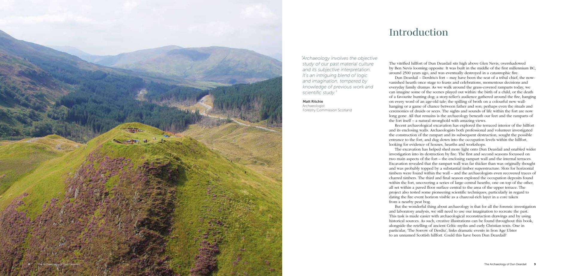
The vitrified hillfort of Dun Deardail sits high above Glen Nevis, overshadowed by Ben Nevis looming opposite. It was built in the middle of the first millennium BC, around 2500 years ago, and was eventually destroyed in a catastrophic fire.
Dun Deardail – Derdriu’s fort – may have been the seat of a tribal chief, the now-vanished hearth once stage to feasts and celebrations, momentous decisions and everyday family dramas. As we walk around the grass-covered ramparts today, we can imagine some of the scenes played out within: the birth of a child, or the death of a favourite hunting dog; a story-teller’s audience gathered around the fire, hanging on every word of an age-old tale; the spilling of broth on a colourful new wall-hanging or a game of chance between father and son; perhaps even the rituals and ceremonies of druids or seers. The sights and sounds of life within the fort are now long gone. All that remains is the archaeology beneath our feet and the ramparts of the fort itself – a natural stronghold with amazing views.
Recent archaeological excavation has explored the terraced interior of the hillfort and its enclosing walls. Archaeologists both professional and volunteer investigated the construction of the rampart and its subsequent destruction, sought the possible entrance to the fort, and dug down into the occupation levels within the hillfort, looking for evidence of houses, hearths and workshops.
The excavation has helped shed more light onto Dun Deardail and enabled wider investigation into its destruction by fire. The first and second seasons focussed on two main aspects of the fort – the enclosing rampart wall and the internal terraces. Excavation revealed that the rampart wall was far thicker than was originally thought and was probably topped by a substantial timber superstructure. Slots for horizontal timbers were found within the wall – and the archaeologists even recovered traces of charred timbers. The third and final season explored the occupation deposits found within the fort, uncovering a series of large central hearths, one on top of the other, all set within a paved floor surface central to the area of the upper terrace. The project also tested some pioneering scientific techniques, particularly in regard to dating the fire event horizon visible as a charcoal-rich layer in a core taken from a nearby peat bog.
But the wonderful thing about archaeology is that for all the forensic investigation and laboratory analysis, we still need to use our imagination to recreate the past. This task is made easier with archaeological reconstruction drawings and by using historical sources. As such, creative illustrations can be found throughout this book, alongside the retelling of ancient Celtic myths and early Christian texts. One in particular, ‘The Sorrow of Derdiu’, links dramatic events in Iron Age Ulster to an unnamed Scottish hillfort. Could this have been Dun Deardail?
Introduction
“Archaeology involves the objective study of our past material culture and its subjective interpretation. It’s an intriguing blend of logic and imagination, tempered by knowledge of previous work and scientific study.”
Matt Ritchie Archaeologist Forestry Commission Scotland
The Archaeology of Dun Deardail 9The Archaeology of Dun Deardail8
“For many local people this was probably the most exciting aspect of the Nevis Landscape Partnership. Taking part on the dig and learning more about our ancient history has been a wonderful experience.”
Patricia Jordan Chair of Nevis Landscape Partnership and volunteer archaeologist
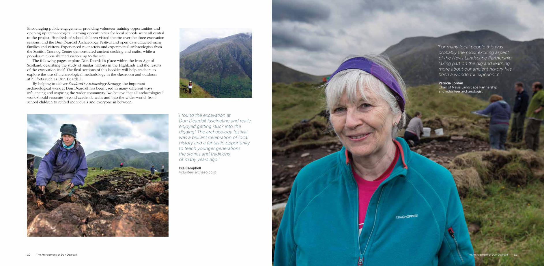
Encouraging public engagement, providing volunteer training opportunities and opening up archaeological learning opportunities for local schools were all central to the project. Hundreds of school children visited the site over the three excavation seasons; and the Dun Deardail Archaeology Festival and open days attracted many families and visitors. Experienced re-enactors and experimental archaeologists from the Scottish Crannog Centre demonstrated ancient cooking and crafts, while a popular minibus shuttled visitors up to the site.
The following pages explore Dun Deardail’s place within the Iron Age of Scotland, describing the study of similar hillforts in the Highlands and the results of the excavation itself. The final sections of this booklet will help teachers to explore the use of archaeological methodology in the classroom and outdoors at hillforts such as Dun Deardail.
By helping to deliver Scotland’s Archaeology Strategy, the important archaeological work at Dun Deardail has been used in many different ways, influencing and inspiring the wider community. We believe that all archaeological work should resonate beyond academic walls and into the wider world, from school children to retired individuals and everyone in between.
“I found the excavation at Dun Deardail fascinating and really enjoyed getting stuck into the digging! The archaeology festival was a brilliant celebration of local history and a fantastic opportunity to teach younger generations the stories and traditions of many years ago.”
Isla Campbell Volunteer archaeologist
The Archaeology of Dun Deardail 11The Archaeology of Dun Deardail10

“Dun Deardail has been a great opportunity for folk to come and get actively involved with archaeology. From volunteering at the excavation, to family activities at the festival, all ages, interests and experiences have been able to join in.”
Ruari Watt Forestry Commission Scotland Ranger
“Dun Deardail has intrigued me since I was a child and the dig offered me a great opportunity to participate in a unique excavation. My training was great fun and I soon felt like a member of the team. Working on a site like this was truly rewarding.”
Mairi Stewart Volunteer archaeologist
The Archaeology of Dun Deardail 13The Archaeology of Dun Deardail12

“Most of the island is flat and overgrown with forests, although many of its districts are hilly. It bears grain, cattle, gold, silver, and iron. These things, accordingly, are exported from the island, as also hides, and slaves, and dogs that are by nature suited to the purpose of the chase.”
Strabo, ‘Geographia’, IV. 5. 4.5.2 A description of Iron Age Britain from Strabo, a Greek geographer who lived between 44 BC and AD 23
The Iron Age also witnessed the rise of the Romans, who invaded Scotland three times during the first and fourth centuries AD. Although they built forts and temporary camps in southern and central Scotland, there is no evidence of them in our area of study. That said, we know the Romans circumnavigated northern Scotland and that Roman goods (particularly pottery, glass and metal work) have been found across Scotland, but whether this is due to Romans being in the area is open to question; the finds were more likely to end up there through trade, gifts or bribes.
The time after the Romans left is usually referred to as the Early Historic period. The Picts occupied much of Scotland north of the Forth, including much of the Highlands, individual kingdoms developing out of earlier Iron Age tribal groupings. The Picts are famous for their elaborate symbols, which can be found on upright stones, precious metalwork and cave walls. No-one knows what the symbols mean: some are recognisable animals, others are abstract shapes. Other parts of Scotland were inhabited by the Britons, the Scots of Dalriada (from Ireland) and the invading Anglo-Saxons. It was also during this post-Roman period that the influence of Christianity first began to be felt, the word spread by monks and missionaries from Celtic Ireland, from Iona and the Anglo Saxon south from Lindisfarne. It was within this vibrant and ever-changing landscape and society that hillforts were built, used and abandoned.
Hillforts in the Highlands
Conventional wisdom would place hillforts, and Dun Deardail, in what archaeologists traditionally call the Iron Age: the time between roughly 700 BC and AD 700. The preoccupation with defended settlements at this time may be explained by a marked deterioration in the British climate that began around 1250 BC, reaching its coolest and wettest around 650 BC. The cooler summers and increased rainfall will have driven communities away from the uplands and the poorly draining areas, which had previously supported agriculture. The pressure upon the better draining slopes and more fertile lowlands, and increased competition for resources, must have led to tension and conflict, requiring clear statements of land ownership and tribal belonging. This becomes visible in the archaeological record, with an increase in armour and weaponry and the development of defended settlements such as hillforts.
The Iron Age peoples living in north west Europe beyond the immediate influence of classical Mediterranean societies are known as the Celts. Regional territories and social groups shared many similarities, particularly in language and material culture (most recognisably in art and design). However, when we think of the ‘Celts’ we should think of shared cultural traditions as opposed to a single homogenous people – cultural traditions that developed and changed over time and in different places.
By the late Iron Age, tribal society in Britain was varied and complex. Influenced by developments and events in continental Europe, by the later first century BC in most areas of lowland Britain, tribal leaders were striking their own gold and silver coinage. High-status goods such as Roman imports and larger, more complex settlement sites indicate a greater centralisation of wealth and political power in southern Britain. However, in areas of northern and western Britain, it is likely that local social systems persisted; hillforts are smaller and no coins were struck.
Most of the population were farmers and herdsmen, practising a successful mixed subsistence economy. Cattle and sheep were the principal livestock, while pigs, dogs, small horses and domestic fowl were also kept. Barley and wheat were grown, alongside other plant crops such as beans, peas and flax. There is evidence for local warrior aristocracies: high-status artefacts such as decorated weapons, jewellery and feasting equipment for example. Surplus agricultural produce was probably surrendered by farmers to this warrior aristocracy, and the control, storage and redistribution of this surplus would help to reinforce their dominant position.
The Archaeology of Dun Deardail 15The Archaeology of Dun Deardail14

HillfortsHillforts are fortified hilltop settlements. They take a range of shapes and sizes, but all include fortifications, usually in the form of ditches and ramparts. They now survive only as grassed-over banks or enclosing spreads of rubble, but would once have been visible for miles around, perhaps with timber palisades, covered walkways and watch towers running around the circumference of the site. Within these enclosing defences were timber roundhouses, stock enclosures and granaries. Some have multiple ramparts, large ditches and enclose large areas; others are smaller, with only a single enclosing rampart. Two distinct types stand out in the north of Scotland: the ‘oblong’ fort (of which Craig Phadrig, Tap o’ Noth and Finavon are good examples) and ‘citadel’ forts (such as Dun Deardail, Dunadd and Dundurn). ‘Oblong’ forts are characterised by their shape and their massive ramparts, and the absence of any discernible entrance, while ‘citadel’ forts comprise an upper terrace with associated lower enclosures.
But what was a hillfort used for? The very definition of the term ‘hillfort’ is much disputed. Hillforts have traditionally been viewed as being primarily defensive in nature, to protect their occupants against attack. However, this suggestion was led by the belief that ancient people were constantly warring with each other. While Iron Age society was tribal, and disputes and battles were undoubtedly fought, they may not have been an everyday occurrence. The idea that Iron Age life was constantly punctuated by widespread pillage, bloodshed and tears no longer stands up to modern scrutiny. Indeed, it is not even certain that the main function of a hillfort was defence; in some instances, the circumference of the hillfort is so huge that it would have required hundreds of people to successfully defend it. Can we even be sure that these sites were home to enough people to defend them?
It is likely that the forts were the focus for a range of different economic, social and ritual activities. Perhaps they were more about control than defence? Perhaps they functioned at least partly as status symbols, a prominent demonstration of wealth, visible for miles round; evidence of their ability and power to command resources and labour beyond their immediate kin? However, these large-scale engineering works could also help to bond communities together and establish and maintain identity. Perhaps they were meeting places, focal points for communities in the surrounding area, rather than year-round settlements?
The social constructs surrounding the creation of these sites remain enigmatic. Were they built by communities for communities, or by slaves and labourers toiling on the orders of a tycoon or tyrant? Although every excavation helps us gain a better understanding of these sites, despite the many digs that have taken place on hillforts around Scotland, we are still no closer to answering some key questions: what were the factors that drove their construction, use, abandonment and reuse? As we shall see, our work at Dun Deardail attempted to answer some of these questions.
Above: This hill shaded terrain model of the ‘oblong’ fort of Tap o’ Noth in Aberdeenshire was captured by high resolution airborne laser scanning. The fort measures about 85m in length within a massive spread rubble rampart.
The hillforts of Craig Phadrig and Ord Hill are located above the Beauly Firth, at the northern end of the Great Glen. This was a core route connecting people and places, just like today. Although the hillforts may never have been occupied at the same time, they had their origins in the Iron Age and may even have seen reuse as Pictish forts. In the Iron Age, they would have looked down on open settlements of timber roundhouses and enclosed field systems nestled amongst the woodland and moor. Crannogs and fishtraps would have dotted the firth and marshland.
The Archaeology of Dun Deardail 17

“The rampart of Knock Farril was twelve feet perpendicular, though certainly all fallen down.”
John Williams, ‘An Account of some Remarkable Ancient Ruins’, 1777.
But what makes Dun Deardail a truly special place is the fact that it is vitrified. While hillforts occur widely across Britain, evidence suggests vitrification occurs more commonly in Scotland than elsewhere. Vitrified forts had drystone ramparts strengthened with timbers. It may be that poor quality building stone – and exposed locations with little earth – required a timber frame. Or it may be that the framework was something to guide generally unskilled labour in facing the ramparts and infilling with rubble.
When the rampart was set alight, the timbers – and perhaps a significant timber superstructure above – burned. The temperature of the fire reached such intensity that the stonework melted and fused together. How and why the rampart was set alight remains a mystery. Was it set on fire by accident, or during an attack? Or was it deliberate, perhaps even by the very people who had spent months or years building it? The fire may have been so intense and long-lasting, perhaps burning for days if not weeks, that it may even have been carefully stage-managed, maintained and manipulated; evidence perhaps that the destruction was an intentional process. The resulting smoke would have been visible for miles around during the day, and the flames would have created an impressive ever-present spectacle at night. Was having – and then destroying – a hillfort a status symbol that not everyone could afford?
Antiquarian investigationLike many archaeologists before us, when we started digging at Dun Deardail we had lots of questions we wanted to answer. But as with any good research we first considered what people before us had found when they explored and excavated vitrified hillforts. Let us start at the beginning.
Hillforts are prominent and visible sites in the landscape; they couldn’t fail to attract attention, whether now or in the past. It is not surprising that antiquarian discussion of such sites dates back centuries. General William Roy surveyed many hillforts when he mapped Scotland in the 1750s, and enthusiastic antiquarians of the 18th and 19th centuries set their sights on a number of Highland hillforts, investigating these enigmatic sites in a bid to understand them better. One of the earliest excavations may have been in the 1770s at Knock Farril, near Strathpeffer, by engineer John Williams. You can still see the deep scars of his huge trenches across the site to this day. Many prominent archaeological sites were also mentioned in the first (or ‘old’) Statistical Account of Scotland; for the Parish of Kilmalie, the Reverend Alexander Fraser noted that ‘Dundhairdghall’ (Dun Deardail) was “a fort of great antiquity”, its ramparts “vitrified all round”. He commented further that “as this naturally renders stone more friable, it has probably accelerated the downfall of the building. How the fire has been applied can only be conjectured” (Statistical Account of Scotland 1791-99, vol. 8 p. 348-9).
The Archaeology of Dun Deardail18

The beginnings of a modern professionInterest in hillforts and vitrification continued into the 20th century. Vere Gordon Childe, a key figure in the birth of modern European archaeology and its inception as a profession in its own right, excavated the oblong fort at Finavon in Angus in the 1930s. His work revealed massive walls up to 6m thick and surviving up to almost 5m in height. The remains of several possible structures were found in the interior. He also found pottery, spindle whorls, flints, an iron ring, a jet finger ring and a crucible for melting bronze; evidence that the forts were used for domestic activities and crafts such as textile working and bronze working. Few of these finds were closely dateable, although Childe recognised the fort to be Iron Age in date. At the time there was no scientific methodology to precisely date archaeological sites. This was an advance yet to come, and one that would revolutionise our thinking.
Dating the various phases of construction or deposition is one of the challenges of interpreting any archaeological site. Typologies tracing the evolution of small finds such as pottery or stone tools are traditional methods, and finding a nice 2nd century AD Roman coin is always useful. But objects can be tricky; a coin can be old before it is lost or deposited, and fragments of pottery can be difficult to identify.
The problem of dating archaeological sites was helped enormously by the application of scientific techniques from the 1970s onwards. These have enabled archaeologists to gain far greater clarity on the dating of archaeological sites. Now archaeologists routinely use radiocarbon dating to date various organic materials. In a nutshell, if archaeologists find things like burnt cereal grains, wood and bone they can send the sample away for laboratory analysis. Living tissue such as bone or wood contains a record of the naturally occurring radioactive carbon (C14) isotopes that was in the atmosphere when it was alive. As the amount of C14 in the atmosphere varies over time, by measuring its content within a sample, we can calibrate the probable date to a range of years. With a range of dates for a site, and the better their excavated stratigraphic distribution, we can use Bayesian modelling to better estimate a precise and accurate chronology.
Radiocarbon dating revolutionised hillfort studies. Archaeologists recently returned to Finavon hillfort and took radiocarbon samples. This showed that the site was occupied during the 1st to 2nd centuries BC and the 6th to 8th centuries AD; occupation in the Iron Age and reuse in the Early Historic period. Perhaps we should not be surprised that such significant sites saw many phases of use.
The completion of the Ordnance Survey’s First Edition Survey in the second half of the 19th century was instrumental in the further advancement of the exploration of Iron Age settlement types; it was this mapping that provided the foundation for the first comprehensive survey of fortified sites across Scotland by David Christison, a pioneering antiquarian whose work transformed archaeological practice and excavation techniques. His authoritative study of hillforts, ‘Early Fortifications of Scotland’, addressed basic issues such as site identification and the vexed issue of dating. Undoubtedly spurred on by his publication, more fieldwork began to be conducted. These antiquarian photographs, drawings and written reports continue to contribute to our understanding of Scotland’s prehistory today. While their methods differ to our more ‘modern’ techniques, our archaeological predecessors nonetheless enhanced our understanding of this enigmatic site type and set the benchmark for all future discussions.
In terms of vitrified forts, one of the earliest excavations was at Dunmacsniachan, near Oban, undertaken by the chemist Robert Angus Smith in 1873. He investigated the defences and inner features, and noted the differences between the vitrified outer walls and the drystone-built dun within. His excavations also uncovered a handful of finds, including an iron sword and dagger, and an enamelled bronze mount, all of which hinted at early life in the hillfort. During his work, Smith observed that vitrification seemed to be a specifically Scottish phenomenon, and his work remains a valuable early example of the recognition of the process. A little over a decade later, the timber framework within hillfort ramparts was demonstrated at Castle Law, near Abernethy in Perthshire. Here, excavations revealed stone walls with regular spaces clearly visible within them. These were the empty slots for long rotted-away beams. The excavators realised that wood was used in combination with stone. It was also obvious that the site had also been set alight.
The Archaeology of Dun Deardail 21The Archaeology of Dun Deardail20

2105 excavation
1971-72 excavations
Later bank
Spoil
Rampart
A hill-shaded terrain model of Craig Phadrig.
A recent small scale excavation at the vitrified fort of Craig Phadrig above Inverness shows a similar pattern. The work was undertaken following significant storm damage, when uprooted fallen trees exposed the rampart walls under the grass-covered slopes. The enormous rampart measured 6.5m in width and may have stood – as perhaps only the stone base for something larger – over 4m in height. As with many hillforts, Craig Phadrig has seen many programmes of excavations, with interventions in the 18th, 19th and 20th centuries. But all of these were in the pre-radiocarbon dating era. The storm damage in 2015 was an opportunity to investigate this important site using modern techniques. It is clear that Craig Phadrig has a long history of use and reuse. It appears to have been built around the 4th to 3rd centuries BC. Parts of the fortifications are vitrified, and the results of the recent work suggest that this burning activity took place during this first phase of occupation. But the site was also reused in the Pictish period, with an additional defensive ditch dug sometime before the early 5th to mid-6th centuries AD. After a period of likely abandonment, the fort was again reused in the medieval period, in the early 11th to 13th centuries AD. Scientific dating methods continue to grow and develop, and these tools form an essential part of our arsenal in investigating and interpreting archaeological sites.
Another exciting advance in hillfort studies is the wider use of innovative survey techniques. Airborne laser scanning, aerial photography and archaeological measured survey have all better enabled the accurate planning and analysis of these sites. Hillforts can be hard to interpret from the ground: the natural topography and vegetation can disguise or conceal even significant upstanding remains. Terrain models deriving from airborne laser scanning and aerial photographs offer an impressive and more easily comprehensible overview, and now low altitude aerial photographs can be taken using a remotely-flown drone and photogrammetric terrain models can be created.
The Archaeology of Dun Deardail 23The Archaeology of Dun Deardail22

‘The Sorrow of Derdriu’ is also known as ‘The Exile of the Sons of Uisliu’. The story was first recorded in the Book of Leinster in c. AD 1160 and forms part of the famous Ulster Cycle. It is a fore tale to the ‘Táin Bó Cuailnge’ – the Cattle Raid of Cooley.
The early medieval Irish myths represent an oral storytelling tradition many centuries old. The colourful descriptions of the courts of Celtic kings have been said to offer a ‘window onto the Iron Age’, where honour and glory, fighting and feasting, and bards, champions, demigods and the spirit world take centre stage. We used the myth to populate the Iron Age context of Dun Deardail, or ‘Derdriu’s fort’.
The Sorrow of Derdriu begins with the scream of an unborn child. The druid Cathub predicts fame and beauty for the girl, “whom champions will contest and high kings will woo” but cautions of “a great slaughter amongst the chariot warriors of Ulaid” (Ulster). King Conchubur ignores the calls of his men to kill the child at birth and instead has her raised in secret, intending to wed her when she comes of age. But all did not go to plan.
Derdriu fell in love with the warrior Noísiu, son of Uisliu. On her urging, they fled to Scotland with his two brothers, Aindle and Arddán, along with ‘three fifties of warriors and three fifties of women and three fifties of hounds and three fifties of servants’ (the Celts liked things to come in threes, and never did anything by half).
King Conchubur sent his envoy, Fergus mac Roach, to promise the brothers a pardon if they returned to Ulaid. They were betrayed, as the vindictive king also instructed Eogan mac Durthacht to ambush the brothers and kill them. Derdriu was to be forced to marry her lover’s murderer, but took her own life rather than submitting to him.
With his honour in question – he had promised the brothers safe passage – Fergus vowed revenge against the treacherous Conchubur. Ulaid was riven with fighting and the druid’s prophecy of the sorrow of Derdriu came to pass.
The love triangle between an old husband, young suitor and beautiful girl is a recurring theme in Irish mythology, representing sovereignty and renewal. An old king is challenged by a young claimant to the throne; the young girl is identified with the fertile goddess of sovereignty.
Although archaeological evidence of Celtic mythology and religion is rare, a wooden figure was discovered in 1880 in a peatbog at nearby Ballachulish. Objects such as the mysterious Ballachulish goddess and the Deskford carnyx (a type of horn) – alongside archaeological research and the creative use of mythology – help to illuminate Celtic society and bring life to hillforts such as Dun Deardail.
The Sorrow of Derdriu
“Call her Derdriu. She will be very beautiful but will bring much sorrow. She will be the cause of the treachery of kings and the death of many heroes…”
The Archaeology of Dun Deardail24

A watery grave preserved this amazing carved figure for over two thousand years. When it was discovered in November 1880 it looked very much the same as when it was carved some 2,600 years ago, but, as the wood dried out, it shrank and became distorted. Nonetheless, the figure has a certain presence, and its white quartz eyes still gaze out serenely. It portrays a woman and, as the original emphasis on her genitals was deliberate, perhaps she is a mother goddess or a fertility deity.
She was found in a peat bog at North Ballachulish, close to the sea at the mouth of Loch Leven. Workmen were digging through the peat in order to build the foundation for a wall, when they discovered the figure lying on gravel beneath the peat. The original account describes how “the image lay on its face, covered with a sort of wickerwork; and several pole-like sticks lying near it…”. The wickerwork was ‘too frail’ to preserve, but it sounds as if it was either part of a shrine in which she had been kept, or a way of ensuring that she remained pinned down in the bog for all eternity. There are no traces of weathering on the figure, which suggests that she was placed in a pit in the bog and covered over with the dug peat, rather than that the peat had grown slowly to cover her. Was her cult in disgrace or was this the vandalism of an enemy tribe with its own preferred deity?
The drawing was made in 1881 from a photograph taken at the time of discovery. The goddess is made of alder wood and she stands ankle-deep in her wooden plinth. There is a small hollow in the plinth at the point where her feet would be, which may have held some precious object, but nothing was found and we shall never know what it was. She seems to be holding a long object in her left hand. The entire carving, goddess and plinth, measured just 1.45m in height when she was found. Even allowing for the uncarved feet and ankles this is a small person, although she is considerably taller than most other wooden figures that have survived from prehistoric Britain and Ireland.
At the time, the Ballachulish goddess was considered so ‘indelicate’ that it must have been made by Vikings, those infamous barbarians from the north. With more advanced scientific methods of analysis, we now know that the figure was carved from wood that dates to around 600 BC, about 1400 years before the Vikings. This was a time of considerable change in Scotland, when iron-working was being introduced and fortifications were being built in response to troubled social times.
Figures like this are often found in special places – beside a spring, or where a trackway crosses the wetland. The Ballachulish goddess would have overlooked the dangerous straits linking Loch Leven with the sea. Perhaps she also acted as the goddess of the straits, to whom prehistoric travellers would need to make an offering if they wanted to be sure of a safe crossing. The Ballachulish goddess is on display in the National Museum of Scotland in Edinburgh.
The Ballachulish Goddess
The Archaeology of Dun Deardail 27The Archaeology of Dun Deardail26
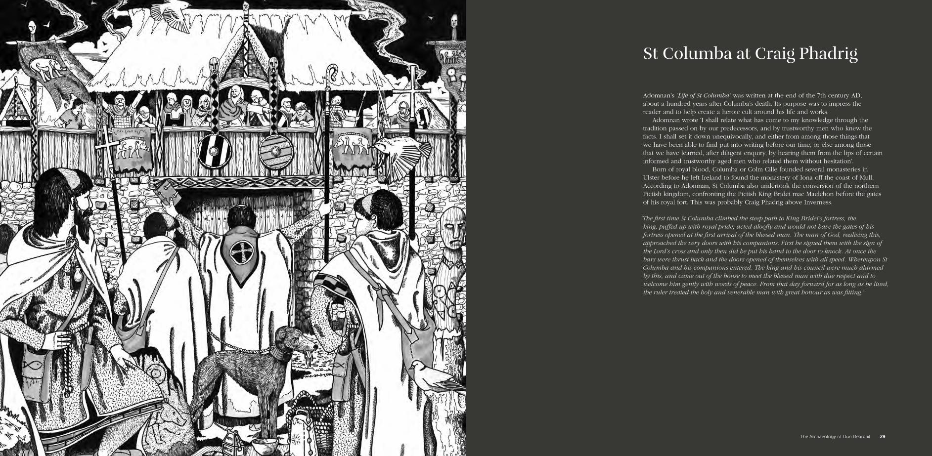
Adomnan’s ‘Life of St Columba’ was written at the end of the 7th century AD, about a hundred years after Columba’s death. Its purpose was to impress the reader and to help create a heroic cult around his life and works.
Adomnan wrote ‘I shall relate what has come to my knowledge through the tradition passed on by our predecessors, and by trustworthy men who knew the facts. I shall set it down unequivocally, and either from among those things that we have been able to find put into writing before our time, or else among those that we have learned, after diligent enquiry, by hearing them from the lips of certain informed and trustworthy aged men who related them without hesitation’.
Born of royal blood, Columba or Colm Cille founded several monasteries in Ulster before he left Ireland to found the monastery of Iona off the coast of Mull. According to Adomnan, St Columba also undertook the conversion of the northern Pictish kingdom, confronting the Pictish King Bridei mac Maelchon before the gates of his royal fort. This was probably Craig Phadrig above Inverness.
St Columba at Craig Phadrig
‘The first time St Columba climbed the steep path to King Bridei’s fortress, the king, puffed up with royal pride, acted aloofly and would not have the gates of his fortress opened at the first arrival of the blessed man. The man of God, realising this, approached the very doors with his companions. First he signed them with the sign of the Lord’s cross and only then did he put his hand to the door to knock. At once the bars were thrust back and the doors opened of themselves with all speed. Whereupon St Columba and his companions entered. The king and his council were much alarmed by this, and came out of the house to meet the blessed man with due respect and to welcome him gently with words of peace. From that day forward for as long as he lived, the ruler treated the holy and venerable man with great honour as was fitting.’
‘The first time St Columba climbed the steep path to King Bridei’s fortress, the king, puffed up with royal pride, acted aloofly and would not have the gates of his fortress opened at the first arrival of the blessed man. The man of God, realizing this, approached the very doors with his companions. First he signed them with the sign of the Lord’s cross and only then did he put his hand to the door to knock. At once the bars were thrust back and the doors opened of themselves with all speed. Whereupon St Columba and his companions entered. The king and his council were much alarmed by this, and came out of the house to meet the blessed man with due respect and to welcome him gently with words of peace. From that day forward for as long as he lived, the ruler treated the holy and venerable man with great honour as was fitting’.
The Archaeology of Dun Deardail 29

The hillfort of Dun Deardail measures some 46m from NE to SW by up to 28m transversely; there is a distinct upper ‘citadel’ terraced above a larger enclosure below, clearly defined by a grass-covered stone-built rampart surviving up to 2.5m in height. This varies considerably in width because of its collapsed nature. The wall appears to be particularly well-preserved on the south west side, before reducing in height to the current entrance. However, it is not clear where the original entrance would have been located as there is no definable break within the wall and no actual wall facing is visible. Lumps of vitrified rock can be found around the circuit of the enclosure. Much of the vitrified material appears to have been displaced from its original location, with many blocks having collapsed downslope.
Project DesignLong before we started at Dun Deardail we worked closely with experts to write a clear and thorough research methodology for our work, all set within the context of the Scottish Archaeological Research Framework.
The Project Design aimed to better understand, protect and value the site by:
• Investigating the archaeological potential of the hillfort;
• Enhancing the national and regional historic environmental records;
• Informing current and future conservation management;
• Ensuring community involvement in regard to practical archaeological research;
• Engaging and enthusing the public in archaeology and the wider historic environment;
• Providing a bespoke high-quality archaeological higher education opportunity;
• Providing accessible classroom and outdoor archaeological learning opportunities.
The primary research aims of the project were to establish the nature, position and role of Dun Deardail within its broader landscape and social context. The initial working hypothesis was that Dun Deardail was an Iron Age hillfort (dating to the middle to late first millennium BC) that was reoccupied and remodelled in the Early Historic / Pictish period (middle to late first millennium AD). The excavation would provide a rare opportunity to investigate a relatively small ‘citadel’ hillfort with extant and visible vitrification.
The Dun Deardail Project
“By investigating and recording the historic environment on Scotland’s National Forest Estate, we aim to continually develop our knowledge, understanding and interpretation of our past and how best to conserve, sustain and present it.”
Matt Ritchie ArchaeologistForestry Commission Scotland
The Archaeology of Dun Deardail 31The Archaeology of Dun Deardail30

“One of my favourite memories from the dig is looking down the hill on the day of a school visit, watching a constant stream of enthusiastic children snaking their way up the hillside across the banks and ditches, all eager to learn more about their past.”
Andy Heald AOC Archaeology
A number of overall research questions were set; these directed the detailed research questions that informed the excavation strategy and individual trench locations. However, archaeologists don’t just dig – they use a suite of techniques to try and understand an archaeological site and landscape. The Dun Deardail team also conducted a geophysical survey, a topographic survey, low altitude photogrammetric survey, environmental sampling (in the form of coring), numerous post-excavation analyses and a detailed and extensive dating strategy. If you visited the site you would have seen a handful of archaeologists working on the site, but they were supported by a host of experts behind the scenes who were crucial to the success of the project.
The excavationWe excavated nine trenches: six within the hillfort, and another three beyond its walls. All of the trenches were de-turfed, excavated and backfilled by hand. Site records were kept for each feature, as well as registers for finds, samples and drawings. Section drawings, plans and photography supplemented the overall site record, alongside the use of low altitude aerial photography. Bulk soil samples were taken from all deposits, as well as environmental samples.
As you can see from the plan, the majority of trenches were placed over the ramparts. We hoped to understand the nature of the ramparts and their construction; investigate the evidence of vitrification; and find out whether the modern-day circuit path around the hillfort was impacting the underlying archaeological deposits. Some of the trenches were deliberately located in the internal area to ascertain whether any internal structures (such as houses or hearths) survived, as well as to look for evidence for occupation and material for dating the construction, use and abandonment of Dun Deardail. Three trenches were excavated on the outer slopes, where we hoped to find evidence of activities happening in the lower terrace at the same time as people were living within Dun Deardail itself.
When archaeologists are looking for evidence of human occupation we tend to focus on four things: structural evidence which may have been built, remodelled, occupied or destroyed; artefacts (or small finds) that may inform discussion of everyday life, craft manufacture and trade; dating evidence that may inform our interpretation of individual phases of use; and environmental data to see how humans have been altering or leaving their mark on the landscape. Let’s consider these in turn.
The Archaeology of Dun Deardail 33The Archaeology of Dun Deardail32

This terrain model of Dun Deardail measures one hectare on plan. It was created following a low altitude photogrammetric survey.
0 20m
The Archaeology of Dun Deardail 35The Archaeology of Dun Deardail34

The structural evidence A lot of our time was given to understanding the large enclosing wall. We discovered that the wall was over 4m in width. In Trenches 2 and 4 we couldn’t find the outer face, as the rampart had collapsed entirely! Our work provided us with fantastic evidence of the structure of the wall itself. Within the walls we found voids, as well as evidence for charred timbers, some of which were still in their original place. Dun Deardail was clearly built with a significant timber component. Many of our trenches showed evidence for the complexity and skill involved in the drystone construction of the wall, with differing stone being laid down both horizontally and vertically, possibly around the interlacing timbers. The sheer amount of collapsed material found across all of our trenches suggests that the wall itself was massive, and perhaps very high. We found that the upper areas of the wall were the most vitrified. Could this be the result of the burning of a timber superstructure above the wall itself? It has been suggested that sites like Dun Deardail had wooden palisades or covered walkways along the top of the walls, perhaps containing stores, living space or workshops.
Interestingly, we didn’t find any good evidence of an entrance. We had hoped that we would find it in Trench 6, but this proved not to be the case. Perhaps any evidence of an entrance was lost due to the destruction of the wall – or perhaps the entrance was not through the wall but within the wall, set above its footings.
We found evidence of vitrification all across the site. In one of our trenches we discovered thickly matted burnt plant and charcoal material. This material may have represented the fuel for the fire which caused the vitrification. In some of the trenches we found evidence of burnt deposits up to 0.4m deep, suggesting the burning occurred for a long period of time and spread into the interior of the hillfort. Interestingly, the material closest to the wall itself was not affected by burning in this way, which may suggest a quick collapse of the wall in this area, covering and protecting the deposits below.
Some parts of the wall seem to have been refaced after the destruction event, and the interior levelled, suggesting later re-occupation of the hillfort. Two hearths were discovered in Trench 3, alongside a series of post holes with consistent spacing between them, both of which are good structural evidence. Although not overwhelmingly clear, the post holes appear to form a possible rectangular building, with the eastern wall being built into the rampart wall. A hearth complex was found roughly central to the upper ‘citadel’ area. This comprised a multiphase hearth and associated paving and trample deposits (where those using the hearth would have been walking and compressing the ground surface).
Above: The exposed rubble rampart within Trench 4.
The Archaeology of Dun Deardail 37

The vitrified rubble upper core of the rampart in Trench 2 (which measures 2m in width); three voids can be seen, roughly spaced about 0.5m apart. These represent the locations of horizontal timber beams that once lay within the rampart wall.
The dominant material recovered during the excavation was fragments of vitrified stone which had collapsed from the heavily burnt ramparts. The process of vitrification occurs when a timber-framed drystone rampart is destroyed by fire. With temperatures reaching over 1000° C, the heat from the blaze begins to melt the rubble core of the rampart. As the burning rampart collapses, the rocks first fracture and then become liquid. Gas bubbles form inside the rocks as the extreme temperatures change their mineral composition. When the fire burns out and the rampart finally cools, the burnt and molten rocks form large blocks of conglomerated stone. These can still be seen within the rampart. Vitrification is not a deliberate construction method as the original timber-framed drystone rampart would have been more stable; it is much more likely to have been the result of accidental fire or deliberate destruction. As the vitrified core is only found in the upper section of the rampart, it may have been caused by the collapse and burning of a substantial timber and thatch superstructure.
The Archaeology of Dun Deardail 39The Archaeology of Dun Deardail38

Thousands of tiny bits of iron flake off of an iron object as a smith beats the iron with their hammer. The small fragments of debris that were found at Dun Deardail tell us that they were forging iron objects, although there is not enough waste to tell us exactly where the ironworking was happening. Various iron objects were also recovered, including a ring, a knife blade and a strange riveted object. These objects were all heavily corroded, and we used an x-ray machine to identify their original shapes.
The iron ring is probably a simple fitting, either used as part of a robust chain or, perhaps, as a horse harness fitting. The x-ray shows us that it is broken, which may be the reason for it being discarded. The ring was discovered amongst the rubble of the vitrified wall in Trench 6. Its position amongst the collapse suggests it relates to the pre-vitrification occupation of the hillfort. The knife blade fragment (now missing its handle) was broken across the width of the blade, probably during use. The other object was slightly harder to characterise: a ‘lump’ of iron in appearance, the x-ray eventually showed a circular rivet amongst the corrosion, which would have held two pieces of the iron object together, perhaps allowing the pieces to pivot. Both of these objects were found in Trench 3, across a lower terrace which has evidence for occupation before and after the destruction event.
Two thin disc-shaped stones were found, each perforated with a central hole. At first glance these could appear to be spindle whorls, used in the manufacturing of fibres, but the central holes are very small, perhaps too small to hold a spindle. They may instead have been used as pendants or beads. The flatter of the two, made of grey schist, has faint traces of an incised zig-zag decoration surrounding the central hole on both faces. Circular scratches on one face are tool marks left behind from using a bow-drill to produce the hole. The rounded, smaller object is probably a bead. It is made of steatite, a stone with a soapy texture which is not local to the area.
Above: X-ray of the iron objects.
The small findsDuring our excavations at Dun Deardail, a small but significant group of Iron Age objects were recovered, including stone tools, metal objects and even tiny pieces of waste from metalworking. The most significant artefact recovered from Dun Deardail was a fragment of a clay crucible discovered on the steep lower terrace, directly under the crag on which Dun Deardail sits. This little bowl-shaped pot was made from clay and then lightly fired to make it hard so that it could be used to hold, melt and pour bronze. Pieces of crushed copper ore or scraps of bronze would have been held in the crucible over a fire until it melted into liquid, at which point it was quickly poured into a clay or stone mould to make an object. Once the metal had cooled and set hard, the mould was broken to reveal the final product. Scientific analysis indicates that the metal heated in the crucible was a leaded bronze alloy made of copper, tin and lead; a type of bronze used in Scotland before the Romans arrived. Careful examination of the surfaces of the crucible under a microscope also revealed indentations on the outside surface that probably represent marks from the tips of iron tongs used to hold the crucible over fire. No mould fragments were found at Dun Deardail during our excavation so we do not know what kind of bronze object they were making, but it may have been ingots or dress accessories such as pins or brooches.
We also found small amounts of evidence for ironworking, beside the hearth in Trench 1. During iron working, large quantities of waste can be produced, particularly when the smith hammered the iron blooms or shaped the objects.
Above left: The hearth discovered in Trench 1.
Above: These flags record the locations of small finds and samples.
Above right: The crucible.
Above far right: The spindle whorl or pendant.
The Archaeology of Dun Deardail 41The Archaeology of Dun Deardail40
Reconstructing the environment As well as looking at the structures and artefacts from an archaeological site, we can also gained lots of information from another strand of evidence: environmental sampling. Environmental archaeologists look at ecofacts – organic material such as plants and pollen found at or near archaeological sites. Studying this material can help to reconstruct the nature of past habitats and land use.
Soil samples were taken from each new deposit we encountered. We then wet sieved the samples looking for any fragments of charcoal, bone and burnt cereal grains which float to the top. Kubiena soil samples were also taken, allowing the detailed analysis of the soil micromorphology under the microscope. Sediment coring enabled us to gather samples and data from deeper peat deposits to reconstruct the character of the past landscape, assess the impact humans had on the landscape and explore evidence of burning or fire within the vicinity. This was especially useful at Dun Deardail, as evidence for burning may help us to more accurately date the destruction event which caused the vitrification of the enclosure wall.
A specific environmental coring programme was carried out at Dun Deardail. A core was extracted from the peat immediately to the north of the fort and transferred back to the lab to be sampled and analysed. The waterlogged nature of the peat provides excellent conditions for the preservation of fossil pollen and charcoal, which we can use in our analysis. By analysing the count and area of the charcoal macroscopic flakes statistically, we can identify specific fire events, including their magnitude and frequency. We can see an exceptionally large fire event at around 310 BC as a prominent spike in the charcoal record. This new technique has enormous research potential in helping to understand the narrative of other vitrified hillforts.
Radiocarbon datesThe excavations resulted in a detailed and important range of radiocarbon dates indicating a construction date for the hillfort in the 5th century BC. Samples of organic material were collected during the excavation (and in the laboratory during post excavation analysis) from contexts relating to the hillfort’s construction, occupation, vitrification and abandonment.
A radiocarbon dating plan was designed to try and identify the timing and sequence of Iron Age activity at Dun Deardail. Fourteen radiocarbon measurements were taken from single pieces of wood, charcoal and cereal grain collected from the soil during the excavations. We were particularly interested in the scientific value of in situ samples which have remained untouched since the life of the hillfort, as these provide the most secure results. Once all the radiocarbon dates were obtained, a programme of statistical analysis was used to produce a model which brings together all the dates. This type of statistical modelling, called Bayesian analysis, helps us to test our theories about the broad date of specific events (such as when the hillfort walls were constructed). It can be used to estimate the duration of various phases of activity at the site and its overall occupation timespan.
Results demonstrate that Iron Age activity at Dun Deardail began in the 5th century BC and ended sometime in the 4th to 2nd centuries BC. This suggests that the hillfort at Dun Deardail was in use during the Iron Age for between 100 and 350 years. Samples of cereal grain, burnt during the fire that vitrified the ramparts, suggest that the burning event occurred between 335 and 120 BC. We have refined this date further, using a technique called fire event analysis (see The Charcoal in the Core). This examines tiny flecks of charcoal expelled by the fire which become trapped in a near-by peat bog. This dates the vitrification event more precisely, suggesting that it occurred around 310 BC.
The site was long believed to have been reoccupied in the Early Historic period but three seasons of work have yielded nothing to support this assertion. There is no definitive artefactual or scientific evidence that suggests the site (unlike many other hillforts) was reused in the Early Historic period. The site is now interpreted as having been built, used and abandoned within the Iron Age.
The Archaeology of Dun Deardail 43The Archaeology of Dun Deardail42

Community engagementEncouraging public engagement, providing volunteer training opportunities and opening up archaeological learning opportunities for local schools were all central to the project. Hundreds of school children have visited the site; and the Dun Deardail Archaeology Festival and Open Days attracted many families and visitors.
Much of the hard work of digging was undertaken by a dedicated volunteer excavation team made up of local enthusiasts, amateur archaeologists, students and trainee countryside rangers. On site, we provided practical training to enable skills acquisition in survey, basic excavation, recording techniques, artefact handling and recognition, archaeological drawing, archaeological photography and sampling. Regular team site tours enabled everyone to be involved in the ongoing (and often changing) trench interpretations. Off site, there were evening master classes in archaeological methodology and historiography, reinforcing knowledge gained on site and enabling wider discussion.
Public site tours were presented to visitors and walkers alike, and a formal site open day was hosted each year. This subsequently developed into the Dun Deardail Archaeology Festival, a celebration of archaeology and ancient crafts organised in partnership with the Scottish Crannog Centre. The festival provided fun for all ages, with wild boar sausages sizzling alongside hands-on craft demonstrations. A minibus ferried people to and from the hillfort, allowing a huge range of people to visit the ongoing excavations.
“I thought that the Dun Deardail Archaeology Festival was fantastic. There were so many fun things to do and see!”
Fiona MacLean Lochaber Countryside Ranger
“Even though it was very wet, the open day was a great opportunity to see the impressive progress that had been made by the dedicated band of volunteers and archaeologists. The archaeological excavations were very well explained, especially by the young lady in the orange waterproofs. What a great way to let the local population get a feel for what was going on up the hill.”
Alex Gillespie Friends of Nevis volunteer
The Archaeology of Dun Deardail 45The Archaeology of Dun Deardail44

Engaging with local schools was a really important element of the project, with a bespoke educational programme developed and delivered. Schools were invited to visit the excavations and received a practical introduction to archaeology. School groups explored the hillfort, tried their hand at excavation, handled objects and artefacts both real and replica, and had fun with their own interpretations of Iron Age and Pictish life.
Classrooms were visited after the preliminary results had been collated, sharing our results and ideas. These workshops took into account the changing interpretations of Dun Deardail as each set of results were analysed. Each year gave a chance for school children to recall information they had learned on site and, for those not able to visit, an opportunity to discuss what archaeology is and why we do it. The first year of school visits focused heavily on the Picts, with activities encompassing their documented appearance, place name evidence and creative drawing. The second year saw a shift in focus to the Iron Age, due to earlier radiocarbon dates being recovered. The technologies of the Iron Age, such as rotary querns, pottery manufacture, metalworking and house construction were discussed, as well as Dun Deardail itself and the evidence for its vitrification. The final year saw an amalgamation of both of these sessions, with a focus on the hillfort, encouraging the groups to think like hillfort builders and explore the reasons for the choices in the design, location and fate of the hillfort. A further educational opportunity was delivered to secondary school groups, with a focus on multi-disciplinary archaeological skills and the provision of career advice for budding archaeologists.
Above: Investigating Dun Deardail at St Bride’s primary school in Ballachulish.
“I had a really interesting day at the dig! I loved going up to the fort in the minibus.”
Callum MacLean Young archaeologist and minibus enthusiast
The Archaeology of Dun Deardail 47The Archaeology of Dun Deardail46

Creative responses We also sought to create opportunities for artistic responses to the archaeological work. The cover is an extract from ‘Dun Deardail’ by archaeologist and landscape artist Andy Heald; while musicians Mac-talla nan Creag (The Echo) from Firecracker Recordings took inspiration from the myth of ‘The Sorrow of Derdriu’ and the astonishing sounds of the ancient Celtic carnyx and Irish horn, reimagined by John Kenny.
Andy Heald has been exploring landscapes across Scotland for over two decades, and a celebration of the cultural and natural environment is intrinsic to all of his work. When painting, he is drawn to the ever-changing character of our landscapes, and attempts to catch these fleeting moments and dynamic elements. His primary influence is the spontaneity of nature – the inseparable responses of sea, cloud, sun, season and weather.
Andy attempts to reflect these fresh interactions by painting rapidly. The paint is driven, splashed, scrubbed or dripped over the canvas in an attempt to capture the raw experiences of nature. In Andy’s paintings there is always a landscape or seascape element, but often the need to quickly capture what is before his eyes is more important, as is documenting his own interaction with and response to a particular time and place. Andy’s work has been described as ‘elemental abstract art’.
In ‘Dun Deardail’, Andy continues this tradition. The painting attempts to evoke the fire, heat, smoke and light that would have cascaded down the hillside as the fort was alight, smouldering over consecutive days and nights and through the changing elements. A powerful statement that would have been visible for miles around, even as people in the valley below peered through night-time mist and fog.
The Archaeology of Dun Deardail 49The Archaeology of Dun Deardail48

The Archaeology of Dun Deardail 51The Archaeology of Dun Deardail50

What can one sample of vitrified rock – known as a clast – tell us of its creation? Formed in the great fire of Dun Deardail, our clast formed as minerals melted, glueing together bits of rock. What stories are hidden in it? What can it tell us about the vitrification event of Dun Deardail? We can look at this clast using differing scales of analysis from the hand-held samples examined with the naked eye, down to the microscopic analysis of single elements. Combined, the information contained at each scale can help write the story of the construction and destruction of the hillfort.
Looking at the outside of the clast, we can see that the rock is covered in small holes known as vesicles. These show that the water in the minerals of the rock was boiling off during vitrification. Imprints of charcoal are also visible in the clast. This is evidence of the timber framework that was part of the structure of the hillfort. At this point, it is difficult to see exactly what rocks have been fused together, so we cut the rock open. In the freshly cut surface of the clast we can now see the different rock types that have been fused together by the intense heat. Using a hand lens helps us to determine what these rock types are. From this we can see that the main rocks used have been the local calc-silicates, pelitic rocks and quartz rocks. Several pieces of granite were also observed.
A thin slice of the clast is then bonded to a glass slide and ground down to a thickness of 30μm, around the width of a human hair. At this thickness, light can pass through the rock and this allows us to look at the mineralogy of the rock under the microscope. We can compare the rocks making up the hillfort ramparts to the rocks in the surrounding area to see if they are the same. This allows us to see if the rocks that the ramparts were built with were local or were imported from elsewhere. As with the visual analysis, the petrology confirms that the rock used to build the ramparts and fill the rubble core were local rocks. Certain minerals only form at set temperatures. These are known as index minerals. Using this index, once we know the mineralogy of the rocks in the clast we can determine a temperature range at which these formed. The temperature of the melt in the hillfort will vary over and around the hillfort due to varying conditions. The presence of mullite in some of the clasts informs us that the temperature of that part must have been greater than 8000c. In other parts of the melt the temperature must have been lower and this is shown by the presence of biotite and orthoclase feldspar. These areas would have only reached between 7000c and 8000c.
The next scale uses x-ray fluorescence to investigate the geochemistry of geological samples. Samples are irradiated with x-rays and when these interact with the minerals in the cut rock sample a packet of energy is emitted. Every chemical element produces a different energy signature and this provides us with another means of identifying the minerals that are present in our clast and to better understand how they have altered during vitrification.
The Story of a Clast
The Archaeology of Dun Deardail 53The Archaeology of Dun Deardail52

When we compared the results from our vitrified clast from the ramparts of the hillfort to samples of the local rocks surrounding the hillfort, we found that the results are very similar. It seems that the rocks in this clast were most likely local rocks, chosen for their ready availability, rather than rocks that had been imported from elsewhere.
Scanning electron microscopy allows us to investigate the clast on an even finer scale, allowing us to investigate single crystals and to build up a picture of chemical changes within the molten rock fragments that are within our clast. Using the chemical composition of certain minerals in the clast, such as orthoclase feldspar and silliminite, we can estimate the temperature of the rock as it melted. Our clast from Dun Deardail appears to have the upper range of between 850oc and 1100oc for the melt. There must have been a sustained, intense fire to allow the rock to melt like this.
Finally, we use Mössbauer spectroscopy to look at just one element: iron. The form in which iron is found in the clast can tell us of the maximum temperature that the rock reached when it melted. It also indicates whether oxygen was in abundance or was absent at the point when the rocks were melted. If there was a lack of oxygen, then we can conclude that something was covering the melt to prevent oxygen getting into the system, or that the fire had used up all of the available oxygen in the combustion process. This may have been an intentional covering to increase the temperature of the fire; or an unintentional covering, such as the melt smothering itself. At Dun Deardail the results from our clast show that the rocks melted and solidified in an oxygen-poor environment. Something was preventing oxygen getting to the melted rocks.
If we take many such clasts from all of the different areas that have been excavated across the hillfort, and repeat the same analyses, we can produce a story of its construction and destruction. From our work to date it appears that local rock was used to build the rampart core at Dun Deardail. It does not look like the rocks were specifically chosen for their melting qualities. This points to the burning event and vitrification being an event that occurred at the end of the hillfort’s life, rather than it being a deliberate constructional technique. It also looks like temperatures in the rampart core reached between 850°c and 1100°c as it was burnt, causing minerals to melt and the rocks to vitrify in an oxygen-poor environment. However, different parts of the structure may have had different peak temperatures. Once all our samples have been analysed we will be able to build a better picture of conditions during burning around the ramparts.
Above: This light blue crystal is a fractured olivine crystal observed under crossed polarised light under a petrology microscope. The crystal measures about 500 um in diameter. The olivine crystal fractured due to the melting of the rock.
The Archaeology of Dun Deardail 55The Archaeology of Dun Deardail54

The fire that destroyed Dun Deardail would have created towering plumes of smoke rising up from the fort, expelling ash and charcoal into the air. These flecks of ash and charcoal then settled over a wide area around the fort. Fortunately for us, the hillfort is surrounded by several areas of natural peatland, waterlogged bog made up of layer-upon-layer of partly decomposed plant matter. Peat preserves the organic materials embedded within it, like wood and charcoal. Its layers act as a stratigraphic chronological record, having formed over long periods of time. If we investigated this peat, could we identify the hillfort burning event through the macroscopic charcoal (visible to the naked eye) in the soil and work out more precisely when the fire occurred?
We began by retrieving a sediment core from the peat immediately to the north of the hillfort. This was achieved by driving a long steel chamber – like a huge apple corer – deep into the peat to capture a long, thin, plug of the sediment. Even without a microscope it was possible to see thin layers of dark, potentially charcoal-rich sediments in the extracted core, and it was these layers that we wanted to investigate in more detail.
The peat core was brought back to the laboratory and our analysis began. A small amount of the sediment was removed from the core every half centimetre along its length to allow us to detect changes in the soil charcoal at different depths. Six radiocarbon dates were taken from several distinct layers of charcoal and used to establish the age of the sediments at various points along the core. We could then focus our analysis on the area of the peat core that dates to the Iron Age. The samples were then treated with various chemicals and analysed to look for tiny macroscopic flecks of charcoal which were then counted and measured. This allowed us to determine concentrations of charcoal that represent fire events. Using statistical modelling and other analytical techniques we were able to distinguish peak fire events, which were likely to have occurred in the immediate vicinity, as opposed to background scatters of charcoal which must have come from fires further away.
Our analysis identified four significant fire events within the peat record. The first occurred around 400 BC and could represent fire being used to clear trees and scrub during the construction of the hillfort. Following this first event, fire activity decreases slightly but remains significant, likely representing local hearths and fires associated with daily life at the hillfort. The largest of the fire events dates to between 347 and 284 BC. This probably represents the destruction of the hillfort. Using statistical modelling, we can calculate that the burning occurred around 310 BC. After this peak burning event, the abundance of charcoal decreases in the core and ultimately disappears from the record by 200 BC, possibly signifying the final abandonment of the site.
The Charcoal in the Core
“The charcoal analysis, along with further pollen analysis and radiocarbon dating, gives us a unique insight into the destruction of Dun Deardail. This is the first time this type of analysis has been used to date a vitrification event, and it holds enormous potential for the understanding of other vitrified sites in Scotland and beyond.”
Donna Hawthorne (AOC Archaeology)
The Archaeology of Dun Deardail 57The Archaeology of Dun Deardail56

As part of the Highland Archaeology Festival in October 2001, local archaeologist and historian Roddy Mainland attempted to recreate the process of vitrification by constructing a short section of timber-laced rampart and burning it. The following account describes the attempt, with questions put to Roddy by the Dun Deardail excavation team.
Having seen the spectacular photographs and enjoyed your vivid description of your experiment, we are all very impressed! Could you tell us a little about your interest in vitrification?
“I have an amateur interest in archaeology and local history and have lived in the Lochaber area for over fifty years. I was aware of and had visited the sites of five local recorded examples of fortified hill tops on which there is a ‘fusion’ of the rubble core within the defining wall. These are referred to as ‘vitrified’ forts. Researching this subject led to the identification of several hundred of this type of fort, more peculiar to the north of Scotland and rarely found elsewhere in the United Kingdom. Several of these locations have been extensively excavated and reported on – and there have been several attempts to explain the two key questions that arise from these structures. Firstly, where the rubble of the wall has apparently become molten and fused areas of loose stone into a solid matrix, how exactly was this achieved? And was this a deliberate action to create this effect, or the accidental result of a destructive incident?”
So you felt that the best way to answer these questions was through experimental archaeology?
“Yes. The most obvious way to begin to explain the phenomena would be to recreate an example by way of experiment. At the time I was aware of three previous attempts at recreating this effect. Archaeologists Wallace Thorneycroft and Gordon Childe claim to have achieved ‘some’ vitrification in an experiment in Stirlingshire in 1934. Later on, in 1937 at the fort at Rahoy in Morvern, they rebuilt a wall section that they had dismantled, and fired it again, with ‘some’ vitrification as result. In early 1980’s, Professor Ian Ralston of Edinburgh University had been persuaded by Yorkshire Television to attempt vitrification in a model wall. This was a part of a series of programmes motivated by author Arthur C Clarke and his book ‘Mysterious World’. This attempt took place in Aberdeenshire and produced a small sample of vitrified material. It is generally accepted that none of these trial attempts were spectacularly successful in recreating the scale of fusion that is apparent in the remains of the many examples we have of these structures.”
The Burning Question
“As to the general question whether vitrifaction, or the binding together of stones by the action of heat, is structural or incidental, notwithstanding all that has been written about it, much remains to be done by experiment and investigation before it can be settled.”
David Christison, ‘The Duns and Forts of Lorne, Nether Lochaber, and the Neighbourhood’, Proceedings of the Society of Antiquaries of Scotland, vol. 23, 1888-9.
The Archaeology of Dun Deardail 59The Archaeology of Dun Deardail58
built onto this long ways and was constructed as two basically interlaced box sections, again with mixed infill. Some seasoned oak was used in this section. The wood lengths were notched to interlock and it was noted that this section was structurally more stable in comparison to the pile-walled section adjacent. Sand and peat were again in the mixture of infill. The remaining five thermocouples were again built into this construction. The excavated turf from the base was then laid across the entire top. The remaining logs were stacked upright around the whole assembly until all the wood was utilised. The completed ‘model’ was then covered with tarpaulin and tied down. Over the course of the following four weeks, the cover was removed during dry days and put back if it was wet. The wood dried to a great extent.”
Thermocouples? Part of your plan to monitor the heat from the fire?
“The local aluminium company agreed to give us probes and thermocouples to monitor temperatures and the assistance of their chemist Mr Graham Lowe to use this equipment. This proved very useful and enabled us to accurately monitor temperatures within the wall.”
Tell us about the burning itself – it must have been really exciting!
“The event started with a public meeting at the Glen Nevis Centre at 2pm. A short talk and explanation was given about vitrified forts and what the coming experiment hoped to achieve. The safety of spectators was stressed and the limits of approach were clearly defined by a taped-off boundary. Everybody moved up to the site and at 4pm a flare was set off from the top of Dun Deardail – the signal to light the fire. Prior to ignition, a record of the ambient temperatures of all the thermocouples was noted as a starting base. The complete structure was soon burning rapidly and the reflected heat was intense enough to make access to the extended thermocouple leads difficult even with protective clothing. The initial readings indicated no rise in core temperature (in fact there was a lowering temperature tendency) and it was suspected that there was a problem with the equipment. A single probe was withdrawn from the wall. This was found to be red hot where it penetrated the outer edge of the logs, but cold at the tip and could be held in the hand! By partially withdrawing the probes, readings as high as 1700 oc were recorded from the outer layer of the burning piles.”
Wow! How long did it burn for?
Hence your attempt in 2001?
“I wanted to recreate the process of vitrification and hoped to stimulate an interest and conversation about how and why this occurred. First, the logistics had to be considered: finding a site, persuading volunteers to assist in the construction, accumulating the material, deciding what ideas to incorporate into the build, getting official sanction to have a fire on this scale, and generating publicity. Remember, the main motivation was to generate interest and discussion. Permission was requested, and was granted by the landowner, to have the event in a grazed area near the Lower Falls in Glen Nevis (at NN 144 682). This was close to car parking and at a safe distance from nearby forest. Highland Council’s Glen Nevis Ranger Service were pleased to help and had access to vehicles required for shifting material.”
What did you use to build the rampart?
“The material? The decisions on this were made after discussion about various theories on what material was evident in the remains of historical sites, what might have created the effect and what we could access in the locality. The Forestry Commission were approached and agreed to deliver a lorry load of Sitka spruce. This had already been pre-cut to standard lengths as a commercial requirement. The total delivery would be approx. 10 tonnes and was in a reasonably dry condition. The infill was to consist of locally sourced broken rock fragments, identified by local geologist Noel Williams as similar to the material in the wall remnants of Dun Deardail. This was actually from Forestry Commission road material sourced very near to the fort. The remainder of infill was a mixture of sand, peat and soil in various ratios in selected parts of the structure.
The fire brigade had to be consulted for the potential risk involved and they advised that permission from SEPA would be required which was granted. Construction started on the 10th of September and the wall was fired on the 13th of October.”
How did you build the rampart?
“The turf was stripped from the ground surface and set aside. The base was then exposed, comprising loose rocky material as per glacial or river bed debris. We started with the ‘stockade’ theory, erecting a piled outer wall of uprights. This was then filled with various layers: approx 450mm of loose rubble; a layer of sand; some cross beams; more rubble and sand; and topped off with a layer of mixed peat and rubble. Four thermocouples were built into this core at varied levels. The next section was
The Archaeology of Dun Deardail 61The Archaeology of Dun Deardail60

“Well, the fire burned fiercely for about three hours until the structure began to collapse. A safety watch was maintained through the night, during which time 90% of the wood was burnt away, leaving a smoking core. We assembled again at midday on the 14th. Light rain had by then quenched the fire completely, but there was still heat within the core. An inspection of this material failed to provide any evidence of vitrification. Six days later, a trench was dug through the still smoking core (it was still too hot to touch) but again there was no vitrified material. The site was cleared of everything shortly afterwards as per our agreement with the landowners.”
What were your conclusions from the experiment?
“The base had been built on the exposed stony ground under the turf. It would appear that the rising column of superheated air from the burning wood pulled chilled air from the base into the core of the wall (explaining the ‘falling’ temperature we evidenced after the start of the fire). Perhaps more wood is required to give prolonged heat exposure to the material that might vitrify? Or perhaps we did not have the ‘magic’ material required for vitrification?”
The Archaeology of Dun Deardail62 The Archaeology of Dun Deardail 63

Learning resources
The Archaeology of Dun Deardail 6564

Health and wellbeing A visit to a hillfort will provide a wonderful opportunity for active learning, not least in the climb to the top of the hill (SOC 0-12a, HWB 0-25a to HWB 2-25a, HWB 3-25a, outdoor learning). In the classroom, you can also explore themes around food and health through consideration of past diets (HWB 0-35a to HWB 2-35a, HWB 2-34a), farming practices in the Iron Age (SOC 1-09a), and learning about native species of flora and fauna (SCN 0-01a to SCN 2-01a). If you have access to outdoor space to plant and grow, you could grow native species of crops (outdoor learning).
Social studies Learning about the Iron Age will help children and young people develop their understanding of the world by learning about other people and their values in different times, places and circumstances. It offers opportunities to investigate timelines and chronologies (SOC 2-06a), enhancing understanding of British history and prehistory. Exploration of the landscape around us, either in real life or online, allows for discovery of maps and mapping techniques (SOC 1-14a to SOC 4-14a).
Technologies Consideration of technologies now and in the past allows for comparison and awareness of how technologies have changed (TCH 2-01b). There is a multitude of resources available online to help your learners explore hillforts and the Iron Age, particularly mapping resources (TCH 1-03a, TCH 1-04a, TCH 2-03a, TCH 2-03s, TCH 2-04a, TCH 2-04b, TCH 1-08a, TCH 2-08a). Iron Age life offers a rich source of inspiration for drawing, either manually or digitally, to express ideas and demonstrate understanding (TCH 1-15a, TCH 2-15a, TCH 2-15b).
Outdoor learning A visit to a hillfort provides an opportunity to stimulate the senses in the sights, sounds, smells and textures of the great outdoors. The journey to the summit can be as much as part of your trip as exploring the hillfort itself: your learners will be challenged by the physical activity of climbing a hill, while keeping a clear goal in mind. Outdoor activity is known to promote physical and emotional health and wellbeing. They will have the opportunity to socialise in a new environment, and to engage with their peers and educators in a new way.
Forestry Commission Scotland has published a separate resource dedicated to encouraging place-based learning on the National Forest Estate and beyond, Outdoor Archaeological Learning. It’s based around the idea of going to visit an archaeological or historic site, recording and discussing it, then creating an interpretative poster with both factual text and creative drawing and writing.
Using archaeological methodology in the classroom and onsite blends indoor and outdoor learning, enabling a meaningful sense of place and informing social responsibility. By exploring the evidence that our shared past has left in our culture and environment, archaeological learning can help develop critical thinking skills, inspire creativity and encourage discussion and teamwork.
The following activities make use of freely available online resources (such as Canmore, the National Library of Scotland and the Ordnance Survey) to learn about maps and how to read and understand them. They are aimed at those working with middle to upper primary school learners (second curriculum level) although activities could be scaled up or down depending on the age or ability of your learners.
Curriculum for Excellence
The study of hillforts can be approached in a variety of ways, and can contribute to learning across any areas of Scotland’s Curriculum for Excellence. In particular, it can contribute to exploring the expressive arts, social studies and technologies. It can help to broaden our young learners’ world view, helping them imagine and understand life for those who came before us. Suggested links with the Curriculum for Excellence are indicated below, but this is by no means a comprehensive list.
Expressive arts Investigation of hillforts and the people who built them provides great scope for expressive and creative activities including role play, musical composition, art and design. Your learners could watch videos online of people playing replica Iron Age musical instruments (EXA 0-19a to EXA 2-19a) and use voice, basic percussion and wind instruments to create prehistoric compositions (EXA 0-16a to EXA 2-16a, EXA 0-17a to EXA 2-17a, EXA 0-18a to EXA 2-18a,) and accompany them with dancing (EXA 0-08a to EXA 2-08a). Drawing or painting what a hillfort might have looked like when in use, or while it was burning, and drawing or painting the people who lived there will help your learners clarify their ideas about life in the past (EXA 0-02a to EXA 2-02a, EXA 1-03a, EXA 2-03a, EXA 0-04a to EXA 2-04a). Use of role play to explore life in an Iron Age hillfort (EXA 0-12a to EXA 2-12a, EXA 0-14a to EXA 2-14a) will provide opportunities for your learners to identify with people in the past, and to explore their feelings about life at this time.
Learning resources
The Archaeology of Dun Deardail 67The Archaeology of Dun Deardail66

Using online mapping, search for and identify your school’s location and transfer this information onto the printed map, marking it with a large dot and labelling it. Label Dun Deardail as well. Now use the scale bar printed just below your map to work out how far your school is from Dun Deardail. There are two ways of doing this, depending on age and ability of learners. We are using Inverness as the school location for this example.
Option 1
Line up a thin piece of paper with the scale bar. Mark the beginning and end of the scale bar, noting that number of miles or kilometres that this distance represents (30km in this example). Extend the scale bar by adding new marks: in our example, using Inverness as the school location, we would make a mark every 23mm, and extend it three times so the scale bar now represents 120km. Place the extended scale bar on the page between Dun Deardail and your school, and measure the distance between the two.
Option 2
Using a ruler, measure the distance in mm from Dun Deardail to your school. In this example, Inverness is 75mm from Dun Deardail. Now measure the scale bar. In our example, the scale bar shows 30km and measures 23mm. Divide the distance between the two points (75mm) by the length of the scale (23mm) and multiply by the distance that the scale represents (30km). 75 ÷ 23 = 3.26, and then 3.26 x 30 = 97.8km. So Dun Deardail is 97.8km from Inverness.
Alternatively, use the Atlas of Hillforts to identify all the hillforts in your area. Your learners then plot the locations of the hillforts onto blank printed maps, using topography and labelled towns / cities to help them accurately transfer the information from one map to the other.
Introducing hillforts
Explore Scran (www.scran.ac.uk) to find images of hillforts, particularly the Pathfinders called ‘Iron Age Hillforts’ and ‘The Iron Age Hillfort at Traprain Law’. Search the web for hillfort reconstruction images (choose carefully, not all will be accurate! We recommend those on the websites of universities, government bodies, local authorities etc.). Visit the BBC website and explore the page ‘How did Iron Age people live?’; this includes a video made at Maiden Castle in Dorset, and an animation called ‘Life in Iron Age Britain’. Identify hillforts in your area with the online Atlas of Hillforts. You might find that you or your pupils have visited some of them, perhaps without knowing it. Watch ‘The Caterthuns’, a short video by Kieran Baxter which gives a very evocative aerial view of the Caterthuns hillforts in Angus, including possible reconstruction images (this is available on YouTube).
Write a list of things that your learners want to find out about hillforts and the Iron Age, and refer back to it every time you touch on the topic.
Mapping hillforts
The Atlas of Hillforts is a great resource for exploring hillforts in Britain and Ireland, as well as for getting to grips with maps. In this activity, your learners will learn about scale and measuring distance on a map. Discuss the different meanings of the word ‘scale’ with your learners and explain that maps have scales too. This is also a good time to talk about the idea of distance ‘as the crow flies’ compared with actual travel distance, since you will be measuring a straight line between two points.
Go to the Atlas of Hillforts (https://hillforts.arch.ox.ac.uk). To change from satellite imagery to a map, select ‘Basemap Gallery’ in the toolbar at the bottom of the screen and select ‘National Geographic’ or ‘Streets’, or any of the maps that shows your town (or the nearest sizeable town). In the search bar at the top, search for Dun Deardail. The map will zoom to the site. Now Click ‘Select’ in the bottom toolbar and click the green drop-down. Choose ‘select by rectangle’ and draw a box around the dot that marks Dun Deardail. This will select the site and make it blue instead of orange, so you can distinguish it among all the other hillforts. Zoom out until you can see both Dun Deardail and your region on the map. Right click and print a copy of the map, ideally in colour so the blue dot is clearly visible.
The Archaeology of Dun Deardail 69The Archaeology of Dun Deardail68

Reading the landscape
Forts are not found on every hilltop; their locations would have been carefully selected for a range of reasons. The people building and using a hillfort would have considered things like: how impressive the summit was; whether there was water nearby; what the space within the walls would have been like; where access routes could be placed; and whether there was stone nearby to build with.
Explore topographic maps and decide where you would build your hillfort. Begin by learning about contour lines and topography. The Ordnance Survey website has a useful resource on understanding topography on maps (www.ordnancesurvey.co.uk/mapzone/map-skills/relief-and-contours/).
Go to the OS website and explore their topographic map (https://osmaps.ordnancesurvey.co.uk). You might like to start off in your local area. Are there lots of hills in your area? How can you find out by looking at the map? If you live in a very flat area, you might choose to focus on an area with more varied topography. Within your chosen area, ask your learners to examine the topography and landscape, with a view to deciding where to place a hillfort. They should consider things like:
Topography
How steep the hill is, and how much flat space there is on top for building. Look at the contour lines: if they are close together, the hill is steep-sided. Also consider things like whether the summit have offered good views of the surrounding landscape – hill forts are believed to have been at least partly status symbols, giving good views but also being visible for many miles around.
Water
Is there a source of water nearby? If there isn’t a steam or loch close by, how would people have collected and stored water? Would they have carried it up to the summit? It may have been possible to dig a well, depending on the underlying geology.
Resources
Would there have been ready sources of food and fuel (i.e. firewood) nearby? Could people have grown crops or kept animals on the lower slopes? Discuss with your learners the pros and cons of different settings. Check the Atlas of Hillforts and see whether people in the past thought your chosen hilltop would have made a good setting for a fort!
Working with historic maps
The fort at Dun Deardail has been recognised as a hillfort for at least 240 years: it is mentioned in engineer John Williams ‘An account of some remarkable ancient ruins’ (1777). It is marked on historic maps, appearing as ‘Dundbhairdghall (Remains of Vitrified Fort)’ on the Ordnance Survey 6” First Edition map published in 1873. Over time, the spelling changes to the version we use today.
Use the National Library of Scotland’s Side by Side map viewer to investigate how Dun Deardail was recorded through time (http://maps.nls.uk/geo/explore/side-by-side). There are two drop-down menus above each map viewer. In one, under Category, select ‘Bing/OS/OSM/MapBox’ and for Map series select ‘OpenTopoMap’. Zoom in until you can find the location of Dun Deardail. The fort itself is not marked on the ‘OpenTopoMap’, but it is NNW of nearby peak Sgor Chalum, within a pear-shaped 100m contour line. The centre of the fort is around the end of the path marked with a dotted line.
You will notice that when you move your pointer around in one map viewer window, a little cross moves around in the other window too, so you can compare the two maps easily. In the second map viewer window, select one of the historic maps and explore how Dun Deardail has been recorded over time. For example, the ‘OS One-Inch, 1885-1903, Hills’ map shows Dun Deardail as ‘Dun Dheardail (Vitrified Fort)’; the ‘OS Six Inch, 1888-1913’ shows the site as ‘Dun Deardail (Remains of Vitrified Fort)’. When the 6-inch map was created, the H had been dropped from the name.
Why not use the map viewer to explore your local area? Using the Bing Hybrid map for ‘Map series’ you can view satellite imagery of your home town as it appears today. Compare this with the historic maps and discuss how your region has developed over time. Explore the location of your school: can you find it on the historic maps? What used to stand in its place?
The Archaeology of Dun Deardail 71The Archaeology of Dun Deardail70

Trade and exchange
Almost all trade in Iron Age Scotland was done using a bartering system rather than coinage. This activity enables your learners to explore ideas of trade and exchange.
Print out lots of pictures of the items on the next page (single cows, sheep and bags of grain; groups of five pots) and distribute them between your pupils. Everyone should have at least one food item i.e. sheep, cow or grain. Take a note of which items everyone has at the beginning. During the course of a day, let them trade their items between themselves. People can team up and club together to trade for larger items than they could afford on their own. Group together again and discuss how many items everyone has. If they traded according to the values assigned above, no individual should have ended up any richer or poorer than they were at the beginning.
Now tell your learners that there has been a bad harvest and the value of grain has gone up; it is worth more because there is less available.
Values after a bad harvest
1 cow = 3 sheep / 10 bags of grain / 75 pots
1 sheep = 2 bags of grain / 25 pots
1 bag of grain = 10 pots
Now let your learners trade again. This time, those with plenty of grain should end up richer because their peers will need to give more in return for their grain. Anyone who has traded away all their grain in return for other items might find it harder to get hold of grain now that it is more valuable.
Gather together again and note down who has what. Discuss the results. Did people who formed groups have greater trading power because they had more items to trade? Did anyone end up with no food items at the end? What would the consequences be in real life? Depending on the age of your learners, you may like to add another round of trading, this time allowing them the freedom to haggle and set prices themselves. The balance will likely shift so that some individuals end up with many more resources than the others!
1 COW =
3 sheep 15 bags of grain 75 pots
Starting values
1 SHEEP =
5 bags of grain 25 pots
1 BAG OF GRAIN =
5 pots
Imagining vitrification
Read some Scottish and Irish legends, myths and folktales with your learners. Identify key themes: love, heroism, warfare, temptation and so on. After a visit to Dun Deardail, or using photographs, artists’ impressions and videos for inspiration, ask your learners to write their own legends about a vitrified hillfort, featuring in particular the vitrification process: perhaps a fire was started and tended as part of a ritual; maybe it was set alight by a mythical fire-breathing creature; or perhaps the fort was struck by lightning. Reinforce the idea that a desire to explain something that wasn’t fully understood would have fed into the creation of many legends, particularly those that focus on sites that might have been mysterious to people in the past, just as they are to us today.
Depending on the age or ability of your learners, you could scale this activity up to include research into Dun Deardail or other hillforts and their layout and features. This information can then feed into your learners’ compositions.
The Archaeology of Dun Deardail 73The Archaeology of Dun Deardail72

The Archaeology of Dun Deardail74
Image credits
‘Dun Deardail’ by Andy Heald, photographed by Monika Maleszka-Ritchie (copyright Andy Heald); black and white archaeological reconstructions by Alan Braby (pages 23, 26, 34 and 62); colour archaeological reconstructions by Chris Mitchell (pages 14, 17, 55 and 61); photogrammetric visualisations by Skyscape Survey (pages 30, 32 and 33); aerial photography by Caledonian Air Surveys (pages 2 and 5); aerial photography by Dave MacLeod (pages 6 and 28) (copyright Nevis Landscape Partnership); portraits and photography by Peter Devlin (pages 8 [left], 9, 11, 31, 43 [top left and top right]); photography by Matt Ritchie (pages 8 [right], 10, 37, 43 [bottom left], 51); photography by Monika Maleszka-Ritchie (pages 22, 48 and 49); photography by Lizzie Cooper (pages 35 and 38 [right]); photography by AOC Archaeology (pages 38 [left], 39, 44, 45 and 54); photography by Amanda Dolan (36, 52 and 53); photography by Alex Gillespie (page 43 [bottom right]); photography by Roddy Mainland (page 57); Tap o’ Noth airborne laser scanning by Bluesky International (copyright Forestry Commission Scotland, Aberdeenshire Council and the University of Aberdeen); Craig Phadrig section drawing by AOC Archaeology (page 20); Craig Phadrig terrain model by Rubicon Heritage (with overlain archaeological plan copyright Historic Environment Scotland) (page 21); Ballachulish Goddess extract from The Proceedings of the Society of Antiquaries of Scotland (1881) (page 24); Ballachulish Goddess (copyright National Museums Scotland) (page 25); and ‘trade and exchange’ playing cards by Ian Kirkwood (page 72).

SCOTLAND’SARCHAEOLOGY STRATEGY
SCOTLAND’SARCHAEOLOGY STRATEGY
SCOTLAND’SARCHAEOLOGY STRATEGY
SCOTLAND’SARCHAEOLOGY STRATEGY
Dun Deardail – Derdriu’s fort – sits high above Glen Nevis, overshadowed by Ben Nevis looming opposite. It was built in the middle of the first millennium BC, around 2500 years ago, and was eventually destroyed in a catastrophic fire. Recent archaeological excavation has shed light on the construction, occupation and destruction of the hillfort.
SCOTLAND’SARCHAEOLOGY STRATEGY
SCOTLAND’SARCHAEOLOGY STRATEGY
SCOTLAND’SARCHAEOLOGY STRATEGY
SCOTLAND’SARCHAEOLOGY STRATEGY