the bagre dam spillage conundrum: are early warning
TRANSCRIPT

Corresponding Author: Chimbar, Nurokinan. E-mail: [email protected]/[email protected]
THE BAGRE DAM SPILLAGE CONUNDRUM: ARE EARLY WARNING SYSTEMS LEADING TO LOCAL ACTIONS IN FLOOD DISASTER HOTSPOT
COMMUNITIES IN NORTHERN GHANA?
aKansuk, Stephen Sabunam and bChimbar, Nurokinan
aGlobal Fellow, Centre for Human Rights and Humanitarian Studies, Brown University and a PhD Researcher, Centre for Climate Justice, Glasgow Caledonian
University, UK. Email: [email protected]
bPrincipal Strategist and Lead Researcher, Methods Consult Limited
Email: [email protected] /[email protected] Accra, Ghana.

i
Table of Content 1 Introduction and background ............................................................................................. 2
1.1 Global trend in natural hazards and Disasters Occurrences ........................................ 2 1.2 Bagre floods, trend and impact in Ghana .................................................................... 3
2 Literature Review............................................................................................................... 4 2.1 Theoretical Foundation ............................................................................................... 4 2.2 Early Warning System (EWS) .................................................................................... 5
2.2.1 EW Communication Systems .............................................................................. 6 2.2.2 Effectiveness of Early Warning Communications ............................................... 7
2.3 Local Actions by Communities in Response to Hazard Warnings ............................. 7 2.4 Flood Disaster Mitigation Strategies and Resilience .................................................. 9 2.5 Post Disaster Recovery and Reconstruction.............................................................. 10
3 Methodology .................................................................................................................... 11 3.1 Data ........................................................................................................................... 11 3.2 Brief Description of the Study Areas ........................................................................ 12
4 Discussion of Results ....................................................................................................... 14 4.1 Demographic Information ......................................................................................... 14 4.2 Awareness of Flood Hazards and Effectiveness of Early Warning Systems ........... 16 4.3 Emotions about Flood Hazard Risk and Local Actions ............................................ 17 4.4 Early Warning Communication and Risk Response ................................................. 19 4.5 Evacuation/Resettlement as protective Measure ....................................................... 21 4.6 Responsibility for Flood Protection .......................................................................... 23 4.7 Post Disaster Recovery, Reconstruction ................................................................... 24
5 Summary of Key Findings ............................................................................................... 26 6 Conclusion ....................................................................................................................... 27 7 Key Policy Issues ............................................................................................................. 28
7.1 Empowerment of disaster hot spot communities ...................................................... 28 7.2 Partnership for disaster risk reduction (DRR) ........................................................... 28 7.3 Increasing capacities and effective colloboation among disaster risk management organizations at the national and sub national levels. .......................................................... 28 7.4 Understanding the underlying flood vulnerabilities in at-risk communities. ............ 29 7.5 Mobiling society for behavioural change in DRR. ................................................... 29
Ethical Considerations ............................................................................................................. 29 References ................................................................................................................................ 31

ii
List of Tables Table 1: Demographic Information ......................................................................................... 14 Table 2: Summary Statistics .................................................................................................... 15 Table 3: Impact of Floods ........................................................................................................ 16 Table 4: Early Warning and Disaster Risk Reduction ............................................................. 17 Table 5: Local Action by Gender ............................................................................................. 18 Table 6: Gendered Emotions following EW ............................................................................ 18 Table 7: Flood experience and risk response ........................................................................... 19 Table 8: Influence of Emotional State on Local Actions ......................................................... 19 Table 9: Sources of EW communication on choice of HH response ....................................... 20 Table 10: Sources of EW Communication on HH response adopted ...................................... 21 Table 11: Decision not to relocate Households Crosstab by Reasons ..................................... 22 Table 12: What do you think are the causes of recurrent floods? ............................................ 23 Table 13: What can households do to mitigate impact of floods? ........................................... 23 Table 14: Who do you think should bear responsibility for flood protection? ........................ 24 Table 15: Did you receive any assistance when you were affected by the flood disaster? ..... 25 Table 16: Logistic regression for assistance on demographic factors ..................................... 25 Table 17: Where did you receive assistance from when you experienced flood disaster? ...... 25 Table 18: How satisfied were you with the assistance received? ............................................ 25 Table 19: How did you managed to deal with your losses in the disaster? ............................. 26 List of Figures Figure 1: Constructed based on Paton's Adaptive and Resilience Modelling ......................... 10 Figure 2: Map of Study Area Showing Flood Hotspot Communities ..................................... 13 Figure 3: Flooded Areas in the Community ............................................................................ 15 Figure 4: Source of Flood EW Messages ................................................................................ 16 Figure 5: Knowledge of flood and perception of occurrence .. Error! Bookmark not defined.

1
Abstract This study set out to investigate whether early warning communications on flood are leading to desired local actions in disaster hotspot communities in the savannah regions of Ghana. We relied on non-experimental research design, combining household interviews and Focus Group Discussions(FGDs) to understand risk response behavior of households. Based on data from 68 households and six separate FGDs, we found that, Early Warning information did not lead to effective local actions in disaster hot spot communities. Despite being concerned about loss of properties and lives when flood disasters occur, householders were less likely to move away from disaster prone areas, citing factors such as intergenerational belief systems, cost of relocation, soil fertility around the riverbanks and the fear of losing ancestral lands. While there is no doubt about people’s awareness of flood hazards and the type of flood risk mitigation measures to adopt, undesired consequences of flooding has become conventional, questioning effectiveness of local actions that have been embarked upon over the years. These actions include the use of sandbags, keeping possessions on high grounds, and relying on climate smart agricultural practices. To reduce the risk of floods in the disaster hotspot communities in the study area, both central and local government authorities need to go beyond early warning communication by putting in place necessary structural and non-structural flood mitigation measures. This should include the construction of an appropriate water reservior in the white and black volta basins to take excess water from the Bagre spillage as well as absorb increased rainwater arising from climate variability.Nonstructural measures such as evidence- based development planning, coherent policies and and efforcement of laws and regulations, public awareness raising, training and education should be pursued at both the national and sub-national levels. Furthermore, early warning system should not only forecast a disaster, but also provide a more targeted and sustained warning for it. The threshold for flood warning in the hotspot communities should consider such factors as the false alarm rate in defining the threshold levels. Reducing false alarm created by early warning will improve local confidence in EW system and consequently trigger the needed public response when a real threat is imminent.
2
1 Introduction and background Ghana has made major strides in reducing poverty supported by relatively strong political
and economic institutions. For instance, income poverty has halved over the last two decades and Ghana is now categorised as a Lower Middle-Income Country (LMIC). This has however occurred without a corresponding systematic reduction in disaster risks in most communities in Ghana. These frequent occurrences of multiple weather-related disasters in Ghana in the last decades have exposed the weaknesses in the country’s disaster preparedness and emergency response system in the same manner it has exposed the vulnerability of people, land use systems and infrastructure in Ghana.
Development and disaster risk reduction (DRR) are inherently linked; capacities for DRR are significant factors for development as recurrent extreme weather disasters such as floods can undermine the significant investments and improvements made through the development process. Disaster preparedness reflects effectiveness in utilizing information about hazards to build resilience and deal with the effects of disasters. Since 1999, seven years after the construction of the Bagre multipurpose Hydro Dam on the White Volta sub-basin in Burkina Faso, several communities in Ghana to the downstream of the White Volta River have experienced series of flood disasters. These disasters have occurred partly because, the Burkinabe power company, Société Nationale Burkinabe d’Electricité (SONABEL) continues to spill excess water from the Bagre Dam in order to maintain the Dam’s 235 meters water holding capacity. From the downstream side, it appears Ghana’s preparedness is still trailing as risk reduction strategies are daunting. For the past 19 years, the story on the impact of the Bagre water spillage has remained unchanged. The spillage continues to cause massive floods in communities in Upper West, Upper East, North East and Northern Regions of Ghana, leading to devastating impact such as loss of human lives and livelihoods.
This study examines the dearth of approaches adopted by key stakeholders in managing hazards from the Bagre spillage, the post reconstruction strategies implemented to reduce burden on affected households as well as demonstrate why the flood impact continues to be widespread in spite of prior hazard alert from the Bagre authorities. The study delves into the factors underpinning local actions by households in hotspot communities while highlighting gaps in Ghana’s disaster preparedness relative to the effectiveness of early warning communication systems in affected areas.
The rest of the paper is structured as follows: section 2 presents related literature and theoretical foundation. Section 3 discusses the study methodology. Section 4 presents empirical results and discussion and finally, section 5 summarizes key findings of the study, provides conclusion and policy implications.
1.1 Global trend in natural hazards and Disasters Occurrences
The Centre for Research on the Epidemiology of Disasters (CRED, 2018, p.8) defines Disaster as “a situation or event that overwhelms local capacity, necessitating a request at the national or international level for external assistance; an unforeseen and often sudden event that causes great damage, destruction and human suffering”. A hazard is an event that has the potential to cause harm or damage and does not necessarily implies a disaster, though it precedes the occurrence of disaster events. In this section, we discuss disasters generally, but places emphasis on flood disaster in order to show the symptomatic global picture.
In 2018, 315 disasters caused by natural hazards were reported globally, affecting 68.5 million people. These disasters led to about 11,804 deaths with estimated economic cost of about $132 billion dollars (CRED, 2018). Floods ranked second with 24 percent of disaster occurrences and accounted for 50 percent of the total people affected. The numbers were much lower in 2018 compared to annual average of the previous decade spanning 2008 to 2017 and this decline was mainly because some isolated, yet massive disaster occurrences were not

3
repeated. These include the 2010 earthquakes in Haiti with 222,500 deaths; 2015/2016 drought in India, which affected 330 million people; the Japan earthquake and tsunami in 2011 with $210 billion in colossal damages. The most significant disaster in 2018 was the earthquake in Indonesia, causing 4,340 deaths or missing people (ibid.)
The CRED data show that flood disaster has dominated other disaster types caused by natural hazards (127 occurrences), including 2018. One of the notable floods in 2018 occurred in Kerala state in India, leading to 504 deaths with over 23 million residents (two-thirds of the state’s residents) affected. This was followed by devastating floods in Somalia (700,000 people affected) and Nigeria, where 300 died and close to 2 million people affected. Apart from earthquake, floods have killed more people (2,879) in 2018 than other types of disasters. Though Africa placed 4th in terms of disaster occurrences, it ranked second and accounted for about 12.6 percent of the total population (68.5 million) affected by disasters in 2018 compared to other continents. Given the massive impact of these disasters, particularly flood disaster, it is important to understand why in spite of early warning measures, flood hazards rapidly transition into destructive consequences for communities. 1.2 Bagre floods, trend and impact in Ghana
In Ghana, the scale of impact of flood induced by Bagre spillages in the last two decades has varied from year to year. In 1999, about 300,000 people were affected in the Northern region, North East, Upper West, Upper East and parts of Brong-Ahafo and Volta regions. According to the National Disaster Management Organisation (NADMO), about GHS280,000 cedis was expended to manage the flood disasters and its accompanying secondary disasters (water borne diseases). Another major flood disaster occurred in 2007 with government declaring state of emergency. This flood disaster affected about 307,127 persons and required an estimated $25million in emergency response (NADMO, 2011). Media reports further indicate that 104 houses collapsed, thirteen (13) public schools ravaged and about 12,000 hectares of farms in 24 communities flooded (Myjoyonline, 2007). Subsequent floods in 2010 and 2014 led to loss of human lives and livestock. In 2015, it was reported that 650 hectares of land flooded in Bawku West district, affecting about 1,200 farmers with five (5) people committing suicide (ibid.) while in 2017, two (2) lives were lost (Appiah, 2018). The recent flood disaster from the Bagre spillage happened on September 3, 2018 leading to 17 deaths, destruction of 75,607 farms and 10,67 houses, damage of 2 bridges, contamination of 43 wells and many other livelihood adaptation strategies (Starrfmonline.com, 2018; GoG Budget Statement, 2019). The spillage affected 686 communities and 81,532 victims (ibid.). While the excess water spillage and Ghana’s preparedness remain important factors in the flood disaster nexus, the impact of climate change on increased rain density along the Volta Basin cannot be ruled out and therefore, the need for integrated interventions. At least, from the last flood disaster occurrence, the magnitude of impact has not improved and this questions the country’s preparedness towards DRR.
The Hyogo Framework for Action (HFA, 2005-2015), which was adopted during the World Conference on Disaster Reduction notes that disaster loss is on the rise, posing a global challenge to livelihoods and hard-won development gains. The impact of disasters is amplified by increasing vulnerabilities related to climate variability, changing demographics, geological hazards, socio-economic conditions, unplanned urbanization, technological conditions and physical development in high risk zones (ibid.). Due to the massive impact of the various hazards, including floods, it has been recognized that, there is the need to reduce disaster risk through coordinated and systematic efforts by national institutions, bilateral, regional and international cooperation and partnerships. This is needed to build capacities at the community and national levels for effective local actions. After 10 years, the successor instrument to the

4
HFA, which is the Sendai Framework (2015-2030), was endorsed by the UN in 2015 as a non-binding agreement. Like the HFA, the Sendai Framework focuses on substantial reduction in disaster risk and loss of human lives, livelihoods, and economic, physical, social, cultural and environmental assets of individuals, communities and countries.
The Sendai Framework has seven global targets and four priority areas for action. It aims to substantially reduce disaster mortality, number of affected people, economic losses and damage to critical infrastructure and basic services (health, educational facilities, etc.), while increasing the number of countries with national and local disaster risk reduction strategies, improving international cooperation and increasing availability of, and access to multi-hazard EWS to people by 2030. The key priority areas stress the need for understanding disaster risk, strengthening disaster risk governance, investing in disaster risk reduction (DRR), and enhancing disaster preparedness for effective response, recovery, rehabilitation and reconstruction.
From the Yokohama Strategy (1994), to Hyogo Framework (2005) and to the Sendai Framework (2015), the emphasis has been to enhance disaster preparedness, response and recovery to improve DRR. One of the strategies recognized in these frameworks as an important step towards DRR is Early Warning System (EWS). The next section addresses the definitional issues and discusses the purpose and constituents of an effective EWS in an effort to situate the effectiveness of Ghana’s EWS efforts. But, the theoretical basis for this study is first presented.
2 Literature Review 2.1 Theoretical Foundation
This study is grounded on the foundation of cultural theory pioneered by Douglas and Wildavsky (1982). The theory explains that perception of risk about environmental and social issues is influenced not by individual’s assessment of the risk and its impact, but through social and cultural context. The assumption in this theoretical reasoning is that, individuals are rooted in a social structure and by extension; their actions or inactions in relation to risk are visualized within the larger context of societal values. In other words, to determine what an individual fears or does not fear is not a matter of that individual’s cognitive worldview, but the shared values of the society and communities in which those individuals find themselves. As Buckle (2006, p.93) puts it, “people do not exist solely as individuals”. Their behavior is social in nature because they interact at different levels of social groupings and acting collectively. Buckle’s classification of the various levels includes the individual, the family, tribe/clan, locality or neighbourhood, community, social associations such as faith based organisations, clubs etcetera. To understand flood risk response, it is important to distinguish shared values and what constitutes individual values, but that distinction will be problematic since the intrinsic philosophy is that, individuals choose how to respond to risk based on their way of life, which essentially reflect the culture they belong to. In our opinion, to the extent that the theory perceives individuals as passive beings who lack the capacity to depart from group values and norms, even if such values are incomprehensible to contend with, the theory is limited in its worldview of people’s capacity to take independent risk response decisions. It argues that materialism or loss of personal property compared to the preservation of group identity may not be considered an important factor in response to risk.

5
2.2 Early Warning System (EWS)
To achieve gains in DRR, it is important to have adequate knowledge of hazards, how they interact with the physical, social, economic and environment vulnerabilities to impact individuals and communities (Sendai Framework, 2015). This knowledge is key to how communities react to the various hazards. In the context of disaster management, EWS is a system that relies on data to build the capacity of disaster-prone communities to act timely and in a manner that helps to reduce the risk of damage to humans and property. For EWS to be effective, the Sendai Framework requires the methodology for early warning to be people centered, incorporating the understanding of the population at risk and being sensitive to demographic, gender and cultural diversity as well as livelihood dynamics of those at risk. The people centered approach calls for the active involvement of local communities and key stakeholders at the international, national and local levels in the design and rollout of early warning communications. According to the DRR frameworks, this will make the EWS effective and results driven.
The EWS is embraced as a preventive measure that aims to protect lives, property and livelihoods, including safeguarding gains made in national development efforts. It is considered by the HFA to be the most cost-effective coping mechanism that strengthens the capacities of communities to remain resilient, anticipate disaster occurrence and initiate local action to mitigate the effect of hazards.
Until the passage of the National Disaster Management Service Bill into law in 2016, the National Disaster Management Organization (NADMO) Act 1996 (Act 517) for over two decades served as the principal legal document for disaster management in Ghana. The Act (517) had two objectives: i) to manage disasters by coordinating the resources of Government institutions and non-governmental agencies, and ii) to develop the capacity of communities to respond effectively to disasters and improve their livelihood through social mobilization, employment generation and poverty reduction projects.
The National Disaster Management Organization (NADMO) under the Ministry of the Interior is the main institutional home for Disaster Risk Management in Ghana. NADMO functions through a National Secretariat, ten Regional Secretariats, two hundred and sixteen District/municipal Secretariats and nine hundred zonal offices with a total of over 8,000 staff. There are also over 3,500 Disaster Volunteer Groups (DVGs) formed with a total National membership of over 60,000 engaged in basic disaster management at the community level as of date.
The new NADMO service Act puts more emphasis on risk reduction, restructuring of NADMO and provides for the establishment of the National Disaster Management Fund. The object of the Fund will be to provide finances for the development and operation of disaster prevention, disaster risk reduction, climate change risk reduction and other disaster management programmes in Ghana. Even before the operationalization of the New NADMO Act, the United Nations Development Programme, in 2012 with funding from the Government of Norway piloted the Community Resilience through Early Warning (CREW) System project. The CREW project builds the foundation for the smooth take off of the new National Disaster Management Service Act. Through the support of the project, NADMO has established functional Early Warning system for multiple hazards; operationalization of WEB based emergency centers at the national and regional levels and in 10 pilot districts, including technical assessments at the national and subnational levels, etcetera, thereby shifting the focus of Ghana from response to disaster risk reduction approach.

6
Communication among disaster management authorities such as Ghana Meteorological Agency (GMET), the Hydrological Services Department (HSD), the National Disaster Management Organisation (NADMO), the Water Resources Commission (WRC),Ghana Police, Ambulance Services and Ghana Armed Forces is carried out over the Gota radio phone to keep stakeholders informed on disaster situations and ensure proper coordination of interventions.
At the local level, people rely on local knowledge of water levels in the White and Black Volta rivers to gauge impending danger aside official announcements of hazards from the National Disaster Management Organisation. They tend to validate official warning messages by adopting the wait and see approach, where the rivers are monitored for changes in water level, before they activate local actions.
2.2.1 EW Communication Systems Disaster risk management all over the world has significantly changed due to technological developments and innovation. Indeed, the availability of mobile phones, drones, internet and satellites have completely transformed the tools and measures that support effective disaster management worldwide. An early warning system (EWS) is a good example of a non-structural measures that could be implemented to achieve positive effect on disaster mitigation especially in data scarce regions such as Ghana.
Generally, a single communication system is not recommended for all population groups and communities because of diversity and peculiarities of each population segment. The common systems for EW identified by Sorensen (2000) and supported by the findings of Khan et al. (2017) include the use of outdoor sirens, telephone calls, loud speakers by officials on the streets and electronic media. In Pakistan for instance, Khan et al. found that residence preferred the use of loud speakers installed in mosques for dissemination of warning messages. This was because of the centrality of the prayer center in the community and the strategic importance and value local people place on information from religious worship places. Apart from the community mosques serving as a valued center for receiving important information, it reinforces the call for disaster authorities to rely on existing local resources in disaster preparedness and response. This falls within the scope of the community-based approach, which recognizes that people have capacities to protect themselves and the fact that first response in disaster situations originates from communities.
The effectiveness of the various warning systems differs and to the extent that varied factors prevail in different communities, there are potential limitations. To Sorensen, people do not give attention to siren sounds because they are unable to interpret different siren signals. Furthermore, loud speaker announcement by officers on the streets are not effective because of personnel constraint for dissemination of information, especially in large geographical areas with dispersed settlements. The effectiveness of electronic media is also affected by the time during which warning messages are transmitted and more so, due to limited coverage of the population at risk. There are other EW systems such as computer-controlled technology and telephone networks used in advanced countries, but these are not useable in deprived communities with no access to enablement facilities. With emerging technology, countries are adopting more advanced warning systems like emergency alert systems, specialized radios, televisions and computer systems with remote activation capabilities. However, the choice of warning system must consider the potential for clarity of message, delivery time, and community resources to support the technology type.

7
2.2.2 Effectiveness of Early Warning Communications Hazard warnings are expected to provide useful information to help at risk communities
and householders take precautionary measures to reduce exposure to hazard risk or build resilience to recover from the effects of disasters. Despite this, there is evidence to suggest that people who live-in disaster-prone areas do not perceive themselves to be at risk of disasters and therefore remain adamant undertaking protective measures (Harvatt, Petts & Chilvers, 2011). The findings of Harvatt et al. indicate that risk perception of householders who have personally experienced flood events in the past did not differ from those without direct experience of the effects of flood hazards. Therefore, the question is how effective are early communications in stimulating the required actions? Harvatt et al. provides evidence that attempts to address this question. They found that past engineering interventions such as the construction of flood defenses persuaded households to think that flood risk has diminished or entirely eliminated, questioning content relevance of EW communication. The findings also point to the tendency of householders to deliberating ignore warning alerts because they perceive no risk or their past experience of disasters fades with time. We are of the view that the passing of time is relevant, if the regularity of hazard occurrence is uncommon or the severity of past disasters is minimal. The interaction of these two situations has the potential to attenuate the knowledge of flood risk and ultimately affect response to hazard warning. Furthermore, flood warning messages that focus on providing knowledge of flood events alone without emphasis on measures of protection tend to be ineffective. We further argue that content of EW messages that do not highlight the use of local resources, but favour exogenous measures outside the capacity of local communities will most likely not engineer the desired actions. 2.3 Local Actions by Communities in Response to Hazard Warnings
Despite the potential impact of local actions in reducing household vulnerability, either prior to hazard occurrence or through reactive adaptation at the time of a hazard, it has been noted that households in hazard prone areas either do not take actions following hazard alerts or take less effective steps to prevent the effects of hazards (Gutscher, 2008). It is argued that the past experience of disasters play a role on risk response perception since households understand the precautionary measures required for mitigating the effects of hazards better than if they had not come into contact with disaster (ibid.). As a result, we expect positive relationship between past experience and risk response for households included in this study, since their inclusion in the sample was based on experience of flood disasters. Consequently, the following is hypothesized for the sample:
H1: Experience of disasters is significantly related to risk response among households in disaster hotspot communities.
Lindell and Perry (1992) argue that response to hazards is influenced by a number of cognitive behavioural processes, which center on risk identification, assessment, reduction and protection. People first question themselves whether the threat of hazard exists, and secondly, whether protection is required. Then lastly, they evaluate how practical the protection will be, before deciding the action to take. Essentially, this means it is not enough for people to be aware of impending hazards, the understanding of risk must be perceived by target population and precautionary measures must fall within the capacity of householders, before desired response is elicited. According to Harries (2008), the perception of responsibility and capacity to act are key predictors in hazard response. In the case of perceived responsibility, people expect institutional response, where the cause of hazards and protection from its risk are not
8
blamable on householders. On the other hand, the ability to act is conceived as a function of the availability of economic resources and how householders perceive the effectiveness of local actions they intend to take.
In contrast, some behavioural typologies by Burton et al. (1993) convey the understanding that people may be well informed about hazard risk, but may choose to deny or fail to conceive how they are personally responsible. The typologies fall into four behavioural patterns. They comprise 1) those who deny the threat or risk of hazards to themselves, 2) those with significant understanding of the risk of hazards, but have no perception of personal role to play, 3) those with understanding of the potential effects of hazard and are willing to take precautionary action following hazard warning and finally, 4) those who are willing to take proactive measures to reduce future hazard, including relocation of settlement. These typologies of local response to hazards do not explain the motivation underlying the actions or inaction of people in hazard prone communities.
The extant literature has documented a number of factors that drive people’s actions. Fishbein and Stasson (1990) and Bempah (2017) have argued that the choice of response by households to hazard warnings is largely influenced by perception of the degree of threat (certainty, immediacy and severity) and the alternative courses of action available to affected communities. These include cost of remedial actions, efficacy of the actions as suggested by Lindell and Perry (1992), and the time required to respond. We formulate the following hypothesis to test how cost of remedial actions (proxied by cost of evacuation or resettlement) affects risk response:
H2: Cost of remedial action significantly relates to local actions adopted by households in response to hazard alerts. To determine behavioural outcome of householders during hazard occurrence, Bempah
argues that risk perception is a good source of predicting local action. He found that cultural beliefs proxied by religion largely influenced the social perception of people in Buipe, a community along the Black Volta River. Householders held the opinion that flood hazards have a divine origin and therefore human actions or inaction are perceived to be independent of hazards. Linking flood hazards and disasters to exogenous factors has the tendency to shift personal responsibility and ultimately impact risk response behavior.
Niemeyer, Petts, and Hobson (2005) also explained that the expected involvement of national and international actors appears to have potential influence on the response from local communities, since householders view their individual actions to have little effect. This perceived diffusion of responsibility has a “bystander effect” (Marshall 2001, p.41), where individuals fail to respond to hazard risk because of expected intervention of external actors. First, the “bystander effect” was observed in the nature of flood mitigation strategies proposed by householders in Buipe following the study by Bempah (2017). Respondents suggested government should finance resettlement of victims away from flood prone areas or engage Bagre authorities to manage water spillages in a manner that poses no effect on households and their property. Secondly, the bystander conundrum is also found, where householders think their mitigation strategies may not be effective and therefore, are more likely to exhibit self-handicapping tendencies (Harries, 2018). People with this cognitive behavioural tendency and personal views of self-incompetence are likely to either blame others for flood occurrence or attribute it to misfortune. By doing so, people’s inaction is seen as the normal response to hazard warning. The attribution of societal problems to exogenous factors (Harries, 2018; Bempah, 2017) such as divinity (Bempah, 2017) greatly influences the response behavior and can ultimately stall effort at creating resilient communities for disaster preparedness (ibid.). Harries (2018, p.234) concludes that “reactive damage mitigation is favoured over proactive

9
mitigation” and anxiety of householders remains the fundamental obstacle to adopting the latter. On the basis of this, we formulate the following hypothesis to test perception of personal responsibility and flood hazard risk response:
H3: Perception of responsibility is significantly related to local response of households in flood prone areas. Other propositions on response behaviour focus on past experience of flood disaster
and the nature of warning alerts – how they are constructed as well as the timing and strategy of communication because, this impacts how recipients understand the warning alerts (Bempah, 2017; McCarthy, 2007; Sorensen, 2000). For instance, Bempah made a point that the knowledge of Bagre Dam spillage has become common among householders along the White and Black Volta such that, the announcement of water spillage is almost equated to flooding. This is because; it coincides with massive floods in communities located to the downstream of the rivers. Despite the potential effect of torrential rains on flash floods, Bagre spillage remains top on the minds of householders as the trigger of floods in those communities. This viewpoint can have effect on early warning for flood hazards that are not necessarily triggered by Bagre spillage. In the case of warning messages, Sorensen (2000) emphasises that content of warning messages must consider five elements: message specificity, accuracy, consistency, certainty, and clarity to have an impact on public response. Consistency builds trust among householders that messages communicated on flood hazards from different stakeholders are the same and address specific needs and protective measures rather than being general. It is also important messages are not ambiguous for interpretations by recipients and timing of hazards come with precision communicated in warning alerts. 2.4 Flood Disaster Mitigation Strategies and Resilience
Flood risk has long lived with humans and diverse adaptation strategies are employed by affected populations to cope with its recurrence and impact i.e. loss of human lives, damage to property, physical infrastructure and psychological trauma. Harries (2008) has posited that the dominant strategy for flood risk mitigation has been the use of flood defense, at least for the large part of the twentieth century. These include flood diversion channels, floodwalls, barricades and drainages to prevent free flow of floodwaters into populated communities. For most of these engineered solutions, the state has often assumed sole responsibility for their construction, but due to competing resource demands, it has not been possible to erect them everywhere, thus limiting its scope and responsibility for construction (ibid.). The Sendai Framework endorses these structural solutions and calls for both public and private interventions. While households, especially in poor and deprived areas lack financial capacity to embark on these engineered solutions, there are local resources that offer alternative mitigation measures, which disaster authorities can leverage upon to build resilience for at risk communities. Mitigation strategies ensure effective preparedness using available resources for effective risk response. These resources include personal dispositions, culture, formal and informal organisations as well as societal and institutional characteristics (Paton, 2006).
The United Nations Office for Disaster Risk Reduction (UNISDR) defines resilience as …the ability of a system, community or society exposed to hazards to resist, absorb, accommodate to and recover from the effects of a hazard in a timely and efficient manner, including through the preservation and restoration of its essential basic structures and functions.

10
The ability of households to face disaster events and be able to withstand its adversities as well as recover from its effects is a function of resources (Paton, 2006a), levels of vulnerabilities faced by households and severity of hazard events. Paton argues that for communities or households to remain resilient, they must embody adaptive capacity, across different levels – individual, community and societal/institutional levels. Such integrative approach promotes cohesion among the actors and enhances adaptive capacity, minimize disruption and facilitate growth. This is represented as follows:
Figure 1: Constructed based on Paton's Adaptive and Resilience Modelling
In Paton (2006b), the concept of resilience is to ensure affected communities bounce back or return to their previous state. He argues that when a disaster event occurs, people experience a changed reality and it is this new reality that people must adapt to, and explore the possibilities inherent in the new reality. To facilitate recovery, it sometimes requires intervention of disasters authorities and government agencies or international bodies to provide relief and cash grants to support victims in distressed situation. 2.5 Post Disaster Recovery and Reconstruction
Several factors explain why hazards transition into disasters. These factors include the vulnerability of households, severity of hazards, timing of hazards, knowledge and understanding of hazards, lack of preparedness and ineffective protective measures amongst others. Each of these factors in addition to household capacity and societal resources determine how easily people recover from disasters and remain resilient. Buckle (2006) has identified significant areas of disaster impact and for that matter the needs arising out of disasters. The impacted areas include life and injury, physical health, psychological health, home/shelter, safety, food, potable water, sewage and public health, income security and economic opportunity, social networks and support, community owned assets, community shared values and aspirations. These impacted areas are also termed the vulnerabilities or in essence, what

11
people stand to lose when disaster occurs. To bounce back (Paton, 2006), there is the need for capacity to withstand the loss (Buckle, 2006).
The question is: what do people need to recover from flood disasters and to reconstruct their lives, assets and relationships? Buckle has given a broad range of support. First, people need financial resources (personal, insurance, state and other sources). Resources extend to include physical goods, alternative accommodation, essential household items and alternative transport (ibid.). Secondly, there is the need for management capacity and this entails physical capacity and support of other people, machinery and access to services. Thirdly, people need information on where to access services or stay away from further disaster. Lastly, there is the need to reestablish linkages with other people (i.e. family, friends, and acquaintances), shared community values such as sense of the future. It is argued that these social networks are crucial in sustaining resilience.
These needs require support of individuals, families, communities, government agencies and donor support. The Sendai Framework recognizes that the recovery and reconstruction phase is important, as it supports people to bounce back better. One of the general objectives of NADMO is to assist in post emergency rehabilitation and reconstruction efforts. This object means that NADMO is expected to partner with international organisations, national and district level agencies, community based organizations, communities, families and individuals to mobilise resources to support affected populations. Government, through NADMO supported over 57,000 victims in the 2018 Bagre spillage, mainly targeting food supplies, household items, roofing sheets, blankets, buckets and portable water (GoG Budget Statement, 2019). The disaster organization (NADMO) has become synonymous with relief support because of its dominant role in post disaster support to victims. The preventive and protective role of NADMO has not been amply demonstrated and known like its function in relief support.
3 Methodology We relied on non-experimental qualitative and quantitative designs i.e. cross-sectional
surveys and Focus Group Discussions (FGDs). This mixed method approach allowed for detailed enquiry in examining the effectiveness of early warning systems on flood hazards awareness and the nature of local actions adopted by communities in response to hazard alerts.
The sample was drawn from the population of victims of the most recent (2018) flood disaster in northern Ghana, opinion leaders in the affected communities and authorities in disaster management. The list of victims who have been registered by the disaster management organization in the local assemblies were obtained and sixty (68) households were randomly selected for the study. We also selected representatives from National Disaster Management Organisation (NADMO) in the study districts, Ghana Police Service, Ghana Ambulance Service, the District Assembly, Department of Agriculture, and traditional rulership. These stakeholders play critical roles during disaster management and were involved in a task force dubbed Operation ThunderBolt 2018 launched by NADMO to manage the effect of the 2018 Bagre spillage. In addition to this, two (2) FGDs were held in each of the three selected districts comprising six (6) members for each FGD session. 3.1 Data Data used for this study was based on interviews with household heads and key stakeholders. Separate FGDs for both men and women were held in each district to ensure as much qualitative information was collected. In-depth interviews in qualitative research give rich information on personal experience, ideology and social structure and these are necessary in getting deep insight into complex problems and poorly researched areas (Rust et al., 2017; Plummer, 1983). Given that this study set out to understand community level strategies in managing hazards and effectiveness of early warning systems, it was important to rely on the
12
mixed method strategy to explore the detailed normative ideas within the communities. The data collection was done between June and August, 2019. This was reviewed and coded in version 18 of Statistical Package for Social Sciences (SPSS) software and then transformed to Stata version 13 for descriptive and logistic regression analysis. 3.2 Brief Description of the Study Areas
This study was conducted in six disaster hotspot communities (Bassisan, Navariwie, Janga, Mishuo, Yinduri and Pwalugu) located in three districts – Sissala East, West Mamprusi and Talensi in Upper West, North East and Upper East regions respectively. The selected communities are located at the downstream along the tributaries of the White Volta Basin, which is the main source of the flood hazard in the study areas. The White Volta water levels rise during the wet season and inundate the riverbanks and part of the flood plains. When Bagre Dam in Burkina Faso starts spilling, the flood extent can become very large through the overflow of the White Volta or backwater effect.
Ghana has a total of 260 district, municipal and metropolitan assemblies responsible for local government in sixteen administrative regions. Sissala East, West Mamprusi and Talensi are part of these 260 districts located in the savannah regions of Ghana..The districts experience a single rainfall, mostly from April to September with the main occupation being food crops farming. As a result of the unimodal rainfall, livelihoods and incomes of households are affected during the dry season and this often leads to the youth migrating to other regions for alternative livelihood opportunities. The exit of the rainy season ushers a prolonged period of harmattan, which is usually characterized by unfavorable weather conditions with temperatures ranging between 210 and 320, sometimes rising to about 420 prior to onset of the rainy season.
Sissala East district has a total population of 56,528 and this represents about 8.1 percent of the population of Upper West region (Ghana Statistical Service, 2014) with average household size of six (6) persons. The district is situated in the north-eastern part of Upper West region, sharing boundaries with Burkina Faso in the north and West Mamprusi in the south. Average annual rainfall is about 121 mm and the district is drained by Sissili River, which is a tributary of the White Volta (ibid).
The district population of West Mamprusi is 4.9 percent (121,117 people) of the total population of Northern region. Though the district is now part of a newly created North East region, at the time of the last Population and Housing Census in 2010, the district was part of Northern region. The district is predominantly rural, as 63.2 percent of the population are rural dwellers. Average household size is 8.4 persons and 79.4 percent of the population are Muslims while 15.5 percent are Christians and 3.7 percent being traditionalist. It is boarded by Talensi district in the south and three districts from Upper East region to the north. Annual mean rainfall is between 950 mm to 1,200 mm. Farmers cultivate crops along the banks of the White Volta river due to the fertile nature of soil at the river banks.
Talensi district has a total land area of 838.4 km2 and lies between latitude 100 15’ and 100 600 north of the equator and longitude 00 31’ and 10 05’ west of the Greenwich meridian. The district population is 81,194, which is 7.8 percent of Upper East regional population. It has the least average household size of 5.2 among the three districts. The population is youthful and dominated by people who practice traditional religion (46.6 percent) with Christians being 43.4 percent and Muslims comprising 3.7 percent. Average rainfall ranges between 88 mm to 110 mm.
The study districts fall in three regions of the savannah belt (North east, Upper east and Upper west) with study communities consisting of Navariwie, Bassisian, Yinduri, Pwalugu, Mishuo, Salugu and Janga. The Bagre dam is built on the White Volta river (around Bagre town), one of the tributaries of the Volta River Basin. Other tributaries include the Black Volta

13
and Red Volta originating from Burkina Faso. While the Black Volta flows along the borders of Ghana from Burkina Faso, the White Volta flows south from Burkina Faso, but confluence as one river in Ghana. It is important to point out that the cause of floods from the Volta Basin is principally a result of extreme rainfall and uninhibited discharges from the basin. In the case of the Bagre dam discharge, excess water flows into Ghana through Sapeilga village in the Upper east region, traversing to join other water courses flowing to the Nakpanduri escarpment in the Northern region and the Black Volta on the borders of Upper west region (Figure 2).
Figure 2: Map of Study Area Showing Flood Hotspot Communities Source: Map produced based on GPS data collected from study areas The 2012 and 2018 floods have been the most destructive, destroying crops and livestock around some hotspot communities such as Galaka, Kobori, Binduri, Bagre and Dekpe amongst others. The automatic water level gauge on the White Volta at Kobori that was a critical component of the flood early warning system for the White Volta was washed away in the 2012 flood. The White Volta is the main source of the flood hazard in the study area. Water levels in this river rise during the wet season and inundate the riverbanks and part of the flood plains. Galaka and Kobori, Yinduri and Pwalugu are the communities closest to the White Volta and are the most flood prone. Other communities are located along White Volta tributaries where floods can also occur through backwater effect from the White Volta or caused by local rainfall.

14
4 Discussion of Results 4.1 Demographic Information
The study reached out to 68 households in three districts. Considering that women and children are usually the most impacted during flooding situation, majority of the respondents (76.5%) were females. Average age of the household respondents was 39 years with members in a household numbering about 10 approximately. The household size is high in the study regions because polygamous marriages are permissible under the dorminant traditional and Islamic religions in the study areas. The proportions of Muslims and Traditionalists in the sample were 73.5% and 20.6% respectively. Only 5.9% constituted Christians. Literacy rate in the study regions was low since less than 50% can read or write in English or local dialect (Ghana Statistical Service (2010). This is reflected in the sample for this study as overwhelming majority (76.5%) did not have any formal education. Almost all respondents (97.1%) have ever married before, but those who are still married constitute 94.1% while 1.5% have divorced or widowed (Table 1 & 2). Table 1: Demographic Information
Male Percent (Absolute value)
Female Percent (Absolute value)
Full Sample Percent (Absolute value)
Sex 23.5(16) 76.5(52) 100(68) Marital Status
Not married 0(0) 2.9(2) 2.9(2) Married 22.1(15) 72.1(49) 94.1(64) Divorced/separated 0(0) 1.5(1) 1.5(1) Widowed 1.5(1) 0(0) 1.5(1) Religious Background Traditionalist 0(0) 20.6(14) 20.6(14) Christian 1.5(1) 4.4(3) 5.9(4) Muslim 22.1(15) 51.5(35) 73.5(50) Educational Attainment No Education 23.5(16) 52.9(36) 76.5(52) Primary 0(0) 8.8(6) 8.8(6) JHS/Middle Sch 0(0) 7.4(5) 7.4(5) SHS/O/A Level 0(0) 5.9(4) 5.9(4) Tertiary 0(0) 1.5(1) 1.5(1)
Source: Field Survey (2019)
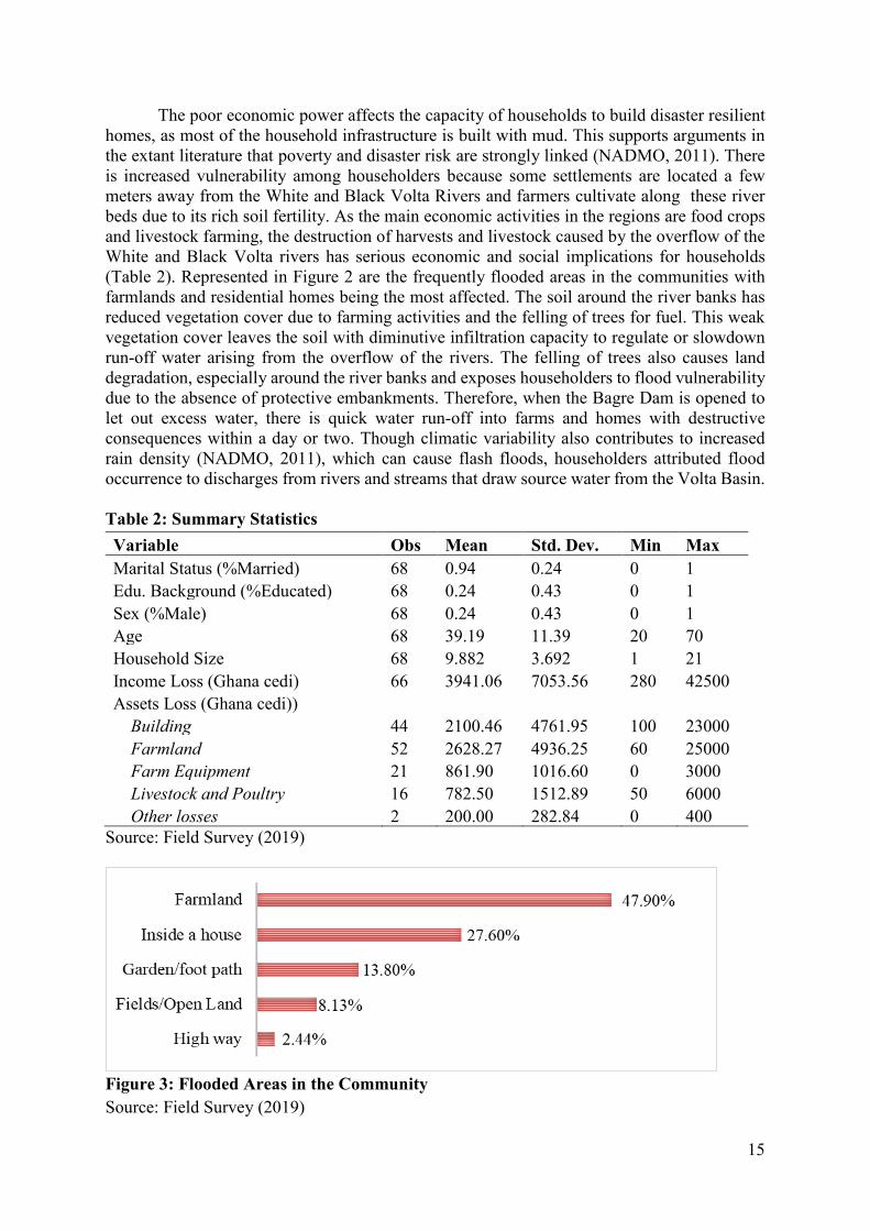
The average income lost in flood disaster was GHS3,941.06 Ghana cedi (GHS1=USD5.4) with the minimum amount of loss being GHS280 and a maximum of GHS42,500 (Table 2). The most affected assets of households were residential homes and farmlands. The Ghana Statistical Service (GSS) in its 2016/2017 living standards survey report captured both urban and rural savannah as the poorest in Ghana. Whereas the national population defined as poor is estimated to be 23.4%, the proportion estimated for rural and urban savannah, which make up regions of the north was 67.7% and 30.1% respectively (GSS, 2018). Extreme poverty in these regions is more than four times the national average, which is pegged at 8.2% per adult per year (income reference for extreme poverty is amount below GHS792.05/year).
15
The poor economic power affects the capacity of households to build disaster resilient homes, as most of the household infrastructure is built with mud. This supports arguments in the extant literature that poverty and disaster risk are strongly linked (NADMO, 2011). There is increased vulnerability among householders because some settlements are located a few meters away from the White and Black Volta Rivers and farmers cultivate along these river beds due to its rich soil fertility. As the main economic activities in the regions are food crops and livestock farming, the destruction of harvests and livestock caused by the overflow of the White and Black Volta rivers has serious economic and social implications for households (Table 2). Represented in Figure 2 are the frequently flooded areas in the communities with farmlands and residential homes being the most affected. The soil around the river banks has reduced vegetation cover due to farming activities and the felling of trees for fuel. This weak vegetation cover leaves the soil with diminutive infiltration capacity to regulate or slowdown run-off water arising from the overflow of the rivers. The felling of trees also causes land degradation, especially around the river banks and exposes householders to flood vulnerability due to the absence of protective embankments. Therefore, when the Bagre Dam is opened to let out excess water, there is quick water run-off into farms and homes with destructive consequences within a day or two. Though climatic variability also contributes to increased rain density (NADMO, 2011), which can cause flash floods, householders attributed flood occurrence to discharges from rivers and streams that draw source water from the Volta Basin. Table 2: Summary Statistics Variable Obs Mean Std. Dev. Min Max Marital Status (%Married) 68 0.94 0.24 0 1 Edu. Background (%Educated) 68 0.24 0.43 0 1 Sex (%Male) 68 0.24 0.43 0 1 Age 68 39.19 11.39 20 70 Household Size 68 9.882 3.692 1 21 Income Loss (Ghana cedi) 66 3941.06 7053.56 280 42500 Assets Loss (Ghana cedi))
Building 44 2100.46 4761.95 100 23000 Farmland 52 2628.27 4936.25 60 25000 Farm Equipment 21 861.90 1016.60 0 3000 Livestock and Poultry 16 782.50 1512.89 50 6000 Other losses 2 200.00 282.84 0 400
Source: Field Survey (2019)
Figure 3: Flooded Areas in the Community Source: Field Survey (2019)

16
4.2 Awareness of Flood Hazards and Effectiveness of Early Warning Systems
Householders in flood prone areas of Mamprusi West, Sissala East and Talensi were very much informed about hazard warnings connected to the Bagre Dam spillage. Warning messages were received from variety of sources, but the most dominant source was through community radio (Figure 4). Other sources included information from neighbours, loud hailer announcement by district information vans, officials of disaster agencies and phone calls. The most preferred mediums for warning messages were however community radio, official knocking at door and loud hailer in the street because householders see those sources as more authentic. In addition, most communities are without telecommunication services and even where they exist, not all households have access to mobile phone. It is important that disaster authorities recognize the fact that local people are more likely to accept warning messages from formal sources given their preference. Increasing disaster personnel will enhance warning communication and elicit appropriate responses from local people. Where it is not feasible to increase personnel due to resource constraints, disaster authorities should identify and train community volunteers in collaboration with traditional authorities and local assembly members beyond the existing district and zonal officers. These volunteers will aid warning dissemination and information acceptability to ensure large geographical coverage. Furthermore, it is crucial that messages communicated through the radio and loud hailers remain consistent in order to maintain the integrity and authenticity perceived by householders.
Table 3: Impact of Floods Degree of Impact Family
Life Priorities in Life
View of community
Sense of financial security
No impact 18% 7% 9% 19% Minor impact 15% 19% 13% 18% Moderate impact 12% 43% 46% 15% Extreme impact 56% 30% 32% 49%
Source: Field Survey (2019)
Figure 4: Source of Flood EW Messages
Figur Figure 5: Knowledge of flood and perception of occurrence

17
The effectiveness of early warning is not only limited to knowledge of flood hazard and its risk, but knowledge of coping and adaptation strategies to avoid hazards from transiting into disasters. This, centers on local response to hazard warning. Householders in the three study areas recognize that flood hazards can lead to disasters to the extent that majority of respondents ranked the impact of flood to their family life and sense of financial security as extreme (Table 3). In addition, householders were also expectant of floods in the future, given that 100% believed their communities are likely to be flooded in the next 10 years. What is intriguing is that, even those who said they were not well informed about flood hazards still think flood occurrence is likely in the future (Figure 4).
Unfortunately, knowledge about flood hazards, its impact on households and perception of occurrence in the future is not leading to desired outcomes, since the ritual spillage of excess water from the Bagre Dam continues to submerge farms and housing infrastructure. In Table 5, we show the different local actions that households have adopted in the past to deal with the annual flooding situation. The common and dominant local actions included moving possessions to higher ground, deploying sandbags as flood defense guards and planting of crops with short gestation period to enable early harvest. Though the latter is an indication of how local people have combined knowledge of agricultural practices and flood hazard awareness to reduce disaster risk, the success of this practice is solely dependent on rainfall and given that Ghana is exposed to climate variability (unpredictable rainfall pattern) relying on only short gestation crops without irrigation system can result in poor yield for households if rainfall is inconsistent (NADMO, 2011). Householders’ risk response falls in one of the behavioral typologies by Burton (1993). With knowledge of flood risk, households are willing to take some precautionary measures. We posed a question to find out if respondents felt receiving warning messages improved their preparedness towards disaster reduction Majority of respondents (92%) felt receiving early warning improved their preparedness towards disaster reduction (Table 4). However, the local mitigating measures such as the use of sandbags did not have the capacity to prevent overflow of flood waters. Poor infiltration capacity of the soil also contributed to rapid runoff of excess water, thus inundating farms around the river banks.
Table 4: Early Warning and Disaster Risk Reduction
Did you receive any warning about the Bagre dam water spillage prior to the floods?
Do you feel receiving early warning improved your preparedness towards reducing disaster risk? No Yes Total
Yes 5 58 63 Total 5 58 63 Source: Field Survey (2019)
4.3 Emotions about Flood Hazard Risk and Local Actions Householders also experienced varied emotional conditions following hazard warnings.
Majority (30%) experienced fear and anxiety; 28% reported being confused about what to do while 26% were helpless and felt they could not manage the hazards without support of others. We refer to the latter as the dependency syndrome, where householders have lost hope in self-capacity, concluding that personal efforts are at best equivalent to inaction. However, two emotional states (anger and feeling of confusion) were significantly associated with local responses. A Chi square analysis revealed the following results for anger (χ2 =.974; p-value = 0.004) and (χ2 = 48.8130; p -value=0.002) for feeling of confusion. It is important disaster agencies take cognizance of the psychological effects of warning messages and develop

18
contents that do not reinforce learned helplessness. For most of the respondents, past experience of the flood disaster played a significant role in their imagination of yet another traumatizing experience. To some extent, the feeling of anxiety is great that householders are tempted to deny the physical dangers that come with flood disaster, hoping that nature will suppress rains to spare Bagre Dam from spilling water. This thinking tends to absolve householders from responsibility of taking protective measures as they believe that favour from divine power is just enough to reduce torrential rains that contribute to filling the Bagre Dam. This concurs with previous findings by Bempah (2017) where householders in flood community - Buipe, attributed the occurrence of flood to divine origin.
Table 5: Local Action by Gender
Local Action Male Sample
Female Sample Total
Created water channels in compound 1% 0% 1% Moved electrical appliances 4% 10% 15% Not taken flood alleviation measure 3% 14% 17% Planting short gestation crops/early harvest 1% 18% 19% Deployed sandbags, flood guards & other defenses 7% 14% 21% Moved possessions to higher ground 7% 19% 27%
Source: Field Survey (2019) Table 6: Gendered Emotions following EW
Emotion during EW Male Female Total Sample Percent of responses Self-control 0 1 1 2 Confusion 3 11 14 28 Fear/Anxiety 4 11 15 30 Dependent on others 2 11 13 26 Anger 1 6 7 14 Total 10 40 50 100 N=50, χ2=4.6640, P-value = 0.7983
Source: Field Survey (2019)
We went further to measure how personal experience of floods impacted on people’s anxiety by asking respondents how often they got worried about flooding. We found that the number of times one was exposed to flood events in the last 5 years was significantly related to their levels of anxiety about floods and risk response (p-value <0.1, Appendix 1 & p-value <0.05, Table 7). Our logistic regression contradicts empirical evidence by Harries (2008) that anxiety about future floods affected people’s emotional capacity (decision making and confidence in overcoming life challenges) in taking precautionary measures for self-protection. We realized that being anxious about floods rather showed that people are more likely to adopt a risk mitigation measure. Table 8 reports the logistic regression result and anxiety significantly influenced the adoption of sandbags to guard against the infiltration of flood waters into people’s homes (P-value < 0.05). In essence, the feeling of individuals and households in hazard prone areas in northern Ghana has influence on the type of response they adopt. Households’ past experience of disasters also have influence on their decisions to take precautionary measures. Thus, the hypothesis that past experience of floods significantly influences risk response is supported.

19
Table 7: Flood experience and risk response
Number of times your property been flooded in the past 5 years
Did you take any action to protect your household from floods ? Yes No Total
1 1 0 1 2 6 1 7 3 10 2 12 4 8 1 9 5 17 11 28 6 1 1 2 7 0 1 1 10 0 4 4 12 0 1 1 Total 43 22 65 χ2 = 17.6976, df =8, p-value = 0.024 Source: Field Survey (2019)
Table 8: Influence of Emotional State on Local Actions
a b c d Self-control 2.389 (1.160)* .799 (0.407)* 1.022 (0.484)* -.888 (0.388)* Confusion 1.201 (0.492)* 1.590 (0.464)*** 1.100 (0.481)* -1.196 (0.533)* Anxiety .741 (0.320)* -0.342 (0.325) 0.154 (0.347) 0.261 (0.288) Dependent 1.162 (0.626) .837 (0.395)* 0.785 (0.540) -0.798 (0.426) Anger 1.628 (0.406)*** .569 (0.267)* 1.515 (0.353)*** -.943 (0.359)** _cons -16.199 (4.783)*** -7.269 (2.042)*** -11.089 (2.603)*** 6.474 (2.424)** N 66 66 66 66 Wald chi2(4) 1.97 17.69 26.08 10 P-value 0.0005 0.0034 0.0001 0.075 Pseudo R2 0.5448 0.2919 0.3914 0.339
Legend: * p<0.05; ** p<0.01; *** p<0.001. Robust standard errors in parenthesis a = use of sand bags, flood guards and other defense measures; b= Moved possessions to higher ground; c = Moved electrical appliances and d = Use of short gestation crops; e = No action taken. Variance Inflation Factor (VIF) was computed to detect the presence of multicollinearity. Average VIF = 1.09 after collinear variables (evacuation of HH members, pumping of flooded water & walls around building) were dropped. 4.4 Early Warning Communication and Risk Response
A logistic regression was modeled to determine the predictability of EW communication channels on the likelihood of householders adopting flood risk mitigation strategies (1 if HH adopted a mitigation measure and 0 otherwise). Two predictor variables (EW from relatives/friends and EW received on phone) had significant influence on decisions of householders against the adoption of mitigation strategy. The explanatory power of both variables (p <0.01, Table 9) shows that householders do not rely on information received from informal sources, though it is possible such information from friends and relatives come from formal and reliable sources. Other EW sources (community radio, use of loud hailer, and official knocking at door) lacked predictive power, although they were appropriately signed (Table 9).

20
In Table 10, we represent the various local actions adopted by households in response to flood hazard risk. These include use of sandbags as flood guards, relocating possessions and assets to higher grounds, relocating electrical appliances and use of short gestation crops. The latter emerged from thematic content analysis of the qualitative responses, which was coded as a quantitative variable. Warning messages received from community radio stations contribute to behavior change, as households are more likely to mount sandbags and move some possessions to higher grounds. Therefore, local FM stations can be relied upon to communicate protective measures or more effective ways of mitigating flood disaster. Public awareness and information channeled through loud hailers and/or district information vans predicted the decisions of farmers to plant crops with short gestation (p < 0.1). The knowledge of flood hazards, which includes timing of the Bagre water spillage, has empowered farmers to embrace adaptation strategies that allow them to do early harvests of crops. Anecdotal evidence shows that this strategy is saving farmers from harvest losses, but also reduces exposure of farmers to risk of being carried away by floods during farm activities. While making use of short gestation crops is a good practice, disaster authorities are still concerned that farmers do not heed to warnings that request them to stop cultivating river beds. This is because climate variability in Ghana can affect rainfall pattern at any time, posing threat to farmers, where the rivers overflow their banks even without Bagre spillage. We include here an extract of interviews with NADMO officers to highlight how they feel about the warnings issued to at risk communities.
Interviewer: What warning messages do you communicate to at risk communities? What expectations do you have of these communities with respect to the warning alerts?
Disaster officer Our outfit usually makes it clear to these communities that no one
should build or farm close to the river banks… we ask them to move their properties to safer heights and encourage them to plant more trees in their communities to help minimize flooding.
Interviewer: What do you think communities are not doing which is leading to recurrence of disasters?
Disaster officer: “They [community members] have always turned deaf ears to our warning alerts not to build close to riverbanks uh not to litter their environment”.
Table 9: Sources of EW communication on choice of HH response
EW Source Coef. St.Err. t-value p-value [95% Conf
Interval] Sig
EW from friends/relatives -2.132 .685 -3.11 .002 -3.474 -.79 *** EW from community radio 1.492 1.026 1.45 .146 -.519 3.502 EW from official knocking at door
.698 1.17 0.60 .551 -1.595 2.99
EW from loud hailer .547 .839 0.65 .514 -1.098 2.192 EW from phone call -2.94 .963 -3.05 .002 -4.828 -1.052 *** Constant .409 .846 0.48 .629 -1.249 2.067 Mean dependent var 0.657 SD dependent var 0.478 Pseudo r-squared 0.340 Number of obs 67 Chi-square 22.198 Prob > chi2 0.000 Akaike crit. (AIC) 68.876 Bayesian crit. (BIC) 82.104

21
*** p<.01, ** p<.05, * p<.1 Variance Inflation Factor (VIF) was computed to detect the presence of multicollinearity. Average VIF = 1.16 after collinear variables (use of flood line and text messages) were dropped. Table 10: Sources of EW Communication on HH response adopted
Local Action Adopted
EW Source a b c d e
Friend/Relative -2.276(0.865)** -0.995(0.661) -1.299(0.817) 1.409(0.932) 2.132(0.685)**
Local radio announcement 2.898(1.291)* 2.886(1.379)* -1.077(0.847) -1.492(1.026)
Official knocking at door 0.975(1.357) 0.382(0.849) 0.754(0.878) -0.805(0.904) -0.698(1.170)
Loud hailer in the street 1.224(0.749) 3.609(0.958)*** -0.547(0.839)
Phone call 2.145(1.044)* 2.940(0.963)**
_cons -1.141(1.149) -2.182(1.400) 0.368(0.499) -1.491(0.687)* -0.409(0.846)
N 41 57 36 67 67
Wald chi2 10.23 6.83 4.04 25.17 22
P-Value 0.0167 0.1453 0.1324 0.0001 0.0005
Pseudo R2 0.2989 0.1660 0.0924 0.4048 0.3401
Legend: * p<0.05; ** p<0.01; *** p<0.001. Robust standard errors in parenthesis a = use of sand bags, flood guards and other defense measures; b= Moved possessions to higher ground; c = Moved electrical appliances and d = Use of short gestation crops; e = No action taken. Variance Inflation Factor (VIF) was computed to detect the presence of multicollinearity. Average VIF = 1.16 after collinear variables (use of flood line and text messages) were dropped.
4.5 Evacuation/Resettlement as protective Measure One of the mitigating measures that disaster authorities have emphasized during
warning communication is the need for households to farm on high plains as well as relocate settlements, especially those that are close to the White and Black Volta rivers. However, householders have been reluctant in complying with these prescriptions. This supports the position of Mileti et al. (1975) that evacuation orders do not automatically result in full compliance as this is sometimes affected by perceived source authority and content of the order. Residents in disaster prone areas argue that the orders to desist from building or farming along river banks do not come with alternative courses of action to sustain livelihoods of households and more so, they (households) have come to build a generational social identities and networks that make it difficult to easily let go. An attempt to let go of their identity and culture as a people, having lived in the communities for long, is construed as being a sign of weakness since their ancestors have survived similar conditions. This concurs with the argument of the cultural theory that preservation of group belif system is a good predictor of risk response compared to materialism. Though the people were generally worried about material losses, their social and cultural values are considered more important to compromise. The fear of losing ancestral land, especially for natives who have lived in the areas for long, is significantly associated with decisions not to relocate settlement (p-value<0.05, Table 11). Furthermore, householders expressed concerns about cost involved in resettlement of their families, given that majority of them are poor, seasonally unemployed and dependent on rain fed subsistence farming.
The hypothesis that cost of evacuation is significantly related to hazard risk response is thus supported (χ2 = 7.264, p-value = 0.007, Table 8). Views of respondents also capture the fact that government has not backed their resettlement orders with compensation for social and economic cost householders will incur in the process of relocation. This evidence is in tandem with Fishbein and Stasson (1990) and Bempah (2017). While the call for government to bear cost of relocation is evidence of how householders shift responsibility for flood risk mitigation

22
(Bempah, 2017), it is important to pay attention to alternative livelihood opportunities for these households, as this is a major concern for them.
It is surprising to note that despite how worried residents are about the flood situation in their communities, coupled with their expectation of floods in the next 10 years, they have still not considered resettlement as an option (Table 11). This point to the strong convictions held by households. No matter how authoritative resettlement orders are crafted and communicated, it will have less influence on decisions of households to resettle, unless the issues of social and economic costs are addressed.
Table 11: Decision not to relocate Households Crosstab by Reasons
Why don’t want to relocate your Residence?
Given the flood situation, have you considered or made plans to move your residence permanently?
Stats
Yes No Total Cost of relocation No 4 15 19 χ2 = 7.264
p-value = 0.007 Yes 1 48 49
Fear of income loss from economic activity No 4 50 54 χ2 = 0.001 p-value = 0.973 Yes 1 13 14
Ownership of landed assets No 4 45 49 χ2 = 0.169 p-value = 0.681 Yes 1 18 19
Government compensation issues No 4 43 47 χ2 = 0.299 p-value = 0.561 Yes 1 20 21
Traditional leader of community No 5 59 64 χ2 = 0.337 p-value = 0.584 Yes 0 4 4
Preservation of ancestral artefacts No 5 57 62 χ2 = 0.522 p-value = 0.470 Yes 0 6 6
Loss of ancestral land No 5 32 37 χ2 = 4.522 p-value = 0.033 Yes 0 31 31
Loss of social networks (friends, relatives, associations)
No 3 27 30 χ2 = 0.552 p-value = 0.457 Yes 2 36 38
Source: Field Survey (2019)
To gauge respondents’ knowledge about causes of flooding in their communities, we sought to find out what they think are responsible for flooding. Reasons are varied across districts. In Mamprusi west, the predominant factors were lack of early warning, Bagre dam spillage, and torrential rains. In Talensi, water spillage from Bagre dam was the major cause of flooding. Sissala East had no particular cause as several factors were assigned to flooding i.e. building close to river banks, dam water spillage, lack of early warning, deforestation, torrential rains and inappropriate physical development amongst others (Table 12). Given that respondents had an idea of the cause of flooding, we proceeded to solicit views on what householders could do to mitigate the impact of flooding. Majority of respondents in Mamprusi west (41%) and Talensi (35%) did not know the appropriate risk mitigation strategy to be employed. About 24% and 18% in Mamprusi west and Talensi respectively suggested the need for householders to stop cultivating river beds while 18% in Mamprusi recommended creation of water channels to divert flood waters. Also, 24% in Talensi suggested climate smart agriculture such as the planting of early maturing crops to ensure early harvest, before decisions of Bagre authorities to spill excess water. Clearly, those who did not have an idea of the action to adopt are more likely not to respond to flood risk. In Sissala east, households recommended that buildings should be sited far away from water courses and trees should be planted around homes and along the river banks to improve vegetation cover and water infiltration capacity

23
(Table 13). Table 12: What do you think are the causes of recurrent floods? HH views on causes of recurrent floods Districts
Mamprusi W. Talensi Sissala E. Total Building close to riverbanks 8% 0% 9% 9% Changing course of rivers by development 0% 0% 9% 8% Inadequate housing development monitoring 0% 0% 9% 8% Lack of early warning information 39% 0% 9% 11% Riverbed sedimentation 0% 6% 6% 6% River channels covered by weeds 0% 0% 9% 8% Dam breaking/spillage of water 28% 94% 9% 14% Heavy rainfall 25% 0% 9% 10% Dumping refuse in drainage channels 0% 0% 9% 8% Lack of tree planting 0% 0% 9% 8% Deforestation 0% 0% 9% 8% Increased impervious surfaces 0% 0% 6% 5% Total 100% 100% 100% 100%
Source: Field Survey (2019) Table 13: What can households do to mitigate impact of floods? HH actions to mitigate impact of flood District Mamprusi W. Talensi Sissala E. Total Comply to warning alerts 0% 0% 6% 3% Site building away from river banks 0% 12% 32% 19% Plant early maturing crops 6% 24% 0% 7% Clear weeds from river channels 0% 0% 15% 7% Redirect river courses 0% 0% 3% 1% Create water channel to divert water 18% 0% 3% 6% No refuse dumping in drainage systems 0% 0% 4% 12% Tree planting 0% 0% 15% 7% No farming along river banks 24% 18% 0% 10% Use flood control plants 0% 6% 0% 1% Don't know 41% 35% 0% 19% Stop felling trees 0% 0% 3% 1% Move possession to high ground 0% 6% 0% 1% Build defense wall along river 12% 0% 0% 3% Total 100% 100% 100% 100% Source: Field Survey (2019)
4.6 Responsibility for Flood Protection It has been argued that flood risk protection is a collective responsibility, from the individual to the family, communities and to state agencies and international bilateral and multilateral institutions. But, respondents’ views do not reflect this conceptual thinking. The tendency to shift blame and responsibility of flood risk protection has been quite evident among respondents and this is largely because of the perception of what causes floods. It makes sense for central government to invest in appropriate infrastructure for flood protection, but

24
complimentary human activity is required to support state efforts. Where this is lacking, government is overburdened with responsibility and is constantly on the lookout for external support. Bempah has argued that continuous dependence on external support can create donor fatigue and consequently lead to withdrawal of their support. Table 14: Who do you think should bear responsibility for flood protection? Districts Mamprusi W. Talensi Sissala E. Total Count % Count % Count % Count % Self 5 16% 0 0% 33 34% 38 26% Landlord 1 3% 0 0% 3 3% 4 3% Local council 9 28% 0 0% 11 11% 20 14% EPA 2 6% 0 0% 16 16% 18 12% NADMO 15 47% 16 100% 34 35% 65 45% Total 32 100 16 100% 97 100% 145 100% χ2= 81.3820 P-value = 0.000
Source: Field Survey (2019) 4.7 Post Disaster Recovery, Reconstruction
Overwhelming majority of respondents (85%) had received some form of assistance following disaster occurrence (Table 15). Assistance was rendered not based on household demographic characteristics, but based on the assessment of household unique situations (Table 16). NADMO for instance, had standard criteria for relief distribution. About 50% of this support came mainly from NADMO - the state agency responsible for disaster prevention and management (Table 17). Social networks i.e. friends and neighbours have equally been helpful. NADMO is well known in the communities for relief distribution and rescue missions while the Ministry of Food and Agriculture (MoFA) in the districts focused on households who suffered harvest losses. Notwithstanding this support, respondents were not satisfied with the kind of support they received from these agencies, explaining that the support was inadequate relative to their losses. As a result, majority reported relying on their personal savings to cope with the vicissitude of life (Table 19). The type of coping mechanism adopted varied based on district of respondents. Respondents were more likely to depend on government or sell personal assets to recover from losses and remain functional, if they lived in Sissala east district. Likewise, respondents in Mamprusi west and Talensi were more likely to use personal savings (ibid.). The differences in coping mechanisms was seen as a function of the perceived role householders expect central government to play as far as supporting recovery and reconstruction are concerned. Government’s relief support is for a short period, focusing on household basic needs of food and safety. These are part of the support mechanisms identified by Buckle (2006). Emergency response with regards to shelter was limited as temporal shelters were reported unavailable for those who are rendered homeless. In the 2007 flood disasters in northern Ghana, an estimated $25million was needed in emergency response and yet, in 2019, only $11.6million was allocated to NADMO in the national budget for goods and services.

25
Table 15: Did you receive any assistance when you were affected by the flood disaster?
Did you receive any assistance when your property got flooded?
Because of the flood, have you considered or made plans to move residence permanently Yes No Total
No 1 9 10 Yes 4 53 57 Total 5 62 67 χ2 = 0.1096, df =1, p-value = 0.741 Source: Field Survey (2019) Table 16: Logistic regression for assistance on demographic factors
Assistance Coef. St.Err. t-value p-value [95% Conf Interval] Age -0.003 0.042 -0.06 0.952 -0.085 0.079 MaritalS -0.737 1.204 -0.61 0.540 -3.096 1.622 NoHH -0.099 0.153 -0.65 0.517 -0.399 0.201 Constant 2.235 2.507 0.89 0.373 -2.679 7.149 Mean dependent var 0.412 SD dependent var 0.507 Pseudo r-squared 0.063 Number of obs 17.000 Chi-square 1.084 Prob > chi2 0.781 Akaike crit. (AIC) 29.574 Bayesian crit. (BIC) 32.907 *** p<0.01, ** p<0.05, * p<0.1 Source: Field Survey (2019)
Table 17: Where did you receive assistance from when you experienced flood disaster? Post disaster support Count Percent Friends/neighbours 31 27% Friends outside locality 13 12% Community group 1 1% Red Cross Society 2 2% Ministry of Food & Agriculture 9 8% NADMO 57 50% Total 113 100%
Source: Field Survey (2019) Table 18: How satisfied were you with the assistance received?
How satisfied were you with the assistance? Because of the flood, have you considered or made plans to move residence permanently
Yes No Total Very satisfied 0 5 5 Somewhat satisfied 3 32 35 Slightly satisfied 0 10 10 Not satisfied 1 7 8 Total 4 54 58 χ2 = 1.6552, df =3, p-value = 0.647 Source: Field Survey (2019)

26
Table 19: How did you managed to deal with your losses in the disaster? Coping Mechanism Mamprusi W. Talensi Sissala E. Total Government assistance 5 0 34 39 Personal savings 13 17 29 59 Sold assets 0 0 28 28 Stopped children schooling 0 0 1 Migrated temporary 0 0 2 2 Reduce expense on food 12 14 10 136 Total 30 31 104 165 Cases 17 17 34 68 χ2 = 77.774, df =1, p-value = 0.000
Source: Field Survey (2019)
5 Summary of Key Findings Early warning on potential floods from Bagre dam spillage has received wide coverage
within the hazard prone areas. This has been possible through the efforts of disaster authorities using community radio, district information vans and official knocking at doors. Though households also received early warning from informal sources like friends and relatives, they showed disposition towards acting on information received from formal sources due to its authenticity and reliability. Further, flood prone communities tend to validate official communique on flood hazards by using local knowledge i.e. observing water levels in the two main rivers – the White and Black Volta together with it tributaries. While there is no doubt about people’s awareness of flood hazards and the type of risk mitigation measures to adopt, undesired consequences of flooding has become conventional, questioning effectiveness of local actions that have been embarked upon over the years. These actions include the use of sandbags, keeping possessions on high grounds, and relying on climate smart agriculture (planting early variety crops). Householders’ risk response falls in one of the behavioral typologies by Burton (1993), where, given knowledge of flood hazard, people are willing to take some precautionary measures. But, evidence from this study showed no relationship between receiving warning message and disaster reduction, an indication that local actions do not have significant influence on DRR. This has the tendency to discourage households from taking any action, because clearly, such conventional measures, with the exception of climate smart agriculture, which anecdotal evidence points to positive impact, have not led to desired outcomes. Therefore, the alternative has been to discourage cultivating river beds while persuading households to resettle homes away from river banks. We found that continuous cultivation of crops along river banks and felling of trees for local fuel along the flood plains have contributed to diminutive infiltration capacity of the soil due to lack of vegetation cover in the area, causing rapid surface water run-off into farms and residential homes.
Despite continuous persuasion of households to relocate settlements and farms, there has not been a corresponding response, as householders are unanimous in their decisions not to relocate. On the one side, it has become difficult for householders to live their existing settlements due to the possibility of losing intergenerational social identities that communities have built over the years. This validates the ideological arguments of the cultural theory, which emphasises the fact that people’s actions are socially constructed based on the values of the social group.
Beyond culture and social reality, livelihoods and socio-economic factors greatly influenced householders’ decisions in terms of taking decisions that will impact flood risk protection in northern Ghana. Farmers along the White and Black Volta rivers continue to

27
cultivate crops along the river banks because the soil is fertile and poor farmers do not require the application of chemical fertilizers to realise good yields. What is not immediately known to farmers is the fact that they tend to incur much more cost through harvest losses as a result of floods than if they had cultivated on high plains and expended on cost of fertilizer for their food crops. Furthermore, while it is easy for disaster authorities to prescribe actions for resettlement, they have not considered cost implications to householders in these areas because majority are poor and only depend on subsistence agriculture. Not only are they (households) concerned about losing ancestral lands, they are concerned about their capacity to shoulder the cost of relocation. The importance placed on culture and lack of economic power to engineer protective measures for DRR portray materialism as though the value of the latter is unimportant to householders, but that is farfetched. The issues are multi-dimensional and require integrated solutions. In fact, evidence in this study confirms that poverty and disaster risk are inherently interlinked.
We noticed what we refer as dependency syndrome, where some respondents felt personal efforts had no influence on disaster risk and they needed to depend on others for risk protection. Literature has shown that loss of self-capacity results from anxiety and fear, which tend to reinforce learned helplessness. We found that anxiety is more likely to influence risk taking behavior, if the threat of risk is immediate and there is recall of past, but traumatizing disaster experience.
While we contend that local resources can be harnessed to improve DRR, strengthen households’ coping mechanisms and ultimately ensure resilience, we argue that protective measures are definitely not cheap. Certainly, there is need for behavior change and cultural reorientation among households, but the 686 communities affected by Bagre dam spillage require central government support that is more structural and proactive than reactive conventional reliefs. There are advantages that will inure to the government of Ghana while supporting livelihood activities such as irrigational cultivation of crops.
6 Conclusion This study set out to examine the effectiveness of early warning communications and
whether such communications are leading to desired local actions among householders affected by the spillage of excess water from Bagre dam. Both the White and Black Volta Rivers, including its tributaries overflow their banks, resulting in massive floods, which tend to affect over 600 communities in Northern Ghana. This has become a yearly routine and a cause for concern for both householders and disaster authorities. While communities are forewarned of impending danger prior to this exercise, the resultant effect has consistently been negative. This prompted our quest to find out why, in spite of early warning communications, householders continue to experience flood disasters. Our study relied on mixed method methodology to unearth the normative ideas about flood hazard awareness and risk response. We found that early warning communications has achieved substantial flood risk awareness and there has been some willingness on the part of householders to adopt protective measures that are largely perceived to be within their control. These measures, although widely used, have proven to be ineffective in managing the Bagre floods from graduating into disasters. Communities have relied on local resources and knowledge to raise flood defenses using sandbags, but this has not helped. Socio-cultural and socio-economic factors have affected the attainment of a more desired solution. Therefore to achieve DRR with respect to the effect of the Bagre conundrum, there is the need for multi-dimensional approach involving all stakeholders’ i.e. central government, disaster authorities, householders and donor partners. It requires climate change interventions, structural engineering, cultural reorientation and sustainable DRR capacity at the local level.

28
7 Key Policy Issues 7.1 Empowerment of disaster hot spot communities One of the principles of the SDGs is leaving no one behind. Ghana risks the opportunity to sustain its middle-income status and the achievement of the SDGs if systematic and well-thought measures are not put in place to address flood disasters in the savannah regions of Ghana, especially those occasioned by the excess water from the perennial Bagre dam spillage. Understanding the flood hazards is as important as providing both structural and non-structural measures, especially targeting the poor people at-risk communities to reduce their vulnerabilities to flood disasters. It is our understanding that the rich individuals compared to the poor in disaster prone communities are better able to protect their livelihoods and productive assets mainly because of their ability to avoid disasters. The poor who live and farm in and around the low-lying areas and along the banks of the White and Black Volta Rivers are more exposed to flood disasters. As a result, it is the poor who are unduly and more likely to be frequently hit by flood disasters and risk losing little assets and properties, thus exacerbating inequalities in opportunities and income among the population. Policy makers should therefore put in place measures to increase investemt which has co-benefits of poverty reduction, improved infrastructure, heath and education in disaster hot spot cummunities with focus on the poor. As a structural measure to deal with the Bagre induced floods, Government of Ghana should consider the construction of an appropriate water reservior in the white and black volta basins to take excess water from the Bagre spillage as well as absorb increased rainwater arising from climate variability. 7.2 Partnership for disaster risk reduction (DRR) Tackling disasters requires significant investment from the government, the private sector, research institutions, CSOs, philanthropic foundations and international development organizations. Therefore, governments through responsible sector agencies need to create the enabling environment to foster partnerships in resource mobilization and supporting community actions aimed at DRR. It is clear that DRR is inherently linked to development as disasters slide back any progress made in reducing poverty and inequalities. With the necessary partnerships and enabling environment, governments can address this challenge with a comprehensive portfolio review of prorgammes, projects and policies aimed at crowding in private sector investment in DRR. Considering that disasters slow down any progress made in the attempt to reduce poverty and inequality, other innovative financing instruments such as SDGs/Green Bonds could be pursued to mobilize sufficient resources in tackling flood disasters in Ghana. 7.3 Increasing capacities and effective colloboation among disaster risk management
organizations at the national and sub national levels. Warning of an extreme weather event such as flooding provided with a lead-time of five days or more is critical in helping at-risk communities to protect their assets and livelihoods. Considering that most at-risk communities are more likely to act on warnings delivered by government officials both at the national and sub-national levels, Governments must therefore invest in building the technical capacity of responsible Disaster Management Organizations to enable them issue information with significant lead-time. It is important for governments to

29
recognize that issuing information with significant lead time, does not mean that at-risk communities would be forewarned of impending hazards. Technical early warning information needs to be translated into potential impacts and adversaries at the local level by warning dissemination agencies and to sectoral agencies such as the Ministry of Food and Agriculture, Ministry of Heath, Ministry of Water and Sanitation among others. There must be well-established channels for communicating early warning information to communities. Effective collaboration among Water, Sanitation and Hygiene Agencies (WASH) is critical in addressing health related issues due to flood disasters. 7.4 Understanding the underlying flood vulnerabilities in at-risk communities. The extent of the vulnerability of a people to hazards has social, economic and environmental dimensions. Governments in close collaboration with research institutions and academia should therefore consider conducting national exercise to identify the vulnerability of different population groups and their livelihoods with the view to systematically address them. The outcome of this exercise should be mainstreamed into the local and national level development plans. Beyond the efforts of mainstreaming vulnerabilities into development planning, a tested methodology for scaling up successful interventions must be made available in the form of toolkits and body of practices that one can use for implementing or scaling up vulnerability reduction efforts at the local levels. 7.5 Mobiling society for behavioural change in DRR. Empirical evidence supports the idea that behaviour change is central to disaster risk reduction. Therefroe, there is the need for active involvement of disaster prone communities in planning risk communication and appropriate protective measures required for DRR. Putting affected communities at the forfront helps to create ownership of agreed DRR interventions to drive the desired behaviour change. This is consistent with DRR frameworks such as the Sendai Framework, which requires the methodology for early warning to be people centered, incorporating the understanding of the population at risk and being sensitive to indigenous knowledge, practices and values of local communities as well as demographic, gender and cultural diversity. It is has been proven that EWS that is people centered is effective and results driven in terms of achieving DRR.
Ethical Considerations This study was approved by the ethics review committee of the National Disaster Management Organisation (NADMO) after a careful review of the proposal. The approval gave clearance for relevant information to be obtained from the district disaster management stakeholders, including NADMO. Data collection was done in strict conformity to the approval given, focusing on household interviews, focus group discussions and review of relevant policy documents and disaster data. Acknowledgements The authors are so grateful to Humanitarian Innovation Initiative (HI²) at Brown University for providing financial support through HI² research seed grant program to undertake this study. We appreciate the coordinating role played by Seth Stulen, Program Manager of HI2 at Brown University. We acknowledge the National Disaster Management Organisation (NADMO) for providing ethical approval, which permitted their officers to participate in the study. Finally we recognize Issifu Salifu and Yaw Asamadu Dikpe, both research assistants and Ben Emunah Aikins, Geospatial Analyst for assisting with the study map.

30
Appendix: Appendix 1: Flood experience and anxiety Number of times your property been flooded in the past 5 years
How often do you worry about flooding? Most often Often Total
1 1 0 1 2 4 3 7 3 9 3 12 4 9 0 9 5 27 1 28 6 2 0 2 7 1 0 1 10 4 0 4 12 1 0 1 Total 58 7 65 χ2 = 13.7113, df =8, p-value = 0.090 Source: Field Survey (2019)

31
References Ahadzie, D.K., Proverbs, D.G., 2011. Emerging issues in the management of floods in ghana.
Int. J. Saf. Secur. Eng. 1, 182–192. https://doi.org/10.2495/SAFE-V1-N2-182-192 Ahadzie, D.K., Proverbs, D.G., 2010. Flooding and post flooding response strategies in Ghana.
WIT Trans. Ecol. Environ. 133, 281–291. https://doi.org/10.2495/FRIAR100241 Burton, I., Kates, R.W., White, G.F., 1993. The Environment as Hazard. The Guilford Press,
New York Acharya, A., & Prakash, A. (2019). When the river talks to its people: Local knowledge-based
flood forecasting in Gandak River basin, India. Environmental Development, 31, 55-67. Bempah, S. A., & Øyhus, A. O. (2017). The role of social perception in disaster risk reduction:
Beliefs, perception, and attitudes regarding flood disasters in communities along the Volta River, Ghana. International journal of disaster risk reduction, 23, 104-108.
Blaikie, Piers, Terry Cannon, Ian Davis, and Ben Wisner, At Risk: Natural hazards, people’s vulnerability, and disasters (London and New York: Routledge, 1994).
Buckle, P. (2006). Assessing social resilience. Disaster resilience: An integrated approach, 88-103
CRED (2018). Natural Disasters 2018. Brussels: CRED; 2019. This document is available at: https://emdat.be/ sites/default/files/adsr_2018.pdf
Douglas, M., & Wildavsky, A. (1982). How can we know the risks we face? Why risk selection is a social process 1. Risk analysis, 2(2), 49-58.
Forkuo, E.K., 2011. Flood hazard mapping using aster image data with GIS. Int. J. Geomatics Geociences 1, 932–950. https://doi.org/ISSN 0976-4380 National Science Board, 2018. Table of contents. Sci. Eng. Indic. 2018 1–8. https://doi.org/10.1002/ejoc.201200111
Fakhruddin, S. H. M., Kawasaki, A., & Babel, M. S. (2015). Community responses to flood early warning system: Case study in Kaijuri Union, Bangladesh. International Journal of Disaster Risk Reduction, 14, 323-331.
Ghana Statistical Service (2018). Poverty Trends in Ghana: 2005 - 2015. Ghana Living Standards Survey Round 7, GSS.
Government of Ghana (2019). National Budget and Economic Policy Statement of Ghana, Republic of Ghana.
Harvatt, J., Petts, J., & Chilvers, J. (2011). Understanding householder responses to natural hazards: flooding and sea‐level rise comparisons. Journal of Risk Research, 14(1), 63-83.
Plummer, K. (1983). Documents of Life: Introduction to the Problems and Literature of a Humanist Method. London: Allen & Unwin.
Khan, I., Razzaq, A., Jan, A., Riaz, S., & Shehzad, N. (2018). An analysis of Community Based Flood Early Warning System in the State of Azad Jammu & Kashmir. Procedia engineering, 212, 792-800.
Marshall, G. (2001). The psychology of denial: Our failure to act against climate change. The ecologist, 22(09), 01.
Morss, R. E., Mulder, K. J., Lazo, J. K., & Demuth, J. L. (2016). How do people perceive, understand, and anticipate responding to flash flood risks and warnings? Results from a public survey in Boulder, Colorado, USA. Journal of hydrology, 541, 649-664.

32
Niemeyer, S., Petts, J., & Hobson, K. (2005). Rapid climate change and society: assessing responses and thresholds. Risk Analysis: An International Journal, 25(6), 1443-1456.
NADMO (2011). Ghana plan of action on Disaster Risk Reduction (DRR) & Climate Change Adaptation (CCA) (2011-2015), NADMO.
NADMO (2010). National Standard Operating Procedures for Emergency Response, Accra, Ghana.
NADMO (2010). National Disaster Management Plan, Accra, Ghana. Paton, D. (2006). Disaster resilience: integrating individual, community, institutional and
environmental perspectives. Disaster resilience: An integrated approach, 320. Paton, D. (2006). Disaster resilience: building capacity to co-exist with natural hazards and
their consequences. Disaster resilience: An integrated approach, 3-10. Rust, N. A., Abrams, A., Challender, D. W., Chapron, G., Ghoddousi, A., Glikman, J. A., ... &
Sutton, A. (2017). Quantity does not always mean quality: The importance of qualitative social science in conservation research. Society & natural resources, 30(10), 1304-1310.
Sorensen, J. H. (2000). Hazard warning systems: Review of 20 years of progress. Natural hazards review, 1(2), 119-125.
UNISDR (2009). UNISDR Terminology and Disaster Risk Reduction, Geneva. https://starrfmonline.com/2018/09/20/bagre-dam-spillage-death-toll-rises-to-34/