the basketmaker communities project annual report, …€¦ · 2 the primary project area is...
TRANSCRIPT
The Basketmaker Communities Project
Annual Report, 2017 Field Season
Caitlin A. Sommer, Susan C. Ryan, Kari L. Schleher, Shanna R. Diederichs,
Steven R. Copeland, Rebecca L. Simon, and Grant D. Coffey
© Copyright 2017 by Crow Canyon Archaeological Center
All rights reserved
How to cite this publication
REMINDER: Archaeological resources are protected by federal laws, and archaeological
research is guided by a set of professional ethics. See Archaeological Ethics and Law.
1
Introduction
In 2017, the Crow Canyon Archaeological Center (Crow Canyon) conducted its seventh year of
field research as part of the Basketmaker Communities Project, a multiyear study of early Pueblo
community development in the central Mesa Verde region. The first four years of the study
focused on a pivotal, but under-investigated, time in Pueblo history—the Basketmaker III period
(A.D. 500–750). The focus of Crow Canyon’s field research has been a settlement cluster
consisting of more than 100 Basketmaker sites located within a 4.9 km2
area near the town of
Cortez, in southwestern Colorado. From 2015 to 2016, Crow Canyon’s field research focused on
the Hatch group―a series of four closely spaced multicomponent sites that date from the
Basketmaker III (A.D. 500–750) and Pueblo II (A.D. 900–1150) periods. This temporal
broadening was an effort to answer questions posed in Research Domains III and V in the
Basketmaker Communities Project research design (Ortman et al. 2011) and in the research
design addendum (Ryan and Diederichs 2014). These research domains address the following
questions: (1) Is there evidence for changes in community organization over time? (2) Is there
evidence for environmental change related to land-use patterns during the Basketmaker III–
Pueblo III periods? (3) How did the momentary population change through time, and is there
evidence for this change being linked to environmental degradation?
In 2017, our field research focused on completing excavations and documentation at the
Ridgeline site (5MT10711). Information from this site will broaden our dataset for the
Basketmaker III time period on Indian Camp Ranch and will help us address the following
research question (Ortman et al. 2011): Is there additional public architecture that dates from the
Basketmaker III period on Indian Camp Ranch? The inclusion of this site in our dataset may help
us understand population change through time and how the wider Basketmaker III population
related to the aggregated Basketmaker III settlement at the Dillard site.
This report summarizes progress on the Basketmaker Communities Project during the 2017
Crow Canyon field season, which was conducted from March through August under the State of
Colorado Archaeological Permit No. 2017-4. This field season was partly funded by a History
Colorado State Historical Fund grant (No. 2015-01-005). Fieldwork was conducted by members
of the archaeology staff with assistance from interns. In 2017, there was no public involvement
at the Ridgeline site. Field and laboratory work conducted by contractors is also summarized in
this report. Upon completion of all fieldwork and laboratory analyses, Crow Canyon will publish
detailed results of the Basketmaker Communities Project on its website (www.crowcanyon.org).
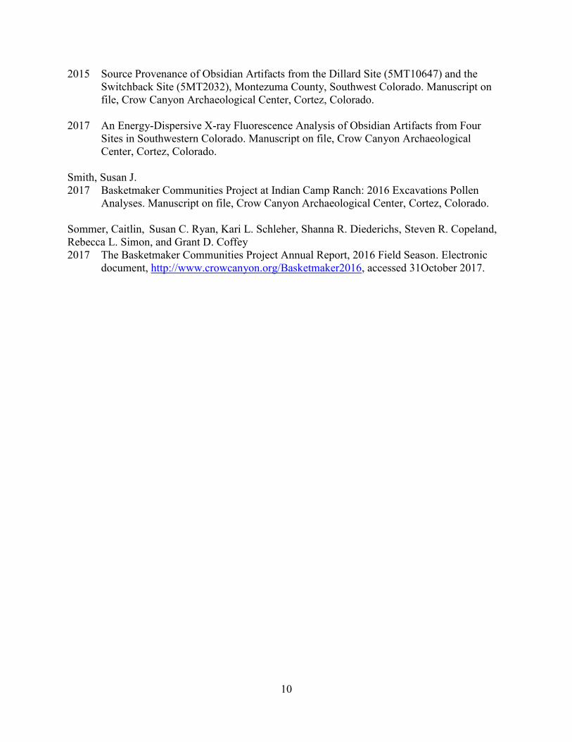
Project Area Location and Ownership
The Basketmaker Communities Project study area is located in the central Mesa Verde region
(Figure 1). Specifically, the study area is located in the McElmo drainage unit, which is defined
as lands that are drained by McElmo Creek. The settlement cluster that is the focus of Crow
Canyon’s research lies north of this creek, on a dissected upland between Alkali Canyon to the
west and the less-substantial Crow Canyon drainage to the east, just over 6 km (about 4 mi) west
of Cortez, Colorado.
2
The primary project area is defined by the property boundaries of Indian Camp Ranch, a 1,200-
acre, 31-lot private residential community developed in the late 1980s and early 1990s. There are
208 known archaeological sites on lands within the Ranch (Ortman et al. 2011). Surface remains
suggest that, of those sites, 107 date from the Basketmaker III period, 49 date from the Pueblo II
period, three are multicomponent Basketmaker III/Pueblo II sites, and 10 are multicomponent
Pueblo II/Pueblo III sites. Figure 2 illustrates the boundaries of Indian Camp Ranch and of
individual lots for which Crow Canyon obtained permission from individual landowners to
conduct field investigations during this field season.
Permits and Permissions
During 2017, excavation was conducted under State of Colorado archaeological permit No.
2017-4 and with the permission of the Indian Camp Ranch Homeowners Association and
individual landowners. Both the bylaws and covenants of Indian Camp Ranch (Indian Camp
Ranch Homeowners Association 2007) were crafted to promote the preservation of, and research
on, archaeological sites on the Ranch. In 2010, the Association granted Crow Canyon permission
to conduct field research at Basketmaker sites located within the Ranch subject only to
restrictions imposed by individual landowners and provided that the work complied with the
professional and ethical standards established by the Society for American Archaeology and the
Register of Professional Archaeologists.
Environmental Setting
The topography of the Basketmaker Communities Project study area consists of gently rolling
uplands where varying thicknesses of eolian silt loam overlie Dakota Sandstone. The elevation at
the center of the project area is about 1890 m (6200 ft). Approximately 100 million years of
geologic history dating from the late Triassic/Jurassic through the middle Cretaceous are exposed
west of the project area in Alkali Canyon. The various geologic strata provided Pueblo people
with construction stone and raw material for tools, and the permeable layers form a high-quality
aquifer that gives rise to numerous springs at the interfaces between fine sandstone beds and
less-permeable mudstones.
Indian Camp Ranch was probably once completely covered by pinyon-juniper woodlands that
were dominated by pinyon pine and Utah juniper and that included an understory of bunch
grasses, yucca, and prickly pear cactus. Today, remnants of this woodland can be found in the
northwest and south-central portions of the Ranch, but elsewhere the native vegetation has been
replaced (in the past 100 years) by ranch land and farm fields. Properties in the eastern one-third
of the Ranch have been cultivated and are planted in winter wheat. Vegetation on ranch lands is
dominated by big sagebrush, rabbitbrush, and bunch grasses.
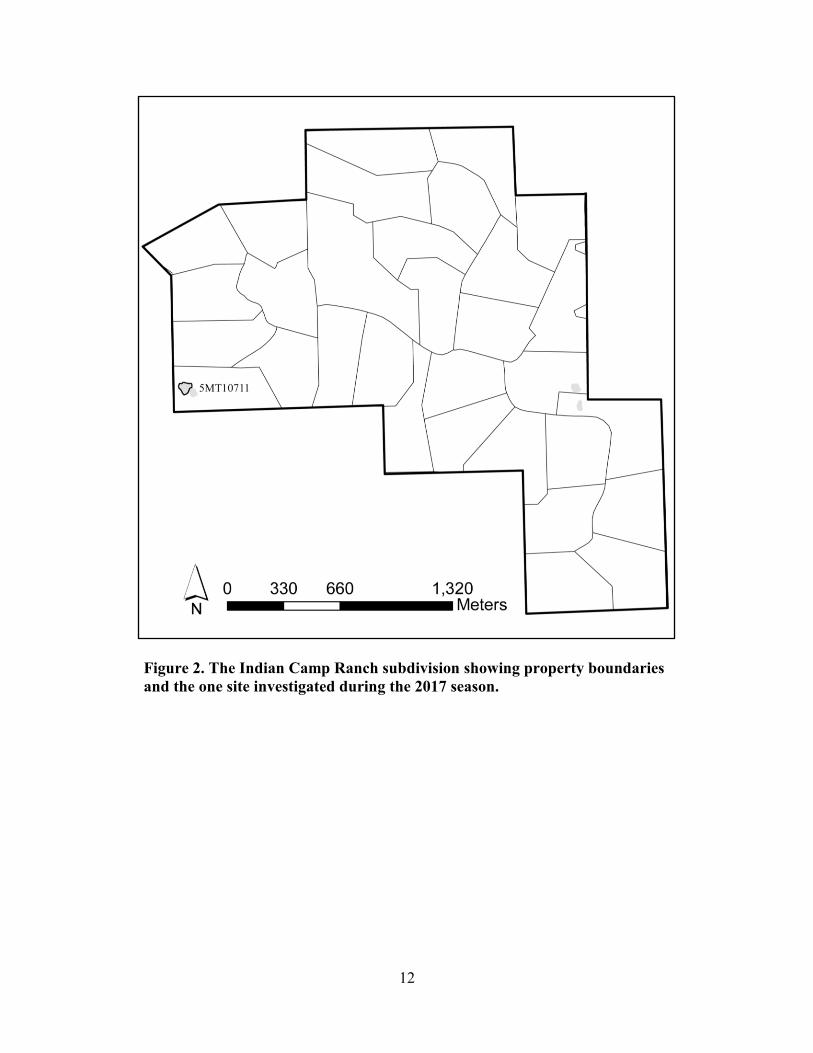
2017 Fieldwork: The Ridgeline Site
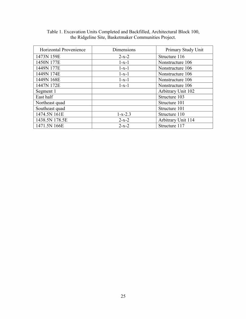
Excavations during the 2017 field season were conducted only at the Ridgeline site (5MT10711).
Table 1 lists all excavation units investigated at the site. By the end of the 2017 season, the final
six excavation units had been fully excavated and documented. Before backfilling, exposed walls
and floors within structures were protected with Geotech cloth—a breathable synthetic fabric
3
that does not deteriorate unless exposed to ultraviolet light. Backfill sediment was tamped down
to reduce settling, and the ground surface was restored as much as possible to pre-excavation
condition.
The Ridgeline site, 5MT10711 (Figure 3), is located on the westernmost ridge in the Indian
Camp Ranch subdivision (Figure 2). This site was identified by Woods Canyon Archaeological
Consultants in 1991 (Honeycutt and Fetterman 1991) and was surveyed using electrical
resistivity in 2012 (Charles 2012). The results of both surveys suggest that the site dates from the
Basketmaker III period. During the 2017 field season, we focused on completing excavations in
the east half of an oversized pit structure (Structure 101-103), three extramural surfaces
(Nonstructures 109, 112, and 120), and three pit rooms (Structures 110, 116, and 117).
Structure 101-103
Structure 101-103 is a large pit structure that measures approximately 11 m from the north wall
of the main chamber (Structure 101) to the south wall of the antechamber (Structure 103). The
main chamber measures approximately 9 m east-west, and the antechamber measures
approximately 6 m east-west. During the 2017 field season, excavations focused on documenting
and recording all surfaces in both the main chamber and the antechamber.
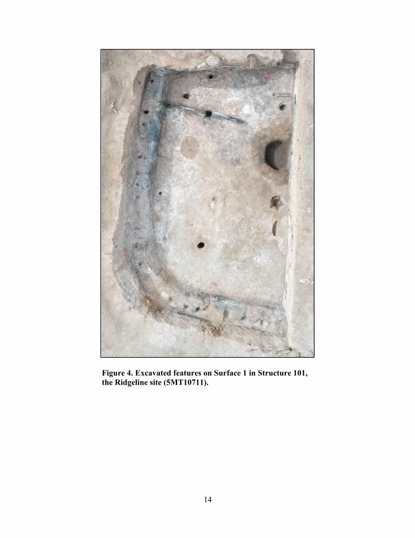
Surface 1 in Structure 101 was the final floor and was formally prepared with red plaster and
tan/brown sand. The hearth, the northeast and southeast main support posts, a deflector, a sipapu,
a wing wall, and several pit features were associated with Surface 1 (Figure 4). During the
excavation of these features, an earlier surface was detected beneath Surface 1. The fill
composing Surface 1 was then removed to reveal Surface 2.
Surface 2 predates Surface 1 and was formed of a mixture of adobe, charcoal, red plaster,
crushed sandstone, and calcium carbonate. The few artifacts recovered from Surface 2 are
interpreted as secondary refuse within Surface 2 sediment. Several pit features, some of which
were filled with sandy loam, were identified on Surface 1. A floor vault, four post holes (two of
which were earlier versions of the northeast and southeast main support posts), and one paho
mark were also documented (Figure 5). Excavation of the features associated with this floor
resulted in the discovery of a third floor underlying Surface 2.
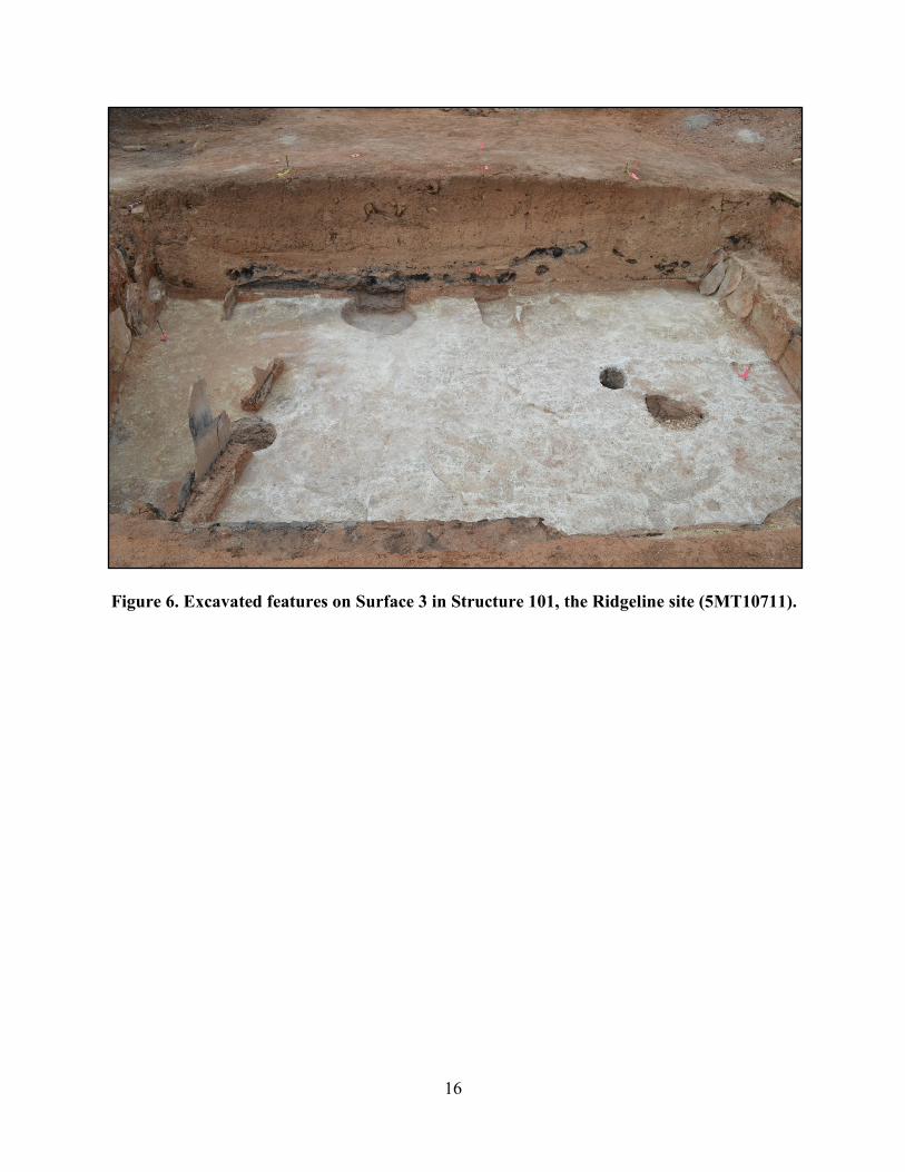
Surface 3 in Structure 101 was the earliest floor in the main chamber. Surface 3 is formed of
undisturbed native calcium carbonate (Figure 6). No artifacts were observed on this floor. Two
sipapus and two postholes that once held early main-support posts were associated with this
floor. The presence and locations of these suggest the existence of an earlier, smaller pit structure
that was later subsumed by Structure 101-103.
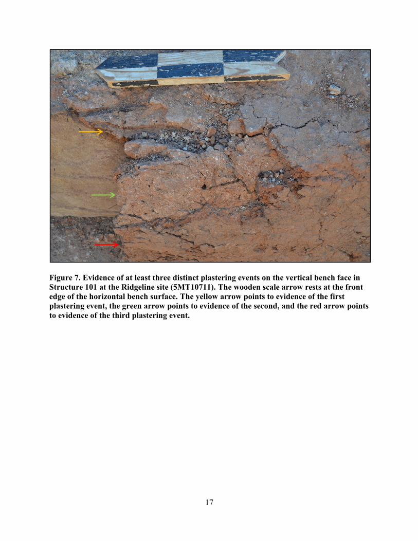
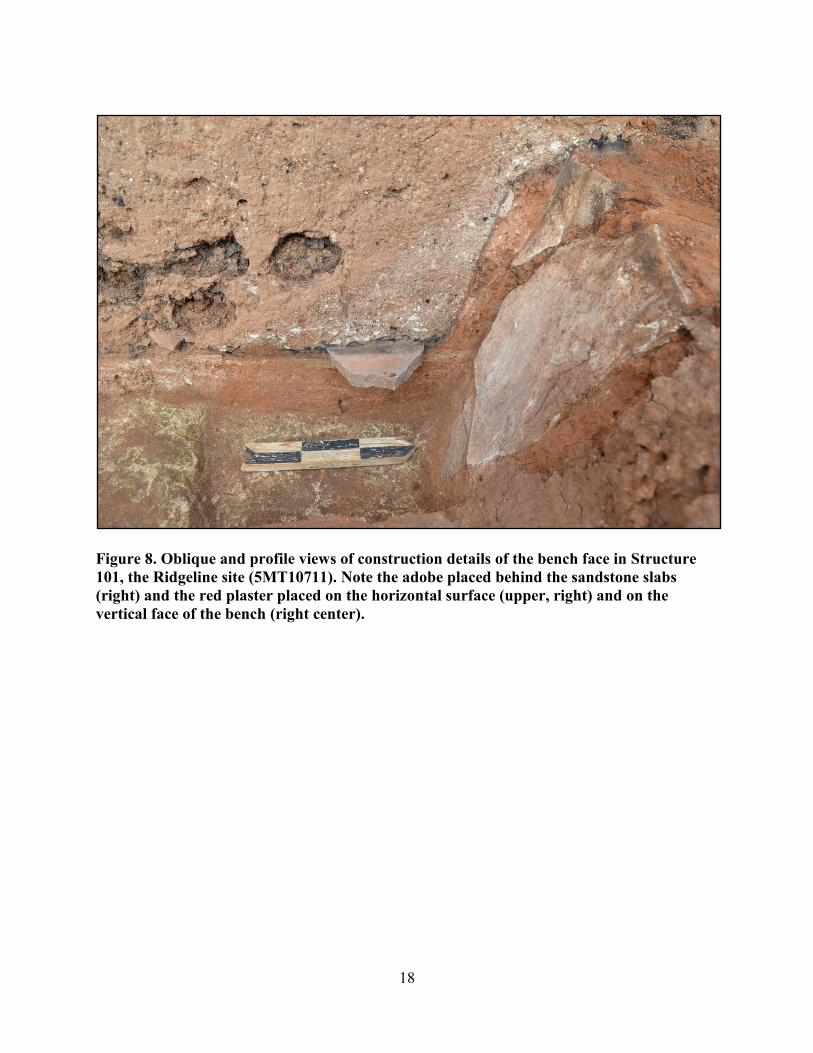
The bench face in Structure 101 displayed evidence of three distinct plastering events (Figure 7).
The bench itself appears to have been constructed when the pit structure was built. The bench
was carved out of undisturbed calcium-carbonate deposits; sandstone slabs were then placed
vertically into wet adobe along the bench face. Reddish plaster was applied to the horizontal
surface of the bench and to the faces of the vertical sandstone slabs along bench face (Figure 8).
4
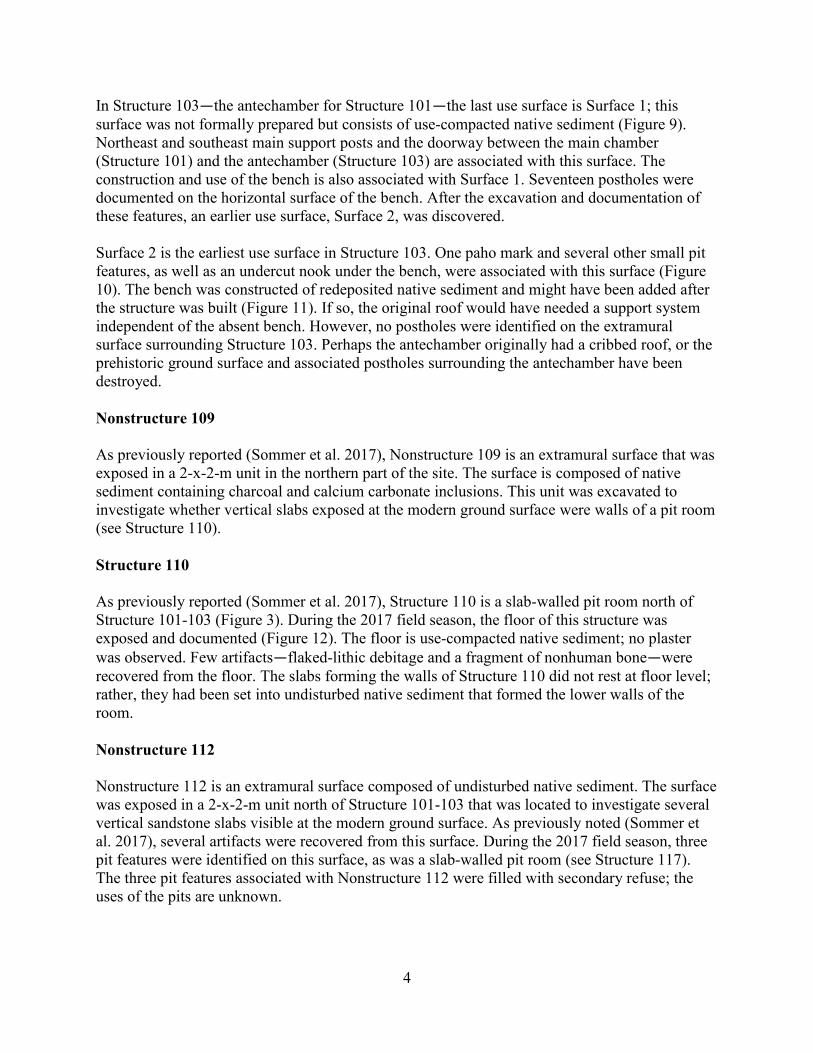
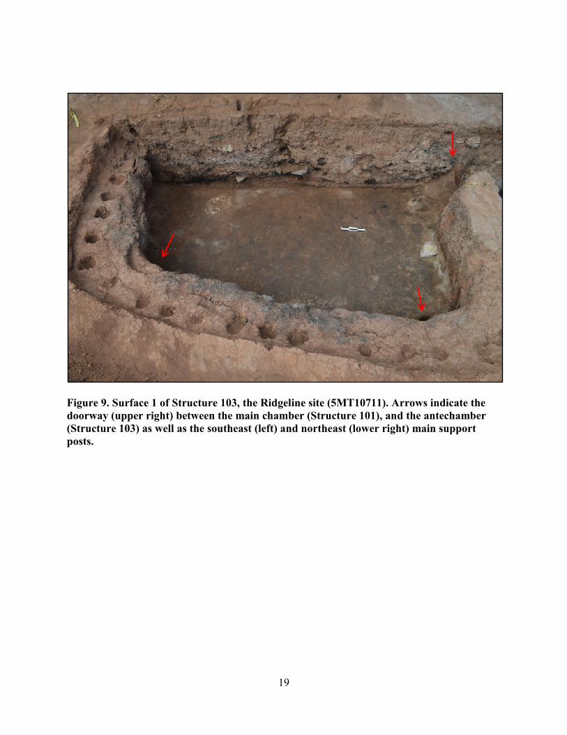
In Structure 103―the antechamber for Structure 101―the last use surface is Surface 1; this
surface was not formally prepared but consists of use-compacted native sediment (Figure 9).
Northeast and southeast main support posts and the doorway between the main chamber
(Structure 101) and the antechamber (Structure 103) are associated with this surface. The
construction and use of the bench is also associated with Surface 1. Seventeen postholes were
documented on the horizontal surface of the bench. After the excavation and documentation of
these features, an earlier use surface, Surface 2, was discovered.
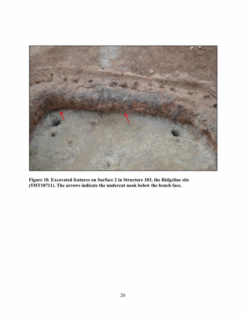
Surface 2 is the earliest use surface in Structure 103. One paho mark and several other small pit
features, as well as an undercut nook under the bench, were associated with this surface (Figure
10). The bench was constructed of redeposited native sediment and might have been added after
the structure was built (Figure 11). If so, the original roof would have needed a support system
independent of the absent bench. However, no postholes were identified on the extramural
surface surrounding Structure 103. Perhaps the antechamber originally had a cribbed roof, or the
prehistoric ground surface and associated postholes surrounding the antechamber have been
destroyed.
Nonstructure 109
As previously reported (Sommer et al. 2017), Nonstructure 109 is an extramural surface that was
exposed in a 2-x-2-m unit in the northern part of the site. The surface is composed of native
sediment containing charcoal and calcium carbonate inclusions. This unit was excavated to
investigate whether vertical slabs exposed at the modern ground surface were walls of a pit room
(see Structure 110).
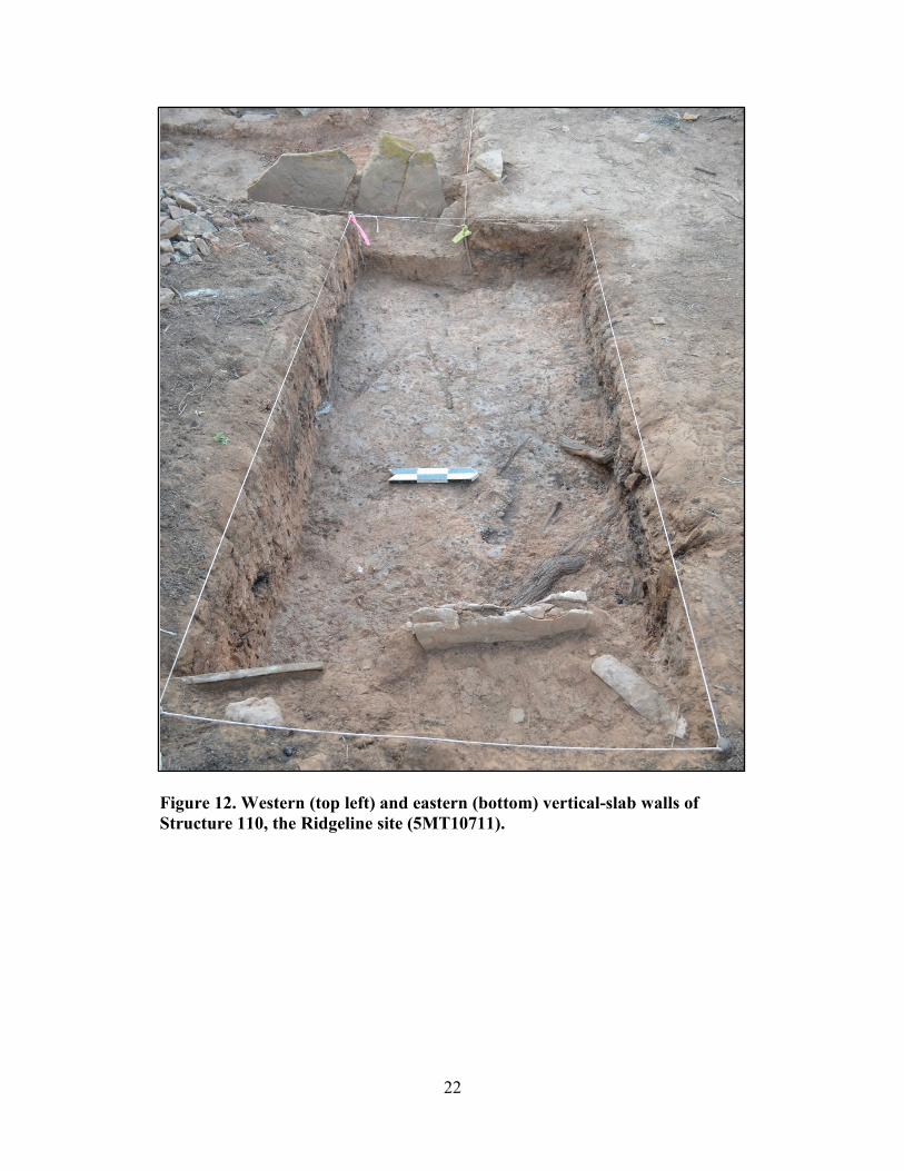
Structure 110
As previously reported (Sommer et al. 2017), Structure 110 is a slab-walled pit room north of
Structure 101-103 (Figure 3). During the 2017 field season, the floor of this structure was
exposed and documented (Figure 12). The floor is use-compacted native sediment; no plaster
was observed. Few artifacts―flaked-lithic debitage and a fragment of nonhuman bone―were
recovered from the floor. The slabs forming the walls of Structure 110 did not rest at floor level;
rather, they had been set into undisturbed native sediment that formed the lower walls of the
room.
Nonstructure 112
Nonstructure 112 is an extramural surface composed of undisturbed native sediment. The surface
was exposed in a 2-x-2-m unit north of Structure 101-103 that was located to investigate several
vertical sandstone slabs visible at the modern ground surface. As previously noted (Sommer et
al. 2017), several artifacts were recovered from this surface. During the 2017 field season, three
pit features were identified on this surface, as was a slab-walled pit room (see Structure 117).
The three pit features associated with Nonstructure 112 were filled with secondary refuse; the
uses of the pits are unknown.
5
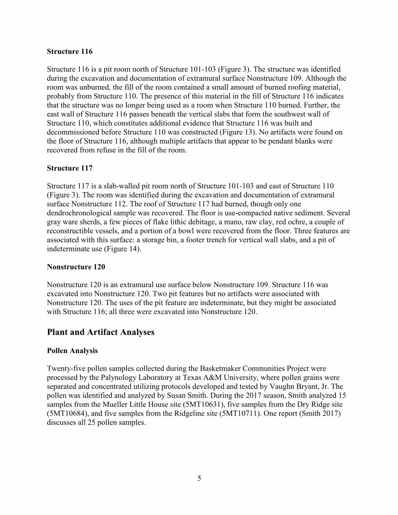
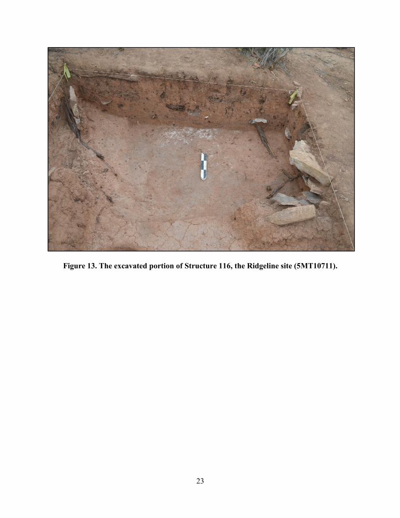
Structure 116
Structure 116 is a pit room north of Structure 101-103 (Figure 3). The structure was identified
during the excavation and documentation of extramural surface Nonstructure 109. Although the
room was unburned, the fill of the room contained a small amount of burned roofing material,
probably from Structure 110. The presence of this material in the fill of Structure 116 indicates
that the structure was no longer being used as a room when Structure 110 burned. Further, the
east wall of Structure 116 passes beneath the vertical slabs that form the southwest wall of
Structure 110, which constitutes additional evidence that Structure 116 was built and
decommissioned before Structure 110 was constructed (Figure 13). No artifacts were found on
the floor of Structure 116, although multiple artifacts that appear to be pendant blanks were
recovered from refuse in the fill of the room.
Structure 117
Structure 117 is a slab-walled pit room north of Structure 101-103 and east of Structure 110
(Figure 3). The room was identified during the excavation and documentation of extramural
surface Nonstructure 112. The roof of Structure 117 had burned, though only one
dendrochronological sample was recovered. The floor is use-compacted native sediment. Several
gray ware sherds, a few pieces of flake lithic debitage, a mano, raw clay, red ochre, a couple of
reconstructible vessels, and a portion of a bowl were recovered from the floor. Three features are
associated with this surface: a storage bin, a footer trench for vertical wall slabs, and a pit of
indeterminate use (Figure 14).
Nonstructure 120
Nonstructure 120 is an extramural use surface below Nonstructure 109. Structure 116 was
excavated into Nonstructure 120. Two pit features but no artifacts were associated with
Nonstructure 120. The uses of the pit feature are indeterminate, but they might be associated
with Structure 116; all three were excavated into Nonstructure 120.
Plant and Artifact Analyses
Pollen Analysis
Twenty-five pollen samples collected during the Basketmaker Communities Project were
processed by the Palynology Laboratory at Texas A&M University, where pollen grains were
separated and concentrated utilizing protocols developed and tested by Vaughn Bryant, Jr. The
pollen was identified and analyzed by Susan Smith. During the 2017 season, Smith analyzed 15
samples from the Mueller Little House site (5MT10631), five samples from the Dry Ridge site
(5MT10684), and five samples from the Ridgeline site (5MT10711). One report (Smith 2017)
discusses all 25 pollen samples.

6
Obsidian Analysis
Seven obsidian artifacts―three from the Dillard site (5MT10647), two from the Portulaca Point
site (5MT10709), one from the Mueller Little House site (5MT10631), and one from the
Ridgeline site (5MT10711)―were analyzed for elemental concentrations through energy-
dispersive X-ray fluorescence by Steve Shackley (2017). All analyses were conducted on a
ThermoScientific Quant’X EDXRF spectrometer located at the University of California,
Berkeley. The artifacts were identified to three source areas in New Mexico and Utah: El
Rechuelos in the Jemez Mountains, New Mexico; Grants Ridge sources at Mount Taylor in New
Mexico; and Wild Horse Canyon in Utah. With the exception of the artifact sourced to Wild
Horse Canyon, these results are similar to those of earlier studies of obsidian artifacts for the
Basketmaker Communities Project (Shackley 2013, 2015).
Compositional Analysis of Pottery
Using neutron activation analysis, Jeffrey Ferguson and Michael Glascock (2017) analyzed 123
pottery sherds from the Dillard site (5MT10647) for elemental concentrations. All analyses were
conducted at the Archaeometry Laboratory at the University of Missouri Research Reactor
Center.
Artifact Analysis
In-house artifact cataloging and analysis for the Basketmaker Communities Project is ongoing.
Thus far, more than 39,000 flaked-lithic artifacts and 44,400 pottery sherds have been analyzed,
and 1,900 flotation samples have been processed. Of the 39,000 pieces of chipped stone, 2,000
pieces were analyzed in 2017. Of the 44,400 pottery sherds analyzed, 5,800 sherds were
analyzed in 2017. Of the 1,900 flotation samples processed, 300 were processed in 2017.
Chronometric Analyses
One of the primary objectives of the Basketmaker Communities Project is to create a
Basketmaker III settlement history of the project area by collecting materials from habitation and
ancillary structures that yield absolute dates. Three dating methods are being applied:
radiocarbon accelerator mass spectrometry, archaeomagnetism, and dendrochronology. No new
dendrochronological dates were available as of November 2017.
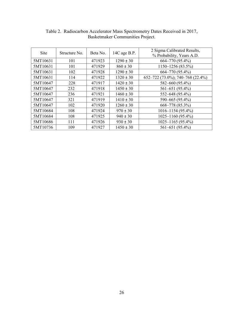
During the 2017 season, 13 radiocarbon accelerator mass spectrometry samples were submitted
to Beta Analytic Inc., and three archaeomagnetic samples were submitted to the
Archaeomagnetic Laboratory at East Tennessee State University. Table 2 provides radiocarbon
accelerator mass spectrometry dates received in 2017. Two of the three archaeomagnetic samples
were datable. The archaeomagnetic sample taken from the hearth in Structure 101 at the Mueller
Little House site (5MT10631) yielded numerous date ranges; the range most likely to be accurate
is A.D. 660–690 (Lengyel 2017a). The sample taken from the hearth in Structure 108 at the Dry
Ridge site (5MT10684) yielded numerous date ranges; most likely to be accurate is either A.D.
985–1040 or A.D. 1060–1140 (Lengyel 2017a). The third archaeomagnetic sample, taken from a
hearth at the Ridgeline site (5MT10711), did not produce a plot on the curve. This sample plots
7
near the A.D. 900 window of the dating curve, although even this date is later than the
Basketmaker III date range (A.D. 500–750) expected for this sample (Lengyel 2017b).
Human Remains
No human remains were exposed during excavations at the Ridgeline site in 2017.
Curation
Crow Canyon has an executed agreement with the Anasazi Heritage Center, Dolores, Colorado,
for the curation of collected materials and associated documentation from the Basketmaker
Communities Project. The Anasazi Heritage Center will curate materials generated as a result of
all field seasons (2011 ̶ 2017) of the project.
Summary
The goals of the seventh and final year of field work for the Basketmaker Communities Project
were to complete all excavations and documentation at the Ridgeline site. We learned that the
oversized pit structure underwent at least three distinct construction episodes―the initial
construction of the pit structure and two remodeling events. We also learned that pit room
Structure 110 was superimposed over an earlier pit room, Structure 116. These data suggest that
the site was occupied for a prolonged period of time.
Several analyses were completed, and the resulting data provide us with a greater understanding
of the ancestral Pueblo community that inhabited the landscape that is today occupied by Indian
Camp Ranch. Several special analyses are ongoing. The following materials from the
Basketmaker Community Project sites have been selected and submitted to specialists
for analysis: pollen samples, faunal remains, and dendrochronological samples. A
comprehensive report on all excavations conducted as part of Crow Canyon’s Basketmaker
Communities Project will be published on Crow Canyon’s website at www.crowcanyon.org.

8
Personnel, 2017 Field Season
Archaeology Department Staff
Shirley Powell, vice president of programs
Susan Ryan, director of archaeology
Caitlin Sommer, supervisory archaeologist
Shanna Diederichs, supervisory archaeologist
Steve Copeland, field archaeologist
Rebecca Simon, field archaeologist
Kari Schleher, laboratory manager
Jamie Merewether, collections manager
Leigh Cominiello, laboratory assistant
Kate Hughes, laboratory education coordinator
Grant Coffey, GIS archaeologist
Kristin Kuckelman, research publications manager
Jessica Petrie, field intern
Caelie Butler, field intern
Genevieve Woodhead, laboratory intern
Christina Stewart, laboratory intern
9
References Cited
Charles, Mona
2012 Electrical Resistance Survey of Three Sites in the Indian Camp Ranch, Montezuma
County, Colorado. Manuscript on file, Crow Canyon Archaeological Center, Cortez,
Colorado.
Ferguson, Jeffrey R., and Michael D. Glascock
2017 Instrumental Neutron Activation Analysis of Mesa Verde Grayware from the Dillard Site
(5MT10647) in Montezuma County, Colorado. Manuscript on file, Crow Canyon
Archaeological Center, Cortez, Colorado.
Honeycutt, Linda, and Jerry Fetterman
1991 Indian Camp Ranch at Cortez: Archaeology at Work, Preserving the Anasazi Legacy for
the Future. Indian Camp Ranch Report, No. 1. Archie and Mary Hanson, Templeton,
California.
Indian Camp Ranch Homeowners Association
2007 Bylaws of Indian Camp Ranch Homeowners Association, Inc. Cortez, Colorado.
Lengyel, Stacey
2017a Archaeomagnetic Laboratory Report of 6 March 2017, Archaeomagnetic Laboratory,
Eastern Tennessee State University, Johnson City, Tennessee. Report on file, Crow
Canyon Archaeological Center, Cortez, Colorado.
2017b Archaeomagnetic Laboratory Report of 26 July 2017, Archaeomagnetic Laboratory,
Eastern Tennessee State University, Johnson City, Tennessee. Report on file, Crow
Canyon Archaeological Center, Cortez, Colorado.
Ortman, Scott G., Shanna R. Diederichs, and Kristin A. Kuckelman
2011 A Proposal to Conduct Archaeological Testing at Indian Camp Ranch, Montezuma
County, Colorado. Proposal submitted to the Colorado State Historic Preservation Office,
Denver, Colorado. Manuscript on file, Crow Canyon Archaeological Center, Cortez,
Colorado.
Ryan, Susan C., and Shanna R. Diederichs
2014 A Proposal to Expand Basketmaker Communities Project Research: An Addendum to
Conduct Archaeological Testing at Indian Camp Ranch, Montezuma County, Colorado.
Proposal submitted to the Colorado State Historic Preservation Office, Denver, Colorado.
Manuscript on file, Crow Canyon Archaeological Center, Cortez, Colorado.
Shackley, M. Steven
2013 An Energy-Dispersive X-ray Fluorescence Analysis of Obsidian Artifacts from the
Dillard Site (5MT10647), Southwestern Colorado. Manuscript on file, Crow Canyon
Archaeological Center, Cortez, Colorado.
10
2015 Source Provenance of Obsidian Artifacts from the Dillard Site (5MT10647) and the
Switchback Site (5MT2032), Montezuma County, Southwest Colorado. Manuscript on
file, Crow Canyon Archaeological Center, Cortez, Colorado.
2017 An Energy-Dispersive X-ray Fluorescence Analysis of Obsidian Artifacts from Four
Sites in Southwestern Colorado. Manuscript on file, Crow Canyon Archaeological
Center, Cortez, Colorado.
Smith, Susan J.
2017 Basketmaker Communities Project at Indian Camp Ranch: 2016 Excavations Pollen
Analyses. Manuscript on file, Crow Canyon Archaeological Center, Cortez, Colorado.
Sommer, Caitlin, Susan C. Ryan, Kari L. Schleher, Shanna R. Diederichs, Steven R. Copeland,
Rebecca L. Simon, and Grant D. Coffey
2017 The Basketmaker Communities Project Annual Report, 2016 Field Season. Electronic
document, http://www.crowcanyon.org/Basketmaker2016, accessed 31October 2017.
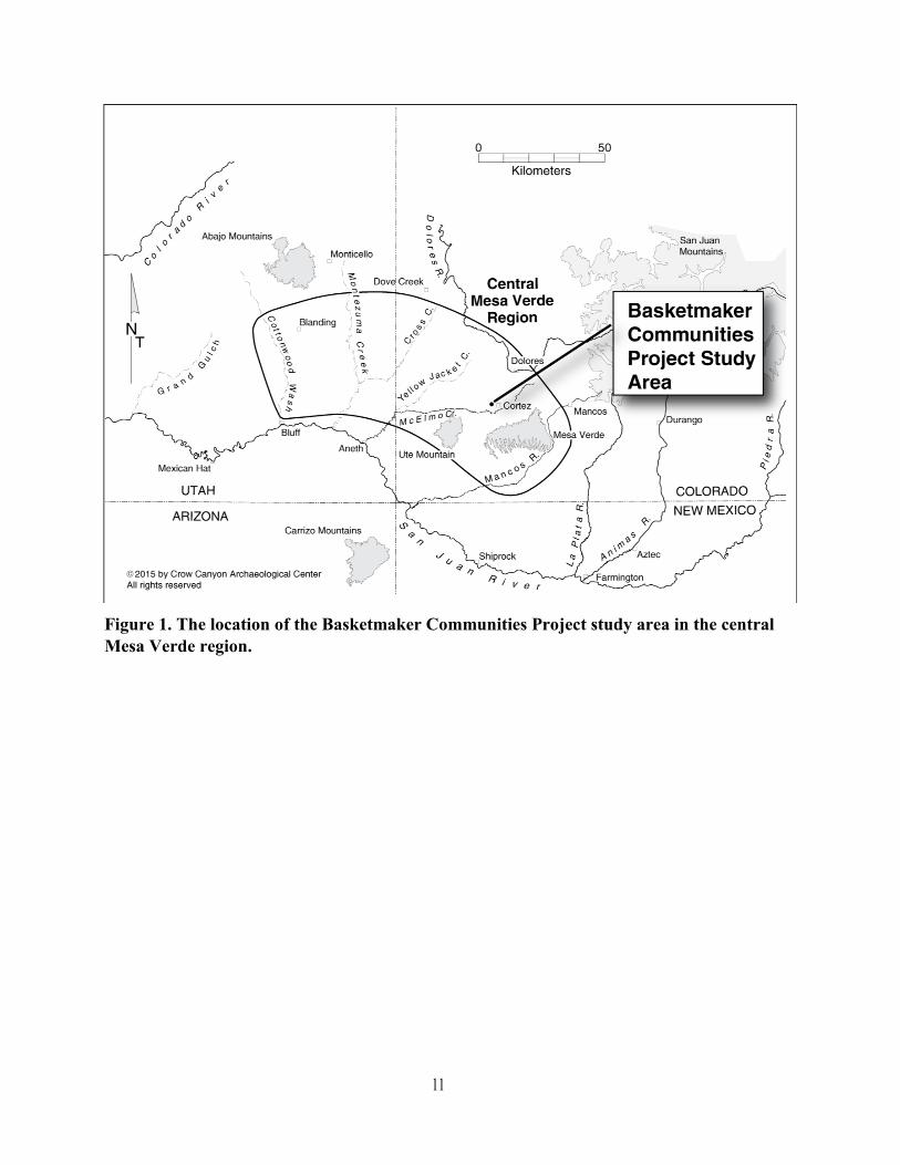
Figure 1. The location of the Basketmaker Communities Project study area in the central Mesa Verde region.
11
12
Figure 2. The Indian Camp Ranch subdivision showing property boundaries
and the one site investigated during the 2017 season.
13
Figure 3. The Ridgeline site (5MT10711).
14
Figure 4. Excavated features on Surface 1 in Structure 101,
the Ridgeline site (5MT10711).

15
Figure 5. Excavated features on Surface 2 in Structure 101, the Ridgeline site (5MT10711).
16
Figure 6. Excavated features on Surface 3 in Structure 101, the Ridgeline site (5MT10711).
17
Figure 7. Evidence of at least three distinct plastering events on the vertical bench face in
Structure 101 at the Ridgeline site (5MT10711). The wooden scale arrow rests at the front
edge of the horizontal bench surface. The yellow arrow points to evidence of the first
plastering event, the green arrow points to evidence of the second, and the red arrow points
to evidence of the third plastering event.
18
Figure 8. Oblique and profile views of construction details of the bench face in Structure
101, the Ridgeline site (5MT10711). Note the adobe placed behind the sandstone slabs
(right) and the red plaster placed on the horizontal surface (upper, right) and on the
vertical face of the bench (right center).
19
Figure 9. Surface 1 of Structure 103, the Ridgeline site (5MT10711). Arrows indicate the
doorway (upper right) between the main chamber (Structure 101), and the antechamber
(Structure 103) as well as the southeast (left) and northeast (lower right) main support
posts.
20
Figure 10. Excavated features on Surface 2 in Structure 103, the Ridgeline site
(5MT10711). The arrows indicate the undercut nook below the bench face.

21
Figure 11. The bench in Structure 103, the Ridgeline site (5MT10711), constructed out of
redeposited native sediment (red arrow) that was attached to the original wall of the
structure (green arrow).
22
Figure 12. Western (top left) and eastern (bottom) vertical-slab walls of
Structure 110, the Ridgeline site (5MT10711).
23
Figure 13. The excavated portion of Structure 116, the Ridgeline site (5MT10711).

24
Figure 14. The excavated portion of Structure 117, the Ridgeline site (5MT10711).
25
Table 1. Excavation Units Completed and Backfilled, Architectural Block 100,
the Ridgeline Site, Basketmaker Communities Project.
Horizontal Provenience Dimensions Primary Study Unit
1473N 159E 2-x-2 Structure 116
1450N 177E 1-x-1 Nonstructure 106
1449N 177E 1-x-1 Nonstructure 106
1449N 174E 1-x-1 Nonstructure 106
1449N 168E 1-x-1 Nonstructure 106
1447N 172E 1-x-1 Nonstructure 106
Segment 1 Arbitrary Unit 102
East half Structure 103
Northeast quad Structure 101
Southeast quad Structure 101
1474.5N 161E 1-x-2.3 Structure 110
1438.5N 178.5E 2-x-2 Arbitrary Unit 114
1471.5N 166E 2-x-2 Structure 117
26
Table 2. Radiocarbon Accelerator Mass Spectrometry Dates Received in 2017,
Basketmaker Communities Project.
Site Structure No. Beta No. 14C age B.P. 2 Sigma Calibrated Results,
% Probability, Years A.D.
5MT10631 101 471923 1290 ± 30 664–770 (95.4%)
5MT10631 101 471929 860 ± 30 1150–1256 (83.5%)
5MT10631 102 471928 1290 ± 30 664–770 (95.4%)
5MT10631 114 471922 1320 ± 30 652–722 (73.0%); 740–768 (22.4%)
5MT10647 228 471917 1420 ± 30 582–660 (95.4%)
5MT10647 232 471918 1450 ± 30 561–651 (95.4%)
5MT10647 236 471921 1460 ± 30 552–648 (95.4%)
5MT10647 321 471919 1410 ± 30 590–665 (95.4%)
5MT10647 102 471920 1260 ± 30 668–778 (85.3%)
5MT10684 108 471924 970 ± 30 1016–1154 (95.4%)
5MT10684 108 471925 940 ± 30 1025–1160 (95.4%)
5MT10686 111 471926 930 ± 30 1025–1165 (95.4%)
5MT10736 109 471927 1450 ± 30 561–651 (95.4%)
27
To Borrow, Credit, or Request Permission
To Borrow from this Publication
This online publication may be quoted for scholarly, educational, or review purposes without
written permission, provided that the use of the quoted material falls within the bounds of fair
use and proper credit is given to the source. Single copies of individual pages may be printed for
ease of reading, for personal use only, provided that no further duplication occurs or is allowed
to occur. All other reproduction or transmission of text, tables, or figures, by mechanical or
electronic means, including downloading, requires written permission of the Crow Canyon
Archaeological Center.
How to Cite this Publication
To cite this publication:
Sommer, Caitlin A., Susan C. Ryan, Kari L. Schleher, Shanna R. Diederichs, Steven R.
Copeland, Rebecca L. Simon, and Grant D. Coffey
2017 The Basketmaker Communities Project Annual Report, 2017 Field Season. Electronic
document, http://www.crowcanyon.org/basketmaker2017, accessed day month year.*
*Example: accessed 15 March 2018.
How to Request Permission to Borrow
To request permission from the Crow Canyon Archaeological Center to reproduce materials
from this publication, e-mail the managing editor ([email protected]).
Your request for permission must include the following (incomplete requests will not be
granted):
Information about the work in which you intend to include the borrowed materials:
• Name of the work (for example, the book, chapter, journal article, dissertation, or thesis title); if
the work is part of a larger work (for example, a chapter in an edited volume), also provide the
title of the larger work; tentative titles are sufficient
• Author and/or editor of the work
• Publisher of the work
• Anticipated date of publication
• Estimated length of the published work
• Publication format (e.g., paperbound, clothbound, online)
• Rights requested (for example, world, U.S. only) (Crow Canyon grants nonexclusive rights
only)
28
Information about the Crow Canyon material that you wish to use:
• Complete title
• Author or editor
• Year of publication
• Detailed description of the material to be borrowed, including figure number, table number,
and/or text passage; include description of proposed modifications to original material, if any
• Link to web page on which material appears, if applicable
Information about you:
• Your name
• Telephone number
• Email address