the belville 2020 vision plan - welcome to the town of ... · master plan is to outline specific...
TRANSCRIPT
© 2007 by Town of Belville, NC, and The Lawrence Group. Reproduction Permitted with Credit in Print.
The Belville viSiON PlaN
Belville, North Carolina
2020

The Belville viSiON 2020 PlaN SePTemBer 2007-FiNalBelville, North Carolina i
This Plan was Prepared For:
The Town of Belville, norTh Carolina
Mayor and Town CouncilDavid h. long, mayor
mary Jean rhodes, mayor Pro-Tem Charles m. Thurlow, Commissioner
Dennis l. Taylor, CommissionerGeneral r. ennis, Commissioner
Town administratorTracie Davis
PrOJeCT Team
The lawrenCe GroUPCraig lewis, aiCP, leeD aP, Principal in Charge
Dave malushizky, aia, leeD aPTom harrington, rla
S. Chad hallBeth Weast, leeD aP
amanda hugginsTrey akers
roSe anD aSSoCiaTeSKathleen rose, CCim
KiMleY-horn & aSSoCiaTeSmike rutkowski, Pe, aiCP
ACKNOWLEDGEMENTSacknowledgements
© 2007 by Town of Belville, NC, and The Lawrence Group. Reproduction Permitted with Credit in Print.
The Belville viSiON 2020 PlaN SePTemBer 2007-FiNalBelville, North Carolina ii
1 ExEcutivE Summary 1
2 iNtrODuctiON & aNaLySiS
2.1 Existing conditions 22.2 market analysis 32.3 Principles of Growth & Development 6
3 civic DiaLOGuE aND ParticiPatiON
3.1 the Public Process 73.2 Kickoff Workshop 83.3 the charrette 93.4 charrette Deliverables 11
4 PLaN rEcOmmENDatiONS
4.1 Environmental Sustainabilty 124.2 transportation & circulation 144.3 composite master Plan 204.4 Lincoln Business Park/uS 17 214.5 Blackwell road area 244.6 the riverfront village 26
a aPPENDix
a.1 Blackwell road area (Leland Jurisdiction) 35a.2 Nc 133 South 37
Table of Contents

The Belville viSiON 2020 PlaN SePTemBer 2007-FiNalBelville, North Carolina 1
exeCuTive Summary
1: executive Summary
The Town of Belville, which was incorporated in 1977, has a population of approximately 1200 residents. Located in Brunswick County’s northeastern corner along the Brunswick River and at the intersection of US 74-76, NC Highway 133 and US 17, the Town is located across the Brunswick and Cape Fear Rivers from Wilmington, a major deep-water port and historic riverfront downtown.
Due to its proximity to the coast, the soil conditions and high water table contribute to a high amount of wetlands. These wetlands are strewn throughout the community and are in various states of protection or degradation.
Largely a residential community, it is almost completely surrounded by the Town of Leland. As a result, the two community’s futures are closely intertwined. This common future set the stage for the completion of two separate but complimentary land use plans in 2007.
This Town Plan and its companion document, Belville Proposed Code Changes-Technical Memo, represent a guide to the future development and perhaps more importantly, the redevelopment of portions of the Belville community.
For the purposes of this plan, the community was divided into four areas for detailed study. Areas that were not included are assumed to remain intact with little change expected for at least twenty years. These planning areas are summarized below:
Lincoln Industrial Park/US 17: The existing light industrial operations and expanding retail have met recently with opposition from new neighbors along the northern and western boundaries. This plan seeks ways to mitigate against future conflicts, while preserving this valuable area for economic development activities.
Blackwell Road: The scattershot industrial operations, old substandard homes, and new subdivisions all share the roads in this area. Noting the presence of a large undeveloped tract as well as tracts that needs to be either redeveloped or simply cleared of the existing use, this plan seeks to balance opportunities for aggressive environmental protection with improved circulation and connectivity to NC 17.
NC 133 South: The number one traffic generator in Belville, the elementary school is also the center of this community. And, with the growing traffic volumes on NC 133, improvement in inevitable. This plan illustrate the timing and phasing of such improvements and the type of aesthetic that is necessary to continue the ambiance of this corridor.
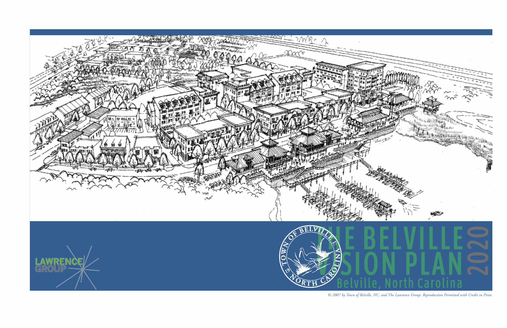
Riverfront Village: The old downtown is in need of more than a facelift; it requires a complete reconstruction. This plan conceptualizes a true urban, riverfront village with a boardwalk, new Town Hall and public green accompanied by mixed-use buildings that create a lively town center. In addition, this sub-area contains the community’s biggest transportation issue. The area around the interchange has a series of key long-term investments that include the improvement of NC 133, the realignment of Blackwell Road, and a new northbound on- and off-ramp.
With regard to the environment, this plan places a high priority on the protection of the Town’s natural systems, namely the wetlands and watercourses. The quality of life for the residents of Belville is closely intertwined with the quality of the natural habitat. Too much degradation has occurred in this region, a trend that must be reversed with more sensitive development regulations.
And finally, the transportation system must better reflect a more balanced approach with greater choice. Not only should there be more street connections to disperse traffic and improve mobility, but the system must mature beyond the current car-only approach. The needs of bicyclists and pedestrians must be accommodated on new streets and existing streets alike.
In the end, this plan seeks to answer the questions posed to it by the Town’s residents. Namely, where should development go, what form should it take, and how do we improve the overall community for the next generation? For a small coastal town with little room to grow, this plan sets forth great ambitions. Yet, with stable, visionary leadership and prudent management, Belville can truly realize its dream of creating a community that maintains its distinctive small town character while balancing between aesthetics, growth and the environment.
1
2
3
4
PLaNNiNG arEaS1: Lincoln Business Park/NC 172: Blackwell Road3: NC 133 South4: The Riverfront Village
thE cOmPOSitE PLaN

The Belville viSiON 2020 PlaN SePTemBer 2007-FiNalBelville, North Carolina 2
2: introduction & analysis
2.1 exiSTiNG CONDiTiONS
I-140
US 17
I-140/Skyway Connection
NC 133
I-140
US 17
I-140/Skyway Connection
NC 133
I-140
US 17
I-140/Skyway Connection
NC 133
rEGiONaL StrEEt NEtWOrKThe map above shows the current street network in dark gray, the Leland collector street plan in dashed-red, and the proposed I-140 in solid black.
FLOODPLaiN aND StOrm SurGE maPThe map above was developed using computer models showing “worst-case scenarios” for flooding at high tide for both slow moving and fast moving storms.
rEGiONaL maPThe map above combines the two maps to the left with the aerial photography.

The Belville viSiON 2020 PlaN SePTemBer 2007-FiNalBelville, North Carolina 3
2.2 marKeT aNalySiSThe following text is adapted from a Preliminary Market Study prepared for the Towns of Leland and Belville by Rose & Associates Southeast Inc. The preliminary study’s purpose was to establish the existing conditions in the north Brunswick area using readily available real estate and demographic data. This report is not intended to serve as a definitive assessment of any individual site but rather to give an overall assessment of the trends in the marketplace and offer some subjective observations and recommendations consistent therein.
StuDy arEa Summary
The Study Area includes the Township of Belville, with particular focus on its riverfront and downtown area. The primary corridors include Highway 17 and NC 133 at the interchange along Highway 74/76. The town is located in Brunswick County, and lies at the western edge of Wilmington and New Hanover County, west of the Cape Fear and Brunswick Rivers. In total, the Town encompasses approximately 3,000 acres.
Current land uses are predominately low-density residential housing with limited commercial facilities and civic/public uses.
hiStOry & PErSPEctivE
Beginning in the early 1890’s, at the time the earliest plantations along the Cape Fear River were established, Belville offered riverfront access and served as a crossroads for commerce and transportation. This continued to evolve with the construction of bridges, and Highway 74/76 that provided primary east/west travel; and Highway 17, providing north/south travel. These highways converge to form the gateway into Wilmington, the region’s largest city. Since its inception, Belville’s land-use patterns evolved into a mix of agricultural, low-density residential and small-scale commercial uses.
These corridors and the communities they connect are the fastest growing areas of Brunswick County, which includes neighboring Leland, who has experienced record growth in the past five years. Feedback from civic leaders, government representatives and residents suggests that the community embraces their natural environment, relationship to the rivers, quality of life and small town/rural character of the type found in suburban towns. Its challenge is to maintain its identity as the area experiences growth pressures, while creating a “sense of place” within a region that has evolved into a mix of uses, predominately commercial, along its primary corridors.
2: introduction & analysis
FactOrS imPactiNG thE StuDy arEa
Regional Development PatternsDevelopment patterns have spread from Wilmington’s historic downtown to the outlying areas along the rivers and primary transportation corridors. Land use has focused higher density, urban, commercial and mixed-use development along the river and ocean shorelines as well as the primary corridors of US Highways 17 & 74/76, NC 421 & 133 and Interstate 40. A new bypass (I-140) is proposed along the western edge of the Leland/Belville area.
These areas underscore the importance of coherent land-use planning to provide transitional areas between recreation/water areas, primary regional clusters of business/employment and retail centers. Quadrants between these primary centers of influence have been rapidly developed for residential housing to serve the growing economic expansion of the Wilmington MSA (Metropolitan Statistical Area). As a result, the region now boasts one of the state’s fastest growth rates.
Transportation The regional transportation network is firmly in place, providing access from other areas of the state. This includes a multi-modal approach with highway, rail, air and port systems. The challenge now is to provide an internal transportation network that connects these corridors, while defining the community’s boundaries and character. The purpose of the master plan is to outline specific land use parameters that will assist in defining these areas to balance commercial and residential uses.
Economic DevelopmentBelville is competitively situated at the edge of Wilmington, the heart of the MSA. The North Carolina State Department of Commerce is divided into seven regions and regional partnerships, including the Southeast Region with the Wilmington MSA at its center. Managed by the Wilmington Ports Authority, Wilmington is one of six foreign trade zones in the State of North Carolina (Zone #66), . The Southeast Regional Partnership currently offers nearly 100 sites ranging in size from 2 to 2,500 acres for economic development. Likewise, there are a small number of industrial parks in the region such as the Lincoln Industrial Park, which is situated within the town limits of Belville.
rEGiONaL maP ShOWiNG thE KEy traNSPOrtatiON
cOrriDOrS iN thE arEa
NOrth BruNSWicK cOuNty arEa ShOWiNG thE SurrOuNDiNG tOWNS
Wilmington Chamber of Commerce

The Belville viSiON 2020 PlaN SePTemBer 2007-FiNalBelville, North Carolina 4
marKEt POtENtiaL
Market potential considers the economic status of a community, demographic and socio-economic trends of its citizens, and quality of life parameters—all of which determine the goals for both creating and sustaining a market.
Given its limited geographic size and demographic profile, the Town will likely remain a predominately residential “bedroom” community, with major shopping, employment and healthcare services provided in neighboring Leland and Wilmington.
The primary target market for the commercial areas includes those residents and businesses residing within the region. The secondary target market includes retirees, business owners and lifestyle conscious consumers drawn to the coastal areas from within the Southeast, and finally those drawn to the Southeast from outside the region.
Importantly, Belville’s location along the Brunswick River distinguishes it from neighboring communities. The old downtown area as previously developed land and available for sale presents an opportunity that is available only in Wilmington and along the intracoastal areas.
FiNDiNGS & rEcOmmENDatiONS
Review of the study area, data and demographic information, together with preliminary interviews with key stakeholders of the community, revealed the following observations:
Belville is a small town situated on the convergence of the Cape Fear �
River, located in Brunswick County and the Wilmington MSA. The Wilmington MSA and Brunswick County are among the fastest growing areas of the state of North Carolina (third and fourth respectively).
The Wilmington MSA along the southern Atlantic coastline is �
driven by tourism, retail trade, real estate and recreation. The area’s increasing popularity as a place for second homes and retirement communities also drives much of the local economy.
Belville benefits from its proximity to Wilmington and neighboring �
New Hanover County. Totaling only approximately 3,000 acres, it is primarily a suburban residential community with a small downtown area that has suffered from decline.
Its coastal location within the Wilmington region, nearness to many �
2.2 marKeT aNalySiS
2: introduction & analysis
OBLiquE aEriaL imaGE OF BELviLLE, LELaND, aND WiLmiNGtON acrOSS thE rivErSSource: Google Earth, 2007
Leland
Belville
Brunswick River
Downtown Wilmington
Cape Fear River
The Belville viSiON 2020 PlaN SePTemBer 2007-FiNalBelville, North Carolina 5
recreational and cultural attractions, together with accessibility via air, waterways, rail and major transportation corridors makes the Belville downtown and waterfront area ripe for revitalization and redevelopment.
Belville’s competitive advantages include its relationship to the �
river(s), accessibility, small town characteristics and infrastructure (sewer plant).
Therefore, the plan recommends that the Town focus on priorities that would result in diversification of its tax base—to provide a balanced ratio between residential needs and commercial services to create a sustainable local economy. These include:
Re-create a town center, tied to the waterfront, to provide the �
community a safe and pleasant area for commerce and community interaction, as well as a destination for tourists;
Develop economic development strategies to balance tax base �
between commercial and residential land uses;
Diversify the housing stock, to include townhomes, condominiums �
and multifamily, to provide a variety of styles and price ranges for the target market segments.
Riverfront Village Area This area should be a mixed development focused around a public waterfront park. Competitive advantages include visibility and accessibility from all directions at the intersection of Highway’s 74, 17 and 133. Uses to include:
Retail - lifestyle/mixed use format; destination and entertainment oriented such as restaurants, theatres, bookstores, etc.;
Office - Class A office above retail; 3-4 stories to serve growing service related employment such as professional offices for real estate, insurance, financial, legal and other services;
Residential - High density housing including condominiums, townhomes and single family homes clustered around a mixed-use, town center format.
Note: It will be important to consider elements of the Leland Conservation and Settlement Plan with respect to the Highway 133/Village Road area. Beliville and Leland should collaborate to form a cohesive strategy for land use in this critical north/south corridor.
Neighborhoods Transition from the riverfront village area to the existing low density areas and neighborhoods with traditional single family housing . This will preserve Belville’s small town charm, particularly along the southern scenic corridor of Highway 133, as outlined in the Vision Plan. Commercial development should be focused on downtown and existing commercial business/industrial parks. However, small neighborhood commercial uses (i.e.; drug/grocery/convenience stores) at primary intersections/nodes to service neighborhoods should be considered as the community realizes the threshold populations needed to support such uses.
rESiDENtiaL uSES-tarGEt marKEtS
HousingThe economic growth of a region includes growth in population and households. Families moving to the region driven by the job market, retirement or lifestyle changes provide opportunities for new housing in areas where amenities and quality of life characteristics reflect changing needs. These are both tangible and non-tangible components of what defines and drives a market. First we must understand the existing market, then determine market potential for new housing, which includes a variety of socio-economic factors including lifestyle, income/affordability and age.
Data was collected for Brunswick County to benchmark the existing housing market. Based on increased costs for housing and rising interest rates, greater growth is anticipated in the renter-occupied versus owner-occupied housing units as the affordability gap narrows and supply increases.
Housing CharacteristicsIn 2000, Brunswick County had a total of 51,431 housing units. Of the total housing units, 55.7% were in single-unit structures, 8.2% were in multi-unit structures, and 35.9% were mobile homes. 37.5% of the housing units were built since 1990, with the balance being older housing stock.
Occupied Housing Unit CharacteristicsIn 2000, Brunswick County had 30,438 occupied housing units—25,013 (82%) owner occupied and 5,425 (18%) renter occupied. Of these totals, the County experienced homeowner vacancy rate of 3.8%, and a rental vacancy rate of 28.2%.
Geographic MobilityAmerican households historically have been mobile. In 2005, an average
of 16% of households moved from one location to another. Further, mobility is higher in urban areas, where there is a higher percentage of renters versus owners and younger versus older households moving. Though this varies by region, Brunswick County is no exception. According to US Census Bureau estimates, in 2000, 54% of the people living in the County were living in the same residence five years earlier; 17% had moved from another residence in the same county, 13% from another county in the same state, 15% from another state, and 1% from abroad.
Demand for New ConstructionAnalysis of the ratio between population and employment suggests that most Belville residents either travel outside of town to work or are not employed. One indicator of new housing demand is the benchmark ratio between employment and building permits for new homes (E/P). A ratio greater than 1.0 indicates opportunities for new housing.
Housing Product TypesThe key to creating a vibrant community is to have an active downtown core. Many downtowns heavily weighted with business uses are active only during standard business hours, 5 days per week. Therefore to establish a vibrant downtown, in addition to drawing employees, local residents and visitors, housing must be part of the equation to attract residents who can live, work, shop and recreate in the downtown.
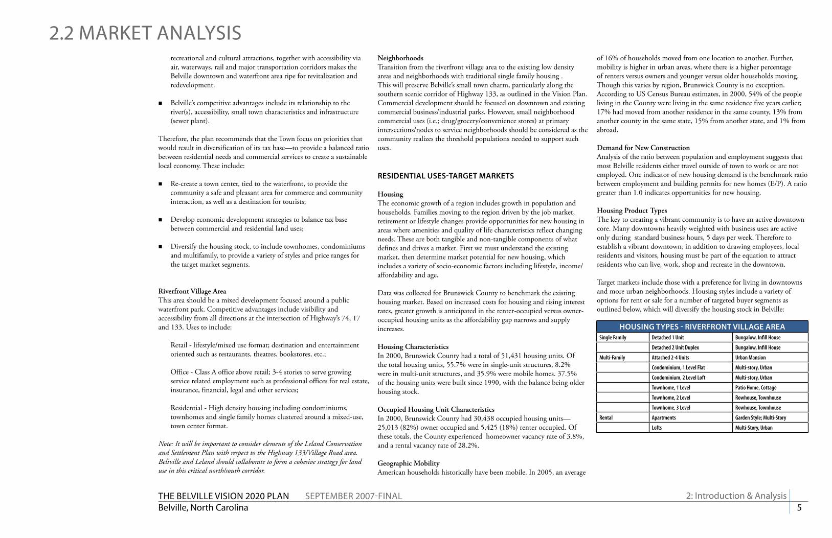
Target markets include those with a preference for living in downtowns and more urban neighborhoods. Housing styles include a variety of options for rent or sale for a number of targeted buyer segments as outlined below, which will diversify the housing stock in Belville:
hOuSiNG tyPES - rivErFrONt viLLaGE arEaSingle Family Detached 1 Unit Bungalow, Infill House
Detached 2 Unit Duplex Bungalow, Infill House
Multi-Family Attached 2-4 Units Urban Mansion
Condominium, 1 Level Flat Multi-story, Urban
Condominium, 2 Level Loft Multi-story, Urban
Townhome, 1 Level Patio Home, Cottage
Townhome, 2 Level Rowhouse, Townhouse
Townhome, 3 Level Rowhouse, Townhouse
Rental Apartments Garden Style; Multi-Story
Lofts Multi-Story, Urban
2.2 marKeT aNalySiS
2: introduction & analysis

The Belville viSiON 2020 PlaN SePTemBer 2007-FiNalBelville, North Carolina 6
2: introduction & analysis
2.3 PriNCiPleS OF GrOWTh & DevelOPmeNTPriNciPLES OF Smart GrOWth
� Mix land uses� Take advantage of compact building design� Create a range of housing opportunities and choices� Create walkable neighborhoods� Foster distinctive, attractive communities with a strong sense
of place� Preserve open space, farmland, natural beauty, and critical
environmental areas� Strengthen and direct development towards existing
communities� Provide a variety of transportation choices� Make development decisions predictable, fair, and cost
effective� Encourage community and stakeholder collaboration in
development decisionsAs adopted by the Smart Growth Network
The Smart Growth Network has developed 10 fundamental goals that serve to implement these principles.
1. A Shot at the American Dream of Opportunity for All2. Safe, Convenient Neighborhoods With Homes That People
Can Afford3. Development Decisions That Are Fair to Everyone4. Investing Taxpayer Money Wisely in Our Communities5. Protecting and Preserving Our Natural Heritage and Working
Lands6. Freedom to Choose How We Get Around7. Healthy Communities for All Ages8. Places Designed for People9. A Lasting Legacy in Our Communities10. Growth and Development That Improves Our Communities
What iS Smart GrOWth?Health, schools, taxes, traffic, the environment, economic growth, fairness, opportunity—many of the things we care about—are all affected by development decisions. From the length of our daily commute to the price of a new home to the safety of our neighborhoods—what, where, and how we build have major impacts on our personal lives, our communities, and our nation.
Growth presents a tremendous opportunity for progress. Communities around the country are looking for ways to get the most out of new development and to maximize their investments. Frustrated by development that requires residents to drive long distances between jobs and homes, many communities are challenging rules that make it impossible to put workplaces, homes, and services closer together. Many communities are questioning the fiscal wisdom of neglecting existing infrastructure while expanding new sewers, roads, and services into the fringe. And in many communities where development has improved daily life, the economy, and the environment, smart growth principles (see facing page) have been key to that success.
When communities choose smart growth strategies, they can create new neighborhoods and maintain existing ones that are attractive, convenient, safe, and healthy. They can foster design that encourages social, civic, and physical activity. They can protect the environment while stimulating economic growth. Most of all, they can create more choices for residents, workers, visitors, children, families, single people, and older adults—choices in where to live, how to get around, and how to interact with the people around them. When communities do this kind of planning, they preserve the best of their past while creating a bright future for generations to come.
From This is Smart Growth by the Smart Growth Network, 2006, available for download at www.smartgrowth.org
In 2006, the Belville Board of Commissioners contracted with the Vision to Action Group to assist them in developing a 5 year strategic plan for the community. On May 22, 2006, the Board of Commissioners adopted a new Mission Statement and four key performance categories - Aesthetic and the Environment, Finance and Administration, Responsible Development, and Services.
Mission Statement The Town of Belville is committed to maintaining its distinctive small town character with a balance between aesthetics, growth and the environment while providing quality customer service and fiscal responsibility.
Specifically, this plan addresses the following priorities:
In the Year 2010:� We have upgraded the entrance to the town (Aesthetics and
Environment)� We have nature and/or biking trails (Aesthetics and Environment)� Hwy. 133 remains a scenic, residentially developed area
(Aesthetics and Environment)� We have a tree and shrub planting program (Aesthetics and
Environment)� Our town wetlands and heritage trees have been preserved
(Aesthetics and Environment)� We have a master plan in place for the downtown that takes
into consideration the environment and appropriate ordinances (Responsible Development)
� We have a master plan in place for commercial and residential areas that includes consideration for street plans, zoning and aesthetics (Responsible Development)
� We have a unified development code in place (Responsible Development)
� We have worked to improve the intersection at Hwy 133 and 74/76 so it is safe, effective and accessible (Responsible Development)
� We have an aesthetically pleasing mixed use development in the downtown (Responsible Development)
� We have quality retail businesses in Belville (Responsible Development)
� We have public, viable, open, green space (Services)
This plan reflects that mission and priorities as they relate to the physical planning of the growth, development, and redevelopment of the community. The elements listed above have been addressed through various initiatives and planning concepts illustrated throughout this plan.
Jona
than
Spi
ers/
The
Sta
te P
ort P
ilot
Jona
than
Spi
ers/
The
Sta
te P
ort P
ilot
The Belville viSiON 2020 PlaN SePTemBer 2007-FiNalBelville, North Carolina 7
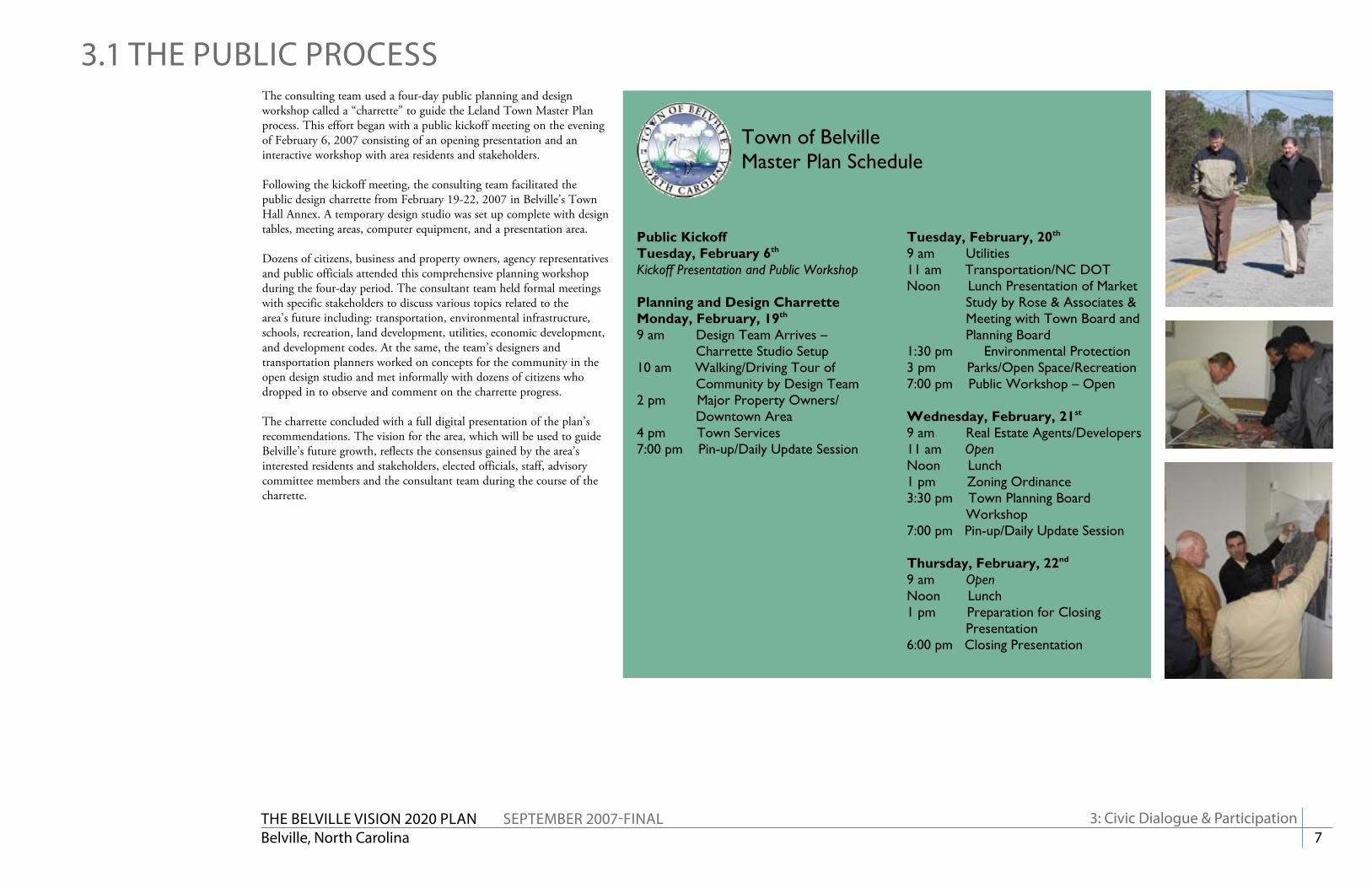
The consulting team used a four-day public planning and design workshop called a “charrette” to guide the Leland Town Master Plan process. This effort began with a public kickoff meeting on the evening of February 6, 2007 consisting of an opening presentation and an interactive workshop with area residents and stakeholders.
Following the kickoff meeting, the consulting team facilitated the public design charrette from February 19-22, 2007 in Belville’s Town Hall Annex. A temporary design studio was set up complete with design tables, meeting areas, computer equipment, and a presentation area.
Dozens of citizens, business and property owners, agency representatives and public officials attended this comprehensive planning workshop during the four-day period. The consultant team held formal meetings with specific stakeholders to discuss various topics related to the area’s future including: transportation, environmental infrastructure, schools, recreation, land development, utilities, economic development, and development codes. At the same, the team’s designers and transportation planners worked on concepts for the community in the open design studio and met informally with dozens of citizens who dropped in to observe and comment on the charrette progress.
The charrette concluded with a full digital presentation of the plan’s recommendations. The vision for the area, which will be used to guide Belville’s future growth, reflects the consensus gained by the area’s interested residents and stakeholders, elected officials, staff, advisory committee members and the consultant team during the course of the charrette.
Town of Belville Master Plan Schedule
Public Kickoff Tuesday, February 6th Kickoff Presentation and Public Workshop Planning and Design Charrette Monday, February, 19th
9 am Design Team Arrives – Charrette Studio Setup
10 am Walking/Driving Tour of Community by Design Team
2 pm Major Property Owners/ Downtown Area
4 pm Town Services 7:00 pm Pin-up/Daily Update Session
Tuesday, February, 20th 9 am Utilities 11 am Transportation/NC DOT Noon Lunch Presentation of Market
Study by Rose & Associates & Meeting with Town Board and Planning Board
1:30 pm Environmental Protection 3 pm Parks/Open Space/Recreation 7:00 pm Public Workshop – Open Wednesday, February, 21st 9 am Real Estate Agents/Developers 11 am Open Noon Lunch 1 pm Zoning Ordinance 3:30 pm Town Planning Board
Workshop 7:00 pm Pin-up/Daily Update Session Thursday, February, 22nd 9 am Open Noon Lunch 1 pm Preparation for Closing
Presentation 6:00 pm Closing Presentation
3.1 The PuBliC PrOCeSS
3: Civic Dialogue & Participation

The Belville viSiON 2020 PlaN SePTemBer 2007-FiNalBelville, North Carolina 8
On February 6, 2007 a kickoff presentation and workshop was conducted in the Town Hall Annex. More than 80 citizens and interested stakeholders were in attendance. The comments listed on this page summarize the primary issues raised by those present.
DOWNtOWNRedevelop downtownMaintain small town feelDevelop downtown so “I do not need to drive to Wilmington.”Keep downtown as a distinct neighborhoodDevelop downtown as a mixed-use areaOpen the riverfront for public useCommunity center!LibraryRiverwalk: Shopping, Restaurants, Movie Theater, Small scale parkProvide separate, fun shops (ice cream/cookies) at riverfrontRemove the D.O.T. building from the waterfrontGet rid of current “downtown buildings & gas station”Harbor Town: small local stores, restaurants, some condos (maybe
above retail), docks to bring boats in for day/dinner
aESthEticSPlant shrubs & trees bordering shops/sidewalksLots of benches, trees
traNSPOrtatiONMake NC 133 three lanes through BelvilleAdd sidewalks & bikeways on NC 133 and collector streetsImprove infrastructure—roads Options for Ploof Rd: Lower speed limit from 55 to 45 or 35; Repave
roadway; Commercial traffic is shaking home foundations!Lower speed limits in the developments: Not 35—but 25!!!Control trafficSmall-scale busing/public transit systemImprove access (roads, feeder streets, connect neighborhoods)Water taxi to Wilmington Traffic lights on Blackwell/Village Rd. (3)Off-street parking in new downtown
PEDEStriaN & BiKESSidewalks in Olde Towne (2)Historical walking trailProvide pathways for pedestrians & bikes, but give enough space so
they don’t endanger one anotherBikes/Walking paths (into downtown)
EcONOmic DEvELOPmENtNo more flea market retailBelville Industrial parkIncrease commerce area to avoid bridgeRiverwalk: Shopping, Restaurants, Movie Theater, Small scale parkRestaurants!
civic/cuLturaL
Move Town Hall back into BelvilleNew Town Hall!!!Community center & library (downtown!)Cinemas/Theater!
PuBLic SErvicESLarge garbage pick-upNeed police departmentSomething done about trash all along the side of roads & parking lotsWater/Sewer infrastructure capabilitiesNeed curbside recyclingLow tax rateMore schoolsActivity center with games for kids
ParKS/PuBLic & OPEN SPacEKeep park by river/school (2)Protect wetlandsPreserve trees & open spaceMultiple, small neighborhood playgrounds as opposed to one large
community parkDog park (2)Keep trees & green space (2)
ENvirONmENtaLPlan for storm water run-off on streetsKeep wetlands protected; no development on them!Keep sound environmental principlesKeep: Green space
miScELLaNEOuS Create cohesive boundaries: land-swap with Leland?
3.2 KiCKOFF WOrKShOP
3: Civic Dialogue & Participation

The Belville viSiON 2020 PlaN SePTemBer 2007-FiNalBelville, North Carolina 9
3.3 The CharreTTe
A charrette consists of an opening presentation, numerous public meetings, design sessions, pin-up sessions, and a closing presentation, all conducted over a multi-day period. This intense and focused effort gives the design team the most efficient opportunity to meet with a large number of interest groups and citizens, gather their vision, and produce a detailed series of high quality plans and renderings that accurately reflect the vision of the community.
There are four guiding principles for charrettes:
iNvOLvE EvEryONE FrOm thE Start: Anyone who might have an opinion or be affected by the plan should be involved from the very beginning. By making people roll up their sleeves and work with the design team, the process gains mutual authorship and a shared vision.
WOrK cONcurrENtLy aND crOSS-FuNctiONaLLy: Our design team has many different specialties, but during the charrette, we all become generalists, assimilating everyone’s expertise and reflecting the wisdom of each ability.
WOrK iN ShOrt FEEDBacK LOOPS: The public needs to be able to propose an idea and see it designed for review in a short period of time. During our process, we hold pin-up sessions every day to garner input on the preferred direction based upon what we heard earlier in the day.
WOrK iN DEtaiL: Only through designing to a level of detail that includes both the details of building types, blocks and public spaces as well as the big picture of circulation, transportation, land use and major public amenities can fatal flaws be reduced or eliminated.
Charrette: French term for “little cart” referring to the final intense work effort expended by architects to meet a project deadline. At the Ecole des Beaux Artes in Paris during the 19th century, proctors circulated with carts to collect final drawings, and students would jump on the “charrette” to put
Images from the Charrette
3: Civic Dialogue & Participation

The Belville viSiON 2020 PlaN SePTemBer 2007-FiNalBelville, North Carolina 10
Images from the Charrette
3: Civic Dialogue & Participation
3.3 The CharreTTe

The Belville viSiON 2020 PlaN SePTemBer 2007-FiNalBelville, North Carolina 11
3: Civic Dialogue & Participation
3.4 CharreTTe DeliveraBleS
THE LAWRENCE GROUP TOWN PLANNERS + ARCHITECTSIN ASSOCIATION WITH
KIMLEY-HORN & ASSOCIATESROSE & ASSOCIATES
© THE LAWRENCE GROUP, 2007
CHARRETTE NOTEBOOK
THE BELVILLE TOWN PLAN
Belville, North Carolina
THE LAWRENCE GROUP / KIMLEY-HORN & ASSOCIATES / ROSE & ASSOCIATES© THE LAWRENCE GROUP, 2007
THE BELVILLE TOWN PLAN
Belville, North Carolina
T r a n s p o r t a t i o n F r a m e w o r k
Existing Roads
Proposed Connections/New Town Streets
Bike Lanes
Riverfront Pathway
Important Intersections
THE LAWRENCE GROUP / KIMLEY-HORN & ASSOCIATES / ROSE & ASSOCIATES© THE LAWRENCE GROUP, 2007
THE BELVILLE TOWN PLAN
Belville, North Carolina
T h e R i v e r f r o n t V i l l a g e - O p t i o n B
Because of the charrette’s comprehensive nature, the master plan proposed at that time provided enough detail to show realistic development capacity for the remaining developable area using detailed schematic design studies in three dimensions including streets, buildings, and open spaces.
The design team delivered a PowerPoint Presentation that restated the goals of the process, illustrated in detail the proposed plan and permitted the team to suggest a number of specific implementation strategies. The digital nature of the final presentation enabled the Lawrence Group to produce both a high quality PowerPoint presentation illustrating the draft Master Plan as well as published package of all of the final drawings.
SLiDES FrOm thE charrEttE’S cLOSiNG PrESENtatiON
PaGES FrOm thE charrEttE NOtEBOOK

The Belville viSiON 2020 PlaN SePTemBer 2007-FiNalBelville, North Carolina 12
4.1 eNvirONmeNTal SuSTaiNaBiliTyiNtrODuctiON
Protection of Belville’s rich natural resources is a priority for the Town and its citizens. As such, development regulations should reflect this conviction. Sustainable design and development comprises two main areas of action: site design and building design. Parameters and guidance for sustainable building design are best set forth in the United States Green Building Council’s (USGBC) LEED standards (Leadership in Energy and Environmental Design) (www.usgbc.org). The LEED design criteria deal also with site design for the areas around the building(s), and these sustainable landscape practices are further codified by the Low Impact Development (LID) standards, promulgated by, amongst others, the Low Impact Development Center (www.lowimpactdevelopment.org).
rEcOmmENDatiONS
Protect the wetlands and watercourses (creeks, streams, and rivers) with increased protection and suitable undisturbed buffers. The Belville area, like most of the County, is strewn with various wetlands ranging from boggy woodlands to ponds, streams and marshlands. The conventional development pattern has largely engineered much of these precious sites water quality benefits in favor of strictly water “quantity” measure. That is, the focus has been on the collection and transmission of storm water to prevent flooding. Little if any focus has been on the quality of the downstream water and its ability to support the natural systems that have long been the basis for the area’s tourism. The Town should closely follow the requirements and categories established by various North Carolina state authorities, especially the NC-CREWS (North Carolina Coastal Region Evaluation of Wetland Significance) Strategic Plan for Improving Coastal Management in North Carolina (1999) and the North Carolina Wildlife Commission’s Guidance Memorandum to Address and Mitigate . . . Impacts to . . . Wildlife Resources and Water Quality (2002).
The NC-CREWS plan notes that: “approximately 50 percent of the original wetlands of the coastal area have been drained and converted to other land uses (Hefner and Brown, 1985; Dahl, 1990; DEM, 1991). Although agricultural conversion, the largest historical contributor to wetlands loss, has largely stopped, wetlands continue to be lost as they are drained or filled for development. Conflicts between economic development and wetlands protection continue to be a major concern, with many coastal communities considering wetlands protection to be a major barrier to economic development. Since wetlands are such a dominant part of the coastal landscape and are vitally important to many aspects of the area’s ecology, their management and protection is a major concern . . . Environmental considerations play a significant role in land use decision-making and are one of the major objectives of the local land use planning mandated by the NC Coastal Area Management Act.”
In their companion report, the North Carolina Wildlife Resources Commission (NCWRC) notes that “riparian” areas, that is, land areas along and adjacent to rivers, creeks and streams:
“frequently perform important ecological functions and contain a disproportionately high numbers of wildlife species in comparison to most upland habitats (Fischer et al. 2000; Knutson and Naef 1997). As a matter of policy, the American Fisheries Society strongly urges that riparian areas be considered unique and distinctly valuable habitats, and that such areas be declared of critical environmental concern (AFS 1985). Riparian areas perform many functions that are essential to maintaining water quality, aquatic species survival, and biological productivity. . . The use of wooded riparian buffers is an important tool in reducing damage to streams (Waters 1995) [and convey] critical benefits to society.”
What iS LOW imPact DEvELOPmENt (LiD)?
LID is an ecologically friendly approach to site development and storm water management that aims to mitigate development impacts to land, water, and air. The approach emphasizes the integration of site design and planning techniques that conserve natural systems and hydrologic functions on a site. The practice has been successfully integrated into many municipal development codes and storm water management ordinances throughout the United States. Specifically, LID aims to:
Preserve Open Space and Minimize Land Disturbance; �
Protect Natural Systems and Processes (drainage ways, vegetation, soils, sensitive areas); �
Re-examine the Use and Sizing of Traditional Site Infrastructure (lots, streets, curbs, gutters, sidewalks) and �
Customize Site Design to Each Site;Incorporate Natural Site Elements (wetlands, stream corridors, mature forests) as Design Elements; and �
Decentralize and Micromanage Storm Water at its Source. �
LID BenefitsIn addition to the practice just making good sense, low impact development techniques can offer many benefits to a variety of stakeholders.
For MunicipalitiesProtect regional flora and fauna �
Balance growth needs with environmental protection �
Reduce municipal infrastructure and utility maintenance costs (streets, curbs, gutters, sidewalks, storm sewer) �
Increase collaborative public/private partnerships �
For DevelopersReduce land clearing and grading costs �
Potentially reduce infrastructure costs (streets, curbs, gutters, sidewalks) �
Reduce storm water management costs �
Potentially reduce impact fees and increases lot yields �
Increase lot and community marketability �
For the EnvironmentPreserve integrity of ecological and biological systems �
Protect site and regional water quality by reducing sediment, nutrient and toxic loads to water bodies �
Reduce impacts to local terrestrial and aquatic plants and animals �
Preserve trees and natural vegetation �
Hydrologic Comparison between Conventional Storm Water Management and LIDHydrologic alterations within the landscape occur whenever land is developed. Conventional development approaches to storm water management have used practices to quickly and efficiently convey water away from developed areas. Usually these practices are designed to control the peak runoff rate for predetermined storm events, usually the 2- and 10-year storms. While these systems have worked to some degree, they still have not accounted for the increased runoff rates and volumes from smaller, more frequent storms, nor have they addressed the larger watershed functions of storage, filtration, and infiltration.
In contrast, LID utilizes a system of source controls and small-scale, decentralized treatment practices to help maintain a hydrologically functional landscape. The conservation of open space, the reduction of impervious surfaces, and the use of small-scale storm water controls, such as bioretention, are just a few of the LID practices that can help maintain predevelopment hydrological conditions.
4: Plan recommendations
Source: Municipal Guide to Low Impact Development, National Assocation of Home

The Belville viSiON 2020 PlaN SePTemBer 2007-FiNalBelville, North Carolina 13
According the NCWRC, riparian areas provide the following benefits:Reduce pollutants and filter runoff �
Improve air quality and lower ozone levels �
Maintain stable water flows �
Help maintain water and air temperature by providing shade �
Stabilize stream banks �
Provide most of the organic carbon and nutrients to support the �
aquatic food webProvide sources of large woody debris for the stream channel �
Help reduce the severity of floods �
Facilitate the exchange of groundwater and surface water �
Provide critical wildlife habitat �
At a minimum, adequate undisturbed buffers a minimum of 50 feet in width should be established around all wetland areas and watercourses. Depending on the soil conditions and vegetation around the area, this buffer could be increased or decreased subject to existing best practices in the coastal areas.
Reduce the impact of parking areas on the environment with reduced parking ratios and pervious pavement systems. The design of parking areas is particularly critical in terms of controlling the amount of surface water run-off from developments in the town center. Efforts to reduce parking lot acreage begin with minimizing required parking ratios; encouraging shared parking between uses; adopting and not exceeding nationally recognized minimum parking dimensions (The Dimensions of Parking, 4th ed. Urban Land Institute and the National Parking Association, 2001); grading parking lots to drain rainwater to multiple landscaped areas that can function as rain gardens to absorb and slowdown water run off; and the use of pervious pavement materials such as interlocking concrete pavers (e.g. Grasscrete).
Incorporate Low Impact Development (LID) Standards into new development. The Town should investigate implementation of Low Impact Development standards recently produced for Brunswick and New Hanover Counties. According to the New Hanover County Planning Department, “LID is an approach to site development and storm water management with the goal being to mitigate development impacts to land, water and air. LID incorporates comprehensive land planning and engineering design in order to maintain or enhance the predevelopment hydrologic regime of urban and developing watersheds. LID incorporates various stormwater techniques to achieve environmental protection, while allowing for development to occur.”
“Conventional stormwater techniques alone may not prevent the continued degradation of water quality. LID provides an additional tool to optimize the use of the urban landscape to reduce and treat runoff,
and in the end, to better protect water quality. Not only can LID provide a better scenario for water quality, it is often more cost effective.” In urban areas, these techniques will range from conventional underground retention structures, to localized bioretention areas such as rain gardens and planted swales as alternatives to large ponds, to permeable pavement surfaces (especially for parking areas), rain barrels and planted roofs.
Consider LEEDTM certification of all new public buildings. This conceptual master plan encourages the use of LEED guidelines to certify all new public buildings. Developed by the USGBC membership, the Leadership in Energy and Environmental Design (LEED) Green Building Rating System is a national consensus-based, market-driven building rating system designed to accelerate the development and implementation of green building practices. In short, it is a leading-edge system for designing, constructing and certifying sustainable buildings.
The trend towards sustainable design practices in building also serves as a means to reduce overall energy consumption. While there is often a 2-10% increase in capital costs for a LEED-certified building, these costs are recouped over a period of time with lower heating, cooling and water consumption costs.
4: Plan recommendations
4.1 eNvirONmeNTal SuSTaiNaBiliTy
The LEED (Leadership in Energy and Environmental Design) Green Building Rating System® was created to:
� Define “green building” by establishing a common standard of measurement
� Promote integrated, whole-building design practices� Recognize environmental leadership in the building industry� Stimulate green competition� Raise consumer awareness of green building benefits� Transform the building market
LEED provides a complete framework for assessing building performance and meeting sustainability goals. Based on well-founded scientific standards, LEED emphasizes state of the art strategies for sustainable site development, water savings, energy efficiency, materials selection and indoor environmental quality. LEED recognizes achievements and promotes expertise in green building through a comprehensive system offering project certification, professional accreditation, training and practical resources.
LEED standards are currently available or under development for:
� New commercial construction and major renovation projects (LEED-NC) � Existing building operations (LEED-EB)� Commercial interiors projects (LEED-CI) � Core and shell projects (LEED-CS) � Homes (LEED-H) � Neighborhood Development (LEED-ND)
Source: http://www.usgbc.org
L.E.E.DLEaDErShiP iN ENErGy & ENvirONmENtaL DESiGN
Pervious Paving System to Improve Natural Drainage and Reduce Runoff
Rain Barrel System to be used for On- Site Irrigation
A Rain Garden that collects stormwater and naturally “cleans” pollutants
Cre
dit:
City
of S
eattl
e Pu
blic
Wor
ks

The Belville viSiON 2020 PlaN SePTemBer 2007-FiNalBelville, North Carolina 14
4.2 TraNSPOrTaTiON & CirCulaTiON
4: Plan recommendations
iNtrODuctiON
Given the unique geography of the Belville town limits with its close relationship to Leland, the railroad and the US 17 highway dividing its borders, it is clear that most of the issues that face Belville residents in getting around are regional in nature. In the car, on a bike, or by foot, circulation around Town is inextricably linked to the decisions of others. As such, it is imperative that Belville continue to actively assert itself in all regional transportation planning efforts, most specifically the Wilmington Area Metropolitan Planning Organization (MPO).
As a part of this planning process, Kimley-Horn & Associates reviewed the existing transportation system and made a series of recommendations for improvements. Because of this review’s qualitative nature, additional study will be required for each recommendation. It is expected, however, that these recommendations will provide a framework in which the Town may begin to make some qualified decisions regarding future mobility.
The recommendations have been organized by the zones noted in the diagram below:
1
2
3
4
PLaNNiNG arEaS
1: Lincoln Business Park/NC 172: Blackwell Road (See also Section A.1)
3: NC 133 South4: The Riverfront Village
Existing roads
Proposed connections/New town Streets
multi-use Path/riverfront Pathway
Bike Lanes
important intersections
traNSPOrtatiON FramEWOrK PLaNBuilding on the NC-133/US-17 Collector Street Plan, the plan
above illustrates the need for a more fine-grained network of multi-modal (cars, bikes, and pedestrians) connections for the Belville area.
Proposed collector streets in Leland’s jurisdiction are grayed out.

The Belville viSiON 2020 PlaN SePTemBer 2007-FiNalBelville, North Carolina 15
PLaNNiNG arEa 1: LiNcOLN BuSiNESS ParK/uS 17
Provide a connection to Grandiflora Drive from Olde Waterford Way. Connectivity is very poor in and around Leland and Belville. Extensive wetlands, the presence of railroad tracks, US 74/76 and US 17 as limited access highways and poor planning have contributed to a network with few choices. The current network forces most trips onto US 17. Better access is needed to connect the Waterford and Magnolia Greens neighborhoods as well to the planned commercial/office development in the business park and along the frontage of US 17.
In order to accomplish this connection, the Town of Leland should preserve the corridor as part of an overall collector street program managed through the development process. It is expected that most of this connection would be constructed by new development. This connection would complete the frontage road/cross-access driveway that has already been started from Olde Waterford Way. With little effort this cross-access will connect to Gregory Road by extending individual driveways. The remaining piece west of Gregory Road may need to take a more northern route closer to Backhoe Road because of the presence of wetlands along US 17.
PLaNNiNG arEa 2: BLacKWELL rOaD
Align Blackwell Road with Ploof Road to provide an east-west corridor for local traffic from NC 133 to Grandiflora Drive. Since the installation of the improvements to US 17 (also know as the Michigan lefts), connectivity to US 17 westbound from Blackwell Road has been eliminated. This access is now right-in/right-out only. Local drivers are now aware that continuing down Blackwell and turning onto Ploof Road enables westbound travel. Unfortunately, this route is not signed and is generally unattractive.
To promote more local traffic along Blackwell Road and away from US 17, this plan encourages the direct connection of Blackwell Road to Ploof Road. To facilitate this new alignment, right-of-way will need to be protected if the parcels in the path of such alignment are redeveloped. In addition to simply providing a path for the motorist, a multi-use path should also be provided to accommodate the bicyclist and the pedestrian.
Ideally, this corridor should be extended to tie into the frontage road now presently installed in front of the new Wal-Mart. As is the case with many of these connections, most lead into Leland’s jurisdiction and will therefore require mutual cooperation and support.
4: Plan recommendations
US 17
Olde
Wat
erfo
rd W
ay
Grandiflora Drive
Gregory Road
US 17
PLaNNiNG arEa 2 traNSPOrtatiON imPrOvEmENtS
“Back door”/street connection parallel to US 17
PLaNNiNG arEa 1 traNSPOrtatiON imPrOvEmENtS
Connection to Grandiflora Drive
New street connections
US 17/74/76
Blackwell Road
Chappell Loop Road
New street connections
Blackwell Road/Ploof Road connector
Ploof Road
Ploof Road connection to Wal-Mart
4.2 TraNSPOrTaTiON & CirCulaTiON

The Belville viSiON 2020 PlaN SePTemBer 2007-FiNalBelville, North Carolina 16
PLaNNiNG arEa 3: Nc 133 SOuth
Improve the capacity of the NC 133/River Road corridor while maintaining a high priority on its overall aesthetics as a gateway to Belville and southern Brunswick County. NC 133 carries approximately 14,000 vehicles per day (vpd) just south of the US 17 interchange. With more than 12,000 homes planned for Brunswick Forest and Mallory Creek and only two points of combined external access, the amount of traffic along NC 133 is expected to swell once those connections are made.
The Southport area’s increased attractiveness for vacationing and the new shipping port planned in that area will put even more pressure on this corridor. Also, the planned (but unfunded) interchange of NC 133 and I-140 to connect to the Skyway project (new bridge across the Brunswick and Cape Fear Rivers to south New Hanover County) will dramatically impact this area. Given the lack of short-term funding, however, such impacts will be far into the future. Finally, Belville Elementary School’s traffic and circulation is simply unacceptable during the morning rush hour.
Though Belville’s preference is to keep this two lane winding rural road in its present state, the need to improve and add additional capacity is simply too inevitable. The goal, therefore, is to establish a new road cross-section that maintains the majestic elements of the current corridor while accommodating the needs of the increased travel projections.Therefore, the following phased improvements should be considered along the NC 133/River Road corridor:
� Short-term (2-5 years) – The section between the US 17/NC 133 interchange and Belville Elementary School presently has 120 feet of right-of-way. This section should be widened (between the interchange and Old River Road) to a 4-lane divided road with wide outside lanes (to accommodate cyclists), a lushly landscaped median with mountable curb, a verge with street trees and 8 foot sidewalks through the village core. In the area from Old River Road to Belville Elementary School/Brunswick River Park the same cross section may be used, but a 10 foot wide multi-use path should replace the 8 foot wide sidewalk along the east side (Brunswick River side).
� Mid-term (5-10 years) – The section between Belville Elementary School and the proposed Skyway (I-140) has only 60 feet of right-of-way. Using this existing right-of-way, this section can be reconstructed to a 2-lane divided road with a landscaped median and mountable curb, paved shoulders and open swales. During this period, the Town should work with adjacent property owners to continue the installation of
PrOPOSED crOSS-SEctiON FOr Nc 133/rivEr rOaDThe proposed ultimate cross section includes four travel lanes, a wide landscaped median and side verges with canopy trees, and a wide sidewalk (or multi-use path) on each side. Ideally, the canopy trees selected could grow and over time, re-crate the existing feel of the rural section with live oak branches creating a “low-country ceiling” over the road like in the image to the left.
4: Plan recommendations
4.2 TraNSPOrTaTiON & CirCulaTiON

The Belville viSiON 2020 PlaN SePTemBer 2007-FiNalBelville, North Carolina 17
4: Plan recommendations
sidewalks and street trees using permanent sidewalk easements. Concurrently, the Town and NC DOT should aggressively pursue additional right-of-way (25 feet on each side) to accommodate a similar road section listed in the Short-term phase above.
� Long-term (10+ years) – Once adequate right-of-way (110 feet) is acquired, the section between Belville Elementary School and the Skyway should be widened to a 4-lane divided cross-section with street trees and a multi-use path on each side.
Request that the NC DOT Urban Municipal Operations Unit conduct an access and circulation study around the elementary school. The current circulation around the school during student drop-off and pick-up times is unacceptable. As NC 133 provides the only north-south route in this entire area, all times of the day, but in particular the morning rush hour, stretch the roadway’s effectiveness. It is imperative that alternate arrangements be considered to remedy the situation. The conceptual plan drawn for the property around the Elementary School provides a dramatic opportunity for positive change in this area. As such, any site planning done on this parcel should keep in mind the needs of circulation around the school.
PLaNNiNG arEa 3 traNSPOrtatiON
imPrOvEmENtS
Multi-use path along NC 133/River Road
Phase 1 Improvem
entsPhase 2 Im
provements
Right-of-way needed in front of school
Need an additional 40-50 of right-of-way (20-25 ft from each side)
4.2 TraNSPOrTaTiON & CirCulaTiON

The Belville viSiON 2020 PlaN SePTemBer 2007-FiNalBelville, North Carolina 18
4: Plan recommendations
PLaNNiNG arEa 4: thE rivErFrONt viLLaGE
The NC 133 Interchange has the highest volume and crash rate within the Belville study area. Peak hour congestion continues to increase and become more problematic.
Adjust the signal timing and phasing around the interchange. In the short term, the existing traffic signals need to have their timing and phasing updates based on movement volumes and crash data. It appears that it has been some time since the current programming was last updated and the system is long overdue for a significant upgrade.
Support the completion of the Village Road improvements north of the interchange. The proposed Village Road improvements to the north of the interchange in Leland should be completed as a landscaped median-divided boulevard extending beyond the intersection of Old Fayetteville Road. The current free movement into driveways close to the interchange increases the risk of crashes and reduces the traffic signals’ efficiency. The plan strongly prefers the landscaped median to a simple concrete median or a two-way-left-turn lane for two reasons. First, the median will eliminate the existing free left turn lanes, thus making Village Road a safer corridor. And second, the landscaping will help to visually enclose the area, thereby lowering overall speeds along the corridor. It is imperative that Belville support Leland’s efforts to advocate for this street section, as Leland’s success in this matter makes a similar cross section for the Belville side of NC 133 more realistic.
Realign Blackwell Road approximately 650 feet south of the current intersection with NC 133 to provide adequate separation between the southbound ramps. Currently, it is quite difficult to turn left from Blackwell Road onto NC 133/River Road. Because of the signals for the on- and off-ramps from US 17/74/76, the spacing is too constrained to permit the installation of another signal at its present intersection. Realigning it further south would meet adequate spacing standards. In concert with this alignment, it is expected that a new access point into the Riverfront Village would be controlled from this same signal.
Construct a “square loop” ramp for northbound ingress and egress in combination with Blackwell Road. Lastly, as part of a longer term solution, the Town should advocate for the removal of NC 133’s existing northbound off-ramp and the installation of a new northound on- and off-ramp separated from the current interchange. This ramp would be connected to the realigned Blackwell Road. The proposed “square-loop” resembles a loop in operation, but permits greater access to the surface road and allows for the surrounding property to develop/redevelop more economically.
PLaNNiNG arEa 4traNSPOrtatiONimPrOvEmENtS
New “Square-Loop” ramp
New street connection
Blackwell Road realignment
New “Main Street” at signal
New signal to support Riverfront Village
4.2 TraNSPOrTaTiON & CirCulaTiON

The Belville viSiON 2020 PlaN SePTemBer 2007-FiNalBelville, North Carolina 19
4: Plan recommendations
By eliminating the left turns required for southbound (NC 133) to northbound (US 17/74/76) traffic the entire interchange works more efficiently. Eliminating the left-turns needed for the northbound on-ramps (and the signal that controls them) increases the interchange’s overall signal spacing to 1500 feet, a more acceptable spacing based on NCDOT design standards.
The proposed configuration also appears to be satisfactory to the needs of the US 17 corridor. Though there is some desire to convert US 17 to a freeway, this conversion is not likely in the next 20+ years given the number of driveways and street intersections. Based on discussions with NCDOT and the MPO, there is no plan to retrofit US 17 at Belville to a freeway.
Make the Riverfront Village area bicycle and pedestrian-friendly. The plan recommends accommodations for bicycle and pedestrian amenities for streets within the Riverfront Village area. Amenities should include highly visible crosswalks (raised where appropriate), sidewalks (5- 10 feet), pedestrian countdown signals, pedestrian level lighting and street furniture (i.e., benches, bicycle parking, etc.).
GENEraL rEcOmmENDatiONS
All new streets should provide facilities for the bicyclist and pedestrian as well as the automobile. Collector street design standards that include 2-lane facilities with provisions for bicycles and pedestrians as well as street trees and lighting should be adopted by the Town of Belville to ensure consistency in street design and construction. Refer to US 17/NC 133 Collector Street Plan for recommended collector street design standards and cross-sections.
PrOPOSED SquarE LOOP iNtErchaNGEThe illustration above shows the proposed configuration for the northbound on- and off-ramps as well as the proposed median along NC 133/River Road.
4.2 TraNSPOrTaTiON & CirCulaTiON

The Belville viSiON 2020 PlaN SePTemBer 2007-FiNalBelville, North Carolina 20
4.3 The COmPOSiTe maSTer PlaNThe plans illustrated in this section and elsewhere represent realistic conceptual build-out scenarios for sites within the community. When envisioning these preferred development opportunities existing property boundaries, ownership rights and the potential consolidation of parcels along with market conditions and trends were considered.
The plan assumes that site-specific modifications to the arrangements shown here will occur once more detailed studies are undertaken for each site, including more detailed programming and market analyses. The purpose of the designs in the Master Plan is to show appropriate patterns, scales and intensities of development; it is not necessarily expected that new development will always conform to each building as drawn.
Nonetheless, the following considerations embodied in this master plan should be actively incorporated in each design proposal:
� General intensity of development� Mixture of uses as appropriate� Urban pattern (i.e. relationships of buildings to streets, public
spaces, parking and adjacent properties)� Street character and pedestrian circulation patterns� Three-dimensional massing and size of buildings� Open space provision
4: Plan recommendations
1
2
4
3
PLaNNiNG arEaS
1: Lincoln Business Park/NC 172: Blackwell Road (See also Section A.1)
3: NC 133 South (See Section A.2)3: The Riverfront Village

The Belville viSiON 2020 PlaN SePTemBer 2007-FiNalBelville, North Carolina 21
4.4 liNCOlN BuSiNeSS ParK/uS 17
4: Plan recommendations
ExiStiNG cONDitiONS
Though seemingly disconnected from the rest of Belville, this area was once surrounded by the Belville Town Limits. Following the legislative de-annexation of the Waterford and Magnolia Greens planned unit developments it became an island connected by a small sliver of land extending across US 17. Presently zoned Industrial, the entire area contains the widest range of uses permitted in the Belville zoning ordinance, as would be expected in an industrial zone.
Now surrounded by new neighborhoods in Leland’s jurisdiction, this business park has two distinct complexions. Historically it has been incrementally developed with various light industrial operations ranging from an industrial coatings shop to a heavy equipment retailer. Nearly all of the buildings are prefabricated metal structure with various levels of masonry veneer. There is little landscaping around the individual sites and no coordinated streetscape or signage program for the area.
The newer buildings towards US 17 would generally be considered “retail-flex”. Though the most recent building has a full brick veneer on three sides, it is still a prefabricated metal structure. Other buildings to the east of the site (in Leland’s jurisdiction) are site-built, multi-story structures with restaurants, retail, and medical office functions.
To the rear of the lots along Poole Road are residential lots separated by either a berm or a fence. Unfortunately, these lots were permitted to be constructed without any significant buffer on the subdivision side of the line. There is a haphazard berm along a portion of the perimeter, the construction of which greatly impacts the usability of the backyards to which it is adjacent. It is unusually tall (~20 ft in height plus landscaping) and poorly planted, creating a canyon-like effect for those homes. It was clearly an afterthought to accommodate resident’s concerns about backing up to an industrial district.
There was considerable discussion during the charrette regarding the potential industrial development adjacent to the existing residential area, though it is clear that the zoning and existing industrial uses long preceded the homes. In fairness, it should have been the residential development’s responsibility to install any needed buffers or screens—a point that must be underscored.
Not unlike the rest of the area, there are considerable wetlands and low areas on the remaining undeveloped land. It appears that a number of parcels have recently been filled to increased their base elevation. Upon inspection of that grading there appeared to be minimal erosion control methods in place and there was heavy siltation in the surrounding areas including some known wetlands.
View of homes in the Waterford subdivision behind a berm
Heavy equipment dealer in Industrial Park
Typical metal building in Industrial Park
Existing pine forest along north side of Poole Road
Existing erosion control measures showing obvious failures under the fence

The Belville viSiON 2020 PlaN SePTemBer 2007-FiNalBelville, North Carolina 22
4.4 liNCOlN BuSiNeSS ParK/uS 17rEcOmmENDatiONS
Maintain the current industrial classification and encourage expansion of employment-based uses. A great need exists in northern Brunswick County for sites housing industrial activities. Far too often these locations get pushed further out into the rural countryside because of encroaching development. Given the presence of a number of significant uses in the business park, their physical relocation to accommodate a different development pattern does not seem practical within a ten year time horizon. Most importantly, including these uses in the community balances an already residential-heavy tax base. Many fast growth communities forget about these uses until the tax base growth slows down. This often means that there are few sites remaining with which to recruit for economic development purposes. Preserving these locations represents an investment in what will be a future need.
Establish design standards for new industrial development. The sporadic nature of the site development to date has been haphazard at best. New site development standards should be incorporated that preserve existing landscaping, landscape developed areas, manage site lighting and garbage collection, and set standards for building design. In other words, the “park” is in need of an upgrade which can be accomplished one site at a time.
4: Plan recommendations
aLtErNatE PLaN ShOWiNG cONNEctiON tO GraNDiFLOra LaNE
Protected wetlands
Vegetated berm/50 foot tree save areaFire Station site
Typical industrial building
Highway Commercial buildings Connected driveway/frontage road
The Belville viSiON 2020 PlaN SePTemBer 2007-FiNalBelville, North Carolina 23
4.4 liNCOlN BuSiNeSS ParK/uS 17rEcOmmENDatiONS (continued)
Provide a buffer along the perimeter and/or maintain the existing canopy. Unfortunately, when the adjacent residential development was constructed little to no vegetation was preserved, nor was any space set aside for additional screening or buffering. Standard lots were platted right to the external boundary as if more homes would be built on the industrial land. This is an unrealistic expectation, but the presence of homes in close proximity to potential industrial operations can be problematic for potential tenants. This plan, therefore, reluctantly recommends that a consistent buffer/screen be installed on the industrial side of the property line. This buffer should take the form of a landscaped berm matching the existing berm or the retention of a minimum of 50 feet of trees (where they exist) in combination with a privacy fence. Ownership and maintenance of that buffer would be the responsibility of the industrial developer.
Permit highway commercial use similar to the Waterford development along the US 17 frontage. The existing pattern and design of development to the east of the business park site consists of well-appointed, brick buildings that are predominately oriented towards US 17. In the absence of a true frontage road, it is acceptable to permit and encourage the continuation of this pattern into Belville’s jurisdiction.
Extend the parallel driveway behind the first row of buildings to facilitate circulation. By providing a frontage road/driveway, motorists would be able to travel from one end of the site to the other without having to access US 17, dramatically improving the transportation choices for people living in the area.
Provide a connection to Grandiflora Drive. Over the long term a connection from the Waterford neighborhood to Magnolia Greens will be very beneficial to residents of each development. It is important to note that this connection would be through Leland jurisdiction and would directly benefit the Leland residents in both of these neighborhoods.
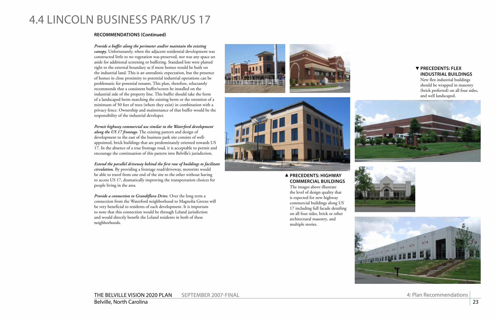
PrEcEDENtS: hiGhWay cOmmErciaL BuiLDiNGSThe images above illustrate the level of design quality that is expected for new highway commercial buildings along US 17 including full facade detailing on all four sides, brick or other architectural masonry, and multiple stories.
PrEcEDENtS: FLEx iNDuStriaL BuiLDiNGSNew flex industrial buildings should be wrapped in masonry (brick preferred) on all four sides, and well landscaped.
4: Plan recommendations

The Belville viSiON 2020 PlaN SePTemBer 2007-FiNalBelville, North Carolina 24
4.5 BlaCKWell rOaD area
4: Plan recommendations
ExiStiNG cONDitiONS
The Blackwell Road and Chappell Loop Road area has an underdeveloped geography comprised of scattered housing and industrial operations. The area is split between Leland (to the south of Blackwell Road) and Belville (to the north of Blackwell Road and east of Chappell Loop Road). This split in jurisdiction, recently enacted through a court order, proves cumbersome as it is not divided along a logical boundary such as a major road or a watercourse.
The Blackwell Road corridor is a long straight road presently being used by many as an alternate to US 17. Because of the recent improvements to US 17, the direct access from Blackwell Road has been converted to a right in/right out only. In order to access US 17 to head west, motorists now have to turn from Blackwell Road to Chappell Loop Road and then on to Ploof Road. While this is not a difficult maneuver, the Ploof Road corridor remains very unsightly. Simply put, it does not present an appropriate western gateway into this area.
Much of this area’s housing stock is substandard and investor-owned. With the existing industrial operations (including a foundry) and the truck traffic, this is not a pleasant area for housing. In addition, a number of junk car lots dominate the landscape on the south side (Leland side) of Blackwell Road. Given given their age and lack of tidiness, they are undoubtedly contaminating the ground water in the area.
To the north side of Blackwell Road at the interchange of US 17 and US 74/76 there is an approved plan for the construction of a travel center/rest stop to serve the regional truck and passenger traffic through the corridors. Because of the extensive wetlands on that parcel, the developers are having significant difficulty receiving permits to construct the facility.
Lastly, the Town of Leland recently approved a subdivision plan for the former sand mine on the south side of Chappell Loop Road. It is important to note that this approval was made with no condition to stub any future roads. All of the access will come from Chappell Loop Road.
US 17/74/76
Blackwell Road
Chappell Loop Road
Ploof Road
The Belville viSiON 2020 PlaN SePTemBer 2007-FiNalBelville, North Carolina 25
4.5 BlaCKWell rOaD arearEcOmmENDatiONS
Adjust the annexation boundaries between Leland and Belville in this area. This area is isolated from much of Leland by US 17 to the north and Mallory Creek to the south. Given Belville’s limited geography and the vast extent of Leland’s potential annexation area, it would be fair and appropriate for Leland to cede jurisdiction to Belville. Because of the area’s significant blight, this cannot be perceived as a land grab by Belville as they will have to expend resources in cleaning up the area. But, as exemplified through Belville’s diligence in cleaning up the downtown, they clearly have a commitment towards improving their aesthetics.
Pursue wetlands mitigation credits to preserve the area to the north of Blackwell Road (travel center site). Given the high percentage of wetlands on the site as well as the existing tree canopy, the site should be preserved in its natural state to the greatest extent possible. From a regional standpoint it serves as a significant transitional area from the highway commercial uses of the US 17 corridor to the southeast to the downtown areas of Leland and Belville before crossing the concourse into Wilmington. It would be an aesthetic loss for the entire area if the site were to be cleared to accommodate yet another paved surface.
Wetlands mitigation bank credits can be used to purchase the site and surrounding undeveloped parcels from the current property owners and place it into a permanent conservation easement. As a public resource, it would be a good location for a +/- 120 acre nature preserve. Boardwalks and trails can traverse lightly through the terrain, permitting the general public to enjoy its resources while otherwise protecting it from large-scale human encroachment. According to the US Army Corps of Engineers, no established wetlands mitigation bank exists to date in either Brunswick or New Hanover County (http://www.saw.usace.army.mil/wetlands/Mitigation/index.html). More information on this program can also be found on the web site for the NC Ecosystem Enhancement Program (http://www.nceep.net).
POtENtiaL WEtLaNDS mitiGatiON BaNK cONSErvatiON arEa
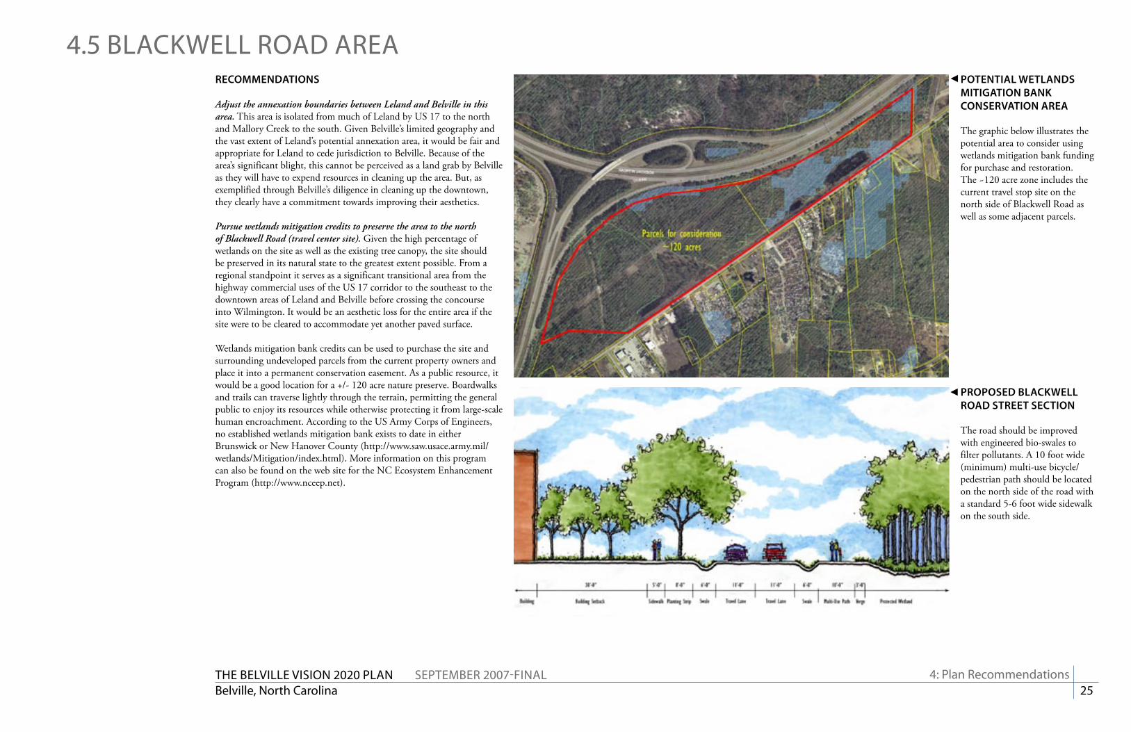
The graphic below illustrates the potential area to consider using wetlands mitigation bank funding for purchase and restoration. The ~120 acre zone includes the current travel stop site on the north side of Blackwell Road as well as some adjacent parcels.
4: Plan recommendations
PrOPOSED BLacKWELL rOaD StrEEt SEctiON
The road should be improved with engineered bio-swales to filter pollutants. A 10 foot wide (minimum) multi-use bicycle/pedestrian path should be located on the north side of the road with a standard 5-6 foot wide sidewalk on the south side.
The Belville viSiON 2020 PlaN SePTemBer 2007-FiNalBelville, North Carolina 26
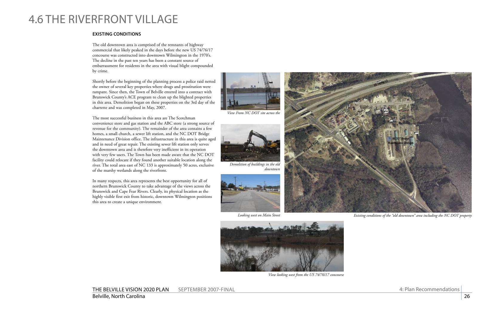
US 74/76/17
Old Main
Street
NC DOT Bridge Maintenance Division
NC 133/River Road
Blackwell Road
ExiStiNG cONDitiONS
The old downtown area is comprised of the remnants of highway commercial that likely peaked in the days before the new US 74/76/17 concourse was constructed into downtown Wilmington in the 1970’s. The decline in the past ten years has been a constant source of embarrassment for residents in the area with visual blight compounded by crime.
Shortly before the beginning of the planning process a police raid netted the owner of several key properties where drugs and prostitution were rampant. Since then, the Town of Belville entered into a contract with Brunswick County’s ACE program to clean up the blighted properties in this area. Demolition began on these properties on the 3rd day of the charrette and was completed in May, 2007.
The most successful business in this area are The Scotchman convenience store and gas station and the ABC store (a strong source of revenue for the community). The remainder of the area contains a few homes, a small church, a sewer lift station, and the NC DOT Bridge Maintenance Division office. The infrastructure in this area is quite aged and in need of great repair. The existing sewer lift station only serves the downtown area and is therefore very inefficient in its operation with very few users. The Town has been made aware that the NC DOT facility could relocate if they found another suitable location along the river. The total area east of NC 133 is approximately 50 acres, exclusive of the marshy wetlands along the riverfront.
In many respects, this area represents the best opportunity for all of northern Brunswick County to take advantage of the views across the Brunswick and Cape Fear Rivers. Clearly, its physical location as the highly visible first exit from historic, downtown Wilmington positions this area to create a unique environment.
Looking west on Main Street
Demolition of buildings in the old downtown
Existing conditions of the “old downtown” area including the NC DOT property
View looking west from the US 74/76/17 concourse
View From NC DOT site across the
4: Plan recommendations
4.6 The riverFrONT villaGe

The Belville viSiON 2020 PlaN SePTemBer 2007-FiNalBelville, North Carolina 27
A Square in Savannah, GA
New mixed-use shopping center in Wrightsville Beach, NC
Images of downtown Wilmington and the Cape Fear riverfront
Precedent images were compiled based on the community’s vision for the waterfront. Not surprisingly, the river front of historic, downtown Wilmington served as the strongest model from which designs were generated. Savannah, GA, Alexandria, VA, Huntersville, NC, and neighboring Wrightsville Beach also were cited as communities with successful waterfronts or mixed-use centers.
From these images, a conceptual plan was developed that focused on the importance of the public realm in the streets, parks, and boardwalks.
4.6 The riverFrONT villaGe
4: Plan recommendations
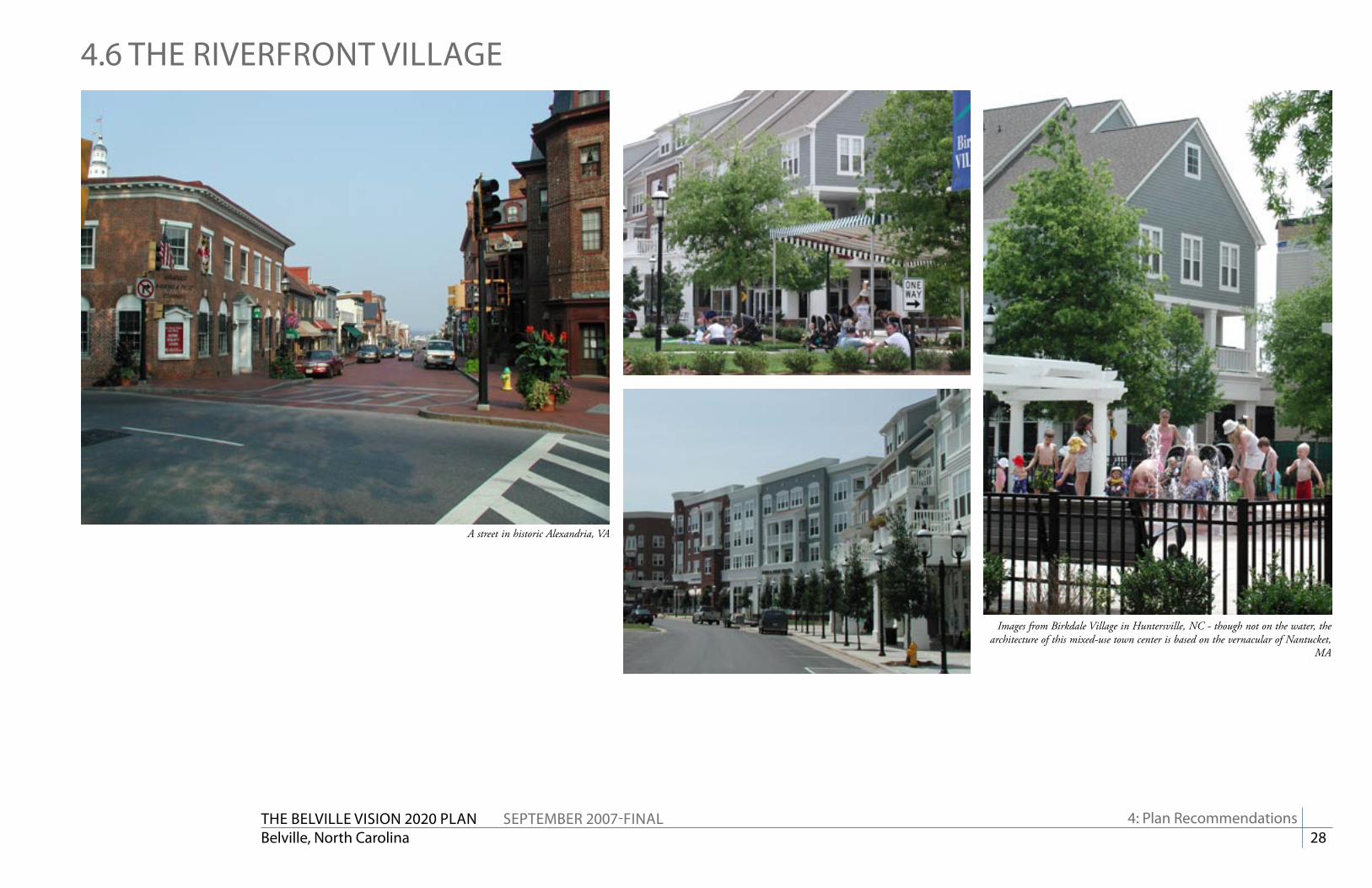
The Belville viSiON 2020 PlaN SePTemBer 2007-FiNalBelville, North Carolina 28
A street in historic Alexandria, VA
Images from Birkdale Village in Huntersville, NC - though not on the water, the architecture of this mixed-use town center is based on the vernacular of Nantucket,
MA
4.6 The riverFrONT villaGe
4: Plan recommendations
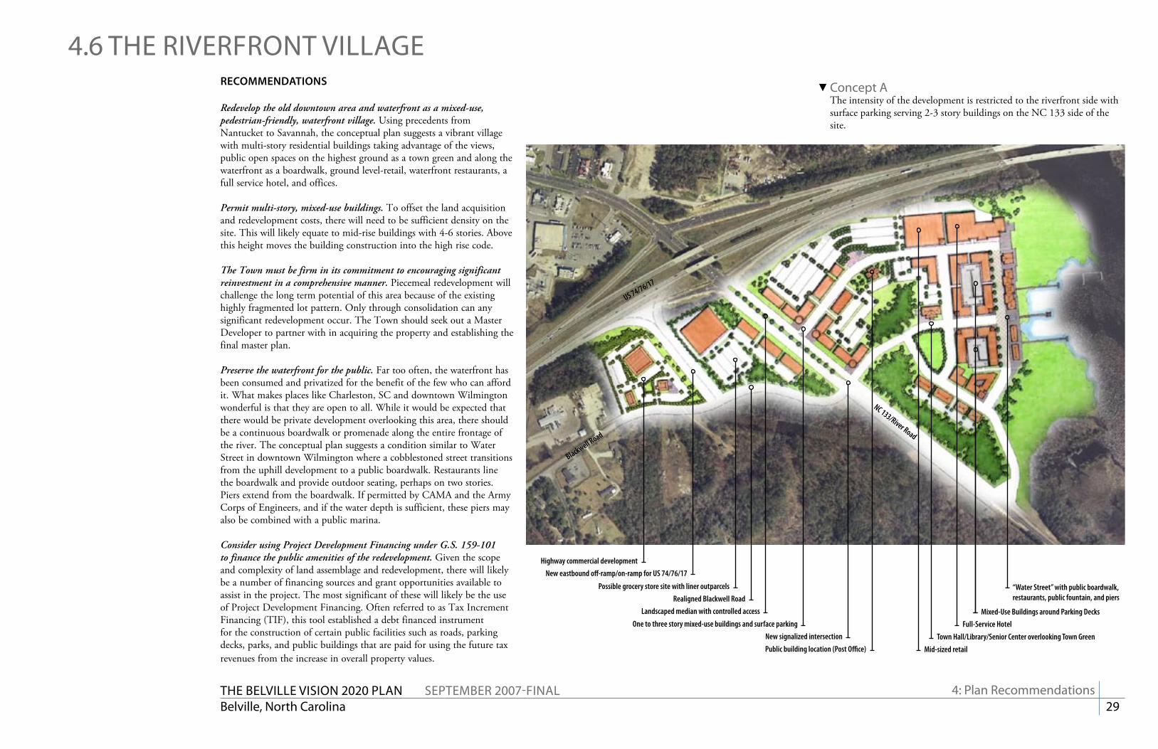
The Belville viSiON 2020 PlaN SePTemBer 2007-FiNalBelville, North Carolina 29
rEcOmmENDatiONS
Redevelop the old downtown area and waterfront as a mixed-use, pedestrian-friendly, waterfront village. Using precedents from Nantucket to Savannah, the conceptual plan suggests a vibrant village with multi-story residential buildings taking advantage of the views, public open spaces on the highest ground as a town green and along the waterfront as a boardwalk, ground level-retail, waterfront restaurants, a full service hotel, and offices.
Permit multi-story, mixed-use buildings. To offset the land acquisition and redevelopment costs, there will need to be sufficient density on the site. This will likely equate to mid-rise buildings with 4-6 stories. Above this height moves the building construction into the high rise code.
The Town must be firm in its commitment to encouraging significant reinvestment in a comprehensive manner. Piecemeal redevelopment will challenge the long term potential of this area because of the existing highly fragmented lot pattern. Only through consolidation can any significant redevelopment occur. The Town should seek out a Master Developer to partner with in acquiring the property and establishing the final master plan.
Preserve the waterfront for the public. Far too often, the waterfront has been consumed and privatized for the benefit of the few who can afford it. What makes places like Charleston, SC and downtown Wilmington wonderful is that they are open to all. While it would be expected that there would be private development overlooking this area, there should be a continuous boardwalk or promenade along the entire frontage of the river. The conceptual plan suggests a condition similar to Water Street in downtown Wilmington where a cobblestoned street transitions from the uphill development to a public boardwalk. Restaurants line the boardwalk and provide outdoor seating, perhaps on two stories. Piers extend from the boardwalk. If permitted by CAMA and the Army Corps of Engineers, and if the water depth is sufficient, these piers may also be combined with a public marina.
Consider using Project Development Financing under G.S. 159-101 to finance the public amenities of the redevelopment. Given the scope and complexity of land assemblage and redevelopment, there will likely be a number of financing sources and grant opportunities available to assist in the project. The most significant of these will likely be the use of Project Development Financing. Often referred to as Tax Increment Financing (TIF), this tool established a debt financed instrument for the construction of certain public facilities such as roads, parking decks, parks, and public buildings that are paid for using the future tax revenues from the increase in overall property values.
4.6 The riverFrONT villaGe
4: Plan recommendations
Concept aThe intensity of the development is restricted to the riverfront side with surface parking serving 2-3 story buildings on the NC 133 side of the site.
Highway commercial development
Possible grocery store site with liner outparcels
New eastbound off-ramp/on-ramp for US 74/76/17
Realigned Blackwell RoadLandscaped median with controlled access
One to three story mixed-use buildings and surface parkingNew signalized intersectionPublic building location (Post Office) Mid-sized retail
Town Hall/Library/Senior Center overlooking Town GreenFull-Service Hotel
Mixed-Use Buildings around Parking Decks
“Water Street” with public boardwalk, restaurants, public fountain, and piers
US 74/76/17
Blackwell Road
NC 133/River Road
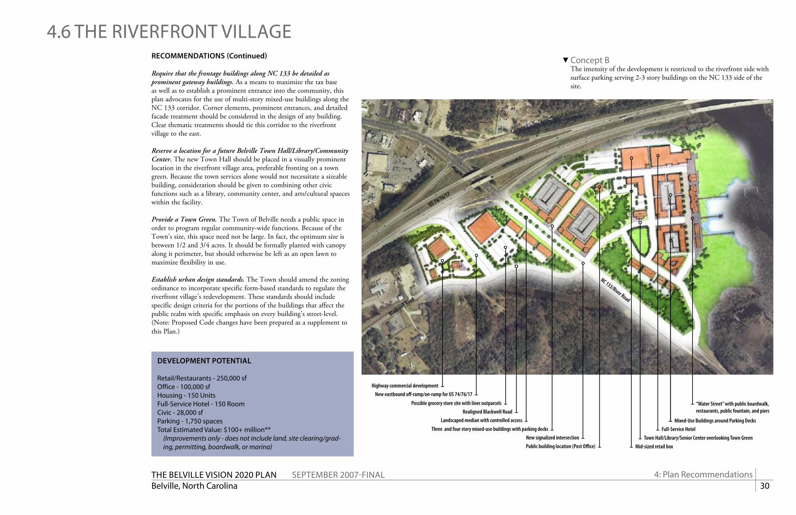
The Belville viSiON 2020 PlaN SePTemBer 2007-FiNalBelville, North Carolina 30
Concept BThe intensity of the development is restricted to the riverfront side with surface parking serving 2-3 story buildings on the NC 133 side of the site.
Highway commercial development
Possible grocery store site with liner outparcels
New eastbound off-ramp/on-ramp for US 74/76/17
Realigned Blackwell RoadLandscaped median with controlled access
Three and four story mixed-use buildings with parking decksNew signalized intersectionPublic building location (Post Office) Mid-sized retail box
Town Hall/Library/Senior Center overlooking Town GreenFull-Service Hotel
Mixed-Use Buildings around Parking Decks
“Water Street” with public boardwalk, restaurants, public fountain, and piers
US 74/76/17
Blackwell Road
NC 133/River Road
rEcOmmENDatiONS (continued)
Require that the frontage buildings along NC 133 be detailed as prominent gateway buildings. As a means to maximize the tax base as well as to establish a prominent entrance into the community, this plan advocates for the use of multi-story mixed-use buildings along the NC 133 corridor. Corner elements, prominent entrances, and detailed facade treatment should be considered in the design of any building. Clear thematic treatments should tie this corridor to the riverfront village to the east.
Reserve a location for a future Belville Town Hall/Library/Community Center. The new Town Hall should be placed in a visually prominent location in the riverfront village area, preferable fronting on a town green. Because the town services alone would not necessitate a sizeable building, consideration should be given to combining other civic functions such as a library, community center, and arts/cultural spaeces within the facility.
Provide a Town Green. The Town of Belville needs a public space in order to program regular community-wide functions. Because of the Town’s size, this space need not be large. In fact, the optimum size is between 1/2 and 3/4 acres. It should be formally planted with canopy along it perimeter, but should otherwise be left as an open lawn to maximize flexibility in use.
Establish urban design standards. The Town should amend the zoning ordinance to incorporate specific form-based standards to regulate the riverfront village’s redevelopment. These standards should include specific design criteria for the portions of the buildings that affect the public realm with specific emphasis on every building’s street-level. (Note: Proposed Code changes have been prepared as a supplement to this Plan.)
4.6 The riverFrONT villaGe
4: Plan recommendations
DEvELOPmENt POtENtiaL
retail/restaurants - 250,000 sfOffice - 100,000 sfhousing - 150 unitsFull-Service hotel - 150 roomCivic - 28,000 sfParking - 1,750 spacesTotal estimated value: $100+ million**
(Improvements only - does not include land, site clearing/grad-ing, permitting, boardwalk, or marina)

The Belville viSiON 2020 PlaN SePTemBer 2007-FiNalBelville, North Carolina 31
4.6 The riverFrONT villaGe
4: Plan recommendations
viEW LOOKiNG NOrth ON Nc 133/rivEr rOaD
The picture underscores the lack of identity the Town has along its primary gateway. The most distinguishing feature is the glow of the McDonald’s pole sign beyond the bridge (in Leland).
cONcEPtuaL imPrOvEmENtS aLONG Nc 133/rivEr rOaD
Adding lanes to accommodate traffic does not mean that the corridor must get uglier. With a planted median, wide sidewalks, and multi-story, mixed-use buildings this corridor can go from being a pass-through to a gateway for the community.
PrOPOSED Nc 133/rivEr rOaD StrEEt SEctiON
The proposed section includes 4 travel lanes, a wide landscaped median, street trees in a wide verge, and multi-use paths and sidewalks on each side.
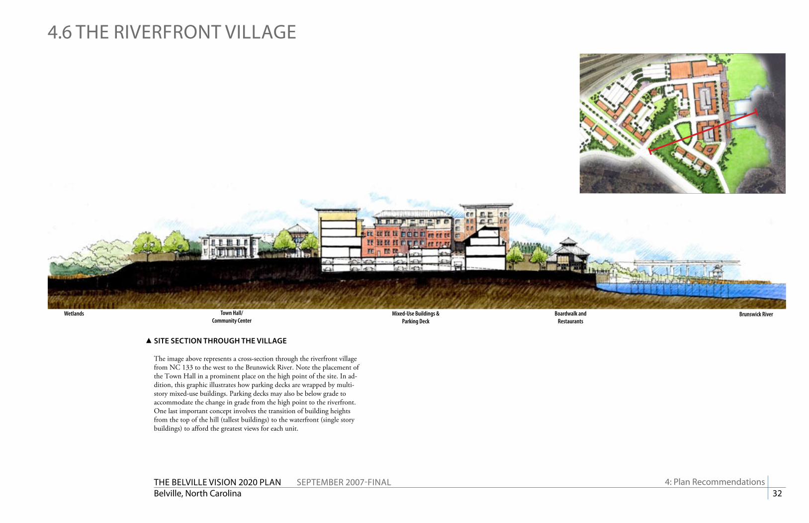
The Belville viSiON 2020 PlaN SePTemBer 2007-FiNalBelville, North Carolina 32
Brunswick RiverTown Hall/Community Center
Boardwalk and Restaurants
Wetlands Mixed-Use Buildings & Parking Deck
4.6 The riverFrONT villaGe
SitE SEctiON thrOuGh thE viLLaGE
The image above represents a cross-section through the riverfront village from NC 133 to the west to the Brunswick River. Note the placement of the Town Hall in a prominent place on the high point of the site. In ad-dition, this graphic illustrates how parking decks are wrapped by multi-story mixed-use buildings. Parking decks may also be below grade to accommodate the change in grade from the high point to the riverfront. One last important concept involves the transition of building heights from the top of the hill (tallest buildings) to the waterfront (single story buildings) to afford the greatest views for each unit.
4: Plan recommendations

The Belville viSiON 2020 PlaN SePTemBer 2007-FiNalBelville, North Carolina 33
Residential/Office
Residential/Office
Residential/Office
Residential/Office
Residential
Residential
Retail/Restaurant
Retail/Restaurant
4.6 The riverFrONT villaGe
SitE SEctiON thrOuGh thE viLLaGE - ENLarGED
This enlarged view of the previous graphic further illustrates the appropriate mix of uses within each building. Note that the ground level is reserved for active, pedestrian-friendly uses such as retail shops and restaurants. Both housing and office uses should generally be reserved for the upper stories of the core buildings. Buildings along the perimeter of the site may be one use (hotel, apartment building, office building), but should be designed in a manner that does not preclude street-level activity.
4: Plan recommendations
BirDSEyE PErSPEctivE OF thE rivErFrONt viLLaGE
This illustration shows the wide diversity of building types, styles, and heights that may constitute the Village area. Note the stepping of the buildings from the top of the hill to the riverfront.

The Belville viSiON 2020 PlaN SePTemBer 2007-FiNalBelville, North Carolina 34
a: appendix
aPPeNDixThe information contained in this appendix includes thoughts, plans, and recommendations for areas bordering the Town of Belville. The purpose of inclusion of such information in this plan is two-fold. First, it serves as a
guide for planning growth and development should the boundaries for the towns of Leland and Belville ever become rationalized as suggested in this report. And second, they define a network of streets and overall circulation
that benefits Belville residents. In adopting and advocating for this plan, the Town has a stronger point of discussion when discussing regional road
projects at the Metropolitan Planning Organization (MPO) level.

The Belville viSiON 2020 PlaN SePTemBer 2007-FiNalBelville, North Carolina 35
a: appendix
a.1 BlaCKWell rOaD area
US 17
BLacKWELL rOaD arEa traNSPOrtatiON imPrOvEmENtS
New street connections
US 17/74/76
Blackwell Road
Chappell Loop Road
New street connections
Blackwell Road/Ploof Road connector
Ploof Road
Ploof Road connection to Wal-Mart
rEcOmmENDatiONS
Improve overall connections in the Blackwell Road/Chappell Loop Road area. Due to the lack of development of the central area bordered by Chappell Loop Road and Blackwell Road, this general area has very poor connectivity. This issue is compounded by the lack of internal connectivity between those neighborhoods that use Chappell Loop Road for primary access but otherwise have only one entrance (or two at most). Unfortunately, subdivisions continue to be approved in this area without any requirement for additional connectivity or stub-out streets.
Therefore, it is imperative to establish a fine-grained collector street network every quarter mile in this area to promote circulation and mobility while limiting local demand on the arterial system. Most if not all of this system should be constructed as development/redevelopment occurs.
The largest obstacle to overcome in this area is the combined presence of extensive wetlands and large junked car lots. While care must be taken to be sensitive to development around these wetlands, the junked car lots should be aggressively cleared as soon as practical. Once cleared, land will be available for development, which will permit new street construction.
Photo of cement plant at the intersection of Chappell Loop Road and Ploof Road

The Belville viSiON 2020 PlaN SePTemBer 2007-FiNalBelville, North Carolina 36
a: appendix
a.1 BlaCKWell rOaD area
Improve aesthetics on Ploof Road with a new streetscape
Ploof Road/Blackwell Road connectorNew commercial/light industrial development
Wetlands conservation areaNew north-south connection
Wetlands conservation area
rEcOmmENDatiONS (continued)
Continue to permit industrial development but with improved aesthetics. Given the investment in light and heavy industrial uses in this area, they are not likely to go away anytime soon. As such, there are some things that can be done to mitigate their visual and physical presence. First, the Town (whichever has jurisdiction) should enforce perimeter landscaping standards. To the greatest extent possible this should be actively encouraged. The Town should set aside some funding to provide grants to these properties (within the Town limits) to improve their frontages. In addition, the Town should seek funding from the state (e.g. NC DOT, Economic Development) to improve the overall streetscape for the increasingly busy and important Ploof Road, adding sidewalks, curbs, street trees, and widened pavement.
Permit low density residential development, substantial wetlands mitigation efforts, or both. Once the junked car lots are cleaned, this area would be well suited for residential development. Residential development would more easily insert into the existing environmental constraints and would, theoretically have a smaller environmental footprint.
In lieu of “low impact” development techniques, this area should be considered for a secondary wetlands remediation zone, similar to the site on the north side of Blackwell Road. (See page 25 for more information)
Remove and/or redevelop the junked car lots along Blackwell Road. These junkyards are significant eyesores to the community. As is usually the case, these junkyards are likely to be major polluters of the area’s groundwater. With the high water table, presence of hydric soils, and nearby substantial wetlands, environmental protection must take precedent over these degraded sites. Though within Leland’s annexation boundary the area is presently unincorporated. Nonetheless, both communities and Brunswick County should work together to close these sites. The entire block surrounded by Blackwell Road and Chappell Loop Road is considered a site for possible use of wetlands mitigation bank funding. Such funding, when combined with other potential sources, could assist both towns in cleaning up this area.

The Belville viSiON 2020 PlaN SePTemBer 2007-FiNalBelville, North Carolina 37
a.2 NC 133 SOuTh
a: appendix
ExiStiNG cONDitiONS
The area around the Belville Elementary School includes the largest tract within Belville’s annexation boundary. The tract, at approximately 166 acres, includes a significant amount of wetlands. It completely surrounds the Belville Elementary School on three sides with the other boundary being NC 133/River Road. A subdivision plan had been proposed and tentatively approved by Brunswick County at the time of the charrette.
Because the school can only be accessed from NC 133/River Road, there are substantial delays in both the morning and afternoon with school traffic. The high number of carpool and parent drop-offs and the commensurately low number of buses have created a very difficult traffic circulation problem. Combined with the morning rush hour traffic (noted in the Section 4.2 - Transportation), this is considered to be the highest priority issue in the community.
This area also backs up to the Chappell Loop Road area. There is an unopened right-of-way, Napoleon Drive, to the west that serves a few small properties.
Directly across from the school is the 22 acre Brunswick River Park, a county-owned facility that includes fishing areas, a small boat dock, 2 playgrounds, 3 picnic areas and restrooms. To the north and south of the park are smaller tracts that have either water view and/or access.
NC 133/River Road
Belville Elementary School
Brunswick River Park
SuBDiviSiON aNaLySiS
The Hawkswater subdivision plan as approved by Brunswick County at the time of the charrette had a disconnected street system, long blocks that discourage walking, and only one park area that is to the rear of homes. In addition there are no connections to the school to permit children to walk or ride their bikes.
ParKS & PLayGrOuNDS
WEtLaNDS & uNuSaBLE arEaS
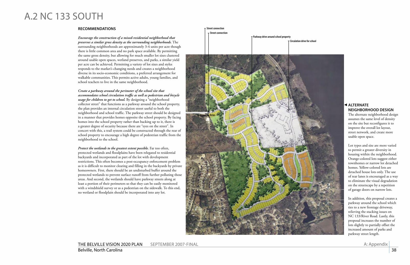
The Belville viSiON 2020 PlaN SePTemBer 2007-FiNalBelville, North Carolina 38
a: appendix
aLtErNatE NEiGhBOrhOOD DESiGNThe alternate neighborhood design assumes the same level of density on the site but reconfigures it to improve the overall lot layout, street network, and create more usable open space.
Lot types and size are more varied to permit a greater diversity in housing within the neighborhood. Orange-colored lots suggest either townhomes or narrow lot detached homes. Yellow-colored lots are detached house lots only. The use of rear lanes is encouraged as a way to eliminate the visual degradation on the streetscape by a repetition of garage doors on narrow lots.
In addition, this proposal creates a parkway around the school which ties to a new frontage driveway, relieving the stacking issues on NC 133/River Road. Lastly, this proposal increases the number of lots slightly to partially offset the increased amount of parks and parkway street length.
To Napolean Drive
Circulation drive for school
Street connection
Park
Park
Park
Park
Street connection
Parkway drive around school property
a.2 NC 133 SOuThrEcOmmENDatiONS
Encourage the construction of a mixed-residential neighborhood that preserves a similar gross density as the surrounding neighborhoods. The surrounding neighborhoods are approximately 3-4 units per acre though there is little common area and no park space available. By permitting the same gross density, but allowing for much smaller lot sizes clustered around usable open spaces, wetland preserves, and parks, a similar yield per acre can be achieved. Permitting a variety of lot sizes and styles responds to the market’s changing needs and creates a neighborhood diverse in its socio-economic conditions, a preferred arrangement for walkable communities. This permits active adults, young families, and school teachers to live in the same neighborhood.
Create a parkway around the perimeter of the school site that accommodates school circulation traffic as well as pedestrian and bicycle usage for children to get to school. By designing a “neighborhood collector street” that functions as a parkway around the school property, the plan provides an internal circulation street useful to both the neighborhood and school traffic. The parkway street should be designed in a manner that provides homes opposite the school property. By facing homes into the school property rather than backing up to it, there is a greater degree of security because there are “eyes on the street”. In concert with this, a trail system could be constructed through the rear of school property to encourage a high degree of pedestrian traffic from the neighborhood to the school.
Protect the wetlands to the greatest extent possible. Far too often, protected wetlands and floodplains have been relegated to residential backyards and incorporated as part of the lot with development restrictions. This often becomes a post-occupancy enforcement problem as it is difficult to monitor clearing and filling in the backyards by private homeowners. First, there should be an undisturbed buffer around the protected wetlands to prevent surface runoff from further polluting those areas. And second, the wetlands should have parkway streets along at least a portion of their perimeters so that they can be easily monitored with a windshield survey or as a pedestrian on the sidewalk. To this end, no wetland or floodplain should be incorporated into any lot.
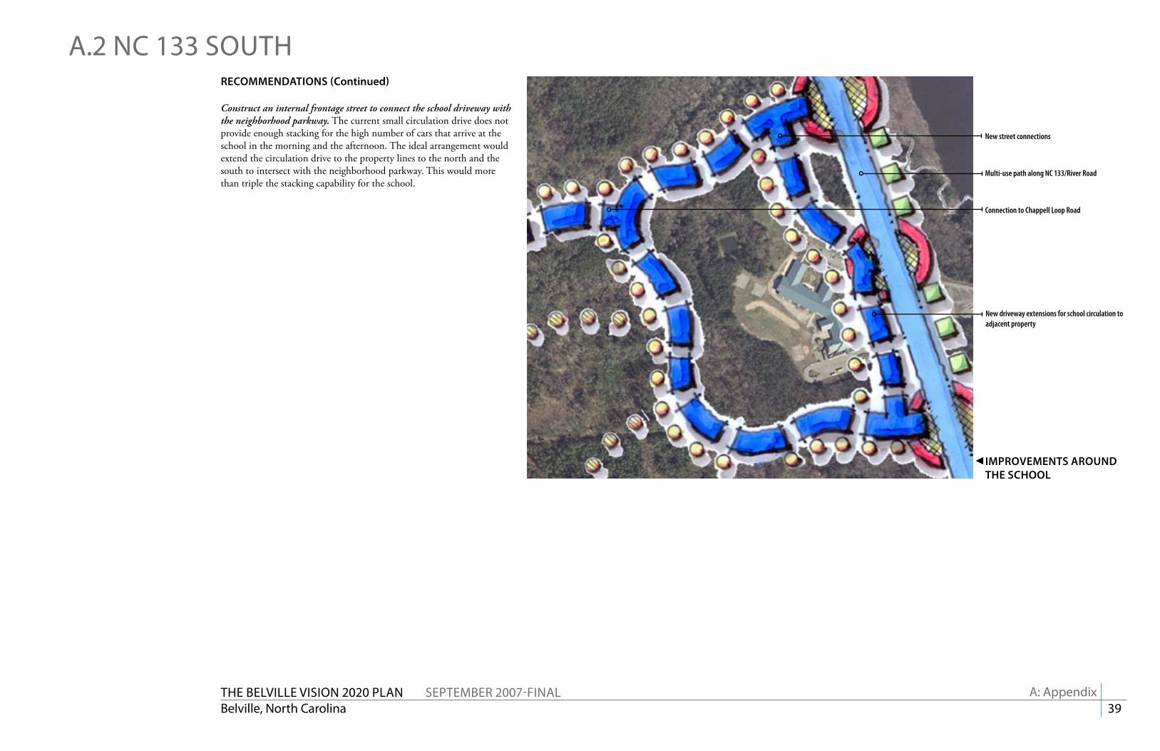
The Belville viSiON 2020 PlaN SePTemBer 2007-FiNalBelville, North Carolina 39
a: appendix
imPrOvEmENtS arOuND thE SchOOL
New street connections
Multi-use path along NC 133/River Road
New driveway extensions for school circulation to adjacent property
Connection to Chappell Loop Road
a.2 NC 133 SOuThrEcOmmENDatiONS (continued)
Construct an internal frontage street to connect the school driveway with the neighborhood parkway. The current small circulation drive does not provide enough stacking for the high number of cars that arrive at the school in the morning and the afternoon. The ideal arrangement would extend the circulation drive to the property lines to the north and the south to intersect with the neighborhood parkway. This would more than triple the stacking capability for the school.