the biology of the hudson-raritan estuarynsgd.gso.uri.edu/njmsc/njmsce97002/njmsce97002_full.pdf ·...
TRANSCRIPT

THE BIOLOGY OF THE HUDSON-RARITAN ESTUARY:A MARINE EDUCATION PROGRAM
Produced by the Staff of theEducation Program
at theNew Jersey Marine Sciences Consortium
Building 22, Fort HancockSandy Hook, New Jersey 07732
Funded by theGeraldine R. Dodge Foundation
and the
New Jersey Sea Grant College Program
N,J,SeaGrantProgram
PREFACE AND ACKNOWLEDGEMENTS
The Hudson-Raritan Estuary encompasses the waters of New York Harbor and the tidallyinfluenced portions of all of the rivers and streams that empty into it. The Estuary is anextraordinary resource and a biologically rich ecosystem. However, as the site of extensivehuman activity, it has experienced significant ecological stress. Presently, the Estuary isthreatened by increasing pollution and overuse of its resources.
Although much information has been made available in recent years about human use of themarine resources of the Hudson-Raritan Estuary, it is scattered among technical and semi-technical reports, scientific journals, newsletter and magazine articles and other documentsproduced by federal and state agencies, private environmental organizations, and academicprograms. Educational materials related to the Estuary are typically geared towards users suchas commercial and recreational fishers, environmentalists, college students, or the generalpublic.
Educational materials related to the Estuary for teachers and students are lacking. To addressthis need, the New Jersey Marine Sciences Consortium undertook a project funded by theGeraldine R. Dodge Foundation and the New Jersey Sea Grant College Program to develop aninterdisciplinary marine education program on the biology of the Hudson-Raritan Estuary. Itis the goal of this project to enable teachers to introduce middle and high school students to theimportant resources of the Estuary, allowing them to understand why the United StatesEnvironmental Protection Agency has designated the Hudson-Raritan Estuary one of nationalsignificance.
The guide was conceived as a package of instructional tools. Each chapter is followed byrelated student activities. These activities are summarized (Activities and Materials Overview)for instructors on a per chapter basis. In addition, the kit includes a glossary, species profilesfor the fish, birds and invertebrates of the area and a selection of exemplary materials fromother sources.
The production and compilation of the following materials would not have been possiblewithout the ongoing efforts of the staff of the Education Program at the New Jersey MarineSciences Consortium, including Claire Antonucci Manager of K-12 Education Programs,Linda Cohen Education Specialist, Amanda Maxemchuk-Daly Program Associate, MichaelDanko Manager of Marine Operations, Rosemary Higgins Program Associate, Liesl HotalingEducation Specialist, Kerry Lynch Marine Specialist, Thomas Lynch Station Biologist, JohnA. Tiedemann Director of Education and Special Projects, and Karen Yerkovic ProgramAssociate. The staff of the Education Program also wishes to acknowledge the contributionsof Dr. Donald Dorfman, Professor of Biology at Monmouth University.
This publication is a result of work funded by the Geraldine R. Dodge Foundation and the NOAA Office of Sea Grant ans ExtramuralPrograms, U.S. Department of Commerce, under grant no. NA36-RG0505 (Project No. E/T 9601). The U.S. Government is authorized toproduce and distribute reprints for governmental purpose notwithstanding any copyright notation that may appear hereon NJSG-97-354.

I.
II.
III.
IV.
V.
THE BIOLOGY OF THE HUDSON-RARITAN ESTUARY
CONTENTS
INTRODUCTION TO THE HUDSON-RARITAN ESTUARY
GEOGRAPHY
Activities:- Getting Your Bearings- How High is High? How Deep is Deep?- Where Does the Water Go?- Mapping the Ocean Floor
OCEANOGRAPHIC FEATURES AND PROPERTIES
Activities:- Sediments of the Hudson-Raritan Estuary- Reading a Tide Chart- Ocean Currents- Turbidity- Salinity-PH- Oxygen in the Water
PLANTS AND ANIMALS
Activities:- Nearshore Communities- Classification- Phytoplankton- Form and Function- Salt Tolerance
ECOSYSTEMS DYNAMICS
Activities:- Food Web- The Competitive Edge- Biomagnification- The Habit of Habitat

VI. WATER QUALITY ISSUES
Activities:- Variations in Water Quality- Point and Non-Point Pollution Involvement- Nutrients - Too Much of a Good Thing- Oil Spill Clean Up- Plastic and Fish
VII. MANAGEMENT OF THE ESTUARY
Activities:- Use and Misuse: The Consequences- Recycle and Reuse- The Great Debate
VIII. SPECIES PROFILES
Informative Guides to:- Fish- Invertebrates- Birds
IIX. GLOSSARY
AN INTRODUCTION TO THE HUDSON-RARITAN ESTUARY
The Hudson-Raritan Estuary, a system of interconnected waterways, is the most prominentnatural feature of northern New Jersey. The watershed of the Hudson-Raritan Estuaryincludes Upper and Lower New York Harbor, the Hudson River, the East River, Newark Bay,the lower Hackensack River, the lower Passaic River, the Kill Van Kull, the Arthur Kill,Raritan Bay, the Raritan River, Sandy Hook Bay, and the Shrewsbury and Navesink Rivers.
The Hudson-Raritan Estuary is one of the greatest natural harbors in the world and one of thebusiest ports in the nation, playing a crucial role in regional economy. During the past 100years, the Estuary has been subject to serious pollution and other modifications resulting indeleterious changes to the environment and biota.
Wide-scale shoreline development, discharges of industrial wastes and sewage and destructionof tidal marshes have had a serious effect on the aquatic resources of the area. This longhistory of environmental degradation suggests that there is little left in the Estuary.
Despite this, the area continues to provide important habitat for diverse marine and estuarinespecies. Among these species are striped bass, bluefish, weakfish, white perch, winterflounder, and summer flounder. Other marine resources of importance include blue clawcrabs, lobsters, hard clams, soft clams, and fish such as shad, herring and tomcod. All utilizeportions of the Estuary for nursery or feeding grounds.
The land boundaries of the Hudson-Raritan Estuary region are the meeting place of threegeologic formations; the rock-based New England Terrain represented by Manhattan, Bronx,Westchester, and Northern New Jersey, the glacial Till/Oak Pinelands represented by LongIsland including Brooklyn and Staten Island and the coastal plain/Pine Barrens vegetationrepresented by southern New Jersey. The shoreline of the area is categorized by two distinctconfigurations; rocky shores to the north and sand and gravel beaches to the south. Theregion outside of New York Harbor is classified as a coastal plain.

GEOGRAPHY OF THE HUDSON - RARITAN ESTUARY
USING TOPOGRAPHIC MAPS AND NAUTICAL CHARTS
NAUTICAL CHARTS
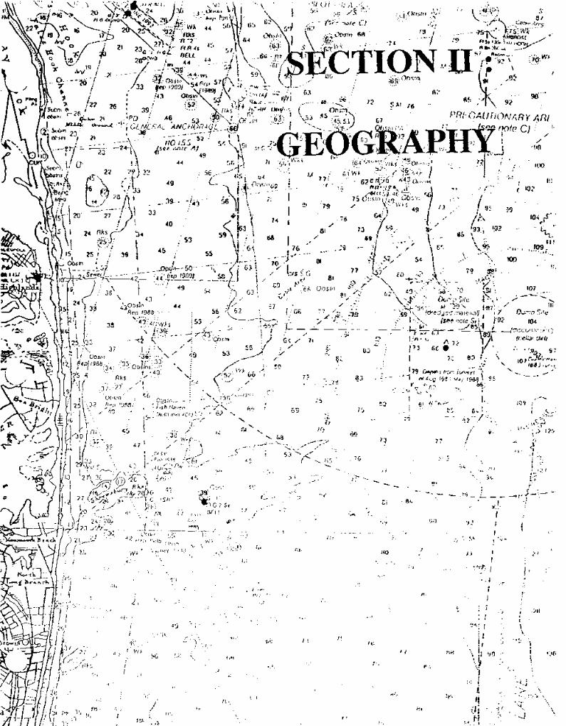
A nautical chart can be viewed as a map of the marine environment. They are designed toprovide information needed by mariners to make proper piloting decisions. The general shapeand nature of the sea floor are important to mariners and a good chart will have a high densityof bottom information. They also include information about tides, currents, depth, navigationchannels, obstructions and other hazards to navigation, the location and description of localaids to navigation, and other information of interest. Most nautical charts are of the Mercatortype, meaning that they are a graphic representation on a flat, two dimensional surface of anavigable portion of the surface of the earth on which latitude and longitude lines are at rightangles to one another. Distances are measured on charts either from printed scales or frombordering meridians and are scaled in minutes of latitude or nautical miles.
Nautical charts are also extremely useful for studying the features of waterways and therelation of waterways to adjacent land areas. In addition to portraying the physicalcharacteristics of a water body, nautical charts portray land areas in detail including shorelineconfiguration, topographic landmarks, harbor facilities and prominent natural andmanufactured features of interest. Charts are commonly termed large-scale or small-scale. Achart covering a relatively small area is called a large-scale chart. In other words, a certainsmall expanse on the earth is represented by a relatively large distance on a large-scale chart.A chart requiring less detail and covering a relatively large area, such as an ocean chart,would have the same expanse represented by a comparatively small distance on the chart and,thus, this chart would be termed a small-scale chart.
Charts of the United States waters are prepared and published by the National Oceanic Service(NOS) of the National Oceanic and Atmospheric Administration (NOAA). The scale of achart is represented by a ratio of a given distance on the chart to the actual distance itrepresents on Earth. Not unlike topographic maps, a scale of 1:2OO,OOO on a nautical chartindicates that 1 inch on the chart represents 200,000 inches, or about 2.74 nautical miles onearth. One nautical mile equals 6,080.2 ft.
CHART CATEGORIES
Conventional flat nautical charts are published in the following categories:
1. Sailing charts- Utilizing the smallest scale (under 1:600,000), they cover long stretches ofcoastline and are used for plotting a course in offshore waters between distant ports and forapproaching the coast from open ocean waters. The shoreline and topography are generalized
i
i,t.
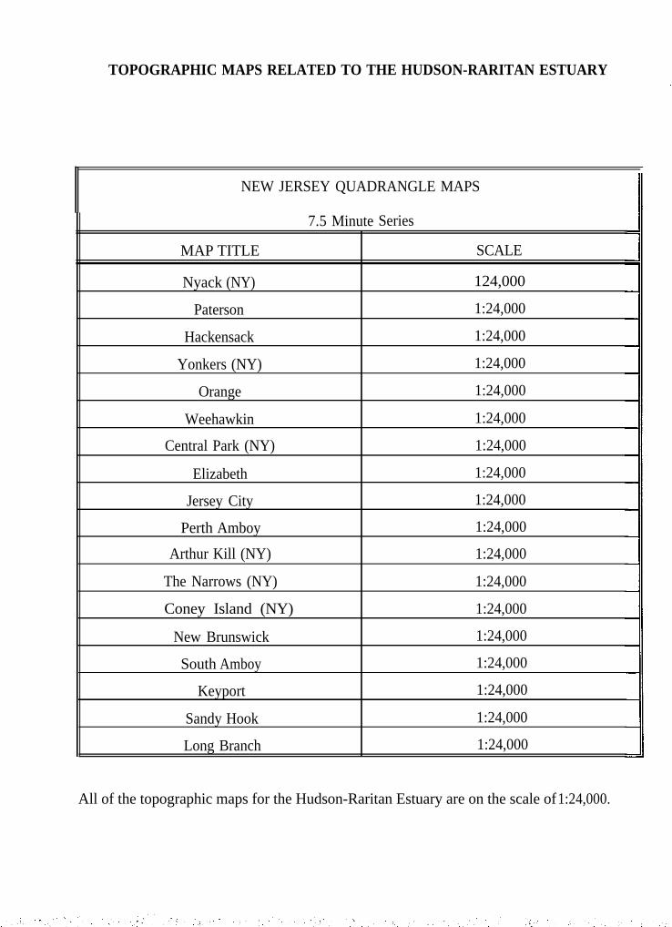
TOPOGRAPHIC MAPS RELATED TO THE HUDSON-RARITAN ESTUARY
NEW JERSEY QUADRANGLE MAPS
7.5 Minute Series
MAP TITLE SCALE
Nyack (NY) 124,000
Paterson 1:24,000
Hackensack 1:24,000
Yonkers (NY) 1:24,000
Orange 1:24,000
Weehawkin 1:24,000
Central Park (NY) 1:24,000
Elizabeth 1:24,000
Jersey City 1:24,000
Perth Amboy 1:24,000
Arthur Kill (NY) 1:24,000
The Narrows (NY) 1:24,000
Coney Island (NY) 1:24,000
New Brunswick 1:24,000
South Amboy 1:24,000
Keyport 1:24,000
Sandy Hook 1:24,000
Long Branch 1:24,000
All of the topographic maps for the Hudson-Raritan Estuary are on the scale of 1:24,000.

and only offshore soundings, principal navigational aids, and landmarks visible at considerabledistances are shown.
2. General charts- These charts use scales of 1:150,000 to 1:160,000 and are used fornavigation well offshore with vessel position fixed by landmarks, characteristic soundings, andnavigational aids such as lights and buoys.
3. Coast charts- Coast charts are large scale charts with scales of 1:50,000 to 1500,000.They are used for nearshore coastwise navigation, entering and leaving bays and harbors ofconsiderable size, and navigating certain inland waterways.
4. Harbor charts- Harbor charts are the most detailed with scales from 1:5,000 to 1:50,000and may include larger scale inserts. They are intended for navigation and anchorage inharbors or smaller waterways. They contain detailed land features as well as navigationalinformation.
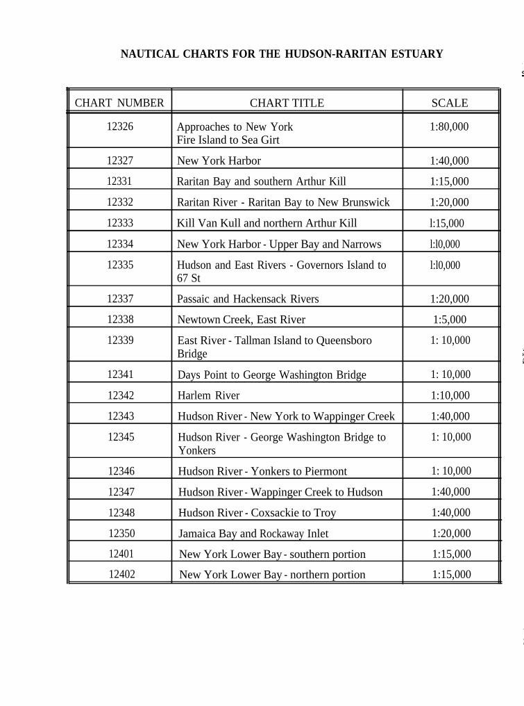
NAUTICAL CHARTS FOR THE HUDSON-RARITAN ESTUARY
CHART NUMBER CHART TITLE SCALE
12326 Approaches to New York 1:80,000Fire Island to Sea Girt
12327
12331
12332
12333
12334
12335
New York Harbor
Raritan Bay and southern Arthur Kill
Raritan River - Raritan Bay to New Brunswick
Kill Van Kull and northern Arthur Kill
New York Harbor - Upper Bay and Narrows
Hudson and East Rivers - Governors Island to67 St
1:40,000
1:15,000
1:20,000
l:15,000
l:l0,000
l:l0,000
12337
12338
12339
Passaic and Hackensack Rivers
Newtown Creek, East River
East River - Tallman Island to QueensboroBridge
Days Point to George Washington Bridge
Harlem River
Hudson River - New York to Wappinger Creek
Hudson River - George Washington Bridge toYonkers
1:20,000
1:5,000
1: 10,000
12341
12342
12343
12345
1: 10,000
1:10,000
1:40,000
1: 10,000
12346 Hudson River - Yonkers to Piermont 1: 10,000
12347 Hudson River - Wappinger Creek to Hudson 1:40,000
12348 Hudson River - Coxsackie to Troy 1:40,000
12350 Jamaica Bay and Rockaway Inlet 1:20,000
12401 New York Lower Bay - southern portion 1:15,000
12402 New York Lower Bay - northern portion 1:15,000
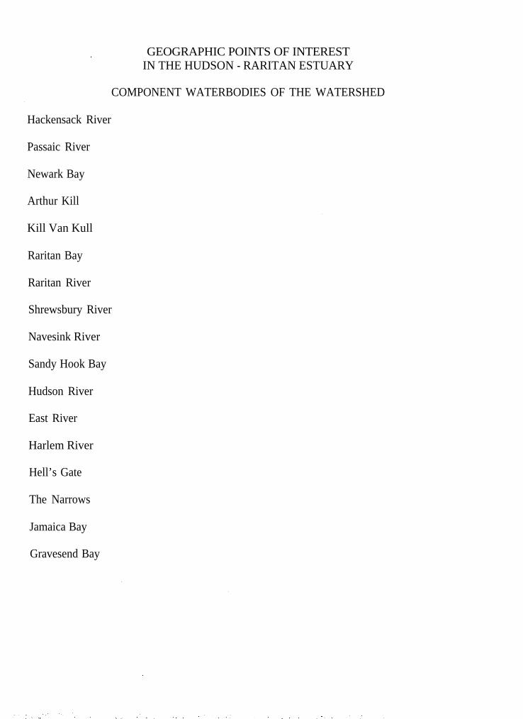
GEOGRAPHIC POINTS OF INTERESTIN THE HUDSON - RARITAN ESTUARY
COMPONENT WATERBODIES OF THE WATERSHED
Hackensack River
Passaic River
Newark Bay
Arthur Kill
Kill Van Kull
Raritan Bay
Raritan River
Shrewsbury River
Navesink River
Sandy Hook Bay
Hudson River
East River
Harlem River
Hell’s Gate
The Narrows
Jamaica Bay
Gravesend Bay
GEOGRAPHIC POINTS OF INTERESTIN THE HUDSON - RARITAN ESTUARY
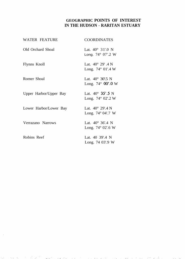
WATER FEATURE COORDINATES
Old Orchard Shoal Lat. 40° 31'.0 NLong. 74° 07'.2 W
Flynns Knoll Lat. 40° 29' .4 NLong. 74° 01'.4 W
Romer Shoal
Upper Harbor/Upper Bay
Lat. 40° 30'.5 NLong. 74° ` W
Lat. 40° 35’S NLong. 74° 02'.2 W
Lower Harbor/Lower Bay
Verrazano Narrows
Lat. 40° 29'.4 NLong. 74° 04'.7 W
Lat. 40° 36'.4 NLong. 74° 02'.6 W
` Robins Reef Lat. 40 39'.4 NLong. 74 03'.9 W

LAND FEATURE
Sandy Hook
Rockaway Point
Staten Island
Crookes Point
Ward Point
Shooters Island
Governors Island
Hoffman Island
Swinburne Island
Port Newark
GEOGRAPHIC POINTS OF INTERESTIN THE HUDSON - RARITAN ESTUARY
COORDINATES
Lat. 40° 27'.0 NLong. 73° 59'.4 W
Lat. 40° 33'.5 NLong. 73° 55'.0 W
Lat. 40° 35'.0 NLong. 74° 10'.0 W
Lat. 40° 31'.73 NLong. 74° 08'.23 W
Lat. 40° 29'.8 NLong. 74° 14'.9 W
Lat. 40° 38'.6 NLong. 74° 09'.6 W
Lat. 40° 41'.3 NLong. 74° 0l'.0 W
Lat. 40° 34'.7 NLong. 74° 03'.13 W
Lat. 40° 33'.93 NLong. 74° 03'.02 W
Lat. 40° 41'.1 NLong. 74° 07'.9 W
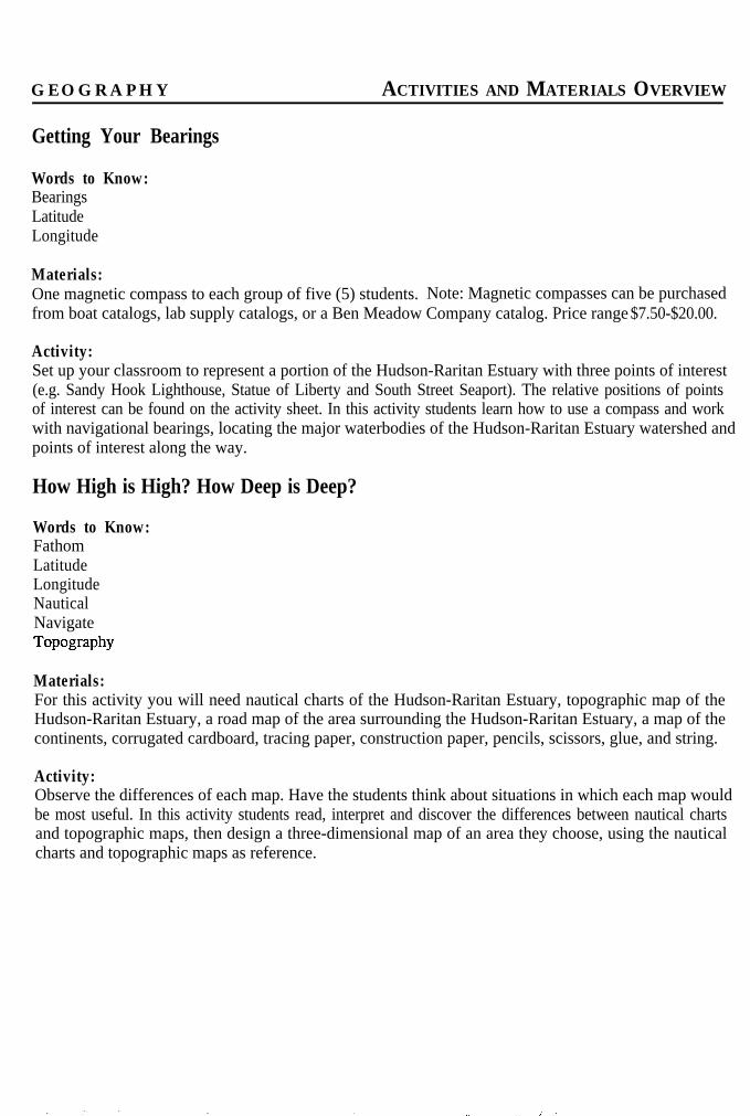
G E O G R A P H Y ACTIVITIES AND MATERIALS OVERVIEW
Getting Your Bearings
Words to Know:BearingsLatitudeLongitude
Materials:One magnetic compass to each group of five (5) students. Note: Magnetic compasses can be purchasedfrom boat catalogs, lab supply catalogs, or a Ben Meadow Company catalog. Price range $7.50-$20.00.
Activity:Set up your classroom to represent a portion of the Hudson-Raritan Estuary with three points of interest(e.g. Sandy Hook Lighthouse, Statue of Liberty and South Street Seaport). The relative positions of pointsof interest can be found on the activity sheet. In this activity students learn how to use a compass and workwith navigational bearings, locating the major waterbodies of the Hudson-Raritan Estuary watershed andpoints of interest along the way.
How High is High? How Deep is Deep?
Words to Know:FathomLatitudeLongitudeNauticalNavigateTopography
Materials:For this activity you will need nautical charts of the Hudson-Raritan Estuary, topographic map of theHudson-Raritan Estuary, a road map of the area surrounding the Hudson-Raritan Estuary, a map of thecontinents, corrugated cardboard, tracing paper, construction paper, pencils, scissors, glue, and string.
Activity:Observe the differences of each map. Have the students think about situations in which each map wouldbe most useful. In this activity students read, interpret and discover the differences between nautical chartsand topographic maps, then design a three-dimensional map of an area they choose, using the nauticalcharts and topographic maps as reference.

Where Does the Water Go?
Words to Know:AquiferBasinDrainage BasinHydrologyHydrologic CycleWatershed
Materials:For this activity you will need a shallow pan, aluminum foil, the three-dimensional map created for the“How High is High? How Deep is Deep?” activity or a few paper cups, a watering can, topographicalmaps and nautical charts for the Hudson-Raritan Estuary, and drink mix or other powdery substance.
Activity:You can use the same groups of students as for the other activities or choose new ones. In this activitystudents will learn about the hydrologic cycle and be able to define it, construct a model of a watershed,and understand how the watershed affects marine pollution.
Mapping the Ocean Floor
Words to Know:Contour mapSonarTopography
Materials:For this activity you will need large, watertight Styrofoam coolers, dark plastic garbage bags, waterproofmarkers, water to fill the coolers, dark food coloring (blue or green), bricks, rocks, sand or gravel, twostrings, two metal nuts or washers, two meter sticks, data sheets for each pair of students and a bucket orpan to bail out the coolers.
Activity:In this activity students use a cooler to build a simulated underwater terrain and take depth readings toaccomplish mapping by using the method of lowering weighted ropes into the water to measure the depths.The figures are placed on the corresponding coordinates on the worksheet.

G E O G R A P H Y STUDENT ACTIVITY
Getting Your Bearings
Objectives: 1) You will learn how to use a compass and work with navigational bearings.2) You will locate geographic points of interest along the Hudson-Raritan Estuary.
Background: When people first started traveling on the ocean, they would calculate their approximatelocation using a magnetic compass to determine direction. If a navigator wanted to travel northwest for100 miles and then directly west for 200 miles to reach his destination and his ship only went 10 mph, hewould travel northwest for 10 hours then turn to travel directly west. Twenty hours later he should reachhis destination, making his total trip 30 hours long. This method was not highly accurate. It does notconsider changes in speed and location due to wind, ocean currents or tides. Today we use advancedtechnology that can tell you your exact longitude and latitude location.
Words to Know:BearingsLatitudeLongitude
Materials:Magnetic compasses with moveable bearings(Magnetic compasses can be purchased from boatcatalogs or lab supply catalogs. Price range $7.50-$20.00)Nautical charts of the Hudson-Raritan EstuaryTopographic maps of the Hudson-Raritan EstuaryA road map of the surrounding area
Activity One:1) Using maps and nautical charts set up yourclassroom to represent a portion of the Hudson-Raritan Estuary including three points of interest(eg. Sandy Hook Lighthouse, Statue of Liberty andSouth Street Seaport).2) Set the bearings on your compasses. Let theneedle on the compass find north, then set thedrawn arrow on the plate of the compass over theneedle. This establishes magnetic north. Next, setthe bearings to 200 degrees. After moving thedial so that 200 degrees is on the line that says“read bearing here”, move the compass until theneedle and the arrow line up again. Then positionyourself to face in the direction of the arrow thatsays “read bearing here.” You are now bearing200 degrees. Move five even paces bearing 200degrees. Keep an even pace. Everyone shouldattempt to standardize their pace.
3) Start at one point in the estuary you have set up,and figure out your bearings and distance (paces) asyou go from one point to another.4) Divide into small groups. Each group shouldset up a series of three bearings with distances(paces) which represent actual locations in theEstuary according to their relative position anddistance from each other. Each group will thengive its directions to another group to follow to testtheir accuracy. At the end of the activity, acomplete set of Hudson-Raritan Estuary courseswill be accumulated.
Activity Two:1) Charts included in the text of this section givethe location of various points of interest within ourEstuary. Use these charts to locate the approximateposition of your three points of interest fromActivity One.2) As a group, brainstorm to determine theimportance of each point of interest listed.
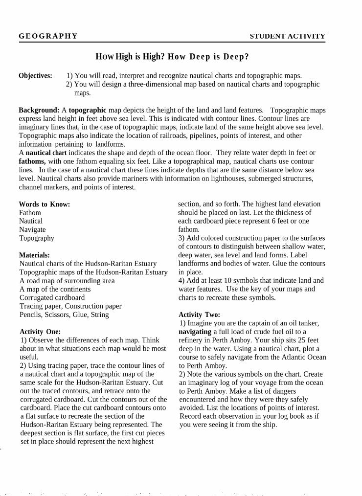
G E O G R A P H Y STUDENT ACTIVITY
HOW High is High? How Deep is Deep?
Objectives: 1) You will read, interpret and recognize nautical charts and topographic maps.2) You will design a three-dimensional map based on nautical charts and topographic
maps.
Background: A topographic map depicts the height of the land and land features. Topographic mapsexpress land height in feet above sea level. This is indicated with contour lines. Contour lines areimaginary lines that, in the case of topographic maps, indicate land of the same height above sea level.Topographic maps also indicate the location of railroads, pipelines, points of interest, and otherinformation pertaining to landforms.A nautical chart indicates the shape and depth of the ocean floor. They relate water depth in feet orfathoms, with one fathom equaling six feet. Like a topographical map, nautical charts use contourlines. In the case of a nautical chart these lines indicate depths that are the same distance below sealevel. Nautical charts also provide mariners with information on lighthouses, submerged structures,channel markers, and points of interest.
Words to Know: section, and so forth. The highest land elevationFathom should be placed on last. Let the thickness ofNautical each cardboard piece represent 6 feet or oneNavigate fathom.Topography
Materials:Nautical charts of the Hudson-Raritan EstuaryTopographic maps of the Hudson-Raritan EstuaryA road map of surrounding areaA map of the continentsCorrugated cardboardTracing paper, Construction paperPencils, Scissors, Glue, String
Activity One:1) Observe the differences of each map. Thinkabout in what situations each map would be mostuseful.2) Using tracing paper, trace the contour lines ofa nautical chart and a topographic map of thesame scale for the Hudson-Raritan Estuary. Cutout the traced contours, and retrace onto thecorrugated cardboard. Cut the contours out of thecardboard. Place the cut cardboard contours ontoa flat surface to recreate the section of theHudson-Raritan Estuary being represented. Thedeepest section is flat surface, the first cut piecesset in place should represent the next highest
3) Add colored construction paper to the surfacesof contours to distinguish between shallow water,deep water, sea level and land forms. Labellandforms and bodies of water. Glue the contoursin place.4) Add at least 10 symbols that indicate land andwater features. Use the key of your maps andcharts to recreate these symbols.
Activity Two:1) Imagine you are the captain of an oil tanker,navigating a full load of crude fuel oil to arefinery in Perth Amboy. Your ship sits 25 feetdeep in the water. Using a nautical chart, plot acourse to safely navigate from the Atlantic Oceanto Perth Amboy.2) Note the various symbols on the chart. Createan imaginary log of your voyage from the oceanto Perth Amboy. Make a list of dangersencountered and how they were they safelyavoided. List the locations of points of interest.Record each observation in your log book as ifyou were seeing it from the ship.
Discussion:1. Discuss the difference between nautical charts,topographic maps, road maps, and world maps.2. Describe the situations each map would bemost useful for and why.
Extension:Each student constructs a 3-dimensionalrepresentation of a different part of the Hudson-Raritan Estuary and watershed. All maps areconstructed to the same scale. As each map iscompleted, they are assembled to represent alarger portion of the Estuary and watershed.

GEOGRAPHY STUDENT ACTIVITY
Where Does the Water Go?
Objectives: 1) You will be able to define and understand the hydrologic cycle.2) You will be able to define and construct a watershed.3) You will understand how the watershed affects marine pollution.
Background: Approximately 70% of the earth is covered by water and the amount of water in the earth’ssystem changes very little over time. Where does water come from and where does it go? The answer tothis question begins with understanding the hydrologic cycle, also known as the water cycle. We recyclepaper, cans and bottles and the earth’s ecosystem recycles water. Water evaporates from the earth’ssurface, rises into the atmosphere, condenses, and falls to the earth as rain. Once back on the earth’ssurface, the water may be taken up by plants or animals, sink into the ground, or flow into the nearest bodyof water (stream, lake, sewer, aquifer). Eventually, the water evaporates and condenses, falling to earthas rain in an ongoing cycle called the hydrologic cycle.Just as gravity causes rain drops to fall to earth, gravity causes water to flow downhill. A water dropletthat falls on land will move downward into and through the soil or along the ground until it reaches astream, river, estuary or the ocean. The waterbody is a basin. The section of land which drains into agiven body of water is that basin’s watershed. The size of a watershed is related to the size of the drainagebasin. A stream has a smaller watershed than an estuary. The watersheds of larger drainage basins likeestuaries are made up of many smaller watersheds, and these smaller watersheds feed the streams andrivers that empty into the estuary. Water that flows over the land into a drainage basin is called runoff.During its downhill trip over the land into streams, rivers, estuaries, and eventually the oceans, waterdroplet pick up pollutants. Thus, human activities on land affect surrounding bodies of water.
Words to Know:AquiferBasinDrainage BasinHydrologyHydrologic CycleWatershed
Materials:A shallow panAluminum foilA three-dimensional map created for the “HowHigh is High? How Deep is Deep?” activity andblocks or a few paper cups and blocksA watering canTopographic maps and nautical charts for theHudson-Raritan EstuaryDrink mix or other powdery substanceFood coloring
Activity:1) If you divided into groups for the activity "How
High is High? How Deep is Deep?" andconstructed three-dimensional maps of the Hudson-Raritan Estuary, divide into those same groups touse the map your group constructed. Otherwise,divide into groups as directed. If you did not buildthe 3-D map you will be using paper cups andblocks for this activity.2) Tear off a piece of aluminum foil the size of thepan being used. Place it over your 3-D model andmold the foil to conform to the contours of yourmap. Place this in the shallow pan and support itwith the blocks so it does not fall over. If you didnot construct a model, place paper cups and blocksin a shallow pan to represent the high and lowpoints of a portion of the Hudson-Raritan Estuary.Place the foil over the blocks and use your hands tocreate valleys in a shape that represents the form ofthe portion of the Hudson-Raritan Estuary youchose to represent. When you are finished, you willhave a model of a watershed.3) Make it rain over your model with the wateringcan. Observe where the water goes. Sprinkle some
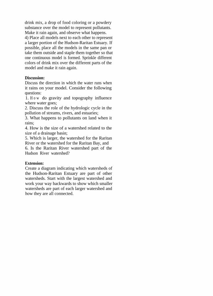
drink mix, a drop of food coloring or a powderysubstance over the model to represent pollutants.Make it rain again, and observe what happens.4) Place all models next to each other to representa larger portion of the Hudson-Raritan Estuary. Ifpossible, place all the models in the same pan ortake them outside and staple them together so thatone continuous model is formed. Sprinkle differentcolors of drink mix over the different parts of themodel and make it rain again.
Discussion:Discuss the direction in which the water runs whenit rains on your model. Consider the followingquestions:1. H o w do gravity and topography influencewhere water goes;2. Discuss the role of the hydrologic cycle in thepollution of streams, rivers, and estuaries;3. What happens to pollutants on land when itrains;4. How is the size of a watershed related to thesize of a drainage basin;5. Which is larger, the watershed for the RaritanRiver or the watershed for the Raritan Bay, and6. Is the Raritan River watershed part of theHudson River watershed?
Extension:Create a diagram indicating which watersheds ofthe Hudson-Raritan Estuary are part of otherwatersheds. Start with the largest watershed andwork your way backwards to show which smallerwatersheds are part of each larger watershed andhow they are all connected.
GEOGRAPHY STUDENT ACTIVITY
Mapping the Ocean Floor
Objectives: 1) You will be able to develop a better understanding of how scientists once mapped thebottom structure of underwater habitats.
2) You will understand that it is possible to describe something you cannot see through thecollection and correlation of accurate data.
3) You will simulate how water body contours were mapped.
Background: Despite the fact that it is underwater, the ocean floor can be mapped by scientists. Thisactivity demonstrates the old fashioned method of measuring depth by the use of a weighted, marked line.People lowered these lines into rivers, lakes and coastal waters to test depths. Presently depth soundersand sonar accomplish the same task more accurately and efficiently. Sonar sends impulses of sounddownward and measurements of depth are determined by the length of time it takes the sound impulse totravel to the water body bottom and bounce back again.
Words to Know:Contour MapSonarTopography
Materials:Large watertight Styrofoam coolersDark plastic garbage bagWaterproof markerWater (to fill the cooler)Dark food coloring (blue or green)Bricks, rocks, sand or gravelTwo stringsTwo metal nuts or washersTwo meter sticksData sheets for each pair of studentsBucket or pan to bail out coolers
Activity:1) Write north, south, east and west on the sides ofthe coolers so maps will have the same orientation.2) Using the magic marker, draw lines onecentimeter apart around the top of the cooler. Labelwith a,b,c’s going north and south and 1,2,3’s eastto west across the coolers.3) Modify and copy the attached data sheet tocorrespond to the size of your coolers.4) Line the cooler with a dark plastic garbage bagand place a variety of objects (rocks, bricks, sandor gravel) inside the cooler to simulate a variedunderwater terrain.
5) Once prepared, place the cooler on a table andfill with water and add food coloring.6) Using a length of string weighted with a washerat one end, take depth readings at predeterminedcoordinates by lowering the weighted string intothe cooler until it touches the bottom surface.Coordinates are determined by laying the metersticks across the marked cooler, perpendicular toone another.7) After the string hits bottom, it is then measuredand the resulting figure is placed at thecorresponding coordinate on the work sheet. Takeat least 15 measurements, entering the data on thework sheet as it is gathered.
Discussion:1. Make predictions about your cooler bottomtopography based on your 15 readings.2. Create your own nautical chart by connectingthe points of common depth.3. After everyone’s predictions have been made,empty the coolers. Compare the cooler’s bottom toyour own predictions.4. How might you have made more accuratepredictions? a more accurate contour map?

GEOGRAPHY OF THE HUDSON - RARITAN ESTUARY
USING TOPOGRAPHIC MAPS AND NAUTICAL CHARTS
TOPOGRAPHIC MAPS ’
Just as a globe is a model of the earth, maps are models of the places they represent. Atopographic map is a line and symbol representation of natural and manufactured features onthe Earth’s surface plotted to a definite scale.
Map scale defines the relationship between distance on a map and the corresponding distanceon the Earth. Scale is generally stated as a ratio in which the numerator (first number)represents map distance and the denominator (second number) represents a horizontal grounddistance. Scale is graphically depicted on topographic maps by bar scales marked in feet andmiles or in meters and kilometers. For example, a scale of 1:24,000 would mean that oneinch on the map would represent 24,000 inches on earth (or 2,000 ft.).
Large-scale maps cover small geographic areas and are useful when detailed information on aparticular location is needed. An example of a scale for a large-scale map would be 1:24,000.Small-scale maps cover very large areas and are useful for comprehensive views of a particularregion. Examples of map scales on small-scale maps include 1:250,000, 1:500,000, or1:1,000,000.
The National Mapping Program of the United States Department of Interior Geological Surveyproduces the standard topographic map series. Each map in the U.S. Geological Survey seriesconforms to established specifications for size, scale, content, and symbolization. The unit ofsurvey for standard topographic maps is the quadrangle. Each quadrangle is defined byparallels of latitude and meridians of longitude. Quadrangles are named after a city, town, orprominent natural feature within the area mapped. Standard edition topographic mapsproduced for New Jersey are published at a scale of 1:24,000 (1 inch = 24,000 inches or2,000 feet) in a 7.5 x 7.5 minute format. This means that these quadrangles cover 7.5 minutesof latitude and longitude. Other quadrangles covering 15 minutes of latitude and longitude arepublished at a scale of 1:62,500 (1 inch = 62,500 inches or 1 mile). In addition, a few specialmaps are published at other scales.
Topographic maps give as complete a picture of the terrain as can be legibly produced inmapped form. Topographic maps show the location and shape of mountains, valleys, andplains, the networks of streams and rivers, and the principal manufactured features of the areadepicted. A distinguishing characteristic of a topographic map is the portrayal of the shapeand elevation of the terrain by contours. Contours are imaginary lines which follow the landsurface or the ocean bottom at a constant elevation above or below sea level. The contourinterval is the elevation difference between adjacent contour lines. The contour interval ischosen on the basis of the map scale and the local relief. Contour intervals differ with thescale of the map and the relief of the area mapped. For example, a small contour interval is
used for flat areas whereas larger intervals are used for mountainous terrain.
The physical and cultural characteristics of an area depicted on a particular topographic mapare determined by engineering surveys and field inspections. These features are recorded ontopographic maps in a convenient, readable format using standardized symbols. Color helpsdistinguish categories of features. Manufactured features are printed in black, water featuresare printed in blue, road classifications, urban areas, and U.S. land lines are red, woodlandsand other vegetated areas are shown in green, and contour lines are printed in brown.
Topographic maps have many uses. They are an essential part of terrestrial ecological studies,geologic research and water quantity and quality studies. They may also be used in floodcontrol, soil conservation, and reforestation projects. Topographic maps are extremely usefulfor studying marine environments. They depict details about shorelines including the extent ofwetlands or shoreline development and the approximate mean high water line. They alsoprovide the types and locations of prominent coastal features like seawalls, breakwaters,jetties, piers, or wharves. In addition, topographic maps reflect local bathymetry includingwater depth depicted by depth curves based on soundings and other bathymetric features likeareas exposed at low tide, the locations of channels, sunken rocks, rocks awash and exposedwrecks.
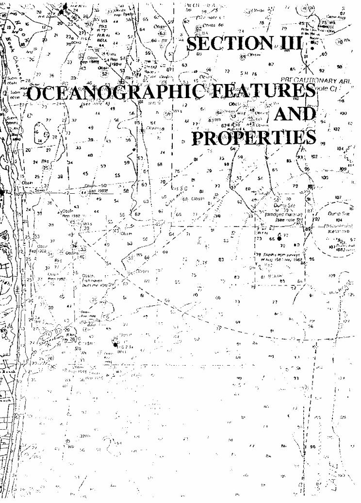

OCEANOGRAPHIC FEATURES AND PROPERTIES
OCEANOGRAPHIC FEATURES
The Hudson-Raritan Estuary connects with the ocean at the Sandy Hook-Rockaway Point transectand Hell’s Gate. Water elevation varies at these ocean boundaries and within the Estuary itself.Factors influencing these variations include both predictable astronomical tides and wind drivenmeteorological tides.
The major freshwater input to the system originates in the Hudson River Basin, which dischargesthrough Upper New York Bay, at the Verazzano Narrows into Lower Bay and continues onto theNew Jersey coast and the Atlantic Gcean. A portion of the discharge through the Narrows movessouthwesterly along Staten Island into the easterly area of Raritan Bay. Exact conditions at anytime and location are dependent on the key factors of freshwater inflow and the tidal motion,which affect the degree of mixing.
There is a net outflow of lower salinity surface waters and an inflow of higher salinity watersalong the bottom of the Estuary due to tides. Both tidal dispersion and circulation contribute tothe differences of salinity in any given area of the Estuary. This two-layer circulation patternprovides the Estuary with a far greater flushing rate than would be the case if circulation werein a seaward direction due to freshwater discharges only.
Salinity differences in the Hudson-Raritan Estuary are typical of a partially mixed estuary.Throughout most of the year, the Hudson-Raritan can be classified as a partially mixed,moderately stratified estuary.
Circulation in the Hudson-Raritan Estuary can be understood by separating it into two parts; tidalcirculation driven by the astronomical tides at the ocean boundaries and a residual or netcirculation which is the average circulation over one or more complete tidal cycles. The reversingtidal currents serve to move water over distances of about 5 to 10 kilometers on either a flood orebb portion of a tidal cycle. The net displacement over a complete tidal cycle is the major factorthat determines exchange and renewal of the Estuary. This average or residual circulation is asvariable as are tides, winds, and freshwater discharges. The key point is that the residual currentsby themselves fail, in general, to predict the transport pattern through the Estuary.
Residual tidal circulation, combined with the residual or net circulation driven by othermechanisms, affects the transport of contaminants through the Estuary, and exchanges theestuarine waters with adjacent coastal ocean waters. These forces also flush and renew the watersof the Estuary. The net or residual circulation is of primary concern, from the viewpoint of waterquality. If the Lower Hudson River, Raritan Bay, Upper Bay, and Lower Bay were dependentonly on freshwater inflow for their renewal, then residence time for these waters would be aboutthree to six months during low flow conditions in the Hudson. The actual residence time is morenearly one to two weeks, which is testimony to the vigor of the residual circulation arising fromthe interplay of the tidal, wind, and freshwater discharge processes of the Estuary.

Circulation which arises from regional wind blowing over the adjacent continental shelf water iscalled meteorological tides. Meteorological tides can cause substantial exchange of estuarine andocean waters, especially when storm surges occur. These surges can inundate low-lying land.Variable local winds over the Estuary also produce changes in circulation patterns within theEstuary. This is most evident in Raritan Bay, which is broad and relatively shallow.
The last major force in estuarine circulation is freshwater discharge. The difference in densitybetween the freshwater entering at the upstream limits of the Estuary and seawater at itsdownstream limit drives vertical and horizontal residual circulations which increase net transportand exchange of water through the Estuary.

PROPERTIES OF LOCAL WATERS
Currents and tidal action move water within the Estuary, causing water quality conditions in onearea to influence conditions in other areas. Tributary and adjacent water bodies also affectconditions in the Estuary. These include the Middle Hudson, Hackensack, Raritan, Passaic,Rahway, and South Rivers, Western Long Island Sound and adjacent ocean waters of theNew York Bight.
With each rainfall, pollutants such as fertilizers, pesticides, pet wastes, oil, and grease are washedfrom lawns and streets into storm drains that flow into streams, rivers, the Estuary and eventuallythe ocean. Known as nonpoint source pollution, this process degrades coastal water quality andcan result in negative impacts to aquatic life and habitat quality within the system.
When materials such as sand, dirt and other fine particles become suspended in water, clarity isreduced making the water turbid. The clarity or transparency of marine and estuarine waters isof prime importance. Since photosynthesis is confined to the sun-lit upper layers of marineecosystems, light penetration is of great importance for primary productivity. In the marineenvironment, absorption and scattering of light causes rapid loss. This loss of light is furtheraccelerated by turbidity or particles suspended in water.
Materials contributing to turbidity are varied. In the summer, turbidity may be due to plankton.Plankton grows and multiplies rapidly in warm, sunlit, nutrient rich water, giving the water acloudy appearance. During periods of heavy runoff, silt-laden surface water flows into the Bay.Wind-generated waves, boat wakes and waves breaking on shore also stir up sedimentscontributing to turbidity.
In addition to turbidity, other measurable properties of water include temperature, salinity,dissolved oxygen, and pH. These four basic properties influence the biological, physical andchemical processes that occur in the Estuary.
Water temperature exerts a strong control over the distribution and activities of marine organisms.For example, some species of phytoplankton will grow more rapidly under certain temperatureconditions.
PH is a measure of how acidic or basic (alkaline) a solution is. Pure water has a neutral pH of7.0. When pH is less than 7.0, water is said to be acidic. When the pH is greater than 7.0, wateris basic or alkaline. A pH of 6.5 to 9.0 is generally accepted as the range necessary to supportsurvival of marine organisms. The pH of sea-water normally ranges from 7.5 to 8.4. Fluctuationsin pH can occur in association with photosynthesis and bacterial activity. In bright light,photosynthesis can raise the oxygen content appreciably and the resulting withdrawal of carbondioxide from the water raises pH. Diminished oxygen, increased carbon dioxide, and reduced pHmay result from the rapid bacterial decomposition of detritus. Events in a watershed that mayaffect pH include increased leaching of soils or mineral outcrops during heavy precipitation,human activities including accidental spills and agricultural runoff of pesticides, fertilizers, soilleachate and sewer overflow. Seawater is resistant to fluctuations in pH due to the carbonate

dissolved in the water, which acts as an acid buffer in marine systems.
Dissolved oxygen at the proper level is one of the most critical factors for maintaining aquatic life.It is essential for all plants and animals inhabiting the water of the Estuary. When oxygen levelsin the water fall below 3-5 parts per million (ppm), fish and many marine organisms cannotsurvive. Oxygen levels are influenced by chemicals present in the water and biological activity.The amount of dissolved oxygen available in a water body is also directly related to temperature.Dissolved oxygen depends on the balance between the respiration demands of organisms presentin the water, bacterial decomposition, and the addition of oxygen from the atmosphere and thephotosynthetic activity of plants. Oxygen depletion is a significant event that can occur as a resultof nutrient pollution and excessive phytoplankton production (i.e., algal blooms) and may resultin mass killings of fish and shellfish in coastal waters if the reduced level of dissolved oxygen isprolonged.
Salinity is a key factor affecting the physical make-up of coastal waters. It refers to theconcentration of dissolved salts in the water, usually expressed in parts of salts per one- thousandparts of water or parts per thousand (ppt or o/00). Freshwater contains few salts (drinking waterusually has a salinity of less than 0.5 ppt), while seawater averages 35 ppt. In estuaries, salinitychanges with the tides and freshwater input. Since seawater enters bays through the inlets, salinityis highest at that point and decreases as one moves away from the inlet. Salinity decreases in thespring when rainfall and groundwater cause increases in freshwater inflows. In the fall, whenfreshwater inflows are reduced, salinities increase as more salt water penetrates further into theEstuary.
Salinity generally increases with depth since the presence of salts increases water density andlighter, less saline water tends to remain at the surface. The relationship between depth andsalinity is not constant. If a bay is shallow, winds and tidal action can cause mixing and salinitywould become the same throughout that water column. Perhaps the most important aspect of abay’s salinity regime is its effect on the distribution of the various biological populations livingin the bay. Different species have different salinity tolerance ranges. Those that are euryhaline cantolerate a wide range of salinities and may be found throughout the Estuary. Species that arestenohaline can only live in a very narrow salinity range and are confined to a relatively small areaof the Estuary.
J?JZATURES AND PROPERTIES ACTIVITIES AND MATERIALS OVERVIEW
Sediments of the Hudson-Raritan
Words to Know:SiltationCoringHypothesis
Materials:
Estuary
For this activity you will need 4 glass cylinders, 4 large jars with lids, stop watch, prepared sediments, analuminum roasting pan, over flow basin, and clear plastic tubing.
Activity One:The students collect a wide range of sediments ranging in size from fine sand to pebbles. After collecting,they make predictions as to which type of particle will sink fastest when dropped in water. Using a stopwatch, they record the time it takes for particles to fall and settle to the bottom. Using the large jars forthe second part of the activity, the students create a mixture of particles in each jar. Once filled with water,the jars are inverted and observations are made as to what happens.
Activity Two:Students learn about the sampling technique, coring, by actually forcing a tube through sedimentary layers.Making predictions beforehand the students learn if the hypothesis they made was right.
Reading A Tide Chart
Words to Know:NavigationSemi-diurnal tidesNeap tideSpring tide
Materials:In this activity you will need a tide chart (supplied), flashlight, index cards labeled: full moon, quartermoon, new moon, spring tide, neap tide; two students to represent the earth and the sun; one student perlabeled index cards.
Activity:Using the tide chart, the students answer questions about the tides in the first part of this activity. For thesecond part, using the labeled index cards, the students demonstrate the phases of the moon that give usthe different tides.

Ocean Currents
Words to Know:UpwellingDownwelling
Materials:For this activity you will need a 2-liter soda bottle (cut off at the shoulder to make a wide-mouth container),one large ice cube colored dark blue, hot water colored red, tap water, plastic-foam cup, blue and redcolored pencils, and unlined paper.
Activity:The students fill a 2-liter bottle half full with tap water. A blue ice cube is floated in it and using unlinedpaper the students sketch their observations. Using a plastic foam cup containing hot water with red foodcoloring in it, the cup is poured slowly down the side of the 2-liter bottle. The changes are added to thedrawing. For an extension, this experiment is repeated using very salty water and observations are madeand differences noted.
Turbidity
Words to Know:BenthicRunoff
Materials:For this activity you will need a water sampling kit, Secchi disk, three or four hydrometer jars (optional),water (optional), soil, sand, clay, rocks (all optional), clock with second hand (optional).
Activity:In this activity students will measure the turbidity of the water using a secchi disk. This is done bylowering the disk with a calibrated line, into the water until it disappears, reading the measurement, andrecording the depth. This leads to a discussion on why turbidity is important.
Salinity
Words to Know:HydrometerMeniscusRefractometerSpecific gravity
Materials:For this activity you will need water, salt, hydrometer, hydrometer jar, salinity conversion table, two pans,two eggs, thermometer, eye dropper (optional) and refractometer (optional).
Activity:In this activity students place two pans on a table, one with fresh water and one filled with very salty water,putting an egg in each pan they observe what happens. Using the hydrometer jar filled with salty waterthe students obtain a temperature and a hydrometer reading. This process is repeated using fresh water.A comparison is made. After that a variety of objects are experimented with to see what sinks and floats.
pH
Words to Know:SAVbufferreagent
Materials:For this activity you will need a water sample freshly drawn, LaMotte pH colorimetric test kit, chemicalwaste receptacle, and hand-held pH meter (optional).
Activity:In this activity students take a freshly drawn water sample to measure pH.. This leads to a discussion onacid rain and how it can cause problems for the Estuary and surrounding region. The method and test kitused in this activity are the same ones that are used by field scientists.
Oxygen in the Water
Words to Know:ColorimetricDiffusionPhytoplanktonPhotosynthesis
Materials:For this activity you will need a LaMotte Winkler-Titration test kit, LaMotte Oxygen in the Water test kit,bucket, thermometer, water sample, and a chemical waste receptacle.
Activity:Students in this activity measure dissolved oxygen in the water by two methods using two different test kits.It is important to obtain fresh samples. These tests can be done in the field, making sure the students arefamiliar with all test equipment beforehand.
FEATURES AND PROPERTIES STUDENT ACTIVITY
Sediments of the Hudson-Raritan Estuary
Objectives: 1) You will be able to investigate and analyze the natural patterns of sedimentation in theHudson-Raritan Estuary.
2) You will learn about coring, a sampling method that is used to study sediment.3) You will observe how heavier particles sink faster than finer particles in an estuary.
Background: Sediments collect as particles, settling slowly to the bottom, varying in compositiondepending on location. The sediments of the Hudson-Raritan Estuary are the product of materials,principally minerals and rocks derived from various upland sources, delivered by rivers and streams.Particles of sediment are also carried into the Estuary from the ocean’s tidal currents. The sediments foundin the Hudson-Raritan Estuary can be made up of very fine particles consisting of silt and clay. Since fineparticles remain suspended in the water column longer than larger, denser particles, the particles arecarried up into the tidal creeks, collecting as marsh mud or finely grained shorelines. Other factors thatinfluence where sediments are deposited are waves, tides, weather conditions, wind and artificial structuressuch as jetties, groins and bulkheads.
Words to Know:SiltationCoringHypothesis
Materials:Clear CylindersLarge Jars with lidsStop WatchPrepared SedimentsAluminum Roasting PanOver Flow BasinClear Plastic TubeWatering can
Activity One:1) Collect a variety of sediments ranging in sizefrom pebbles to fine sand. Arrange the particles inseparate piles and predict which particles will sinkthe fastest when dropped in water. Using a stopwatch and a clear container of water, record thetime it takes for each different type of particle tofall to the bottom of the container.2) Based on your findings predict what will occurwhen a mixture of particles are placed in acontainer of clear water. Using large jars with lids,create a “sediment mix” in each jar. Fill jar slowlywith water. When the sediments have settled invertthe jars and observe the action.
Discussion:1. Discuss the relationship of siltation rates fromyour activity and what effects it might have on theHudson-Raritan Estuary.2. How do sedimentation rates affect thecomposition of various locations within theestuary?3. What factors (human and natural) influence thelayering of sediments?
Activity Two:In order to study and analyze bottom sedimentsscientists utilize a process known as coring. Byforcing a pipe through sedimentary layers, a samplecore can be extracted, representing sediments in theorder in which they were deposited.1) Using a large aluminum roasting pan set up onan angle, build an estuarine sediment deposit byplacing at least three different types of sedimentarymaterials in separate piles at the top of the pan.Using a source of water that you can regulate,slowly water each pile, one at a time, movingthem down to the bottom of the pan. Be sure thepan is placed in a larger basin to allow for wastewater overflow. Continue moving sediment untilthe sample is complete.2) Predict how you think the layers have settled.3) To test your hypothesis, take samples usingthis simple coring method. Using a clear plastic

tube, carefully insert the tube into the drainedsediment. This method should yield a core.Observe the layers within the tube. Did you makea correct prediction?
FEATURES AND PROPERTIES STUDENT ACTIVITY
Reading a Tide Chart
Objectives: 1) You will learn how to read and interpret tide charts.2) You will use information contained in tide charts to plan and predict marine-related
events.
Background: Tide charts are used to determine at what time of day the two high or low tides will occurin a specific location on a daily basis. A tide chart posts the projected time for daily high and low tides,based on the effects of the phases of the moon, the position of the sun and observed local changes. Tidalpredictions assume average weather conditions, so actual tides may deviate during extreme weathersituations. Tides are an important phenomenon. They affect navigation, replenish sea life, and assist inkeeping coastal areas like the Hudson-Raritan Estuary clean. The ability to read tide charts becomesimportant if you plan to work or recreate in coastal areas. To find a tide chart look in the local newspaperor check with a local marina.
Words to Know:NavigationSemi-diurnal tidesNeap tideSpring tide
Materials:Tide ChartFlash LightIndex cards labeled: full moon, quarter moon, newmoon, spring tide, neap tide.Two students: l-Earth, l-SunOne student: l-moon chosen by the labeled cards.
Activity One:1) Using the given tide chart, look at one month ofyour choice, use the information to answer thefollowing questions.a) What is the relationship in time between the twodaily high tides?b) What is the relationship in time between the twodaily low tides?c) Compute the average time lapse between highand low tide?2) There are two high tides and two low tides eachday in the Hudson-Raritan Estuary. These areknown as semi-diurnal tides. The rule of thumbfor high tides is that they occur 12 hours and 25minutes apart. This is because the moon passes thesame spot on the Earth every 24 hours and 50
minutes. If the morning high tide arrives at 8 a.m.it will occur at 850 a.m. tomorrow morning. Thesame is true of low tides.Using a tide table look at the morning tides andanswer the following questions.a) What date will the morning high tide appear justafter sunrise?b) When is the next high tide?c) Calculate the difference between the high tides.d) What is the time difference between the morninghigh tide and the next low tide on the date youchose.
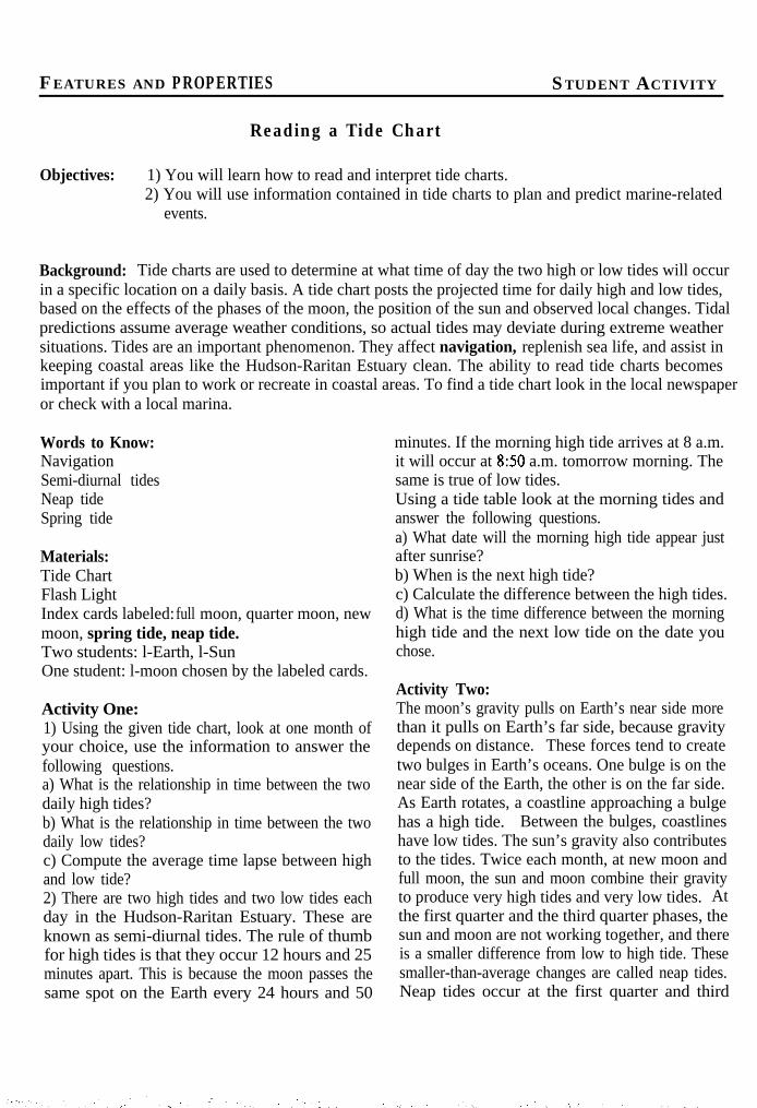
Activity Two:The moon’s gravity pulls on Earth’s near side morethan it pulls on Earth’s far side, because gravitydepends on distance. These forces tend to createtwo bulges in Earth’s oceans. One bulge is on thenear side of the Earth, the other is on the far side.As Earth rotates, a coastline approaching a bulgehas a high tide. Between the bulges, coastlineshave low tides. The sun’s gravity also contributesto the tides. Twice each month, at new moon andfull moon, the sun and moon combine their gravityto produce very high tides and very low tides. Atthe first quarter and the third quarter phases, thesun and moon are not working together, and thereis a smaller difference from low to high tide. Thesesmaller-than-average changes are called neap tides.Neap tides occur at the first quarter and third
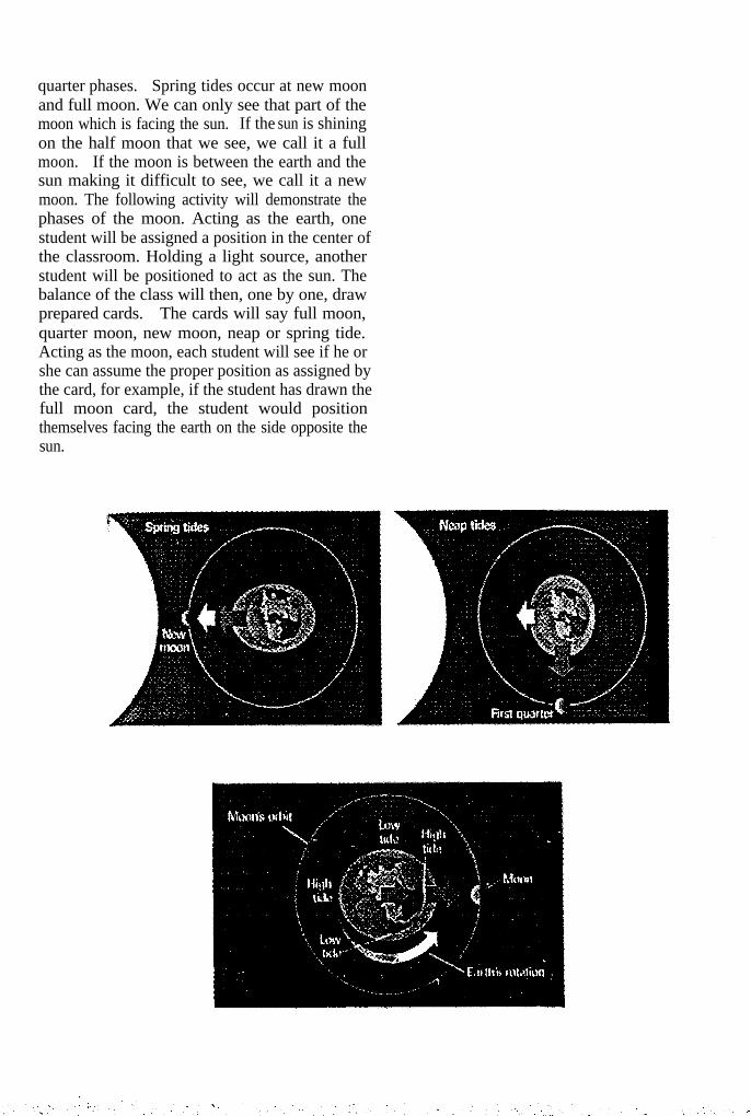
quarter phases. Spring tides occur at new moonand full moon. We can only see that part of themoon which is facing the sun. If the sun is shiningon the half moon that we see, we call it a fullmoon. If the moon is between the earth and thesun making it difficult to see, we call it a newmoon. The following activity will demonstrate thephases of the moon. Acting as the earth, onestudent will be assigned a position in the center ofthe classroom. Holding a light source, anotherstudent will be positioned to act as the sun. Thebalance of the class will then, one by one, drawprepared cards. The cards will say full moon,quarter moon, new moon, neap or spring tide.Acting as the moon, each student will see if he orshe can assume the proper position as assigned bythe card, for example, if the student has drawn thefull moon card, the student would positionthemselves facing the earth on the side opposite thesun.
FEATURES AND PROPERTIES STUDENT ACTIVITY
Ocean Currents
Objectives: 1) You will investigate how temperature differences in waterbodies causes currents.2) You will have a better understanding of density as it relates to water.3) You will better understand the impact of human actions on the marine environment.
Background: Currents are like giant rivers of water flowing through a given waterbody. Some flow onthe surface, while others move huge amounts of water deep in the ocean. Currents are fueled by winds,heat, water density and the gravitational pull of the sun and the moon. Winds are caused by theaccumulation of energy generated by the sun. As winds push across water, friction creates waves. Windsthat push up against waves are the driving force behind surface currents. Currents formed by temperaturestart in the ocean’s colder regions, (i.e. earth’s polar areas) and move slowly across the sea floor towardsland. When they run into a land mass or converge with another current they rise to the surface. Whenthe cold water is forced to the surface it sinks down since it is heavier. The water or current then movessluggishly towards warmer water at the equator. Gradually, these once chilly waters work their way backto the surface, replacing new, cold surface water that sinks. This upwelling and downwelling carries allsorts of interesting life with it including plankton and other marine creatures. Like cold water, salt wateris denser than fresh, so it sinks when it encounters fresh waters causing currents. This is the case in thebays of the Hudson-Raritan Estuary. Fresh water from rivers converge with salty, colder ocean water.The ocean water sinks, causing vertical currents that continuously mix the water. Currents keep theEstuary’s waters mixed constantly, carrying and supporting a myriad of marine organisms.
Words to Know:UpwellingDownwelling
Materials:2-liter soda bottle (cut off at the shoulder to makea wide-mouth container)One large ice cube colored dark blueHot Water (colored red)Tap WaterPlastic-foam CupBlue- and Red pencilsUnlined Paper
Activity:1) Fill a 2-liter bottle about half full with tap water.Float a blue ice cube in it. Use unlined paper tosketch your observations.2) Obtain a plastic foam cup containing hot waterwith red food coloring in it. Be careful not to spillthe hot water. Slowly pour the hot water down theside of the 2-liter bottle.3) Allow the 2-liter bottle to sit as you continue to
observe. Add any changes you observed to yourdrawing.
Discussion:1. Keeping in mind the poles and the equator, howdoes this experiment explain the flow of someocean currents?2. Write a simple explanation of how thetemperature of water is one cause of oceancurrents.
Extension:1. Repeat this experiment with a blue ice cubemade with very salty water. Drop into a 2-literbottle half full of fresh tap water. Sketch yourobservations.2. Add moderately salty water to this mixture.You may want to tint this water red before slowlypouring it down the side of the 2-liter bottle. Onceagain, observe and sketch your observations.

FEATURES AND PROPERTIES STUDENT ACTIVITY
Turbidity
Objectives: 1) You will be able to measure the turbidity of the water.2) You will be able to identify possible environmental complications caused by excess
turbidity.
Background: Turbidity or cloudiness in the water is caused by suspended solid matter which scatters lightpassing through the water. There are many possible sources of turbidity. Most people think primarily ofsediment from disturbed or eroded soil and runoff as sources of turbidity. Microscopic plankton alsocontribute to high turbidity when their numbers are increased due to excess nutrients. Apparent watercolor, microscopic examination and streamwalk observations can help determine the sources of turbidity.In addition to blocking out the light needed by submerged aquatic vegetation (SAV) and burying eggs andbenthic creatures, suspended sediment can carry nutrients and pesticides throughout the water system.Suspended particles near the water surface also absorb additional heat from sunlight, raising surface watertemperature.
Words to Know:BenthicRunoff
Materials:Water sampling kitSecchi disk3 or 4 hydrometer jars (optional)Water (optional)Soil, Sand, Clay, Rocks (optional)Clock with second hand (optional)
Activity:1) Attach a secchi disk to a calibrated line. Lowerthe disk into the water until it just disappears.Record the depth of water from the surface to thedisk. If the secchi disk reaches the bottom beforedisappearing, the secchi depth is greater than thewater depth and cannot be accurately measured.When this occurs, a notation must be added to thesecchi depth reading in your data.2) Slowly raise the disk until it reappears. Recordthis depth.
Discussion:1. Very clear water,ocean, supports onlyWith that in mind,turbidity indicate?
typically found in the opensparse plant and animal life.what might low levels of
2. What environmental complications might beindicated by a high turbidity environment?
Extension:1) Fill 3 or 4 hydrometer jars with water. To eachjar, add a different type of sediment, for example,sand, rocks, clay or soil.2) Mix the jars well and time how long it takes forthe sediment to settle down below a predeterminedpoint in the hydrometer jar.3) Discuss the effects different types of sedimentmight have in the estuarine waters.

FEATURES AND PROPERTIES STUDENT ACTIVITY
Salinity
Objectives: 1) You will be able to determine the salinity of a water sample by using a hydrometer.2) You will understand how salinity affects when an object will or will not float in water.
Background: Salinity is the total of all salts dissolved in water. Salt water is more dense (heavier per unitof volume) than fresh water. Salinity is usually expressed in “parts per thousand” (ppt). In an estuary,the flow of fresh water from streams and rivers mix with salty ocean water, producing salinity rangingfrom 0 to 35 ppt. The salt content of water can cause currents and affect the distribution of animal andplant species according to the amount of salinity they can tolerate. Salinity may be calculated by measuringthe specific gravity of a sample of water using a hydrometer, correcting for the effect of temperature andconverting the readings to salinity by means of a salinity conversion table.
Words to Know:HydrometerMeniscusRefractometerSpecific gravity
Materials:WaterSaltHydrometer jarHydrometerSalinity conversion table2 pans2 eggsThermometerEye dropper (optional)Refractometer (optional)
Activity:1) Place two pans on a table, one filled with freshwater and the other filled with very salty water.Place an egg in each pan. Note what happens.2) Fill the hydrometer jar with salt water and obtaina temperature reading. Remove the thermometerand place the hydrometer in the hydrometer jar.3) Wait until the hydrometer stops bobbing. Besure that your eye is even with the water level inhydrometer jar, not the meniscus, because viewingdown or up at an angle can give an inaccuratereading. Read and record the specific gravity.Use the conversion tables that came with your
hydrometer to determine the salinity of yoursample.4) Repeat this procedure with fresh water.
Discussion:1. Why did the eggs behave the way they did whenplaced in the pans of water?2. How might the different seasons effect thesalinity of the oceans and the estuaries?
Extension:1) After obtaining a salinity measurement from thehydrometer, use a refractometer to create acomparison between the two readings. Discusshow the readings may be similar or different.2) Attempt to float or sink a variety of objects insalt water after making predictions of what willsink or float.

FEATURES AND PROPERTIES STUDENT ACTIVITY
pH
Objectives: 1) You will be able to test the pH level of a water sample.2) You will understand the dramatic effect the pH level can have on a waterbody.
Background: The pH test is one of the most common analysis in water testing. An indication of thesample’s acidity, pH is actually a measurement of the activity of hydrogen ions in the sample. pHmeasurements run on a scale from 0 to 14, with 7.0 considered neutral. Solutions with a pH below 7.0are considered acids. Solutions with a pH of 7.0 to 14.0 are considered basic. In a lake or pond, thewater’s pH is effected by its age and the chemicals discharged by communities and industries. Most lakesare basic when they are first formed and become more acidic with time due to the build-up of organicmaterials. As the organic substances decay, carbon dioxide forms and combines with water to produce aweak acid called carbonic acid. Large amounts of carbonic acid lower the water’s pH. A range of pH of6.5 to 8.2 is optimal for most organisms. Most fish can tolerate pH values of 5.0 to 9.0. Rapidly growingalgae or SAV remove carbon dioxide from the water during photosynthesis. This can result in a significantincrease in pH levels. The pH of salt water is not as vulnerable as the pH of fresh water to acid wastes.This is because the different salts in sea water tend to buffer the water. Normal pH values in sea waterare about 8.1 at the surface and decrease to about 7.7 in deep water. Shellfish and algae are generallymore sensitive than fish to large changes in pH, so they need the sea’s relatively stable pH environmentto survive.
Words to Know:SAVBufferReagent
Materials:Water sample (freshly drawn)LaMotte pH Colorimetric testChemical waste receptacleHand-held pH meter (optional)
Activity:1) The pH measurement must be made in the fieldor from a freshly drawn sample. The pH of abottled sample will quickly change due tobiological and chemical activity in the samplecontainer.2) Using the LaMotte pH colorimetric test, rinseand fill two sample tubes with water to the mark.Cap one tube and use it as the blank.3) To the second tube, add ten drops of thereagent. Cap the tube and invert gently severaltimes to mix the solution.
4) Insert both tubes into the color comparator.Facing a source of natural light, match the samplecolor to a color standard.5) The color corresponds with a number and thatnumber will be the pH value of the sample.
Discussion:1. Using a hand-held pH meter, compare theresults with the wide range colorimetric pH test.2. Use the topic of pH to discuss acid rain and theproblems it causes in the Estuary and thesurrounding region.
FEATURESANDPROPERTIES STUDENT ACTIVITY
Oxygen in the Water
Objectives: 1) You will be able to use a test kit to measure dissolved oxygen in a water sample.2) You will be able to determine if the dissolved oxygen level is reflective of a healthy
system.3) You will understand that it is possible to describe a process that you cannot see by taking
measurements of dissolved oxygen in a water sample.4) You will develop an understanding of how oxygen enters and exits the water.
Background: A large percentage of all the oxygen we breathe is manufactured by green plants. A totalof three-fourths of the earth’s oxygen supply is produced by phytoplankton. Oxygen is a necessarycomponent of life to virtually every living creature on this planet. Commonly, we think of oxygen asbeing the air that surrounds us, but then how would aquatic creatures get the oxygen they need to survive?Oxygen gets into the water by diffusion from the surrounding air, by tumbling over falls and rapids, andas a bi-product of photosynthesis. The oxygen in water is dissolved oxygen. The two test kit proceduresdescribed below will yield results of varying degrees of accuracy. The LaMotte Oxygen in the Water TestKit is a colorimetric test kit which allows for only a broad generalization of the level of dissolved oxygenin a water sample. The LaMotte Winkler-Titration Test Kit offers much more accurate results, in therange of 0.2 ppm (parts per million).
Words to Know:ColorimetricDiffusionPhytoplanktonPhotosynthesis
Materials:LaMotte Winkler-Titration Test KitLaMotte Oxygen in the Water Test KitBucketThermometerWater sampleChemical waste receptacle
Activity:1) Obtain a water sample, ideally one that has justbeen pulled from the source under investigation.Follow the procedures as outlined below for thedissolved oxygen test kit selected:
LaMotte Wiikler-Titration Test1. Rinse sample bottle 3 times2. Obtain an air-tight sample by submerging thesample bottle fully under the water and slowlyallowing the water to fill the bottle. Cap the bottleunderwater.
3. When you are ready to do the test, uncap thesample bottle, making sure that the plastic conefrom the cap stays in the cap (this displaces theproper amount of water to allow room for thechemicals that are about to be added to the sample.Please keep the plastic cone in the cap at all times).4. Add 8 drops of Manganous Sulfate Solution(pinkish solution) and 8 drops of AlkalinePotassium Iodide Azide Solution (same sizebottle, clear solution).5. Cap the sample bottle and mix by invertingseveral times. A precipitate will form.6. Place bottle in an undisturbed area and allowprecipitate to settle below the shoulder of the bottle(approximately 5 minutes).7. Add 8 drops of sulfuric acid (clear solutionwith red cap).8. Cap and gently shake until precipitate iscompletely dissolved.9. Fill titration tube (glass bottle with the cap withthe hole in top) to the 20 ml mark.10. Fill the direct reading titrator (syringe) withSodium Thiosulfate. When filling the directreading titrator, the upper part of the black rubberstopper should be even with the zero mark. Makesure that there are no air bubbles in the column.
11. Insert the direct reading titrator into the centerhole of the titration tube cap.12. Add 1 drop of Sodium Thiosulfate and gentlyswirl the tube. Continue one drop at a time untilthe yellow-brown color is reduced to a very faintyellow. The term “very faint” is subjective. It ishelpful to bring a piece of white paper with you tohold the sample up against to determine the“faintness” of the color.13. Remove the titration tube cap, being careful notto disturb the plunger.14. Add 8 drops of Starch Indicator Solution andgently swirl.15. Replace the titration tube cap.16. Continue adding 1 drop of SodiumThiosulfate and swirling until the blue solutionturns clear.17. Read the test result where the plunger tip meetsthe scale. Record dissolved oxygen in parts permillion (ppm) .
LaMotte Oxygen in the Water Test Kit1. Collect the water sample as described above.2. Fill the vial to overflowing with the watersample and cap underwater.3. Add two Dissolved Oxygen Tablets and cap.The water will overflow the vial. Make sure thatthere aren’t any air bubbles in the sample.4. Gently invert until the tablets have dissolved.5. Wait 5 minutes for full color development.6. Facing a source of natural light, hold the vial flatagainst the white section of the ColoRuler. Matchthe sample color to a color standard.7. Record the oxygen level as zero, low or high.
Discussion:1. How could overfertilization of water plantsdeplete the dissolved oxygen levels?2. Overall, how would an algal bloom effect theenvironment? What would happen to the other lifein the water?
Extension:1) Obtain a dissolved oxygen meter, or readingsfrom a meter and use the test kits to measure foraccuracy.

PLANTS AND ANIMALS
PLANTS
PHYTOPLANKTON
Phytoplankton make up 99% of all plant life in marine ecosystems. Phytoplankton are small,mostly microscopic plants that can range in size from a thousandth of a millimeter to two ormore millimeters. They are most abundant near coastlines where nutrient levels are thehighest. Both phytoplankton and zooplankton may float or drift at the mercy of the currentsbecause they are often unable, too weak or too small to swim.
Phytoplankton are at the bottom of the food chain. They are consumed in large quantities byzooplankton and larval and juvenile marine organisms. Like most plants, phytoplanktonproduce their own food through photosynthesis. They use nutrients in the water and sunlightto accomplish this. They are generally not found at depths where sunlight cannot penetrate.
DINOFLAGELLATES
Two of the more abundant and important types of phytoplankton are diatoms anddinoflagellates. Diatoms are single celled phytoplankton that make up more than half of allplanktonic life. They live inside a shelter that they build with silica, the same material sandconsists of. A diatom’s shelter consists of two halves, one larger than the other so that thesmaller one can fit inside. Diatoms can be quite beautiful and have many projections to keepthem afloat.
PLANT GROWTH
Growth rates of phytoplankton can be expressed in terms of “primary production. ” Primaryproduction is the amount of plant growth, or photosynthesis, for a given unit of surface area orvolume, over a specified time period. Rates of primary production depend on several factors,the most important being availability of light and nutrients, which limit the production ofphytoplankton.
Primary production forms the base of the food web leading up to fish, shellfish, birds andultimately, humans. High rates of primary production by some plant species enhance seafoodproduction. However, over-abundant primary production almost always results in reduction ofthe aesthetic values of ocean water, taking the form of algal blooms, such as red, brown andgreen tides.
The high nutrient levels in the Hudson-Raritan Estuary support high rates of growth ofphytoplankton. Plankton fluctuates on a cycle and depends on deep, nutrient rich watersmixed with less nutritious surface waters. The first rapid growth period of plankton begins inthe spring after winter storms have mixed the waters. Phytoplankton begins to bloom,

supporting zooplankton populations. These populations will provide food for fish. Planktonproduction during the summer is typically low, but in fall mixing of nutrient-rich bottom waterwith surface water occurs and the process experienced last spring is repeated. Spawning ofmany larger species of marine animals often coincides with these plankton growth periods.
ANIMALS
ZOOPLANKTON
Zooplankton has representatives in almost every phylum in the animal kingdom. Species inthe Hudson-Raritan Estuary represent most major taxonomic groups common to estuariesalong the eastern seaboard. Larvae, fingerlings and invertebrates represent a large portion ofthe zooplankton population. They begin their life as zooplankton but eventually settle to thebottom and take on a benthic existence. This is common to many types of crabs, bottom fishesand mollusks.
Copepods, one of the classes of the phylum Arthropoda, are dominant zooplankton in theHudson-Raritan Estuary. They often make up 70-90 percent of a zooplankton sample,especially in the spring. Copepods consume many diatoms and support large populationsherring and sardines.
BENTHIC INVERTEBRATES
of
Benthic fauna are usually defined as those invertebrates that dwell in or on the seabed or onsubmerged structures (pilings, rocks, boat bottoms, etc.). The benthos of the Hudson-RaritanEstuary are generally regarded as an extremely important component of this estuarineecosystem. Benthic organisms are often indicative of the relative “health” or condition of anestuary. They also provide much of the food for commercially and recreationally importantfish species such as flounder, blackfish, striped bass, and bluefish. Commercially, clams andlobsters are the most important benthic species living in the estuary.
Benthic organisms are categorized by their positions in the water column. Mussels, barnaclesand some species of shrimp, crabs and lobsters usually reside on the surface of the sediment oron hard surfaces and are termed epibenthic. Organisms such as clams, worms and manycrustaceans reside in the sediment, either in tubes or burrows and are called infauna.
FISH
The rich waters of the Hudson-Raritan Estuary support a diversity of fish species. Manyspecies spend only part of the year in the Estuary while migrating through offshore waters orbetween the ocean and Estuary. Other species are year-round residents. Seasonal occurrenceand distribution of fish in the Hudson-Raritan Estuary is related to life history patterns. A
variety of studies related to the distribution and abundance of fishes in portions of the Hudson-Raritan Estuary have been conducted. These studies have identified over 145 speciesrepresenting more than 50 families of resident and migratory finfish.
The Hudson-Raritan Estuary is a major spawning and/or nursery ground for many species offish and shellfish. Studies have found close to two dozen species of fish in egg and larvalstages in upper New York Bay alone. Other studies have shown that the lower bay regionserves as an important area for species in young-of-the-year and/or juvenile life stages.
Year-round residents, i.e., fish that spawn and remain within the Estuary for their entire lifecycle include the silverside minnow, killifish or mummichogs, white perch, and bayanchovies. The area is particularly important for diadromous species which migrate throughthe Estuary to different spawning places such as striped bass, white perch, shad, alewife,American eel and shortnose sturgeon. Anadromous species such as shad, alewife, bluebackherring, Atlantic sturgeon, tomcod, and smelt make spring spawning runs from the ocean intofresh and brackish waters. Catadromous species such as eels arrive as juveniles, mature infreshwater after several years then return to the ocean to spawn.
In recent years, the Hudson-Raritan Estuary, particularly the Hudson River and New YorkHarbor region, has been identified as a significant habitat for striped bass. Studies of both theHudson and East Rivers have documented the usage of the Estuary by adult and juvenilestriped bass. Generally, the juveniles use the pier and interpier areas of Manhattan and thenorthern parts of the Arthur Kill, Newark Bay, and other areas as overwintering groundswhile adults utilize channel areas. Currently, the Hudson-Raritan Estuary stock of striped bassis extremely important since the historically dominant stocks from the Chesapeake areexperiencing low abundance.
BIRDS
Although the shoreline of the Hudson-Raritan Estuary is intensely developed, the area supportsa diverse and abundant bird population. With approximately 125 species of resident ormigratory birds recorded in the region, the area is home to a diverse population of resident,migrating, wintering and breeding birds. The Estuary is able to support this diversity becauseit offers many habitats. These habitats range from open water to marsh and woodlands. Thebirds that use these varied habitats can range from large birds of prey to waterfowl orpasserines. In addition, plants and invertebrates living in shore and marsh areas provideplentiful food sources.
The Hudson-Raritan Estuary is a prominent feature of the Atlantic flyway during spring andfall migrations supplying abundant feeding and resting areas for many avian species. It isduring spring and fall when food is most abundant that migrating waterfowl, snow geese andbrant frequent the Estuary as they utilize the flyway to travel between northern breedinggrounds to southern wintering areas. Fall migrations are generally heaviest because theyinclude offspring from the summer breeding season. Other species overwinter within the
confines of the Estuary. Shooters Island, located north of Staten Island at the confluence ofthe Arthur Kill and Kill Van Kull in Newark Bay, is an uninhabited island providing anundisturbed environment for colonial nesting birds, primarily herons.
Birds have evolved in such a way as to make them specialists and each bird occupies its ownniche. Body parts have evolved to perform specific functions. Waterfowl, for example haveshort legs and webbed feet, and spend most of their time in the water. Wading birds, such asherons and egrets, have long necks, legs and beaks that enable them to stalk prey in theshallow water habitats they frequent. Birds of prey, such as osprey, use sharp beaks andpowerful legs to grasp prey once it is sighted with their keen eyesight.
Wading birds such as herons and egrets do not swim but wade through the water. They stalktheir prey along the shallow edges of marshes, mud flats and creeks. These birds have shorttails, long legs, long necks and specialized bills. The biIls of egrets and herons are used toquickly seize prey such as small fishes, frogs and aquatic insects.
Gulls and terns are long winged birds with short legs and webbed feet. They have hookedbills and are good swimmers. They are probably the most common and visible of all birds inthe area. The herring gull and the common tern are two of the most abundant birds in thearea. Gulls are opportunistic feeders and will feed on almost any food source. Terns aresmaller and more graceful. Unlike the gull they have sharp pointed bills. Terns are moreselective feeders, preferring small live minnows, squids and shrimp.
Shorebirds like plovers, sandpipers and oyster catchers, inhabit the beach-littoral and marshzones. These shorebirds have long legs and pointed beaks. They live near areas that are onlyexposed during low tide, feeding mainly on sand and mud dwelling invertebrates.
Raptors are birds of prey and feed at the top of the food chain. They include ospreys, hawksand owls. They feed mainly on fish and small rodents. They are large birds with stronglyhooked bills and powerful feet with hooked claws.
Waterfowl spend most of their time on the water as their name would imply. They consist ofducks, geese and swans. Waterfowl have webbed feet and are very good swimmers. They arealso strong and swift fliers that enable them to undertake extensive migrations each spring andfall. Migrations begin in the early afternoon and continue through the night. Waterfowlfollow specific paths in their migrations and these paths have become known as flyways. Mostwaterfowl are gregarious, staying together as a flock, which is advantageous for feeding andsafety when migrating.
Passerines are the largest order of birds containing some 59 families. They are made up ofsparrows, warblers, ravens and other similar perching type birds. They can range in size from4-26 inches. Passerines are the most adaptive and intelligent of all birds. They all have threetoes pointed forward and one backward. This enables them to perch easily on anything from abranch to a grass stem.

Wintering grounds are very important to all birds, and each species has specific requirementsfor an area to qualify as wintering grounds. Populations will often move to satisfy theseneeds. Plenty of food is a major requirement of all birds. To endure colder temperaturesbirds need more energy. In order to produce more energy, they need to eat more. Openwater is important to waterfowl because this is where they feed. Should an area become icedover they will have to move on in search of open water. Waterfowl prefer the Hudson-RaritanEstuary because the constant currents ensure there will always be some open water available tothem.
The Hudson-Raritan Estuary is also a breeding ground. Saltmarshes, beach-littoral zones anduplands with woody vegetation are the most widely used areas in the Estuary. Breeding areasmust be able to support a growing population of birds by providing plenty of food andprotection. Because birds use the same breeding grounds year after year, the health of theEstuary can be measured on how successful breeding is.

PLANTS AND ANIMALS ACTIVITIES AND MATERIALS OVERVIEW
Nearshore Communities
Words to Know:Benthic NicheBenthos PelagicDiversity PhytoplanktonDetritus PlanktonDominant NektonEcosystems VertebrateHabitat ZooplanktonInvertebrate
Materials:For this activity you will need a seine net, two pairs of chest waders, a bucket filled with estuary water,data sheets, pencils, plankton net with jar, wash bottle, microscopes, an eight inch piece of 4.5 inchdiameter PVC tubing, meter stick, sample jars, a sieve with mesh, a well sealed opaque jug containinga 10% solution of formalin, dissecting microscope, field guide books on fish, invertebrates, birds andplants of the area, and keys for the organisms of the area.
Activity:There are four activities all related to nearshore communities. The first activity is to collect livesamples by seining. Using a seining net, chest waders and a bucket filled with estuary water, thestudents identify the animals found, recording species names and quantities, using field guide books asnecessary. After they have been counted, the catch should be released back into the environment.Activity Two tells how to use a plankton net to get a plankton sample and examine the findings under amicroscope. Activity Three is taking a sample of the benthos or bottom sediment using a PVC pipeand getting a core sample. A sieve and wash bottle are used to sift out the sample, the sample isplaced into a formalin solution to be looked at under the microscope in the classroom. Activity Four istaking a walk through or around the area being studied. The students identify the plants, birds, andterrestrial animals observed, recording identities and relative abundance.
Classification and Identification
Words to Know:Classification KeyCouplet NomenclatureBinomial Nomenclature SystematicsDichotomous Taxonomy-Taxonomic KeyHierarchical
Materials:For this activity you will need a bag for each student containing ordinary household items (eg. straw,rubber band, screw, washer, eraser), an additional household item for each student that is not placed inthe bag (eg. button), a bag containing shells from the Hudson-Raritan Estuary (eg. clam, oyster,scallop, mussel, moon snail, slipper snail, oyster drill), poster board, drawing paper, glue, colored

pencils or markers, four or five different kinds of local marine or estuarine fish (these may be obtainedby the students through a seining activity or from a local fish market. The fish may be frozen andreused for this activity or for fish printing. You will also need field guides for the shells of the area,and a copy of the Illustrated Guide to the Hudson River Fishes.
Activity:Divide the students into groups of four or five each. Each group gets one bag and one additional item.Removing the items from the bag, the items get divided into two groups based on one thing that makesthe two groups different (eg. shells that have a hinge and shells that do not have a hinge or hard objectsvs. soft objects). The students keep dividing the groups into two groups until each object has its owngroup. The field guide for shells may be used if shells are used, to help with the classification. For thesecond part of this activity the students mix up the objects, start over again, and at each step draw apicture of the objects in each group and write a phrase that describes a physical characteristic thatmakes all the objects similar. When the picture is done, starting at the top and working your way down,lines are drawn from the smaller groups to the larger one they came from, and in this way, studentscreate a diagrammatic key of their own.
Phytoplankton
Words to know:AutotrophBiomassCarotenoidsChlorophyllConsumersFucoxanthinPhotosynthesis
PigmentPrimary ProductivityProducersProductionRespiration
Materials:For this activity you will need a sample of green algae, brown algae and red algae collected from abeach along the Hudson-Raritan Estuary kept in a cool dark place during transport and then frozen,fresh spinach, acetone, white vinegar (mixed with acetone in a ratio of 92 parts vinegar to 8 partsacetone), chromatography paper, capillary tubes, test tubes with cork lids, vials, cheesecloth, mortarand pestle, fine sand, funnel, knife, pencil, tacks, a fresh water sample from the Hudson-RaritanEstuary, a 130 micron mesh screen, 4 glass bottles (2 clear and 2 completely opaque), and a LaMotteor Hach dissolved oxygen kit. You will need to use the algae as soon as possible after collecting. Iffrozen it must be defrosted and blotted dry.
Activity:In this activity the students get to observe the color pigments found in different algae.In part two ofthis activity, the students perform a dissolved oxygen test to calculate respiration, net production, andgross primary production using the equations that are given. Respiration and net production reflect theamount of energy (food) used and made by the phytoplankton and zooplankton together. The grossprimary production reflects the energy (food) produced by the phytoplankton alone. Repeating thisactivity at different times of the year gives you a record of differences in community respiration, netcommunity production, and gross primary production over a period of time and different seasons.

MorphologyPhysiological adaptation
OsmoconformerOsmoregulatorOsmosisSalinityStenohaline
Form and Function
Words to Know:AdaptationAnatomical adaptationAnatomyBehavioral adaptationBenthic
Materials:For this activity you will need library access, paper, pencil, several whole fish of different shapes fromthe Hudson-Raritan Estuary, either obtained through seining or from the local fish market (the fishshould be fresh and frozen immediately after being caught), newspaper, paint or ink, brushes, coloredpencils or markers, newsprint, cloth or another medium to which paint can be applied.
Activity:For this activity the student will define and discuss three types of adaptations, then try to describe anexample of each type, for an organism from the Hudson-Raritan Estuary. Next the student reads thenine sentences on the activity sheet and decides if the sentences describe an anatomical, physiological,or behavioral adaptation. For Activity Two, the student chooses a benthic organism, then goes to thelibrary to research the lifestyle of the organism. The student creates a personal ad or classified ad,making a clear description of the organism without naming it, and reads it to a classmate to see if thatstudent can guess which organism it is. Once the classmate has guessed correctly, see if together, theycan explain the morphology or anatomy of that organism that makes it most suitable for the position ordescription. In Activity Three, fish are placed on newspaper and examined for their external anatomy.The different fins of the fish are observed to see how shape or size might change the way the fishmoves. Next the fish gets painted with a very thin coat of paint to make a print of the fish. Paper orcloth can be used for this. After the print dries, the different parts of the fish can be labeled or thename of the fish can be added to the print.
Salt Tolerance
Words to Know:AdaptationBrackishDehydrateEuryhalineHomeostasisMolecules
Materials:For this activity you will need potatoes, carrots or celery, two glasses, measuring cup, Elodea(available at pet shops or from Frey Scientific l-800-225-FREY), sea salt (available at pet shops),chlorine remover (available at pet shops), metric balance, glass jars, salt marsh cordgrass Spartinaalterniflora, collected by permit along the Hudson-Raritan Estuary, four l-gallon plastic buckets, four1.5gal. (or 2-gal.) plastic buckets.
/ ,

I
Activity:In this activity students get to do an experiment using vegetables, salt water and making observations asto what happens to the vegetables overnight and why. In Activity Two the students perform theexperiment adding salt to water in different amounts to four jars containing Elodea, observing andrecording changes over a four day period. The second part of Activity Two is optional because itinvolves getting a collectors permit to dig up salt marsh cord grass It should be stressed not to dig upmore than you need for the experiment as this is unnecessary destruction of precious salt marsh habitat.In this experiment four buckets of salt marsh cord grass are given salt water of different salinities for aprocess of five consecutive days. Observations are made and changes are recorded daily.
PLA.NTsANDANIMALs STUDENT ACTIVITY
Classification and Identification
Objectives: 1) You will learn to classify objects and organisms based on physical attributes.2) You will identify objects and organisms.3) You will create a diagrammatic key.4) You will use a taxonomic key.
Background: Systemati cs is used to classify plants and animals into organized groups. This is usuallydone based on physical characteristics, presuming that organisms that look similar are similar. Onceorganisms are classified and each organism is in a group by itself, organisms can be identified throughthe use of taxonomic keys. These keys are usually dichotomous, dividing organisms into groups oftwo at each step of the key.It should be noted that organisms are given Latin names usually describing their form or function.These Latin names are universal in use. This creates a universal understanding of which organism isbeing referred to. Each plant and animal has two names -a genus name and species name. The genusname is capitalized and comes first, the species name is lower case and comes second, and each nameis either italicized or underlined (eg . Genu s species or Genus species). There is only one organism foreach species, but there can be many species for each genus (eg . Etropus crossotus, Etropusmicrostomus, and Etropus rimosus are three different kinds of flounder from the same genus.) Thereare different levels of classification, and at each taxonomic level, organism groups are described inmore specific detail until the species level is reached. This creates a hierarchical system ofnomenclature and grouping of organisms. Kingdom is the broadest category and species is thenarrowest.
Words to Know:ClassificationBinomial NomenclatureDichotomousHierarchicalKeyNomenclatureTaxonomy-Taxonomic Key
Materials:A bag for each student containing ordinaryhousehold items (eg. straw, rubber band, screw,washer, eraser); an additional household item foreach student that is not placed in the bag (eg.button)A bag containing shells from the Hudson-RaritanEstuary (eg. clam, oyster, scallop, mussel, moonsnail, slipper snail, oyster drill)Poster boardDrawing paperGlue, Colored pencils or MarkersFour or five different kinds of local marine or
estuarine fish (these may be obtained by thestudents through a seining activity or from a localfish market-fish may be frozen and reused forthis activity or for fish printing)Laminated key to univalves and bivalves(included)Illustrated Guide to the Hudson River Fishes,(included)
Activity:1) Divide into groups of four or five. Eachgroup should take one bag and one additionalitem provided. Keep the single item separatefrom the items in the bag. Remove the items fromthe bag and divide them into two groups based onone thing that makes the two groups different (eg.shells that have a hinge and shells that don’t havea hinge or hard and soft objects). Take each ofthese two groups and divide them into two moregroups based on something that makes themdifferent. Continue to divide each group into twogroups until each object has its own group. You
may use a field guide for shells if shells are usedfor this activity to help with the classification.2) Mix up your objects and start over again,dividing your objects into smaller and smallergroups. This time, at each step, draw a picture ofthe object in each group, and write a phrase thatdescribes a physical characteristic that makes allthe objects in that group similar (eg. hingedshells, shells with no hinge or hard objects, softobjects). Paste your picture and your descriptionon a piece of poster board, starting at the top andworking your way down. Draw lines going fromthe smaller groups to the larger group they camefrom. You have just created a diagrammatic key.3) Take your additional object and classify itusing the diagrammatic key you have created.Which group would it fall into at each step?Draw this onto your diagrammatic key at eachstep. Then divide the last group it fell into in halfso that each object is in its own group, therebyincorporating it into the diagrammatic key.4) As a group, move from table to table, workingtogether to identify the fish in front of you usingthe Illustrated Guide to Hudson River Fishes.This is a dichotomous key and usually offers youtwo choices, known as a couplet, at each step.Start with the first step. Choose the description ateach numbered step that best characterizes thefish you are trying to identify. As you make achoice at each step, you will be directed toanother couplet until you have identified the fish.
Discussion:1. Discuss as a class what physical characteristicsyou used to group the shells or objects you wereprovided with. While there is a correct and anincorrect way to classify shells because there isalready a method of classification that is acceptedin Systematics , there is no correct or incorrectway to classify objects or organisms that have notbeen classified. Therefore, every student’ssystem of classifying objects is correct.
Extension:Identify other organisms of the Hudson-RaritanEstuary such as plants, birds, and invertebratesusing keys to the local flora and fauna. Once youhave determined the genus and species names aswell as the common names of the organisms youare identifying, determine the Latin names of thelarger groups that the organisms belong to (i.e.Family name, Order name, Class name, Phylumname, Kingdom name).

PLANTS AND ANIMALS STUDENT ACTIVITY
Sampling Nearshore Communities
Objectives: 1) You will learn how to sample organisms of nearshore communities.2) You will learn to identify organisms of nearshore communities in the Hudson-
Raritan Estuary.3) You will create a database by recording the numbers and types of organisms
sampled from the community.
Background: Once you have developed skills for identifying organisms, you can begin to study whereand how organisms live within the Hudson-Raritan Estuary. Estuaries are highly complex ecosystemsthat contain numerous habitats. There are habitats with different salinities, different sediments, anddifferent water depths. There are habitats that are vegetated, habitats with soft-sediment bottoms, andhabitats with hard, solid structures. Organisms in a habitat depend on and are strongly influenced bytheir surroundings. Each habitat has a community that may be slightly or drastically different from thecommunity of the next habitat. Estuaries are also highly susceptible to seasonal changes in climatebecause they are shallow-water environments. These seasonal changes cause changes in the populationsof organisms that make up communities. Lastly, organisms in a community are influenced by physicaland chemical disturbances in their habitats. Some organisms are more tolerant of pollution anddisturbance than others. Therefore, the presence or absence of certain organisms in a community canbe an indication of an area’s environmental health. It is for this reason that many people like to studyand monitor the communities of nearshore habitats. These habitats are the most impacted of all marinehabitats because they are so close to land and are utilized by humans. In order to understand howhumans affect nearshore communities, we must first understand how naturally-existing habitatdifferences and seasonal changes influence them.
Words to Know:BenthicBenthosDetritusDiversityDominantEcosystemHabitatInvertebrateNektonNichePelagicPhytoplanktonPlanktonVertebrateZooplankton
Materials:Seine netChest waders (2 pair)Bucket to be filled with water from the Estuary
PencilsData sheets or blank paperPlankton net with a jarWash bottle or spray bottleMicroscopesAn 8-inch long piece of 4.5-inch diameter PVCtubing (marine or brackish habitats)Meter stickSample jars or other containersA sieve with a 1.0~mm meshWell-sealed, opaque jug containing a 10%solution of formalinDissecting microscopeField guide books for the fish, invertebrates,birds and plants of the areaKeys for identifying organisms of the area
Activity One:1) This activity is performed in the field, ideallyat a bayfront shoreline where you have obtainedpermission to seine. First, half fill a bucket withlocal water. This will provide a temporary

habitat for observing your catch. Two peoplethen put chest waders on and hold the seine netstretched between them. The weights should be atthe bottom of the net and the floats should be atthe top of the net. Turn the net so that it isparallel with the ground, and walk into the water
i to the desired depth or location. Turn the netperpendicular to the ground so that the weightsare on the bottom again. Walk through the waterwith the net stretched between you and yourpartner, keeping the floats above water and theweights on the bottom, pointing the bottom ofthe seine net slightly into the direction of yourmovement. As you approach the shore, scoop upthe bottom of the net to form a hammock. Walkthe net up on the beach or bank, and place it onthe ground. Using wet hands, remove allorganisms from the net and place in the bucketthat has been filled with estuary water.2) Using field guides and keys, identify theorganisms collected and count them. Record howmany of each organism is found on a piece ofpaper or a pre-prepared data sheet. Release theorganisms back to their environment as gentlyand as soon as possible.
Activity Two:1) Attach a jar to the end of a plankton net. Tiethe rope attached to the net to a stationarystructure and place the net in the water so that thecurrent flows through the net. The jar at the endshould fill with water. If there is no current, thenet can be towed through the water either byhand or by boat. The net will collect moreplankton when this procedure is conducted forlonger periods of time.2) When sampling is completed, gently washdown the sides of the net with a wash or squirtbottle so anything that has accumulated on the netgoes into the sample jar. Remove the jar from theend of the net and cover for transport.3) Place a drop of the sample under amicroscope. Note how much detritus is in thesample, and try to identify the organisms, makingnote of which organisms are most abundant,
Activity Three:1) To sample the benthos, take the PVC pipe andpush it down into the substrate until it is flushwith the bottom. Push your hand down along theoutside of the pipe and reach underneath to coverthe bottom opening. Pull the sample up and placein the 1.0-mm sieve. Wash water from thesample site over the sample until all smallerparticles pass through the sieve. Wash the sampleinto a jar and preserve with the formalin solution.If a hard substrate is being sampled, mark off asmall, designated, predetermined area andidentify and count the organisms occupying themarked space.2) In the classroom or laboratory, rinse thesamples thoroughly in a well-ventilated area untilthey no longer smell of formalin. Remove allanimals from the sample and identify them withthe aid of a dissecting microscope. Record thenumbers and types of organisms found.
Activity Four:1) Walk through the area being studied,identifying as many plants, birds, and terrestrialanimals as you see.2) Record the organisms observed and theirnumbers or relative abundances.
Discussion:Discuss your data in terms of diversity.1. Did you find a lot of different organisms or
species?2. Which organisms dominated in each of the
samples from each of the four activities?3. Did phytoplankton, zooplankton, or
detritus dominate the plankton sample?3a.Does this relate to what time of year it is?4. What role does each of the organisms play in
the community (what is its niche or what doesit do)?
Extension:Collect the same types of samples at differentlocations, times of the year, or tidal stages.Discuss how the community changes.
PLANTSANDANIMALS STUDENT ACTIVITY
PhytopIankton
Objectives: 1) You will learn the colors of marine algae.2) You will learn what phytoplanlcton needs to make food and grow.3) You will learn that phytoplankton makes oxygen, but also uses oxygen to make its
own biomass.
Background: With the exception of a very few kinds of bacterial organisms, plants are the onlyorganisms that are autotrophs or producers of their own food energy. The process by which food isused is called respiration. Without plants, life on earth would not exist. They are the only organismsthat make oxygen, while most other organisms only use oxygen. The general reactions that describephotosynthesis and respiration are as follows:
Photosynthesis: 6C02 + 6H,O C6H120s + 602Respiration: C,H,,O, + 6% 6C02 + 6H,O
The process by which plants make their own food is called photosynthesis. Plants put togethernutrients and water to form plant material using light energy. The main pigment which helps plants todo this is chlorophyll, although other pigments may be involved as well. Pigments are molecules thathave color because they absorb a certain wavelength of light. Plants appear to be the color of thepigment that dominates. While rooted plants like sea and marsh grasses are partially responsible forthe primary productivity of estuaries and other marine environments, the majority of primaryproduction comes from phytoplankton. The amount of primary production occurring at any time isinfluenced by several environmental factors including temperature, the availability of nutrients, andhow much light is available.
Words to Know:AutotrophBiomassCarotenoidsChlorophyllConsumersFucoxanthinPhotosynthesisPigmentPrimary ProductivityProducersProductionRespiration
Materials:A sample each of green algae (divisionChlorophyta), brown algae (divisionPhaeophyta), and red algae (Rhodophyta)collected from a beach along the Hudson-RaritanEstuary, kept in a cool dark place duringtransport and frozenFresh spinach
AcetoneWhite vinegar (mixed with the acetone in a ratioof 92 parts vinegar to 8 parts acetone)Chromatography paperCapillary tubesTest tubes with cork lidsVialsCheeseclothMortar and pestle with fine sandFunnel, Knife, Pencil, TacksA fresh water sample from the Hudson-RaritanEstuaryA 130 micron mesh screen4 glass bottles (2 clear and 2 completely opaque)A LaMotte or Hach dissolved oxygen kit
Activity One:1) Use the algae as soon as possible aftercollecting. Defrost the algae, if frozen, and blot itdry.2) Chop the spinach and each of the algae as fineas possible with a knife. Place about 2tablespoons of chopped spinach in the mortar.
Add up to 5 ml of acetone and thoroughly grindwith the pestle to make a very concentratedsolution. This should be done in a well-ventilatedplace. More acetone may be added as needed.3) Once the acetone has become colored, pourthe solution through a funnel lined with severallayers of cheesecloth into a vial. If this solution isnot used immediately, the vial must be wrappedin foil to prevent light exposure.4) Place 6-7 mm of the white vinegar-acetonemix in the bottom of a test tube. Center a pencildot 2 cm from the bottom of a chromatographypaper strip, handling the paper by the edges only.Dip a capillary tube in the spinach-acetone mix,and touch it briefly to the pencil dot. Blow untilthe acetone evaporates. Repeat until the dot isvery dark in color. Tack the other end of thepaper to the cork lid. Place the cork in the testtube so that the end of the paper is in the vinegar-acetone mixture. Make sure the dot is not in thefluid and the paper is not touching the sides of thetest tube. Do not move the setup for 5-10minutes, or not until the fluid has traveled to thetop of the paper. Remove the strip and observethe pigments.5) Repeat steps 2-4 for each algae. The followingpigments will probably be observed:
chlorophyll a: blue-greenchlorophyll b: green (in green
algae only)chlorophyll c: green (in brown
algae only)chlorophyll d: green (in red .
algae only)xanthophyll: yellow to browncarotene: yellow-orange
Discussion:1. Discuss which pigments are found in whichplants observed.2. Discuss which pigments were mostconcentrated in each of the samples and how thisreflects on the color of the specimen.
Activity Two:1) Immediately filter the Hudson-Raritan Estuarywater sample through a 130 micron mesh toremove the larger zooplankton. Take a subsampleand measure the dissolved oxygen with LaMotte
or Hach kit. Measure the dissolved oxygen of asecond subsample. Average the two dissolvedoxygen measurements. This will be your DOa.2) Fill the four bottles to the top with theremaining water sample and cap the bottles sothat no air bubbles are trapped inside. Place allfour bottles under continuous light for about 24hours.3) After 24 hours, measure the dissolved oxygenin each of the bottles and average themeasurements for the two dark bottles (DBDOr& and for the two light bottles (LB DO&.4) Calculate respiration, net production, andgross primary production using the equations thatfollow. Respiration and net production reflectthe amount of energy (food) used and made bythe phytoplankton and zooplankton together andare denoted as R, and NCP respectively. Grossprimary production reflects the energy (food)produced by the phytoplankton alone and isdenoted as GPP.R, = DOtiM - DB DOfinal
NCP = LB DOfinal - DOti,GPP = NCP + Rc
Extension:Repeat the activity at different times of the year.Discuss the differences in community respiration,net community production, and gross primaryproduction.Speculate on why there may bedifferences in these values at different times ofthe year.
PLANTS AND ANIMALS STUDENT ACTIVITY
Form and Function
Objective: 1) You will learn how an organism’s anatomy and morphology can reveal how it livesand functions.
Background: Most organisms are adapted to a specific way of life. Adaptations may be behavioral,anatomical, or physiological. Many adaptations can be understood through observation andunderstanding how the animal lives. For example, we know that fish live in water having ways tomove through the water to keep themselves afloat. We also know that seastars love to eat bivalves, andthey have developed a way to open tightly closed shells to eat the animal inside. The following is aseries of activities that involves observing and discussing the morphology and anatomy of variousorganisms, focusing on how this relates to the animal’s lifestyle.
Words to Know: d) A pipefish turns from gray to a muddy brownAdaptation as it swims to the bottom of the Estuary.Benthic e) A mallard duck has webbed feet to help itMorphology swim.
Materials:Library accessPaper, PencilSeveral whole fish of different shapes from theHudson-Raritan Estuary, either obtained throughseining or from the local fish market (the fishshould be fresh and frozen immediately afterbeing caught)NewspaperPaint or Ink, Brushes, Colored Pencils orMarkersNewsprint, Cloth, or another medium to whichpaint can be applied
Activity One:1) Define and discuss the three types ofadaptations. Try to describe an example of eachtype for organisms from the Hudson-RaritanEstuary.2) Read the following sentences and decidewhether the sentence describes an anatomical,physiological or behavioral adaptation.a) Sea gulls that live near people feed on garbageat garbage dumps.b) An osprey has clawed feet coated with smallspines or spicules so it can grasp slippery fish.c) A clapper rail hides in marsh grasses forprotection.
f) Hermit crabs hide in their shells for protection.g) The male egret grows a large yellow plumeduring mating season.h) The razor clam has a muscular, hatchet-likefoot that anchors it into the sand.i) The squid emits a black ink to blind a predatorthat is pursuing it.j) Marsh snails climb to the top of the salt marshcordgrass during high tide to avoid drowning.
Activity Two:1) Choose a benthic organism that lives in theHudson-Raritan Estuary. Go to the library andresearch the lifestyle of the organism you chose.Write a classified ad or personal ad for whichyour organism would be suited.2) Read your ad out loud and let other studentsguess what organism it was written for. Oncethey guess correctly, the students explain what isit about their morphology or anatomy makesthem most suitable for the position or description.

I Example 1: Classified AdLooking for an experienced driller for clammining operation. Must work neatly. (OysterDrill - An oyster drill has a special organ called aradula which is like a tongue with teeth. Thissnail will drill perfectly round little holes in aclam shell to get to the meat inside.Example 2: Personal AdFeisty freckled male seeks a crabby lady withattitude. If you like surf and sand and a goodfight, you’re the one for me. (Lady crab - Thispale grayish crab has clusters of purple specks allover it. It is usually found in shallow water withsandy habitats. It is an ill-tempered crab thatneeds to be handled with care.)
Activity Three:1) Thaw fish specimens under cold water l/2hour before using them. Dry the fish well andplace them on newspaper.2) Look at the different fish. Use the FishAnatomy and Fish Morphology worksheets toidentify the different fins of the fish and how theyhelp the fish move. If an aquarium is available,watch fish to see how the different fins help thefish move. Look at the morphology chart toidentify the different fish shapes and how fishwith different shapes move.3) Take a paint brush and brush a very thin layerof paint over a fish (the less paint used, thebetter). Place a piece of paper or cloth over thepainted fish and gently press it down around theedges of the fish, taking care not to squash thefish. Lift the paper or cloth to reveal the fishprint. When the print has dried, label thedifferent parts of the fish’s external anatomy onthe print, write the name of the fish, and writethe shape of the fish with a description of how thefish moves.
k4NTS AND ANIMALS
Salt Tolerance
STUDENT ACTIVITY
Objectives: 1) You will learn how different plants adapt to various amounts of salt water.2) You will conduct experiments under controlled situations, making observations and
recording information over time.
Background: An estuary is a place where saltwater and freshwater meet and mix. After a heavysnow or rainfall, there is more freshwater flowing into the estuary and salinity is lower. At othertimes, saltwater from the ocean intrudes further into the estuary making salinity higher. Estuaries arevery complex and, for many animals, very stressful ecosystems because of the large fluctuations insalinity. The organisms that live in estuaries are usually adapted to stressful conditions. For example,if you poured seawater on a regular houseplant, it would die. Unlike house or garden plants, saltmarsh plants have made adaptations to separate salt from freshwater so they can use the freshwater forhydration.Salinity is most often measured in parts per thousand (ppt). The major ions in seawater are chloride(55%) and sodium (30.6%) (which together make table salt), sulfate (7.7%), magnesium (3.7%),calcium (1.2%), and potassium (1.1%). There are also ions inside cells, giving them a measurablesalinity. Organisms will either let the ion concentrations, or salinity, in their cells conform to the ionconcentrations, or salinity, of their surroundings or they will try to maintain the ions in their cells at aconstant concentration. The process by which an internal balance is maintained while externalconditions change is called homeostasis. Ions don’t usually pass across cell membranes, so water doesinstead. If the salinity of an organism’s surroundings drops due to an influx of freshwater, water willflow into the organism’s cells to drop the concentration of ions to the same level causing the cells toswell, or the organism’s cells will work to pump the water that flows across the membranes out of thecells to keep the ionic concentrations where they were. If the salinity of the organism’s environmentdrops too low, the organism’s cells may explode because too much water flows in. The reversehappens if environmental salinity gets too high, causing the organism’s cells to shrink and dehydrate.
Words to Know:AdaptationBrackishDehydrateEuryhalineHomeostasisMoleculesOsmoconformerOsmoregulatorOsmosisSalinityStenohaline
Scientific,l-8OO-225-FREY)Sea salt (available at pet shops)Chlorine remover (available at pet shops)Metric balanceGlass jarsSpartina alterniflora (salt marsh cordgrass;collected from along the Hudson-Raritan Estuary)(opt.)Four l-gal. plastic buckets (opt.)Four 1.5- or 2-gal. plastic buckets (opt.)Four 6-gal. buckets (opt.)
Materials:A Potato, Carrots, or CeleryAt least two glassesSalt, Measuring cupElodea (available at pet shops or from Frey
Activity One:Fill two glasses with tap water. Add about l/4cup of salt to one glass of water and stir until thesalt dissolves. Place potato sticks, carrot sticks,
or celery sticks in each of the two glasses andallow them to sit overnight. Observe whathappens to the vegetables, and discuss why ithappens.
Activity Two:1) Place tap water in a large clean pail or basinand treat it with chlorine remover. Place 1 literQ of the treated water in each of 4 jars. Add 30grams (g) of sea salt to one jar and stir until thesalt dissolves. This makes 30 ppt salt water. Add15 g of sea salt to anotherjar and 7.5 g to a third jar, also stirring until thesalt is dissolved.2) Place a piece of Elodea in each jar. Observeand record changes over a four day period.The remainder of this activity is optional butbetter illustrates the concept of salt tolerance.3) Punch four holes in the bottom of each l-galbucket for drainage.4) Go to a salt marsh for which you have acollectors permit and dig up enough cordgrassand substrate to fill each bucket. Do not dig upmore than you need, as this is unnecessarydestruction of precious salt marsh habitat. Placethe plants in the bucket so that they stand upright.5) Back in the lab, fill four 6-gal. buckets eachwith 16 L of tap water and treat with chlorineremover. To one pail add 480 g of sea salt tomake a 30 ppt solution, to a second add 240 g ofsea salt to make a 15 ppt solution, and to a thirdadd 120 g of sea salt to make a 7.5 ppt solution.The fourth pail will contain fresh water. Labeleach pail appropriately, and stir the pails towhich salt has been added until all the salt hasdissolved.6) Place the buckets with the Spartina inside the1.5 or 2-gal. buckets. Then place one bucket infront of each water bucket. Pour enough waterfrom the bucket overthe plant next to it so that the water saturates thesubstrate and fills the pail. After four hours,empty the exterior bucket into the sink and placethe plants back in it. Repeat this process for fiveconsecutive days, making sure to pour water ofthe same salinity over the same plant on all fourdays. Record observations for each treatmentdaily.
Discussion:1. Discuss what happened to each piece ofElodea over the course of the experiment.2. How much salt did it tolerate?3. What does this imply about the salt toleranceof plants in the Hudson-Raritan Estuary?4. Discuss what happened to the plants in eachbucket over the five day period.5. How did the cordgrass respond to the differentsalinities?
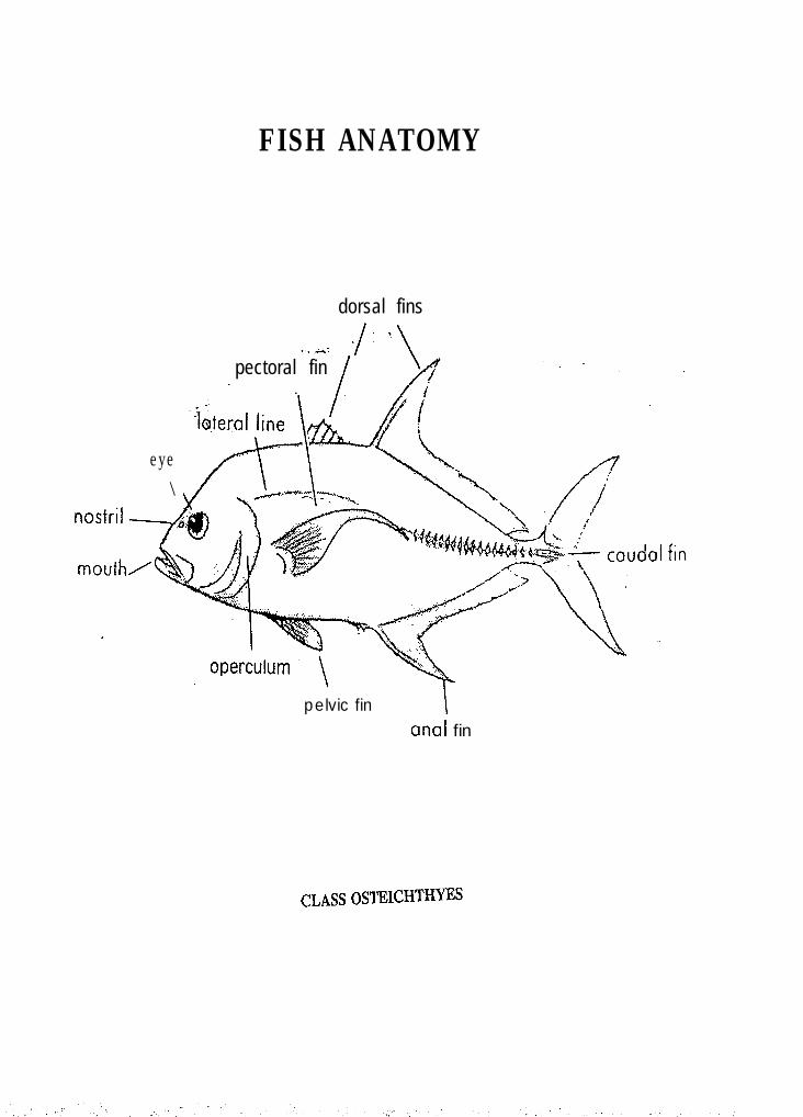
eye\
FISH ANATOMY
dorsal fins ./. ‘\
_. -r:pectoral fin
. I
pelvic fin Icinal fin
CLASSOSTEICHTHYES
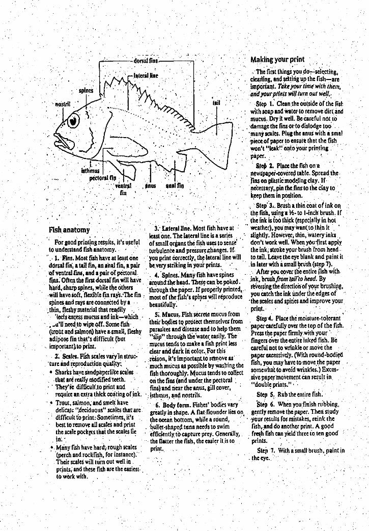
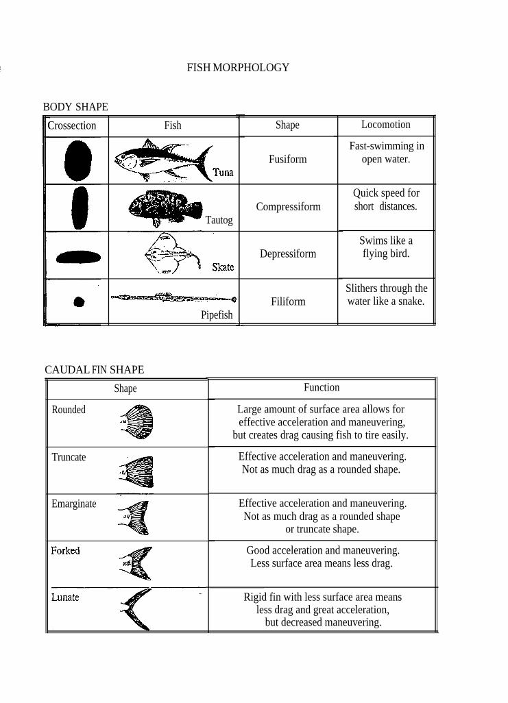
FISH MORPHOLOGY
BODY SHAPE
Crossection
Tautog
-4
Pipefish
Fish
CAUDAL FIN SHAPE
Shape
Rounded
Truncate
Emarginate
I
L-
Shape
Fusiform
Compressiform
Depressiform
Filiform
Locomotion
Fast-swimming inopen water.
Quick speed forshort distances.
Swims like aflying bird.
Slithers through thewater like a snake.
Function
Large amount of surface area allows foreffective acceleration and maneuvering,
but creates drag causing fish to tire easily.
Effective acceleration and maneuvering.Not as much drag as a rounded shape.
Effective acceleration and maneuvering.Not as much drag as a rounded shape
or truncate shape.
Good acceleration and maneuvering.Less surface area means less drag.
Rigid fin with less surface area meansless drag and great acceleration,
but decreased maneuvering.

ECOSYSTEM DYNAMICS IN THE HUDSON-RARITAN ESTUARY
ECOSYSTEMS
The many land forms surrounding the Hudson-Raritan Estuary create diverse habitats for avariety of plants and animals. Habitats for fish and wildlife include salt and freshwater tidalmarshes, shallow bays, barrier beaches and dune systems. Estuaries are nutrient traps and aretherefore highly productive systems. Habitats like salt marshes and sea grass beds benefitfrom the nutrients trapped there and are themselves highly productive. Many estuarineorganisms rely on the productivity and protection of salt marshes and sea grass beds. Overtime, many complex interrelationships have evolved.
The diversity of habitats is exemplified by areas that range in size from the 15 acre barrierbeach at Nassau Beach in New York, which is a nesting site for least terns and piping plovers,to the 64,000 acre Great South Bay, known for its hard clam resource and over-wintering areafor waterfowl. The Piermont Marsh, one of the largest wetland areas on the Hudson River, isan intertidal brackish marsh and providing a significant coastal fish and wildlife habitat on theHudson River.
LOSS OF HABITAT
Although no scientific data exists on the status of the Estuary at the time of the arrival of thefirst European explorers, it can be assumed that all major river systems emptying into theEstuary were in a pristine state, with a great variety of fresh and saltwater fish in abundance.From available information, an evolving profile of Hudson-Raritan Estuary over the last 300years can be reconstructed. The reduction in climax forests was the greatest single changeoccurring in the Hudson-Raritan watershed. Deforestation and plowing led to increased soilerosion which resulted in higher silt loads and greater flooding in the various river systems,Rising water temperatures, also the result of deforestation, have been noted since pre-colonialtimes.
In 1609 when Henry Hudson explored the area, much of what is now Jersey City, Hoboken,and Bayonne between the Hudson and Hackensack Rivers was an extensive marsh and sanddune delta interwoven with creeks. Liberty and Ellis Island were called Great Oyster Islandand Oyster Island, respectively, because of the extensive oyster reefs that surrounded them.Nineteenth century urbanization and industrialization of the entire New York Harbor arearesulted in population increases, pollution and wetland development. The development of themarshes, once considered wastelands, was viewed as beneficial since it provided more usableland. Unfortunately, this uncontrolled wetland filling also caused significant reduction inhabitat for birds, fish and shellfish.
Exact estimates of wetland loss within the Estuary are not available, but limited historicalinformation does exist. More than one-fourth of Manhattan Island was made by filling 3,650
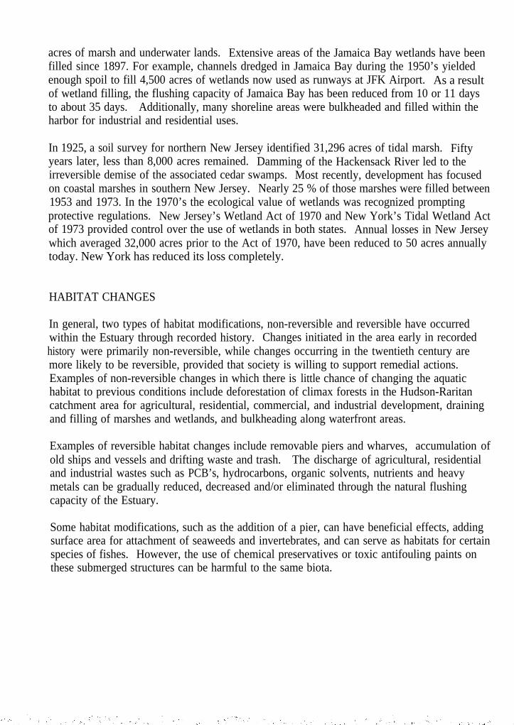
acres of marsh and underwater lands. Extensive areas of the Jamaica Bay wetlands have beenfilled since 1897. For example, channels dredged in Jamaica Bay during the 1950’s yieldedenough spoil to fill 4,500 acres of wetlands now used as runways at JFK Airport. As a resultof wetland filling, the flushing capacity of Jamaica Bay has been reduced from 10 or 11 daysto about 35 days. Additionally, many shoreline areas were bulkheaded and filled within theharbor for industrial and residential uses.
In 1925, a soil survey for northern New Jersey identified 31,296 acres of tidal marsh. Fiftyyears later, less than 8,000 acres remained. Damming of the Hackensack River led to theirreversible demise of the associated cedar swamps. Most recently, development has focusedon coastal marshes in southern New Jersey. Nearly 25 % of those marshes were filled between1953 and 1973. In the 1970’s the ecological value of wetlands was recognized promptingprotective regulations. New Jersey’s Wetland Act of 1970 and New York’s Tidal Wetland Actof 1973 provided control over the use of wetlands in both states. Annual losses in New Jerseywhich averaged 32,000 acres prior to the Act of 1970, have been reduced to 50 acres annuallytoday. New York has reduced its loss completely.
HABITAT CHANGES
In general, two types of habitat modifications, non-reversible and reversible have occurredwithin the Estuary through recorded history. Changes initiated in the area early in recordedhistory were primarily non-reversible, while changes occurring in the twentieth century aremore likely to be reversible, provided that society is willing to support remedial actions.Examples of non-reversible changes in which there is little chance of changing the aquatichabitat to previous conditions include deforestation of climax forests in the Hudson-Raritancatchment area for agricultural, residential, commercial, and industrial development, drainingand filling of marshes and wetlands, and bulkheading along waterfront areas.
Examples of reversible habitat changes include removable piers and wharves, accumulation ofold ships and vessels and drifting waste and trash. The discharge of agricultural, residentialand industrial wastes such as PCB’s, hydrocarbons, organic solvents, nutrients and heavymetals can be gradually reduced, decreased and/or eliminated through the natural flushingcapacity of the Estuary.
Some habitat modifications, such as the addition of a pier, can have beneficial effects, addingsurface area for attachment of seaweeds and invertebrates, and can serve as habitats for certainspecies of fishes. However, the use of chemical preservatives or toxic antifouling paints onthese submerged structures can be harmful to the same biota.
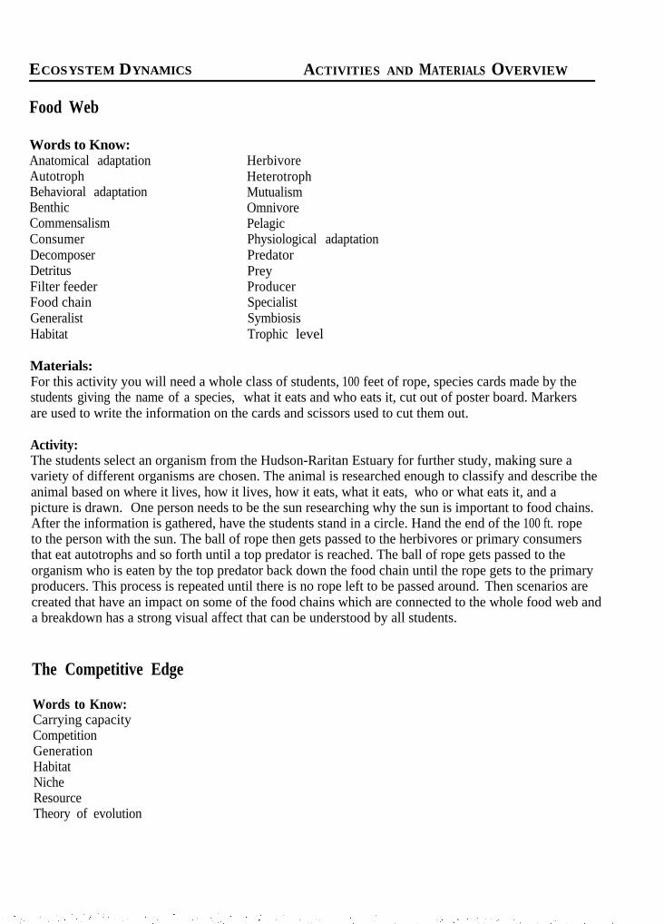
ECOSYSTEM DYNAMICS ACTIVITIES AND MATERIALS OVERVIEW
!Food Web
Words to Know:Anatomical adaptation HerbivoreAutotroph HeterotrophBehavioral adaptation MutualismBenthic OmnivoreCommensalism PelagicConsumer Physiological adaptationDecomposer PredatorDetritus PreyFilter feeder ProducerFood chain SpecialistGeneralist SymbiosisHabitat Trophic level
Materials:For this activity you will need a whole class of students, 100 feet of rope, species cards made by thestudents giving the name of a species, what it eats and who eats it, cut out of poster board. Markersare used to write the information on the cards and scissors used to cut them out.
Activity:The students select an organism from the Hudson-Raritan Estuary for further study, making sure avariety of different organisms are chosen. The animal is researched enough to classify and describe theanimal based on where it lives, how it lives, how it eats, what it eats, who or what eats it, and apicture is drawn. One person needs to be the sun researching why the sun is important to food chains.After the information is gathered, have the students stand in a circle. Hand the end of the 100 ft. ropeto the person with the sun. The ball of rope then gets passed to the herbivores or primary consumersthat eat autotrophs and so forth until a top predator is reached. The ball of rope gets passed to theorganism who is eaten by the top predator back down the food chain until the rope gets to the primaryproducers. This process is repeated until there is no rope left to be passed around. Then scenarios arecreated that have an impact on some of the food chains which are connected to the whole food web anda breakdown has a strong visual affect that can be understood by all students.
The Competitive Edge
Words to Know:Carrying capacityCompetitionGenerationHabitatNicheResourceTheory of evolution
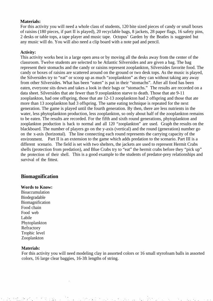
Materials:For this activity you will need a whole class of students, 120 bite sized pieces of candy or small boxesof raisins (180 pieces, if part II is played), 20 recyclable bags, 8 jackets, 28 paper flags, 16 safety pins,2 desks or table tops, a tape player and music tape. Octopus’ Garden by the Beatles is suggested butany music will do. You will also need a clip board with a note pad and pencil.
Activity:This activity works best in a large open area or by moving all the desks away from the center of theclassroom. Twelve students are selected to be Atlantic Silversides and are given a bag. The bagrepresent their stomachs and the candy or raisins represent zooplankton, Silversides favorite food. Thecandy or boxes of raisins are scattered around on the ground or two desk tops. As the music is played,the Silversides try to “eat” or scoop up as much “zooplankton” as they can without taking any awayfrom other Silversides. What has been “eaten” is put in their “stomachs”. After all food has beeneaten, everyone sits down and takes a look in their bags or “stomachs.” The results are recorded on adata sheet. Silversides that ate fewer than 9 zooplankton starve to death. Those that ate 9-11zooplankton, had one offspring, those that ate 12-13 zooplankton had 2 offspring and those that atemore than 13 zooplankton had 3 offspring. The same eating technique is repeated for the nextgeneration. The game is played until the fourth generation. By then, there are less nutrients in thewater, less phytoplankton production, less zooplankton, so only about half of the zooplankton remainsto be eaten. The results are recorded. For the fifth and sixth round generations, phytoplankton andzooplankton production is back to normal and all 120 “zooplankton” are used. Graph the results on theblackboard. The number of players go on the y-axis (vertical) and the round (generation) number goon the x-axis (horizontal). The line connecting each round represents the carrying capacity of theenvironment. Part II is an extension to the game which adds predation to the scenario. Part III is adifferent scenario. The field is set with two shelters, the jackets are used to represent Hermit Crabsshells (protection from predation), and Blue Crabs try to “eat” the hermit crabs before they “pick up”the protection of their shell. This is a good example to the students of predator-prey relationships andsurvival of the fittest.
Biomagnification
Words to Know:BioaccumulationBiodegradableBiomagnificationFood chainFood webLabilePhytoplanktonRefractoryTrophic levelZooplankton
Materials:For this activity you will need modeling clay in assorted colors or 16 small styrofoam balls in assortedcolors, 16 large clear baggies, 16-3ft lengths of string.
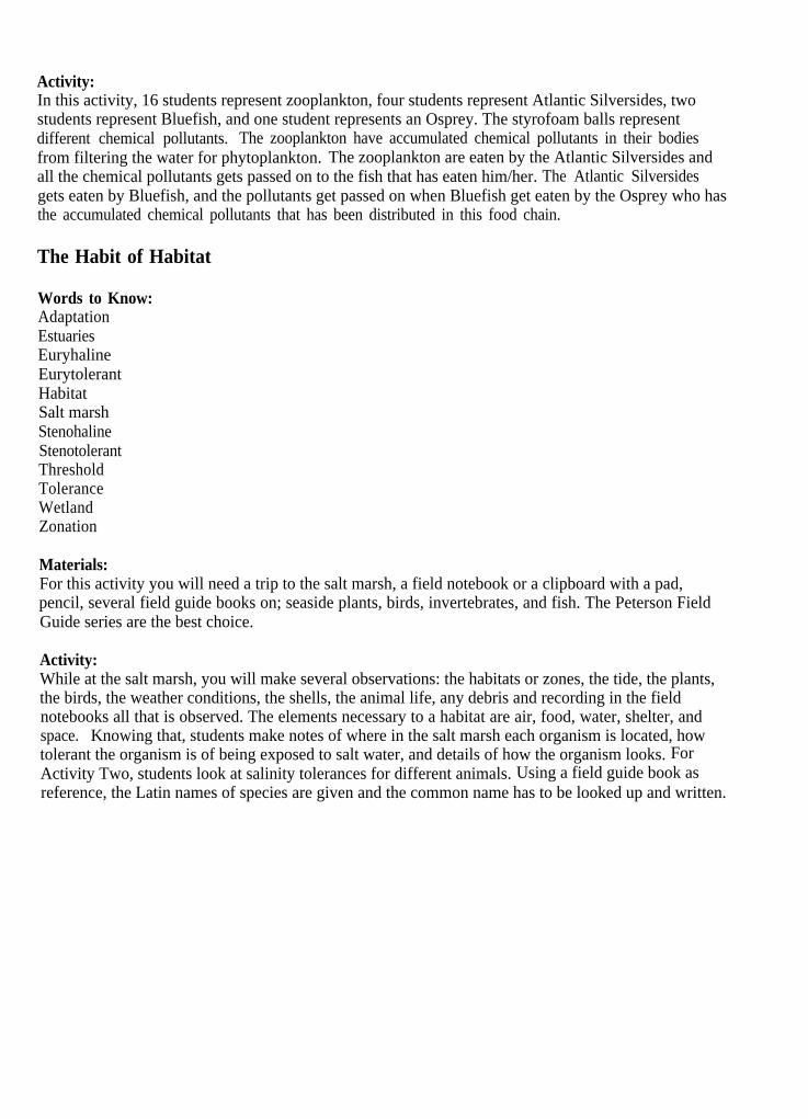
Activity:In this activity, 16 students represent zooplankton, four students represent Atlantic Silversides, twostudents represent Bluefish, and one student represents an Osprey. The styrofoam balls representdifferent chemical pollutants. The zooplankton have accumulated chemical pollutants in their bodiesfrom filtering the water for phytoplankton. The zooplankton are eaten by the Atlantic Silversides andall the chemical pollutants gets passed on to the fish that has eaten him/her. The Atlantic Silversidesgets eaten by Bluefish, and the pollutants get passed on when Bluefish get eaten by the Osprey who hasthe accumulated chemical pollutants that has been distributed in this food chain.
The Habit of Habitat
Words to Know:AdaptationEstuariesEuryhalineEurytolerantHabitatSalt marshStenohalineStenotolerantThresholdToleranceWetlandZonation
Materials:For this activity you will need a trip to the salt marsh, a field notebook or a clipboard with a pad,pencil, several field guide books on; seaside plants, birds, invertebrates, and fish. The Peterson FieldGuide series are the best choice.
Activity:While at the salt marsh, you will make several observations: the habitats or zones, the tide, the plants,the birds, the weather conditions, the shells, the animal life, any debris and recording in the fieldnotebooks all that is observed. The elements necessary to a habitat are air, food, water, shelter, andspace. Knowing that, students make notes of where in the salt marsh each organism is located, howtolerant the organism is of being exposed to salt water, and details of how the organism looks. ForActivity Two, students look at salinity tolerances for different animals. Using a field guide book asreference, the Latin names of species are given and the common name has to be looked up and written.
ECOSYSTEM DYNAMICS STUDENT ACTIVITY
Food Web
Objectives: 1) You will learn some of the food chains of estuarine communities.2) You will learn that estuarine food chains are complex, and estuarine organisms are
highly interdependent.3) You will identify what happens if there is a breakdown in the food web due to
anthropogenic effects (eg. pollution, overfishing, habitat, destruction, etc.)4) You will learn how changes in estuarine communities caused by humans affect food
chains and other interactions between organisms.
Background: Water circulation in estuaries is restricted because they are enclosed embayments. Thisretains nutrients and organic matter necessary for growth, making it a highly productive ecosystem.This is one reason why salt marshes can exist in estuaries. Salt marshes themselves are the mostproductive habitats in estuarine ecosystems. The high productivity in estuaries begins with the primaryproducers such as phytoplankton, salt marsh grasses, sea grass, and algae. Of these, phytoplanktonand detritus from salt marsh grasses form the most important food chain bases. Generally, there arefive trophic levels in the Hudson-Raritan Estuary food web. The primary producers make up the firsttrophic level, the primary consumers which eat the primary producers make up the second trophiclevel, the secondary consumers which eat the primary consumers make up the third trophic level, andtertiary and quaternary consumers make up the fourth and fifth trophic levels. All the organisms in theEstuary are highly interdependent, and a change in one population will always affect other populations.
Words to Know:Anatomical adaptationAnthropogenic effectsAutotrophBehavioral adaptationBenthicCommensalismConsumerDecomposerDetritusFilter feederFood chainGeneralistHabitatHerbivoreHeterotrophMutualismOmnivorePelagicPhysiological adaptationPredatorPreyProducerSpecialist
SymbiosisTrophic level
Materials:100 ft. ropePoster board, Markers, Scissors
Activity One:1) Look up or review the “Words to Know”:before starting this activity.2) Select an organism from the Hudson-RaritanEstuary for further study, making sure a varietyof different kinds of organisms are chosen (eg.phytoplankton, zooplankton, blue crab, stripedbass, osprey, humans, flounder, grass shrimp,etc.). Make a list of the organisms that it eats.Research the animal you have selected enough toclassify and describe the organism based onwhere it lives, how it lives, how it eats, and whatit eats. One person should select the sun. Theperson researching the sun should study why thesun is important to food chains.3) Draw a picture of the organism you studied tofit on a card approximately 6"x8" made out of
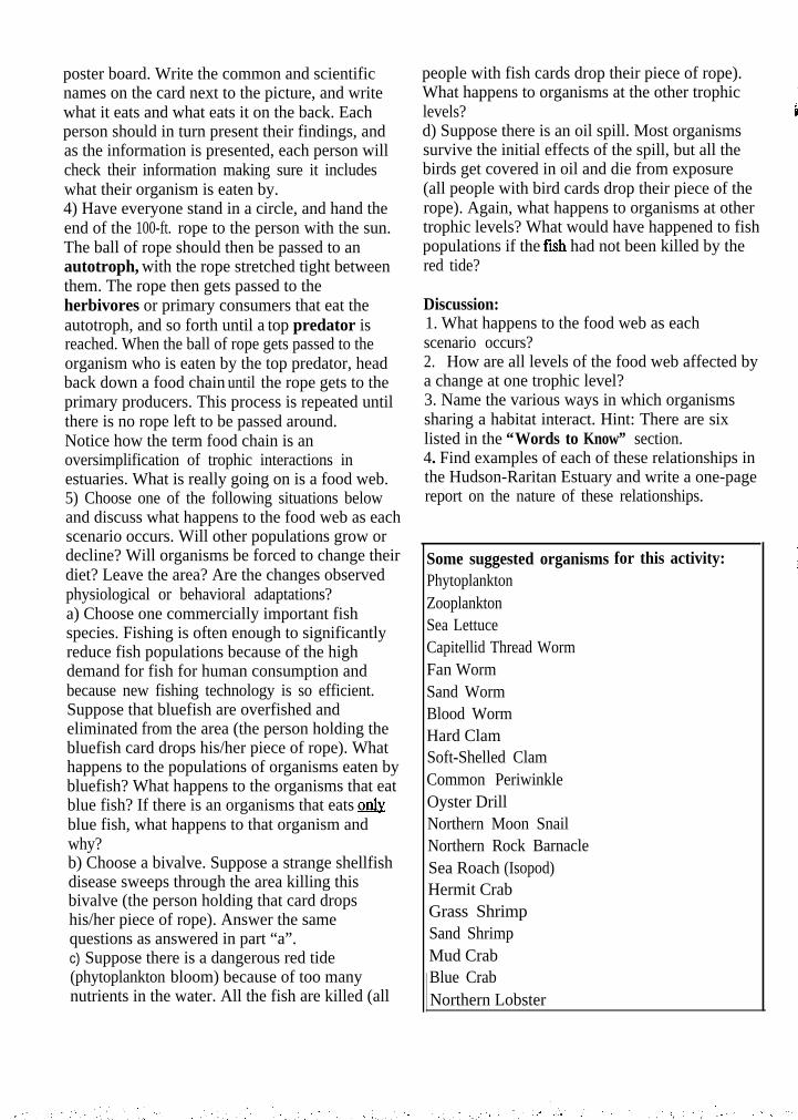
poster board. Write the common and scientificnames on the card next to the picture, and writewhat it eats and what eats it on the back. Eachperson should in turn present their findings, andas the information is presented, each person willcheck their information making sure it includeswhat their organism is eaten by.4) Have everyone stand in a circle, and hand theend of the 100-ft. rope to the person with the sun.The ball of rope should then be passed to anautotroph, with the rope stretched tight betweenthem. The rope then gets passed to theherbivores or primary consumers that eat theautotroph, and so forth until a top predator isreached. When the ball of rope gets passed to theorganism who is eaten by the top predator, headback down a food chain until the rope gets to theprimary producers. This process is repeated untilthere is no rope left to be passed around.Notice how the term food chain is anoversimplification of trophic interactions inestuaries. What is really going on is a food web.5) Choose one of the following situations belowand discuss what happens to the food web as eachscenario occurs. Will other populations grow ordecline? Will organisms be forced to change theirdiet? Leave the area? Are the changes observedphysiological or behavioral adaptations?a) Choose one commercially important fishspecies. Fishing is often enough to significantlyreduce fish populations because of the highdemand for fish for human consumption andbecause new fishing technology is so efficient.Suppose that bluefish are overfished andeliminated from the area (the person holding thebluefish card drops his/her piece of rope). Whathappens to the populations of organisms eaten bybluefish? What happens to the organisms that eatblue fish? If there is an organisms that eats &blue fish, what happens to that organism andwhy?b) Choose a bivalve. Suppose a strange shellfishdisease sweeps through the area killing thisbivalve (the person holding that card dropshis/her piece of rope). Answer the samequestions as answered in part “a”.c) Suppose there is a dangerous red tide(phytoplankton bloom) because of too manynutrients in the water. All the fish are killed (all
people with fish cards drop their piece of rope).What happens to organisms at the other trophiclevels?d) Suppose there is an oil spill. Most organismssurvive the initial effects of the spill, but all thebirds get covered in oil and die from exposure(all people with bird cards drop their piece of therope). Again, what happens to organisms at othertrophic levels? What would have happened to fishpopulations if the fuh had not been killed by thered tide?
Discussion:1. What happens to the food web as eachscenario occurs?2. How are all levels of the food web affected bya change at one trophic level?3. Name the various ways in which organismssharing a habitat interact. Hint: There are sixlisted in the “Words to Know” section.4. Find examples of each of these relationships inthe Hudson-Raritan Estuary and write a one-pagereport on the nature of these relationships.
Some suggested organisms for this activity:PhytoplanktonZooplanktonSea LettuceCapitellid Thread WormFan WormSand WormBlood WormHard ClamSoft-Shelled ClamCommon PeriwinkleOyster DrillNorthern Moon SnailNorthern Rock BarnacleSea Roach (Isopod)Hermit CrabGrass ShrimpSand ShrimpMud CrabBlue CrabNorthern Lobster

I-
Horseshoe CrabBoreal AsteriasLittle SkateAtlantic SilversideMummichogStriped KillifishBay AnchovySea RobinAmerican EelMenhadenWeakfishSummer FlounderWinter FlounderThreespine SticklebackBluefishStriped BassPiping PloverRing-Billed GullSnowy EgretGreat Blue HeronOsprey
,Humans
ECOSYSTEM DYNAMICS STUDENT ACTIVITY
Biomagnification
Objective: 1) You will be able to understand how and why poisons in the environment accumulatein organisms higher in the food chain.
Background: The natural shoreline of the Hudson-Raritan Estuary has been changed drastically byhumans from forests and tidal wetlands to residential communities, industrial areas, ports and cities.Human activity has also dumped pollutants of all kinds into the local waters from quicklybiodegradable organic pollutants like sewage to nondegradable chemical pollutants like the pesticideDDT. This is a problem in estuaries, which, by nature, trap pollutants. Sewage and nutrient pollutionresults in algae blooms, low dissolved oxygen and pathogenic bacteria, but the effects are relativelyshort-term provided the source of the problem is eliminated. More refractory materials remain in theestuary for very long periods of time because they are not used up or degraded, and they are eitherburied as they bind with sediment particles and sink to the bottom, or they enter the food web.Chemicals that initially enter the food web through air, water, or sediment will accumulate at one levelof the food web. Water-soluble chemicals will accumulate in food webs until they reach aconcentration in organisms bodies that is in balance with the environment. Fat-soluble chemicals bindto fatty tissues in organisms as they are ingested. Because organisms at higher trophic levels must eat alarge number of organisms at lower trophic levels to get enough food, these chemicals tend to becomebioaccumulated in organisms' bodies as they get passed up the food chain.
Words to Know:BioaccumulationBiodegradableBiomagnificationFood chainFood webTrophic level
Materials:Modeling clay in assorted colors or 16 smallStyrofoam balls in assorted colors16-Large clear bags16-3ft lengths of string23 students
Activity One:1) Take a piece of string and attach a bag to thestring so that it forms a pouch when tied aroundyour waist.2) Form the clay into small balls and allow theseor the styrofoam to represent different chemicalpollutants. More advanced students with abackground in chemical bonds and moleculesshould try to create a DDT molecule using the
balls and the toothpicks to emphasize howcomplex the more refractory pollutants are.3) Have the class divide into groups thatrepresent organisms at different trophic levels.Because consumers must expend energy to obtainfood and maintain their bodies, and because somefood is lost as waste material, it takes moreorganisms at lower trophic levels to nourishorganisms at higher trophic levels. The groupsthat represent organisms at lower trophic levelsshould be larger. Have sixteen students representzooplankton, four students represent AtlanticSilversides, two students represent Bluefish, andone student represent an Osprey.4) Imagine that zooplankton have accumulatedchemical pollutants in their bodies from filteringthe water to eat phytoplankton. Eachzooplankton at this point should have one ormore different colored balls in his/her pouch.5) The zooplankton are then eaten by the AtlanticSilversides. All chemical pollutants that eachzooplankton has accumulated in his/her body(pouch) gets passed on to the fish that has eatenhim/her. The Atlantic Silversides now have all
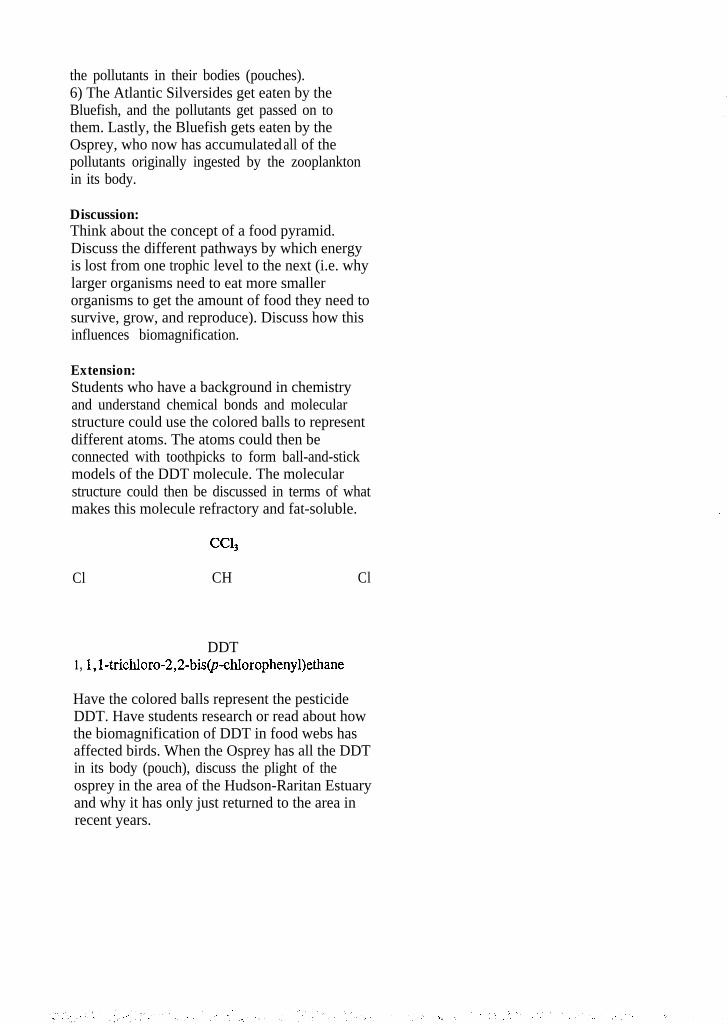
the pollutants in their bodies (pouches).6) The Atlantic Silversides get eaten by theBluefish, and the pollutants get passed on tothem. Lastly, the Bluefish gets eaten by theOsprey, who now has accumulated all of thepollutants originally ingested by the zooplanktonin its body.
Discussion:Think about the concept of a food pyramid.Discuss the different pathways by which energyis lost from one trophic level to the next (i.e. whylarger organisms need to eat more smallerorganisms to get the amount of food they need tosurvive, grow, and reproduce). Discuss how thisinfluences biomagnification.
Extension:Students who have a background in chemistryand understand chemical bonds and molecularstructure could use the colored balls to representdifferent atoms. The atoms could then beconnected with toothpicks to form ball-and-stickmodels of the DDT molecule. The molecularstructure could then be discussed in terms of whatmakes this molecule refractory and fat-soluble.
Cl CH Cl
DDT1, l,l-trichloro-2,2-bis@chlorophenyl)ethane
Have the colored balls represent the pesticideDDT. Have students research or read about howthe biomagnification of DDT in food webs hasaffected birds. When the Osprey has all the DDTin its body (pouch), discuss the plight of theosprey in the area of the Hudson-Raritan Estuaryand why it has only just returned to the area inrecent years.
ECOSYSTEM DYNAMICS STUDENT ACTIVITY
The Competitive Edge
Objectives: 1) You will be able to use a model of a simple food chain.2) You will be able to understand how organisms compete for food and shelter.3) You will be able to explain how the availability of a resource can limit a population
which depends on that resource.
Background: All organisms occupy a niche in a habitat. The most simple definition of a habitat is aplace where an organism lives. Therefore all the things an organism needs to live must be contained ina habitat. The essentials are air, water, food, shelter, and space. These essentials are calledresources. Resources, however, are not unlimited. There is only so much food and space available onthis earth, and in each habitat, and only a certain number of organisms can be supported. This is calledthe carrying capacity of a habitat. When the number of organisms has reached carrying capacity, theorganisms will begin to compete for resources. Some organisms are better competitors than others,and they will survive while the weaker organisms die. This is the basis of Charles Darwin’s theory ofevolution - “survival of the fittest”.
Words to Know:Carrying capacityCompetitionHabitatNicheResourceTheory of evolution
Materials:A class of students120 bite-size pieces of candy (wrapped) or smallboxes of raisins20 recyclable or recycled bags8 jackets28 paper flags, 16 safety pins2 desksA tape player and a music tape (“Octopus’Garden” by the Beatles is appropriate, but anymusic will do)A clip board with a note padPencil
Activity:This activity is best played outside or in a largeopen area like a gym. Simply moving all desksand chairs away from the center of the room maysuffice if the classroom is large enough.
Part I: Competition for Food1) Select 12 students to be Atlantic Silversides,and give them each a bag. The bags are theirstomachs, and the candy or raisins representzooplankton. Silversides love to eat zooplankton.2) Scatter the candy or raisins around on theground. When the music starts to play, theSilversides will try to “eat” as much zooplanktonas they can without taking any away from anyother Silverside. As each Silverside “eats” a“zooplankton”, he/she puts it in his/her“stomach”. When all the zooplankton have been“eaten”, stop the music and have everyone sitdown in a circle.3) All Silversides should empty their stomachs onthe ground in front of them. Did all theSilversides get the same amount of food? Theanswer is probably no, some fish are better atsearching for food than others. Those that atemore produce more offspring. Record the resultson a data sheet. Silversides that ate fewer thannine zooplankton starve to death, those that ate 9-11 had 1 offspring, those that got 12 or 13zooplankton had 2 offspring, and those that atemore than 13 zooplankton had 3 offspring.4) Repeat the game for the next generation ofSilversides. The number of Silversides in thisround should equal the number of offspring fromthe last round. Rescatter the “zooplankton”, and
have the new Silversides “eat”. Record the resultsagain and repeat the game again.5) For the fourth round generation, pretend thatthere were less nutrients in the water. There wasless phytoplankton production, and thereforethere was less zooplankton production becausezooplankton eat phytoplankton. Remove half ofthe zooplankton, and repeat the game. For thefifth and sixth round generations, phytoplanktonand zooplankton production returns to normaland all 120 “zooplankton” are used.6) Back in the classroom, graph the results on theblackboard. Plot the number of players(Silverside offspring) on the y-axis (vertical) andwrite the round number (generation) on the x-axis(horizontal). The number of players initiallyshould be marked at zero along the x-axis, thenumber of offspring from the first round of thegame at round (generation) 1, and so forth. Drawa dotted line across the graph representing thecarrying capacity (K) of the environment. This isthe number of organisms that can be supported atany point in time. For generation 4, K=6, andfor all other generations and the initialpopulation, K=12.
Discussion:Discuss how the numbers of offspring relate tothe carrying capacity of the environment. Eventhough there was enough food at first for all ofthe Silversides, some were better at competingfor food than others, and they used this extrafood to reproduce. The better competitors hadmore offspring. If this trick or adaptation isinherited, the next generation will also be betterat finding food, and more animals in the nextgeneration will be more fit competitors becausethe better competitors have more offspring.
Part II1) Go back outside for two more rounds. There isno need to record results this time. For the firstround, start with twelve Silversides. Have twopeople represent Bluefish that prey on theSilversides, and have one side of your fieldrepresent saltmarsh cordgrass which provides agood hiding spot for the Silversides. Mark thisside of the field with two desks. Once aSilverside passes between the two desks, it cannot
be eaten by a Bluefish. Once again, scatter the“zooplankton” on the field and begin to play.This time, each Silverside has a paper flag pinnedto his/her back, which the Bluefish try to tear off.If the Bluefish tears off a Silverside’s flag, theSilverside must give the Bluefish his/her“stomach” and leave the playing field. When allthe food is gone, stop the music and count thenumber of offspring each surviving Silversidehad. How did predation on the Silversides reducecompetition for food among Silversides?2) For the final round, increase the number ofzooplankton to 180 and keep the number ofSilversides at 12. There will be no predators forthis round. Scatter the food over the field andplay again. Count the number of offspringproduced. Did the number of offspring increasetoward the new carrying capacity of theenvironment (18)? If you like, play enoughrounds to get the population to meetenvironmental carrying capacity.
Part III: Competition for Shelter1) Set up your playing field for a differentscenario. Place two desks at opposite ends of thefield as shelter. Each shelter is only large enoughfor two organisms, but these two organisms aresafe from predators when in the shelter. Scattereight jackets around the playing field. Have threestudents playing Blue Crabs ready to eat newlysettled Hermit Crabs.2) Select sixteen students to play Hermit Crabsthat have just settled out of the plankton. TheseHermit Crabs need to find shells (jackets) to livein to protect them from being eaten by predators.Each Hermit Crab has a flag pinned to its back,representing its life.3) Begin playing the music, and have the HermitCrabs move out onto the field. The Hermit Crabsneed to find shells (jackets) before they are eatenby the Blue Crabs. Meanwhile, the Blue Crabstry to take the flags off the Hermit Crabs’ backs.If a Hermit Crab loses his/her flag, he/she mustleave the field. When all jackets are gone, allshelters are occupied, and there are no morehermit crabs to be eaten, turn the music off andend the game.

Discussion:1. How does this activity relate to the real lifesituation?2. Discuss how the more fit Hermit Crabs foundshelter and escaped being eaten.3. How does predation pressure help prevent thenumber of organisms exceeding environmentalcarrying capacity?
ECOSYSTEM DYNAMICS
The Habit of Habitat
STUDENT ACTIVITY
Objectives: 1) You will know what a habitat is.2) You will be able to describe how a habitat is defined.3) You will understand how the characteristics of estuarine habitats affect what
organisms live in it.
Background: Estuaries are places where saltwater and freshwater meet and mix, where land meetswater, where there is variable wave action, and where a wide range of extremes exist. All thesefactors contribute to the wide variety of habitats found in estuaries. You probably already know that ahabitat is a place where organisms live, and it is usually described by the dominant life form (eg. seagrass meadows) or a defining physical parameter (eg. intertidal zone). Habitats are in fact defined by amultitude of different physical environmental parameters. In estuaries, some of those parametersinclude salinity (fresh to marine), bottom type (hard substrate or sediment), sediment type (sandy ormuddy), coverage (vegetated or un-vegetated), tidal influence (intertidal or subtidal), water depth(shallow or deep), or wave energy (high or low). The reason physical parameters are used to definehabitats relate to organisms adaptations. Physical parameters influence where an organism lives asdetermined by the organism’s tolerance thresholds. A habitat is also defined by the organisms usingit. For example, the osprey may utilize all aspects of a salt marsh, thereby defining the entire saltmarsh as its habitat. On the other hand, salt meadow hay (Spartina patens) can only be found in thehigh intertidal zone, so the upper part of the low marsh is its habitat. Different salt marsh habitats existin part because of the amount of time that area of the marsh is covered by water. This tidal influence isresponsible for how organisms use a habitat and results in zonation. Zonation reflects the differenttolerances of plant and animal species to salt water.
Words to Know:AdaptationEstuaryEuryhalineHabitatSalt marshStenohalineThresholdToleranceWetlandZonation
Materials:Several field guide books with at least one foreach of the following categories: seaside plants,birds, invertebrates, and fish (the Peterson FieldGuide series is best)Field notebook or a clipboard with a padPaper and pencils
Activity One:1) Take a trip to a salt marsh. Make observationsabout the habitats or zones, the tide, the plants,the birds, the weather conditions, the shells, theanimal life, and any debris. When you are hikingnear the marsh, how many habitats or zones doyou see at first glance? What makes thesehabitats different? Where are the mean high tideline and the mean low tide line? How can youlocate them?2) Recall the elements necessary to have ahabitat - air, food, water, shelter, and space.Identify as many plants and animals as you canusing your field guides without disturbing themarsh. Make note of where in the salt marsheach organism is located. Speculate on how theirhabitat provides the five requirements, and howtolerant the organisms are to being covered withsalt water. For example, fish and seagrass needto be covered by water all the time, so they areonly found in the marsh creek. Meanwhile,


WATER QUALITY ISSUES
Although water quality varies greatly, it is clear that the waters of the Hudson-Raritan Estuaryhave been substantially impacted by contaminants attributable to urban development. Waterquality conditions are especially varied because the area is home to a major seaport, largeindustrial complexes and residential and commercial facilities serving large industrial anddomestic needs. Consequently, much of the Hudson-Raritan Estuary is not considered fishableor swimmable.
Many sources contribute to the pollution of the Hudson-Raritan Estuary. Some contaminantsenter the Hudson-Raritan Estuary from the rivers and streams that drain into this watershed.Some enter the Estuary directly from outfalls, runoff, and rainfall. Rainfall and runoff aremajor source of water for the Hudson-Raritan Estuary. The old view that rainwater is asubstance of high purity has been displaced in the past twenty years by the realization thatpollutants in the air are incorporated into rain. Resulting precipitation can carry significantconcentrations of these pollutants.
Major sources of pollution include controlled point sources, such as from industry and sewagetreatment; uncontrolled point sources, such as combined sewer overflows and storm sewerdischarges; non-point sources, such as urban and agricultural runoff; dredging; leachate fromlandfills; chronic and acute spills of oil and other contaminants; thermal pollution and airpollution deposition from nearby and distant locations. Floatable debris from various sourcesis a visible problem. The extent of illegal dumping is unknown, but may be significant.
FLUSHING CAPACITY AND POLLUTANT TRANSPORT
Freshwater flow is one of the mechanisms that transports pollutants within and out of thesystem. Large amounts of pollutants are brought to the Estuary from upstream sources. Themovement of waters between various bodies of water within the Estuary governs the probablepaths of pollutants that are discharged from various point and nonpoint sources. Movement ofwater in, out, and through the Hudson-Raritan system affects water quality. Circulation withinthe Hudson-Raritan Estuary, the transport of material through the Estuary, and the exchangeof the estuarine water with the Atlantic Ocean are complex processes. The time scale of thesevaries from a few hours to several months. The irregular form and depth of the Estuarycontribute to the complexity of all water quality issues. Sea level variations at the Estuary’sconnections with the open ocean, regional and local winds, and freshwater discharge areadditional contributing factors.
The physical and chemical characteristics (shallow depth, poor circulation, and mixing of freshand saltwater) cause pollutants to be flushed relatively slowly. There is a tendency forpollutants to settle to the bottom. The most critical period for water quality occurs during thesummer months. At this time, river flows are at minimums, causing low flushing capacity inthe system. Water temperature is at a maximum, causing lower saturated oxygen levels andhigher biological productivity.
INDICATORS OF DEGRADATION
Although much of the Estuary’s water quality is good enough to support a healthy, diversepopulation of aquatic organisms, pollution and overuse of the Hudson-Raritan Estuary causemany problems. In some cases pollution impairs human use of the Estuary. In other casespollution damages the health and functioning of the estuarine ecosystem. Evidence ofecosystem stress in the Hudson-Raritan Estuary includes chemical contamination, fisheryclosures, fish consumption advisories, fish diseases and fish kills, changes in the distributionand abundance of living organisms, eutrophication and algal blooms, bathing beach closures,and aesthetic degradation.
CHEMICAL CONTAMINATION
. Many estuarine systems in the United States are used as depositories for toxic and non-toxicwaste. These chemicals enter the system from sewage, industrial, and non-point sources. TheHudson-Raritan Estuary is no exception and is continuously exposed to varying concentrationsof chemical mixtures.
Chemicals considered to be contaminants in an estuarine environment are contained in threebasic reservoirs: water, sediment, and biota. The biota reservoir is extremely important sinceorganisms in an estuary can be adversely affected, and human health hazards can arise throughconsumption of the affected organisms. The quantity of the contaminants in the biota reservoiris small, however, compared to the water reservoir which, in turn, is much smaller than thesediment reservoir. The consequence of this hierarchy is that, at any point in time, the greatmajority of contaminants in an estuary reside in the sediments.
Reports of chemical pollution in Hudson-Raritan Estuary sediments have identified metals,petroleum hydrocarbons, pesticides and halogenated hydrocarbons as the major contaminants.Trace metal contaminants include high concentrations of zinc, copper, lead, cadmium andmercury. The sediments act as a sink or reservoir for both heavy metal and organiccontaminants, taking toxic chemicals from the water column and releasing them whenenvironmental conditions are suitable. Sediments in many parts of the Estuary are also heavilycontaminated with oil and grease. Newark Bay and the Arthur Kill appear to be the mostseverely contaminated. Within Newark Bay the highest concentrations occur in the vicinity ofthe mouths of the Passaic and Hackensack Rivers and the Arthur Kill.
The salt marshes which still exist along the shoreline of the Estuary appear to have becomesinks for heavy metals. Extremely high concentrations of metals have been found in marshsediments along the Arthur Kill, yet the creeks draining these marshes do not appear to beexporting the metals. The Harbor is the ultimate sink for toxins associated with sediments forthe entire Hudson/Mohawk basin within New York State. Similarly, Passaic River sedimentsare believed to be a major source of dioxin to the area. Many of the contributing industries(e.g., metal refineries) no longer exist but their discharged wastes still remain within thesediments. Sediments in this case, are the memory of past abuses.

Unfortunately, many sources of pollutants are still present. Point and nonpoint dischargesand other inputs continue to contaminate sediments. Ocean disposal of dredged material andsludge may also impact the area.
Raritan Bay is one of fifty national sites studied in the National Oceanic and AtmosphericAdministration (NOAA) National Status and Trend Program for marine environmental quality.Sediments were analyzed for various metals, pesticides, PCBs, PAHs and sewage-by-products.Of the sites monitored throughout the country, the sediments of Raritan Bay had the fifthhighest PAH (polyaromatic hydrocarbons) levels and the third highest PCB and DDT levels.
One of the most important questions concerning the sediments of the estuarine system iswhether the contaminants contained within them can be released. Much of the Hudson-Raritansystem consists of relatively shallow water where bottom sediments are subject to tidalcurrents, storms, waves, and boat propellers. Studies have shown that dredging of theshipping channels, agitation of sediments, and mild oxidation will cause the release ofcontaminants from sediments. Human-induced changes in the Estuary have the potential toincrease the natural processes which can release metals and organic contaminants from thesediments. One decision which must be made is whether the release of contaminants can betolerated. At this point, data is not adequate to indicate the rates of introduction of the variouscontaminants into the water column and whether they will then pass out of the system quicklyenough not to affect the biota. The release may not occur at a high enough rate to warrantconcern. However, it should be investigated before large-scale efforts are launched whichwould affect the present equilibrium in the system.
Sources which contribute to the high levels of these toxic metals in the Estuary includewastewater discharges, urban runoff, atmospheric pollutants, accidental spills, landfill leachateand tributary discharges. Wastewater might be the major contributor of most types ofpollutants, but in some cases other sources are equally important. Innovative managementstrategies must be explored to control these sources.
FISHERY CLOSURES AND ADVISORIES
Seafood suffers contamination from two major classes of pollutants - toxic chemicals andpathogens. Evidence of such contamination may result in closure of shellfish beds or fishinggrounds and the issuance of advisories about eating certain species. Health advisories seek tolimit the number of fish eaten and may reduce consumption completely by creating theimpression that eating fish is harmful. Several commercially and recreationally importantspecies in the Hudson-Raritan Estuary have become unrnarketable due to public concern aboutthe accumulation of contaminants in their tissues and the resulting concern that eating themwould pose a health risk to human consumers.
Toxic chemicals may present a health risk to people who consume contaminated fish andshellfish. PCB’s and dioxin appear to be the major toxic chemicals contaminating finfish inthe Hudson-Raritan Estuary. Fish become contaminated by ingesting tainted water and/or
food, or directly through gills and skin. Exposure to contaminated sediments also has anadverse affect on fish. Levels of contaminants found in fish are regulated by the species’ fatcontent and amount of exposure to the contaminant in question. However, the effects of thechemicals on the fish themselves is not well understood. Studies have shown a reduction inegg hatchability and an increase in egg and larval abnormalities because of elevated pollutantlevels. Metals also tend to accumulate in crustaceans. For example, cadmium levels are highin the hepatopancreas of blue claw crabs caught in the Hudson River by the Tappan ZeeBridge. PCB’s and dioxin also accumulate at high levels in the hepatopancreas of lobstersfrom this area.
Because of chemical contamination, stringent consumption advisories have been required formany important commercial and recreational species. In New York State, the advisorysuggests limiting consumption of any fish caught in New York waters to one meal per week.New York and New Jersey have issued advisories limiting consumption of bluefish, stripedbass, and American eels caught in the Hudson-Raritan Estuary. In New Jersey, channelcatfish are subject to an advisory and in New York, an advisory against consuming thehepatopancreas portion of lobsters and blue crabs, known as the “mustard” or “tomalley, hasbeen issued.
The closure of fisheries due to polychlorinated biphenyls (PCB) and dioxin contamination hashad major economic impact. Closure of shellfish beds due primarily to fecal contamination isanother major loss of economic value in the Estuary. Shellfish concentrate bacteria and otherpathogens during their normal feeding process. If these shellfish are consumed by humans, itmay cause disease.
Contamination of shellfish by pathogens in the Hudson-Raritan Estuary is caused mainly bysewage and nonpoint source pollution. In recent years the contamination has declined slightlyas the number and quality of sewage treatment plants have increased. On the other hand,contamination from stormwater runoff appears to be increasing. At present, shellfish beds inthe Estuary are closed to harvest with the exception of some beds in Raritan Bay, Sandy HookBay, and the Shrewsbury and Navesink River system which are open for harvesting with thecondition that the shellfish be depurated in clean water for a period of time to allow them torid themselves of pathogenic contaminants.
FISH DISEASES AND FISH KILLS
For finfish and invertebrates remaining in the system, elevated incidence of a variety ofdiseases, both infectious and non-infectious, have been reported. Pollution weakens theseorganisms, making them more susceptible to infections and other diseases. Certain hardyspecies in the Estuary, such as softshell clams, grass shrimp and killifish, seem to haveadapted to the polluted environment by becoming resistant to certain chemicals. However, forother species, lifespans and adaptability to environmental variables has been reduced.Although there is some evidence of disease in fish associated with pollution in the Hudson-Raritan Estuary, additional research is needed to identify the types, combinations and

concentrations of pollutants contributing to physiological stress in fishes.
Fish and shellfish in the Estuary may suffer from a variety of diseases including fin rot, shelldisease, tumors, and ulcers. Shell disease, a natural occurrence affecting lobsters, crabs andshrimp, is more widespread and severe in polluted areas. Other diseases, associated withpollution are caused by viruses and bacteria. Diseases include lymphocystis, a herpes-likevirus, vibriosis, shell disease, fin rot, skeletal anomalies, and “black gill”. Neoplastic diseasesinclude epidermal papilloma, stomatopapilloms and hepatoma. In each of these cases, theprognosis for the afflicted animal varies. Some diseases are fatal while others have little effecton their hosts.
“Fish Kills” affecting both fm and shellfish are frequently associated with decreased levels ofdissolved oxygen in water. Lowered oxygen levels are often caused by excessive algalgrowth, stimulated by an oversupply of nutrients such as nitrogen and phosphorus. Althoughthese nutrients can come from natural sources, they are also added to water by sewage andother wastes. Hypoxia or lowered oxygen levels can also be caused directly by decompositionof organic matter. There are many contributing factors to low dissolved oxygen (DO) levelsin the area; municipal discharges, incoming biological oxygen demand (BOD) from upstreampoint and nonpoint sources, combined sewer overflows (CSOs), urban runoff, industrialdischarges, landfill leachate, benthic deposits and low flow due to upstream diversions.Dissolved oxygen problems are further aggravated by thermal discharges from non-contactcooling water. Our Estuary is susceptible to DO problems.
Low DO can induce stress in organisms and modify chemical reactions in the water column.Many marine organisms use these waters during critical life stages. Low DO can affectabundance of population, reduce growth rates, and lead to avoidance of an area, placing stresson adjacent areas.
CHANGES IN DISTRIBUTION AND ABUNDANCE OF ORGANISMS
The ecological resources of the Hudson-Raritan Estuary have been negatively impacted byanthropogenic influences such as pollution from industrialization, raw sewage disposal,wetland filling and shoreline alteration, damming, dredging and overfishing. Species thatdepend on rivers and estuaries are particularly vulnerable to the negative effects of humanactivities. Available information indicates that the numbers of many species of fish andshellfish in the Hudson-Raritan Estuary region have declined. Some of this decline is due tonatural fluctuations and overfishing, but there is evidence that pollution and destruction ofhabitats are contributing factors.
Sturgeon, smelt, and oysters provided good catches for colonial fishers, but by the latenineteenth century this declined sharply. Between 1900 and 1920, the fisheries collapsedcompletely. Disease, water pollution and declining numbers of fish due to overfishing andhabitat destruction (e.g., dam building) were responsible factors. Oyster beds, once abundantin Raritan Bay, were also destroyed by pollution and overfishing. In the mid-1800’s, there

were over 400 boats and 1,000 to 3,000 people employed in the oyster industry. By the earlytwentieth century few remained.
Paralleling the decline in the oyster industry, studies made during the 1920’s recordedconsiderable reduced species richness due to environmental deterioration. This trendcontinued and in 1971, 34 of 80 benthic samples taken from various sites within the Estuaryappeared totally devoid of benthic invertebrates that are common in similar, less stressedenvironments.
EUTROPHICATION AND ALGAL BLOOMS
Eutrophication and resulting low dissolved oxygen level affect the biological resources of theEstuary. Overly high nutrient levels allow phytoplankton to grow too much, promoting algalblooms. Algal blooms are always present in coastal waters but favorable winds, watertemperatures and an over-abundant supply of nutrients cause population explosions within asingle species. Single species blooms, also known as red, green, or brown tides dependingupon the species involved, may discolor water or cause it to smell.
In Raritan Bay and nearby waters, there are typically two periods of intense growth ofphytoplankton; one in the spring dominated by diatoms and one in summer when a small greenalga is most abundant. “Red tides” or blooms of small mobile species called phytoflagellatesmost frequently occur from late June through August. Most phytoflagellate blooms last fromone to two weeks, but may persist for up to six weeks. Initial bloom development is promotedby calm weather. Blooms often spread into coastal waters one or two days later, especiallywhen the Estuary is flushed by substantial rainfalls. These blooms can extend as far south asManasquan. During years when summertime stratification of the water column develops early(due to wet, warm springs), this may seed hypoxia. Strong stratification prevents mixing ofdissolved oxygen from the surface to the bottom waters whereby bottom waters becomeoxygen depleted. When algae blooms die, they fall to the bottom using more oxygen as theydecompose, adding to the problem. Although fish can escape hypoxic conditions by moving todifferent areas, bottom dwelling shellfish cannot. An event of this type occurred in 1976destroying most of the surf clam populations off New Jersey.
Blooms causing water discoloration have occurred for the past 25 years along the shores ofNew Jersey and New York. Factors contributing to these blooms include warm temperatures,ample sunlight, an abundance of nutrients (especially nitrogen and phosphorus) in thesewaters, and quiescent weather conditions allowing cells to concentrate. Wastewatercontributes about two-thirds of these nutrients and urban and agricultural runoff contributes therest. Extensive algal blooms will continue to occur as long as favorable blooming conditionsprevail. Much of the Hudson-Raritan system has high nutrient levels, especially the ArthurKill, Kill Van Kull, East River, and Newark Bay. This region is considered eutrophic, subjectto algal blooms and low dissolved oxygen levels.
Reductions in nutrient levels both in the Hudson-Raritan and along the coast would lessen the

frequency and severity of blooms, as well as resulting dissolved oxygen problems. Sincephosphorus is easier and less expensive to control than nitrogen, nutrient reduction programsoften concentrate on phosphorus. However, phosphorus control alone may not have thedesired result. A recent study indicated that phosphorus removal in the Hudson-Raritan wouldreduce algal growth there and in adjacent coastal waters.
BATHING BEACH CLOSURES
Beaches are scattered throughout the Hudson-Raritan Estuary from New York City to theRaritan Bay and Sandy Hook Bay shorelines. Floatables and pathogens are two major causesof beach closures. Floatable debris has been a major cause of beach closures in recent years.Materials such as styrofoam, paper products, wood, tar balls, sewage, and medical wastesfrequently wash up on beaches. This debris comes from a variety of sources such as overflowof sewers that carry both stormwater and sewage, stormwater discharges, commercial andrecreational boat traffic, beach users, and accidental releases from sewage treatment plants orsolid waste transfer operations.
Pathogens are disease-producing organisms such as certain bacteria and viruses. They arepresent in sewage and in runoff from land. Health authorities measure levels of coliformbacteria as an indicator of pathogen contamination. Even though few serious illnesses fromwater contact have been reported in recent years, elevated coliform bacteria levels indicative ofpathogen contamination can cause beach closures. Although a significant portion of theEstuary could be used recreationally, high bacteria levels caused by the discharge ofinadequately treated sewage and discharges from combined sewer overflows and storm sewershave often prevented swimming. Aesthetic pleasure derived from the estuarine environmentmay be decreased as a result of many factors. Debris in water and on beaches, unpleasantsights and smells due to algal blooms, noxious conditions and fish kills caused by lack ofoxygen in the water all detract from the recreational potential of our Estuary.

WATER QUALITY ISSUES ACTIVITIES AND MATERIALS OVERVIEW
Variations in Water Quality
Words to Know:TurbidityClarityPatterns
Materials:For this activity you will need a salinity test kit, hydrometer or refractometer, pH paper, LaMotte orHach Company test kits for dissolved oxygen, pH and salinity, non-glass thermometers, clear plasticbottles or jars, safety goggles, buckets, watch with a second hand, secchi disk or white meter stick,sieves, dip net, notebook, pencils, topographic and or land use maps and a trip to a location along theHudson-Raritan Estuary any time of the year.
Activity:For this activity the students need to be familiar with all water quality testing equipment. Be sure totake time to prepare a water quality testing plan and learn how to read and interpret results. Implementsafety procedures. Follow the directions that come in the LaMotte or Hach water quality test kits. Thestudents need to develop a data sheet for field work. Some of the things on the data sheet wouldinclude: observer’s name, site location, data, time, rainfall, weather conditions, tidal stage, winddirection, temperature, salinity, dissolved oxygen, and wild life observations. This is an exercise usedto develop the use of scientific observational skills, data recording, and water quality issues in theHudson-Raritan Estuary.
Point and Non-point Pollution Involvement
Words to Know:Point sourcesNon-point sourcesPollutionPollutantsWaterways
Materials:For this activity you will need soil test kits (local garden center), poster board, video camera and tape,Styrofoam pellets, small aquarium, spoon, and various floatable and non-floatable objects.
Activity:The students have an opportunity to do research into local pollution from public, private, and industrialsources, to perform a soil test to tell the pH and nutrient levels present in the soil, and develop a planfor responsible lawn care. In the form of posters, radio broadcasts, mailings, newspaper articles, oreven a video, the students have the opportunity to educate the community. For Activity Two thestudents place various objects into a small aquarium, use a spoon to push the objects around andobserve what happens. This activity helps students to learn what happens to trash that gets discardedoverboard from a vessel, what affect wave action has on floatables, and how some things get suspendedin the system.
Nutrients- Too Much of a Good Thing
Words to Know:EutropicEutrophicationNutrientsHypoxia
Materials:For this activity you will need five one-quart glass jars, Estuary or aquarium water, fertilizer, andseveral weeks to complete this activity.
A&vi@In this activity the students observe first hand what happens when water contains too many nutrients.Jars are labeled one through five with varying levels of nutrients added to each jar and the results areobserved over time. This activity uses long term observational skills and data recording.
oil spill Clean up
Words to Know:AbsorptionSkimmingCoagulatingSinking
Materials:For this activity you will need paper towels, straw, styrofoam pieces, twigs tied together, detergent,sand, a small fish net, basins of water and oil, feathers, shells, and fur.
Activity:This activity compares various methods used in cleaning up an oil spill. The students get to study thevarious methods of oil spill clean-up available, then, using basins filled with water, experiment bycreating an oil spill and determining the best method to clean it up.
Plastic and Fish
Words to Know:DecayEnvironmentHypothesisImpactMicrohabitatNon-biodegradable
Materials:For this activity you will need a collection of plastic waste from home from over a two day period.
Activity:The plastic waste materials brought in from home are separated into categories and classified in termsof how they might be perceived by aquatic wildlife. The students make a hypothesis about how thesematerials might affect aquatic animals and those affects are checked with current findings.The schoolground or community gets surveyed for plastic litter and an action plan is developed that will increaseawareness of the problem, including setting up a plastic recycling depot. This activity helps students tobecome aware of plastic waste materials, to get involved in educating the community, and to helpsolve the plastic waste material problem.

WATER QUALITY ISSUES STUDENT ACTIVITY
Variations in Water Quality
Objectives: 1) You will be able to investigate variations in water quality by water sampling.2) You will be able to interpret data collected.
Background: Determining what actually constitutes water of good quality is quite difficult. Manyfactors, including dissolved oxygen, bacterial content, turbidity or clarity, sedimentation rates,salinity, pH and temperature are measured in water quality research. To be valuable, data from alocation must be compared with many other measurements over previous seasons in order to observetrends which might indicate a change in quality. In addition to being measured over time, these factorsmust be measured at various depths and locations. Indicatory species-plants and animals associated withwater of various quality- are also useful in evaluating water. Dissolved oxygen is an importantindicator, since most species require oxygen. Sometimes oxygen levels can drop dramatically becauseof sudden algae population explosions or blooms caused by excess nutrients. In daylight, the algaeproduce more oxygen than they consume. However, such blooms usually result in a net loss of oxygen,since oxygen continues to be consumed by algae during the night. Estuaries are particularly vulnerableto low dissolved oxygen in summer, when warmer water, which holds less oxygen then cold water,promotes algae growth.
Words to Know:TurbidityClarityPatterns
Materials:Salinity test kit, hydrometer or refractometerpH paperLaMotte or HACH company test kits (dissolvedoxygen, pH, salinity)Non-glass thermometersClear plastic bottles or jarsSafety gogglesBucketsWatch with second handSecchi disk or white meter stickSievesDip netNotebook, PencilsTopographic and or land use mapsTrip to a location along the Hudson-RaritanEstuary
Activity:1) Before the trip prepare a water quality testingplan. Water quality testing usually involves the
use of chemicals and chemical testing procedures.Before attempting these activities you need tobecome competent with the specific kits you willbe using, learn how to read and interpret results,and be prepared to implement appropriate safetyprocedures. Follow directions that come in theLaMotte or HACH company water quality testkit.2) Develop a data sheet for field work. The datasheet should include: pH, temperature (in degreesC or F), salinity, dissolved oxygen (DO), andanswer the following questions: is the water tidalor nontidal?, if tidal, what was the tidal stage atthe time of water testing? You can also includeturbidity of the water. Develop ideas of how todetect if pollution is present.3) Visit the test area to become familiar with theaquatic environment and select at least two testsites. Try to visit the test areas twice during atdifferent seasons and compare the test results.Save the results and compare with other testresults.4) At the test site you will record the followinginformation: observer’s name, site location, date,time, rainfall, weather conditions, tidal stage,wind direction, water transparency (turbidity),
water depth, water temperature, salinity,dissolved oxygen, algae bloom index value (0-4),submerged aquatic vegetation index value (0-2),and any wild life observations. Look for patternsand trends.
Discussion:1. Do you get different results at different sitesand dates?2. What negatively impacts the localenvironment? What cancels out or compensates?3. What improves the local environment?4. What goes into the water? The air? The earth?
WATER QUALITY ISSUES STUDENT ACTIVITY
Point and Non-point Pollution Involvement
Objectives: 1) You will learn that pollution problems may begin in your home town.2) You will discover that floatable debris can be stopped at its source because unlike some
forms of pollution, this problem begins at home.3) You will be able to identify specific action you can take to help remedy the problem and
educate your own community on this issue.
Background: The Hudson-Raritan Estuary receives more than its share of pollutants from a wide varietyof point (knowing the source) and non-point sources (not knowing the source). Litter washed off streetsis carried either directly into the water or into storm sewers. Many storm sewers are combined withsanitary sewers and the debris passes through the sewage treatment plants (STP). With a combined system,moderate rainfall overloads the STP. Sewage and floatables, is discharged as raw combined sewer overflow(CSO) directly into the waterways. CSO’s are the greatest source of floatables in the Northeast. Thispollution poses health risks to people who consume fin- fish and shellfish harvested from contaminatedwaters. This can cause beach and fishery closings with great loss of income to our state’s economy.Although a significant portion of our Estuary could be used for recreation, it is not, due to unsightlygarbage, noxious odors and unsafe, unhealthy conditions. Can individuals contribute solutions to thisseemingly overwhelming problem? The answer is yes, and the place to start is in your own backyard!
Words to Know:LitterPoint and non-point sourcesPollution-pollutantsWaterways
Materials:Soil test kitsPoster boardVideo tape (blank) and cameraStyrofoam pelletsSmall aquariumVarious small floatable and non-floatable objectsSpoon
Activity One:1) Cite at least five local sources of pollution thatcould affect estuarine waters. Investigate public,private and industrial sources. The list mightinclude sewage effluent, agricultural run-off,inefficient septic tanks, residential use of pesticides,industrial release, over-population anddevelopment. Once the list has been compiled,investigate solutions and alternatives.2) Residential lawn treatment is often a source of
pollution when pesticides are used indiscriminately.Soil test kits can be obtained from your localgarden center or County Cooperative Extensionoffice. Perform a soil test at home or in theschoolyard. The tests will tell the pH and nutrientlevels present in the soil sample. Determine thelevels of nitrogen, potassium, phosporous and limethat your soil really needs. Ideally soil should havea neutral pH (between 6.5 and 7.5) allowing it tosupport good micro-organisms and worms andeasily give up nutrients to plants. If the pH of yoursoil sample is not within this range, investigatesteps to correct this problem.3) Contact the local garden center, library orCounty Cooperative Extension office forinformation, remedies, facts, and tips forresponsible lawn and garden care. Develop a planto get the word out to the community about thiscritical problem and the possible, easilyaccomplished solutions. Consider making posters,radio broadcasts, mailings, newspaper articles oreven a video-infomercial to re-educate thecommunity.

Discussion:1. Has the soil been over-nutrified?2. Could run-off from your area pose a danger tothe Hudson-Raritan Estuary waters?3. What can you do to educate the communityabout this problem? Name three steps you can take.
Activity Two:Floatable debris is a controllable problem. Unlikesome forms of pollution, this problem begins athome. Put various small objects in the water of anaquarium and use a spoon to push the objectsaround. Observe.
Discussion:1. List the objects that float and sink and whatwave action does to the system.2. Are some things suspended in the water columnbeneath the water surface?
WATER QUALITY ISSUES STUDENT ACTIVITY
Nutrients-- Too Much of a Good Thing
Objectives: 1) You will learn the basis of eutrophication.2) You will be able to demonstrate how unnatural nutrient input can impact our aquatic
environment.
Background: Nutrients, such as nitrogen and phosphorus, are substances required for plant and animalgrowth. When these same life-sustaining nutrients are added to our waters in unnatural amounts, adevastating form of pollution, known as eutrophication can occur. Much of the Hudson-Raritan Estuaryis considered eutrophic. Eutrophic water is over-enriched, resulting in too much plant growth, particularlyalgae. When algae clouds the water, it blocks sunlight needed to sustain other underwater vegetation.Especially effected are estuary grasses which serve as crucial suppliers of food and shelter to the livinganimals of the estuary. The algae does not live forever, and when it dies it decomposes, using up inordinateamounts of oxygen. The result is that the water becomes dangerously low in dissolved oxygen. Fish soonsuffocate and die under these conditions in a process known as hypoxia.
Words to Know:Eutropic--eutrophicationHypoxiaNutrients
Materials:Five one quart glass jarsEstuary or aquarium waterFertilizerAllow several weeks to complete this activity.
Activity One:This activity will allow you to observe firsthandwhat happens when water contains too manynutrients.1) Label five glass one-quart jars with the numbersone through five. Fill jar #l with tap water and setit aside. This is your control sample since no algaeshould grow in this jar. Fill the remaining four jarswith water from the Hudson-Raritan Estuarysystem. If this is unavailable, aquarium water thathas been in the tank for at least one month, isadequate.2) Label jar #2, “No Nutrients Added” and set itaside.3) Following the directions on the plant food label,mix enough fertilizer with the water in jar #3 to
make the regular suggested solution.
4) In jar #4 add enough plant food to make asolution that is three times stronger than suggested.5) In jar #5 mix a solution six times stronger thansuggested. Label the jars according to NutrientLevel (#3: one dose, #4: three doses, #5: sixdoses.)6) Cover the jars lightly with foil to preventevaporation. Place the jars in a cool, sun-lit place,avoiding direct sun light. Every few days, stir thecontents of each jar to simulate wave action. Tipthe jar to see if algae is growing on the glass (seenas a grey or green film.) Be patient as algae maytake weeks to become visible, especially in the lowdosage samples.
Discussion:Observe results over time.1. Do all five jars look the same?2. Which jar has the most algae? Least algae?3. What will happen as more time passes?4. Why does fertilizer (plant food) have an effecton the growth of algae?5. Look at a drop of water from each jar andrecord observations, including species identificationand drawings, when appropriate. Are there anysmall living organisms observed? Can they beidentified?

WATER QUALITY ISSUES STUDENT ACTIVITY
Oil Spill Clean Up
Objectives: 1) You will identify the types of methods available for clean-up of oil spills.2) You will learn what methods work best and invent new ones.
Background: Scientists and engineers are always studying ways to clean up oil spills. Several methodsused include containing the spill, absorption, skimming, coagulating, and sinking of the oil. The methodused depends upon the type of oil spilled and where the spill occurs. Sometimes several methods are usedon one spill. In this age of supertankers ferrying oil across the seas, there is always a chance of anaccidental oil spill. Since crude oil is less dense than sea water, it can cause serious ecological problems.Winds, tides, and currents act to spread the oil spill.
Words to Know:AbsorptionCoagulatingSkimming
Materials:Paper towelsStrawStyrofoam piecesTwigs tied togetherDetergentSandSmall fish netBasins for water and oilFeathersShellsFurSquirt bottlesWatering can
Activity One:1) This activity compares various methods used incleaning up an oil spill. Imagine that you areworking on an EPA (Environmental ProtectionAgency) team rushed to the site of a groundedtanker spilling oil. You are to use the best possiblemethod to clean up the oil spill2) Fill basins 2/3’s full with water. Add 100ml ofmotor oil to each basin. Using a straw, simulatewaves and wind. Rain in the basins using wateringcans and squirt bottles.3) Using the list of materials below, devise amethod of cleaning up the oil spill. Test the method
for containment and/or removal and record theresults. If there are other student groups doing thisactivity at the same time, you can create a masterchart and share the findings with all the groups.
Methods and MaterialsPaper towelStraw and styrofoam piecesTwigs tied togetherSoda straw--blow bubbles under oil, a ring ofbubbles will contain spill.Detergent-add a drop to disperse oil.Sand-sprinkle on the surface of oil spill.Aquarium net--scoop up oilAny additional methods you can come up with.
Discussion:1. What method appeared to work best?2. Does the method have any negative effects onthe environment?3. Who should be responsible for the cleaning upof an oil spill?4. Dip a feather, shell and fur into the oil spill.Observe. Try to clean the feather, shell or fur byusing the methods described. Record the results.5. Did the feather, shell, and fur clean up easily?What can you do to help the animals that getcovered in oil because of the oil spill?
,.

WATER QUALITY ISSUES STUDENT ACTIVITY !:
Plastic and Fish
Objectives: 1) You will be able to describe the potential effects of plastic waste on aquatic wildlife.2) You will be able to identify specific actions you can take to help remedy the problem
of plastic waste.
Background: In the Hudson-Raritan Estuary environment, plastic waste materials have potential negativeimpacts on wildlife. Some aquatic animals mistake plastics for food. Sometimes they become entangledin plastic debris and subsequently die. It is estimated that six million tons of litter enter the sea each year.Most of this is the product of merchant ships and their practice of dumping garbage overboard.Amongthe most damaging kinds of solid waste from litter are non-biodegradable plastics. Plastics do not decay.Commercial fBhmg fleets are estimated to have lost nearly 300 million pounds of plastic fishing gear inone year alone. Plastic nets pose a great hazard to marine life. Few fish or marine mammals can swimbackward. Once entangled, nearly all animals perish. Plastics pieces have also been found in the stomachsof whales, dolphins, fish, and birds. Leatherback turtles often mistake plastic bags floating in the water forjellyfish, one of their favorite foods. Some creative actions are also being explored to use plastic materialsto enhance, rather than damage habitat for wildlife. Wildlife specialists are experimenting with ways to useplastics intentionally to provide anchoring sites for aquatic organisms. Some are using plastic bottles andjugs to provide a microhabitat for certain fish.
Words to Know:DecayEnvironmentHypothesisImpactMicrohabitatNon-biodegradable
Materials:Plastic waste from home
Activity:1) Collect and save every piece of plastic wasteproduced in your home for a two day period. Bringthese materials to school. Be sure to clean theplastics before bringing them to school so that theyare free of food or drink remains. Also be carefulwith toxins such as ammonia, chlorine bleach, etc.which may be in the containers. These should beemptied and rinsed completely.2) Separate these plastic waste materials intocategories. Classify them in terms of how theymight be perceived by aquatic wildlife as food.Identify the species that might attempt to eatplastic. Classify the materials according to thelikelihood of specific animals becoming entangled
with them and subsequently dying.3) Hypothesize about how these materials mightaffect aquatic animals. Check your hypothesis withcurrent findings. Summarize what you have learnedabout the potential hazards to aquatic wildlife fromplastic waste materials.4) Survey the school grounds or community forplastic litter to see where and if it exists. Investigateits potential negative impact on animals in thecommunity.5) If there is damaging plastic litter in thecommunity, create an action plan that will increaseawareness of the problem and help take care of it,e.g. setting up a plastic recycling depot.
Discussion:1. Give three examples of ways that plastic wastecould enter the Hudson-Raritan Estuary food chain.2. For each example given above, discuss twopossible consequences of plastic waste entering thefood chain.3. Describe some actions you and others can taketo help remedy the problems associated with plasticwastes.

MANAGEMENT OF THE ESTUARY
HISTORICAL USES
The Hudson-Raritan Estuary has experienced centuries of use and abuse. Its shoreline hasbeen altered and its communities used for food, recreation, and livelihood. From the earliestEuropean settlement to the present, these uses have resulted in constant change including shiftsof water quality, available fish resources, recreational opportunities, and aesthetic values. Inspite of this conflict of usage, it is still a productive and valuable Estuary.
The counties bordering the Hudson-Raritan Estuary were first settled by Europeans in the mid-seventeenth century. By 1880, some 4.3 million acres of improved farmland were inproduction. This represented a great loss of virgin, broadleaf forest. After 1880, the acreageof improved farmland began to decline due to increasing urbanization until there were onlyabout 1.1 million acres of farmland left by 1960. The human population also increased frominitial settlement in the mid-seventeenth century to 400,000 by 1790, then increasing morethan tenfold to 5,500,000 by 1900. By 1980 the population was more than 15 million.
Many acres of low-lying marsh and tidal lands have been filled and drained throughout theyears. During the 1700’s approximately 500 acres of land were created around ManhattanIsland by filling marshes and shallow tidal areas. A further 450 acres of additional land werecreated around Manhattan using the same methods during the nineteenth century. In the1800’s in Essex County, New Jersey most salt marshes were drained and filled. By 1918about 96 percent of the county’s salt marshes were gone. Waterfront development alsooccurred during the latter part of this period. Initially, piers and wharves were built, but astime progressed many of the piers were bulkheaded and filled in. The region now containsvirtually no rural lands, except in the upper reaches of the tributary waterways. The directdrainage of the Estuary is the heart of the most populous metropolis in the United States.Heavy industrialization, major marine transport, and highly congested urban living allcontribute to the burden placed on these waters.
COMMERCE
The Port of New York and New Jersey is one of the premier ports of the United States and theworld. A world-class container port, it handles tens of millions of containers annually. Over100 steamship lines have the port as a port-of-call. Besides container terminals, the Port ofNew York and New Jersey hosts passenger ships and is the final destination for refmedpetroleum, fruit, coffee, and general cargo.
Bulk cargo import items entering the port include residual fuel oils, gasoline, crude petroleum,distilled fuel oils, lime, and building cement. Imported general cargo items include beverages,cars, bananas, and hydrocarbons. Major exported general cargo items include waste paper,plastic, textile wastes, steel plates and sheets, and machinery. Exported bulk cargo include

iron/steel scrap, anthracite coal, gasoline, non-ferrous scrap, and inedible tallow.
FISHERIES AND FISHING
The Hudson-Raritan Estuary is an area of diverse aquatic life. The Estuary is utilized bynumerous species of finfish and shellfish, including several commercially and recreationallyimportant species. Economically important marine fishes common in the Estuary includebluefish, weakfish, winter flounder, summer flounder, tomcod, menhaden, and spot.Important forage species include mummichogs, silversides, and bay anchovies. Oysters aswell as hard and soft clams were common throughout the Estuary, and formed the basis forextensive commercial fisheries until their decline. Commercial lobster and blue crab fisheriesalso operate, although at decreased levels since their peak in the 1930’s. A recreational bluecrab fishery has been in existence since the late 1800’s.
RECREATION
The Hudson-Raritan Estuary provides opportunities for a variety of marine recreationalactivities including fishing, boating, swimming, and sightseeing. The area supports numerousrecreational angling opportunities. Recreational fishing occurs from shoreline areas andaboard private, charter and party boats. Catches of bluefish, striped bass, summer and winterflounder and blue crabs are significant. Other species sought by anglers include eels, tomcod,weakfish, spot, bluefish, and white perch.
Boating opportunities in the region abound. Recreational boating is enhanced by theavailability of marinas and launch ramps throughout the region. In addition to private boats,boat tours around the Harbor are also available. Tourist attractions in the region include theStatue of Liberty-Ellis Island complex, the Cloisters, Battery Park and North Hudson Park.Popular beaches in the region include the units of the Gateway National Recreation Area atSandy Hook in New Jersey and Jamaica Bay in New York.
THE FUTURE OF OUR ESTUARY
The Hudson-Raritan Estuary has been subjected to serious pollution and other modifications,beginning with the clearing in Colonial times of over four million acres of water-conservingvirgin forest. Changes accelerated during the late nineteenth and early twentieth centuries.
Legislation, regulation, and enforcement to abate pollution and slow aquatic habitat loss gainedmomentum during the 1970’s. The public became conscious of what had been lost, and gaineda sense that determined action could restore this valuable resource. Filling of wetlands beganto be restricted although dredging and waste disposal continued under more careful control.Secondary treatment was also added to the primary sewerage treatment.
Although water quality is beginning to improve in some instances as a result of these actions,nagging problems still remain. For example, closures and restrictions on fish and shellfishharvesting are still needed to protect public health. Objectionable floating debris interfereswith enjoyment of beaches and waterways and the input of toxic contaminants continues.Whether the Estuary returns maximum value for the people of New Jersey depends on the waywaters and surrounding lands are treated.
In recognition of the importance of the Hudson-Raritan Estuary and the need to protect andrestore the environments of the area, the region was formally recognized as an estuary ofnational significance in July 1988 under The National Estuary Program. The National EstuaryProgram was established by the U.S. Congress in 1987 with passage of the Clean Water Act.The objective of this program is to set up regional management conferences that areresponsible for maintaining the ecological integrity of our nation’s estuaries through long-termplanning and management. The New York-New Jersey Harbor Estuary Program is apartnership of public officials, scientists, and the general public working together to establishand maintain a healthy, productive ecosystem and full beneficial uses of the Estuary. In orderto achieve this goal the program will focus on the achieving the following:
Restore and maintain an ecosystem that supports an optimal diversity of livingresources on a sustained basis;
Preserve and restore ecological important habitat;Attain water quality that fully supports bathing and other recreational uses of theEstuary;Ensure that fish and shellfish in the Estuary are safe for unrestricted humanconsumption;Restore and enhance the aesthetic quality of the Estuary;Actively address emerging issues that impact the Estuary;Manage and balance the competing uses of the Estuary to improve environmentalquality andManage pollutants within the Estuary so that they do not contribute to useimpairments outside the Estuary.

MANAGEMENT OF THE ESTUARY ACTIVITIES AND MATERIALS OVERVIEW
Use and Misuse: The Consequences
Words to Know:CarnivoreEcological balanceHabitatHerbivoreFood webFood pyramid
Materials:For this activity you will need the use of all the students in class, labels that say zooplankton,phytoplankton, crabs, mummichogs, etc. designated Herbivore or Carnivore, and markers oror sugar bags.
Activity:
tea bags
In this activity, students simulate the natural order of the food web in the Hudson-Raritan Estuary andwhat happens with human intervention. The class gets labeled herbivore or carnivore, what they are,(zooplankton, phytoplankton, etc) and what they eat. Marker or tea bags or sugar bags represent foodunits, with 10 markers being enough food for herbivores to reproduce and survive. Carnivores willneed 20 markers and top carnivores will require 40 markers to survive. The game is played in an openarea allowing students to “tag” each other for their food markers. The student that is tagged gives upits food and sits down or observes from the sidelines. The tagging continues until everyone either hasgotten enough to eat, runs out of food, or has been eaten. The activity is repeated adding humanintervention -pollution, over fishing etc.; a prediction is made of what the out come will be andenough time for discussion is allocated.
Recycle and Reuse
Words to Know:EnvironmentalThe Center For Marine ConservationWaterways
Materials:In this activity you will need the ingredients for two lunches (or cut outs of food items from magazines,pasted on posterboard and covered with plastic to be used over and over like a card game,) a trip to theestuary to collect marine debris and a data card to be filled out after the trip.
Activity:In this activity students will be able to trace the biodegradability of products from their source to theirdestination after use, and identify the types of products that can be recycled and reused. They will beable to develop and practice responsible conservation behaviors about refuse. In activity one, studentspack two lunches. Picking and choosing the right ingredients to make a nutritious lunch and one thatgenerates the least amount of garbage. Activity two the students take a trip to the estuary to collectgarbage and fill out a data collection card or can one of their own. The debris collected is of great

interest to The Center for Marine Conservation which the students are encouraged to contact.TheCenter analyzes data cards. The results become a tool in finding the sources of marine debris andhaving it stopped. The students make an advertisement to educate other people of ways to userecycling.
The Great Debate
Words to Know:ConserveConservationHypothetical situation
Materials:For this activity students will need posterboard, markers, and presentation skills.
Activity:In this activity students are given a hypothetical situation in which a land developer has proposedbuilding a medium-sized shopping mall. The controversy is that the site borders a salt marsh. Thestudents hold a mock hearing to debate the developers proposal. The class of students gets divided intofour special interest groups: the developers, the environmentalists, the town planners and the arearesidents. Each group researches the proposal and its relationship to their interest group, thenformulates their group’s viewpoint on the issue. During the debate each group presents theirdescription of the situation and their recommended solutions. After the debate a compromise plan thatcombines and meets at least one objective from each group is found. Time is allocated for discussion.

M A N A G EMENT OF THE ES T U A R Y S T U D E N T ACTIVITY
Use and Misuse: The Consequences
Objectives: 1) You will identify the types of human activities that can alter natural feedingrelationships within the Hudson-Raritan Estuary.
2) You will find out what you can do to become a positive influence.
Background: The region surrounding the Hudson-Raritan Estuary is one of the most densely populatedareas of our country. Over the past three hundred years, our estuary has been subject to landfill projectsthat have drained and filled most of our existing wetlands. In Essex county alone over 96% of existingwetlands were drained and filled before 1920! When habitat like this is removed it causes detrimentalchange up and down the food chain. Less obvious but no less detrimental than pollution, this changeupsets the natural, ecological balance of those areas. The damage is both widespread and pervasive.Despite the damage resulting from over-population and drainage, the estuary is still a valuable andproductive area.
Words to Know:CarnivoreEcological balanceFood webFood pyramidHabitatHerbivoreHypothetical situation
Materials:Labels: Herbivores, CarnivoresMarkers or tea bags or sugar bagsUse of other students in the class
Activity One:The following activity needs to be done twice.The first time represents the natural order of thefood web of the Hudson-Raritan Estuary. Thesecond represents the effect of humanintervention. Record results after each round sothat results can be compared when thedemonstrations are concluded.1)Designate three-quarters of the class asherbivores, (zooplankton, Phytoplankton, clams,insects.) Two students need to play the role of topcarnivores, (egret, osprey, human). The remainingstudents will represent the carnivores in the mid-section of the food pyramid of the Hudson-Raritan Estuary. Give each herbivore 10 markersrepresenting food units. This represents enoughfood for herbivores to reproduce and survive.
Carnivores will require 20 markers and topcarnivores will require 40 units to survive. When astudent has been tagged by his or her appropriatepredator, that student should give up its food unitsand sit down. This tagging should continue untileveryone has either gotten enough to eat, run outof food, or has been eaten. Record the results.Repeat this activity, introducing humanintervention. Predict the new out come of theactivity as before now that two organisms nolonger exist.
Discussion:1. Record the outcome and compare it to thepredictions.2. Did a balance occur?3. Did some members at each level of the foodpyramid survive?4. Name the human activities affecting the foodchain.5. Can you name some of the animals of theHudson-Raritan Estuary already suffering theadverse affects of careless human activities?6. A hypothetical situation-- if the AtlanticSilverside, a small fish providing food forcarnivores, like the ospreys and bluefish, wereover-fished by humans, what would be the effecton the food web of the Hudson-Raritan Estuary?Include the effects to the environment, plants andanimals, local economics, recreation andaesthetics.
MANAGEMENT OF THE ESTUARY STUDENT ACTIVITY
Recycle and Reuse
Objectives: 1) You will be able to trace the biodegradability of products from their source to theirdestination after use.
2) You will be able to identify the types of products that can be recycled and reused.3) You will be able to develop and practice responsible conservation behaviors about
refuse.
Background: The Hudson-Raritan Estuary has been subjected to serious pollution. Although waterquality is beginning to improve because of legislation, regulation, and enforcement to abate pollution,nagging problems still remain. Closures and restrictions on fish and shellfish harvesting to protect publichealth are still in effect. Objectionable floating debris interferes with enjoyment of beaches andwaterways. Whether the Estuary returns maximum value to the people of New Jersey depends in largepart on the changes that are made in the way we treat the waters and surrounding lands now and in thefuture.
Words to Know:Environmental groupThe Center for Marine ConservationWaterways
Materials:Cloth lunch bagThermosTwo plastic containersSandwichCookiesOne brown bagZip lock bagsJuice boxPackaged cheese and crackersContainer of yogurtGranola cookie (these materials can be made fromcut-outs from magazines, pasted on Posterboardand covered with plastic to be used over and overlike a card game.)
Activity One:1) Packing a lunch can become an automatic andhabitual daily routine. Often not much thought isgiven to this activity. The connection with thenatural world and the consequences of not usingrecyclable products rarely is made. In this exerciseyou will pack two lunches. In the first one, (lunch#l), will go a thermos with water, plastic
container with sandwich made with luncheonmeat, a piece of fruit, and two cookies in a smallplastic container. In the other lunch, (lunch #2),you will pack a brown bag lunch with a cheesesandwich in a zip lock bag, a juice box, storebought prepackaged cheese and crackers, storebought yogurt and a prepackaged granola bar.2) After each lunch is made and consumed,answer the following questions: which one hasthe least amount of garbage? Which one has morenutritional value? Can you come up with someideas on how to have a good lunch packed withrecyclable materials? How can you educate yourschool community on the subject of lunchrecycling and how it affects our waters withmarine debris?
Discussion:1. Make a list of the items you can use every dayto become a responsible recycler. Let the listinclude household items, furnishings, andanything else you can think of. Discuss with otherstudents the list you made and why you thinkthese things can be recycled.

Activity Two:1) Take a trip to the Estuary to collect garbage.Fill out a garbage data card from a localenvironmental group or make your own. TheCenter for Marine Conservation in WashingtonD.C. is interested in your findings, (write to them:1725 DeSales Street, NW, Washington, DC20036.) Proper data collection is extremelyimportant. The Center analyzes data cards and theresults become a powerful tool in finding thesources of marine debris, helping to find solutionsand developing effective control strategies to helpprevent the problem.2) If you make your own data card there aregeneral categories to include: plastics, foamedplastics, glass, rubber, metal, paper, wood, andcloth. You can get specific after each category.For example, Plastic: bags, bottles, buckets, caps,cigarette butts, cigarette lighters, utensils, diapers,fishing line, fishing lures, fishing nets, hard hats,light sticks, pieces, rope, sheeting, 6-pack holders,strapping bands, straws, tampon applicators, toys,vegetable sacks, other plastics (specify).3) Organize a group of students who can actbefore a group or on video to educate others aboutrecycling ideas, programs, or daily routines peoplecan adopt to make more use of recycling. Thiscan take the form of a short play, commercialadvertisement, or pantomime.

MANAGEMENT OF THE ESTUARY S T U D E N T A C T I V I T Y
The Great Debate
Objectives: 1) You will be able to make educated, conscientious choices balancing human use ofnatural resources with informed conservation.
Background: The need to conserve, protect and restore the natural environment of the Hudson-RaritanEstuary is well recognized. On the other hand, use of natural resources is the key to human existence onEarth. Obviously, a balance must be reached with a goal of life and conservation. Reaching this balanceis far from simple because people have different values and standards. Careful examination of the issuesand our values are required to make informed, intelligent decisions.
Words to Know:ConserveConservationHypothetical situation
Materials:PosterboardMarkersUse of presentation skills
Activity:1) The following is a hypothetical situation: Aland developer has proposed building a medium-sized strip-type shopping mall. The proposalincludes a three story building, located in themall’s center that will house amusements such asvideo games to an otherwise depressed area. Thechosen site borders on a salt marsh, with a streamrunning through it. The stream is home to smallfish and a colony of egrets that nest nearby. Plan amock hearing to debate this proposal. Gatherenough students to divide into four special interestgroups: the developers, the environmentalists, thetown planners, the concerned citizens and arearesidents.2) Each group should research the proposal and itsrelationship to their interest group beforeformulating a viewpoint on the issue.3) During the debate, each group will present theirdescription of the situation and theirrecommended solutions. The particular benefits ofa planned action should also be included. After thefour groups have made their presentations, thereshould be time for a question answer period.
4) After the debate, draw up a compromise planthat combines and meets at least one objectivefrom each interest group.Discussion:Keep in mind the need to conserve, protect andrestore the natural environment. Although there isno right answer to this debate, possiblecompromises might include:1. Moving the buildings back as far as possiblefrom the marsh area.2. Landscaping the area with native plant life.3. Moving the parking lot away from the streamand using gravel instead of asphalt to reducerunoff.4. Maintaining a nature trail that is botheducational and aesthetic.5. Installing silt fences during construction toprevent erosion.
BIOLOGY OF THE HUDSON-RARITAN ESTUARY
SPECIES GUIDE
TO COMMON FISH, BIRDS AND INVERTEBRATESOF THE HUDSON-RARITAN ESTUARYAND ADJACENT NEW YORK BIGHT
Produced by the Staff of theE d u c a t i o n P r o g r a m
at theNew Jersey Marine Sciences Consortium
Building 22, Fort HancockSandy Hook, New Jersey 07732
Funded by theGeraldine R. Dodge Foundation
and the
New Jersey Sea Grant College Program.
THE BIOLOGY OF THE HUDSON-RARITAN ESTUARY
COMMON FISHES OF THE HUDSON-RARITAN ESTUARY.AND ADJACENT NEW YORK BIGHT
INTRODUCTION
The waters of the Hudson-Raritan Estuary are rich with a diversity of fish species. Some fishreside year-round within the Estuary while others spend only part of the year in area waters asthey migrate to and from ocean waters and other estuaries..
Seasonal occurrence and distribution of fish in the Hudson-Raritan Estuary is related to lifehistory patterns. Studies have identified over 145 species representing more than 50 familiesof resident and migratory fin fish. In addition, 81 species of fish have been recorded duringsampling efforts conducted in the Jamaica Bay region, adjacent to the Estuary.
The Hudson-Raritan Estuary is a major spawning and nursery ground for many species of fishand shellfish. Studies have found close to two dozen species of fish in egg and larval stages inupper New York Bay alone. Most fish spawn in early spring and summer. During this timeeggs and larvae are found throughout the Hudson River-but are concentrated in particular areasaccording to species. Other studies have shown that the lower bay region serves as an . .important area for juvenile and young-of-the-year fish of many species.
Year-round residents, or fish that spawn and remain within the estuary for their entire life --
cycle, include the silverside, killifish or mummichog, white perch, and bay anchovy. Theyare important forage organisms for seasonally abundant carnivores and may attract othercoastal species into the estuary.
Common Fishes of the Hudson-Raritan Estuary and Adjacent New York Bight profilesspecies frequently encountered in the Hudson-Raritan Estuary. It is designed to complementthe Peterson Field Guide on Atlantic Coast Fishes by C.R. Robins, G.C. Ray, J. Douglass andR. Freund, 1986, Houghton Mifflin Company and the Illustrated Guide to Hudson RiverFishes by J.M. Haynes and N.J. Frisch, 1993, SUNY College at Brockport.
ACKNOWLEDGMENTS
This guide was prepared by the staff of the New Jersey Marine Sciences ConsortiumEducation Program including Claire Antonucci, Education Program Coordinator, JohnTiedemann, Director of Education and Special Projects, Mike Danko, Manager of MarineOperations, Rosemary Higgins, Program Associates, Liesl Hotaling, Education Specialist,.Kerry Lynch, Marine Specialist, and Thomas Lynch, Station Biologist. The staff of theEducation Programs also wishes to acknowledge the contributions of Dr. Donald Dorfman,Professor of Biology at Monmouth University.
Information contained in this guide is a compilation of many sources including the PetersonField Guide to Atlantic Coast Fishes by C.R. Robins, G.C. Ray, J. Douglass and R. Freund(Houghton Mifflin Company), Fishes of Chesapeake Bay by S.F. Hildebrand and W.C.Schroeder (T.F.H. Publications, Inc.), Fishes of the Gulf of Maine by H.B. Bigelow andW. C. Schroeder, The Illustrated Guide, to Hudson River Fishes by J.M. Haynes and N. J.Frisch (SUNY College), The Peterson Field Guide to Eastern Birds by Roger Tory Peterson(Houghton Mifflin Company), The Audubon Society Encyclopedia of North American Birdsby John K. Terres, Marine Animals of Southern New England and New York by Howard M.Weiss, Ph.D. (D.E.P. Maps and Publications), Peterson Field Guide to The Atlantic Seashoreby Kenneth L. Gosner (Houghton Mifflin Company) as well as many other unpublishedsources. It is hoped that this guide will prove useful to students and teachers attempting tostudy and identify the species inhabiting the Hudson-Raritan Estuary and its adjacent coastalwaters.
This guide was made possible through the generous support of the Geraldine R. DodgeFoundation and the New Jersey Sea Grant College Program. The New Jersey Marine SciencesConsortium (NJMSC). NJMSC is a private, non-profit organization comprised of membercolleges, universities and private groups interested in marine affairs. The New Jersey SeaGrant Education and Outreach Program supports the education goals of the Consortium byplanning and conducting a wide range of precollege, college, teacher and public educationprograms.

COMMON FISHES OF THE HUDSON-RARITAN ESTUARYAND ADJACENT NEW YORK BIGHT
INTRODUCTION
The waters of the Hudson-Raritan Estuary are rich with a diversity of fish species. Some fishreside year-round within the Estuary while others spend only part of the year in area waters asthey migrate to and from ocean waters and other estuaries.
Seasonal occurrence and distribution of fish in the Hudson-Raritan Estuary is related to lifehistory patterns. Studies have identified over 145 species representing more than 50 familiesof resident and migratory fin fish. In addition; 81 species of fish have been recorded, duringsampling efforts conducted in the Jamaica Bay region, adjacent to the Estuary.
The Hudson-Raritan Estuary is a major spawning and nursery ground for many species of fishand shellfish. Studies have found close to two dozen species of fish in egg and larval stages inupper New York Bay alone; Most fish spawn in early spring and summer. During this timeeggs and larvae are found throughout the Hudson River but are concentrated in particular areasaccording to species. Other studies have shown that the lower bay region serves as animportant area for juvenile and young-of-the-year fish of many species.
Year-round residents, or fish that spawn and remain within the estuary for their entire lifecycle, include the silverside, killifish or mummichog, white perch, and bay anchovy. Theyare important forage organisms for seasonally abundant carnivores and may attract othercoastal species into the estuary.
Common Fishes of the Hudson-Rariten Estuary and Adjacent New York Bight profilesspecies frequently encountered in the Hudson-Raritan Estuary. It is designed to complement,the Peterson Field Guide on Atlantic Coast Fishes by CR. Robins, G.C. Ray, J. Douglass andR. Freund, 1986, Houghton Mifflin Company and the Illustrated Guide to Hudson RiverFishes by J.M. Haynes and N.J. Frisch, 1993, SUNY College at Brockport.

Selected species are identified using the following categories:
Common and Scientific Names: The common and scientific names used followthe 1980 AFS check list. Scientific names are used universally by scientists, whilecommon names vary. Scientific names are italicized, with the first letter of thegenus capitalized and the species name lower cased.
Identification: Included is a brief description of the species, focusing on characteristicsthat are obvious and easy to recognize. Descriptions generally begin with the head andprogress to the tail. In addition, other distinctive characteristics are included such ascolor and special behaviors.
a: Lengths and weights are at maximum recorded levels.
Range: The range is given in a north to south direction and is very general. Range isoften useful for identifying species.
Local Distribution: Local distribution provides specific information on a species levelof occurrence in the Hudson-Raritan Estuary.
Habitat: Lists the types of habitat they preferred including substrate type, watercomposition and depth. This information can be useful in identification, as manyspecies are habitat specific.
Spawning Information on spawning is provided to help understand the life cycles of aparticular species. Detailed information is not currently available on all species,therefore some species may have more detail than others.
Feeding: Explains how the species feed and includes a list of their preferred fooditems.
Definitions of unfamiliar terms included Common Fishes of the Hudson-Raritan Estuary andAdjacent New York Bight may be found in the glossary section of this curriculum guide.

COMMON FISHES OF THEHUDSON-RARITAN ESTUARY
Class Elasmobranchiomorphi
Family Carcharhinidae
Mustelis canis
Family Squalidae
Squalus acanthias
Family Rajidae
Raja eglanteria
Raja erinacea
Raja laevis
Raja radiata
Class Osteichthyes
Family Acipenseridae
Acipenser brevirostrum
Acipenser oxyrhynchus
Family Anguillidae
Anguilla rostrata
Family Clupeidae
Alosa aestivalis
Alosa mediocris
Alosa pseudoharengus
COMMON NAME
Smooth d o g f i s h
Spiny dogfish
Clearnose skate
Little skate
Barndoor skate
Thorny skate
Shortnose sturgeon
Atlantic sturgeon\
American eel
Blueback h e r r i n g
American Hickory Shad
Alewife

A l o s a sapidissima .
Brevoortia tyrannus
Family Engraulidae
Anchoa mitchilli
Familv Osmeridae
Osmerus mordax
amily Synodontidae
Synodus foetens
Family Batrachoididae
Opsanus tau
Familv Gadidae
Microgadus tomcod
Pollachius virens
Urophycis chuss
Family Belonidae
Strongylura marina
Familv Cyprinidontidae
Cyprinodon variegatus
Fundulus heteroclitus
Fundulus majalis
Family Atherinidae
Menidia menidia
American Shad
Atlantic menhaden
Bay anchovy ’
Rainbow smelt
Inshore lizardfish
* O y s t e r Cracker ’
’* Atlantic tomcod
Pollock
* Red hake
* Atlantic needlefish
* Sheepshead minnow
* Mummichog
* Striped mummichog
* Atlantic silverside

amily Gasterosteidae
Apeltes quadracus
Gasterosteus aculeatus
amily Syngnathidae
Hippocampus erectus
Syngnathus fuscus
y Percichthyidae
Morone americana
Morone saxatilis
amily Serranidae
Centropristis striata
Family Pomatomidae
Pomatomus saltatrix
Family Sparidae
Stenotomus chrysops
Family Sciaenidae
Cynoscion regalis
Leiostomus xanthurus
Menticirrhus saxatilis
Family Labridae
Tautoga onitis
Tautogolabrus adspersus
*
*
*
*
*
*
*
*
*
*
*
*
*
*
Fourspine stickleback
Threespine stickleback
Lined Seahorse
Northern pipefish
White perch
Striped bass
Black sea bass
Bluefish
Scup
Weakfish
Spot
Northern kingfish
Tautog
Cunner
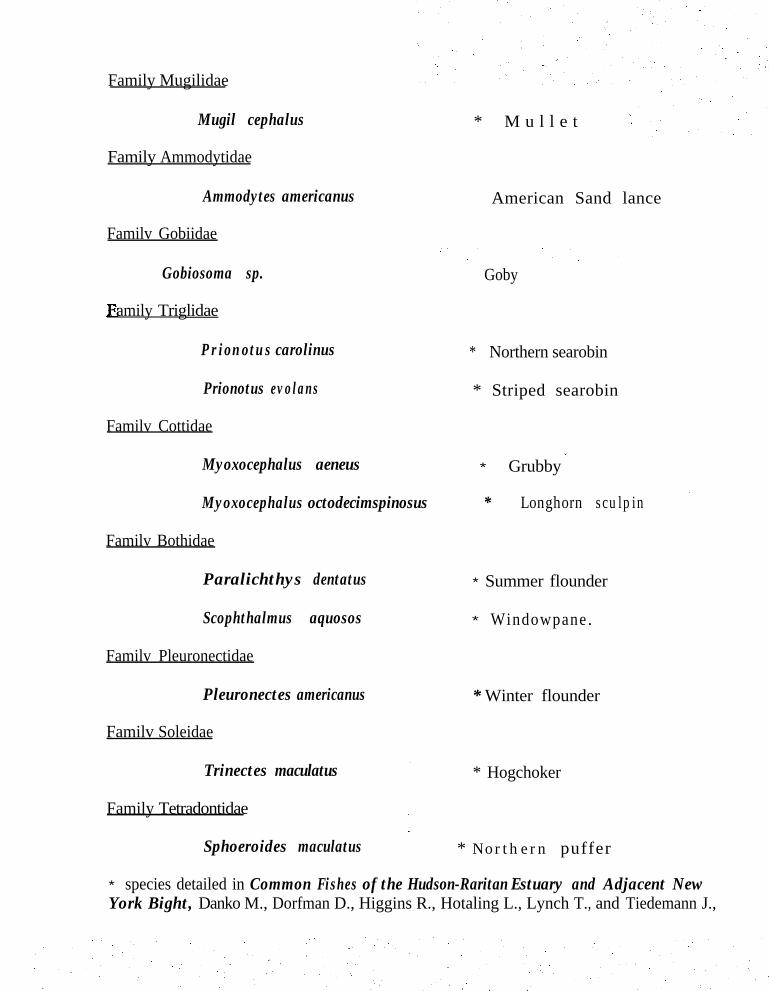
Family Mugilidae
Mugil cephalus
Family Ammodytidae
* M u l l e t
Ammodytes americanus
Familv Gobiidae
American Sand lance
Gobiosoma sp. amily Triglidae
Goby
Prionotus carolinus * Northern searobin
Prionotus evolans * Striped searobin
* Grubby *
Familv Cottidae
Myoxocephalus aeneus
Myoxocephalus octodecimspinosus * Longhorn sculpin ’
Familv Bothidae
Paralichthys dentatus * Summer flounder
Scophthalmus aquosos * Windowpane.
Familv Pleuronectidae
Pleuronectes americanus
Familv Soleidae
* Winter flounder
* Hogchoker
Family Tetradontidae
Sphoeroides maculatus * Northern puffer
* species detailed in Common Fishes of the Hudson-Raritan Estuary and Adjacent NewYork Bight, Danko M., Dorfman D., Higgins R., Hotaling L., Lynch T., and Tiedemann J.,
Trinectes maculatus
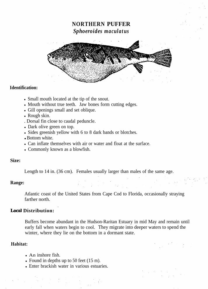
NORTHERN PUFFERSphoeroides maculatus
Identification:
l Small mouth located at the tip of the snout.l Mouth without true teeth. Jaw bones form cutting edges.l Gill openings small and set oblique.l Rough skin.. Dorsal fin close to caudal peduncle.l Dark olive green on top.l Sides greenish yellow with 6 to 8 dark bands or blotches.lBottom white.l Can inflate themselves with air or water and float at the surface.l Commonly known as a blowfish.
Size:
Length to 14 in. (36 cm). Females usually larger than males of the same age.
Range:
Atlantic coast of the United States from Cape Cod to Florida, occasionally strayingfarther north.
Distribution: ’
Buffers become abundant in the Hudson-Raritan Estuary in mid May and remain untilearly fall when waters begin to cool. They migrate into deeper waters to spend thewinter, where they lie on the bottom in a dormant state.
Habitat:
l An inshore fish.l Found in depths up to 50 feet (15 m).l Enter brackish water in various estuaries.

Spawning:
. Spawning takes place in New Jersey from mid May until June.A single female can contain up to 180,000 eggs.Eggs are round and adhere to each other or to anything they come in contact withwhen they sink.Hatching occurs in about 3 to 5 days.
.
.
.
Feeding:
l Voracious feeders.l Diet consists of small crustaceans, especially crabs, shrimps, isopods, small
mollusks, worms and sea urchins.
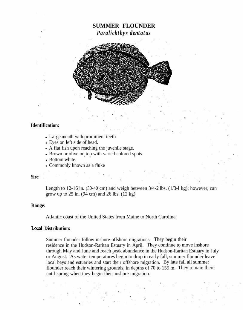
SUMMER FLOUNDERParalichthys dentatus
Identification:
Size:
l Large mouth with prominent teeth.l Eyes on left side of head.l A flat fish upon reaching the juvenile stage.l Brown or olive on top with varied colored spots.
~l Bottom white.l Commonly known as a fluke
Length to 12-16 in. (30-40 cm) and weigh between 3/4-2 lbs. (1/3-l kg); however, cangrow up to 25 in. (94 cm) and 26 lbs. (12 kg).
Range:
Atlantic coast of the United States from Maine to North Carolina.
Local Distribution:
Summer flounder follow inshore-offshore migrations. They begin theirresidence in the Hudson-Raritan Estuary in April. They continue to move inshorethrough May and June and reach peak abundance in the Hudson-Raritan Estuary in Julyor August. As water temperatures begin to drop in early fall, summer flounder leavelocal bays and estuaries and start their offshore migration. By late fall all summerflounder reach their wintering grounds, in depths of 70 to 155 m. They remain thereuntil spring when they begin their inshore migration.

Habitat:
. Migrate inshore in the summer.l Frequent ocean waters, bays, and estuaries.l Prefer sandy, muddy sand, mussel beds and clay bottoms.l Winter months they migrate offshore to depths of 70 to 155 m.
Spawning:
l Spawning occurs from Southern New England to Cape Hatteras during theiroffshore migration in the autumn months.
y Maturation occurs during their third year of life, l A 16 inch (40 cm) female produces 300,000 eggs while a 26 inch (65 cm) female
produces 3.5 million eggs. l Eggs are buoyant and drift towards shore:i Hatching occurs in 2-6 days.l Larvae resemble other fishes and have eyes symmetrically placed on either side of
the head.l Pelagic larvae go through a metamorphosis.l Eyes migrate to the left side of the head.l At this point they settle to the bottom.l When they take up a benthic existence they migrate to nursery areas in estuaries.l Remain in the estuary until they migrate with the adult population.l Growth is rapid during warmer months.
Feeding:
l Voracious feeders.l Depend on sight to feed.l Feed only during daylight hours. l Diet consists of worms, shrimps, squid, rock crabs, silversides, killifish, American
sand lance, juvenile bluefish and weakfish.
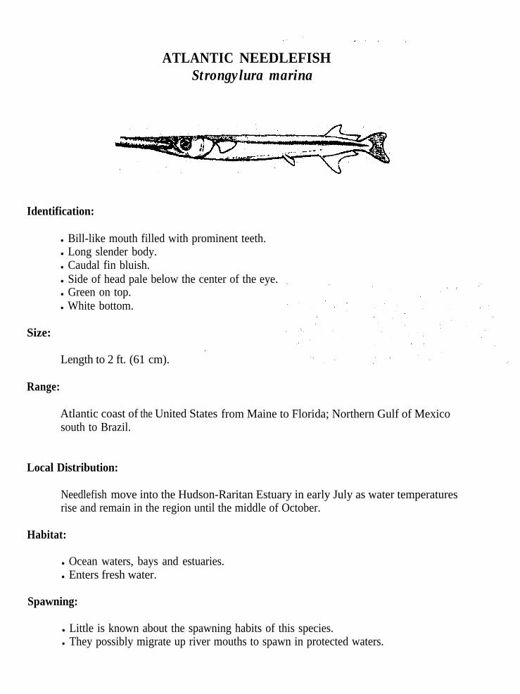
ATLANTIC NEEDLEFISHStrongylura marina
Identification:
l Bill-like mouth filled with prominent teeth.l Long slender body.l Caudal fin bluish.l Side of head pale below the center of the eye.l Green on top.l White bottom.
Size:
Length to 2 ft. (61 cm). ’
Range:
Atlantic coast of the United Statessouth to Brazil.
Local Distribution:
from Maine to Florida; Northern Gulf of Mexico
Needlefish move into the Hudson-Raritan Estuary in early July as water temperatures rise and remain in the region until the middle of October.
Habitat:
l Ocean waters, bays and estuaries.l Enters fresh water.
Spawning:
l Little is known about the spawning habits of this species.l They possibly migrate up river mouths to spawn in protected waters.

Feeding:
l Diet consists of all smaller fishes.
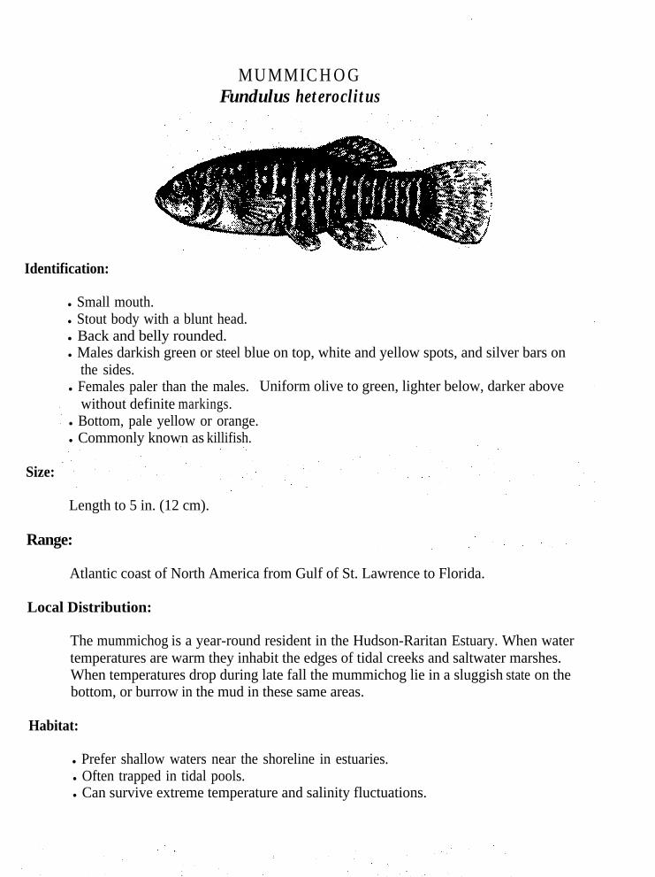
Size:
MUMMICHOGFundulus heteroclitus
Identification:
l Small mouth.l Stout body with a blunt head.l Back and belly rounded.l Males darkish green or steel blue on top, white and yellow spots, and silver bars on
the sides.l Females paler than the males. Uniform olive to green, lighter below, darker above
without definite markings.l Bottom, pale yellow or orange.l Commonly known as killifish.
Length to 5 in. (12 cm).
Range:
Atlantic coast of North America from Gulf of St. Lawrence to Florida.
Local Distribution:
The mummichog is a year-round resident in the Hudson-Raritan Estuary. When watertemperatures are warm they inhabit the edges of tidal creeks and saltwater marshes.When temperatures drop during late fall the mummichog lie in a sluggish state on thebottom, or burrow in the mud in these same areas.
Habitat:
l Prefer shallow waters near the shoreline in estuaries.l Often trapped in tidal pools.l Can survive extreme temperature and salinity fluctuations.

Spawning:
l Spawning occurs from June into August.l Males court and pursue the females, sometimes fighting over a mate.l Eggs are non-buoyant and sticky; stick to anything they come in contact with.l Hatching occurs in 9 to 18 days. l Hatching is temperature dependent.
Feeding:
l Omnivorous, diet consists of a variety of plants and animals.l Diet includes diatoms, eelgrass, shrimp, other crustacea and small fish.
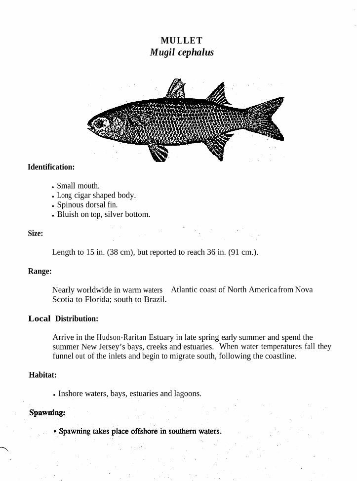
MULLETMugil cephalus
Identification:
l Small mouth.l Long cigar shaped body.l Spinous dorsal fin.l Bluish on top, silver bottom.
Size:
Length to 15 in. (38 cm), but reported to reach 36 in. (91 cm.).
Range:
Nearly worldwide in warm waters. Atlantic coast of North America from NovaScotia to Florida; south to Brazil.
Local Distribution:
Arrive in the Hudson-Raritan Estuary in late spring early summer and spend thesummer New Jersey’s bays, creeks and estuaries. When water temperatures fall theyfunnel out of the inlets and begin to migrate south, following the coastline.
Habitat:
l Inshore waters, bays, estuaries and lagoons.

Feeding:
l Diet consists of mud, debris and plankton. _
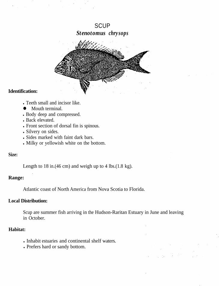
SCUPStenotomus chrysops
Identification:
l Teeth small and incisor like.l Mouth terminal.l Body deep and compressed.l Back elevated.l Front section of dorsal fin is spinous.l Silvery on sides.l Sides marked with faint dark bars.l Milky or yellowish white on the bottom.
Size:
Range: .
Atlantic coast of North America from Nova Scotia to Florida.
Local Distribution:
Scup are summer fish arriving in the Hudson-Raritan Estuary in June and leavingin October.
Habitat:
l Inhabit estuaries and continental shelf waters.l Prefers hard or sandy bottom.
Length to 18 in.(46 cm) and weigh up to 4 lbs.(1.8 kg).
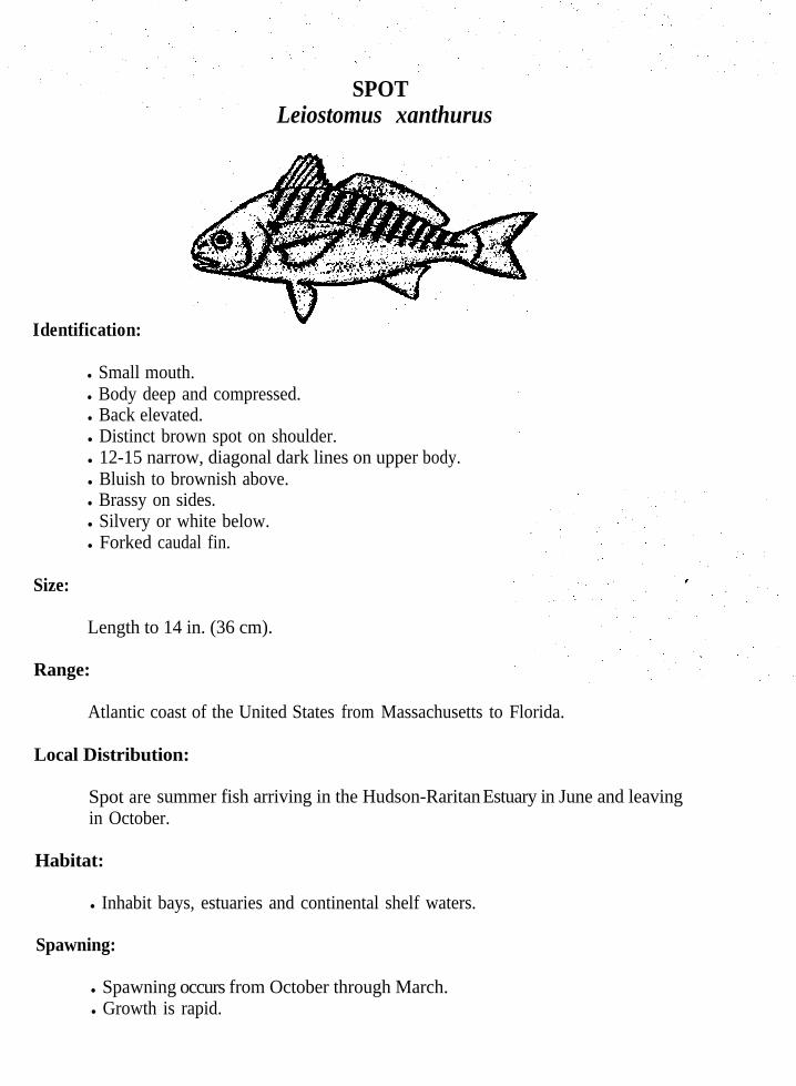
SPOTLeiostomus xanthurus
Identification:
l Small mouth.l Body deep and compressed.l Back elevated.l Distinct brown spot on shoulder.l 12-15 narrow, diagonal dark lines on upper body.l Bluish to brownish above.l Brassy on sides.l Silvery or white below.l Forked caudal fin.
Size:
Length to 14 in. (36 cm).
Range:
Atlantic coast of the United States from Massachusetts to Florida.
Local Distribution:
Spot aree summer fish arriving in the Hudson-Raritan Estuary in June and leavingin October.
Habitat:
l Inhabit bays, estuaries and continental shelf waters.
Spawning:
l Spawning occurs from October through March.l Growth is rapid.

Feeding:
l Strictly bottom feeders.l Diet Consists of crustaceans, mollusks, worms and small fish.

NORTHERN K I N G F I S HMenticirrhus saxatilis
Identification:
l Mouth contains no teeth.l Upper jaw extends past the lower.l Blunt nose and snout overhang the mouth.l Lower jaw with single barbel.l First dorsal fin longer than other fins.l Dusky grey to black on top.l Sides cross marked with dark bars.l Milky or yellowish white on the bottom.
Size:
Length to 17 in.(43 cm) and weigh up to 3 lbs.(1.4 kg).
Range:
Atlantic coast of the United States from Cape Cod to Florida.
Local Distribution:
Kingfish are summer fish arriving in the Hudson-Raritan Estuary in May and leavingin October. They migrate south to warmer waters.
Habitat:
l Inhabit ocean coastlines and river mouths.l Prefers hard or sandy bottom.

Spawning:.
Spawning occurs in bays and sounds from June until August, but may occurlater if waters do not warm sufficiently.Growth rapid.Measure 4 to 6 inches (10-15 cm) by their first winter.Maturity is reached by males and females at age 3.
Feeding:
l Strictly bottom feeders..l Diet consists of shrimp, small mollusks, worms and young fish.
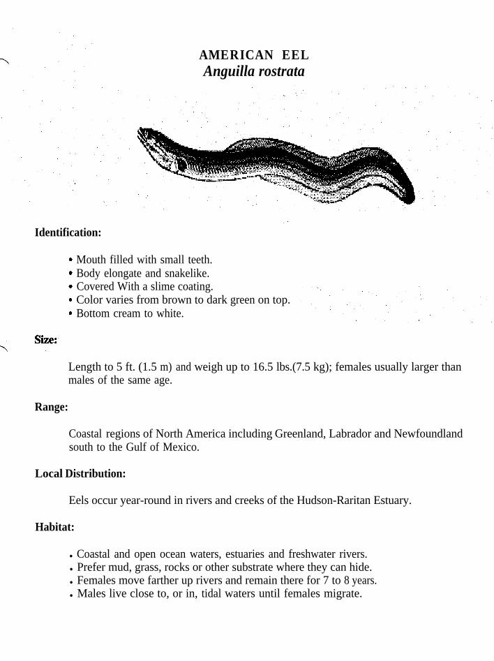
AMERICAN EELAnguilla rostrata
Identification:
.
.
.
.
.
Mouth filled with small teeth.Body elongate and snakelike.Covered With a slime coating.Color varies from brown to dark green on top.Bottom cream to white.
Length to 5 ft. (1.5 m) and weigh up to 16.5 lbs.(7.5 kg); females usually larger thanmales of the same age.
Range:
Coastal regions of North America including Greenland, Labrador and Newfoundlandsouth to the Gulf of Mexico.
Local Distribution:
Eels occur year-round in rivers and creeks of the Hudson-Raritan Estuary.
Habitat:
l Coastal and open ocean waters, estuaries and freshwater rivers.l Prefer mud, grass, rocks or other substrate where they can hide.l Females move farther up rivers and remain there for 7 to 8 years.l Males live close to, or in, tidal waters until females migrate.
Spawning:
l Catadromous, spawning in saltwater and migrating to freshwater to grow,l Spawning takes place in the Atlantic ocean in the Sara Gasso Sea..l Spawning occurs as early January and may continue into August.b Eels undergo oceanic, estuarine and river phases.l Females release 10 to 20 million eggs.l Hatching begins in February and continues into August.l Larval stage may last for more than a year, this is followed by the “glass eel”
stage. l At this point they are unpigmented.l As they develop pigment they migrate into freshwater and become elvers.l Remain in freshwater for several years and are called yellow eels.l Yellow eels mature and undergo changes in color and body shape and begin to
migrate down river to the ocean spawning grounds. At this point they arecalled bronze eels.
l After spawning the adults die.l Growth takes place very slowly.l Male eels mature at age 3 and females at age 4-5.l May live for 20 years.
F e e d i n g :
+ Benthic feeders..l Feed predominantly at night. l Diet consists worms, crustaceans, mollusks and fish.

C U N N E RTautogolabrus adspersus
Identification:
.b
Size:
Small mouth.Several rows of conical teeth.Color is usually a uniform greenish grey with blotching. Color can vary greatlydepending on the bottom they are inhabiting.Commonly known as a bergall.
to 15 in. (38 cm) and weigh up to 2.2 lbs. (1 Kg.).
Range:
Atlantic coast of North America from Newfoundland and Gulf of St. Lawrence toChesapeake Bay.
Local Distribution:
Cunners are present in the waters of the Hudson-Raritan Estuary year-round, but moveoffshore during the colder months.
Habitat:
l Inhabit waters from shallow bays out to deep shelf waters.l Prefer rocky areas, around pilings, seawalls and wrecks.
Spawning:
.
Spawning takes place in June, July, and August along the coastline.Eggs are buoyant and transparent.Hatching occurs in about 40 hours.Growth is rapid, measuring 2.5-3.5 inches (5-7 cm) by the fall.
Feeding:
l Aggressive scavengers. Feeding occurs along the bottom.l Diet consists of small mussels, clams, worms and crabs, but will eat almost
anything.
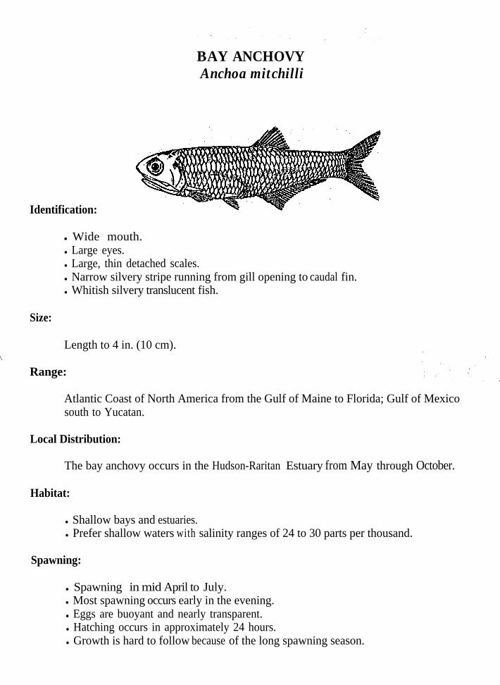
BAY ANCHOVYAnchoa mitchilli
Identification:
l Wide mouth.l Large eyes.l Large, thin detached scales.l Narrow silvery stripe running from gill opening to caudal fin.l Whitish silvery translucent fish.
Size:
Length to 4 in. (10 cm).
Range:
Atlantic Coast of North America from the Gulf of Maine to Florida; Gulf of Mexicosouth to Yucatan.
Local Distribution:
The bay anchovy occurs in the Hudson-Raritan Estuary from May through October.
Habitat:
l Shallow bays and estuaries.l Prefer shallow waters with salinity ranges of 24 to 30 parts per thousand.
Spawning:
l Spawning in mid April to July. l Most spawning occurs early in the evening.l Eggs are buoyant and nearly transparent.l Hatching occurs in approximately 24 hours.l Growth is hard to follow because of the long spawning season.

Feeding:
l Diet consists mainly of zooplankton, copepods, small gastropods, annelids andbivalves.

OYSTER CRACKEROpsanus tau
.
.
.
.
.
.
.
.b
Size:
Identification:
Large flat head and mouth.Tapering body with plump belly.Mostly soft rayed fish.Fleshy flaps on upper and lower jaws, on cheeks and over each eye.Skin covered with a thick layer of mucus.Color ranges from dark muddy olive green to brown or yellow. Darker on top andlighter on bottom.Irregularly marked with bars and marblings.Like many bottom fish it adjusts coloring to blend with the substrate.Commonly known as a toadfish.
Length to 15 in. (38 cm).
Range:
Atlantic coast of North America from Cape Cod to Cuba; occasionally strayingnorthward to Maine.
Local Distribution:
Oyster Crackers are year-round residents in the Hudson-Raritan Estuary and undergolittle movement.
Habitat:
.
.Largely coastal, rocky bottoms, jetties and wrecks.Tolerate polluted waters.
Spawning:
l Spawning occurs in June and early July.l Large eggs are laid in holes, under stones, shells and among eelgrass.l Eggs adhere in a single layer to whatever serves as a nest.l Male guards the eggs for about three weeks until they hatch.l Larvae remain attached to the nest by an adhesive disc until they reach 5/8 of an
inch (15 mm.).
Voracious, omnivorous fish.Feeding takes place on or near the bottom.Lie in wait for prey and dart out to grab it as it passes.Diet consists of worms, amphipods, shrimps, crabs, mollusks, squid and small fishes.
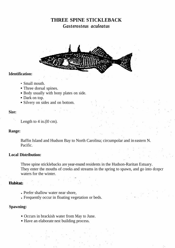
THREE SPINE STICKLEBACKGasterosteus aculeatus
Identification:
l
.
.
.
. Silvery on sides and on bottom.
Size:
Small mouth.Three dorsal spines.Body usually with bony plates on side.Dark on top.
Length to 4 in.(l0 cm).
Range:
Baffin Island and Hudson Bay to North Carolina; circumpolar and in eastern N.Pacific.
Local Distribution:
Three spine sticklebacks are year-round residents in the Hudson-Raritan Estuary.They enter the mouths of creeks and streams in the spring to spawn, and go into dcepcrwaters for the winter.
l Prefer shallow water near shore,l Frequently occur in floating vegetation or beds.
Spawning:
.
.Occurs in brackish water from May to June.Have an elaborate nest building process.

Feeding:
l A pugnacious species that uses its spines to drive away other species.1 Diet consists of invertebrates, small fish and fish eggs.

BLACK SEA BASSCentropristis striata
Identification:
Size:
l Large mouth and thick head.l Spinous dorsal fm.l Caudal fin round.l Head and body bluish black to dark brown, bottom is bluish gray.l Color tends to vary with age and type of structure they occupy.b Males develop a hump on the nape.
Length to 2 ft.. (60 cm) and weighs up to 8 lbs. (3.6 Kg).
Range:
Atlantic coast of North America from Maine to northeast Florida and east Gulf ofMexico.
Local Distribution:
Black sea bass begin to appear in large numbers in the waters of the Hudson-RaritanEstuary when water temperatures begin to rise in the spring. They reach peakabundance by the beginning of the summer. When water temperatures warmconsiderably they will migrate to the north. When water temperatures begin to fallthey become abundant again as they migrate south and offshore. They spend the winter in the southern part of their range.
Habitat:
l Prefer to live near rocks, wrecks, pilings or any type of structure that offersprotection and food.
l Young enter brackish water.

Spawning:
.b
l
Spawning takes place May to June.Eggs are buoyant.Hatching occurs in approximately 75 hours:Black sea bass begin life as females and transform into males.Sex reversal takes place between two and five years of age.
.
.
Feeding:
l Feeding occurs along the bottom.l Use their large mouth to capture prey.,l Diet consists of crustaceans, mollusks and fish.

TAUTOGTautoga onitis
Identification:
l Conical teeth, with two or three in the front of each jaw much larger than the others.l Heavy stout fish with thick lips.l Dark fish, generally chocolate grey, with mottling or blotches of darker color.l Color tends to vary with age, and type of structure they occupy.l Commonly known as a blackfish.
Size:
- Length to 3 ft. (91 cm) and weighs up to 22 lbs. (10 Kg).
Range:
Atlantic coast of North America from Nova Scotia to South Carolina.
Local Distribution:
Tautog begin to appear in large numbers in the waters of the Hudson-Raritan Estuarywhen water temperatures begin to rise in early spring. They reach peak abundance bymid spring. When water temperatures warm considerably they begin their northerlymigration. When water temperatures begin to fall they become abundant again as theymigrate south and offshore. They spend the winter in the southern part of their range.Those that remain in the Hudson-Raritan Estuary area move off to deeper waters.
Habitat:
l Rarely stray more than 10 to 12 miles from shore or depths of 100-150 feet(30-45 m.).
l Enter brackish water.l Prefer to live near rocks, wrecks, pilings or any type of structure that offers
protection and food.

Spawning:
T Spawning takes place in June.l Eggs are buoyant.l Growth is slow.
Feeding:
. Feeding occurs along the bottom.l Use their large front teeth to pry mussels or barnacles off the structure on which
they grow, then use their back teeth to crush them.l Often they lie dormant until a certain stage of the tide, and then feed.l Diet consists of invertebrates, preferring mussel, barnacles, crabs, hermit crabs and
worms.
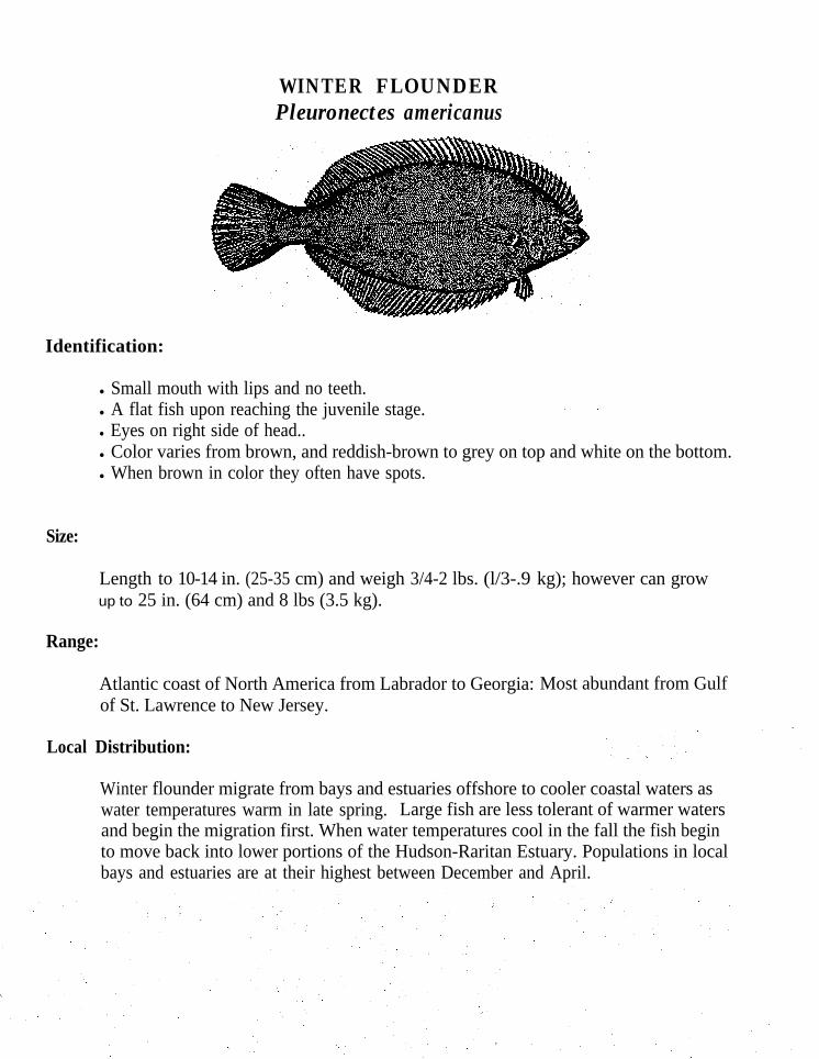
WINTER FLOUNDERPleuronectes americanus
Identification:
Size:
l Small mouth with lips and no teeth.l A flat fish upon reaching the juvenile stage.l Eyes on right side of head..l Color varies from brown, and reddish-brown to grey on top and white on the bottom.l When brown in color they often have spots.
Length to 10-14 in. (25-35 cm) and weigh 3/4-2 lbs. (l/3-.9 kg); however can growup to 25 in. (64 cm) and 8 lbs (3.5 kg).
Range:
Atlantic coast of North America from Labrador to Georgia: Most abundant from Gulfof St. Lawrence to New Jersey.
Local Distribution:
Winter flounder migrate from bays and estuaries offshore to cooler coastal waters aswater temperatures warm in late spring. Large fish are less tolerant of warmer watersand begin the migration first. When water temperatures cool in the fall the fish beginto move back into lower portions of the Hudson-Raritan Estuary. Populations in localbays and estuaries are at their highest between December and April.
l Prefer waters between 3-426 feet (1-130 m)1
l Found on sand, clay, gravel and muddy-sand bottoms.l Enter mouths of estuaries and extend into water that is nearly fresh during winter.l In warmer parts of their range they can be found in deeper waters during late spring
and summer months.
Spawning:
. Spawning takes place from mid winter to early spring.l Spawn in water 6-20 feet (2-6 m) deep in the upper reaches of the estuary.. Eggs are not buoyant, sink to the bottom and stick to each other in clusters.l When the eggs hatch the larvae resemble those of other laterally compressed fish,
but as they grow they go through a metamorphosis and settle to the bottom as a flatright handed fish.
‘e Juveniles, because of their larger size, fight the currents and migrate downstream.l Eventually leave the estuary to follow the adults in their migration.l Females mature at 2-3 years of age.
Feeding:
; Feeding takes place along the bottom.l Depend on sight for feeding therefore they feed only during the day.i Move about in search of food.l Diet consists of small worms, crustaceans, mollusks and some plant material.
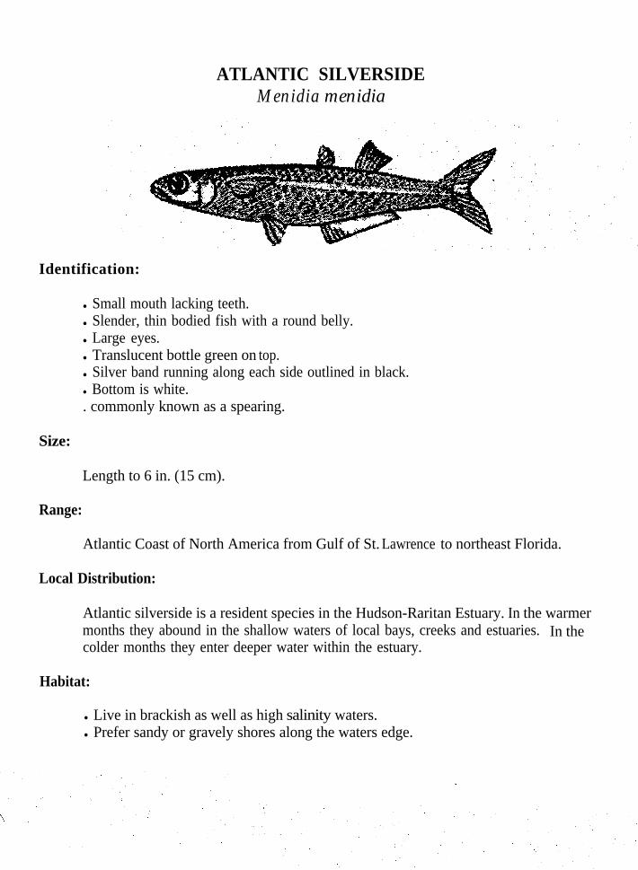
ATLANTIC SILVERSIDEMenidia menidia
Identification:
l Small mouth lacking teeth.l Slender, thin bodied fish with a round belly.l Large eyes.l Translucent bottle green on top.l Silver band running along each side outlined in black.l Bottom is white.. commonly known as a spearing.
Size:
Length to 6 in. (15 cm).
Range:
Atlantic Coast of North America from Gulf of St. Lawrence to northeast Florida.
Local Distribution:
Atlantic silverside is a resident species in the Hudson-Raritan Estuary. In the warmermonths they abound in the shallow waters of local bays, creeks and estuaries. In thecolder months they enter deeper water within the estuary.
Habitat:
l Live in brackish as well as high salinity waters.l Prefer sandy or gravely shores along the waters edge.
Spawning:
l Spawn in May, June and early July.l Gather in schools and deposit their eggs on sandy bottoms.l Eggs sink and stick together in clusters or sheets.l Hatching occurs in 8-10 days.l Growth is rapid with maturity reached at approximately 1 year of age.
Feeding:
l Omnivorous.l Diet consists of algae, copepods, shrimp, young squid, worms, insects and fish.
eggs.

STRIPED MUMMICHOGFundulus majalis
Identification:
. Male has 15-20 black vertical bars on side.l Female with 2-3 black horizontal stripes.l Body is more slender and snout more pointed than the common mummichog.l Dark olive green on top, with silver sides and greenish-yellow on the bottom.l Commonly known as a killifish.
Size:
Length to 7 in. (18 cm).
Range:
Atlantic Coast of North America from New Hampshire to northeast Florida; northGulf of Mexico.
Local Distribution:
The striped mummichog is a resident species of the Hudson-Raritan Estuary. It wintersin the deeper waters of the estuaries.
Habitat:
l Often found along the open beach.l Live in nearshore shallow waters.l Prefer high salinity waters.
Spawning:
l Spawning occurs from April to September in shallow water.l Eggs are large and only a small number are produced.l Eggs are laid on sand.

Feeding:
l Diet consists of small mollusks, crustaceans, insects and fish.

FO~SPINKS~KLEI~A~KApeltes quadracus
Identification:
.
Size:
Four to five dorsal spines.No bony plates on side.Skin has no scales.Flat belly and sharp back differs from other sticklebacks.Brownish olive or greenish brown on top, with dark mottling.Bottom is silvery white.
Length to 3 in. (7 cm).
Range:
Atlantic coast of North America from the Gulf of St. Lawrence to North Carolina.
Local Distribution:
Four spine sticklebacks are a year-round resident in the Hudson-Raritan Estuary. Theyenter the mouths of creeks and streams in the spring to spawn, and enter slightly deeperwater for the winter.
Habitat:
l Prefer shallow near shore waters.l Inhabit both vegetation beds and floating vegetation.
Spawning:
f Spawning occurs from May to July.l Go through an elaborate nest building process.l Male builds a nest of plant fragments.l The nest is conical, with an opening at the top. l The male picks up the eggs laid by the female and deposits them at the top of the
nest.. l Eggs sink and stick together in clumps when inside the nest.l Hatching occurs in six days.
Feeding:
l A pugnacious species that uses its spines to drive away other species.. Diet consists of small invertebrates, small fish and fish eggs.
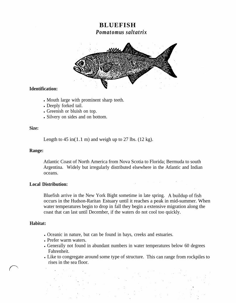
BLUEFISHPomatomus saltatrix
Identification:
l Mouth large with prominent sharp teeth.l Deeply forked tail.l Greenish or bluish on top.l Silvery on sides and on bottom.
Size:
Length to 45 in(1.1 m) and weigh up to 27 lbs. (12 kg).
- Range:
Atlantic Coast of North America from Nova Scotia to Florida; Bermuda to southArgentina. Widely but irregularly distributed elsewhere in the Atlantic and Indianoceans.
Local Distribution:
Bluefish arrive in the New York Bight sometime in late spring. A buildup of fishoccurs in the Hudson-Raritan Estuary until it reaches a peak in mid-summer. Whenwater temperatures begin to drop in fall they begin a extensive migration along thecoast that can last until December, if the waters do not cool too quickly.
Habitat:
l Oceanic in nature, but can be found in bays, creeks and estuaries.l Prefer warm waters.l Generally not found in abundant numbers in water temperatures below 60 degrees
Fahrenheit.l Like to congregate around some type of structure. This can range from rockpiles to
rises in the sea floor.

Spawning:
.
.
Spawn offshore twice a year, in the spring and in the summer.A mature fish contains about 900,000 eggs.Young bluefish, from the spring spawn migrate inshore and spend the summer inlocal bays, creeks, and estuaries.Fish from the summer spawn swim towards the coast and migrate south in the fall.Become sexuallymature at age two.
Feeding:
l Feeding occurs throughout the water column.‘. l Rely primarily on sight to find food.
6 Feed on a variety of invertebrates and fishes.l Diet consists of shrimp, squids, crabs, worms and fishes.
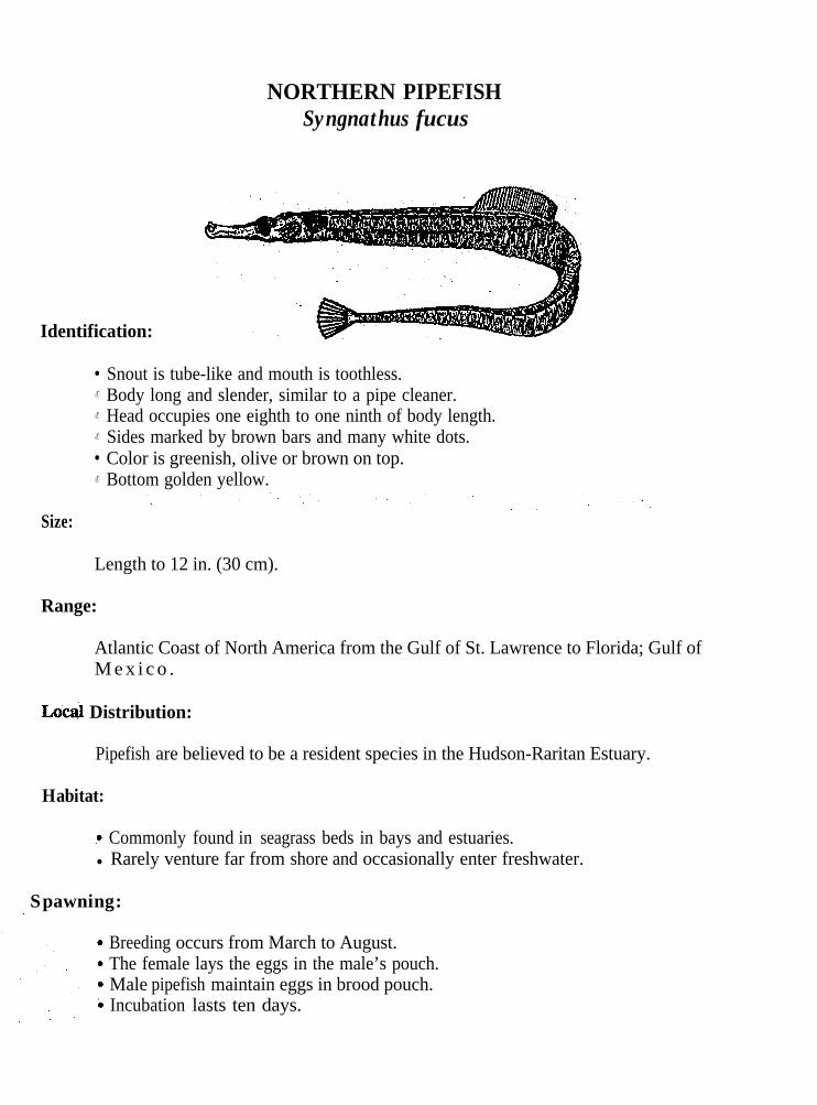
NORTHERN PIPEFISHSyngnathus fucus
Identification:
l
.
.
.
l
.
Size:
Snout is tube-like and mouth is toothless.Body long and slender, similar to a pipe cleaner.Head occupies one eighth to one ninth of body length.Sides marked by brown bars and many white dots.Color is greenish, olive or brown on top.Bottom golden yellow.
Length to 12 in. (30 cm).
Range:
Atlantic Coast of North America from the Gulf of St. Lawrence to Florida; Gulf ofM e x i c o .
Distribution:
Pipefish are believed to be a resident species in the Hudson-Raritan Estuary.
Habitat:
? Commonly found in seagrass beds in bays and estuaries.l Rarely venture far from shore and occasionally enter freshwater.
Spawning:
Breeding occurs from March to August.The female lays the eggs in the male’s pouch.Male pipefish maintain eggs in brood pouch.Incubation lasts ten days.
l The young remain in the pouch until they are about 5/16 in. (9 mm) long.l Young are independent after leaving pouch.
Feeding:
. In order to capture prey they expel water from the trumpet-like mouth, the resultingvacuum returns water that contains food.
l Diet consists of minute copepods, amphipods, fish eggs and other small marineanimals.
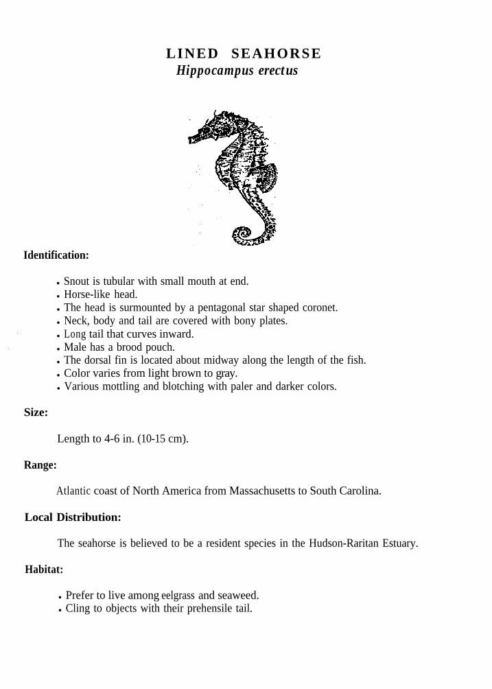
LINED SEAHORSEHippocampus erectus
Identification:
l Snout is tubular with small mouth at end.l Horse-like head.l The head is surmounted by a pentagonal star shaped coronet.l Neck, body and tail are covered with bony plates.l Long tail that curves inward.l Male has a brood pouch.l The dorsal fin is located about midway along the length of the fish.l Color varies from light brown to gray.l Various mottling and blotching with paler and darker colors.
Size:
Length to 4-6 in. (10-15 cm).
Range:
Atlantic coast of North America from Massachusetts to South Carolina.
Local Distribution:
The seahorse is believed to be a resident species in the Hudson-Raritan Estuary.
Habitat:
l Prefer to live among eelgrass and seaweed.l Cling to objects with their prehensile tail.
Spawning:
.
.l
.
Breed in the summer. Eggs are deposited a few at a time in the pouch of the male.Up to 150 eggs may be deposited in the pouch.When the yolk sac is absorbed they are squeezed out of the pouch and resemble theparents.
Feeding:
l Feed by sucking in minute crustacea and anything else that fits in their mouth.
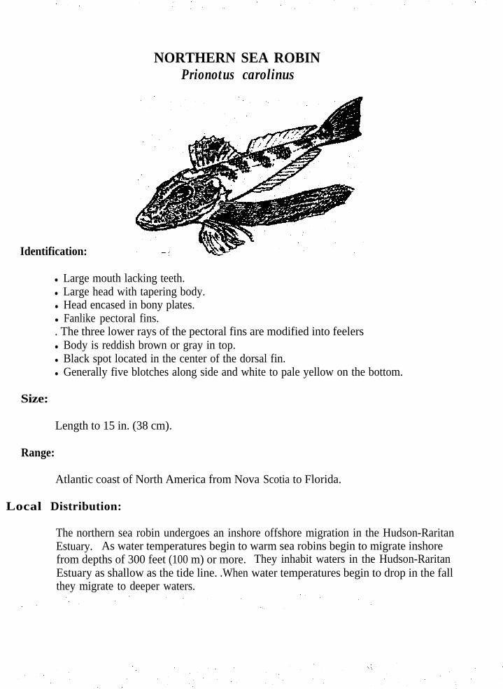
NORTHERN SEA ROBINPrionotus carolinus
Identification:
l Large mouth lacking teeth.l Large head with tapering body.l Head encased in bony plates.l Fanlike pectoral fins.. The three lower rays of the pectoral fins are modified into feelersl Body is reddish brown or gray in top.l Black spot located in the center of the dorsal fin.l Generally five blotches along side and white to pale yellow on the bottom.
Size:
Length to 15 in. (38 cm).
Range:
Atlantic coast of North America from Nova Scotia to Florida.
Local Distribution:
The northern sea robin undergoes an inshore offshore migration in the Hudson-RaritanEstuary. As water temperatures begin to warm sea robins begin to migrate inshorefrom depths of 300 feet (100 m) or more. They inhabit waters in the Hudson-RaritanEstuary as shallow as the tide line. .When water temperatures begin to drop in the fallthey migrate to deeper waters.
Habitat:
l Keep to the bottom but are active swimmers.l Generally found on smooth, hard bottom, and often bury themselves in the sand.
Spawning:
l Spawning occurs from June to Septcmberl Eggs are buoyant, and hatching occurs in 60 hours or more.l Spawning and incubation varies with temperature. Warmer temperatures result
in earlier spawning, as well as shorter incubation. The opposite applies forcolder temperatures.
Feeding:
. A voracious feeder.l Diet consists of squid, shrimp, bivalve mollusks, worms, crabs and small fish.

STRIPED SEA ROBINPrionotus evolans
Identification:
l Large mouth lacking teeth.l Large head with tapering body.: Head encased in bony plates.l Fanlike pectoral fins.l The three lower rays of the pectoral fins are modified into feelersl Body is reddish brown or gray in top.l Two black stripes along body.i Dark blotch between dorsal spines 4-5.l White to pale yellow on the bottom.
Size:
Length to 18 in. (45 cm).
Range:
Atlantic coast of North America from Nova Scotia to Florida.
Local Distribution:
The striped sea robin undergoes an inshore offshore migration in the Hudson-RaritanEstuary. As water temperatures begin to warm sea robins begin to migrate inshorefrom depths of 300 feet (100 m) or more. They inhabit waters in the Hudson-RaritanEstuary as shallow as the tide line. When water temperatures begin to drop in the fallthey migrate to deeper waters.
Habitat:
l Keep to the bottom but are active swimmers.l Generally found on smooth, hard bottom, and often bury themselves in the sand.

Feeding:
l A voracious feeder.l Diet consists of squid, shrimp, bivalve mollusks, worms, crabs and small fish.
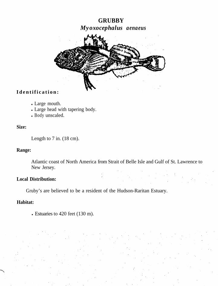
GRUBBYMyoxocephalus aenaeus
I d e n t i f i c a t i o n :
l Large mouth.l Large head with tapering body.l Body unscaled.
Size:
Length to 7 in. (18 cm).
Range:
Atlantic coast of North America from Strait of Belle Isle and Gulf of St. Lawrence toNew Jersey.
Local Distribution:
Gruby’s are believed to be a resident of the Hudson-Raritan Estuary.
Habitat:
l Estuaries to 420 feet (130 m).

LONGHORN SCULPINMyoxocephalus octodecemspinosus,
Identification:
l Large mouth lacking teeth.l Large head with tapering body.l Head encased in bony plates.l Long preopercular spine.l Body is reddish brown or gray in top.
Length to 18 in. (46 cm).
Range:
Atlantic coast of North America from East New Foundland and north Gulf of St.Lawrence to Virginia.
Local Distribution:
The longhorn sculpin undergoes an inshore offshore migration in the Hudson-RaritanEstuary. As water temperatures begin to cool longhorn sculpins begin to migrateinshore from deeper offshore waters. When water temperatures begin to rise in thespring they migrate to deeper waters.
Habitat:
l Estuaries and continental shelf waters.
Spawning:
l Spawning occurs from November to January.l Eggs are demersal and adhesive.l Hatching occurs in three months or less.

Feeding:
l A bottom feeder.l Diet consists of mainly of crustacea, particularly Cancer crabs, fish and fish eggs.

SHEEPSHEAD MINNOWCyprinodon variegatus
Identification:
l Large, wedge shaped teeth.l Upper profile slightly concave, deep-bodied.l Thick caudal peduncle.l Ocellus on rear of dorsal fin in females.l Irregular bands and dark spot at base of dorsal fin.l Males have dark-edged caudal fin. Breeding males display brilliant blue nape and
orange cheeks.l Commonly known as a killifish.
Size:
Length to 3 in. (7 cm).
Range:
Atlantic coast of North American from Cape Cod to Florida; Bahamas and Gulf ofMexico.
Local Distribution and Movement:
A year-round resident in the Hudson-Raritan Estuary.
Habitat:
l Common in weedy areas.l Found in fresh to full seawater.
Spawning:
. Spawning occurs from April to September.l Males fight for females, clasping them with dorsal and anal fin, while eggs and milt
are released.l Eggs sink, sticking together in clumps, hatching in 5 or 6 days.
Feeding:
. Diet consists of both plants and animals.
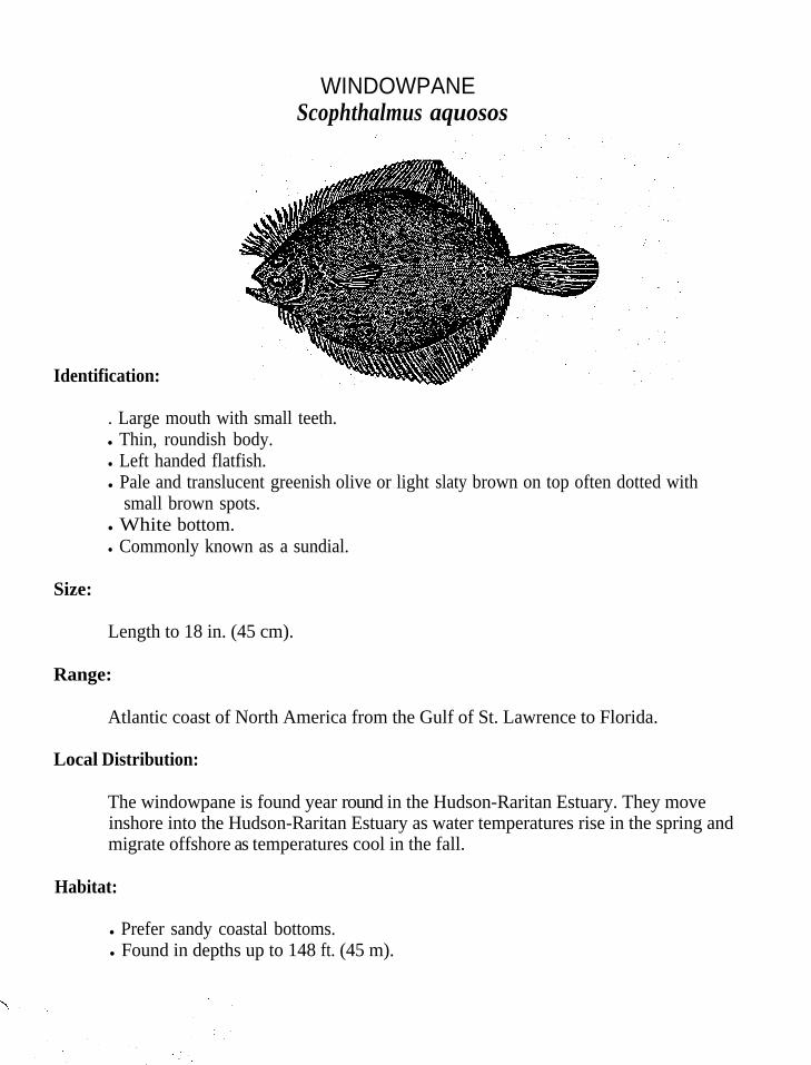
WINDOWPANEScophthalmus aquosos
Identification:
. Large mouth with small teeth.l Thin, roundish body.l Left handed flatfish.l Pale and translucent greenish olive or light slaty brown on top often dotted with
small brown spots.l White bottom.l Commonly known as a sundial.
Size:
Length to 18 in. (45 cm).
Range:
Atlantic coast of North America from the Gulf of St. Lawrence to Florida.
Local Distribution:
The windowpane is found year round in the Hudson-Raritan Estuary. They moveinshore into the Hudson-Raritan Estuary as water temperatures rise in the spring andmigrate offshore as temperatures cool in the fall.
Habitat:
l Prefer sandy coastal bottoms.l Found in depths up to 148 ft. (45 m).
Spawning:
l Spawn in the bight from April to December.l Eggs are transparent.and buoyant,l Incubation lasts about eight days.l Larvae swim upright and have eyes on both sides of their head.l Eyes migrate to left side and they take up a bottom existence.l Measure approximately 7/16 of an inch (10 mm) by this stage.
Feeding:
l Diet consists of a variety of annelid worms, crabs, squid, mollusks andcrustacea.
,

AMERICAN SHADAlosa sapidissima
Identification:
l Deep body.l Saw edge on belly; calIed razor belly.l Forked tail.l Dark spot on shoulder just behind operculum followed by 3 to 27 small spots.l Silver color.
Length to 30 in. (75 cm) and weigh up to 12 lbs. (5 kg).
Range:
Atlantic coast of North America from Newfoundland to Florida.
Local Distribution:
Shad are anadromous. They enter the waters of the Hudson-Raritan Estuary in earlyspring, depending on water temperature.middle to late spring.
They reach peak abundance in the rivers byOnce spawning occurs they descend the rivers and return to their
offshore grounds.
Habitat:
l Found in freshwater in the spring where oxygen levels are high.l In the ocean they are found on continental shelf waters.l Populations of different rivers mix on the wintering grounds.
Spawning:
.
.
.
.0
.
.
.
An anadromous species spawning in freshwater and maturing in the sea.In the spring adult shad migrate to the upper reaches of their natal rivers.Prefer to spawn over sand, gravel, or mud. Spawning begins in the late afternoon and continues into the night.Females release from 100,000 to 600,000 eggs, depending on the sizeof the female.Eggs are nonadhesive and heavier than water. They are dependent on currents tocarry them and keep them afloat.Eggs generally hatch in 4 to 6 days.Small teeth develop in the jaws of the larvae.Growth is rapid and within 4 to 6 weeks they become juveniles.Juveniles lose their teeth.These young form schools migrating downstream to tidal portions.In the fall they migrate into the sea to their wintering grounds.After spawning adults return to the sea, although many die on their return to sea asa result of exhaustion from the spawning process.
l Adults do not feed on their upstream migration.l Juveniles diet consists of a variety of invertebrates, including crustaceans and
insects while in freshwater.l In saltwater their diet consists of zooplankton including copepods, mysids and
euphausids.

STRIPED BASSMorone saxatilis
Identification:
l Large mouth lacking teeth.l Spinous dorsal fin.l 7-8 stripes.l Dark green to black on top.l White bottom.
Size:
Length to 5 ft. (1.5 m) and weighs up to 125 lbs. Adults average approximately18-30. in. (45-75 cm) and weigh between 1-15 lbs. (.5-7 kg).
Atlantic coast of North America from St. Lawrence to North Florida. They havebeen established in several landlocked lakes and on the west coast of North America.
Local Distribution:
The striped bass is a year-round resident in the Hudson-Raritan Estuary. Peakabundance is reached in the spring and fall, when they undergo extensive migrations toand from winter and summer grounds.
Habitat:
l Anadromous .l Schools in rivers, bays, estuaries, and the ocean.l Do not have a preference for particular bottom types, prefer to congregate around
structure.
.
Spawning:
.
.
.
.
.
Adult striped bass return to their natal rivers to spawn.Spawning begins in March and continues until June.Females carry between 62,000-112,000 eggs per pound of fish.Eggs are nonadhesive and heavier than freshwater.Current is required to keep the eggs from settling and being smothered by silt.hatching occurs from 30-74 hours. Juveniles remain in fresh or slightly saline, water and seek shelter alongprotected shorelines until fall.In late fall they move into the deep holes of the river and remain there until spring.In their second summer they migrate into bays and sounds.Three year old fish will begin to migrate into the ocean and join the adult,population along the coast.
l Voracious predators, high on the food chain.l Prey upon invertebrates and small fishes.l Diet consists of clams, calico crabs, herring, menhaden, and mullet.‘ When feeding, bass will gorge themselves.
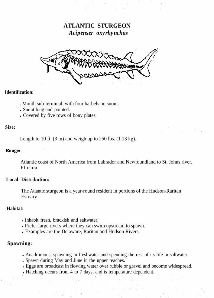
ATLANTIC STURGEONAcipenser oxyrhynchus
Identification:
. Mouth sub-terminal, with four barbels on snout.l Snout long and pointed.
l Covered by five rows of bony plates.
Size:
Length to 10 ft. (3 m) and weigh up to 250 lbs. (1.13 kg).
Atlantic coast of North America from Labrador and Newfoundland to St. Johns river,Florida.
Local Distribution:
The Atlantic sturgeon is a year-round resident in portions of the Hudson-RaritanEstuary.
Habitat:
l Inhabit fresh, brackish and saltwater.l Prefer large rivers where they can swim upstream to spawn.l Examples are the Delaware, Raritan and Hudson Rivers.
Spawning:
l Anadromous, spawning in freshwater and spending the rest of its life in saltwater.l Spawn during May and June in the upper reaches.l Eggs are broadcast in flowing water over rubble or gravel and become widespread.l Hatching occurs from 4 to 7 days, and is temperature dependent.

Feeding:
l Bottom feeders.l Use snout to stir up bottom and barbels to find food.l Diet consists of mollusks, polychaete worms, gastropods, shrimps and small benthic
fishes.
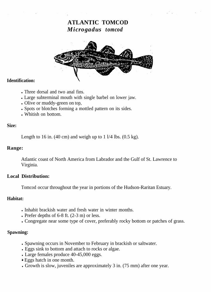
ATLANTIC TOMCODMicrogadus tomcod
Identification: \
l Three dorsal and two anal fins.l Large subterminal mouth with single barbel on lower jaw.l Olive or muddy-green on top,l Spots or blotches forming a mottled pattern on its sides.l Whitish on bottom.
Size:
Length to 16 in. (40 cm) and weigh up to 1 l/4 lbs. (0.5 kg).
Range:
Atlantic coast of North America from Labrador and the Gulf of St. Lawrence toVirginia.
Local Distribution:
Tomcod occur throughout the year in portions of the Hudson-Raritan Estuary.
Habitat:
l Inhabit brackish water and fresh water in winter months.l Prefer depths of 6-8 ft. (2-3 m) or less.l Congregate near some type of cover, preferably rocky bottom or patches of grass.
Spawning:
l Spawning occurs in November to February in brackish or saltwater.l Eggs sink to bottom and attach to rocks or algae.l Large females produce 40-45,000 eggs.i Eggs hatch in one month.l Growth is slow, juveniles are approximately 3 in. (75 mm) after one year.

Feeding:
l Bottom dwellers that use their barbell to detect food.l Diet consists of shrimp,worms, clams, squid and small fishes.

F e e d i n g :
l Bottom dwellers that use their barbell to detect food.l Diet consists of shrimp, worms, clams, squid and small fishes.
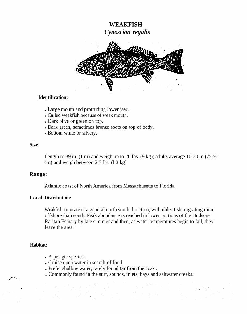
WEAKFISHCynoscion regalis
Identification:
l Large mouth and protruding lower jaw.l Called weakfish because of weak mouth.l Dark olive or green on top.l Dark green, sometimes bronze spots on top of body.l Bottom white or silvery.
Size:
Length to 39 in. (1 m) and weigh up to 20 lbs. (9 kg); adults average 10-20 in. (25-50cm) and weigh between 2-7 lbs. (l-3 kg)
Range:
Atlantic coast of North America from Massachusetts to Florida.
Local Distribution:
Weakfish migrate in a general north south direction, with older fish migrating moreoffshore than south. Peak abundance is reached in lower portions of the Hudson-Raritan Estuary by late summer and then, as water temperatures begin to fall, theyleave the area.
Habitat:
l A pelagic species.l Cruise open water in search of food.l Prefer shallow water, rarely found far from the coast.l Commonly found in the surf, sounds, inlets, bays and saltwater creeks.
Spawning:
l Spawning occurs from May to October, peaking in May and June in estuaries andnearshore zones.
l Females produce about 286,000 eggs.l Eggs are buoyant and hatch in approximately 48 hours.l Growth is rapid and fishh measure 8 in. (20 cm) by the end of their first year.l Young spend summer in protected nursery areas until fall, then migrate
southward. .l Young migrate in a north-south direction, while adults migrate in an inshore-
offshore direction. l Females mature at ages 1 and 2.
Feeding:
l Feed throughout the water column.l When feeding they open their mouth quickly causing a drop in pressure
this draws food into their mouth.l Diet consists of grass shrimp, crabs, worms, and small fishes such as silversides,
anchovies, and killifish..
:

WHITE PERCHMorone americana
Identification:
l Similar in appearance to striped bass only body is more compressed and lacksstripes.
l Anal fin has three spines.l Caudal fin with a shallow fork.l Olive or dark green on top.l Silver green on sides.l Silver on the bottom.
Size:
-Length to 19 in. (48 cm) and weigh up to 4 lbs. (1.8 kg).
Range:
Atlantic coast of North America from Nova Scotia to North Carolina.
Local Distribution:
White perch are year-round residents in the Hudson-Raritan Estuary.
Habitat:
.
.
.
Prefer shallow water, usually not deeper than 10 feet (3 m).Inhabit fresh, brackish and coastal waters, usually near mouths of rivers.Roam in search of food.
Spawning:
.
Spawning occurs in April, May and June.Adults swim into fresh or slightly brackish water to spawn.Eggs sink, and stick together in masses or to benthic.Hatching occurs in about six days. Larvae at time of hatching measure approximately 2.3 mm long.As juveniles grow they migrate to the lower reaches of their natal rivers andbays.Growth is rapid during the summer and early fall months.In the winter they gather in large schools and move into deep holes in the river.Migrate upstream to spawn in the spring.
Feeding:
l Gregarious and constantly in search of food.l Diet consists of young squid, worms, shrimps, crabs, killifishes, and fish fry.l Eat spawn as fish deposit it.

MENHADENBrevoortia tyrannus
I d e n t i f i c a t i o n :
l Dark shoulder spot often followed by many smaller spots.l Saw-like edges on the belly, near anus.l Dark bluish-green on top, silvery, with brassy sides,l Fins pale yellowish.l Commonly known as a mossbunker.
Size:
Length to 14 in. (35 cm).
Range:
Atlantic coast of North America from Nova Scotia to Florida.
Local Distribution:
Menhaden are common in the waters of the Hudson-Raritan Estuary from May to October. They arrive in the spring as temperatures warm, then migrate south astemperatures cool in the fall. It is not known where they spend the winter. They arelast seen around Cape Fear in North Carolina.
Habitat:
l Roaming fish.l Inhabit bays, estuaries and the open oceanl Rarely stray more than a couple miles from the coast.l Travel in schools that number in the thousands.
Spawning:
l Spawning begins in June, and continues into August in the northern part of itsrange, and late autumn into early winter in the southern portion of its range.
l Eggs are buoyant and are carried by the currents.l Hatching occurs in less than 48 hours.l Growth is rapid, and fish spawned in the summer will measure 2-3 in. (6-8 cm) by
winter.
Feeding:
Swim with mouth open and gills spread apart.Mouth and straining apparatus act in a way similar to that of a plankton net.Adult menhaden will filter between 6-7 gallons of water per minute.Diet consists of microscopic plants, diatoms in particular, and small crustaceans.Feed by filtering the water with a strain-like apparatus consisting of layers of gillrakers.

H O G C H O K E RTrinectes maculatus
Identification:
l Small mouth.l Right handed flatfish.0, Lack pectoral fin.l Dark brown with dark bars.l Blind side frequently blotched or spotted.
Size:
Length to 8 in. (20 cm).
Range:
Atlantic coast of North America from Massachusetts to Florida; Gulf of Mexico toArgentina.
Local Distribution:
The hogchoker is a year-round resident in the entire Hudson-Raritan Estuary.
Habitat:
l Found in coastal waters out to depths of 240 ft. (73 m).l Enter freshwater hundreds of miles upstream.
Spawning:
. Spawn in late spring and summer.,l A female contain about 54,000 eggs.. Growth is rapid. They measure 2-3 inches (5-8 cm) at one year.l Hogchokers become mature at approximately 4 inches (10 cm).

Feeding:
l Diet consists of worms_ and small crustaceans.
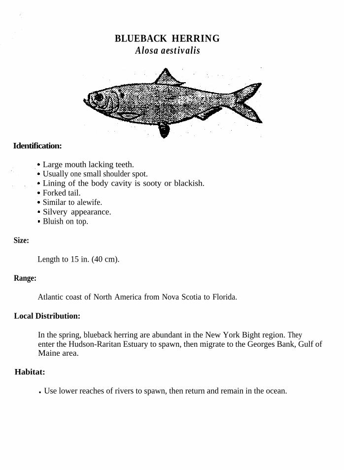
BLUEBACK HERRINGAlosa aestivalis
Identification:
.
.
Size:
Large mouth lacking teeth.Usually one small shoulder spot.Lining of the body cavity is sooty or blackish.Forked tail.Similar to alewife.Silvery appearance.Bluish on top.
Length to 15 in. (40 cm).
Range:
Atlantic coast of North America from Nova Scotia to Florida.
Local Distribution:
In the spring, blueback herring are abundant in the New York Bight region. Theyenter the Hudson-Raritan Estuary to spawn, then migrate to the Georges Bank, Gulf ofMaine area.
Habitat:
l Use lower reaches of rivers to spawn, then return and remain in the ocean.
Spawning:
.
.
.
.
.l
.
.
The blueback herring is anadromous.Spawning begins in April, when they begin to ascend fresh and brackish water.Spawn in streams over rocky or gravel bottom.Approximately 350,000 eggs are laid.Eggs sink and will stick to any object.Hatching occurs in approximately 50 hours.In one month they measure l-2 inches (3-5 cm). Spent fish return to the ocean.
Feeding:
l Filter feeders.i Feeding is believed to take place mainly during daylight hours.l Planktonic feeder.l Diet consists of copepods and pelagic shrimp.
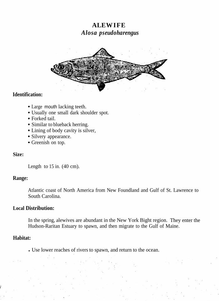
ALEWIFEAlosa pseudoharengus
Identification:
.
.
.
.
.
.
.
Size:
Large mouth lacking teeth.Usually one small dark shoulder spot.Forked tail.Similar to blueback herring.Lining of body cavity is silver,Silvery appearance.Greenish on top.
Length to 15 in. (40 cm).
Range:
Atlantic coast of North America from New Foundland and Gulf of St. Lawrence toSouth Carolina.
Local Distribution:
In the spring, alewives are abundant in the New York Bight region. They enter theHudson-Raritan Estuary to spawn, and then migrate to the Gulf of Maine.
Habitat:
l Use lower reaches of rivers to spawn, and return to the ocean.

Spawning:
.
.
.
.
.l
Alewives are anadromous.Become mature between three and five years old.Spawning begins in late March and earIy April.Spawning takes place in shallow, quiet areas of streams, ponds of large rivers andsmall coastal streams.Eggs are randomly broadcast and adhesive but lose this property within a few hoursof spawning. Females deposit 100,000 to 300,000 eggs.Hatching occurs in three to five days, depending on water temperature.Juveniles remain in the estuary until the summer, when they migrate into the ocean.After spawning, mature adult fish return to the sea.
Feeding:
l Alewives are plankton feeders..
l Dietconsists of copepods in freshwater and euphausids, mysids, mollusks andarrow worms in marine waters.
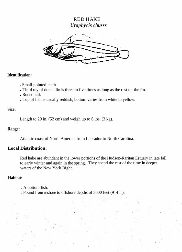
RED HAKEUrophycis chusss
Identification:
. Small pointed teeth.l Third ray of dorsal fin is three to five times as long as the rest of the fin.l Round tail.l Top of fish is usually reddish, bottom varies from white to yellow.
Size:
Length to 20 in. (52 cm) and weigh up to 6 lbs. (3 kg).
Range:
Atlantic coast of North America from Labrador to North Carolina.
Local Distribution:
Red hake are abundant in the lower portions of the Hudson-Raritan Estuary in late fallto early winter and again in the spring. They spend the rest of the time in deeperwaters of the New York Bight.
Habitat:
l A bottom fish.l Found from inshore to offshore depths of 3000 feet (914 m).

Spawning:
l Spawning occurs from April to May in the New York Bight.is an important spawning and nursery area.
The New York Bight
l Eggs are buoyant.l Young fish are pelagic until 2 to 4 inches (5-10 cm), then settle to the bottom.l Young fish during their first year enter and live within sea scallops for
protection. They live here until they are too large for their hosts, or watertemperatures become too low.
l Red hake mature when approximately two years old.
Feeding:
l Red hake feed predominantly at night on or near the bottom.l Diet consists of squid, shrimp, amphipods, other crustaceans, and small fish.
COMMON BIRDS OF THE HUDSON RARITAN ESTUARYAND ADJACENT NEW YORK BIGHT
INTRODUCTION
The New York Bight is home to a diverse population of resident bird species but is equallyimportant to the migrating, wintering and breeding birds that use the area. The bight is able tosupport this diversity because of the many types of habitats it has to offer. The habitat canrange from open water to marsh and woodlands along the shores. The birds that use thesevaried habitats can range from large birds of prey, to waterfowl, to passerines.
Birds have evolved in such a way as to make them specialists, each bird occupies a separateniche. Body parts have evolved to perform specific functions. Waterfowl,. for example haveshort legs and webbed feet, this is important because they spend most of their time in thewater and need to be strong swimmers. Wading birds have long necks, legs and beaks thatenable them to stalk prey in the shallow water habitats they frequent. Meanwhile birds of preyuse sharp beaks and powerful legs to grasp prey once it is sighted with their keen eyesight. Byinferring from these examples it is easy to see why birds need to specialize. Birds of preywould have no use for webbed feet and waterfowl would find long legs useless. There arecountless specializations of body parts among birds, these are just a few example that arecommon to the birds of the bight area.
Birds will use areas for different purposes depending on the time of year and species involved.The New York Bight is especially important to birds on their annual spring and fallmigrations. It is during the spring and fall when there is abundance of food. This abundancemakes the bight area an ideal rest stop. The birds can feed heavily and rest before headingonto their wintering and breeding grounds. Fall migrations are generally the heaviest becausethey contain progeny from the summer breeding season.
Wintering grounds are very important to all birds. Birds have specific requirements for anarea to qualify as wintering grounds. They will often move about quite a bit to satisfy theseneeds. Plenty of food is a major requirement of all birds. With colder temperatures birdsneed more energy to survive. In order to produce more energy they must digest faster thereforthey need to eat more. Open water is important to waterfowl because this is where they feed.Should an area become iced over they will have to move, in search of open water. Waterfowlprefer the bight because the constant currents ensure there will always be some open wateravailable to them.
The bight area is used as breeding grounds for many species of birds. Breeding areas mustalso fulfill specific requirements needed by the bird in order for it to qualify as a breeding site.The saltmarsh, beach-littoral zone and uplands with woody vegetation are the most importantareas used in the bight. Breeding areas must be able to support a growing population of birdsby providing plenty of food and safety. The health of the bight is also very important to asuccessful brood. Because birds use the same breeding grounds year after year, the health ofthe bight can be measured on how successful breeding is.
Various types of birds live in and visit the bight area throughout the year. Some of the morecommon types are waterfowl, wading birds, gulls, terns, raptors and passerines.
Wading birds are water birds that do not swim but wade through the water. In the bight areathey consist of herons, egrets and ibises. They wade along the shallow edges of marshes, mudflats and creek stalking their prey. Wading birds have short tails and long legs. They alsohave long necks and specialized bills. The bills of egrets and herons are used to seize prey inquick motions such as small fishes, frogs and aquatic insects. Ibises on the other hand usetheir bills to probe into the mud in search of fiddler crabs and mollusks.
Gulls and terns are long winged birds that have hooked bills and are good swimmers. Theyare probably the most common and visible of all birds in the bight area. The herring gull andthe common tern are the most frequently observed in the bight area. Gulls are generally largein size and have a grey and white appearance. Gulls are opportunistic feeders and will feed onalmost any food it can find. Terns are smaller and more graceful birds and unlike the gullthey sharp have pointed bills. Terns are similar in color to gulls but instead of grey theygenerally have black caps. Terns are more selective in their preferring small live minnows,squids and shrimps.
Shorebirds inhabit the beach-littoral and marsh zones they include the plovers, sandpipers andoyster catchers. Most shorebirds have long legs and live near areas that are only exposedduring low tides. Shorebirds makeup a considerable portion of the birds that migrate throughthe bight area with only a few remaining to nest.invertebrates.
They feed mainly on sand and mud dwelling
Raptors are birds of prey and feed at the top of the food chain. They consist of ospreys,hawks and owls. They feed mainly on fish and small rodents. They are large birds withstrongly hooked bills and powerful feet with hooked claws. Raptors are often good biologicalindicators of the health of the bight area.
Waterfowl spend most of their time on the water as their name would imply. They consist ofducks, geese and swans. Waterfowl have webbed feet and are very good swimmers. They arealso strong and swift fliers that enable them to undertake extensive migrations each spring andfall. Migrations begin in the early afternoon and continue through the night. Waterfowlfollow specific paths in their migrations and these paths have become known as flyways. Mostwaterfowl are gregarious, which is advantageous for feeding and safety when migrating.
Passerines are the largest order of birds containing some 59 families. They are made up ofsparrows, warblers, ravens and other similar perching type birds. They can range in size from4-26 inches. Passerines are the most adaptive and intelligent of all birds. They all have threetoes pointed forward and one backward: This enables them to perch easily on anything from abranch to a grass stem.
The arrangement of class, families, genus and species follows the taxonomic order of thePeterson Field Guide to Eastern Birds. Within the family, genus are placed in alphabeticalorder and within each genus, species are listed alphabetically.
Common and Scientific Names: The common and scientific names used in this guide, arelatin names which are used worldwide by scientists. Both scientific names are italicized,genus is capitalized and species is not.
Identification: Identification includes a brief description of the species, focusing oncharacteristics that are obvious and easy to recognize. Descriptions generally begin with thehead and progress to the tail, also included are color and anything special they do.
Size: Lengths are maximum total lengths recorded and weights are maximums.
Range: The range is given in a north to south direction and is very general. Range is oftenuseful in the identification of a species.
Local Distribution: Local distribution provides species specific information on a speciesoccurrence in the Hudson-Raritan Estuary.
Habitat: Lists the types of habitat they prefer including substrate, water composition anddepth. This information can be useful in identification as many species are habitat specific.
Spawning: Information on spawning is provided to help understand the life cycles of aparticular species. Detailed information is not currently available on all species, thereforesome species may have more detail than others.
Feeding: Explains how the species feed and includes a list of their preferred food items.
The glossary includes words that are found in the text as well as other words that can be usefulwhen discussing fishes, birds and invertebrates.
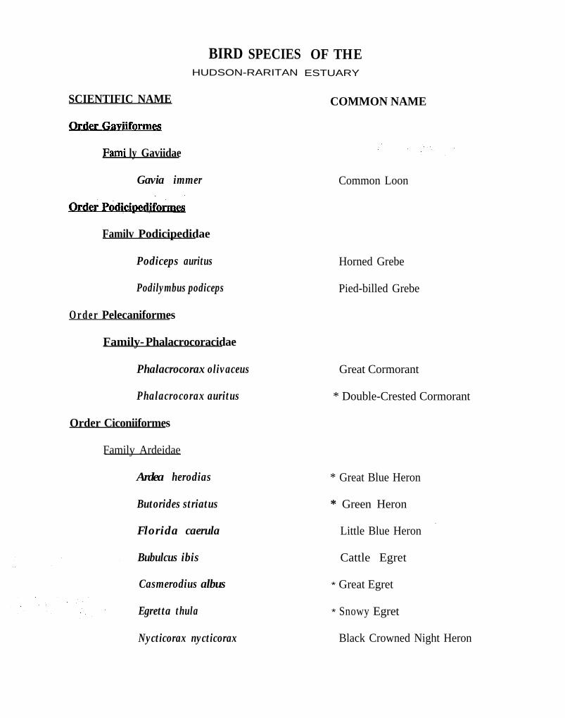
BIRD SPECIESHUDSON-RARITAN
OF THEESTUARY
COMMON NAMESCIENTIFIC NAME
ly Gaviidae
Gavia immer
QukLb&pPodlcloediformes
Familv Podicipedidae
Podiceps auritus
Podilymbus podiceps
O r d e r Pelecaniformes
Family-Phalacrocoracidae
Phalacrocorax olivaceus
Phalacrocorax auritus
Order Ciconiiformes
Family Ardeidae
Ardea herodias
Butorides striatus
Florida caerula
Bubulcus ibis
Casmerodius albus
Egretta thula
Nycticorax nycticorax
Common Loon
Horned Grebe
Pied-billed Grebe
Great Cormorant
* Double-Crested Cormorant
* Great Blue Heron
* Green Heron
_Little Blue Heron
Cattle Egret
* Great Egret
* Snowy Egret
Black Crowned Night Heron

Familv Threskiornithidae
Plegadis falcinellus
Order Anseriformes
amily Anatidae
Subfamily Cyginae
Cygnus olor
Olor columbias
Subfamily Anserinae
Branta canadensis
Branta bernicla
Chen caerulescens
Subfamily Anatinae
Anas platyrhynchos
Anas rubripes
Anas strepera
Anas acuta
Anas crecca
Anas discors
Anas americana
Anas clypeata
* Glossy Ibis
Mute Swan
Whistling Swan
* Canada Goose
Brant
Snow Goose
* Mallard
Black Duck
Gadwall
Pintail
Green-winged Teal
Blue-Winged Teal
American Widgeon
Northern Shoveler
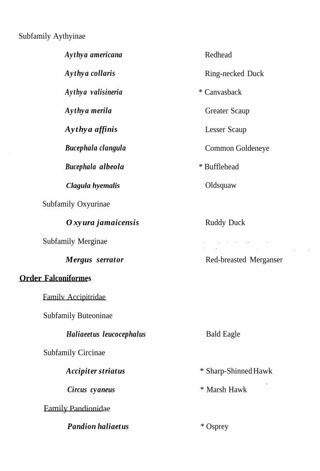
Subfamily Aythyinae
Aythya americana
Aythya collaris
Aythya valisineria
Aythya merila
Aythya affinis
Bucephala clangula
Bucephala albeola
Clagula hyemalis
Subfamily Oxyurinae
Oxyura jamaicensis
Subfamily Merginae
Mergus serrator
Order Falconiformes
Familv Accipitridae
Subfamily Buteoninae
Haliaeetus leucocephalus
Subfamily Circinae
Accipiter striatus
Circus cyaneus Family Pandionidae
Pandion haliaetus
Redhead
Ring-necked Duck
* Canvasback
Greater Scaup
Lesser Scaup
Common Goldeneye
* Bufflehead
Oldsquaw
Ruddy Duck
Red-breasted Merganser
Bald Eagle
* Sharp-Shinned Hawk
_* Marsh Hawk
* Osprey
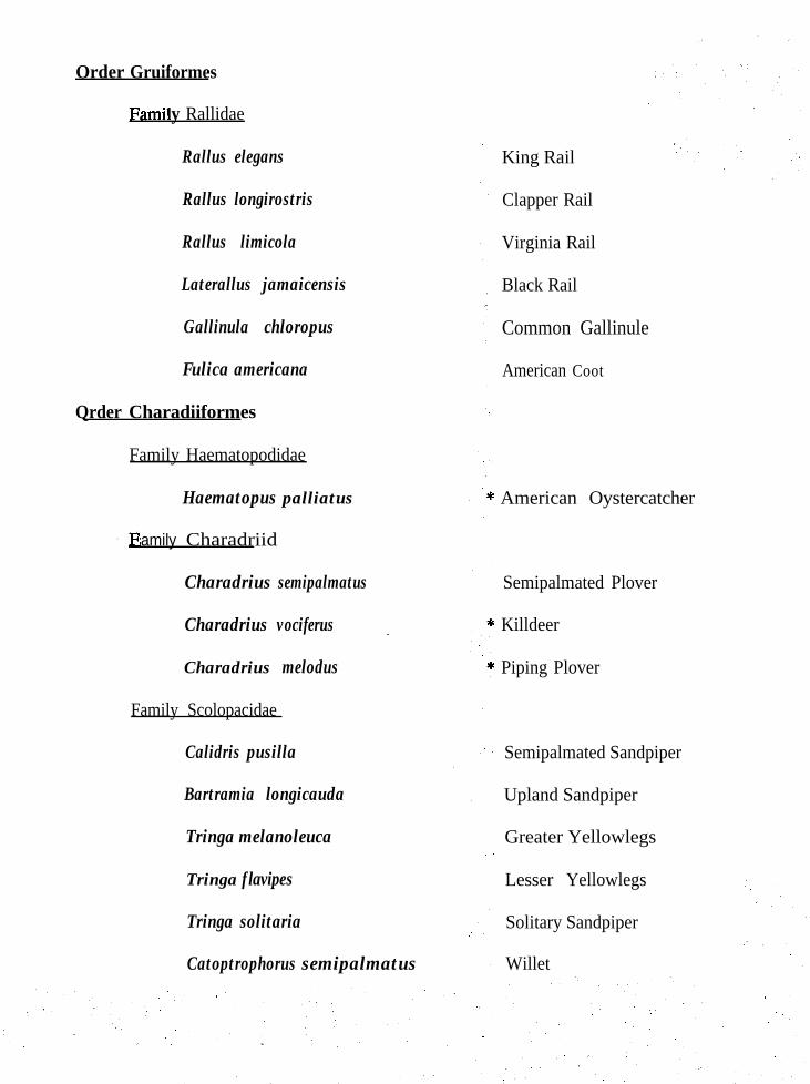
Order Gruiformes
y Rallidae
Rallus elegans
Rallus longirostris
Rallus limicola
Laterallus jamaicensis
Gallinula chloropus
Fulica americana
Qrder Charadiiformes
Family Haematopodidae
Haematopus palliatus
amily Charadriid
Charadrius semipalmatus
Charadrius vociferus ~
Charadrius melodus
Family Scolopacidae
Calidris pusilla
Bartramia longicauda
Tringa melanoleuca
Tringa f lavipes
Tringa solitaria
Catoptrophorus semipalmatus
King Rail
Clapper Rail
Virginia Rail
Black Rail
Common Gallinule
American Coot
American Oystercatcher
Semipalmated Plover
Killdeer
Piping Plover
Semipalmated Sandpiper
Upland Sandpiper
Greater Yellowlegs
Lesser Yellowlegs
Solitary Sandpiper
Willet
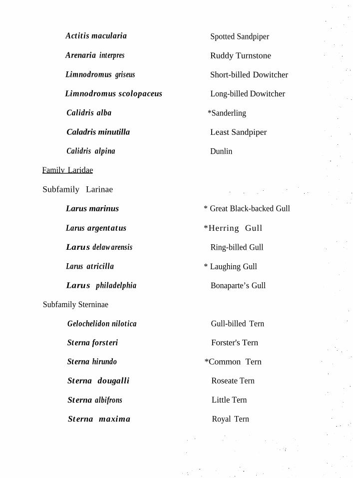
Actitis macularia
Arenaria interpres
Limnodromus griseus Short-billed Dowitcher
Limnodromus scolopaceus
Calidris alba
Caladris minutilla
Calidris alpina
Familv Laridae
Subfamily Larinae
Larus marinus
Larus argentatus
Larus delawarensis
Larus atricilla
Larus philadelphia
Subfamily Sterninae
Gelochelidon nilotica
Sterna forsteri
Sterna hirundo
Sterna dougalli
Sterna albifrons
Sterna maxima
Spotted Sandpiper
Ruddy Turnstone
Long-billed Dowitcher
*Sanderling
Least Sandpiper
Dunlin
* Great Black-backed Gull
*Herring Gull
Ring-billed Gull
* Laughing Gull
Bonaparte’s Gull
Gull-billed Tern
Forster's Tern
*Common Tern
Roseate Tern
Little Tern
Royal Tern

Family Rvnchopidae
Rhychops niger * Black Skimmer
Order Strigiformes
.. .amily Strigidae
Asio flammeus
Order Coraciiformes .
. amily Alcedinidae
Megaceryle alcyon
Short-eared Owl
* Belted Kingfisher
Order Passeriformes
amily Alaudidae
Eremophila alpestris
amily Corvidae
Cyanocitta cristata
Corvus ossifragus
Family Paridae
Horned Lark
Blue Jay
Fish Crow
Parus atricapillus
Familv Troglodytidae
Cistothorus palustris
Familv Turdidae
Turdus migratorius
Family Parulidae
Geothlypis trichas Yellow Throat
Black-capped Chickadee
Long-billed Marsh Wren
Robin
Geothlypis trichas Yellow Throat
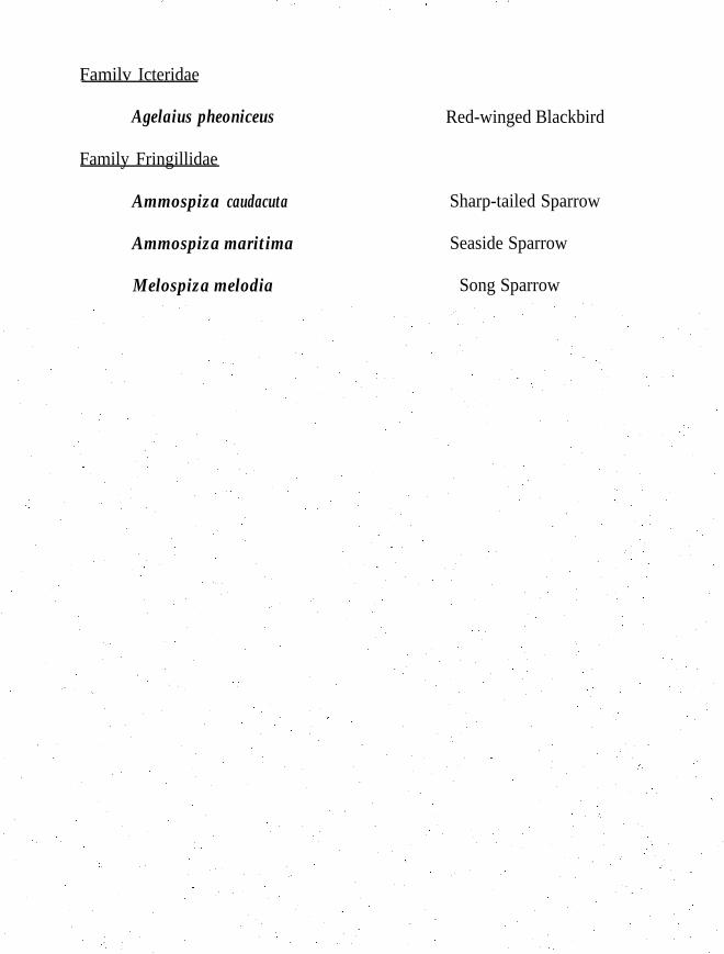
Familv Icteridae
Agelaius pheoniceus Red-winged Blackbird
Family Fringillidae
Ammospiza caudacuta Sharp-tailed Sparrow
Ammospiza maritima Seaside Sparrow
Melospiza melodia Song Sparrow
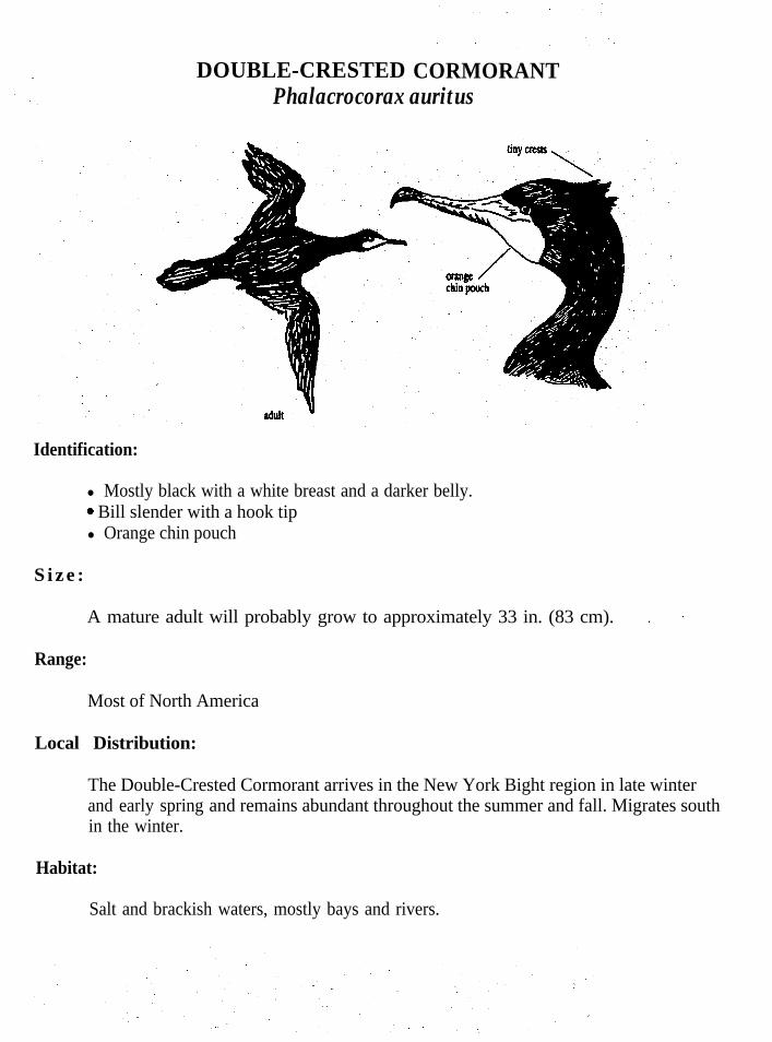
DOUBLE-CRESTED CORMORANTPhalacrocorax auritus
Identification:
l Mostly black with a white breast and a darker belly.-0 Bill slender with a hook tipl Orange chin pouch
S i z e :
A mature adult will probably grow to approximately 33 in. (83 cm).
Range:
Most of North America
Local Distribution:
The Double-Crested Cormorant arrives in the New York Bight region in late winterand early springin the winter.
and remains abundant throughout the summer and fall. Migrates south
Habitat:
Salt and brackish waters, mostly bays and rivers.
Breeding:
l Nest in colonies built by both sexes on ground or trees:l Nest built of sticks and weed stems, lined with leafy twigs and grass.T Eggs, clutch of 2-7 are laid from April to July.l Incubation performed by both sexes 24-25 days.0, First flight 35-42 days after hatching.
Feeding:
l Dives from the surface and swims about in pursuit of prey, generally depths of25 ft. below the surface.
l Catches mainly fish such as, sculpins, eels, herring, tomcod, flounder, butterfishalong with small invertebrates.
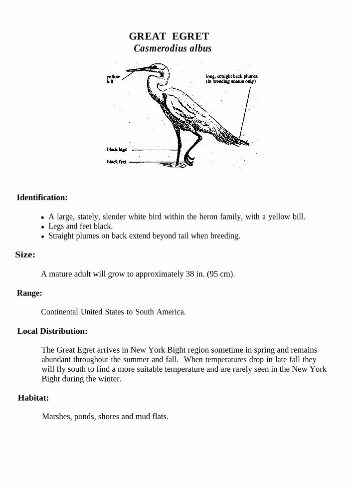
GREAT EGRETCasmerodius albus
Identification:
l A large, stately, slender white bird within the heron family, with a yellow bill.l Legs and feet black.l Straight plumes on back extend beyond tail when breeding.
Size:
A mature adult will grow to approximately 38 in. (95 cm).
Range:
Continental United States to South America.
Local Distribution:
The Great Egret arrives in New York Bight region sometime in spring and remainsabundant throughout the summer and fall. When temperatures drop in late fall theywill fly south to find a more suitable temperature and are rarely seen in the New YorkBight during the winter.
Habitat:
Marshes, ponds, shores and mud flats.
Breeding:
l Nest either singly or in colonies, Usually with other herons in woods of swamps,mangroves, cypresses and willows near water.
l Nest is usually 20-40 feet above ground in medium sized trees.l l-6 eggs are laid from January into June depending on location of nest.l Incubation lasts 23-24 days.l First flights of young occur about 42 days after hatching.
Feeding:
l Feeds commonly in salt-marshes and freshwater ponds and marshes.l Feeds on fishes, frogs, salamanders, snakes, crayfishes, mice, cotton rats, aquatic
insects, moths, grasshoppers, etc.

Identification:
SNOWY EGRETEgretta thula
black bill
l A small white heron, with a black bill, black legs and yellow feet.l Recurved plumes on the back during breeding season.l A yellow loral spot before the eye.
Size:
A mature adult will grow to approximately 20-27 in. (50-68 cm).
Range:
United States to Argentina.
Local Distribution and Movement:
The Snowy Egret is abundant from spring to fall in the New York Bight and is anuncommon resident in the winter months.
Habitat:
Lives around fresh, brackish and saltwater.
Breeding:
l Builds nest on ground or to 30 feet high in trees.l A social nester often found in colonies with pairs numbering in the thousands.l Eggs are laid from January to July depending in Latitude.l Anywhere from l-6 blue-green eggs are laid..l Incubation is by both parents and lasts approximately 18 days.l Young are reported to leave the nest in 20-25 days after hatching.

l
Eats small fishes, frogs, lizards, snakes, shrimps, fiddler crabs, crayfish and variousinsects.Uses feet to stir up prey, will hover, then drop to catch prey in bill and chase preyin shallows.
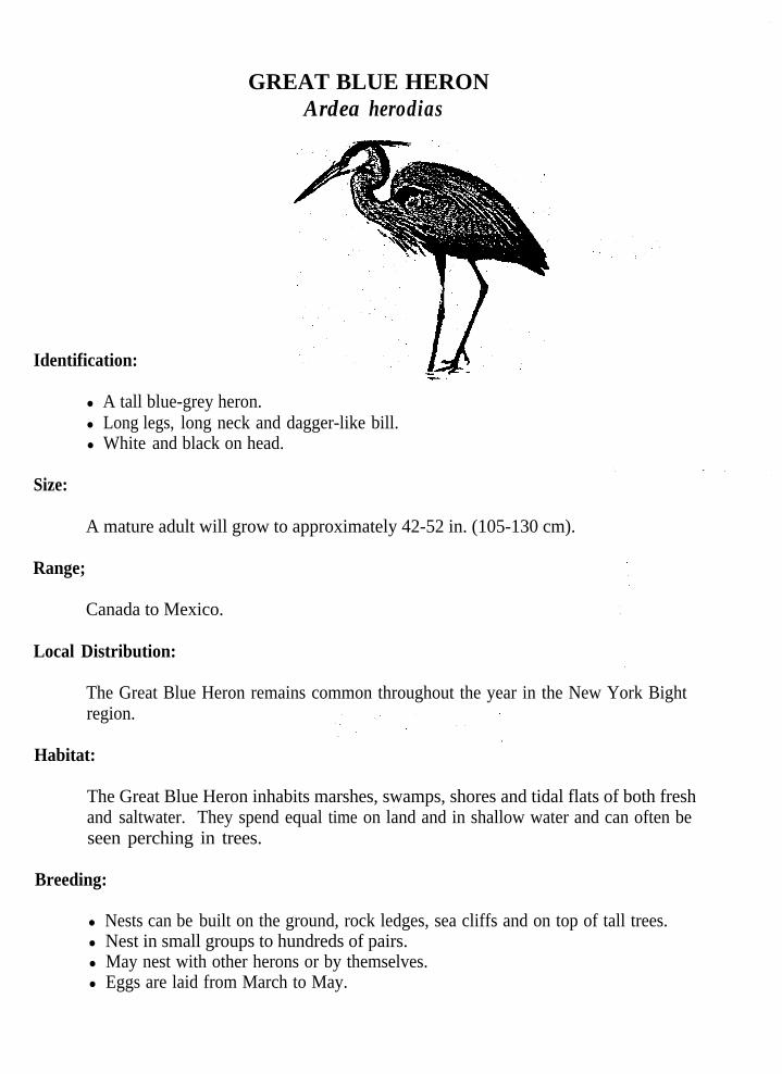
GREAT BLUE HERONArdea herodias
Identification:-.
l A tall blue-grey heron.l Long legs, long neck and dagger-like bill.l White and black on head.
Size:
A mature adult will grow to approximately 42-52 in. (105-130 cm).
Range;
Canada to Mexico.
Local Distribution:
The Great Blue Heron remains common throughout the year in the New York Bightregion.
Habitat:
The Great Blue Heron inhabits marshes, swamps, shores and tidal flats of both freshand saltwater. They spend equal time on land and in shallow water and can often beseen perching in trees.
Breeding:
l Nests can be built on the ground, rock ledges, sea cliffs and on top of tall trees.l Nest in small groups to hundreds of pairs.l May nest with other herons or by themselves.l Eggs are laid from March to May.
l 3-7 blue-green to pale olive eggs are laid.l Incubation is by both sexes and lasts approximately 25-29 days.l Young leave the nest after 64-91 days. - -
Feeding:
l Fishes at night and during the day.l Waits motionless in shallow water for prey to come into striking distance.l Will usually catch fish crosswise in bill, turn and swallow whole.l Feeds on fishes, frogs, shrimps, salamanders, snakes, insects and occasionally small
rodents.
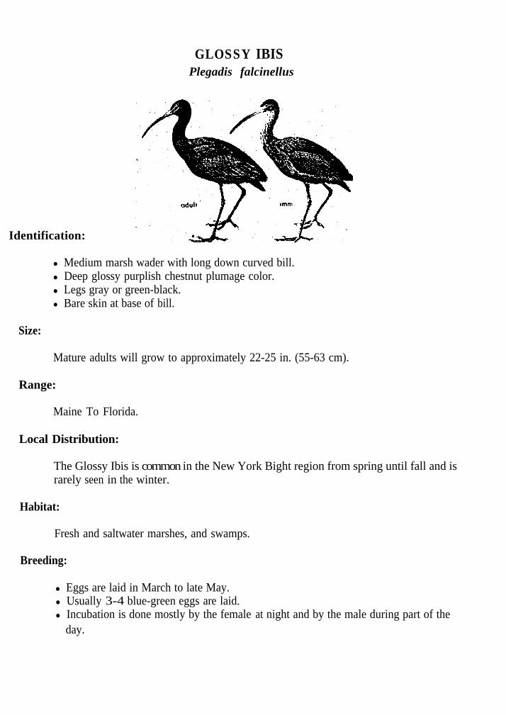
GLOSSY IBISPlegadis falcinellus
Identification:
Mature adults will grow to approximately 22-25 in. (55-63 cm).
Range:
Maine To Florida.
l Medium marsh wader with long down curved bill.l Deep glossy purplish chestnut plumage color.l Legs gray or green-black.l Bare skin at base of bill.
Size:
Local Distribution:
The Glossy Ibis is common in the New York Bight region from spring until fall and israrely seen in the winter.
Habitat:
Fresh and saltwater marshes, and swamps.
Breeding:
l Eggs are laid in March to late May.l Usually 3-4 blue-green eggs are laid.l Incubation is done mostly by the female at night and by the male during part of the
day.

l Incubation lasts approximately 21 days and young feed on regurgitated food fromthe parents.
l Young are on their own after 42 days.
Feeding:
l Feeds .by probing into crayfish holes, a major part of their diet in some areas.l Also eats snakes, grasshoppers, cut worms and other insects.
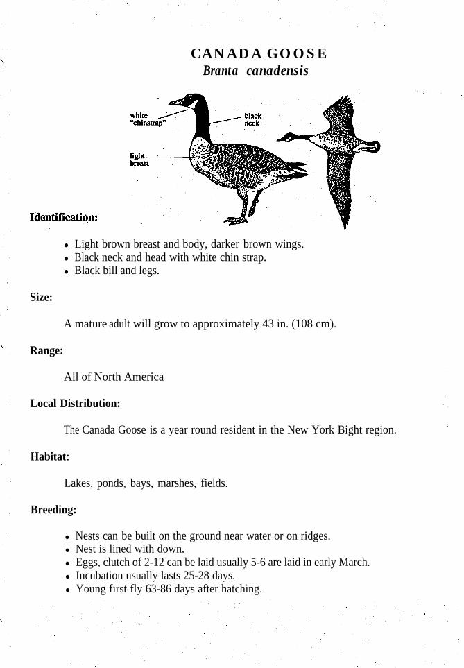
CANADA GOOSEBranta canadensis
l Light brown breast and body, darker brown wings.l Black neck and head with white chin strap.l Black bill and legs.
Size:
A mature adult will grow to approximately 43 in. (108 cm).
Range:
All of North America
Local Distribution:
The Canada Goose is a year round resident in the New York Bight region.
Habitat:
Lakes, ponds, bays, marshes, fields.
Breeding:
l Nests can be built on the ground near water or on ridges.l Nest is lined with down.l Eggs, clutch of 2-12 can be laid usually 5-6 are laid in early March.l Incubation usually lasts 25-28 days.l Young first fly 63-86 days after hatching.

Feeding:
l Feed mostly in early morning and late afternoon.l Essentially grazers.

MALLARD Anas pluyrhynchos
Identification:
l Male has shiny green head a brown breast and may have a white neck ring.l Female is mottled brown overall.l Both sexes have violet blue speculum, yellow bill and whitish tail.
Size:
A mature adult will grow to approximately 28 in. (70 cm.)
Range:
Found in temperate regions around the world. Most of the Northern hemisphere.
Local Distribution:
The Mallard is a year round resident throughout the New York Bight Region.
Habitat:
Marshes, wooded swamps, grainfields, ponds, rivers, lakes, and bays.
Breeding:.
l Nests usually built on ground among dead grasses, reeds, sometimes in cavities oft r e e s .
l Nests lined in down.l Eggs, clutch from 5-14 usually 8-10 are laid between March and July.l Incubation lasts 26-30 days.l Once young dry off from hatching, they are led to the nearest water.l Young first fly 49-60 days after hatching.

Feeding:
l Feeds by tipping up and reaching below the water surface with bill in shallow waters.l Can dive for food if necessary.l Feeds on marsh grasses, seeds, and sedges.
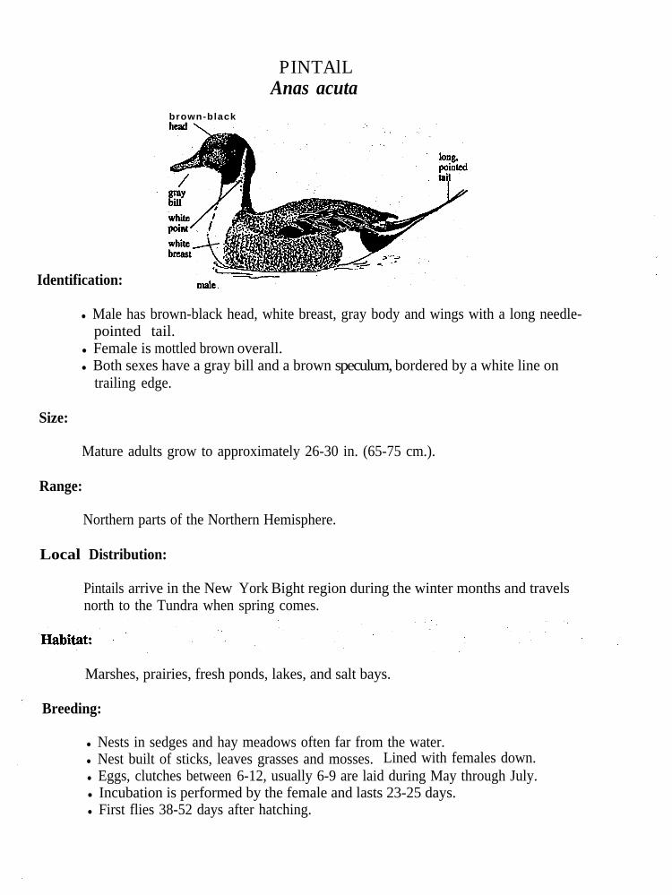
PINTAlLAnas acuta
brown-black
Identification:
l Male has brown-black head, white breast, gray body and wings with a long needle-pointed tail.
l Female is mottled brown overall.l Both sexes have a gray bill and a brown speculum, bordered by a white line on
trailing edge.
Size:
Mature adults grow to approximately 26-30 in. (65-75 cm.).
Range:
Northern parts of the Northern Hemisphere.
Local Distribution:
Pintails arrive in the New York Bight region during the winter months and travelsnorth to the Tundra when spring comes.
Marshes, prairies, fresh ponds, lakes, and salt bays.
Breeding:
l Nests in sedges and hay meadows often far from the water.l Nest built of sticks, leaves grasses and mosses. Lined with females down.l Eggs, clutches between 6-12, usually 6-9 are laid during May through July.l Incubation is performed by the female and lasts 23-25 days.l First flies 38-52 days after hatching.

Feeding:
Feeds like other dabbling ducks.90% of diet is vegetal, chiefly of seeds.The other 10% is of small invertebrates.
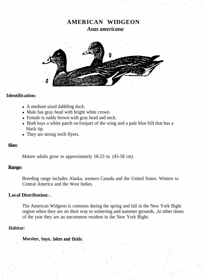
AMERICAN WIDGEONAnas americana
Identification:
l A medium sized dabbling duck.l Male has gray head with bright white crown.l Female is ruddy brown with gray head and neck.l Both haye a white patch on forepart of the wing and a pale blue bill that has a
black tip.l They are strong swift flyers.
Mature adults grow to approximately 18-23 in. (45-58 cm).
Breeding range includes Alaska, western Canada and the United States. Winters toCentral America and the West Indies.
Local Distribution: .
The American Widgeon is common during the spring and fall in the New York Bightregion when they are on their way to wintering and summer grounds. ,At other timesof the year they are an uncommon resident in the New York Bight.
Habitat:

Breeding:
l Eggs are laid from May to July.l Commonly 9-11 cream white eggs are laid.l Incubation is by the female and lasts 22-24 days, Young leave the nest at 45-58 days.
Feeding:
l Dabbles with bill in mud or tips up in shallow water to reach bottom.l When feeding in water they eat mostly seeds, leaves, stems, buds, widgeon grass,
.and other grasses that are found in the water. l Will also graze in fields feeding on snails; beetles, insects and young grass and grain
plants.
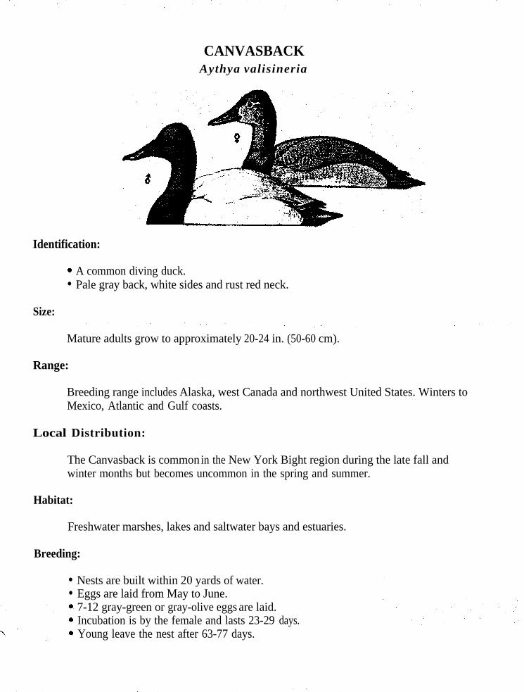
CANVASBACKAythya valisineria
Identification:
0
l
Size:
A common diving duck.Pale gray back, white sides and rust red neck.
Mature adults grow to approximately 20-24 in. (50-60 cm).
Range:
Breeding range includes Alaska, west Canada and northwest United States. Winters toMexico, Atlantic and Gulf coasts.
Local Distribution:
The Canvasback is common in the New York Bight region during the late fall andwinter months but becomes uncommon in the spring and summer.
Habitat:
Freshwater marshes, lakes and saltwater bays and estuaries.
Breeding:
l
l
Nests are built within 20 yards of water.Eggs are laid from May to June.7-12 gray-green or gray-olive eggs are laid.Incubation is by the female and lasts 23-29 days.Young leave the nest after 63-77 days.

Feeding:
l Feeds by diving in water that varies from 3-30 feet deep.l Eats primarily roots, tubers, grasses and basal parts of bottoms plants.l Will also eat some mollusks, aquatic insects and small fishes.

Identification:
BUFFLEHEADBucephala albeola
l One of the smallest diving ducks.l Tiny bill with large puffy head.l Body of male mostly white with black back and white patch on head.l Female is gray-brown with small white cheek patch.
Size:
Mature adults grow to approximately 13-15 in. (33-38 cm).
Range:
Breeding range includes Alaska and Canada. Winters to Mexico and Gulf coast.
Local Distribution:
The Bufflehead is abundant in the New York Bight region throughout the fall, winterand spring months but becomes scarce in the summer.
Habitat:
Fresh and saltwater lakes, ponds, rivers, bays, and estuaries.
Breeding:
l Nests in flicker holes adding no nesting material.l Eggs are laid from mid April to May.l Commonly 9 ivory yellow to pale olive buff eggs are laid.l Incubation is by the female and lasts 28-33 days.l Young leave nest at 24-36 hours after hatching and fly at approximately 50-55 days
after hatching.

Feeding:
l Dives for food often having a companion on the surface to watch for danger.l Eats primarily small aquatic insects, snails, small fishes, shrimp and some water
plants.

SHARP-SHINNEDAccipiter striatus
Identification:
l A small slimmed bodied hawk.l Slim tail and squared at the end, cross barred with three or four narrow bands of
black.l Adults upper-parts blue-gray.l Underparts whitish, heavily cross barred with red-brown.l Legs yellow.
Size:
Mature adults grow to approximately 10 -14 in. (25-35 cm.).
Range:
Tree limit in Canada to Gulf states.
Local Distribution:
Year round resident of the New York Bight region. Mainly in wooded area's. Mostcommonly seen during migratory seasons.

Breeding:
l Nest built of sticks and twigs lined with strips of bark. About 2 ft. across in a crotchof a tree or a branch close to the trunk of a tree.
l Usually found in a coniferous tree, between 10- 60 ft. up.‘O Eggs, clutches of 3-8 are laid between March and July.l Incubation is performed by both adults 34-35 days.
‘0 First fly about 23 days after hatching.
Feeding:
l Feeds on small birds, starlings, mourning doves, and pigeons.* Hunts by dashing through woods in a low swift flight, around trees, through brush
and reaches out in air or on the ground to catch in talons; surprised birds and other
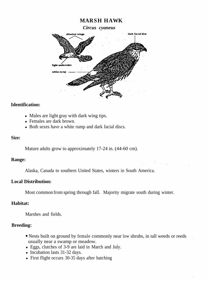
MARSH HAWKCircus cyaneus
Identification:
l Males are light gray with dark wing tips.l Females are dark brown.l Both sexes have a white rump and dark facial discs.
Size:
Mature adults grow to approximately 17-24 in. (44-60 cm).
Range:
Alaska, Canada to southern United States, winters in South America.
Local Distribution:
Most common from spring through fall. Majority migrate south during winter.
Habitat:
Marshes and fields.
Breeding:
6 Nests built on ground by female commonly near low shrubs, in tall weeds or reedsusually near a swamp or meadow.l Eggs, clutches of 3-9 are laid in March and July.l Incubation lasts 31-32 days.l First flight occurs 30-35 days after hatching

Feeding:
l Glides and tilts buoyantly low over the ground with wings slightly above horizontal.6 Eat mainly mice, rats, frogs, small snakes, crayfish, insects, and small birds.
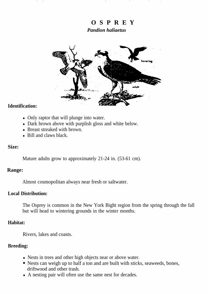
O S P R E Y Pandion haliaetus
Identification:
l Only raptor that will plunge into water.l Dark brown above with purplish gloss and white below.l Breast streaked with brown.l Bill and claws black.
Size:
Mature adults grow to approximately 21-24 in. (53-61 cm).
Range:
Almost cosmopolitan always near fresh or saltwater.
Local Distribution:
The Osprey is common in the New York Bight region from the spring through the fallbut will head to wintering grounds in the winter months.
Habitat:
Rivers, lakes and coasts.
Breeding:
l Nests in trees and other high objects near or above water.i Nests can weigh up to half a ton and are built with sticks, seaweeds, bones,
driftwood and other trash.l A nesting pair will often use the same nest for decades.

l Incubation is by the female and lasts 35-38 days. l First flight takes place 48-59 days after hatching and return to nest afterwards.l Young do not breed until three years old.l Osprey will go to great measures to protect nest.
Feeding:
l Spends most of time perched near water and flies out over water to hunt.-0 When a fish is sighted they will hover with wings beating, legs trailing under body
and strike with a great splash.l Holds fish gripped in both feet and head pointed forward to reduce resistance from
wind.l Feeds almost exclusively on fish, such as herring, bluefish, flounders, catfish,
pickerel and most any fish it can capture. .l The outer toe of the talons, rotate foward and, backward, which permits them to hold
two toes foward and two toes backwards or three toes forward and one backwards,this adaptation allows the osprey to grasp strong-swimming, slippery fish.
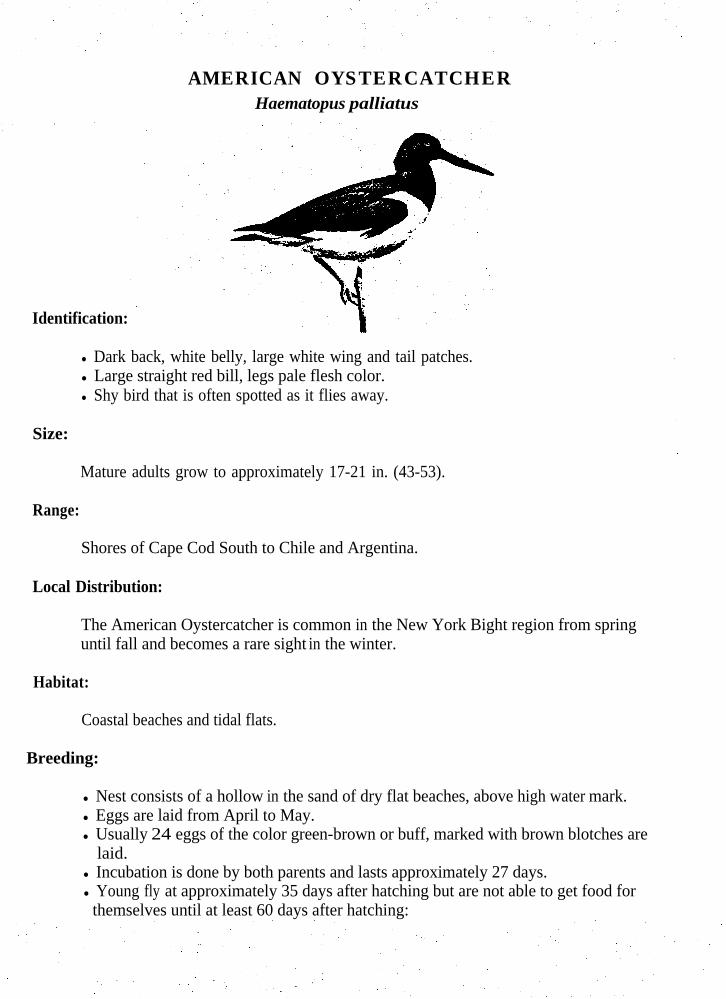
AMERICAN OYSTERCATCHERHaematopus palliatus
Identification:
l Dark back, white belly, large white wing and tail patches.l Large straight red bill, legs pale flesh color.l Shy bird that is often spotted as it flies away.
Size:
Mature adults grow to approximately 17-21 in. (43-53).
Range:
Shores of Cape Cod South to Chile and Argentina.
Local Distribution:
The American Oystercatcher is common in the New York Bight region from springuntil fall and becomes a rare sight in the winter.
Habitat:
Coastal beaches and tidal flats.
Breeding:
l Nest consists of a hollow in the sand of dry flat beaches, above high water mark.l Eggs are laid from April to May.l Usually 24 eggs of the color green-brown or buff, marked with brown blotches are
laid.l Incubation is done by both parents and lasts approximately 27 days.l Young fly at approximately 35 days after hatching but are not able to get food for
themselves until at least 60 days after hatching:

Feeding:
l Feeds primarily by prying bivalves open with the use of their long bill.l Will also eat sea urchins, starfish, crabs, and marine worms.
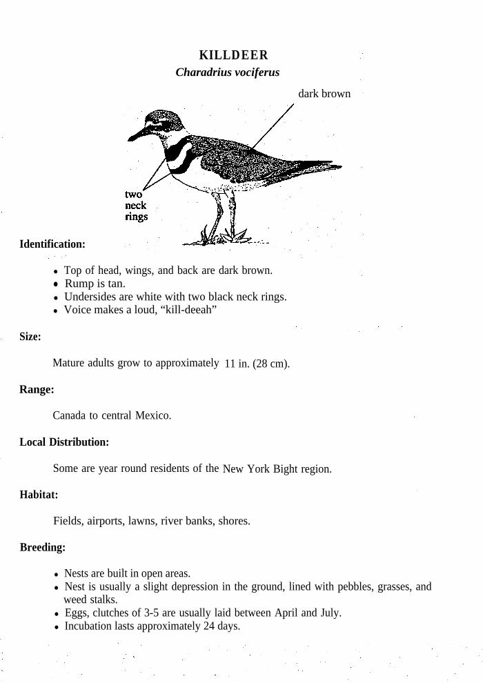
KILLDEERCharadrius vociferus
dark brown
Identification:
l Top of head, wings, and back are dark brown.l Rump is tan.l Undersides are white with two black neck rings.l Voice makes a loud, “kill-deeah”
Size:
Mature adults grow to approximately
Range:
Canada to central Mexico.
Local Distribution:
Some are year round residents of the
11 in. (28 cm).
New York Bight region.
Habitat:
Fields, airports, lawns, river banks, shores.
Breeding:
l Nests are built in open areas.l Nest is usually a slight depression in the ground, lined with pebbles, grasses, and
weed stalks.l Eggs, clutches of 3-5 are usually laid between April and July.l Incubation lasts approximately 24 days.

l Young fly around 25 days after hatching.
Feeding:
l 98%l Also
of food are insects gleaned from fields and river banks etc.feeds off of small marine invertebrates.

P I P I N G P L O V E RCharadrius melodus
Identification:
l Color of dry sand on top and white below.l A complete or incomplete ring around neck. ,l Legs yellow, bill yellow with black tip in summer and all black in winter.
Size:
Mature adults grow to approximately 6-7 1/2 in. (15-19 cm).
Range:
South Canada to northcast and central United States.
Local Distribution:
The Piping Plover is an uncommon sight in the New York Bight region, however theyutilize lower portions of the Hudson-Raritan Estuary as a nesting site.
Habitat:
Sand beaches and tidal flats.
Breeding:
l Nests are built on sand bordering a water body and consist of a hollow in the sandthat is sometimes lined with shells or driftwood.
l 3-4 eggs are laid in April to May.l Eggs are a sand color, spotted with purple and black.l Incubation is done by both parents and lasts approximately 27 days.l Young fly 30-35 days after hatching.

Feeding:
l The Piping Plover when feeding will run a short distance, stop, stare at the sand andthen pick up something.
l Feeds on marine worms, fly larvae, beetles, crustaceans, mollusks and small eggs ofother animals.
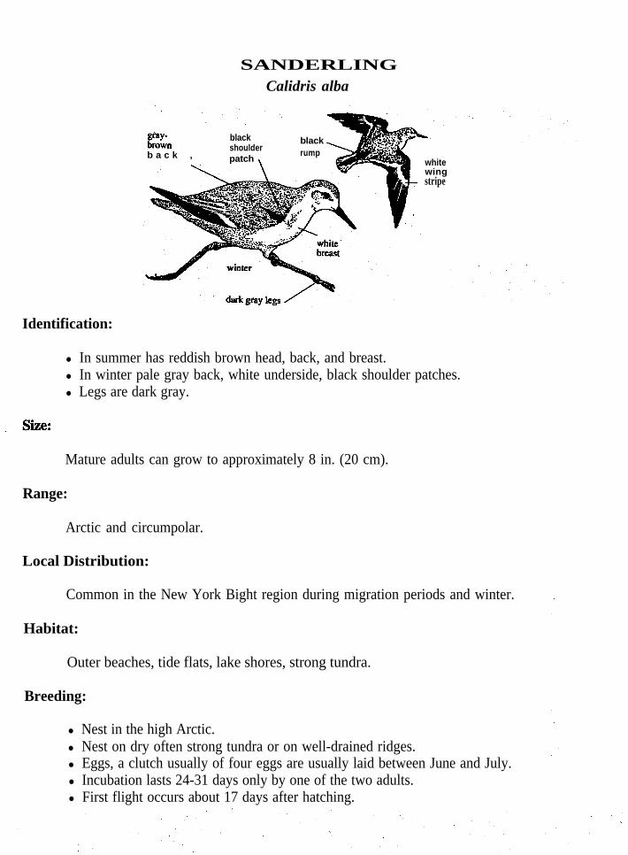
SANDERLINGCalidris alba
t2Gnb a c k ,
blackshoulderpatch \
black \rump
whitewingstripe
Identification:
l In summer has reddish brown head, back, and breast.l In winter pale gray back, white underside, black shoulder patches.l Legs are dark gray.
Mature adults can grow to approximately 8 in. (20 cm).
Range:
Arctic and circumpolar.
Local Distribution:
Common in the New York Bight region during migration periods and winter.
Habitat:
Outer beaches, tide flats, lake shores, strong tundra.
Breeding:
l Nest in the high Arctic.l Nest on dry often strong tundra or on well-drained ridges.l Eggs, a clutch usually of four eggs are usually laid between June and July.l Incubation lasts 24-31 days only by one of the two adults.l First flight occurs about 17 days after hatching.

Feeding:
l Eats flies and their larvae along with other insects and minute crustaceans.l On wet beaches of coasts, the Sanderling probes vigorously with partly open bill.
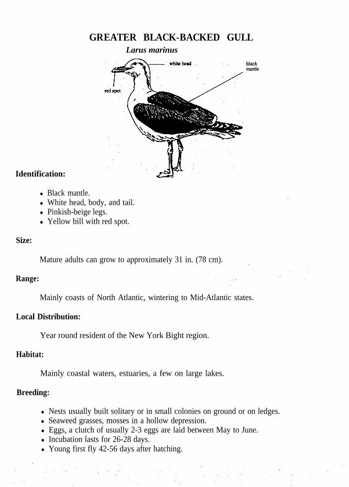
GREATER BLACK-BACKED GULLLarus marinus
blackmantle
Identification:
l Black mantle.l White head, body, and tail.l Pinkish-beige legs.l Yellow bill with red spot.
Size:
Mature adults can grow to approximately 31 in. (78 cm).
Range:
Mainly coasts of North Atlantic, wintering to Mid-Atlantic states.
Local Distribution:
Year round resident of the New York Bight region.
Habitat:
Mainly coastal waters, estuaries, a few on large lakes.
Breeding:
l Nests usually built solitary or in small colonies on ground or on ledges.l Seaweed grasses, mosses in a hollow depression.l Eggs, a clutch of usually 2-3 eggs are laid between May to June.l Incubation lasts for 26-28 days.l Young first fly 42-56 days after hatching.

Feeding:
Omnivorous and voracious feeder.Feeds on eggs and young.Takes fish from other seabirds.Scavengers on garbage.Hunts for fishes.
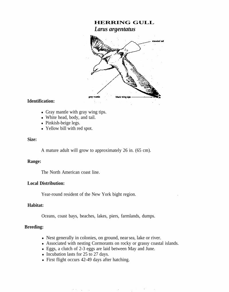
HERRING GULLLarus argentatus
Identification:
l Gray mantle with gray wing tips.l White head, body, and tail.l Pinkish-beige legs.l Yellow bill with red spot.
Size:
A mature adult will grow to approximately 26 in. (65 cm).
Range:
The North American coast line.
Local Distribution:
Year-round resident of the New York bight region.
Habitat:
Oceans, coast bays, beaches, lakes, piers, farmlands, dumps.
Breeding:
l Nest generally in colonies, on ground, near sea, lake or river.l Associated with nesting Cormorants on rocky or grassy coastal islands.l Eggs, a clutch of 2-3 eggs are laid between May and June.l Incubation lasts for 25 to 27 days.l First flight occurs 42-49 days after hatching.

Feeding:
Feeds on small fish. Forages through wastes and sewage along water fronts of towns, cities, or dumps.Hunts animal carrion, dead fishes, mollusks, crustaceans, marine worms, starfish andsea urchins.

LAUGHING GULLLarus Atricilla
rounded tail
\darksmudge
Identification:
Dark gray mantle with black wing tips.White body and tail.Dark red legs.In summer head is all black, in winter head is white with dark smudge.
Mature adults will grow to approximately
Range:
16-17 in. (40-43 cm).
Nova Scotia to Venezuela.
Local Distribution:
The Laughing gull is most common during the summer in the New York Bight region.
Habitat:
Salt marshes, coastal bays, piers, beaches, oceans.
Breeding;
l Nests in colonies.l Nest is usually built on ground of coastal islands or on tufts of grass or reeds in
saltwater marshes.l Eggs, a clutch of 3-4 are usually laid between May and July.l Incubation lasts about 20 days.

Feeding;
l Catches small fish at the surface.‘0 Seeks scraps thrown from boats.

n COMMON
Identification:
hirundo
l Light grayl White body and tail.l Orange-red feet.
mantle.
l In summer, black cap on head and black tip on bill,l In winter black cap is incomplete and bill is blackish.
Size:
A mature adult can grow to approximately 16 in. (40 cm).
Range:
Temperate zone of the Northern Hemisphere.
Local Distribution:
The Common Tern migrates into the New York Bight region in early May and leavesin mid September.
Habitat:
Lakes, oceans, bays, beaches.
Breeding:
l Nests in colonies, several hundred or up to many thousands assemble in breedingseason.
l Nest is made in a slight depression in soil usually lined with grasses, seashells, orbits of seaweeds. ’
l Eggs, a clutch usually of 2-3 are laid between May and August.

i Incubation lasts 21-26 days.l Young first fly after 28 days after hatching.
Feeding:
l Hover in flocks over schools of small fish that have been driven to the surface bybluefish and plunging head first into the water to feed.
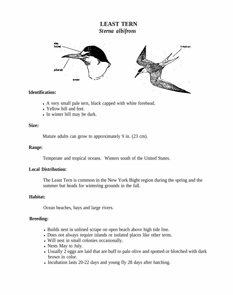
LEAST TERNSterna albifrons
Identification:
l A very small pale tern, black capped with white forehead.l Yellow bill and feet.l In winter bill may be dark.
Size:
Mature adults can grow to approximately 9 in. (23 cm).
Range:
Temperate and tropical oceans. Winters south of the United States.
Local Distribution:
The Least Tern is common in the New York Bight region during the spring and thesummer but heads for wintering grounds in the fall.
Habitat:
Ocean beaches, bays and large rivers.
Breeding:
l Builds nest in unlined scrape on open beach above high tide line.l Does not always require islands or isolated places like other terns.l Will nest in small colonies occasionally.l Nests May to July.l Usually 2 eggs are laid that are buff to pale olive and spotted or blotched with dark
brown in color.l Incubation lasts 20-22 days and young fly 28 days after hatching.

l Adults will defend eggs by flying above and dropping excrement on intruder.
Feeding:
l Feeds by hovering or skimming above the surface of water and then diving water;catches prey in its bill. Usually swallows prey while in flight.
l Eats small fishes and shrimps.

BLACK SKIMMERRhychops niger
Identification:
l Black above and white below.l Exceptionally long wings.l Long scissor like bright red bill with black tip, lower mandible is longer than upper.
Size:
Mature adults grow to approximately
Range:
16-20 in. (40-50 cm).
Cape Cod to Gulf of Mexico. Winters from Gulf of Mexico to South America.
Local Distribution:
The Black Skimmer is common in the New York Bight region from spring until fall butbecomes rare in the winter when they head for their wintering grounds.
Ocean, beaches, salt bays and tidal waters.
Breeding:
l Nests in colonies of 100-200 pairs.l Nest consists of a shallow hollow above high-water mark.l Eggs are laid in May to July.

6 Usually a clutch of 4-5 eggs, heavily marked with brown, lilac and grey colors.l Eggs are often destroyed by dogs and people walking on the beach.l Incubation is by female. l Length of incubation and first flight are unknown.
Feeding:
l Feeding takes place mostly at night when waters are calm and fish and crustaceansare near the surface.
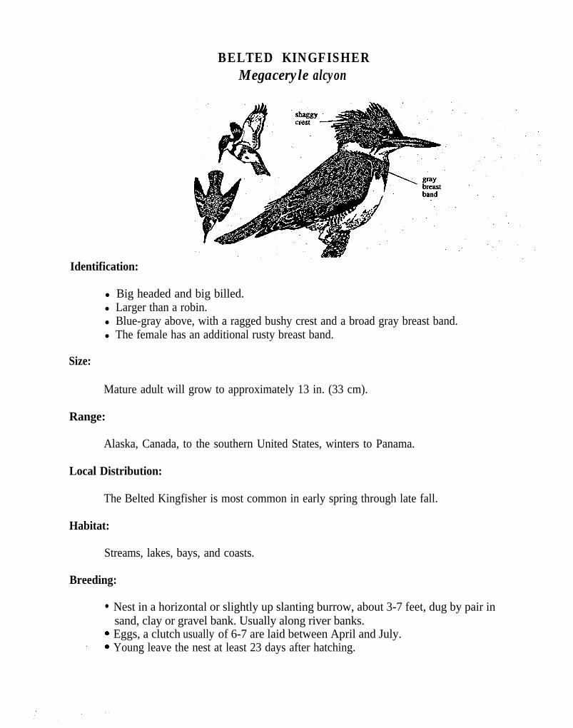
BELTED KINGFISHERMegaceryle alcyon
Identification:
l Big headed and big billed.l Larger than a robin.l Blue-gray above, with a ragged bushy crest and a broad gray breast band.l The female has an additional rusty breast band.
Size:
Mature adult will grow to approximately 13 in. (33 cm).
Range:
Alaska, Canada, to the southern United States, winters to Panama.
Local Distribution:
The Belted Kingfisher is most common in early spring through late fall.
Habitat:
Streams, lakes, bays, and coasts.
Breeding:
l
.:
Nest in a horizontal or slightly up slanting burrow, about 3-7 feet, dug by pair insand, clay or gravel bank. Usually along river banks.Eggs, a clutch usually of 6-7 are laid between April and July.Young leave the nest at least 23 days after hatching.

Feeding:
l Mainly small fish.l May dive from perch obliquely into water to seize fish in its powerful bill or hover in
the air 20 to 40 feet above the water, then make a straight dive into the water.
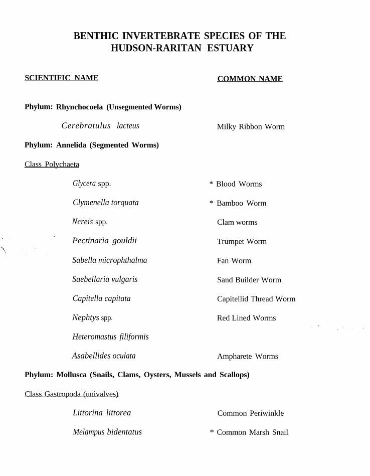
BENTHIC INVERTEBRATE SPECIES OF THEHUDSON-RARITAN ESTUARY
SCIENTIFIC NAME
Phylum: Rhynchocoela (Unsegmented Worms)
Phylum: Annelida (Segmented Worms)
Cerebratulus lacteus
Class Polychaeta
Glycera spp.
Clymenella torquata
Nereis spp.
Pectinaria gouldii
Sabella microphthalma
Saebellaria vulgaris
Capitella capitata
Nephtys spp.
Heteromastus filiformis
Asabellides oculata Ampharete Worms
Phylum: Mollusca (Snails, Clams, Oysters, Mussels and Scallops)
COMMON NAME
Milky Ribbon Worm
* Blood Worms
* Bamboo Worm
Clam worms
Trumpet Worm
Fan Worm
Sand Builder Worm
Capitellid Thread Worm
Red Lined Worms
Class Gastropoda (univalves)
Littorina littorea
Melampus bidentatus
Common Periwinkle
* Common Marsh Snail

Busycon carica
Busycon canaliculatum Channeled Welk _
Urosalpinx cinerea Atlantic Oyster Drill
Thick-lipped Oyster Drill
Mud Snail
Eupleura caudata
Nassarius obsoleta *
Nassarius trivittatus
Lunatia heros
Polinices duplicatus
Anomia simplex
Crepidula fornicata
Crepidula plana
Class Bivalvia (bivalves)
*
*
*
Anadara ovalis
Anadara transversa
Astarte castanea
Mulinia lateralis
Spisula solidissima
Mya arenaria
Modiolus demissus
Mytilus edulis
Crassostrea virginica
Aequipecten irradians
*
*
*
Knobbed Welk ’
Three-Lined Basket Shell
Northern Moon Snail
Lobed Moon Snail.
Jingle Shell
Common Slipper Shell
Eastern White Slipper Shell
Blood Ark
Transverse Ark
Chestnut Astarte
Dwarf Surf Clam
Atlantic Surf Clam
Soft Shelled Clam
Ribbed Mussel
Blue Mussel
Eastern Oyster
Bay Scallop
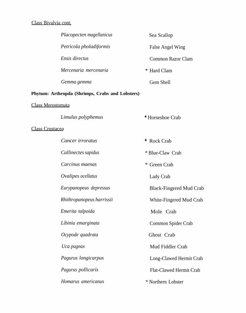
Class Bivalvia cont,
Placopecten magellanicus Sea Scallop
Petricola pholadiformis False Angel Wing
Ensis directus Common Razor Clam
Mercenaria mercenaria * Hard Clam
Gemma gemma Gem Shell
Phytum: Arthropda (Shrimps, Crabs and Lobsters)
Class Merostomata
Limulus polyphemus * Horseshoe Crab
Class Crustacea
Cancer irroratus
Callinectes sapidus
Carcinus maenas
Ovalipes ocellatus
Eurypanopeus depressus
Rhithropanopeus harrissii
Emerita talpoida
Libinia emarginata
Ocypode quadrata
Uca pugnax
* Rock Crab
* Blue-Claw Crab
* Green Crab
Lady Crab
Black-Fingered Mud Crab
White-Fingered Mud Crab
Mole Crab
Common Spider Crab
Ghost Crab
Mud Fiddler Crab
Pagurus longicarpus Long-Clawed Hermit Crab
Pagurus pollicaris Flat-Clawed Hermit Crab
Homarus americanus * Northern Lobster
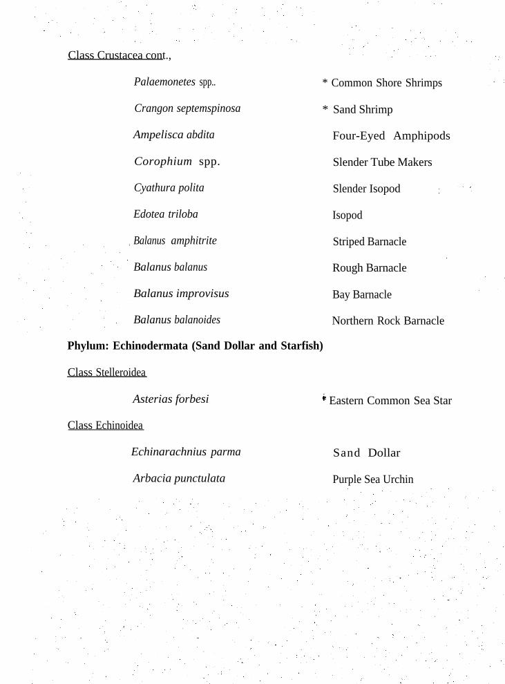
Class Crustacea cont.,
Palaemonetes spp..
Crangon septemspinosa
Ampelisca abdita
Corophium spp.
Cyathura polita
Edotea triloba
Balanus amphitrite
Balanus balanus
Balanus improvisus
Balanus balanoides
Phylum: Echinodermata (Sand Dollar and Starfish)
Class Stelleroidea
Asterias forbesi
Class Echinoidea
Echinarachnius parma
Arbacia punctulata
* Common Shore Shrimps
* Sand Shrimp
Four-Eyed Amphipods
Slender Tube Makers
Slender Isopod
Isopod
Striped Barnacle
Rough Barnacle ’
Bay Barnacle
Northern Rock Barnacle
* Eastern Common Sea Star
Sand Dollar
Purple Sea Urchin
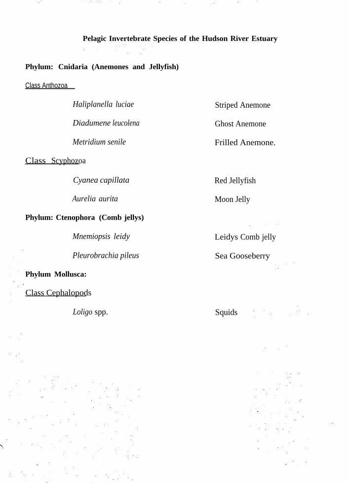
Pelagic Invertebrate Species of the Hudson River Estuary
Phylum: Cnidaria (Anemones and Jellyfish)
Class Anthozoa
Haliplanella luciae
Diadumene leucolena
Metridium senile
Class Scyphozoa
Cyanea capillata
Aurelia aurita Moon Jelly
Phylum: Ctenophora (Comb jellys)
Mnemiopsis leidy
Pleurobrachia pileus
Phylum Mollusca:
Class Cephalopods
Loligo spp.
Striped Anemone
Ghost Anemone
Frilled Anemone.
Red Jellyfish
Leidys Comb jelly
Sea Gooseberry
Squids
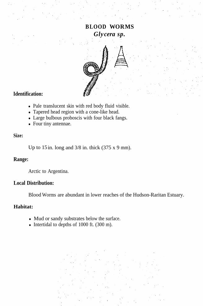
BLOOD WORMS Glycera sp.
Identification:
l Pale translucent skin with red body fluid visible.l Tapered head region with a cone-like head.l Large bulbous proboscis with four black fangs.l Four tiny antennae.
Size:
Up to 15
Range:
Arctic to
in. long and 3/8 in. thick (375 x 9 mm).
Argentina.
Local Distribution:
Blood Worms are abundant in lower reaches of the Hudson-Raritan Estuary.
Habitat:
l Mud or sandy substrates below the surface.l Intertidal to depths of 1000 ft. (300 m).
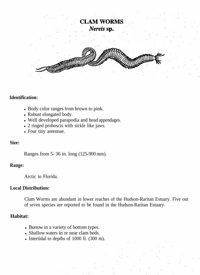
Identification:
l Body color ranges from brown to pink.l Robust elongated body.l Well developed parapodia and head appendages.l 2 ringed proboscis with sickle like jaws.l Four tiny antennae.
Size:
Ranges from 5- 36 in. long (125-900 mm).
Range:
Arctic to Florida.
Local Distribution:
Clam Worms are abundant in lower reaches of the Hudson-Raritan Estuary. Five outof seven species are reported to be found in the Hudson-Raritan Estuary.
Habitat:
l Burrow in a variety of bottom types.l Shallow waters in or near clam beds.l Intertidal to depths of 1000 ft. (300 m).
Spawning:
Feeding:
l Strong predators.l Feed on other clam worms, algae and scavenge.
During breeding seasons they metamorphose into special sexual forms calledheteroneises, which have enlarged parapodia especially adapted for swimming.Heteroneises swarm to the surface in frenzied mating dances in spring and summer.They appear for several successive nights and eventually they release their eggs andsperm and die.Planktonic larvae develop and become recognizable clam worms.They settle to the bottom and resume the benthic existence of their parents.Some species spawn in their burrows.
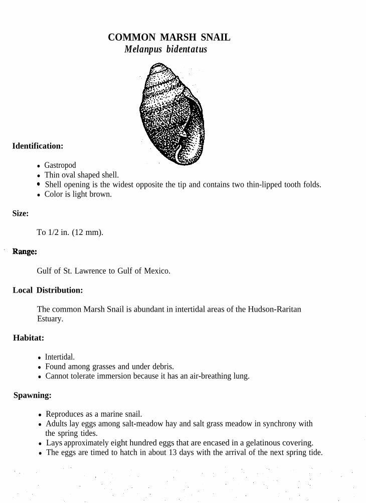
COMMON MARSH SNAILMelanpus bidentatus
Identification:
l Gastropodl Thin oval shaped shell.0 Shell opening is the widest opposite the tip and contains two thin-lipped tooth folds.l Color is light brown.
Size:
To 1/2 in. (12 mm).
Gulf of St. Lawrence to Gulf of Mexico.
Local Distribution:
The common Marsh Snail is abundant in intertidal areas of the Hudson-RaritanEstuary.
Habitat:
l Intertidal.l Found among grasses and under debris.l Cannot tolerate immersion because it has an air-breathing lung.
Spawning:
l Reproduces as a marine snail.l Adults lay eggs among salt-meadow hay and salt grass meadow in synchrony with
the spring tides.l Lays approximately eight hundred eggs that are encased in a gelatinous covering.l The eggs are timed to hatch in about 13 days with the arrival of the next spring tide.


Identification:
l Blunt tipped shell with approximatily six body spirals.l Lattice-like surface.
MUD SNAILIllyanassa obsoletus
l Smooth edged operculum.l Color varies from brown to black with a glazed inner lip.
Size:
To 1 in. (25mm).
Range:
Cape Cod to Gulf of Mexico.
Local Distribution:
Mud Snails are common in intertidal areas of the Hudson-Raritan Estuary.
Habitat:
l Intertidal to subtidal.l Prefers muddy substrates.
Feeding:
l Feeds primarily on bottom sediments rich in algae.l Can detect dead organisms such as clams, crabs, and fish.l Hundreds of Mud Snails can be found feeding on these dead animals.
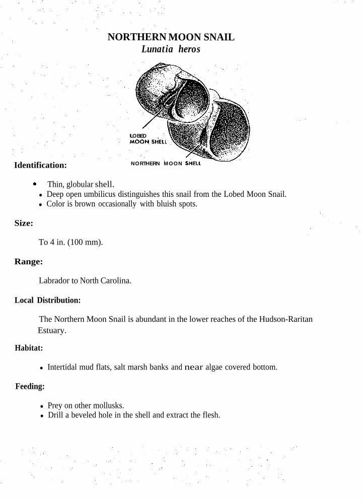
MOON SNAILNORTHERNLunatia heros
LOBED
Identification: NORTHERN MOON
6 Thin, globular shell.l Deep open umbilicus distinguishes this snail from the Lobed Moon Snail.l Color is brown occasionally with bluish spots.
Size:
To 4 in. (100 mm).
Range:
Labrador to North Carolina.
Local Distribution:
The Northern Moon Snail is abundant in the lower reaches of the Hudson-RaritanEstuary.
Habitat:
l Intertidal mud flats, salt marsh banks and near algae covered bottom.
Feeding:
l Prey on other mollusks.l Drill a beveled hole in the shell and extract the flesh.

LOBED MOON SNAILPolinices duplicatus
Identification:MOON SHELL
NORTHERN MOON
l Solid, rounded, glossy shell.l Umbilicus almost completely covered by a dark callus.
‘0 Color gray to tan.
Size:
To 3 in. (75 mm).
Range:
Massachusetts Bay to Gulf of Mexico.
Local Distribution:
The Lobed Moon Snail is abundant in lower reaches of the Hudson-Raritan Estuary.
Habitat:
l Sandy beaches, intertidal zone to subtidal in shallow water.l Prefers high salinity waters.
Spawning:
l Lay distinctive eggs cases called sand collars up to 6 inches in diameter.
Feeding:
l A predaceous hunter.l Prey on other mollusks primarily clams.l Drills a beveled hole in the shell and extract the flesh using their proboscis.
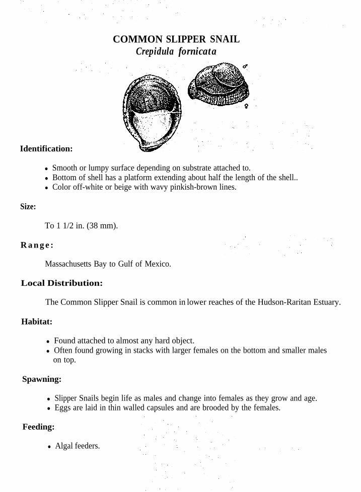
COMMON SLIPPERCrepidula fornicata
SNAIL
Identification:
l Smooth or lumpy surface depending on substrate attached to.l Bottom of shell has a platform extending about half the length of the shell..l Color off-white or beige with wavy pinkish-brown lines.
Size:
To 1 1/2 in. (38 mm).
R a n g e :
Massachusetts Bay to Gulf of Mexico.
Local Distribution:
The Common Slipper Snail is common in lower reaches of the Hudson-Raritan Estuary.
Habitat:
l Found attached to almost any hard object. l Often found growing in stacks with larger females on the bottom and smaller males
on top.
Spawning:
l Slipper Snails begin life as males and change into females as they grow and age.l Eggs are laid in thin walled capsules and are brooded by the females.
Feeding:
l Algal feeders.
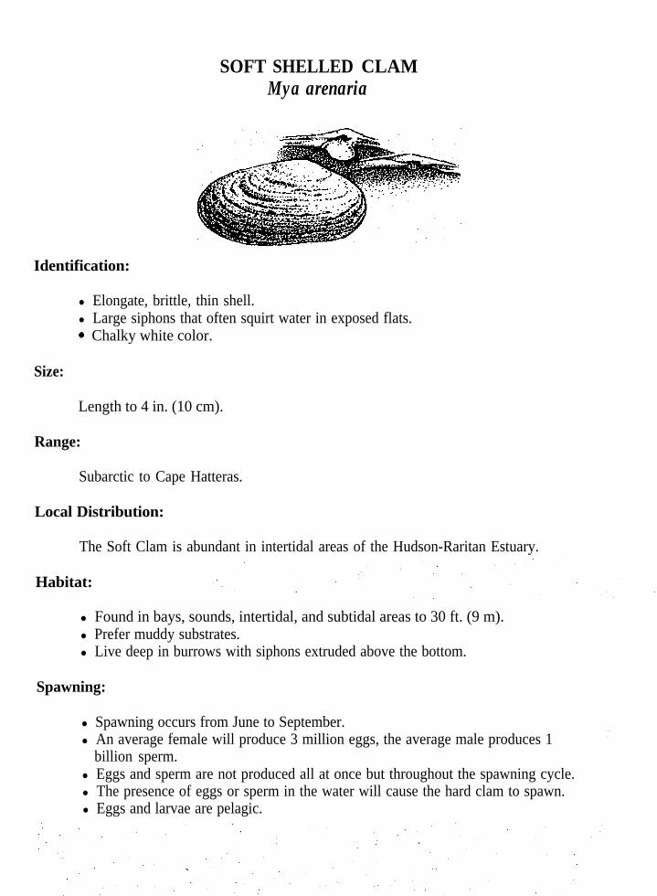
SOFT SHELLED CLAMMya arenaria
Identification:
l Elongate, brittle, thin shell.l Large siphons that often squirt water in exposed flats..* Chalky white color.
Size:
Length to 4 in. (10 cm).
Range:
Subarctic to Cape Hatteras.
Local Distribution:
The Soft Clam is abundant in intertidal areas of the Hudson-Raritan Estuary.
Habitat:
l Found in bays, sounds, intertidal, and subtidal areas to 30 ft. (9 m).l Prefer muddy substrates.l Live deep in burrows with siphons extruded above the bottom.
Spawning:
l Spawning occurs from June to September.l An average female will produce 3 million eggs, the average male produces 1
billion sperm.l Eggs and sperm are not produced all at once but throughout the spawning cycle.l The presence of eggs or sperm in the water will cause the hard clam to spawn.l Eggs and larvae are pelagic.

Growth:
Eggs develop into ciliated larvae, a period that lasts anywhere from 12 days to amonth or more.After this period they go through a change and develop a foot and two shells. Theyare called spat.The spat settle to the bottom and attach themselves by byssal threads. They aremicroscopic.At approximately 1 in. (25 mm) they lose their byssal threads and burrow into thebottom. Growth is rapid.Young Soft Shelled Clams can move about to search for suitable habitat, eventuallythey become non-motile and remain in their burrows for the duration of their life.
Feeding:
l Soft Shelled Clams have a in current and excurrent siphon. Il Water enters the in current siphon, passing over the gills. Food sticks to the mucus,
and cilia passes it to the mouth.l Unwanted food and wastes are passed out the excurrent siphon.l Food consists of small plants, clumps of bacteria, decomposing
fragments of organic material, and animals.

RIBBED MUSSELGuekensia demissa
Identification:
l Bivalve.l Numerous radial ridges.l Color varies from brown to greenish-yellowish.
Size:
To 4 in. (100 mm).
Range:
Florida to Cape Cod.
Local Distribution:
The Ribbed Mussel is abundant in lower reaches of the Hudson-Raritan Estuary.
Habitat:
l Common along salt marsh banks and submerged rocks.l Mussels use byssal threads to attach themselves to rocks, pilings, mud flats, etc.l Often half buried in peat or muck.
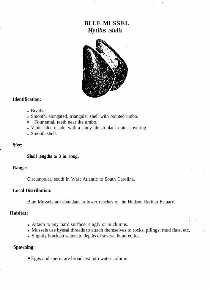
Identification:
BLUE MUSSELMytilus edulis
l Bivalve.l Smooth, elongated, triangular shell with pointed umbo.l Four small teeth near the umbo.l Violet blue inside, with a shiny bluish black outer covering.l Smooth shell.
Range:
Circumpolar, south in West Atlantic to South Carolina.
Local Distribution:
Blue Mussels are abundant in lower reaches of the Hudson-Raritan Estuary.
Habitat:
l Attach to any hard surface, singly or in clumps.l Mussels use byssal threads to attach themselves to rocks, pilings; mud flats, etc. l Slightly brackish waters to depths of several hundred feet.
Spawning:
h Eggs and sperm are broadcast into water column.
Growth:
l Full growth can take place in one year in prime habitats, otherwise it may take 2-5years.
Feeding:
l Feeds primarily on organic detritus.l Feeds by siphoning of water.l The current is caused by cilia.l Selective feeder, secretes a mucous containing unwanted food particles.

HARD CLAMMercenaria mercenaria
Identification:
l Strong thick shell.l Violet interior border.l Short siphons.
Size:
Length to 5 in. (13 cm).
Range:
Gulf of St. Lawrence to Texas.
Local Distribution:
Hard Clams are abundant in lower portions of the Hudson-Raritan Estuary.
Habitat:
l Inhabit intertidal and subtidal waters to depths as great as 50 ft. (15 m).l Prefer areas with higher salinity.l Found in sand or muddy-sand bottom.
Spawning:
l Spawning occurs from June through August in the New York bight.l Males release semen, containing pheromones, into the water.l Females are stimulated into releasing eggs.l Spawning is most intense during the first few days after peak temperatures are
reached.l A 2.5 in. (6 cm) female will release up to 2 million eggs.l Eggs are pelagic and distributed by local currents.
Growth:
l Eggs hatch into larvae in about 10 hours and go through a complex developmentperiod before they become seed clams.
l Larvae settle on sand bottom.l Hide under rocks and shells until they reach a size of 7/16 in. (10 mm).‘0 Go through a metamorphosis, become adults, and burrow into the bottom.l Hard clams grow quickly and measure 3/16-l/4 in. (5-7 mm) by the end of their
first summer.l Growth ranges from 7/16 -1 in. (l-2 cm) in a season.l Growth is temperature dependent.
Feeding:
l Filter feeders having an incurrent and excurrent siphon.l Filter out plankton and other microorganisms.l Water is bought in by the incurrent siphon and passed over the gills, mantle and
visceral mass which secretes mucus,l Particles caught in the mucus are passed onto the mouth.l Palps at the entrance of the mouth either reject or accept the particles.l If accepted it is passed into the mouth and ingested.l If rejected it is ejected as pseudo feces.
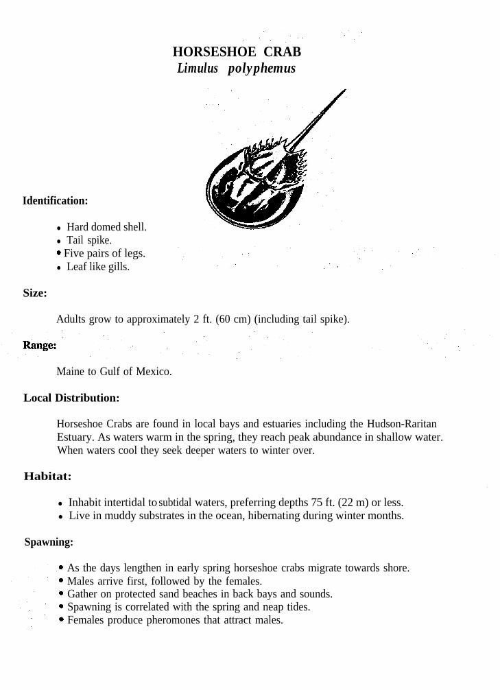
HORSESHOE CRABLimulus polyphemus
Identification:
l Hard domed shell.l Tail spike.. Five pairs of legs.l Leaf like gills.
Size:
Adults grow to approximately 2 ft. (60 cm) (including tail spike).
Maine to Gulf of Mexico.
Local Distribution:
Horseshoe Crabs are found in local bays and estuaries including the Hudson-RaritanEstuary. As waters warm in the spring, they reach peak abundance in shallow water.When waters cool they seek deeper waters to winter over.
Habitat:
l Inhabit intertidal to subtidal waters, preferring depths 75 ft. (22 m) or less.l Live in muddy substrates in the ocean, hibernating during winter months.
Spawning:
As the days lengthen in early spring horseshoe crabs migrate towards shore.Males arrive first, followed by the females.Gather on protected sand beaches in back bays and sounds.Spawning is correlated with the spring and neap tides.Females produce pheromones that attract males.
l As the females crawl ashore males attach themselves and are dragged to the edge ofthe shore.
l Eggs are laid at the high tide line.l Eggs laid, number in the thousands.l The female drags the male over the eggs. The eggs are fertilized as he passes over
them.l Males and female move back into the water, wait 12 hours till the next high tide,
and repeat the process.l Females can lay over 80,000 eggs during the mating season.l Eggs are left to incubate under the sand for about two weeks.l Hatching occurs at high tides. l Juvenile Horseshoe Crabs emerge as miniature adults.
Growth:
l Growth takes place slowly and occurs by molting.l The shell splits along the front edge and the soft crab protrudes from the front edge.l The new shell hardens in a few days.l Molting occurs once a year except when they are young.l Maturity is not reached until they are ten years old, or have molted 16 times for
males and 17 for females.
Feeding:
l Feed by pushing their way along the bottom in a way similar to that of a plow.l Use their chelicerae as feelers to find food.l When food is located they use their claws to push it towards their mouth.l Since Horseshoe Crabs have no jaws, they use their claws to grind the food, then
push it into their mouth. l Feed primarily on worms, clams, and dead fish. _

ROCK CRABCancer irroratus
Identification:
l Rounded body.l Nine wide, smooth-edged marginal teeth.: Color yellow-orange with red or purple speckles.
Size:
To 5 1/4 in. (131 mm).
Range:
Labrador to South Carolina.
Local Distribution:
Rock Crabs are abundant in lower reaches of the Hudson-Raritan Estuary.
Habitat:
l Found in shallow subtidal waters to depths of 2600 ft. (780 m).l Common on all types of bottom.
Spawning:
l Spawning occurs from spring until fall and is temperature dependent.l Larvae are present in surface waters from late spring to September.
Growth:
l Active molting takes place in April and June and growth ceases in winter.

Feeding:
6 Known to be a scavenger and a carnivore.l Feed on small clams, polychaetes, mussels, starfish and sea urchins.

BLUE CLAW CRABCallinectes sapidus
Identification:
9 Males abdomen is shaped like a golf tee; virgin females have a triangular abdomen,gravid females have a rounded abdomen.
l Last pair of legs are paddled shape.l Generally olive or bluish-green above, white below.l Adults have bright blue claws.
Size:
Shell lengths to 9 in. (225 mm). Live for 2-3 years.
Range:
Cape Cod to Uruguay.
Local Distribution:
Blue Claw Crabs are year-round residents in the Hudson-Raritan Estuary. They exhibitseasonal migrations in relation to spawning. Blue Claws inhabit shallow waters inspring and summer and move into deeper waters during autumn, where they spend thewinter.
Habitat:
l Found in depths as great 120 ft. (36 m).l Common in bays and estuaries where they often extend into freshwater.l Prefer muddy or clay bottoms and eel grass beds.
Spawning:
l Occurs in late fall in the upper bay areas.l Females are inseminated in the fall, but fertilization is not complete.
l In the spring females extrude the eggs and fertilize them, with the stored sperm.l Eggs stay attached enmasse to the females abdomen.l Larvae go through an extensive period of development.l Young migrate into rivers and bays.
Growth:
l Blue Claw Crabs have a short life span and grow by molting.l Molting occurs 18-22 times during their life. l When molting approaches they seek shelter in vegetated areas.l Molt by backing out of their shells.l Now they are completely soft and vulnerable to predators.l Within hours the new shell begins to harden and they can again protect themselves.l The soft shell crab supports a large industry.
Feeding:
Feed by ripping apart food with their front claws and passing it into their mouth.Use their large first claws to capture prey.Feed on plants, soft clams, young hard clams, soft shelled juvenile blue claw crabsand fishes.
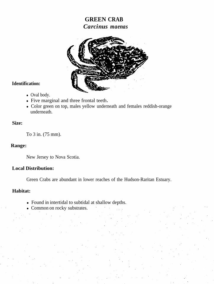
GREEN CRABCarcinus maenas
Identification:
l Oval body.l Five marginal and three frontal teeth .l Color green on top, males yellow underneath and females reddish-orange
underneath.
Size:
To 3 in. (75 mm).
Range:
New Jersey to Nova Scotia.
Local Distribution:
Green Crabs are abundant in lower reaches of the Hudson-Raritan Estuary.
Habitat:
l Found in intertidal to subtidal at shallow depths.l Common on rocky substrates.

NORTHERN LOBSTERHomarus americanus.
Identification:
l First claws consist of a pincer and a crusher.l Dark brown with orange edges and spots.
Size:
Length to 36 in. (90 cm) and weighs up to 40 Ibs. (18 kg).
Range:
Labrador to Virginia.
Local Distribution:
Lobsters migrate in a more or less east-west direction. When Hudson-Raritan Estuarywaters are warm they move to shallow waters, as the waters cool they move back intodeep waters. Peak abundance in the waters of the New York Bight is reached by Julyor early August.
Habitat:
l Inhabit shallow coastal waters out to the edge of the continental shelf.l Nocturnal, and prefer a place to hide during daylight hours.l Rocky areas are favored.
Spawning:
l Spawning occurs once every other year.l Mating occurs after the female has molted and is soft.l Sperm is stored for up to 15 months.l When the eggs are laid they pass the sperm and are fertilized.l They attach to the swimmerets and remain there until hatching occurs.
l The female is now a berried female.l Eggs are carried for a period of 10 to 11 months.l Large females can carry up to 80,000 eggs.l Hatching occurs about mid May and the larvae go through a free swimming stage.l Larvae are dispersed by prevailing water currents.l Larvae go through three molts, at which point they resemble adults, and seek the
bottom in order to complete their life cycle.
Feeding:
l Lobsters are not the scavengers they are believed to be.l Feed primarily on algae, hydroids, mollusks, crustaceans, echinoderms, and fish.l Feeding does not take place immediately before molting.
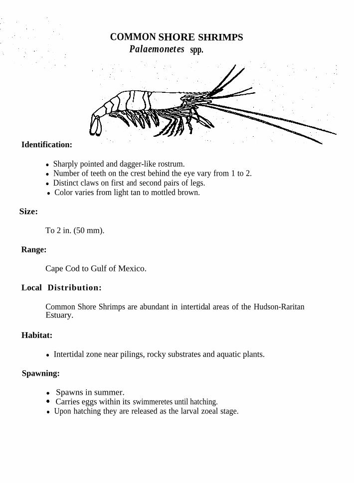
Identification:
COMMON SHORE SHRIMPS spp.Palaemonetes
l Sharply pointed and dagger-like rostrum.l Number of teeth on the crest behind the eye vary from 1 to 2.l Distinct claws on first and second pairs of legs. l Color varies from light tan to mottled brown.
Size:
To 2 in. (50 mm).
Range:
Cape Cod to Gulf of Mexico.
Local Distribution:
Common Shore Shrimps are abundant in intertidal areas of the Hudson-RaritanEstuary.
Habitat:
l Intertidal zone near pilings, rocky substrates and aquatic plants.
Spawning:
l Spawns in summer. . Carries eggs within its swimmeretes until hatching.l Upon hatching they are released as the larval zoeal stage.

SAND SHRIMP Crangon septemspinosa
Identification:
l Short rostrum.l Subchelate claws on first pair of walking legs.l Color varies from almost colorless to mottled brownish or black.
Size:
To 2 3/4 in. (69 mm).
Range:
Arctic to Florida; also North Pacific.
Local Distribution:
Sand Shrimp are common in intertidal areas of the Hudson-Raritan Estuary.
Habitat:
l Lower intertidal down to subtidal down to 300 ft. (90 m).l Common on sandy bottoms and in eel grass beds.l Often burrow into the sand.
Feeding:
l Feed on small decapods, invertebrate eggs and organic debris.

EASTERN COMMON SEASTARAsterias forbesi
Identification:
l Radially-symmetrical.l Typically five arms project outward from the center.l Tube feet grow in four rows on the underside of the arms.l Mouth is located in the center on the underside.l An orange “eye” or madreporite is located near the center.l Color varies from olive; brown, yellow, orange, purple or red.
Size:
To 5 in. (125 mm).
Range:
Penobscot Bay to Gulf of Mexico.
Local Distribution:
Seastars are abundant in lower reaches of the Hudson-Raritan Estuary.
Habitat:
l Intertidal to subtidal zone.l To depths of 150 ft. (45 m).
Feeding:
‘0 Carnivorous: Feeds on snails, clams, mussels and barnacles.l Feeds by attaching its arms around shelled invertebrates, forcing valves or shells
open.l Valves are pried open just far enough for the seastar to evert its stomach into
the animal to devour it.
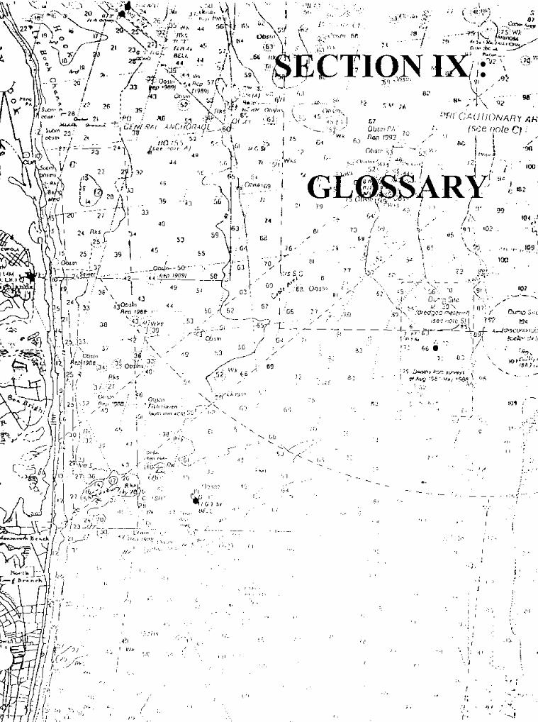

GLOSSARYi
Abiotic environment - the non-living components of an ecosystem.
Absorb - to take in and make part of an existing whole.
Adaptations - changes by an organism or its parts that make it more fit to the conditions of itsenvironment.
Adhesive Disc (Oral) - a modification of the dorsal, pelvic or pectoral fin to form a,mechanism by which the fish can attach itself to a rocky substrate or to other animals.
Aesthetics - a pleasing appearance or effect: Beauty.
Anadromous - the ability to live part of the time in fresh water and part of the time in saltwater.
Anatomical Adaptations - changes in the structure of an organism that make it more fit to theconditions of its environment.
Anal Fin - the median fin on the mid-ventral line behind the anus. May contain only soft rays but in most advanced fishes this fin may have two or three spines at the front.
Anoxic - without oxygen or lacking oxygen for body use.
Anthropogenic effects - relating to, or resulting from the influence of human beings onnature.
Appendages - A subordinate or derivative body part; a limb or analogous part.
Aquifer - a water bearing stratum of permeable rock sand or gravel.
Ascend - in reference to fish that move up river.
Autotroph - plants and other organisms that make their own food from inorganic substances.
Barbel - a fleshy sensory appendage located on the head, snout, chin or around the mouth.
Basin - an enclosed or partly enclosed water area.
Bathymetry - the measurement of depth of water in oceans, seas and lakes.
Bearings - to extend in a direction indicated or implied.
Benthic - living in or on the bottom.
Benthos - the forms of marine life that live on the ocean bottom.
Behavioral Adaptations - changes involving action and response to stimulation that makes anorganism more fit to the conditions of its environment.
Berried - bearing eggs.
Binomial Nomenclature - a system of nomenclature in which each species of animal or plantreceives a name of two terms of which the first identifies the genus to which it belongs and thesecond the species itself.
Bioaccumulation - the accumulation of substances in the body of an organism.
Biodegradable - capable of being broken down. .
Biomagnification - the accumulation of substances in larger and larger quantities in the bodiesof organisms at each higher level of a food chain.
Biomass - the amount of living matter in a volume of habitat.
Biota - the animal and plant life of a region; flora and fauna collectively.
Biotic Community - the living organisms that inhabit an ecosystem.
Blotches - irregularly shaped, colored marks.
Body Cavity - a cavity within the body.
Bony Plates - a bony plate in the throat region of certain primitive fishes.
Brackish Water - water in which salinity ranges from approximately 0.50 to 17.00 parts perthousand.
Broadcast - a type of spawning where eggs and sperm are cast or scattered in all directions inthe water.
Brood Pouch - a pouch where eggs or embryos develop.
Buffer - material used as a cushion against shock due to contact.
Carnivore - animals that feed on other animals.
Carrying Capacity - the maximum size of a population that can be supported by anenvironment.
Carotenoid - any of various yellow to red pigments found widely in plants and animals.

Catadromous- living in fresh water and going to the sea to spawn. ”
Caudal Fin - the median fin at the rear end of the body.
Caudal Peduncle - the rear, usually slender, part of the body between the caudal fin base andthe base of the last dorsal and anal fin rays.
Center for Marine Conservation - an environmental group concerned with marine debris thatcan be contacted at: 1725 DeSales St. NW, Washington D.C. 20036.
Chart - a map for navigators which displays water depths and land forms.
Chelicerae - the first pair of appendages.
Chlorophyll - green-colored, photosynthetic plant material found in chloroplast.
Cilia - minute, movable, hairlike projections.
Clarity - the quality or state of being clear.
Classification - a systematic arrangement in groups or categories according to establishedcriteria.
Coagulating - to become viscous or thickened.
Coastline - the boundary between the land and the ocean. ,
Colorimetric - a method of chemical analysis that compares a liquid’s color with standard.colors.

Commensalism - a type of symbiotic relationship in which one organism benefits from theassociation and the other is not affected.
Community - the population of various individuals interacting in a common area.
Competition - active demand by two or more organisms or kinds of organisms for anenvironmental resource in short supply.
Compressed - describes a fish body which is flattened from the side to side.,
Concave - bowed or curved inward.
Conical - having the characteristic shape of a cone.
Conservation - a careful preservation and protection of resources.
Conserve - to avoid wasteful or destructive use.
Consumer - an organism that feeds on already formed organic matter or preys on otherorganisms.
Contaminants - substances that introduce unwholesome or undesirable elements to theenvironment.
Continental Shelf - that part of the ocean floor from the shoreline to a depth of about 200m(660 ft.).
Contour Interval - the space on a map found between contour lines.
Contour Line - a line on a map connecting land surfaces with equal elevations.
Coring - a sampling method that studies the deposition of sediments.
Current - a part of a fluid body of water moving continuously in a horizontal direction.
Decay - a slow change or breakdown.
Decomposer - an organism that feeds off of decaying matter, in turn speeding up thedecomposition of an organism.
Deep Bodied - a fish whose body extends far vertically from the center.
Dehydrate - to remove water from.
Density - mass per unit of volume.
Detritus - organic particles that result directly from disintegration.
Depositional - an act or process of depositing, as in sediments.
Detrimental - obviously harmful, damaging.
Diadromous - diadromous species are fish that either migrate into fresh water from the sea tospawn (these species are also known as anadromous fishes) or into the sea from fresh water tospawn (these species are also known as catadromous fishes).
Dichotomous - dividing into two parts.
Diffusion - a process by which fluids move through other fluids from areas of highconcentration to areas of lower concentrations through random molecular movement.

Dinoflagellates - single-celled microscopic organisms that may possess chlorophyll and belong.to the plant phylum Pyrrophyta (autotrophic) or may ingest food and belong to the classMastigophora of the animal phylum Protozoa (heterotrophic).
Dissolved Oxygen - oxygen that is dissolved in water.
Diurnal tide - a tide sequence with one high water and one low water during a tidal day.
Diversity - a function of both the numberthe relative proportions of their numbers,
of species present in a given region or habitat and
Dominant - prevailing over all others.
Dormant - temporarily devoid of external activity.
Dorsal Fin - the median fin located on the back.
Downwelling - surface water set in motion by wind that is carried down beneath the surface.
Dredging - removing material from the ocean bottom to deepen a waterway.
Ecology - the branch of science concerned with the interrelationship of organisms and theirenvironments.
Ecological Balance - the balance between organisms and their environment.
Ecosystem - the entire system of organisms and the physical and chemical aspects of theirenvironments.
Elevation - height above sea level.
Elongate - to make long and narrow.
Environment - the combination of physical, chemical and biotic factors that act upon anorganism or an ecological community and ultimately determine its form of survival.
Environmental group - a group of people whose goal is to protect and preserve theenvironment.
Epibenthic - living on the bottom of the sea floor.
Epifauna - animals that live on the ocean bottom, either attached or moving freely over it.
Estuarine - characteristics of an estuary.
Estuary - a water passage where salt water meets fresh.
Euryhaline - able to live in waters of a wide range of salinity.
Eutrophication - the process by which a body of water becomes, either naturally or by pollution, too rich in dissolved nutrients ( as phosphates ) causing a seasonal deficiency in
dissolved oxygen.
Evolution - a process of change in a certain direction.
Fathom - a unit of length equal to six feet used for measuring the depth of water.
Fauna - the animal life of any particular area or of any particular time.

Feelers - a sensory extension that look like whiskers found on fish.
Filter Feeder - an animal that obtains food by filtering organic matter or minute organismsfrom a current of water that passes through some point of its system.
Fin - an external membranous process of an aquatic animal used to propel or guide the body.
Flora - plant life.
Flushing - a sudden flowing of water.
Food chain - the passage of food energy from producers to top consumers.
Food web - all of the food chains that interconnect at various points taken together.
Fresh water - water with little to no salt content usually found in rivers, lakes, ponds andstreams.
Fucoxanthin - a brown carotenoid pigment (C40H60O6 ). Especially found in the ova of brownalgae.
.
Generalist - one whose skills or interests extend to several different fields.
Gill - organs designed to remove oxygen from water enabling the organism to breathe whilesubmerged.
Gill Rakers - variously developed structures which project forward from the gill arches, likethe teeth of a comb.
Gorge - to eat greedily or feed to capacity.

Gregarious - tending to associate with others of one’s kind.
Habitat - the natural life-environment of individuals or organisms.
Herbivore - animals that only feed on plants.
Heterocercal - describes a caudal fm in which the vertebral column turns upward andcontinues almost to the end of the upper lobe.
Heterotroph - animals and bacteria that depend on the organic compounds produced by otheranimals and plants for food. Organisms not capable of producing their own food byphotosynthesis.
Hierarchial - arranged in hierarchy.
Homeostasis - the process of achieving and maintaining a stable internal environment within agiven organism.
Homocercal - describes a caudal fin in which all the principal rays of the fin attach to themodified last vertebrae.
Hydrographic - the measurement of the physical features of the oceans, seas, lakes, riversand other waters, and their marginal land areas, with special reference to the elements thataffect safe navigation, and the publication of such information in a suitable form for the use ofnavigators.
Hydrologic cycle - the cycle of water exchange among the atmosphere, land and oceanthrough the processes of evaporation, precipitation, runoff and subsurface percolation.
Hydrology - a science dealing with the properties, distribution and circulation of water on the surface of the land, in the soil, underlying rocks and in the atmosphere.
Hydrometer - a instrument for determining specific gravities of liquids.
Hypothetical Situation - a circumstance towith observed data or previous knowledge.
test logical consequences to see if it is consistent
Hypoxia - detrimental effects caused by lack of oxygen in the body cells or tissues.
Hypothesis - an interpretation of a practical situation or condition taken as the ground foraction.
Impact - the force or affect of one thing on another.
Incubation - the act of maintaining eggs under conditions favorable for hatching,development, or reaction.
Infauna - animals that live buried in the soft substrate (sand or mud).
Inferior - refers to the placement of a fish’s mouth on the underside of its head or distinctlybelow the snout.
Inshore - area ranging from near the shore to the continental shelf.
Invertebrate - lacking a spinal column.
Juveniles - young of a species; generally a small immature version of the adults.
Key - an arrangement of the descriptive characters of a group of plants or animals or of taxadesigned to facilitate identification.
Larvae - newborn, i.e., the development stage of a fish before it becomes a juvenile.
Laterally compressed - compressed side to side.
Lateral Line - a canal along a fish’s body. This canal is a rearward extension of.a sensorycanal system on the head and it contains sense organs which can detect pressure changes.Usually single and located mid-side, but sometimes branched, double or triple and variouslyplaced.
Latitude - location on the earth’s surface based on angular distance north and south of theequator.
Litter - an untidy accumulation of objects usually trash, wastepaper, or garbage.
Longitude - location on the earth’s surface based on angular distance east and west of theGreenwich Meridian.
Lunate - used in reference to a deeply forked, narrow-bladed caudal fish fin.
Madreporite - a porous plate through which the internal waste vascular system opens to theexterior in echinoderms. Often conspicuous in sea stars and mistaken for an eye.
Mandible - lower jaw.
Mantle - a fold of skin that surrounds the body organs in mollusks and contains glands thatsecrete the shell of shelled mollusks.
Maursupium - a chamber, or pouch on the underside of the trunk or tail of male seahorsesand pipefish for the retention and brooding of eggs.
Mature - relating to a condition of full development.
Maxilla - the rear bone of the two bones that form the upper jaw.
Meniscus - the curved upper surface of a liquid column thatwalls are wetted by the liquid and convex when not.
is concave when the containing

Mercator projection - a conformal map projection in the usual case of which the meridiansare drawn parallel to each other and the parallels of latitude are straight lines whose distancesfrom each other increases with their distance from the equator.
Meridian - any great circle which goes through the poles of a spherical body which isrotating.
Metamorphosis - a marked and more or less abrupt developmental change in the form orstructure of an organism.
Micro Habitat - a small, distinctly specialized and effectively isolated habitat.
Molecules - the smallest particle of a substance that retains all the propertiesand is composed of one or more atoms.
Mollusks - soft unsegmented animals usually protected by a calcareous shell and having a
of the substance
muscular foot for locomotion. Includes snails, clams, chitons and octopuses.
Molting - in arthropods, shedding of the exoskeleton.
Morphology - a branch of biology that deals with the form and structure of animals andplants.
Mottling - marked with blotches, streaks or spots of different colors or shapes.
Mutualism - a symbiotic relationship in which both organisms benefit from their association.
Nape - the part of the back immediately behind the head or, in spiny-rayed fishes, the portionbetween the head and the point where the first dorsal fm begins.
Natal - in reference to an area where a fish was born.

Nautical Mile - unit of distance applied at sea, equivalent to about 6,076 feet, l/60 of adegree, or 1852 meters.
Navigation - the method of determining position, course, and distance traveled.
Neap Tides - low tides which occur about every two weeks when the moon is in its quarterposition.
Nekton - animals that are able to swim, independent of current action.
Niche - the ecological role of an organism and its position in the ecosystem.
Nocturnal - relating to or occurring in the night.
Non-Biodegradable - unable to be broken down by bacteria and other organisms into simplersubstances.
Nomenclature - name, designation; an intentional system of standardized new Latin namesused in biology for kinds and groups of animals and plants.
Nonpoint Source Pollution (NPS) - situations where the source of pollution is not known.
Nursery Areas - a place where young fish and other organisms can grow.
Oceanography - science that deals with the oceans and includes the delimitation of theirextent and depth, the physics and chemistry of their waters, marine biology and theexploitation of their resources.
Ocellus - an eyespot in which the central color is bordered by a ring of another color, which isalso different from the adjacent color of the body.
Offshore - area beyond the continental shelf.
Omnivore - feeds on both plants and animals.
Opercle - the uppermost and largest of the bones that form the gill cover.
Osmoregulator - regulation of osmotic pressure in the body of a living organism.
Osmosis - the passage of water through a semipermeable membrane from a region of highconcentration of water to a region of low concentration of water.
Palps - in polychaete worms one of several types of sensory appendages on the head.
Palustrine - pertaining to materials growing or deposited in a marsh.
Parapodia - one of the lateral foot like appendages found on polychaete worms.
Passerine - of or relating to a suborder of ( Passers ) passerine birds, comprising the truesongbird, with specialized vocal apparatus.
Pathogen - a specific causative agent (as a bacterium or virus) of disease.
Pattern - a reliable sample of traits, acts, tendencies, or other observable characteristics.
Pectoral - of, situated in, or on the chest.
Pelagic - of, relating to, or living or occurring in the open sea: oceanic.
Pelvic Fin - also called the ventral fin.. A pair of fins on the lower part of the body. Thesefins can vary in position from on the belly just in front of the anal fin to under the pectoral fin, to below a point in front of the base of the pectoral fins.
Pervasive - to go through every part.

pH - the measure of the alkalinity or acidity of a solution.
Foramens : A hormone that acts upon the olfactory system in animals, usually used by ananimal to attract a mate.
Photosynthesis - the process by which plants produce carbohydrate food from carbon dioxideand water in the presence of chlorophyll, using light energy and releasing oxygen.
Phytoplankton - plant plankton. The most important community of primary producers in theoceans.
Pigment - a coloring agent in animals and plants especially in cells or tissue.
Plankton - passively drifting or feebly swimmmg organisms that are carried by oceancurrents. Plankton include microscopic plants, protozoa, and larval forms of higher animals,including jellyfish.
Point Source - situations where the source of pollution is known.
Pollution - the addition of anything to the environment that makes it less fit for living things.
Populations - the whole number of inhabitants in a certain area.
PPT. - parts per thousand.
,.
Predator - carnivores that capture and feed on prey.
Prey - an animal taken as food by a predator.
Primary Productivity - the amount of organic matter synthesized by organisms frominorganic substances within a given volume of water or habitat in a unit of time.
Proboscis - a snout or trunk, with distinct structural peculiarities in different phyla.
Producer - the autotrophic component of an ecosystem, that produces the food that supportsthe bio-community.
Productive - the power of producing in abundance.
Prehensile - adapted for seizing or grabbing by wrapping around.
Protrude - to jut out from the body.
Pugnacious - having a belligerent nature.
Quadrangle - a tract of country represented by one of a series of map sheets.
Quiescent - marked by inactivity or repose.
Radial Symmetry - spoke-like arrangement of parts around a central axis as in jellyfish, seastars, etc...
Raptors - birds that capture food by use of talons.
Ray - one of the supporting elements, which may be soft or spiny in a fin.
Reagent - a substance used because of its chemical or biological activity.
Refractometer - a device that measures the index of refraction to determine salinity.
Resource - a source of supply or support.

Respiration - the process by which food is used.
Resuspension - when the particles within the water column become stirred up then settle backdown and then become stirred again.
Riverine - relating to, formed by, or resembling a river.
Rostrum - The blade-like projection between the eyes in shrimp.
Runoff - the portion of the precipitation on the land that ultimately reaches streams.
Salinity - a measure of the quantity of dissolved salts in ocean water.
Salt wedge estuary - a very deep river mouth with a very large volume of freshwater flowbeneath which a wedge of salt water from the oceans invades.
Scale - a small, flattened, rigid and definitely circumscribed plate forming part of the externalbody covering.
Scavenger - carnivores that feed on dead animals.
Sea water - water containing dissolved salts, primarily Na+ and Cl-.
Sediment - particles of organic or inorganic origin that accumulate in loose form.
Semidiurnal Tide - tide having two high and two low waters per tidal day with smallinequalities between successive highs and successive lows.
Serrate - saw-like notches along an edge.
Siltation - the act of being choked, filled, covered, or obstructed with silt or mud.
Siphons - a tube that carries water in to the body or out of the body. Bivalves usually have aincurrent and excurrent siphon.
Skimming - glide or skip along, above, or near a surface.
Snout - that portion of the head which projects beyond the eyes.
Sounding-measuringg the depth of water beneath a ship.
Soft Rays - a bilaterally paired element or ray in a fin, with cross striations; frequentlybranched toward the tip, and usually soft or flexible to the touch.
Spat - a young bivalve.
Specialist - one who devotes itself to a special occupation or branch of learning.
Species - a category of biological classification, ranking immediately below the genus orsubgenus.
Specific Gravity - the ratio of density of a given substance to that of pure water at 4-C and atatmospheric pressure.
Spine - sharp, pointed, protective outgrowths used for defense and locomotion.
Spring Tides - tide of maximum range occurring every fortnight when the moon is new orfull.
Stenohaline - organisms that can withstand only a small range of salinity change.
Storm Surge - a rise above normal water level resulting from wind stress and reducedatmospheric pressure during storms.
Stout Body - physically strong.
Straining Apparatus - a device to retain food or debris as water passes through.
Substrate - a base on which an organism can live and grow.
Sub Terminal - in reference to the placement of a fish’s mouth, where the mouth opens justbelow the tip of the snout.
Superior Mouth - in reference to the placement of the mouth, when the mouth opens, on the upper profile. In these cases the tip of the lower jaw is the foremost part of the body.
Symbiosis - a relationship between two species in which one or both benefit and/or neither oneis harmed.
Symbiotic Relationship - relationships in which two different organisms live in closeassociation with each other to the benefit of at least one of them.
Taxonomy - orderly classification of plants and animals according to their presumed naturalrelationships.
Terminal - in reference to the placement of the mouth, used in those instances when themouth opens at the front end of the body, the snout and lower jaw being equally far forward.
Theory of Evolution - Charles Darwin’s theory of survival of the fittest.
Threshold - the minimum sensitivity level of a nerve cell; impulses below this level do notinitiate responses.
Tidal Creeks - water that flows through the marsh moved by tides.
Tides - periodic rise and fall of the surface of the ocean and connected bodies of waterresulting from the gravitational attraction of the moon and sun acting unequally on differentparts of the earth.
Tide Line - line formed on shore made by the high and low tide water levels.
Tidal Pools - water left in the marsh or on a beach after the tide recedes. Some are permanentand others are temporary.
Tolerant - able to withstand changes in the environment, including fluctuations in salinity,dissolved oxygen and temperature.
Topography - the configuration of a surface.
Translucent - allowing light to pass through, but not transparent or clear.
Transparent - having the property of transmitting light without appreciable scattering so thatbodies lying beyond are entirely visible.
Tributaries - small streams that feed into larger streams or rivers.
Trophic level - a nourishment level in a food chain.
Turbidity - a state of reduced clarity in a fluid caused by the presence of suspended matter.
Umbilicus - a sometimes conspicuous dent or hollow at the base of the columella in shelledgastropods .
Umbo - in bivalves, a projection near the hinge.
Unpigmented - lacking coloring matter, especially in cells and tissues.
Upwelling - the process by which deep, cold, nutrient-laden water is brought to the surface.
Valve - in mollusks, one of the parts of the shell, bivalves have two and gastropods have one.
Vegetation Beds - areas where vegetation growth is concentrated and heavy.
Vertebrate - animals with backbones.
Wastewater - water that has been used (sewage).
Watershed - a region or area bounded peripherally by a water parting and drainingultimately to a particular watercourse or body of water.
Waterway - a navigable body of water.
Wetlands - land containing much soil moisture.
Zoea - a crustacean larval stage, especially of crabs or crab like forms.
Zonation - distribution of kinds of organisms in biogeographic zones.
Zooplankton - animal plankton.