the burnham house site, situated on a parcel historically known as
TRANSCRIPT

The Burnham House site, situated on a parcel historically known as “Noxon’s Adventure,” is located midway along the northwestern Spur Road of the larger Route 301 DelDOT undertaking.
1
Phase IA archaeological research revealed that the site included the ruins of a dwelling, a timber‐frame shed, a second outbuilding, and a well, all within a copse of trees. Preliminary archival research identified the original patentee of the Burnham House parcel to have been Thomas Noxon, an entrepreneur living near Middletown, Delaware.
2
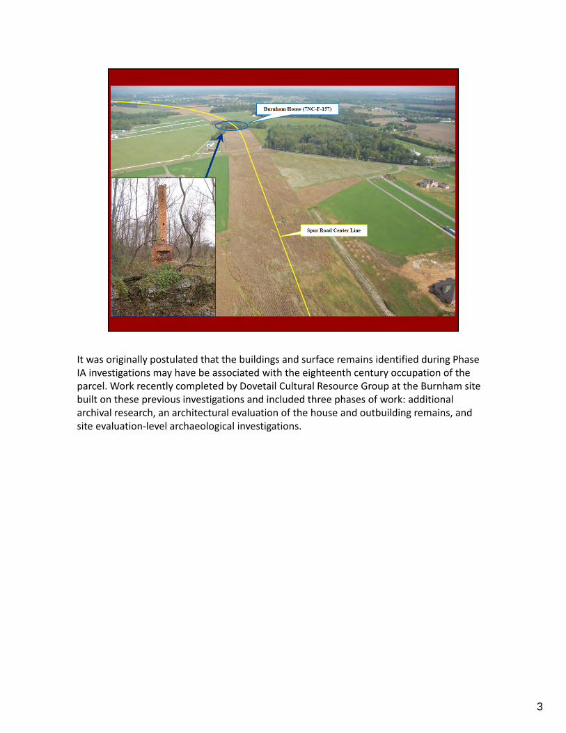
It was originally postulated that the buildings and surface remains identified during Phase IA investigations may have be associated with the eighteenth century occupation of the parcel. Work recently completed by Dovetail Cultural Resource Group at the Burnham site built on these previous investigations and included three phases of work: additional archival research, an architectural evaluation of the house and outbuilding remains, and site evaluation‐level archaeological investigations.
3
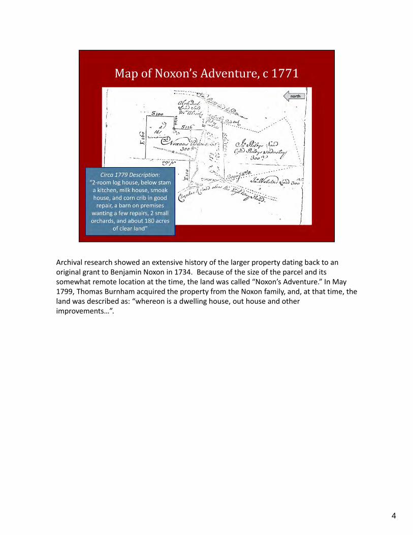
Archival research showed an extensive history of the larger property dating back to an original grant to Benjamin Noxon in 1734. Because of the size of the parcel and its somewhat remote location at the time, the land was called “Noxon’s Adventure.” In May 1799, Thomas Burnham acquired the property from the Noxon family, and, at that time, the land was described as: “whereon is a dwelling house, out house and other improvements…”.
4

The Burnhams live on the parcel through most of the nineteenth century, but their exact house location, and that of the Noxon’s who preceded them, was not recorded on period maps. What is known is that Reedy Island Road, a seventeenth and eighteenth century cart path, ran through the Noxon/Burnham property, allowing access to Noxon’s Adventure and placing this land along one of the primary travel routes in the county.
5

In 1873 descendants of Thomas Burnham took out a Farmers Mutual Insurance policy on the property covering “a New 2 Story Frame Dwelling Situated on his farm in St. Georges Hundred about 2 ½ miles from Middletown.” What is believed to be a depiction of this “New House” appears on the 1868 Atlas of the State of Delaware map. The house that is shown on this map is undoubtedly the Burnham House examined during the course of Dovetail’s investigation, as several landscape elements such as the long drive leading from the road to the south and neighboring farmsteads match the current landscape. In the twentieth century, the house and parcel were sold from the Burnhams and passed through various owners. It was eventually acquired by the State of Delaware.
6

Although the Burnham House was no longer extant during the current investigation, field observations, aided by a set of documentary photographs captured in 1988, helped to decipher its construction chronology and building style. Although previous investigations suggested that the Burnham House was the possible remains of an eighteenth century dwelling, further inspection determined that the Burnham House was a two‐story, five‐bay vernacular Gothic Revival I‐house with an L‐shaped plan, built not in the eighteenth century but rather in the late‐1860s. The home has an uncoursed stone foundation and rubble chimney off the kitchen ell, but the structural system was timber frame.
7

Physical and photographic evidence indicated that the house underwent extensive updating in the first part of the twentieth century, including the unique architectural step of replacing what was a handmade brick transition between the stone foundation and the timber frame structure with a machine made brick edifice. This undertaking was likely painstaking and costly, but the condition of some remnant handmade bricks at the site suggests that the local made bricks likely weathered quite poorly, leaving the structure in peril. Such a drastic measure as replacing part of the underpinning of the structural system was necessary despite the risks. Map and aerial photographic inspection verified that the Burnham House was destroyed by fire in the 1990s.
8

In addition to the Burnham House ruins, the team identified one extant outbuilding and eight ruins, comprising mostly foundational remains.
9

Phase II investigations were conducted on the 4.4‐acre site, resulting in the recovery of almost 7,000 artifacts from 233 close‐interval shovel tests and 30 test units.
10

The assemblage was dominated by architectural artifacts (over 5,000 in total, or 72.1 percent), not surprising given the above‐ground remains of the Burnham House and remnants of nine other structures. The collection also contains an abundance of vessel and/or bottle glass (over 1,000 fragments; or 14.5 percent). Large quantities of this artifact category is commonplace on late‐nineteenth and twentieth century sites and is likely reflective of the later occupation/renovation of the property. The ceramic assemblage comprises 2.4 percent (168 fragments) of the overall Phase II collection. This assemblage is particularly useful in further assessing the site’s occupation timeframe and was used in this analysis to augment interpretations from both the archival and architectural analysis of the site.
11

A calculation of the Mean Ceramic Date (MCD) results in a mean occupation date of 1882, which generally indicates a central habitation period. Backed by historic documentation, the architectural analysis and archaeological study confirmed that the Burnham House was constructed in the late 1860s, consistent with the ceramic analysis. The remainder of the collection consists of very small portions of arms and ammunition materials (0.1 percent; 7 artifacts), metal (6 percent, 416 fragments), organic (3.4 percent, or 234 pieces), other (1.1 percent; total of 79), and personal items (0.4 percent, or 30 items).
12

Through the course of archaeological investigations it became apparent that the property, in particular the remains of the main house, had undergone extensive grading and demolition via heavy machinery. Test units adjacent to the Burnham House remains yielded plastic and modern trash below the uncoursed stone rubble foundation, further evidence of the lack of horizontal and vertical integrity of the site. It is likely that the entire site or at least large portions of it were graded following the destruction of the main house by fire in the 1990s.
13

Now, archival research showed that the general parcel was occupied during the eighteenth century; however, the architectural and archaeological undertakings indicate that the Burnham House is not reflective of this early occupation, but rather postbellum residency. So where was the eighteenth century house complex?
14

Cursory Phase I testing north of the Burnham House site indicated a heightened presence of eighteenth century artifacts, in particular ceramics, in this area. Historic maps of Noxon’s Adventure in the eighteenth century show Old Reedy Island Road in this general vicinity, and this cart road was noted as the northern boundary of the parcel in 1799 court records. Historic maps and court records indicate that this historic cart road was an important landscape organizing element across the region and, given the presence of eighteenth century artifacts north of the Burnham House, along the proposed road course, the road may have been the organizing factor for the domestic occupation of this parcel in particular.
15

Thus, the earliest occupation of this property was likely north of the Burnham House site, and the postbellum residents reoriented the parcel in the 1860s to access the new regional road system to the south as opposed to remaining along the defunct eighteenth century cart road to the north. This theory is further backed by a comparison of this site to nearby farmsteads. The extant house was constructed during the Period of Rebuilding in St. Georges Hundred, which dates from 1850–1880. This period is marked by a consolidation of agricultural properties and is characterized by the joining of domestic and agricultural spheres. The Burnham House and its multiple associated agricultural outbuildings are reflective of this reorganization.
16

Probably the most compelling physical evidence of this eighteenth/nineteenth/twentieth century interface sits just east of the Burnham House. The one standing outbuilding on the property clearly exhibits construction modifications from all three occupation centuries.
17

Upon initial investigation, the building appears to simply be a dilapidated garage, but a careful architectural analysis highlights original eighteenth century construction, as the structure has a timber frame built using hand‐hewn beams joined through mortise and tenon and peg technology. The structure was augmented and reused in the nineteenth century, when a new roof was installed and the interior was resurfaced with circular‐sawn lumber fastened with cut nails. It was changed again in the twentieth century to accommodate the new automotive needs of the occupations through the installation of a large garage door on the south elevation and other structural changes utilizing ungalvanized wire nails.
It appears that this one outbuilding is the remaining above‐ground vestige of the earliest use of this property in the eighteenth century, and it was likely moved from its original location near Reedy Island Road to the north to its current location near the Burnham House in the 1860s when the property was reorganized. It is such a small building, but it holds such immense importance in our understanding of site cultural transitions through the centuries.
18

In sum, although not significant as a nineteenth century farmstead, the archival, architectural, and archaeological analysis performed at the Burnham House site helps us to better understand the historical evolution of the parcel. In particular, the nineteenth and twentieth century remains helps decipher the reorganization of the domestic and agricultural localities on eighteenth‐century Noxon’s Adventure and provides clues on the 300‐year occupation of the surrounding landscape. Further Phase I investigations will be undertaken by Dovetail on property located north of the Burnham House site, near the location of Old Reedy Island Road, this coming February. We are hopeful that these investigations will help further clarify the eighteenth‐century occupation of parcel and uncover evidence of the adventurous Noxon clan, one of this area’s founding families.
19