the cambridgeshire and peterborough local transport plan
TRANSCRIPT

Report
January 2020
The Cambridgeshire and Peterborough Local Transport Plan
Cambridgeshire and Peterborough Combined Authority
23217301
Appendix 2


Steer has prepared this material for Cambridgeshire and Peterborough Combined Authority. This material may
only be used within the context and scope for which Steer has prepared it and may not be relied upon in part or
whole by any third party or be used for any other purpose. Any person choosing to use any part of this material
without the express and written permission of Steer shall be deemed to confirm their agreement to indemnify
Steer for all loss or damage resulting therefrom. Steer has prepared this material using professional practices and
procedures using information available to it at the time and as such any new information could alter the validity of
the results and conclusions made.
Report
January 2020
The Cambridgeshire and Peterborough Local Transport Plan
Prepared by: Prepared for:
Steer
28-32 Upper Ground
London SE1 9PD
Cambridgeshire and Peterborough Combined
Authority
The Incubator 2
First Floor
Alconbury Weald Enterprise Campus
Alconbury Weald
Huntingdon
Cambridgeshire
PE28 4WX
+44 20 7910 5000
www.steergroup.com
Our ref: 23217301
The Cambridgeshire and Peterborough Local Transport Plan | Report
January 2020
Contents
Executive Summary ............................................................................................................ 6
Policy alignment ................................................................................................................. 7
Vision, goals and objectives................................................................................................ 9
Overarching strategy ........................................................................................................ 11
Our priority schemes ........................................................................................................ 13
Implementing the strategy ............................................................................................... 18
1 The Cambridgeshire and Peterborough Local Transport Plan .................................... 20
Introduction ...................................................................................................................... 20
Progress to-date ............................................................................................................... 22
The Local Transport Plan .................................................................................................. 24
Transport Vision 2050 ...................................................................................................... 31
Evidence base ................................................................................................................... 35
2 Our Strategy ........................................................................................................... 49
Introduction ...................................................................................................................... 49
Our overall strategy .......................................................................................................... 50
Major schemes ................................................................................................................. 56
3 Local Strategies ....................................................................................................... 62
Introduction ...................................................................................................................... 62
Peterborough ................................................................................................................... 62
Greater Cambridge ........................................................................................................... 70
Huntingdonshire ............................................................................................................... 82
East Cambridgeshire ......................................................................................................... 89
Fenland ............................................................................................................................. 96
4 Our Policies ............................................................................................................ 101
Introduction .................................................................................................................... 101

The Cambridgeshire and Peterborough Local Transport Plan | Report
January 2020
Figures
Figure 1.1: The Local Transport Plan and other strategic documents ........................................ 28
Figure 1.2: Ratio of median house process to median salary ..................................................... 36
Figure 1.3: Observed traffic congestion in Cambridgeshire and Peterborough in 2015 ............ 37
Figure 1.4: Forecast traffic congestion in Cambridgeshire and Peterborough in 2041 .............. 38
Figure 1.5: Transport infrastructure and accessibility in 2018 ................................................... 39
Figure 1.6: Accessibility to major employment sites by public transport in 2018 ..................... 40
Figure 1.7: Method of travel to work ......................................................................................... 41
Figure 1.8: Percentage of total CO2emissions due to transport by local authority – 2005 to 2017
.................................................................................................................................................... 42
Figure 1.9: Transport CO2 emissions per capita by local authority in 2005 to 2017 .................. 43
Figure 1.10: Charging points per 100,000 of the population by Local Authority in 2019 .......... 44
Figure 1.11: 4G coverage of A and B roads by Local Authority in 2019 ..................................... 45
Figure 2.1: Movement and place function ................................................................................. 54
Figure 2.2: Indicative user hierarchy by movement and place function .................................... 54
Figure 2.3: Key projects for Cambridgeshire and Peterborough ................................................ 57
Figure 3.1: Summary of key projects in Peterborough ............................................................... 66
Figure 3.2: Summary of key projects in Greater Cambridge ...................................................... 74
Figure 3.3: Summary of key projects in Huntingdonshire .......................................................... 86
Figure 3.4: Summary of key projects in East Cambridgeshire .................................................... 93
Figure 3.5: Summary of key projects in Fenland ........................................................................ 99
Figure 4.1: Policy themes by objective and transport mode policy themes ............................ 102
Tables
Table 1.1: Local transport plan objectives .................................................................................. 34
Table 4.1: Policy summaries ..................................................................................................... 103
Appendices
Appendix A: Glossary of terms
6 of 120
Executive Summary
This is the first Local Transport Plan for Cambridgeshire and Peterborough. It replaces the
Interim Local Transport Plan, which was published in June 2017 and was based upon the
existing Local Transport Plans for Cambridgeshire (Local Transport Plan 3) and Peterborough
(Local Transport Plan 4). The Plan describes how transport interventions can be used to
address current and future challenges and opportunities for Cambridgeshire and
Peterborough. It sets out the policies and strategies needed to secure growth and ensure that
planned large-scale development can take place in the county in a sustainable way.
This Local Transport Plan has been produced in partnership with Peterborough City Council,
Cambridgeshire County Council, the Greater Cambridge Partnership, and the city and District
Councils of Cambridge, East Cambridgeshire, Fenland, Huntingdonshire and South
Cambridgeshire. Engagement has taken place throughout with several of central
government’s arm’s length bodies such as Highways England and Network Rail, as well as
neighbouring transport and highway authorities. In addition to working with public sector
partners, our work has also been informed by wider stakeholder engagement, including with
transport operators; industry groups; and community organisations.
The Plan is split in to three main parts:
• This Local Transport Plan sets out the vision, goals and objectives that define how
transport will support the Cambridgeshire and Peterborough Combined Authority’s (Combined Authority) Growth Ambition, and our approach to meeting these objectives. A
summary of the plan is provided in this Executive Summary.
• The Transport Delivery Plan summarises the projects that the Combined Authority –
together with our partners – aims to deliver over the lifetime of the Local Transport Plan,
and the mechanisms through which they will be delivered. It also describes how the plan
will be monitored, reviewed and updated through time, and the roles and responsibilities
of the Combined Authority and its delivery partners (separate annex).
• Our Policies describes requirements related to transport planning and design, delivery,
and operation and maintenance for the Combined Authority, our public sector partners,
and key private sector and non-for-profit stakeholders. They also provide the principles
which will underpin decision-making, capital investment and revenue support in our
transport network (separate annex).
A draft of this document was released for public consultation which ran for fifteen weeks in
the summer of 2019. Key stakeholders including Local Authorities, statutory bodies and
members of the public were invited to comment on the content of the Local Transport Plan.
The plan was subsequently amended to reflect the feedback received. A summary of
consultation responses is provided in the accompanying Consultation Report.
The Plan is also complemented by the following supporting documents:
• Evidence Base;
• Strategic Environmental Assessment (SEA);
• Habitats Regulation Assessment (HRA); and
• Community Impact Assessment (CIA) - incorporating a Health Impact Assessment (HIA)
and an Equality Impact Assessment (EqIA).
7 of 120
Policy alignment
The Local Transport Plan has been developed in tandem with a range of other documents. This
ensures that it describes a coherent and complementary suite of schemes, programmes and
initiatives. Taken together, these documents explain how the Combined Authority can support
and deliver wider environmental, social and economic objectives. The Local Transport Plan has
built on the body of work of included within the Mayor’s Interim Transport Strategy
Statement, previous Local Transport Plans, the work of the Greater Cambridge Partnership,
and Local Planning Authorities’ Local Plans. The Plan and its associated interventions are
strongly aligned with local, regional and national policies.
From an economic perspective, the scale of opportunity for sustainable growth and
development is defined by the Cambridgeshire and Peterborough Independent Economic
Review (CPIER), and the Combined Authority’s response to this in the form of our Growth
Ambition Statement. This restates our commitment to double GVA over 25 years and
recognises the role of the Combined Authority to lead and bring together public, private and
third-sector bodies in order to secure the action and investment needed to make that happen.
The spatial context for the strategy is provided by the Strategic Spatial Framework (non-
statutory) and current Local Plans. Phase 1 of the Strategic Spatial Framework sets out how
the Combined Authority will support the implementation of development strategies in Local
Plans to 2036, so that jobs and homes ambitions are met. However, in order to meet our
growth ambition, a step-change in housing delivery is required.
The Strategic Spatial Framework identifies the opportunities for longer-term strategic planning
between the Combined Authority and Planning Authorities from 2036 to 2050 and these will
be developed through ongoing stakeholder engagement. A second phase of work, currently
underway, will provide a longer-term development strategy to 2050 that is designed to inform
the next round of Local Plan updates.
Closer alignment between spatial and transport planning can allow economic growth without
driving increased travel. It is essential that transport services are designed to support historic
settlement patterns, particularly for residents and businesses located in rural areas. A key
contribution to the Combined Authority’s efforts in this area is the work of the Bus Reform
Task Force.
The Task Force was launched early in 2019 and has three main workstreams: to establish an
integrated framework to assess subsidy requirements, to identify and implement tangible
short-term improvements to bus services, and to develop and examine the business case for a
number of alternative delivery options for bus services in Cambridgeshire and Peterborough.
In addition to implementing a public transport system which offers a genuine alternative to
the car, this Local Transport Plan describes a range of policies designed to reduce the
environmental footprint associated with travelling to, from and around Cambridgeshire and
Peterborough. They include targets to achieve net zero carbon by 2050 in line with national
priorities, and to double the area of rich wildlife habitat and natural greenspaces under
management by 2050. The Plan also includes adoption of biodiversity net gain principles
which mandate that all new developments must leave the natural environment in a
measurably better state than beforehand, and extensive measures to enhance air quality.

8 of 120
Alongside the Local Industrial Strategy and Spatial Framework, this Local Transport Plan
completes the suite of documents which articulate the Combined Authority’s response to CPIER.
The Plan provides a robust platform for the planning and delivery of the Combined Authority’s ambitious programme of priority transport schemes. It will inform the next, immanent, round
of Local Plan development. As the overarching spatial strategy for Cambridgeshire and
Peterborough continues to develop, it may be necessary to refresh the Local Transport Plan
accordingly. The Combined Authority will continue to work closely with its partners in spatial
planning and the delivery of transport priorities to identify the most appropriate time to
refresh the Local Transport Plan.
9 of 120
Vision, goals and objectives
Vision
The Combined Authority’s Local Transport Plan vision is:
To deliver a world-class transport network for Cambridgeshire and
Peterborough that supports sustainable growth and opportunity for all
The vision is intended to capture the aspirations for Cambridgeshire and Peterborough’s transport network, reflecting our ambition to provide:
• ‘A world-class transport network’ – Cambridgeshire and Peterborough aspire toward a
transport system of the highest quality on a global stage, which meets the needs of
residents, businesses, and visitors.
• ‘Sustainable growth’ – the network will support the delivery of future economic and
housing growth across the region that enhances overall quality of life, supports the
transition to a net zero carbon economy and protects or enhances the environment.
• ‘Opportunity for all’ – the network should support access to jobs, services and education
for all, irrespective of income, age, ability, location, or access to a car.
Goals
Our goals are intended to outline (at a high level) what wider outcomes we want the transport
network in Cambridgeshire and Peterborough to achieve. They are fully consistent with the
guiding principles outlined in the Mayoral Interim Transport Strategy Statement and Growth
Ambition Statement:
• Economy: Deliver economic growth and opportunity for all our communities.
• Society: Provide an accessible transport system to ensure everyone can thrive and be
healthy.
• Environment: Preserve and enhance our built, natural and historic environment and
implement measures to achieve net zero carbon
Objectives
Each of the objectives of the Local Transport Plan underpin the delivery of the goals, and form
the basis against which schemes, initiatives, and policies will be assessed. They address the
challenges and opportunities inherent in accommodating growth sustainably, enhancing
freight and tourism connections, and putting people and the environment at the heart of
transport design and decision making. The objectives of the Local Transport Plan are described
in Table i.

10 of 120
Table i: Local Transport Plan objectives
Goal Objective
Economy
Support new housing and development to accommodate a growing
population and workforce, and address housing affordability issues
Connect all new and existing communities sustainably so residents can
easily access a good job within 30 minutes, spreading the region’s prosperity
Ensure all of our region’s businesses and tourist attractions are connected sustainably to our main transport hubs, ports and airports
Build a transport network that is resilient and adaptive to human and
environmental disruption, improving journey time reliability
Society
Embed a safe systems approach into all planning and transport
operations to achieve Vision Zero – zero fatalities or serious injuries
Promote social inclusion through the provision of a sustainable
transport network that is affordable and accessible for all
Provide ‘healthy streets’ and high-quality public realm that puts people
first and promotes active lifestyles
Ensure transport initiatives improve air quality across the region to
meet good practice standards
Environment
Deliver a transport network that protects and enhances our natural,
historic and built environments
Reduce emissions to ‘net zero’ by 2050 to minimise the impact of
transport and travel on climate change

11 of 120
Overarching strategy
Our region is both large and diverse: Cambridgeshire and Peterborough is home to some
850,000 residents and 42,000 business, in an area covering some 340,000 hectares. The area
has a diverse geography with a wide range of communities from the cities of Peterborough
and Cambridge, to large market towns and a network of rural villages and hamlets.
Developing a unified transport strategy for the whole region is therefore complex. At its core,
is providing choices in the way we travel to be less reliant on the car and ensuring we put our
communities – the places we live, work and visit – first in the planning and investment in our
transport network. Integrated transport and spatial planning, investment in high quality public
realm in our town and city centres, safe and attractive active travel infrastructure, accessible
and frequent public transport and innovative new transport modes designed to enhance
mobility all play an important role in helping achieve our ambition for healthy, thriving
communities in Cambridgeshire and Peterborough.
Economy
Our strategy will help to deliver the Combined Authority’s strategic ambition to become the UK’s capital of innovation and productivity, doubling the size of its economy from £22 billion
Gross Value Added (GVA) to £40 billion over the next 25 years. Improving journey times, both
by road and rail, and reliability is important for businesses to access their markets,
collaborators and supply chains. Improving journey times will also help to increase the
geographical catchment from which to draw growing workforces, helping businesses to realise
their full potential for growth.
Enhancing our transport network and creating new journey opportunities that do not solely
rely on the private car is key to preventing congestion from worsening, and to accommodate
new and existing journeys as sustainability as possible. Large-scale investment in public
transport will provide extra capacity for people to travel sustainably while delivering our
regions’ growth. Projects in this category include; a new rail link to Wisbech, improved highway links designed to accommodate ultra-low emission vehicles, electric vehicle charging
points and other emerging technologies.
Growth must be inclusive, truly sustainable and distributed appropriately across the entirety
of the area. It should create places where all members of our community contribute to, and
benefit from, our area’s growth and success. Currently, employment, amenities and prosperity
are predominantly centred in and around the cities of Cambridge and Peterborough, but these
cities also contain significant areas of deprivation, and Cambridge has the most uneven
income distribution of any UK city. This Plan helps to spread success across our region,
ensuring that all our residents benefit from growth wherever they live.
Society
The transport network must provide access to a wide range of sites and amenities, all of which
are important for effective social functioning. It must connect current housing and
employment sites and provide additional capacity for the transport network to accommodate
extra journeys from more households and to more jobs. This improvement must also be
aligned with investment in digital connectivity, energy supplies and other utilities.
This investment will ensure that the area is globally renowned for being forward-thinking and
progressive regarding mobility and movement – putting the region at the forefront of tackling
one of the Government’s Industrial Strategy Grand Challenges – the future of mobility.

12 of 120
Ultimately, our ambition is that everyone should have access to a good job, within easy reach
of their home. To achieve this will require not only an increasing level of jobs, but also
provision of high-quality housing and commercial spaces within and near existing communities
to accommodate a growing population and workforce. The Combined Authority is supporting
the region’s Local Planning Authorities in targeting more than 90,000 new jobs and over
100,000 new homes by 2036, as outlined in their adopted Local Plans.
By providing real choices for how people travel this will promote social mobility, inclusive
growth and improve health: a key driver for productivity. Transport will continue to play an
important part in ensuring that our workforce is able to access the skills and education
required for the modern world. Investment in our sustainable transport network will facilitate
improved access to education and skills provision, including for those without access to a car.
Many rural areas have poor public transport connectivity, reducing the opportunities to access
employment opportunities, key services, and amenities. For people without the use of a car,
including young people, those on low income or for people with disabilities, these challenges
are exacerbated. For future gains in productivity and economic growth to benefit all our
residents, investment in sustainable modes of transport will be prioritised, as this will ensure
the network is safe and accessible, integrated and well-connected for all people who move to,
from, within and through the region.
Environment
Our approach, including a commitment to biodiversity net gain through investment in
transport and the developments it supports, will help our communities to become high
quality, sustainable environments where people want to live. Reducing the need to travel, and
distances travelled, through integrated land use, transport planning, investment in digital and
mobile connectivity and energy supply, will be a central pillar in meeting local and national
ambitions to significantly reduce greenhouse gas emissions as we move towards net zero
carbon by 2050.
This Plan identifies a range of schemes and other interventions that will create sustainable
travel opportunities, reduce traffic flows and improve air quality through encouraging people
to walk or cycle rather than drive for shorter journeys. This includes investment in world-class
new and enhanced Dutch-quality facilities for pedestrians, cyclists and other non-motorised
users. For example, a network of segregated cycleways and new bridges over the Rivers Nene,
Cam and Ouse, and designed to accommodate a wide range of non-motorised users including
horse riders and carriage drivers.
In addition to dedicated corridors for cycling, walking and other non-motorised modes and the
creation of a public transport network that offers a genuine alternative to the car, all new
public transport and highway infrastructure will be designed to include parallel cycling and
walking corridors with suitable access and crossing points.

13 of 120
Our priority schemes
This Local Transport Plan is forward-focused and visionary, with strategic objectives that will
need to be achieved if the vision is to succeed. These objectives underpin the delivery of the
Local Transport Plan and form the basis against which schemes have been assessed. They are
described below with a selection of key schemes to illustrate how they will be delivered.
Figure i shows the Combined Authority’s priority transport schemes. These have been
designed to align with the major development sites across the region – sites that transport
investment will help unlock to recognise the economic potential of the region.

14 of 120
Figure i: Key projects for Cambridgeshire and Peterborough
15 of 120
Transport and the economy
We want to connect all new and existing communities sustainably, so residents can easily
access a good job within 30 minutes, spreading the region’s prosperity. The transport network across the area is already of a good quality, but there remain significant areas for
improvement. As much as possible, we want to encourage transfer from the private car to
public and ‘active’ transport modes, ultimately aiming to reduce ‘car dependency’. Improving
the links between those more rural market towns such as Ramsey and Chatteris and larger
urban centres will be central to this.
Traffic congestion is the most frequent form of disruption to our region’s transport network, posing a risk to the Combined Authority’s future growth and prosperity. Within urban and surrounding areas, solutions to manage demand for road space are being explored, such as
the construction of the Cambridgeshire Autonomous Metro (CAM). CAM will provide high
quality, high frequency metro services, delivering a step change in connectivity across the city
and helping to deliver ‘agglomeration benefits’: the productivity improvements delivered
through industrial clustering and specialisation. Opportunities to expand the CAM network
beyond Cambridge and its environs to Peterborough (via Alconbury Weald and Ramsey) will
be explored, and options to provide a mass-transit solution for Peterborough will also be
considered.
Rail usage continues to be on the rise across the Combined Authority area, and we will
promote a range of schemes to help encourage and accommodate this trend. For example,
there are a number of new railway stations being proposed for the region, including Soham
station, which would reintegrate Soham town into the national rail network, and Cambridge
South station, the construction of which would provide much needed additional capacity near
the Cambridge Biomedical Campus. East West Rail, a new rail link from Cambridge to Bedford,
Milton Keynes and Oxford, will transform public transport connectivity along the Oxford to
Cambridge corridor, while construction of a new rail link from March to Wisbech would
improve public transport connectivity to the latter. More locally, rail improvements such as Ely
Area Capacity Enhancements (EACE) scheme will enable more frequent services and make
journeys quicker for passengers.
Buses form a fundamental component of the transport network across Cambridgeshire and
Peterborough, particularly in rural areas. The Bus Reform Task Force will explore the best
operating and delivery model for our public transport network, while acknowledging the
different requirements of urban and rural residents. For example, we will seek to ensure that
rural areas have a public transport service that provides access to employment, education,
shopping and recreation including, for example, enhanced links between St Ives and
Huntingdon. In addition, we will continue to work with operators to place inter-urban bus
services, combined with local rail services, at the centre of an integrated rural public transport
network.
Cycling also plays a key role in commuting. More than a quarter of people within Cambridge
alone travel to work by bike – the highest rate in the country. Greater levels of cycling will not
only help more people travel to work easily and cheaply, but help to relieve traffic congestion,
and enable our region to grow sustainably. We will continue to work with our partners to
improve infrastructure for cyclists, and other non-motorised users, with segregated Dutch-
type infrastructure along major road corridors and a network of ‘Greenways’ connecting to
major employment hubs. Our policies support the promotion and roll-out of new technology,

16 of 120
such as affordable e-bikes and cargo bikes, which will allow new groups of people to cycle and
commute longer distances by bike.
Although we want to prioritise the development of public and ‘active’ transport modes, we also recognise that the private car remains a key mode for many residents across
Cambridgeshire and Peterborough. We will therefore support targeted highway infrastructure
and enhancement schemes such as upgrades to the A47 between Kings Lynn, Wisbech and
Peterborough, to improve labour market accessibility to and from the Fens and Wisbech
Garden town; King’s Dyke crossing improvements, to relieve traffic congestion and associated
safety issues caused by the level crossing; and dualling of the A428, which will significantly
improve commuter links along the Oxford to Cambridge corridor. Improvements to the A14,
one of the most congested routes in the country, are currently underway and will bring
journey time, reliability and safety benefits to residents, workers and businesses alike. New
travel hubs and interchanges will act as gateways to our public transport network, giving car
users the opportunity to travel sustainably for part of their journey.
Alongside the physical improvements, we are committed to enhancing the region’s ‘virtual network’. Faster, more reliable digital connectivity – with digital infrastructure such as fibre
ducting delivered alongside transport infrastructure where appropriate – will provide
improved connectivity between businesses and to homes; greater working flexibility, thereby
taking take the strain off the transport network; and allow better management of our
transport networks to increase capacity, make travel times more reliable, and ultimately,
make journeys safer.
Improvements to the transport network will help to support new housing and development to
accommodate a growing population and workforce, and address housing affordability issues.
The housing market is currently very ‘overheated’, particularly around Cambridge, where the average house price is nearly 13 times the annual salary, compared to the national average of
just under 8 times. The effects of higher house prices spread through the economy, potentially
slowing growth. The local plans include targets for over 100,000 new homes, by 2036, with
the location of the strategic sites shown in Phase 1 of the Spatial Framework. Transport, such
as a new highway links to the north of St Neots, will help to unlock future development sites
and connect new residents to jobs and amenities.
Necessary partnerships and plans are currently being developed for the construction of vastly
improved public transport connectivity to Alconbury. Connectivity and a new travel hub will
play a central role in delivering over 8,000 jobs at the Alconbury Weald Enterprise Zone,
accelerate the development of 6,000 new homes and sustainably connect new residents to
jobs and amenities. Improvements on the Ely-Cambridge transport corridor will unlock key
opportunities such as a new town north of Waterbeach and development on the Cambridge
Science Park.
Transport and society
Everybody should be able to access our transport network, feel safe, and be healthier when
they do so. We want to promote social inclusion through the provision of a sustainable
transport network that is affordable and accessible for all. To achieve this, the network must
be examined at every scale, from curb-heights to area-wide highway network planning,
ensuring that nobody is excluded from using the transport network due to personal
circumstances; income, age, disability or any other factors.

17 of 120
This ‘human-centred’ thinking is a central component of our approach across projects and
schemes. We also want to embed a safe systems approach into all planning and transport
operations to achieve Vision Zero – zero fatalities or serious injuries on the transport network.
Almost all transport related deaths occur on the road, and so improvements to highway
safety, in partnership with the Cambridgeshire and Peterborough Road Safety Partnership and
our highway authority partners, will be our focus when aiming to reduce fatalities and injuries
on the transport network.
Finally, we recognise that the transport network does not always function flawlessly and is
subject to internal and external stresses that can cause delays. We must therefore make the
transport network resilient and adaptive to human and environmental disruption, improving
journey time reliability.
The Cambridgeshire and Peterborough area is one of the driest in the UK, yet also susceptible
to flooding due to its predominantly low-lying topography. This means that transport
infrastructure can be vulnerable to extreme weather events and must be appropriately
protected. We will look to incorporate climate resilience into the new transport network,
designing infrastructure that is resilient but also easily reparable. By ensuring that the
transport network is protected against human and environmental disruptions, journey time
reliability will be improved for residents, allowing better journeys across the Combined
Authority.
Transport and the environment
Whilst encouraging appropriate development, we also want to deliver a transport network
that protects and enhances our natural, historic and built environments. We are fortunate to
have exceptionally high-quality environments within Cambridgeshire and Peterborough, which
have positive impacts on the quality of life for our residents. Nonetheless, there are
biodiversity challenges and not everyone has easy access to good quality open space. We will
therefore integrate environmental considerations, including biodiversity net gain, into our
thinking throughout the development of the future transport network and ensure that all new
transport schemes cause minimal disruption to the environment during construction and
operation.
We will aim to ensure transport initiatives improve air quality across the region, exceeding
good practice standards. The Combined Authority has a responsibility to implement measures
that ensure improvements to air quality can continue to be delivered alongside growth by
creating conditions that will change travel behaviour and bring about the use of cleaner
vehicles.
Reductions in vehicle mileage and shifting journeys to sustainable modes such as walking,
cycling and public transport are very important, but need to be achieved alongside ‘greening’ of public transport vehicle fleets and improvements to transport infrastructure to enable easy
uptake of low emission transport modes. Our proposals to improve air quality in
Cambridgeshire and Peterborough are directly linked to the key priorities identified in the
Cambridge City Council Air Quality Action Plan (AQAP) 2018-2023 and the Joint Air Quality
Action Plan for the Cambridgeshire Growth Areas (2015). They have been informed by
discussions with Peterborough City Council Air Quality Task and Finish Group and Cambridge
City Council’s Air Quality Team.
The key areas identified for action, and to be supported through the Local Transport Plan,
include:
• reducing emissions from taxis, buses, coaches, and HCVs;

18 of 120
• mandating consideration of electric vehicle charging points for all new or upgraded
highway infrastructure;
• maintaining low emissions through the planning process, and long-term planning; and
• improving public health.
We will minimise the impact of transport and travel on climate change. We understand that
climate change, a global issue, requires interventions at a local scale and by committing to a
target of net zero carbon by 2050, want to ensure that Cambridgeshire and Peterborough are
at the forefront of driving reductions in emissions from transport.
To help deliver these changes we must also provide ‘healthy streets’ and high-quality public
realm that puts people first and promotes active lifestyles. ‘Active’ transport modes such as
walking and cycling have a very positive impact upon local air quality, greenhouse gas
emissions, and public health. Walking and cycling are already popular transport modes within
certain areas of the Combined Authority, such as Cambridge, but we must ensure that they
become more widespread across the region. To help promote walking and cycling, we will
develop Local Cycling and Walking Infrastructure Plans (LCWIPs) to provide evidence for
prioritised investment in infrastructure for walking, cycling and other non-motorised users.
We will develop high quality cycle provision, through schemes such as the Greater Cambridge
Partnership’s Greenways. This will involve building upon the current network and providing additional links to join up key destinations that are already partially served (for example the
Chisholm Trail in Cambridge).
The use of active travel as part of multi-modal trips will be encouraged wherever possible. For
example, we will investigate the possibility of a cycle hub in Peterborough city centre and
improve cycle links to other key destinations around the city. Broadly we must consider ‘place’ and ‘movement’ function when designing new infrastructure to ensure that we can provide good transport connectivity whist retaining and developing ‘healthy streets’.
Cambridgeshire and Peterborough depends upon national and international connectivity to
drive its economic prosperity. We must therefore ensure that all our region’s businesses and tourist attractions are connected sustainably to our main transport hubs, ports and airports.
For example, the Combined Authority is currently working in partnership with Highways
England to assess the viability of dualling the A47, which would significantly improve east-west
freight movement in the north of the Combined Authority area. In addition, we will support
infrastructure and signalling enhancements to improve rail freight capacity, taking freight off
the road network and moving it across the region more sustainably. Combined, these
interventions will ensure that goods continue to flow freely into and out of the region,
allowing trade and local businesses to flourish.
Implementing the strategy
The accompanying Delivery Plan outlines how this Local Transport Plan will be delivered and is
aligned entirely with the Combined Authorities Assurance Framework and Monitoring and
Evaluation Framework. It summarises:
• the roles and responsibilities for delivering transport infrastructure and services;
• explains the governance arrangements to ensure that delivery of the Local Transport Plan
is coordinated and controlled;
• outlines a high-level schedule for delivery of transport investment;
• indicates the sources of funding available to pay for the investment programme; and

19 of 120
• explains how the success of the Local Transport Plan will be monitored and, in time,
evaluated.
It describes the important checks and balances that are in place to ensure that we are making
the best possible use of public and private funds and, aligned to this, the parallel steps we are
taking to remove unnecessary red-tape so that the benefits of improvements to our transport
networks are secured sooner and at lower cost.
20 of 120
1 The Cambridgeshire and Peterborough Local Transport Plan Introduction
This document sets out the first Local Transport Plan for Cambridgeshire and Peterborough. It
replaces the Interim Local Transport Plan published in June 2017 and which was de facto
based upon the existing local transport plans for Cambridgeshire (LTP3) and Peterborough
(LTP4)1.
The strategy has been developed by the Combined Authority in consultation with
Cambridgeshire County Council, the six District Councils (City of Cambridge, East
Cambridgeshire, Fenland, Huntingdonshire, Peterborough and South Cambridgeshire), the
Greater Cambridge Partnership, Highways England and Network Rail. In preparing the strategy
we have also sought the comments, advice and guidance of a wide range of consultees in the
public, private and third sector including regional transport bodies, industry representative
groups and community organisations.
In response to the Cambridgeshire and Peterborough Independent Economic Review (CPIER)2,
the Combined Authority has set out a Growth Ambition Statement3. This statement repeats
our Devolution Deal target to double economic output to £40bn over 25 years. In doing so,
the Growth Ambition Statement acknowledges the CPIER perspective that “this [level of
growth] is particularly ambitious” and embraces the challenge that “current efforts are not enough to secure that growth.” At the same time, we recognise that growth cannot come at
any cost. Therefore, this Local Transport Plan sets out a trajectory for us to achieve net zero
carbon by 2050 and to deliver net improvements to biodiversity.
In parallel to the Local Transport Plan, the Combined Authority is developing a Strategic
Spatial Framework for Cambridgeshire and Peterborough. Phase 1 was approved in March
2018 and sets out how the Combined Authority will support the implementation of
development strategies in Local Plans to 2036, including proposals on how existing housing
allocations could be accelerated. A second phase of work, currently underway, will provide a
longer-term development strategy to 2050 that is designed to inform the next round of Local
Plan updates.
Nonetheless, Cambridgeshire and Peterborough are likely to change significantly over the
lifetime of the Plan, in ways that we cannot currently predict. As a consequence, the transport
strategy needs to be sufficiently flexible to influence and support transport initiatives as they
are brought forward. It will do so by:
1 Source: Cambridgeshire & Peterborough Combined Authority website transport section
(Cambridgeshire & Peterborough Combined Authority, 2019)
2 Source: Cambridgeshire and Peterborough Independent Economic Review (Cambridgeshire &
Peterborough Combined Authority, 2018)
3 Source: Growth Ambition Statement (Cambridgeshire & Peterborough Combined Authority, 2019)
21 of 120
• In conjunction with the Combined Authority’s Assurance Framework, providing a rigorous
process for transport scheme prioritisation and development, which will ensure that
investment is directed to those areas where it can contribute most to the wellbeing of the
area; and
• Presenting a Delivery Plan which set out the Combined Authority’s spending programme, based on the resources available. These Delivery Plans will be reviewed annually through
the Medium-Term Financial Planning process4.
This plan has been developed in line with current Local Transport Plan guidance and best
practice. It is based upon an extensive evidence base, a summary of which is provided in a
separate annex. It has also been subject to multiple impact assessments, to ensure that it fully
considers equalities, environmental, habitats and health impacts.
The remainder of this document is structured as follows:
• Chapter 1 explains the role and purpose of a Local Transport Plan, sets out our vision,
goals and objectives for transport in Cambridgeshire and Peterborough, summarises the
evidence base that has informed our assessment of the challenges and opportunities
facing our communities, and summarises how we deliver the schemes, policies and
initiatives described in the plan.
• Chapter 2 introduces our overarching strategy for the area. It explains how our transport
network will be enhanced to support the goals and objectives set out in Chapter 1, and
describes the principles that have been used to guide its development;
• Chapter 3 contains location-specific details of our strategy, including information
regarding the key transport planning approaches and schemes and initiatives that will be
required.
• Chapter 4 presents a summary of the policies that have been identified to support
delivery of the Local Transport Plan, grouped by theme (e.g. enabling development,
expanding labour markets etc.) and objective.
This main Local Transport Plan document is supplemented by a suite of accompanying
documents.
• The Transport Delivery Plan summarises the projects that the Combined Authority –
together with our partners – aims to deliver over the lifetime of the Local Transport Plan,
and the mechanisms through which they will be delivered. It also describes how the plan
will be monitored, reviewed and updated through time, and the roles and responsibilities
of the Combined Authority and its delivery partners.
• Our Policies describes requirements related to transport planning and design, delivery,
and operation and maintenance for the Combined Authority, our public sector partners,
and key private sector and non-for-profit stakeholders. They also provide the principles
which will underpin decision-making, capital investment and revenue support in our
transport network.
• The Consultation Report provides a summary of the public consultation process and
other stakeholder engagement activities, identifies key themes in the responses provided
and describes how we have modified the Local Transport Plan in response to the feedback
received.
4 Source: 2019/20 Budget and Medium-Term Financial Plan 2019 to 2023 (Cambridgeshire &
Peterborough Combined Authority, 2019)

22 of 120
• The Evidence Base examines the current and future socio-economic, environmental, and
transport conditions in the region, aiming to identify the key challenges the Local
Transport Plan should seek to tackle and the opportunities that transport can help realise.
• Three statutory Impact Assessments including the Strategic Environmental Assessment,
Habitats Regulation Assessment and Community Impact Assessment (incorporating a
Health Impact Assessment (HIA) and an Equality Impact Assessment (EqIA)).
Progress to-date
As noted previously, this strategy should be considered as a successor document to the
existing Local Transport Plans for Cambridgeshire and Peterborough, albeit with a greater
focus on achieving the Combined Authority’s ambitions for substantial and sustainable area-
wide growth. It builds upon the considerable success of Cambridgeshire County Council and
Peterborough City Council in delivering the improvements set out in their respective Local
Transport Plans, the Greater Cambridge Partnership in implementing its transport priorities
and the Combined Authority in funding, financing and delivering major transport schemes.
This section briefly highlights some recent achievements from across our area.
Urban Realm
A series of improvements to the ‘urban realm’ of the villages, market towns and cities have
recently been implemented. The completion of the St Neots Masterplan, for example, which
includes a range of projects such as the new foot and cycle bridge in St Neots town centre
mentioned above, has established St Neots as the first ‘Smart Town’ in the country.
In Peterborough, the City Council has recently delivered a package of significant infrastructure
developments in Bourges Boulevard. These are designed to relieve congestion, significantly
reduce delay at critical locations (in particular to improve access to the railway station car
park) and promote development as part of regenerating the city centre. The Greater
Cambridge Partnership and Cambridge City Council are currently working on Spaces and
Movement Supplementary Planning Document and have published a Clean Air Zone Feasibility
Study.
Sustainable Transport
Use of sustainable and ‘active’ transport modes is significantly higher in parts of our area than
the national average, the result of proactive efforts to improve the attractiveness of these
modes. Peterborough City Council for example, has used funding from the DfT to deliver
Bikeability training, which aims to give children confidence on their bikes, so they are more
likely to take up cycling as adults. Since 2016 training has been provided to almost 6,000
pupils. Peterborough City Council has also developed partnership arrangements with a
number of organisations, including Sustrans, to provide a range of initiatives to promote
active and sustainable travel. In 2017 the Sustrans ‘Bike-It’ scheme reached its 70,000th engagement with pupils, teachers and families in Peterborough.5
In Cambridge, the Greater Cambridge Partnership has delivered a number of cycle route
improvements, including improvements to the A10 cycleway to Melbourne and the
implementation of four cross-city cycling schemes to improve key routes within the city. Work
5 ‘Bike-It is a behaviour change programme for schools developed by Sustrans, which works by
delivering training involving students, staff, parents and the wider school community. The programme
aims to normalise riding a bike and to increase the number of pupils regularly cycling to school.

23 of 120
has started on the ‘Chisholm Trail’, which will provide a new route linking Cambridge North
and Cambridge stations, generating connectivity across the city. Funding has been secured
and design contracts awarded for a new foot and cycle bridge in St Neots, funded partially by
the Combined Authority. When constructed, the bridge will offer a safer, traffic-free crossing
of the Great Ouse for non-motorised users.
Cambridgeshire County Council recently secured £10.1 million from Department for
Transport’s (DfT) Cycle City Ambition Fund, the aim of which was to provide separate cycle
lanes on the main roads in Cambridge and to create good quality cycle links to employment
areas in Cambridge and South Cambridgeshire. This funding was used to construct a new
segregated on-carriageway cycle lane on Huntingdon Road, Cambridge, improving safety and
making cycling a more attractive travel option.
Public Transport
Vital steps have been taken to maintain and improve our public transport network. For
example, the Combined Authority has committed £9 million of investment into March, Manea
and Whittlesea railway stations to aid their regeneration, and is currently working with the
Greater Cambridge Partnership to develop a strategic outline business case for CAM. The CAM
project is highly ambitious and aims to deliver a mass transit solution to the urban area of
Cambridge, which suffers from serious congestion and connectivity issues and which will need
a significant improvement in connectivity if our growth ambition is to be delivered.
The Combined Authority has saved several critical bus services from closure and has
completed a strategic review of bus services in Cambridgeshire and Peterborough6. This
review recommended that the Combined Authority should engage with operators to
investigate short term improvements, while exploring alternative long-term delivery models.
In order to provide an integrated response to the recommendations from the report, the
Combined Authority Board approved the establishment of the Bus Reform Task Force, which
commenced work in early 2019. Its role is to:
• establish an integrated framework to assess subsidy requirements;
• identify and implement tangible short-term improvements to bus services; and
• develop and examine the business case for alternative delivery options for bus services in
Cambridgeshire and Peterborough.
In the meantime, the Greater Cambridge Partnership is running the ‘City Access Project’, which aims to reduce traffic levels in and around Cambridge city by 10-15% on 2011 levels. To
this end, the Greater Cambridge Partnership has undertaken wide-reaching public
engagement on improvements to the public transport network; options for reducing
congestion; and improving air quality, including running the UK’s first Citizens’ Assembly on transport, which met in September and October 2019 to consider these issues.
In support of this work, the Greater Cambridge Partnership is working with Cambridgeshire
City Council on a Spaces and Movement Supplementary Planning Document7 and has
6 Source: Cambridgeshire and Peterborough Strategic Bus Review: Options Report (Systra, 2019)
7 A Supplementary Planning Document adds further detail to the policies set out in the Local Plan and
helps to guide future development. The ‘Spaces and Movement Supplementary Planning Document’ aims to help guide improvements to the city centre, identifying opportunities to improve public spaces
and the way people move around the city.

24 of 120
commissioned and published a Clean Air Zone Feasibility Study, the outputs of which will be
used to inform the Cambridge City Access Package. In addition, an ‘Intelligent City Platform’ has been developed by ‘Smart Cambridge’, which makes use of real-time travel data to
provide clear information for travellers across the city through an app-based interface, helping
to provide information to travellers and local authorities about the functioning of the
transport network.
Looking ahead to the future of Public Transport, the Greater Cambridge Partnership recently
agreed to fund both an electric bus and hybrid bus in Cambridge to understand and examine
their operation on the local network. Smart Cambridge is supporting a project trialling the use
of autonomous shuttles as part of its public transport offering. This will see the design and
build of six autonomous shuttles which will be tested on the Guided Busway in Cambridge
outside current operating hours.
Highways
Finally, to help alleviate bottlenecks which cause congestion and serious disruption to the
journeys of many residents on a daily basis, a significant number of infrastructure
improvements have been implemented on our road network. For example, the existing level
crossing on the Peterborough Road, near the Kings Dyke Nature reserve, has long been the
cause of serious delays between Peterborough and Whittlesey. The Combined Authority are
providing £30 million to improve the infrastructure of this crossing.
Cambridgeshire County Council and the Combined Authority have already provided funding
for the Ely Southern Bypass, a new road connecting the A142 at Angel Drove to Stuntney
Causeway, including bridges over the railway line and the River Great Ouse and its floodplains.
The bypass opened to traffic on Wednesday 31st October 2018 and has eased congestion in
and around Ely by providing a new link between Stuntney Causeway and Angel Drove to the
south of the city.
Peterborough City Council and Cambridgeshire County Council have also been collaborating to
repair drought-damaged roads, work which has been nominated for two awards due to the
effectiveness of the collaboration, and the innovative way that the work is being completed.
The Local Transport Plan
What is a Local Transport Plan?
The Cambridgeshire and Peterborough Devolution Deal, agreed with Central Government in
2017, gave the Mayor and Combined Authority responsibility for certain transport functions.
Among other responsibilities, the Combined Authority took over the role of Local Transport
Authority from Cambridgeshire County Council and Peterborough City Council. 8 One of the
key responsibilities of the Local Transport Authority is the development of a new Local
Transport Plan. Cambridgeshire County Council and Peterborough City Council retain their
roles as Highway Authorities and must continue to make sure that local roads are in a good
state of repair, as required by law.
8 Source: Cambridgeshire and Peterborough Devolution Deal (HM Government and Cambridgeshire &
Peterborough Combined Authority, 2017)
25 of 120
This Local Transport Plan is intended to set out the Combined Authority’s plans and strategies
for maintaining and improving all aspects of the local transport system. This is the first Local
Transport Plan to be produced by the Combined Authority and sets out:9
• the vision and objectives for transport in the area alongside a programme for achieving
them;
• the current and future transport needs of people and freight, across transport modes;
and
• policies and delivery plans relating to transport, explaining how they contribute to the
delivery of local strategic priorities.
A Local Transport Plan should also consider the maintenance, operation and best use of
existing transport assets, while at the same time giving due regard to environmental issues
and opportunities.
The Plan is split in to three main parts:
• This Local Transport Plan sets out the vision, goals and objectives that define how
transport will support the Combined Authority’s Growth Ambition, and our approach to meeting these objectives. A summary of the plan is provided in this Executive Summary.
• The Transport Delivery Plan summarises the projects that the Combined Authority –
together with our partners – aims to deliver over the lifetime of the Local Transport Plan,
and the mechanisms through which they will be delivered. It also describes how the plan
will be monitored, reviewed and updated through time, and the roles and responsibilities
of the Combined Authority and its delivery partners.
• Our Policies describes requirements related to transport planning and design, delivery,
and operation and maintenance for the Combined Authority, our public sector partners,
and key private sector and non-for-profit stakeholders. They also provide the principles
which will underpin decision-making, capital investment and revenue support in our
transport network.
The Local Transport Plan is intended to complement, but not replace, the development of
local transport policies and schemes. It provides the overarching context that local scheme
promoters should consider when prioritising investment in transport.
The Combined Authority has identified priority schemes which support delivery of the vision
and objectives for transport described later in this chapter. These schemes will need to be
supported by initiatives identified, developed and prioritised by local promoters and decision-
makers. By doing so our cities, towns and villages will be able to maximise the opportunities
and benefits presented by the area-wide schemes highlighted in this document, while
accommodating local views, opportunities and constraints.
The Transport Delivery Plan and Combined Authority Assurance Framework describe the
process through which new policies and schemes can be accommodated within the Combined
Authority’s transport investment programme.
9 The Plan is produced in accordance with the Combined Authority’s duty, as set out in the Local
Transport Act 2008. This Act also removed the requirement to prepare a new Local Transport Plan every
five years and replaced it with a requirement to keep the Local Transport Plan under review and replace
it as the authority sees fit.

26 of 120
Why is a Local Transport Plan needed?
This Local Transport Plan sets the policy framework for the development, assessment, design
and implementation of transport interventions across Cambridgeshire and Peterborough. It
provides a robust platform for the planning and delivery of the Combined Authority’s ambitious programme of priority transport schemes. It will also inform the next round of Local
Plan development being embarked upon imminently.
The plan has been developed within the context of supporting one of the county’s most vital economies to thrive and grow. As stated by the Cambridgeshire & Peterborough Independent
Economic Review:
“The area contains some of the most important companies and institutions in the country, much of its very highest quality agricultural
land, and the cities and towns that continue to support both.”
It will, therefore, help us to establish a fully integrated, multi-modal transport system in
Cambridgeshire and Peterborough. It is a critical tool in developing a transport system that
supports the Combined Authority’s goals of economic growth and opportunity, equity and
environmental responsiveness. It will inform our work with communities and other
organisations, ensuring that we respond to local needs and deliver investments with good
value for money and which support our journey towards net zero carbon.
Moreover, the Local Transport Plan will explain how we will work with a variety of partners to
deliver investment and services that maximise the growth potential of the area, promoting the
wellbeing of our residents, businesses and visitors. Some of these partners will include; the
Business Board and employers in the area, the Greater Cambridge Partnership, neighbouring
councils, and central Government. As noted in our Growth Ambition Statement, partnership
will be essential to delivery.
How does the Local Transport Plan relate to other strategic documents?
The Local Transport Plan has been developed in tandem with a range of other documents to
ensure it describes a coherent and complementary suite of schemes, programmes and
initiatives that support wider environmental, social and economic objectives. It has built on
the body of work of included within the Mayor’s Interim Transport Strategy Statement, previous Local Transport Plans, the work of the Greater Cambridge Partnership, and Local
Planning Authorities’ Local Plans.
The Plan has been assessed to ensure alignment with relevant local, regional and national
policies, and all interventions will be required to align similarly as they are developed. Figure
1.1 illustrates the relationships between the Local Transport Plan and local and regional policy
and strategy documents.
From an economic perspective, the scale of opportunity for sustainable growth and
development is defined by the Cambridgeshire and Peterborough Independent Economic
Review (CPIER), and the Combined Authority’s response to this in the form of our Growth Ambition Statement. This restates our commitment to double GVA over 25 years and
recognises the role of the Combined Authority to lead and bring together public, private and
third-sector bodies in order to secure the action and investment needed to make that happen.

27 of 120
The spatial context for the strategy is provided by the Strategic Spatial Framework (non-
statutory) and current Local Plans10. Phase 1 of the Strategic Spatial Framework sets out how
the Combined Authority will support the implementation of development strategies in Local
Plans to 2036, so that jobs and homes ambitions are met. In order to meet our growth
ambition, however, a step-change in housing delivery is required.
To meet this challenge, the Strategic Spatial Framework identifies the opportunities for
longer-term strategic planning between the Combined Authority and Planning Authorities
from 2036 to 2050, including through ongoing stakeholder engagement. A second phase of
work, currently underway, will provide a longer-term development strategy to 2050 that is
designed to inform the next round of Local Plan updates.
Finally, in order to secure sustainable economic growth this Local Transport Plan describes a
range of policies designed to reduce the environmental footprint associated with travelling to,
from and around Cambridgeshire and Peterborough. They include targets to achieve net zero
carbon by 2050 in line with national priorities, and to double the area of rich wildlife habitat
and natural greenspaces under management by 2050. The Plan also includes adoption of
biodiversity net gain principles which mandate that all new developments must leave the
natural environment in a measurably better state than beforehand, and extensive measures
to enhance air quality.
10 Source: Cambridgeshire and Peterborough Strategic Spatial Framework (Non-Statutory): Towards a
Sustainable Growth Strategy to 2050 (Cambridgeshire & Peterborough Combined Authority, 2018)

28 of 120
Figure 1.1: The Local Transport Plan and other strategic documents

29 of 120
Relevant documents include:
• Interim Local Transport Plan: The interim Local Transport Plan has been reassessed to
better understand the which objectives and schemes from it are still relevant. The new
Local Transport Plan addresses the shortfalls in the existing Local Transport Plan, to
ensure full alignment with the Combined Authority’s bold and ambitious transport aspirations.
• Mayoral Interim Transport Strategy Statement: We have incorporated the ambitious
vision set out by the Mayor into the Local Transport Plan, ensuring that the key features
and strategic framework that emerge from the Local Transport Plan work towards
achieving this vision.
• Cambridgeshire and Peterborough Independent Economic Review (CPIER): We have
incorporated the findings from the CPIER into our own evidence base, which outlines how
the Cambridgeshire and Peterborough economy interacts with transport, and identified
the mechanisms through which transport can strengthen the economic potential of the
area.
• Cambridgeshire and Peterborough Strategic Spatial Framework (Non-Statutory): The
Strategic Spatial Framework sets out how the Combined Authority will support the
delivery of Local Plan development strategies (to 2036), define our ambitions and
opportunities to growth for 2050, and set out joint working arrangements. We have
incorporated the planned development numbers and locations provided in the report into
our analysis of the future challenges and opportunities faced by the transport network. In
particular, to consider what is needed to ensure that transport can support the planned
growth of the area.
• Local Plans: Local Plans set out the strategic priorities for development of an area and
cover housing, commercial, public and private development, including transport
infrastructure, along with protection for the local environment. We have reviewed
existing Local Plans, and engaged with officers currently developing their Local Plans, to
ensure alignment with the policies and strategies contained within the Local Transport
Plan.
• The Transport Investment Plan (Cambridgeshire): The Transport Investment Plan (TIP)
sets out the transport infrastructure, services and initiatives that are required to support
growth in Cambridgeshire. Many of the schemes included in the TIP have also been
identified by the Combined Authority for potential delivery to support growth. These
range from strategic schemes identified through transport strategies; those required to
facilitate the delivery of Local Plan development sites and for which Section 106
contributions will be sought; through to detailed local interventions. The Transport
Investment Plan has informed our assessment of schemes for inclusion within the Local
Transport Plan.
• The Infrastructure Delivery Schedule (Peterborough): The Peterborough Infrastructure
Delivery Schedule (IDS) identifies infrastructure requirements to support the growth of
Peterborough. This includes meeting the needs of current planned growth, as set out in
the Peterborough Core Strategy and Site Allocations Development Plan Documents over
the current plan period to 2026. It is intended to inform Council spending decisions and to
the preparation of the Local Plan and other plans / strategies. The Infrastructure Delivery
Schedule has informed our assessment of schemes for inclusion within the Local
Transport Plan.

30 of 120
Alongside the Local Industrial Strategy and Spatial Framework, this Local Transport Plan
completes the suite of documents which articulate the Combined Authority’s response to
CPIER.
The Plan provides a robust platform for the planning and delivery of the Combined Authority’s ambitious programme of priority transport schemes. It will inform the next round of Local Plan
development being embarked upon imminently, and as the overarching spatial strategy for
Cambridgeshire and Peterborough continues to develop, so it may be necessary to refresh the
Local Transport Plan accordingly. The Combined Authority will work closely with its partners in
spatial planning and the delivery of transport priorities to identify the most appropriate time
to refresh the Local Transport Plan over the coming years.
31 of 120
Transport Vision 2050
Our Ambition
The Combined Authority’s overarching ambition and objectives are contained within our Devolution Deal - for the Combined Authority and its partners, over the next 30 years, to
deliver a leading place to live, learn and work. This will be realised through achieving the
following ambitions:
• doubling the size of the local economy over 25 years;
• accelerating house building rates to meet the local and UK need;
• delivering outstanding and much needed connectivity in terms of transport and digital
links;
• transforming public service delivery to be much more seamless and responsive to local
need;
• growing international recognition for our knowledge-based economy;
• improving quality of life by tackling areas suffering from deprivation; and
• providing the UK’s most technical skilled workforce.
Better integration of transport and development planning has the potential to reduce the
number of trips and the distance travelled by individuals. It can bring households and
employers closer together, deliver productivity benefits from clustering and specialisation
and, by making it easier to do business encourage investment and job creation in
Cambridgeshire and Peterborough.
By using the Strategic Spatial Framework to strike a balance between the different possible
patterns for future settlements, the Combined Authority will encourage development in those
places where good transport can be provided, including along existing transport corridors and
new garden villages. This integrated planning approach will therefore guide the investment in
transport infrastructure that is needed to meet the area’s growth ambitions, enable improved
connectivity and act as a key enabler for sustainable growth.
Ultimately, we want everyone to have access to a good job within easy reach of home. The
integrated planning approach described above should help to achieve this. By providing real
choices for how people travel, we will promote social mobility, inclusive growth and improve
health. Transport will play an important part in ensuring that our workforce is able to access
the skills and education required for the modern world. Moreover, our commitment to
biodiversity net gain and target to deliver net zero carbon will help our communities to
become high quality, sustainable environments where people want to live
The Local Transport Plan for Cambridgeshire and Peterborough
Transport has a key role to play in bringing about the Combined Authority’s vision for
Cambridgeshire by contributing towards the delivery of its priorities, set out below. These
priorities have been developed with available budgets in mind and reflect what communities
want and need from the Combined Authority.
The Combined Authority’s identified key transport priorities reflect a commitment to improve strategic connectivity to reduce commuting times and to support future development. We are
committed to rigorous prioritisation based on business cases which assess the impact of the
projects on future growth. Bringing transport and spatial planning together around projects
like the CAM creates opportunities to fund future investment through Land Value Capture.
32 of 120
The vision, goals and objectives have been developed from – and are consistent with – the
Mayoral Interim Transport Strategy Statement (MITSS), Growth Ambition Statement for
Cambridgeshire and Peterborough, Strategic Economic Plans, and previous Local Transport
Plans.
They have been developed under a simple hierarchy:
• the Vision Statement is short, simple and intends to capture the broad aspirations for
Cambridgeshire and Peterborough’s transport network; • the Goals develop the vision further, outlining the wider outcomes that investment in the
regions’ transport network is expected to help deliver; and • the Objectives form the foundations of the Local Transport Plan, against which schemes
will be assessed. Objectives are aligned to policies, projects, first-order outputs (e.g.
better public transport) and second-order outcomes (e.g. better quality-of-life).
Vision for the Local Transport Plan
The Combined Authority’s vision is to:
Deliver a world-class transport network for Cambridgeshire and
Peterborough that supports sustainable growth and opportunity for all
The vision is intended to capture the aspirations for Cambridgeshire and Peterborough’s transport network, reflecting our ambition to provide:
• ‘A world-class transport network’ – Cambridgeshire and Peterborough aspire toward a
transport system of the highest quality on a global stage, which meets the needs of
residents, businesses, and visitors.
• ‘Sustainable growth’ – the network will support the delivery of future economic and
housing growth across the region that enhances overall quality of life, supports the
transition to a net zero carbon economy and protects or enhances the environment.
• ‘Opportunity for all’ – the network should support access to jobs, services and education
for all, irrespective of income, age, ability, location, or access to a car.
Goals for the Local Transport Plan
This vision guides the overall direction of this strategy, and from it we have developed the key
goals around which the Local Transport Plan focuses. Our three goals are intended to outline
(at a high level) what wider outcomes we want the transport network in Cambridgeshire and
Peterborough to achieve. They bring greater context to the vision and identify the transport
network as an ‘enabler’ of wider outcomes. They are:
• Economy: Deliver economic growth and opportunity for all our communities.
• Society: Provide an accessible transport system to ensure everyone can thrive and be
healthy.
• Environment: Protect and enhance our environment and implement measures to achieve
net zero carbon.
The goals are fully consistent with the guiding principles outlined in the Mayoral Interim
Transport Strategy Statement and Growth Ambition Statement, and there is ‘read across’ with similar transport priorities / objectives of Peterborough City Council, Cambridgeshire County
Council, and the Greater Cambridge Partnership.

33 of 120
Firstly, this transport strategy must facilitate economic growth, delivering opportunity and
prosperity for all communities by providing good connectivity for commuters and businesses.
There is a quantifiable economic cost to every minute spent travelling rather than working,
and minimising these ‘wasted minutes’ will have a tangible economic return. Connecting businesses to markets and residents to good, high quality jobs, will expand opportunities for
individuals across the region, and allow businesses to operate more efficiently. Better
connectivity between businesses should also provide ‘agglomeration benefits’, by effectively bringing organisations closer together and making it easier to do business. In turn, this will
attract inward and international investment to Cambridgeshire and Peterborough. Expansion
of the transport network will open areas for future housing growth, allowing the labour
market to expand and reduce living costs that threaten to stifle economic growth.
Secondly, this transport strategy must encourage social inclusion and equity of access to the
transport network. Making sure that everyone can access key services and amenities that will
allow communities to thrive and be healthy. This will include the provision of affordable
transport networks that spread across the Combined Authority area and making sure that
these are safe for all users. For example, we want to ensure that individuals are not ‘car dependent’ anywhere within the Combined Authority and we have a ‘Vision Zero’ objective; no deaths or serious injuries on the transport network. Connecting people to jobs and
amenities, and businesses to the local supply chain helps to encourage social mobility and
ensures that the benefits of future prosperity are spread to residents, businesses and visitors
across Cambridgeshire and Peterborough.
Thirdly, this transport strategy must ensure that the environment is enhanced by future
transport schemes, and that individuals are encouraged to take active and sustainable travel
choices or, where possible, to travel less. Cambridgeshire and Peterborough currently have a
high quality of natural environment which, through adhering to the principles of biodiversity
net gain, must be enhanced by the future transport network. We want to ensure that air
quality across the Combined Authority area, but particularly within Air Quality Management
Areas, sees a marked improvement over the next ten years. We want to go further, not simply
meeting the national standard for air quality, but exceeding it. And we want to reduce carbon
emissions to net zero by 2050. ‘Active modes’ such as walking and cycling, and significant increases in the numbers of people using sustainable transport modes, will be particularly
important for guiding this change, and have the added benefit of improving public health for
residents.
These goals are clearly overlapping. For example, ensuring equitable access to the transport
system will help to expand the potential labour market for employers, and improving the
safety of the road network should help to allow people to make more sustainable travel
choices. We believe that by concurrently pursuing these three goals the transport network will
effectively serve all users and be sustainable for the long term. All three of these goals have,
and will be, considered when analysing the merits of future transport schemes.
Objectives for the Local Transport Plan
Each of the ten objectives refers to one of the Local Transport Plan goals. These form the basis
against which schemes, initiatives, and policies will be assessed. Objectives have been
developed to reflect the Combined Authority’s aspirations for the transport network of
Cambridgeshire and Peterborough and how it can support the wider economy, social
inclusion, and the environment within Cambridgeshire and Peterborough. They address the
challenges and opportunities inherent in accommodating growth sustainably, enhancing

34 of 120
freight and tourism connections, and putting people and the environment at the heart of
transport design and decision making. The objectives of the Local Transport Plan are described
in Table 1.1.
Table 1.1: Local transport plan objectives
Goal Objective
Economy
Support new housing and development to accommodate a growing
population and workforce, and address housing affordability issues
Connect all new and existing communities sustainably so residents can
easily access a good job within 30 minutes, spreading the region’s prosperity
Ensure all of our region’s businesses and tourist attractions are connected sustainably to our main transport hubs, ports and airports
Build a transport network that is resilient and adaptive to human and
environmental disruption, improving journey time reliability
Society
Embed a safe systems approach into all planning and transport
operations to achieve Vision Zero – zero fatalities or serious injuries
Promote social inclusion through the provision of a sustainable
transport network that is affordable and accessible for all
Provide ‘healthy streets’ and high-quality public realm that puts people
first and promotes active lifestyles
Ensure transport initiatives improve air quality across the region to
meet good practice standards
Environment
Deliver a transport network that protects and enhances our natural,
historic and built environments
Reduce emissions to ‘net zero’ by 2050 to minimise the impact of
transport and travel on climate change

35 of 120
Evidence base
Introduction
This Local Transport Plan is based on a thorough analysis of a range of supporting evidence.
This evidence base examines the current transport conditions and socio-economic
characteristics of the area, and an assessment of the likely future opportunities and
constraints that we will need to plan for.
The vision and guiding principles set out in the Mayor’s Interim Transport Strategy Statement have been translated into the ten objectives that were presented in the previous section.
These objectives divide the Mayoral vision into specific areas against which we can prioritise
schemes and interventions and measure their success upon delivery.
The following section presents a brief overview of the evidence which has been used to inform
these objectives. Not all this evidence is primary evidence, as we drew extensively on
information provided in the CPIER and Cambridge Futures work. A full version of the Evidence
Base Report is provided as an annex to this document.
Summary of evidence
The economy and housing
The transport network sits on top of a diverse socio-economic geography. The area is one of
the most productive and fastest-growing in the country. Between 2001 and 2016 growth in
economic output per head was 47% above the UK average in Cambridge, 7% above average in
South Cambridgeshire and 3% above average in Peterborough.11 Economic activity is
concentrated in key ‘clusters’ of ‘Knowledge-Intensive’12 businesses, particularly around
Cambridge and Peterborough. The dense concentration of these businesses allows them to
take advantage of ‘agglomeration benefits’ but means that the prosperity they generate is, in turn, concentrated into small geographical areas, leading to high levels of inequality.
There is a significant risk that without careful integrated planning and appropriate
development, future economic growth might ‘overheat’ the economy causing it to ‘burn-out’ – a scenario widely discussed in CPIER. The most obvious manifestation of this is the rise in
house prices over the past two decades, driven by population growth outstripping the
provision of new homes. This rise is illustrated by Figure 1.2.
Transport connectivity has a role to play in both enabling and connecting new development,
as well as connecting more affordable areas to live with centres of employment and locations
for key services and amenities.
11 Source: Regional economic activity by gross value added (Office for National Statistics, 2017)
12 For the purposes of this document, ‘knowledge intensive’ jobs are considered to be those which rely heavily on professional knowledge, and include a broad range of intangible assets, like research, data,
software and design skills, which capture or express human ingenuity. The creation and application of
knowledge is especially critical to the ability of firms and organisations to develop in a competitive
global economy and to create high-wage employment (Source: OECD, 2013)

36 of 120
Figure 1.2: Ratio of median house process to median salary
Source: Median average house prices to median average household earning (Office for National Statistics, 2018)
Traffic, congestion and delay
Congestion and delay act to limit the effectiveness of the transport network. Figure 1.3 shows
observed morning ‘rush hour’ road vehicle speeds as a proportion of ‘free flow’ speeds. The
average speed on all major roads entering Cambridge during the ‘rush hour’ is less than 60% of the ‘free flow’ speed. In addition, the road network often lacks resilience, where alternative
routes do not exist (e.g. main inter-urban links across The Fens) or where opportunities for
increasing capacity do not exist (e.g. in Cambridge and historic market towns and cities where
the network is constrained by listed buildings and historic streetscape).
Congestion is not only detrimental for drivers of cars, lorries and other vehicles, but also for
people taking buses, cyclists and pedestrians and other non-motorised users. On average,
more than 20% of bus services within Cambridgeshire and Peterborough run late, in large part
due to congestion13.
13 Source: Bus Statistics (Department for Transport, 2018)

37 of 120
Figure 1.3: Observed traffic congestion in Cambridgeshire and Peterborough in 2015
Source: Satellite navigation and mobile phone data (DriveTime, 2015)
Future growth in housing and employment, and associated travel, is expected to result in
worsening traffic congestion as capacity on the network becomes increasingly constrained,
and act as a brake on the economy. Figure 1.4 outlines how traffic congestion across the
region is forecast to worsen in the absence of further investment in highways or alternatives
to private vehicles, based on outputs from Highways England’s traffic modelling for 2041.
There will be significant growth in the number of commuting trips originating in the areas
around the City of Cambridge and to the west of Peterborough. Consequently, the A47
between Peterborough and Wisbech, together with radial routes serving Cambridge, will all
see significant rises in congestion by 2041. Congestion will also worsen in and around other
urban areas, particularly Ely, Wisbech and Huntington.
In short, this ‘business as usual’ scenario will not work. We will not be able to achieve our
economic, social and environmental goals through inaction.

38 of 120
Figure 1.4: Forecast traffic congestion in Cambridgeshire and Peterborough in 2041
Source: South East Regional Transport Model
Connectivity and accessibility
Cambridgeshire and Peterborough enjoy relatively good transport connectivity, with strong
links to major cities, ports and airports outside the Combined Authority area, and good
connections between major urban areas within it. From Peterborough and Cambridge urban
areas, London can be reached by rail in under an hour, Stansted Airport can be accessed on
direct Cross-Country rail services, and the A14, A1(M) and M11 provide good strategic
connectivity, including for freight travelling to the ports of Harwich, Ipswich and Felixstowe on
the East Coast.
An overview of this transport infrastructure is provided in Figure 1.5, together with the service
frequency of local bus and rail services across the Combined Authority. This high-level
connectivity is critical for ensuring that the region’s businesses have easy access to the staff,
suppliers and markets they need, and that tourist attractions can flourish. For example,
domestic tourism alone brings an estimated 1.8 million visitor trips and £256 million annually
into the area’s economy14.
14 Source: Great Britain Tourism Survey 2017 (Visit Britain, 2018)

39 of 120
Figure 1.5: Transport infrastructure and accessibility in 2018
Source: Analysis conducted by Steer
However, connectivity within the Combined Authority is variable, with larger urban areas
benefiting from significantly better transport network coverage than their small market town
and rural counterparts. This translates into poorer access to jobs and opportunities for rural
residents. In Cambridge 88%, and in Peterborough, 95% of residents are within 15 minutes by
walking or public transport of a local primary school. By contrast, in South Cambridgeshire and
East Cambridgeshire this figure falls to 77% and 79% respectively15.
Figure 1.6 demonstrates the accessibility by public transport to major employment sites (with
more than 2,500 jobs) within Cambridgeshire and Peterborough, with each ‘hexcell’ representing one square kilometre. Although 58% of the population of Cambridgeshire and
Peterborough are within 30 minutes of a major employment centre (and a further 25% are
within 60 minutes), many rural areas, in particular, either lack direct public transport
accessibility, or suffer from lengthy journey times that make it difficult to those without a car
to access jobs and services elsewhere.
15 Source: Journey time statistics (Department for Transport, 2018)
40 of 120
Figure 1.6: Accessibility to major employment sites by public transport in 2018
Source: Analysis conducted by Steer
For those without access to a car, rising fares for public transport are reducing the
affordability of the public transport network. Currently fares are rising across the region,
broadly in line with the national average, and significantly faster than RPI (for example, bus
fares have increased nationally by an average of 66% since 2005)16. This threatens to increase
‘car-dependency’ – the position whereby an individual has no viable option available other
than to use a car when making a journey.
One potential solution is to further promote the use of ‘sustainable’ transport modes. Their efficient use of road space makes them an effective way of tackling congestion, and the range
of other benefits they bring, such as improvements to air quality, reductions in greenhouse
gases, and improvements to public realm, are closely aligned to several Local Transport Plan
objectives.
16 Source: Bus Statistics (Department for Transport, 2018)

41 of 120
The use of ‘sustainable’ modes is already broadly popular within the Combined Authority area, and sees high levels of investment, particularly in Greater Cambridge where £16 per head is
spent on cycling per annum, a higher figure than in any other area of the UK.17 Cambridge
enjoys the highest ‘mode-share’ of cycling within the region. However, in other areas of the
Combined Authority, such as Fenland, levels of walking and cycling are significantly lower, as
illustrated in Figure 1.7. New technology, such as the advent of affordable electric bikes, is
already allowing new groups of people to cycle and lengthening the distance many are willing
to travel by bike.
Figure 1.7: Method of travel to work
Source: 2011 Census Travel to Work Dataset (Office for National Statistics, 2011)
Decarbonising transport
Promoting the uptake of sustainable transport modes will have a significant, positive
environmental impact. As illustrated by Figure 1.8, the proportion of CO2 emissions produced
by the transport has seen a marked increase in all Local Authorities in Cambridgeshire and
Peterborough over the past four years. This is likely due to the fact that the transport network
is failing to decarbonise as effectively as other sections of the economy.
17 Source: Greater Cambridge Partnership Website (Greater Cambridge Partnership, 2018)
42 of 120
Figure 1.8: Percentage of total CO2emissions due to transport by local authority – 2005 to 2017
Source: Local Authority and Regional CO2 Emissions (Office for National Statistics, 2019)
In 2016, total carbon dioxide (CO2) emissions in Cambridgeshire and Peterborough were 5,614
kilo-tonnes. In the same year per capita emissions in Cambridgeshire (7.2 tonnes) were higher
than in Peterborough (5.1 tonnes) and the regional and national averages (5.4 tonnes).18
The highest proportion of CO2 emission in Cambridge derived from road transport emissions
(40.6%), followed by industry and commercial emissions (30.6%) and domestic emissions
(21.8%). In Peterborough, the equivalent figures were 43.1% (road transport), 28.6% (industry
and commercial) and 27.6% (domestic).19
As illustrated by Figure 1.9, South Cambridgeshire District Council has the highest CO2
emissions per capita, followed by Fenland, Huntingdonshire, East Cambridgeshire and
Cambridge City Council. This figure highlights the gradual downward trend in transport-related
CO2 emissions per capita across the region. However, there is considerable disparity between
the cities and more rural districts, where car ownership and usage are considerably higher.
Fenland is a notable outlier, with lower per capita emissions than might be expected from a
rural district. Given the relatively poor public transport provision, this suggests that access to
private vehicles may also be constrained, with implications for accessibility and mobility in the
area. In isolation, the forecast traffic growth will subsequently result in an overall increase in
CO2 emissions.
18 Source: Cambridgeshire and Peterborough Combined Authority Local Transport Plan Strategic
Environmental Assessment – Environmental Report (Cambridgeshire & Peterborough Combined
Authority, 2019)
19 Source: ibid.
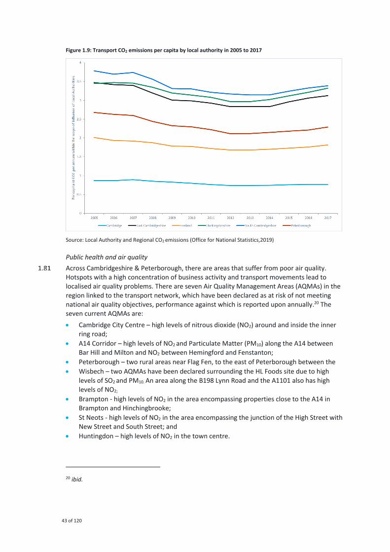
43 of 120
Figure 1.9: Transport CO2 emissions per capita by local authority in 2005 to 2017
Source: Local Authority and Regional CO2 emissions (Office for National Statistics,2019)
Public health and air quality
Across Cambridgeshire & Peterborough, there are areas that suffer from poor air quality.
Hotspots with a high concentration of business activity and transport movements lead to
localised air quality problems. There are seven Air Quality Management Areas (AQMAs) in the
region linked to the transport network, which have been declared as at risk of not meeting
national air quality objectives, performance against which is reported upon annually.20 The
seven current AQMAs are:
• Cambridge City Centre – high levels of nitrous dioxide (NO2) around and inside the inner
ring road;
• A14 Corridor – high levels of NO2 and Particulate Matter (PM10) along the A14 between
Bar Hill and Milton and NO2 between Hemingford and Fenstanton;
• Peterborough – two rural areas near Flag Fen, to the east of Peterborough between the
• Wisbech – two AQMAs have been declared surrounding the HL Foods site due to high
levels of SO2 and PM10. An area along the B198 Lynn Road and the A1101 also has high
levels of NO2;
• Brampton - high levels of NO2 in the area encompassing properties close to the A14 in
Brampton and Hinchingbrooke;
• St Neots - high levels of NO2 in the area encompassing the junction of the High Street with
New Street and South Street; and
• Huntingdon – high levels of NO2 in the town centre.
20 ibid.

44 of 120
Addressing the causes of these hotspots, as well as other locations where poor travel-related
air quality negatively impacts our health is key to the overall success of the Local Transport
Plan.
Future of mobility – electric and digital connectivity
Reducing greenhouse gas emissions and removing air quality management areas requires a
multi-faceted approach, including encouraging better use of active ‘sustainable’ modes such
as walking and cycling, improving public transport, and increasing the number of electric
vehicles in use. Electric vehicles require appropriate infrastructure, such as charging points,
before they become a viable transport option. The availability of such charging points varies
significantly across the Combined Authority area, as illustrated by Figure 1.10.
The more urban areas of South Cambridgeshire, Cambridge and Peterborough all have
charging point numbers broadly in line with the national average, while the more rural areas
of East Cambridgeshire, Huntingdonshire and Fenland have numbers significantly below the
national average. If widespread roll-out of electric vehicles is to become a reality across
Cambridgeshire and Peterborough, a concerted effort will be needed to provide better
charging provision across its geography, not only in more urban areas.
Figure 1.10: Charging points per 100,000 of the population by Local Authority in 2019
Source: Electric vehicle charging devices by local authority (Department for Transport, 2019)
In the same way that electric vehicles require charging infrastructure to make their roll-out a
reality, autonomous vehicles need good mobile coverage to operate effectively. It is expected
that for autonomous vehicles to be effective 5G coverage will be required. 5G is currently
unavailable in the UK, but current rates of 4G coverage provide a good proxy for what 5G
coverage might look like in the future. Figure 1.11 shows the 4G coverage of the A and B road
network by Local Authority across Cambridgeshire and Peterborough. As this figure illustrates,
Cambridge has significantly better 4G coverage than any other Local Authority, and Fenland
and East Cambridgeshire have significantly lower levels of coverage than the other areas.
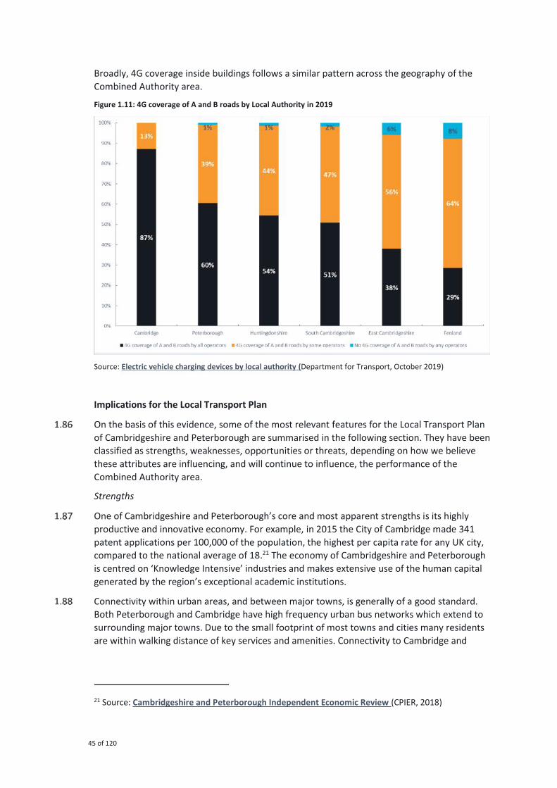
45 of 120
Broadly, 4G coverage inside buildings follows a similar pattern across the geography of the
Combined Authority area.
Figure 1.11: 4G coverage of A and B roads by Local Authority in 2019
Source: Electric vehicle charging devices by local authority (Department for Transport, October 2019)
Implications for the Local Transport Plan
On the basis of this evidence, some of the most relevant features for the Local Transport Plan
of Cambridgeshire and Peterborough are summarised in the following section. They have been
classified as strengths, weaknesses, opportunities or threats, depending on how we believe
these attributes are influencing, and will continue to influence, the performance of the
Combined Authority area.
Strengths
One of Cambridgeshire and Peterborough’s core and most apparent strengths is its highly
productive and innovative economy. For example, in 2015 the City of Cambridge made 341
patent applications per 100,000 of the population, the highest per capita rate for any UK city,
compared to the national average of 18.21 The economy of Cambridgeshire and Peterborough
is centred on ‘Knowledge Intensive’ industries and makes extensive use of the human capital
generated by the region’s exceptional academic institutions.
Connectivity within urban areas, and between major towns, is generally of a good standard.
Both Peterborough and Cambridge have high frequency urban bus networks which extend to
surrounding major towns. Due to the small footprint of most towns and cities many residents
are within walking distance of key services and amenities. Connectivity to Cambridge and
21 Source: Cambridgeshire and Peterborough Independent Economic Review (CPIER, 2018)

46 of 120
Peterborough is also good. For example, both cities have rail connections to London of less
than one-hour journey time.
The region is a leader in active travel provision and is widely considered to be one of the best
areas in the UK for cycling. Cambridge boasts the highest mode share of cycling in the country
with approximately one third of residents cycling to work on a regular basis. Peterborough
also has extensive cycling and active travel networks.
Cambridgeshire and Peterborough have excellent environmental quality, both natural and
built. This provides significant cultural value, drawing large numbers of tourists to the area
and enhancing quality of life for residents.
Weaknesses
However, the area also has some fundamental underlying weaknesses. Although the area is
broadly prosperous, the region also contains significant pockets of deprivation. Inequality is
therefore a key issue. Cambridge is one of the most unequal cities in the UK (as measured by
GINI coefficient) and mean annual gross pay in South Cambridgeshire is over £10,000 higher
than in Fenland22.
Despite good public transport within urban areas, wider public transport links within and
across the Combined Authority area can be poor. For example, train services between
Cambridge and Peterborough take approximately 50 minutes, despite being just 40 miles
apart. There is poor provision of bus services outside the major urban areas of Cambridge and
Peterborough cities.
Rural access to key amenities and transport links in rural areas is often poor. In South
Cambridgeshire only 22% of residents are within 30 minutes of walking or public transport
access of a town centre.23 This results in a reliance on private cars, and residents who do not
have access to private cars are effectively cut off from key services and amenities.
In the short to medium-term, as we transition to a clean vehicle fleet, private car ownership
may become more expensive and potentially prohibitive for those on low incomes. It is,
therefore, imperative that rural residents are provided with a public transport system that
offers a genuine alternative to the car.
Road Safety is a great concern. In 2016 there were 45 deaths across Cambridgeshire and
Peterborough’s roads, a figure which we see as unacceptable.24 Many roads, particularly in
rural areas, lack segregated provision for non-motorised users, reducing road safety and
deterring individuals from walking or cycling for their journeys.
Opportunities
The weaknesses also present opportunities to improve the transport network and the lives of
residents across Cambridgeshire and Peterborough. For example, by providing better access
to public transport we will help residents to access a range of opportunities and amenities,
helping to reduce ‘car dependency’. In addition, by providing a more efficient transport
network, better active travel uptake, and appropriate environmental consideration during
22 Source: Cities Outlook 2018 (Centre for Cities, 2018)
23 Source: Journey time statistics (Department for Transport, 2018)
24 Source: Road accidents and safety statistics (Department for Transport, 2018)

47 of 120
construction, the new transport network will enhance environmental quality across the
region. Nationwide, the transport sector is currently struggling to decarbonise at the same
rate as other sectors of the economy. The Combined Authority and partners have an
opportunity to lead the way in ‘greening’ its transport network, providing environmentally
friendly public transport options, particularly in geographies with high CO2 emissions per
capita such as Fenland.
By better connecting people, markets and businesses, future transport provision will help to
improve regional productivity. This will ultimately help the Combined Authority to reach its
economic targets and improve quality of life for all. Public transport will be key in achieving
these outcomes through initiatives such as new mass transit systems like CAM, plans for which
are currently being developed. Better infrastructure for non-motorised users, such as cyclists,
can encourage more people to travel sustainably and hence both reduce congestion on the
roads and support healthy living and access to opportunity. Delivering these projects will
stimulate a step change in connectivity in and around Cambridge and build the Combined
Authority’s reputation as a place with a progressive vision.
Finally, new technologies will have a transformational impact upon Cambridgeshire and
Peterborough’s transport network. Providing better charging infrastructure for Electric
Vehicles and improving mobile network coverage, particularly in rural areas where it is
currently most limited, will help to allow Cambridgeshire and Peterborough to take advantage
of these new technologies when they come forward. Electric bikes can encourage more
people to cycle, use approximately a hundredth of the electricity of an electric car, and extend
the distances individuals are willing to cycle. Ultimately, such technologies can help to make
the transport network greener, more accessible, and effective for all those who use it.
Threats
The area faces a number of threats, which, if not addressed promptly, have the capacity to
seriously affect the future success of the region. Congestion is the most obvious of these and
is already a serious issue within and around urban areas. Congestion lengthens journey times,
making them less reliable, while simultaneously worsening air quality and having a significant
economic cost. Modelling forecasts show that if steps to improve the road network are not
taken now, there will be a marked increase in congestion (and concomitant risks to the
economy and air quality) within and around urban areas in Cambridgeshire and Peterborough
by 2041.25
Congestion issues may be compounded by a reduction in bus service provision. Outside major
cities, bus provision is falling along with patronage. Falls in provision and patronage are
mutually reinforcing, and there is a danger that without intervention the already limited rural
bus service will become even less effective. This reduction in provision, combined with rising
fares and generally poor accessibility in rural areas, has the potential to drive users off the
public transport network. Fares are currently rising faster than RPI for both trains and buses,
which has the potential to make transport unaffordable for many into the future. House prices
are also rising rapidly and are far above the national average in many areas of the Combined
Authority. This increases the cost of living and will ultimately propagate through the economy,
risking future growth.
25 Source: Cambridge Sub-Regional Model 2 (Cambridgeshire County Council)

48 of 120
Future demographic changes also have the potential to change demand for transport within
the Combined Authority. Forecasts predict that over coming decades the average age of the
population within Cambridgeshire and Peterborough will increase. This is likely to change the
demands upon the transport network, which will need to be accommodated if it is to remain
effective.
Finally, some areas within Cambridgeshire and Peterborough have poor mobile connectivity,
an issue which causes inconvenience at present but may be a serious barrier to growth in the
future. Good mobile connectivity and a more ubiquitous full fibre footprint will likely be
required for autonomous vehicle roll-out.

49 of 120
Introduction
This chapter contains the overarching transport strategy for Cambridgeshire and
Peterborough - explaining how our transport network will be enhanced to support the goals
and objectives set out in the previous section, including the key transport planning
approaches and schemes/initiatives that will be required.
The schemes included in the Local Transport Plan have been identified and selected from
multiple sources: the priority schemes and studies of the Combined Authority; the
Cambridgeshire and Peterborough Independent Economic Review; previous Local Transport
Plans for Cambridgeshire and Peterborough; the work of the Greater Cambridge Partnership;
and Local Plans. These schemes have been reviewed with officers at a local, regional and
national level. On the basis of an initial assessment, a balanced and integrated package of
schemes has been brought forward for inclusion in the Plan.
Notwithstanding the high-level scheme assessment and sifting undertaken to inform this Local
Transport Plan, all individual schemes will be subject to further scrutiny as plans for their
delivery are progressed. These include further value for money testing (through the business
case development process) and environmental assessment (including air quality and noise
assessments) where required.
The Local Transport Plan currently includes a range of different transport investments, from
projects already approved and being delivered, through to initial ideas and concepts that still
need further study. A significant volume of work is needed to develop, appraise and prioritise
the transport interventions in this Local Transport Plan, and to ensure that new ideas and
alternative approaches can be accommodated within future amendments. Further
information on the mechanisms in place to ensure that the Plan is sufficiently flexible to
influence and support transport initiatives as they are brought forward, and that it continues
to reflect the realities of contemporary Cambridgeshire and Peterborough are set out in the
accompanying Delivery Plan.
The remainder of this chapter:
• describes the guiding principles that have been employed to inform and shape our
strategy for transport in Cambridgeshire and Peterborough; and
• presents an overview of our overall strategy, including the vision, goals and objectives for
transport in Cambridgeshire and Peterborough, and a sample of selected schemes.
The overarching strategy is then followed up in Chapter 3 that outlines more detailed
strategies for Peterborough City Council, the Greater Cambridge Partnership area (Cambridge
City Council and South Cambridgeshire District Council), and the Local Planning Authority
areas of Huntingdonshire, East Cambridgeshire and Fenland.
2 Our Strategy

50 of 120
Our overall strategy
Overview
Our region is both large and diverse: 850,000 residents and 42,000 business call
Cambridgeshire and Peterborough home, in an area covering some 340,000 hectares. It is
home to a wide range of communities, settled in diverse geographical and social settings –
from the cities of Peterborough and Cambridge, to large market towns and a network of rural
villages and hamlets.
Developing a unified transport strategy for the whole region is complex. At its core is our
vision for sustainable growth and opportunity for all to deliver healthy, thriving communities
in Cambridgeshire and Peterborough. In doing so, we must put our communities – the places
we live, work and visit – first when planning our transport network. We want to provide
choices regarding the way we travel, to allow individuals and businesses to be less reliant on
the car and to decarbonise transport more generally.
Integrated transport and spatial planning, investment in high quality public realm in our town
and city centres, safe and attractive walking and cycling infrastructure, accessible and
frequent public transport and innovative new transport modes designed to enhance mobility
will all play an important role in helping achieve this ambition.
Preparation of this Local Transport Plan has, been guided by several high-level principles that
provide overarching guidance to ensure that it fulfils the overriding imperative for sustainable
economic growth, including decarbonising transport on our journey to net zero carbon
emissions by 2050. The guiding principles are:
• supporting economic growth and distributing prosperity;
• integrating spatial planning and reducing the need to travel;
• providing attractive alternatives to driving – ‘mode shift’; • preparing for the future of mobility;
• greening our transport infrastructure;
• supporting social mobility and access to opportunity for all; and
• protecting and increasing biodiversity
Guiding principles
Supporting economic growth and distributing prosperity
Our strategy will help to deliver the Combined Authority’s strategic ambition to become the UK’s capital of innovation and productivity, and to double the size of its economy from £22 billion Gross Value Added (GVA) to £40 billion over the next 25 years. Improving journey
times, both by road and rail, and reliability is important for businesses to access their markets,
collaborators and supply chains. This will also help to increase the geographical catchment
from which to draw growing workforces, helping businesses to realise their full potential for
growth.
Enhancing our transport network and creating new journey opportunities that do not solely
rely on the private car is key to relieving congestion on our road network, and to
accommodating new and existing journeys as sustainability as possible. Large-scale
investment in public transport, including a rapid transit network for Cambridgeshire and a new
rail link to Wisbech, coupled with improved highway links designed to accommodate ultra-low

51 of 120
emission vehicles, electric vehicle charging points and other emerging technology will provide
extra capacity for people to travel sustainably while delivering our regions’ growth.
Growth must be inclusive, truly sustainable and spread appropriately across the entirety of
the area. It should create places where all members of our community contribute to, and
benefit from, our area’s growth and success. Currently, employment, amenities and prosperity
are predominantly centred in and around the cities of Cambridge and Peterborough, but these
cities also contain significant areas of deprivation, and Cambridge has the most uneven
income distribution of any UK city26. Our proposals will help to spread success across the
region, ensuring that all our residents benefit from growth wherever they live.
Supporting social inclusion – improving accessibility and health for all
The transport network must provide access to sites for housing and employment, as well as
increasing the capacity and connectivity of the transport network for future housing and
employment growth. It must also align with other investments in digital connectivity, energy
supplies and other utilities, and skills, housing, and other civic infrastructure and business
support. This investment will ensure that the area is globally renowned for being forward-
thinking and progressive regarding mobility and movement – putting the region at the
forefront of tackling one of the Government’s Industrial Strategy Grand Challenges – the
future of mobility27.
Ultimately it is our ambition that everyone will have access to a good job within easy reach of
home. To achieve this will require not only an increasing level of jobs, but also provision of
high-quality housing and commercial spaces within and near existing communities to
accommodate a growing population and workforce. The Combined Authority is supporting the
region’s Local Planning Authorities in targeting more than 90,000 new jobs and over 100,000
new homes by 2036, as outlined in their adopted Local Plans.
By providing real choices for how people travel, we will promote social mobility, inclusive
growth and improve health: a key driver for productivity. Transport plays an important part in
ensuring that we can access the skills, education and health care required. Investment in our
sustainable transport network will facilitate improved access, including for those without
access to a car, and reduce carbon emissions and particulate emissions that impact air quality
negatively.
Many rural areas have poor public transport connectivity, reducing the opportunities to access
employment opportunities, key services, and amenities. For people without the use of a car,
including young people, those on low income or for people with disabilities, these challenges
are exacerbated. For future gains in productivity and economic growth to benefit all of our
residents, investment in sustainable modes of transport will be prioritised. Investing in
sustainable transport modes will ensure that the network provides accessible transport for all
users, without damaging the surrounding environmental, social and built environments.
Integrating spatial planning and reducing the need to travel
Our strategy is focused on transport-oriented planning and development. This approach aims
to reduce the need to travel, particularly by private car, by providing attractive alternatives
26 Source: Cities Outlook 2018 (Centre for Cities, 2018)
27 Source: Industrial Strategy: Building a Britain fit for the future (HM Government, 2017)
52 of 120
that support a significant shift to more sustainable forms of transport. The Combined
Authority is continuing to develop its non-statutory Spatial Framework and one of its guiding
principles is to integrate spatial and transport planning to reduce the need to travel and
shorten many of the journeys we do need to make – making our communities more walkable
and cyclable.
While the Combined Authority is the Local Transport Authority, it is the city and District
Councils that are the Local Planning Authorities. The Combined Authority will work with the
Local Planning Authorities to support their Local Plan processes and supplementary planning
document and guideline development to promote integrated planning. Within this are the
facilitation of sustainable transport, and the roll-out of digital connectivity and electric
charging infrastructure, and other policies and infrastructure which influence suitability
positively.
Providing attractive alternatives to driving – ‘mode shift’
Currently, private car is the most popular transport mode for making journeys in and around
Cambridgeshire and Peterborough. Our strategy recognises this and provides a wider range of
travel options so that people have a genuine alternative to the private car. This is key to
achieving our wider economic, social and environmental objectives, and delivering the
sustainable growth required to meet the Combined Authority’s ambitions.
Our strategy includes investment in world-class Dutch-quality walking and cycling facilities,
including a network of segregated cycleways and new bridges of the River Nene, Cam and
Ouse, and designed to accommodate a wide range of non-motorised users including horse
riders and carriage drivers. More people travelling on foot, by bike and public transport, rather
than by private car, will help to reduce congestion, improve air quality and safety, and create
attractive, healthy, and thriving streets and communities.
In addition to dedicated corridors for cycling, walking and other non-motorised modes, and
alongside the creation of a public transport network that offers a genuine alternative to the
car, all new public transport and highway infrastructure will be designed to include parallel
cycling and walking corridors with suitable access and crossing points.
Many of our core policies aim to encourage the shift to walking, cycling and public transport:
from providing sustainable connectivity to and within new developments, to delivering world-
class walking and cycling infrastructure, and a new, more integrated and accessible, public
transport network. Major projects, such as CAM; a new rail link to Wisbech; and East West
Rail, will provide new journey opportunities, with fast, frequent services and competitive
journey times, designed to act as a genuine alternative to the private car.

53 of 120
What is ‘Dutch-quality’?
The Netherlands has the highest mode share for cycling of any country
globally, at 27% of all trips28, compared to 2% in the UK. Dutch cycling
infrastructure is near-universally viewed as globally renowned and key to
facilitating such high levels of cycling for people of all ages, including
children, young people and the elderly.
Key to Dutch infrastructure is it ensures cycling is safe, convenient and
attractive. Cyclists are segregated from general traffic where traffic
speeds and/or volumes are high, in line with a clear route hierarchy.
‘Filtered permeability’ is used to reduce traffic flows and eliminate ‘rat-running’ on residential streets where cyclists share space with motorists. Segregated cycle tracks are typically wide by UK standards, with standard
widths of 2.5m for one-way tracks and 4.0m for two-way tracks, providing
ample space for cyclists to pass one another, separated from highway
traffic by a barrier and/or verge, surfaced for use all-year round, and
designed to maintain priority for cyclists as much as possible (such as at
driveways and minor road junctions). Cyclists are also segregated from
pedestrians where pedestrian flows are high, or conflict likely, such as
within urban areas. Junction design aims to minimise conflicts between
cyclists, pedestrians and general traffic, with tighter junction geometry
reducing speeds and enabling cyclists and motorists to clearly see one
another29.
To help guide the development of new transport schemes we have developed a user hierarchy
that outlines how consideration will be given to the needs of different transport modes. This
Plan prioritises the ‘active modes’ over other forms of transport, as we believe that their benefits align closely with our three overarching goals of Economy, Society and Environment.
Consideration of both ‘place’ and ‘movement’ function will be used to identify the suitability
of a given transport scheme within a specific location. An explanation of the relationship
between place and movement is provided in Figure 2.1, and an indicative user hierarchy for
each of the four broad quadrants in Figure 2.2.
Considering ‘place’ and ‘movement’ reflects the reality of the transport network and the
needs which it must serve. Different transport modes have different strengths and
weaknesses, meaning that certain modes are appropriate for certain situations. The best
transport networks enable a mix of modes to operate effectively aligned to the geographical
requirements of an area. We believe that considering ‘place’ and ‘movement’ function as part of our user hierarchy is the best way to deliver a transport network that provides good
connectivity, whilst preserving the localities which it serves.
28 See: Cycling in the Netherlands, 2009
29 Further details of Dutch infrastructure design can be found in CROW Design Manual for Bicycle
Traffic.

54 of 120
Figure 2.1: Movement and place function
Figure 2.2: Indicative user hierarchy by movement and place function
In spaces with a high movement function and low place function, efficient transport modes
will be given priority. For example, along fast-moving roads such as the A14, the private car
and Heavy Commercial Vehicles will be given higher priority, while consideration will also be
given to how the infrastructure can facilitate walking and cycling through measures, such as
parallel segregated pathways and safe junction crossings.
By contrast, in spaces with low movement requirements but high place value, priority will be
given to modes that best preserve that specific setting or location. For example, within
Cambridge’s historic city centre, cyclists and pedestrians will be given priority as these modes
provide good access to this space whilst causing minimal disruption.
55 of 120
There will cases where a degree of judgement will be required to identify the most suitable
user hierarchy for a given location given its movement and place functions. In these cases, a
combination of professional judgement, local engagement and location-specific constraints
will inform the definition of the user-hierarchy.
Preparing for the future of mobility
Over the next twenty years technology will result in significant changes to our transport
network and the way we chose to and want to travel. Alongside attitudes changing toward
transport, travel and technology, advancements may include:
• data and vehicle connectivity;
• automation and artificial intelligence;
• electrification and other ultra-low emission fuels;
• shared mobility (e.g. bike share schemes) and new modes of transport; and
• new payment mechanisms and business models.
For Cambridgeshire and Peterborough to remain an economically dynamic centre of
innovation and progress, we must stay at the forefront of future transport and technology and
create the right conditions for them to ‘take root’. For example, to realise the full potential of
autonomous mobility and services, improving the digital networks to 5G standard will almost
certainly be required. In addition, to fully realise the potential of electric vehicle technology,
investment in electricity networks will be required, including changes to our planning and
building regulations.
The Combined Authority has already applied for funding – and been shortlisted to the second
stage – for Future Mobility Zone funding from the Government to invest in harnessing the
benefits of such technology. This includes proposals for an app-based Demand Responsive
Service within Greater Cambridge, integrated into the wider transport network through
Mobility-as-a-Service (MaaS), supporting the delivery of autonomous public transport
‘shuttles’ to and from the Cambridge Biomedical Campus, and better use of integrated real
time data, machine learning and technology.
Predicting the exact nature of these technological developments and the impact they will have
on the transport network is challenging. Any such predictions will likely have a high degree of
uncertainty and using them to drive long-term strategy is unwise. At present, however, the
opportunities are to:
• help better manage demand upon and increase the efficiency of the transport network;
• allow people work and access goods and services remotely; and
• plan better and more seamless journeys both in advance and in real time.
Emerging technologies evolve more quickly than regulation. Therefore, anticipating and
reacting to these changes efficiently, knowing when to facilitate them, and when to inhibit
them is key. In the long-term, we must avoid becoming ‘path-dependent’ or committing too much to any single transport mode. Historically, the most effective transport networks have
combined a range of modes to provide an array of services for different users and journey
types. Although technology will provide new modes and change the exact nature of journeys,
it is likely that a diverse, multi-modal transport network will provide the best range of
transport options for our residents.
56 of 120
Greening our transport infrastructure
Poorly planned transport infrastructure has the potential to cause significant environmental
damage. This damage can occur at a local level, for example, through damage to local
habitats, the creation of localised air pollution, or aesthetic damage. This damage can also be
more systemic and less geographically contained, for example, through the production of
greenhouse gases. It is critical that we ‘green’ our transport infrastructure both literally; by
adding ‘green infrastructure’ to newly constructed components of the transport network; and,
by ensuring that these changes do not systemically drive an increase in environmentally
damaging behaviours and/or outputs. For new schemes and pieces of infrastructure,
biodiversity net gain must be delivered, and the impacts on carbon emissions considered as
part of the process needed to achieve net zero carbon by 2050.
Greening transport infrastructure means considering the environment impacts of new
infrastructure, including on carbon emissions and air quality, biodiversity, and the natural,
built and historic environment, at the earliest stage. These considerations allow the addition
of ‘green’ elements to all new pieces of infrastructure, from extensive planting along new
transport corridors, ‘green bridges’, to providing corridors for biodiversity that reduce, and
potentially enhance, impacts on the landscape. The addition of such green space serves a dual
purpose; it both mitigates any local impacts on biodiversity and the aesthetic impacts of newly
constructed infrastructure, whilst helping to offset the emissions produced in their
construction and operation.
At a more systemic level, we must encourage behavioural changes that alter the way that
transport infrastructure is used. New highway infrastructure, for example, should provide
space for public transport, walking, cycling and other non-motorised modes transport modes,
in addition to more conventional motorised vehicles. Encouraging the use of modes other
than conventional, privatised, motorised vehicles, has the potential to significantly improve
the environmental impact per trip along such pieces of infrastructure.
Protecting and increasing biodiversity
Our commitment to biodiversity net gain through investment in transport and the
developments it supports will help our communities to become high quality, sustainable
environments where people want to live30. Reducing the need to travel, and distances
travelled, through integrated land use, transport planning, investment in digital and mobile
connectivity and energy supply, is a central pillar in meeting local and national ambitions to
significantly reduce greenhouse gas emissions as we move towards net zero carbon by 2050.
Major schemes
Where strategies in previous Local Transport Plans have been largely predicated on
overcoming existing and anticipated future challenges, this Plan is designed to be focused on
meeting the Combined Authority’s ambitions plans for growth. In doing so, the Local
Transport Plan presents a clear strategy for meeting our economic, social and environmental
goals which will need to be fulfilled if the ambition is to be met. The steps we are taking to
achieve each goal are described below with a summary of key schemes (shown in Figure 2.3)
to illustrate how they will be delivered.
30 Source: A Green Future: Our 25 Year Plan to Improve the Environment (Defra, 2018)

57 of 120
Figure 2.3: Key projects for Cambridgeshire and Peterborough

58 of 120
Transport and the economy
We want to connect all new and existing communities sustainably, so residents can easily
access a good job within 30 minutes, thereby spreading the region’s prosperity. The transport network across the area is already of a good quality, but there remain significant areas for
improvement. As much as possible, we want to encourage mode transfer from the private car
to public and ‘active’ transport modes, ultimately aiming to reduce ‘car dependency’.
Traffic congestion is the most frequent form of disruption to our region’s transport network, posing a risk to the Combined Authority’s future growth ambitions. Within our urban and
surrounding areas, solutions to manage demand for road space are being explored, such as
the construction of the CAM. This will provide high quality, high frequency metro services,
delivering a step change in connectivity across the city and helping to deliver additional
‘agglomeration benefits’. These agglomeration benefits are those that businesses reap from
increased competition, knowledge sharing and efficiency gains, brought by greater proximity
to one another.
Rail usage has risen considerably over the Combined Authority area and continues to increase;
therefore, we will promote a range of schemes to help encourage, maintain and
accommodate this trend. For example, there are a number of new railway stations being
proposed for the region, including Soham station that would reintegrate the town with the
national rail network. In addition, Cambridge South station will significantly improve access to
the Cambridge Biomedical Campus from the region and beyond.
East West Rail, a new rail link from Cambridge to Bedford, Milton Keynes and Oxford, will
transform public transport connectivity along the Oxford to Cambridge corridor. While
construction of a new rail link from March to Wisbech would improve public transport
connectivity to the latter. Improvements to rail junctions in Ely delivered by the Ely Area
Capacity Enhancements (EACE) project will enable more frequent services and make journeys
quicker for passengers. We will also work to support continued electrification of the rail
network for both passengers and freight, along the Ipswich to Cambridge and Peterborough
corridor.
Buses are a fundamental component of the transport network across Cambridgeshire and
Peterborough, particularly in our rural areas. We will explore the best operating and delivery
model for our public transport network, acknowledging the different requirements of urban
and rural residents. For example, we will seek to ensure that rural areas have a public
transport service that provides access to employment, education, shopping and recreation. In
addition, we will work with operators to place inter-urban bus services, combined with local
rail services, at the centre of an integrated rural public transport network.
Cycling, particularly within Greater Cambridge, plays a key role in commuting, with more than
a quarter of people within Cambridge travelling to work by bike – the highest rate in the
country. Greater levels of cycling will not only help more people travel to work easily and
cheaply, but help to relieve traffic congestion, and enable our region to grow sustainably. We
will continue to work with our partners to improve infrastructure for cyclists, and other non-
motorised users, with segregated Dutch-type infrastructure along major road corridors and a
network of ‘Greenways’ connecting to major employment hubs. New technology, such as affordable e-bikes and cargo bikes, can allow new groups of people to cycle and commute
longer distances by bike, which our policies will actively encourage and support.

59 of 120
Although we want to prioritise the development of public and ‘active’ transport modes, we recognise that the private car remains a key mode for many residents across Cambridgeshire
and Peterborough. We will therefore support targeted highway infrastructure and
enhancement schemes such as:
• upgrades to the A47 between Kings Lynn, Wisbech and Peterborough, to improve labour
market accessibility to and from the Fens and Wisbech Garden town;
• King’s Dyke crossing improvements, to relieve traffic congestion and associated safety issues caused by the level crossing; upgrades to the A505, to improve accessibility and
support development at the Wellcome Genome Campus; and
• dualling of the A428, which will significantly improve commuter links along the Oxford to
Cambridge corridor.
Improvements to the A14, one of the most congested routes in the country, are currently
underway and will bring journey time, reliability and safety benefits to residents, workers and
businesses alike.
Alongside the physical improvements, we are committed to enhancing the region’s ‘virtual network’. Faster, more reliable digital connectivity will provide:
• improved connectivity between businesses and to homes;
• greater working flexibility, thereby taking take the strain off the transport network; and
• allow better management of our transport networks to increase capacity, for travel times
to be more reliable, and ultimately, safer for making all journeys.
Improvements to the transport network will help to support new housing and development.
This will help to accommodate a growing population, mitigating housing affordability issues.
The housing market is currently very ‘overheated’, particularly around Cambridge, where the
average house price is nearly 13 times the annual salary, compared to the national average of
just under 8 times. The effects of higher house prices spread through the economy, potentially
slowing growth. Local plans include targets for over 100,000 new homes, by 203631, with the
location of the strategic sites shown in the Cambridgeshire and Peterborough Non-Statutory
Spatial Framework (NSSF) Phase 1. Transport will help to unlock future development sites and
connect new residents to jobs, services and amenities.
Necessary partnerships and plans are currently being developed for the construction of vastly
improved public transport connectivity to Alconbury. Connectivity into the CAM network and
a new travel hub will play a central role in delivering over 8,000 jobs at the Alconbury Weald
Enterprise Zone, accelerate the development of 6,000 new homes and sustainably connect
new residents to jobs, services and amenities. Improvements on the Ely-Cambridge transport
corridor will unlock key opportunities, such as a new town north of Waterbeach and
development on the Cambridge Science Park.
Transport and society
Everybody should be able to access our transport network, feel safe, and be healthier when
they do so. We want to promote social inclusion through the provision of a sustainable
transport network that is affordable and accessible for all. To achieve this, the network must
be examined at every scale, from curb-heights to area-wide highway network planning,
31 Source: Cambridgeshire and Peterborough Non-Statutory Spatial Framework, (Cambridgeshire &
Peterborough Combined Authority, 2018)

60 of 120
ensuring that nobody is excluded from using the transport network due to personal
circumstances; income, age, disability or any other factors. This ‘human-centred’ thinking is a central component of our approach across projects and schemes. We want to embed a safe
systems approach into all planning and transport operations to achieve Vision Zero – zero
fatalities or serious injuries on the transport network. The vast majority of transport-related
deaths occur on our road network, and so working in partnership with the Cambridgeshire and
Peterborough Road Safety Partnership and our highway authority partners to deliver
improvements to highway safety will be our focus when aiming to reduce fatalities and
injuries on the transport network.
We recognise that the transport network does not always function flawlessly and is subject to
internal and external stresses that can cause delays. We must therefore make the transport
network resilient and adaptive to human and environmental disruption, improving journey
time reliability. Cambridgeshire and Peterborough is one of the driest areas in the UK, yet also
susceptible to flooding due to its predominantly low-lying topography. This means that
transport infrastructure is vulnerable to extreme weather events and needs to be
appropriately protected. We will look to incorporate climate resilience into the new transport
network, designing infrastructure that is resilient but relatively easy to maintain and repair. By
ensuring that the transport network is protected against human and environmental
disruptions, journey time reliability will be improved, allowing quicker and more enjoyable
journeys.
Transport and the environment
While encouraging development, we want to deliver a transport network that protects and
enhances our natural, historic and built environments. We are fortunate to have exceptionally
high-quality environments within Cambridgeshire and Peterborough that have positive
impacts on our residents’ quality of life. Nonetheless, there are biodiversity challenges and
not everyone has easy access to good quality open space. We must integrate environmental
considerations, including biodiversity net gain when developing the future transport network,
ensuring that all new transport schemes cause minimal disruption to the environment both
during construction and operation.
In addition, we aim to ensure transport initiatives improve air quality across the region,
exceeding standards as set by the European Union32. We will work to improve air quality and
noise pollution, exploring options such as electrification of local taxi fleets and increasing the
number of ultra-low and zero-emission buses. This will ensure that local air quality sees
significant improvement, resulting in a better quality of life for our residents.
We will reduce emissions to ‘net zero’ by 2050 to minimise the impact of transport and travel on climate change. We understand that climate change, a global issue, requires interventions
at a local scale. We recognise that everybody has a role to play in tackling this issue and want
to ensure that Cambridgeshire and Peterborough are proactive in this area.
To help drive these changes we must provide ‘healthy streets’ and high-quality public realm
that puts people first and promotes active lifestyles. ‘Active’ transport modes like walking and cycling have a significant impact upon local air quality, greenhouse gas emissions, and public
32 Air quality standards are set in European Union (EU) Directive 2008/50/EC on Ambient Air Quality and
Cleaner Air for Europe and the Fourth Daughter Directive (2004/107/EC)

61 of 120
health. Walking and cycling are already popular transport modes within certain areas of the
region, such as Cambridge, but we must ensure that they become more widespread.
To help promote walking and cycling, we will continue to develop Local Cycling and Walking
Infrastructure Plans (LCWIPs) thereby providing evidence for prioritised investment in cycling
and walking infrastructure. We will develop high quality cycle provision, through schemes
such as the Greater Cambridge Partnership’s Greenways. This will involve building upon the current network and providing additional links to join up key destinations that are already
partially served (for example the Chisholm Trail in Cambridge).
The use of active travel as part of multi-modal trips will be encouraged wherever possible. For
example, we will investigate the possibility of a cycle hub in Peterborough city centre and
improve cycle links to other key destinations around the city. Broadly we will consider ‘place’ and ‘movement’ functions when designing new infrastructure to ensure that we can provide
good transport connectivity whist retaining and developing ‘healthy streets’. On a broader scale, Cambridgeshire and Peterborough depends upon national and
international connectivity to drive its economic prosperity. We must therefore ensure that all
our region’s businesses and tourist attractions are connected sustainably to our main transport hubs, ports and airports. For example, the Combined Authority is currently working
in partnership with Highways England to assess the viability of dualling the A47 that would
significantly improve east-west freight movement in the north of the region. In addition, we
will support infrastructure and signaling enhancements to improve rail freight capacity, taking
freight off the road network and moving it across the region more sustainably. Combined,
these interventions will ensure that goods continue to flow freely into and out of the region,
allowing trade and local businesses to flourish.
The following chapter provides a summary of our strategy for the geographical areas of
Peterborough, Greater Cambridge, Huntingdonshire, East Cambridgeshire and Fenland.
Additional detail regarding the specific projects that are under consideration in each area is
provided in the Transport Delivery Plan.

62 of 120
Introduction
Each district of Cambridgeshire and Peterborough is different; hence we have developed
distinct strategies for the geographical areas of Peterborough, Greater Cambridge,
Huntingdonshire, East Cambridgeshire and Fenland. These are set out in this chapter, and
each reflects local transport constraints, opportunities and patterns of growth.
Each strategy outlines the major schemes expected to be delivered within each area to deliver
our objectives, both directly by the Combined Authority and in partnership with other local
and national stakeholders. Some aspects of the strategies are, by necessity, still under
development and hence all schemes will need to demonstrate value-for-money and
affordability, together with alignment with our strategic priorities, before they are able to
proceed.
Each strategy is set out below, and includes:
• a summary of recent and planned growth, and local transport constraints;
• progress and projects delivered to date; and
• the transport schemes to help deliver each strategy.
Peterborough
Background
Peterborough is a rapidly growing city, with a population of approximately 200,000 people.
Traditionally a ‘railway town’, centred upon its location as a major rail junction on the East Coast Main Line between London and the North of England, it grew rapidly after designation
as a ‘new town’ in the 1960s. Surrounded by a predominately rural district with few major
service and employment centres, Peterborough includes a large historic town centre with an
extensive shopping offer, a major hospital, numerous key employment sites and the site of the
future Peterborough University.
Peterborough’s patterns of growth are reflected in the city’s geography, and its transport network. Peterborough’s town centre and ‘inner city’, including the historic Cathedral and numerous Victorian terrace streets, are surrounded by lower-density development from later
years linked by a radial ‘Parkway’ network of high-capacity dual carriageway roads. This
network supports efficient movements between and within the city, resulting in significantly
less congestion than elsewhere in Cambridgeshire and Peterborough, helping to support
significant growth around the city.
Recent and planned growth
Peterborough has continued to be one of the fastest-growing cities in the country,
experiencing population growth of 15% between 2007 and 2017, the fastest-growing district
within the Combined Authority. Recent growth has been focused at Hampton to the south,
where a major urban extension is underway on reclaimed brickfields, and at Stanground in the
east, together with increased development in the city centre. Several vacant and underused
3 Local Strategies
63 of 120
sites close to the city centre also offer the opportunity for continued investment and
regeneration.
Peterborough has recently developed a new Local Plan, which was adopted by the Council in
July 2019. It outlines the vision for the city to become a destination of choice, with a walkable,
liveable centre; a strong, resilient economy; and attractive, well-designed neighbourhoods,
surrounded by a network of characterful villages.
The Local Plan sets out proposals to deliver 19,440 additional homes from 2016 to 2036, with
growth focused within the city and within a collection of seven ‘urban extensions’ at Hampton, Stanground South, Paston Reserve, Gateway Peterborough, Norwood, Great
Haddon and at the East of England Showground. It also establishes proposals for a new
independent, campus-based university with 12,500 undergraduate students, proposed to be
located off Bishop’s Road to the south-east of the city centre.
Transport challenges
Peterborough’s’ transport network must continue to adapt and expand to support the city’s growth, whilst ensuring a sustainable transport network that provides access to opportunity
for all. Although Peterborough benefits from significantly less traffic congestion than
elsewhere in the region, largely due to the high-quality Parkway network, additional
development focused on the fringes of the city is expected to place increasing pressure on the
highway network. Even combined with investment in sustainable transport, including
improvements to the bus network and better walking and cycling infrastructure, there is a
need to provide additional, targeted highway capacity to support Peterborough’s growth.
While Peterborough benefits from a comprehensive bus network, some routes operate at
comparatively low frequencies for an urban environment (every 20 mins or less frequently)
and hence do not provide a ‘turn-up-and-go’ level of service that acts as a genuine alternative
to the car. Recent reductions in financial support for the network have resulted in reductions
to a small number of evening and weekend services and there is also not a comprehensive on-
demand community transport service for those not directly served by the bus network, or
through age or disability are not able to access local services. New urban extensions to
Peterborough, such as at Hampton, must be integrated fully in Peterborough’s bus and public transport network as they are built out, so that new residents are able to travel sustainably as
soon as they move in, rather than waiting several years for sustainable transport options to
become available.
The Queensgate Bus Interchange is in need of modernisation, and despite its proximity, can be
disorientating to reach from the railway station due to severance caused by the A15. Although
Peterborough is well-served by the rail network, with frequent, direct services to London,
Cambridge and Norwich, together with the West Midlands and North of England, there are a
number of improvement opportunities, including faster services to London, Cambridge and
Stansted Airport, more frequent services on rural routes to Cambridgeshire, Suffolk and
Norfolk, and more capacity.
Peterborough has a large network of segregated cycle and pedestrian routes and is funding
significant improvements to the public realm in and around the city centre and the railway
station. However, some major roads and junctions lack adequate provision for all non-
motorised users, while in places the Parkway network causes severance between
communities that deters active travel between them. Although much of the cycle network is
segregated from traffic, it is not consistently designed to ‘Dutch’ (or comparable) standards,
with cyclists often lacking priority at junctions, and security concerns caused by inadequate

64 of 120
lighting or sightlines. Continued investment and maintenance in the network, particularly
integrated into new development, is needed to ensure walking and cycling is an attractive
option for people of all ages to travel around Peterborough.
Progress to date
Since the adoption of Peterborough City Council’s fourth Local Transport Plan in 2014,
Peterborough has delivered a package of transport improvements to improve the urban realm
and make Peterborough a more attractive place to live. Extensive improvements to Bourges
Boulevard, the creation of a new entrance to Peterborough railway station and the
refurbishment of a vital footbridge have all been completed, supported by a £9.2 million
contribution from the Combined Authority.
Peterborough City Council have been proactive in promoting sustainable transport. Funding
from the DfT has been used to deliver ‘Bikeability’33 training. In addition, local schools have
been encouraged to participate in the national ‘Big Pedal’34 competition and the council has
collaborated with Sustrans on an initiative known as ‘School Streets’ that encourages schools
to close the street outside their gate to ease congestion and encourage active and sustainable
travel.
Highway improvements have been delivered to support new development, including at the
A47 Junction 20 that has been converted to a fully signalised roundabout to help to unlock the
delivery of up to 2,500 new homes. Peterborough City Council has also enthusiastically
embraced the potential that new technologies may bring to the city. £90,000 of funding from
the DfT has been awarded to install four rapid electric vehicle chargers for the local taxi trade,
and through an additional £22,500 contribution from Peterborough City Council, the chargers
are expected to be operational during the first half of 2020.
Our approach
Peterborough’s public transport network must offer accessibility for all. Central to this is our
plan for the bus network that subject to the recommendations of the Bus Review Task Force,
will provide improvements to levels of service and operating hours. This will help ensure that
the bus network provides a high-quality service, allowing people to travel across Peterborough
quickly and easily without a private car. Bus services will be integrated into new developments
at the outset, with the aim of ensuring high-frequency services directly serve new
developments as the first new residents move in. We will continue to explore the potential to
modernise Queensgate Bus Interchange to present a better gateway to Peterborough and the
bus network, while improving linkages to the railway station.
Complementing this investment is the continued development of Peterborough’s walking and cycling network. New junctions and highway infrastructure will be integrated into the walking
and cycling network, ensuring that roads in the city do not act as a barrier to movement.
Continued improvements to segregated infrastructure, including a new foot and cycle bridge
across the Nene, and the upgrading of the cycle network to ‘Dutch’ standards, will help to
33 Bikeability is a scheme delivered by the Department for Transport which aims to give everyone the
skills and confidence to ride a bike.
34 “Big Pedal is the UK’s largest inter-school cycling, walking and scooting challenge. It inspires pupils,
staff and parents to choose human power for their journey to school.” Source: Sustrans website
(Accessed May 2019)

65 of 120
make walking and cycling an attractive choice for short journeys. More journeys on foot and
by bike will help allow residents to live active, healthy lives, together with improving air
quality and reducing congestion when people switch from the private car.
Not everyone can or wants to walk or cycle, however. A significant number of journeys in
Peterborough will continue to be undertaken by the private car: a reflection of its geography
of the transport network. We will continue to invest in our highway network, alongside
sustainable alternatives, to tackle key ‘pinch points’ to alleviate traffic congestion, and support Peterborough’s growth.
Delivering additional capacity is needed at key junctions on the Parkway network, particularly
where these serve large development sites and new urban extensions. Development of
thousands of new homes and jobs at the Hamptons, for example, will increase traffic flows on
Fletton Parkway, and without intervention, will result in significant worsening of traffic
congestion at Junction 3. This will result in longer, more unreliable journeys for drivers and
bus passengers, undermining our economy and worsening local air quality. Poor accessibility
to major development sites also places growth at risk, as both people and businesses want to
be based in attractive, well-located neighbourhoods.
Investment in key junctions and ‘pinch points’, including carriageway widening and junction improvements on Fletton, Paston and Nene Parkway, plus at Stanground, will help to improve
journey times and reliability, while providing the required capacity for future growth. These
investments will make travelling around Peterborough, whether travelling to work, to school
or to the shops, quicker and easier and help to make the city an attractive place to live and
work.
Better strategic linkages to Peterborough, both road and rail, will help to make long-distance
journeys quicker and easier, and attract investment. We will support proposals for
improvements to the A1 including a grade-separated junction at Wittering to improve safety
and access to the village. The Oxford to Cambridge Expressway and continued dualling of the
A47 corridor will significantly improving highway accessibility towards London and support our
freight and distribution sectors. Improved rail services from Peterborough, including faster
journey times to/from London (to less than 40 minutes) and Cambridge, and improved
frequencies on rural routes to Cambridgeshire, Suffolk and Norfolk, will make rail a more
attractive option for longer-distance travel and help make Peterborough a major business
destination.
Our detailed plans and projects to deliver this strategy are summarised in Figure 3.1.

66 of 120
Figure 3.1: Summary of key projects in Peterborough

67 of 120
Strategic projects
Improving access to Peterborough from the rest of Cambridgeshire and Peterborough, as well
as the rest of the country, is an important priority. This will reduce journey times for longer-
distance journeys by both road and rail, as well as improving the attractiveness of
Peterborough as a business destination.
Improvements to strategic highway links are key to this strategy. Dualling of the A47 between
Wansford and Sutton will improve journey times and reduce congestion along a key strategic
route from Peterborough to the A1 corridor, and the wider North of England, as well as
improving road safety along a route with a history of fatal and serious collisions. Highways
England have recently published their proposed route for the scheme, and construction is
expected to commence in 2020. The Combined Authority support longer-term improvements
to:
• the A47 corridor, where we will continue to build the case to dual the route to Kings Lynn
to help improve accessibility from Peterborough to East Anglia; and
• the A16 corridor, where we will support investigating the feasibility of dualling the route
between Spalding (in Lincolnshire) and Norwood / Peterborough.
In addition to these improvements to our strategic highway links are a series of parallel
upgrades to our rail routes. Construction has recently commenced on the Werrington dive-
under scheme, to the north of Peterborough that will provide additional freight capacity,
particularly for intermodal traffic on routes from the east coast ports to the North of England.
This will help to take lorries off our roads and improving journey time reliability for all rail
users. We will also continue to work with Network Rail to understand the feasibility of
reintroducing four tracks between Peterborough and Huntingdon, allowing faster journey
times and additional train services from Peterborough to London. Completion of High Speed 2
in the early 2030s will allow the opportunity to refocus the East Coast Main Line timetable
through Peterborough, as non-stop services to Leeds and York are diverted to the new
railway, allowing more services to call at Peterborough and providing additional capacity to
London.
Local projects
City centre
The Combined Authority will continue to deliver improvements to the transport network to
support the growth planned for the city centre and help to make it an attractive destination
for shoppers, businesses and visitors.
Key to the city centre improvements will be continued investment in the streetscape and
urban realm to make the city core attractive, pleasant and safe. Following the improvements
along Bourges Boulevard that helped to improve walking and cycling connectivity to
Peterborough railway station, further urban public realm improvements will be delivered
(currently unfunded) in the Midgate, Northminster and Broadway areas. These will include
better paving, lighting and street furniture, improving access to the north of the centre and
encouraging more people to walk and cycle.
Further connectivity to the railway station is proposed through a new access route associated
with future development of land to the west of the station. In addition, the Council is taking

68 of 120
an active role in the redevelopment of North Westgate, an area of the city centre that has
been underutilised for decades.
Supporting the continued development at Fletton Quays, a new high-density residential and
commercial cluster within the city centre, immediately south of the River Nene, is a key
priority. Improved pedestrian links will help better integrate the development into the
surrounding area, and we will continue to develop the case for a new foot and cycle bridge
across the river to the city centre and the future university site. This will significantly improve
north/south walking and cycling accessibility, further supporting active travel.
Better serving the future site of Peterborough University, to the south of Bishops’ Road, together with the wider area is imperative. We will explore a package of measures to create
and enhance walking/cycling links to the University, improve highway access to the Parkway
network, whilst considering how best to replace the surface-level parking provision that
currently occupies the University site.
Local Cycling and Walking Infrastructure Plans will prioritise a series of key routes that will
increase levels of walking and cycling by improving the infrastructure. Improvements will be
undertaken on Peterborough's Green Wheel network, a 45-mile-long route for pedestrians,
cyclists and equestrians that circles the city, and takes users through the historic Fens and
scenic countryside that surrounds Peterborough.
Parkway network
Peterborough’s parkway network provides for efficient movement within and around the city
and includes two of only three bridges across the River Nene. Certain sections of route, and
key junctions, suffer from significant congestion that will be tackled through a range of
investments.
A47 Junction 18 forms a key interchange with the A15 to the north of Peterborough, used by
local traffic accessing nearby retail facilities and the city centre, together with longer-distance
traffic through Peterborough to East Anglia and the east coast ports. It suffers from significant
peak-time congestion that will be tackled through junction improvements and additional lanes
to provide capacity to accommodate future traffic growth. Existing footbridges will be
refurbished and strengthened, and new crossings will be provided for foot and cycle traffic,
improving the local walking and cycling network.
A1139 Fletton Parkway serves the major urban extension at Hampton, which is expected to
generate significant additional traffic flows along this key route. Improvements at Junction 3,
including widening of the A1139 off-slips and full signalisation, will provide capacity for
additional traffic to new developments. Developer-led proposals for a new bridge for local
traffic between the A605 Stanground Bypass and the London Road / The Serpentine
roundabout over the East Coast Main Line will also help to relieve congestion in the area and
support future development.
The A1260 Nene Parkway Junction 32/33 – provides a key link across the River Nene, resulting
in high traffic flows and peak-time congestion. We will therefore explore widening the
carriageway to three lanes in each direction across the river, together with alternative
options, to relieve this key ‘pinch point’ on the network. A1260 Junction 15, where the route intersects with the A47, also suffers from congestion, and we will explore options to improve
traffic flow at this key junction with the Strategic Road Network.
69 of 120
Improvements to the A16, by dualling a short section to the north-east of Peterborough, will
help support the development at Norwood and relieve congestion. Suitable provision for non-
motorised users will be incorporated in the scheme to support sustainable access to the
development.
Eastern industries and Fengate
The Fengate district to the east of the city centre forms a key cluster for manufacturing and
distribution firms in Peterborough and is home to the world-renowned Perkins Engines. The
district is expanding further, with 30ha of land at Red Brick Farm allocated for employment
development. We will therefore investigate the feasibility of improving access to this key site
to provide additional capacity for future traffic growth. A study will be undertaken to look at
access improvement options, which may include:
• a new roundabout at the Oxney Road / Edgerley Drain Road Junction;
• a new roundabout at Edgerley Drain Road / Storey’s Bar Road / Vicarage Farm Road
Junction; and
• an additional lane on the A15 Paston Parkway between Junction 20 and Junction 8.
Stanground
The Stanground area, located to the south-east of Peterborough city centre, is home to a new
urban extension and is expected to accommodate significant housing and employment
growth. Transport improvements are therefore proposed to support this growth, and relieve
congestion, including:
• improvements to the A605 / B1095 junction to relieve queuing from right-turning traffic,
which can block the nearby roundabout and result in widespread congestion;
• dualling of the eastern end of the Stanground bypass;
• junction improvements at the Stanground fire station junction, which also negatively
impacts on bus journey reliability.
70 of 120
Greater Cambridge
Background
Greater Cambridge includes both the City of Cambridge and the surrounding district of South
Cambridgeshire and has a combined population of approximately 280,000 people. It includes
the historic, internationally-renowned Cambridge city centre; two world-class universities;
internationally-renowned high-tech research, innovation and science parks (including the
largest centre of medical research and health science in Europe: the Cambridge Biomedical
Campus); and more than one hundred rural hamlets, villages and small towns.
Cambridge itself forms the centre of the region, with a population of approximately 125,000
people. It includes a city centre with an extensive retail, leisure and tourist offer, two
universities, and a number of large employment sites. Densely-populated, many residents
cycling or travelling by public transport to work: 52% of people cycle at least once a week,
greater than any other Local Authority area in the country.
South Cambridgeshire, by comparison, is a predominately rural district, comprising villages
and small towns, with no settlement larger than 10,000 people. Cambourne, a new settlement
located ten miles west of Cambridge, forms the largest town and is home to the District
Council offices. Northstowe, a new town located five miles north-east of Cambridge, is in
development and due to grow to accommodate approximately 10,000 homes.
Aside from the cluster of biotechnology and science parks located in South Cambridgeshire,
including the Cambridge Science Park, the Wellcome Genome Campus, Babraham Research
Campus and Granta Park, the area predominately looks to Cambridge for employment,
shopping and major services, which complement those located within the district. 23,400
workers living in South Cambridgeshire commute to work in Cambridge city, for example,
compared to 23,800 that work within the district itself35.
In 2014, the Greater Cambridge area negotiated a City Deal with Central Government,
delivering up to £500 million of grant funding to invest in projects to support future growth.
The City Deal recognised the regions’ national importance and provided funding to address
several key constraints to growth – particularly the transport network.
The Greater Cambridge Partnership, the body formed to deliver the aims and objectives of the
City Deal, was established to plan and deliver schemes to alleviate these constraints. Its Board
comprises a representative from each of Cambridgeshire County Council, Cambridge City
Council, South Cambridgeshire District Council, the University of Cambridge and the business
community. The Combined Authority continues to work very closely with the Greater
Cambridge Partnership to integrate plans, funding, and delivery to deliver a world-class
transport network.
35 Source: Location of usual residence and place of work (Office for National Statistics, 2011)
71 of 120
Recent and planned growth
Greater Cambridge’s population has increased by 10% over the past ten years36, with property
prices have increased by more than 64% between 2007 and 201737. Greater Cambridge is now
one of the most unaffordable places to live in the country, with average house prices more
than 12 times38 average local earnings in 2017. This undermines quality-of-life and the region’s attractiveness as a place to live and work. Recent growth has seen the historic development
pattern of Greater Cambridge change significantly in recent years, with Cambridge emerging
as the heart of a rapidly growing, polycentric city region.
Historically, employment and economic activity in the city of Cambridge was centred around
the city centre but beginning with the construction of the Cambridge Science Park in 1971,
development has increasingly occurred on the city ‘fringe’. Partly reflecting the lack of available land for development in the city centre, Cambridge’s development and employment
has become increasingly decentralised, with employment and leisure activity focused within
six key districts:
• Cambridge City Centre;
• Cambridge Station, CB1 and Hills Road;
• Cambridge Biomedical Campus and ‘Southern Fringe’; • Cambridge Science Park and ‘Northern Fringe’; • West Cambridge; and
• Cambridge East.
Collectively, these sites account for 63% of all jobs within the Cambridge urban area, and 40%
of all jobs within Greater Cambridge. Growth is expected to be disproportionately located in
these areas, which benefit from agglomeration and good labour market accessibility.
Both Cambridge and South Cambridgeshire have ambitious plans for growth, which will
require continued investment in the regions’ transport network to provide the capacity, connectivity and accessibility required. More than 33,500 homes and 44,000 jobs are
expected to be delivered by 2031 under both districts’ Local Plans, with a ‘sequential’ approach to development, where the most sustainable locations are prioritised first for
growth. Housing growth is therefore proposed under the Plan from 2011 to 203139:
• firstly, in the existing urban area of Cambridge (6,800 homes);
• within defined fringe sites on the edge of Cambridge, and sites proposed to be released
from the inner Green Belt boundary (e.g. at North West Cambridge) (12,700 homes);
• within existing and newly identified new settlement locations at Cambourne, Northstowe,
Bourn Airfield and Waterbeach (8,100 homes); and
• (lastly) within identified villages (8,200 homes), reflecting the difficulty in achieving
sustainable growth in these locations.
36 Source: ONS Mid-Year Population Estimates, mid-2017 vs 2007 (Office for National Statistics, 2018)
37 Source: Cambridgeshire and Peterborough Local Transport Plan Evidence Base (Steer, 2018)
38 The average house price to earnings ratio in the city of Cambridge is 13. In the Greater Cambridge
area, which also includes South Cambridgeshire, the average is 12.
39 Source: Cambridge Local Plan (Cambridge City Council, 2012)
72 of 120
Looking to the longer-term, post-2031, the two Local Planning Authorities are about to
embark upon developing a joint Local Plan and the Combined Authority is currently
developing a Non-Statutory Spatial Framework (NSSF), which will outline the region’s longer-
term potential for growth. This will build on the Cambridgeshire and Peterborough
Independent Economic Review (CPIER) that highlighted Greater Cambridge’s unique potential for growth but stressed the need for significantly higher levels of housing delivery in order to
deliver the region’s potential.
Transport challenges
Supporting this growth presents a unique challenge for Greater Cambridge. There is a clear
need for an ambitious approach to significantly increase transport capacity to support
additional trips from new residents, while tackling congestion on the highway network and
creating more attractive, less car-focused places to live and work. Tackling congestion was
identified in the City Deal as a key barrier to growth. The Greater Cambridge Partnership aims
to reduce traffic by up to 15% on 2011 levels, equivalent to taking one in four cars off the road
compared to today’s traffic flows. Commuters into Cambridge by car spend on average a
quarter of their journey time stuck in traffic, with significant implications for their productivity
and wellbeing.
To improve people’s journeys into and around Greater Cambridge, we need to significantly improve and expand the public transport network and invest in better active travel
infrastructure. More people need to walk, cycle or use public transport for their journeys,
rather than driving as they do today. Without action, the number of car journeys may rise by
up to 50% by 2031, impacting on local air quality and health outcomes, and potentially
threatening Greater Cambridge’s outstanding quality-of-life. Cambridge is a historic city, and
simply providing additional highway capacity to support growth does not form a viable or
attractive option.
Delivering a more sustainable public transport network, combined with better walking and
cycling infrastructure, will better connect communities and employment areas and provide a
genuine alternative to the car. Today, congestion means that many bus services are
comparatively slow, particularly on routes into the city, leading to poor reliability that can
mean that users do not feel they can rely on the bus to travel to work or access essential
services. In rural areas, many services are infrequent or non-existent, with services limited at
evenings and weekends, undermining the ability of the public transport network to compete
with the car. There is also no comprehensive demand-responsive service for those
communities not directly served by the bus network.
Many major destinations and employment sites, such as the Cambridge Biomedical Campus
and the West Cambridge Site, lack good public transport accessibility, with bus services limited
to those running along specific corridors to the city centre, rather than providing wider
accessibility to market towns and new settlements in Greater Cambridge. Future growth is
expected to be focused at such sites, and so there is a clear need for improved public
transport accessibility to both provide a genuine alternative to the car (and hence alleviate
congestion) as well as ensure that Greater Cambridge’s dynamic, highly productive firms have the best access to skill and talent elsewhere.

73 of 120
Although much of the region has benefited from significant investment in high-quality
infrastructure for non-motorised users, such as new cycleways along Huntingdon Road, many
city districts and local villages lack safe, attractive pavements and cycleways. Concerns with
cycling amongst traffic, particularly on congested and polluted roads, acts as a key deterrent
to active travel, and hence there is a clear need to invest in improved infrastructure to make
walking and cycling an attractive option for short trips.
Our detailed plans and projects to exploit the opportunities and overcome the challenges
faced by Cambridge and its environs are summarised in Figure 3.2.

74 of 120
Figure 3.2: Summary of key projects in Greater Cambridge

75 of 120
Progress to date
Greater Cambridge has seen several transport schemes come to fruition since the adoption of
the Cambridgeshire Local Transport Plan 3 in 2014, delivered through the combined efforts of
the Greater Cambridge Partnership, Cambridgeshire County Council and the Combined
Authority.
Efforts have focused on delivering sustainable transport improvements, with the Greater
Cambridge Partnership completing a number of improvements to cycle routes including the
A10 cycleway to Melbourne and four cross-city cycling schemes, with work beginning on the
‘Chisholm Trail’ including a new bridge over the River Cam. Cambridgeshire County Council recently secured £10.1 million from the DfT’s Cycle City Ambition Fund that funded ‘Dutch-
standard’ cycle routes on major road corridors into Cambridge, including the Huntingdon
Road.
Several major improvements have also been made to the city’s public transport network, including the opening of a new £44m railway station – Cambridge North – in 2017. Designed
to serve the Cambridge Science Park – a major employment site – together with surrounding
residential areas, more than 450,000 journeys are already made annually to and from the
station. Improvements have also been made to Cambridge station, with a larger concourse
and ticket office, and additional ticket gates and machines, completed in 2017, following
completion of the largest multi-story cycle park in the country, with more than 2,500 spaces.
Against a background of falling bus patronage and national reductions in service mileage, the
Combined Authority in partnership with District Councils have provided new grants to
continue to support vital bus services linking smaller towns and villages in South
Cambridgeshire to the city, such as the X3 from Papworth to Cambridge, the 196 from
Waterbeach to Cambridge, the 31 from Barley to Cambridge and the 75 from Wrestlingworth
to Cambridge.
Our approach
Sustainable transport, including investment in walking, cycling, rapid transit and better bus
and rail services, is central to our strategy. A measure of success will be more people travelling
on foot, by bike and public transport, reducing congestion, improving air quality, working
towards net zero carbon emissions, and helping to create attractive, healthy, and thriving
streets and communities where people want to live. Our strategy is ambitious, but deliverable,
and represents a step-change in planning how people travel across the region.
Delivery of the CAM in collaboration with the Greater Cambridge Partnership will provide a
reliable, high frequency metro service between the employment hubs and high-tech clusters
of Greater Cambridge, including the Cambridge Science Park and Biomedical Campus, with the
city centre and surrounding market towns and new settlements. Work is already underway on
the first phase of the CAM through the Greater Cambridge Partnership’s programme to provide high quality, segregated public transport routes along key corridors, including links to
Cambourne, Granta Park, Cambridge East and Waterbeach.
CAM will provide a step-change in public transport connectivity across the region, with
services being segregated from other motor traffic within Cambridge. It will enable residents
and visitors to travel quickly and easily across Greater Cambridge, providing better access to
employment and education, broadening labour markets, and thereby supporting our dynamic
economy. The scheme, including segregated links to Cambourne, Granta Park and
Waterbeach, will also significantly improve the accessibility of new settlements (such as Bourn
Airfield and Waterbeach New Town), supporting the delivery of much-needed homes, and

76 of 120
major employment clusters at the Cambridge Biomedical Campus and Science Park,
supporting productivity growth and the creation of skilled, well-paid jobs. Each CAM route –
outside of the tunnelled city centre section – will include segregated parallel infrastructure for
pedestrians, cyclists and horse riders, opening up new commuting opportunities on foot or by
bike, similar to that already achieved by the Cambridgeshire Guided Busway.
Complementing CAM will be a comprehensive, better integrated network of local bus services,
connecting the suburbs of Cambridge and smaller towns and villages to employment centres
across the area and the CAM network. Park & Ride sites will continue to provide sustainable
options for those who do not have a feasible alternative to the car. These will be better
integrated into surrounding local transport networks, acting as travel hubs with high-quality
interchange between CAM and local bus and demand-responsive services, together with the
walking and cycling network. Local buses – and demand-responsive transport within South
Cambridgeshire – will be designed to ensure that no one is outside of the reach of safe,
reliable public transport, and hence helping to maximise social inclusion for those who lack
access to a car.
Improved Dutch-quality segregated infrastructure for pedestrians, cyclists and horse riders –
such as the Greater Cambridge Partnership’s ‘Greenways’ programme – will encourage active
travel by making it a safer, more attractive travel option within our communities, and
seamlessly connecting into the public transport system. More journeys by bike and on foot
will help to reduce air pollution, support better health outcomes, and alleviate congestion on
the highway network. New technology, such as affordable electric bikes, will increase the
attractiveness of cycling to new groups of people and extend the distance at which people are
willing to cycle. We will support the introduction of bike sharing schemes, to facilitate cycling
for visitors and those making ‘one-way’ trips, subject to the agreed Code of Conduct for
Cambridge agreed with local councils to ensure that negative impacts on the urban realm are
minimised.
Residents of all ages – including children and teenagers – will be able to cycle to school,
college, the shops or the cinema safely, helping them live healthy lives and providing them
with the independence to travel without being driven by family. Better designed streets, with
improved active travel facilities, will be less dominated by traffic, helping to create attractive
communities and better places to live in line with the guidance within the new Making Space
for People Supplementary Planning Guidance, funded by the Greater Cambridge Partnership.
The Supplementary Planning Guidance is expected to be adopted shortly.
Improved rail services, such as faster, more frequent services between Peterborough,
Cambridge and Stansted Airport, and a new station at Cambridge South, will help to improve
inter-regional connectivity, and provide important longer-distance commuting links into
Cambridge. Cambridge South station will support development at the Cambridge Biomedical
Campus, expected to generate over 30,000 additional journeys by 2031, and relieve
congestion in and around the campus by providing greater sustainable transport options.
Commuting into Cambridge by rail will become a more attractive option, allowing residents to
switch from car and improving access to skilled labour for our dynamic, productive firms.
Demand management in Cambridge will be considered to reduce congestion, improve air
quality, work towards net zero carbon emissions, and help fund an improved public transport
network, while ensure that Cambridge’s road network is prioritised for walking, cycling and
public transport. The Greater Cambridge Partnership’s recent engagement with the public
through the Choices for Better Journeys initiative and the UK’s first Citizens’ Assembly on
transport for views on different options for delivering demand management in the city.
77 of 120
Our highway network will still play an important role for some journeys, particularly those
between our rural villages and for freight movements. Targeted highway improvements will
provide additional capacity for essential highway trips where major population growth is
expected, such as investment in the A10 at Waterbeach New Town, accompanied by
investment in sustainable transport. Improvements to orbital corridors – such as the M11 –
will help to ensure that strategic traffic can bypass Cambridge effectively and reduce traffic
flows through Cambridge and smaller towns and villages.
We will assess the feasibility of investing in a limited number of specific ‘pinch points’ in the highway network that currently contribute to severe localised traffic congestion and cannot
be alleviated through other means, accompanied by complementary initiatives to avoid knock-
on impacts elsewhere on the network. Support will be given to wider strategic upgrades to the
highway network, such as the completion of the Oxford to Cambridge Expressway, to improve
connectivity and key freight linkages with the rest of the country.
Working in Partnership
Key to successfully delivering our strategy is working in collaboration with key local partners.
Several organisations have specific responsibilities for transport, planning and project delivery,
and hence, partnership working is key to delivering our vision for Greater Cambridge. These
include working closely with:
• The Greater Cambridge Partnership, who are currently leading the development of a
series segregated public transport corridors from Cambridge to Cambourne, Granta Park
and Waterbeach that will form part of the future CAM network.
• The local planning authorities of Cambridge City Council and South Cambridgeshire
District Council.
• Cambridgeshire County Council, who have responsibilities for maintenance and
investment in the local highway network, as well as local bus services, and will be key to
helping realise our plans for local transport accessibility.
• DfT, Highways England, Network Rail, the East West Rail Company, and Train Operating
Companies responsible for delivering wider strategic transport improvements.
Engagement with large employers, organisations at large employment sites, and developers
will continue to be critical in order to successfully deliver our strategy and vision for Greater
Cambridge. Detailed plans and projects are set out below.
Strategic projects
Several highway and public transport corridors link the Cambridge urban area to the towns
and villages of South Cambridgeshire, and form strategic links between Greater Cambridge,
the rest of the Combined Authority, and the rest of the country. Major residential and
employment development is proposed at points along these corridors. This growth will help
support the continued success of Greater Cambridge – and the wider Combined Authority – by
providing the floorspace for companies to expand and prosper, and the new homes that are
key to alleviating Greater Cambridge’s housing affordability crisis. However, in the absence of intervention, this growth will result in increasing congestion and worsening journey times,
particularly in peak periods.
Working in partnership with the Greater Cambridge Partnership, we have developed a
package of significant public transport, walking and cycling improvements, alongside targeted
highway investments. The aim of these package of measures is to deliver a more sustainable

78 of 120
transport system. These schemes, underpinned by our policies, will help make travelling on
foot, by bike or public transport more attractive than by car, thereby alleviating congestion
and supporting the region’s growth.
North – towards Waterbeach and Ely
Waterbeach New Town, located six miles north of Cambridge along the A10 corridor, will be
home to a new settlement of approximately 9,000 homes. Key to building sustainable travel
patterns, and a successful thriving community, is comprehensive and reliable public transport
provision. We will support Greater Cambridge Partnership in the delivery of a new segregated
public transport corridor to Cambridge, integrated with a new travel hub with parking, to
provide a genuine alternative to the private car. This will form a first phase of the CAM
network, operated by high-quality electric vehicles, prior to the opening of tunnels under the
city centre. Relocation of Waterbeach station, with a larger car park and longer platforms, and
a ‘Greenway’ from Waterbeach to Cambridge for pedestrians, cyclists and horse riders, will
also help to attract drivers away from their cars and create a more sustainable transport
system for the region.
Dualling of the A10, combined with upgrades to Milton Interchange, will provide additional
highway capacity where required to support developments and assist in the alleviation of
chronic traffic congestion along the corridor. It will be accompanied by parallel infrastructure
for non-motorised users.
West – towards Cambourne, St Neots and Bedford
Along the A428/A1303 corridor, the Cambourne to Cambridge scheme being led by the
Greater Cambridge Partnership will deliver a segregated public transport corridor from
Cambourne. This corridor will serve the future housing sites at Cambourne West and Bourn
Airfield, to West Cambridge and other key employment sites and destinations. Similarly, to
Waterbeach, this will form a first phase of the CAM network, operated by high-quality electric
vehicles, and will include a new Park & Ride site at Scotland Farm or Madingley Mulch. It will
help to attract those who currently drive to public transport, and hence contribute towards
reducing the impacts of traffic on local communities. Parallel facilities for pedestrians, cyclists
and horse riders will create new opportunities for active travel to and from Cambridge.
East West Rail, a new rail link from Cambridge to Bedford, Milton Keynes and Oxford, will also
transform public transport connectivity along the Oxford to Cambridge corridor and, subject
to consultation, is expected to serve new or expanded stations in Sandy, Tempsford,
Cambourne and/or Bassingbourn depending on the alignment chosen. It will open up new
sustainable commuting opportunities to Cambridge from the west and create a direct rail link
along the Oxford to Cambridge arc for the first time since the 1960s.
Dualling of the A428 between Cambourne and St Neots, currently being proposed by
Highways England, will improve access to and from Greater Cambridge from St Neots, Bedford
and the wider Strategic Highway Network. This will form the first phase of the Oxford to
Cambridge Expressway.
South – into South Cambridgeshire and towards Stansted Airport
Along the A10 and M11 corridors, we will continue to work with partners to deliver
improvements to key rail routes, including an increased frequency of trains to Stansted
Airport, and in the longer-term an upgrade of the M11 to ‘smart motorway’ standard around Cambridge to improve journey time reliability along this key strategic route. This will help to
79 of 120
ensure that the M11 continues to act as a strategic bypass for Cambridge, and limits traffic
flows through the city. Additional Park & Ride capacity, including at M11 Junction 11, will also
help to reduce traffic within central Cambridge by providing more sustainable travel options
for those outside the reach of existing high-frequency public transport links.
Improvements to the A505, including better orbital public transport, local junction
improvements and/or dualling, will help to relieve traffic congestion and support growth at
the Wellcome Genome Campus, Granta Park and the proposed North Uttlesford Garden
Community in North Essex. We will continue to explore how to improve sustainable cross-
border connectivity from Greater Cambridge to the proposed North Uttlesford Garden
Community, in partnership with Uttlesford District Council, reflecting the likelihood for high
levels of commuting between the Garden Community and Greater Cambridge.
East – the biotech corridor and towards Newmarket and Haverhill
The Cambridge Biomedical Campus, located on the south-eastern fringe of Cambridge, is
expanding rapidly, and is expected to be home to 26,000 workers by 203140. It will be linked
directly to the A1307 corridor by the Cambridge South East scheme, currently being
developed by the Greater Cambridge Partnership. This will deliver a segregated public
transport corridor from Granta Park to the Cambridge Biomedical Campus and a new Park &
Ride site near the A11, which will form part of the CAM network at opening. This will be
combined with additional bus priority measures along the A1307 corridor to Haverhill, and a
segregated path for pedestrians, cyclists and horse riders.
The improvements described above will significantly enhance the accessibility of the
Cambridge Biomedical Campus, the Wellcome Genome Campus, Babraham Research Campus
and Granta Park, thereby supporting the creation of high-value jobs in life sciences and
research and development. In addition, they will improve connectivity towards Haverhill and
supporting future housing growth. The segregated public transport corridor will form a first
phase of the CAM network, operating with high-quality electric vehicles prior to the opening
of tunnels under Cambridge city centre, and will be accompanied by a new active travel
‘Greenway’ along the corridor.
Frequency enhancements on the rail corridor to Newmarket accompanied by an increase in
Newmarket to Cambridge services to half-hourly, will help to provide a genuine alternative to
driving along the A14 corridor and help to reduce traffic in Cambridge city. We support
electrification of this key route in the longer-term, to reduce journey times for passengers and
provide a key component of the electrification of the rail freight route from Felixstowe to the
Midlands.
Local projects
The city of Cambridge, and its large employment sites in the vicinity of the city centre (at the
Cambridge Biomedical Campus, the Cambridge Science Park and West Cambridge), forms the
centre of the region, and accounts for 23% of employment. Future growth is expected to be
concentrated primarily at ‘fringe’ sites in the city that will place new and renewed pressures
on the highway network. Sustainable investment in our transport network, both within the
City and on the surrounding corridors, is imperative to supporting future growth, and relieving
congestion by attracting people out of their cars.
40 Source: Greater Cambridge Partnership website (Greater Cambridge Partnership, 2019)

80 of 120
Across the region, we will continue to improve our public transport network to increase
accessibility and encourage people out of their cars. The Greater Cambridge Partnership is
already making significant investment in bus priority, alongside walking and cycling facilities,
along the Histon Road and Milton Road corridors. Our proposals for the bus network will help
to increase frequencies, improve reliability and reduce journey times, both within Cambridge
and our rural towns and villages, based on the recommendations of the recently-completed
Strategic Bus Review. The Greater Cambridge Partnership’s recent public engagement, Choices
for Better Journeys, explored the public’s views on how to improve and fund public transport
within Cambridge through investment in public transport, walking and cycling, as well as
proposals for tackling congestion, improving air quality and enhancing public realm through
better managing demand for road space.
High-quality active travel facilities, both within Cambridge and between smaller towns and
villages in South Cambridgeshire, will ensure that active travel is an option for all journeys,
either for journeys in their entirety or for accessing the wider public transport network. Initial
investment will be focused on improvements on new segregated cycleways on key radial
routes within Cambridge, including along the Histon, Milton and Huntingdon Roads, together
with the Chisholm Trail, a new cross-city link including a new bridge over the River Cam, and
the Greenways programme that is currently being delivered by the Greater Cambridge
Partnership. Greenways will deliver new and improved segregated links from Cambridge to
twelve market towns and villages in South Cambridgeshire, providing safe and attractive
facilities for walkers, cyclists and horse riders away from traffic for the first time.
In the longer-term, across the timespan of this Local Transport Plan, continued investment in
active travel will help to achieve the ambition of connecting all communities in Greater
Cambridge with safe, attractive infrastructure, largely segregated from traffic, for non-
motorised users. New travel hubs and interchanges, including with CAM, will enable
individuals to easily access transit, even when they are outside walking distance of a CAM stop
or a railway station. Our policies will help to ensure the benefits of new infrastructure are
maximised, including working with employers to provide good cycle parking facilities to
encourage e-bikes and cycle freight.
In the longer-term, Greater Cambridge will benefit from CAM, which will seamlessly link our
market towns and new settlements to major destinations within Cambridge, including the city
centre, the Biomedical Campus, West Cambridge and the Cambridge Science Park via new
tunnels under central Cambridge.
The first phases of CAM will include new segregated links to Cambourne, Haverhill (via Granta
Park), East Cambridge and Waterbeach New Town, being delivered by the Greater Cambridge
Partnership from 2024, prior to the opening of the tunnelled sections providing cross-city
connectivity from 2029. Operated by electric, rubber-tyred vehicles, segregated from traffic,
CAM will deliver a high-quality, reliable transport network with fast journey times competitive
with the private car. CAM is key to our proposals to reduce traffic in Cambridge by attracting
people out of their cars, helping to improve air quality, free up road space for walking and
cycling and create less traffic-dominated and more attractive places to live.
Expanding access to the rail network, including delivering a new station at Cambridge South to
directly serve the Cambridge Biomedical Campus. Additional rail services from Cambridge,
Cambridge North and the future Cambridge South to Stansted Airport, Ely and Peterborough,
will be prioritised with the aim of each key destination having at least a half-hourly service to
and from Cambridge. Our work will be informed by the Cambridgeshire Rail Capacity Study

81 of 120
that has identified network constraints on the Cambridgeshire rail network, with the view to
identifying potential improvements to facilitate additional services and/or routes.
82 of 120
Huntingdonshire
Background
Huntingdonshire is the largest district in Cambridgeshire, with a population of 170,000 across
an area of over 900 km2. It is predominately rural in nature, with a sparse population density
of just four people per acre – compared to 75 in Cambridge41 – with local employment and key
services focused in the large towns of Huntingdon and St Neots, together with St Ives to the
east. Huntingdonshire’s towns and rural villages have strong links to neighbouring communities, including Cambridge to the east, Peterborough to the north and Bedford to the
south-west. These provide employment, shopping, leisure and health services to complement
those available within the district and generate significant long-distance travel demand.
Recent and planned growth
Huntingdonshire's population has grown by around 20% over the past 20 years, partly in
response to housing market pressures in and around Cambridge. Recent housing and
employment growth have been concentrated in and around the district's main towns, and to a
lesser extent within the larger villages, placing a significant pressure on the region’s transport infrastructure.
The Huntingdonshire Local Plan outlines proposals for at least 20,100 new homes (both
market and affordable), together with 14,400 additional jobs, in the period 2011-2036.
Development is expected to be focused in four spatial planning areas, reflecting their status as
the district's traditional market towns and most sustainable centres. These are:
• Huntingdon, including Brampton and Godmanchester, and the new settlement of
Alconbury Weald;
• St Neots, including Little Paxton and the urban extension at St Neots East;
• St Ives, including the redevelopment of the Wyton Airfield site, subject to alleviating local
transport constraints in timescales beyond the current Local Plan period; and
• Ramsey, including the former RAF Upwood site.
Transport challenges
Reflecting the district’s rural geography, local communities rely on the private car for the vast majority of trips. For example, approximately 79% of journeys to work within the district are
by road, which contributes towards local congestion and poor air quality. High traffic flows,
particularly through rural villages and high streets, have a negative impact on the local
environment, and make it less attractive to walk or cycle for local journeys. Many rural, single-
carriageway roads, with high traffic speeds and substandard alignments have poor road safety
records and can present challenges for freight transport.
While the region benefits from excellent strategic links, including the East Coast Main Line and
the A14, A428 and A1, these also suffer from significant traffic congestion, particularly at key
junctions (such as the Buckden Roundabout). Longer-distance journeys originating in
Huntingdonshire, particularly towards Cambridge, contribute towards congestion and poor air
quality problems.
41 Source: Huntingdonshire's Local Plan to 2036: Proposed Submission 2017 (Huntingdonshire District
Council, 2018)
83 of 120
In addition, those who lack access to private transport – particularly within rural villages –
often have limited access to good public transport that exacerbates social exclusion and can
mean that some are ‘forced’ into car ownership as they feel they have little practical alternative to access employment or other key services. Some bus services, particularly within
rural areas, are infrequent, and community transport for those not directly served by bus does
not always provide a sufficiently comprehensive service. Dedicated, high-quality walking and
cycling infrastructure is also limited outside of Huntingdon, St Neots and St Ives and deters the
use of active modes and contributes to poor health outcomes.
Aside from the East Coast Rail Line and the successful Guided Busway, linking Cambridge to St
Ives, there is a notable lack of sustainable, high-quality, long-distance public transport
connectivity from Huntingdonshire. This acts to limit the commuting opportunities of residents
in Huntingdonshire, making it difficult to travel to employment or education opportunities
further afield, such as at the Cambridge Biomedical Campus or Cambridge Regional College.
Future development, in particular at Alconbury Weald, is dependent on securing significant
upgrades to the region’s highway and public transport infrastructure. If these developments
are to be attractive places to live and work, they need to be; well-integrated into the region’s key highway network (and the A1 and A14) without worsening congestion; and, include
seamless public transport connectivity to Huntingdon, Cambridge and London. Environmental
constraints of such transport infrastructure must also be suitable mitigated.
Progress to date
Located directly between Cambridge and Peterborough, the transport network in
Huntingdonshire is critical to the success of the Combined Authority as a whole. Several
improvements have been made to Huntingdonshire’s transport network since the publication
of the Cambridgeshire Local Transport Plan in 2014, including the £1.5bn A14 Cambridge to
Huntingdon improvement scheme. The first section of this route, between Swavesey and
Brampton Hut at the A1 to the south of Huntingdon, opened in December 2019, with the
complete route expected to open in 2020. This will include the removal of the A14 viaduct
over Huntingdon Town Centre, helping to create a more attractive environment within the
town, with the wider upgrade of the route alleviating a serious bottleneck on the major
highway link between Cambridge and Peterborough.
Major investment is also being delivered in St Neots, where a £4.1million bid for investment
was agreed by the Combined Authority board in June 2018 as part of a package of investment
and initiatives designed to pave the way for accelerated growth within the town. These
initiatives were outlined in the St Neots Masterplan, which includes a range of future projects
such as a new foot and cycle bridge and improvements to street furniture to improve the
towns ‘urban realm’, to be completed in 2021. The ambitious nature of these schemes, and
their progressive vision has led to St Neots being declared the first ‘Smart Town’ in the country.
Our approach
Reflecting our rural geography, many longer distance journeys within Huntingdonshire will
continue to take place by road. We will therefore continue to invest in our highway network,
alongside sustainable alternatives, to tackle key ‘pinch points’, alleviate local traffic congestion
and improve safety. Our approach will seek to prioritise improving access to new development
sites, together with improving strategic connectivity to Greater Cambridge and the rest of the
country.

84 of 120
Our strategy for the bus network is key to delivering this, with frequent services on ‘core’ inter-urban routes, such as St Neots – Cambourne – Cambridge and Alconbury – Huntingdon –
St Ives – Cambridge. These will be complemented by a set of ‘local’ routes, with a sustainable but attractive and consistent frequency, linking larger market towns and some smaller villages,
such as Huntingdon – Brampton – Buckden – St Neots, and Huntingdon – Godmanchester –
Papworth Everard – Cambourne. This will be supported by a review of levels of service at
evenings and weekends. Improved bus priority measures, particularly within Huntingdon, have
the potential to deliver faster, more reliable journeys that can compete with the car on
journey times.
Many Huntingdonshire residents, however, live within smaller villages outside of the reach of
existing bus services, or receiving an infrequent service. Working in partnership with
Huntingdonshire District Council, we will ensure that local community and demand-responsive
transport provides accessibility for all, integrated into the bus and rail network with dedicated
interchanges and joint ticketing.
Our approach will integrate all forms of public transport – including rail services, local buses
and community and demand-responsive transport – to provide a seamless, attractive and
comprehensive rural public transport network. We will work to adapt existing rail and bus
stations in rural travel hubs, offering improved real-time information provision, waiting
facilities and cycle and car parking, supported by a more unified, integrated ticketing system.
We will also explore opportunities to enhance strategic public transport accessibility and
support growth through new infrastructure, including improving multi-modal connectivity to
Alconbury Weald through new segregated transit links between St Ives, Huntingdon and
Alconbury – planned to be integrated into the future CAM network – together with support for
East West Rail to provide a direct rail service from Huntingdonshire to Cambridge, Milton
Keynes and Oxford. This will help to significantly reduce journey times to major cities
elsewhere, creating new opportunities for work and leisure for our residents while supporting
expanding the labour market and Cambridgeshire and Peterborough’s productivity.
Additional highway capacity and improved accessibility is primarily required at major
development sites such as Alconbury Weald, in order to support the delivery of much-needed
homes and jobs. We will invest in improved access to these sites, particularly around the
heavily congested A141 Huntingdon Northern Bypass corridor, helping to create faster, more
reliable journeys by car. Investment in improved regional highway connectivity, such as the
dualling of the A428 between Cambourne / Caxton Gibbett and the Black Cat Roundabout, as
part of the delivery of the wider Oxford to Cambridge Expressway, will also improve
accessibility to Greater Cambridge and the rest of the country, and help to make
Huntingdonshire a more attractive place to live or locate a business. Improvements to the A14,
one of the most congested routes in the country, are currently underway and include a new
bypass to the south of Huntingdon and upgrades to a 21-mile section. Work is due to be
completed in 2020 and will bring journey time, reliability and safety benefits to residents,
workers and businesses alike.

85 of 120
It is important, however, that the delivery of much-needed improvements to our key road
corridors is not at the expense of better walking, cycling and public transport connectivity, and
does not result in car dependency. New highway infrastructure will therefore be planned in
conjunction with sustainable transport links, planned in accordance with the highest design
standards to minimise the impact on the natural environment, and to reduce traffic in local
residential streets.
New, high-quality active travel infrastructure – such as a new foot and cycle bridge at St Neots
– will also help to make active travel a safer and more attractive option for local journeys
within and between our towns and villages. More journeys on foot and by bike will also help
to alleviate traffic congestion and improve air quality, whilst allowing those without access to
a car – such as teenage children – more independence and opportunity to travel. Continued
support for electric vehicles, in partnership with local districts and national government, will
help to reduce carbon emissions towards net zero and improve local air quality.
Key to ensuring a safe, accessible transport network for all that supports social inclusion and
access to opportunity is our package of investment and financial support for our rural public
transport network. More people will have a genuine alternative to the car in the form of
access to reliable, comprehensive public transport, with the aim – as set out in the Strategic
Bus Review – of ensuring that all of Huntingdonshire has a public transport service that
provides access to employment, education, shopping and recreation, at a reasonable
frequency.
Our detailed plans and projects to deliver this strategy are summarised in Figure 3.3.

86 of 120
Figure 3.3: Summary of key projects in Huntingdonshire

87 of 120
Strategic projects
North / South
The A1/A1(M) runs through the middle of Huntingdonshire, acting as a key strategic route to
London and Northern England, together with a key local corridor between St Neots,
Huntingdon and Alconbury. Between Junction 10 at Baldock (in Central Bedfordshire) and
Junction 14 at Alconbury, the route suffers from significant congestion and a poor safety
record, due to a sub-standard alignment, numerous at-grade right-turn junctions, and five
roundabouts on an otherwise grade-separated route between the M25 and Newcastle-upon-
Tyne in the North East of England.
The Combined Authority, therefore, supports improvements to the A1 corridor, as currently
being explored by Highways England, including the potential for upgrades between Baldock
(near Biggleswade) and Brampton (near Huntingdon), and more local improvements to
junctions and existing roundabouts, particularly at Buckden where there are specific
challenges with road safety and access to the village. These improvements will help to provide
significant capacity for future housing and employment growth within Huntingdonshire,
together with improving safety along the corridor, reducing severance to local villages, and
improving journey times and reliability for journeys to, from and within Huntingdonshire along
the A1 corridor.
East / West
East – West accessibility from Huntingdonshire, in particular to and from Cambridge, is limited,
and hence the Combined Authority is supporting a number of improvements currently being
developed by Highways England and the East West Rail Company.
East – West Rail will provide a new railway corridor linking Cambridge, Bedford and Milton
Keynes to Oxford, transforming public transport accessibility across the Oxford to Cambridge
arc and supporting the arc’s ambitious plans for growth, as outlined by the National
Infrastructure Commission. Proposals for the ‘Central Section’ of East – West Rail between
Cambridge and Bedford were subject to consultation between January and March 2019 and
will include new or expanded stations at Sandy, Tempsford, Cambourne or Bassingbourn, from
which connections to St Neots, Huntingdon and a new travel hub at Alconbury Weald will be
available. Feedback from the consultation is currently being analysed with a consultation
feedback report and preferred route option expected to be issued shortly. The Combined
Authority will continue to work with the East West Rail Company, together with the DfT, to
deliver the new railway and ensure that it best serves Huntingdonshire through interchange
with existing East Coast Main Line services.
The Oxford to Cambridge Expressway will also provide a new or upgraded grade-separated
dual carriageway along the corridor, significantly improving accessibility to and from
Huntingdonshire and improving journey times and reliability from Huntingdonshire to
Cambridge and Bedford. Within our district, the project will include dualling of the A428
between Cambourne / Caxton Gibbet and the Black Cat roundabout on the A1, and a new
three-level grade-separated interchange between the A1 and the A428. Subject to funding and
planning approval, construction is expected to begin in 2021/22.

88 of 120
Local projects
Improvements at Alconbury
Significant new housing and employment growth is proposed to the east of the A14, between
Huntingdon and Alconbury, in particular at Alconbury Weald. To support this growth, a
number of local schemes are proposed, supported by the Combined Authority, including
• capacity and junction enhancements to the A141 around Huntingdon;
• safeguarding of an alignment for the possible future re-routing of the A141 Huntingdon
northern bypass; and
• multi-modal accessibility to and from Alconbury Weald, with high-quality bus
infrastructure linking this new development to Huntingdon, and the potential for a future
CAM route to serve the site.
St Ives and Wyton Airfield
To the east of Huntingdon, in and around another of the district’s growth areas – St Ives –
both highway and public transport projects are planned to mitigate the impact of
development and connect the area’s key residential and employment centres sustainably.
These projects include capacity enhancements to the A1096 around St Ives and a transport
interchange at Hartford, which would be the focal point of high-quality bus infrastructure
connecting St Ives (Busway) with Huntingdon, Alconbury Weald and potentially Wyton Airfield
in the long-term.
Furthermore, the Combined Authority wishes to understand how the highway network north
of the Great River Ouse can be more effectively connected with the wider strategic road
network. Capacity studies for the Huntingdon and St Ives areas are being progressed and an
initial report is expected in 2020.
St Neots
Finally, in the south-west of the district is St Neots – a market town served by a fast rail link
into London, which makes it an attractive location for commuters. The limited public
transportation links to and from the town centre to the train station, residential areas (old and
new) and employment areas is hampering the connection of the town to its population. In
addition, connectivity between the east and west sides of the town is restricted by a single
roadway bridge crossing (B1428). Projects proposed to alleviate these issues include a
pedestrian and cycle bridge across the Great Ouse, providing a safer, traffic-free alternative to
the B1428 and a northern link road from the east of St Neots to Little Paxton in the north.

89 of 120
East Cambridgeshire
Background
East Cambridgeshire is a largely rural district with a population of approximately 81,000,
centred around the cathedral city of Ely to the north-east of Cambridge. Along with Ely, there
are two other urban settlements - Littleport and Soham. Approximately 45% of the district’s population live in these three settlements, with the remainder spread between approximately
50 villages42. The district benefits from an attractive rural environment, including the special
landscape and ecological value of the Fens, numerous historic villages, and the famous
Anglican cathedral within Ely.
Ely forms the centre of East Cambridgeshire, acting as the district’s main employment hub,
and forming a key leisure, retail and education centre. The district also has close connections
to Cambridge: 21% of East Cambridgeshire residents commute to work in Cambridge, and
many also work elsewhere, with only 40% of employed people who live in the district also
working there. Reliable, high quality transport links, in particular to Greater Cambridge, are
therefore key to supporting the districts’ economy.
Recent and planned growth
Recent years have seen significant growth in East Cambridgeshire, with the population
growing by 11% in the decade to 2017, greater than anywhere else in Cambridgeshire43. Ely
has been the focus for much of this growth, strongly associated with the success of the
Greater Cambridge economy. However, other than the recent construction of the Ely Southern
Bypass, there has been limited investment in the regions’ transport links.
The East Cambridgeshire 2015 Local Plan sets out the district’s proposals to grow by 11,500 dwellings and 9,200 jobs by 2031, typically focused on the fringes of the largest settlements of
Ely, Soham and Littleport. This includes:
• 4,000 homes within Ely, including 3,000 at Ely North;
• 2,300 homes within Soham, focused on the eastern and southern edges of the town;
• 1,500 within Littleport;
• 1,900 within smaller villages in East Cambridgeshire.
Transport challenges
As with neighbouring Huntingdonshire and Fenland, East Cambridgeshire residents rely heavily
on the private car for making their journeys: for example, approximately 79% of trips to work
within the district are made by car or van. Other than the A14 to the south, highway transport
is limited to a network of rural, single-carriageway A-roads such as the A10, which can suffer
from traffic congestion, including that associated with slower agricultural traffic. Ely’s historic city core can also suffer from congestion, which undermines its attractiveness as a destination
for tourism and shopping, or as a pleasant place for walking and cycling, and a careful balance
is required between the need for access and retaining a thriving a diverse high street.
42 Source: East Cambridgeshire Local Plan, (East Cambridgeshire District Council, 2015)
43 Source: Population estimates - local authority based by single year of age (Office for National
Statistics, 2019)

90 of 120
Many rural roads also have a poor safety record, with a combination of high traffic speeds and
substandard alignments leading to a higher-than-average number of serious and fatal
collisions.44 High-quality walking and cycling infrastructure, particularly outside of Ely, is
limited, which means that walking and cycling are unattractive, contributing towards
congestion from short car trips and poor air quality.
While East Cambridgeshire, and particularly Ely, is well-served by the rail network, with direct
services to Kings Lynn, Cambridge, London, Norwich, Stansted Airport, Peterborough and the
Midlands and North West, some services, particularly on the Kings Lynn – Cambridge – London
corridor during peak times, suffer from severe overcrowding, and services to Ipswich are only
two-hourly. In addition, the complex junctions north of Ely act as a key constraint on capacity,
and make it difficult to run additional train services.
Frequent bus services are limited to key corridors from Ely to Cambridge via Stretham and
Waterbeach, to Newmarket via Soham and to March via Chatteris, although many services are
particularly limited during the evenings and at weekends, reducing their ability to provide a
genuine, attractive alternative to the car. East Cambridgeshire also benefits from a range of
community transport services, including flexible ‘Dial-a-Ride’ services and community car
schemes, although there is significant scope to create a more integrated, multi-modal
transport network, with integrated ticketing, better connections and interchange facilities
between modes.
Progress to date
Several major improvements to the transport network within East Cambridgeshire have
recently been delivered, helping the district support economic growth and improve quality of
life for local residents. Completion of the Ely Southern Bypass in 2018 has significantly eased
congestion around Ely by better connecting Stuntney Causeway and Angel Drove, and
improving safety by removing the need for heavy goods vehicles to use the railway level
crossing and avoid an accident-prone low bridge. Partnership working was key to delivering
the scheme, with funding from Cambridgeshire County Council, East Cambridgeshire District
Council, the Combined Authority and Network Rail.
Continued improvements are also being made to the Kings Lynn to Ely, Cambridge and London
rail route, with work to facilitate eight-car trains to Ely and Kings Lynn beginning in October
2019. Parallel improvements have also been made to pedestrian access over the River Ouse,
by constructing a new walkway attached to the bridge that faces towards Ely. The walkway
links the Fen Rivers Way and Ouse Valley Way footpaths together, providing a new circular
walking route for residents and visitors to Ely.
Our approach
East Cambridgeshire, reflecting its rural geography, is heavily reliant on its highway network
for travel, particularly between and within our rural towns and villages. Significant population
growth, combined with increased long-distance commuting and a successful local economy,
means that investment in tackling key ‘pinch points’ in the network, alongside investment in sustainable transport, is vital to relieving congestion and supporting growth.
Capacity is most constrained on the A10, which links Littleport, Ely and Waterbeach to
Cambridge, and suffers from severe peak-time congestion and poor road safety. We will
44 Source: Rural Road safety – policy options (Transport Research Laboratory, 2007).

91 of 120
prioritise investment on this key route, improving journey times and reliability for drivers and
freight movements, while also providing new high-quality segregated facilities for pedestrians,
cyclists and horse riders along the route the first time.
This will be accompanied by investment in the parallel rail route, with the Ely Area Capacity
Enhancement (EACE) scheme facilitating additional rail services to Cambridge, as well as
additional services to Peterborough, Ipswich and Norwich, and a new station at Soham. These
improvements will provide much-needed additional capacity, create new journey
opportunities, and deliver faster, more frequent rail journeys for passengers, whilst
maintaining highway access for residents and businesses in Queen Adelaide. New Park & Ride
provision on the A10 corridor at Waterbeach, combined with a new segregated link to central
Cambridge as part of the future CAM network, will help to limit the impact on Cambridge city
centre of car-based trips originating in East Cambridgeshire.
These options will help to make longer-distance journeys to East Cambridgeshire quicker and
more reliable, granting residents new opportunities to travel to job opportunities and
shopping and leisure destinations elsewhere, while supporting Cambridgeshire and
Peterborough’s growth. Improvements to both road and rail will ensure that public transport
continues to offer an attractive service to passengers and avoiding car dependency, while
those whose journey is better suited to the private car will be able to travel on more reliable,
less congested and safer roads.
To accompany improvements to our strategic transport links, we will also prioritise investment
in and support for our local public transport network, ensuring access of opportunity for all.
Our proposals for the bus network will deliver frequent, reliable services along key corridors,
which could include Newmarket – Soham – Ely and March – Chatteris – Sutton – Ely, with a
new ‘minimum level of service’ to ensure that the bus networks cater for travel at all times of
day, for travelling to work or for leisure. We will continue to support community transport and
demand-responsive services to provide accessibility for all, including those located in rural
villages without access to a bus service and / or who lack access to a private car.
Together with our rail network (where we are planning to open a new station at Soham in the
early 2020s and improve rail capacity across the district through improvements to rail
junctions in Ely) we will explore how these services can be better integrated to provide a
seamless public transport network, with improved timetabled connections, interchange
facilities and integrated ticketing. These improvements will ensure that public transport acts as
a genuine alternative to the private car, ensuring that everyone can easily access employment,
education or key services elsewhere and hence ensure social inclusion.
New, high-quality infrastructure for pedestrians, cyclists and horse riders – such as high-quality
cycleways in Ely and a segregated route to Soham – will also help to make active travel a safer
and more attractive option for local journeys within and between our towns and villages.
More journeys on foot and by bike will also help to alleviate traffic congestion and improve air
quality, whilst allowing those without access to a car – such as teenage children – more
independence and opportunity to travel. Continued support for electric vehicles, in
partnership with local districts and national government, will help to reduce carbon emissions
towards net zero and improve local air quality across the district.
Planning and provision of sustainable transport options for new developments, in conjunction
with highway improvements where required, will help to promote healthy lifestyles and
improve air quality, while ensuring that the district continues to offer an outstanding quality-

92 of 120
of-life. Within Soham, a proposed new railway station will help to support new development
by making the town a more attractive place to live, greatly improving public transport links
and offering an alternative to the car for existing residents.
Our detailed plans and projects to deliver this strategy are summarised in Figure 3.4.

93 of 120
Figure 3.4: Summary of key projects in East Cambridgeshire

94 of 120
Strategic projects
North / South
The A10, and the parallel Cambridge to Kings Lynn railway line, form the main transport links
between Ely and Cambridge. They enable travel between Fenland, East Cambridgeshire, West
Norfolk and Cambridge, and directly serve a number of key centres of economic activity on the
northern fringe of Cambridge and on the routes themselves. The Cambridge Science Park and
neighbouring innovation centres and business parks on the northern fringe of Cambridge are
home to an exceptionally high-performing cluster of high-tech and knowledge-based
businesses. Because of their position linking these employment sites to residential areas in Ely
and beyond, the road and rail links are very busy, particularly at peak times, when there is
extensive congestion. There is limited capacity to accommodate further travel demand on this
key corridor, which will impede further economic and housing growth if not addressed.
To support the continued success and growth of the high tech and knowledge-based cluster,
more employment floorspace close to the existing sites is needed, as is affordable housing
within the corridor for those working in these businesses. The lack of employment space and
affordable housing constrain further growth of the cluster. Without further investment to
manage and accommodate new travel demand, the increased volume of travel which will arise
from these developments will exacerbate congestion and crowding problems already apparent
today, and will displace traffic onto less suitable parallel routes.
The A10 Ely to Cambridge capacity improvements project includes a package of transport
options designed to address these challenges and support growth, with the longer-term
aspiration of dualling the A10 entirely between Ely and Cambridge. This includes a series of
enhancements to junctions along the route, including at the Witchford Road and Cambridge
Road roundabouts to support employment development at the Grovemere and Lancaster Way
Business Parks. These improvements, in particular at the Witchford Road ‘BP’ roundabout, will provide a safe route for pedestrians, cyclists and equestrians to cross the A10, helping to
provide attractive alternatives to the private car. Further work is planned to prioritise specific
capacity and safety improvements to the western section of the A142, between Ely and
Chatteris, where a high proportion of fatal collisions are a local concern, following a study
earlier this year.
East / West
Work is also ongoing with Suffolk County Council and West Suffolk Council to investigate
options for significant junction improvements at Exning, Junction 37, where the A142 from
Soham and Ely meets the heavily congested A14, and at Junction 38, where the A14 and A11
(towards Norwich) converge. The congestion at these pinch points is not only a safety concern
but also has knock-on impacts on journey time reliability.
Local projects
Rail improvements
Five railway lines converge on Ely from Cambridge, Newmarket, Norwich, King’s Lynn, and Peterborough. The lines to King’s Lynn and Norwich split from the Ely-Peterborough line at Ely
North Junction. In the early 1990s, the line from Cambridge to King’s Lynn was electrified and to keep costs down the junction layout was simplified. This limited the number of trains that
could use the junction and with growing demand for both passenger and freight trains this is
now a serious strategic constraint on the wider railway network in the area.
95 of 120
The Combined Authority is therefore working, in partnership with Network Rail, to deliver
additional capacity through the Ely area, known as the Ely Area Capacity Enhancements – EACE
– project. This will help to deliver additional rail services, including to Cambridge, Kings Lynn,
Peterborough and Ipswich, and provide the capacity for any future services to Wisbech, as well
as helping ensure more reliable journeys for all passengers. The scheme will also help provide
additional capacity for freight services, and hence reduce the need for freight to be
transported by heavy goods vehicles along the A14. Parallel upgrades to the level crossings at
Queen Adelaide will support the need to deliver additional rail services, while ensuring that
road network access for residents and businesses in Prickwillow, Queen Adelaide and North
Ely is maintained.
Ely
By far the largest housing allocation within the district is planned for the north of Ely, with
approximately 3,000 homes at the Church Commissioners site to the east of Lynn Road and
the Endurance Estates site between Lynn Road and the A10. To support the sustainability of
this development, enhance accessibility and reduce transport related emissions, there are
plans to provide reliable and timely bus links to and from the development, Ely city centre and
Ely railway station, together with an extensive package of pedestrian and cycle links to link the
development to link the development to the rest of the city.
In addition to the Ely Area Capacity Enhancements project, improvements are planned to
public transport interchange facilities, pedestrian and cycle access and car and cycle parking at
Ely Railway Station, while longer platforms are also planned for Littleport Railway Station.
These improvements aim to facilitate access to the rail network in the district, thereby
improving residents’ and visitors’ ability to access key destinations.
North of the Ely North Junction, all three lines cross the B1382 at Queen Adelaide. Since
increasing the number of trains will have an impact on traffic and safety at the level crossings,
work has also been undertaken to assess highway investment options on the B1382 to
mitigate the local impacts of unlocking the strategic benefits to the rail network to ensure that
highway access to Queen Adelaide, and neighbouring settlements, is maintained.
Soham
Soham has also been allocated significant growth within the Local Plan, with 2,300 additional
homes by 2031 largely concentrated on the southern and eastern edges of the town. Despite a
population of more than 10,000, the town’s railway closed in 1965, and public transport
provision is now limited to bus services.
Construction of a new station at Soham is proposed for the early 2020s, served by
Peterborough – Ely – Soham – Ipswich services, significantly improve the accessibility of the
town and support housing delivery. Doubling of the track between Ely, Soham and
Newmarket, together with rebuilding the ‘western curve’ at Newmarket, is currently being explored for the longer-term, and could support additional services, including direct to
Newmarket and Cambridge.
96 of 120
Fenland
Background
Fenland covers approximately 200 square miles within the county of Cambridgeshire. It is a
rural, sparsely populated district with many diverse communities, each with different needs.
Approximately 80% of the district’s residents live within the four towns of Wisbech, March,
Whittlesey and Chatteris, with the remainder living in a number of small villages and hamlets
across the district.
Although Wisbech forms the largest town, with significant local employment and a range of
services, each of the sub-regional centres of Cambridge, Peterborough and Kings Lynn have a
considerable influence on various parts of Fenland. Growth in employment in the district has
not matched workforce expansion and out-commuting is increasing, with 45% of residents in
work commuting to outside the district, including 14% to Peterborough, despite the rural
geography.
Fenland’s economy is also more reliant on agriculture and food production than the rest of Cambridgeshire and Peterborough. There are higher levels of deprivation, particularly within
Wisbech. Despite this, there is significant investment in the local economy, including in agri-
tech, boosting productivity and creating new jobs for local people.
Recent and planned growth
Although the district remains relatively sparsely populated, Fenland has experienced
considerable housing and population growth in recent years, growing by 8.7% in the decade to
201745. Chatteris and March in particular have accommodated significant new house building,
as have Doddington, Wimblington and Manea, with this growth expected to continue.
The Fenland Local Plan, adopted in 2011, set out the district’s proposals for growth, including 11,000 additional homes from 2011 to 2031. This includes:
• 3,500 in Wisbech, plus 550 on the eastern edge of the town within the Kings Lynn and
West Norfolk council area;
• 4,200 in March;
• 1,600 in Chatteris;
• 1,000 in Whittlesey; and
• 1,200 elsewhere, predominately in smaller villages.
In addition, the Combined Authority and Fenland District Council are currently exploring plans
to develop a new ‘garden town’ expansion at Wisbech, delivering up to 10,000 additional homes, stimulating further economic growth and creating an attractive place to live.
Transport challenges
As the most rural and economically deprived district within Cambridgeshire and Peterborough,
limited accessibility to Fenland acts to constrain the local economy and hinders development.
Uniquely within the Combined Authority, Fenland is not linked to the wider national highway
network by dual carriageway. Instead, the district’s road network primarily consists of rural, single-carriageway A-roads, many of which suffer from slow average journey times,
particularly associated with slower agricultural traffic, and with a poor safety record.
45 Source: Population estimates - local authority based by single year of age (Office for National
Statistics, 2019)

97 of 120
Several key junctions, particularly within Wisbech and at the A47 / A141 Guyhirn Roundabout,
act as ‘pinch points’ on the network, and suffer from severe peak-time traffic congestion,
which hinder the town’s potential growth. Reflecting the low-lying Fenland landscape, some
routes suffer from regular flooding, such as North Bank near Whittlesey, or require specific
maintenance due to being constructed on peat soils. High-quality walking and cycling
infrastructure is limited or entirely absent, which means that walking and cycling are often
unattractive, contributing towards congestion from short car trips and poor air quality.
Fenland also lacks good wider public transport accessibility, particularly by rail. While March is
directly served by the rail network, with an hourly service between Stansted Airport,
Cambridge and Peterborough (continuing to Birmingham) and more infrequent services to
Ipswich, the largest town of Wisbech lacks direct access to the rail network. Residents within
Wisbech must therefore either drive to March, or travel to Peterborough, to access the rail
network, resulting in additional car journeys on the highway network.
Although frequent bus services operate on key inter-urban corridors between Peterborough,
Wisbech and Kings Lynn, and Peterborough, Whittlesey, March and Chatteris, services
elsewhere are less frequent and irregular, and recent reductions in financial support have
significantly reduced weekend and evening services, making it harder for those without access
to a car to travel easily around Fenland. Fenland Association for Community Transport (FACT),
in partnership with the Fenland Transport and Access Group, operate dial-a-ride services five
days a week linking to areas not served directly by the bus network, but there is limited
integration between these services and the wider public transport network, which acts to limit
the ease with which rural residents can make longer journeys elsewhere (such as to
Peterborough).
Lack of transport integration between different bus, rail and community transport services can
therefore make it difficult for residents without access to a car to travel to key educational and
healthcare services, such as Peterborough City Hospital, which can act to increase the risk of
social exclusion and reduce opportunities for our young people to travel elsewhere for
education or training.
Progress to date
Since the adoption of the Cambridgeshire LTP3 in 2014, several significant improvements have
been made to the Fenland transport network. The Combined Authority has recently allocated
£10.5 million for a package of improvements to the road network in and around Wisbech to
help stimulate housing and economic growth, in addition to the £1.5 million approved to fund
a study into a potential future rail link between Wisbech and March. The Combined Authority
have already committed £9 million of investment into March, Manea and Whittlesea railway
stations to aid their regeneration: the first of these projects has been delivered in the form of
70 new solar-powered ‘cats eyes’ providing an illuminated walkway to Whittlesea railway station.
Infrastructure improvements are also being delivered to better connect Fenland to
Peterborough, the nearest major urban centre. Removal of the level crossing at Kings’ Dyke - long the cause for delays between Peterborough and Whittlesey – and replacement with a
new road bridge, has recently been approved, supported by over £30 million of funding from
the Combined Authority. The Hereward Community Rail Partnership, established in 2012, has
continued to work to promote the rail service and local stations between Ely and

98 of 120
Peterborough, engage with train operating companies to improve services, and support
station groups such as the Friends of March Station.
Our approach
Improving accessibility to Fenland by both road and public transport is central to our strategy.
Better links to Peterborough, Greater Cambridge and the rest of the country will help to make
Fenland a more attractive place to live and work, encouraging investment and much-needed
additional jobs, while creating new opportunities for residents to travel to employment,
education or training elsewhere.
Construction to reopen the rail link to Wisbech will transform accessibility of the town by rail,
with residents and businesses in Wisbech able to reach Cambridge in approximately 45
minutes, directly connecting them to opportunities within Greater Cambridge. It will also play
a key role in supporting the ambition for Wisbech Garden Town.
Accompanied by the rail link is a package of improvements to the A47 between Peterborough,
Wisbech and Kings’ Lynn, including a much-needed upgrade to the Guyhirn Roundabout. In
the longer-term, the Combined Authority will continue to explore the case to dual the route,
further reducing journey times and improving safety and reliability along this key link for
commuters and freight. Local junction improvements within Wisbech will also help to relieve
congestion and provide additional highway capacity to support the town’s growth.
Key to our strategy is developing a more integrated, seamless public transport network that
provides a genuine alternative to the private car, and ensures access to opportunity for all.
Our plans for the bus network include continued support for our key interurban routes
between Wisbech and Whittlesey, March, Chatteris, Peterborough and King Lynn, working in
partnership with operators to review levels of service at evenings and weekends, in line with
the recommendations of the Strategic Bus Review. We will also continue to support the
demand-responsive FACT network to provide vital links for rural hamlets and villages not
directly served by the bus network, recognising the key role that such links play in connecting
our communities.
We will also work to ensure that it is easier for passengers to make journeys involving a
combination of bus, rail and/or demand-responsive services. New rural travel hubs will offer
improved interchange between transport modes, acting as a gateway to our public transport
network, combined with better integrated ticketing and timetabled connections. This will help
ensure that our residents can travel easily to destinations without having to rely on a car, and
will simultaneously reduce pressure on our highway network.
New, high-quality active travel infrastructure – focused around new development in Wisbech
and along upgraded highway corridors – will help to make walking and cycling a safer, more
attractive option for local journeys. Moreover, we will seek opportunities to improve
interchange between public transport and active modes, particularly for short-distance
journeys within and between Fenland market towns and villages.
More journeys on foot and by bike will help to alleviate traffic congestion and improve air
quality, whilst allowing those without access to a car – such as teenage children – more
independence and opportunity to travel. Continued support for electric vehicles, in
partnership with local districts and national government, will help to reduce carbon emissions
towards net zero and improve local air quality.
Our detailed plans and projects to deliver this strategy are summarised in Figure 3.5.
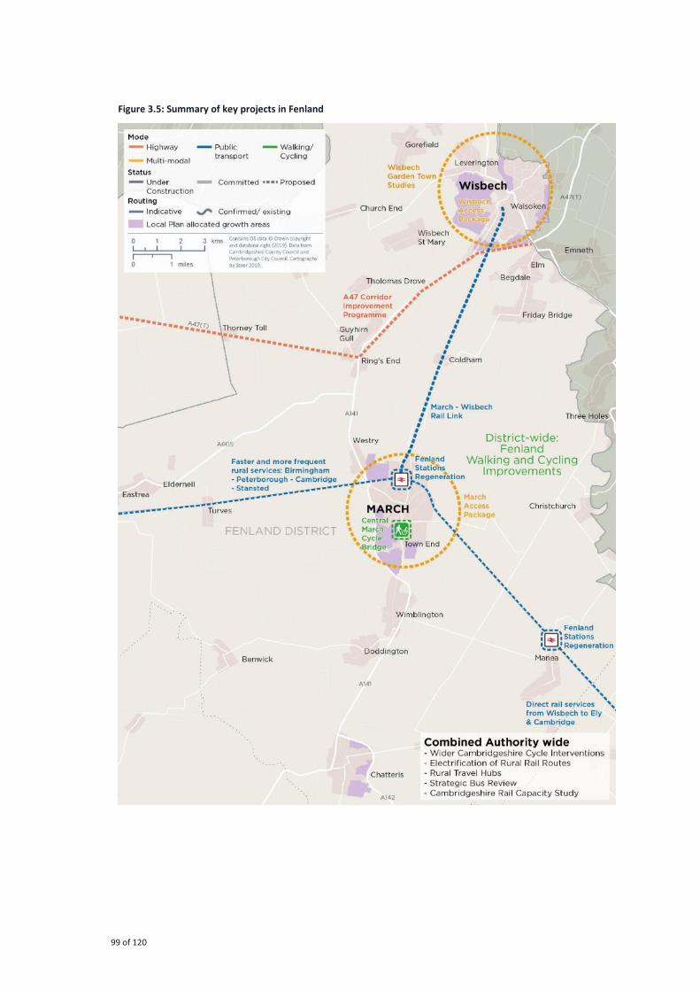
99 of 120
Figure 3.5: Summary of key projects in Fenland

100 of 120
Strategic projects
East / West Corridor
The A47 is both a nationally and internationally strategic link. Internationally, it is part of the
TEN-T Trans European Network Route, making it a part of the European Union’s strategic transport network. Nationally, it is a key route into East Anglia, connects Norwich and Norfolk
with the East Midlands and the A1, and carries a large amount of heavy goods traffic.
On a more local scale, the section of the A47 within the Combined Authority area provides
direct access between Peterborough, Wisbech and Kings Lynn. Beyond these settlements, the
area is lowly populated and is largely agricultural. Consequently, the A47 is a key commuter
route for people travelling into and out of these settlements for employment.
The long-distance regional trips (and particularly heavy good vehicles) generate a consistent
flow of traffic along the route, and when this is mixed with commuter traffic the local network
comes under substantial strain and congestion is common, particularly on the approaches to
key junctions such as the A47 / A141 Guyhirn Roundabout and the A47 / A1101 Elm High Road
Roundabout. The high proportion of heavy goods vehicles travelling along the single
carriageway section between Thorney and Wisbech often creates queues of platooning
vehicles unable to safely overtake, which reduces journey time reliability and can lead to
increased driver frustration and risk taking.
To address these issues, the Combined Authority is working in partnership with Highways
England to assess the viability of the A47 dualling/capacity improvements proposal between
the A16 Peterborough and Walton Highway.
Wisbech Rail
Construction of a new link to Wisbech will transform accessibility to the town. Options for rail
and other high order transit such as tram/Light Rail Transit and Bus Rapid Transit are being
considered by the Combined Authority and Cambridgeshire County Council, working closely
with Network Rail and Fenland District Council. Residents and businesses in Wisbech would
benefit from being able to reach Cambridge directly, connecting them to the opportunities
within Greater Cambridge, including well-paid, skilled roles in the knowledge economy, and
education and training opportunities at The University of Cambridge, Anglia Ruskin University
and Cambridge Regional College. It will also play a key role in supporting the ambition for
Wisbech Garden Town, helping to secure the viability and delivery of additional development.
Local projects
Plans to re-open the March to Wisbech rail line will be complemented by bus, walk and cycle,
and road improvements in Wisbech to help realise the ambition and plans for a Garden Town.
Funding has been secured from the Greater Cambridge Greater Peterborough Growth Deal to
deliver this package over the next five years.
A package is also planned for enhancements to railway stations within Fenland at Manea,
March, and Whittlesea. Short platform lengths currently prevent longer, higher capacity trains
from calling at the stations, as well as reducing the frequency of trains able to stop. In addition
to platform lengthening, we will fund station enhancements to improve the quality of station
and waiting facilities, as well as improving access to, from and at the stations, following
continued engagement with the Hereward Community Rail Partnership.

101 of 120
Introduction
The policies set out the requirements related to transport planning and design, delivery, and
operation and maintenance for the Combined Authority, our public sector partners, and key
private sector and non-for-profit stakeholders.
They are designed to support the delivery of the transport schemes identified in this core
document, and collectively, to ensure that we achieve our vision to deliver a world-class
transport network for Cambridgeshire and Peterborough that supports sustainable growth and
opportunity for all.
They are also designed to provide the principles which underpin decision-making, capital
investment and revenue support in our transport network.
Each policy is associated either with a given objective, as set out in Chapter 1 of this
document, or a given mode of transport. Policies are grouped into individual ‘policy themes’.
Figure 4.1 overleaf provides a summary of the relationship between objectives and policy
themes containing our policies, as well as identifying policy themes for specific forms of
transport, or “modes”, and transport infrastructure (e.g. parking). A summary of the policies
then follows in Table 4.1.
Annex 1 of the Cambridgeshire and Peterborough Local Transport Plan contains our detailed
policies for transport.
4 Our Policies

102 of 120
Figure 4.1: Policy themes by objective and transport mode policy themes
Economy Society Environment
Housing Employment Business and
tourism
Resilience Safety Accessibility Health and
wellbeing
Air quality Environment Climate change
Support new
housing and
development to
accommodate a
growing population
and workforce, and
address housing
affordability issues
Connect all new and
existing
communities
sustainably so
residents can easily
access a good job within 30 minutes,
spreading the
region’s prosperity
Ensure all of our
region’s businesses and tourist
attractions are
connected
sustainably to our
main transport
hubs, ports and
airports
Build a transport
network that is
resilient and
adaptive to human
and
environmental
disruption,
improving journey
time reliability
Embed a safe
systems approach
into all planning
and transport
operations to
achieve Vision Zero
– zero fatalities or
serious injuries
Promote social
inclusion through
the provision of a
sustainable
transport network
that is affordable
and accessible for
all
Provide ‘healthy streets’ and high-
quality public
realm that puts
people first and
promotes active
lifestyles
Ensure transport
initiatives improve
air quality across
the region to
exceed good
practice standards
Deliver a transport
network that
protects and
enhances our
natural, historic
and built
environments
Reduce emissions
to deliver net zero
carbon by 2050 to
minimise the
impact of transport
and travel on
climate change
Enabling
development
Planning and
designing
developments
sustainably
Accessing ports
and airports
Building a resilient
and adaptive
transport network
to climate change
Safety for all – a
safe systems
approach
Transport
accessibility for all
Public rights of way
and waterways
Improving air
quality
Protecting our
natural
environment
Reducing the
carbon emissions
from travel
Expanding labour
markets
Supporting the
local visitor
economy
Maintaining and
managing the
transport network
Ensuring transport
security
Transport pricing
and affordability
Promoting and
raising awareness
of sustainable
transport options
Enhancing our built
environments and
protecting our
historic
environments
Supporting
business clusters
Access to
education and key
services
Supporting and
promoting health
and wellbeing
Freight The future of
mobility
Reducing noise
pollution
Modal policies
Walking Cycling
Delivering a
seamless public
transport system
Rural transport
services
Improving public
transport in our
towns and cities
Travelling by coach Travelling by train The local road
network Parking
Making long
distance journeys
by car
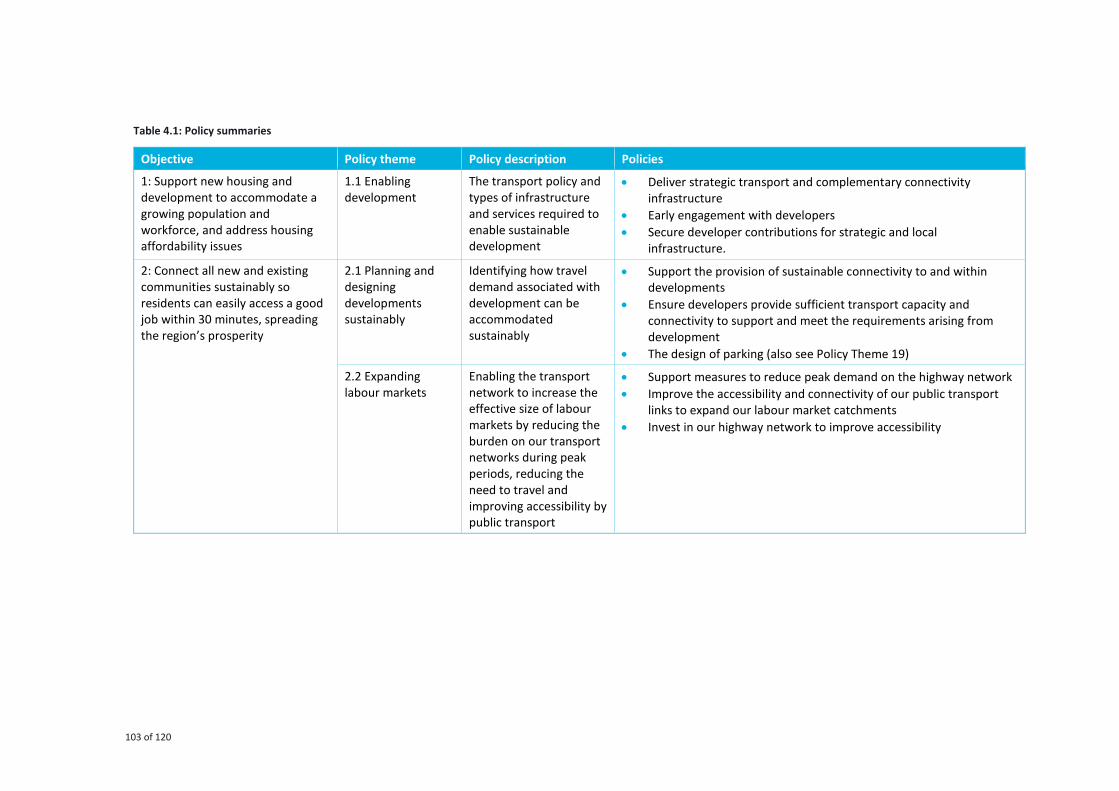
103 of 120
Table 4.1: Policy summaries
Objective Policy theme Policy description Policies
1: Support new housing and
development to accommodate a
growing population and
workforce, and address housing
affordability issues
1.1 Enabling
development
The transport policy and
types of infrastructure
and services required to
enable sustainable
development
• Deliver strategic transport and complementary connectivity
infrastructure
• Early engagement with developers
• Secure developer contributions for strategic and local
infrastructure.
2: Connect all new and existing
communities sustainably so
residents can easily access a good
job within 30 minutes, spreading
the region’s prosperity
2.1 Planning and
designing
developments
sustainably
Identifying how travel
demand associated with
development can be
accommodated
sustainably
• Support the provision of sustainable connectivity to and within
developments
• Ensure developers provide sufficient transport capacity and
connectivity to support and meet the requirements arising from
development
• The design of parking (also see Policy Theme 19)
2.2 Expanding
labour markets
Enabling the transport
network to increase the
effective size of labour
markets by reducing the
burden on our transport
networks during peak
periods, reducing the
need to travel and
improving accessibility by
public transport
• Support measures to reduce peak demand on the highway network
• Improve the accessibility and connectivity of our public transport
links to expand our labour market catchments
• Invest in our highway network to improve accessibility

104 of 120
Objective Policy theme Policy description Policies
3: Ensure all of our region’s businesses and tourist attractions
are connected sustainably to our
main transport hubs, ports and
airports
3.1 Accessing ports
and airports
Providing access to ports
and airports from across
the Combined Authority
and mitigating the
impacts of traffic to/from
these gateways,
including traffic passing
through the region
• Support improvements to our transport infrastructure to enable
efficient access for freight travelling to Felixstowe and Harwich,
particularly by rail
• Support improved road and rail connectivity to nearby airports, in
particular at Stansted
• Support the region’s visitor economy through efficient passenger connectivity at Harwich
• Work in partnership with port and airport operators to encourage
sustainable commuting patterns to their sites for workers
commuting from within the Combined Authority
3.2 Supporting the
local visitor
economy
Improving accessibility to
the region via
international gateways
to ensure that the area
remains favourable for
tourism
• Improving connectivity to international gateways and larger centres
• Delivering an integrated transport network easily navigable for
those visiting the region for the first time
• Delivering sustainable transport connectivity to tourist destinations
in rural areas
• Providing sufficient space and appropriate infrastructure for coach
services to manage the impacts of day visitors on our highway and
parking infrastructure
3.3 Supporting
business clusters
Ensuring that businesses
can trade effectively and
facilitate linkages that
support our varied and
successful economy
• Invest in our rail and highway networks to allow our firms and
organisations and workers to trade and travel easily across the
country and abroad
• Improve local connectivity to bring firms and organisations in our
towns and cities closer together
3.4 Freight Supporting the
sustainable and efficient
movement of goods
across the region
• Promoting rail freight
• Promoting and enforcing appropriate Heavy Commercial Vehicle
routing
• Promoting sustainable urban freight distribution
• Improving road freight facilities
• Supporting efficient air freight and the aviation sector

105 of 120
Objective Policy theme Policy description Policies
4: Build a transport network that is
resilient and adaptive to human
and environmental disruption,
improving journey time reliability
4.1 Building a
resilient and
adaptive transport
network to climate
change
Developing a transport
network that is resilient
to extreme climatic
events and is maintained
accordingly
• Managing the risks to the transport network presented by climate
change
• Sustainable road network maintenance
• Utilising proven technologies as they become available to help the
transport network adapt to the challenges presented by climate
change
4.2 Maintaining and
managing the
transport network
Focusing on highways
including standardising
maintenance standards
and encouraging the use
of sustainable materials
in scheme construction
• Standardising highways and transport asset maintenance standards
and performance indicators
• Supporting highway authorities in minimising the whole life costs of
the highway
• Addressing the challenges of climate change and enhancing our
communities and environment
5: Embed a safe systems approach
into all planning and transport
operations to achieve Vision Zero
– zero fatalities or serious injuries
5.1 Safety for all – a
safe systems
approach
Significantly improving
the safety of the
transport network –
including monitoring and
evaluation, education
and adoption of a ‘safe system approach’
• A multi-agency approach to improving road safety
• Continuous and comprehensive monitoring and evaluation of key
road safety indicators
• Support improvement in road user behaviour through education,
training and publicity programmes
• Adoption of the Safe System Approach into the mainstream of
highway engineering
5.2 Ensuring
transport security
Addressing personal
safety and security issues
on the transport network
and improving the
security of transport
hubs
• Addressing personal safety and security issues
• Improving the security of public transport stops, stations and hubs

106 of 120
Objective Policy theme Policy description Policies
6: Promote social inclusion
through the provision of a
sustainable transport network that
is affordable and accessible for all
6.1 Transport
accessibility for all
Facilitating access for all
by improving
infrastructure and the
availability of
information, and
promoting demand-
responsive transport
services
• Supporting and promoting demand-responsive community
transport services
• Facilitating access to education and wider mobility for vulnerable
children
• Improving the accessibility of transport infrastructure
• Promoting the provision of accessible transport information
• Optimise the use of new technologies in improving accessibility
6.2 Transport
pricing and
affordability
Improving public
transport to make it an
affordable alternative to
the car and increasing
the affordability of
travelling by bus and rail
• Improve our public transport to provide an affordable alternative to
the car
• Increase the affordability of travelling by bus and rail
6.3 Access to
education and key
services
Improving access to
education and key
services to make the
Combined Authority an
inclusive community for
all
• Access to education
• Access to non-emergency health and social care, and other key
services and amenities
• Digital inclusion
6.4 The future of
mobility
Focusing on supporting
integration and roll-out
of programmes which
will enable the uptake
and optimisation of new
transport technologies
across the region
• Promote and support research, innovation and engagement work
undertaken by Smart Cambridge
• Provide the infrastructure which will enable the uptake and
optimisation of new transport and digital connectivity technologies
• Guiding the development of a regulatory framework under which
new transport technology providers operate

107 of 120
Objective Policy theme Policy description Policies
7: Provide ‘healthy streets’ and high-quality public realm that puts
people first and promotes active
lifestyles
7.1 Public rights of
way and waterways
Maintaining and
enhancing the network
of public rights of way
and waterways in a
consistent manner across
the region
• Align policies for Public Rights of Way across Cambridgeshire and
Peterborough
• Improve access to the green spaces for all
• Develop a network which is safe and encourages healthy activities
• Integrate new development into the Public Rights of Way network
without damaging the countryside
• Make available high quality, definitive information, maps and
records on the network
• Ensure the network is complete to meet the needs of todays’ users
and land managers
• Support better land and waterway management
7.2 Promoting and
raising awareness
of sustainable
transport options
Using education, training
and information
provision to promote
sustainable transport
options
• Support travel plan development and implementation of travel plan
measures within workplaces so that healthy, safe, low carbon travel
options for commuters are actively encouraged and supported
• Ensure the adoption and enforcement of local travel plan guidance,
for new planning applications
• Promote existing and new walking and cycling routes to commuters
and residents
• Continue to promote cycle training in schools and for adults
• Improve availability, type and quality of information on sustainable
modes ensuring health and air quality benefits are emphasised
7.3 Supporting and
promoting health
and wellbeing
Promoting health and
wellbeing by increasing
the amount of physical
activity undertaken,
reducing air pollution,
improving the public and
urban realm and
increasing access to
healthcare, leisure,
employment and social
activities
• Reducing physical inactivity through active travel infrastructure,
education, training and promotion
• Reducing air pollution through supporting zero and low emissions
transport options and developing green infrastructure
• Improving street scene / public realm to improve safety
• Increasing ability to access health and social care, and leisure
facilities / amenities
• Increasing ability to access to wider opportunities - employment,
social activities

108 of 120
Objective Policy theme Policy description Policies
7.4: Reducing noise
pollution
Reducing noise pollution
from roads, railways and
airports within
Cambridgeshire and
Peterborough
• Monitoring and reducing noise pollution from the road network
• Monitoring and reducing noise pollution from airports
• Monitoring and reducing noise pollution from the railway network
• Monitoring and reducing noise pollution from construction
8: Ensure transport initiatives
improve air quality across the
region to meet good practice
standards
8.1 Improving air
quality
Harnessing
improvements to vehicle
technology and
disincentivising travel by
high polluting modes to
reduce vehicle emissions
and improve public
health
• Reducing vehicle emissions
• Keeping emissions low in the future
• Improving public health
9: Deliver a transport network that
protects and enhances our
natural, historic and built
environments
9.1 Protecting our
natural
environment
Ensuring that all
transport initiatives and
schemes improve rather
than damage the natural
environment, based on
guidance from DEFRA
(including biodiversity
and environmental net
gain principles),
Environment Agency,
and Natural England
• Protection and enhancement of the natural environment
• Improving sustainable access to the natural environment
• Delivering green infrastructure
9.2 Conserving and
enhancing our built
and historic
environments
Ensuring that the built
and historic environment
is protected and
enhanced in a consistent
way across the
Combined Authority area
• Work with our local highway and planning authority partners to
enhance and protect our built and historic environment

109 of 120
Objective Policy theme Policy description Policies
10: Reduce emissions to ‘net zero’ by 2050 to minimise the impact of
transport and travel on climate
change
10.1 Reducing the
carbon emissions
from travel
Reducing emissions by
encouraging the uptake
of new emissions-free
technologies and
encouraging sustainable
alternatives to the
private car
• Utilising new technologies as they become available to minimise the
environmental impacts of transport
• Managing and reducing transport emissions
• Encouraging and enabling sustainable alternatives to the private car
including reducing the need to travel
Modal policies 11: Walking Increasing the number of
walking trips by
establishing safe,
interconnected
pedestrian connections
between key
destinations across our
cities, towns and villages
• Support an increased number of walking trips by establishing safe,
interconnected pedestrian connections between key destinations
across our cities and towns
• Ensure that new developments provide a high-quality walking
environment
Modal policies 12: Cycling Increasing the number of
cycling trips through
establishing safe and
interconnected cycling
links across the region’s cities, towns and
settlements – will be
supported by Local
Walking and Cycling
Infrastructure Plans to
ensure that cycling and
walking infrastructure
investment is based on
evidence and prioritised
for greatest impact
• Enhance and expand cycling infrastructure across Cambridgeshire
and Peterborough, including connecting links to surrounding towns,
villages and rural areas
• Provide secure, conveniently located cycle parking that meets
demand
• Ensure that new developments provide a high-quality cycling
environment as well as linkages into the existing cycle network and
to key destinations
• Promote cycling as a healthy, convenient and environmentally
friendly mode of transport to residents, businesses and visitors,
including the uptake of new cycle technologies such as affordable e-
bikes
• Embed cyclists needs in the design stage of new transport
infrastructure

110 of 120
Objective Policy theme Policy description Policies
Modal policies 13: Delivering a
seamless public
transport system
Exploring new methods
of ticketing, improving
journey information,
supporting the delivery
of new and improved
integrated transport
hubs and supporting
additional Park & Ride
• Explore new methods of ticketing to improve the ease and
affordability of travel, including across transport modes and
operators
• Improve journey information to maximise the ease of travelling by
public transport
• Support the delivery of new and improved integrated, multi-modal
transport hubs
• Support additional Park & Ride provision, in conjunction with
Cambridgeshire Autonomous Metro, where fully integrated into
local transport networks
Modal policies 14: Rural transport
services
Ensuring a
comprehensive and
integrated rural public
transport system
• Explore different mechanisms to help deliver a more integrated,
coherent rural transport network, in collaboration with operators,
local councils, communities and stakeholders
• Work with operators to develop a frequent, attractive rural bus
network, forming the backbone of the rural public transport
network
• Support local community transport, fully integrated into the rural
public transport network, for communities not served by the bus or
rail network
Modal policies 15: Improving
public transport in
our cities
Improving the coverage,
frequency and reliability
of all forms of public
transport within cities to
meet the expectations of
residents, visitors and
businesses
• Support the continued development of urban bus networks by
working in partnership with bus operators and local authorities to
improve service quality, reliability and frequency
• Deliver transformational mass transit within our cities to support
growth and deliver a step-change in accessibility
• Support measures to better manage demand for road space
following the provision of high-quality public transport
infrastructure

111 of 120
Objective Policy theme Policy description Policies
Modal policies 16: Travelling by
coach
Providing sufficient space
and infrastructure for
picking-up and setting-
down passengers and
integrating coach
services with wider
public transport and
highway networks
• Providing sufficient space and appropriate infrastructure for coach
services
• Integrating coach services with wider public transport and highway
networks
Modal policies 17: Travelling by
train
Improving key rail
services, reducing
pressure on the highway
network and providing a
better service for
passengers
• Support measures to deliver a more reliable, integrated, passenger-
friendly rail network
• Facilitate improvements to our rail stations to improve the
experience of travelling by train
• Explore options to expand the rail network to link to new
settlements, corridors and growth areas
• Support frequency and journey time enhancements on our rural
and intercity rail links to improve connectivity and capacity
Modal policies 18: The local road
network
Supporting Local
Highway Authority
partners in identifying a
Key Road Network;
promoting more efficient
use of the existing
network; and aligning
approaches to highway
management and
maintenance
• Identifying a Key Route Network
• Promoting more efficient use of the existing road network
• Aligning approaches to management and maintenance
Modal policies 19: Parking Managing the demand
for parking through
parking design,
controlled provision, and
enforcement
• The design of parking
• Managing parking demand
• Parking technology and implications of disruptive technology
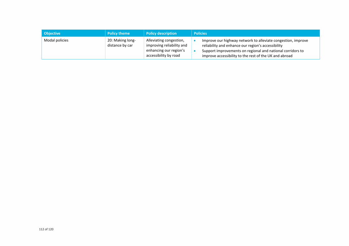
112 of 120
Objective Policy theme Policy description Policies
Modal policies 20: Making long-
distance by car
Alleviating congestion,
improving reliability and
enhancing our region’s accessibility by road
• Improve our highway network to alleviate congestion, improve
reliability and enhance our region’s accessibility
• Support improvements on regional and national corridors to
improve accessibility to the rest of the UK and abroad

113 of 120

114 of 120
Appendices

115 of 120
Term Description
Active travel Physically active modes such as cycling, walking, or horse riding. It also includes walking or
cycling as part of a longer journey
AQAP Air Quality Action Plan, developed when an area isn't meeting Defra's air quality objectives,
and sets out a plan for better achieving these objectives.
AQMA Air Quality Management Area. An area where it is unlikely that the national air quality
objectives, as set by DEFRA, will be achieved.
BAME Black, Asian and Minority Ethnic people and/or households
BRT Bus Rapid Transit, a bus-based public transport system designed to improve capacity and
reliability relative to a conventional bus system.
CAM Cambridge Autonomous Metro, a high-capacity public transport system designed to deliver
transformative improvements to connectivity in Cambridgeshire.
Car dependency Reliance on cars to get around, whether through habit, because street environments have
been planned around car use, or because walking, cycling and public transport alternatives
are not available or appealing.
Car sharing Cars that are not owned by the people who use them to travel. This includes car clubs,
taxis and private hire vehicles.
Carbon footprint The total greenhouse gas emissions caused directly and indirectly by an individual,
organisation, event or product, expressed as a carbon dioxide equivalent.
CCG Clinical Commissioning Group, responsible for implementing the commissioning roles as
set out in the Health and Social Care Act 2012.
CIA Community Impact Assessment. A tool used to ensure the policies, practices, projects and
activities which shape the work of a council are ensuring equal access to all services.
C-ITS Cooperative Intelligent Transport Systems, which will allow road users and traffic managers
to share information and use it to coordinate their actions.
CMO Chief Medical Officer. The UK government’s principal medical adviser and the professional head of all directors of public health in local government.
CNFE Cambridge Northern Fringe East. A significant new development planned on the fringes of
Cambridge City.
Combined
Authority
A Combined Authority is a legal structure that enables two or more local authorities to
collaborate and make collective decisions across council boundaries.
Connected and
Autonomous
Vehicles (CAVs)
Vehicles, also referred to as driverless cars, which incorporate a range of technologies
allowing them to communicate with and draw information from their environment to
enable the safe, efficient movement of people and goods.
CPCA Cambridgeshire and Peterborough Combined Authority, established on the 3rd of March
2017 under devolution from central government.
CPIEC Cambridgeshire and Peterborough Independent Economic Commission, a body that has
been established to deliver the CPIER.
Appendix A: Glossary of terms

116 of 120
Term Description
CPIER The Cambridgeshire and Peterborough Independent Economic Review, published on the
14th of October 2018.
CPRSP Cambridgeshire and Peterborough Road Safety Partnership, aiming to prevent all road
deaths across Cambridgeshire and Peterborough.
DEFRA Department for Environment, Food and Rural Affairs. The UK government department
responsible for safeguarding the natural environment, supporting the food and farming
industry, and sustaining a thriving rural economy.
DNO Distribution Network Operator. A company licenced to distribute electricity in the UK.
DRT Demand Responsive Transport, a form of transport where vehicles alter their routes based
on particular transport demand rather than using a fixed route or timetable.
ECML East Coast Main Line. Major railway line running largely along the East Coast from London
to Edinburgh.
EHCP Education, Health and Care Plan. A legal document which describes a child or young
person's special educational needs, the support they need, and the outcomes they would
like to achieve.
Electric vehicle A vehicle that uses an electric motor for propulsion, comprising ones that run solely on
batteries, as well as plug-in hybrid electric vehicles that have an attached petrol or diesel
engine to power the battery engine.
EqIA Equality Impact Assessment, a process designed to ensure that a policy, project or scheme
does not discriminate against any disadvantaged or vulnerable people.
FACT Fenland Association for Community Transport. A not-for-profit organisation serving the
Fenland Area of Cambridgeshire to people who have difficulties using conventional modes
of transport.
GCP Greater Cambridge Partnership, he local delivery body for a City Deal with central
Government.
GINI The most commonly used measurement of national inequality.
Greenhouse gas A gas which absorbs solar radiation contributing to the greenhouse effect which leads to
global warming and climate change.
GVA The value of goods and services produced in an area, industry or sector of an economy.
HGV Heavy Goods Vehicle. A large heavy vehicle generally used for transporting freight.
HIA Health Impact Assessment, a series of procedures by which the impact of an intervention
or policy may have on the health of a population is measured.
HRA Habitats Regulation Assessment, which assesses whether plans will have the potential to
cause an impact on protected areas.
Hub A place of transport interchange providing easy access to the whole transport network
with cycle parking, taxi call points and access to car club vehicles, drop off points and at
larger locations park and ride facilities.
IER Independent Economic Review
Killed or Seriously
Injured
A standard metric used to measure levels of road safety.
LCWIP Local Cycling and Walking Infrastructure Plan, a long-term approach to developing local
cycling and walking networks over a ten-year period
Light rail A form of urban rail transport which operates at a higher capacity to a tramway, often on
an exclusive right of way, and serving parts of a large metropolitan area.
Local Authority A local government organisation. In England there may be either one or two tiers of local
government. A two-tier structure includes a County Council as the upper tier and a District

117 of 120
Term Description
Council as the lower tier. Local Authority responsibilities include strategic land use
planning, and highways and transport.
Local Enterprise
Partnership
Cooperation between a number of stakeholders including local authorities’ business and education sectors with the joint aim of promoting economic growth in an area, focusing on
housing, planning and transport.
Local Plan A statutory planning document which sets out the vision and framework for future
development within a Local Planning Authority area. It addresses housing, economy,
community and infrastructure and is used as a tool to guide decisions about development
proposals
LTP Local Transport Plan. A statutory document which sets out the objectives and programme
for improving the transport network.
MaaS Mobility as a Service. A shift away from privately owned vehicles towards a model where
different transport modes are consumed as an on-demand service through a single (online)
platform. For example, the concept of paying for a weekly travel pass that includes bike
hire, car hire, bus and train travel.
Mass transit A form of public transport to satisfy higher potential trip demand, featuring limited stops,
high capacity and attractive, reliable journey times. It is usually rail based, such as trams or
light rail above ground, or underground trains.
MHCLG Ministry of Housing, Communities and Local Government. Creates places to live and work,
and to gives more power to local people to shape what happens in their area.
MITSS Mayor’s Interim Transport Strategy Statement. A summary of the Cambridgeshire and
Peterborough Local Transport Plans, enacted whilst the Combined Authority’s first Local
Transport Plan is being developed.
MLEI Mobilising Local Energy Investment. A project aiming to attract more energy investment
and infrastructure delivery into Cambridgeshire.
Mode share The relative use of each mode of transport.
Mode shift A percentage change in the use of different transport modes. When one transport mode
becomes more advantageous than another over the same route or market, a modal shift is
likely to take place.
MRN Major Road Network, a classification of Local Authority roads in England
NEPTS Non-emergency patient transport services. A free transport service provided to patients
who have a specific medical need and are attending healthcare services.
NHS National Health Service
NHT National Highways and Transport. The leading performance improvement organisation
which provides a range of benchmarking services for the Highways and Transport sector.
NICE National Institute for Clinical Excellence. Provides national guidance and advice to improve
health and social care.
NOx A generic term for the nitrogen oxides that are most relevant for air pollution, namely
nitric oxide (NO) and nitrogen dioxide (NO2). NOX gases are produced during the
combustion of hydrocarbon fuels in diesel and petrol-powered vehicles. In areas of high
motor vehicle traffic, NOX can be a significant source of air pollution.
NSSF Non-statutory spatial framework, which will act as a framework for future planning across
Cambridgeshire and Peterborough
NSSP Non-statutory spatial plan, which will act as a framework for future planning across
Cambridgeshire and Peterborough
OECD Organisation for Economic Cooperation and Development, a forum where the
governments of democracies with market economies collaborate

118 of 120
Term Description
Park and Ride A system for reducing urban traffic congestion, in which drivers leave their cars in car parks
on the outskirts of a city and travel to the city centre on public transport.
PCC Peterborough City Council
PHE Public Health England. Responsible for protecting the nation's health and wellbeing, and
reducing health inequalities.
PM Particulate Matter. A complex mixture of small material and liquid droplets which have the
potential to cause significant health issues.
Powered Two-
Wheeler
A vehicle that runs on two wheels and uses a form of power other than human effort.
Examples include motorbikes, mopeds and electric scooters.
PRM Persons with Reduced Mobility
PSVAR UK Public Service Vehicles Accessibility Requirements. Requires that new vehicles carrying
22 passengers or more have facilities such as low floor boarding devices, space for
wheelchair users, highlighting of steps, handrails for visually impaired people and priority
seating.
Public realm Publicly accessible space between and within buildings, including streets, squares,
forecourts, parks and open spaces.
RPI Retail Prices Index, a measure of inflation published monthly by the Office for National
Statistics
SEA Strategic Environmental Assessment, a decision support process which ensures that
environmental and sustainability aspects are considered effectively in policy, plan and
program making.
SPD Supplementary Planning Document, provides more detailed guidance about policies in the
Local Plan
SRN Strategic Road Network, motorways and the most significant trunk roads in end and, which
are managed by Highways England
Sustainable
transport
Forms of transport which have lower environmental impact than single occupancy car use.
It includes walking, cycling, public transport, Park & Ride, and car-sharing.
TEN-T Trans European Network (Transport). Aims to build a transport network that facilitates the
flow of goods and people between EU countries.
TFL Transport for London, the body in charge of delivering transport services in Greater London
TIP Transport Investment Plan, sets out the transport infrastructure, services and initiatives
that are required to support the growth of a region.
Trip A one-way movement from one place to another to achieve a single main purpose. Trips
may be further sub-divided into journey stages.
Ultra-Low
Emission Vehicle
Vehicles that use low carbon technologies, fuelled by electricity or hydrogen, to reduce the
amount of pollutants emitted. They commonly have rechargeable batteries which are used
to store energy
Urban realm The area between building alignments, including public spaces next to streets. Streets
make up the greatest part of the urban realm in most cities.
Vision Zero An approach to road danger reduction that works towards the elimination of road traffic
deaths and serious injuries by reducing the dominance of motor vehicles.
WHO World Health Organisation. Leads international health within the United Nations system.

Control Information
Prepared by Prepared for
Steer
28-32 Upper Ground
London SE1 9PD
+44 20 7910 5000
www.steergroup.com
Cambridgeshire and Peterborough Combined Authority
The Incubator 2
First Floor
Alconbury Weald Enterprise Campus
Alconbury Weald
Huntingdon
Cambridgeshire
PE28 4WX
Steer project/proposal number Client contract/project number
23217301
Author/originator Reviewer/approver
Steer SGB
Other contributors Distribution
CJA, JJR, ETC, TAL, CXC, RGG Client: Cambridgeshire and
Peterborough Combined
Authority
Steer: Project Team
Version control/issue number Date
Structure v1.0 26 September 2018
Draft v1.0 (Internal) 17 April 2019
Draft v2.0 (Working Group) 18 April 2019
Draft v3.0 (Steering Group) 26 April 2019
Draft v4.0 (Board Paper) 03 May 2019
Draft v5.0 (Informal Cabinet) 08 May 2019
Draft v6.0 (Combined Authority Board [internal]) 16 May 2019
Draft v7.0 (Combined Authority Board [external]) 17 May 2019
Draft v8.0 (Combined Authority Board [external]) 20 May 2019
Draft v9.0 (Post-consultation to Combined Authority officers) 22 November 2019
Draft v10.0 (Post-consultation to Combined Authority officers) 25 November 2019
Draft v11.0 (Final Draft) 16 December 2019
Draft v12.0 (Final Draft - revisions) 20 December 2019

steergroup.com