the cascade caver ern grotto
TRANSCRIPT
CASCADE•"
Delayed Issue
THE
Volume IVDecemberOfficial PublicationCASCADE GROTTOSeattle
CAVER
Number 121965
of theN.S.S.
Washington
PROPERT';'OfTHE WINDY ern GROTTO
LIBRARY
======================================================================
IRON FLOWSTONE IN CAVE RIDGE by Bill Halliday
"
For several years, cavers have admired scant but colorful deep red terracedpasty flowstone in several of the caves on Cave Ridge (see Caves of Washington).With the cooperation of the Washington Division of Mines and Geology, I recentlygot around to some qualitative analysis. The results were rather intri'guing:No calcite or aragonite or silica is present; most or all of the sample (fromLookout Cave) appears to be iron oxide. Another sample is being sent to theN. S. S. News, seeking further studies. Under a microscope, crystals resemblelimonite.
----------------------------------------------------------------------
MORE NEW DISCOVERIES IN MT. ADAMS AREA
The recent discovery of the Upper Butter system seems to have triggered quitea bit. As mentioned elsewhere) Homer Ward locateI' a new system about 2) 000feet farther southwest; its potentials still arenft known and it's where Red Caveshould be.
Jim Nieland writes from Portland that he, Martin Deos and Jay Schwortz havefound two new ones, one just north and east of Stairwell Cave) and another south-east of the town of Trout Lake. No details yet.----------------------------------------------------------------------
AND STILL MORE NEW CAVES
Ted Danner writes from Vancouver, B. C. of a new cave entrance in a remotesection of Orcas Island (near the Imperial Quarry Cave» and of one on thesouthern end of Red Monutain) in Whatcom County. Explict location directionsand a map accompany the latter. He did not enter either (Ted's a limestoneexpert and only reports entrances) but every entrance he's reported to us so farhas gone somewhere. The Red Mountain cave might be accessible in winterunless snow is recent
-93-
-
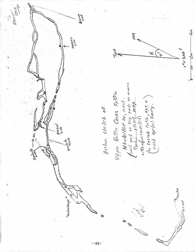
UPPER BUTTER - STAIRWELL SYSTEM .... AND ~OTHERY Bill Halliday
On the fine weekend of November 6th and 7th, Jerry Frahm, Marcia, Patricia,Ross and r returned to the exciting new complex at the upper end of the ButterCave System. After stopping at Ape Cave, Homer Ward and two friends fromOlympia came over and joined us - and found still another unrecorded system!
We mapped the short northernmost arm of the new cave area, found a splendidupper level with a poachers' camp, then headed uptrench from the natural br'idgecrossed by the key side road. First was a spacious complex beautifully illumin-ated by segmental collapse orifices: The Interchange, according to Jerry Frahm. I"
Several hundred yards up-tube (mostly sinks), we came upon a double- barreledtube complex, one arm of which finally ends (beginp, rather) at a fine tumulus.The other arm ends by a typical lava seal. Chunks of red lava are present in thegrey- black floor flow in this area.
Everything above the natural bridge is merely sketched to date.
!
Homer's new system contains three major lengths of cave, quite a bit of trenchand was still going when time ran out. It is west and a bit south of the area onwhich we have been working; the entrance of the cave which was not fully exploredis about 2, 000 feet south on the entrance of the uppermost cave in the Butter system.At first running sinuously northeast, it curves and looks like it will roughlyparallel the latter.
WELCOME TO THE TYPO CLUB
As you may have noticed, the Caver has a certain distinctive something, triumph-antly produced by the stencil- cutterl s utter lack of proof reading ability.(Unfair!!! i spels em da wiegh i gets em).
But we aren't alone. With glee, we welcome the sedate NATIONAL PARKSMAGAZINE to the Typographical Error Club.
With skill so exceptional that even we must marvel, NATIONAL PARKS typoedBill Halliday's article in its December issue into saying: "Most damage to cavescomes from informed casual visitors". Since the whole article is built aroundthe concept that most damage comes from UNinformed casual visitors for whomprograms of conservation education should be designed, the typo was classicindeed.
The pictures are really pretty good. We recommend it.
=94=
-
;,
.'-"- .~..•.....::~.;.. ","
•...;_.
(>
(>
-,J'~~. ~I~ ~:~~ . <~~ ~-,\~-C:::;;;::""'-----___ _ \\
~-
'-95":
~."
\
JIM NIELAND CORRELATES RECENT MT. ADAMS DISCOVERIES(letter of December 20, 1965)
The cave you found with the cow bones in it is the same cave that I found.The blue tapes are not ours, but the blazes are. Actually, they don't leadto anything. On an earlier trip, we found a small sink which we did not have timeto investigate, and marked our trail with strips torn off a sweatshirt.On our next trip we started out on the trail, blazing it that time. and thenlost the trail. It was when we were scouting around to the west, hunting for ourtrail, that we found Cowbones Cave. (Exactly as we did - WRH.)
About the sink that Maurice found (maybe - WRH). We spent two or three lhours in it Thanksgiving weekend. Maurice is right, there are caves at bothends of the sink, if you enter by one of the center sinks. The center part ismore like a lava trench, with a section of cave at each end. The south endis blocked by breakdown which seperates this cave and Cowbones Cave.The north end is about a hundred feet long and terminates with a lava seal.
From the trench there are two side pasages, downslope and to the east.Each of these is about 100 feet long. They start out as crawlways, but openup after about 50 feet. The odd thing about them is that they are nearlyidentical in shape and size. They both terminate in lava seals. To get tothis cave we walked about 200 feet due north from Cowbones Cave. (This isthe problem - WRH. Maurice's sink ought to be considerably farther west,only about 100 yards from the entrance of Stairwell Cave. )----------------------------------------------------------------------
-96-
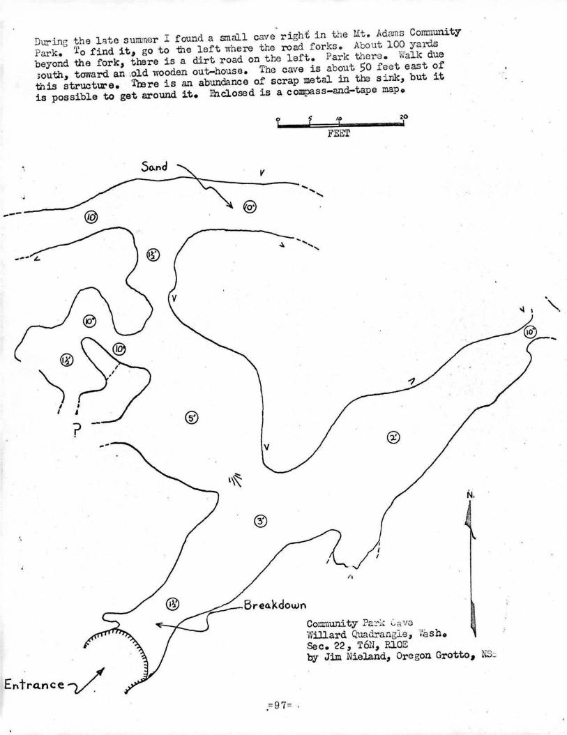
During the l:>te summer I found a s:nall ca're right: in the Lit. AdamsCommunityPark. To find it~ go to "the left where the road forks.. About 100 yardsbeyond the fork" there is a dirt road on the left. Park t.l}ore.. Walk due;outh~ toward an .old .woodenout-house. The cave is about 50 feet east ofthis structUt'e. Trore is an abundance of scrap metal in u.s sink, but itis possible to get around it. Enclosed is a compass-and-tape mapo
---
@
\II
Entra.nce V'
L s (0 20! \ I
FEET
So.nd V
"...••..•.•.@
...~ ..........
BreakdownCom:numty Pa~~~C, 0.vaWillard Quadrangle, VashoSec. 22, T6N~P..lOEby Jim Nieland~ Oregon Grotto ,NS:
...•
.=97=

j
THE CASCADE CAVER
"
Volume VJanuaryOfficial PublicationCASCADE GROTTOSeattle
Number 11966
of theN.S.S.
Washington
Butter - Stairwell Trip by Maurice Magee
I left Seattle friday night and met my brothers at Vancouver. We arrived atthe cave area at noon Saturday and started following the trail of breakdowns up- hill.We found several interesting places but finally went into Stairwell Cave.It had at least three levels and was more complex than most lava tubes wehad been in. It was an interesting cave and seemed quite extensive. We wentall through all of the passages and then decided to map it.
The second time through with compass and tape made it much less complicatedand shorter than it seemed at first. It is amazing what a difference there isbetween a first impression and an actual survey. After completion of ourfutH survey we left the cave to get someting to eat.
At the cave entrance there was a note signed WRH saying to sing out when wegot out of the cave. We did and were answered by WRH and three children whowere maki.riK.a surface survey from some breakdown farther on which wassuspected to contain Red Cave.
After lunch we drove off through the boondocks closer to the other breakdownholes and started through this cave system. It was an interesting system withseveral breakdown holes in the ceiling or side and numerous side passageswhich we did not have time to explore. I went through one side passagewhich was probably parallel to the main passage, because it left it and cameback into the main passage a little farther down. At one place just after avery low crawl way about a foot. high it opened into a circular room probably20 feet across and 4 feet high with other possible entrances and exits than theones I used. It will take a lot of measuring and crawling to check out all of thepossibilities in this system.-----------------------------------------------------------------------
Filler material:
Harry Reese's teleptlOne number is 231-4235
Telephone operators don't as a rule know where Trout Lake is, but the galson the switchboard at Hood River, Oregon do and can help complete your calls.
:::1:::
VULCANOSPELEOLOGICAL ABSTRACT
"Breathing Cones" from an article in The Volcano Letter # 263, January 9, 1930published by the Hawaii Volcano Observatory. by Don Rimbach
"The extraordinary lava activities of the year 1919 at Halemaumau, the firepit of Kilauea, marked the peak of the eleven year cycle. To the tourist whosees the vast caldera of today, a thous and feet deep and three thousand feetacross, it is hard to realize that glowing, molten slag was overflowing theedge of the pit a decade ago. The pit has a definite margin of cold rock butwithin that margin and overlaping it were lava lakes, pots, droplet spires,flow heaps, tunnels, stalactite grottoes, smoke holes, ana breathing cones.
The east cone of the spring of 1919 was a low hillock, built up around a lava pot onthe inner flow of Halemaumau. Visitors habituaally walked over this floorwhich extended from the lakes inside the pit area to merge with the overflowsoutside. The pot was supplied with a glowing glassy melt through a tunnelleading from the main lake. With the rise and fall of the liquid lava a cone wasbuilt around the pot, and the interior ceiling of the tunnel became hung withhuge gas= glazed stalactites three to four feet long.
One could stand on the rim of this conduit and gaze into the open pot where lava,of bright yellow glow was splashing fifteen feet below. Under the lip of the orficethe interior chamber was bright orange with incandesence hung with beautifullysculptured firey stalactites shaped like long bunches of grapes. By night, a banr-'was visible, of blue- green flame, fluttering above the orfice sending off a paleblue transparent fume, acrid with sulpher. As a whole durring this period, thelakes were rising, the inner floor was being overflowed in spasms, and theheaps, cones, and spiracles were building up. The East Cone hissed, andbreathed, and roared at different times. Sometimes it would vomit up moltenstuff like an artesian well, and give vent to a glowing flow. At such timesthe pot and tunnel were obliterated only to reappear when the outflow ceasedwith the stalactites reforming.
The grape'-like droplets, and the grey, ye low, red, or brown glazes on thesurface of these stalactites are not the result of direct spatter. There areother stalactites and drip curtains and frozen drop points which are the resultof direct splash.
The grape-like bunches however, and the long worm -like stalactites are formedby the remelting of the roof of the cavern by slow action of the intensly hot burninggasses. The burning is converted into a blow-torch effect when air has access to thetunnel so as to convert the combustible gasses from the boiling lava into oxidizingflames. When air reaches the volcanic gas pipe suddenly the changes in theiron oxide in the glazes may be equally sudden and the whole cavern may becaused to glow by the access of air alone.
"=2::: .
VULCANOSPELEOLOGICAL ABSTRACTS by Bill Halliday
Plantz, Charles. 1965. Field trip to two large Icelandic lava tunnels.Netherworld News (Pittsburgh Grotto, NSS) pp. 172-176, Oct.
The writer visited Surtshellir and Raufarholshellir, and gives detailed directions(he spent 5 hours trying to find Surtshellir even though the location is shown ontopographic maps). Surtshellir is about 3/4 mile long and contains fine flowpatterns, ice and an alter.
Prior to the discovery of Apr Cave, Raufarholshellir was the longest knownlava tube cavern (3200 meters according to Corbel - see below). The writerrecords three lava springs, ice and several lavafalls. Lava stalactites weremore prominent than in Surtshellir but no stalagmites were noted in either.
The cover photo of the issue of Netherworld News shows the short sectionof Surtshellir where the original floor is not covered with breakdown.
Corbel, Jean. 1957.Geog. Rev. de Lyon.
Les karst du nort- ouest de l' Europe.pp . 258- 263.
- ,
The lava tubes of Iceland occur in two grouges: the southwestl£:r'n peninsula and theSurtshellir area. Raufarholshellir is 3200 meters in length, and is in a flow whichoccurred in the year 1000. its elevation is 200 meters. Its average temperatureis around freezing. Breakdown segments are plentiful. Surtshellir is 1250 meterslong and is known from legends of the 10th century. Both of these caves arebasiclly unitary. Nearby Stephanshellir however has the form of a labyrinth.Vidgilmir Cave closely resembles Surtshellir. Other smaller caves are mentioned.Theoretical considerations will be presented later.
* * * * *Spry, A. H. and Hale, G. E. A., 1964 A cave in dolerite at Wayatinah,Tasmania. Univ. of Tasmania Dept. of Geol. Pub. # 149, Dec.This is not a lava tube but is in a volcanic rock - dolerite. 60 feet long,30 feet wide and 4 to 30 feet high, it was intersected by a tunnel and is 600 feetbelow the surface. It was full of water when intersected, but the presence of"small conical masses of calcite" indicated that the filling was a recentphenomenon. Unfortunately, the cave is no longer accessible; it appears to bean unusually interesting pseudokarstic phenomenon meriting much moredetailed study than was possible.
Fish, John and Reddell, James, 1965. Field trip report: States of Hidalgo,Veracruz and Guerrero. Assoc. for Mex. Cave Studies Newsl., 1(8):75, Aug.First inveEtigation of lava tube cavern reported near Jalapa, within a night'sdrive of Cacahuamilpa Cavern (an enormous limestone cave). Elevation 10,000 feet."The sink is about 680 feet long, 100 feet wide and 50 feet deep. It appears torepresent the sollapse of an upper level tube into a lower level". The opening ofa lava tube about 15 feet in diameter was observed but could not be reached with-out special climbing gear.
I,
i I{.~.--.~.liD
"1;:';:-
L ,1"1 Ii' II' c .-
. i
"
, ;;')
.". --- - .. ~.--- .~-_.- ---_. __ ..- .. - -.- .. - -
I(Db
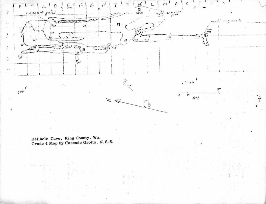
Hellhole Cave, King County, Wn.Grade 4 Map by Cascade Grotto, N. S. S.
I! !I-=- 3°
~~--.;O----------\-
frd 'II'<flII
I\
I,
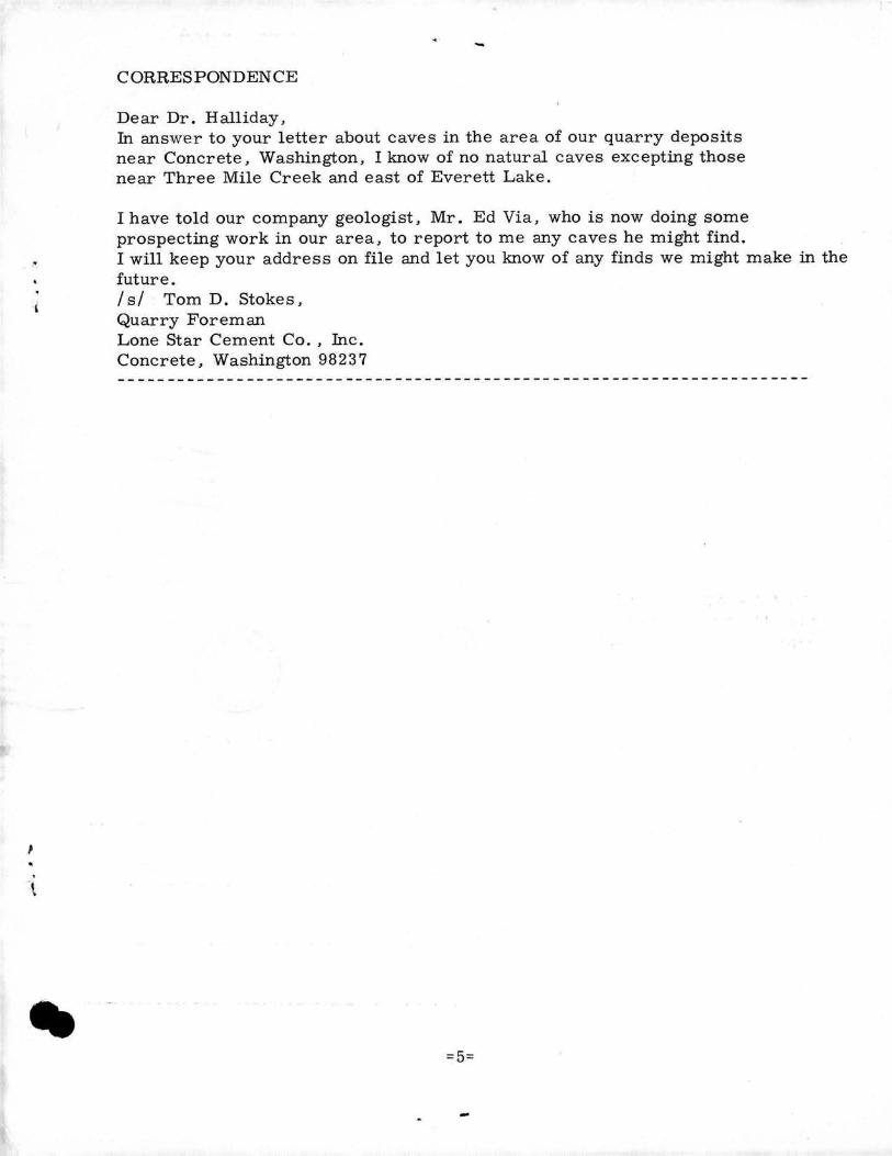
CORRESPONDENCE
Dear Dr. Halliday,In answer to your letter about caves in the area of our quarry depositsnear Concrete, Washington, I know of no natural caves excepting thosenear Three Mile Creek and east of Everett Lake.
I have told our company geologist, Mr. Ed Via, who is now doing someprospecting work in our area, to report to me any caves he might find.I will keep your address on file and let you know of any finds we might make in thefuture.I sl Tom D. Stokes,Quarry ForemanLone Star Cement Co., Inc.Concrete, Washington 98237
=5=
. '.
.~ -"'.. ~..t • ;:. '".
-_._~--.,..-- ..... -., •...... ~.........---. ..,-
THE CASCADE CAVER1117-36th Avenue EastSeattle, Washington 98102
THIRD CLASS MAIL
a6-~+C:#y 4<?-7Y&IO>2:d~~~e.
~A'?I~ 7
to&c2Z
,
1
=6=