the cera spatial data infrastructure (sdi) business whitepaper not government policy the cera...
TRANSCRIPT

A Business Whitepaper
Not Government Policy
The CERA
Spatial
Data
Infrastructure
A model for government ICT delivery Stephen Ferriss, Martin Erasmuson
March 2016

The CERA SDI – A Model for Government ICT Delivery 2

The CERA SDI – A Model for Government ICT Delivery 3
Unprecedented Disruption
Unprecedented is the phrase often used
to describe the situation which
Christchurch New Zealand encountered
following the magnitude 7.1 and 6.3
earthquakes of September 2010 and
February 2011 and their associated
aftershocks.
Not only was the Christchurch City CBD
virtually destroyed, the on-going
aftermath included the removal of more
than 200,000 tonnes of liquefaction silt,
more than 1,000 km of roads requiring
rebuild or repair and more than 500 km of
sewer pipe needing replacement.
Over 100,000 houses were damaged and
required repair or rebuilding. The
Earthquake Commission (EQC) received
over 400,000 claims and more than 8,000
residential properties were declared “Red
Zoned” as they were unable to be
redeveloped in the short to medium-term
due to serious land damage.
Individuals, companies, NGOs and
government agencies found themselves
trying to glean information to respond
and coordinate activities with an
information infrastructure that was barely
adequate in a peace-time situation,
but was unable to meet
the demands this
crisis presented.
“The Public Sector holds large amounts of data but it is
not being shared effectively and that there is a lack of
knowledge as to what data are available where, and how
one can access them.” Spatial Information in the New Zealand Economy Report 2009 cf

The CERA SDI – A Model for Government ICT Delivery 4
The Great Data Hunt This setting provided the catalyst for the
creation and on-going governance of a
world-class spatial data infrastructure
(SDI) by a collaborative group of local and
national organisations from the Public and
Private sectors in New Zealand.
The 2009 report; ‘Spatial Information in
the New Zealand Economy’ stated that the
Public Sector “holds large amounts of data
[but it is] not being shared effectively and
there is a lack of knowledge as to what
data are available where, and how one
can access them1 ” This proved to be the
greatest initial challenge. The team
tasked with implementing the SDI knew
that much of the data they required
resided within local and national
organisations with interests in
Christchurch but most of those
organisations were not accustomed to
sharing their data with the Public or each
other in a coordinated way. This
underscored the policy, political,
organisational and people challenges
which far outweighed any technical
challenges in implementing the SDI. The
focus was therefore on building
relationships, partnerships and trust with
data stewards and custodians within
those organisations. The partnerships and
trust across the recovery partners remains
the most important and enduring legacy
of the CERA SDI.
Partnership & Trust Land Information NZ (LINZ) took a
remarkable leadership decision by initially
1 Section 3.1.2 Spatial Information in the New Zealand Economy: http://www.linz.govt.nz/about-linz/our-location-strategy/geospatial-
projects/spatial-information-new-zealand-economy 2 Named Explorer Graphics Ltd at the time and subsequently renamed as NorthSouth GIS 3 Stronger Christchurch Infrastructure Rebuild Team (SCIRT) is a partnership between Government and Private Sector infrastructure
companies tasked with rebuilding horizontal infrastructure in Christchurch following the earthquakes of 2010 and 2011.
funding a cloud-hosted geographical
information system (GIS) from prominent
New Zealand company NorthSouth GIS
Ltd2. This GIS, which can be more
accurately called a spatial data
infrastructure (SDI), initiated a
Public/Private partnership at the core of
the on-going governance of the SDI. This
immediately began to expand and evolve
to meet the changing demands of various
stakeholder agencies and organisations
through the response and recovery
phases.
In 2011, little was known and much was
assumed yet in that climate of
uncertainty, this ‘partnership of the
willing’ between Public and Private Sector
recovery agencies took its practical form
in the shape of a “GIS roundtable” tasked
with the Governance and Strategic
direction of the SDI. Those recovery
partners included: SCIRT3, Christchurch
City Council, Land Information New
Zealand (LINZ), Selwyn District Council,
Waimakariri District Council, CERA,
NorthSouthGIS Ltd.
Some agencies were often represented at
the table by Private Sector organisations
acting as agents for Government and Local
Authorities, so business and government
formed a strong bond where priorities and
resources were shared and aligned
between agencies.
The CERA SDI – A Model for Government ICT Delivery 5
Connecting the pieces There are several theoretical or academic
accounts of what an SDI might look like
and how one might go about creating
such an infrastructure, but very few, if
any, actual working examples anywhere in
the world. While the SDI embraces and
validates current New Zealand
Government strategy and indeed
influenced some international thinking,
not all of that guidance existed in 2011.
4 https://www.ict.govt.nz/strategy-and-action-plan/strategy/ 5 http://www.ssc.govt.nz/bps-results-for-nzers
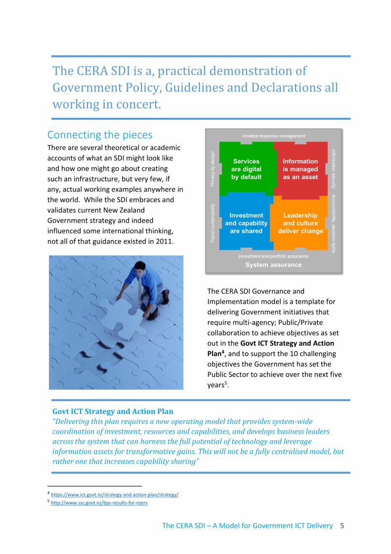
The CERA SDI Governance and
Implementation model is a template for
delivering Government initiatives that
require multi-agency; Public/Private
collaboration to achieve objectives as set
out in the Govt ICT Strategy and Action
Plan4, and to support the 10 challenging
objectives the Government has set the
Public Sector to achieve over the next five
years5.
The CERA SDI is a, practical demonstration of
Government Policy, Guidelines and Declarations all
working in concert.
Govt ICT Strategy and Action Plan
“Delivering this plan requires a new operating model that provides system-wide
coordination of investment, resources and capabilities, and develops business leaders
across the system that can harness the full potential of technology and leverage
information assets for transformative gains. This will not be a fully centralised model, but rather one that increases capability sharing”
The CERA SDI – A Model for Government ICT Delivery 6
The SDI Cookbook
In the geospatial world, the CERA SDI is
the real life expression of the LINZ SDI
Cookbook6 published by the NZ
Geospatial Office. The roles (geospatial
custodian, geospatial steward) and
standards prescribed in that series of
documents can be observed successfully
operating in the CERA SDI which can be
considered complimentary to other
government initiatives such as the LINZ
Data Service www.data.linz.govt.nz and
the Government Data Portal
(www.data.govt.nz).
Declaration on Open and Transparent
Government
The principles of the NZ Declaration on
Open and Transparent Government7 can
be found expressed in the CERA SDI,
enabling citizens to engage with
authoritative Government data. That
encompasses the NZ Government Data
Portal (www.data.govt.nz) integrated into
core SDI processes with all CERA-authored
6 http://www.linz.govt.nz/about-linz/our-location-strategy/connecting-and-sharing-geospatial-data 7 https://www.ict.govt.nz/programmes-and-initiatives/open-and-transparent-government/ 8 http://creativecommons.org/licenses/by/3.0/nz/
data discoverable on the data.govt.nz site
linked from the CERA SDI landing page
www.cera.govt.nz/maps. The discovery
and use component of the wider
infrastructure is completed with CERA
data licensed under Creative Commons by
attribution (CC-BY 3.0 (NZ))8.
Integrated: Govt ICT Strategy and Action Plan |
Government Data Portal | The SDI Cookbook | NZ
Declaration on Open and Transparent Government

The CERA SDI – A Model for Government ICT Delivery 7
Spatial information - the
currency of disaster
response Within the SDI architecture (below)
customer focused tools deliver over 4,000
datasets, from 80 secure and public data
services including 10 separate imagery
services from 14 public and private sector
organisations.
CERA staff have an array of customised
secure web viewers at their disposal, as
well as bureau access to ad hoc analysis
9 Open GIS Consortium (OGC - http://www.opengeospatial.org/) and industry standard formats are available including: JavaScript Object
Notation (JASON), Simple Object Access Protocol (SOAP), representational state transfer (REST), Web Map Service (WMS), Web Feature Service (WFS) and Keyhole Mark-up language (KML)
and visualisation services commonly
delivered on a just-in-time basis.
Non-technical users can view and query
‘packaged’ datasets in web-based viewers
on industry standard platforms including
Silverlight and HTML5. HTML5 is an open
industry standard allowing device and
browser agnostic delivery to any platform
or device the user should choose.
Expert users can access the spatial data in
a range of OGC standard formats9 directly
from a central service catalogue;
enforcing a single source of truth for CERA
authored data.
Security AND flexibility
Within a single web-based tool access to specific data layers,
layer attributes or geographies (location) can be controlled by
role based credentials. Rather than multiple applications for
multiple teams, a single application can be deployed with a
security model allowing specific access.
The CERA SDI – A Model for Government ICT Delivery 8
Responding to continuous
change Today the CERA spatial data infrastructure
is mature, embedded and utilised
throughout CERA and many organisations
and agencies involved in the recovery.
While comprised of the technical, data,
policy and organisational elements one
might expect in any SDI; what it delivers is
an agile framework for successfully
responding to continuous change. The
CERA SDI is a fully cloud-hosted, service-
oriented-architecture (SOA) utilising an
Infrastructure as a Service (IaaS)/Software
as a Service (SaaS) model. Loosely
coupled10 components allow for minimal
dependency and agile development to
occur in the constantly changing
Christchurch recovery environment.
During one of the more significant land-
zone announcements of 2012 the SDI
supported in excess of 4,000 map
requests a minute sustained for several
hours.
10 Loose coupling is an approach to interconnecting the components in a SDI so that those components depend on each
other to the least extent practicable. Coupling refers to the degree of direct knowledge that one element has of another. 11 http://www.ogcnetwork.net/taxonomy/term/170 12 http://www.esri.com/ 13 http://www.intergraph.com/
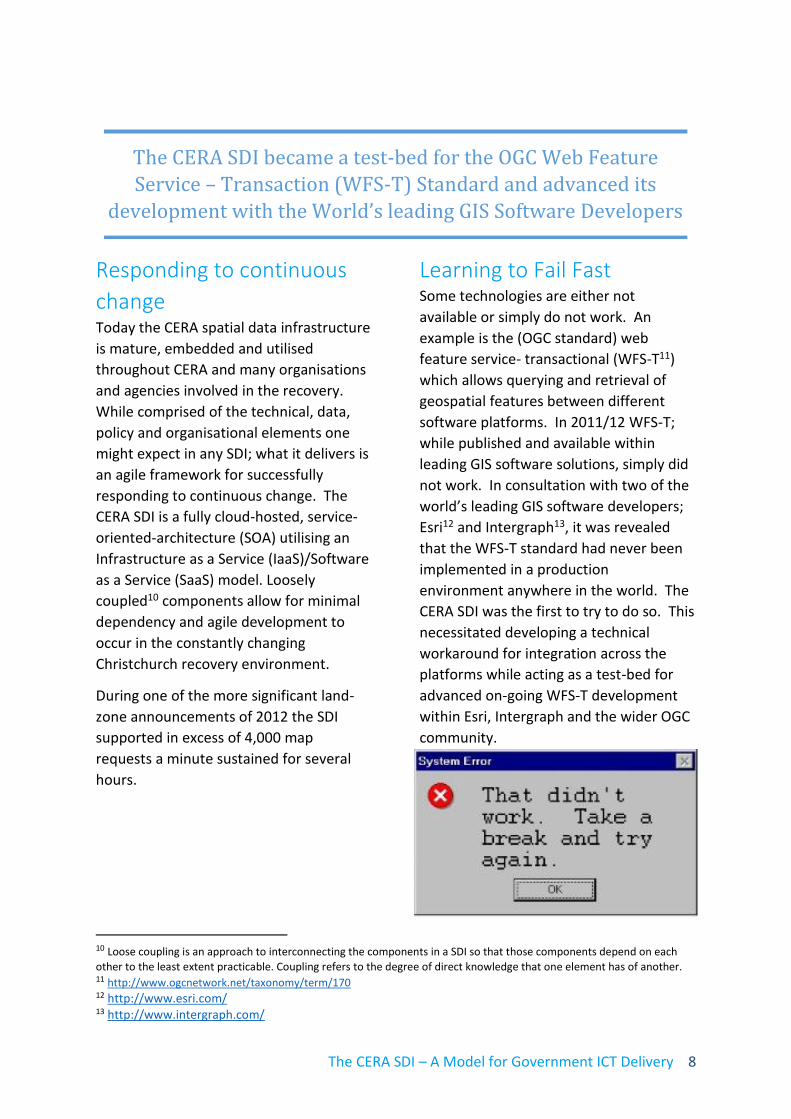
Learning to Fail Fast Some technologies are either not
available or simply do not work. An
example is the (OGC standard) web
feature service- transactional (WFS-T11)
which allows querying and retrieval of
geospatial features between different
software platforms. In 2011/12 WFS-T;
while published and available within
leading GIS software solutions, simply did
not work. In consultation with two of the
world’s leading GIS software developers;
Esri12 and Intergraph13, it was revealed
that the WFS-T standard had never been
implemented in a production
environment anywhere in the world. The
CERA SDI was the first to try to do so. This
necessitated developing a technical
workaround for integration across the
platforms while acting as a test-bed for
advanced on-going WFS-T development
within Esri, Intergraph and the wider OGC
community.
The CERA SDI became a test-bed for the OGC Web Feature
Service – Transaction (WFS-T) Standard and advanced its
development with the World’s leading GIS Software Developers

The CERA SDI – A Model for Government ICT Delivery 9
Measure to manage Web analytics offer powerful insights into
audience and user behaviour.
Below we see a highly repeatable pattern
of weekday use of CERA public map
viewers. The two spikes in early-May and
mid-June 2014 represent significant
flooding events affecting many citizens in
the heavily damaged eastern suburbs of
the city of Christchurch. Timely access to
accurate data was invaluable to affected
people and responding agencies alike.
Show me the data! Property owners in Christchurch have
been faced with significant challenges in
insurance, town planning, property
remediation and flooding issues. This in
turn complicated the areas of residential
construction (particularly foundation
design), insurance and re-insurance.
Property owners, developers, builders and
insurance companies needed timely
access to data to quantify risk, enable
mitigation strategies, and lower
foundation and insurance costs so that
rebuilding could commence.
One of the simple solutions to this
challenge is the Christchurch City Council
(CCC) Flood Levels Viewer
(http://maps.cera.govt.nz/advanced-
viewer/?Viewer=Ccc-Floor-Levels) which is
hosted on the CERA SDI on behalf of CCC.
This is a simple viewer with land-zones,
flood-extent models and floor level
parameters. Built in a week on HTML5, it
will run on any device. It was first
deployed on 10 April 2012 and by the end
of October 2012 had recorded 580,000
individual browser sessions. It remains
one of the most-used sites for CERA with
an average of over 300 unique user
visits per day.

The CERA SDI – A Model for Government ICT Delivery 10
Heuristics and thinking
outside the square Through 2011 and into 2012 various CERA
teams and supporting agencies from
Infrastructure to Community Wellbeing
were struggling to understand the scope
and nature of population movement.
While there was considerable anecdotal
evidence indicating significant population
movement; there was no available data
even approaching a level sufficient for
meaningful decision-making or policy
development. The SDI Team began
thinking about data that might indicate
property occupancy or vacancy and came
up with a heuristics-based14 approach
using postal redirection and power usage
data. Both NZ Post and local power
companies had property (address) level
data.
Once combined, a property with both a
postal redirection and zero electricity
meter reading indicated a ‘potentially
vacant’ property.
14 A heuristic technique is an approach to problem solving, learning, or discovery that employs a practical method not guaranteed to be
optimal or perfect, but sufficient to achieve the immediate goals, particularly where finding an optimal solution is impossible, impractical to too time-consuming.
While not definitive at an individual
property level, when combined with
Statistics NZ population data these simple
maps and underlying data presented a
clear, suburb-level view of population
movement that was invaluable to CERA
and agencies involved in the recovery.
Fit for purpose in a changing
world There is no doubt that the CERA SDI
remains one of the success stories to rise
from the ruins of a significant natural
disaster. In many ways the business of
CERA has been that of a conglomerate of
government agencies on speed. Because
of this, the effects of some business
problems present in inter alia insurance
and town planning processes have been
magnified to disproportionate levels
compared to “peacetime”.
The earthquakes presented unparalleled
challenges for everyone from responding
agencies to residents in Christchurch.
Indeed, while many people at work were

The CERA SDI – A Model for Government ICT Delivery 11
dealing with the challenges their
organisations faced in responding to the
crisis, many were also dealing with
personal challenges at home.
The provision of a best of breed spatial
data infrastructure has enabled the region
to respond with timely and decisive
evidence based policy, planning and
projects to meet the unprecedented
challenges of five years of earthquake
recovery in Canterbury. While focused on
a natural disaster recovery in a specific
geography; the overarching framework
could be applied to any Government
context in any town, region or at a
National level and as such is a model for
ICT Service delivery across Government in
New Zealand.

The CERA SDI – A Model for Government ICT Delivery 12
About the authors The Canterbury Earthquake Recovery Authority (CERA) is the New Zealand Government
agency established in April 2011 to lead and coordinate the response and recovery from the
Canterbury Earthquake Sequence for a period of five years.
Stephen Ferriss
Data & GIS Manager
Canterbury Earthquake Recovery Authority
https://www.linkedin.com/in/steve-ferriss-04432144
Stephen is the Data & GIS Manager at CERA who has overseen the on-going development of
the CERA Spatial Data Infrastructure (SDI) and its support to the wider stakeholder
community. Stephen is a location information and SDI specialist with a background in
surveying and GIS, who has worked across the public and private sectors. Outcomes
focussed and agile-thinking, Stephen delivers results in a dynamic discovery based
environment.
Martin Erasmuson
Managing Director
StratSim Ltd.
https://nz.linkedin.com/in/martinerasmuson
Martin has a broad background across the spectrum of knowledge management disciplines
ranging from; spatial data infrastructure (SDI) and GIS; programme and project
management, document and content management, agile and discovery-based
methodologies and information architecture design. That experience spans 30 plus years
across the New Zealand public and private sectors including central and local government.
Martin is an active writer, blogger and thought leader in knowledge management
communities with several published whitepapers and articles.
This material is licensed for re-use under a Creative Commons
Attribution 3.0 New Zealand License15.
15 http://creativecommons.org/licenses/by/3.0/nz/